Guidelines for Applying the Clearing of Invasive Native ...
38
Invasive native species self-assessable code Landholder Guide Guidelines for applying the Clearing of Invasive Native Species Ministerial Order (INS self-assessable code)
Transcript of Guidelines for Applying the Clearing of Invasive Native ...

Invasive native species self-assessable code
Landholder Guide
Guidelines for applying the Clearing of Invasive Native Species Ministerial Order (INS self-assessable code)

© 2015 State of NSW and Office of Environment and Heritage
Cover photo: The chaining method in use for clearing cypress pine/Paul Theakston, Western Local Land Services. Illustrations page 25, DT Graphics.
Published by: Office of Environment and Heritage 59 Goulburn Street, Sydney NSW 2000 PO Box A290, Sydney South NSW 1232
Phone: (02) 9995 5000 (switchboard) Phone: 131 555 (environment information and publications requests) Phone: 1300 361 967 (national parks, general environmental enquiries, and publications requests) TTY users: phone 133 677, then ask for 131 555 Speak and listen users: phone 1300 555 727, then ask for 131 555 Fax: (02) 9995 5999
Email: [email protected] Website: www.environment.nsw.gov.au
Report pollution and environmental incidents Environment Line: 131 555 (NSW only) or [email protected] See also www.environment.nsw.gov.au
ISBN 978 1 74359 868 9 OEH 2015/0010 February 2015

i
Contents
1. Introduction 1
2. Does the code apply to you? 3
3. Process for an assessment using the INS self-assessable code 4
4. What can be cleared? 5
5. How can the vegetation be cleared? 6
6. Where can the clearing types be used? 8
7. How much can be cleared? 10
8. Conditions on the use of INS clearing types 15
9. Definitions 16
Appendix 1 – Invasive native species database listing 18
Appendix 2 – Summary of conditions for INS clearing types 21
Appendix 3 – How to assess land degradation risk 23
Appendix 4 – How to measure stem diameter 28
Appendix 5 – Checklists 29

ii
1 Invasive native species self-assessable code
1. Introduction
This guide is for NSW landholders who are managing invasive native scrub (INS) on their property.
Together with the Clearing of Invasive Native Species Ministerial Order, this guide forms a self-assessable code for the management of invasive native scrub (the INS self-assessable code). The INS self-assessable code has been created to allow you to undertake management of INS without requiring a Property Vegetation Plan (PVP).
If you comply with the provisions of the INS self-assessable code, a PVP is not required; however, in accordance with the INS self-assessable code, you are required to notify the Local Land Services (LLS) of your intention to clear at least 14 days before that clearing is carried out.
You can notify by:
• using the online Native Vegetation Notification System available at www.environment.nsw.gov.au/vegetation/onlinetools.htm
• using the notification form available at www.environment.nsw.gov.au/resources/nvrtapp/NotificationForm.pdf
• contacting your nearest Local Land Services office where they will help you with the notification process.
For more information about the notification process, please refer to the fact sheet The notification process.
How to use the INS self-assessable code
The Clearing of Invasive Native Species Ministerial Order sets the rules that you will need to comply with. The order is made under the provisions of clause 38 of the Native Vegetation Regulation 2013.
This guide takes you through the process of identifying and planning to clear INS on your property, in accordance with the ministerial order.
The Clearing of Invasive Native Species Ministerial Order states:
Purpose of these conditionsFor the purposes of this Ministerial Order, ‘invasive native scrub’ (INS) refers to plants:
a. for which the species is declared an invasive native species for the relevant Local Land Services Region, and
b. are regenerating densely or are invading plant communities, causing decline in the structure or composition of the vegetation community.
Clearing of INS will be a routine agricultural management activity if it is carried out in accordance with this Ministerial Order and the conditions of the order set out in this schedule.
The intent is to allow for self-assessment to control and manage INS. The objective of INS clearing is to create a mosaic of native vegetation states across the landscape by allowing the clearing of some of the INS and encouraging the re-establishment of and/or natural regeneration of more desirable native vegetation.

2 Landholder Guide (Invasive native species)
Please note that throughout this guide you will find text extracted from the Clearing of Invasive Native Species Ministerial Order. Such text is set out in blue breakout boxes, as above. Explanatory text directly follows the blue breakout box to assist your interpretation of the Ministerial Order. Not all of the text in the Ministerial Order is included in the blue boxes. A full copy of the Ministerial Order can be found at www.environment.nsw.gov.au/resources/vegetation/140276INSorder.pdf
A list of definitions for terms used throughout this guide is available in Section 9 of this document.
Other useful informationOnline tool
An online information tool has been developed to help you interpret and apply the INS Ministerial Order. It walks you through the decision-making process to determine if or how the self-assessable code will apply to your situation. It also links to sources of information that will help with self-assessment. The online tool can be used with this guide.
To use the tool go to www.environment.nsw.gov.au/vegetation/onlinetools.htm.
Note: When you use the online tool the information is not recorded or saved in any way. You can use the tool completely anonymously. This is confirmed in the Online tools disclaimer on the website.
Fact sheets
A series of fact sheets are also available that will help you apply aspects of the code.
The most relevant fact sheets for INS are:1. How to obtain other approvals2. The notification process3. Determining distances from water bodies 4. Assessing groundcover5. Identifying invasive native species6. Identifying threatened ecological communities.
These fact sheets are available at your Local Land Services office. They are also available at www.environment.nsw.gov.au/vegetation/selfassess.htm.
Further assistance
If you have any questions about using the INS self-assessable code, or would like assistance using the code to clear INS, contact your Local Land Services.
Other publications
The Local Land Services publishes a range of best practice guidelines for INS management. It is recommended you refer to these documents when undertaking the assessment and planning INS management.
A best management practice guide for managing INS in the Central West and Western Catchment is available from the Central West and Western Local Land Services.

3 Invasive native species self-assessable code
The code does not apply to your
particular situation
You may consider applying for a
Property Vegetation Plan (PVP)
Please contact your LLS for more
information, or the EPA in relation to a
PNF PVP
Is the vegetation you wish to clear regenerating densely or invading other plant communities causing a decline in structure/composition?
Is the purpose of the clearing to change the land use from grazing to cropping?
Following clearing, will native vegetation (e.g. grasses) be allowed to re-establish in the area?
This self-assessable code may apply to you. Please read this guide for more information
Has the area previously been cleared under the thinning or paddock tree orders?
Has the vegetation you wish to clear been declared as INS?Refer to Appendix 1 for more information.
2. Does the code apply to you?
The flowchart at Figure 1 will help you decide if the INS self-assessable code is relevant to your situation.
Figure 1: Does the INS self-assessable code apply to my property?
If your situation does not fit within the INS self-assessable code, you may need to discuss other options with your Local Land Services (LLS).
NO
YES
NO
YES
YES
NO
YES
NO
NO
YES

4 Landholder Guide (Invasive native species)
The code does not
apply
Determine areas with similar vegetation and site characteristics (zones)
Is the species declared an invasive native species (that is listed in Appendix 1) for the relevant Local Land Services Region?
Are plants regenerating densely or invading plant communities, causing decline in the structure or composition of the vegetation community?
3. Process for an assessment using the INS self-assessable codeThe flowchart in Figure 2 outlines the process that should be followed in doing an assessment using the INS self-assessable code.
Figure 2: Process for applying the INS self-assessable codeSee Appendix 2 for conditions on the use of clearing types.
For each area (zone) undertake the steps belowFor each area (zone) undertake the steps belowFor each area (zone) undertake the steps below
Determine what clearing types you can useAvailable clearing types depend on the following site characteristics:• proportion of INS vs non-INS plants present• whether the vegetation is an endangered community• whether the vegetation is lignum or belah• land degradation risk level, and• distance from water bodies.
For all clearing types apply general conditions listed in section 5 of the Ministerial Order
For clearing type
a. Management burning, apply conditions in section 6 of the order
For clearing type
b. Clearing individual plants with nil to minimal disturbance to soil and groundcover, apply conditions in section 7 of the order
For clearing type
c. Clearing plants at paddock scale with nil to minimal disturbance to soil and groundcover, apply conditions in section 8 of the order
For clearing type
d. Clearing plants at paddock scale with temporary disturbance to soil and groundcover, apply conditions in section 9 of the order
For clearing type
e. Clearing plants at paddock scale with longer-term disturbance to soil and groundcover, apply conditions in section 10 of the order
Determine the INS extent on the property and the amount that can be cleared by each available clearing type
NO
NO

5 Invasive native species self-assessable code
4. What can be cleared?
The Clearing of Invasive Native Species Ministerial Order states:
1. What can be cleared?1.1 INS can be cleared if:
a. the plants to be cleared are of a species that is a declared invasive native species (as listed in Appendix 1) for the relevant Local Land Services (LLS) region, and
b. the plants to be cleared are regenerating densely or are invading plant communities, causing decline in the structure or composition of the vegetation community.
Species declared as invasive native species
The extent to which plants are an invasive problem varies from place to place, because of climate, soil and other environmental variables. As a result, there is a different list of species declared as invasive native species for each Local Land Services Region.
The list of declared invasive native species is reproduced at Appendix 1 of this guide.
There are fact sheets available called Identifying invasive native species, to help you correctly identify each species. The fact sheets provide images and a description for each INS species likely to be in your area.
Is the species acting invasively?
In addition to being declared as an invasive native species the plants to be cleared need to be regenerating densely or invading plant communities. This will usually lead to, or may have already caused, a change in the structure and composition of the plant community. This could result in the vegetation being dominated by a particular species (or a few similar species) or the structure changing; for example, open grassy woodland may become a shrubby forest with little grass.
Historical records along with personal knowledge of the property can help you determine whether the plant species you plan to clear is invading plant communities.
Factors that may be considered when determining whether a species is acting invasively include:
• absence of mature trees in the area
• predominance of a single species and of a single or limited range of ages and/or sizes
• records (historical information or photographs), or anecdotal information from a reliable source.
Your Local Land Services can assist in identification of species and help to determine whether the plants are regenerating densely or are invading plant communities.

6 Landholder Guide (Invasive native species)
5. How can the vegetation be cleared?
The Clearing of Invasive Native Species Ministerial Order states:
2. How can the vegetation be cleared?2.1 Subject to the site characteristics outlined in Section 3 [of the order], clearing may only be undertaken using one or more of the following clearing types:
a. management burning
b. clearing individual plants with nil to minimal disturbance to soil and groundcover
c. clearing plants at paddock scale with nil to minimal disturbance to soil and groundcover
d. clearing plants at paddock scale with temporary disturbance to soil and groundcover
e. clearing plants at paddock scale with longer-term disturbance to soil and groundcover.
The Ministerial Order provides for the use of a range of clearing types. Clearing types are described according to their scale of use and the level of soil and groundcover disturbance they cause. This is so the INS self-assessable code does not prevent the use of innovative clearing methods that are not listed.
Some examples of clearing methods that fit each clearing type are shown in Figure 3.
Russel Harland
Paul Theakston/Western LLS
a. Management burning• Controlled burns
b. Clearing individual plants with nil disturbance to soil and groundcover• Chemical spot treatment
• Ringbarking
• Grubbing

7 Invasive native species self-assessable code
Paul Theakston (Western LLS)
Paul Theakston/Western LLS
Paul Theakston/Western LLS
Paul Theakston/Western LLS
c. Clearing plants at paddock scale with nil to minimal disturbance to soil and groundcover • Chaining
• Slashing
• Roping
• Stick raking applied with minimal disturbance to soil and groundcover
d. Clearing plants at paddock scale with temporary disturbance to soil and groundcover• Bladeploughing
• Crocodiling
e. Clearing plants at paddock scale with longer-term disturbance to soil and groundcover• Short-term cropping
Figure 3 a-e: Examples of clearing methods for each clearing type

8 Landholder Guide (Invasive native species)
6. Where can the clearing types be used?
The Clearing of Invasive Native Species Ministerial Order states:
Where can the clearing types be used?The clearing types identified in Section 2.1 [of the order] can only be used according to the site characteristic of the land where the clearing is to take place. In Table 1 [of the order, reproduced below], a ‘’ indicates the availability of a clearing type for use on land with the corresponding site characteristic. A clearing type cannot be used on land where a ‘’ occurs against the relevant site characteristic.
Table 1: Clearing type availability for di�erent site characteristics
Clearing type
Man
agem
ent b
urni
ng
Cle
arin
g in
divi
dual
pla
nts
with
nil
to m
inim
al
dist
urb
ance
to s
oil a
nd g
roun
dcov
er
Cle
arin
g p
lant
s at
pad
dock
sca
le w
ith n
il to
m
inim
al d
istu
rban
ce to
soi
l and
gro
undc
over
Cle
arin
g p
lant
s at
pad
dock
sca
le w
ith
tem
por
ary
dist
urb
ance
to s
oil a
nd
grou
ndco
ver
Cle
arin
g p
lant
s at
pad
dock
sca
le w
ith lo
nger
-te
rm d
istu
rban
ce to
soi
l and
gro
undc
over
a) b) c) d) e)Site characteristic 1. Non-INS trees and shrubs represent >50 per cent of the
total number of trees and shrubs 2. The vegetation is a threatened ecological community 3. The INS to be cleared is Duma florulenta (syns.:
Muehlenbeckia cunninghamii and Muehlenbeckia florulenta (lignum)) and/or Casuarina cristata (belah)
4. The area to be cleared is of low land degradation risk 5. The area to be cleared is of moderate land degradation
risk 6. The area to be cleared is of high land degradation risk 7. The area to be cleared is within 30 metres of an estuary,
wetland, or incised watercourse 8. The area to be cleared is within 100 metres of an estuary,
wetland, or incised watercourse
Depending on the clearing type you want to use you may need to assess the site characteristics of the area you want to clear. These characteristics determine which clearing types you can use.

9 Invasive native species self-assessable code
Determining the proportion of non-INS trees and shrubs on a site
The proportion of non-INS trees and shrubs on a site determines the range of clearing types that can be used. The area to be cleared should be divided into areas (zones) with similar vegetation. The amount of non-INS should be determined for each zone.
Before starting you should complete a visual inspection of each zone. If the zone is dominated by non-INS (i.e. more than 50 per cent) the clearing types are limited to:
a) clearing by management burning
b) clearing individual plants with nil to minimal ground disturbance.
If the zone is dominated by INS, the clearing types are not limited by this site characteristic.
If the proportion of non-INS and INS is not clear from a visual inspection, you will need to calculate the percentage of non-INS species on a site as follows:
• Mark out a 20m X 20m plot and count the number of non-INS and INS trees and shrubs in it. A minimum of two plots should be counted for each zone.
• Add the number of non-INS stems from all the plots in each zone to determine the number of stems for non-INS trees and shrubs (‘A’).
• Add the total number of all stems from all the plots in each zone to determine the number of non-INS and INS trees and shrubs combined (‘B’).
• Divide A by B and multiply by 100 to determine the percentage (proportion) of non-INS species for the zone.
Assessing land degradation risk
If you are planning to use paddock scale clearing types (clearing types c), d) and/or e)) you will need to assess the land degradation risk. This is done by assessing the risk of water erosion, wind erosion and presence of shallow and rocky soils.
The overall risk category is determined by the highest risk level achieved out of the three individual hazards.
Details on how to do the land degradation risk assessment are at Appendix 3.
Assessing other site characteristics
The following fact sheets have been developed to help you assess the other site characteristics in Table 1 of the Ministerial Order:
• Identifying threatened ecological communities
• Determining distances from water bodies.
These fact sheets are available at your Local Land Services office. They are also available at www.environment.nsw.gov.au/vegetation/selfassess.htm.

10 Landholder Guide (Invasive native species)
7. How much can be cleared?
The Clearing of Invasive Native Species Ministerial Order states:
4. How much can be cleared?4.1 No more than 80 per cent of the INS extent on the landholding may be cleared; that is, 20 per cent of the INS extent must be retained and not cleared by any clearing type.
Table 2 illustrates the proportion of the INS extent that can be cleared by each clearing type.
Table 2: Proportion of INS extent able to be cleared by each clearing type
Clearing typeProportion of INS extent that can be cleared
Proportion of INS extent that must be retained
Clearing type (a)
Management burning80% 20%
Clearing type (b)
Clearing individual plants with nil to minimal disturbance to soil and groundcover
80% 20%
Clearing type (c)
Clearing plants at paddock scale with nil to minimal disturbance to soil and groundcover
Phase 1
40%
Phase 2
40%20%
Clearing type (d)
Clearing plants at paddock scale with temporary disturbance to soil and groundcover
Phase 1
40%
Phase 2
40%20%
Clearing type (e)
Clearing plants at paddock scale with longer-term disturbance to soil and groundcover
Phase 1
40%
Phase 2
40%20%
Calculating INS extent
The INS extent means the extent of the areas on the landholding where:
• INS is currently present, and
• INS may not presently occur but where INS management is required to prevent their spread or recurrence.
Areas of non-native vegetation and areas of native vegetation not impacted by INS are not included in the INS extent on the landholding.
For example:
For the property shown in Figure 4 the cultivation area is excluded because there is no native vegetation and any native vegetation that regrows on that land is regrowth. The floodplain on the left hand side of the property is excluded in this case from the INS extent as it has a different soil type and is not affected by the INS. Note: in some cases the floodplain will be affected by invasive native scrub.

11 Invasive native species self-assessable code
Figure 4: Calculation of INS extent
Creating a mosaic from the 20 per cent retained
Leaving 20 per cent of the INS extent untreated will help to create a mosaic of vegetation states across the landscape. It is recommended that this 20 per cent be scattered across your property in appropriately sized clumps to create a mosaic.
Figure 5 shows how the 20 per cent retained (untreated) INS might be distributed to create a mosaic of vegetation states across the property. Note some is retained along the creek, some on the rocky hill, some along fence lines and also in other clumps around the property.

12 Landholder Guide (Invasive native species)
Figure 5: Mosaic created using the 20 per cent untreated INS
The Clearing of Invasive Native Species Ministerial Order states:
4.2 If clearing greater than 200 hectares on a landholding using clearing types c) and/or d) and/or e) (as listed in Section 2.1 [of the order]) the initial clearing increment must not exceed 40 per cent of the INS extent on the landholding, except as set out in condition 4.3 below.
4.3 A further 40 per cent of the INS extent may be cleared using clearing type c) and/or d) and/or e) (as listed in Section 2.1 [of the order]) if the area cleared in the initial clearing increment by these clearing types has achieved and maintained for a period of at least 12 months the following minimum groundcover recovery levels:
a. a groundcover of greater than 50 per cent, and
b. the groundcover consists of greater than 75 per cent native groundcover.

13 Invasive native species self-assessable code
If your total INS clearing area is less than 200 hectares then this condition does not apply.
If you are clearing more than 200 hectares by clearing types c), d) and/or e) then you will need to stage the clearing in at least two phases. Each phase cannot be more than 40 per cent of the INS extent.
You can clear the phase 2 area once the phase 1 area has reached and maintained 50 per cent groundcover (of which 75 per cent is native) for at least 12 months. Figure 6 below shows how the clearing might be staged in two 40 per cent phases.
Figure 6: Staging of the clearing of INS in at least two phases
4.4 The initial 40 per cent cleared (referred to in condition 4.2 above) may be re-cleared using clearing type c) and/or d) and/or e) (as listed in Section 2.1 [of the order]) if:
a. all additional areas cleared have achieved the groundcover recovery levels as defined in condition 4.3 above, and
b. no more than 40 per cent of the INS extent is cleared at any one time.

14 Landholder Guide (Invasive native species)
Re-clearing of the land cleared in phase 1 is permitted so long as the phase 2 area has reached and maintained 50 per cent groundcover (of which 75 per cent is native) for at least 12 months. It should be noted that the vegetation that has regrown following clearing using the INS order is ‘protected regrowth’ and must be cleared in accordance with the conditions in the order.
To do the groundcover assessment it is recommended you use one of the two methods below to determine whether you have met these criteria. These methods are:
1. the step point method, and
2. the quadrat method.
These methods are described in the fact sheet Assessing Groundcover.
You should keep a record of your assessments and photos of the areas to demonstrate the required groundcover recovery had been achieved in the area prior to undertaking clearing in the second increment and re-clearing the first increment.
For assistance with measuring groundcover, contact your Local Land Services.

15 Invasive native species self-assessable code
8. Conditions on the use of INS clearing typesConditions applying to all clearing types
Clearing of INS under the INS self-assessable code by any method must comply with the following conditions:
• Clearing must not result in a change of land use from a grazing system to a cropping system.
• All native groundcover, retained individuals of the INS and all non-INS must be retained following clearing. Vegetation that has regrown following clearing under the order is ‘protected regrowth’ and cannot be cleared as ‘regrowth’.
• Clearing must be for the purpose of re-establishing native vegetation or allowing natural regeneration of native vegetation in order to maintain or create a mosaic of native vegetation states across the landscape.
• Clearing of non-INS must be limited to the minimum extent necessary to clear the INS.
• Clearing is not permitted in areas where either the Thinning of native vegetation order or the Clearing of paddock trees in a cultivation area order have been used.
Conditions applying to specific clearing types
The Ministerial Order recognises that INS can occur across large areas and allows techniques relevant to larger scale treatments. The conditions applying to clearing types c), d) and e) attempt to balance broad scale activity with protection of soil, water and wildlife.
Some conditions apply to all clearing types, while others apply to specific clearing types. A summary of all conditions is provided at Appendix 2.

16 Landholder Guide (Invasive native species)
9. Definitions
In this guide terms have the same meaning as in the Native Vegetation Act 2003, Native Vegetation Regulation 2013 and the Invasive Native Species Ministerial Order unless otherwise defined below.
Annual non-native vegetation means a plant that is not native vegetation and which completes its life cycle, from germination to the production of seed, within one year, and then dies.
Density or densities means the number of plants per hectare.
Diameter at breast height over bark (DBHOB) means the diameter over the bark of the stem at 1.3 metres above the ground. If there are multiple stems on a tree then the diameter is measured on the largest stem.
INS extent means the extent of the areas on the landholding where:
• INS is currently present, or
• INS may not presently occur but where INS management is required to prevent their spread or recurrence.
Areas of non-native vegetation and areas of native vegetation not impacted by INS are not included in the INS extent on the landholding.
Invasive Native Scrub (INS) means plants that satisfy the following criteria:
1. The plants to be cleared are of a species listed in the INS database (refer to Appendix 1).
2. The plants to be cleared are regenerating densely or are invading plant communities, causing decline in the structure or composition of the vegetation community on the land to be cleared.
Refer to the fact sheet Identifying invasive native species for more information.
Land degradation risk is an indication of the level of risk of land degradation that could occur as a result of INS clearing. There are three risk levels: Low, Moderate and High. The risk level for the land to be cleared is determined in accordance with the land degradation risk assessment methodology. Refer to Appendix 3 for more information.
Landholding means:
a) a parcel of land, or
b) several parcels of land which:
i. are contiguous with one another or are separated from one another only by a road, river, creek or other watercourse, and
ii. constitute or are worked as a single property,
irrespective of whether those parcels are held under the same title or different titles or titles of different kinds.
Management burning is planned and controlled use of fire for the purpose of managing INS.
Minimal disturbance means there has been no greater than 30 per cent of the soil surface and existing groundcover disturbed (total area) as a result of the clearing.

17 Invasive native species self-assessable code
No disturbance means there has been no greater than 5 per cent of the soil surface and existing groundcover disturbed (total area) as a result of the clearing.
Non-native vegetation means vegetation that is not native vegetation, as defined by section 6 of the Native Vegetation Act 2003.
Non-INS means any plants that are not INS, as defined above and in Section 1 of the Ministerial Order.
Paddock scale means the clearing of multiple trees or shrubs at one time, usually by methods including but not limited to chaining, roping, bladeploughing and stick raking.
Soil disturbance means the turning, digging or disrupting of the soil surface, usually by an implement or machinery or by the pushing or pulling of trees or shrubs.
Temporary disturbance means the application of a clearing method that causes significant soil disturbance, generally as a single pass, such as (but not limited to) bladeploughing or crocodiling.
Threatened ecological community means a threatened ecological community or threatened population within the meaning of the Threatened Species Conservation Act 1995 or a population listed in Schedule 1, 1A or 2 of that Act. Refer to the fact sheet, Identifying threatened ecological communities for more information.
Strahler stream order means the stream order of a stream determined by the Strahler system as defined in Schedule 2, Part 1 of the Water Management (General) Regulation 2011. Refer to the fact sheet Determining distances from water bodies for more information
Visible channel means a visible path where water flows, regardless of flow regime, which shows some degree of incision or erosion.
Watercourse means a stream of Strahler stream order 3 or larger with a visible channel. Refer to the fact sheet Determining distances from water bodies for more information.
Wetland means any type of shallow body of water, other than a floodplain (such as a marsh, billabong, swamp or sedgeland) that is:
a) inundated cyclically, intermittently or permanently with water, and
b) vegetated with wetland plant communities.
Refer to the fact sheet Determining distances from water bodies for more information.
Zero till means drilling of seed with minimal disturbance (less than 30 per cent) to topsoil and no application of herbicide.

18 Landholder Guide (Invasive native species)
Appendix 1– Invasive native species database listingIn
vasi
ve n
ativ
e sp
ecie
s
Central Tablelands
Central West
Greater Sydney
Hunter
Murray
North Coast
North West
Northern Tablelands
Riverina
South East
Western
Max
imum
D
BHO
B al
low
ed to
b
e cl
eare
d
Rete
ntio
n re
quire
men
ts w
hen
clea
ring
by c
lear
ing
typ
e b
) cle
arin
g of
in
divi
dual
pla
nts
with
nil
to m
inim
al
dist
urba
nce
to so
il an
d gr
ound
cove
r
(Num
ber
of p
lant
s p
er h
ecta
re to
be
reta
ined
)Ac
acia
ane
ura
(mul
ga)
20 c
m
20 s
tem
s un
der 2
0 cm
D
BH
OB
Acac
ia d
eane
i (D
eane
’s w
attl
e)1
n/a
nil
Acac
ia h
omal
ophy
lla (y
arra
n)
20
cm
20 s
tem
s un
der 2
0 cm
D
BH
OB
Acac
ia m
earn
sii (
bla
ck w
attl
e)
n/a
nil
Acac
ia p
arad
oxa
(kan
garo
o th
orn)
n/a
nil
Acac
ia sa
licin
a (c
oob
a or
nat
ive
will
ow)
20
cm
nil
Acac
ia st
enop
hylla
(bla
ck w
attl
e or
rive
r coo
ba)
20
cm
20 s
tem
s un
der 2
0 cm
D
BH
OB
Burs
aria
spin
osa
(bla
ckth
orn)
2
Calli
tris
end
liche
ri (b
lack
cyp
ress
)
30 c
m20
ste
ms
unde
r 30
cm
DB
HO
BCa
llitr
is g
lauc
ophy
lla (w
hite
cyp
ress
)
30 c
m20
ste
ms
unde
r 30
cm
DBH
OB
Cass
inia
arc
uata
(sift
on b
ush)
n/a
nil
Cass
inia
laev
is (c
ough
bus
h)
n/a
nil
Cas
sini
a qu
inqu
efar
ia
n/
ani
l
Casu
arin
a cr
ista
ta (b
elah
)
20 c
m20
ste
ms
unde
r 20
cm
DB
HO
BD
odon
aea
visc
osa
sub
sp. a
ngus
tissi
ma
(nar
row
-leaf
hop
bus
h)
n/
ani
lD
odon
aea
visc
osa
sub
sp. m
ucro
nata
n/
ani
l
Dod
onae
a vi
scos
a su
bsp
. spa
tula
ta (b
road
-leaf
hop
bus
h)
n/
ani
l

19 Invasive native species self-assessable code
Inva
sive
nat
ive
spec
ies
Central Tablelands
Central West
Greater Sydney
Hunter
Murray
North Coast
North West
Northern Tablelands
Riverina
South East
Western
Max
imum
D
BHO
B al
low
ed to
b
e cl
eare
d
Rete
ntio
n re
quire
men
ts w
hen
clea
ring
by c
lear
ing
typ
e b
) cle
arin
g of
in
divi
dual
pla
nts
with
nil
to m
inim
al
dist
urba
nce
to so
il an
d gr
ound
cove
r
(Num
ber
of p
lant
s p
er h
ecta
re to
be
reta
ined
)Er
emop
hila
big
noni
iflor
a (e
urah
)
n/
ani
lEr
emop
hila
bow
man
ii su
bsp
. bow
man
ii (s
ilver
turk
ey b
ush)
n/
ani
lEr
emop
hila
dut
toni
i (ha
rleq
uin
fuch
sia
bus
h)
n/
ani
lEr
emop
hila
gile
sii (
gree
n tu
rkey
-bus
h)
n/a
nil
Erem
ophi
la lo
ngifo
lia (e
mu
bus
h)
n/
ani
lEr
emop
hila
mac
ulat
a (s
pot
ted
fuch
sia)
n/
ani
l
Erem
ophi
la m
itche
llii (
bud
da, f
alse
san
dalw
ood)
n/a
nil
Erem
ophi
la st
urtii
(tur
pen
tine)
n/a
nil
Euca
lypt
us c
amal
dule
nsis
(riv
er re
d gu
m)
30
cm
20 s
tem
s un
der 3
0 cm
D
BHO
B
Euca
lypt
us c
oola
bah
(coo
libah
)
20 c
m20
ste
ms
unde
r 20
cm
DBH
OB
Euca
lypt
us in
tert
exta
(red
box
)
30
cm
20 s
tem
s un
der 3
0 cm
D
BH
OB
Euca
lypt
us la
rgifl
oren
s (b
lack
box
)
20
cm
20 s
tem
s un
der 2
0 cm
D
BHO
B
Euca
lypt
us p
opul
nea
sub
sp. b
imbi
l (b
imb
le b
ox, p
opla
r box
)
30 c
m20
ste
ms
unde
r 30
cm
DBH
OB
Gei
jera
par
viflo
ra (w
ilga)
20
cm
20 s
tem
s un
der 2
0 cm
D
BHO
B
Kunz
ea e
ricoi
des
(bur
gan)
n/
ani
l
Kunz
ea p
arvi
folia
(vio
let k
unze
a)
n/a
nil

20 Landholder Guide (Invasive native species)
Inva
sive
nat
ive
spec
ies
Central Tablelands
Central West
Greater Sydney
Hunter
Murray
North Coast
North West
Northern Tablelands
Riverina
South East
Western
Max
imum
D
BHO
B al
low
ed to
b
e cl
eare
d
Rete
ntio
n re
quire
men
ts w
hen
clea
ring
by c
lear
ing
typ
e b
) cle
arin
g of
in
divi
dual
pla
nts
with
nil
to m
inim
al
dist
urba
nce
to so
il an
d gr
ound
cove
r
(Num
ber
of p
lant
s p
er h
ecta
re to
be
reta
ined
)Le
ptos
perm
um b
revi
pes
(gre
y te
a-tr
ee, t
ea-t
ree)
n/
ani
l
Mai
rean
a m
icro
phyl
la (e
aste
rn c
otto
n b
ush)
n/a
nil
Dum
a flo
rule
nta
(syn
s.: M
uehl
enbe
ckia
cun
ning
ham
ii an
d M
uehl
enbe
ckia
flor
ulen
ta (l
ignu
m))
n/
ani
l
Nitr
aria
bill
ardi
erei
(Dill
on b
ush)
n/a
nil
Ole
aria
elli
ptic
a su
bsp
. elli
ptic
a (s
ticky
dai
sy b
ush,
pea
ch b
ush)
n/
ani
l
Scle
rola
ena
birc
hii (
galv
aniz
ed b
urr)
n/a
nil
Scle
rola
ena
mur
icat
a (b
lack
roly
-pol
y)3
n/a
nil
Senn
a ar
tem
isio
ides
sub
sp. X
art
emis
ioid
es
(syn
.: Se
nna
form
taxo
n ‘a
rtem
isio
ides
’ (si
lver
cas
sia)
)
n/a
nil
Senn
a ar
tem
isio
ides
sub
sp. fi
lifol
ia
(syn
.: Se
nna
form
taxo
n ‘fi
lifol
ia’ (
pun
ty b
ush)
)
n/a
nil
Vach
ellia
farn
esia
na (m
imos
a)
n/a
nil
Not
es:
1 Ac
acia
dea
nei (
Dea
ne’s
wat
tle)
incl
udes
bot
h su
bsp
. dea
nei a
nd p
auci
juga
.
2 Bu
rsar
ia sp
inos
a (b
lack
thor
n) in
clud
es b
oth
sub
sp. s
pino
sa a
nd la
siop
hylla
.
3 Sc
lero
laen
a m
uric
ata
(bla
ck ro
ly-p
oly)
incl
udes
all
sub
sp. m
uric
ata,
sem
igla
bra
and
villo
sa.

21 Invasive native species self-assessable code
Appendix 2 – Summary of conditions for INS clearing typesConditions applying to all clearing types
Section 5 of the Ministerial Order lists the following conditions as applicable to all clearing types:
• Clearing must not result in a change of land use from grazing to cropping.
• All native groundcover, retained individuals of the INS and all non-INS must be retained following clearing. Vegetation that has regrown following clearing under the order is ‘protected regrowth’ and cannot be cleared as ‘regrowth’.
• Clearing must re-establish native vegetation or allow natural regeneration of native vegetation to maintain or create a mosaic of native vegetation across the landscape.
• Clearing of non-INS must be limited to the minimum extent necessary to clear the INS.
Conditions specific to clearing types
Sections 6–10 of the Ministerial Order list additional conditions as applicable to the use of each clearing type. These are outlined in the following table:
Condition
Clearing type
Man
agem
ent b
urni
ng
Cle
arin
g in
divi
dual
pla
nts
with
ni
l to
min
imal
dis
turb
ance
to s
oil
and
grou
ndco
ver
Cle
arin
g p
lant
s at
pad
dock
sca
le
with
nil
to m
inim
al d
istu
rban
ce to
so
il an
d gr
ound
cove
r
Cle
arin
g p
lant
s at
pad
dock
sca
le
with
tem
por
ary
dist
urb
ance
to
soil
and
grou
ndco
ver
Cle
arin
g p
lant
s at
pad
dock
sca
le
with
long
er-t
erm
dis
turb
ance
to
soil
and
grou
ndco
ver
a) b) c) d) e)Clearing must not result in soil surface disturbance. Clearing must not result in the intentional introduction into the cleared area of any non-native vegetation.
Clearing must only be undertaken by clearing of individual INS plants, with minimal disturbance to soil and groundcover.
Plants of the species listed in Appendix 1 of the order as requiring retention (see last column) are to be retained at the densities specified in Appendix 1, except:
• where more than one species of INS is present on the area to be cleared, the total stems required to be retained does not exceed 20 stems per hectare for stems under the maximum diameter at breast height over bark (DBHOB) allowed to be cleared
• stems retained must reflect the proportion of total individuals for each species present
• where an individual tree or shrub retained in accordance has multiple stems, then that tree or shrub is counted as one stem for the purposes of calculating the retention requirements.

22 Landholder Guide (Invasive native species)
Condition
Clearing type
Man
agem
ent b
urni
ng
Cle
arin
g in
divi
dual
pla
nts
with
ni
l to
min
imal
dis
turb
ance
to s
oil
and
grou
ndco
ver
Cle
arin
g p
lant
s at
pad
dock
sca
le
with
nil
to m
inim
al d
istu
rban
ce to
so
il an
d gr
ound
cove
r
Cle
arin
g p
lant
s at
pad
dock
sca
le
with
tem
por
ary
dist
urb
ance
to
soil
and
grou
ndco
ver
Cle
arin
g p
lant
s at
pad
dock
sca
le
with
long
er-t
erm
dis
turb
ance
to
soil
and
grou
ndco
ver
a) b) c) d) e)Non-INS with a stem or trunk greater than 20 centimetres DBHOB and INS with a stem or trunk greater than the ‘maximum DBHOB allowed to be cleared’ must not be cleared.
There must be nil to minimal disturbance to soil and groundcover. The clearing of groundcover and disturbance to soil surface must be limited to the minimum extent necessary.
Non-INS with a stem or trunk greater than 20 centimetres DBHOB and INS with a stem or trunk greater than the ‘maximum DBHOB allowed to be cleared’ must not be cleared except where the clearing is not intentional and does not exceed 20 stems per hectare.
Non-INS must comprise less than 10 per cent of the total number of individual trees and shrubs cleared.
If more than 500 hectares are to be cleared, a minimum of 20 per cent of the native vegetation on that area must be retained on each 500 hectare area within or between cleared areas and must be part of the INS extent. The native vegetation retained for the purposes of this provision may be included in the calculation of the 20 per cent uncleared area of INS extent on the landholding.
The clearing must not result in the intentional introduction into the cleared area of any non-native vegetation except the sowing of non-persistent annual non-native vegetation by zero till.
The clearing must not result in the intentional introduction into the cleared area of any non-native vegetation except the sowing of non-persistent annual non-native vegetation as part of the clearing operation and is limited to three occasions in 15 years from the date of notification of the intention to use this Ministerial Order, and the non-native vegetation is not harvested.
The clearing must not result in the intentional introduction into the cleared area of any non-native vegetation except the preparation and sowing of non-persistent annual non-native vegetation limited to three occasions in 15 years from the date of first notification of the intention to use this Ministerial Order.
Can be used within 30 metres of an estuary, wetland or incised watercourse Can be used within 100 metres of an estuary, wetland, or incised watercourse
Notes:Clearing type a) management burning will unavoidably clear other plants and must only be used to the minimum extent necessary to manage INS. Burning cannot cause soil disturbance and fire trails. Breaks and other clearing must be completed in accordance with Routine Agricultural Management Activities (RAMAs) and other approvals. The introduction of non-native vegetation is not permitted.
For clearing type b) the clearing must only be undertaken by removing individual trees and woody shrubs with no disturbance to soil or groundcover within 30 metres of an estuary, wetland or incised watercourse.

23 Invasive native species self-assessable code
Appendix 3 – How to assess land degradation riskIf you are planning to use paddock scale clearing types (clearing types c), d) and/or e)) when applying the INS self-assessable code, you will need to assess the land degradation risk. This is done by assessing the risk of water erosion, wind erosion and presence of shallow and rocky soils.
The overall risk category is determined by the highest risk level achieved out of the three individual hazards.
There are three land degradation risk categories: Low, Moderate and High.
Assessing water erosion hazard
Water erosion hazard is the susceptibility of land to soil erosion by moving water. Slope, evidence of existing gully erosion and whether the site is a high run on area are factors used to determine the land degradation risk category for water erosion, according to Table A3.1.
Gullies are where channels are formed by water concentrating and cutting a channel through the soil.
Table A3.1: Water erosion hazard criteria
Per cent slope Land is a high run on area or there is evidence of existing erosion
Land degradation risk category
0–3% Low risk
>3–8%
Not a water run on area and no evidence of existing gully erosion Low risk
Land receives a lot of water run off or there is evidence of existing gully erosion on the land
High risk
>8–25%
Not a water run on area and no evidence of existing gully erosion Moderate risk
Land receives a lot of water run off or there is evidence of existing gully erosion on the land
High risk
>25 High risk
Estimating slope
Slope can be expressed in a number of ways. One is a percentage which can also be converted to the amount of fall over a 100–metre distance. The table below shows the conversion of percent slope to fall over 100 metres. A visual assessment can be made using the amount of fall over 100–metres and converting back to a percentage.
Table A3.2: Conversion of percent slope to fall over 100 metres
Per cent slope Amount of fall over a 100–metre distance
0% Flat with no fall
1% 1 m
3% 3 m
8% 8 m
25% 25 m
A clinometer can be used for a more accurate measurement of slope. Clinometer apps are available for smart phones.
24 Landholder Guide (Invasive native species)
A dumpy level can also be used to accurately determine the fall over 100 metres or more (or less).
Slope may also be determined using a GPS or topographic map. To determine the slope using a topographic map you will need the rise (the difference in elevation between two points) and the run (the distance between two points calculated using the map scale). Slope can then be determined with the following calculation: rise/run x 100 = % slope.
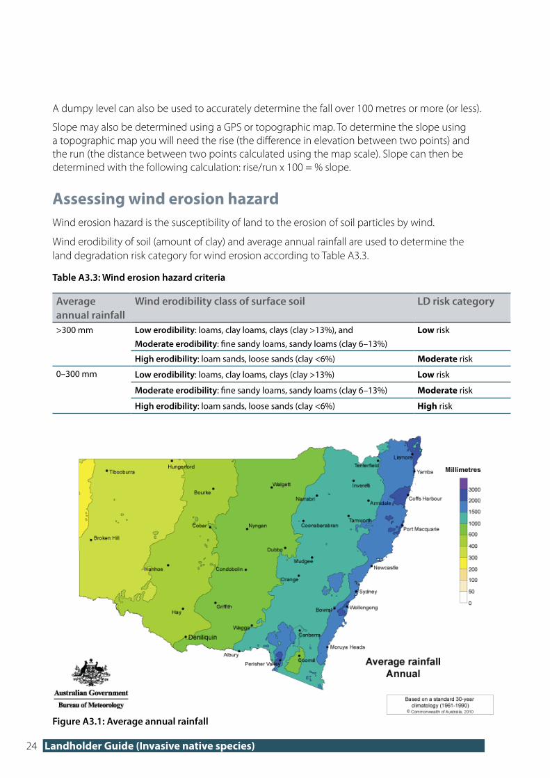
Assessing wind erosion hazardWind erosion hazard is the susceptibility of land to the erosion of soil particles by wind.
Wind erodibility of soil (amount of clay) and average annual rainfall are used to determine the land degradation risk category for wind erosion according to Table A3.3.
Table A3.3: Wind erosion hazard criteria
Average annual rainfall
Wind erodibility class of surface soil LD risk category
>300 mm Low erodibility: loams, clay loams, clays (clay >13%), and
Moderate erodibility: fine sandy loams, sandy loams (clay 6–13%)
Low risk
High erodibility: loam sands, loose sands (clay <6%) Moderate risk
0–300 mm Low erodibility: loams, clay loams, clays (clay >13%) Low risk
Moderate erodibility: fine sandy loams, sandy loams (clay 6–13%) Moderate risk
High erodibility: loam sands, loose sands (clay <6%) High risk
Figure A3.1: Average annual rainfall

25 Invasive native species self-assessable code
The map above shows the average annual rainfall over the period 1961 to 1990.
Go to the Bureau of Meteorology (BOM) website at www.bom.gov.au for more detailed average rainfall information, or phone your regional BOM office.
Assessing soil texture
Soil texture refers to how coarse or fine the soil is; that is, how much sand, silt and clay it contains. Texture has a major influence on how much water a soil can hold; generally, the smaller and finer the soil particles (the more silt and clay), the more water a soil can hold, and the less susceptible it is to wind erosion with adequate rainfall.
Soil texture can be estimated by hand using the ribboning technique illustrated in Figure A3.2, noting that it takes practice to produce a consistent result.
Carry out this ribbon test on a sample of soil from the area to be cleared using the self-assessable code. If soil differs across the area to be cleared, assess each area separately.
1. Take a small handful of soil. 2. Add enough water to make a ball. If you can’t make a ball, the soil is very sandy.
3. Feel the ball with your fingers to find out if it is gritty (sand), silky (silt) or plastic/sticky (clay).
4. Reroll the ball and with your thumb gently press it out over your forefinger to make a hanging ribbon.
5. If you can make a short ribbon, your soil texture is loamy, a mixture of sand and clay.
6. The longer the ribbon, the more clay is in your soil.
Figure A3.2: The ribbon test for soil texture

26 Landholder Guide (Invasive native species)
Do this several times for confirmation and compare the average ribbon length with those in Table A3.4. Each soil texture is classified within a ribbon length range (for example, sandy clay loam ribbon length is 25–40 mm long).
Once a consistent ribbon length is being produced, you can be reasonably confident that the correct soil texture has been identified.
Table A3.4: Soils textures using the ribboning technique
Broad group Texture grade Behaviour of the soil ball Ribbon length (mm)
Sands
Sand Ball will not form 0
Loamy sand Ball just holds together 5
Clayey sand Ball forms, sticky-clay stains fingers 5–15
Sandy loamsSandy loam Ball forms, feels sandy, but spongy 15–25
Silty loam Ball forms, feels smooth and silky 25
LoamsLoam Ball forms, feels smooth and spongy 25
Sandy clay loam Ball is firm, feels sandy and plastic 25–40
Clay loamsSilty clay loam Ball is firm, smooth, silky, plastic 40–50
Clay loam Ball firm, feels smooth and plastic 40–50
Clays
Light clay Ball very strong, feels plastic 50–75
Medium clay Ball very strong, feels like plasticine 75+
Heavy clay Ball very strong, stiff plasticine 75+
Assessing shallow and rocky soil hazard
Shallow soils and rockiness increase the land degradation risk category.
Average soil depth and percentage exposure of rocky outcrops are used to determine the risk category for shallow and rocky soil hazard according to Table A3.5.
Table A3.5: Shallow and rocky soils hazard criteria
Soil depth (cm) Rocky outcrop (per cent coverage)
LD risk category
>50 0–30 Low risk
>30–50 Moderate risk
>50 High risk
0–50cm 0–30 Moderate risk
>30 High risk

27 Invasive native species self-assessable code
Soil depth
Average soil depth is the depth from the soil surface to bedrock. If weathered rock is loose and friable it may be included within the soil depth. If you are unsure of the soil depth, look for an existing excavation (e.g. road batter), obtain a soil core sample or dig a hole.
Estimating rocky outcrop coverage
Rocky outcrops are rocks or stone that can be seen above the soil surface. Avoid using clearing types involving soil disturbance in areas with rocks or stones. The percentage of rocky outcrops can be estimated using a visual assessment, a step point method or mapping the rocky outcrops to determine the area of clearing and area of rocky outcrops. A percentage can then be calculated using the areas mapped.

28 Landholder Guide (Invasive native species)
Appendix 4 – How to measure stem diameterSome clearing types include a maximum allowable diameter at breast height over bark (DBHOB) that is allowed to be cleared. The diameter is measured 1.3 metres from the ground. If there are multiple stems on a tree then the diameter is measured on the largest stem.
Figure A4.1 shows a simple way of measuring DBHOB. A special DBHOB measuring tape can be used for a more accurate measure.
Figure A4.1: Measuring diameter at breast height over bark (1.3 metres above ground)
Paul
The
akst
on/W
este
rn L
LS

29 Invasive native species self-assessable code
Appendix 5 – Checklists
This section provides checklists for each clearing type.
Use the checklists to ensure you consider all of the relevant factors when using the INS self-assessable code.
It is recommended you keep the completed check list on file with any other records relevant to the assessment. It is also very useful to keep photos of the clearing area from before and after the clearing.
Checklist for clearing type a) Management burning
INS extent
The area contains at least one INS species listed in my LLS Region (refer to Appendix 1).
The INS species are acting invasively (refer to Section 4).
I have calculated the INS extent on my landholding (refer to Section 7).
How much can be cleared?
No more than 80 per cent of the INS will be burned and a minimum of 20 per cent will be retained. Containment measures will be in place so that at least 20 per cent of the INS is not burned.
General conditions
Clearing will not result in a change of land use from grazing to cropping.
All native groundcover, retained individuals of the INS and all non-INS will be retained following clearing.
Clearing will re-establish native vegetation or allow natural regeneration of native vegetation to maintain or create a mosaic of native vegetation across the landscape.
Clearing of non-INS will be limited to the minimum extent necessary to clear the INS.
The Thinning or Paddock Tree Ministerial Orders have not been used in the area to be cleared.
Additional conditions
Burning will not result in soil surface disturbance (excludes construction of fire breaks).
Non-native vegetation will not be intentionally introduced into the cleared area.
Other considerations and approvals
I have all the other approvals I need and have contacted the RFS to discuss my management burn (refer to the fact sheet How to obtain other approvals).
Noti�cation
I have notified 14 days before I want to clear (refer to the fact sheet The notification process).

30 Landholder Guide (Invasive native species)
Checklist for clearing type b) Clearing individual plants with nil to minimal disturbance to soil and groundcover
INS extent
The area contains at least one INS species listed in my LLS Region (refer to Appendix 1).
The INS species are acting invasively (refer to Section 4).
I have calculated the INS extent on my landholding (refer to Section 7).
How much can be cleared?
No more than 80 per cent of the INS extent will be treated and 20 per cent will be retained untreated.
General conditions
Clearing will not result in a change of land use from grazing to cropping.
All native groundcover, retained individuals of the INS and all non-INS will be retained following clearing.
Clearing will re-establish native vegetation or allow natural regeneration of native vegetation to maintain or create a mosaic of native vegetation across the landscape.
Clearing of non-INS will be limited to the minimum extent necessary to clear the INS.
The Thinning or Paddock Tree Ministerial Orders have not been used in the area to be cleared.
Additional conditions
Clearing will only be undertaken by clearing of individual INS plants with minimal disturbance to soil and groundcover (<30 per cent of total area).
Plants of the INS species requiring retention will be retained at the densities specified in Appendix 1. Where more than one INS species is present in the area to be cleared, up to 20 stems per hectare will be retained and these will be in the same proportion as currently exists.
Individual plants of INS with a DBHOB greater than the ‘maximum DBHOB allowed to be cleared’ as listed in Appendix 1 will be retained (refer to Appendix 4 for measuring DBHOB).
Any clearing within 30 metres of a water body will be undertaken by removing individual trees and woody shrubs with no disturbance to soil and groundcover (refer to the fact sheet Determining distances from water bodies).
Non-native vegetation will not be intentionally introduced.
Other considerations and approvals
I have all the other approvals I need (refer to the fact sheet How to obtain other approvals).
I have read the label(s) of herbicides and heeded all necessary advice when using this control method.
Noti�cation
I have notified 14 days before I want to clear (refer to the fact sheet The notification process).
31 Invasive native species self-assessable code
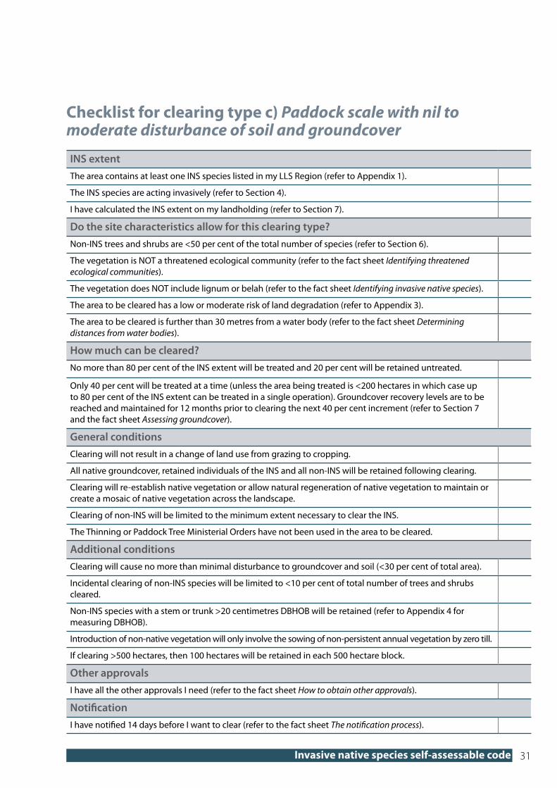
Checklist for clearing type c) Paddock scale with nil to moderate disturbance of soil and groundcover
INS extentThe area contains at least one INS species listed in my LLS Region (refer to Appendix 1).
The INS species are acting invasively (refer to Section 4).
I have calculated the INS extent on my landholding (refer to Section 7).
Do the site characteristics allow for this clearing type?Non-INS trees and shrubs are <50 per cent of the total number of species (refer to Section 6).
The vegetation is NOT a threatened ecological community (refer to the fact sheet Identifying threatened ecological communities).
The vegetation does NOT include lignum or belah (refer to the fact sheet Identifying invasive native species).
The area to be cleared has a low or moderate risk of land degradation (refer to Appendix 3).
The area to be cleared is further than 30 metres from a water body (refer to the fact sheet Determining distances from water bodies).
How much can be cleared?No more than 80 per cent of the INS extent will be treated and 20 per cent will be retained untreated.
Only 40 per cent will be treated at a time (unless the area being treated is <200 hectares in which case up to 80 per cent of the INS extent can be treated in a single operation). Groundcover recovery levels are to be reached and maintained for 12 months prior to clearing the next 40 per cent increment (refer to Section 7 and the fact sheet Assessing groundcover).
General conditionsClearing will not result in a change of land use from grazing to cropping.
All native groundcover, retained individuals of the INS and all non-INS will be retained following clearing.
Clearing will re-establish native vegetation or allow natural regeneration of native vegetation to maintain or create a mosaic of native vegetation across the landscape.
Clearing of non-INS will be limited to the minimum extent necessary to clear the INS.
The Thinning or Paddock Tree Ministerial Orders have not been used in the area to be cleared.
Additional conditionsClearing will cause no more than minimal disturbance to groundcover and soil (<30 per cent of total area).
Incidental clearing of non-INS species will be limited to <10 per cent of total number of trees and shrubs cleared.
Non-INS species with a stem or trunk >20 centimetres DBHOB will be retained (refer to Appendix 4 for measuring DBHOB).
Introduction of non-native vegetation will only involve the sowing of non-persistent annual vegetation by zero till.
If clearing >500 hectares, then 100 hectares will be retained in each 500 hectare block.
Other approvalsI have all the other approvals I need (refer to the fact sheet How to obtain other approvals).
Noti�cationI have notified 14 days before I want to clear (refer to the fact sheet The notification process).

32 Landholder Guide (Invasive native species)
Checklist for clearing type d) Paddock scale with temporary disturbance of soil and groundcover
INS extentThe area contains at least one INS species listed in my LLS Region (refer to Appendix 1).
The INS species are acting invasively (refer to Section 4).
I have calculated the INS extent on my landholding (refer to Section 7).
Do the site characteristics allow for this clearing type?Non-INS trees and shrubs are <50 per cent of the total number of species (refer to Section 6).
The vegetation is NOT a threatened ecological community (refer to the fact sheet Identifying threatened ecological communities).
The vegetation does NOT include lignum or belah (refer to the fact sheet Identifying invasive native species).
The area to be cleared has a low or moderate risk of land degradation (refer to Appendix 3).
The area to be cleared is further than 100 metres from a water body (refer to the fact sheet Determining distances from water bodies).
How much can be cleared?No more than 80 per cent of the INS extent will be treated and 20 per cent will be retained untreated.
Only 40 per cent will be treated at a time (unless the area being treated is <200 hectares in which case up to 80 per cent of the INS extent can be treated in a single operation). Groundcover recovery levels are to be reached and maintained for 12 months prior to clearing the next 40 per cent increment (refer to Section 7 and the fact sheet Assessing groundcover).
General conditionsClearing will not result in a change of land use from grazing to cropping.
All native groundcover, retained individuals of the INS and all non-INS will be retained following clearing.
Clearing will re-establish native vegetation or allow natural regeneration of native vegetation to maintain or create a mosaic of native vegetation across the landscape.
Clearing of non-INS will be limited to the minimum extent necessary to clear the INS.
The Thinning or Paddock Tree Ministerial Orders have not been used in the area to be cleared.
Additional conditionsClearing will cause no more than temporary disturbance to groundcover and soil.
Incidental clearing of non-INS species will be limited to <10 per cent of total number of trees and shrubs cleared.
Incidental clearing of non-INS species with a stem or trunk >20 centimetres DBHOB will not exceed 20 stems per hectare and other stems will be retained (refer to Appendix 4 for measuring DBHOB).
Introduction of non-native vegetation will only involve the sowing of non-persistent annual vegetation as part of the clearing operation and will be limited to 3 times in 15 years from the date of notification.
If clearing >500 hectares, then 100 hectares will be retained in each 500 hectare block.
Other approvalsI have all the other approvals I need (refer to the fact sheet How to obtain other approvals).
Noti�cationI have notified 14 days before I want to clear (refer to the fact sheet The notification process).

33 Invasive native species self-assessable code
Checklist for clearing type e) Paddock scale with longer-term disturbance of soil and groundcover
INS extentThe area contains at least one INS species listed in my LLS Region (refer to Appendix 1).
The INS species are acting invasively (refer to Section 4).
I have calculated the INS extent on my landholding (refer to Section 7).
Do the site characteristics allow for this clearing type?Non-INS trees and shrubs are <50 per cent of the total number of species (refer to Section 6).
The vegetation is NOT a threatened ecological community (refer to the fact sheet Identifying threatened ecological communities).
The vegetation does NOT include lignum or belah (refer to the fact sheet Identifying invasive native species).
The area to be cleared has a low risk of land degradation (refer to Appendix 3).
The area to be cleared is further than 100 metres from a water body (refer to the fact sheet Determining distances from water bodies).
How much can be cleared?No more than 80 per cent of the INS extent will be treated and 20 per cent will be retained untreated.
Only 40 per cent will be treated at a time (unless the area being treated is <200 hectares in which case up to 80 per cent of the INS extent can be treated in a single operation). Groundcover recovery levels are to be reached and maintained for 12 months prior to clearing the next 40 per cent increment (refer to Section 7 and the fact sheet Assessing groundcover).
General conditionsClearing will not result in a change of land use from grazing to cropping except for short-term cropping.
All native groundcover, retained individuals of the INS and all non-INS will be retained following clearing.
Clearing will re-establish native vegetation or allow natural regeneration of native vegetation to maintain or create a mosaic of native vegetation across the landscape.
Clearing of non-INS will be limited to the minimum extent necessary to clear the INS.
The Thinning or Paddock Tree Ministerial Orders have not been used in the area to be cleared.
Additional conditionsIncidental clearing of non-INS species will be limited to <10 per cent of total number of trees and shrubs cleared.
Incidental clearing of non-INS species with a stem or trunk >20 centimetres DBHOB will not exceed 20 stems per hectare and other stems will be retained (refer to Appendix 4 for measuring DBHOB).
Introduction of non-native vegetation will only involve the sowing of non-persistent annual vegetation and will be limited to 3 times in 15 years from the date of notification.
If clearing >500 hectares, then 100 hectares will be retained in each 500 hectare block.
Other approvalsI have all the other approvals I need. If in the Western Division, have you contacted the Western Lands Commission regarding a cultivation permit? (refer to the fact sheet Other approvals).
Noti�cationI have notified 14 days before I want to clear (refer to the fact sheet The notification process).

www.environment.nsw.gov.au