Guideline 7 - Reporting on Mineral Titles€¦ · Web viewForms are to be completed using a word...
79
Guideline 7 - Reporting on Mineral Titles Guidelines for submission of exploration and resource reports under the Mineral Titles Act 2010 and Regulations DEPARTMENT OF PRIMARY INDUSTRY AND RESOURCES Page 1 of 79
Transcript of Guideline 7 - Reporting on Mineral Titles€¦ · Web viewForms are to be completed using a word...

Guideline 7 - Reporting on Mineral Titles
Guidelines for submission of exploration and resource reports under the Mineral Titles Act 2010 and Regulations
DEPARTMENT OF PRIMARY INDUSTRY AND RESOURCES Page 1 of 70

Guideline 7 - Reporting on Mineral Titles
TABLE OF CONTENTS
1.0 SOURCE REFERENCES AND AMENDMENTS...............................................................................4
1.1 Source References.............................................................................................................................4
1.2 Recent amendments...........................................................................................................................4
2.0 Introduction.......................................................................................................................................4
3.0 Reporting type and frequency.........................................................................................................5
3.1 Preliminary exploration.......................................................................................................................5
3.1.1 Airborne geoscientific surveys......................................................................................................5
3.1.2 Ground based activities................................................................................................................5
3.2 Annual reports....................................................................................................................................6
3.2.1 Reports of Nil Activity...................................................................................................................6
3.3 Final reports........................................................................................................................................6
3.3.1 Partial relinquishment reports.......................................................................................................6
3.3.2 Final surrender reports.................................................................................................................7
3.4 Expenditure report..............................................................................................................................7
3.5 Production report................................................................................................................................8
3.6 Reserves report..................................................................................................................................8
3.7 Core facility sampling report...............................................................................................................9
3.7.1 Return of materials.......................................................................................................................9
3.8 Notification of a significant discovery..................................................................................................9
4.0 Geological samples (drill core and cuttings)...............................................................................10
4.1 Notification of recovery.....................................................................................................................10
4.2 Submission and disposal..................................................................................................................10
4.3 Confidentiality...................................................................................................................................10
4.4 Examination and sampling of submitted core and cuttings..............................................................10
5.0 Amalgamated reporting.................................................................................................................11
5.1 Group reporting.................................................................................................................................11
5.2 Reporting on MLs and under the Mining Management Act..............................................................11
6.0 Confidentiality.................................................................................................................................11
7.0 Report Formats...............................................................................................................................13
7.1 File naming convention.....................................................................................................................13
DEPARTMENT OF PRIMARY INDUSTRY AND RESOURCES Page 2 of 70

Guideline 7 - Reporting on Mineral Titles
8.0 Acceptable media and labelling....................................................................................................15
8.1 File compression...............................................................................................................................15
9.0 Contacts..........................................................................................................................................15
10.0 How and where to lodge reports.................................................................................................16
11.0 Late or non-submission of required reports..............................................................................16
12.0 Content for annual and final reports..........................................................................................16
12.1 Title page........................................................................................................................................17
12.2 Abstract...........................................................................................................................................17
12.3 Copyright........................................................................................................................................18
12.4 Body of text.....................................................................................................................................18
12.4.1 Location, title history, physiography and access......................................................................18
12.4.2 Geological setting, exploration/mining history and exploration rationale.................................19
12.4.3 Exploration index map..............................................................................................................19
12.4.4 Geological activities and office studies.....................................................................................19
12.4.5 Remote sensing.......................................................................................................................19
12.4.6 Geophysical activities...............................................................................................................19
12.4.7 Surface geochemistry...............................................................................................................20
12.4.8 Drilling.......................................................................................................................................20
12.4.9 Geotechnical studies................................................................................................................21
12.4.10 Resources and reserve estimation/modelling........................................................................22
12.5 Conclusion and recommendations.................................................................................................22
12.6 References.....................................................................................................................................22
12.7 Photographs other than those in the body of the text.....................................................................22
13.0 Data formats and specifications.................................................................................................23
13.1 Tabular data....................................................................................................................................26
13.2 Report text......................................................................................................................................26
13.3 Maps, plans, figures, images and photographs..............................................................................26
13.4 GIS data..........................................................................................................................................27
13.5 Geophysical data other than seismic..............................................................................................27
13.6 Seismic data...................................................................................................................................28
13.7 Petrophysical and downhole geophysical data...............................................................................28
13.8 Spectral and alteration logs............................................................................................................28
13.9 Aerial hyperspectral data................................................................................................................28
DEPARTMENT OF PRIMARY INDUSTRY AND RESOURCES Page 3 of 70

Guideline 7 - Reporting on Mineral Titles
13.10 Computer modelling......................................................................................................................28
13.10.1 3D Model Objects...................................................................................................................28
13.10.2 Geophysical inversion............................................................................................................29
13.10.3 Numerical simulation..............................................................................................................29
13.10.4 Resource/reserve modelling and estimation..........................................................................29
14.0 Data standard specification – tabular data, metadata and templates.....................................30
14.1 Template Software..........................................................................................................................30
14.2 File header format...........................................................................................................................30
14.2.1 Metadata file header codes......................................................................................................31
14.2.2 Content of file templates for tabular data.................................................................................34
14.2.3 Description of individual templates for data submission...........................................................34
Appendix 1: DATA FILE Examples......................................................................................................37
Appendix 2: Glossary of abbreviations and terms............................................................................48
DEPARTMENT OF PRIMARY INDUSTRY AND RESOURCES Page 4 of 70

Guideline 7 - Reporting on Mineral Titles
1.0 SOURCE REFERENCES AND AMENDMENTS
1.1 Source ReferencesThroughout this document there are cross references to the source legislation ie the Mineral Titles Act and the Mineral Titles Regulations and to other relevant sections within this document. References to the Act are shown as “section X(y) of the Act” eg “section 17(3)(b) of the Act”, and references to the Regulations are shown as Regulation Z(y) eg Regulation 127(1). The references to other sections within these guidelines are shown in italics eg Section 3.2.
Copies of these and other guidelines, and approved forms under the Mineral Titles Act are to be found on the department website at https://nt.gov.au/minerals-energy.
1.2 Recent amendmentsThese reporting guidelines are complementary and subordinate to the Mineral Titles Act 2010 and its Regulations. The Guidelines will be updated from time to time. It is the responsibility of the titleholder to ensure that the latest version of the Guidelines is used when preparing a report or submitting expenditure or data.
28/11/2011, Version 1 release for the commencement of the Mineral Titles Act 2010 and superseding all previous versions of reporting guidelines relating to the Mining Act.
2.0 INTRODUCTIONThe mineral exploration industry in Australia generates a vast amount of geoscientific and resource information each year. This large investment in basic data gathering should be available for future explorers so that similar effort is not duplicated and new exploration models can be developed on the basis of earlier data. State/Territory agencies play a critical role in promoting effective and efficient mineral exploration in Australia by archiving statutory mineral exploration information and then releasing it back into the public domain for the use of future explorers.
These Guidelines have been produced to assist mineral title holders in the Northern Territory (NT) with the preparation and submission of statutory reports to the Department of Primary Industry and Resources (the “Department”) under the Mineral Titles Act 2010. All reports must cover the exploration, mining and other technical work undertaken on the title. Annual and final reports must be of sufficient standard and detail to substantiate the expenditures claimed, and the activities undertaken. Data must be presented in standard formats and be capable of reprocessing and/or reinterpretation by others in the future.
Under the Mineral Titles Act 2010, it is the responsibility of the titleholder to comply with statutory reporting requirements, even if the title is being operated or managed by another party. Reports on separate activities (eg ore reserve statements, feasibility studies) prepared by consultants or bodies other than the title holder, must be submitted as appendices to the annual report. Reports must be in the English language.
DEPARTMENT OF PRIMARY INDUSTRY AND RESOURCES Page 5 of 70

Guideline 7 - Reporting on Mineral Titles
Digital reporting is mandatory. The required digital formats follow nationally endorsed guidelines developed and maintained by the Government Geoscience Information Committee, a subcommittee of the Chief Government Geologists' Committee, with representatives from all jurisdictions. These national guidelines standardise file types and content to enable more consistent and complete reporting of activities by explorers that operate in a number of Australian jurisdictions. Adherence to these standards will also ensure that high quality reports, data and metadata will remain assessable to the mineral exploration industry and will provide a lasting information resource for future exploration. Hardcopy reports will only be accepted under exceptional circumstances and with prior permission.
Title holders need to be aware of the datum their data are in and explicitly state this information when supplying spatial data including maps. All spatial data is to be submitted and reported in the Geocentric Datum of Australia 94 (GDA94).
Reports that do not comply with the standards discussed in these Guidelines will be rejected which may result in late lodgment and thus incur late lodgement fees.
3.0 REPORTING TYPE AND FREQUENCY
3.1 Preliminary exploration
3.1.1 Airborne geoscientific surveys
Any explorer intending to undertake preliminary exploration by conducting an airborne survey over land for which they are not the title holder, or over land that has neither a granted mineral title or an application for a mineral title, or over land for which they are not the applicant for the mineral title, must first gain approval by submitting a request to the Minister no later than 30 days prior to any work being undertaken (section 17(3)(b) of the Act).
A report for the airborne survey, and all airborne data acquired as preliminary exploration must be supplied to the Department within 12 months of the approval date (Regulation 9). The report must contain:
the specifications of the approved airborne survey and of the equipment used for conducting the survey;
the data collected, including navigation data and details of all data processing;
any interpretations or conclusions made about the land surveyed; and
details of the expenditure for conducting the survey.
The report must meet the content requirements for an annual report with regard to the title page, abstract, location, geological setting, exploration rationale and details of the geophysical activities. The report must also meet the copyright requirements as outlined for annual and final reports in Section 12.3.
Preliminary exploration airborne survey data will be held confidential for 5 years where the explorer holds a granted title or has a current title application (Regulation 10(3)). If there are no titles or title applications by the explorer in an area covered by the survey the report may be released 6 months after the reporting date
DEPARTMENT OF PRIMARY INDUSTRY AND RESOURCES Page 6 of 70
Guideline 7 - Reporting on Mineral Titles
(Regulation 10(2)). When all or part of the title ceases to be in force, for whatever reason, the airborne survey data for the area no longer under title may be released (Regulation 10(4)).
3.1.2 Ground based activities
Under Part 2 of the Act an explorer can also undertake preliminary exploration on land that is either vacant, over which the explorer has a title application, or which is under application or held by other parties. Section 17(3) of the Act specifies preliminary exploration activities may include:
Examination of geological characteristics
Removal of small samples of minerals or extractive minerals for analysis
Although there is no mandatory reporting requirement for preliminary exploration work, it is possible to claim expenses in the first year of title provided the work is documented in the first annual report.
3.2 Annual reportsAnnual technical reports detailing all exploration and geoscientific activities on each EL, ELR or ML are to be submitted to the Department. Annual reports are due 60 days from the anniversary of the date of grant of the title (Regulation 78(1)).
Where an application for amalgamated or group reporting has been made and subsequently approved by the Department, the group annual report is due on the nominated reporting date (Regulation 87). It is expected that an application for amalgamated annual reporting be accompanied by an application for amalgamated expenditure reporting with a common nominated reporting date. See Guideline 2 “Amalgamated Reporting” for information required when applying for approval of amalgamated reports.
If expenditure has been claimed for an activity then the activity must be reported and the data submitted in the annual report (Regulation (78(3)). Data need only be submitted once, so if data from the title(s) being reported has already been submitted to the Department this information needs to be explicitly stated in the report (for example, a geophysical survey that also covers an adjoining title and was previously reported upon).
3.2.1 Reports of Nil Activity
An annual report is still required where there has been no activity and must follow the format described in Section 12 of these Guidelines. The report must state the purpose for which the title is held, provide a location map, title history, target commodity, the reason why there was no activity, when activity will be resumed and what the nature of the activity will be (Regulation 78(4)).
3.3 Final reports
3.3.1 Partial relinquishment reports
Partial relinquishment reports are those final technical reports required when only part of an EL or ELR is surrendered and no longer in force. Partial relinquishments may be mandatory, voluntary or as a result of
DEPARTMENT OF PRIMARY INDUSTRY AND RESOURCES Page 7 of 70

Guideline 7 - Reporting on Mineral Titles
replacement of a title in part by another title. Final reports are required to be submitted within 60 days after the date of surrender or relinquishment (Regulation 86(1)).
Partial relinquishment reports are immediately available for release and therefore should deal ONLY with work conducted on the area relinquished. The report will be released regardless of the fact it may contain work in retained areas. There are provisions to obviate the need to “cookie-cut” remote-sensed or geophysical data if the data subset is not meaningful or useful.
All analytical and geophysical data pertinent to the relinquished area must be included, even if it has been previously submitted in annual reports, unless the title holder consents to all annual reports containing relevant information on the relinquished area to be released. In this case the partial relinquishment report must contain information and data for that part of the final reporting year not previously reported, a summary of all exploration activities for the life of the title area and the reason why the area was relinquished.
A report in the prescribed format is still required even if there was no work in the relinquished area. The report must provide a location map, title history and state the target commodity, exploration rationale, and an explanation as to why the area was relinquished (Regulation 86(5)).
3.3.2 Final surrender reports
Final surrender reports are those final technical reports required when an EL, ELR or ML is surrendered, expires or is cancelled in its entirety (Regulation 86). The report must include a summary of all the exploration activity over the life of the mineral title. A complete title history must be included as well as the rationale for dropping the ground.
For convenience it is usual to combine the last annual report with the final report and therefore information and data for that part of the final year of tenure that has not been previously reported in an annual report should be included in the final report. This should be stated on the title page, for example, Fourth Annual and Final Report for EL 11111.
A final report for each EL may or may not be required if two or more ELs are amalgamated in their entirety. The requirement for a report is dependent on the reporting period and the work undertaken in the operational year prior to the original titles ceasing to be in force. However, if part of the area is surrendered at the time of amalgamation, a final report must be provided for the surrendered area of each EL involved.
If an EL or ELR is replaced by an ELR or ML such that they only partially overlap the original title, two final reports are required. One relates to work in the area not included in the new title, which becomes open file as usual for partial relinquishment final reports. The second final report is required for those areas of the original title that are included in the new title. This report will be kept confidential for five years.
If two or more EL or ELR titles are replaced in their entirety by an ELR or ML, a final surrender report will be required and may be kept confidential for five years.
DEPARTMENT OF PRIMARY INDUSTRY AND RESOURCES Page 8 of 70

Guideline 7 - Reporting on Mineral Titles
A report in the prescribed format is still required even if there was no work on the surrendered title. The report must provide a location map, a title history, a list of targeted commodities, the exploration rationale, and an explanation of why the title was surrendered.
3.4 Expenditure reportThe title holder must submit an expenditure report on the approved form for each operational year of a mineral title within 30 days of the anniversary of the grant date for an EL or ELR, and 60 days for an ML (Regulation 81(1)). The operational year will cover the same period as the annual report for the title.
Where an application for amalgamated expenditure reporting has been made and subsequently approved by the Department, the amalgamated expenditure report is due on the nominated reporting date (Regulation 87) It is expected that an application for amalgamated annual reporting be accompanied by an application for amalgamated expenditure reporting with a common nominated reporting date. See Guideline 6 “Amalgamated Reporting” for information required when applying for amalgamated reporting.
An expenditure report in the approved form is also required to cover part or all of a year not already reported when titles are surrendered. This report must accompany the final report.
Expenditure reports for MLs with approval for annual reporting concurrently with reports required under the Mining Management Act are due on the nominated reporting date.
Expenditure is reported in Australian dollars against admissible expenditure categories and includes details of exploration activities. Proposed expenditure and work program are also required for the coming operational year.. The annual (or final) technical report must substantiate the expenditure claimed. Information on admissible expenditure can be found in Guideline 6 “Benchmark minimum and admissible expenditure”
The expenditure form must be submitted in a digital format with appropriate settings (see Section 13.2). Hardcopy forms are not acceptable. Forms are to be completed using a word processor (in which case the signature can be typed) and converted to Portable Document Format (PDF) unless prior permission has been given to provide a PDF file based on a scanned copy. Contact details (email, a phone number, or both) must be provided in case more information is required. A backup contact can also be nominated; neither has to be the same person who signs the form.
The form is to be named according to the file naming convention detailed in Section 7.1. Use of this form and the naming convention is mandatory and failure to submit a correctly completed expenditure form on time will result in late lodgement fees being charged.
If a section of expenditure is not relevant to your operations, insert “not applicable” at the appropriate section.
DEPARTMENT OF PRIMARY INDUSTRY AND RESOURCES Page 9 of 70

Guideline 7 - Reporting on Mineral Titles
3.5 Production reportA production report is required on annually for each ML (Regulation 84) or EML (Regulation 85) within 14 days after the end of the financial year. Those MLs granted for purposes ancillary to mining are not required to lodge a production report.
Reports must be submitted using either the approved form for mineral production (MLs) or extractive production (EMLs). One form is required for each group of titles included in a single authorisation under the Mining Management Act but the production figures are required to be reported separately for each title within the authorisation. If there exists more than one operating mine on a single title a separate production report is required for each mine/orebody.
The required units of measure are specified on the approved form but in general all production figures and grades must be reported in SI units unless otherwise acceptable to the Department eg carats for diamonds.
Reports will not be accepted unless correctly formatted and on the approved form. The production report may be combined with the reserves report as one document. Failure to submit a report on time will incur late lodgement fees.
3.6 Reserves reportA summary of reserves and resources is required annually for each ML (Regulation 84) and ELR (Regulation 83) within 14 days after the end of the financial year. Those MLs granted for purposes ancillary to mining are not required to lodge a reserves report.
All reports must be submitted using the approved form. One form is required for each group of titles included in a single authorisation under the Mining Management Act. Each ELR not covered by an authorisation under the Mining Management Act must be reported separately. Resources and reserves must be able to be substantiated.
Reporting requirements shall be those recommended in The Australasian Code for Reporting of Exploration Results, Mineral Resources and Ore Reserves as issued by the Joint Ore Reserves Committee (JORC) of The Australian Institute of Mining and Metallurgy, Australian Institute of Geoscientists, and Minerals Council of Australia in December 2004 (JORC Code 2004 edition), or later versions of the JORC code as it is revised from time to time.
Reports will not be accepted unless correctly formatted and on the approved form. The reserves report may be combined with the production report as one document. Failure to submit a report on time will incur late lodgement fees.
3.7 Core facility sampling reportAlthough not required under the Mineral Titles Act unless expenditure for the activity is claimed against a title, the Department requires reports describing any chemical, physical, geophysical, biostratigraphic or other studies done on material at, or removed from, its Core Facilities. The results of any non-destructive testing or assaying (eg handheld XRF, spot chemical tests) undertaken on the premises must also be reported.
DEPARTMENT OF PRIMARY INDUSTRY AND RESOURCES Page 10 of 70

Guideline 7 - Reporting on Mineral Titles
The report must be a text PDF as described in Section 13.2.
The report must contain a title page with the following information:
titleholder (where part of authorised activities on a mineral title)
project operator (if different from above)
report title including the report type ie core facility sampling report, and current titles if relevant
date of sampling
either a corporate, or personal author, or both,
a date of compilation and/or submission
the names of the standard NT 1:100 000- and 1:250 000-scale mapsheets to which the drill core relates
The report should clearly state the rationale behind the sampling and summarise the results and interpretations. Details of the sampling, processing and analytical methods should be included. Reports that merely present data will be rejected. Numerical tabular data (assays etc) must follow the same digital data formats described in Section 14.0. Please ensure that the results can be matched back to the sampled material using original hole identifications or numbers and depth intervals.
If a titleholder is sampling material and intends to claim expenditure against a granted title, this must be stated and the title number(s) given when requesting to sample the core. Otherwise, the report will be immediately available for public release unless otherwise negotiated with the Department. If the core sampling has been claimed as exploration expenditure the core sampling report should also be included as an appendix in the relevant annual report or reports and it will be subject to the same confidentiality conditions as the annual report.
3.7.1 Return of materials
All unused sample residues or off-cuts must be returned to the core facility from which they came within six months. All such material must be clearly labelled to match the material in the core facility. The only exceptions to the return of materials are if:
the material removed from the core facility becomes part of a catalogued museum or university collection and the person responsible for the sampling can confirm this in writing with catalogue number(s) from that institution
the residual material is of insufficient quantity (nominally less than 5 gm per sample) to warrant return; this requires written approval from the Department.
Failure to return materials may jeopardise further requests for sampling.
DEPARTMENT OF PRIMARY INDUSTRY AND RESOURCES Page 11 of 70

Guideline 7 - Reporting on Mineral Titles
3.8 Notification of a significant discoveryOn the discovery of a significant mineral occurrence a titleholder is required to notify the Department within 28 days (Section 32(2)(b) of the Act). The brief report is to include details of the type of occurrence or deposit, the location, including coordinates, a summary of the geological setting and current estimates of size and grade.
4.0 GEOLOGICAL SAMPLES (DRILL CORE AND CUTTINGS)
4.1 Notification of recoveryThe Department must be notified of the recovery of drill core and cuttings on an EL, ELR or EMEL under section 93(1) of the Act. The Department accepts the notification as part of the annual report for ELs and ELRs. A separate notification is required for EMELs.
4.2 Submission and disposalDrill core and cuttings from an EL, ELR or EMEL are to be offered to the Department when authorised activities cease or the title area under which drilling occurred is no longer in force (Section 93(3) of the Act). A form to assist in the offer of geological samples is available on the website. The samples are assessed for inclusion in the departmental collection and if selected, details of the samples are to be provided on the approved form, “Geological Sample Submission Form” and a submission date negotiated prior to delivery. Drill core and cuttings must be delivered to the Core Facility closest to the location of the mineral title on which the samples were collected. The drill core and cuttings are stored for public viewing and once released to open file, and if sufficient sample exists, are also available for further sampling and analysis. If the samples are not accepted for inclusion in the Core Facilities the titleholder is authorised to dispose of the samples.
The titleholder must not dispose of any core without the written permission of the Department (Section 93(4) of the Act). The current titleholder is also responsible for all core obtained from their title, regardless of it having been acquired by a previous holder of that title or by a joint venture partner or operator on the current title. The titleholder is also responsible for any actions by other parties that may jeopardise the integrity or availability of the core.
In addition to the requirements of Section 93 of the Act detailed above the Department may request geological samples at any time during the life of a mineral title, including a Mineral Lease (Regulation 127(1)).
4.3 ConfidentialityGeological samples submitted to the Department from a current EL or ELR are closed file for the same period as the annual report covering the reporting year in which they were required to be notified, that is, five years from the due date of the annual report (Regulation 128(3)). If a geological sample is submitted under Regulation 127(1) the sample is also closed file for a period of 5 years after the due date of the annual report in which it was notified.
Any geological sample from an EMEL given to the Department while the title over the land on which it was obtained is in force is closed file for five years after the date of the notification of recovery.
DEPARTMENT OF PRIMARY INDUSTRY AND RESOURCES Page 12 of 70

Guideline 7 - Reporting on Mineral Titles
Geological samples submitted to the Department subject to the partial relinquishment or full surrender of a title are immediately available for public access.
4.4 Examination and sampling of submitted core and cuttingsGeological samples submitted to the department are available for examination, viewing and sampling once they become open file (Regulation 128). A person may apply to remove part of a submitted geological sample for analysis. The application must be made using the approved form, available from the website. See Section 3.7 Core facility sampling report for details of reporting requirements.
5.0 AMALGAMATED REPORTING
5.1 Group reportingTitles may be amalgamated for annual and expenditure reporting purposes if they satisfy certain criteria (Regulation 87). This allows titleholders to report exploration activities on a project basis and facilitates reporting of regional geophysical or geochemical surveys across adjacent titles. This type of amalgamated reporting is referred to as group reporting.
Grouped annual reports must clearly distinguish work conducted on individual titles within the reporting group. Final surrender reports for complete cessation of a title included in a group reporting application will have to include all details of the work undertaken on the title since the date of grant, in the same manner as a partial relinquishment report. This is required because the annual reports for the preceding 5 years will ordinarily remain confidential due to the inclusion of information on work undertaken for other titles still in force within the reporting group.
A grouped expenditure report for the titles included in the group reporting application is to be submitted separately to the annual report but cover the same reporting period. Expenditure is to be identified against individual titles using the approved form for each. The grouped annual and expenditure reports are due on the approved group reporting date.
An application or an amendment for group reporting is to be made on the approved form “Amalgamated reporting – application and amendment”. See Guideline 2 “Amalgamated Reporting” for information on the conditions under which an application for amalgamated reporting can be made. The reporting date for the group is nominated by the applicant as required by Regulation 87(4) and approved in consultation with the applicant. The first grouped report will cover varying periods for each individual title if they have been granted on different dates.
If a title is removed from a reporting group then the normal reporting conditions under Regulation 78 apply (see Section 3.2). A bridging annual report may be required depending upon the date of the last group report relative to the anniversary date of the title.
Group reporting may be revoked by the Department at anytime for any reason including non-compliance.
DEPARTMENT OF PRIMARY INDUSTRY AND RESOURCES Page 13 of 70

Guideline 7 - Reporting on Mineral Titles
5.2 Reporting on MLs and under the Mining Management ActAn application may be made to submit annual and expenditure reports for MLs at the same time as reports due under the Mining Management Act. If approved, the reports remain separate but share the same reporting date and cover the same reporting period.
6.0 CONFIDENTIALITYAnnual and final reports submitted to the Department are kept confidential (closed file) until released to the public.
All annual reports may be released to open file five years after the date of lodgement. If the mineral title to which the annual report relates ceases to be in force the report may be released at any time after the cessation (Regulation 125(3)(a)).
A final report may be released to open file at any time after the report is lodged (Regulation 125(3)(a)), provided there is no replacement title. If the title is succeeded by a replacement title, the final report may be released five years after the date of lodgement. The annual reports for the original title will continue to be released five years after their individual dates of lodgement.
If part of a title ceases to be in force and is not succeeded by a replacement title, the final report, called a partial relinquishment report in these Guidelines, may be released at any time after relinquishment.
Expenditure reports remain confidential but non-identifying data may be used to produce statistics and summary reports which will be available to the public.
Production reports and reserve reports remain confidential but the data may be used to produce statistics and summary reports which will be available to the public, and to other government agencies.
7.0 REPORT FORMATS
7.1 File naming conventionFile names should conform to the following file naming convention:
Title id_YYYY_[G|A|P|S|E]_ ##_ {data type}.eee
Where:
Title id is an identifier for the title, or in the case of group reporting, the group reporting number is used; there is no space between the title type/prefix and the number ie EL12345 and a dash is used in the group reporting number between the number and the two digit year ie GR142-09.
YYYY is a four-digit report date representing year in which the report is due (not the year of submission).
DEPARTMENT OF PRIMARY INDUSTRY AND RESOURCES Page 14 of 70

Guideline 7 - Reporting on Mineral Titles
[G|A|P|S|E] uses one or more of these letters where they denote respectively a Group, Annual, Partial relinquishment, Surrender or Expenditure form respectively, these letters can be used in combination in the order in which they are listed eg a combined annual and final surrender uses both A and S, a group annual is GA, and a group expenditure is GE
## is a two digit sequential integer for each file submitted as part of the report.
{data type} either denotes the data type contained in the file corresponding to one of the abbreviations in Table 7 or for documents appended to the report, the appendix number eg appendix4,
.eee is the file suffix as shown in Table 5.
For example, the file EL22222_2010_04_drillcollars.txt would be the fourth file of the 2010 report for Exploration Licence 22222 and would contain tabular data in ASCII text format. A large document included in the report as an appendix and that has been split in two would be named EL22222_2010_03_appendix2.pdf and EL7766_200004_04_appendix2.pdf. Further examples are given in the table below:
Table 1. Examples of file names.
Type of File
Description of file Name of title
File name
Report File
Expenditure form ML 122 ML122_2010_E.pdfAnnual report, body of text part one ML 234 ML234_2010_A_01.pdfAnnual report, body of text part two ML 234 ML234_2010_A_02.pdfAnnual report text with no data EL 12345 EL12345_2010_A.pdfPartial relinquishment report text with no data
EL 12345 EL12345_2010_P.pdf
Final report text with no data EL 12345 EL12345_2010_S.pdfGroup annual report text with no data EL 1111,
EL 1112GR180-09_2010_GA.pdf
Combined annual and final text with no data
EL 1111 EL1111_2010_AS.pdf
Tabular Data
Drilling location file in the annual report EL 12345 EL12345_2010_A_02_DrillCollars.txtGeochemical analysis for drillhole samples in a final report
EL 12346 EL12346_2010_S_02_DownholeGeochem.txt
Downhole geological data for the above; EL 12346 EL12346_2010_S_03_DownhGeol.txtAppended text document of petrographic descriptions in a partial relinquishment report
EL 12345 EL12345_2010_P_03_Appendix1.pdf
Compressed file containing Appendix of .jpg core photos for group annual report
EL 12301 EL 12302
GR123-10_2010_GA_04_Appendix2.zip
Locations and assays of soil sampling for group annual report
EL 12301 EL 12302
GR123-10_2010_GA_05_SurfaceGeochem.txt
Example of a Complete Report – combined annual and surrender
Combined annual and final text EL 33333 EL33333_2010_AS_01.pdfAppendix – consultant’s report recommending no further work
EL33333_2010_AS_02_Appendix1.pdf
Assays of geochemical sampling with locations
EL33333_2010_AS_03_surfacegeochem.txt
QA/QC data for assays of rockchip sampling
EL33333_2010_AS_04_QAQCGeochem.txt
Drilling locations EL33333_2010_AS_05_ DrillCollars.txtDownhole survey data for the above drillholes
EL33333_2010_AS_06_DownholeSurveys.txt
DEPARTMENT OF PRIMARY INDUSTRY AND RESOURCES Page 15 of 70

Guideline 7 - Reporting on Mineral Titles
Geochemical analysis for drillhole samples
EL33333_2010_AS_07_DownholeGeochem.txt
QA/QC data for assays of downhole geochemical samples
EL33333_2010_AS_08_QAQCGeochem.txt
Downhole geological data/logs EL33333_2010_AS_09_Lithologs.txtLithological codes used by company for geological logs
EL33333_2010_AS_10_LithologyCodes.txt
Summary of drilling on title EL33333_2010_AS_11_DrillingSummary.txtAeromagnetic data GDF format EL33333_2010_AS_12_Aeromag.datAeromagnetic data GDF format EL33333_2010_AS_13_Aeromag.dfnAeromagnetic data GDF format EL33333_2010_AS_14_Aeromag.desFile verification listing EL33333_2010_AS_15_FileListing.txt
DEPARTMENT OF PRIMARY INDUSTRY AND RESOURCES Page 16 of 70

Guideline 7 - Reporting on Mineral Titles
8.0 ACCEPTABLE MEDIA AND LABELLINGThe Department will accept the following media to deliver reports and data:
Email, the total report and data not to exceed 10MB
CD-ROM, no multisession, read only
DVD-ROM, no multisession, read only
Portable hard drive, non-returnable
USB flash drives, non-returnable
3592 tape cartridges for large volume data sets, specifically seismic field data
Discs must be read-only full-sized disks, all media must be compatible with the Windows operating system, and must be supplied in a hard protective cover. Large volume datasets such as seismic or hyperspectral data must be provided on DVD or industry standard 3592 tape cartridges.
All digital media must be checked for viruses prior to submission. Any media that contains suspicious material will be rejected.
All media must be individually labelled with the company name, title number(s), report type and period, and numbered media, for example 1/5. A list of all files is to be included with the report (File verification listing in Table 1).
The titleholder or operator should keep a digital back-up copy of the report and data submitted to the Department for at least a year to cover the possibility of physical damage, data loss or corruption.
8.1 File compressionFiles may be submitted in compressed form. The only acceptable formats are ZIP, RAR and ECW. Self-extracting executable files are not acceptable because of potential problems with virus detection software. File names specified within the report and templates must be the original (expanded) files. Compressed files must expand into a single directory with no subdirectories. Compressed files must not be compressed into another compressed file. Compressed files are not to be used for joining several PDF files in lieu of submitting them in separate components.
9.0 CONTACTS
General enquiries about report submission should be directed to:
Exploration Evaluation Geoscientist
Ph: +61 8 8999 7816
DEPARTMENT OF PRIMARY INDUSTRY AND RESOURCES Page 17 of 70

Guideline 7 - Reporting on Mineral Titles
Email: [email protected]
DEPARTMENT OF PRIMARY INDUSTRY AND RESOURCES Page 18 of 70

Guideline 7 - Reporting on Mineral Titles
10.0 HOW AND WHERE TO LODGE REPORTSAll annual, expenditure, final, production and reserve reports must be lodged with:
Minerals and Energy InfoCentre
Northern Territory Geological Survey
Department of Primary Industry and Resources
GPO Box 4550
DARWIN NT 0801
or
3rd Floor Paspalis Centrepoint Building
48-50 Smith Street Mall DARWIN NT 0801
or emailed to [email protected].
If email is to be used, it must be a single email of the complete report and data and must not exceed 10 MB. Multiple emails to provide a single report and/or data are NOT acceptable. All material for large reports must be submitted on acceptable media and delivered to the address above rather than sent by email.
The Department will not accept the report until the total report is received and accepted as satisfactory in accordance with these Guidelines.
It is of no advantage and unnecessary to email the Department in advance to say that a report has been sent by surface delivery.
11.0 LATE OR NON-SUBMISSION OF REQUIRED REPORTS
If after the due date, the expenditure, annual or final report has not been received, or the content or format of these has been deemed to be incomplete or unacceptable, a warning will be issued to the titleholder to rectify the specific problem.
Late lodgment fees will be incurred if an acceptable report is not lodged with the Department by the due date. Fees commence the day after the due date and are charged for a maximum of 60 days. Following the 60 day period of late lodgement fees the Department can cancel all or part of a title. Late lodgement fees vary depending on the number of titles included in the report Non-submission of a group report may result in the group reporting status being revoked. Non-submission of a report may jeopardise the standing of the title holder with respect to further title applications.
DEPARTMENT OF PRIMARY INDUSTRY AND RESOURCES Page 19 of 70
Guideline 7 - Reporting on Mineral Titles
If a partial relinquishment report is not lodged with the Department by the end of the 60 day period in which late lodgement fees are incurred, all the relevant annual reports will be released to the public. This includes grouped annual reports regardless of whether any of the titles are still in force.
12.0 CONTENT FOR ANNUAL AND FINAL REPORTSAll reports must contain:
a title page with mandatory content as listed in Section 12.1
an abstract
a body of text structured under meaningful headings
a conclusion and recommendations for further work
references and appendices as appropriate.
Data sets structured and formatted as specified in Section 13.0
DEPARTMENT OF PRIMARY INDUSTRY AND RESOURCES Page 20 of 70

Guideline 7 - Reporting on Mineral Titles
12.1 Title pageAll reports must contain a title page which displays the following information:
Name of titleholder,
Name of project operator (if different from above), and may not be the same operator designated under the Mining Management Act)
Report Title including:
titles involved or for amalgamated reports, the group reporting number,
the report type using the specific terms “annual”, “partial relinquishment”, “final surrender”, “annual and final”,
title and project names if applicable
Reporting period as with a from and to date, or as the year ending on a specific date (avoid saying the “x th annual report” or “the report for 2010”),
A corporate or personal author, or both,
A date of compilation,
Target commodity or commodities,
The names of the standard NT 1:100 000 and 1:250 000 scale mapsheets relevant to the report.
Some examples follow:
EL 12345 “Red Spring” Partial relinquishment report, 30/6/2011
EL 12345 Annual report for the period 1/7/2010 to 30/6/2011
EL 12345 Bridging annual report for the period 1/2/2010 to 1/7/2010
EL 12345 Partial surrender report for the period 1/7/2010 to 30/6/2011
GR123/10 “Red Project” group annual report for the period 1/7/2010 to 30/6/2011
EL 12345 Combined annual and final report for the period 1/7/2010 to 30/6/2011
Contact details for the person(s) responsible for the technical content of the report must be supplied with each report. These will be the contacts used if the report is unsatisfactory. If such contact details are not initially supplied, the titleholder will be taken as the first point of contact.
12.2 AbstractThe report must contain a brief text-only abstract with no tables or figures. The summary must include discussion of the title history; refer to any relevant named prospects, commodity sought or mined, exploration rationale, geology, exploration activities during the reporting period and the main results and conclusions. A report on grouped titles should specify which titles were worked and which were not, with reasons.
DEPARTMENT OF PRIMARY INDUSTRY AND RESOURCES Page 21 of 70
Guideline 7 - Reporting on Mineral Titles
To facilitate data entry into the Department’s report management system it is appreciated if the summary does not contain headings, references, paragraph breaks, hyperlinks, bullet points or other special characters such as @, ® or ±.
It should clearly quantify the work undertaken, eg the wording “RAB drilling was undertaken” should be “Drilling consisted of 25 RAB holes for 804 m and 1200 samples”. Aerial geophysical surveys must be described with the total line kilometres, line spacing and flying height specified. Where data relevant to the report has been submitted previously, for example airborne geophysical data, this must be explicitly stated in the abstract. The result of any resource and reserve estimation must be included in the abstract in plain English. Partial relinquishment and final reports must clearly state why the ground was dropped and detail any form of replacement tenure if applicable.
DEPARTMENT OF PRIMARY INDUSTRY AND RESOURCES Page 22 of 70

Guideline 7 - Reporting on Mineral Titles
12.3 CopyrightAll annual and final reports submitted under the Mineral Titles Act 2010 must contain statements regarding copyright ownership (Regulation 126).
The person giving the annual or final report, the “relevant person”, must include a statement about that person’s ownership of copyright in part or all of the report, and if the statement relates to a specific part of the report, clearly identify the part. The relevant person must also authorise the Minister to publish information in which the copyright subsists where “publish” has the meaning under Regulation 10 or 125 of the Copyright Act 1968 (Cth). This includes authorising the department to copy and distribute the report and associated data (Regulation 126(3)(a)).
If another person owns the copyright in part of the report, then the report must include a statement about the other person’s ownership of copyright and clearly identify the part of the report in which the copyright subsists. Furthermore the report must state whether or not the other person has authorised the publication of the information in that part, and if not, briefly describe the steps taken to obtain the authorisation (Regulation 126(3)(b).
It is the responsibility of the relevant person to take all reasonable steps to obtain the other person’s written authority for the publication of the information contained in the report (Regulation 126(2)).
Reports must NOT include any material that is protected by copyright or prohibited from release by other laws (eg some aerial photos, some satellite imagery, data from technology embargoed by US International Traffic in Arms Regulations). Clients will be asked to resubmit reports that contain unacceptable material.
12.4 Body of textThe report must be as comprehensive as possible and must detail the work undertaken during the reporting period in sufficient detail to substantiate expenditure claims. Such work may include, but is not limited to, literature studies, remote sensing, geological mapping, petrological studies, isotopic studies, age dating, microprobe work, geophysical surveys, reprocessing of data, drilling, costeaning, surface geochemical surveys, underground investigations, and determining ore resources and reserves. Geotechnical work may include, but is not limited to, topographic surveys, rock quality designation, fracture density logging and other engineering studies, metallurgical testing, sterilisation drilling, drilling borefields, hydrogeological studies, metallurgical and mineral processing studies, mining feasibility, mine design studies, pilot plant testing and marketing studies etc.
Reports must NOT include any information, language, names or images that may be culturally sensitive, offensive or in confidence to Traditional Owners. For example no AAPA reports, locations or images of sacred sites, photos or names of persons recently deceased should be included. Clients will be asked to resubmit reports that contain unacceptable material. See also Section12.3.
12.4.1 Location, title history, physiography and access
This section must include discussion of location of the title(s) or project area, general physiography and discussion of any logistical constraints. State the type of land involved (eg Freehold Land, Aboriginal Freehold Land, Native Title Affected Land or National Park), and if relevant discuss the steps taken and the progress in gaining access, for example obtaining AAPA clearances.
DEPARTMENT OF PRIMARY INDUSTRY AND RESOURCES Page 23 of 70

Guideline 7 - Reporting on Mineral Titles
State the titles covered by the report, the area of the title(s), date of grant and, if relevant, the remaining period of tenure, and any corporate dealings eg transfers, JVs. If the title has resulted from amalgamation or has subsumed a former title(s) this needs to be stated. Any partial relinquishments must be mentioned. If the title is contiguous with other holdings by the same titleholder or is part of a project area as nominated by the titleholder, this must be stated.
All reports should include a scaled map detailing the title boundaries. The partial relinquishment report must contain a scaled block map which shows the blocks relinquished in relation to the area retained.
12.4.2 Geological setting, exploration/mining history and exploration rationale
The geological setting should be described in both regional and local context and named occurrences, prospects or mines are to be located on a map. Any relevant historical exploration and mining history should also be described.
For greenfields exploration, describe the empirical exploration philosophy, generic, genetic, conceptual or exploration models, targeting criteria (eg minimum target size and/or grade), the locations of known exploration targets, and exploration rationale. In the case of brownfields exploration, the philosophy behind the work (eg testing the lateral continuation of an ore body) must be stated.
12.4.3 Exploration index map
All reports must contain a scaled location map showing sample points and surveys in relation to boundaries of titles covered by the report.
12.4.4 Geological activities and office studies
Any literature searches must be demonstrated by the inclusion of a list of the references consulted. References to previous company reports should include Departmental CR numbers (see Section 12.6). Maps, GIS datasets, images or 3D models showing the results of all interpretations of existing data or reprocessed data (eg images of gravity worms generated and interpreted faults) must be provided.
Any area mapped geologically must be shown on a located, scaled map in relation to the title. The geological maps must be provided digitally at an appropriate scale, with a legend and accompanied by a discussion of the results. Geological maps must distinguish between geological 'fact' and interpretation by symbol or by separate maps. Other examples of geological work include structural studies, petrographic or petrological description.
If expenditure is claimed for the capture of legacy data or data reprocessing, that data must be supplied to the Department.
12.4.5 Remote sensing
Briefly describe the intention of the survey or the purchased dataset (eg LANDSAT, airborne multispectral surveys, or radar) and its specifications. Describe the results and interpretations. Images produced should be submitted as a georeferenced digital file (see Section 13.0). Where appropriate, the individual bands included in each image and their colour allocation should be identified. A brief description of the processes used to develop the image should also be provided.
DEPARTMENT OF PRIMARY INDUSTRY AND RESOURCES Page 24 of 70

Guideline 7 - Reporting on Mineral Titles
If the data are protected by copyright or other laws that prevent inclusion of data, contour maps or images (see Section 12.3), this must be stated and a representative stitched image or scaled interpretative plan included in the body of the report in lieu of the prohibited content.
12.4.6 Geophysical activities
Quantify the geophysical exploration or interpretation undertaken. Include:
a location plan which shows the boundaries of the data acquired in relation to the GDA94 datum and title boundaries. This can be a georeferenced image or a GIS data set (see Section13.4)
a quantitative description (eg line km flown, elevation and spacing) in each title or the percent of the survey in each title
any data or observations on terrain conditions, nature of ground, quality of electrical contacts, extent of drifts and quality of data etc to enable another explorer to extend or reinterpret the survey
discussion of what constitutes an anomaly; and how anomalies relate to geochemistry, geology and drilling results
interpretations of results, including a selection of key profiles and plans.
Both processed and unprocessed data, all associated metadata and details of the programs, must be provided in digital form.
12.4.7 Surface geochemistry
Quantify the geochemical investigation program, its rationale, results and its relationship to other components of the exploration program. These must be described in sufficient detail and in a format to allow the results to be used by another party. Note that raw geochemical data, details of the surveys, standards and blanks must be submitted in the appropriate templates (see Section 14.0).
In the body of the text include:
the types of surveys, eg rockchip, stream sediment sampling, vegetation sampling, water sampling, isotopic, age dating, microprobe, and these must be quantified for each title
the program rationale and design parameters for eg general location, determining the number of samples, sample spacing or grid orientation
a list or table of the elements, oxides, isotopes, etc analysed or other work undertaken
details of quality control including the use of blanks and duplicates as appropriate
advanced data processing and/or methods employed
interpretations of the results and methods employed (statistical techniques used, parameters used to define threshold and/or background), highlighting and quantifying anomalous values, areas, etc
processed data (eg gridded and contoured) and details of the processing techniques used is encouraged but optional
the location and availability of samples at completion of the exploration program
DEPARTMENT OF PRIMARY INDUSTRY AND RESOURCES Page 25 of 70
Guideline 7 - Reporting on Mineral Titles
sample locations (with sample numbers) on plans shown in relation to relevant geological features
a brief written statement of the sample preparation and analytical techniques, this is in addition to the proprietary codes from the laboratory included with the metadata given when submitting tabular data in accordance with the templates
information on any renumbering of the samples or changes to recorded spatial locations since first reported
The general location of anomalies should be reported and the peak results of the target elements tabulated in the body of the report as per the following example:
Table 2. Surface geochemistry record example
Sample Location Survey Sample Statistics
Sample Type
Sample Number Zone MGA East
(m)MGA North (m)
Peak Value Au (ppb)
No. of samples
Mean Au (ppb)
Median Au (ppb)
Standard Deviation Au (ppb)
Soil AA5001 53 424930 7823969 1132 250 31 42 6
12.4.8 Drilling
All drilling must be quantified in the body of the report and this section of the report must also include a scaled map or plan showing drill collars in relation to the title boundary or another acceptable frame of reference. Greenfields, brownfields and grade control drilling, stratigraphic, water bore drilling, and geotechnical drilling etc must be discussed separately. The type of drilling (eg percussion /diamond coring), total depths and depth ranges must be specified. All digital data including hole locations, orientation, and assay results must be provided in the appropriate format using templates (see Section 14.0). Geological logging codes are to be provided even if they have been given in previous reports.
DEPARTMENT OF PRIMARY INDUSTRY AND RESOURCES Page 26 of 70

Guideline 7 - Reporting on Mineral Titles
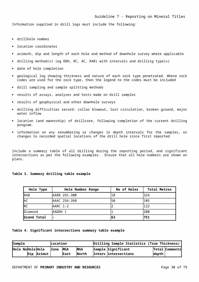
Information supplied in drill logs must include the following:
drillhole number
location coordinates
azimuth, dip and length of each hole and method of downhole survey where applicable
drilling method(s) (eg DDH, RC, AC, RAB) with intervals and drillrig type(s)
date of hole completion
geological log showing thickness and nature of each rock type penetrated. Where rock codes are used for the rock type, then the legend to the codes must be included
drill sampling and sample splitting methods
results of assays, analyses and tests made on drill samples
results of geophysical and other downhole surveys
drilling difficulties record: collar blowout, lost circulation, broken ground, major water inflow
location (and ownership) of drillcore, following completion of the current drilling program.
information on any renumbering or changes in depth intervals for the samples, or changes to recorded spatial locations of the drill hole since first reported
Include a summary table of all drilling during the reporting period, and significant intersections as per the following examples. Ensure that all hole numbers are shown on plans.
Table 3. Summary drilling table example
Hole Type Hole Number Range No of Holes Total MetresRAB AARB 291-300 10 324AC AAAC 256-260 50 105RC AARC 1-2 2 122Diamond AADDH 1 1 200Grand Total - 63 751
Table 4. Significant intersections summary table example
Sample Location Drilling Sample Statistics (True Thickness)
Hole No Hole Dip
Hole Azimuth Zone
MGA East (m) MGA
North (m)Sample Interval (m)
Significant intersections Total depth (m)
CommentsFrom (m) Cut-offs: 0.5 g/t Au,
5 g/t Ag
AARC1 60 180 53 424930 7823969 0.5 20 3m at 3.4 g/t Au 60Ironstone from 18 m to 24 m
AARC2 55 200 53 424980 78234980 0.5 22 4m at 4.1 g/t Au 62 Ironstone
DEPARTMENT OF PRIMARY INDUSTRY AND RESOURCES Page 27 of 70

Guideline 7 - Reporting on Mineral Titles
from 18 m to 24 m
Note: In the event that it is impractical to list all significant intercepts then list the best intersections giving the selection criteria, such as >5m and >1 g/t Au.
Section 13.1 Tabular data deals with the submission of drilling and downhole analytical data.
12.4.9 Geotechnical studies
All geotechnical work must be quantified in the body of the report. The spatial distribution of such studies or samples must be shown on a map in relation to the title boundaries. Separate detailed studies should be appended and all data must be provided digitally in the appropriate format.
12.4.10 Resources and reserve estimation/modelling
When estimates of mineral resources, or ore reserves, are first calculated, full details of these should be reported, together with plans and sections showing ore blocks and ore outlines, and included as a separate appendix or volume to the annual report. Major revisions of mineral resources or ore reserves should also be reported in full. However, annual updates and small revisions of resource or reserve estimates may be provided in summary form. Annual summary reserve reports are required for ELRs and MLs (see Section 3.6). The summary reports do not include details of the estimation and modeling.
Reporting requirements shall be those recommended in The Australasian Code for Reporting of Exploration Results, Mineral Resources and Ore Reserves as issued by the Joint Ore Reserves Committee (JORC) of The Australian Institute of Mining and Metallurgy, Australian Institute of Geoscientists, and Minerals Council of Australia in December 2004 (JORC Code 2004 edition), or later versions of the JORC code as it is revised from time to time.
Mining activities should be reported as tonnes and grades in SI units other appropriate units of measurement as deemed acceptable. Any other quantification of resource that is pre- or non-JORC compliant must be clearly stated as such. The body of the report must discuss:
the software used in resource/reserve calculation
the consultants (if any) employed
statistical techniques used
physical (eg bulk density) or chemical (eg limestone purity) properties used and how they were derived
details of, and quantification of, the types of drillhole intercepts, pits etc that were used in generating the resource or reserve
other determining factors eg overburden thickness, cut-off grade or recovery factor
If the resource estimation was undertaken by another party, their report in full must be appended. Reporting of coal reserves should follow the guidelines in AS2519–1986. It is essential to stipulate if resources are inclusive of reserves. The data may best be presented as a table.
DEPARTMENT OF PRIMARY INDUSTRY AND RESOURCES Page 28 of 70

Guideline 7 - Reporting on Mineral Titles
12.5 Conclusion and recommendationsThis section summarises and discusses the significant findings and interpretation of results obtained. This should be done in the context of exploration rationale, mine planning or future mining as appropriate. If relevant, it should also justify any shortfall in expenditure. If a proposed work program for the next reporting period is relevant, this needs to be briefly described and recommendations for further work included. If no further work is planned, the reasons need to be stated. Any plans for partial or complete surrender or change of tenure should be described.
12.6 ReferencesReferences should be cited. References to previous statutory reports should include the Company Report (CR) numbers assigned by the Department.
12.7 Photographs other than those in the body of the textSubmissions of outcrop, mine face and core photographs is encouraged. These must be high-quality colour photos and must be clearly labelled so as to be able to relocate the material photographed.
DEPARTMENT OF PRIMARY INDUSTRY AND RESOURCES Page 29 of 70
Guideline 7 - Reporting on Mineral Titles
13.0 DATA FORMATS AND SPECIFICATIONSThis section specifies acceptable data formats for the different types of data. The table below provides a summary and further explanation is available under the appropriate headings following the table.
Table 5. Summary of data formats and specifications
Data Type Description Format Parameter SuffixTabular data* Point locations,
geochemistry, heavy mineral, diamond indicator and drilling data
Tab Delimited ASCII Standard as described in Sections 13.1 and 14.0
.txt
Report text Documents, figures etc. previously provided only in hardcopy
Adobe Acrobat PDF See Section 13.2 .pdf
Maps, plans, figures and photographsnot embodied in report text
Files of maps, plans, figures, core photographs, aerial photographs etc.
Adobe Acrobat PDF
GEOTIFF/TIFF (colour)
JPEG
GIF
PNG
See Section 13.2
Reproducible at 300 dpi, 24 bit
Q>95, reproducible at 300 dpi
8 bit
.tif
.jpg
.gif
.pngGIS data Data in GIS format MapInfo Tab
ESRI Shape.tab.shp
Video clips Fly-throughs etc MPEGAvi
.mpg
.avi3D mine models and resource estimation
3D mine model data, resource/reserve models
See Table 6 See Section 13.10
3D modelling 3D models As appropriate to fulfil requirements in Section 13.10 ASCII .dxf files
See Section 13.10
.dxf
.txt Geophysics (other than seismic)
Raw and processedlocated data and gridded data. For example magnetics, radiometrics, EM, DTM and gravity data
ASEG GDF2
ASEG GXF (grid exchange format)ER Mapper grid
XML (including schema)
.dfn
.dat
.des
.gxf
.grd, .ers
.xml, .xsdGeophysical and other remotely sensed images
Images derived from geophysical / remote sensing surveys, e.g. TMI, Bouguer, radiometrics, Landsat 5 or 7
GEOTIFF/TIFF (colour)
TIFF (greyscale)
Reproducible at 300 dpi, 24 bit
Reproducible at 300 dpi, 8 bit
.tif
.tif
DEPARTMENT OF PRIMARY INDUSTRY AND RESOURCES Page 30 of 70

Guideline 7 - Reporting on Mineral Titles
Data Type Description Format Parameter Suffix
CompressedER Mapper
JPEGGIFPDFPNG
Best quality (least loss)
Quality as above8 bitSee Section 13.2
.ecw
.jpg
.gif
.pngGeophysical Inversion and Numerical Modelling
Models Points (DXF or ASCII)
Images
Surfaces
3D grids (UBC Grid or GoCAD Voxet)
See Section 13.2See parameters above for Geophysical Images
.dxf
.txt
.tif
.jpg
.gif
.png
.dxf
See Table 6
Seismic data Raw and processed data SEG Y, preferably Rev. 1
SEG D
.sgy
.sgdNavigation data UKOOA P1/90 .ukaProcessed sections(refer to Petroleum data submission guidelines for further information, www.ga.gov.au)
CGM+ format with metadata (line number, shotpoint number, …)
Images See parameters above for Geophysical Images
.cgm
.tif, .jpg, .gif, .pdf, .png
Petrophysical and geophysical log data
Raw and processed wireline and MWD data(refer to Petroleum data submission guidelines for further information, www.ga.gov.au)
DLIS and LISLAS
Delimited ASCII (format must be explained)
WELLOGML (POSC standard)
As defined by latest Industry Standard
Include schema
.lis
.las
.asc
.xml, .xsd
Log plots Adobe Acrobat PDF
TIFF (colour)
TIFF (greyscale)
JPEG
GIF
PNG
See Section 13.2
See parameters above for Geophysical Images
8 bit
.tif
.tif
.jpg
.gif
.png
DEPARTMENT OF PRIMARY INDUSTRY AND RESOURCES Page 31 of 70

Guideline 7 - Reporting on Mineral Titles
Data Type Description Format Parameter SuffixProcessed down-hole velocity data
SEG Y, preferably Rev. 1 .sgy
* proprietary formats will be accepted until an open-source International Standard is developed
*.TSG or FOS files are only accepted if accompanied by an equivalent ASCII file
Table 6. Summary of 3D model data types
Data Type Description Format Suffix3D Model Objects
3D spatial datasets including pit and underground design, mine development, geology and resources plus metadata
Attributed dxf export files. ASCII xyz export files Native software formats: Datamine
Earth Vision
GemCom
GoCAD Pointset
Leapfrog Attributed mesh Micromine
Surpac Block
.dxf
.txt
.asc
.dm
.dmb
.dm *tr.asc & *pt.asc *tr.dm & *pt.dm
.2grd
.dat
.nvflt
.3dr
.tri or .bt2
.vs
.pl
.ts
.vs
.sg
.msh
.dat, .sec, .stp, .str, .svy .dat .out geol.par .grd .tdb .dmp
.msr
.mdl
.str
.dtm
DEPARTMENT OF PRIMARY INDUSTRY AND RESOURCES Page 32 of 70

Guideline 7 - Reporting on Mineral Titles
Data Type Description Format Suffix
Vulcan Block model .inp .bdf & *.bmf_asc .svg _dgd1.dbl & .scd .00t .00t_asc
DEPARTMENT OF PRIMARY INDUSTRY AND RESOURCES Page 33 of 70

Guideline 7 - Reporting on Mineral Titles
13.1 Tabular data
These data include point locations, geochemistry, diamond indictor observations and drilling data. Data will be submitted as TAB delimited ASCII files with a suffix of .txt. File format details are provided in Section 14.0 Data standard specification – tabular data, metadata and templates and Appendix 1.
The required file format for tabular data is a "flat file" rather than a "relational" file system. This allows more flexibility in the format and also reduces the need for relational keys between files. However, some datasets, particularly drill logs incorporating lithological, geochemical, structural and other data, including authority / lookup tables, may have to be submitted as a series of "linked" flat files, appropriately documented.
The “MRT” software creates the metadata headers required for compliant tabular files. Compliant files of tabular data can be modified manually using any text editor.
13.2 Report textThe report text and associated tables, maps, plans and figures that are part of the main body of the report must be compiled in a single Portable Document Format (PDF) file, such that the file is less than 10 MB. The PDF security must be set to allow “copy and paste” and “print”, but not to “edit” the document. The file must be a text (not image) PDF.
PDF files created by software other than Adobe Acrobat must be able to be read by Adobe products. Only provide PDF files that are legible including the use of common standard fonts and readable maps and images. Avoid use of non-standard fonts as viewers of the documents may not have all the required fonts; Arial and Times New Roman are the safest option. Some software will create a PDF which looks correct in Adobe Reader but the special fonts will turn to meaningless characters when the text is copied and pasted. For ease of reading the text should use a font no smaller than 10 pt Arial or 11 pt Times New Roman.
The text must be in a read from “top to bottom” form; that is, if some pages are in landscape then pages must be rotated. For larger reports, both thumbnails and bookmarks are appropriate. Do not embed any files as attachments within the text PDF. All associated files must be separate. Hyperlinks from PDF documents may not work when the report is lodged into the report lodgment system.
When compressing or re-sampling image files, ensure that the final images have the resolutions and clarity for readers. Image resolutions have to be at least 75 dpi and the recommended resolutions for down hole logs is 150 dpi, but ensure that the final document size does not exceed the 10 MB limit. Any particularly high-quality graphics or georeferenced maps included within the text must be submitted as individual stand-alone image files (see below) and a thumbnail included in the report text as a placeholder. Where the single report PDF is too large (over 10 MB), it must be split into smaller PDF files and named according to the file naming conventions (see Section 7.1).
13.3 Maps, plans, figures, images and photographsDepending on the number involved and the file size, maps, plans, figures, photographs and other illustrations may be inserted into the appropriate places within the text document or may be grouped together in a separate section or appendix. Refer to Table 5 for formats and parameters.
All maps, plans, sections, figures, etc. must:
DEPARTMENT OF PRIMARY INDUSTRY AND RESOURCES Page 34 of 70

Guideline 7 - Reporting on Mineral Titles
have a metric scale bar
have a coordinate grid clearly marked and a label within the bounds of the map or plan that includes the datum and where relevant, the zone (52 or 53)
have a north point (grid, true and magnetic north) or orientation of sections
have a clear and comprehensive legend. We recommend using symbols defined in Symbols Used on Geological Maps, (1989) by the Bureau of Mineral Resources, Geology and Geophysics
distinguish between geological ‘fact’ and interpreted geology
show the author, acknowledged sources and date of drafting.
TIFF (.tif) is recommended for black and white and JPEG (.jpg) for greyscale or colour including photographs, but not for images containing text or line work.
Imagery will be primarily derived from geophysical surveys. Other imagery includes satellite, multispectral scanner and orthoimagery. Sufficient information should be provided to allow spatial registration of images where appropriate.
13.4 GIS dataCurrently, there is no international standard for data in GIS format but most common software is able to read the common proprietary formats. GIS data formats accepted are ESRI shape files (SHP) and MapInfo tab files (TAB).
Where practical the symbology of the GIS displayed data should be provided (e.g. an ESRI layer file (LYR) or legend file (AVI) or MapInfo workspace file (WOR).
13.5 Geophysical data other than seismicThese data include magnetic, gravity, radiometric and electromagnetic (including TEM, SIROTEM and airborne EM) surveys. For both raw and processed located data, the standard ASEG GDF2 format is required. All airborne geophysical contractors operating in Australia can supply located data in ASEG GDF2 format and gridded data in ER Mapper format.
Unless an exemption has been granted to not cookie-cut data (see Section 3.3.1 Partial relinquishment reports), the submission of images alone does not exempt companies from submission of the located geophysical data from which the images were derived.
In the case of airborne EM surveys, as much of the following located information as is pertinent to the type of survey conducted shall be supplied, in addition to the operational data (such as line number, sample position, terrain clearance etc) normally supplied for airborne surveys. Such additional data shall be sufficient to enable inversion of the data to the current extent implied by the type of survey conducted:
Raw EM data for each recorded component, if supplied by the survey contractor
Levelled, windowed and processed EM data for each recorded sample and component
DEPARTMENT OF PRIMARY INDUSTRY AND RESOURCES Page 35 of 70

Guideline 7 - Reporting on Mineral Titles
All channels of information computed from the processed EM data eg half-space apparent conductivities, layered earth apparent conductivities
Ancillary data such as those recorded by 50Hz monitors and spherics monitors
Tx-Rx vertical and horizontal separation tabulated with accompanying diagram, or Tx and Rx positions, for each sample if recorded dynamically
All parameters relevant to Tx and Rx moment and all orientation data
If a B-field sensor is used, all relevant sensitivity information
Tx current details and, if available, for each sample recorded dynamically
All reference or real-time waveforms recorded and suitable for calibration purposes
All calibration data relevant to the flight lines supplied
Full metadata including frequencies, waveform and duty cycle, window times, centres and widths, measurement units and details of any amplitude normalization
Full metadata about the EM data processing including a list defining the processing sequence employed and a quantitative description of each processing stage in the sequence sufficient that its effect on the data may be determined for future reference. Such descriptions may include references to published papers explaining the algorithms used
Any other recorded parameters relevant to the current processed or interpretive outputs or useful for the further processing or inversion of the data.
Much of the reference information required will be in the operations report which should be lodged with the data. It is required that gridded data be submitted in either ASEG GXF or ER Mapper gridded data format
The data format specifications maybe waivered for ground geophysical surveys of less than 1000 data points and/or over an area of less one square kilometre. Permission must be granted in advance.
13.6 Seismic dataInternational standards exist for seismic data and compliance with the following formats is required:
Raw and processed data - SEG Y (preferably Rev. 1) or SEG D, with file names including the survey name and line number where appropriate.
Navigation data - as a complete UKOOA P1/90 file.
Processed sections - CGM+ files complete with metadata, with the line number included within the file name. Images of processed sections may use geophysical image formats specified in Table 5.
Refer to Guidelines for reporting and submission of petroleum data at www.ga.gov.au for further details.
13.7 Petrophysical and downhole geophysical dataRaw and processed wireline (eg gamma or resistivity logs) and MWD data must be provided as DLIS, LIS, LAS, delimited ASCII or WELLOGML(POSC standard) files.
DEPARTMENT OF PRIMARY INDUSTRY AND RESOURCES Page 36 of 70

Guideline 7 - Reporting on Mineral Titles
Log plots are to be provided as either PDF, TIFF, JPEG, GIF or PNG files. Processed down hole velocity data should be provided in SEG Y (preferably Rev.1) format, with the well/hole name as part of the file name.
13.8 Spectral and alteration logsProprietary files generated by spectral and/or alteration logging hardware or by the display and interpretation software may be submitted in the native format but MUST be accompanied by a generic ASCII equivalent. For example, PIMA™ FOS files must be accompanied by one or more .txt and/or .emf files and, if necessary, .jpg files that contain the same data and are readable without using specialist software.
13.9 Aerial hyperspectral dataHyperspectral data must be submitted as reflectance-level data with all associated geocorrection files. In this form, the data has the full 125/128 bands while using minimum disk space, and will allow reprocessing in the future. Reflectance data must be submitted as .bil files, with accompanying .hdr header files and corresponding geocorrection information in .img and .glt files. Data older than 2004 may lack the .glt files or be at radiance level rather than reflectance. Mineral maps must also to be presented. All images must be georeferenced.
13.10 Computer modelling
13.10.1 3D Model Objects
Sufficient data and associated files to regenerate the models must be submitted. Supply regional and mine scale 3D model objects including points, lines, surfaces and volumes. Refer to Table 6 for formats.
Provide:
details of software and version used
model extents in GDA94 (MGA or latitude/longitude)
local grid transformation data if local grid is used
model points, lines and surfaces as ASCII .dxf files (or as ASCII point sets or ASCII line strings for point and line objects)
13.10.2 Geophysical inversion
Supply inputs to and results from geophysical inversion modelling, a description of the modelling process and a description of the model scope and purpose. Refer to Tables 5 and 6 for formats and parameters.
Provide:
a description of the aim and scope of the inversion project
details of software and version used
model extents in GDA94 (MGA or latitude/longitude)
DEPARTMENT OF PRIMARY INDUSTRY AND RESOURCES Page 37 of 70

Guideline 7 - Reporting on Mineral Titles
a description of the input datasets and constraints (eg using drill data)
a description of the modelling parameters (eg susceptibility, density, dimensions of body) used (control file)
Model outputs either as:
points (DXF or ASCII)
images – calculated, observed, residual
surfaces (DXF and/or file type described in Section 13.10.1)
3D grids (UBC Grid sus, bin and mesh files or GoCAD Voxet)
Include a brief description of model convergence and confidence level (Is the model a good fit for the data?).
13.10.3 Numerical simulation
Describe the model scope and purpose. Supply inputs, to and results from, numerical simulation modelling.
Refer to Table 6 for formats.
Provide:
a description of the aim and scope of the numerical simulation
details of software and version used
model extents in GDA94 (MGA or latitude/longitude)
a description of the input datasets and constraints
a description of the simulation parameters used (control file)
Model outputs in DXF, VRML, VTK, GoCAD or other appropriate format from the list in Section 13.10.1.
13.10.4 Resource/reserve modelling and estimation
Provide the data used to produce the estimate including:
details of software and version used
rock density estimate or measurement data
boreholes involved (collars, assays and down hole survey files)
additional grade information (eg bulk sampling data)
all relevant model points, lines and surfaces as ASCII .dxf files (or as ASCII pointsets or ASCII line strings for point and line objects)
DEPARTMENT OF PRIMARY INDUSTRY AND RESOURCES Page 38 of 70

Guideline 7 - Reporting on Mineral Titles
assumptions made (eg cut-off grade, overburden etc)
Refer to Table 6 for formats.
DEPARTMENT OF PRIMARY INDUSTRY AND RESOURCES Page 39 of 70

Guideline 7 - Reporting on Mineral Titles
14.0 DATA STANDARD SPECIFICATION – TABULAR DATA, METADATA AND TEMPLATES
Digital data must be submitted in common formats that will ensure that the data can be transferred directly into the Department’s database with minimal risk of transcription errors. Standardised templates have been developed as a basis for the national reporting guidelines produced by GGIC. These templates facilitate the submission of the most common types of digital data.
All such data must be accompanied by metadata or "data about the data". The standard recommended by ANZLIC for metadata should be used where appropriate. However, some data require more information for intelligent use, and some data require specific metadata covered under other international standards.
The metadata should provide sufficient information about the data for it to be used again. Metadata are to be presented in a file header at the top of the file of related tabular data (preferred), or as a separate file. The objective of including the metadata with the numerical data is to remove the need to search elsewhere to complete or comprehend a dataset. Details of the metadata file headers information required is in Tables 3 and 4 and the metadata headers (“templates”) in Examples 1 to 8 are discussed in the following sections.
Metadata should include:
location of the data (or a pointer to a file providing this information;
date the data were produced
date the data were altered
parameters controlling the data acquisition
parameters controlling the data’s alteration
name of the company for whom the data was produced, eg the title holder
titles(s) under which the data was produced
activity which produced the data, eg drilling
name of the contractor producing the data
any translation parameters required for conversion of the data (especially location data)
equipment used to generate the data
original format of the data
definition of codes.
DEPARTMENT OF PRIMARY INDUSTRY AND RESOURCES Page 40 of 70

Guideline 7 - Reporting on Mineral Titles
14.1 Template SoftwareThe software Mineral Reporting Template or MRT, available for download from the department website, captures the metadata and combines it with the relevant exploration data file. It prompts the user to choose a template relevant to the particular type of exploration data being submitted in the report. MRT formats this metadata according to the relevant template and inserts it as a header to the corresponding exploration data file. MRT then exports it in a comma delimited ASCII format (such as the .txt extension viewable in software like Excel) as required by the reporting guidelines.
14.2 File header formatThe metadata header is constructed in such a way as to present the information by category, and then by sub-category. The main rules with these file headers are:
1. The field number series and description fields are mandatory for data supplied and must be placed in the first and second positions respectively
2. Header data fields must be tab delimited and allow for several separate pieces of information for each header type
3. The national standard numbering system described below must be strictly adhered to (note that some numbers have been reserved by other jurisdictions or are no longer used)
4. Do not embed the delimiter in any of the fields
5. Where a header row is not relevant to that type of data in the file, it should be omitted (eg H0800 series (assay information) would be omitted from a collar file generated from the SL3 template
6. Where a piece of metadata is otherwise not relevant or unknown, state this rather than leave a blank field
7. Users may add additional specific data fields to the mandatory fields in the data section of any template file. This is accomplished by adding header fields to the H1000 series.
14.2.1 Metadata file header codes
The following table contains example codes and shows all available variants in use within the Australian jurisdictions. Some header codes have been reserved and/or used by earlier versions and are now not available for use.
Table 7. Version 4 metadata file header information
Fields in bold are mandatory, fields in italics are recommended, and fields in normal face are optional.
Field Title explanation in italics
Square brackets denote alternatives, e.g. [AAA|BBB] denotes one of AAA or BBB
Header Number
Header Field Title Examples of Values
H0000 Reserved – used by earlier versions
H0001 Reserved – used by earlier versions
H0002 Version (of digital reporting guidelines) 4.0
DEPARTMENT OF PRIMARY INDUSTRY AND RESOURCES Page 41 of 70

Guideline 7 - Reporting on Mineral Titles
Header Number
Header Field Title Examples of Values
H0003 Date_generated 15-Oct-2002
H0004 Reporting_period_end_date 30-Sep-2002
H0005 State SA
H0100 [Tenement_no|Combined_rept_no]
(When Combined_rept_ no is used, a listing of all tenements under the combined reporting no for that year must be included in the text of the report. In addition, individual tenement numbers should be included in the H1000 and D series, i.e. identifying each row of data as belonging to a particular tenement.)
[EL99999|C316_99]
H0101 Tenement_holder Big Time Mining
H0102 Project_name Kryptonite
H0103 to H0105
Reserved – used by earlier versions
H0106 Tenement_operator Small Time Mining
H0110 Documents (Reserved by SA) ENV09876
H0113 Reserved – used by earlier versions
H0123 Reserved – used by earlier versions
H0150 250K_map_sheet_number ( covered by data) SH5311
H0151 100K_map_sheet_number ( covered by data) 5936 5937 6037
H0152 50K_map_sheet_number 59361 59373 60374
H0153 25K_map_sheet_number 59361N 59373S 60374N
H0200 Start_date_of_data_acquisition 01-Oct-2001
H0201 End_date_of_data_acquisition 30-Sep-2002
H0202 Template_format SL1
H0203 Number_of_data_records (in this file) 7
H0204 Date_of_metadata_update 15-Oct-2002
H0300 onwards
(Pointers to other files directly related to this file. H0300 and H0308 are always present. Other H03nn records which relate to this file must be present. H03nn records which are not relevant to this file should be omitted. H0318 onward are currently used for variant data files which do not match the main categories listed. Those numbers are subject to reservation for particular data types in future. )
DEPARTMENT OF PRIMARY INDUSTRY AND RESOURCES Page 42 of 70

Guideline 7 - Reporting on Mineral Titles
Header Number
Header Field Title Examples of Values
H0300 This_filetype
(H0300 should always contain the name and type of the file in which it is contained as a check against inadvertent filename changes)
EL99999_2002_A_06_DrillCollars.txt
H0301 Location_data_file EL99999_2002_A_06_DrillCollars.txt
H0302 Downhole_lithology_data_file EL99999_2002_A_08_Lithologs.txt
H0303 Downhole_geochem_data_file EL99999_2002_A_09_DownholeGeochem.txt
H0304 Downhole_survey_data_file EL99999_2002_A_14_DownholeSurveys.txt
H0305 Surface_geochem_comp_data_file EL99999_2002_A_10_SurfaceGeochem.txt
H0306 Surface_geochem_abbr_data_file EL99999_2002_A_13_SurfaceGeochem.txt
H0307 Lithology_code_file EL99999_2002_A_16_LithologyCodes.txt
H0308 File_Verification_Listing EL99999_2002_A_18_FileListing.txt
H0309 Drilling_summary_data_file EL99999_2002_A_17_DrillingSummary.txt
H0310 Water_data_file EL99999_2002_A_19_WaterDataFile.txt
H0311 Hydrodata_in_litholog_flag [Yes | No]
H0313 Alteration_data_file EL99999_2002_A_21_Alteration_data_file.txt
H0314 Magsusc_data_file EL99999_2002_A_22_Magsusc_data_file.txt
H0315 Vein_data_file EL99999_2002_A_23_Vein_data_file.txt
H0316 Recovery_data_file EL99999_2002_A_23_Recovery_data_file.txt
H0317 Weathering_data_file EL99999_2002_A_23_Weathering_data_file.txt
H0318 onward
Other_data_file (name appropriate to content) EL99999_2002_A_nn_Variant_data_file.txt
H0400 Drill_code (All drilling codes used should be stated here. Where more than one type of drilling is used, an additional column stating the drilling type must be included in the H1000 and D series, i.e.
RAB ACR DIA
DEPARTMENT OF PRIMARY INDUSTRY AND RESOURCES Page 43 of 70

Guideline 7 - Reporting on Mineral Titles
Header Number
Header Field Title Examples of Values
identifying each row of data as applying to a particular drilling type.)
H0401 Drill_contractor
(Drilling contractor used. If more than one, they should also be included in the H1000 and D series, i.e. identifying each row of data as applying to a particular driller.)
Drill Faster Pty Ltd Drill Well Pty Ltd
H0402 Description
(Describe the drilling codes in the order they are shown in the H0400 record, with code/description paired and items separated by the standard delimiter.)
RAB Rotary air blast ACR Aircore
DIA Diamond bit coring
H0500 Feature_type Hole_collar
H0501 Geodetic_datum GDA94
H0502 Vertical_datum
(If an arbitrary vertical datum has been used then this must be stated.)
AHD
H0503 Projection
(Detailed as at right for a projected coordinate system, “None” for a geographic coordinate system.)
UNIVERSAL TRANSVERSE MERCATOR (UTM)
H0504 to H0507
Reserved – used by earlier versions
H0508 Local_grid_name
(When local grid coordinates are provided the Geographic or Projected coordinates must also be included in the H1000 and D series.)
Neutron grid
H0510 Local_grid_information (State specific)
H0511 Local_grid_information (State specific)
H0522 to H0524
Reserved by NSW
H0530 Coordinate_system [Geographic|Projected] Projected
H0531 Projection_zone
(Null for geographic coordinate system, zone specified for UTM. If more than one UTM zone is specified and this template file contains coordinates, an additional column specifying UTM zone must be included in the H1000 and D series, i.e. identifying each row of data as belonging to a particular zone.)
53
H0532 Surveying_instrument(Where more than 1 instrument applicable to this particular template file is used, an additional column stating the instrument type must be included in the H1000 and D series, i.e. identifying
GPS Differential Generic
GPS Survey Grade
DEPARTMENT OF PRIMARY INDUSTRY AND RESOURCES Page 44 of 70

Guideline 7 - Reporting on Mineral Titles
Header Number
Header Field Title Examples of Values
each row of data as applying to a particular survey method.)
H0533 Surveying_company Super Surveying Pty Ltd
H0600 Sample_code DC CT CS
H0601 Sample_type
(Sample source type code/description pairs, in the order they are shown in the H0600 record.)
DC Drill core
CT Drill cuttings
CS Core sludge
H0602 Sample_description
(Describe field and pre-lab dispatch sampling methods)
Quarter core
Half splits of cuttings
H0700 Sample_preparation_code
(Codes used for laboratory sample preparation for assaying.)
S031
H0701 Sample_preparation_details
(Lab sample preparation code/description pairs. Where more than one laboratory is specified in H0801, list sample prep details in order of H0801 lab listing, assuming one sample prep. method per laboratory. If more than one sample preparation method per laboratory, results should be presented in separate files.)
S031 Fine pulverise to 75m
H702 Job_no
(Laboratory job number. Where more than one laboratory is used, show job numbers in the order corresponding to the laboratories in H0801.)
G37215
ADL20406
H0800 Assay_code
(All laboratory assay codes used should be stated in the metadata. Where more than one type of assay is used the assay code must also be included in the H1002 row.)
FA50 IC587
H0801 (Assay_company
Lab code/name pairs, name including location. Where more than one laboratory is used, each laboratory name should be preceded by an abbreviation code which is then used in the H1007 record to identify assay_code against laboratory.)
PLP Phlogiston Laboratories, Perth
AAL Aardvark Laboratories, Adelaide
H0802 Assay_description
(Assay code/description pairs, in order of codes specified in H0800.)
FA50 Aqua regia digest, Fire assay determination
IC587 HClO4 + HNO3 + HF digest, Inductively coupled plasma mass spectrometry determination
DEPARTMENT OF PRIMARY INDUSTRY AND RESOURCES Page 45 of 70
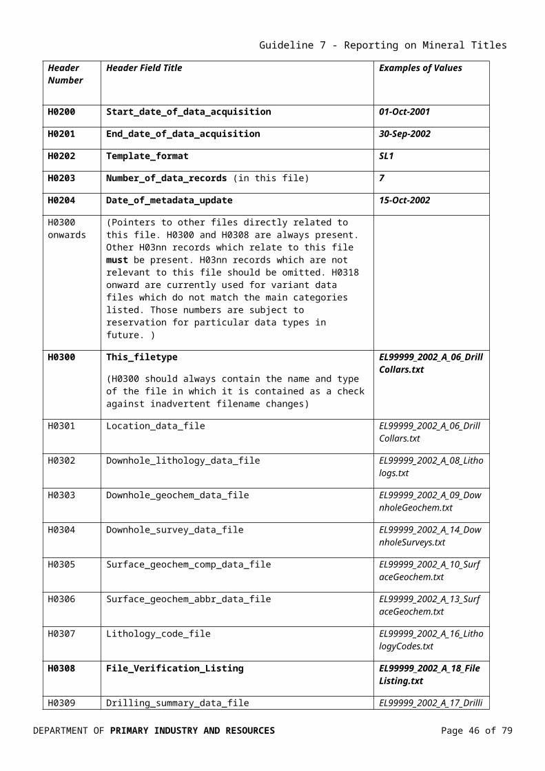
Guideline 7 - Reporting on Mineral Titles
Header Number
Header Field Title Examples of Values
H0900 Comments (Free text comments and remarks, enclosed in quotes.)
“Various general comments, remarks, observations etc.”
H1000 onward
Note that, in the H1000 series, the record name is not shown after the H1nnn designator. Each record passes directly into field names, units etc.
H1000 (Data field names) Xcoordinate, Lab Job no., Au SiO2 Zn
H1001 (Units of measure for each dimensioned field – ensure that a delimiter is present as a placeholder for fields where this is null.)
metres ddd.ddddddd ddmmss.sss ppm %
H1002 (Assay_code - specify for each analyte) FA50
H1003 (Lower detection limit as units specified in H1001) 0.01
H1004 (Accuracy - specify for each dimensioned field using the units in H1001)
0.01
H1005 (Upper detection limit as units specified in H1001) 1000
H1006 (Preferred assay indicator (P) for preferred assay where several values are presented for a single sample, null for others. The “preferred assay” field should also be the first listed for that analyte.)
P
H1007 (Assay_company_ID: where more than one laboratory is used, a code specified in H0801 identifies assay_code against laboratory.)
PLP
D (Data)
14.2.2 Content of file templates for tabular data
All headers require the “Numerical Header”, eg “H0100”, to appear in the first field (column) of each header row to enable transcription software to upload the metadata correctly. The underlying data records require the character “D” in the first field to allow transcription software to distinguish the data itself from the metadata on upload. An end of file marker “EOF” must immediately follow the last data record as the final line of the file. It must be emphasised that the format is flexible enough to handle more data than is shown in the example below because the H1000 series headers allow for self-definition of the data.
14.2.3 Description of individual templates for data submission
The most common types of data must be supplied using templates:
Table 8. Templates for tabular data submission.
Explanation in italics
DEPARTMENT OF PRIMARY INDUSTRY AND RESOURCES Page 46 of 70

Guideline 7 - Reporting on Mineral Titles
Template Data Type Mandatory dependant/related templates
Dependent/related templates
Appendix 1 Examples
SL1 Surface point locations, drill collars
DG1, DL1, DS1(when downhole data collected)
Example 1
SG1 Surface geochemistry Lithology_code_file (when lithology is specified for each sample) QG1
Example 2
DG1 Downhole geochemistry SL1 Lithology_code_file (when lithology is specified for each sample)QG1
Example 3
QG1 QA/QC file for capturing laboratory/field duplicates, standards and blanks.
SG1 &/or DG1 Example 4
DS1 Downhole directional survey SL1 Example 5DL1 Downhole lithological logs SL1
Lithology_code_fileExample 6
VL1 File verification listing Example 7DU1 Drilling Summary SL1 Example 8
Note that SG1, SG2 and DG1 templates may also be used for submission of heavy mineral or diamond indicator sampling results.
SL1: Surface point locations, drill collars (Example 1)
Drillhole collar and sample point locations require the additional parameters of geodetic datum, coordinate system, projection and spatial accuracy to ensure completeness, usefulness and longevity of data. Detailed explanations of these concepts are available from a number of sources, and are outside the scope of this document.
H1001 should include the datum for the azimuth as a suffix to the units of measurement, i.e. _M (Magnetic) or _T (True).
SG1: Surface geochemistry (Example 2)
A complete file of surface geochemistry contains both location and assay data and will therefore require metadata on both the spatial and analytical components. Spatial metadata are treated as in the SL1 header template. The H0600, H0700 and H0800 series contain metadata related to sample collection, preparation and analysis respectively. H1002, H1003, H1005, H1006 and H1007 are brought into use for analytical metadata.
DEPARTMENT OF PRIMARY INDUSTRY AND RESOURCES Page 47 of 70

Guideline 7 - Reporting on Mineral Titles
The H0800 record should contain the assay method code as specified by the laboratory, rather than that used by the client. Description of each analytical method in H0802 should specify sample digestion as well as final analytical determination method.
When an assay result for a particular analyte is below detection limit, it should be shown in the data record as not detected “nd”, or the negative of the detection limit e.g. “-10”.
When an analyte was not assayed for a particular sample, it should be shown in the data record as null or not assayed “na”.
Each file must be consistent in its usage of “below detection limit” and “not assayed”.
SG1 templates may also be used for submission of heavy mineral or diamond indicator sampling results.
QA/QC data (laboratory/field duplicates, standards, blanks) should be included in a separate QA/QC file. See QG1below.
DG1: Downhole geochemistry (Example 3)
Downhole geochemical data files require sample location data and metadata to be provided in separate files, i.e. in the SL1 file. In the DG1 file, only the drillhole identifier, sample code, downhole interval and assay data are provided for each sample in the data records, with pointers to the relevant SL1 file.
If downhole lithological logs (DL1) are not presented, it is recommended that the lithology of each sample be specified as an extra data field in the DG1 file.
DG1 template may also be used for submission of heavy mineral or diamond indicator sampling results.
QA/QC data (laboratory/field duplicates, standards, blanks) should be included in separate QA/QC file. See QG1 below.
QG1: QA/QC file for capturing laboratory/field duplicates, standards and blanks (Example 4)
It is considered that in addition to the metadata covering analytical method, laboratory, sample preparation, units of measure, and upper and lower detection limits, all of which are required in the various geochemistry templates, inclusion of analytical results of named standards as well as results of analyses of duplicate samples and blanks will assist in evaluating the quality of the data
DEPARTMENT OF PRIMARY INDUSTRY AND RESOURCES Page 48 of 70

Guideline 7 - Reporting on Mineral Titles
The QG1 Template has the same structure and metadata as the Geochemistry files (SG1 & DG1) but will include:
Lab Job Number – as provided by analytical laboratory,
QA/QC type:
o FDup = field duplicate submitted to laboratory
o LDup = duplicate generated and reported by laboratory,
o Standard = General and certified standards, and
o Blank = Laboratory blanks
Standard ID – name of standard be it certified or a general standard, and
Duplicated Sample Number (original sample number for field duplicate).
DS1: Downhole directional survey (Example 5)
H1001 should include the datum for the azimuth as a suffix to the units of measurement, i.e. _M (Magnetic) or _T (True).
DL1: Downhole lithological logs (Example 6)
Only the drillhole identifiers, depth intervals and lithological data are provided in this file, with pointers to the relevant SL1 file and lookup / authority / validation / namespace files. In most cases, lithologies are presented as abbreviation codes. A TAB delimited ASCII file showing abbreviation code against full lithology name must be provided if this is the case, Lithology_code_file.
VL1: File Verification Listing (Example 7)
A listing of all digital files submitted as part of the report, including the file type and format. Sufficient information on graphics files to ensure valid interpretations can be made.
DEPARTMENT OF PRIMARY INDUSTRY AND RESOURCES Page 49 of 70

Guideline 7 - Reporting on Mineral Titles
APPENDIX 1: DATA FILE EXAMPLESIn Examples 1 to 8, fields in bold are mandatory, fields in italics are recommended, and fields in normal face are optional.
Example 1. SL1 Surface point locations, drill collars.
Filename EL99999_2002_A_05_DrillCollars.txt
H0002 Version 4.0
H0003 Date_generated 15-Oct-2002
H0004 Reporting_period_end_date 30-Sep_2002
H0005 State NT
H0100 Tenement_no EL99999
H0101 Tenement_holder Big Time Mining Ltd
H0102 Project_name Kryptonite
H0106 Tenement_operator Small Time Mining NL
H0150 250K_map_sheet_number SD53-10
H0151 100K_map_sheet_number 5669 5670 5770
H0152 50K_map_sheet_number 56691 56692 56703 57703 57704
H0153 25K_map_sheet_number 56691N 56692N 56692S 56703S 57703N 57704S
H0200 Start_date_of_data_acquisition 01-Oct-2001
H0201 End_date_of_data_acquisition 30-Sep-2002
DEPARTMENT OF PRIMARY INDUSTRY AND RESOURCES Page 50 of 70

Guideline 7 - Reporting on Mineral Titles
H0202 Template_format SL1
H0203 Number_of_data_records 7
H0204 Date_of_metadata_update 15-Oct-2002
H0300 Location_data_file EL99999_2002_A_05_DrillCollars.txt
H0301 Location_data_file EL99999_2002_A_05_DrillCollars.txt
H0302 Downhole_lithology_data_file EL99999_2002_A_06_LithoLogs.txt
H0303 Downhole_geochem_data_file EL99999_2002_A_07_DownholeGeochem.txt
H0304 Downhole_survey_data_file EL99999_2002_A_10_DownholeSurveys.txt
H0400 Drill_code RAB DIA
H0401 Drill_contractor Drill Faster Pty Ltd Drill Well Pty Ltd
H0402 Description RAB Rotary Air Blast DIA Diamond Bit – Coring
H0500 Feature_located Hole_collar
H0501 Geodetic_datum GDA94
H0502 Vertical_datum AHD Arbitrary RL500 Nominal
H0503 Projection UTM
H0530 Coordinate_system Projected
H0531 Projection_Zone 53
H0532 Surveying_instrument GPS Multi Base Wide Area Differential
H0533 Surveying_company Super Surveying Pty Ltd
DEPARTMENT OF PRIMARY INDUSTRY AND RESOURCES Page 51 of 70

Guideline 7 - Reporting on Mineral Titles
H1000 Hole_ID Xcoordinate Ycoordinate Zcoordinate Maxdepth Collar_azimuth Collar_Inclination Drill_code Drill_Date Projection_Zone
H1001 metres metres metres metres degrees_M degrees
H1004 0.001 0.001 0.5 0.1 1 1
D RD01 512920 6928100 243.5 88.6 0 -90 RAB 17/08/2002
D RD/DD02 513000 6926320 230.0 120.4 275 -73 RAB,DIA 17/08/2002
D RD03 514970 6925540 211.5 35.3 0 -90 RAB 18/08/2002
D RD04 511110 6923680 181.5 225.0 0 -90 RAB 18/08/2002
D RD/DD05 513160 6925880 279.0 186.6 36 -82 RAB,DIA 24/08/2002
D DD06 513320 6924990 222.0 105.4 0 -90 DIA 25/08/2002
D RD07 513280 6924250 211.5 12.5 0 -90 RAB 19/08/2002
EOF
Example 2. SG1 Surface geochemistry.
Filename EL99999_2002_A_08_SurfaceGeochem.txt
For demonstration purposes only, it includes all methods of specifying “below detection limit” or “not assayed”; files actually submitted must be consistent in usage of “below detection limit” or “not assayed” designators.
H0002 Version 4.0
H0003 Date_generated 15-Oct-2002
H0004 Reporting_period_end_date 30-Sep_2002
H0005 State NT
DEPARTMENT OF PRIMARY INDUSTRY AND RESOURCES Page 52 of 70

Guideline 7 - Reporting on Mineral Titles
H0100 Tenement_no EL99999
H0101 Tenement_holder Big Time Mining Ltd
H0102 Project_name Kryptonite
H0106 Tenement_operator Small Time Mining NL
H0150 250K_map_sheet_number SD53-10
H0151 100K_map_sheet_number 5669
H0152 50K_map_sheet_number 56691
H0153 25K_map_sheet_number 56691N 56691S 56694N
H0200 Start_date_of_data_acquisition 01-Oct-2001
H0201 End_date_of_data_acquisition 30-Sep-2002
H0202 Template_format SG1
H0203 Number_of_data_records 7
H0204 Date_of_metadata_update 15-Oct-2002
H0300 Surface_geochem_comp_data_file EL99999_2002_A_08_SurfaceGeochem.txt
H0305 Surface_geochem_comp_data_file EL99999_2002_A_08_SurfaceGeochem.txt
H0307 Lithology_code_file EL99999_2002_A_11_LithologyCodes.txt
H0500 Feature_located Surface_location
H0501 Geodetic_datum GDA94
H0502 Vertical_datum AHD Arbitrary RL500 Nominal
H0503 Projection UTM
H0530 Coordinate_system Projected
H0531 Projection_zone 53
DEPARTMENT OF PRIMARY INDUSTRY AND RESOURCES Page 53 of 70

Guideline 7 - Reporting on Mineral Titles
H0532 Surveying_instrument GPS Averaged Position
H0533 Surveying_company Super Surveying Pty Ltd
H0600 Sample_code RO SSH0601 Sample_type RO Rock outcrop / float SS Stream sedimentH0602 Sample_description 2kg grab samples Screened –80# ASTM 500g samples split to 250g for lab dispatchH0700 Sample_preparation_code S031 R040H0701 Sample_preparation_details S031 Pulverise to 50um R040 Tungsten steel ring mill pulverise to 70 umH0702 Job_no ADL12345 02A1234H0800 Assay_code FA3 IC587 AAS1H0801 Assay_company PLP Phlogiston Laboratories, Perth AAL Aardvark Laboratories, AdelaideH0802 Assay_description FA3 Aqua regia digest, fire assay / carbon rod determination; IC587 HClO4+HNO3+HF digest, inductively coupled plasma mass spectrometry determination; AAS1 HClO4+HNO3+HF digest, atomic absorption spectrometry determination
H1000 Sample_ID Sample_code Lithology Xcoordinate Ycoordinate Zcoordinate Au Au Ca Cu Pb Zn
H1001 metres metres metres ppb ppb ppm ppm ppm ppm
H1002 FA3 AAS1 IC587 IC587 IC587 IC587
H1003 1 10 10 10 10 10
H1004 10 20 0.1 1 1 10 5 5 5
H1005 10000 500000 500000 200000 200000 200000
H1006 P
H1007 PLP AAL PLP PLP PLP PLP
D A111 RO GRDI 512920 6926810 240 12 15 125000 75 15 30
D A112 RO SLST 513000 6926230 230 0 0 11420 10 0 10
D A113 SS 514970 6925540 210 2 nd 1530 nd nd 10
D A114 SS 511110 6923680 180 4 -10 3770 15 10 25
D A115 SS 513160 6925880 270 76 50 18460 30 85 160
DEPARTMENT OF PRIMARY INDUSTRY AND RESOURCES Page 54 of 70

Guideline 7 - Reporting on Mineral Titles
D A116 RO LMST 513320 6924990 220 55 30 65
D A117 RO GBRO 513280 6924250 220 na na na 10 10 20
EOF
Example 3. DG1 Downhole geochemistry.
Filename EL99999_2002_A_07_DownholeGeochem.txt
H0002 Version 4.0
H0003 Date_generated 15-Oct-2002
H0004 Reporting_period_end_date 30-Sep_2002
H0005 State NT
H0100 Tenement_no EL99999
H0101 Tenement_holder Big Time Mining Ltd
H0102 Project_name Kryptonite
H0106 Tenement_operator Small Time Mining NL
H0200 Start_date_of_data_acquisition 01-Oct-2001
H0201 End_date_of_data_acquisition 30-Sep-2002
H0202 Template_format DG1
H0203 Number_of_data_records 7
H0204 Date_of_metadata_update 15-Oct-2002
H0300 Downhole_geochem_data_file EL99999_2002_A_07_DownholeGeochem.txt
H0301 Location_data_file EL99999_2002_A_05_DrillCollars.txt
DEPARTMENT OF PRIMARY INDUSTRY AND RESOURCES Page 55 of 70

Guideline 7 - Reporting on Mineral Titles
H0303 Downhole_geochem_data_file EL99999_2002_A_07_DownholeGeochem.txt
H0600 Sample_code DC CT CSH0601 Sample_type DC Drill core CT Drill cuttings CS Core sludgeH0602 Sample_description Quarter core Half splits of cuttings Approx 100g sample of sludgeH0700 Sample_preparation_code S031 R040H0701 Sample_preparation_details S031 Pulverise to 50um R040 Tungsten steel ring mill pulverise to 70 umH0702 Job_no ADL12345 02A1234H0800 Assay_code FA3 IC587 AAS1H0801 Assay_company PLP Phlogiston Lab, Perth AAL Aardvark Laboratories, AdelaideH0802 Assay_description FA3 Aqua regia digest,fire assay/carbon rod determination; IC587 HClO4+HNO3+HF digest,inductively coupled plasma mass spectrometry determination; AAS1 HClO4+HNO3+HF digestatomic absorption spectrometry determination
H1000 Hole_ID Depfrom Depto Sample_ID Sample_code Au Au Ca Cu Pb Zn
H1001 metres metres ppb ppb ppm ppm ppm ppm
H1002 FA3 AAS1 IC587 IC587 IC587 IC587
H1003 1 10 10 10 10 10
H1004 0.1 0.1 1 1 10 5 5 5
H1005 10000 500000 500000 200000 200000 200000
H1006 P
H1007 PLP AAL PLP PLP PLP PLP
D RD111 12 14 A111 CT 12 15 125000 75 15 30
D RD111 14 16 A112 CT nd nd 11420 10 nd 10
D RD111 16 18 A113 CT 2 nd 1530 nd nd 10
D DD112 123.4 123.5 A114 DC 4 nd 3770 15 10 25
D DD112 120.0 121.0 A115 CS 76 50 18460 30 85 160
D DD112 273.0 273.7 A116 DC na na na 55 30 65
DEPARTMENT OF PRIMARY INDUSTRY AND RESOURCES Page 56 of 70

Guideline 7 - Reporting on Mineral Titles
D DD112 354.6 355.1 A117 DC na na na 10 10 20
EOF
Example 4. QG1 QA/QC file for geochemistry.
Filename EL99999_2004_A_14_QAQCGeochem.txt
H0002 Version 4.0
H0003 Date_generated 19-Jan-2005
H0004 Reporting_period_end_date 28-Feb_2004
H0005 State NT
H0100 Tenement_no EL99999
H0101 Tenement_holder Big Time Mining Ltd
H0102 Project_name Kryptonite
H0106 Tenement_operator Small Time Mining NL
H0150 250K_map_sheet_number SD53-10
H0151 100K_map_sheet_number 5669 5769
H0152 50K_map_sheet_number
H0153 25K_map_sheet_number 56691N 56691S 56694N
H0200 Start_date_of_data_acquisition 01-Mar-2003
H0201 End_date_of_data_acquisition 28-Feb-2004
H0202 Template_format QG1
H0203 Number_of_data_records 10
DEPARTMENT OF PRIMARY INDUSTRY AND RESOURCES Page 57 of 70

Guideline 7 - Reporting on Mineral Titles
H0204 Date_of_metadata_update 19-Jan-2005
H0300 QAQC_Geochem_data_file EL99999_2004_A_14_QAQC_Geochem.txt
H0301 Location_data_file EL99999_2004_A_05_DrillCollars.txt
H0303 Downhole_geochem_data_file EL99999_2004_A_07_DownholeGeochem.txt
H0600 Sample_code ACCH0601 Sample_type AC Chips H0602 Sample_description 1m Chip samplesH0700 Sample_preparation_code S031
H0701 Sample_preparation_details S031 Pulverise to 50um
H0702 Job_no S20058 S20059H0800 Assay_code AR BLEGH0801 Assay_company PH Phlogiston Lab, Perth BR Brimstone Lab, BrisbaneH0802 Assay_description AR Aqua regia atomic absorption BLEG Bulk cyanide leach extractable gold
H0900 Remarks na-sample not assayed, below level of detection indicated by a minus sign.
H1000 LAB job No Sample_ID QAQC_Type Standard_ID Original_Sample Ag As Au Au1 Au2 Zn
H1001 ppm ppm ppm ppm ppm ppm
H1002 AR AR AR AR BLEG AR
H1003 0.1 5 1 1 1 1
H1006 P P P P P P
H1007 PH PH PH PH BR PH
D S20058 123456 Ldup 0.1 -5 1 15 na 25
D S20058 123467 Ldup 0.1 -5 4 10 na 20
D S20058 ST STDKG1 20 100 10 1530 12 500
D S20059 127928 Fdup 127921 0.1 -5 2 15 na 200
DEPARTMENT OF PRIMARY INDUSTRY AND RESOURCES Page 58 of 70

Guideline 7 - Reporting on Mineral Titles
D S20059 127969 Fdup 127940 0.1 -5 1 30 na 25
D S20059 128162 Fdup 128144 0.1 -5 1 55 na 25
D S20059 127928 Ldup 0.2 -5 1 10 na 210
D S20059 128162 Ldup 0.2 -5 2 10 na 180
D S20059 BL -0.1 -5 -1 10 -1 -1
D S20059 ST STDBB1 25 300 10 10 10 300
EOF
Example 5. DS1 Downhole directional survey.
Filename EL99999_2002_A_10_DownholeSurveys.txt
H0002 Version 4.0
H0003 Date_generated 15-Oct-2002
H0004 Reporting_period_end_date 30-Sep_2002
H0005 State NT
H0100 Tenement_no EL99999
H0101 Tenement_holder Big Time Mining Ltd
H0102 Project_name Kryptonite
H0106 Tenement_operator Small Time Mining NL
H0200 Start_date_of_data_acquisition 01-Oct-2001
H0201 End_date_of_data_acquisition 30-Sep-2002
H0202 Template_format DS1
DEPARTMENT OF PRIMARY INDUSTRY AND RESOURCES Page 59 of 70

Guideline 7 - Reporting on Mineral Titles
H0203 Number_of_data_records 4
H0204 Date_of_metadata_update 15-Oct-2002
H0300 Downhole_survey_data_file EL99999_2002_A_10_DownholeSurveys.txt
H0301 Location_data_file EL99999_2002_A_05_DrillCollars.txt
H0304 Downhole_survey_data_file EL99999_2002_A_10_DownholeSurveys.txt
H0532 Surveying_instrument Eastman multishot camera
H0533 Surveying_company Drill Faster Pty Ltd
H1000 Hole_ID Depth Inclination Azimuth
H1001 metres degrees degrees_M
H1004 0.1 0.1 0.1
D DD112 10.0 -89.9 285.2
D DD112 120.0 -87.3 276.0
D DD112 275.0 -82.1 273.4
D DD112 445.3 -79.7 268.9
EOF
DEPARTMENT OF PRIMARY INDUSTRY AND RESOURCES Page 60 of 70

Guideline 7 - Reporting on Mineral Titles
Example 6. DL1 Downhole lithological logs.
Filename EL99999_2002_A_11_Lithologs.txt
H0002 Version 4.0
H0003 Date_generated 15-Oct-2002
H0004 Reporting_period_end_date 30-Sep_2002
H0005 State NT
H0100 Tenement_no EL99999
H0101 Tenement_holder Big Time Mining Ltd
H0102 Project_name Kryptonite
H0106 Tenement_operator Small Time Mining NL
H0200 Start_date_of_data_acquisition 01-Oct-2001
H0201 End_date_of_data_acquisition 30-Sep-2002
H0202 Template_format DL1
H0203 Number_of_data_records 7
H0204 Date_of_metadata_update 15-Oct-2002
H0300 Downhole_lithology_data_file EL99999_2002_A_06_Lithologs.txt
H0301 Location_data_file EL99999_2002_A_05_DrillCollars.txt
H0302 Downhole_lithology_data_file EL99999_2002_A_06_Lithologs.txt
H0307 Lithology_code_file EL99999_2002_A_11_LithologyCodes.txt
H0400 Drill_code RAB DIA
H0402 Description RAB Rotary Air Blast DIA Diamond Bit – Coring
DEPARTMENT OF PRIMARY INDUSTRY AND RESOURCES Page 61 of 70

Guideline 7 - Reporting on Mineral Titles
H1000 Hole_ID Depfrom Depto Drill_code Recovery Lithology Description
H1001 metres metres %
H1004 0.1 0.1 5
D RD111 0 2 RAB 90 SAND Fine to medium grained sand, red-brown”
D RD111 2 4 RAB 85 SAND Fine to medium grained sand 30%, red-brown, with calcrete
D RD111 4 6 RAB 80 GRNT Granite, weathered”
D DD112 123.4 123.7 DIA 100 LMST Massive limestone with traces of pyrite and chalcopyrite”
D DD112 123.7 136.2 DIA 90 GBRO Medium and coarse layered gabbro, layers 10 to 50 cm thick”
D DD112 136.2 136.4 DIA 20 FBRC Clayey, highly weathered fault breccia”
D DD112 136.4 137.7 DIA 100 KOMT Spinifex-textured komatiite with minor sulphides”
EOF
DEPARTMENT OF PRIMARY INDUSTRY AND RESOURCES Page 62 of 70
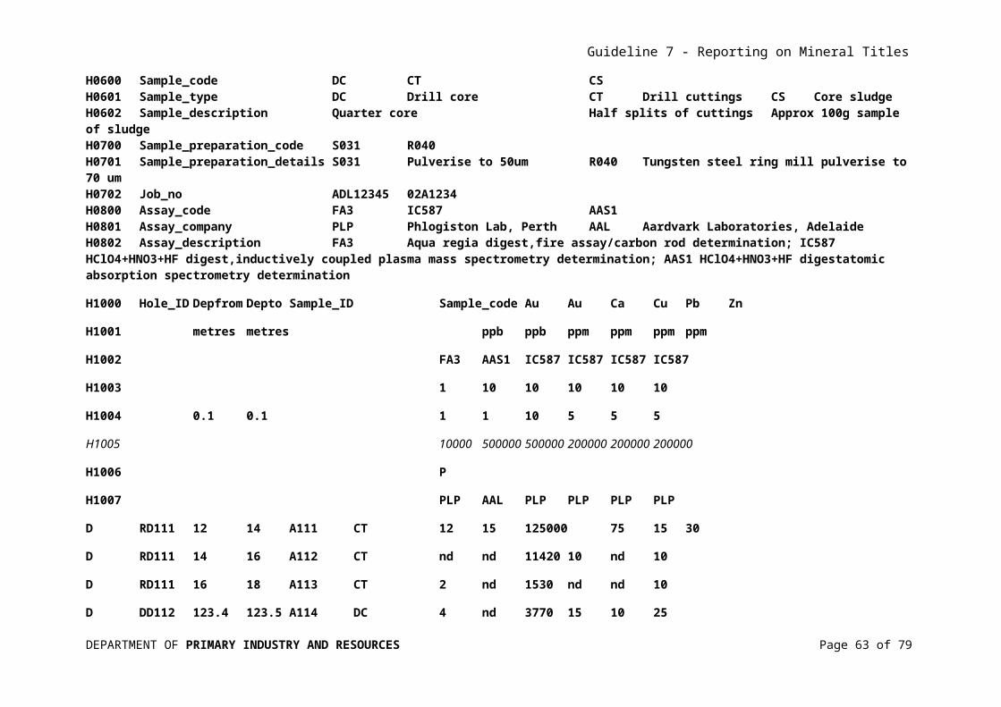
Guideline 7 - Reporting on Mineral Titles
Example 7. VL1 Sample Hardcopy File Verification Listing
Filename EL99999_2002_A_13_Filelisting.txt
Exploration Work Type Filename Format
Office Studies
Literature search EL99999_2002_A_01_ReportBody.pdf pdf
Database compilation
Computer modelling EL99999_2002_A_01_ReportBody.pdf pdf
Reprocessing of data
General research EL99999_2002_A_01_ReportBody.pdf pdf
Report preparation EL99999_2002_A_01_ReportBody.pdf pdf
Other (specify)
Airborne Exploration Surveys
Aeromagnetics EL99999_2002_A_03_Aeromag.gdf
EL99999_2002_A_04_Aeromag.ecw
gdf, ecw
Radiometrics
Electromagnetics
Gravity
Digital terrain modelling
Other (specify)
Remote Sensing
Aerial photography
LANDSAT
SPOT
MSS
Radar
Other (specify)
Ground Exploration Surveys
Geological Mapping
Regional
Reconnaissance
DEPARTMENT OF PRIMARY INDUSTRY AND RESOURCES Page 63

Guideline 7 - Reporting on Mineral Titles
Prospect EL99999_2002_A_02_ProspectGeology.tif tif
Underground
Costean
Ground geophysics
Radiometrics
Magnetics
Gravity
Digital terrain modelling
Electromagnetics
SP/AP/EP
IP
AMT
Resistivity
Complex resistivity
Seismic reflection
Seismic refraction
Well logging
Geophysical interpretation
Other (specify)
Geochemical Surveying
Drill sampling EL99999_2002_A_07_DownholeGeochem.txt
EL99999_2002_A_05_DrillCollars.txt
EL99999_2002_A_14_QAQCGeochem.txt
txt
Surface sampling EL99999_2002_A_08_SurfaceGeochem.txt
EL99999_2002_A_09_SurfaceLocations.txt
EL99999_2002_A_14_QAQCGeochem.txt
txt
Other (specify) txt
Drilling
All drilling EL99999_2002_A_05_DrillCollars.txt
EL99999_2002_A_06_Lithologs.txt
EL99999_2002_A_10_DownholeSurveys.txt
txt
DEPARTMENT OF PRIMARY INDUSTRY AND RESOURCES Page 64

Guideline 7 - Reporting on Mineral Titles
EL99999_2002_A_11_LithologyCodes.txt
EL99999_2002_A_12_DrillingSummary.txt
File Verification Listing (this file)
EL99999_2002_A_13_FileListing.txt txt
DEPARTMENT OF PRIMARY INDUSTRY AND RESOURCES Page 65

Guideline 7 - Reporting on Mineral Titles
Example 8. DU1 Drilling Summary.
Filename EL99999_2002_A_12_DrillingSummary.txt
The drilling details shown here are illustrative only. In a real exploration report, they would correspond to the details in drilling-related SL1 files within the report.
H0002 Version 4.0
H0003 Date_generated 15-Oct-2002
H0004 Reporting_period_end_date 30-Sep_2002
H0005 State NT
H0100 Tenement_no EL99999
H0101 Tenement_holder Big Time Mining Ltd
H0102 Project_name Kryptonite
H0106 Tenement_operator Small Time Mining NL
H0200 Start_date_of_data_acquisition 01-Mar-2001
H0201 End_date_of_data_acquisition 30-Sep-2002
H0202 Template_format DU1
H0203 Number_of_data_records 3
H0204 Date_of_metadata_update 15-Oct-2002
H0300 Drilling_summary_data_file EL99999_2002_A_12_DrillingSummary.txt
H0301 Location_data_file EL99999_2002_A_05_DrillCollars.txt
H0309 Drilling_summary_data_file EL99999_2002_A_12_DrillingSummary.txt
H0400 Drill_code RAB DIA
DEPARTMENT OF PRIMARY INDUSTRY AND RESOURCES Page 66 of 70

Guideline 7 - Reporting on Mineral Titles
H0402 Description RAB Rotary Air Blast DIA Diamond Bit - Coring
H1000 Drill_code DrilledLength Expenditure FinancialYear ExplorationType
H1001 metres AU$
H1004 10 100
D RAB 4950 34400 2000-2001
D RAB 2210 16100 2001-2002
D DIA 2260 213600 2001-2002
EOF
DEPARTMENT OF PRIMARY INDUSTRY AND RESOURCES Page 67 of 70

Guideline 7 - Reporting on Mineral Titles
APPENDIX 2: GLOSSARY OF ABBREVIATIONS AND TERMSAbbreviation Description Used asAHD Australian Height Datum Geodetic datum for altitude
measurement in AustraliaAMIRA Australian Mineral Industry
Research AssociationOrganisation
ANZLIC Australia and New Zealand Land Information Council
National organisation
ASCII American Standard Code for Information Interchange
International standard
ASEG Australian Society of Exploration Geophysicists
Organisation
BIL Band Interleaved by Line File formatCD-ROM Compact Disc, Read only-memory Acceptable media for submitting digital
dataCGGC Chief Government Geologists’
CommitteeOrganisation – Chief Geologists from Australian Commonwealth, State and Territory geoscience agencies, plus New Zealand and Papua New Guinea
CGM Concatenated Graphics Metafile File typeCSIRO Commonwealth Scientific and
Industrial Research OrganisationOrganisation
DG1 Downhole Geochemistry1 Metadata header template for drill hole assay data
dpi Dots per inch Spatial printing or video dot densityDL1 Downhole Lithology1 Metadata header template for drill hole
lithology, structural, alteration etc dataDLIS Digital Logging International
StandardInternational industry standard
DS1 Downhole Survey 1 Metadata header template for drill hole survey data
DTM Digital Terrain Model Digital representation of surface topography
DU1 Drilling Undertaken 1 Summary of drillingDVD-ROM Digital Video Disc, Read only-
memoryAcceptable format for submitting digital data
DXF Data Exchange File 2D and 3D graphic file fomatEL Exploration Licence Mineral title for non-extractive
explorationELR Exploration Licence in Retention Mineral title for evaluation of mineral
discoveryEM Electromagnetic Geophysical survey methodEMEL Extractive Mineral Exploration
LicenceMineral title for extractives exploration
EML Extractives Mineral Lease Mineral title for extractives miningFTD File Transfer Protocol Method of exchanging files between
computers on the internetGB Gigabyte 109 bytes of computer memoryGDA94 Geocentric Datum of Australia 94 projected coordinate system for
AustraliaGDF2 General Data Format (Version 2) National standard for geophysical dataGEOTIFF Geo-referenced Tagged Image
File FormatFile type
GGIC Government Geoscience Organisation – advisory subcommittee
DEPARTMENT OF PRIMARY INDUSTRY AND RESOURCES Page 68

Guideline 7 - Reporting on Mineral Titles
Information Committee to CGGCGIF Graphics Interchange Format File typeGIS Geographic Information System Integrates, stores, edits, analyses,
shares and displays geographic dataGML Geography Markup Language International standardGoCAD Voxet Geological Object Computer Aided
Design VoxetThree dimensional regular grid of a GoCAD surface model that exports as a Noddy geological block model
GPS Global Positioning System Allows reliable location informationGXF Grid Exchange Format International standardJPG, JPEG Joint Photographic Experts Group File typeLAS Log ASCII Standard International industry standardLIS Logging International Standard
(binary format)International industry standard
MB Megabyte 1 million (106) bytes of computer memory
MGA Map Grid of Australia Coordinate system based on the UTM projection and GDA94
ML Mineral Lease Mineral title for non-extractive miningMRT, MINEX Mineral Reporting Template Preferred software for producing
compliant metadata headers for tabular data files
MWD Measurement While Drilling Logging techniqueOGC Open GIS Consortium Organisation (see
http://www.opengis.org)P1/90 Navigation data standard format International standardPDF Portable Document Format File typePNG Portable Network Graphics File typePOSC Petrotechnical Open Software
ConsortiumOrganisation (see http://www.posc.org)
PPDM Public Petroleum Data Model International standard database modelQA/QC Quality Assurance / Quality
ControlIdentifying data/samples used to validate geochemistry results
QG1 Quality Geochemistry1 Metadata header template for QA/QC duplicates and blanks assay data
SD card Secure Digital card A flash memory card that provides storage for digital files
SDTS Spatial Data Transfer System International standardSEG Society of Exploration
GeophysicistsOrganisation
SG1 Surface Geochemistry Metadata header template for surface sample assay data
SGML Standard Generalized Markup Language
International standard
SIROTEM CSIRO Transient ElectroMagnetics
Geophysical method developed by CSIRO
SI International System of Units International standardSL1 Surface Location 1 Metadata header template for location
data such as collarsSPS Shell Processing System International standardTEM Transient ElectroMagnetics Geophysical techniqueTIF, TIFF Tagged Image File Format File typeTMI Total Magnetic Intensity Geophysical measurementUBC GIF University of British Columbia
Geophysical Inversion FacilityEnables 3D inversion of geophysical data
UKOOA United Kingdom Offshore Operators Association
International organisation
DEPARTMENT OF PRIMARY INDUSTRY AND RESOURCES Page 69

Guideline 7 - Reporting on Mineral Titles
USB Flash Drive
Universal Serial Bus Flash Drive flash memory data storage device integrated with a USB interface.
UTM Universal Transverse Mercator International spatial specification / map projection
VL1 Verification List1 List of all digital files submitted with an exploration report
VRML Virtual Reality Modelling Language
3D graphics language used on the Web
VTK Visualisation Tool Kit File format used in geophysical modelling
WELLOGML Well Log Markup language Standard for web-based exchange of digital well log data
XML Extensible Markup Language International standardXMML Exploration and Mining Markup
LanguageStandard under development by CSIRO
DEPARTMENT OF PRIMARY INDUSTRY AND RESOURCES Page 70