GUIDE TO FAMILY ROUTES - Inici - caminsdepedra
60
Departament de Medi Ambient GUIDE TO FAMILY ROUTES
Transcript of GUIDE TO FAMILY ROUTES - Inici - caminsdepedra

Departament de Medi Ambient
GUIDE TO FAMILY ROUTES

AuthorsText:
Antoni Reynés Trias, Francesca Rotger Moyà
Photography:Guillem Alomar Canyelles, Philippe Álvaro Frotté, Antoni Reynés Trias
Design:Diana Farràs i Serra
© edition:Consell de Mallorca and the authors
© text:Consell de Mallorca
© photography:Consell de Mallorca and the authors
Edition: April 2016
If you look back, you will immediately remember the people you met, people who had a peculiar characteristic,
the fact that they were so easy to love. This is thanks to their kindness, their warm welcome,
and the memories that they leave in your heart. That is the way Mallorca is.
We propose a series of delightful excursions, some are very easy and others perhaps not so, and they have been devised for the enjoyment of families.
The walking pace will allow you to get closer to the nature and culture of our mountains,
and help you to discover a living and very rich heritage.
Sandra Espeja AlmajanoCouncilor for the
Environment Department
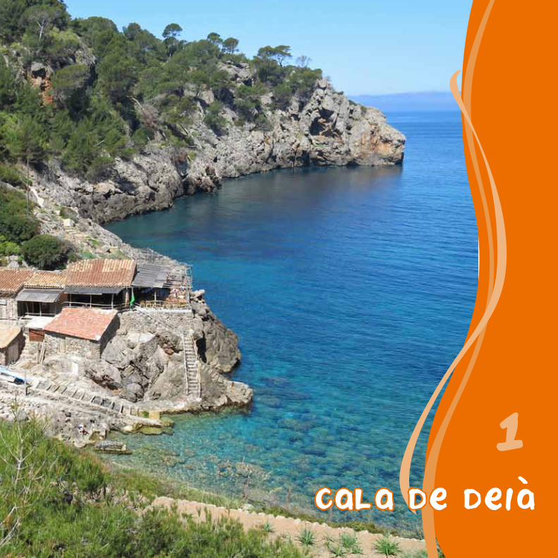
Cala de deia
1

Piques des Clot
The Wash HousesIn days gone by, the wash houses or “llavadosos” as they are known in Deià, were an
essential part of daily life. Women would gather under the small roof of the wash house to do their laundry and talk about the latest goings-on in the town.
This chore, which was time consuming and cumbersome, began at home by scrubbing clothes with clean water and bleach. Afterwards, women placed the clothing in a wooden wash bowl with bags of ash, they put it into boiling water and left it to rest overnight. The following day, no matter whether it was warm or cold, the women would go to the wash houses to cover the
clothes in soap on the slanted stones. After washing, they would rinse the clothes with water and hang them out to dry. Lastly, they were left with the ironing, which they did with
equipment very different to our modern devices.
The route begins in Carrer Arxiduc Lluís Salvador, next to the bus stop, on the road leading to Sóller. On the other side of the road, close by, is the start of Carrer des Porxo, which you follow. Having passed the Town Hall and the Can Vallès estate, with its stately tower, you will reach a crossroads. Continue downwards through the Costa den Topa, along a path of steps that leads to a little bridge over the Torrent des Racó. Opposite, you will find the tower shaped millpond of the Can Carindo mill, the last one to remain running in the town, and next to it, the museum founded by William Waldren which is home to his discoveries from the Mallorcan prehistoric era.
Keep going, following the course of the river, leaving behind the wash houses of Es Siquió. Soon afterwards, on the first bend, you will come across the Can Boi refuge, which belongs to Mallorca Council. Here you can visit the mill.
You are now walking through the Es Clot neighbourhood, where you can see the Pica de sa Font des Molí and further down, the irrigation channel that supplies water to the wash houses known as the Piques des Clot. Then, you pass alongside the mill pond of one of the four mills powered by the Font des Molí. After that, is the beginning of the Camí des Ríbassos, which is narrower.
You now go over two sets of wooden stiles, that cross the Can Raboa torrent, and the Font des Molí irrigation
channel, which has dried out. Ignoring the detour on your left hand side, you keep going down the gentle slope until you reach the Pont de Sa Cala, a bridge over the Torrent Major. Here, you can forget about the path opposite you and continue along the paved path until you reach the cove Cala de Deià, where you can still see fishermen’s huts alongside the remains of slipways that were used to house boats.
You return along the same path until Pont de sa Cala, at which point you ignore the trail you came down and continue along the paved road. Some metres down the road, on your left, you will see the start of the cobblestone path of San Vinyeta, after crossing the road two more times, and skirting around the Es Bancal terraces and the municipal school, you will come to the town centre and the route’s starting point.

PONT DESA CALA DEIA
CALADE DEIA es porxo
CANVALLES
COSTA D'EN TOPA
CANCARINDO
RENTADORSDES SIQUIO
REFUGI DE CAN BOI
PICA DE SA FONT DES MOLI
PIQUES DES CLOT
CAMI DESA VINYETA
PONT DESA CALA
CALADE DEIA
DEIA
es porxo
CANVALLES
COSTA D'EN TOPA
CAN CARINDO
RENTADORSDES SIQUIO
REFUGI DECAN BOI
PICA DE SA FONT DES MOLI
PIQUESDES CLOT
CAMI DE SA VINYETA
1 h 24 min
4.123 m200 m
150 m
100 m
50 m
0
Cala de Deià
Pont de sa Cala
Deià
Pont de sa Cala
Deià
1 km 2 km 3 km 4 km

Cala de deia
1
Palma
Start / End: Deià, street Arxiduc Lluís Salvador (178 m)
Distance: 4.123 m
Time required: 1 h 24 min
Difficulty: low
Net increase in altitude: 185 m
Net decrease in altitude: 185 m
Not suitable for: prams for children, wheelchairs
Cala de Deià
The MillsBy the time of Muslim rule, the energy created by the water from the fountains of Deià was exploited in order to create flour at mills that, along with various modifications, kept operating until the start of the 20th century.
In order to increase the power of the water, it was stored up in a pond and an artificial waterfall was created thanks to a kind of tower (millpond) where the water fell on a wheel which in turn moved a large circular stone (grindstone), whose friction with another stone located below crushed the grain, thereby turning it into flour.
The SlipwaysIn the past, Cala de Deià was used as a refuge for fishermen, who would row or sail out to the fishing waters. Upon returning, they would go by foot (or in the best case scenario with pack mules) to the town, neighbouring municipalities, or Palma in order to sell the fish.
They did not require extensive infrastructures to go about their work: they simply needed a place to lay out their nets,
another to dye them -in order to increase their resistance and durability-, and the slipways or “escars” where
they launched their vessels from. You can still find these structures standing in the most protected areas of the coastline. They consist of a sloping plane with wooden crossbeams in order to make it easier
to bring up the boats, and a hut for storing them.

cuber2

The water of PalmaThe two reservoirs in the municipality of Escorca are located on land belonging to the Cúber,
Almallutx and S’Estret estates. These areas have been populated since ancient times, and they are where the Muslims resisted for three years in very tough conditions following the
conquest of the island in 1229.
Not long ago, remains were rediscovered, under the waters of Gorg Blau, a reservoir
initially designed to produce electricity, but which was reconverted in order to provide
water for human consumption. Its water is pumped in order to travel upwards
and led afterwards to Cúber up a narrow canal that is more than 5 kilometres long;
from there it is directed towards Palma through a long pipe network.
The route begins at kilometre 33.8 on the road from Sóller to Pollensa, next to the canal that takes water from the Gorg Blau reservoir to the Cúber reservoir. From here, you go up until a small car park. On your left is Font des Noguer which used to supply water to the houses on the Cúber estate. Several benches and some grills make this zone a very busy recreational area at weekends.
On the opposite side, a wooden stile indicates the route to follow, always running parallel along the road, until you reach the pass to Cúber. To the left, on the slope of Puig de Sa Font, you can observe the reforestation of pine trees and holm oaks. Over time, they will turn the old grazing land into an extensive forest.
You immediately leave the paved road and head off along the path located opposite, signposted with GR 221 signs. It skirts around the north side of the reservoir, taking advantage of a path created during its construction.
Shortly afterwards, at a crossroads, a little concrete bridge on the left indicates the route to follow. Now walk between the reservoir and Serra de Cúber
until you come across the stream that comes down from L’Ofre and cross it using a path of stepping stones, if there is water in it.
Continue straight on until you find the pass that marks the boundary between the public estate of Cúber and that of Binimorat. Without crossing it, leave the GR 221, and turn to the left in order to continue along the route that it suitable for cars. It quickly takes you to the vicinities of the small Cúber refuge, a facility where you can spend the night if you make a booking in advance.
You keep walking, close to the water, alongside an area of reforestation that is characteristic of riverbank woodland, with several ash and elm trees. Before finishing the route, you will go over the dam where water from Torrent d’Almadrà passes through. The houses of the Cúber estate were located to the north of this area. Afterwards, you should ignore the path on your right which follows the course of the stream, continue along a paved stretch and you will once again reach the Cúber boundary, from where you return to the starting point.

REFUGI DECUBER
PORTELL DECUBER
FONTDES NOGUER
PRESABARRERA DEBINIMORAT
TORRENTD ALMADRA
puig major
DEIA
REFUGI DECUBER
CUBER
PORTELL DECUBER
FONTDES NOGUER
PRESABARRERA DEBINIMORAT
TORRENTD ALMADRA
puig major
1 h 17 min
4.683 m750 m
1 km
800 m
700 m0 2 km 3 km 4 km
Font des Noguer Font des NoguerBarrera de Binimorat

cuber
2
Palma
Start / End: road Sóller to Lluc Ma-10, km 33,8 (752 m)
Distance: 4.683 m
Time required: 1 h 17 min
Difficulty: low
Net increase in altitude: 45 m
Net decrease in altitude: 45 m
Not suitable for: prams and wheelchairs can only go as far as theCúber dam along the paved road (approximately 1 km)
Cúber
Transhumance of herdsMallorca has always been an island conducive for sheep. It is said that in the past there were more than 200,000 sheep, which were used for their wool, a prime material for the significant community of weavers, and milk, which was used to create a highly valued cheese.
These high, cool and rainy valleys provided an abundance of grazing land in summer, a time of year when it was harder to find in lower areas. However, during winter, snowfall harmed the cattle which made it advisable to move them. Back then, shepherds with flocks that sometimes numbered one thousand animals, took the so called “mountain routes” to the arranged estates, with a large ram with curved horns leading the procession, known as the “xot passador”, and accompanied by dogs and the sound of sheep bells. The shepherds retraced this path each year when the weather improved. Sometimes the return was complicated by the hunger of the sheep, who did not care about the fact that they were banned from entering the crop areas next to the route.

puig de maria
3

La Cadireta del Bon Jesus
The Cova del Dimoni is found on the cobbled path that ascends to the summit of the Puig, just before you go through a
gate. It consists of a small chair shaped cavity in the rock, which is known as La
Cadireta del Bon Jesús. According to legend, pregnant women who sit there
will have a happy childbirth.
You begin the route on kilometre 51.8 of the Ma-2200 road which goes around the town of Pollensa on the eastern side, 300 metres to the south of the monument commemorating the poet Costa i Llobera.
A line of cypress trees marks the start of the route, which quickly climbs the mountain hillside, passing not far from some very elaborate boundary walls built at the beginning of the 20th century by master dry stone wallers (”margers”) from Pollensa.
Continue along the narrow paved road that has some bends, next to which you will find the remains of the old bridle path and the watering place known as Piqueta de l’Ase, where passers-by heading to Puig de Maria would water their animals.
A little further on is the end of the stretch that is fit for cars, and the start of the cobbled bridle path, restored in 1994 by the “margers” of the Council of Mallorca. After going through a gate you will find the Cova del Dimoni next to the path as well as the rock known as the Cadireta del Bon Jesús. The Camí dels Ermitans is
a little further along on the left. It was built at the beginning of the 20th century, and leads to the Clot de la Verge Maria, a chasm where according to tradition the image of the Virgin Mary appeared.
Leaving this path, you go straight on until you arrive at the sanctuary of Verge María del Puig, from where you can view the bays of Pollensa and Alcúdia, the Pla de Mallorca plain area and the Serra de Tramuntana, with the Puig de Massanella in the background.
You simply cannot miss out on a visit to the different buildings of the old monastery of cloistered nuns, which survived until the 16th century, and was occupied by the order of Saint Peter and Saint Paul; the refectory, the chapter house, now a chamber museum with votive offerings, the church, whose origins date back to the 15th century, with the image of the Mare de Déu del Puig (St Mary of the Mount), and the walled enclosure with its robust defence tower.
You will retrace the entire route on the way back, allowing you to enjoy beautiful panoramic views over the town of Pollensa and the Serra de Tramuntana. Also, consider the chance to spend the night at the guesthouse managed by the Puig Brotherhood.

ctra.ma-2200
santuarimare de deu
del puig
COSTERSDEL PUIG
HORT DELCAMI DEL PUIG
CADIRETADEL BON JESUS
ctra.ma-2200
pollencapollenca
santuarimare de deu
del puig
L AVENCL AVENC
COSTERSDEL PUIG
HORT DELCAMI DEL PUIG
CADIRETA DEL BON JESUS
1 h 39 min
4.192 m
100 m
0 1 km 2 km 3 km 4 km
200 m
300 m
400 m
Ctra. Ma-2200 Ctra. Ma-2200
Santuari Mare de Déu del Puig

puig de maria
3
Palma
Start / End: Pollença, road Ma-2200, km 51,8 (48 m)
Distance: 4.192 m
Time required: 1 h 39 min
Difficulty: low
Net increase in altitude: 270 m
Net decrease in altitude: 270 m
Not suitable for: children under the age of 3, prams for children, wheelchairs
Puig de Maria
El clot de la Mare de DEuAccording to legend, around the 14th century Flor Ricomana, Simona and Dolça, three devout women who were doing penance at the Can Sales estate, close to the town of Pollensa, saw how the mountain lit up during sunset, especially on Saturday, a day devoted to the Virgin Mary.
The news quickly spread among the townspeople who organised a procession to the area and discovered an image of the Virgin; as you would expect, the women of Can Sales moved to the mountain and created the first community of female hermits in Mallorca.

castell d alaro
4

La potada del cavall del rei En Jaume
According to legend, the conquest of the castle, seated on a hill surrounded by vertical walls and with a single narrow and steep
access route, required all of the energy and courage of King James. It is said that he fought ferociously on his horse and managed to corner
all of the Saracens inside the castle.
The most intense conflict took place on the staircase at the foot of the wall, and the thrust and fury of the King’s horse was such that it left a hoof print at the
edge of the entrance, that is still visible today.It is said that so much blood was spilled that day that
the grass was dyed red, and the animal was so powerful that the dust it kicked up rose into the sky and spread
out, creating the “Carrera del Rei En Jaume”, also known by the name of the Milky Way.
The walk begins in the town’s Plaça, which is presided over by the town hall and the parish church of Sant Bartomeu, and you head off in a north-easterly direction along the street named Carrer Petit.
Following a crossroads, you continue along Carrer del Ponterró, pass by the town’s wash houses and continue along Carrer Solleric.
Once in the outskirts of the town, carefully go along the Ma-2100 road, until you reach the place known as Sa Sort, where you will see a route on the left that leads to Alaró Castle.
At the following crossroads, take the road that appears on your right, it will lead you past the houses of Son Curt, which are on one side and barely visible from the path, and those of Son Penyaflor, which are closer.
You keep going until you come to Codolí des Gegant, a crag that is said to have broken off from the shoe of a giant. Next to it is the beginning of the first shortcut that forms part of the old bridle path, thus named because only horses and people were allowed to travel on it. It provides two shortcuts for the paved path.
When the houses of Es Verger come into view, leave the cart track and head off on the right along a path of steps which runs, firstly along terraces of olive trees and, after going through a gate, along the hillside covered in holm oaks.
You now move closer to the cliff, and further on, at a crossroads, take the road on the right that soon leads to the doorway of the walled enclosure. Inside, you will cross L’Homenatge tower, and pass the remains of a water tank. After a short climb you will arrive at the oratory of the Mare de Déu del Refugi and the guesthouse.
Return along the same route, until you reach the first crossroads; at that point head off towards the north towards Pla des Pouet, before then taking the route suitable for carts, leaving the path on the right that connects with Orient via the GR 221.
The cart road snakes along, through the holm oak grove, until you reach the houses of Es Verger, and soon afterwards you will find yourself back on the route that you came up, which will take you back to the town of Alaró again.

sonpenyaflor
CASA CONSISTORIAL
desviamentdes verger
creuercami des pouet
castelld alaro
plades pouet
sonpenyaflor
CASA CONSISTORIAL
desviamentdes verger
creuercami des pouet
castelld alaro
plades pouet
4 h 53 min
14.152 m800 m
600 m
400 m
200 m
0
Desviament Es Verger
Son Penyaflor
Alaró
2 km 4 km 14 km6 km 8 km 10 km 12 km
Castell d'AlaróCreuer camí des Pouet
Desviament Es Verger
Son Penyaflor
Alaró
Creuer camí des Pouet

castell d alaro
4
Palma
Start / End: Alaró, Plaça de la Vila (224 m)
Distance: 14.152 m
Time required: 4 h 53 min
Difficulty: high
Net increase in altitude: 643 m
Net decrease in altitude: 643 m
Not suitable for: children under the age of 3, prams for children, wheelchairs
Castelld'Alaró
Cabrit and BassaIn the distant past, good King James II governed this small island with great skill. Even so, things did not go smoothly for long, and his nephew and the King of Aragon, Alonso or “Anfós”, promised to his father that he would conquer these lands.
The dreaded invasion took place in 1285 and the few people that were faithful to the legitimate king took refuge in Alaró Castle, where the soldiers Guillem Capell Cabrit and Guillem Bassa resisted with great courage.
Alfonso himself came to the foot of the walls to urging the defenders to surrender. Cabrit responded that he knew of no other king than James and that, in Mallorca, they ate oven roasted “anfós” (grouper). The king, filled with anger, asked for the name of the man who dared to talk to him like that, and when he heard the response he swore that he would take revenge for the offense by roasting the traitor on a grill.
And he did. When the castle's defenders surrendered because of hunger, Cabrit and Bassa were arrested and burned in the Plaça del Lledoner de Los d’Amunt, in Alaró. As a result of what happened, Mallorcans considered them to be martyrs and people elevated them to the status of saints.

cami vell des barranc5

The best farmstead The village of Biniaraix, with around one hundred inhabitants, is located in a privileged area, surrounded by fountains and fertile land, characteristics that were valued by the
re-settlers soon after they seized the islands from the Muslims in the 13th century.
This land was given to a group of knights and to the bishop of Gerona. The latter, before finding out which part he had received, decided to give his nephew the best farmstead that would have been his in the valley of Sóller. This was Biniaraix, land which was then home to
orchards and olive groves, as well as vineyards and uncultivated land, among which new settlers put down roots and built the houses which now comprise the town centre.
The route, which runs along part of the GR 221, begins in the Plaça in Biniaraix, next to the Church of the Immaculate Conception. From here, you continue up Carrer de Sant Josep. At the end of it you will find the stately homes of Cas Son, and just past the corner of these buildings, the wash houses supplied with water from the Font de la Mare de Déu.
On your left, ignore the old Monnàber road and follow the earth paved route towards the ravine, which is framed by Morro de ses Solanes and Es Cornadors.
You will immediately reach a crossroads. On the left is the path that leads to the olive groves of Cas Don, but continue along the Camí des Barranc path. You pass the stream before beginning the climb up the very steep path.
Walk past the spout of the Font des Patró Lau, then ignore a path on the right that goes to the olive groves of Can Fenasset and keep going until you head off the GR 221 along the Camí Vell, which will appear to your right. This path runs through terraces and rocky areas, enabling you to reach Coll d’en Se. This is the point where your descent begins, and which leads you to the Torrent de l’Ofre, whose course forms a small pool, a few metres before reconnecting with the GR 221.
Now turn to your left in the direction of Biniaraix. Westwards is the estate of Can Catí, with its terraced grove, and to the right are the houses of Can Silles,
before them you will find the fountain supplied by water from the Font des Verger, the end destination of the diversion which also appears on the right. However, keep descending in order to cross the Torrent des Verger across a ford with stepping stones and a wooden bridge. You will then reach S’Estret where the crags, path and stream meet. You go over a little stone bridge, then the channel of the Font des Verger will run alongside your route. It was recently recovered and is only used to carry excess water.
Further on, the paved path negotiates the drop thanks to some spectacular bends known as Ses Voltetes, which will once again take you across the bed of the stream and soon afterwards you will once again come onto the route that you came up via, and you can continue along it in the opposite direction until you end up in Biniaraix.

S ESTRET
barrancde biniaraix
CAN SILLES
S ALOVA
rentadors
placa debiniaraix
COLLD EN SE
FONTDES VERGER
SES VOLTETES
TORRENTDE L OFRE
CANCATIS ESTRET
CAN SILLES
barrancde biniaraix
S ALOVA
TORRENTDE L OFRE
rentadors
CAN CATI
placa debiniaraix
COLLD EN SE
FONTDES VERGER
SES VOLTETES
2 h 22 min
5.010 m
500 m
400 m
300 m
200 m
100 m
0 1 km 2 km 3 km 4 km 5 km
Biniaraix
s'Alova
Coll d'en Se
s'Estret
s'Alova
Biniaraix

cami vell des barranc
5
Start / End: Biniaraix, Plaça de la Concepció (98 m)
Distance: 5.010 m
Time required: 2 h 22 min
Difficulty: low
Net increase in altitude: 421 m
Net decrease in altitude: 421 m
Not suitable for: children under the age of 3, prams for children, wheelchairs
Palma
Camí Velldes Barranc
The route of the pilgrimsThe coalmen, muleteers, peasants and above all pilgrims were the main users of the Camí des Barranc de Biniaraix. The Virgen de Lluc and the hope of a miracle or thankfulness for a favour, were more than enough reason to climb this rough and steep path. It was also necessary to confront the dangers of snowfall in winter and bandits throughout the year.
Aware of its importance, the civic authorities made a real effort to keep it suitable for travel; in 1400 the governor ordered pilgrims not to destroy bridges or the path, and threatened them with financial penalties, or in the case of the slaves, with floggings. The church also contributed to maintenance, and thirty years afterwards, the bishop offered forty days of religious pardon to worshippers who contributed to its improvement. Although many years have now passed, it is still a tradition for the local people of Sóller, along with those of outside towns, to climb up to the foot of the Lluc sanctuary once a year.

talaia d alcudia
6

La talaia d'AlcudiaThis fortification was built in the 16th century under orders from the Jurors of
Alcúdia, with the aim of reinforcing surveillance over the part of the bay that was not visible from the watchtower of Penya Roja, further forward.
As you can see in the remains, it was a circular structure of almost six metres in diameter. Inside, the tower’s watchmen took refuge as they kept watch for the
arrival of enemy boats and sent out fire warnings at night or smoke signals during the day to the other towers and
the city of Alcúdia, with which they also communicated using a set of flags.
The tower, very exposed to storms and especially to lightning strikes, was
already in very poor condition when the military knocked it down in 1918.
In the car park of the sanctuary of the Mare de Déu de la Victòria you take the forest path. Shortly after beginning the climb, you will find a route on the left that leads to the Ses Tres Creus vantage point. Ignore this path, just like the one you will find further along which leads to the Penya Roja.
The climb continues along the forest route that leads to the Pla de sa Talaia, where a bridle path begins. It is known as Pas de s’Aritja, and ends at the Talaia d’Alcúdia, at an altitude of 445 m. At the summit you will find the remains of an old tower from the 16th century, and a little further down, two huts where soldiers took refuge during the Civil War.
Start the route again from the remains of the tower, turns a few metres backwards, and turn off to the right along the route that you had previously passed by, heading southwards, it will allow you to reach the Puig des Boc. From here, continue the descent along the zigzagging path and you will end up at the Collet des Coll Baix, a place that is recognisable thanks to the presence of a refuge with some tables and benches outside it.
Forget about the route that leads down to the beach of Es Coll Baix and continue on your right hand side along the forest path that will soon lead you to a stream. From here you will go up the course of the stream, crossing it several times.
Further up you will pass Fontanelles Sobiranes, a water deposit located in the middle of the stream and you will arrive at Coll de na Benet, characterised by the large wild olive trees that grow there. From here, and ignoring the diversion that emerges on the left known as "Es Escalons”, continue straight on, now downwards, following the stream of Ses Fontanelles.
Shortly afterwards, you reach Fontanelles Fondes, another pool found in the channel of the stream, after which, Ses Planes opens up, it is a flat stretch where you pass by two access routes on the left, the first of which leads to the Victòria campsite. Afterwards, you skirt around the hillside of Sa Talaia, passing by an abandoned quarry. Then, you will come to the Torrent de s’Aladernar, where you begin a steep ascent that will lead you to the starting point.

ermita dela victoria
ses fontanellesfondes
talaiad alcudia
Collbaix
campamentde la victoria
Coll dena benet
ses fontanellessobiranes
ermita dela victoria
ses fontanellesfondes
talaiad alcudia
Collbaix
campamentde la victoria
Coll dena benet
ses fontanellessobiranes
3 h 48 min
10.206 m
100 m
0 2 km
200 m
300 m
400 m
500 m
4 km 6 km 8 km 10 km
Ermita dela Victòria
Talaia d'Alcúdia
Coll Baix Coll de na BenetErmita dela Victòria

talaia d alcudia
6
Start / End: Ermita de la Victòria hermitage (132 m)
Distance: 10.206 m
Time required: 3 h 48 min
Difficulty: medium
Net increase in altitude: 598 m
Net decrease in altitude: 598 m
Not suitable for: children under the age of 6, prams for children, wheelchairs
Palma
Talaia d'Alcúdia
The sanctuary of la Mare de Deu de la VictoriaIt is said that at the beginning of the 14th century a shepherd boy discovered an image of the Virgin at the place now known as “Ses Tres Creus”. It was taken to Alcúdia and the image returned by itself to the same spot, never to leave again. Latter, Friar Diego Garcia, a hermit and alchemist, settled in the area, and the image became very famous after it was called upon by the defenders of the city during the Germanies War that befell the island in the 16th century.
Its fortified appearance did not make it immune from pirate attacks. In 1684 raiders landed at S’Illot and after overcoming the ferocious defence of the lay people, they went into the chapel, chopped off the right arm of the image of Jesus and robbed the liturgical ornaments and other valuable objects.
In September 1735 another attack took place which caused serious damage to the inside of the sanctuary, including damage to the gothic image of the Virgin Mary, which had to be restored.

far de tramuntana lighthouse
7

The Arago LineA meridian is an imaginary line that encircles the earth,
passing through the two poles. It is used to measure longitudes and time zones.
One of these lines passes through the island of Sa Dragonera and it is recognised with a strip of lightly coloured paving stone that crosses your route. This is the Paris meridian, the former zero meridian, which
the Frenchman François Arago measured from Mallorca. He ended up being jailed for spying during the Peninsular War, and ultimately fled the island by boat. His sacrifices were largely in vain, as some years
later this line was replaced by the Greenwich Meridian, which passes through London and is still officially recognised.
From Sant Elm or the Port of Andratx you can go by boat to the cove of Es Lledó, where the route begins. Here you find the information centre, from where you head to the first crossroads. At this point, choose the option you find on the right, which crosses the Torrent de sa Cova over a little bridge that goes around an old pigsty and some agricultural terraces.
You then continue walking next to a pine forest with tables and benches, and soon afterwards you will have the option to take a detour on the right along a path that leads to Na Miranda, a well that forms a magnificent balcony over the coast of Andratx.
You now return to the cart path and pass Es Colomer, shaped like a battlement, before beginning a short climb that allows you to join up with the road of the Far de Tramuntana lighthouse, where you will continue along on the right. From here the route is flat, surrounded by thick scrubs, with Cala Regau and the darkly coloured Esculls des Calafats reefs, beneath you.
Cross over the stone boundary which marks the Paris meridian. Further along, next to the route,
is a viewpoint protected by a wooden railing. In spring and summer here, you can observe the development of Eleonora’s falcons and peregrine falcons, birds which had great fame during the middle age among falconers.
At the end of the route you will come to a small bend, below which is the lighthouse of Tramuntana, built between 1907 and 1910. It houses an exhibition about the island’s lighthouses, which you can visit if you request the key beforehand at the information centre. You are separated from Mallorca by Es Freu, a strait that is seven hundred metres wide, and on the other side you can see the tower of Cala en Basset and, up un the cliffs, the terraces of the old Trappist monastery.
In order to return, you retrace your route until Collet de Tramuntana, where you pass by the route leading down to Na Miranda that you came along, and carry on along the path of the lighthouse of Tramuntana which curves as it reaches Torrent de sa Cova, leaving a detour on the right that leads to the cave Cova des Moro, and you will end back at the starting point.

DRAGONERA
FAR DETRAMUNTANA
es COLOMER
NA MIRANDA
collet detramuntana
ES LLeDO
DRAGONERA
FAR DE TRAMUNTANA
es COLOMER
NA MIRANDA
collet de tramuntana
ES LLeDO
1 h 09 min
3.761 m
25 m
0 1 km
50 m
75 m
100 m
Es Lledó
Na Miranda
Far de Tramuntana Collet deTramuntana
Es Lledó2 km 3 km

far de tramuntanalighthouse
7
Start / End: Dragonera, Es Lledó (2 m)
Distance: 3.761 m
Time required: 1 h 09 min
Difficulty: low
Net increase in altitude: 108 m
Net decrease in altitude: 108 m
Not suitable for: access to the island is not adapted for wheelchair use
* For this route, please contact Sa Dragonera Natural Park
Palma
Far deTramuntana
The den of wrongdoersIt is said that the name of the small port in La Dragonera, Es Lledó, comes from the Catalan word for thief, “lladre”. This seems likely to be correct, given that the islet, close to the larger island, uninhabited and with drinking water, was a helpful place for several pirates and bandits who would stop off there.
As such, fugitives that had plundered churches, abducted women or carried out murders, ended up being captured in this place that they believed to be safe. Even so, pirates were the people that most frequently came to these waters, despite surveillance from watchmen in towers.
One of the most famous was the fearsome Barbarossa. During the first half of the 16th century he fled the Christian kings in the Mediterranean and took refuge in this place while he attacked vessels heading to the peninsula and raided Mallorcan coasts. The Turkish admiral “Dragut” also left his mark here and he is remembered for the defeat he suffered at the hands of the inhabitants of Pollensa lead by Joan Mas.

na popia
8

El far de na PopiaThe engineer Antonio López designed the structure midway through the
19th century. Designed with a neoclassical style, the building has living space for two families of lighthouse. Its role was to guide boats, but it
also causes an impact due to its size and the beauty of its lines.
First, the path was built, and the work lasted for three months, afterwards common prisoners worked on the construction of the
lighthouse, watched over by the army, with the invaluable support of the bishop at the time, who kindly allowed them to
work on Sunday in order to speed up the conclusion of the work.
The light was visible for more than fifty miles, however the fog that often shrouded it made it
advisable to abandon the lighthouse and replace it with two lighthouses located at lower heights. So, in
1910 the light was switched out forever.
After a small boat trip from Sant Elm or the Port of Andratx you will land at the dock of Es Lledó. Once here, head to the island’s small information centre. Once you have passed the centre, keep going along the road northwards until you reach a crossroads. On the right is the road to the Far de Tramuntana lighthouse, opposite is the path to the Cova des Moro and to the left is the paved roads to the Far de Llebeig lighthouse, which is the option to choose.
You pass under one of the houses in the park and a short distance after, head off the paved path along a road that appears on your right, which leads to the valley of Coll Roig. Soon afterwards, a gate without a barrier leads you into a crop field surrounded by a wall. This is known as Es Tancat, and inside it the path winds between terraces of almond trees and carob trees, always with the impressive Puig des Far Vell or Na Pòpia on your left.
You will pass a hut and after at Coll Roig, you will come to another gate, with a vantage point over the Tramuntana Sea. From here you take the Camí des Far Vell, first along the east side of the mountain, and then on the south side, in spring it is common to
find seagull nests in this area, and the birds try to dissuade visitors from coming to close with their low flying. The vegetation here is very dense thanks to the island’s protection and the recent extermination of rats.
As you climb, the view broadens out and to the left is the Puig des Aucells, with reddish rock, that you will just glimpse at one of the bends. Immediately afterwards, you pass by the Caseta des Coloms. Despite its name, it was a refuge for the watchmen of the now disappeared watchtower of Na Pòpia, a structure begun in 1580, which was knocked down in order to build the lighthouse.
Finally, you reach the summit of the Puig des Far Vell, situated at an altitude of 352 metres above the blue sea on the north side. You will see the remains of the lighthouse, with the tower, very damaged due to the impact of lightning, and the other buildings which are in an advanced state of deterioration.
After enjoying the impressive view over the Mediterranean and getting your breath back, you head back to the route’s starting point along the path you came down, the only possible way back.

FAR DENA POPIA
es tancat
Coll roig
ES LLeDO
FAR DENA POPIA
es tancat
Coll roig
ES LLeDO
2 h 51 min
8.406 m
100 m
0 2 km 4 km 6 km 8 km
200 m
300 m
400 m
Es Lledó
Coll Roig
Na Pòpia
Es Lledó
Coll Roig

na popia
8
Start / End: Dragonera, Es Lledó (2 m)
Distance: 8.406 m
Time required: 2 h 51 min
Difficulty: medium
Net increase in altitude: 361 m
Net decrease in altitude: 361 m
Not suitable for: prams for children, wheelchairs
* For this route, please contact Sa Dragonera Natural Park
Palma
na Pòpia
Monk sealsAs you enter the port of the island of Sa Dragonera, you will see a small cave on the left that is known as the Cova des Vell Marí. The name is a reminder of the fact that “vell marí” or monk seals were found on the island until halfway through the last century.
This species, one of the ten most threatened on the planet, lived and bred for many years in the coves and on the beaches of the Mediterranean coast. However, human pressure led the species to look for isolated caves, preferably ones with underwater access.
There are currently only a few remaining specimens scattered around countries such as Greece, Morocco and Mauritania. However, there is an international action plan which is carrying out a lot of work in order to prevent the species’ extinction and to encourage its recovery in protected areas.

FAR DE LLEBEIG LIGHTHOUSE
9FAR DE LLEBEIG
LIGHTHOUSE

SmugglingBringing in goods such as tobacco, without
any state control, was a very lucrative activity. That explains why two of the
wealthiest people on the island during the 20th century were indeed smugglers.
At nightfall, bundles of goods were moved from a boat located far from the coast to smaller vessels used to bring them ashore. The smugglers walked with the
bundles on their backs up impossibly difficult paths, to get to the secrets, hideouts where the bundles were stashed until the time came to transport
them to their final destination.
After arriving at the island by boat, your route begins at the dock of Es Lledó, where you head north along the route that passes the information centre and, upon reaching the first crossroads, you go off on the left along the paved road.
After passing the last remaining house in the port, you will immediately come to a crossroads. The road on the right leads to Na Pòpia or Puig des Far Vell, the highest point on the island, but continue westwards, around the rocky coast full of wild olive trees, rosemary and spurge weed.
On the right you will pass S’Abeurador, one of the structures built for the purpose of collecting some of the rare rainfall that the island gets, while on the coastline you can make out Cala Cucó, where there is a well with a destroyed cover. On the other side you can see a large part of Andratx’ coastline, from Cap Fabioler until Sa Mola.
As the route heads into the Comellar de Cala Cucó, at the end you will see a small detour on the right. It will lead you to the remains of a lime furnace, a circular structure used to cook calcareous stone in order to obtain lime, which was used to build and whitewash houses.
Upon returning to the lighthouse road, continue along the mountain slope, and still far in the distance, you will spot the lighthouse and defence tower that controlled Cala des Llebeig.
Afterwards, you will approach the cliff of Ses Penyes Rotjes, where a small wall serves as protection from the precipice, and having passed the Torrent de ses Fontanelles, you will come to Ses Cantarilles. It is a small dam used to collect water from the stream bed.
On the left of the route is Llebeig Tower and after a few bends you will finally come to the Far de Llebeig, a lighthouse built between 1907 and 1910, and situated at an altitude of 121 metres above sea level. The tower houses a lamp that reaches a distance of 34 miles, and it is completed with the houses of the lighthouse keepers and some large wells that collect water from the extensive terraces, which was then used to water a small vegetable garden.
You will return along the same path you came down, and it lead you back to the port.

S ABEURADOR
FAR DELLEBEIG
ES LLeDO
CALACUCO
TORRE DELLEBEIG
PENYES ROGES
torrent deses fontanelles
S ABEURADOR
FAR DELLEBEIG
ES LLeDO
CALACUCO
TORRE DELLEBEIG
PENYES ROGES
torrent deses fontanelles
2 h 50 min
9.224 m
50 m
0 2 km 4 km 6 km 8 km
100 m
150 m
Es Lledó
s'Abeurador
Torrent deses Fontanelles
Far desLlebeig Torrent de
ses Fontanelless'Abeurador
Es Lledó

far de llebeiglighthouse
9
Start / End: Dragonera, Es Lledó (2 m)
Distance: 9.224 m
Time required: 2 h 50 min
Difficulty: low
Net increase in altitude: 257 m
Net decrease in altitude: 257 m
Not suitable for: access to the island is not adapted for wheelchair use
* For this route, please contact Sa Dragonera Natural Park
PalmaFar de Llebeig
LizardsThe Balearic lizard or “sagartana”, greenish in colour,
is the true lady of the crags and wild olive trees. It differs to lizards from other islands and islets thanks to the evolutionary process which has modified the
size and ecological needs of each group.
It is omnivorous, and can be found between the grooves of stones and climbing
on bushes in search of fruits and small invertebrates. Its life is
threatened by several enemies such as kestrels, seagulls and Eleonora’s
falcons which appreciate their meat. However, sometimes they only
manage to take the tail, an appendix which comes off
easily, and continues to move in order to attract predators.

CAMI DE SA FIGUERA
10

The festival of Sant PoncOn 11 May 1561, the day of Sant Ponç, one thousand Sarracens
landed at Ses Puentes and headed to the town of Sóller, in order to try and catch its inhabitants off guard. The pirates failed to do
so, and after some battles and several acts of heroism, they were defeated. These events were engraved on the
collective memory and each year they are commemorate with a festival on the day of “Es Firó”.
Returning back to the ships, the privateers got lost on the route to Sa Figuera. One of the groups ended up at the houses of Can Tamany, where the sisters Francesca and
Catalina Casesnoves, club in hand, attacked one them and threw him out of the window onto the rest of the group,
who fled terrified. As a result of what happened, the sisters are remembered as “Ses Valentes Dones de Can Tamany”,
the brave women of Can Tamany.
The route begins in the street Carrer Antoni Montis, from where you head to the roundabout that leads to the Sa Mola tunnel. On the other side of the road, you will see the start of the Camí Vell des port or Camí de Figuera, which you go down through a gate with a wooden barrier before coming to a lime furnace, which has been partially restored. After a gentle climb you will reach a flat area with olive trees.
Once you have passed the Torrent de Son Llampaies, continue on until you reach a dirt road that is suitable for cars. Heading left would lead you to the village of Sa Figuera, but take the diversion on the right which passes through Coll d’en Borrassar. On the descent, the remains of the bridle path quickly lead you to the houses of Can Penya.
Keep going westwards, and shortly afterwards, take a diversion on your left hand side in order to reach the houses of Can Tamany. After a short paved stretch, you will join up with the Ma-10 road, go around it without crossing it until you reach a path that will lead you to the Vella des Port road. Close to the roundabout is Es Monument, a work created
by the sculptor Pavía to commemorate the events of the Sant Ponç festival.
Your route now runs along the old floodable area of Sóller valley and, once you have come across the Torrent des Jaiot, continue along the port of Sóller road for a short stretch until on the other side, and next to a tram stop, you will find the bridge and the point where the route continues.
Soon afterwards, you will arrive at the next crossroads, ignore the Camí de Binidorm on the left and head down the old Camí Reial de Muleta, a path that you will follow before heading off on a short route on the right. It links up with the road that leads to Platja d’en Repic beach and the Cap Gros lighthouse, that you should go along carefully due to car traffic.
Now on Platja d’en Repic, you begin the urban stretch that takes you back to the starting point, around the bay of Sóller, always on the pedestrian promenade, allowing you to calmly enjoy the environment.

SON LLAMPaIES
CAN TAMANY
ES MONUMENTCAN PENYA
SA MOLA
CARRERD ANTONI MONTIS
PLATJAD EN REPIC
COLL D EN BORRASSARcOLL D EN BORRASSAR
SON LLAMPaIES
cAN TAMANY
ES MONUMENTcAN PENYA
SA MOLA
CARRERD ANTONI MONTIS
PLATJAD EN REPIC
1 h 43 min
5.964 m50 m
0 1 km 2 km 3 km 4 km 5 km 6 km
100 m
150 m
Port deSóller
Son LlampaiesColl d'en Borrassar
Can TamanyPlatja
d'en Repic Port deSóller

cami desa figuera
10
Start / End: Port de Sóller, street Carrer Antoni Montis (0 m)
Distance: 5.964 m
Time required: 1 h 43 min
Difficulty: low
Net increase in altitude: 113 m
Net decrease in altitude: 113 m
Not suitable for: children under the age of 3.
Wheelchairs and prams can only be used on the urban stretch of the route.
Palma
Camí desa Figuera
The Dragon of
sa MolaThere was a time when
Saint George was passing through the country, and
coincidence had it that he came to Sóller, where the farm workers lived in
fear of the Cuca de Sa Mola, a “cuca fera” (a fierce dragon) that ate them without them being
able to do anything to prevent it. When the dragon could find nothing to eat, it would spend
the day nibbling rocks and stones.
Saint Jorge, who was very skilful, challenged the wild beast, and after a terrible duel, he killed it
unceremoniously. Nothing more was ever heard of the saint or the beast, but in Sa Mola, on the other side of
the stream, you can still see the nibbled boulders, and if you look really closely, the hole where the dragon hid.

PUIG DE GALATZO
11

La rota de n'UgoGround clearing (”rotes”) was the work of the most underprivileged workers, who through a
contract signed with the owners of the large estates, would remove weeds and stones in order to then be able to sow and farm the land for a certain amount of time, before
returning it again to the estate.
This system was used to begin growing on very poor land which required a great effort in order to produce very little. This was the first abandoned land, so now you can only see the remains of some mountains of rocks or terraces that have become overrun with holm oaks
along the route, and they are gradually disappearing.
Located on kilometre 96.7 of the Ma-10 road between Estellencs and Andratx, you begin the walk on a forest path that forks a little further along, in the shadow of Es Morralàs, a crag that measures slightly more than 600 metres at its highest point. The detour on the right following the Dry Stone Route leads to the estate of Sa Coma d’en Vidal, but you will take the route on the left, leading you to Boal de ses Serveres, and forget about the one on the right, a path that leads to the Pas des Cossis.
Pass through the recreational area and continue along the forest path. After a small climb it leads you to Sa Copa d’Or, a place whose name comes from the golden colour of the wheat sown in other eras, and from where you can spot the town of Estellencs for the first time.
You go around the hillside, until, at Coma des Moro, you ignore a route on your left and reach Rota de n’Ugó, a flatter area with some old terraces.
You pass by the ruins of a well and further along you will find another crossroads. Ignore the route to the left which leads to the Font d’Alt, and keep climbing up westwards in order to reach the Pas de na Sabatera, a strategic crossroads. The path which heads west, and downwards, will once again lead you to the Boal de ses Serveres, while if you want to reach Puig de Galatzó, a relatively difficult option, you will head south along a path with a steep slope that leads to a small flat area where it once again splits into two. Here, you take the path on the right, then head up to a steeper area of land and afterwards you will climb a little with the help of your hands in order to reach the mountain summit.
You return along the same route taken up to Galatzó until you once again reach the Pas de na Sabatera. Here, turn to the left in order to keep going down the slope of Sa Moleta Rasa. You will pass a small well, until you arrive at the starting point on the Pas des Cossis without difficulty.

BOAL DESES SERVERES
fontde dalt
COMADES MORO
puig degalatzo
PAS DE NASABATERA
PAS DES COSSI
pk 96,7
ROTA DE N UGO
SA COPA D OR
BOAL DESES SERVERES
FONTde dalt
coMA DES MORO
puig degalatzo
PAS DE NA sABATERA
PAS DES COSSI
pk 96,7
ROTA DE N UGO
SA COPA D OR
3 h 23 min
8.240 m
200 m2 km 4 km 6 km 8 km
300 m
400 m
500 m
600 m
700 m
800 m
ctra. Ma-10
Boal deses Serveres
Comades Moro
Pas de na Sabatera
Boal deses Serveres
ctra. Ma-10
Pas des Cossi

el puigde galatzo
11
Start / End: road Estellencs to Andratx Ma-10, km 96,7 (292 m)
Distance: 8.240 m
Time required: 3 h 23 min
Difficulty: high
Net increase in altitude: 568 m
Net decrease in altitude: 568 m
Not suitable for: children under the age of 6, prams for children, wheelchairs
Palma
Puig deGalatzó
La taula de GalatzoAt the conical peak of the Puig de Galatzó, visible from all of the western side of the island, is the boundary between the municipalities of Puigpunyent, Estellencs and Calvià. However, this was also the boundary point between three large estates: Son Nét, Son Fortuny and Galatzó. It is said that the owners of these estates met here, each one on their own property, sat around a stone table (”taula”).
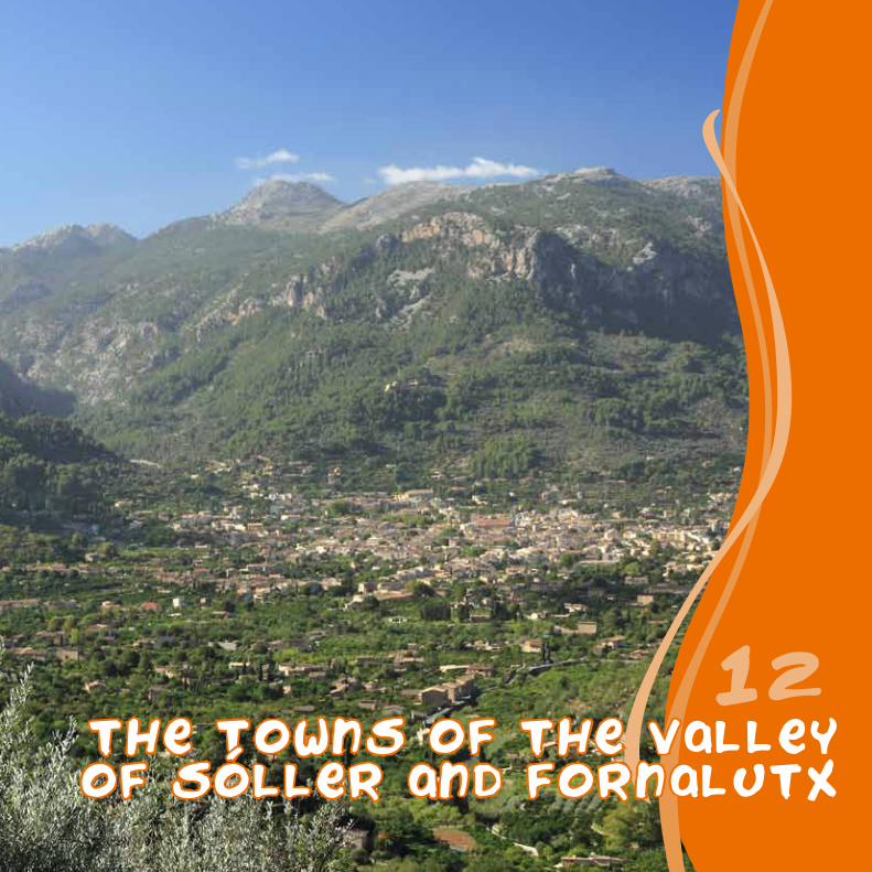
THE TOWNS OF THE VALLEYOF soller and fornalutx
12

Painted roof tilesSuperstition has always had a real presence among the
inhabitants of Serra de Tramuntana, who used to do everything needed in order to encourage good luck and
protect themselves against evil spirits.
Some of the most popular rituals were the ones linked to properties. On the day when owners entered their home
for the first time, they would notify the spirits of their presence by cutting branches from the trees, opening and closing doors and windows and crying out loudly that they were taking possession of the residence. They also decorated the roof overhangs with animal,
vegetable and human motifs and inscriptions of symbolic value, whose meanings are now unknown. Even so, they are one of the most unique elements of Fornalutx’s
architecture and they will undoubtedly continue to protect their inhabitants.
The tour begins in Plaça de la Constitució in Sóller, from where you continue the path of stage 5 of the Dry Stone Route. Take Carrer de Sa Lluna, the town's shopping street “par excellence”, and turn left on Carrer de la Victòria 11 de maig.
Without changing direction, you continue along Avenida de Asturias and, once you have passed the bridge over the stream of Fornalutx, with the municipal sports pitch opposite, turn right to keep going along the Camí des Murterar, always parallel to the course of the water.
Without coming off the GR 221, just before Pont de Can Rave, turn to your left, forget about the Ses Marjades path and the Sa Capelleta route on your left, and you will reach a sharp bend, where on the left, a route begins that will lead to the farmstead of Binibassí.
Here you leave the stage that continues on towards Biniaraix, and choose the one that goes to Fornalutx. You will find it between the wash houses and the tower of the Binibassí estate.
Once you have passed Fornalutx cemetery and the Sa Rutlana municipal pitch, head into Fornalutx along
Carrer de Joan Albertí Arbona, which joins up with the town plaza. Opposite, look for Carrer Major, afterwards, Carrer de Sa Font and walk by the house and tower of Can Arbona, which is where the Council is located.
You will then come across the manors of Can Xoroi and Pont des Creuer and, at a bend, you begin heading up the Camí des Creuer towards the olive trees of Es Marroigs, where there are spectacular views over the valley and, further up, next to Penyal d’en Carles, you will join up with Monnàber cart road (paved).
Take this path, and heading downwards, you will arrive at the wash houses of Biniaraix, where you will join up again with the Dry Stone Route and continue along Carrer de Sant Josep. You will pass Plaça de la Concepció, with the village’s church and Carrer de Sant Guillem, where you turn at the first detour that emerges on the right.
After leaving the town centre, you will cross the Biniaraix vegetable garden and come to the road that goes from Fornalutx to Sóller, where after one hundred metres you turn to the right to take the path that allows you to return to the village of Binibasssí, which is visible on a small hill. From here, you retrace the path that takes you back to Plaça de la Constitució in Sóller.

soller
binibassi
fornalutx
penyald en carles
biniaraix
pont decan rave
cementeride fornalutx
horta debiniaraix
binibassi
fornalutx
penyal D en carles
biniaraix
pont decan rave
cementeride fornalutx
horta debiniaraix
Soller
3 h 22 min
10.269 m
50 m
0 2 km 4 km 6 km 8 km 10 km
100 m150 m
200 m250 m300 m350 m
Sóller Sóller
BinibassíFornalutx
BinibassíBiniaraix
Penyal d'en Carles

the towns of valley of soller
and fornalutx
12
Start / End: Sóller, Plaça de la Constitució (33 m)
Distance: 10.269 m
Time required: 3 h 22 min
Difficulty: medium
Net increase in altitude: 384 m
Net decrease in altitude: 384 m
Not suitable for: children under the age of 6, prams for children can only be taken as far as Torrent de s'Ermita mountain stream
Palma
the towns of valley of
Sóller and Fornalutx
Binibassi and King Arthur
Once upon a time there was a knight who lived in Binibassí. One day, he
went to the Port of Santa Catalina, the name used for the Port of Sóller
in the past. There, he was kidnapped by a whale and a parrot that took him to an enchanted island, where
he met King Arthur from Britain (the one from the Round Table),
and his sister Morgana. They ordered him to return to
Mallorca and explain to his fellow countrymen all that he
had seen and heard during his travels. And that is exactly
what Guillem de Torroella, lord of Binibassi, did in the book entitled “La Faula”, written
towards the end of the 14th century.

es fornassos and s esquena de s ermita
13

The "colls de tords"Thrushes are small birds that barely grow to 20 centimetres in length and 100 grams in weight.
They spend winter on our island before returning afterwards to the north of Europe.
During their stay on the island, they sleep in the forest, and at dawn they head out to the olive groves and areas of garrigue vegetation, where they feed on
worms, olives and the fruits of mastic trees. Hunters take advantage of this habit in order to hunt them
by placing nets along their route. This is a very old ritual, and in past eras it was for many people one of
the few means of obtaining something to eat.
The route begins in the Caimari Ethnological Park, which you can visit before starting the walk. It is located on the Camí de ses Deveres, a few metres from the entrance to the town and it shows aspects of the old rural way of life, such as freezer rooms, lime furnaces and huts for coalmen.
Once you have finished your visit, head to Caimari, where you will go up Carrer de Nostra Senyora de Lluc until, one the left, you find Carrer des Fornassos, which takes you to the play area of the same name, which has tables, benches and outdoor grills.
On the right you can see the watercourse where your route begins. Located between myrtle bushes and pine forests, it runs up a steep slope, to the hillock named Sa Placeta. Then, continue along the path on your right, which is surrounded by rope grass and rises gradually.
Soon after the pine grove, the route clears for a few moments, and to the west, offers an excellent panoramic view of the towns of Mancor de la Vall,
Santa Llúcia and the Puig des Suro. Afterwards, you will come across the first of the colls de tords (the thrush hunting areas) that you will find along the way.
The climb continues, with Puig de sa Creu opposite, and the city of Inca and the Pla de Mallorca behind you. A little further along you will come to a crossroads. On the right there is still a pond used to water livestock with two openings, it bears witness to the livestock farming on the commons, which were leased out by the Council of Selva.
You keep climbing until you reach Coll Sacós, a hill from where you can see the Puig de n’Escuder on your right, the setting that has witnessed several local legends.
From here, the path goes up in a zig-zag shape and reaches Es Planiol where you will find the vantage point of S’Esquena de S’Ermita. It will enable you to enjoy spectacular panoramic views over the Bay of Mallorca and the Pla de Mallorca. The climb ends here, and you turn in order to retrace your path, now downwards, in order to return to the Ethnological Park of Caimari, the starting point of the route.
“Coll de tords” by Archduke Ludwig Salvator of Austria

es fornassos
Parc Etnologic
comuna de caimari
sa placeta
Mirador de s'Esquena
de s'Ermita
es fornassos
sa placeta
comuna de caimari
Parc Etnologic
Mirador de s'Esquena
de s'Ermita
1 h 50 min
4.324 m500 m400 m300 m200 m100 m
0 1 km 2 km
Mirador de s'Esquena de s'Ermita
sa Placeta
es Fornassos
3 km 4 km
sa Placeta
es Fornassos
Parc Etnològic Parc Etnològic

es fornassosand s esquena
de s ermita
13
Start / End: Caimari, Ethnologic Park (158 m)
Distance: 4.324 m
Time required: 1 h 50 min
Difficulty: medium
Net increase in altitude: 311 m
Net decrease in altitude: 311 m
Not suitable for: prams for children, wheelchairs
Palma
es Fornassos and s'Esquena de s'Ermita
MyrtleThe leaves of this bush, known for their aromatic properties, were used in other eras to waterproof animal hides and prevent them from rotting and to create myrtle water, very highly valued as a perfume. To create it, branches were cut between March and August, they were dried and then they were hit with a club in order to make the leaves fall onto a sheet.
Afterwards they were placed in a copper still, where they were mixed with water. When it reached high temperatures, its essences evaporated. Having cooled and condensed as they passed through the cooling coil, what remained was myrtle water.
The hermitsIn another era, hermits settled in the Comuna de Caimari, and dedicated
their time to prayer and work. They lived austerely with the help of alms that the residents gave to them out of their love of God.
Some documents have survived from their time in the area, as well as the place name of S’Esquena de s’Ermita. However, memory of
the building in which they dwelt has vanished. Perhaps forever? We hope not, perhaps one day someone will find its remains
at they walk between the crags and watercourses.

Pas de s escaleta
14

The Commune of "s'Estret"Many years ago, around the year 1300, King James II wanted to make it easier to
repopulate the island so he regulated the creation of new towns with public spaces designed to supply the inhabitants with firewood, hunting and grazing land.
For centuries, the “alaroners” used S’Estret as a source of resources, and one that was especially important during famines. However, at the end of the 17th century a large fire
took place which razed to the ground pine forests and areas of garrigue. Subsequently, the authorities decided to divide the land into plots and sell it.
The first task the new owners faced was building the terraces walls, crucial for growing in an area with such a steep slope. To do so, they broke up boulders and cleared rocks
from the land. Another essential step was grafting wild olive trees with olive trees, and finally, they built huts in order to shelter tools, beasts of burden and workers.
In the plaza of the town of Alaró you begin an urban route that takes you northwards, first along Carrer de Can Xalet, and after turning left, along Carrer d’Enmig.
In the neighbourhood of Los d’Amunt you come to Plaza de Cabrit i Bassa, and begin climbing up Carrer de Son Durán, which will take you out of the urban centre.
You then pass by Moli de sa Font, on your right, which functioned using water from the Font de ses Artigues, a fountain located a little further up.
After going across the s’Estret stream over a little bridge, the path is closed in between the course of the water and the crags. Afterwards, it opens out onto the valley, which was previously the property of the inhabitants of Alaró.
Keep going up, ignoring an access route on the left which leads to Cas Siquier and, before the following bend, you also head off on the left along a narrower path.
After a while, you will come to a wall that can be overcome thanks to some steps, known as the Pas de s’Escaleta. From here, the route runs between holm oaks and rocks until you reach Sa Plana.
You cross a gate, and begin the descent between the
terraces of an abandoned olive grove, a little further down you will find a fountain, Sa Fonteta, with a small veranda and a drinking trough.
You then continue between terraces, which accompany the route until you reach a gate that leads to the road linking Orient and Alaró. Here you will find signposting for the Dry Stone Route, characterised by the white and red colour strips. Keep going along with caution due to the cars, towards Alaró, and once you have passed the houses of Son Bernadàs, that appear in the lower part of the roads, on the right you will find the gate that leads to the path to follow, just beside the Font d’en Tries and its wash house.
This marks the start of the climb to Pla des Pouet, an esplanade at the end of which you will find a cart road on your right, which goes beyond the path that, heading in the opposite direction, leads to Alaró Castle.
Once you have passed the houses of Es Verger, you will once again find signs for the GR 221, that you follow downwards, before passing the houses of Son Penyaflor and Son Curt. Then, turn to the right at the first cross roads and right again at the second one, before ending up in the town of Alaró, at the starting point.

sonpenyaflor
CASA CONSISTORIAL
es verger
los d amunt
s estret
plades pouet
soncurt
PAS DES escaleta
sonpenyaflor
CASA CONSISTORIAL
es verger
los d amunt
s estret
plades pouet
soncurt
PAS DES escaleta
5 h
14.078 m
300 m
400 m
500 m
600 m
700 m
200 m0 2 km 4 km 6 km 8 km 10 km 12 km 14 km
Alaró
S'Estret
Pas de s'Escaleta
Pla des Pouet
Es Verger
Alaró

pas des escaleta
14
Start / End: Alaró, Plaça de la Vila (224 m)
Distance: 14.078 m
Time required: 5 h
Difficulty: high
Net increase in altitude: 710 m
Net decrease in altitude: 710 m
Not suitable for: children under the age of 6, prams for children, wheelchairs
Palma
Pas des'Escaleta
The legend of Son PenyaflorSon Penyaflor lies to the west of your route. It is an estate that owes its name to the lineage of one of the old land owning families. However, legend provides an explanation that goes back to the 14th century, to a time of disputes over dominion of the kingdom of Mallorca.
It is said that when the nobleman Arnau de Vilaragut became a widower (a supporter of the defeated James III of Mallorca) he moved to this estate with his daughter Blanca Bella. While he spent his time hunting, his daughter would walk alone in the woods collecting flowers and fruits. On one of these outings, she met Jordi Unís de Montacada, governor of the castle and supporter of Pere el Ceremoniós, and she fell in love with him.
When her father found out, he was furious and swore blindly that he would never permit the relationship, so much so that it would be more likely for the crags below the castle to flower. Lo and behold, spring arrived and the crags blossomed with “violes boscanes” and “violes de penyal”, so the couple in love were able to get married. Ever since, the estate has been known as Son Penyaflor.

Wear appropriate footwear and clothing.Bear in mind that in summer, the temperatures can be very high. Avoid walking at midday. Take with you and drink large amounts of water to keep you from getting dehydrated.Do not light fires.Do not leave litter behind.Respect your surroundings and leave everything just as you found it.Keep to the signposted paths. If you are walking alone, take a mobile phone with you.
Leave gates just as you found them.All dogs must be kept on a lead.If you are riding a bicycle or horse, respect hikers and do not ride at speeds that might put other users in danger.Do not build cairns of stones.If you notice that a signpost is missing or that there are any other defects, please inform the Trail Management at [email protected] or on telephone no. 971 173 700.Phone 112 in the case of emergency.
RECOMMENDATIONS
Cala de Deia
Deià
1
CUBER
Escorca
2
PUIG DE MARIA
Pollença
3
CASTELL D'ALARO
Alaró
4
CAMI VELL DES BARRANC
Sóller
5
TALAIA D'ALCUDIA
Alcúdia
6FAR DE TRAMUNTANAlighthouse
Dragonera · Andratx
7
NA POPIA
Dragonera · Andratx
8
FAR DE LLEBEIGlighthouse
Dragonera · Andratx
9
CAMI DE SA FIGUERA
Sóller
10
puig de Galatzo
Estellencs
11the towns of the valley of soller and fornalutx
Sóller i Fornalutx
12
es fornassos and s'esquena de s'ermita
Selva · Caimari
13
pas de s'escaleta
Alaró
14

This project has been funded with
the support of the European Commission.
This publication is the sole responsibility
of the author.The Commission cannot
be held responsible for any use which
may be made of the information
contained therein.
PARC NATURALDE S'ALBUFERA
Refugi deCAN BOI
Refugi deSON AMER
Refugi delPONT ROMÀ
Refugi deMULETA
Refugi deTOSSALS
VERDS
Hostatgeria delCASTELL D'ALARÓ
352
491
Mola de s'Esclop
926
1027Puig de Galatzó
765Puig de sa Parra
Mola de PlanÌcia
934
Fita del Ram830
Mola de Sarrià
499
Puig de Benàtiga
616
373
Puig de na Baucà
sa Comuna708
644Sa Gúbia
1062Puig des Teix
Puig de Bàlitx
578
Puig Major1445
1365Puig de
Massanella
Puig deMaria
333
334el Fumat
Puig de SantaMagdalena
444Talaia
d'Alcúdia
350El Morral
839Puig Gros de
Ternelles
Puig Roig1002
Puig Caragoler
921
Puig de n'AlÍ1035
Serra des Vidre
623
Puig de Ca8871103
PuigTomir
Puig de Suro644
Puig desTossalsVerds
1118
1091Puig de l'Ofre
307
Puig de ses Basses
la PenyaMascorda
443
Mola de Son Pacs
Puig deses Rotes
Coll des Vent
Mola deSon Cotoner
Serra de na Burgesa
Coll deSóller
Clot d'Albarca
Vall d'en Marc
Puig deRanda
Castell del Rei
Fita del Ram
Serra de Cornavaques
Cap de sa Mola
Palmanyola
Llucalcari
Ruberts
Cap de Regana
Son Macià
Son Carrió
Calonge
s'Alqueria Blanca
s'Horta
Cas Concos
es Llombards
Colòniade Sant Jordi
Cala Pi
s'Estanyolde Migjorn
sa Ràpita
Pòrtol
es Capdellà
Galilea
PegueraPort d'Andratx
Illa del ToroCap de Cala Figuera
Cap Enderrocat
Cap Blanc Portopetro
Cala Figuera
Cala Santanyí
Cala Murada
Cala d'Or
Portocolom
Port de Manacor
Cales deMallorca
Punta de n'Amer
Cala Millor
s'Illot
Costadels Pins
Cala Bona
Cala Rajada
Son Serrade Marina
Colònia deSant Pere
Betlem
Can Picafort
Moscari
Illa d'Alcanada
Cap des Pinar
Portd'Alcúdia
Port de Pollença
Cap de Formentor
Cala de Tuent
Sa Calobra
Port deSóller
Biniaraix
Port de Valldemossa
Port desCanonge
Biniali
Pina
Caimari
Parc NaturalSa Dragonera
Sant Elm
Biniamar
Arenaletd'Albarca
SANTUARIDE LLUC
s'Arracó
Orient
Albufereta
ANDRATX
CALVIÀ
PALMA
BANYALBUFAR
DEIÀ
VALLDEMOSSA
BUNYOLA
SÓLLER
BINISSALEM
CONSELL
SANTA MARIADEL CAMÍ
ALARÓ
FORNALUTX
MARRATXÍ
SENCELLES
COSTITX
SANTA EUGÈNIA
SELVA
LLOSETA
INCA
MANCORDE LA VALL
POLLENÇA
ALCÚDIA
MURO
BÚGER
SA POBLA
CAMPANET
LLUCMAJOR
MONTUÏRIALGAIDA
PORRERES
FELANITX
CAMPOS
SANTANYÍ
SES SALINES
PUIGPUNYENT
MANACOR
SINEU
LLORET DEVISTALEGRE
VILAFRANCA
SANT JOAN
PETRA
ARTÀ
CAPDEPERA
SANT LLORENÇDES CARDASSAR
SON SERVERA
SANTAMARGALIDA
ARIANY
MARIA DELA SALUT
LLUBI
ESPORLES
ESTELLENCS
Before undertaking the routes, look up the website in order to obtain up to date information
www.conselldemallorca.net/mediambient/pedra
Tel. 34 971 173 700Fax. 34 971 173 732c/ del General Riera, 11107010 Palma
1
2 345
6
78
9
10
11
1213
14