Guidance on establishing reference conditions and ... · REFCOND Guidance Final version, 30 April...
86
REFCOND Guidance Final version, 30 April 2003 1 CIS - WFD Guidance on establishing reference conditions and ecological status class boundaries for inland surface waters Produced by Working Group 2.3 1 Reference conditions for inland surface waters (REFCOND) 1 Working Group 2.3 was established under the EU Common Implementation Strategy (CIS) for the Water Framework Directive.
Transcript of Guidance on establishing reference conditions and ... · REFCOND Guidance Final version, 30 April...

REFCOND Guidance Final version, 30 April 2003
1
CIS - WFD
Guidance on establishing referenceconditions and ecological status classboundaries for inland surface waters
Produced by Working Group 2.31 � Referenceconditions for inland surface waters (REFCOND)
1 Working Group 2.3 was established under the EU Common Implementation Strategy (CIS) for the Water
Framework Directive.

REFCOND Guidance Final version, 30 April 2003
2
ForewordThe EU Member States, Norway and the European Commission have jointly developed acommon strategy for supporting the implementation of the Directive 2000/60/EC establishinga framework for Community action in the field of water policy (the Water FrameworkDirective). The main aim of this strategy is to allow a coherent and harmoniousimplementation of this Directive. Focus is on methodological questions related to a commonunderstanding of the technical and scientific implications of the Water Framework Directive.
In the context of this strategy, the project �Development of a protocol for identification ofreference conditions, and boundaries between high, good and moderate status in lakes andwatercourses� was launched in December 2000 and named REFCOND. During 2001 theREFCOND project was widened to an informal working group included in the CommonImplementation Strategy (working group 3.2). The final document to be produced was alsochanged from a more formal and binding protocol to a non-legally binding guidancedocument. Sweden is the lead country with responsibility of the co-ordination of the workinggroup that is composed of ecologists and technical experts from governmental and non-governmental organisations. The Swedish Environmental Protection Agency (SEPA) has theresponsibility for the administration and management and the Swedish University ofAgricultural Sciences, as sub-contractor to SEPA, has the responsibility for the scientificproject management.
The present guidance document is the outcome of this working group. It contains thesynthesis of the output of the REFCOND group activities and discussions that have takenplace since December 2000. It builds on the input and feedback from a wide range of expertsand stakeholders from EU Member States and candidate countries that have been involvedthroughout the process of guidance development through meetings, workshops, conferencesor electronic communication media, without binding them in any way to its content.
�We, the water directors of the European Union, Norway, Switzerland and the countriesapplying for accession to the European Union, have examined and endorsed this guidancethrough written procedure during April 2003. We would like to thank the participants and, inparticular, the Swedish leaders of the Working Group, for preparing this high qualitydocument.
We strongly believe that this and other guidance documents developed under the CommonImplementation Strategy will play a key role in the process of implementing the WaterFramework Directive. This guidance document is a living document that will need continuousinput and improvements as application and experience build up in all countries of theEuropean Union and beyond. We agree, however, that this document will be made publiclyavailable in its current form in order to present it to a wider public as a basis for carryingforward ongoing implementation work. Moreover, we welcome that several volunteers havecommitted themselves to test and validate this and other documents in the so-called pilot riverbasins across Europe during 2003 and 2004 in order to ensure that the guidance isapplicable in practice.
We also commit ourselves to assess and decide upon the necessity for reviewing thisdocument following the pilot testing exercises and the first experiences gained in the initialstages of the implementation.�

REFCOND Guidance Final version, 30 April 2003
3
Table of contents
FOREWORD ......................................................................................................................................................... 2
TABLE OF CONTENTS ...................................................................................................................................... 3
INTRODUCTION - A GUIDANCE DOCUMENT: WHAT FOR?.................................................................. 5
TO WHOM IS THIS GUIDANCE DOCUMENT ADDRESSED?..................................................................... 5WHAT CAN YOU FIND IN THIS GUIDANCE DOCUMENT? ...................................................................... 5ADAPTATION TO REGIONAL AND NATIONAL CIRCUMSTANCES ........................................................... 6WHAT YOU WILL NOT FIND IN THIS GUIDANCE DOCUMENT ................................................................ 6
SECTION 1. INTRODUCTION - IMPLEMENTING THE DIRECTIVE...................................................... 8
1.1 DECEMBER 2000: A MILESTONE FOR WATER POLICY.................................................................. 81.2 PURPOSES AND TIMING.................................................................................................................. 81.3 WHAT ARE THE KEY ACTIONS THAT MEMBER STATES NEED TO TAKE? ..................................... 111.4 CHANGING THE MANAGEMENT PROCESS � INFORMATION, CONSULTATION AND PARTICIPATION........................................................................................................................................................... 111.5 INTEGRATION: A KEY CONCEPT UNDERLYING THE WFD............................................................ 111.7 WORKING GROUP 2.3 � REFCOND ............................................................................................ 13
SECTION 2. COMMON UNDERSTANDING OF CONCEPTS AND TERMS........................................... 15
2.1 REFERENCE CONDITIONS AND HIGH ECOLOGICAL STATUS ......................................................... 152.2 GOOD AND MODERATE ECOLOGICAL STATUS ............................................................................. 172.3. SURFACE WATER BODIES............................................................................................................ 182.4 WETLANDS .................................................................................................................................. 202.5. WATER BODY TYPES................................................................................................................... 212.6 CLASSIFICATION OF ECOLOGICAL STATUS .................................................................................. 23
SECTION 3. GENERAL GUIDANCE ON PRINCIPLES AND METHODS FOR ESTABLISHINGREFERENCE CONDITIONS AND ECOLOGICAL STATUS CLASS BOUNDARIES ............................ 28
3.1 OVERVIEW � A STEPWISE APPROACH .......................................................................................... 283.2 NEED FOR INFRASTRUCTURE....................................................................................................... 303.3 DIFFERENTIATION OF WATER BODY TYPES ................................................................................. 313.4 USE OF PRESSURE CRITERIA AND ECOLOGICAL CRITERIA ........................................................... 323.5 METHODS FOR ESTABLISHING REFERENCE CONDITIONS ............................................................. 353.7 ASSESSING VARIABILITY IN REFERENCE CONDITIONS................................................................. 403.8 SETTING EQR-BASED CLASS BOUNDARIES ................................................................................. 42

REFCOND Guidance Final version, 30 April 2003
4
SECTION 4. THE TOOLBOX........................................................................................................................... 46
TOOL 1. PROPOSED PRESSURE SCREENING CRITERIA FOR SELECTING POTENTIAL REFERENCECONDITION SITES OR VALUES. ........................................................................................................... 47TOOL 2. INTERPRETATIONS OF NORMATIVE DEFINITIONS FOR THE BIOLOGICAL QUALITY ELEMENTS........................................................................................................................................................... 49TOOL 3. NUMERICAL EXAMPLES ON SETTING CLASS BOUNDARIES ACCORDING TO ALTERNATIVE A,B AND C IN SECTION 3.8. ................................................................................................................... 55
SECTION 5. EXAMPLES ON GOOD PRACTICE ........................................................................................ 58
EXAMPLE 1. DEVELOPMENT OF A RISK BASED PRIORITISATION PROTOCOL FOR STANDING WATERSIN GREAT BRITAIN, BASED ON A GEOREFERENCED INVENTORY, AS AN AID TO DEFINING REFERENCECONDITIONS. ...................................................................................................................................... 58EXAMPLE 2. THE USE OF PALAEOLIMNOLOGY AND SPECIES TURNOVER MEASURES TO SELECTPOTENTIAL REFERENCE LAKES .......................................................................................................... 61EXAMPLE 3. THE ESTABLISHMENT AND VALIDATION OF REFERENCE CONDITIONS FOR LAKES ANDLARGE RIVERS IN GERMAN PARTS OF THE CENTRAL EUROPEAN LOWLAND, ECOREGION 14, USINGPALEOLIMNOLOGY............................................................................................................................. 64
REFERENCES .................................................................................................................................................... 67
ANNEX A OVERALL STRUCTURE OF THE COMMON IMPLEMENTATION STRATEGY
ANNEX B LIST ON REFCOND PARTNERS AND OTHER CONTACTS
ANNEX C NORMATIVE DEFINITIONS IN WFD OF ECOLOGICAL STATUS CLASSIFICATIONS FORRIVERS AND LAKES
ANNEX D GLOSSARY
ANNEX E LIST OF RELEVANT EU-FUNDED RESEARCH PROJECTS
ANNEX F (ECO)REGION SPECIFIC TYPOLOGY
ANNEX G WHO NEEDS TO GET INVOLVED IN CARRYING OUT AND USING THE REFERENCECONDITION ANALYSIS?

REFCOND Guidance Final version, 30 April 2003
5
Introduction - A Guidance Document: What For?
To whom is this Guidance Document addressed?This document aims at guiding experts and stakeholders in the implementation of theDirective 2000/60/EC establishing a framework for Community action in the field of waterpolicy (the Water Framework Directive � �the Directive�). It focuses on the implementationof the Annexes II and V with special emphasis on inland surface waters and methods andprinciples for the establishment of reference conditions and class boundaries between high,good and moderate ecological status. If this is your task, we believe the guidance will helpyou in doing the job, whether you are:
• Establishing reference conditions and ecological status class boundaries for inlandsurface waters yourself or participating in the process as a stakeholder;
• Leading and managing experts undertaking the ecological status analysis;• Using the results of the ecological status analysis for taking part to the policy making
process; or• Reporting on the ecological status analysis to the European Union as required by the
Directive.
What can you find in this Guidance Document?Purposes and timing (Section 1)
• What is the role of the key elements in the REFCOND guidance document within theimplementation process of the Directive?
• The timetable of the Directive - When are Member States expected to deliversomething that requires that reference conditions and class boundaries have beenestablished?
Common understanding of concepts and terms (Section 2)• What are the key elements of the Water Framework Directive relating to reference
conditions and ecological status classes?• Where in the Directive are these elements made explicit or referred to?• Which is the common understanding of the concepts “reference conditions” and “high
ecological status”, “good” and “moderate ecological status”, “surface water bodies,“wetlands”, “water body types” and “classification of ecological status”incorporating the Directive’s terminology and requirements?
Principles and methods for establishing reference conditions and ecological status classboundaries (Section 3)
• Which are the key steps in the suggested approach for establishing referenceconditions and ecological quality class boundaries?
• Which infrastructure is needed for a successful implementation of the suggestedapproach?
• How can differentiation of water body types be done in order to support theestablishment of reference conditions and the intercalibration exercise?

REFCOND Guidance Final version, 30 April 2003
6
• How can ecological criteria and pressure criteria be used in site selection and forsetting class boundaries?
• What benchmark should we use to determine very minor and slight disturbance interms of pressure criteria?
• What methods can be used to establish reference condition values and what are thestrengths and weaknesses of different methods?
• How can reference conditions and quality class boundaries be validated?• How can “ sufficient level of confidence about the values for the reference conditions”
be dealt with?• How can “adequate confidence and precision in the classification of the quality
elements” be dealt with?• Which are the circumstances for excluding quality element indicators when
establishing reference conditions?• How can the ecological quality class boundaries be set, and are there any alternative
approaches?
The Toolbox (Section 4)• Which specific tools are available for establishing reference conditions and ecological
quality class boundaries?• How can these tools be further developed and tested in order to be tailored for
different water body types, different pressures-impacts and different quality elements?
Good practice Examples (Section 5)• What examples are available of current good practice in respect of at least one aspect
of the suggested approach for establishing reference conditions and ecological qualityclass boundaries?
Adaptation to regional and national circumstancesThe Guidance Document proposes an overall methodological approach. Because of thediversity of circumstances within the European Union, the way to deal with the logicalapproach and answer to questions will vary from one river basin to the next. The proposedmethodology would therefore need to be tailored to specific circumstances.
What you will not find in this guidance documentThe guidance document focuses on definitions, methods, principles and criteria to be usedwhen establishing reference conditions and when setting the boundaries between high, goodand moderate ecological status for inland surface waters. The document does not includeguidance for specific quality elements and specific water body types but is restricted togeneral guidance that applies to most quality elements and most inland surface water bodytypes. The guidance does not focus on:
• Groundwater, transitional water and coastal water (handled by CIS Working Group2.8 (groundwater) and 2.4 (coastal and transitional water);
• Classification of poor and bad ecological status;• Emission limit values and environmental quality standards for classification of
chemical status (handled by Expert Advisory Forum on Priority Substances);

REFCOND Guidance Final version, 30 April 2003
7
• Method standardisation and intercalibration (intercalibration is handled by CISworking group 2.7).

REFCOND Guidance Final version, 30 April 2003
8
Section 1. Introduction - Implementing the DirectiveThis Section introduces the overall context for the implementation of the Water FrameworkDirective and informs on the initiatives that led to the production of this Guidance Document.
1.1 December 2000: A Milestone for Water PolicyDecember 22, 2000, will remain a milestone in the history of water policies in Europe: on thatdate, the Water Framework Directive (or the Directive 2000/60/EC of the EuropeanParliament and of the Council of 23 October 2000 establishing a framework for Communityaction in the field of water policy) was published in the Official Journal of the EuropeanCommunities and thereby entered into force.
This Directive is the result of a process of more than five years of discussions andnegotiations between a wide range of experts, stakeholders and policy makers. This processhas stressed the widespread agreement on key principles of modern water management thatform today the foundation of the Water Framework Directive.
1.2 Purposes and timingThe Directive establishes a framework for the protection of all waters (including inlandsurface waters, transitional waters, coastal waters and groundwater) which:
• Prevents further deterioration and protects and enhances the status of waterresources;
• Promotes sustainable water use based on long-term protection of water resources;• Aims at enhancing protection and improvement of the aquatic environment through
specific measures for the progressive reduction of discharges, emissions and losses ofpriority substances and the cessation or phasing-out of discharges, emissions andlosses of the priority hazardous substances;
• Ensures the progressive reduction of pollution of groundwater and prevents its furtherpollution; and
• Contributes to mitigating the effects of floods and droughts.
Overall, the Directive aims at preventing deterioration of the status of all bodies of surfacewater and achieving good water status for all waters by 2015. For surface waters, �goodstatus� is determined by a �good ecological status� and a �good chemical status�. Ecologicalstatus is determined by biological quality elements, supported by hydromorphological andphysico-chemical quality elements. The point of reference is given by �undisturbed�conditions showing no or only �very minor� human impacts.
The various articles of the directive describe what shall be done and the sometimes ratherelaborate annexes are to be seen as a way to help Member States in doing the job andachieving the overall purpose of the directive. Hence, although the text at a first reading mayseem difficult to comprehend, the purpose that it is intended to result in is simple and easy tounderstand.
The present guidance document (REFCOND guidance) will, together with the other Guidancedocuments published by the Commission, help Member States achieve that purpose. It does

REFCOND Guidance Final version, 30 April 2003
9
so by advising on how member states may proceed to establish reference conditions andecological status class boundaries for lakes and watercourses.
It should be pointed out here, that the REFCOND guidance does not provide solutions indetail that may be copied and applied as such. Rather, it offers principles, ways of reasoningand suggestions on alternative pathways of action. It is up to Member States themselves toimplement these principles and suggestions under their own circumstances and to be able toverify that the solutions meet the requirements of the directive. Harmonization betweenMember States will be achieved through intercalibration (which is described in a separateguidance document) and participation in the work in Pilot River Basins and InternationalRiver Basin Districts.
Guidance on the establishment of reference conditions and class boundaries are needed atseveral stages in the implementation of the directive (Figure 1). They will first be needed forthe selection of sites for the draft register of intercalibration sites which should be completedin December 2003. More specifically, criteria for selecting minimally disturbed sites (on thehigh/good boundary) and slightly disturbed sites (on the good/moderate boundary)representative of different water body types will be needed. The present guidance documentwill also be needed for selection of complementary sites for the final register ofintercalibration sites which should be completed in December 2004. The actualintercalibration exercise should be completed 18 months after the final register on sites havebeen established (described in guidance document on intercalibration). As the intercalibrationexcercise will be completed before the monitoring programmes are fully operational (seeFigure 1) pressure criteria for selection of sites will have to be used together with existingsurvey data on ecological status.
The analysis of characteristics of River Basin Districts and the assessment of the risk forindividual water bodies of failing the environmental objectives in accordance with Article 5and Annex II in the Directive will also require guidance on reference conditions andclassification. This analysis should be completed at the latest in December 2004. As themonitoring programmes will not be fully operational this risk assessment will have to relyvery much on pressure information.
According to Article 8 of the Directive monitoring programmes shall be operational at thelatest in December 2006. The REFCOND guidance will here be needed for the specificationof the monitoring requirements of reference sites (high status sites) and assessing ecologicalstatus of all monitoring sites.
Finally, the REFCOND guidance will be needed when producing the first River BasinManagement Plans which should be published at the latest in December 2009. In these planstype-specific reference conditions shall be listed together with map presentations onecological status classifications for surface waters.
The dates given in Figure 1 outlines the time schedule for Member States to deliverdocumentation indicating that reference conditions and class boundaries have beenestablished. In practice this means that work has to be done well in advance and should bestarted immediately. The time needed to do the job will vary with circumstances, such as thevariability and complexity of the water bodies in Member States as well as the availableexpertise.

REFCOND Guidance Final version, 30 April 2003
10
1
Years after the date of adoption Ğ 01 Dec 2000
2 3 4
on
GIS-m
5 6 7 8 9 10
Draft register ofintercalibration s ites(Annex V, 1.4.1)
Final register ofintercalibration s ites(Annex V, 1.4.1)
Intercal ibrationexcercise 2005-6(Annex V, 1.4. 1)
Character isation andrisk assessment(Annex II)
Monit oring program-mes made operational (Annex V)
First RBMPpublished(Annex VII)
Figure 1. Timetable for implementation of parts of the Water Framework Directive which aredepending on guidance from WG 2.3 (REFCOND).
REFCOND Guidance Final version, 30 April 2003
11
1.3 What are the key actions that Member States need to take?� To identify the individual river basins lying within their national territory and assign
them to individual River Basin Districts (RBDs) and identify competent authorities by2003 (Article 3, Article 24);
� To characterise river basin districts in terms of pressures, impacts and economics ofwater uses, establishing a register of protected areas lying within the river basindistrict and finally assessment of the risk for individual water bodies of failing theenvironmental objectives by 2004 (Article 5, Article 6, Annex II, Annex III);
� To make operational the monitoring networks by 2006 (Article 8);� Based on sound monitoring and the analysis of the characteristics of the river basin, to
identify by 2009 a programme of measures for achieving the environmental objectivesof the Water Framework Directive cost-effectively (Article 11, Annex III);
� To produce and publish River Basin Management Plans (RBMPs) for each RBDincluding the designation of heavily modified water bodies, by 2009 (Article 13,Article 4.3);
� To implement water pricing policies that enhance the sustainability of water resourcesby 2010 (Article 9);
� To make the measures of the programme operational by 2012 (Article 11);� To implement the programmes of measures and achieve the environmental objectives
by 2015 (Article 4)
Member States may not always reach good water status for all water bodies of a river basindistrict by 2015, for reasons of technical feasibility, disproportionate costs or naturalconditions. Under such conditions that will be specifically explained in the RBMPs, the WaterFramework Directive offers the possibility to Member States to engage into two further six-year cycles of planning and implementation of measures.
1.4 Changing the management process � information, consultationand participationArticle 14 of the Directive specifies that Member States shall encourage the activeinvolvement of all interested parties in the implementation of the Directive and developmentof river basin management plans. Also, Member States will inform and consult the public,including users, in particular for:
• The timetable and work programme for the production of river basin managementplans and the role of consultation at the latest by 2006;
• The overview of the significant water management issues in the river basin at the latestby 2007;
• The draft river basin management plan, at the latest by 2008.
1.5 Integration: a key concept underlying the WFDThe central concept to the Water Framework Directive is the concept of integration that isseen as key to the management of water protection within the river basin district:
REFCOND Guidance Final version, 30 April 2003
12
� Integration of environmental objectives, combining quality, ecological and quantityobjectives for protecting highly valuable aquatic ecosystems and ensuring a generalgood status of other waters;
� Integration of all water resources, combining fresh surface water and groundwaterbodies, wetlands, coastal water resources at the river basin scale;
� Integration of all water uses, functions and values into a common policyframework, i.e. investigating water for the environment, water for health and humanconsumption, water for economic sectors, transport, leisure, water as a social good;
� Integration of disciplines, analyses and expertise, combining hydrology, hydraulics,ecology, chemistry, soil sciences, technology engineering and economics to assesscurrent pressures and impacts on water resources and identify measures for achievingthe environmental objectives of the Directive in the most cost-effective manner;
� Integration of water legislation into a common and coherent framework. Therequirements of some old water legislation (e.g. the Fishwater Directive) have beenreformulated in the Water Framework Directive to meet modern ecological thinking.After a transitional period, these old Directives will be repealed. Other pieces oflegislation (e.g. the Nitrates Directive and the Urban Wastewater Treatment Directive)must be co-ordinated in river basin management plans where they form the basis of theprogrammes of measures;
� Integration of all significant management and ecological aspects relevant tosustainable river basin planning including those which are beyond the scope of theWater Framework Directive such as flood protection and prevention;
� Integration of a wide range of measures, including pricing and economic andfinancial instruments, in a common management approach for achieving theenvironmental objectives of the Directive. Programmes of measures are defined inRiver Basin Management Plans developed for each river basin district;
� Integration of stakeholders and the civil society in decision making, by promotingtransparency and information to the public, and by offering an unique opportunity forinvolving stakeholders in the development of river basin management plans;
� Integration of different decision-making levels that influence water resources andwater status, be local, regional or national, for an effective management of all waters;
� Integration of water management from different Member States, for river basinsshared by several countries, existing and/or future Member States of the EuropeanUnion.1.6 What is being done to support implementation?
Activities to support the implementation of the Water Framework Directive are under way inboth Member States and in countries candidate for accession to the European Union.Examples of activities include consultation of the public, development of national guidance,pilot activities for testing specific elements of the Directive or the overall planning process,discussions on the institutional framework or launching of research programmes dedicated tothe Water Framework Directive.
May 2001 – Sweden: Member States, Norway and the European Commission agreed aCommon Implementation Strategy
REFCOND Guidance Final version, 30 April 2003
13
The main objective of this strategy is to provide support for the implementation of the WaterFramework Directive by developing coherent and common understanding and guidance onkey elements of this Directive. Key principles in this common strategy include sharinginformation and experiences, developing common methodologies and approaches, involvingexperts from candidate countries and involving stakeholders from the water community (seeAnnex I for the overall structure of the Common Implementation Strategy).
In the context of this common implementation strategy, a series of working groups and jointactivities have been launched for the development and testing of non-legally binding guidancedocuments (see Table 1). A strategic co-ordination group (SCG) oversees these workinggroups and reports directly to the water directors of the European Union and the Commissionthat play the role of overall decision body for the Common Implementation Strategy.
Table 1. Working Groups in the ”Common Implementation Strategy” with description of leadcountries/organisations (see also Annex A).
Working group Lead
2.1 Analysis of pressures and impacts (IMPRESS) UK & Germany
2.2 Heavily modified water bodies (HMWB) UK & Germany
2.3 Reference conditions and ecological status classboundaries for inland surface waters (REFCOND)
Sweden
2.4 Typology, classification of transitional & coastal waters UK, Germany, France, Sweden & EEA
2.5 Intercalibration Joint Research Centre
2.6 Economic analysis (WATECO) France & Comm.
2.7 Monitoring Italy & EEA (ETCw)
2.8 Tools on assessment & classification of groundwater Austria
2.9 Best practices in river basin planning Spain
3.1 Geographical Information Systems, GIS Joint Research Centre
4.1 Integrated testing in Pilot River Basins Comm., SCG
1.7 Working group 2.3 � REFCONDA working group has been created to deal specifically with issues relating to the establishmentof reference conditions and ecological status class boundaries for inland surface waters. Theshort-term objective of this working group, with the acronym REFCOND, was thedevelopment of a non-legally binding and practical guidance to support the implementation ofthe relevant parts of the Water Framework Directive, specifically the Annexes II and V.
The members of the REFCOND group are ecologists and technical experts fromgovernmental and non-governmental organisations from each European Union Member Statesand from Norway. A number of candidate countries and stakeholders have also been involvedin the working group. A list of REFCOND partners and other contacts is given in Annex B.
To ensure an adequate input and feedback during the guidance development phase from awider audience, the REFCOND group has organised three workshops. The first workshop,with focus on the review of techniques and principles used in Member States for identification

REFCOND Guidance Final version, 30 April 2003
14
of reference conditions and boundaries between quality classes, was held in Uppsala, Sweden,14-15 May 2001. The second workshop, with focus on evaluation of techniques used forestablishing reference conditions and quality class boundaries, was held in Ispra, Italy 5-6December 2001. The third workshop, with focus on review and validation of the first draftguidance document, was held in Stockholm, Sweden, 5-6 September 2002. Fulldocumentation of presentations, group discussions etc are currently available at the CircaSystem and at the REFCOND web site (http://www-nrciws.slu.se/REFCOND/).
A questionnaire has been used to collect information for the review of techniques andprinciples used in Member States for identification of reference conditions and boundariesbetween quality classes using the quality elements included in the WFD. The questionnaireand a summary of the questionnaire returns is available at the Circa System and theREFCOND web site (see above).
Based on the questionnaire returns and other available information four discussion papershave been produced by the REFCOND group to be used for the evaluation of techniques usedin Member States (De Wilde & Knoben 2001, Johnson 2001, Owen et al. 2001 and Van deBund 2001). These documents are concerned specifically with the processes involved in thedefinition and setting of reference conditions, the setting of class boundaries and typology.All papers are available at the Circa System and the REFCOND web site (see above).
The present guidance document is based on information from REFCOND workshops,questionnaire returns, discussion papers for evaluation of techniques and other availableinformation, eg. from on-going EU and national research projects, CEN (EuropeanCommittee for Standardization), national strategy papers and from literature reviews.
Developing the guidance document: an interactive processWithin a very short time period, a large number of experts have been involved at varyingdegrees in the development of this Guidance Document. The process has included thefollowing activities:
• Regular meetings with the REFCOND lead group;• Regular meetings with the Strategic Co-ordination Group and meetings with the other
work group leaders in Brussels;• Organisation of three workshops to follow up the work programme and preliminary output
of REFCOND;• Regular interactions with experts from other working groups of the Common
Implementation Strategy, mainly those dealing with typology and classification oftransitional and coastal waters (WG 2.4) and intercalibration (WG 2.5);
• Regular interactions with experts from past and on-going EU-funded research projects,mainly AQEM, STAR, FAME and EUROLAKES;
• Participation in several meetings and workshops organised by Member States, Europeanorganisations or EU on the subject of reference conditions and ecological statusclassifications.
In Annex E of this document past and on-going EU-funded research projects relevant forREFCOND are listed with full names, acronyms and web sites if available.

REFCOND Guidance Final version, 30 April 2003
15
Section 2. Common understanding of concepts and terms
2.1 Reference conditions and high ecological statusExcerpts from the Directive pertaining to reference conditions and high ecological status:
Annex II: 1.3 (i-vi) Establishment of type-specific reference conditions for surface waterbody types:
For each surface water body type….type-specific hydromorphological and physico-chemicalconditions shall be established representing the values of the hydro-morphological and physico-chemical quality elements specified….for that surface water body type at high ecologicalstatus….Type-specific biological reference conditions shall be established, representing the valuesof the biological quality elements…for that surface water body type at high ecological status….
…. Type-specific biological reference conditions may be either spatially based or based onmodelling, or may be derived using a combination of these methods. Where it is not possible to usethese methods, Member States may use expert judgement to establish such conditions.
Type-specific biological reference conditions based on modelling may be derived using eitherpredictive models or hindcasting methods. The methods shall use historical, palaeological andother available data ….
Annex V: 1.2 Normative definitions of ecological status classifications. Table 1.2. Generaldefinition of high ecological status:
There are no, or only very minor, anthropogenic alterations to the values of the physico-chemicaland hydromorphological quality elements for the surface water body type from those normallyassociated with that type under undisturbed conditions.
The values of the biological quality elements for the surface water body reflect those normallyassociated with that type under undisturbed conditions and show no or only very minor, evidenceof distortion.
Annex V: 1.2.1-1.2.2 Definitions for high, good and moderate ecological status. Values ofquality elements at high status:Tables 1.2.1 (rivers) and 1.2.2 (lakes) provide normative definitions of high ecological statusin rivers and lakes for each biological, physico-chemical and hydromorphological qualityelement. In every case, the definition includes the following clause in the status description ofthe biological quality elements:
The [specific quality element value] “corresponds totally, or nearly totally, toundisturbed conditions”.
In addition, more specific criteria are provided for specific pollutants:
Specific synthetic pollutants: “concentrations close to zero and at least below the limitsof detection of the most advanced analytical techniques in general use”.
Specific non-synthetic pollutants: “concentrations remain within the range normallyassociated with undisturbed conditions (background levels)”.

REFCOND Guidance Final version, 30 April 2003
16
Conclusions and recommendations
• Reference conditions (RC) do not equate necessarily to totally undisturbed, pristineconditions. They include very minor disturbance which means that human pressure isallowed as long as there are no or only very minor ecological effects;
• RC equal high ecological status, i.e. no or only very minor evidence of disturbance foreach of the general physico-chemical, hydromorphological and biological qualityelements;
• RC shall be represented by values of the relevant biological quality elements inclassification of ecological status;
• RC can be a state in the present or in the past;
• RC shall be established for each water body type;
• RC require that specific synthetic pollutants have concentrations close to zero or at leastbelow the limits of detection of the most advanced analytical techniques in general use2;
• RC require that specific non-synthetic pollutants have concentrations remaining within therange normally associated with undisturbed conditions (background values) 3;
The last two bullet points above have been subject to a long debate (cf. OSPAR) and it is clearthat no scientific specification can be given for terms like �close to zero�. These issues arebeing examined by a sub group of the Expert Advisory Forum on Priority Substances dealingwith Analysis and Monitoring (AMPS). It is recommended that the approach adopted by theEAF PS, AMPS group, be adopted for substances for which national detection limits andbackground concentrations are to be set.
2 Examples on how to select the specific pollutants that are relevant to a particular water body are described inthe guidance document from Working Group 2.1 (IMPRESS).3 See footnote 1.

REFCOND Guidance Final version, 30 April 2003
17
2.2 Good and moderate ecological statusExcerpts from the Directive pertaining to good and moderate ecological status :
Annex V: 1.2 Normative definitions of ecological status classifications.. Table 1.2 GeneralDefinitions
Good ecological status: The values of the biological quality elements for the surface water bodytype show low levels of distortion resulting from human activity, but deviate only slightly fromthose normally associated with the surface water body type under undisturbed conditions.
Moderate ecological status: The values of the biological quality elements for the surface waterbody type deviate moderately from those normally associated with the surface water body typeunder undisturbed conditions. The values show moderate signs of distortion resulting from humanactivity and are significantly more disturbed than under conditions of good status.
Annex V: 1.2.1-1.2.2 Definitions for high, good and moderate ecological status. Values ofquality elements at good and moderate status:Table 1.2.1 (rivers) and 1.2.2 (lakes) provides normative definitions of good and moderateecological status in rivers and lakes for each biological quality element. In every case, thedefinition includes the following clause in the status description:
Good ecological status: There are slight changes in the [specific biological quality element]compared to the type-specific communities.Moderate ecological status: The [specific biological quality element] differs moderately fromthe type specific communities. The values are significantly more disturbed than under conditions ofgood status.
For general physico-chemical quality elements it is stated that the conditions for goodecological status should “not reach levels outside the range established so as to ensure thefunctioning of the type specific ecosystem and the achievement of the values specified abovefor the biological quality elements” (Annex V: 1.2).
In addition, more specific criteria are provided for good ecological status for syntheticpollutants:
Specific synthetic and non-synthetic pollutants: “concentrations not in excess of thestandards set in accordance with the procedure detailed in section 1.2.6 (environmentalquality standards - EQS)4”.
4 Detailed procedures for the establishment of EQS is under elaboration in the Expert Advisory Forum onPriority Sub-stances.

REFCOND Guidance Final version, 30 April 2003
18
Conclusions and recommendations
For any surface water body type in good ecological status the following criteria should bemet:• The values of the biological quality elements show slight deviation from reference
conditions (low levels of distortion resulting from human activity);• The levels of the general physico-chemical quality elements do not exceed the range
ensuring ecosystem functioning and the achievement of the values associated to biologicalquality elements at good status;
• Concentrations of specific synthetic and non-synthetic pollutants are not in excess ofenvironmental quality standards (EQS) established in accordance with Annex V 1.2.6. orunder relevant Community legislation.
For any surface water body type in moderate ecological status the following criteria shouldbe met:• The values of the biological quality elements show moderate deviation from reference
conditions (moderate signs of distortion resulting from human activity);• Conditions consistent with the achievement of values for the biological quality elements
and significantly more disturbed than under conditions of good status.
2.3. Surface water bodiesExcerpt from the Directive pertaining to surface water bodies:Article 2, point 10:
“Body of surface water” means a discrete and significant element of surface water such as alake, a reservoir, a stream, river or canal, part of a stream, river or canal, a transitional wateror a stretch of coastal water”.
The recommendations given below are mainly based on the horizontal guidance document onthe application of the term �water body� in the context of the WFD. The REFCOND guidancemay need to be revised in the light of the final version of the horizontal guidance on waterbodies.
Most of the elements of the Directive�s definition of surface water body are relatively clearand do not require further elaboration. The horizontal guidance document provides guidanceto two other points that do need to be elaborated, however, namely size and whether parts oflakes or watercourses may be regarded as water bodies.
Concerning the second point, the horizontal guidance document explicitly says that significantchanges in status (i.e. level of impact) should be used to delineate water bodies so that waterbodies provide for an accurate description of water status. This means that rivers and lakesmay be sub-divided into those parts that are impacted by human activities and those parts thatare not or not much affected, e.g. a lake may be split into more than one �water body�. Sub-divisions of surface waters into smaller and smaller water bodies that does not support a clear,consistent and effective application of its objectives should, however, be avoided.
The purpose of the Directive is to establish a framework for the protection of all watersincluding inland surface waters, transitional waters, coastal waters and groundwater5. Member 5 Article 1

REFCOND Guidance Final version, 30 April 2003
19
States must ensure that the implementation of the Directive�s provisions achieves thispurpose. However, surface waters include a large number of very small waters for which theadministrative burden for the management of these waters may be enormous.
The Directive does not include a threshold for very small �water bodies�. However, theDirective sets out two systems for differentiating water bodies into types6. System A andSystem B. Only the System A typology specifies values for size descriptors for rivers andlakes. The smallest size range for a System A river type is 10 � 100 km2 catchment area7. Thesmallest size range for a System A lake type is 0.5 � 1 km2 surface area8. No sizes for smalltransitional and coastal waters are given. The application of system B must achieve, at least,the same level of differentiation as system A. It is therefore recommended to use the size ofsmall rivers and lakes according to system A. However, it is recognised that in some regionswhere there are many small water bodies, this general approach will need to be adapted.Having said that, it may be appropriate to aggregate water bodies into groups for certainpurposes as outlined in the horizontal guidance document o water bodies in order to avoidunnecessary administrative burden.
However, there are still large numbers of discrete rivers and lakes that are smaller than thesethresholds. A possible approach for the protection of these waters is outlined in the horizontalguidance document.
Conclusions and recommendations• �Surface water bodies� must not overlap with each other;
• A surface water body must not cross the boundaries between surface water body types;
• Physical features (geographical or hydromorphological) that are likely to be significant inrelation to the objectives of the Directive should be used to identify discrete elements ofsurface water;
• A lake or reservoir will normally be identified as one water body. However, wheredifferent reference conditions apply within a lake due to morphological complexity (eg.sub-basins), the lake must be sub-divided into separate water bodies (see example inFigure 2). Furthermore, where there are significant differences in status in different partsof a lake, the lake must be sub-divided into separate water bodies to achieve the desiredenvironmental outcome in the most cost effective way;
• A whole river, stream or canal can be a �water body�. However, where different referenceconditions apply within a river stream or canal, it must be sub-divided into separate waterbodies. Furthermore, where there are significant differences in status in different parts of ariver, stream or canal, it must be sub-divided into separate water bodies to achieve thedesired environmental outcome in the most cost effective way;
• The lower size limit of surface water bodies may be set lower than the ones prescribed intypology system A (described in Annex II of the Directive) in certain cases, i.e. if MemberStates decide that certain smaller water bodies are significant and require separateidentification. This is of specific ecological relevance for lakes.
6 Annex II 1.27 Annex II 1.2.18 Annex II 1.2.2

REFCOND Guidance Final version, 30 April 2003
20
Figure 2. Sub-division of lakes on the basis of significant differences in characteristics (from thehorizontal guidance on water bodies).
2.4 WetlandsExcerpts from the Directive pertaining to wetlands:
Article 1The purpose of this Directive is to establish a framework for the protection of inlandsurface waters, transitional waters, coastal waters and groundwater, which: preventsfurther deterioration and protects and enhances the status of aquatic ecosystems and,with regard to their water needs, terrestrial ecosystems and wetlands directlydepending on the aquatic ecosystems.
Wetland ecosystems are ecologically and functionally parts of the water environment, withpotentially an important role to play in helping to achieve sustainable river basinmanagement. The Water Framework Directive does not set environmental objectives forwetlands. However, wetlands that are dependent on groundwater bodies, form part of asurface water body, or are Protected Areas, will benefit from WFD obligations to protect andrestore the status of water. Relevant definitions are developed in CIS horizontal guidancedocuments water bodies and further considered in guidance on wetlands.
Pressures on wetlands (for example physical modification or pollution) can result in impactson the ecological status of water bodies. Measures to manage such pressures may thereforeneed to be considered as part of river basin management plans, where they are necessary tomeet the environmental objectives of the Directive.
Wetland creation and enhancement can in appropriate circumstances offer sustainable, cost-effective and socially acceptable mechanisms for helping to achieve the environmentalobjectives of the Directive. In particular, wetlands can help to abate pollution impacts,contribute to mitigating the effects of droughts and floods, help to achieve sustainable coastalmanagement and to promote groundwater recharge. The relevance of wetlands withinprogrammes of measures is examined further in a separate horizontal guidance paper onwetlands.
REFCOND Guidance Final version, 30 April 2003
21
2.5. Water body typesExcerpts from the Directive pertaining to water body types :Annex II: 1.1 (ii)
For each surface water category, the relevant surface water bodies within the river basindistrict shall be differentiated according to type. These types are those defined using either"system A" or "system B" identified in section 1.2.
Annex II: 1.1 (iv)If System B is used, Member States must achieve at least the same degree of differentiation aswould be achieved using System A. Accordingly, the surface water bodies within the river basindistrict shall be differentiated into types using the values for the obligatory descriptors and suchoptional descriptors, or combinations of descriptors, as are required to ensure that type specificbiological reference conditions can be reliably derived.
The Directive requires that Member States differentiate the relevant surface water bodies withrespect to type and that Member States establish reference conditions for these types. Themain purpose of typology is consequently to enable type specific reference conditions to bedefined which in turn is used as the anchor of the classification system. The followingguidance may be given relative to specific issues concerning types.
”System A” versus ”System B”The two systems are about the same in that the same obligatory factors are to be used in both:geographic position, altitude, size, geology and, for lakes, depth. The difference is that SystemA prescribes how water bodies shall be characterised spatially (ecoregions) and with respectto specific altitude, size and depth intervals, and that System B, besides lacking thisprescription, permits the use of additional factors. It is up to Member States to decide on whatsystem to use, and most Member States have indicated that they prefer to use System B.
Degree of differentiationThe Directive requires that System B, if used, must achieve at least the same degree ofdifferentiation as would System A. This is interpreted to mean that if System B is used, itshould result in no greater degree of variability in type specific reference conditions than ifSystem A had been used. Hence, if it can be demonstrated that the same or a lower degree ofvariability in reference condition values may be achieved with a lower number of types thanwould be derived using System A, this would be acceptable, since the purpose of typing is toestablish reference conditions as precisely as possible. This comparison of �degree ofdifferentiation� does not imply an obligation to compare one system with the other in greatdetail, but rather at a more general level based on existing data and expert judgement. What isimportant is that the established typology system assist in achieving an adequate confidencein reference conditions and the subsequent classifications.
Reducing variabilityMember States must establish type-specific biological reference conditions for each qualityelement used for classification. Where the natural variability of a quality element in a type asa whole is much larger than the natural variability expected for it in any particular water body,Member States should be able to utilise a suitable reference value for the water body wheninterpreting monitoring results and calculating environmental quality ratios. The relevantreference value will be from within the range of values established for the type as a whole.The reference value arrived at in this way will be water body specific. The possibility to

REFCOND Guidance Final version, 30 April 2003
22
revise the typology system or to exclude a quality element indicator showing large naturalvariability in reference conditions should also be considered (Annex II: 1.3 (vi)).9
Use of optional factorsConcerning optional factors, the interpretation of the Directive is that these are factors thatmay be included according to the choice of the user, who may very well also decide to useothers than those suggested in the Directive.
Catchment geologyAn interpretation is also needed with respect to the Directive�s alternative descriptors ofgeology. The Directive is interpreted here to mean a relevant catchment area of the waterbody and to mean, in System A, the geology with the predominating influence of the waterbody. This is up to Member States to decide, depending on the circumstances.
Conclusions and recommendations• Water body types may be differentiated using �System A� or �System B�;• The two systems are similar in that they contain the same obligatory factors: Geographic
position, altitude, geology, size and (for lakes) depth;• Optional factors of System B can be used as desired by Member States and can be
complemented with factors other than those mentioned in the Directive;• The Directive´s descriptors of geology (in System A) refer to the dominating character
(calcareous, silicious, etc.), expected to have the strongest influence on ecological qualityof the water body;
• The Directive´s requirement that Member State must achieve the same degree ofdifferentiation with System B as with System A is interpreted to mean that if System B isused, it should result in no greater degree of variability in type specific referenceconditions than if System A had been used. Hence, if a lower number of types, usingSystem B, results in equally low or lower variability of reference conditions values aswould be given by System A, this would be acceptable;
• Water body specific reference conditions, within a range of values for the type as a whole,may be used in order to cope with natural variability within types.10
9 It should be stressed that the Directive only requires type specific reference conditions to be established andthat water body specific reference conditions only should be regarded as a complementary approach.10 See footnote 4.

REFCOND Guidance Final version, 30 April 2003
23
2.6 Classification of ecological statusExcerpts from the Directive pertaining to ecological status:
Article 2(17):“Surface water status” is the general expression of the status of a body of surface water,determined by the poorer of the ecological status and the chemical status.
Article 2(21):“Ecological status” is an expression of the quality of the structure and functioning ofaquatic ecosystems associated with surface waters, classified in accordance with Annex V.
The Directive requires surface water classification through the assessment of ecologicalstatus. Annex V, Table 1.1, explicitly defines the quality elements that must be used for theassessment of ecological status (see Table 2 below). Biological as well as supportinghydromorphological and physico-chemical quality elements are to be used by Member Statesin the assessment of ecological status.
Annex V, Table 1.2, in the Directive provides a general definition of ecological quality ineach of the five status classes. For each relevant quality element and a set of indicators, morespecific definitions for ecological status at high, good and moderate status in rivers (Table1.2.1) and lakes (Table 1.2.2) are given. These general and specific definitions are referred toas �normative definitions� (Table 1.2, 1.2.1 and 1.2.3 in the Directive and are listed in AnnexC).
The specific hydromorphological quality elements are required for determination of highstatus. For other status classes the hydromorphological elements are required to have�conditions consistent with the achievement of the values specified [in Tables 1.2.1 and 1.2.2]for the biological quality elements.�
The specific physico-chemical quality elements are required for determination of high andgood status. For other status classes the physico-chemical elements are required to have�conditions consistent with the achievement of the values specified [in Tables 1.2.1 and 1.2.2]for the biological quality elements.�
These relative roles of biological, hydromorphological and physico-chemical quality elementsin status classification are presented in Figure 3.
Annex V, section 1.4.2. (i) Presentation of monitoring results and classification of ecologicalstatus and ecological potential
For surface water categories, the ecological status classification for the body of watershall be represented by the lower of the values for the biological and physico-chemicalmonitoring results for the relevant quality elements classified in accordance with thefirst column of the table set out below.
To classify ecological status, the Directive stipulates that the lower of the values for thebiological and physico-chemical monitoring results for the relevant quality elements shouldbe used (Annex V, 1.4.2. (i)). This implies, de facto, that Member States will need to establishmethods/tools for assessing ecological status for both the biological and physico-chemicalquality elements. Figure 3 illustrates that there are separate criteria in WFD Annex V, 1.2, forestablishing appropriate ranges for physico-chemcial elements at high and good status. It can

REFCOND Guidance Final version, 30 April 2003
24
also be concluded that classification of ecological status should be on the quality elementlevel, i.e. not on parameter level (the quality elements are listed in Table 2).
There is a clear distinction between the role of general physico-chemical quality elements andspecific pollutants in classification of ecological status. In good ecological status, generalphysico-chemical quality elements should not reach levels outside the range established toensure ecosystem functioning and the achievement of the values specified for the biologicalquality elements ((a) in the middle box in Figure 3) and specific pollutants should meet theEnvironmental Quality Standards (EQS) set in accordance with section 1.2.6 in the Directive((b) in the middle box in Figure 3).
Once European EQS have been established, priority substances are not included in theecological status, but are relevant for assessment of chemical status (Article 2, Annex X andArticle 16(7) dealing with priority substances). For the purpose of assessing ecological statusthe quality elements for specific pollutants listed in Annex V, 1.1 and 1.2 (�specific syntheticpollutants� and �specific non-synthetic pollutants�) must be considered and their nationalquality standards must be met11. Shifting of priority substances for which EU-wide qualitystandards have been set from ecological to chemical state assessment does not compromisethe good status of a water body because for good status, both ecological and chemical statusmust be good.
The Expert Advisory Forum on Priority Substances will continue the discussion on thesepoints in order to ensure a smooth transition from the current requirements to the upcomingproposals under Article 16 of the Water Framework Directive.
Annex V: 1.4.1 (ii). Comparability of biological monitoring resultsIn order to ensure comparability of such monitoring systems, the results of the systemsoperated by each Member State shall be expressed as ecological quality ratios for thepurposes of classification of ecological status. These ratios shall represent therelationship between the values of the biological parameters observed for a given bodyof surface water and the values for these parameters in the reference conditionsapplicable to that body. The ratio shall be expressed as a numerical value between zeroand one, with high ecological status represented by values close to one and badecological status by values close to zero.
Classification of ecological status is to be based on ecological quality ratios, which arederived from biological quality values as illustrated in Figure 4. No EQR scheme orintercalibration exercise is envisaged in the Directive for classification of ecological status forthe supporting physico-chemical quality elements. Member States need to develop their ownmethods/tools for assessing ecological status for these supporting elements (see above, andFigure 3).
The issue of how to use physico-chemical quality elements for classification of ecologicalstatus will be further developed within the work programme of the Common ImplementationStrategy during 2003.
11 Examples on how to select the specific pollutants that are relevant to a particular water body are described inthe guidance document from Working Group 2.1 (IMPRESS).

REFCOND Guidance Final version, 30 April 2003
25
Figure 3. Indication of the relative roles of biological, hydromorphological and physico-chemicalquality elements in ecological status classification according the normative definitions in Annex V:1.2.A more detailed understanding of the role of physico-chemical parameters in the classification ofecological status will be developed in specific guidance on this issue during 2003.
Figure 4. Basic principles for classification of ecological status based on Ecological Quality Ratios.
Slight deviation from RC
No or very minor deviationfrom undisturbed conditions
Good status
Moderate status
Poor status
Bad status
High status or referenceconditions (RC)
Moderate deviation from RC
EQR close to 1
EQR close to 0
EQR =
Observedbiological
valueReferencebiological
value
Do the estimated valuesfor the biological quality
elements deviate onlyslightly from reference
condition values?
Do the estimated valuesfor the biological
quality elements meetreference conditions?
Classify on the basis ofthe biological deviation
from referenceconditions?
Do the hydro-morphological
conditions meet highstatus?
Do the physico-chemical conditionsmeet high status?
Do the physico-chemicalconditions (a) ensure
ecosystem functioningand (b) meet the EQSsfor specific pollutants?
Classify ashigh status
Yes Yes Yes
No
No
Yes Classify asgood status
Yes
No
Classify asmoderate status
Is the deviationmoderate?
Yes
No
Is the deviationmajor?
Classify aspoor status
Yes
Classify as badstatus
Greater
Greater
No

REFCOND Guidance Final version, 30 April 2003
26
Table 2. Quality elements to be used for the assessment of ecological status based on the listin Annex V, 1.1, of the Directive.
Annex V 1.1.1.RIVERS
Annex V 1.1.2.LAKES
Biological elements• Composition and abundance of aquatic flora12
• Composition and abundance of benthicinvertebrate fauna
• Composition, abundance and age structure offish fauna
• Composition, abundance and biomass ofphytoplankton
• Composition and abundance of other aquaticflora
• Composition and abundance of benthicinvertebrate fauna
• Composition, abundance and age structure offish fauna
Hydromorphological elements supporting the biological elements• Quantity and dynamics of water flow• Connection to ground water bodies• River continuity• River depth and width variation• Structure and substrate of the river bed• Structure of the riparian zone
• • Residence time• Connection to the ground water body• Lake depth variation• Structure and substrate of the lake bed• Structure of the lake shore
Chemical and physicochemical elements supporting the biological elements• Thermal conditions• Oxygenation conditions• Salinity• Acidification status• Nutrient conditions• Specific pollutants
• pollution by priority substances identified asbeing discharged into the body of water.
• pollution by other substances identified asbeing discharged in significant quantities intothe body of water.
• Transparency• Thermal conditions• Oxygenation conditions• Salinity• Acidification status• Nutrient conditions• Specific pollutants
• pollution by priority substances identified asbeing discharged into the body of water.
• pollution by other substances identified asbeing discharged in significant quantities intothe body of water.
Conclusions and recommendations
• The normative definitions of the Directive (Annex V, Table 1.2) provide the basis forclassifying surface waters according to their ecological status and each Member Statemust develop classification systems that conform to these status definitions;
12 Phytoplankton is not listed as a quality element in rivers in Annex V, 1.1.1., but is included as a quality element in AnnexV, 1.2.1. It should therefore be possible to use phytoplankton as a separate quality element, if needed and appropriateespecially in low land large rivers where phytoplankton may be important.

REFCOND Guidance Final version, 30 April 2003
27
• Biological as well as supporting hydromorphological and physico-chemical qualityelements are to be used by Member States in the assessment of ecological status (relativeroles illustrated in Figure 3);
• Ecological status classifications should be made on the basis of the relevant biological andphysico-chemical results, and classification should be made using quality elements andnot parameters;
• The ecological status is represented by the lower of the values for the biological andphysico-chemical monitoring results for the relevant quality elements. The practicalimplementation is to be developed within the work programme of the CommonImplementation Strategy during 2003;
• Classification of ecological status is to be based on ecological quality ratios, which arederived from biological quality values as illustrated in Figure 4, and on the Member Statesassessments of ecological quality for physico-chemical quality elements;
• No EQR scheme is envisaged in the Directive for classification of ecological status basedon physico-chemical monitoring results. Member States will apply their ownmethods/tools for assessing ecological quality for these quality elements (see above);
• No definitions are given in the Directive for physico-chemical or hydromorphologicalquality elements in poor and bad status;
• All Issues relating to how to use physico-chemical quality elements for classification ofecological status will be further developed within the work programme of the CommonImplementation Strategy during 2003.
REFCOND Guidance Final version, 30 April 2003
28
Section 3. General guidance on principles and methods forestablishing reference conditions and ecological statusclass boundaries
3.1 Overview � a stepwise approachThe establishment of reference conditions and the establishment of ecological quality classboundaries are closely interconnected. To establish the boundary between high and goodecological status it is necessary to identify conditions representing very minor anthropogenicdisturbances. To establish the boundary between good and moderate ecological status it isnecessary to identify conditions corresponding to slight anthropogenic disturbances. Both theestablishment of reference conditions and the setting of class boundaries are dealt with in thischapter.
Figure 5 schematically shows a number of steps that may be taken to establish referenceconditions and ecological class boundaries. Reference conditions and ecological classboundaries must be established by Member States for all surface water body types and allrelevant quality elements. Member State�s classification systems will also be compared in theintercalibration exercise (Annex V: 1.4.1 ), and the outcome of this intercalibration will beused to set the class-boundaries.. This means that the process of intercalibration is closelyinterrelated with the process of establishing reference conditions and quality class boundaries.The process of intercalibration is described in a separate guidance document.
The different steps in the approach outlined in Figure 5 are described in the following sub-sections of Section 3.
The suggested approach for establishment of reference conditions and ecological quality classboundaries involves several technical considerations that might not be transparent to thepublic, water users and stakeholders. These considerations are, however, crucial for thejudgement of the risk that individual water bodies will fail to reach the overall objective goodwater status by 2015. It is therefore important to involve the public, water users andstakeholders at an early stage in order to reach acceptance for the quality class boundariesfinally set. It is also in line with Article 14 in the Directive to involve all interested parties inthe implementation of the Directive.
The guidance document on �Public Participation�, produced by a sub-group within WorkingGroup 2.9 (Best practices in river basin management) will tell more about these forms ofparticipation. In short the Directive mentions the following:

REFCOND Guidance Final version, 30 April 2003
29
Figure 5. Flow-chart of the suggested step-by-step approach for establishing reference conditions andboundaries between high, good and moderate ecological status classes (RC=reference conditions,EQR=Ecological Quality Ratio).
Calculate or estimate the levelof confidence for RC values
Establish spatialnetwork of RC
sites
Establish typespecific RC for allrelevant quality
elements
Differentiate water body types
Establish anduse predictivemodels
Use historical data,palaeoecology, hind-casting and/or expert
judgement
Calculate EQR values forrelevant quality elements and
establish preliminary classboundaries
Establish infrastructure,including databases on water
bodies
Use pressure criteria as ascreening tool
Potential RC-sitesavailable
Use ecological criteria basedon normative definitions
Potential RC-sitesnot available
Preliminary ecological statusassessment of water bodiesfor relevant quality elements
Establish values representinggood and moderate status for
relevant quality elements
Validated methods
Harmonised EQR-scales areset in the intercalibration
excercise

REFCOND Guidance Final version, 30 April 2003
30
Article 14 promotes the active participation of all interested parties in the development ofRiver Basin Management Plans, and requires Member States to inform and consult the public.Stakeholder participation is important as it can fulfil many functions:• Developing a process agreed by all will increase the legitimacy of its outcome;
• Stakeholders can be a useful source of information and have expertise of direct use for thereference condition analysis (see Table 1 in Annex G);
• Surveys of the public can be useful to understand how people value improvements in theenvironment and quality of our waters, and how far they are ready to pay forenvironmental improvements;
• Public involvement and the network of partners developed through participation can beuseful to develop a sense of ownership over the River Basin Management Plans and mayincrease the effectiveness of measures taken to meet the Directive�s objectives.
The Directive only specifies key dates for consultation, but rightly does not specify dates forthe participation process, as this will depend on local institutions and socio-referencecondition set-up. However, it will be important to start the participation process early (e.g. aspart of the characterisation of the river basin before 2004) to improve its effectiveness.
See also Annex G at the back of this document showing who needs to get involved in carryingout and using the REFCOND guidance.
3.2 Need for infrastructureParamount to the implementation of the directive is an infrastructure at the national as well asthe water district level consisting of:
• Expertise;• Databases;• Assessment methods, models and other tools;• Organisational structure.
If a robust infrastructure is not available, it would initially be important to set up a group ofexperts including, for matters relating to reference conditions and classification, ecological,chemical, hydrological, and statistical expertise as well as expertise on modelling, GIS anddatabases.
Databases are needed for the identification of relevant water bodies and characterisation ofrelevant pressures and ecological status, and subsequently for unconstrained implementationof the Directive. State variables would be those required in the Directive for characterisationand classification of water bodies (Annex II and V) plus optional variables suggested in thedirective or other variables preferred by Member States (see section 3.3). Pressure variableswould include measures of land-use, point source discharges, hydromorphological alterations,etc (see section 3.4).

REFCOND Guidance Final version, 30 April 2003
31
Assessment methods, models and other tools should include (i) models for determining point-source and diffuse loadings of nutrients, metals and other substances, (ii) methods fordetermining biological state variables, and (iii) GIS applications.
The organisational structure, finally, will vary depending on the circumstances in MemberStates, and in many cases it will require a great effort of co-ordination among responsibleauthorities and stakeholders.
3.3 Differentiation of water body typesThe Directive requires that Member States differentiate the relevant surface water bodies withrespect to type (using either �System A� or �System B�.) and then establish referenceconditions for these types. In the following section guidance is given on the use of System Aand B. Interpretations and clarifications regarding concepts and terms are given in section 2.5.
Of the two systems prescribed in the Directive, System A is the most straightforward andsimplest to implement. One clear disadvantage of System A is that the classes establishedmay not adequately partition the variability of the quality elements used, resulting in poordetection of ecological change. Given the inflexibility of System A, most Member States arelikely to use System B as a basis for characterising water body types.
System B provides, as indicated above, greater flexibility in defining water body typologies.Implementation of System B should contain both the obligatory factors given in Annex II:1.2of the Directive and other relevant factors deemed useful by the Member State for minimisingquality element variability.
Based on the data-availability, types may be delimited using various grouping procedures;these may be based on commonly used clustering techniques or more intuitive (expertopinion) methods. Statistical methods are also available for determining if �groups� differfrom one another (e.g. using randomisation techniques) and if among-group variance can beadequately explained (e.g. using discriminant analysis). The objective of establishingtypologies is to partition among-group variance to better detect ecological change.
Unlike the guidance document on transitional and coastal waters no common Europeantypology system is proposed for inland surface waters. One reason for this difference is theapparent need for a common typology of coastal waters shared between countries. In contrastto coastal and transitional waters, a number of Member States presently use typology systemsfor inland surface waters.
Member States sharing the same (eco)region may, however, initiate activities to harmonisetypology for inland surface waters on the most appropriate (eco)regional scale as soon aspossible or latest in early 2003. This harmonisation should at least cover the types selected tobe included in intercalibration and will help in the selection of sites to be included in the draftregister for intercalibration network during 2003.
The suggested procedure and timetable for the development of (eco)region specific surfacewater body typologies to be used for selection of types and sites to be included in theintercalibration exercise is further outlined in Annex F.

REFCOND Guidance Final version, 30 April 2003
32
Conclusions and recommendations(Partly repeated, for the sake of clarity, from section 2.5)
• Water body types may be differentiated using �System A� or �System B�;• The two systems are similar in that they contain the same obligatory factors: geographic
position, altitude, size, depth (for lakes) and geology;• Optional factors of System B can be used as desired by Member States and can be
complemented with other factors;• A data base including, at the least, values of the obligatory factors for relevant water
bodies is a prerequisite for differentiation of water body types;• System A is simple and easy to adopt but has the potential disadvantage of giving a lower
level of precision of reference values;• Using System B, types may be differentiated using various mathematical-statistical
clustering methods, regional classifications or more intuitive methods, including expertopinion.
3.4 Use of pressure criteria and ecological criteriaIt follows from the Directive that ecological criteria are the definitive test of high ecologicalstatus (Annex V:1.2). However, the use of both ecological and pressure criteria may be themost efficient way for screening of potential reference sites or values or needed to aid in atleast a preliminary assessment of status of waters. Indeed, to establish reference conditions itcould be most cost-effective to start with pressure criteria, because the reference communityis defined as the biological community expected to occur where there is no or only very minoranthropogenic disturbance. In other words, to avoid circularity (see section 3.6.1), pressurecriteria may be used conveniently to screen for sites or values representing potential referenceconditions. Once identified, biological elements should be used to corroborate this ecologicalhigh status.
Figure 6 shows how ecological and pressure criteria may be used (i) for determining potentialreference sites or values and setting class boundaries between high and good ecological status,(ii) for determining potential sites for the intercalibration network, and (iii) for identifyingbodies at risk of failing to achieve the Directive�s objectives. Focus here is on how ecologicaland pressure criteria may be used for delineating potential reference sites or values and settingclass boundaries. However, the approach outlined in Figure 6 may also be used to establishthe class boundaries between good and moderate ecological status. Good status is defined inecological terms as slight deviation from the expected biological reference condition. Thesetting of class boundaries should however explicitly incorporate the normative definitions forthe ecological criteria as stipulated in the Directive (Annex V 2.1). In other words, whilepressure criteria might be a proxy measure for assessing risk or screening for sites or values,their role in defining good status is secondary. Ultimately, as mentioned above, it is thebiological data assessed against the normative definitions in Annex V 2.1, which willdefinitively assign water bodies to status classes.
For pressures and quality elements where critical loading models are established (i.e.phosphorus and phytoplankton, or acid rain and fish), pressure criteria can be used to estimatevalues for the related biological quality element. If the response of the biological qualityelement is in accordance with the normative definitions for good and moderate status, thevalues for the biological quality element corresponding to the critical load value can be used

REFCOND Guidance Final version, 30 April 2003
33
to set the border between good and moderate status for that element.
3.4.1 Setting a benchmark for very minoralterationsWith regard to the definitions of high and good ecological status given in the Directive, it isnecessary to come to a view on the spatial or temporal benchmark to set in respect ofanthropogenic pressures so that appropriate comparison against the current condition of waterbodies can be made across all Member States.
This allows a determination of whether current conditions in any water body equates toreference state or if a prediction of reference state will be required. The following benchmarkfor high ecological status or reference conditions is suggested:
• High status or reference conditions is a state in the present or in the past corresponding tovery low pressure, without the effects of major industrialisation, urbanisation andintensification of agriculture, and with only very minor modification of physico-chemistry, hydromorpology and biology.
This implies that there should be no fixed temporal and spatial benchmark but raises theproblem of not knowing what we are accepting as the degree of change in an anthropogenicpressure that is incorporated into the concept of reference condition.
Figure 6. The respective roles of pressure criteria and ecological criteria in identifying status classes.

REFCOND Guidance Final version, 30 April 2003
34
Bearing in mind the Directive�s requirement that reference condition should represent totally,or nearly totally, undisturbed condition but also assuming that an absolutely pristine, post-glacial state is not realistic, then it is proposed that a flexible temporal benchmark assuggested above best fits the legislative intention. However, the temporal benchmark need notbe coincidental for each pressure - merely chosen such that reference conditions can beadequately described.
If a water body was physically modified in the past the following recommendations are given:
• If the water body has changed category (e.g. a river impounded by a dam to form a lake)and can therefore be considered for designation as a heavily modified water body, itcannot be used as part of a network of sites for deriving spatially based type-specificreference conditions (e.g. as a reference site for lakes) under Annex II (1.3) of theDirective (see Guidance on heavily modified and artificial water bodies);
• If a water body has changed neither category nor type and the biology shows no or onlyminor changes, the water body can be considered as a reference site (e.g. kettle hole lakesin Northern Europe which have been artificially increased in size);
For current uses, for example water abstraction, guidance is provided on the degree ofacceptable change (ie. with negligible effect on ecological structure and functioning) withinthe reference condition. This should be qualified in each case by the over-riding requirementto demonstrate no or only very minor ecological change (see tool 1 in the Toolbox section).
3.4.2 Pressure criteria as a screening toolTo facilitate the assessments of status classes, the basic process outlined in Figure 6 can beused to identify generic pressure thresholds (or criteria), which, for any water bodies with aspecified set of characteristics, would be expected to result in effects that are compatible witha particular status class. These thresholds can then be used to help screen water bodies inorder to identify potential reference sites or values, intercalibration sites or bodies that can beconfidently identified as not at risk or at risk of failing to achieve their objectives. Criticalloads for acid deposition are an example of such thresholds, although the ecological effectsthey reflect need to be validated with the criteria relevant to the boundary between good andmoderate ecological status.
Tool no 1 in the Toolbox section suggests a set of criteria which elaborate on the degree ofacceptable change in an anthropogenic pressure, that would provide the limits of referencecondition sites or values and, hence, be used as a screening tool. However, if no or only veryfew reference sites are available, it would be advisable to consider use of reference state sitesin unaltered parts of water bodies elsewhere slightly altered, or use of sites that are alteredonly regarding certain biological elements. The existence of only minor alteration for allbiological elements (relevant for the type) is, however, a prerequisite for the definition ofreference sites. Such sites can, accordingly, not be treated as �true� reference sites even if datafor a specific quality element is used for establishing reference conditions.
Different water body types will respond differently to one and the same pressure. Theproposed pressure screening criteria should therefore be regarded as illustrating concepts andprinciples to be used for developing water body type specific pressure screening criteria. Aprerequisite for the use of pressure screening criteria is that the relationship between pressure-

REFCOND Guidance Final version, 30 April 2003
35
state-impact is established and that the state correspond to the normative definitions in theDirective (Annex V: 1.2).
3.4.3. Use of ecological criteriaAlthough the ecological status definitions must be used as the firm basis for establishment ofclassification systems by Member States (Annex V: 1.2), it might be considered useful toprovide some further practical guidance on how such definitions can be developed into morequality element specific descriptions of expected ecological conditions at high, good andmoderate status.
The development of robust ecological criteria requires further work beyond this guidancedocument and it is recommended that this should be given high priority. An indicativeapproach has been provided for the biological quality elements as interim guidance (Tool 2 inthe Toolbox section) but it should be noted that this approach may not be suitable for all typesand all pressures. Certain pressures may induce specific needs for ecological statusassessment and the choice of parameters may need adjustment according to type and also toprevailing monitoring systems.
With the exception of fish13 no specific guidance is given in the directive as to the level oftaxonomic resolution that is required for the purpose of the characterisation of the biologicalcommunities at reference condition and for the derivation of the interpretations of the status ofthese communities at the various quality classes. Depending on type of water body andpressure, different levels of taxonomic resolution might be necessary to achieve a sufficientlevel of confidence in classification. Even if it is not required by the Directive, a consensus onthe level of taxonomic resolution will be beneficial between Member States sharing similarwater body types in the intercalibration exercise, at least concerning data provided forintercalibration.
3.5 Methods for establishing reference conditionsAccording to the Directive reference conditions need to be established for water body typesand quality elements which in turn are represented by parameters indicative of the status ofthe quality elements. Quality elements may however be excluded from the assessmentprocedure, and hence establishment of reference conditions is not necessary, if they displayhigh degrees of natural variability (see section 3.7). In addition, it may be difficult to establishtype-specific reference communities for all quality elements with acceptable precision.However, certain biological quality element indicators, such as taxa richness or the presenceof sensitive taxa, may be less variable than others (e.g. community composition) and hencemore reliably inferred (e.g. if few reference sites are available). Furthermore, it should beemphasised that the reference conditions should be established for the same quality elementindicators that will be used for the classification of ecological status.
The basis for the identification of reference conditions is given in Annex II, 1.3 in theDirective. Without any specific ranking of the methods the main options for establishingreference conditions are:• Spatially based reference conditions using data from monitoring sites;• Reference conditions based on predictive modelling;
13 For fish quality elements the Directive (Annex V 1.2.1 � 1.2.2) specifically referes to species.
REFCOND Guidance Final version, 30 April 2003
36
• Temporally based reference conditions using either historical data or paleoreconstructionor a combination of both;
• A combination of the above approaches.
And where it is not possible to use these methods, reference conditions can be establishedwith expert judgement.
A short description of a number of methods commonly used to ascertain reference conditionsis given below. It should be noted that establishing reference conditions for many qualityelements may involve using more than one of the methods described below.
3.5.1 Spatially based reference conditionsIf undisturbed or minimally disturbed sites are available and numbers are adequate fordetermining a reliable measure of mean, median or mode and distribution of values(percentiles, confidence limits), then the use of survey data is one of the most straightforwardmethods available for establishing reference conditions. This is done a priori by collection ofdata from reference sites only, by using inclusion/exclusion criteria for delineating a referencepopulation. One of the reasons that spatially based or survey approaches are commonly usedis that they can be designed to include natural (both spatial and temporal) variability. Forexample, in establishing reference communities using field surveys, water body and sitestratification (e.g. by size, altitude, substratum, etc) should insure adequate representation andprecision of distinctive ecosystem types. In addition, the importance of temporal variabilitycan be dealt with directly if among-year variability is measured. A disadvantage of thisapproach is that spatially extensive data sets are needed to cover the inherent variabilitywithin all water body types.
3.5.2 Reference conditions based on predictive modellingWhen adequate numbers of representative reference sites are not available in a region/type,predictive modelling, using the data available within a region/type or �borrowing� data fromother similar regions/types, can be used in model construction and calibration.
One of the advantages of using predictive approaches is that the number of sites needed forreliable estimates of mean or median and error are usually lower than those needed if spatialapproaches are used. This usually results in fewer sites that need to be sampled, and lowerimplementation costs. A second advantage of using predictive approaches is that the modelscan often be �inverted� to examine the likely effects of mitigation measures. It must bestressed that predictive models only are valid for the ecoregion and water body type they arecreated for.
3.5.3 Temporally based reference conditionsTemporally based reference conditions may be based on either historical data orpaleoreconstruction, or a combination of both approaches. Both of these approaches arecommonly used in areas where human-induced stress is widespread and unperturbedreferences are few or lacking entirely. For example, paleoreconstruction of past conditionsmay be determined either (i) directly, based on species presence/absence from fossil remainsor (ii) indirectly, using relationships between fossil remains and inference to determine othervalues such as the reference pH situation. One of the strengths of a paleo-approach is that itcan often be used to validate the efficacy of other approaches if the conditions are stable.Another advantage is that recent step-changes in ecological status are more easily determined.

REFCOND Guidance Final version, 30 April 2003
37
A third strength of palaeoreconstruction is that if strong relationships exist between land useand ecosystem composition and function, a predictive approach (hindcasting or extrapolatingdose-response relationships) may be used to predict quality elements prior to major alterationsin land use (e.g. pre-intensive agriculture).
Both of these approaches share, however, some of the same weakness. They are usually site-and organism-specific, and hence may be of limited value for establishing type-specificvalues. Regarding palaeoreconstruction, caution should also be exercised in unequivocalreliance on this method as providing the definitive value, as choice of the calibration datasetused to infer ecological status may result in different values. Regarding the widespread use ofhistorical data, it may be limited by its availability and unknown quality.
3.5.4 Establishing reference conditions using expert judgementExpert judgement usually consists of a narrative statement of expected reference condition.Although an expert´s opinion may be expressed semi-quantitatively, qualitative articulation isprobably most common. Use of expert judgement may by warranted in areas where referencesites are lacking or few. However, one of the strengths of this approach is that it may also beused in combination with other methods. For example, expert judgement may be used toextrapolate findings from one quality element to another (i.e. paleoreconstruction using fossildiatom remains may be used to infer invertebrate community composition) or to extrapolatedose-response relationships to those expected in unperturbed sites. Another strength of thisapproach is that both empirical data and opinion can be amalgamated with present-dayconcepts of ecosystem structure and function.
However, as a number of weaknesses are inherently associated with this approach, cautionshould be exercised when using this approach as the sole means of establishing referencecondition. For example, subjectivity (e.g. the common perception that it was always better inthe past) and bias (e.g. even sites with low diversity can be representative) may limit itsusefulness. Other drawbacks include the lack of clarity or low degree of transparency inassumptions used to establish reference and the lack of quantitative measures (e.g. mean ormedian values) for validation. A further weakness of this (and many other approaches) is thatthe measure obtained is often static, and hence does not include the dynamic, inherentvariability often associated with natural ecosystems.
3.5.5 Concluding remarksMany of the above approaches may be used either singly or in concert for establishing and/orcross-validating reference condition. Knowledge of the inherent strengths and weaknesses ofthe various approaches or the potential problems associated with using different methods is,unfortunately, weak and fragmentary. A summary of the strengths and weaknesses withdifferent methods is presented in Table 3. Regardless of the approach(es) used to establishreference condition, the variability (or errors) associated with the method(s) should beestimated.
In areas where human-generated disturbances are low or not widespread (e.g. in the Nordiccountries), spatial approaches may be used either singly or in concert with predictivemodelling to establish potential reference conditions for the quality elements. In contrast, inareas that are/have been strongly affected by single or multiple pressures, identification ofpotential reference conditions may require a suit of methods and substantial validation.

REFCOND Guidance Final version, 30 April 2003
38
Table 3. Strengths and weaknesses of a few approaches commonly used to determinereference condition.Approach Strengths WeaknessesSpatially based using surveydata
Region specific Expensive to initiate
Predictive modelling Site-specific Requires data, calibration andvalidation
Historical data Often inexpensive to obtain Variable data, few parametersand data quality may be pooror unknown, static measure
Palaeoreconstruction
-Direct
-Indirect
Incorporates both physico-chemical and biological data
Site-specific
Calibration models currentlyavailable for modelling anumber of stressor variables;pH, total phosphorus andtemperature reconstructions
Basically limited to lakes, highinitial costs
Few parameters
Expert opinion or bestjudgement
May incorporate both historicaldata/opinion and present dayconcepts
Bias may be present

REFCOND Guidance Final version, 30 April 2003
39
3.6 Validation of reference conditions and ecological classboundariesKnowledge of the variability or uncertainty associated with establishing reference conditionsand setting ecological class boundaries is a crucial step in the process of determining theecological status of water bodies. Clearly, estimating the errors associated with ecologicalbanding schemes and validation of reference conditions are important steps. Anintercalibration exercise will be facilitated by the Commission in accordance with Annex V,section 1.4.1, in the Directive. This exercise will calibrate the class boundaries established bythe Member States. As there is a guidance document available on intercalibration this sectionwill focus more on validation of reference conditions.
3.6.1 Minimise risk of circularityTo minimise risk of circularity in establishing reference conditions, ideally mainly physico-chemical, hydromorphological and pressure criteria (i.e. community driving forces) should beused in a first step. Inclusion of biological quality elements in this first step of screening forpotential reference sites or values may introduce bias (e.g. different persons/experts may havedifferent perceptions of what reference conditions represents) and circularity (i.e. use of thesame variable to delineate and validate reference condition). There will also be a risk thatnaturally occurring rare water body types (e.g. naturally nutrient poor, low diversity waterbodies) will not be detected. In practice, however, it is likely that Member States may have toresort to using all data currently available (including biological data), to initially identifypotential reference sites or values. If biological quality elements are used in this initial stage,it is important that additional biological data (e.g. for other quality elements) is collected toverify the final identification of a site as a reference.
If a water body fulfils the requirements for reference conditions in this first step, biologicalreference conditions can then be established in the next step. The suggested procedure can bedescribed as follows:
• Find sites at which on the basis of all the identified pressures, the physico-chemical,hydromorphological and biological quality elements are believed to be subject to no morethan minor disturbance. Use Tool 1-2 in the Toolbox section for this initial riskassessment;
• Sample the biological quality elements to see if they appear to be only affected, if at all,by minor alterations to the physico-chemical and hydromorphological quality elements. Ifsampling shows that a biological value is more disturbed than predicted by the riskassessment, further investigation of possible pressures and their effects should beundertaken (i.e. refinement of the risk assessment);
• If sites deviate from what is expected to occur under reference conditions, but no knownhuman-generated pressures are evident, removal of these sites should be considered. Careshould, however, be exercised as these sites may indicate the true, natural, variabilityexpected to occur.
3.6.2 Secure documentationAs part of the decision-making process, it is important to document how the valuesrepresenting reference conditions and ecological quality class boundaries have been

REFCOND Guidance Final version, 30 April 2003
40
established. Likewise, the steps taken to validate reference and class boundaries need to bedocumented in detail.
3.6.3 Validation of methodsSince different methods used to establish reference conditions most likely have differentinherent errors, some form of validation procedure needs to be performed. Clearly the mainissue is to determine whether the reference values obtained can be used to achieve robustclassifications of ecological status (see section 3.7). When several methods have been used forestablishing reference conditions, they should be compared, if possible, using the samequality element(s). If the outcome of this comparison is that there is a significant differencebetween the different methods there has to be an expert judgement on how to set the value.
3.7 Assessing variability in reference conditionsThe Directive requires a �sufficient level of confidence about the values for the referenceconditions� regardless of which method is used for establishing reference conditions (AnnexII, 1.3). Adequate confidence and precision in the classification of the quality elements is another statistical requirement mentioned in the Directive (Annex V, 1.3).
Neither �sufficient level of confidence about the values for the reference conditions� nor�adequate confidence and precision in the classification� is specified in statistical terms in theDirective. It is, consequently, up to the Member States to decide about this definition, takinginto account the natural spatial and temporal variability for different quality elements togetherwith errors associated with sampling and analysis.
The Directive´s requirements about confidence levels require relevant databases includingdata of several years for a good temporal variations appraisal. Such databases will, however,not be necessarily available for the first River Basin Management Plan publication in 2009.So, the databases have to be improved during the first RBMP implementation and at the latest3 years after the first RBMP publication to be able to consider in 2015 if the WFD targetshave been failed or fulfilled on sufficient statistical basis.
Methods for establishing reference condition and setting class boundaries must include anestimate of error. This information is needed to determine the confidence and precision instatus classification. For example, estimates of a biological reference condition willincorporate the natural (i.e. real) variability of the quality element in time and space and theerrors in the method of estimation.
3.7.1 Sources of errorsA multitude of factors can affect measurement uncertainty and confound interpretations usingbiological parameters. The most common errors are related to measurement and include errorsassociated with sampling effort and sample processing. The importance of natural variabilitycan also vary among organism groups. For example, small organisms such as those making upthe phytobenthos community may change markedly over a period of weeks, whereasmacrophyte and fish communities may have much longer response scales (e.g. years). Anunderstanding of how uncertainty is related to different methods is needed to better interprethumans-induced deviations from those naturally expected to occur.
Regardless of the method used to establish reference condition, it is important to estimate theerrors that are inherently associated with the method used and how levels of uncertainty relate

REFCOND Guidance Final version, 30 April 2003
41
to specific quality elements. Errors can be intrinsically related to different quality elements,and different methods used to establish reference condition can vary in accuracy andprecision. For example, paleoreconstruction is probably more precise than spatially basedapproaches in reconstructing reference conditions of specific sites. This approach may,however, be less accurate than methods that provide estimates of mean or median values. Forexample, if the site measured is not representative of the type-specific population, and if anadequate number of sites are not measured to obtain reliable measures of mean or median(e.g. for regional patterns), this method can be less accurate than other methods.
The sources of uncertainty in the observed biological quality fall roughly into the followingcategories:
• Sampling errors (natural spatial variation). Within each site/water body there willbe spatial heterogeneity in the microhabitats. This means e.g. that taxonomic richnessand composition will vary between samples taken during the same period;
• Sample process errors. When e.g. sorting the material in a new macroivertebratesample and identifying the taxa, some taxa may be missed or misidentified. This maylead to underestimation of the EQR-value for number of taxa at the site;
• Analytical errors. For chemical quality elements the errors associated with differentanalytical techniques may vary for the same substance;
• Natural temporal variation. The taxa present at a site will vary naturally over time.
3.7.2 Choice of quality element indicatorsThe indicators used in establishing reference conditions and the subsequent classificationmust enable significant impacts to be reliably detected and recorded through the assignmentof an ecological status class. Indicators that do not do this will be unsuitable.
The selection of indicators will be an iterative process, requiring consideration of the factorsdescribed below.
• Relevance. An indicator should indicate the condition of the quality element. It shouldbe capable of indicating the effects of pressures, and thus represent the response of thequality element to pressures;
• Responsiveness. Different indicators may be sensitive to different pressures. The useof different indicators for the same quality element may be appropriate depending onwhich pressures are affecting a water body;
• Range of sensitivity. Indicators may detect effects over a range of pressures but reachtheir maximum response at a low level of pressure (e.g. a sensitive species maydisappear). It may be necessary to use one set of indicators for the lower classes andanother for higher classes;
• Ability of Member States to estimate reference values. Values for some indicatorsmay be more easily estimated than others. For example, where there are no sites atreference condition, other options may be to borrow sites from neighbour regions orstates, use historical data, modelling or expert judgement to estimate referenceconditions for some indicators.;
• Variability. Indicators whose natural variability is high and poorly understood arelikely to be unsuitable. Indicators measured by methods that produce large sampling

REFCOND Guidance Final version, 30 April 2003
42
and analysis errors, or for which the size of the sampling and analysis errors has notbeen quantified, are also likely to be inappropriate;
• Confidence. Indicators should be selected so that there is good and demonstrableconfidence and precision in classification of ecological status. If confidence is low,the range of uncertainty in the value of the quality element may span the boundaries ofseveral or all the classes. This will result in random allocations of status class and falseindications that class has changed.
If the risk of misclassification is too large, more than one indicator may be used to estimatethe value of the quality element. In such cases, the number of indicators, and the means bywhich the data for these are combined, should be such as to achieve the required degree ofconfidence in the estimate for the quality element.
3.7.3 Exclusion of indicators and quality elementsThe reference value for each indicator should be identified, including an estimate of thevariance associated with it. The variance should be estimated so that a decision can be takenas to whether the indicator can be used to achieve reliable classification. If the variance is toohigh, reliable classification will not be possible and the indicator should not be used. Onereason for excluding a specific quality element from assessment of ecological status is that thenatural variability is too large. This would mean that the natural variability is too high for allrelevant quality element indicators. This exclusion principle is described in the Directive inthe following way:
Annex II 1.3 (vi) Establishment of type-specific reference conditions for surface water bodytypes:
Where it is not possible to establish reliable type-specific reference conditions for aquality element in a surface water body type due to high degrees of natural variability inthat element, not just as a result of seasonal variations, then that element may beexcluded from the assessment of ecological status for that surface water type. In suchcircumstances Member States shall state the reasons for this exclusion in the River BasinManagement Plan.
3.8 Setting EQR-based class boundariesExcerpts from the Directive pertaining to setting quality class boundaries is given in thefollowing sections of the Directive:
Annex V: 1.4.1 (ii). Comparability of biological monitoring resultsIn order to ensure comparability of such monitoring systems, the results of the systems operated byeach Member State shall be expressed as ecological quality ratios for the purposes of classificationof ecological status. These ratios shall represent the relationship between the values of thebiological parameters observed for a given body of surface water and the values for theseparameters in the reference conditions applicable to that body. The ratio shall be expressed as anumerical value between zero and one, with high ecological status represented by values close toone and bad ecological status by values close to zero.
Annex V: 1.4.1 (iii)Each Member State shall divide the ecological quality ratio scale for their monitoring system foreach surface water category into five classes ranging from high to bad ecological status, as definedin Section 1.2, by assigning a numerical value to each of the boundaries between the classes. Thevalue for the boundary between the classes of high and good status, and the value for the boundary

REFCOND Guidance Final version, 30 April 2003
43
between good and moderate status shall be established through the intercalibration exercisedescribed below.
Annex V: 1.4.1 (iv)The Commission shall facilitate this intercalibration exercise in order to ensure that these classboundaries are established consistent with the normative definitions in Section 1.2 and arecomparable between Member States.
Annex V: 1.4.1 (vi)Each Member State monitoring system shall be applied to those sites in the intercalibrationnetwork which are both in the ecoregion and of a surface water body type to which the system willbe applied pursuant to the requirements of this Directive. The results of this application shall beused to set the numerical values for the relevant class boundaries in each Member State monitoringsystem.
3.8.1. Options for setting class boundariesBased on theoretical considerations and the experience from EQR-based classificationsystems currently used in Member States, the following guidance may be given on alternativeoptions for setting class boundaries. These alternatives are further elaborated in tool 3 in theToolbox section. It should be noted, that whereas Member States may set their own classboundaries, harmonisation within a European scale will be achieved through theintercalibration procedure.
The suggested options for setting class boundaries need to be further developed and tested inPilot River Basins and future work of the Common Implementation Strategy during 2003-4.
Within each of the alternative options A, B and C below, several alternative methods mayapply (e.g. different statistical measures). It is recommended to use the method consideredmost relevant for the available data set.
A. With access to sufficient data from sites or historical records, derived as described insections 3.4-3.7, class boundaries may be set as follows for an individual qualityelement indicator14:
1. Establish a suitable summary statistic (e.g. median value or arithmetic mean) of the valuespertaining to reference conditions or high status � the reference value15.
2. Divide the values pertaining to reference conditions (or high status) by the referencevalue, thus creating a set of normalised values pertaining to reference conditions (or highstatus). These values are ratios between observed values and the reference value, and assuch potential EQR values for the borderline between high and good status.
14 Note: Class boundaries will have to be developed for each quality element indicator15 The mean or median value from the distrubution of reference site values are considered the most rubust valuesto be used as the reference value in classification of ecological status (relatively few data/sites needed forsufficient confidence in RC). One disadvantage with using the mean or median value as the reference value isthat many reference sites will fall outside the range 0-1 (>1). However, if sufficient amount of data from thereference population exist a high percentile (eg. the 75th, 90th or 95th percentile) may be used as the referencevalue. This would reduce the problem of many reference sites lying outside the range 0-1. On the other hand,reference values established this way will be very much influenced by extreme values. The conclusion is that themean or median values from the reference site/data population is considered the best staring point whenestablishing the classification schemes for ecological status.

REFCOND Guidance Final version, 30 April 2003
44
3. Invert the normalised values if the nominal values increase toward the �bad end� of thescale. This is necessary in order to achieve a final scale that descends from 1 to 0, asrequired by the Directive.
4. Select a suitable statistic among the normalised values to represent the class boundarybetween high and good status, e.g. the 10th percentile.
5. Repeat step 2 (and if necessary 3) for values pertaining to good status, i.e. divide by thereference value and (if necessary) invert.
6. Select a suitable statistic among the normalised values arrived at in the preceding step torepresent the class boundary between good and moderate. If the 10th percentile wereselected in step 4, the same statistic (of the values representing good status) would beselected here.
The same procedure as described above may be used to set the remaining class boundaries ifnominal values representing these quality classes are available.
B. With scarce access to data from sites or historical records corresponding to ecologicalquality criteria, class boundaries may be set as follows for an individual qualityelement indicator16:
1. Establish a tentative scale of ecological quality ratios based on expert judgement of whatmay be considered to represent appropriate intervals from high to bad quality.
2. Apply the scale on a number of real or virtual data sets and compare, by expert judgement,the resulting classification with the ecological quality criteria given by the normativedefinitions and, if available, further developments of these such as those described inTool 2 in the Toolbox section.
3. If necessary adjust the scale and repeat the procedure described in Step 3 above until ascale of class boundaries has been established that results in a classification correspondingto the ecological quality criteria.
C. A statistical distribution approach may be used as an alternative to the above onebased on expert judgement if the ecological quality criteria represented by thenormative definitions and the developments thereof are deemed too weak to supportany judgement of where the borderlines between quality classes should be:
1. Establish a suitable summary statistic (e.g. mean value or percentile) of the referencevalues.
2. Calculate EQR ratios by normalising all values of the reference dataset (i.e. divide allvalues by the selected reference value).
3. Determine the �upper anchor� and in doing so the width of the high or reference band byselecting an appropriate statistic (e.g. the 10th percentile) using the distribution of the
16 Note: Class boundaries will have to be developed for each quality element indicator

REFCOND Guidance Final version, 30 April 2003
45
reference values. The width of this class is determined by the natural variation associatedwith undisturbed or least impaired reference sites. The upper anchor is also the classboundary between high and good ecological status.
4. Determine the width of the four remaining classes by dividing the interval between theupper and lower anchors equally. The lower anchor used in setting classification bandwidths can be a zero value. However, some thought should be given to using theminimum value measured or expected to occur in nature. Setting the lower anchor to avalue > 0 might be more ecologically relevant and should result in lower probabilities ofcommitting type 2 errors.
3.8.2 Errors associated with classification schemesOnce a classification scheme has been established, the error associated with the individualclasses (i.e. misbanding errors) needs to be determined. Determination of the error oruncertainty associated with a classification scheme can be done using a number ofrandomisation tests. In brief, uncertainties in classification need to explicitly address thequestion of �what is the probability that a site is assigned to the wrong class?� If a site isincorrectly placed in a class denoting poorer ecological status than the actual condition this isconsidered as a type 1 or false positive error. If a site is incorrectly placed in a class denotinghigher ecological status than the actual condition this would be classified as a type 2 or falsenegative error. False negative errors (ie. wrongly assigned to a higher class) mean thatecological degradation may proceed undetected, while false positive errors may cause hugelywasted effort and investment in monitoring and measures. Consequently, both kinds of errorshave serious associated problems.
Furthermore, attempts at lowering false negative error frequencies are in line with theEuropean Councils precautionary principle. Article 7 of this resolution states that the Council�considers that use should be made of the precautionary principle where the possibility ofharmful effects on health or the environment has been identified and preliminary scientificevaluation, based on the available data, proves inconclusive for assessing the level of risk�(European Council Resolution on the Use of the Precautionary Principle, 14328/00, 5December 2000).
The errors associated with classification schemes can be alarmingly high. Therefore, anunderstanding of the errors associated with misclassification is needed so as to design andimplement cost-effective monitoring and assessment programmes.

REFCOND Guidance Final version, 30 April 2003
46
Section 4. The ToolboxThe toolbox includes the following elements and instruments which can be seen as examplesillustrating possible ways of implementing the different steps in the REFCOND guidance. Alltools need to be further developed and tested by Member States for specific water body typesand pressures The Pilot River Basin testing during 2003-4 will also contribute in thedevelopment of the REFCOND tools and tools from other guidance documents.
List on tools included in the toolbox:
1. Pressure screening criteria for high status sites or values;2. Ecological criteria or interpretations of normative definitions for the biological quality
elements;3. Examples on setting class boundaries according to alternative A, B and C in section 3.8.

REFCOND Guidance Final version, 30 April 2003
47
Tool 1. Proposed pressure screening criteria for selecting potentialreference condition sites or values.In the table below a set of criteria is suggested which elaborate the degree of acceptablechange in an anthropogenic pressure that would provide the limits of high status sites orvalues. The table may be used as a screening tool alongside with ecological criteria forselection of potential reference sites or values. A prerequisite for the use of pressure screeningcriteria is that the relationship between pressure and ecological impact is well established andthat the impact correspond to the normative definitions in the Directive (Annex V: 1.2).Thescreening criteria is suggested to be further developed into water body type specific criteriaand tested in Pilot River Basins and future work of the Common Implementation Strategyduring 2003-42004..
High ecological statusGeneral statement • High status or reference conditions is a state in the present or in
the past corresponding to very low pressure, without the effectsof major industrialisation, urbanisation and intensification ofagriculture, and with only very minor modification of physico-chemistry, hydromorpology and biology.
Diffuse source pollutionLand-use intensification:Agriculture, forestry
• Pre-intensive agriculture or impacts compatible with pressurespre-dating any recent land-use intensification.
• Pressures pre-dating any recent intensification in airborne inputsthat could lead to water acidification.
Point source pollutionSpecific synthetic pollutants • Pressures resulting in concentrations close to zero or at least
below the limits of detection of the most advanced analyticaltechniques in general use (A Selection process for relevantpollutants in a river basin is presented as an example of bestpractice in section 6 of the guidance document from WorkingGroup 2.1, IMPRESS).
Spec. non-synthetic pollutants • Natural background level/load (see reference above)Other effluents/discharges • No or very local discharges with only very minor ecological
effects.
Morphological alterationsRiver morphology • Level of direct morphological alteration, e.g. artificial instream
and bank structures, river profiles, and lateral connectivitycompatible with ecosystem adaptation and recovery to a level ofbiodiversity and ecological functioning equivalent to unmodified,natural water bodies
Lake morphology • Level of direct morphological alteration, eg. structuralmodifications that hinder fluctuations of the water surface,compatible with ecosystem adaptation and recovery to a level ofbiodiversity and ecological functioning equivalent to unmodified,natural water bodies
Water abstractionRiver and lake water abstraction • Levels of abstraction resulting in only very minor reductions in
flow levels or lake level changes having no more than veryminor effects on the quality elements.
•

REFCOND Guidance Final version, 30 April 2003
48
Flow regulationRiver flow regulation • Levels of regulation resulting in only very minor reductions in
flow levels or lake level changes having no more than veryminor effects on the quality elements.
Riparian zone vegetation• Having adjacent natural vegetation appropriate to the type and
geographical location of the river.
Biological pressuresIntroductions of alien species • Introcuctions compatible with very minor impairment of the
indigenous biota by introduction of fish, crustacea, mussels orany other kind of plants and animals.
• No impairment by invasive plant or animal species.Fisheries and aquaculture • Fishing operations should allow for the maintenance of the
structure, productivity, function and diversity of the ecosystem(including habitat and associated dependent and ecologicallyrelated species) on which the fishery depends
• Stocking of non indigenous fish should not significantly affectthe structure and functioning of the ecosystem..
• No impact from fish farming.Biomanipulation • No biomanipulation.
Other pressuresRecreation uses • No intensive use of reference sites for recreation purposes (no
intensive camping, swimming, boating, etc.)

REFCOND Guidance Final version, 30 April 2003
49
Tool 2. Interpretations of normative definitions for the biological quality elementsThe table may not be suitable for all types and all pressures. Choice of indicators may need adjustment according to prevailing monitoring. The tablesuggested to be further developed and tested in Pilot River Basins and future work of the ECOSTAT cluster. Interpretations of the normativedefinitions will also be needed for physico-chemical and hydromorphological quality elements.
Rivers High Status Good Status Moderate StatusPhytoplankton Taxonomic composition � the phytoplankton community will
be indistinguishable from the type specific referenceconditions.All or nearly all of the taxa present will reflect the typespecific phytoplankton community.Any taxa present that are not from the type specific referencephytoplankton community list are likely either to be at verylow abundance or their presence will be attributable to thechance occurrence of taxa outside their normal distributionrange. In either case, their presence will not be indicative ofdisturbance.
Size structure of the phytoplankton community isindistinguishable from the type specific reference conditions.
Abundance � Nearly all the taxa present will be within theirexpected abundance values at reference conditions.
Biomass � The biomass of the phytoplankton community willbe within the range of values expected at reference conditions.
Transparency- The average transparency will not besignificantly changed from that expected at type specificreference conditions as a result of phytoplankton.
Planktonic blooms � The frequency and intensity ofplanktonic blooms will be within the range found at referenceconditions.
Note:- taxonomic composition and abundance are relevant to all pressures;biomass, transparency and planktonic blooms are relevant primarily toeutrophication.
Taxonomic composition � the phytoplankton community maybe slightly changed from the type specific referenceconditions.
The community may contain a minority of taxa which indicatechanges from the type specific reference community.
Taxa which reflect the type specific reference phytoplanktoncommunity are likely still to be dominant.
Size structure of the phytoplankton community is near or justoutside the type specific reference conditions.
Abundance � The majority of the taxa present will be withintheir expected abundance values at reference conditions, butsome may deviate significantly from expected.
Biomass � The biomass of the phytoplankton community willbe higher than the range of values at reference conditions.
The overall increase in abundance of algae will not besufficient to significantly alter the light climate or alter thephysico-chemical quality of the water or the sediment and thuschange the composition of other biota from their expectedcondition.
Planktonic blooms � blooms may occur more frequently thanexpected, but will not be sufficiently frequent or intense so asto cause any significant damage to other quality elements.
Taxonomic composition � the phytoplankton community maybe significantly changed from the type specific referenceconditions.
The community may contain taxa which indicate a significantchange from the type specific reference community.
Size structure of the phytoplankton community is significantlyoutside the type specific reference conditions.
Abundance � Many taxa will be outside their expectedabundance at reference conditions.
Biomass � The biomass of the phytoplankton community willbe significantly higher than the range of values at referenceconditions.
Other quality elements, such as macrophytes and benthicinvertebrates, may be altered by the increased algalabundance. (e.g. depth of colonisation of macrophytes may bedemonstrably affected and significant areas of channelvegetation may have been lost.The benthic invertebrate faunamay be significantly altered as a result of the increasedbiomass)
Planktonic blooms � persistent blooms will occur regularly.Even in types where plankton blooms are common atreference condition, these will be considerably more intensethan expected at reference conditions and will frequentlyconsist of taxa that do not usually dominate at referenceconditions.
Macrophytes andphytobenthos
Taxonomic composition � this will be indistinguishable fromthe type specific reference conditions.All or nearly all of the taxa present will be contained in thetype specific taxa list.
Taxonomic composition � this will differ slightly from thetype specific reference conditions.The majority of taxa present will be in the type specific taxalist, but taxa that are not commonly found at reference
Taxonomic composition-� this will differ significantly fromthe type specific reference conditions.As few as half of the taxa present may be regularly found inthe type specific taxa list. Taxa from outside the type specific
17 Applies only to organic matter pollution.18 Applies only to organic matter pollution.
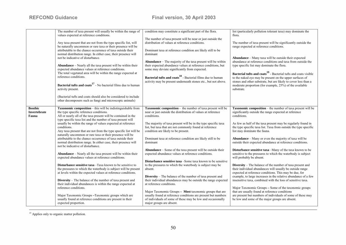
REFCOND Guidance Final version, 30 April 2003
50
The number of taxa present will usually be within the range ofvalues expected at reference conditions.
Any taxa present that are not from the type specific list, willbe naturally uncommon or rare taxa or their presence will beattributable to the chance occurrence of taxa outside theirnormal distribution range. In either case, their presence willnot be indicative of disturbance.
Abundance � Nearly all the taxa present will be within theirexpected abundance values at reference conditions.The total vegetated area will be within the range expected atreference conditions.
Bacterial tufts and coats17 - No bacterial films due to humanactivity present.
(Bacterial tufts and coats should also be considered to includeother decomposers such as fungi and microscopic animals)
condition may constitute a significant part of the flora.
The number of taxa present will be near or just outside thedistribution of values at reference conditions.
Dominant taxa at reference condition are likely still to bedominant
Abundance � The majority of the taxa present will be withintheir expected abundance values at reference conditions, butsome may deviate significantly from expected.
Bacterial tufts and coats18 - Bacterial films due to humanactivity may be present underneath stones etc., but not above.
list (particularly pollution tolerant taxa) may dominate theflora.
The number of taxa present will be significantly outside therange expected at reference conditions.
Abundance � Many taxa will be outside their expectedabundance at reference conditions and taxa from outside thetype specific list may dominate the flora.
Bacterial tufts and coats19 - Bacterial tufts and coats visibleto the naked eye may be present on the upper surfaces ofstones and other substrate, but are likely to cover less than amoderate proportion (for example, 25%) of the availablesubstrate.
BenthicInvertebrateFauna
Taxonomic composition � this will be indistinguishable fromthe type specific reference conditions.All or nearly all of the taxa present will be contained in thetype specific taxa list and the number of taxa present willusually be within the range of values expected at referenceconditions.Any taxa present that are not from the type specific list will benaturally uncommon or rare taxa or their presence will beattributable to the chance occurrence of taxa outside theirnormal distribution range. In either case, their presence willnot be indicative of disturbance.
Abundance � Nearly all the taxa present will be within theirexpected abundance values at reference conditions.
Disturbance sensitive taxa �Taxa known to be sensitive tothe pressures to which the waterbody is subject will be presentat levels within the expected values at reference conditions.
Diversity � The balance of the number of taxa present andtheir individual abundances is within the range expected atreference conditions.
Major Taxonomic Groups –Taxonomic groups which areusually found at reference conditions are present in theirexpected proportion.
Taxonomic composition - the number of taxa present will benear or just outside the distribution of values at referenceconditions.
The majority of taxa present will be in the type specific taxalist, but taxa that are not commonly found at referencecondition are likely to be present.
Dominant taxa at reference condition are likely still to bedominant
Abundance � Some of the taxa present will be outside theirexpected abundance values at reference conditions.
Disturbance sensitive taxa �Some taxa known to be sensitiveto the pressures to which the waterbody is subject may beabsent.
Diversity � The balance of the number of taxa present andtheir individual abundances may be outside the range expectedat reference conditions.
Major Taxonomic Groups – Most taxonomic groups that areusually found at reference conditions are present but numbersof individuals of some of these may be low and occasionallymajor groups are absent.
Taxonomic composition � the number of taxa present will besignificantly outside the range expected at referenceconditions.
As few as half of the taxa present may be regularly found inthe type specific taxa list. Taxa from outside the type specificlist may dominate the fauna.
Abundance � Many or even the majority of taxa will beoutside their expected abundance at reference conditions.
Disturbance sensitive taxa �Many of the taxa known to besensitive to the pressures to which the waterbody is subjectwill probably be absent.
Diversity � The balance of the number of taxa present andtheir individual abundances will usually be outside rangeexpected at reference conditions. This may be due, forexample, to large increases in the relative abundance of a fewinsensitive taxa, combined with the loss of sensitive taxa.
Major Taxonomic Groups – Some of the taxonomic groupsthat are usually found at reference conditionsare present but numbers of individuals of some of these maybe low and some of the major groups are absent.
19 Applies only to organic matter pollution.

REFCOND Guidance Final version, 30 April 2003
51
Fish Fauna Taxonomic composition � this will be indistinguishable fromthe type specific reference conditions.
Any species present that are not from the type specific list willbe naturally uncommon or rare species or their presence willbe attributable to the chance occurrence of species outsidetheir normal distribution range. In either case, their presencewill not be indicative of disturbance.
The number of species present will usually be within the rangeof values expected at reference conditions.
Abundance - Nearly all the species present will be withintheir expected abundance values at reference conditions.The overall fish abundance will be within the range expectedat reference conditions.
Disturbance sensitive taxa �Species known to be sensitive tothe pressures to which the waterbody is subject will be presentat levels within the expected values at reference conditions.
Age classes - All expected age classes of the type specificspecies must be present.
Taxonomic composition - the number of species present willusually be just within or just outside the distribution of valuesexpected at reference conditions.
The majority of species present will be in the type specificspecies list, but species that are not commonly found atreference condition may be present.
Dominant species at reference condition will still be dominant
Abundance - Some of the species present may be outside theirexpected abundance values at reference conditions.The overall fish abundance will usually be near or just outsidethe range of values expected at reference conditions.
Disturbance sensitive taxa �Species known to be sensitive tothe pressures to which the waterbody is subject will be presentat levels near or just outside the lower end of the range ofvalues expected at reference conditions.
Age classes - All expected age classes of the type specificdominant species must be present.Age classes of minor species may be absent.
Taxonomic composition � the number of species present willbe significantly outside the range expected at referenceconditions.
As few as half of the species present may be regularly found inthe type specific species list. Species from outside the typespecific list may dominate the fauna.
Abundance � Many or even the majority of species will beoutside their expected abundance at reference conditions.
Disturbance sensitive taxa �Many of the species known to besensitive to the pressures to which the waterbody is subjectwill probably be absent.
Age classes - The type specific dominant species is stillpresent, although expected age classes may be missing.Minor species may be completely absent or represented onlyat abundances significantly outside the expected range ofvalues for reference condition sites.

REFCOND Guidance Final version, 30 April 2003
52
Lakes High Status Good Status Moderate StatusPhytoplankton Taxonomic composition � the phytoplankton community will
be indistinguishable from the type specific referenceconditions.All or nearly all of the taxa present will reflect the typespecific phytoplankton community.Any taxa present that are not from the type specific referencephytoplankton community list are likely either to be at verylow abundance or their presence will be attributable to thechance occurrence of taxa outside their normal distributionrange. In either case, their presence will not be indicative ofdisturbance.
Size structure of the phytoplankton community isindistinguishable from the type specific reference conditions.
Abundance � Nearly all the taxa present will be within theirexpected abundance values at reference conditions.
Biomass � The biomass of the phytoplankton community willbe within the range of values expected at reference conditions.
Transparency- The average transparency will not besignificantly changed from that expected at type specificreference conditions as a result of phytoplankton.
Planktonic blooms � The frequency and intensity ofplanktonic blooms will be within the range found at referenceconditions.
Note:- taxonomic composition and abundance are relevant toall pressures; biomass, transparency and planktonic bloomsare relevant primarily to eutrophication.
Taxonomic composition � the phytoplankton community maybe slightly changed from the type specific referenceconditions.
The community may contain a minority of taxa which indicatechanges from the type specific reference community.
Taxa which reflect the type specific reference phytoplanktoncommunity are likely still to be dominant.
Size structure of the phytoplankton community is near or justoutside the type specific reference conditions.
Abundance � The majority of the taxa present will be withintheir expected abundance values at reference conditions, butsome may deviate significantly from expected.
Biomass � The biomass of the phytoplankton community willbe higher than the range of values at reference conditions.
The overall increase in abundance of algae will not besufficient to significantly alter the light climate or alter thephysico-chemical quality of the water or the sediment and thuschange the composition of other biota from their expectedcondition.
Planktonic blooms � blooms may occur more frequently thanexpected, but will not be sufficiently frequent or intense so asto cause any significant damage to other quality elements.
Taxonomic composition � the phytoplankton community maybe significantly changed from the type specific referenceconditions.
The community may contain taxa which indicate a significantchange from the type specific reference community.
Size structure of the phytoplankton community is significantlyoutside the type specific reference conditions.
Abundance � Many taxa will be outside their expectedabundance at reference conditions.
Biomass � The biomass of the phytoplankton community willbe significantly higher than the range of values at referenceconditions.
Other quality elements, such as macrophytes and benthicinvertebrates, may be altered by the increased algalabundance. (e.g. depth of colonisation of macrophytes may bedemonstrably affected and significant areas of vegetation mayhave been lost.The benthic invertebrate fauna may be significantly altered asa result of the increased biomass)
Planktonic blooms � persistent blooms will occur regularly.Even in types where plankton blooms are common atreference condition, these will be considerably more intensethan expected and will frequently consist of taxa that do notusually dominate at reference condition.

REFCOND Guidance Final version, 30 April 2003
53
Macrophytes andphytobenthos
Taxonomic composition � this will be indistinguishable fromthe type specific reference conditions.All or nearly all of the taxa present will be contained in thetype specific taxa list.The number of taxa present will usually be within the range ofvalues expected at reference conditions.
Any taxa present that are not from the type specific list will benaturally uncommon or rare taxa or their presence will beattributable to the chance occurrence of taxa outside theirnormal distribution range. In either case, their presence willnot be indicative of disturbance.
Abundance � Nearly all the taxa present will be within theirexpected abundance values at reference conditions.The total vegetated area will be within the range expected atreference conditions.
Bacterial tufts and coats - No bacterial films due to humanactivity present.
(Bacterial tufts and coats should also be considered to includeother decomposers such as fungi and microscopic animals)
Taxonomic composition � this will differ slightly from thetype specific reference condition.The majority of taxa present will be in the type specific taxalist, but taxa that are not commonly found at referencecondition may constitute a significant part of the flora.
The number of taxa present will be near or just outside thedistribution of values at reference conditions.
Dominant taxa at reference conditions are likely still to bedominant
Abundance � The majority of the taxa present will be withintheir expected abundance values at reference conditions, butsome may deviate significantly from expected.
Bacterial tufts and coats - Bacterial films due to humanactivity may be present underneath stones etc., but not above.
Taxonomic composition-� this will differ significantly fromthe type specific reference conditions.As few as half of the taxa present may be regularly found inthe type specific taxa list. Taxa from outside the type specificlist (particularly pollution tolerant taxa) may dominate theflora.
The number of taxa present will be significantly outside therange expected at reference conditions.
Abundance � Many taxa will be outside their expectedabundance at reference conditions.
Bacterial tufts and coats - Bacterial tufts and coats visible tothe naked eye may be present on the upper surfaces of stonesand other substrate, but are likely to cover less than a moderateproportion (for example, 25%) of the available substrate..
BenthicInvertebrateFauna
Taxonomic composition � this will be indistinguishable fromthe type specific reference conditions.All or nearly all of the taxa present will be contained in thetype specific taxa list and the number of taxa present willusually be within the range of values expected at referenceconditions.Any taxa present that are not from the type specific list will benaturally uncommon or rare taxa or their presence will beattributable to the chance occurrence of taxa outside theirnormal distribution range. In either case, their presence willnot be indicative of disturbance.
Abundance � Nearly all the taxa present will be within theirexpected abundance values at reference conditions.
Disturbance sensitive taxa �Taxa known to be sensitive tothe pressures to which the waterbody is subject will be presentat levels within the expected values at reference conditions.
Diversity � The balance of the number of taxa present andtheir individual abundances is within the range expected atreference conditions.
Taxonomic composition - the number of taxa present will benear or just outside the distribution of values at referenceconditions.
The majority of taxa present will be in the type specific taxalist, but taxa that are not commonly found at referencecondition are likely to be present.
Dominant taxa at reference condition are likely still to bedominant
Abundance � Some of the taxa present will be outside theirexpected abundance values at reference conditions.
Disturbance sensitive taxa �Some taxa known to be sensitiveto the pressures to which the waterbody is subject may beabsent.
Diversity � The balance of the number of taxa present andtheir individual abundances may be outside the range expectedat reference conditions.
Major Taxonomic Groups � Most taxonomic groups that are
Taxonomic composition � the number of taxa present will besignificantly outside the range expected at referenceconditions.
As few as half of the taxa present may be regularly found inthe type specific taxa list. Taxa from outside the type specificlist may dominate the fauna.
Abundance � Many or even the majority of taxa will beoutside their expected abundance at reference conditions.
Disturbance sensitive taxa �Many of the taxa known to besensitive to the pressures to which the waterbody is subjectwill probably be absent.
Diversity � The balance of the number of taxa present andtheir individual abundances will usually be outside rangeexpected at reference conditions. This may be due, forexample, to large increases in the relative abundance of a fewinsensitive taxa, combined with the loss of sensitive taxa.
Major Taxonomic Groups – Some of the taxonomic groupsthat are usually found at reference conditions

REFCOND Guidance Final version, 30 April 2003
54
Major Taxonomic Groups �Taxonomic groups which areusually found at reference conditions are present in theirexpected proportion.
usually found at reference conditions are present but numbersof individuals of some of these may be low and occasionallymajor groups are absent.
are present but numbers of individuals of some of these maybe low and some of the major groups are absent.
Fish Fauna Taxonomic composition � this will be indistinguishable fromthe type specific reference conditions.
Any species present that are not from the type specific list willbe naturally uncommon or rare species or their presence willbe attributable to the chance occurrence of species outsidetheir normal distribution range. In either case, their presencewill not be indicative of disturbance.
The number of species present will usually be within the rangeof values expected at reference conditions.
Abundance - Nearly all the species present will be withintheir expected abundance values at reference conditions.The overall fish abundance will be within the range expectedat reference conditions.
Disturbance sensitive taxa �Species known to be sensitive tothe pressures to which the waterbody is subject will be presentat levels within the expected values at reference conditions.
Age classes - All expected age classes of the type specificspecies must be present.
Taxonomic composition - the number of species present willusually be just within or just outside the distribution of valuesexpected at reference conditions.
The majority of species present will be in the type specificspecies list, but species, that are not commonly found atreference condition, may be present.
Dominant species at reference condition will still be dominant
Abundance - Some of the species present may be outside theirexpected abundance values at reference conditions.The overall fish abundance will usually be near or just outsidethe range of values expected at reference conditions.
Disturbance sensitive taxa �Species known to be sensitive tothe pressures to which the waterbody is subject will be presentat levels near or just outside the lower end of the range ofvalues expected at reference conditions.
Age classes - All expected age classes of the type specificdominant species must be present.Age classes of minor species may be absent.
Taxonomic composition � the number of species present willbe significantly outside the range expected at referenceconditions.
As few as half of the species present may be regularly found inthe type specific species list. Species from outside the typespecific list may dominate the fauna.
Abundance � Many or even the majority of species will beoutside their expected abundance at reference conditions.
Disturbance sensitive taxa �Many of the species known to besensitive to the pressures to which the waterbody is subjectwill probably be absent.
Age classes - The type specific dominant species is stillpresent, although expected age classes may be missing.Minor species may be completely absent or represented onlyat abundances significantly outside the expected range ofvalues for reference condition sites.

REFCOND Guidance Final version, 30 April 2003
55
Tool 3. Numerical examples on setting class boundaries accordingto alternative A, B and C in section 3.8.
The setting of class boundaries is illustrated below, using imaginary data on a particularquality element indicator � species richness of benthic macroinvertebrates. The descriptionfollows the steps outlined in section 3.8.1.
A. Sufficient data from sites (or historical records) are available
1. Observations at reference condition sites representative of rivers of type XX gave thefollowing set of data (numbers of species per unit area or per effort): 35, 28, 29, 43, 45, 31,37, 29, 33, 34, 39, 35, 32.
The median value � 34 � was selected to represent the reference value.
2. The data set was divided by the reference value, thus creating a set of normalised values:1.03, 0.82, 0.85, 1.26, 1.32, 0.91, 1.09, 0.85, 0.97, 1.00, 1,15, 1.03, 0.94.
3. Species richness does not increase toward the �bad� end of the scale. Hence, there was noneed to invert the values arrived at in the previous step in order to achieve a scale thatdescends from 1 to 0.
4. A lower percentile of the normalised data set arrived at in step 2 above, in this case the 10thpercentile, was selected to represent the class boundary between high and good status: 0.83.
5. Observations at sites of river type XX considered to be representative of good ecologicalstatus gave the following data set: 30, 27, 28, 31, 27, 29, 28, 23, 27, 24.
6. Division by the reference value (34) gave the following set of normalised values: 0.88,0.79, 0.82, 0.91, 0.79, 0.85, 0.82, 0.68, 0.79, 0.71.
7. The 10th percentile was, again, selected to represent the class boundary: 0.68.
In summary, the following class boundaries were thus established in terms of EQR values:
High status: ≥ 1.00 � 0.83Good status: 0.83 � 0.68.
The remaining class boundaries might have been established in the same way, had nominalvalues representing these quality classes been available.
Finally, one would have to decide weather the scale developed for a particular type of riverwould be applicable to all types. If not, separate scales would have to be developed.
B. Few data from sites (or historical records) available
1. The following tentative scale of EQR values was established by a group of experts, basedon their judgement of what would be appropriate intervals from high to bad in terms ofspecies richness of benthic macroinvertebrates:

REFCOND Guidance Final version, 30 April 2003
56
High status: ≥1.00 � 0.80Good status: 0.80 � 0.60Moderate status: 0.60 � 0.40Poor status: 0.40 � 0.20Bad status: <0.20
2. Application of the tentative scale on a number of real and virtual data sets andconsideration of whether the scale is compatible with the normative definitions of ecologicalstatus in Appendix V, 1.2, of the Directive, and the interpretations of the normativedefinitions given in Tool 2 of the toolbox of this Guidance document, caused the group ofexperts to adjust the class boundaries upwards into the following scale:
High status: ≥1.00 � 0.85Good status: 0.85 �0.70Moderate status: 0.70 � 0.55Poor status: 0.55 � 0.40Bad status: <0.40.
3. No further iterations were considered necessary. It was recommended that the scale besubject to re-evaluation as more data become available from monitoring and intercalibrationprocedures.
It was decided to apply the scale on all types of rivers, pending re-evaluation with more data.
C. A statistical approach (alternatives A and B deemed not applicable)
1. Same as A1 above.
2. Same as A2 above.
3. The 10th percentile was selected as the �upper anchor� and the class boundary betweenhigh and good (same as A4 above): 0.83.
4. The width of the four remaining classes was evenly spaced over the remaining interval (the�lower anchor� was set to 0 as there was considered to be no need to set a higher value). Thisresulted in the following class boundaries:
High status: ≥1.00 � 0.83Good status: 0.83 � 0.62Moderate status: 0.62 � 0.41Poor status: 0.41 � 0.20Bad status: <0.20.
The scale would presumably have been levelled off to more even figures, since there was noquantitative basis for a two decimal accuracy.
General comment to tool3:When establishing the class boundaries it will be obvious that some sites/data that was pre-selected for a specific quality class will fall in an other class in the classification scheme

REFCOND Guidance Final version, 30 April 2003
57
(sites/data close to the boundaries). This means that the first preliminary classification have tobe reassessed for these sites/data in the final status classification.

REFCOND Guidance Final version, 30 April 2003
58
Section 5. Examples on Good Practice
Example 1. Development of a risk based prioritisation protocol forstanding waters in Great Britain, based on a georeferencedinventory, as an aid to defining reference conditions.
PrincipleStanding waters respond to catchment pressures (including development, land use, changes inland management, and atmospheric deposition) by displaying changes in theirphysicochemical environment. This in turn leads to changes in the condition of the biologicalelements supported, and in WFD terms, may lead to movement away from referencecondition. The rationale is developed therefore that a measure of catchment pressures willgive an indirect estimate of proximity to reference condition. This approach can ,can,therefore, be regarded as a preliminary screening tool or risk assessment method to identifypotential reference sites which can then be tested against the ecological criteria of the WFDfor reference condition. The crux of this approach is the definition of the WFD high statusclass boundary based on pressure criteria for �no or only very minor� disturbance, this has notyet been achieved.
MethodImplementation of the WFD requires a procedure to identify lakes at risk of a deterioration inwater quality as a result of the presence of a hazard(s) in their catchment. A protocol using athree-tiered hierachical prioritisation system was developed to assess environmental harmusing nutrients and acid deposition as example hazards. In order to carry out theseprioritisations, basic information was required on the location, number and size of lakes, inassociation with ecological and water quality data and target (reference) conditions. Since nosingle comprehensive inventory of lakes and reservoirs in Great Britain existed, prior to thisstudy, the development of a georeferenced inventory of standing waters in Great Britain andtheir physical, chemical and ecological properties was an integral part of the project.
In Great Britain there are some 46000 standing waters identified on the 1:50,000 OS maps,and some 14000 waters of >1ha surface area. The regulatory agencies have little data on mostof these waters, including many of the larger waters which have been assumed to be in goodcondition. The only realistic approach to collating information on the bulk of these waters toassist in implementing the WFD was seen as using macro scale datasets covering most of theland surface of GB, together with some simple models to derive estimates of variouspressures. The focus of the project to date has been the identification of waters at risk offailing to meet the requirements of the WFD, and this work is described below.
The inventory itself contains basic physical characteristics for all standing waters in GreatBritain derived from the 1:50 000 ordnance survey panorama digital dataset. For those waterbodies >1 hectare, catchment boundaries were generated and associated attribute data werederived, to allow implementation of the risk based prioritisation protocol. The inventory waslinked to external databases using a meta-data system and summary water chemistry datawere collated from some of these databases for over 400 water bodies. It is hoped that furthermeta-data and summary data can be added in the future as and when data become available.

REFCOND Guidance Final version, 30 April 2003
59
Project outlineThe project was comprised of two phases, Phase 1, completed in 2001, was a scoping study toidentify the content and structure of the inventory and to design the risk based prioritisationprotocol. During Phase 2, the inventory has been populated and the risk based prioritisationprotocol further developed, tested and refined. The approach used to develop the risk basedprioritisation protocol largely follows the framework for environmental risk assessment andmanagement detailed by the DETR (2000). The scheme is based on the three properties,importance, hazard and sensitivity, and appropriate measures of each were determined. Athree-tiered approach was adopted whereby an initial rapid assessment is made at Risk Tier 1for all standing waters in Great Britain (approximately 14,000 greater than 1ha), based on theminimum of information gained from already available data sources. This assessment is thenused to guide the acquisition of further data for more detailed evaluation of a subset ofstanding waters at Risk Tier 2 (a few hundred to a few thousand) and, in even finer detail atRisk Tier 3 on a very small subset of waters (a few tens) for which remedial action is likely tobe taken.
Phosphorus as an indication of nutrient enrichmentThe anthropogenic phosphorus load (human sewage, run-off from land and domestic farmanimal waste � the latter data were not available for Scotland) was used as a measure of theeutrophication hazard. The loads were converted into in-lake concentrations using relevantOECD equations, and lakes were given a rank on the basis of the standard Vollenweiderclassifications of lake trophic status. Retention time was used to identify lakes where the algaewould remain in the lake long enough to utilise the phosphorus in the water. Depth data wereunavailable for most lakes so that modelled depths were used in calculations.
Acidification from atmospheric depositionThe Risk Tier 1 estimation of hazard and sensitivity to acidification was much simpler sincethe appropriate data sets had already been compiled for other purposes. Total acid depositionload was used to identify the level of hazard. Five classes were defined and only those in class1 (<0.5 keq/ha/y) were not passed through to the sensitivity assessment. Data were alreadyavailable on the sensitivity of lakes to acidification. The data are available at 1 km square gridscale and relate to the buffering capacity of the dominant soil type and baseline geologywithin each square. Five sensitivity classes were defined. Only classes 1 and 2 (High andmedium-high, respectively) were passed on to the final tier 1 risk assessment. The aciddeposition class and freshwater sensitivity class for each lake was assessed jointly and lakeswith specified combinations of deposition class and sensitivity class were passed through tothe Risk Tier 2 assessment.
Identification of potential reference sitesEutrophication and acidification have been identified as the two major causes of downgradingof water quality in standing waters across Europe (Ref: Dobris Assessment). The methoddescribed here permits National screening of all standing waters greater than 1 ha in size forexposure to the risk of damage from these two hazards. The sub-set of standing watersidentified as having minimal exposure to catchment pressures in the Tier 1 assessment formthe basis for a Tier 2 more detailed assessment at the site level, both to validate theassessment of the principle pressures of enrichment and acidification and to assess otherpressures and impacts of relevance to reference condition such as impoundment, shorelinedevelopment etc.

REFCOND Guidance Final version, 30 April 2003
60
Testing of the protocol outputsApplication of the protocol to 30 test lakes across Great Britain indicates that the schemes forboth eutrophication and acidification produce reliable risk assessments. These 30 lakes weresites which are well studied by direct survey and sampling of both their physicochemical andecological quality. Additionally some sites had undergone palaeolimnological investigation.
It is recommended that this method of identifying potential reference lakes is employed as afirst screening step offering a method of dealing with a large number of standing waters forwhich no direct evidence of condition exists. It could be used in conjunction with the methodoutlined in Example 2 in this section of this guidance, The use of palaeolimnology andspecies turnover measures to select potential reference lakes, to provide a two way assessmentof sites for further evaluation

REFCOND Guidance Final version, 30 April 2003
61
Example 2. The use of palaeolimnology and species turnovermeasures to select potential reference lakes
PrincipleThe Water Framework Directive requires lakes to be classified according to the assemblage ofbiological elements they currently support. The system specified for this classification is astate-changed system, comparing any lake�s current condition with its condition at a referencestate (where: There are no, or only very minor, anthropogenic alterations to the values of thephysico-chemical and hydromorphological quality elements for the surface water body typefrom those normally associated with that type under undisturbed conditions). Theidentification of a suite of lakes at an undisturbed condition is difficult in Western Europe,and presupposes that all possible causes of disturbance are known and quantified. Analternative method exists for lakes � the use of palaeolimnology. This permits a directcomparison of sub-fossil elements of the biological assemblage representing conditions atsome previous undisturbed state with the same biological element in its current state.
MethodIn Great Britain most palaeolimnological investigations have worked with diatoms, and forthis reason diatoms are the most practical choice for the identification of potential referencelakes across all lake types. Additionally, diatoms have been shown to be amongst the mostsensitive of biological elements and responsive to the two most significant pressures inWestern European lakes, eutrophication and acidification (Ref: Dobris Assessment). Sedimentcores from the deepest part of lakes may be dated and the diatom assemblages characterisedand their development traced over long periods of time. For the purposes of the WFD,undisturbed conditions may be interpreted as being those pertaining before the intensificationof agriculture and before any gross disturbance by industrialisation. For Great Britain thisbroadly indicates a period circa 1850. Classification of diatom assemblages existing aroundthis date allows a provisional �diatom based typology� of lakes to be made and comparison ofsediment strata at this date with current diatom assemblages permits an assessment of theproximity of each lake to reference condition.
Project outlineAnalysed sediment cores exist for 166 lakes across the United Kingdom (England, Scotland,Wales and Northern Ireland) and the strata for circa 1850 or earlier were examined and theirdiatom assemblages described. Analysis by Ward�s minimum variance clustering produced anoptimal number of 6 end groups of diatom assemblage. The 166 lakes in the diatom datasetappear to represent a broad range of UK lake types and cover a wide geographicaldistribution, their diatom assemblages from circa 1850 may be taken then, in the firstinstance, as representing the major reference assemblages for UK lakes.
Comparison of these bottom core strata with diatom assemblages in the most recent strataallows a direct comparison of previous and current diatom assemblages. The degree offloristic change (diatom species turnover) between the core bottom and surface sample foreach of the 166 lakes was assessed using a simple chord distance dissimilarity measure. Thescores range from 0 to 2 whereby 0 indicates that two samples are exactly the same and 2indicates that they are completely different. Any score <0.39 can be judged to haveinsignificant species turnover at the 2.5th percentile, a score <0.48 at the 5th percentile, and ascore <0.58 can be judged to have insignificant species turnover at the 10th percentile.

REFCOND Guidance Final version, 30 April 2003
62
Within each of the six diatom end groups, the lakes are ranked according to the degree offloristic change between the base and surface core sample.
In Group 1 there are very few lakes with low species turnover, with only two having a chorddistance of <0.48. This indicates that there are currently few examples of potential referencelakes for this group in the diatom dataset. Similarly for Group 2, where only 4 lakes have achord distance <0.48. Both Groups 1 and 2 are largely lowland sites in relatively productivecatchments and hence many are impacted by eutrophication. It may be difficult, therefore, tofind good examples of potential reference lakes for these lake types.
In Group 3 there are many examples of lakes with low species turnover (c. 50% of lakes inthis group have a chord distance of <0.48). Therefore, good examples of reference lakes areavailable for this lake type. Note, however, that there are very few lakes in this group inEngland and Wales.
In Group 4, only 7 lakes have a species turnover of < 0.48. Given that this group includesmost of the large (deep) lakes, more examples of potential reference lakes in this group mayneed to be found.
In Group 5, 11 lakes have a species turnover of < 0.48. Many lakes in this group haveacidified.
In Group 6, 15 lakes have a species turnover of < 0.48. Whilst there are a number of potentialreference lakes, many lakes in this group have been impacted and the pressures appear toinclude both eutrophication and acidification.
Testing of the project outputsSites selected as potential reference sites will be cross checked using pressure criteria fromExample 1 in this section of the guidance �Development of a risk based prioritisation protocolfor standing waters in Great Britain, based on a georeferenced inventory, as an aid to definingreference conditions�.
Representative sites having a chord distance of <0.4 from each of the 6 diatom based typeshave been selected for survey and sampling to determine their current biological assemblages.These data should prove useful for classification tool development and for intercalibrationpurposes.
At each stage, assessment will be made of compliance with reference state criteria asdescribed in the WFD.
Example output from analysis: Type 4 lochs (highlighted potential reference lochs).SITE code Site name grid ref country WBID Wardcluster chord distanceMARE Loch Maree NG 985675 S 14057 4 0.12908LOMO Loch Lomond North Basin NS 365945 S 24447 4 0.2199RANN Loch Rannoch NN 610580 S 22782 4 0.25262CRAI Loch of Craiglush NO 042444 S 23557 4 0.32084ECK Loch Eck NS 141939 S 24996 4 0.41377WAST Wast Water NY 165060 E 29183 4 0.43559EINI Loch Einich NN 913990 S 21191 4 0.47976LOWS Loweswater NY 126217 E 28986 4 0.52396AWE Loch Awe North Basin NM 930 065 S 24025 4 0.65754

REFCOND Guidance Final version, 30 April 2003
63
BUTT Loch of Butterstone NO 058449 S 23531 4 0.67202CLUN Loch of Clunie NO 115442 S 23561 4 0.71851AWE Loch Awe South Basin NM 930 065 S 24025 4 0.73948LDE Loch Dee NX 470790 S 27948 4 0.74503BALA Lake Bala or Llyn Tegid SH 905347 W 34987 4 0.76477CWEL Llyn Cwellyn SH 560549 W 34002 4 0.80267MARL Marlee Loch NO 145443 S 23553 4 0.87704MENT Lake of Menteith NN 580005 S 24919 4 0.94378BASS Bassenthwaite Lake NY 214296 E 28847 4 0.97801LOWE Loch of Lowes NO 049439 S 23559 4 1.17712DOON Loch Doon NX 495985 S 27604 4 1.21363ESTH Esthwaite Water SD 358969 E 29328 4 1.33895EARN Loch Earn NN 640235 S 24132 4 1.62814

REFCOND Guidance Final version, 30 April 2003
64
Example 3. The establishment and validation of referenceconditions for lakes and large rivers in German parts of the CentralEuropean Lowland, ecoregion 14, using paleolimnology
IntroductionThe member states of the European Community shall finish the establishment of type-specificreference conditions for surface water body types up to 2004. Not for all types of lakes andrivers in the ecoregion 14 such reference conditions can be derived spatially based, especiallyfor shallow and flushed lakes methods based on modelling are required. Type-specificbiological and physico-chemical reference conditions based on modelling may be derivedusing hindcasting methods. One valid opportunity to obtain quantitative data about the naturalbiota and physico-chemical conditions is to analyse fossil diatom communities in sedimentcores and to reconstruct nutrient concentrations based on diatom-environment-transferfunctions. These quantitative paleolimnological approaches make use of multivariate statisticsand regional calibrated data sets.
Situation in the ecoregion 14In northern Germany there are approximately 500 lakes each greater than 50 ha. Trophicstatus ranges from oligotrophic to hypereutrophic. The water bodies are 1 to 68 m deep andfully imbedded in the loamy sand of the Weichselian ice age moraines. Groundwater is rich inhydrogen carbonate and phosphorus, coming from Interglacial lake deposits. The lake internalphosphorus concentration strongly depends on residence time (<0.1 to >30 years) and thelatter on lake volume and catchment size (1 to 20,000 km²). All the lake catchments wereclear cut during the 12th to 13th centuries and no one lake can be classified undisturbed. After1750 approximately 30% of the landscapes have been afforested. An assemblage ofapproximately 30 lakes with small catchment areas was kept from agriculture during the last200 years and have been quasi renaturalized. These lakes form the web of ecologicalreference sites of the oligotrophic and slightly mesotrophic stratified lake types. The highermesotrophic and eutrophic reference conditions for lakes with larger catchments and inflow ofsurface water by rivers are not available from present-day conditions. Therefore threecooperating REFCOND-relevant paleolimnological projects are in work or start in October2002:
• Paleolimnological reconstruction of reference conditions for flushed lakes in thecatchment area of the lowland river Havel (Brandenburg Office for the Environment,funded by Federal Ministry of Education and Research, 2002-2004)
• Biotic reference conditions for shallow lakes: Paleolimnological studies on diatoms, algalpigments, chironomids and macrophytes in the catchment area of the lowland river Spree(Brandenburg University of Technology Cottbus, funded by Ministry of Agriculture,Environment and Structural Development Brandenburg, 2001-2002)
• Reconstruction of natural biotic reference conditions in combination withhydromorphological, hydraulic and hydrochemical conditions on rivers in the northeasternGerman lowland (Leibniz-Institute of Freshwater Ecology and Inland Fisheries Berlin,funded by the Senate Department of Urban Development Berlin, 2002-2004).

REFCOND Guidance Final version, 30 April 2003
65
Type specific reference conditions for lakes using diatoms – principle and first resultsThe paleolimnological approach is used to reveal undisturbed diatom communities (benthicand planktonic) and to quantify the relationship between catchment size and undisturbedwater chemistry with respect to the assumed strong influence of lake morphology.Weighted-averaging regression and calibration of 304 indicator taxa with tolerance down-weighting and classical deshrinking was used to develop transfer functions between littoraldiatoms and TP, TN, DIC, pH, chloride and the DOC:TP ratio in 84 German lakes and riversites (Schönfelder et al. 2002). Transfer functions based on littoral diatoms have been usedsuccessful for the reconstruction of past water chemistry in flushed and shallow lakes, forexample in the lake Großer Treppelsee, see Fig. 1). For deep lakes a diatom data set based onprofundal samples from >100 sites is in progress. Twelve lakes have been selected to drilllong sediment cores. They can be grouped into four lake types in respect to their waterresidence times. Diatom based inferences of TP and TN will be used to establish a model topredict in-lake TP and TN as a bivariate function of lake catchment size and lake volume forundisturbed conditions. The model will be validated using data from the most renaturalizedlakes in the region. Recent studies on flushed lakes with a great catchment area such asGroßer Treppelsee have shown that the anthropogenic influence on water quality was evidentsince AD 1250. In other lakes with smaller catchment areas anthropogenic pressures fromsetteling and intensifying agriculture were indicated by fossil diatoms not before the end ofthe 18th century.
Figure 1. Long term changes of TP concentration of the lake Großer Treppelsees based on diatomsand the main historical events in the catchment which led to higher or lower TP concentrations. Thestrong anthropogenic impact in this flushed lake began already 1250. To reconstruct undisturbed
TP (µg L -1)
0 20 40 60 80 100 120 140 160 180
age
(AD
)
-1000
-900
-800
-700
-600
-500
-400
-300
-200
-100
0
100
200
300
400
500
600
700
800
900
1000
1100
1200
1300
1400
1500
1600
1700
1800
1900
2000
2100
oligo- meso-meso- to eutrophic eutrophic eu- to polytrophic polytrophic
1250: 2th wave of German east expansionestablishment of the city of Fürstenberg
1370 agrarian crisis1350 plague wave
1972 intensive breeding of trout
mineral fertilization
deforestation,upswing in the agriculture
1618-1648 Thirty Years War
TP (µg L -1)
0 20 40 60 80 100 120 140 160 180
age
(AD
)
-1000
-900
-800
-700
-600
-500
-400
-300
-200
-100
0
100
200
300
400
500
600
700
800
900
1000
1100
1200
1300
1400
1500
1600
1700
1800
1900
2000
2100
oligo- meso-meso- to eutrophic eutrophic eu- to polytrophic polytrophic
1250: 2th wave of German east expansionestablishment of the city of Fürstenberg1250: 2th wave of German east expansionestablishment of the city of Fürstenberg
1370 agrarian crisis1350 plague wave1370 agrarian crisis1350 plague wave
1972 intensive breeding of trout
mineral fertilizationmineral fertilization
deforestation,upswing in the agriculturedeforestation,upswing in the agriculture
1618-1648 Thirty Years War1618-1648 Thirty Years War

REFCOND Guidance Final version, 30 April 2003
66
conditions in such lake types with great catchment area the water authorities require a quantitativelook on past centuries.
References:Schönfelder, I., J. Gelbrecht, J. Schönfelder & C. E. W. Steinberg, 2002. Relationshipsbetween littoral diatoms and their chemical environment in northeastern German lakes andrivers. J. Phycol. 38: 66-82.

REFCOND Guidance Final version, 30 April 2003
67
ReferencesAQEM consortium 2002. Manual for the application of the AQEM system. A comprehensive
method to assess European streams using benthic macroinvertebrates, developed for thepurpose of the Water Framework Directive. Version 1.0, February 2002.
Cardoso, A.C., Duchemin, J., Margarou, P. & Premazzi, G., 2001. Criteria for theidentification of freshwaters subject to eutrophication. Their use for implementation ofthe �Nitrates� and Urban Waste Water Directives. � Environment Institute, Waterresearch and Monitoring Unit, JRC Ispra & Directorate General for Environment,European Commission. EUR 1910 EN.
CEN 2002. A guidance standard for assessing the hydromorphological features of rivers. CENTC 230/WG 2/TG 5: N30. Fifth revision: March 2002
Clarke, R. 2000. Uncertainty in estimates of biological quality based on RIVPACS. pp 39-54,In: J. F. Wright, D. W. Sutcliffe, and M. T. Furse (eds). Assessing the biological qualityof freshwaters. RIVPACS and other techniques. Freshwater Biological Association,Ambleside, UK.
De Wilde, A.J. &. Knoben, R. A.E. 2001. Setting classboundaries for the classification ofrivers and lakes in Europe. � REFCOND discussion paper for evaluation of techniques.Royal Haskoning, The Netherlands.
Fozzard, I., Doughty, R., Ferrier, R.C., Leatherland, T., and Owen, R. (1999) A qualityclassification for management of Scottish standing waters. Hydrobiologia 395/396 pp433-453
Johnson, R.K. 2001. Defining reference conditions and setting class boundaries in ecologicalmonitoring and assessment. � REFCOND discussion paper for evaluation of techniques.University of Agricultural Sciences, Department of Environmental Assessment,Sweden.
Nixon, S., Grath, J. & Bøgestrand, J. 1986. EUROWATERNET. The European EnvironmentAgency´s Monitoring and Information Network for Inland Water Resources. TechnicalGuidelines for Implementation. Technical Report no 7. EEA, Copenhagen 1998.
Oberdorff, T., Pont D., Hugueny, B., Chessel D. 2002. A probabilistic model characterizingfish assemblages of French rivers: a framework for environmental assessment.Freshwater Biology, 46: 399-415
Oberdorff, T., Pont D., Hugueny B., Porcher J.P. 2002. Development and validation of a fish-based index (FBI) for the assessment of �river health� in France. Freshwater Biology,47: 1720-1734
Owen, R., Duncan, W. & Pollard, P. 2001. Definition and Establishment of ReferenceConditions. - REFCOND discussion paper for evaluation of techniques. ScottishEnvironment Protection Agency, Aberdeen, Scotland.
OSPAR, 2000. 00/9/2 OSPAR Add.6 and OSPAR 00/20/1, § 9.5b. Euroharp Draft Guideline6: Quantification and Reporting of Nitrogen and Phosphorus Losses from DiffuseAnthropogenic Sources, and Natural Background Losses. Reference Number: 2000-12.
SEPA, 2000. Environmental Quality Criteria � Lakes and Watercources. � SwedishEnvironmental Protection Agency (SEPA). Report 5050.
SNIFFER (Scottish and Northern Ireland Forum for Environmental Research. (2000)Palaeolimnological investigation of Scottish freshwater lochs. ENSIS Ltd. Ref:SR(00)02S. Available from Foundation for Water Research.
UBA, 1996. Manual on methodologies and criteria for mapping critical levels/loads andgeographical areas where they are exceeded. UN/ECE Convention on Long-rangeTransboundary Air Pollution. � Federal Environment Agency (Umweltbundesamt),Texte 71/96, Berlin.

REFCOND Guidance Final version, 30 April 2003
68
US EPA 1998. Lake and Reservoir Bioassessment and Biocriteria: Technical GuidanceDocument (1998) � US Environmental Protection Agency. EPA 822-B00-98-001.
US EPA 2000. Nutrien criteria technical guidance Manual. Lakes and reservoirs. 1st edition. �US Environmental Protection Agency. EPA 841-B-98-007. Office of Water andTechnology, Washington DC 20460.
Usseglio-Polatera, P., Beisel, J.-N., Archaimbault, V. & de Crespin de Billy,V. 2002.Biological and ecological traits in macrobenthic community: a bioassessment -systemusing faunal lists achieved with a French Standardized Protocol (IBGN). AQEMConference, 9-10th December 2002, Ede (The Netherlands)
Van de Bund, W. 2001. Assigning water body types: an analysis of the REFCONDquestionnaire results. - REFCOND discussion paper for evaluation of techniques.European Commission, Joint Research Centre, Institute for Environment andSustainability, Inland and Marine Waters Unit, Ispra, Italy.
Wright, J. F, Sutcliffe, D. W. & Furse, M. T. 2000. Assessing the biological quality offreshwaters. RIVPACS and other techniques. Freshwater Biological Association,Ambleside, England.

REFCOND Guidance Final version, 30 April 2003
69
1Sharing
Information
1.1 Tools for informationsharing1.2 Raising awareness
2Develop guidance
2.1 Analysis of pressures andimpacts
2.2 Heavily modified waterbodies
2.3 Refrence conditions inlandsurface waters
2.4 Typology, classification oftransitional, coastal waters
2.5 Intercalibration
2.6 Economic analysis
2.7 Monitoring
2.8 Tools on assessment,classification of groundwater
2.9 Best practices inriver basin planning
3Information Management
3. Geographical InformationSystems
4Application,testing andvalidation
Impl
emen
tatio
n st
rate
gy
4.1Integratedtesting in
pilotriver basins
Annex A. Overall structure of theCommon Implementation Strategy

REFCOND Guidance Final version, 30 April 2003
70
Annex B. List on REFCOND partners and other contacts
Country Surname First name E-mailMember State partners (primary contact persons in bold)Austria Koller-Kreimel Veronika [email protected] Ofenboeck Gisela [email protected] Konecny Robert [email protected] Schneiders Anik [email protected] Van Den Langenbergh Veronique [email protected] Kaas Hanne [email protected] Karottki Ivan B. [email protected] Nielsen Kurt [email protected] Skriver Jens [email protected] Søndergaard Martin [email protected] Heinonen Pertti [email protected] Pilke Ansa [email protected] Stroffek Stephane [email protected] Wasson Jean-Gabriel [email protected] Carstens Marina [email protected] Irmer Ulrich [email protected] Rechenberg Bettina [email protected] Skoulikidis Nikolaos [email protected] Andreadakis A. [email protected] Bowman Jim [email protected] Cunningham Peter [email protected] Passino Roberto [email protected] Buffagni Andrea [email protected] Tartari Gianni [email protected] Somma Giacomo [email protected] Reichard Monique [email protected] Rimet Frédéric [email protected] Cauchie Henry-Michel [email protected] Van Oirschot Miel [email protected] van Dijk Sjoerd [email protected] Wortelboer Rick [email protected] Nijboer Rebi [email protected] Fuglestad Jon L. [email protected] Sandøy Steinar [email protected] Lyche Anne [email protected] Schartau Ann Kristin [email protected] Alves Maria Helena [email protected] Pio Simone [email protected] Bernardo João Manuel [email protected] Ortiz-Casas Jose Luis [email protected] Toro Manuel [email protected] Prat Narcís [email protected] Ruza Javier [email protected] Wiederholm Torgny [email protected] Johansson Catarina [email protected] Johnson Richard [email protected] Wallin Mats [email protected] - England/Wales Forrow David [email protected] - England/Wales Logan Paul [email protected] - England/Wales Austin Isobel [email protected] - Scotland Owen Roger [email protected] - Scotland Doughty Ross [email protected] - Scotland Marsden Martin [email protected]

REFCOND Guidance Final version, 30 April 2003
71
UK � N Ireland Crone Victoria [email protected] � N Ireland Hale Peter [email protected] contactsCommission D'Eugenio Joachim Joachim.D'[email protected] 2.2 Mohaupt Volker [email protected] 2.4 Vincent Claire [email protected] 2.4 Nygaard Kari [email protected] 2.4 Bruchon Franck [email protected] 2.4 Haythornthwaite Julia [email protected] 2.5 van de Bund Wouter [email protected] 2.5 Heiskanen Anna-Stiina [email protected] 2.5 de Jesus Cardoso Ana Cristina [email protected] - WG 2.4 Nixon Steve [email protected] Hering Daniel [email protected] Duwe Kurt [email protected] Furse Mike [email protected] Schmutz Stefan [email protected]/MOLAR/EMERGE Patrick Simon [email protected] Hughes Robert [email protected] Henrikson Lennart [email protected] Lewin Kirsty [email protected] Davis Ruth [email protected] Schoeters Ilse [email protected] Sweeting Roger [email protected] countriesLatvia Poikane Sandra [email protected] Kirstuka ? [email protected] Hollo Gyula [email protected] Vodopivec Natasa [email protected] Matoz Helena [email protected]

REFCOND Guidance Final version, 30 April 2003
72
Annex C. Normative definitions in WFD of ecological status classifications for rivers and lakes.
1.2 Normative definitions of ecological status classifications
Table 1.2 General definition for rivers, lakes, transitional waters and coastal waters
The following text provides a general definition of ecological quality. For the purposes of classification the values for the quality elements of ecological status foreach surface water category are those given in tables 1.2.1 - 1.2.4 below.
High status Good status Moderate statusGeneral There are no, or only very minor, anthropogenic
alterations to the values of the physicochemical andhydromorphological quality elements for the surfacewater body type from those normally associated withthat type under undisturbed conditions.
The values of the biological quality elements for thesurface water body reflect those normally associatedwith that type under undisturbed conditions, andshow no, or only very minor, evidence of distortion.
These are the type specific conditions andcommunities.
The values of the biological quality elements for thesurface water body type show low levels ofdistortion resulting from human activity, but deviateonly slightly from those normally associated with thesurface water body type under undisturbedconditions.
The values of the biological quality elements for thesurface water body type deviate moderately fromthose normally associated with the surface waterbody type under undisturbed conditions. The valuesshow moderate signs of distortion resulting fromhuman activity and are significantly more disturbedthan under conditions of good status.
Waters achieving a status below moderate shall be classified as poor or bad.
Waters showing evidence of major alterations to the values of the biological quality elements for the surface water body type and in which therelevant biological communities deviate substantially from those normally associated with the surface water body type under undisturbed conditions,shall be classified as poor.
Waters showing evidence of severe alterations to the values of the biological quality elements for the surface water body type and in which largeportions of the relevant biological communities normally associated with the surface water body type under undisturbed conditions are absent, shallbe classified as bad.

REFCOND Guidance Final version, 30 April 2003
73
1.2.1 Definitions for high, good and moderate ecological status in RIVERS
Biological quality elements
Element High status Good status Moderate statusPhytoplankton The taxonomic composition of phytoplankton
corresponds totally or nearly totally to undisturbedconditions.
The average phytoplankton abundance is whollyconsistent with the type-specific physicochemicalconditions and is not such as to significantly alterthe type specific transparency conditions.
Planktonic blooms occur at a frequency andintensity which is consistent with the type specificphysicochemical conditions.
There are slight changes in the composition andabundance of planktonic taxa compared to the type-specific communities. Such changes do not indicateany accelerated growth of algae resulting inundesirable disturbances to the balance oforganisms present in the water body or to thephysico-chemical quality of the water or sediment.
A slight increase in the frequency and intensity ofthe type specific planktonic blooms may occur.
The composition of planktonic taxa differsmoderately from the type specific communities.
Abundance is moderately disturbed and may besuch as to produce a significant undesirabledisturbance in the values of other biological andphysico-chemical quality elements.
A moderate increase in the frequency and intensityof planktonic blooms may occur. Persistent bloomsmay occur during summer months.
Macrophytes and phytobenthos The taxonomic composition corresponds totally ornearly totally to undisturbed conditions.
There are no detectable changes in the averagemacrophytic and the average phytobenthicabundance.
There are slight changes in the composition andabundance of macrophytic and phytobenthic taxacompared to the type-specific communities. Suchchanges do not indicate any accelerated growth ofphytobenthos or higher forms of plant life resultingin undesirable disturbances to the balance oforganisms present in the water body or to thephysico-chemical quality of the water or sediment.
The phytobenthic community is not adverselyaffected by bacterial tufts and coats present due toanthropogenic activity.
The composition of macrophytic and phytobenthictaxa differs moderately from the type-specificcommunity and is significantly more distorted thanat good status.
Moderate changes in the average macrophytic andthe average phytobenthic abundance are evident.
The phytobenthic community may be interferedwith and, in some areas, displaced by bacterial tuftsand coats present as a result of anthropogenicactivities.
Benthic invertebrate fauna The taxonomic composition and abundancecorrespond totally or nearly totally to undisturbedconditions.
The ratio of disturbance sensitive taxa to insensitivetaxa shows no signs of alteration from undisturbedlevels
The level of diversity of invertebrate taxa shows nosign of alteration from undisturbed levels.
There are slight changes in the composition andabundance of invertebrate taxa from the type-specific communities
The ratio of disturbance sensitive taxa to insensitivetaxa shows slight alteration from type specificlevels.
The level of diversity of invertebrate taxa showsslight signs of alteration from type specific levels.
The composition and abundance of invertebratetaxa differ moderately from the type-specificcommunities.
Major taxonomic groups of the type-specificcommunity are absent.
The ratio of disturbance sensitive taxa to insensitivetaxa, and the level of diversity, are substantiallylower than the type specific level and significantlylower than for good status.
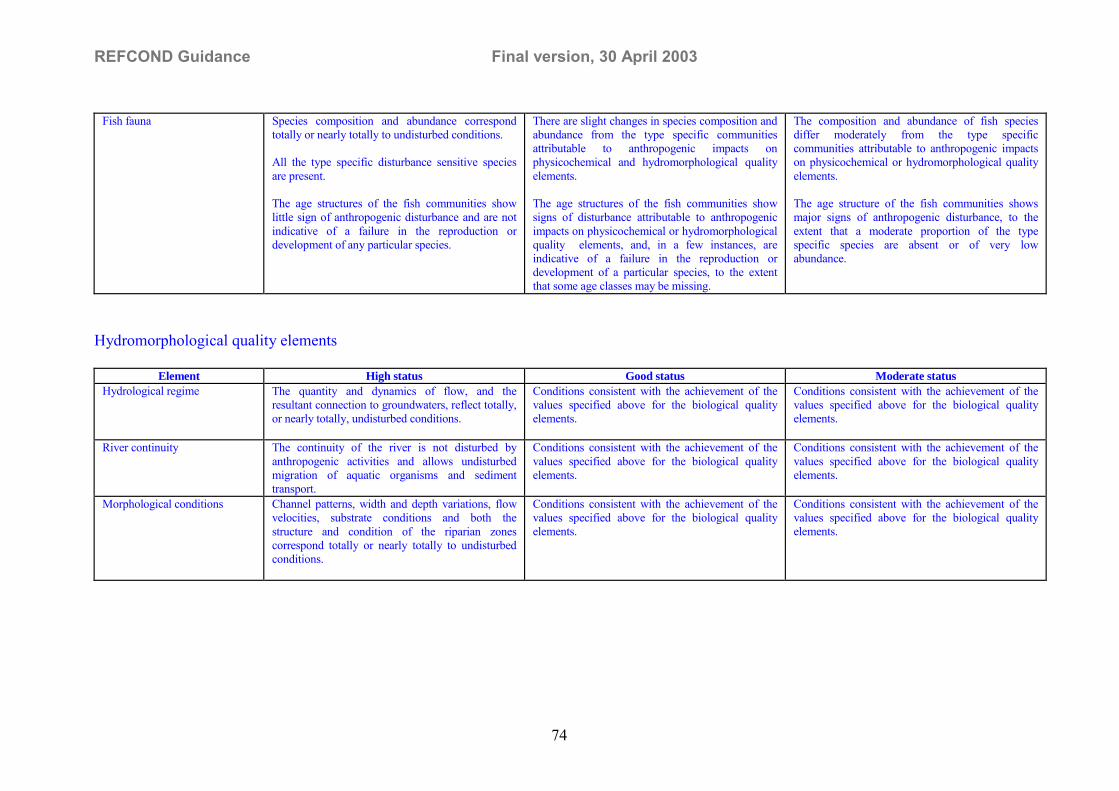
REFCOND Guidance Final version, 30 April 2003
74
Fish fauna Species composition and abundance correspondtotally or nearly totally to undisturbed conditions.
All the type specific disturbance sensitive speciesare present.
The age structures of the fish communities showlittle sign of anthropogenic disturbance and are notindicative of a failure in the reproduction ordevelopment of any particular species.
There are slight changes in species composition andabundance from the type specific communitiesattributable to anthropogenic impacts onphysicochemical and hydromorphological qualityelements.
The age structures of the fish communities showsigns of disturbance attributable to anthropogenicimpacts on physicochemical or hydromorphologicalquality elements, and, in a few instances, areindicative of a failure in the reproduction ordevelopment of a particular species, to the extentthat some age classes may be missing.
The composition and abundance of fish speciesdiffer moderately from the type specificcommunities attributable to anthropogenic impactson physicochemical or hydromorphological qualityelements.
The age structure of the fish communities showsmajor signs of anthropogenic disturbance, to theextent that a moderate proportion of the typespecific species are absent or of very lowabundance.
Hydromorphological quality elements
Element High status Good status Moderate statusHydrological regime The quantity and dynamics of flow, and the
resultant connection to groundwaters, reflect totally,or nearly totally, undisturbed conditions.
Conditions consistent with the achievement of thevalues specified above for the biological qualityelements.
Conditions consistent with the achievement of thevalues specified above for the biological qualityelements.
River continuity The continuity of the river is not disturbed byanthropogenic activities and allows undisturbedmigration of aquatic organisms and sedimenttransport.
Conditions consistent with the achievement of thevalues specified above for the biological qualityelements.
Conditions consistent with the achievement of thevalues specified above for the biological qualityelements.
Morphological conditions Channel patterns, width and depth variations, flowvelocities, substrate conditions and both thestructure and condition of the riparian zonescorrespond totally or nearly totally to undisturbedconditions.
Conditions consistent with the achievement of thevalues specified above for the biological qualityelements.
Conditions consistent with the achievement of thevalues specified above for the biological qualityelements.

REFCOND Guidance Final version, 30 April 2003
75
Physico-chemical quality elements 20
Element High status Good status Moderate statusGeneral conditions The values of the physico-chemical elements
correspond totally or nearly totally to undisturbedconditions.
Nutrient concentrations remain within the rangenormally associated with undisturbed conditions.
Levels of salinity, pH, oxygen balance, acidneutralising capacity and temperature do not showsigns of anthropogenic disturbance and remainwithin the range normally associated withundisturbed conditions.
Temperature, oxygen balance, pH, acidneutralising capacity and salinity do not reachlevels outside the range established so as to ensurethe functioning of the type specific ecosystem andthe achievement of the values specified above forthe biological quality elements.
Nutrient concentrations do not exceed the levelsestablished so as to ensure the functioning of theecosystem and the achievement of the valuesspecified above for the biological quality elements.
Conditions consistent with the achievement of thevalues specified above for the biological qualityelements.
Specific synthetic pollutants Concentrations close to zero and at least below thelimits of detection of the most advanced analyticaltechniques in general use
Concentrations not in excess of the standards set inaccordance with the procedure detailed in section1.2.6 without prejudice to Directive 91/414/EC andDirective 98/8/EC. (<eqs)
Conditions consistent with the achievement of thevalues specified above for the biological qualityelements.
Specific non syntheticpollutants
Concentrations remain within the range normallyassociated with undisturbed conditions(background levels = bgl).
Concentrations not in excess of the standards setin accordance with the procedure detailed insection 1.2.6 21 without prejudice toDirective 91/414/EC and Directive 98/8/EC.(<eqs)
Conditions consistent with the achievement of thevalues specified above for the biological qualityelements.
20 The following abbreviations are used: bgl = background level, eqs = environmental quality standard21 Application of the standards derived under this protocol shall not require reduction of pollutant concentrations below background levels: (eqs>bgl)

REFCOND Guidance Final version, 30 April 2003
76
1.2.2 Definitions for high, good and moderate ecological status in LAKES
Biological quality elements
Element High status Good status Moderate statusPhytoplankton The taxonomic composition and abundance of
phytoplankton correspond totally or nearly totally toundisturbed conditions.
The average phytoplankton biomass is consistentwith the type-specific physicochemical conditionsand is not such as to significantly alter the typespecific transparency conditions.
Planktonic blooms occur at a frequency andintensity which is consistent with the type specificphysicochemical conditions.
There are slight changes in the composition andabundance of planktonic taxa compared to the type-specific communities. Such changes do not indicateany accelerated growth of algae resulting inundesirable disturbance to the balance of organismspresent in the water body or to the physico-chemicalquality of the water or sediment.
A slight increase in the frequency and intensity ofthe type specific planktonic blooms may occur.
The composition and abundance of planktonic taxadiffer moderately from the type specificcommunities.
Biomass is moderately disturbed and may be suchas to produce a significant undesirable disturbancein the condition of other biological quality elementsand the physico-chemical quality of the water orsediment.
A moderate increase in the frequency and intensityof planktonic blooms may occur. Persistent bloomsmay occur during summer months.
Macrophytes and phytobenthos The taxonomic composition corresponds totally ornearly totally to undisturbed conditions.
There are no detectable changes in the averagemacrophytic and the average phytobenthicabundance.
There are slight changes in the composition andabundance of macrophytic and phytobenthic taxacompared to the type-specific communities. Suchchanges do not indicate any accelerated growth ofphytobenthos or higher forms of plant life resultingin undesirable disturbance to the balance oforganisms present in the water body or to thephysicochemical quality of the water.
The phytobenthic community is not adverselyaffected by bacterial tufts and coats present due toanthropogenic activity.
The composition of macrophytic and phytobenthictaxa differ moderately from the type-specificcommunities and are significantly more distortedthan those observed at good quality.
Moderate changes in the average macrophytic andthe average phytobenthic abundance are evident.
The phytobenthic community may be interferedwith, and, in some areas, displaced by bacterial tuftsand coats present as a result of anthropogenicactivities.
Benthic invertebrate fauna The taxonomic composition and abundancecorrespond totally or nearly totally to theundisturbed conditions.
The ratio of disturbance sensitive taxa to insensitivetaxa shows no signs of alteration from undisturbedlevels
The level of diversity of invertebrate taxa shows nosign of alteration from undisturbed levels
There are slight changes in the composition andabundance of invertebrate taxa compared to thetype-specific communities.
The ratio of disturbance sensitive taxa to insensitivetaxa shows slight signs of alteration from typespecific levels.
The level of diversity of invertebrate taxa showsslight signs of alteration from type specific levels.
The composition and abundance of invertebratetaxa differ moderately from the type-specificconditions
Major taxonomic groups of the type-specificcommunity are absent.
The ratio of disturbance sensitive to insensitivetaxa, and the level of diversity, are substantiallylower than the type specific level and significantlylower than for good status

REFCOND Guidance Final version, 30 April 2003
77
Fish fauna Species composition and abundance correspondtotally or nearly totally to undisturbed conditions.
All the type specific sensitive species are present.
The age structures of the fish communities showlittle sign of anthropogenic disturbance and are notindicative of a failure in the reproduction ordevelopment of a particular species.
There are slight changes in species composition andabundance from the type specific communitiesattributable to anthropogenic impacts onphysicochemical or hydromorphological qualityelements.
The age structures of the fish communities showsigns of disturbance attributable to anthropogenicimpacts on physicochemical or hydromorphologicalquality elements, and, in a few instances, areindicative of a failure in the reproduction ordevelopment of a particular species, to the extentthat some age classes may be missing.
The composition and abundance of fish speciesdiffer moderately from the type specificcommunities attributable to anthropogenic impactson physicochemical or hydromorphological qualityelements.
The age structure of the fish communities showsmajor signs of disturbance, attributable toanthropogenic impacts on physicochemical orhydromorphological quality elements, to the extentthat a moderate proportion of the type specificspecies are absent or of very low abundance.
Hydromorphological quality elements
Element High status Good status Moderate statusHydrological regime The quantity and dynamics of flow, level, residence
time, and the resultant connection to groundwaters,reflect totally or nearly totally undisturbedconditions.
Conditions consistent with the achievement of thevalues specified above for the biological qualityelements.
Conditions consistent with the achievement of thevalues specified above for the biological qualityelements.
Morphological conditions Lake depth variation, quantity and structure of thesubstrate, and both the structure and condition of thelake shore zone correspond totally or nearly totallyto undisturbed conditions.
Conditions consistent with the achievement of thevalues specified above for the biological qualityelements.
Conditions consistent with the achievement of thevalues specified above for the biological qualityelements.

REFCOND Guidance Final version, 30 April 2003
78
Physico-chemical quality elements 22
Element High status Good status Moderate statusGeneral conditions The values of physico-chemical elements
correspond totally or nearly totally to undisturbedconditions.
Nutrient concentrations remain within the rangenormally associated with undisturbed conditions.
Levels of salinity, pH, oxygen balance, acidneutralising capacity, transparency and temperaturedo not show signs of anthropogenic disturbance andremain within the range normally associated withundisturbed conditions.
Temperature, oxygen balance, pH, acid neutralisingcapacity, transparency and salinity do not reachlevels outside the range established so as to ensurethe functioning of the ecosystem and theachievement of the values specified above for thebiological quality elements.
Nutrient concentrations do not exceed the levelsestablished so as to ensure the functioning of theecosystem and the achievement of the valuesspecified above for the biological quality elements.
Conditions consistent with the achievement of thevalues specified above for the biological qualityelements.
Specific synthetic pollutants Concentrations close to zero and at least below thelimits of detection of the most advanced analyticaltechniques in general use.
Concentrations not in excess of the standards set inaccordance with the procedure detailed in section1.2.6 without prejudice to Directive 91/414/EC andDirective 98/8/EC. (<eqs)
Conditions consistent with the achievement of thevalues specified above for the biological qualityelements.
Specific non synthetic pollutants Concentrations remain within the range normallyassociated with undisturbed conditions (backgroundlevels = bgl).
Concentrations not in excess of the standards set inaccordance with the procedure detailed in section1.2.6 23 without prejudice to Directive 91/414/ECand Directive 98/8/EC. (<eqs)
Conditions consistent with the achievement of thevalues specified above for the biological qualityelements.
� The following abbreviations are used: bgl = background level, eqs = environmental quality standard� Application of the standards derived under this protocol shall not require reduction of pollutant concentrations below background levels

REFCOND Guidance Final version, 30 April 2003
79
Annex D. GlossaryComplementary to Article 2 in the Directive
[Will be completed following the agreement on the overall glossary for the WFDCommon Implementation Strategy.]

REFCOND Guidance Final version, 30 April 2003
80
Annex E. List of Relevant EU-funded research projects
EU-funded projects can provide a strong support as far as the classification of inlandsurface water status is concerned, but very little has been and is being done as far asthe definition and identification of reference conditions is concerned. Most of the pastor on-going EU-funded projects have also been directed towards streams and rivers.This means that limited support for classification of ecological status of lakes can begained from these projects.
For the first aspect, at least five main projects, among the others in the list in AnnexE, have to be cited, because they represent today the main effort carried out atEuropean level with the objective of development and standardisation of assessmentmethodologies. One of these projects, the AQEM project, was recently concludedwith the production of all the expected deliverables. The AQEM web site(www.aqem.de/) contains in a downloadable format all the main results of AQEM:
• assessment software• manual how to apply the AQEM system• taxa list (>7700 European macroinvertebrate taxa)• several reports, tools and interesting software products
AQEM (http://www.aqem.de/)Development and testing of an integrated assessment system for the ecologicalquality of streams and rivers throughout Europe using benthicmacroinvertebrates.The aim of the project is to develop and test an assessment procedure for streams andrivers which meets the demands of the EU Water Framework Directive using benthicmacroinvertebrats. The assessment system will be based on a European streamtypology and on near-natural reference conditions. The method will be adapted toregional conditions in order to allow comparable use in all EU member states. It willbe combined with methods for stream assessment and indication currently used in theEU member states. If these methods supply additional information for certain regionsthey will be included in the assessment system as additional modules. Data bases onEuropean macroinvertebrate taxa used for the assessment system will be generated.Finally, the method will be transferred into water management application via amanual and a PC program.
PAEQANN (http://www-cesac.ecolog.cnrs.fr/~paeqann/)Predicting Aquatic Ecosystem Quality using Artificial Neural Networks: Impactof Environmental characteristics on the Structure of Aquatic Communities(Algae, Benthic and Fish Fauna).The goal of the project is to develop general methodologies, based on advancedmodelling techniques, for predicting structure and diversity of key aquaticcommunities (diatoms, micro-invertebrates and fish), under natural (i.e. undisturbedby human activities) and under man-made disturbance (i.e.submitted to variouspollutions, discharge regulation, ... ). Such an approach to the analysis of aquaticcommunities will make it possible to: i) set up robust and sensitive ecosystemevaluation procedures that will work across a large range of running water ecosystemsthroughout European countries; ii) predict biocenosis structure in disturbedecosystems, taking into account all relevant ecological variables; iii) test for

REFCOND Guidance Final version, 30 April 2003
81
ecosystem sensitivity to disturbance; iv) explore specific actions to be taken forrestoration of ecosystem integrity. Among the available modelling techniques,artificial neural networks are particularly appropriate for establishing relationshipamong variables in the natural processes that shape ecosystems, as these relationshipare frequently non-linear.
STAR (http://www.eu-star.at/)Standardisation of river classifications : Framework method for calibratingdifferent biological survey results against ecological quality classifications to bedeveloped for the Water Framework Directive.The ecological status of rivers will be determined in the STAR project from a range oftaxonomic groups and a variety of methods. Most Member States will have their ownassessment procedures, but a common European standard is still missing. Throughfield sampling and desk studies the project aims to: 1) cross-calibrate and integrateassessments using different methods and taxonomic groups 2) recommend whichprocedures to use in which situations 3) define the precision and reliability of eachmethod and 4) assist the EU in defining the boundaries of classes of ecological status.A decision support system will be developed for applying the project findings. Theresearch will be used to assist in the establishment of a European standard forassigning the ecological status of rivers on the basis of multiple sources of ecologicaldata. The STAR project builds upon the results of the previously funded AQEMproject and will be clustered with the complementary FAME project.
FAME (http://fame.boku.ac.at/)Development, Evaluation and Implementation of a Standardised Fish-basedAssessment Method for the Ecological Status of European Rivers: AContribution to the Water Framework Directive.The objective of the project is to develop, evaluate and implement a standardisedFish-based Assessment Method for the ecological status of European rivers (FAME),a method identified as priority requirement for the implementation of the WaterFramework Directive. FAME will follow a pan-European approach in developingmodels to characterise reference and degraded conditions based on existing fish dataof 17000 sites (5200 rivers) in 16 of the 25 eco-regions of Europe. An integratedsystem to assess the ecological status will be developed in close co-operation withend-users integrated into the project as "Applied partners". The new method will beevaluated by field tests within ongoing national monitoring programmes. A manualand PC-software will be produced and made available to the public via a project website. FAME will be clustered with the complementary STAR project.
ECOFRAMEEcological quality and functioning of shallow lake ecosystems with respect to theneeds of the European Water Framework Directive.Contact address: Prof. Brian Moss, School of Biological Sciences, Derby Building,University of Liverpool, Liverpool L69 3GS, UK ([email protected]). TheECOFRAME project was recently concluded and a draft summary final report isavailable. Using expert workshops and subsequent field testing a practical pan-European typology and classification system have been developed for shallow lakes,which can be expanded to all lakes. It is minimal, based on current limnologicalunderstanding and as cost-effective as possible given the provisions of the Directive.The typology is a core typology that can be expanded easily in particular States to met

REFCOND Guidance Final version, 30 April 2003
82
local conditions. The core includes 48 ecotypes across the entire European climategradient and incorporates climate, lake area, geology of the catchment andconductivity. The classification system is founded on a liberal interpretation ofAnnexes of the Directive and uses variables that are inexpensive to measure andecologically relevant. Taxonomic expertise is minimised. The scheme has beenthrough eight iterations, two of which were tested in the field on tranches of 66 lakes.The final version, Version 8, is offered for operational testing and further refinementby statutory authorities.
Full list on relevant EU-funded research projects- AASER - ARCTIC AND ALPINE STREAM ECOSYSTEM RESEARCH - ENV4-CT95-0164
- AQEM - DEVELOPMENT AND TESTING OF AN INTEGRATEDASSESSMENT SYSTEM FOR THE ECOLOGICAL QUALITY OF STREAMSAND RIVERS THROUGHOUT EUROPE USING BENTHICMACROINVERTEBRATES - EVK1-CT-1999-00027 - http://www.aqem.de/- BIOMASS - BIODIVERSITY OF MICROORGANISMS IN AQUATICSYSTEMS - ENV4-CT95-0026
- ECOFRAME - ECOLOGICAL QUALITY AND FUNCTIONING OFSHALLOW LAKE ECOSYSTEMS WITH RESPECT TO THE NEEDS OF THEEUROPEAN WATER FRAMEWORK DIRECTIVE - EVK1-CT-1999-00039 �
- EMERGE - EUROPEAN MOUNTAIN LAKE ECOSYSTEMS:REGIONALISATION, DIAGNOSTICS & SOCIO-ECONOMIC EVALUATION -EVK1-CT-1999-00032 � http://www.mountain-lakes.org/index.html
- ERMAS - EUROPEAN RIVER MARGINS: ROLE OF BIODIVERSITY IN THEFUNCTIONING OF RIPARIAN SYSTEMS - ENV4-CT95-0061- FLOBAR-1 – FLOODPLAIN BIODIVERSITY AND RESTORATION PART 1:HYDROLOGICALAND GEOMORPHOLOGICALMECHANISMSINFLUENCING FLOODPLAIN BIODIVERSITY AND THEIRAPPLICATION TO THE RESTORATION OF FLOODPLAINS � ENV4-CT96-0317
- MOLAR � MEASURING AND MODELLING THE DYNAMIC RESONSE OFREMOTE MOUNTAIN LAKE ECOSYSTEMS TO ENVIRONMENTALCHANGE: A PROGRAMME OF MOUNTAIN LAKE RESEARCH- ENV4-CT95-0007 � http://www.mountain-lakes.org/molar/index.html
- PAEQANN - PREDICTING AQUATIC ECOSYSTEM QUALITY USINGARTIFICIAL NEURAL NETWORKS: IMPACT OF ENVIRONMENTALCHARACTERISTICS ON THE STRUCTURE OF AQUATIC COMMUNITIES(ALGAE, BENTHIC AND FISH FAUNA). - EVK1-CT-1999-00026 - http://www-cesac.ecolog.cnrs.fr/~paeqann/
- STAR - STANDARDISATION OF RIVER CLASSIFICATIONS : FRAMEWORKMETHOD FOR CALIBRATING DIFFERENT BIOLOGICAL SURVEY RESULTSAGAINST ECOLOGICAL QUALITY CLASSIFICATIONS TO BE DEVELOPEDFOR THE WATER FRAMEWORK DIRECTIVE - EVK1-CT-2001-00089 -http://www.eu-star.at/

REFCOND Guidance Final version, 30 April 2003
83
- SWALE - SHALLOW WETLAND LAKE FUNCTIONING ANDRESTORATION IN A CHANGING EUROPEAN ENVIRONMENT - ENV4-CT97-0420 - http://swale.sbs.liv.ac.uk/index.html
- TARGET - INTEGRATED ASSESSMENT TOOLS TO GAUGE LOCALFUNCTIONAL STATUS WITHIN FRESHWATER ECOSYSTEMS - EVK1-CT-1999-00005 - http://bscw.bio.ua.pt:3000/
- EUROLAKES - INTEGRATED WATER RESOURCE MANAGEMENT FORIMPORTANT DEEP EUROPEAN LAKES AND THEIR CATCHMENT AREAS -EVK1-
- FAME - DEVELOPMENT, EVALUATION AND IMPLEMENTATION OF ASTANDARDISED FISH-BASED ASSESSMENT METHOD FOR THEECOLOGICAL STATUS OF EUROPEAN RIVERS: A CONTRIBUTION TO THEWATER FRAMEWORK DIRECTIVE � EVK1-CT-2001-00094 �http://fame.boku.ac.at/

REFCOND Guidance Final version, 30 April 2003
84
Annex F. (Eco)region specific typologyOne important use of typology systems is for the selection of types and sites to beincluded in the intercalibration exercise (see separate guidance document onintercalibration). Ideally, the chosen typology system should be validated usingbiological data from reference condition sites. Monitoring programmes will, however,not be fully operational until 2007 and the availability of biological data for validationpurposes will be scarce before that. Below a stepwise approach is suggested forestablishing inland surface water body types for the purpose of selecting sites for theintercalibration network.
Based on the information in the guidance documents from workgroup 2.3(REFCOND) and 2.5 (Intercalibration) together with expert judgement preliminary(eco)region specific typology system is suggested to be developed in co-operationbetween Member States sharing the same (eco)region. Based on the preliminary(eco)region specific typology, types are selected for the preliminary selection ofintercalibration sites.
Hydromorpological, physico-chemical and biological data is collected from theselected sites together with data on different human pressures. Data from potentialhigh status sites are used for validating the preliminary types (only reference sites canbe used for testing and validation to avoid impact from human pressure on thetypology). The minimum requirement on the validation result is that the variability inreference conditions within types is smaller than the variability between types.
Depending of the outcome of the validation procedure the types may be revised andcomplementary types and sites are selected for the final register of intercalibrationsites. The typology system may be revised once again when monitoring data from allwater bodies at risk and other selected water bodies will be available.
The suggested procedure and timetable for the development of (eco)region specificsurface water body types to be used for selection of intercalibration sites is describedin the figure below.Annex G.
Assessing �who needs to get involved� in the reference condition and class boundaryanalysis requires addressing some of the following questions:
Guidance documentsfrom WG 2.3 and 2.5
Expert judgement(experts from countries in
the same region)
Preliminary regionspecific types
Validation of types withbiological data from RC
sites
Reviewed intercalibrationtypes
Preliminary register ofintercalibration sites
Preliminary register ofintercalibration sites
First quarterof 2004
First quarterof 2003 Dec 2003
Dec 2004

REFCOND Guidance Final version, 30 April 2003
85
� Who will be responsible for the analysis?� Who will undertake the analysis?� Who will provide input into the analysis?� Who will control the quality of the analysis?� Who will use the results of analysis?� Who will pay for the analysis?
Answers to these �Who� questions are likely to include a wide range of organisations,stakeholders and individuals according to questions. For example, experts from theMinistry of Environment or other ministries (land planning, nature protection units,GIS units, agriculture, etc), experts from river basin agencies or regional authorities,managers in charge of developing river basin management plans, ministry heads ofwater departments, researchers and consultants, historians, the public and a widerange of stakeholders that have developed expertise in specific fields (see table 1) andare involved in water management.
Developing a stakeholder analysis with possible involvement of key stakeholders canbe an appropriate step for finding answers to these questions. It also helps inidentifying key steps in the analytical process when involvement or input fromspecific stakeholders is required (different �Who� for different steps).

REFCOND Guidance 2nd Draft, version 2002-10-04
86
Table 1. Key Stakeholders can be a Very Important Source of Information and expertiseKey Stakeholders Where they can help with information and expertiseWater Service Suppliers � Characterising water services and their relations to the river system condition, e.g. impact on groundwater levels
� Knowledge about previous water quality situation� Developing trends in water services and their impact on river system conditions
Experts from Ministries(agriculture, transport,planning, finance�) -
� Characterising water uses and their impact of the anticipated reference condition� Assessing changes in key national and regional policies and drivers for the trend analysis, e.g. drainage of wetlands� Defining coherent methodologies for assessing key variables at Member State level
Environmental NGOs � Identifying key environmental issues� Providing information about previous stage of the river system� Developing methodologies for estimating impacts on anticipated reference condition� Assessing political complications related to choosing between various reference condition alternatives� Providing social acceptance of agreed reference condition
Economic sectors (farmers,industrialists, etc)
� Assessing trends in economic sectors and their previous impact on the river system� Identifying possible measures needed for achieving a certain water quality status based on an anticipated reference
condition, and their costsResearchers/Experts � Assessing key policies/drivers for the trend analysis
� Assessing impact of such policies on pressures� Assessing impact of climate change on water quality� Assessing the impact of previous impacts and pressures on water status (e.g. via modelling)
Stakeholders/civilsociety/public
� Assessing changes in key policies/drivers for the trend analysis� Assessing (local, regional, national) priorities vis-à-vis water quality improvements,� Providing input into the assessment of disproportionate costs and analysis aimed at explaining derogation, when taking
into account various reference condition alternatives� Providing input into the assessments of socio-economic impacts and costs� Providing historic knowledge about the river system in previous decades / centuries