Grout Remediation Plan - Site 2 - Office of Environment ... · Orica has been the sites principle...
75
WWC SD PLN 0108 Grout Remediation Plan - Site 2 Status: Approved Version: 1.0 Effective: 10/03/2014 Review: 10/03/2017 Page 1 of 48 THIS DOCUMENT IS UNCONTROLLED UNLESS VIEWED ON THE INTRANET Sustainable Development Plan Grout Remediation Plan - Site 2 West Wallsend Colliery
Transcript of Grout Remediation Plan - Site 2 - Office of Environment ... · Orica has been the sites principle...

WWC SD PLN 0108
Grout Remediation Plan - Site 2
Status: Approved
Version: 1.0
Effective: 10/03/2014
Review: 10/03/2017
Page 1 of 48
THIS DOCUMENT IS UNCONTROLLED UNLESS VIEWED ON THE INTRANET
Sustainable Development Plan
Grout Remediation Plan - Site 2
West Wallsend Colliery
West Wallsend Colliery
Sustainable Development Plan
WWC SD PLN 0108
Grout Remediation Plan - Site 2
Status: Approved
Version: 1.0
Effective: 10/03/2014
Review: 10/03/2017
Page 2 of 48
THIS DOCUMENT IS UNCONTROLLED UNLESS VIEWED ON THE INTRANET
Contents
1. Background ...................................................................................................... 4
1.1 Existing Environment ..................................................................................... 5
1.2 Regulatory Context ........................................................................................ 8
2. Introduction ................................................................................................... 10
2.1 Key Objectives & Purpose ............................................................................. 10
3. Remediation Options ....................................................................................... 10
3.1 Remediation Options Investigated ................................................................. 10
3.1.1 Option 1 – Manual breakup of grout material and removal by Capalotta Cap Bora Super Sucker Heavy Vehicle 10 3.1.2 Option 2 – Manual breakup of grout material and removal by person and/or ATV .......................... 12 3.1.3 Option 3 – Manual breakup of grout material and removal by vehicle ........................................... 13 3.1.4 Option 4 – Manual breakup of grout material and removal by helicopter ....................................... 14 3.1.5 Option 5 – Mechanical breakup of grout material and removal by earthmoving equipment/heavy vehicles 15 3.1.6 Option 6 – Mechanical breakup of grout material and removal by helicopter.................................. 16 3.1.7 Option 7 – Leave the grout in situ and allow it to naturally weather ............................................. 17
3.2 Preferred Remediation Option ....................................................................... 17
3.2.1 Operational Planning .............................................................................................................. 17 3.2.2 Grout Removal Process .......................................................................................................... 18 3.2.3 Heli-lifting............................................................................................................................. 19 3.2.4 Waste Characterisation, Disposal and Tracking .......................................................................... 19
3.3 Ancillary Activities ....................................................................................... 19
3.3.1 Rockfall Stabilisation Works .................................................................................................... 19 3.3.2 Vegetation Clearing/Minor Ground Disturbance.......................................................................... 19 3.3.3 Installation of safety barriers/controls/manual handling systems ................................................. 20 3.3.4 Weed Control Activities .......................................................................................................... 20 3.3.5 Equipment Storage Areas ....................................................................................................... 20 3.3.6 Erosion and Sediment Control Activities .................................................................................... 21 3.3.7 Access tracks and Car parking ................................................................................................. 21 3.3.8 Post Remediation Activities and Determination of Final Rehabilitation Criteria................................ 23
3.4 Risk Management ........................................................................................ 25
3.4.1 Training & Answers ................................................................................................................ 25 3.4.2 Grout Remediation Team – Required Knowledge and Skills ......................................................... 25 3.4.3 Public Safety ......................................................................................................................... 26
3.5 Change Management ................................................................................... 26
3.6 Responsibilities ........................................................................................... 27
4. Environmental Impact Assessment .................................................................... 28
4.1 Aboriginal Cultural Heritage .......................................................................... 29
4.2 Historic Cultural Heritage ............................................................................. 30
4.3 Noise ......................................................................................................... 30
4.4 Air Quality .................................................................................................. 31

West Wallsend Colliery
Sustainable Development Plan
WWC SD PLN 0108
Grout Remediation Plan - Site 2
Status: Approved
Version: 1.0
Effective: 10/03/2014
Review: 10/03/2017
Page 3 of 48
THIS DOCUMENT IS UNCONTROLLED UNLESS VIEWED ON THE INTRANET
4.5 Flora & Fauna ............................................................................................. 31
4.6 Erosion & Sedimentation .............................................................................. 33
4.7 Surface Water & Hydrology ........................................................................... 34
5. Monitoring Stakeholder Consultation, reporting, remediation timeline and evaluation35
5.1 Monitoring .................................................................................................. 35
5.1.1 Surface Water Monitoring ....................................................................................................... 35 5.1.2 Aquatic Macro Invertebrate Monitoring ..................................................................................... 35 5.1.3 Vegetation Monitoring ............................................................................................................ 35 5.1.4 Erosion Monitoring ................................................................................................................. 35 5.1.5 Photo Monitoring Points .......................................................................................................... 37
5.2 Stakeholder Consultation.............................................................................. 37
5.3 Reporting ................................................................................................... 38
5.4 Remediation Timeline................................................................................... 39
5.5 Evaluation .................................................................................................. 39
5.6 Summary of Commitments ........................................................................... 40
6. References ..................................................................................................... 45
6.1 Legislation .................................................................................................. 45
6.2 Miscellaneous.............................................................................................. 45
7. Appendices ..................................................................................................... 46
7.1 Appendix 1 – Remediation Direction .............................................................. 46
7.2 Appendix 2 – Due Diligence Ecological Assessment .......................................... 47
8. Control and revision history .............................................................................. 48
8.1 Document information ................................................................................. 48
8.2 Revisions .................................................................................................... 48

West Wallsend Colliery
Sustainable Development Plan
WWC SD PLN 0108
Grout Remediation Plan - Site 2
Status: Approved
Version: 1.0
Effective: 10/03/2014
Review: 10/03/2017
Page 4 of 48
THIS DOCUMENT IS UNCONTROLLED UNLESS VIEWED ON THE INTRANET
1. BACKGROUND
West Wallsend Colliery is an underground coal operation located in the Newcastle Coalfields of New
South Wales and is managed by Oceanic Coal Australia Limited (OCAL) on behalf of the Macquarie Coal
Joint Venture. OCAL is the major joint venture participant in the Macquarie Coal Joint Venture (MCJV)
with 70 per cent ownership. Other participants include Marubeni Coal Pty Ltd, OCAL Macquarie Pty Ltd
and JFE Minerals (Aust) Pty Ltd. OCAL, which also wholly owns OCAL Macquarie Pty Ltd, is wholly
owned by Glencore Plc.
West Wallsend Colliery (WWC) undertakes its mining operations in accordance with the sites Project
Approval (PA_09_0203), Environment Protection License (EPL1360), Environmental Assessment (West
Wallsend Colliery Continued Operations Project 2010) and Subsidence Management/Extraction Plans. As
outlined in the WWC Environmental Assessment, the majority of the WWC’s underground mining area
is located within the Sugarloaf State Conservation Area (SSCA).
The Environmental Assessment for continued operations, predicted subsidence cracking within the
Sugarloaf State Conservation Area as part of its detailed Subsidence Assessment for the operation.
Subsidence remediation activities coordinated by WWC are undertaken in accordance with the approved
remediation management methods listed in the sites Environmental Assessment and subsequent
Subsidence Management/ Extraction Plans required under the site’s Project Approval. As outlined in
these respective management plans, remediation of surface cracking on gently sloping terrain with
vehicular and equipment access is generally undertaken using earthworks machinery. In areas where
access is limited or in steeper terrain WWC has utilised a contractor Orica Australia (Orica) to assist with
filling selected surface cracks using grout.
Remediation activities undertaken within the SSCA are undertaken in consultation with the OEH
(through consent with the National Parks and Wildlife Service). Grout products used by Orica within the
SSCA to fill surface cracking in the SSCA have been chosen in consultation with and approved by OEH.
WWC has developed and maintained a site specific surface grouting procedure to assist with providing
guidance for remediation activities. Prior to the remediation of each surface cracking area WWC adopts a
risk based approach to managing hazards associated with any work area.
Since April 2012, WWC has successfully remediated surface cracking across Longwalls 38 - 41 using
grouting techniques within the SSCA in accordance with its existing procedures.
The grouting activities within the SSCA generally involved the establishment of a grout mixing site
(Adjacent existing access tracks/trails) and the installation of poly pipelines, these are run from the
mixing site to the location of the subsidence cracks requiring remediation.
Orica has been the site’s principle grouting contractor for subsidence, grouting remediation works in the
SSCA during this time.
Remediation of surface cracking adjacent Longwall 41 commenced in December 2012.

West Wallsend Colliery
Sustainable Development Plan
WWC SD PLN 0108
Grout Remediation Plan - Site 2
Status: Approved
Version: 1.0
Effective: 10/03/2014
Review: 10/03/2017
Page 5 of 48
THIS DOCUMENT IS UNCONTROLLED UNLESS VIEWED ON THE INTRANET
At approximately 1pm on 20 September 2013, two ecologists from Umwelt who were engaged by WWC
to undertake biodiversity monitoring at a site toward the northern extent of Longwall 41, identified the
presence of the approved grouting product (Air – O – Cem), down slope of a previously remediated
subsidence crack in the SSCA. Following the notification of the potential incident, WWC immediately
conducted a site inspection of the affected area. Following confirmation of the incident, notifications to
the relevant authorities were made by Oceanic Coal Australia Ltd (OCAL). Figure 1 shows the location of
the grout affected area within the SSCA.
1.1 Existing Environment
The Sugarloaf State Conservation Area (SSCA) was created in 2007 and covers an area of approximately
3,937Ha. The conservation area extends from Seahampton in the North to Awaba in the South. The area is
predominantly vegetated with forest consisting of several general vegetation communities. The incident
area is located on the foothills of the Sugarloaf Range within the Hunter Sub-region of the Sydney Basin
Bioregion (Thackway and Cresswell, 1995), and the Gosford-Cooranbong Coastal Slopes landscape (OEH,
2007).
As outlined in WWC’s detailed incident report, the grout affected area extends approximately 120m
down slope of a previously remediated subsidence crack site. The average width of the affected area is
approximately 1m. It is estimated that the average depth of the grout product is approximately 100mm.
Based on the above information it is estimated that approximately 12 cubic meters of grout has travelled
down the side of a steep slope area on the northern end of longwall 41, terminating on the embankment
of an ephemeral drainage channel in the Cockle Creek catchment. The terrain within the affected area
varies from gentle slopes (towards the bottom and middle of the affected area) to moderate and steeply
sloping terrain (on the foothills toward the top of the affected area).
Based on vegetation mapping initially undertaken during the WWC continued operations environmental
assessment (Umwelt 2010) and a targeted ecological assessment by (Kleinfelder 2013 – Appendix 2), as
part of the development of this GRP, there have been three vegetation communities that have been
identified as occurring within or adjacent to the grout affected area / proposed work areas. These are
discussed in further detail below:
The proposed primary access into the site is via an existing foot track through Coastal Plains Smooth Bark
Apple Woodland. The floristic description of this community is outlined below:
West Wallsend Colliery
Sustainable Development Plan
WWC SD PLN 0108
Grout Remediation Plan - Site 2
Status: Approved
Version: 1.0
Effective: 10/03/2014
Review: 10/03/2017
Page 6 of 48
THIS DOCUMENT IS UNCONTROLLED UNLESS VIEWED ON THE INTRANET
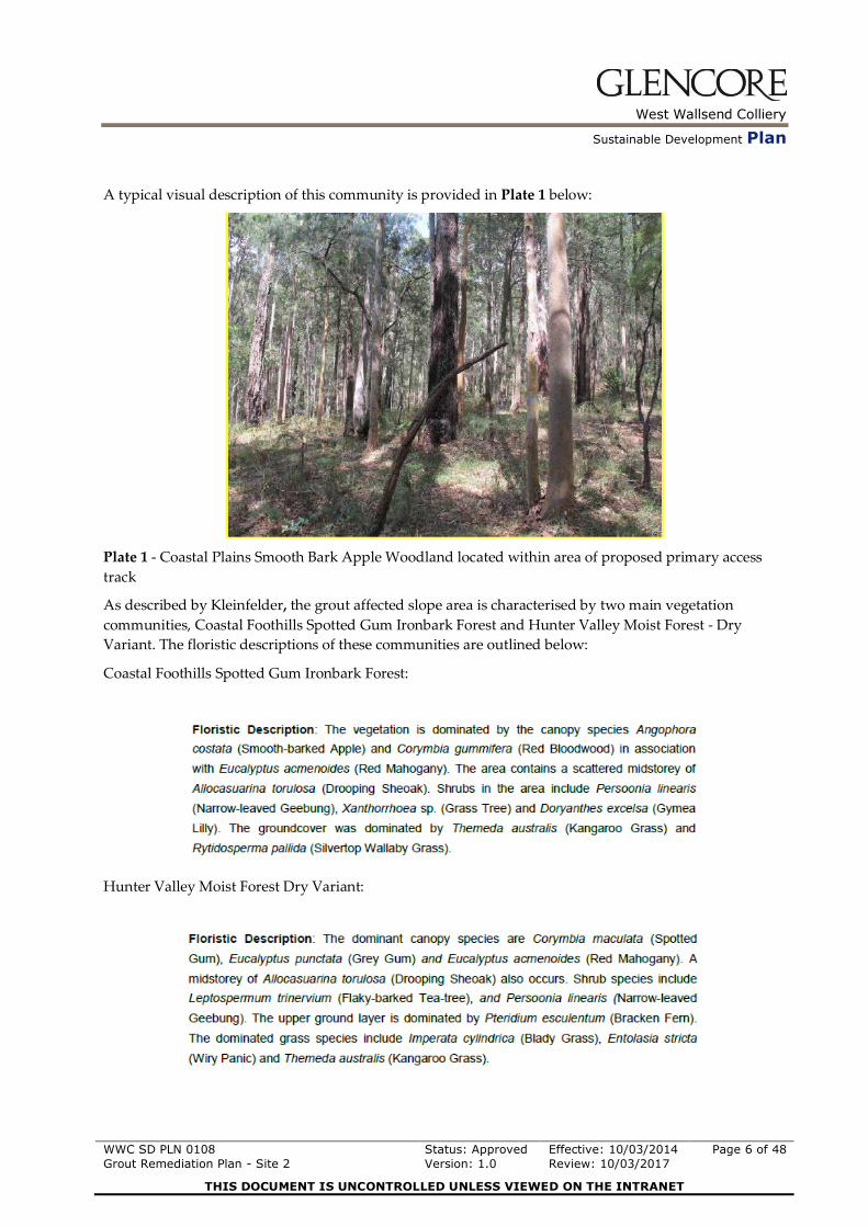
A typical visual description of this community is provided in Plate 1 below:
Plate 1 - Coastal Plains Smooth Bark Apple Woodland located within area of proposed primary access
track
As described by Kleinfelder, the grout affected slope area is characterised by two main vegetation
communities, Coastal Foothills Spotted Gum Ironbark Forest and Hunter Valley Moist Forest - Dry
Variant. The floristic descriptions of these communities are outlined below:
Coastal Foothills Spotted Gum Ironbark Forest:
Hunter Valley Moist Forest Dry Variant:

West Wallsend Colliery
Sustainable Development Plan
WWC SD PLN 0108
Grout Remediation Plan - Site 2
Status: Approved
Version: 1.0
Effective: 10/03/2014
Review: 10/03/2017
Page 7 of 48
THIS DOCUMENT IS UNCONTROLLED UNLESS VIEWED ON THE INTRANET
A typical visual description of these communities is provided in Plates 2 and 3 below:
Plate 2 - Coastal Foothills Spotted Gum Ironbark Forest located on the slopes of the affected area
Plate 3 - Hunter Valley Moist Forest Dry Variant located on the slopes of the affected area.

West Wallsend Colliery
Sustainable Development Plan
WWC SD PLN 0108
Grout Remediation Plan - Site 2
Status: Approved
Version: 1.0
Effective: 10/03/2014
Review: 10/03/2017
Page 8 of 48
THIS DOCUMENT IS UNCONTROLLED UNLESS VIEWED ON THE INTRANET
As described by Kleinfelder, the ephemeral drainage channel located below the grout affected area is
predominantly made up of the Hunter Valley Moist Forest –Mesic Variant. The floristic description of
this community is outlined below:
A typical visual description of this community is provided in Plate 4 below:
Plate 4 - Hunter Valley Moist Forest - Mesic Variant located in the drainage channel adjacent the grout
affected area.
1.2 Regulatory Context
As outlined in Section 1.0, WWC undertakes its mining operations in accordance with the sites Project
Approval (PA_09_0203), Environment Protection License (EPL1360), Environmental Assessment (West
Wallsend Colliery Continued Operations Project 2010) and Subsidence Management/Extraction Plans.
This Remediation Plan has been developed and will be implemented in accordance with the Remediation
Direction issued by the OEH (Notice DOC13/76057). Refer to Appendix 1

West Wallsend Colliery
Sustainable Development Plan
WWC SD PLN 0108
Grout Remediation Plan - Site 2
Status: Approved
Version: 1.0
Effective: 10/03/2014
Review: 10/03/2017
Page 9 of 48
THIS DOCUMENT IS UNCONTROLLED UNLESS VIEWED ON THE INTRANET

West Wallsend Colliery
Sustainable Development Plan
WWC SD PLN 0108
Grout Remediation Plan - Site 2
Status: Approved
Version: 1.0
Effective: 10/03/2014
Review: 10/03/2017
Page 10 of 48
THIS DOCUMENT IS UNCONTROLLED UNLESS VIEWED ON THE INTRANET
2. INTRODUCTION
2.1 Key Objectives & Purpose
The Key Objectives and Purpose of this Grout Remediation Plan are listed below:
Outline identified remediation options for the removal of the grout product from the affected
area of the SSCA.
Identify and discuss the preferred remediation option based on site investigations.
Outline associated activities required to successfully implement the remediation plan.
Identify and outline the potential environment and community impacts regarding the
remediation plan and the mitigation measures to be implemented to reduce these impacts.
Outline the proposed operational planning, monitoring, reporting and timing of the
remediation activities.
Outline how the remediation activities will be carried out to an extent as far as possible to
restore the natural, environmental, and cultural values of the site in a controlled and
sustainable manner to allow for a net environmental benefit from the remediation works.
Satisfy the Direction to Carry Out Remedial Works DOC 13/76057 issued by OEH.
Clearly outline the responsibilities of all parties associated with the implementation of the
Remediation Plan.
3. REMEDIATION OPTIONS
3.1 Remediation Options Investigated
Following the identification of the incident, OCAL, in consultation with Orica, commenced investigations
into potential remediation options for the affected area. The following remediation options were
investigated for the grout affected area:
1. Manual breakup of grout material and removal by Capalotta Cap Bora Super Sucker heavy
vehicle.
2. Manual breakup of grout material and removal by person and/or All Terrain Vehicle (ATV).
3. Manual breakup of grout material and removal by heavy vehicle.
4. Manual breakup of grout material and removal by helicopter.
5. Mechanical breakup of grout material and removal by earthmoving equipment/heavy vehicles
6. Mechanical breakup of grout material and removal by helicopter.
7. Leaving the grout in situ and allowing it to weather naturally.
These options are discussed in further detail below:
3.1.1 Option 1 – Manual breakup of grout material and removal by
Capalotta Cap Bora Super Sucker Heavy Vehicle
This remediation option involved the manual break up of grout material using various types of non
mechanical equipment and then pulverising it into a powder like state. This would potentially allow for
the grout material to be ‘sucked’ approximately 560 metres across the State Sugarloaf Conservation Area
to the nearest possible potential truck accessible access track.

West Wallsend Colliery
Sustainable Development Plan
WWC SD PLN 0108
Grout Remediation Plan - Site 2
Status: Approved
Version: 1.0
Effective: 10/03/2014
Review: 10/03/2017
Page 11 of 48
THIS DOCUMENT IS UNCONTROLLED UNLESS VIEWED ON THE INTRANET
JR Richards, a waste services provider has provided advice into the practicality and feasibility of this
removal method. Schematics of the typical ‘sucker truck’ to be used (Cap Bora) were provided and are
displayed below in Figure 2.
Upon further investigation, the waste services provider was not able to provide assurance as to the
design capability of the Cap Bora for this particular application due to the difficult terrain. It was also
recognised that significant upgrades to existing access tracks would be required to provide safe and
stable access for this equipment. The advantages and disadvantages of this option are discussed below:
Figure 2

West Wallsend Colliery
Sustainable Development Plan
WWC SD PLN 0108
Grout Remediation Plan - Site 2
Status: Approved
Version: 1.0
Effective: 10/03/2014
Review: 10/03/2017
Page 12 of 48
THIS DOCUMENT IS UNCONTROLLED UNLESS VIEWED ON THE INTRANET
Advantages Disadvantages
Removal method would require minimal
disturbance to the SSCA during grout
removal activities.
Would reduce potential for manual
handling injuries as material would be
transferred via mechanical means.
Preliminary investigations confirmed that
the required application was likely to fall
outside of the equipments design
parameters.
Noise impacts from the daily use of sucker
truck could potentially impact on the local
community
Would require the grout to be pulverised
into a powder like state prior to removal.
This would potentially increase the risk of
the grout material becoming airborne or
mobilised during removal.
3.1.2 Option 2 – Manual breakup of grout material and removal by person
and/or ATV
This remediation option involved the manual break up of grout material using various types of non
mechanical equipment and then collecting the material into bags. The bags would then be either dual lift
carried by person or transported from the affected area approximately 560m by a small all terrain vehicle
(ATV), to the nearest possible potential truck accessible access point on land owned by Oceanic Coal. The
advantages and disadvantages of this option are discussed below:
Advantages Disadvantages
Removal method would require minimal
disturbance to the SSCA during grout
removal activities.
Use of ATV’s can reduce risk of manual
handling injuries in difficult terrain.
Potential for manual handling injury when
dual lifting and transporting bags of waste
grout by foot from the affected area over
undulating terrain.
Potential for unplanned movement/ injury
when using an ATV to remove grout from
the affected area over undulating terrain.
Dual lift carry would be extremely time
consuming and would require a
substantial increase in workforce numbers
to maintain efficient progress with
remediation activities.
Increased potential for weed spread
West Wallsend Colliery
Sustainable Development Plan
WWC SD PLN 0108
Grout Remediation Plan - Site 2
Status: Approved
Version: 1.0
Effective: 10/03/2014
Review: 10/03/2017
Page 13 of 48
THIS DOCUMENT IS UNCONTROLLED UNLESS VIEWED ON THE INTRANET
through the use of an ATV.
Track clearing for access to the affected
area.
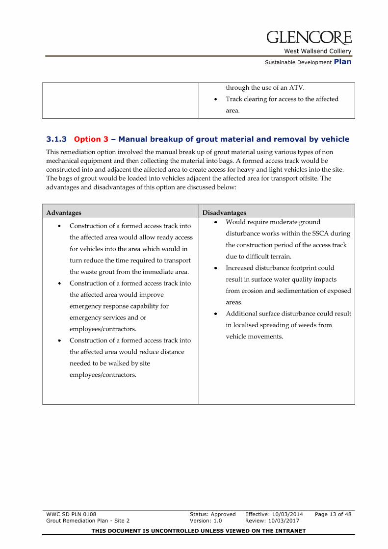
3.1.3 Option 3 – Manual breakup of grout material and removal by vehicle
This remediation option involved the manual break up of grout material using various types of non
mechanical equipment and then collecting the material into bags. A formed access track would be
constructed into and adjacent the affected area to create access for heavy and light vehicles into the site.
The bags of grout would be loaded into vehicles adjacent the affected area for transport offsite. The
advantages and disadvantages of this option are discussed below:
Advantages Disadvantages
Construction of a formed access track into
the affected area would allow ready access
for vehicles into the area which would in
turn reduce the time required to transport
the waste grout from the immediate area.
Construction of a formed access track into
the affected area would improve
emergency response capability for
emergency services and or
employees/contractors.
Construction of a formed access track into
the affected area would reduce distance
needed to be walked by site
employees/contractors.
Would require moderate ground
disturbance works within the SSCA during
the construction period of the access track
due to difficult terrain.
Increased disturbance footprint could
result in surface water quality impacts
from erosion and sedimentation of exposed
areas.
Additional surface disturbance could result
in localised spreading of weeds from
vehicle movements.
West Wallsend Colliery
Sustainable Development Plan
WWC SD PLN 0108
Grout Remediation Plan - Site 2
Status: Approved
Version: 1.0
Effective: 10/03/2014
Review: 10/03/2017
Page 14 of 48
THIS DOCUMENT IS UNCONTROLLED UNLESS VIEWED ON THE INTRANET
3.1.4 Option 4 – Manual breakup of grout material and removal by helicopter
This remediation option involves the manual break up of grout material using various types of non
mechanical equipment and then bagging the grout into bags suitable for heli-lifting. The grout bags
would then be heli-lifted to a location on an adjacent landholder’s property. The grout bags would then
be loaded onto trucks and transported to an appropriately licensed waste facility by a licensed waste
contractor. The advantages and disadvantages of this option are discussed below:
Advantages Disadvantages
This method was successfully trialled
under an existing remediation plan for a
previously grout affected area in
consultation with OEH.
Removal method would require minimal
disturbance to the SSCA during grout
removal and transport activities.
Use of heli-lifting technique would reduce
risk of manual handling injuries associated
with carrying bags out by foot.
Heli-lifting has been proven to be an
efficient access technique in remote areas.
Doesn’t require the construction of formed
access tracks into the affected area which
reduces the disturbance footprint for the
remediation activities.
Less intrusive method of remediation with
minimal impact on surrounding
environment.
Manual removal allows for the activity to
be controlled in a sustainable manner as
opposed to mechanical means.
Manual removal will ensure that care can
be taken around sensitive areas to
minimise disturbance within the affected
area.
Option still requires access into the affected
area by foot across undulating terrain
which has the potential for injury.
Increased noise impacts on surrounding
community during heli-lifting campaigns
Increase visual exposure to the local
community through the use of helicopters.
Potential for increased dust generation
from heli-lifting process.
Manual removal can be quite time
consuming which could delay the time
taken to complete the works.
Additional risks associated with
introducing airborne equipment to the
removal process.

West Wallsend Colliery
Sustainable Development Plan
WWC SD PLN 0108
Grout Remediation Plan - Site 2
Status: Approved
Version: 1.0
Effective: 10/03/2014
Review: 10/03/2017
Page 15 of 48
THIS DOCUMENT IS UNCONTROLLED UNLESS VIEWED ON THE INTRANET
3.1.5 Option 5 – Mechanical breakup of grout material and removal by earthmoving equipment/heavy vehicles
This remediation option involved the mechanical break up of grout material using various types of
mechanical equipment (small earthmoving equipment, jackhammers, power tools etc). The broken up
material would then be collected into bags. A formed access track would be constructed into and adjacent
to the affected area to create access for earthmoving equipment a well as heavy and light vehicles into the
site. The bags of grout would be loaded into vehicles adjacent the affected area for transport offsite. The
advantages and disadvantages of this option are discussed below:
Advantages Disadvantages
Construction of a formed access track into
the affected area would allow ready access
for vehicles into the area which would in
turn reduce the time required to transport
the waste grout from the immediate area.
Construction of a formed access track into
the affected area would improve
emergency response capability for
emergency services and or
employees/contractors.
Construction of a formed access track into
the affected area would reduce distance
needing to be walked by site
employees/contractors.
The use of small earthmoving machinery to
break the grout up in situ could be
undertaken very quickly.
Would require moderate ground
disturbance works within the SSCA during
the construction period of the access track
due to difficult terrain.
Mechanical breakup of the grout material
increases the potential for impacts on the
surrounding environment.
Increased disturbance footprint could
result in surface water quality impacts
from erosion and sedimentation of exposed
areas.
Increased potential for injury with
mechanical equipment in close proximity
to workers.
Additional surface disturbance could result
in localised spreading of weeds from
vehicle movements.

West Wallsend Colliery
Sustainable Development Plan
WWC SD PLN 0108
Grout Remediation Plan - Site 2
Status: Approved
Version: 1.0
Effective: 10/03/2014
Review: 10/03/2017
Page 16 of 48
THIS DOCUMENT IS UNCONTROLLED UNLESS VIEWED ON THE INTRANET
3.1.6 Option 6 – Mechanical breakup of grout material and removal by helicopter
This remediation option involves the mechanical break up of grout material using various types of
mechanical equipment (small earthmoving equipment, jackhammers, power tools etc). Small
earthmoving machinery would be tracked into the affected area across the undulating terrain. The broken
up material would then be collected into bags suitable for heli-lifting. The grout bags would then be heli-
lifted to a location on an adjacent landholder’s property where they would then be loaded onto trucks
and transported to an appropriately licensed waste facility by a licensed waste contractor. The
advantages and disadvantages of this option are discussed below:
Advantages Disadvantages
The use of small earthmoving machinery to
break the grout up in situ could be
undertaken very quickly.
A formed access track isn’t necessarily
required for this option as the equipment
could be tracked into the affected.
Use of heli-lifting technique would reduce
risk of manual handling injuries associated
with carrying bags out by foot.
Heli-lifting has been proven to be an
efficient access technique in remote areas.
Doesn’t require the construction of access
track into the affected area for Heli-lifting
which reduces the disturbance footprint for
the remediation activities .
Option still requires access into the affected
area by foot across undulating terrain
which has the potential for injury.
Mechanical breakup of the grout material
increases the potential for impacts on the
surrounding environment.
Potential increase for erosion due to
equipment tracking adjacent the drainage
line.
Potential for finite material to be left
behind.
Increased potential for injury with
mechanical equipment in close proximity
to workers.
Tracking of earthmoving equipment would
require a moderate amount of vegetation
clearing during access into and adjacent
the affected area to allow for this
equipment to be used.
Increased noise impacts on surrounding
community during heli-lifting campaigns.
Increase visual exposure to the local
community through the use of helicopters.
Potential for increased dust generation
from heli-lifting process.
Additional risks associated with
introducing airborne equipment to the
removal process.

West Wallsend Colliery
Sustainable Development Plan
WWC SD PLN 0108
Grout Remediation Plan - Site 2
Status: Approved
Version: 1.0
Effective: 10/03/2014
Review: 10/03/2017
Page 17 of 48
THIS DOCUMENT IS UNCONTROLLED UNLESS VIEWED ON THE INTRANET
3.1.7 Option 7 – Leave the grout in situ and allow it to naturally weather
This remediation option involved leaving the grout material in situ within the affected area and allowing
it to naturally weather.
The advantages and disadvantages of this option are discussed below:
Advantages Disadvantages
Low level of disturbance within the SSCA
required.
This option could be perceived by the
community as “doing nothing”.
The grout material, while inert in nature is
a foreign material which is not consistent
with other materials within the SSCA.
Visual impact to the local community
using the SSCA.
Could potentially impact on surface water
quality within the adjacent drainage
channel following rainfall events.
3.2 Preferred Remediation Option
Following a detailed assessment of all options it was decided that the preferred option was Option 4 for
the following reasons:
This option has been successfully trialled in a recent grout remediation program in consultation
with OEH.
This option requires minimal surface disturbance works to achieve the desired outcome.
Use of heli-lifting technique would reduce risk of manual handling injuries associated with
carrying bags out by foot.
Heli-lifting has been proven to be an efficient access technique in remote areas and has been
tested within a recent grout remediation trial.
This option does not require the construction of an access track into the affected area for Heli-
lifting which reduces the total disturbance footprint for the remediation activities.
Further detail on the preferred option and how it will be implemented is outlined below in Sections 3.2.1
to 3.4.
3.2.1 Operational Planning
Given the unique nature of this remediation project, careful consideration and planning of operational
requirements is critical to achieving the outcomes of the Grout Remediation Plan. Prior to commencing
grout removal activities under this Grout Remediation Plan, WWC, in consultation with OEH will
develop a detailed Operational Project Plan (OPP) for the proposed remediation activities. The OPP will
West Wallsend Colliery
Sustainable Development Plan
WWC SD PLN 0108
Grout Remediation Plan - Site 2
Status: Approved
Version: 1.0
Effective: 10/03/2014
Review: 10/03/2017
Page 18 of 48
THIS DOCUMENT IS UNCONTROLLED UNLESS VIEWED ON THE INTRANET
provide the operational framework for the remediation activities to be undertaken throughout the project
and will provide the following:
Detail key actions/activities/milestones required to achieve the outcomes of the GRP; and
Outline estimated completion timeframes for the various actions/activities/milestones required
under the GRP;
The OPP is a dynamic project management tool that will be regularly updated and managed by the
OCAL Grout Remediation Project Supervisor to assist with tracking remediation progress.
3.2.2 Grout Removal Process
The methodology that will be adopted for the manual breakup and removal of the grout from the
affected area is generally consistent with Option 4 of this GRP - Manual breakup of grout and removal by
helicopter. The following equipment will be used to breakup and remove the grout material from the
affected area into Bulk bags ahead of heli-lifting activities:
Crow bars – Bulk removal
Breaker bars – Bulk removal
Pelican Picks– Bulk removal
Mattocks– Bulk removal
Shovels– Bulk removal
Hand Picks and Screw Drivers– Bulk removal
Chisels– Bulk removal
Wire brushes– Fine removal
Battery powered tools – Bulk and Fine removal
Dust pan and brooms – Fine removal
Scoops – Fines removal
Misting spray bottles – Dust control
Rakes – Leaf Litter / Bulk and Fine removal
Storage buckets (20l) – Grout transport
Brattice/Tarps– Grout wet weather management
Pallets – level storage (if required)
Bulk Bags – Grout storage and transport
It is anticipated that grout removal from the affected area will be undertaken by a small team of men (less
than 6). Grout removal and ancillary activities will be undertaken during daylight hours Monday to
Friday for the duration of the program.
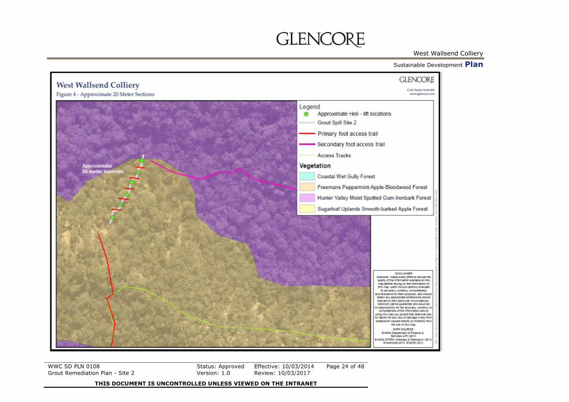
As displayed in Figure 4 the remediation project area has been broken up into 20 metre sections.
Following the approval of this GRP, Orica will commence grout removal activities from the affected area
starting at the lowest point and progressing upslope. It is proposed that grout be removed from 3 sections
at a time (60m blocks) to ensure continuity of works. Once the first 60m has been completed and
provisional signoff has been received from OEH, grout removal activities will progress into the second
60m block (remainder of the remediation area).
The grout material will continue to be placed in bulk heli-lift bags following its removal from the affected
area. The bags will be positioned at the designated heli-lifting locations as determined by OCAL, Orica
and OEH.

West Wallsend Colliery
Sustainable Development Plan
WWC SD PLN 0108
Grout Remediation Plan - Site 2
Status: Approved
Version: 1.0
Effective: 10/03/2014
Review: 10/03/2017
Page 19 of 48
THIS DOCUMENT IS UNCONTROLLED UNLESS VIEWED ON THE INTRANET
3.2.3 Heli-lifting
Approximately 6 potential heli-lift locations were identified within the grout affected area as part of the
development of this GRP.
These heli-lift locations were based on the existing topography and the canopy spans of surrounding
vegetation and are generally located adjacent the affected area.
Waste grout bags will be heli-lifted from the existing pre determined locations to a suitable cleared area
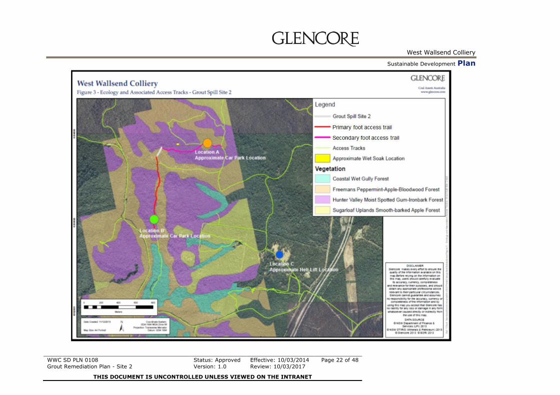
on an adjacent private landholding (Refer to Figure 3).
Depending on remediation progress it is expected that multiple heli-lift campaigns may be required
throughout the remediation project. These heli-lifting campaigns are expected to be relatively short in
duration and are unlikely to impact on the surrounding community due to limited time required to
undertake the works.
Although it is not expected that equipment/supplies will be required to be heli-lifted into or out of the
work area for the remainder of the program it is possible that this may need to occur as remediation
works progress and will be undertaken where required in consultation with OEH. Heli-lifting of
equipment/supplies into or out of the work area will be assessed on a case by case basis and appropriate
controls will be implemented to minimise the impacts on the surrounding environment and local
community should this be required.
3.2.4 Waste Characterisation, Disposal and Tracking
Based on the products MSDS, the grout material has been assessed by a waste management services
provider and is characterised as general waste – non putrescibles.
Each bag of grout material that is removed from the affected area will be transported to a licensed waste
disposal facility by a licensed waste contractor. The volumes and tonnages of the waste material will be
recorded and tracked in accordance with the OEH Direction.
3.3 Ancillary Activities
In order for OCAL/ Orica to achieve the outcomes of this remediation plan the following ancillary
activities have been and will continue to be undertaken:
3.3.1 Rockfall Stabilisation Works
During the preparation of this GRP it has been determined that rockfall stabilisation activities may be
required on a steep slope immediately above the top section of the grout affected area prior to works
commencing in this area. These works will involve the controlled displacement of rocks above the work
area to reduce the potential of these rocks rolling down slope when grout removal activities are being
undertaken in this area. Future stabilisation activities may need to be undertaken during the remainder of
the program in consultation with OEH if required using a similar methodology.
3.3.2 Vegetation Clearing/Minor Ground Disturbance
Selective brush cutting/trimming of vegetation as well as the removal of selected logs and rocks along the
access tracks, heli-lift locations and sections of the affected area will be undertaken following the
approval of this GRP. Vegetation clearing will be undertaken by suitably qualified bush regeneration
contractors ahead of grout removal works. All vegetation to be modified or removed will be marked and
assessed by OEH prior to works commencing. This will ensure that that any clearing of vegetation is

West Wallsend Colliery
Sustainable Development Plan
WWC SD PLN 0108
Grout Remediation Plan - Site 2
Status: Approved
Version: 1.0
Effective: 10/03/2014
Review: 10/03/2017
Page 20 of 48
THIS DOCUMENT IS UNCONTROLLED UNLESS VIEWED ON THE INTRANET
undertaken in a controlled and environmentally responsible manner. The extent of clearing along the
access track will be minimised and is primarily required to allow safe, unobstructed access for personnel
and equipment to access the remediation area. Where possible, the clearing of mature trees (>30cm
diameter) will continue to be avoided. No clearing of mature trees is expected to be required to undertake
the remediation activities.
As recommended in an independent aviation audit an area of approximately 5m2 cleared area is required
around heli-lift locations to provide adequate line of sight to the helicopter during heli-lifting. In some
areas the trimming of canopy vegetation may be required to provide this adequate line of sight for the
helicopter pilot. Where possible, and safe to do so, branches that are impacted by trimming activities will
be positioned in a way to provide habitat for ground dwelling fauna. Any hollows that are identified
during pre clearance inspections will be offset with nest boxes by OCAL/Orica throughout the
remediation campaign.
Heli-lift locations will be designed to reduce potential impacts to surrounding vegetation where possible.
A coordinated approach for the planning, establishment and management of heli-lift sites will be
undertaken in consultation with OEH.
Clearing of vegetation within and adjacent to the affected area will be undertaken to reduce the risk of
slips, trips, falls and improve the accessibility of the area for safety, remediation works and access in the
case of an emergency. Vegetation clearing will be minimised where possible and will be constrained to
low and mid storey vegetation where possible.
3.3.3 Installation of safety barriers/controls/manual handling systems
Based on the outcomes of the site inspections additional safety barriers and controls will be installed as
the works progress. These works may include the following:
Installation of demarcation barriers/signage around the perimeter of the work area
Construction of walkways along the proposed access tracks in higher risk areas to reduce the risk
of slips and trips.
Installation of working at heights equipment, anchor points, guidance ropes
Installation of transfer chutes in steep areas; and
Pulley transport systems to allow for grout removal in steep areas to be controlled.
It is expected that these areas will be minor in nature and will be confined to adjacent the existing
remediation areas.
3.3.4 Weed Control Activities
Where required, weed control activities will be undertaken by a qualified weed control contractor to
reduce the potential for weed spread prior to and during remediation activities in consultation with OEH.
for weeds will continue to be undertaken throughout the remediation program and weed control
activities undertaken where required.
3.3.5 Equipment Storage Areas
Secure equipment storage areas will be established adjacent the active work areas as remediation works
progress. It is anticipated that secure portable containers will be utilised to store
equipment/tools/supplies/safety gear overnight on site. Equipment storage areas are generally less then
10m2 in area and will be minimised where possible to limit the impact on the surrounding environment.

West Wallsend Colliery
Sustainable Development Plan
WWC SD PLN 0108
Grout Remediation Plan - Site 2
Status: Approved
Version: 1.0
Effective: 10/03/2014
Review: 10/03/2017
Page 21 of 48
THIS DOCUMENT IS UNCONTROLLED UNLESS VIEWED ON THE INTRANET
3.3.6 Erosion and Sediment Control Activities
An erosion and sediment control plan has been developed for the site which will be implemented prior to
grout removal activities commencing. The plan has been peer reviewed by an Erosion and Sediment
Control specialist. Sediment fencing has been installed along the site in consultation with OEH to
minimise the potential for grout to mobilise and enter the adjacent drainage channel. Effectiveness of the
erosion and sedimentation controls will be monitored daily during remediation work activity. The
sediment fencing will be removed once the site is given final sign-off from OEH. Where required
specialist advice will be sought regarding the design, placement and maintenance of erosion and
sedimentation controls for the remediation work area during and post remediation works.
3.3.7 Access tracks and Car parking
The car park and access track which will be utilised for personnel engaged in grout removal activities is
at location B (see Figure 3). A secondary access track and car parking area at Location A has been
assessed by OCAL and will not be utilised for the duration as the remediation program due to access
restrictions. Entry to the proposed remediation area is via an existing access track (Forestry Track East)
which has two locked gates which will act as a deterrent for third party vehicular access and reduce
impact. This vehicular access track, car parking area and foot track are pre-existing. There are currently 3
car spaces at this location which will be adequate for the number of personnel required for this activity.
Photo 1 and 2. Existing Car Parking area that will be used and typical existing foot track to the
remediation area
West Wallsend Colliery
Sustainable Development Plan
WWC SD PLN 0108
Grout Remediation Plan - Site 2
Status: Approved
Version: 1.0
Effective: 10/03/2014
Review: 10/03/2017
Page 22 of 48
THIS DOCUMENT IS UNCONTROLLED UNLESS VIEWED ON THE INTRANET
West Wallsend Colliery
Sustainable Development Plan
WWC SD PLN 0108
Grout Remediation Plan - Site 2
Status: Approved
Version: 1.0
Effective: 10/03/2014
Review: 10/03/2017
Page 23 of 48
THIS DOCUMENT IS UNCONTROLLED UNLESS VIEWED ON THE INTRANET
3.3.8 Post Remediation Activities and Determination of Final Rehabilitation Criteria
OCAL, in consultation with Orica and the Office of Environment and Heritage will determine if any post
remediation activities are required for the site upon remediation completion. These activities may include
but are not limited to:
Additional weed control activities;
Identification and supplementary planting of endemic species if required;
Rehabilitation of access tracks established for the remediation works;
Removal of all safety barriers/demarcation
OCAL, in consultation with Orica and the Office of Environment and Heritage will develop final
rehabilitation criteria for the remediation site to assist with defining the completion requirements for the
site. The criteria will be determined based on industry and site knowledge and should take into account
existing environmental conditions adjacent to the affected area. An assessment against the criteria will be
provided in the post remediation completion report that will be submitted to OEH at the completion of
the remediation project.
West Wallsend Colliery
Sustainable Development Plan
WWC SD PLN 0108
Grout Remediation Plan - Site 2
Status: Approved
Version: 1.0
Effective: 10/03/2014
Review: 10/03/2017
Page 24 of 48
THIS DOCUMENT IS UNCONTROLLED UNLESS VIEWED ON THE INTRANET

West Wallsend Colliery
Sustainable Development Plan
WWC SD PLN 0108
Grout Remediation Plan - Site 2
Status: Approved
Version: 1.0
Effective: 10/03/2014
Review: 10/03/2017
Page 25 of 48
THIS DOCUMENT IS UNCONTROLLED UNLESS VIEWED ON THE INTRANET
3.4 Risk Management
A Broad Brush Risk Assessment (BBRA) will be undertaken by OCAL and Orica for the grout
remediation site and the controls identified from this assessment will be incorporated into site specific
Standard Operating Procedures (SOPs).
OCAL and Orica have comprehensive risk management standards in place to assist with assessing risks
to personal safety, the environment and the local community. Where required specific risk assessments
may be undertaken for specific tasks to further identify additional controls to manage risks associated
with the activity and where deemed appropriate the outcomes from the assessments will be incorporated
into site specific Standard Operating Procedures (SOPs) as remediation works progress.
3.4.1 Training & Answers
A site specific induction/training package will be developed outlining the key environmental/ safety
hazards and controls identified in the risk assessment, SOP’s and the Grout Remediation Plan as well as
providing basic environmental awareness information. It will be a site requirement that any
contractor/employee undertaking remediation activities on the site is inducted prior to any works
commencing. Regular tool box talks on safety and environmental matters are provided as required by the
Orica Crew Supervisor and or OCAL Project Supervisor.
3.4.2 Grout Remediation Team – Required Knowledge and Skills
Orica are responsible for the coordination of the day to day activities associated with the implementation
of the GRP. Orica, as the supplier and principle contractor for the grouting activities at WWC over the
last 20 months have extensive experience in handling the grout product and are familiar with its chemical
and physical characteristics.
Orica employees have experience working at various operations which broadens their exposure to strong
positive corporate cultures enabling them to understand the importance placed upon requirements for
working in sensitive environments. OCAL and Orica management has inspected the remediation site and
has tailored induction programs and modules for all employees proposed to undertake works under the
Grout Remediation Plan. Prior to the commencement of works on site all employees will be trained
(based on the task required to be undertaken) and assessed as competent in the following (as required):
Orica Site Specific Safe Operating Procedures
Grout Remediation Plan Requirements
WWC Contractor Management System / Induction
Use of Behavioural Safety Systems (SLAM’s, Take Two)
Safe Act Observation System
Task Analysis System
Accident Training Module
Chemical Awareness Module
Hazard Awareness
Basic Strata Control Operations
Manual Handling
To this end Orica have appointed a full time supervisor with experience in managing multiple crews who
is also familiar with the grouting product. The Orica remediation team will also be supervised by an

West Wallsend Colliery
Sustainable Development Plan
WWC SD PLN 0108
Grout Remediation Plan - Site 2
Status: Approved
Version: 1.0
Effective: 10/03/2014
Review: 10/03/2017
Page 26 of 48
THIS DOCUMENT IS UNCONTROLLED UNLESS VIEWED ON THE INTRANET
OCAL Project supervisor who will have training in environmental management and will have the
necessary skills to ensure that the remediation activities are carried out in accordance with the Plan.
Specialist advice or services will be engaged by Orica where the skills or knowledge required to
undertake a specific task fall outside Orica’s or OCAL’s knowledge or skills set. To date, activities which
have been identified as requiring specialist advice and/or coordination have included:
Ecological assessments
Erosion and sediment control design
Vegetation clearing activities
Weed management activities
Heli-lifting activities
Rockfall Stabilisation Works
Working at heights planning
Waste removal (disposal)
3.4.3 Public Safety
OCAL / Orica take the management of Public Safety seriously. Based on site experience the following
public safety controls will be implemented to control Public Safety:
All active work areas will be clearly demarcated and appropriate signage installed advising the
Public not to enter these areas.
All work areas within the SSCA will be closed to the Public for the duration of the remediation
works.
3.5 Change Management
While it is not expected, and although OCAL in consultation with Orica have undertaken significant
planning to form the basis of this remediation plan there may be circumstances arise that require actions
to be implemented on the site that may not have been foreseen during the development of this plan.
Any changes to remediation activities outside the approved Remediation Plan will be thoroughly
assessed in accordance with the OCAL Change Management Standard. The change management process
provides a framework for the assessment of risks associated with a proposed change to site activity to
ensure that any changes outside of an approved scope have been approved by the appropriate levels of
management and that any required controls have been identified and implemented prior to the change
being adopted or accepted.
As part of the change management process, OEH will be notified and due diligence assessments will be
undertaken where required in consultation with OEH to minimise impacts. If warranted and if the
change management process identifies, the remediation plan may require modification in consultation
with OEH. Any significant changes to the methodology approved under this plan will be assessed in
consultation with OEH which may involve further trials to assess the effectiveness of the proposed
changes.

West Wallsend Colliery
Sustainable Development Plan
WWC SD PLN 0108
Grout Remediation Plan - Site 2
Status: Approved
Version: 1.0
Effective: 10/03/2014
Review: 10/03/2017
Page 27 of 48
THIS DOCUMENT IS UNCONTROLLED UNLESS VIEWED ON THE INTRANET
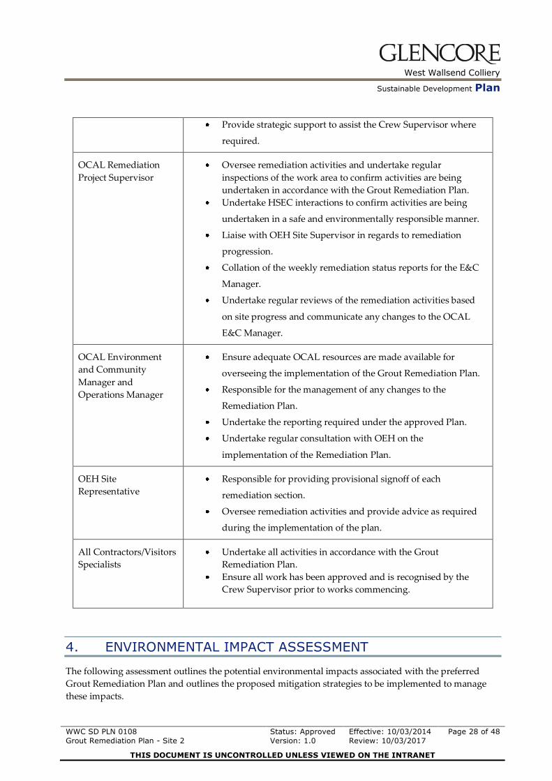
3.6 Responsibilities
The following table, Table 1, outlines the responsibilities of various personnel associated with the
implementation of the Grout Remediation Plan.
Table 1:
Position Key Responsibilities
Remediation Activity
Operators
Ensuring they undertake their remediation activities in
accordance with the Approved Grout Remediation Plan.
Be aware of the requirements of the Grout Remediation Plan
and the key controls to be implemented associated with the
activity they are undertaking.
Have an understanding and adhere to all safety and
environmental controls required to complete their respective
tasks.
Report hazards and incidents immediately to the Remediation
Crew Supervisor.
Participate in any safety or environmental tool box talks.
Orica Remediation
Crew Supervisor
Provide regular communication of all safety and environmental
controls within the Grout Remediation Plan and associated
SOP’s.
Coordinate day to day activities on site.
Undertake regular inspections of the remediation activities to
ensure that all activities are being carried out in accordance with
the approved Remediation Plan.
Ensure all work party members are inducted and trained in the
appropriate management systems applicable to the tasks they
are undertaking.
Coordinate risk based assessments where required for specific
tasks.
Regularly report on remediation progress to the OCAL
Remediation Project Supervisor.
Liaise with the OEH site supervisor where required in
consultation with OCAL Remediation Project Supervisor.
Orica Operations/HSEC
Manager
Ensure that there are adequate resources to allow for the
successful implementation of the Grout Remediation Plan.
West Wallsend Colliery
Sustainable Development Plan
WWC SD PLN 0108
Grout Remediation Plan - Site 2
Status: Approved
Version: 1.0
Effective: 10/03/2014
Review: 10/03/2017
Page 28 of 48
THIS DOCUMENT IS UNCONTROLLED UNLESS VIEWED ON THE INTRANET
Provide strategic support to assist the Crew Supervisor where
required.
OCAL Remediation
Project Supervisor
Oversee remediation activities and undertake regular
inspections of the work area to confirm activities are being
undertaken in accordance with the Grout Remediation Plan.
Undertake HSEC interactions to confirm activities are being
undertaken in a safe and environmentally responsible manner.
Liaise with OEH Site Supervisor in regards to remediation
progression.
Collation of the weekly remediation status reports for the E&C
Manager.
Undertake regular reviews of the remediation activities based
on site progress and communicate any changes to the OCAL
E&C Manager.
OCAL Environment
and Community
Manager and
Operations Manager
Ensure adequate OCAL resources are made available for
overseeing the implementation of the Grout Remediation Plan.
Responsible for the management of any changes to the
Remediation Plan.
Undertake the reporting required under the approved Plan.
Undertake regular consultation with OEH on the
implementation of the Remediation Plan.
OEH Site
Representative
Responsible for providing provisional signoff of each
remediation section.
Oversee remediation activities and provide advice as required
during the implementation of the plan.
All Contractors/Visitors
Specialists
Undertake all activities in accordance with the Grout
Remediation Plan.
Ensure all work has been approved and is recognised by the
Crew Supervisor prior to works commencing.
4. ENVIRONMENTAL IMPACT ASSESSMENT
The following assessment outlines the potential environmental impacts associated with the preferred
Grout Remediation Plan and outlines the proposed mitigation strategies to be implemented to manage
these impacts.

West Wallsend Colliery
Sustainable Development Plan
WWC SD PLN 0108
Grout Remediation Plan - Site 2
Status: Approved
Version: 1.0
Effective: 10/03/2014
Review: 10/03/2017
Page 29 of 48
THIS DOCUMENT IS UNCONTROLLED UNLESS VIEWED ON THE INTRANET
4.1 Aboriginal Cultural Heritage
Table 4.1:
Potential Impact Proposed Mitigation Measures
Impact /affect on known Aboriginal
objects or Aboriginal places?
Access into the remediation work site is via pre existing access tracks and trails. No upgrades to
existing access tracks or trails are proposed to be undertaken. There are no known cultural
heritage sites within the grout affected area.. WWC has an established Aboriginal Cultural
Heritage Management Plan (ACHMP) in place to manage cultural heritage items.
Regular consultation with the sites registered Aboriginal stakeholder groups. AAC Meetings.
Is the activity located in areas where
landscape features indicate the presence
of Aboriginal objects?
AHIMS Search, GIS Mapping and archaeological assessment undertaken as part of PA09_0203.
OCAL is aware of the sensitive land units (i.e. near creek–lines and floodplain areas or ridges
close to existing drainage) and that these locations are likely to increase the risk on impacting
unknown Aboriginal heritage within the mine lease area.
All people working within the remediation area will be inducted. This induction will include
Cultural heritage awareness.
Should a site be identified during the remediation works it will be managed in accordance with
the procedures outlined in the WWC ACHMP.
Impact on wild resources or access to
these resources, which are used or
valued by the Aboriginal community.
The proposed activity does not significantly affect wild resources within the area, or does it
restrict access to surrounding resources.

West Wallsend Colliery
Sustainable Development Plan
WWC SD PLN 0108
Grout Remediation Plan - Site 2
Status: Approved
Version: 1.0
Effective: 10/03/2014
Review: 10/03/2017
Page 30 of 48
THIS DOCUMENT IS UNCONTROLLED UNLESS VIEWED ON THE INTRANET
4.2 Historic Cultural Heritage
Table 4.2:
Potential Impact Proposed Mitigation Measures
Impact on places, buildings, landscapes
or moveable historic heritage items?
Vegetation clearing limited to defined areas as discussed throughout the Grout Remediation Plan.
Ultimately, there will be a minimal impact on the vegetation within this area that will not have a
significant impact on the visual aesthetics of the landscape.
Impact on vegetation of cultural
landscape value.
As per mitigation measures listed above.
4.3 Noise
Table 4.3:
Potential Impact Proposed Mitigation Measures
Impact on surrounding environment
(Neighbours, community, Fauna etc)?
Remote nature of the site
Only two residential neighbours located within proximity to the affected area. Consultation with
affected landholders will be undertaken.
Removal proposed by manual techniques with only small industrial vacuums or alike for small
time periods unlikely to impact on surrounding properties.
Heli-lift campaigns will be minimised where possible to reduce any noise impacts on the local
community. Flights will only occur during daylight hours.

West Wallsend Colliery
Sustainable Development Plan
WWC SD PLN 0108
Grout Remediation Plan - Site 2
Status: Approved
Version: 1.0
Effective: 10/03/2014
Review: 10/03/2017
Page 31 of 48
THIS DOCUMENT IS UNCONTROLLED UNLESS VIEWED ON THE INTRANET
4.4 Air Quality
Table 4.4:
Potential Impact Proposed Mitigation Measures
Dust Generation from Heli- Lifting
causing community complaints or air
quality impacts
Heli-lifting will only be undertaken in low wind conditions. Heli-lift drop off zone (Location B) will
be suppressed where required to reduce air borne dust.
Dust generation from break up of grout
material
Monitor remediation plan and techniques, if significant dust generation occurs, modify technique as
required to reduce dust generation.
4.5 Flora & Fauna
Table 4.5:
Potential Impact Proposed Mitigation Measures
Clearing or modification of vegetation
along access track or drainage channel
leading to poor regeneration of
vegetation after remediation activities.
Due Diligence survey conducted to identify the vegetation community and the potential for
threatened or endangered flora and fauna. Clearing activities to be confined to minimum area
required.
Bush Regeneration Specialists to undertake clearing activities to minimise impact to existing
vegetation within the remediation areas.
Vegetation monitoring program
Categorisation and demarcation of vegetation to be removed will be undertaken prior to clearing
works commencing
Delineated clearing areas.
Replacement of hollows that are removed as a result of ancillary activities with nest boxes (1:1 ratio)
Clearing of mature trees (> 30cm diameter) will be avoided where possible.

West Wallsend Colliery
Sustainable Development Plan
WWC SD PLN 0108
Grout Remediation Plan - Site 2
Status: Approved
Version: 1.0
Effective: 10/03/2014
Review: 10/03/2017
Page 32 of 48
THIS DOCUMENT IS UNCONTROLLED UNLESS VIEWED ON THE INTRANET
Is the activity likely to have a significant
effect on threatened flora or fauna
species, populations, or their habitats, or
critical habitat; or an endangered
ecological community or its habitat?
As per mitigation measures described above.
Does the activity have the potential to
endanger, displace or disturb fauna
(including fauna of conservation
significance) or create a barrier to their
movement?
As per mitigation measures described above.
Impact on an ecological community of
conservation significance?
As per mitigation measures described above.
Is the activity likely to cause a threat to
the biological diversity or ecological
integrity on an ecological community?
As per mitigation measures described above.
Is the activity likely to introduce
noxious weeds, vermin, feral species or
genetically modified organisms into an
area?
As per mitigation measures described above.
As outlined in Section 3.3.4, weed control activities will be undertaken within the remediation area
to minimise the chance of any further weed spread in the SSCA as a result of the remediation
activities.
West Wallsend Colliery
Sustainable Development Plan
WWC SD PLN 0108
Grout Remediation Plan - Site 2
Status: Approved
Version: 1.0
Effective: 10/03/2014
Review: 10/03/2017
Page 33 of 48
THIS DOCUMENT IS UNCONTROLLED UNLESS VIEWED ON THE INTRANET
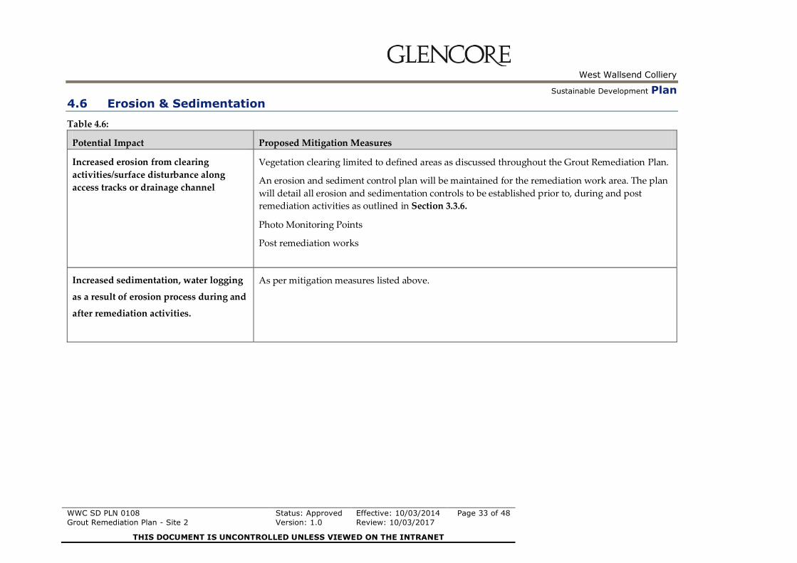
4.6 Erosion & Sedimentation
Table 4.6:
Potential Impact Proposed Mitigation Measures
Increased erosion from clearing
activities/surface disturbance along
access tracks or drainage channel
Vegetation clearing limited to defined areas as discussed throughout the Grout Remediation Plan.
An erosion and sediment control plan will be maintained for the remediation work area. The plan
will detail all erosion and sedimentation controls to be established prior to, during and post
remediation activities as outlined in Section 3.3.6.
Photo Monitoring Points
Post remediation works
Increased sedimentation, water logging
as a result of erosion process during and
after remediation activities.
As per mitigation measures listed above.

West Wallsend Colliery
Sustainable Development Plan
WWC SD PLN 0108
Grout Remediation Plan - Site 2
Status: Approved
Version: 1.0
Effective: 10/03/2014
Review: 10/03/2017
Page 34 of 48
THIS DOCUMENT IS UNCONTROLLED UNLESS VIEWED ON THE INTRANET
4.7 Surface Water & Hydrology
Table 4.7:
Potential Impact Proposed Mitigation Measures
Change in surface water quality within
drainage channel/Cockle Creek
catchment following rainfall
- Impacts on downstream water users
Installation of erosion and sediment controls as the remediation works progress.
Surface water monitoring program (Section 5.1.1).
Adjacent landowners have been notified of the proposed remediation activities. Ongoing
consultation with adjacent landowners will be undertaken throughout the program.
Drainage channels are ephemeral in nature.
Remediation activities will not affect water flows within the catchment area. No loss of water from
the catchment is expected.
Changes in drainage channel
morphology (bank stability, creek bed,
scours) as a result of remediation
activities
n/a

West Wallsend Colliery
Sustainable Development Plan
WWC SD PLN 0108
Grout Remediation Plan - Site 2
Status: Approved
Version: 1.0
Effective: 10/03/2014
Review: 10/03/2017
Page 35 of 48
THIS DOCUMENT IS UNCONTROLLED UNLESS VIEWED ON THE INTRANET
5. MONITORING STAKEHOLDER CONSULTATION, REPORTING,
REMEDIATION TIMELINE AND EVALUATION
5.1 Monitoring
5.1.1 Surface Water Monitoring
As outlined in Section 4, a surface water quality monitoring program will be implemented for the site to
monitor water quality in the surrounding catchment. OCAL has identified 6 sample locations which will
be sampled during flow conditions for pH, EC, TSS and alkalinity. Given that the drainage channel below
the affected area is ephemeral in nature, samples will not be able to be taken on a defined frequency.
Monitoring locations have been chosen to provide water quality results upstream, from the potentially
affected channel, downstream as well as a reference channels. The indicative monitoring locations are
shown below on Figure 5.
OCAL/Orica has sourced and installed samplers at five of the surface water monitoring locations as
outlined in Figure 5 under an existing approved Remediation Plan associated with a different spill site
within the same catchment area. One additional sampling site “Upstream 1” will be added to the
monitoring network for the second spill site. This sampling location will be positioned in the drainage
channel upstream of the affected area. Samples will be collected upstream from access tracks where
possible to limit potential for access track runoff to affect samples.
5.1.2 Aquatic Macro Invertebrate Monitoring
OCAL/Orica have already engaged a suitably qualified specialist to undertake a field survey up to 2km
downstream of the affected area to identify any permanent water bodies. The results of the survey
indicated that there were no permanent pools of water located within the ephemeral drainage channel.
As such aquatic macro invertebrate monitoring is not proposed to be undertaken under this GRP.
5.1.3 Vegetation Monitoring
As outlined in Section 4, a vegetation monitoring program will be established in consultation with a
qualified ecologist and OEH for the affected area to assist with documenting the extent (and type) of
vegetation growth in the affected area. This monitoring program will be designed to assess the health of
the surrounding flora potentially affected by the remediation activities. Results from the monitoring will
be used to inform the post remediation plan and will be used to determine any future rehabilitation
activities that may be required. Vegetation surveys are proposed to be undertaken prior to and post grout
removal and 6 monthly thereafter until final sign off of the remediation project has been received.
5.1.4 Erosion Monitoring As outlined in Section 4, erosion monitoring will be undertaken within the affected area to identify the
development of any erosion or sedimentation that results from the remediation activities as works
progress. Due to the short term duration of the remediation works, monitoring will be undertaken prior
to and post remediation activities by a qualified specialist. The OCAL Project Supervisor will inspect the
site after significant storm events (>50mm in a 24 hours period) that have resulted in surface water flows
within the affected area. The monitoring will involve a formal walkover assessment of the affected area
by a suitably qualified specialist. Where monitoring identifies impacts that are attributable to the
remediation activities, suitable controls/ remediation actions will be established to control or minimise
any identified impacts in consultation with OEH. Monitoring will cease once OEH have given final sign-
off on the remediation area.

West Wallsend Colliery
Sustainable Development Plan
WWC SD PLN 0108
Grout Remediation Plan - Site 2
Status: Approved
Version: 1.0
Effective: 10/03/2014
Review: 10/03/2017
Page 36 of 48
THIS DOCUMENT IS UNCONTROLLED UNLESS VIEWED ON THE INTRANET

West Wallsend Colliery
Sustainable Development Plan
WWC SD PLN 0108
Grout Remediation Plan - Site 2
Status: Approved
Version: 1.0
Effective: 10/03/2014
Review: 10/03/2017
Page 37 of 48
THIS DOCUMENT IS UNCONTROLLED UNLESS VIEWED ON THE INTRANET
5.1.5 Photo Monitoring Points
Photo monitoring points have been established along pre determined sections of the grout affected area.
OCAL/Orica will undertake photo point monitoring of the work area to show changes over time and the
results will be reported to OEH regularly.
5.2 Stakeholder Consultation
OCAL and Orica are committed to adequately consulting with all affected stakeholders regarding the
implementation of this Grout Remediation Plan. An overview of key external stakeholders that have been
identified by OCAL and the likely consultation methods to be employed throughout the remediation
activity program are outlined in Table 5.1 below:
Table 5.1
Stakeholder Consultation Method /
Description
Frequency
Office of Environment and
Heritage / Relevant
Regulatory Authorities
Operational Status Report
GRP Cessation Report
Updates to Operational Project
Plan (OPP)
Site Inspections
Weekly
Once Off (following completion
of works)
As required
As required
Local State and Federal
Parliament Members
Operational Status Report
GRP Cessation Report
Community Newsletter
Site Inspections
Weekly
Once Off (following completion
of works)
6 Monthly
As required
Adjacent Landowners Community Newsletter
Phone Calls / Emails
Site Inspections
6 Monthly
As required – based on
operational status
As required

West Wallsend Colliery
Sustainable Development Plan
WWC SD PLN 0108
Grout Remediation Plan - Site 2
Status: Approved
Version: 1.0
Effective: 10/03/2014
Review: 10/03/2017
Page 38 of 48
THIS DOCUMENT IS UNCONTROLLED UNLESS VIEWED ON THE INTRANET
Stakeholder Consultation Method /
Description
Frequency
Aboriginal Stakeholder
Groups
AAC Meetings
Community Newsletter
Site Inspections
6 Monthly
6 Monthly
As required
Local Community CCC Meetings
Community Newsletter
6 Monthly
6 Monthly
Wider Community / All
Stakeholders
WWC Website Updates
WWC Annual Review
Media Releases
Weekly during remediation
activities
Annually
As required
5.3 Reporting
OCAL will distribute a weekly operational status report on remediation progress at the site to the
relevant stakeholders. The report will include the following as a minimum:
Update on the status of remediation activities against the operational project plan
Overview of any safety or environmental incidents since the last report
Summary of any previous monitoring results/reports received since the last report.
Photos taken from designated photo monitoring points where relevant.
OCAL will continue to develop a Grout Remediation Progress Plan which will be updated weekly and
will be uploaded onto the West Wallsend Colliery website (www.westwallsendcolliery.com.au). The Plan
will be designed to provide a visual representation of the remediation work progress over time.
In accordance with the OEH Direction, OCAL will submit a final report on remediation activities
following the completion of the grout removal works to the Office of Environment and Heritage and the
relevant government authorities.
OCAL will also provide an update on the grout remediation activities undertaken during future
Community Consultative Committee (CCC), Aboriginal Advisory Committee (AAC) meetings and in the
operations annual review in accordance with the site Project Approval.

West Wallsend Colliery
Sustainable Development Plan
WWC SD PLN 0108
Grout Remediation Plan - Site 2
Status: Approved
Version: 1.0
Effective: 10/03/2014
Review: 10/03/2017
Page 39 of 48
THIS DOCUMENT IS UNCONTROLLED UNLESS VIEWED ON THE INTRANET
5.4 Remediation Timeline
The following table, Table 5.2, provides an estimated project timeline which outlines major tasks and
milestones associated with the remediation program. It should be noted that this timeline is indicative
only and should not be used for auditing or tracking purposes due to the associated unknown variables
that cannot be predicted. The timeline is dependent on approvals being received as outlined in the below
Table 5.2. Any changes to approval timeframes will push project timelines out by the same period.
As outlined in Section 3.2.1, OCAL will develop, update and continue to maintain an Operational Project
Plan (OPP) for the remediation activities in consultation with OEH throughout the duration of the
remediation program.
Table 5.2
Task or Milestone Estimated date of Completion
Submission of draft G.R.P. to OEH for approval 13/12/2013
Submission of final G.R.P. to OEH for approval 28/02/2014
Approval of G.R.P. by OEH 05/03/2014
Submit OPP for Remediation Site 19/03/2014
Complete Grout Remediation Activities Refer to Approved OPP
5.5 Evaluation
Throughout the remediation activities, the effectiveness of the remediation activities will be evaluated
along with the suitability and practicality of the equipment and remediation team sizing. The Operational
Project Plan (as outlined in Section 3.2.1) will be updated in consultation with OEH as works progress.
Should a significant change to the operational plan need to occur, consultation and notification to the
Office of Environment and Heritage will be managed as described in Section 3.5.
As outlined in section 3.2.2, following the removal of grout from each 60m work section the area will be
inspected by a representative of OEH and OCAL. Where required, leaf litter will be removed to allow for
grout removal and inspections of the working section and will be recovered once the provisional sign-off
is received from OEH. Provisional signoff will be sought from OEH to confirm that grout removal has
been undertaken to a suitable standard. OCAL has developed sign off criteria in consultation with OEH
which assists with assessing each remediation section against agreed remediation goals.
If at any stage it is deemed required by OEH, Orica will engage a suitably qualified independent expert to
supervise and evaluate the remediation works.

West Wallsend Colliery
Sustainable Development Plan
WWC SD PLN 0108
Grout Remediation Plan - Site 2
Status: Approved
Version: 1.0
Effective: 10/03/2014
Review: 10/03/2017
Page 40 of 48
THIS DOCUMENT IS UNCONTROLLED UNLESS VIEWED ON THE INTRANET
5.6 Summary of Commitments
Table 5.3 below summarises the commitments from the Grout Remediation Plan and provides indicative timing regarding the implementation of
these commitments.
Table 5.3
Commitment Indicative Timing
WWC in consultation with OEH will develop a detailed Operational Project Plan (OPP) for the remediation
activities. The OPP will provide the operational framework for the remediation activities and will provide
the following:
Detail key actions/activities/milestones required to achieve the outcomes of the GRP; and
Outline estimated completion timeframes for the various actions/activities/milestones required
under the GRP;
The OPP will be developed and managed by WWC in consultation with Orica and will be updated regularly
as remediation works progress.
Prior to remediation works
commencing.
Updated throughout program
in consultation with OEH
Each bag of grout material that is removed from the affected area will be transported to a licensed waste
disposal facility by a licensed waste contractor. The volumes and tonnages of the waste material will be
recorded and tracked in accordance with the OEH Direction.
Ongoing throughout program.
OCAL / Orica will undertaken Ancillary activities in accordance with the Grout Remediation Plan Staged throughout program.
OCAL, in consultation with Orica and the Office of Environment and Heritage will determine if any post
remediation activities are required for the site upon remediation completion. These activities may include
but are not limited to:
Upon completion of grout
removal

West Wallsend Colliery
Sustainable Development Plan
WWC SD PLN 0108
Grout Remediation Plan - Site 2
Status: Approved
Version: 1.0
Effective: 10/03/2014
Review: 10/03/2017
Page 41 of 48
THIS DOCUMENT IS UNCONTROLLED UNLESS VIEWED ON THE INTRANET
Commitment Indicative Timing
Additional weed control activities
Identification and supplementary planting of endemic species if required
Rehabilitation of access tracks established for the remediation works
Removal of all safety barriers/demarcation
A site specific induction/training package will be developed outlining the key environmental/ safety hazards
and controls identified in the risk assessment, SOP’s and the Grout Remediation Plan as well as providing
basic environmental awareness information. It will be a site requirement that any contractor/employee
undertaking remediation activities on the site will be inducted prior to any works commencing. Regular tool
box talks on safety and environmental matters will be provided as required by the Orica Crew Supervisor
and or OCAL Project Supervisor.
Prior to and throughout
program
Orica will have a full time dedicated supervisor with experience in managing multiple crews who is also
familiar with the grouting product. The Orica remediation team will also be supervised by an OCAL Project
supervisor who will have training in environmental management and will have the necessary skills to ensure
that the remediation activities are carried out in accordance with the Plan.
Specialist advice or services will be engaged by Orica where the skills or knowledge required to undertake a
specific task fall outside Orica’s or OCAL’s knowledge or skills set.
Prior to and throughout
program.
All active work areas will be clearly demarcated and appropriate signage will be installed advising the Public
not to enter these areas.
Prior to remediation works
commencing.
Any changes to remediation activities outside the approved Remediation Plan will be thoroughly assessed in
accordance with section 3.5.
Prior to and throughout
program.

West Wallsend Colliery
Sustainable Development Plan
WWC SD PLN 0108
Grout Remediation Plan - Site 2
Status: Approved
Version: 1.0
Effective: 10/03/2014
Review: 10/03/2017
Page 42 of 48
THIS DOCUMENT IS UNCONTROLLED UNLESS VIEWED ON THE INTRANET
Commitment Indicative Timing
OCAL/Orica to ensure that mitigation measures as outlined in Section 4 are implemented Prior to, throughout and
following remediation
program.
As outlined in Section 4, OCAL is proposing that a surface water quality monitoring program be
implemented for the site to monitor water quality in the surrounding catchment. OCAL has identified 6
sample locations which will be sampled during flow conditions for pH, EC, TSS and alkalinity.
Prior to, throughout and
following remediation
program.
OCAL/Orica will source and install samplers at surface water monitoring locations as outlined in Figure 5. Prior to undertaking
remediation activities.
As outlined in Section 4, it is proposed that a vegetation monitoring program will be established in
consultation with a qualified ecologist and OEH for the affected area to assist with documenting the extent
(and type) of vegetation growth in the affected area. It is anticipated that this monitoring program will
include quantitative surveys of the area prior toand post remediation activities.
Prior to grout removal and
ongoing at a frequency agreed
to by OEH.
Photo monitoring points will be set up prior to remediation activities occurring along pre determined
sections of the grout affected area. OCAL will undertake photo point monitoring of the work area to show
changes over time and the results will be reported in the weekly status reports.
Prior to Grout Remediation
Activities
OCAL will ensure that consultation with stakeholders is undertaken in accordance with the Stakeholder
Consultation Strategy as outlined in Section 5.2.
Ongoing throughout program.
OCAL will provide OEH and the Parliament Members with a weekly operational status report on Weekly.
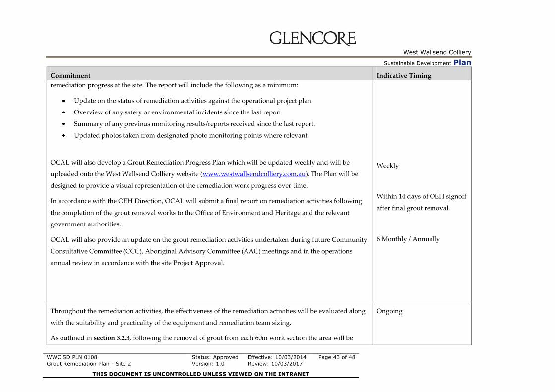
West Wallsend Colliery
Sustainable Development Plan
WWC SD PLN 0108
Grout Remediation Plan - Site 2
Status: Approved
Version: 1.0
Effective: 10/03/2014
Review: 10/03/2017
Page 43 of 48
THIS DOCUMENT IS UNCONTROLLED UNLESS VIEWED ON THE INTRANET
Commitment Indicative Timing
remediation progress at the site. The report will include the following as a minimum:
Update on the status of remediation activities against the operational project plan
Overview of any safety or environmental incidents since the last report
Summary of any previous monitoring results/reports received since the last report.
Updated photos taken from designated photo monitoring points where relevant.
OCAL will also develop a Grout Remediation Progress Plan which will be updated weekly and will be
uploaded onto the West Wallsend Colliery website (www.westwallsendcolliery.com.au). The Plan will be
designed to provide a visual representation of the remediation work progress over time.
In accordance with the OEH Direction, OCAL will submit a final report on remediation activities following
the completion of the grout removal works to the Office of Environment and Heritage and the relevant
government authorities.
OCAL will also provide an update on the grout remediation activities undertaken during future Community
Consultative Committee (CCC), Aboriginal Advisory Committee (AAC) meetings and in the operations
annual review in accordance with the site Project Approval.
Weekly
Within 14 days of OEH signoff
after final grout removal.
6 Monthly / Annually
Throughout the remediation activities, the effectiveness of the remediation activities will be evaluated along
with the suitability and practicality of the equipment and remediation team sizing.
As outlined in section 3.2.3, following the removal of grout from each 60m work section the area will be
Ongoing

West Wallsend Colliery
Sustainable Development Plan
WWC SD PLN 0108
Grout Remediation Plan - Site 2
Status: Approved
Version: 1.0
Effective: 10/03/2014
Review: 10/03/2017
Page 44 of 48
THIS DOCUMENT IS UNCONTROLLED UNLESS VIEWED ON THE INTRANET
Commitment Indicative Timing
inspected by a representative of OEH and OCAL. Provisional signoff will be sought from OEH once OEH
representatives confirm that grout removal has been undertaken to a suitable standard. If at any stage it is
deemed required by OEH, Orica will engage a suitably qualified independent expert to supervise and
evaluate the remediation works.

West Wallsend Colliery
Sustainable Development Plan
WWC SD PLN 0108
Grout Remediation Plan - Site 2
Status: Approved
Version: 1.0
Effective: 10/03/2014
Review: 10/03/2017
Page 45 of 48
THIS DOCUMENT IS UNCONTROLLED UNLESS VIEWED ON THE INTRANET
6. REFERENCES
6.1 Legislation
National Parks and Wildlife Act, 1974.
Protection of the Environment Operations Act, 1997.
Threatened Species Conservation Act, 1995.
Work Health and Safety Act, 2011.
Work Health and Safety Regulations, 2011.
Environmental Planning and Assessment Act, 1979.
Water Management Act.
6.2 Miscellaneous
Office of Environment and Heritage (2007) Mitchell Landscapes with per cent cleared estimates,
listed by CMA, Updated November 2007, OEH Website:
http://www.environment.nsw.gov.au/projects/biometrictool.htm.
Thackway, R. and Cresswell, I.D. (1995). An interim biogeographic regionalisation for Australia:
a framework for setting priorities in the National Reserves System Cooperative Program
Canberra. Report to the Australian Nature Conservation Agency, Reserve Systems Unit,
Canberra.
Department of Primary Industries (Office of Water) – Guidelines for in stream works on water
front land (July 2012)
Department of Primary Industries (Office of Water) – Guidelines for watercourse crossings on
water front land (July 2012)
WWC Grout Remediation Trial Phase Report – December 2013 (WWC SD PLN 0105)
WWC Grout Remediation Plan (WWC SD PLN 0097)

West Wallsend Colliery
Sustainable Development Plan
WWC SD PLN 0108
Grout Remediation Plan - Site 2
Status: Approved
Version: 1.0
Effective: 10/03/2014
Review: 10/03/2017
Page 46 of 48
THIS DOCUMENT IS UNCONTROLLED UNLESS VIEWED ON THE INTRANET
7. APPENDICES
7.1 Appendix 1 – Remediation Direction

West Wallsend Colliery
Sustainable Development Plan
WWC SD PLN 0108
Grout Remediation Plan - Site 2
Status: Approved
Version: 1.0
Effective: 10/03/2014
Review: 10/03/2017
Page 47 of 48
THIS DOCUMENT IS UNCONTROLLED UNLESS VIEWED ON THE INTRANET
7.2 Appendix 2 – Due Diligence Ecological Assessment

Ecological Assessment of Grout Spill (Site 2) within the Sugarloaf State Conservation Area
Glencore Xstrata
February 2014


Ref: WB13R_89335-138358 Page i 28 February 2014
Copyright 2013 Kleinfelder
Ecological Assessment of Grout Spill (Site 2) within
the Sugarloaf State Conservation Area
Kleinfelder Report Number: WB13R_89335-138358
Copyright 2013 Kleinfelder
All Rights Reserved
Prepared for:
GLENCORE XSTRATA PO BOX 4186, EDGEWORTH, NSW, 2285
Only Glencore Xstrata, its designated representatives or relevant statutory authorities may
use this document and only for the specific project for which this report was prepared. It
should not be otherwise referenced without permission.
Document Control:
Version Description Date Author Reviewer
1.0 Draft for client review 12/12/2013 Dr. G Whyte Chelayne Evans
2.0 Final version (amendments as per Glencore comments) 28/02/14 Dr. G. Whyte S. Schulz
Kleinfelder Australia Pty Ltd 64 Medcalf Street Warners Bay, NSW 2282 Phone: 1300 881 869 Fax: 1300 881 035 ABN: 23 146 082 500


Ref: WB13R_89335-138358 Page iii 28 February 2014
Copyright 2013 Kleinfelder
Contents
ABBREVIATIONS _________________________________________________________ V
1. INTRODUCTION _________________________________________________________ 1
1.1 SCOPE ....................................................................................................................... 1
1.2 BACKGROUND .......................................................................................................... 1
2. METHODOLOGY ________________________________________________________ 4
2.1 SITE ASSESSMENT ................................................................................................... 4
3. RESULTS ______________________________________________________________ 7
3.1 THREATENED FLORA AND FAUNA .......................................................................... 7
3.2 VEGETATION COMMUNITY IDENTIFICATION ......................................................... 7
3.2.1 Coastal Foothills Spotted Gum Iron Bark Forest 7
3.2.2 Coastal Plains Smooth Bark Apple Woodland 8
3.2.3 Hunter Valley Moist Forest - Dry Variant 9
3.2.4 Hunter Valley Moist Forest - Mesic Variant 10
3.3 AQUATIC HABITAT .................................................................................................. 12
4. SUMMARY OF ECOLOGICAL IMPACTS ____________________________________ 15
4.1.1 Direct Impacts: Vegetation Clearing 15
4.1.2 Threatened Flora 15
4.1.3 Endangered Ecological Communities 15
5. RECOMMENDATIONS ___________________________________________________ 16
6. REFERENCES _________________________________________________________ 17
7. STAFF CONTRIBUTIONS ________________________________________________ 18
8. LICENSING ____________________________________________________________ 19
Figures
Figure 1: Locality Map ........................................................................................................ 2
Figure 2: Extent of The Grout Spill...................................................................................... 3
Figure 3 Survey Effort ........................................................................................................ 6
Figure 4: Locations of Habitat and Threatened Flora ........................................................ 14

Ref: WB13R_89335-138358 Page iv 28 February 2014
Copyright 2013 Kleinfelder
Plates
Plate 1: Coastal Foothills Spotted Gum Ironbark Forest .................................................... 8
Plate 2: Coastal Plains Smooth Bark Apple Woodland ...................................................... 9
Plate 3: Hunter Valley Moist Forest – Dry Variant ........................................................... 10
Plate 4: Hunter Valley Moist Forest – Mesic Variant........................................................ 11
Plate 5: Minor Pooling Location 1 .................................................................................... 12
Plate 6: Minor Pooling Location 2 .................................................................................... 13
Plate 7: Minor Pooling Location 3 .................................................................................... 13
Ref: WB13R_89335-138358 Page v 28 February 2014
Copyright 2013 Kleinfelder
ABBREVIATIONS
AHD Australian Height Datum
DP Deposited Plan
DSEWPaC Commonwealth Department of Sustainability, Environment, Water, Population and Communities
EEC Endangered Ecological Community (category of Threatened Ecological Community)
EP&A Act Environmental Planning and Assessment Act 1979
EPBC Act Environment Protection and Biodiversity Conservation Act 1999
GIS Geographic Information System
GPS Global Positioning System
ha hectares
KTP Key Threatening Process
LEP Local Environmental Plan
LGA Local Government Area
MU Map Unit
OEH NSW Office of Environment and Heritage
TSC Act Threatened Species Conservation Act 1995


Ref: WB13R_89335-138358 Page 1 28 February 2014
Copyright 2013 Kleinfelder
1
1. INTRODUCTION
1.1 SCOPE
Kleinfelder was engaged by Glencore Xstrata to conduct an ecological pre-clearance survey
within Sugarloaf State Conservation Area. This survey was undertaken of an area affected
by a grout spill to help inform the remediation plan for the site.
1.2 BACKGROUND
The Sugarloaf State Conservation Area (SSCA) was created in 2007 and covers an area of
approximately 3,937 ha. The conservation area extends from Seahampton in the North to
Awaba in the South (Figure 1). The area is predominantly vegetated with forest consisting of
several general vegetation communities. The incident area is located on the foothills of the
Sugarloaf Range within the Hunter Sub-region of the Sydney Basin Bioregion (Thackway and
Cresswell, 1995) and the Gosford-Cooranbong Coastal Slopes landscape (OEH, 2007).
As outlined in WWC’s detailed incident report, the grout affected area extends approximately
120 m down slope of a previously remediated subsidence crack site. The average width of
the affected area is approximately 1 m (Figure 2). It is estimated that the average depth of
the grout product is approximately 100 mm. Based on the above information it is estimated
that approximately 12 cubic meters of grout has travelled down the side of a steep slope area
on the northern end of longwall 41 terminating on the embankment of an ephemeral drainage
channel in the Cockle Creek catchment. The terrain within the affected area varies from
gentle slopes (towards the bottom and middle of the affected area) to moderate and steeply
sloping terrain (on the foothills toward the top of the affected area).
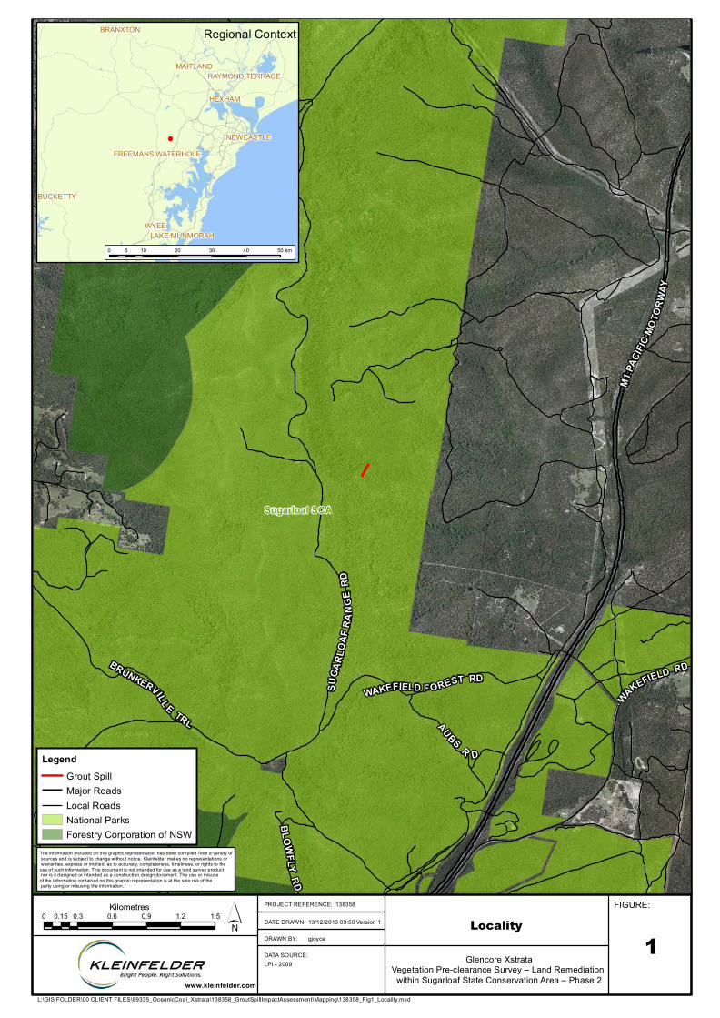
SUGA
RLOA
F RAN
GE R
D
WAKEFIELD RDBRUNKERVILL E TRL AUBS R D
WAKEFIELD F OREST RDGAP RD
BLOWFLY RD
M1 PA
CIFIC
MOTO
RWAY
Sugarloaf SCA
LocalityGlencore Xstrata
Vegetation Pre-clearance Survey – Land Remediation within Sugarloaf State Conservation Area – Phase 2
113/12/2013 09:50
138358
gjoyce
L:\GIS FOLDER\00 CLIENT FILES\89335_OceanicCoal_Xstrata\138358_GroutSpillImpactAssessment\Mapping\138358_Fig1_Locality.mxd
FIGURE:PROJECT REFERENCE:
DATE DRAWN:
DRAWN BY:
DATA SOURCE:
www.kleinfelder.com
LPI - 2009
LegendGrout SpillMajor RoadsLocal RoadsNational ParksForestry Corporation of NSW
0 0.3 0.6 0.9 1.2 1.50.15Kilometres ´
WYEE
HEXHAM
BUCKETTY
BRANXTON
MAITLAND
NEWCASTLE
LAKE MUNMORAH
RAYMOND TERRACE
FREEMANS WATERHOLE
Regional Context
0 10 20 30 40 505 km
The information included on this graphic representation has been compiled from a variety of sources and is subject to change without notice. Kleinfelder makes no representations or warranties, express or implied, as to accuracy, completeness, timeliness, or rights to the use of such information. This document is not intended for use as a land survey product nor is it designed or intended as a construction design document. The use or misuse of the information contained on this graphic representation is at the sole risk of the party using or misusing the information.
Version 1
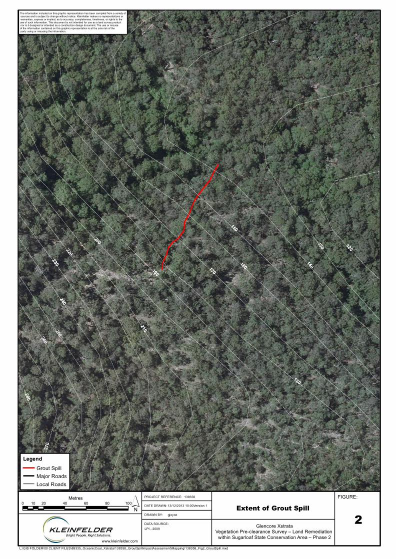
170
180
160190
150
200
210
140
220
230240
130
250260
270
280
120
Extent of Grout SpillGlencore Xstrata
Vegetation Pre-clearance Survey – Land Remediation within Sugarloaf State Conservation Area – Phase 2
213/12/2013 10:00
138358
gjoyce
L:\GIS FOLDER\00 CLIENT FILES\89335_OceanicCoal_Xstrata\138358_GroutSpillImpactAssessment\Mapping\138358_Fig2_GroutSpill.mxd
FIGURE:PROJECT REFERENCE:
DATE DRAWN:
DRAWN BY:
DATA SOURCE:
www.kleinfelder.com
LPI - 2009
LegendGrout SpillMajor RoadsLocal Roads
0 20 40 60 80 10010Metres ´
The information included on this graphic representation has been compiled from a variety of sources and is subject to change without notice. Kleinfelder makes no representations or warranties, express or implied, as to accuracy, completeness, timeliness, or rights to the use of such information. This document is not intended for use as a land survey product nor is it designed or intended as a construction design document. The use or misuse of the information contained on this graphic representation is at the sole risk of the party using or misusing the information.
Version 1

Ref: WB13R_89335-138358 Page 4 28 February 2014
Copyright 2013 Kleinfelder
2. METHODOLOGY
2.1 SITE ASSESSMENT
A site assessment was conducted on 11 December 2013. The following survey
methodologies were used to compile information on the existing vegetation, and potential
habitat for locally occurring threatened flora and fauna species within the subject site.
2.1.1.1 Flora Sampling (Random Meander)
A floristic list was compiled during a random meander within the proposed access track and
grout affected drainage channel (Figure 3). Note: Following further investigations by OCAL
the proposed access track that was surveyed as part of this report is no longer intended to
be used.
2.1.1.2 Floristic Identification and Nomenclature
Floristic identification and nomenclature was based on Harden (1992, 1993, 2000 and 2002)
with subsequent revisions as published on PlantNet (http://plantnet.rbgsyd.nsw.gov.au).
2.1.1.3 Vegetation Community Identification
The identification of vegetation communities was based on the dominant species present in
the overstorey, midstorey, shrub and ground layers. The species composition of each
vegetation community was compared to vegetation community types as defined by the Lower
Hunter and Central Coast Regional Environmental Management Strategy 2000
(LHCCREMS; NPWS, 2000) in order to arrive at an accepted community identity.
2.1.1.4 Fauna Survey (Opportunistic Sightings)
The presence of all fauna species and potential habitat was recorded. The meandering route
was used to undertake targeted surveys for threatened fauna species identified as potentially
occurring in the region.

Ref: WB13R_89335-138358 Page 5 28 February 2014
Copyright 2013 Kleinfelder
5
The availability of habitat for threatened fauna was also examined by noting the presence of
the following habitat features:
Presence of woody debris (fallen timber);
Presence of tree hollows;
Availability of nectar resources; and
Other species specific habitat requirements.

110
120
130
140
150
160170
180190
20010
0
210
90
220
Survey EffortGlencore Xstrata
Vegetation Pre-clearance Survey – Land Remediation within Sugarloaf State Conservation Area – Phase 2
313/12/2013 10:10
138358
gjoyce
L:\GIS FOLDER\00 CLIENT FILES\89335_OceanicCoal_Xstrata\138358_GroutSpillImpactAssessment\Mapping\138358_Fig3_SurveyEffort.mxd
FIGURE:PROJECT REFERENCE:
DATE DRAWN:
DRAWN BY:
DATA SOURCE:
www.kleinfelder.com
LPI - 2009
LegendGrout SpillSurvey Meander TracksMajor RoadsLocal Roads
0 20 40 60 80 10010Metres ´
The information included on this graphic representation has been compiled from a variety of sources and is subject to change without notice. Kleinfelder makes no representations or warranties, express or implied, as to accuracy, completeness, timeliness, or rights to the use of such information. This document is not intended for use as a land survey product nor is it designed or intended as a construction design document. The use or misuse of the information contained on this graphic representation is at the sole risk of the party using or misusing the information.
Version 1

Ref: WB13R_89335-138358 Page 7 28 February 2014
Copyright 2013 Kleinfelder
7
3. RESULTS
3.1 THREATENED FLORA AND FAUNA
One threatened plant species, Tetratheca juncea (Black-Eyed Susan) was identified during
the assessment. The plants were found over 150 m from the grout affected area (Figure 4).
3.2 VEGETATION COMMUNITY IDENTIFICATION
Three vegetation communities were identified within the area of the grout spill area. The
vegetation occurring directly within the grout spill area was identified as Coastal Foothills
Spotted Gum Ironbark Forest. Areas around the spill such as downstream within the
drainage channel were dominated by other vegetation communities including Coastal Plains
Smooth Bark Apple Woodland and Hunter Valley Moist Forest (Dry and Mesic variations).
Descriptions of these communities are provided in the following sections.
3.2.1 Coastal Foothills Spotted Gum Iron Bark Forest
Distribution: This community occurs directly within the grout affected area (i.e. north facing
slope) (Plate 1).
Floristic Description: The canopy is dominated by Corymbia maculata (Spotted Gum),
Eucalyptus paniculata (Grey Ironbark) and Eucalyptus acmenoides (Red Mahogany).
Midstorey is largely absent with Allocasuarina torulosa (Drooping Sheoak) in some areas.
The main shrub species occurring is Persoonia linearis (Narrow-leaved Geebung). The
groundcover is dominated by Rytidosperma pallidum (Silvertop Wallaby Grass).
Threatened Flora: No Threatened flora were identified.
Vegetation Community: MU15 Coastal Foothills Spotted Gum Iron Bark Forest (NPWS,
2000).
Ecological Community Conservation Status: Not listed.

Ref: WB13R_89335-138358 Page 8 28 February 2014
Copyright 2013 Kleinfelder
Fauna Habitat Value: One hollow bearing tree was identified
Plate 1: Coastal Foothills Spotted Gum Ironbark Forest
3.2.2 Coastal Plains Smooth Bark Apple Woodland
Distribution: This community occurs in several areas between the access road to the site
and the affected drainage channel (Plate 2).
Floristic Description: The vegetation is dominated by the canopy species Angophora
costata (Smooth-barked Apple) and Corymbia gummifera (Red Bloodwood) in association
with Eucalyptus acmenoides (Red Mahogany). The area contains a scattered midstorey of
Allocasuarina torulosa (Drooping Sheoak). Shrubs in the area include Persoonia linearis
(Narrow-leaved Geebung), Xanthorrhoea sp. (Grass Tree) and Doryanthes excelsa (Gymea
Lilly). The groundcover was dominated by Themeda australis (Kangaroo Grass) and
Rytidosperma pallidum (Silvertop Wallaby Grass).
Threatened Flora: Tetratheca juncea was identified approximately 150m from the grout spill
area (Figure 4).

Ref: WB13R_89335-138358 Page 9 28 February 2014
Copyright 2013 Kleinfelder
9
Vegetation Community: MU30 Coastal Plains Smooth Bark Apple Woodland (NPWS,
2000).
Ecological Community Conservation Status: Not listed.
Fauna Habitat Value: Several stags, hollow bearing trees and logs were identified.
Plate 2: Coastal Plains Smooth Bark Apple Woodland
3.2.3 Hunter Valley Moist Forest - Dry Variant
Distribution: This community occurs on slopes leading into the affected drainage channel
(Plate 3).
Floristic Description: The dominant canopy species are Corymbia maculata (Spotted
Gum), Eucalyptus punctata (Grey Gum) and Eucalyptus acmenoides (Red Mahogany). A
midstorey of Allocasuarina torulosa (Drooping Sheoak) also occurs. Shrub species include
Leptospermum trinervium (Flaky-barked Tea-tree), and Persoonia linearis (Narrow-leaved
Geebung). The upper ground layer is dominated by Pteridium esculentum (Bracken Fern).
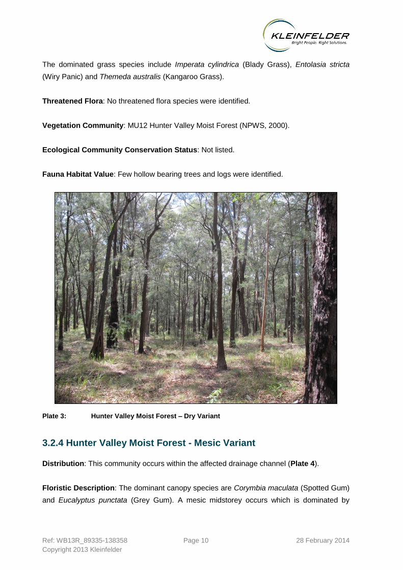
Ref: WB13R_89335-138358 Page 10 28 February 2014
Copyright 2013 Kleinfelder
The dominated grass species include Imperata cylindrica (Blady Grass), Entolasia stricta
(Wiry Panic) and Themeda australis (Kangaroo Grass).
Threatened Flora: No threatened flora species were identified.
Vegetation Community: MU12 Hunter Valley Moist Forest (NPWS, 2000).
Ecological Community Conservation Status: Not listed.
Fauna Habitat Value: Few hollow bearing trees and logs were identified.
Plate 3: Hunter Valley Moist Forest – Dry Variant
3.2.4 Hunter Valley Moist Forest - Mesic Variant
Distribution: This community occurs within the affected drainage channel (Plate 4).
Floristic Description: The dominant canopy species are Corymbia maculata (Spotted Gum)
and Eucalyptus punctata (Grey Gum). A mesic midstorey occurs which is dominated by
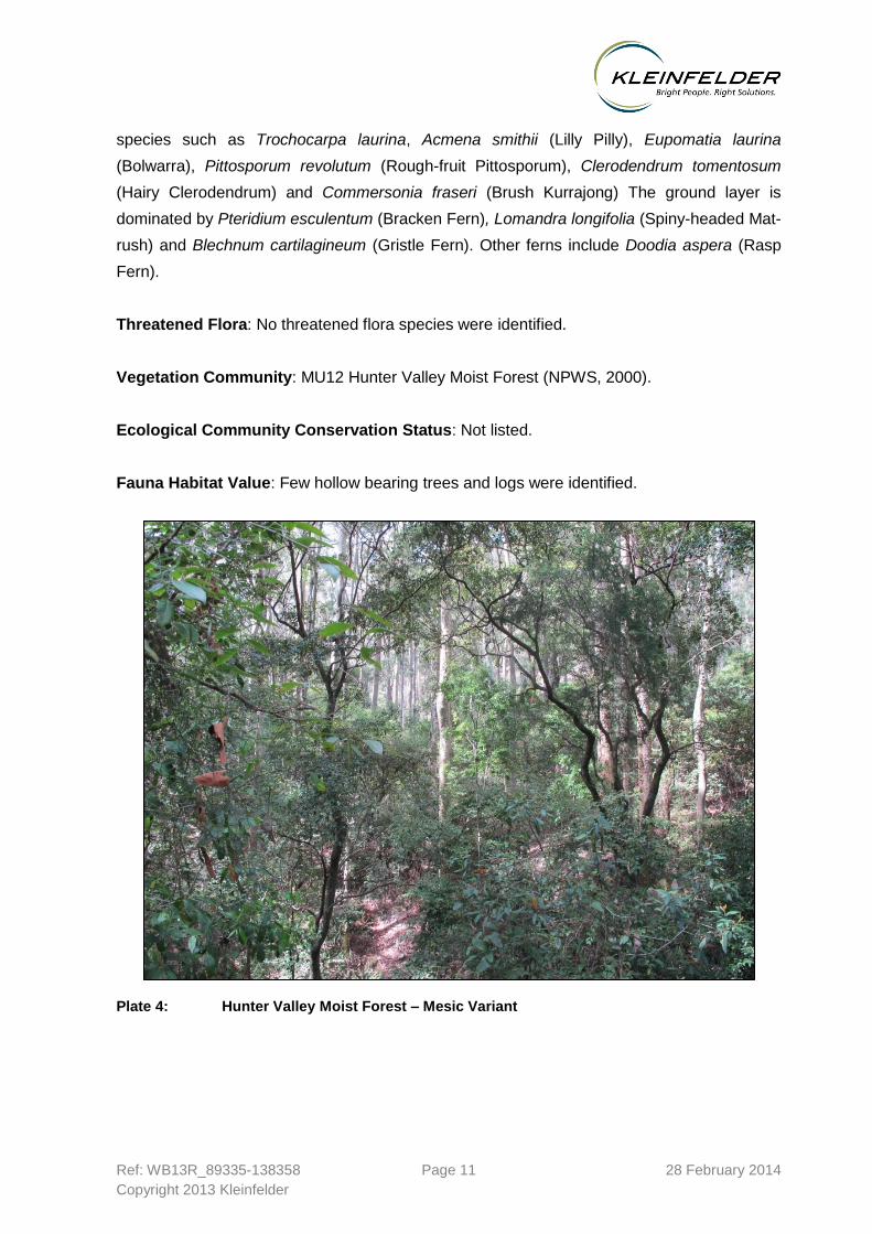
Ref: WB13R_89335-138358 Page 11 28 February 2014
Copyright 2013 Kleinfelder
11
species such as Trochocarpa laurina, Acmena smithii (Lilly Pilly), Eupomatia laurina
(Bolwarra), Pittosporum revolutum (Rough-fruit Pittosporum), Clerodendrum tomentosum
(Hairy Clerodendrum) and Commersonia fraseri (Brush Kurrajong) The ground layer is
dominated by Pteridium esculentum (Bracken Fern), Lomandra longifolia (Spiny-headed Mat-
rush) and Blechnum cartilagineum (Gristle Fern). Other ferns include Doodia aspera (Rasp
Fern).
Threatened Flora: No threatened flora species were identified.
Vegetation Community: MU12 Hunter Valley Moist Forest (NPWS, 2000).
Ecological Community Conservation Status: Not listed.
Fauna Habitat Value: Few hollow bearing trees and logs were identified.
Plate 4: Hunter Valley Moist Forest – Mesic Variant

Ref: WB13R_89335-138358 Page 12 28 February 2014
Copyright 2013 Kleinfelder
3.3 AQUATIC HABITAT
As part of the assessment, a survey of approximately 2 km downstream within the drainage
channel below the affected area was undertaken to identify any permanent water bodies that
may be present. There were no permanent water bodies identified during the survey. Three
locations within the affected drainage channel (Figure 4) were noticed to be holding small
pools of water and the habitat characteristics at each location were very similar and
consisted of pooling water within the rock lines channel (Plates 5, 6 & 7).
Detrital accumulations within each habitat were dense and consisted mainly of leaves and
woody debris from falling vegetation. The water was stained brown due to detrital
accumulation (i.e. tannins from native flora). An anoxic odour was evident, which is an
indicator of decomposing vegetation. Fauna habitat includes the associated vegetation
(riparian areas), woody debris around the edges of the water, the water column and the
benthic environment. No aquatic flora (macrophytes) was identified.
Plate 5: Minor Pooling Location 1

Ref: WB13R_89335-138358 Page 13 28 February 2014
Copyright 2013 Kleinfelder
13
Plate 6: Minor Pooling Location 2
Plate 7: Minor Pooling Location 3

&%
!?
!?
GF
GF
GF
!?
110
150
140 120
130
100
160170
180190
200
210
220
90
230
80
70
240
250
Locations of Habitat and Threatened FloraGlencore Xstrata
Vegetation Pre-clearance Survey – Land Remediation within Sugarloaf State Conservation Area – Phase 2
413/12/2013 11:43
138358
cevans
L:\GIS FOLDER\00 CLIENT FILES\89335_OceanicCoal_Xstrata\138358_GroutSpillImpactAssessment\Mapping\138358_Fig4_Habitat_ThreatendFlora.mxd
FIGURE:PROJECT REFERENCE:
DATE DRAWN:
DRAWN BY:
DATA SOURCE:
www.kleinfelder.com
LPI - 2009
LegendGrout SpillMajor RoadsLocal Roads
!? Aquatic Habitats&% Dead StagGF Tetratheca juncea
0 20 40 60 80 10010Metres ´
The information included on this graphic representation has been compiled from a variety of sources and is subject to change without notice. Kleinfelder makes no representations or warranties, express or implied, as to accuracy, completeness, timeliness, or rights to the use of such information. This document is not intended for use as a land survey product nor is it designed or intended as a construction design document. The use or misuse of the information contained on this graphic representation is at the sole risk of the party using or misusing the information.
Version 1

Ref: WB13R_89335-138358 Page 15 28 February 2014
Copyright 2013 Kleinfelder
15
4. SUMMARY OF ECOLOGICAL IMPACTS
4.1.1 Direct Impacts: Vegetation Clearing
Vegetation clearing is to be restricted to the removal of limbs of trees and midstorey species
to create heli-lift locations by which grout filled bags can be removed.
4.1.2 Threatened Flora
Tetratheca juncea (Black Eyed Susan) was identified approximately 150 m from the drainage
channel.
4.1.3 Endangered Ecological Communities
No endangered ecological communities were identified during the assessment.

Ref: WB13R_89335-138358 Page 16 28 February 2014
Copyright 2013 Kleinfelder
5. RECOMMENDATIONS
The following recommendations are provided to minimise potential impacts to native
vegetation and fauna habitat associated with the proposal to remove the grout from the
affected channel:
All vehicles and equipment should be clean before entering the site to prevent the
spread of soil, weed species or plant diseases;
A vegetation monitoring program should be implemented to monitor the effectiveness of
the remediation works within the affectation area in consultation with OEH.

Ref: WB13R_89335-138358 Page 17 28 February 2014
Copyright 2013 Kleinfelder
17
6. REFERENCES
Harden, G.J. (ed) (1992). Flora of New South Wales Volume 3. NSW University Press:
Sydney.
Harden, G.J. (ed) (1993). Flora of New South Wales Volume 4. NSW University Press:
Sydney.
Harden, G.J. (ed) (2000). Flora of New South Wales Volume 1. NSW University Press:
Sydney.
Harden, G.J .(ed) (2002). Flora of New South Wales Volume 2. NSW University Press:
Sydney.
NPWS (2000). Vegetation Survey, Classification and Mapping Lower Hunter and Central
Coast Region. Version 1.2. A project undertaken for The Lower Hunter and Central Coast
Regional Environment Management Strategy CRA Unit Sydney Zone, National Parks and
Wildlife Service.
Office of Environment and Heritage (2007). Mitchell Landscapes with per cent cleared
estimates, listed by CMA, Updated November 2007, OEH Website:
http://www.environment.nsw.gov.au/projects/biometrictool.htm.
Thackway, R. and Cresswell, I.D. (1995). An interim biogeographic regionalisation for
Australia: a framework for setting priorities in the National Reserves System Cooperative
Program, Version 4.0. Australian Nature Conservation Agency, Canberra.

Ref: WB13R_89335-138358 Page 18 28 February 2014
Copyright 2013 Kleinfelder
7. STAFF CONTRIBUTIONS
Name Qualification Title/Experience Contribution
Gilbert Whyte PhD Senior Ecologist Flora and fauna survey and report
writing
Chelayne Evens BSC (Geog) Dip. SIS Ecologist/ Workflow
Manager Report Review
Samara Schulz BEnvSc & Mgt (Hons) Ecologist Report Review

Ref: WB13R_89335-138358 Page 19 28 February 2014
Copyright 2013 Kleinfelder
19
8. LICENSING
Kleinfelder employees involved in the current study are licensed or approved under the
National Parks and Wildlife Act 1974 (License Number: SL100730, Expiry: 31st March 2014)
and the Animal Research Act 1985 to harm/trap/release protected native fauna and to pick
for identification purposes native flora and to undertake fauna surveys.

West Wallsend Colliery
Sustainable Development Plan
WWC SD PLN 0108
Grout Remediation Plan - Site 2
Status: Approved
Version: 1.0
Effective: 10/03/2014
Review: 10/03/2017
Page 48 of 48
THIS DOCUMENT IS UNCONTROLLED UNLESS VIEWED ON THE INTRANET
8. CONTROL AND REVISION HISTORY
8.1 Document information
Property Value
Approved by Environment & Community Manager
Document Owner OCAL Grout Remediation Project Supervisor
Effective Date 10/03/2014
Keywords Remediation, grout, subsidence
For a complete list of document properties, select View Properties from the document’s context menu on
the intranet.
8.2 Revisions
Version Date reviewed
Review team
(consultation) Nature of the amendment
1 10/03/2014 W Covey Initial published version
2
3