GROUND WATER BROCHUREcgwb.gov.in/District_Profile/Telangana/Ranga Reddy.pdf · GROUND WATER...
16
For Official Use Only CENTRAL GROUND WATER BOARD MINISTRY OF WATER RESOURCES GOVERNMENT OF INDIA GROUND WATER BROCHURE RANGA REDDY DISTRICT, ANDHRA PRADESH SOUTHERN REGION HYDERABAD September 2013
Transcript of GROUND WATER BROCHUREcgwb.gov.in/District_Profile/Telangana/Ranga Reddy.pdf · GROUND WATER...
For Official Use Only
CENTRAL GROUND WATER BOARD MINISTRY OF WATER RESOURCES
GOVERNMENT OF INDIA
GROUND WATER BROCHURE RANGA REDDY DISTRICT, ANDHRA PRADESH
SOUTHERN REGION HYDERABAD
September 2013

CENTRAL GROUND WATER BOARD MINISTRY OF WATER RESOURCES
GOVERNMENT OF INDIA
GROUND WATER BROCHURE RANGA REDDY DISTRICT, ANDHRA PRADESH
(AAP-2012-13)
BY
T. BHARATH BHUSHAN SCIENTIST-B
SOUTHERN REGION BHUJAL BHAWAN,
GSI Post, Bandlaguda NH.IV, FARIDABAD -121001
Hyderabad-500068 HARYANA, INDIA
Andhra Pradesh Tel: 0129-2418518
Tel: 040-24225201 Gram: Bhumijal
Gram: Antarjal

GROUND WATER BROCHURE RANGA REDDY DISTRICT, ANDHRA PRADESH
CONTENTS
District at a glance 1. Introduction 2. Rainfall and climate 3. Geomorphology 4. Drainage 5 Irrigation 6. Geology 7. Hydrogeology 8. Ground water resources 9. Ground water quality 10 Ground water development 11. Ground water related issues and problems 12. Conclusions List of tables 1. Rainfall distribution in RR district. 2. Depth range and yields in granites and basalts. 3. Range of chemical constituents in drilled wells. . List of figures 1. Administrative map of Ranga Reddy district. 2a. Monthly rainfall distribution and LPA, Ranga Reddy district. 2b. Annual rainfall and RF departure from LPA, Ranga Reddy district. 3. Hydrogeological map, Ranga Reddy district. 4. Premonsoon DTW level map, Ranga Reddy district 5. Post monsoon DTW level map, Ranga Reddy district. 6. Water level fluctuation map, Ranga Reddy district. 7. EC distribution in groundwater, Ranga Reddy district

DISTRICT AT A GLANCE 1. General Location North Latitude:16° 54’ - 17°48’
East Longitude:77° 21’ - 78°51’ Geographical area (sq.km) 7493 Headquarters Hyderabad No. of revenue mandals 37 No. of revenue villages 870 Total Population (2011) 52,96,396 Decadal Growth Rate %(2001-10) 48.15 Population density (persons/sq.km) 707 Urban Population % 70 Rural Population % 30 Major rivers Musi, Musa, Kagna, Manjeera Soils Red soils, Medium Black soils, Mixed soils
Agro climatic zone Southern Telangana zone 2. Rainfall Normal annual rainfall 833 mm Annual rainfall (2012) 988 mm Cumulative departure from LPA -64 % 3. Land use (2012) (Area in ha) Forest 73,075 Barren and uncultivated 27,084 Cultivable waste 18,910 Current fallows 1,49,181 Net area sown 234557
4. Irrigation (2012) (Area in ha) Canals 765 Tanks 2208 Dug wells 4325 Bore/Tube wells 68,499 Other Sources 1188 Net area irrigated(more than once) 76,985 Gross area irrigated 98,730 Major irrigation projects None Medium irrigation projects Three Minor Irrigation Sources 263(PWD) ; 1882 (PR Dept) 5. Geology Granites, Gneisses, Limestones, Shales,
Deccan Trap, Laterite Major aquifers - Weathered and fractured granites, basalts
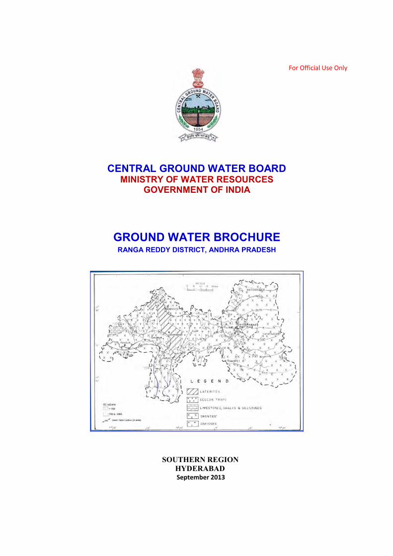
6. Ground water monitoring No. of Dugwells 24 No. of Piezometers 60 Depth to water level ( Pre-monsoon-2012) Min-max 1.40 – 33.50 m bgl Depth to water level ( Postmonsoon-2012) Min-max 0.20 – 28.32 m bgl Water Level Fluctuation (Pre – Post) 0.18 – 20.27 m (Rise) 7. Ground water resources
Net ground water availability 62199 ham Gross annual draft 46136 ham Balance resource 17195 ham Stage of ground water development 74 % 8. Chemical quality
E C (micro Siemens/cm at 25C) 550-1790
Chloride (mg/l) 16-314 Fluoride (mg/l) 0.25-3.60 Nitrate (mg/l) 3-220
GROUND WATER BROCHURE RANGA REDDY DISTRICT, ANDHRA PRADESH
1. INTRODUCTION
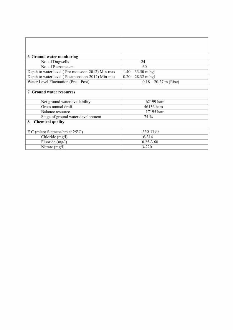
Ranga Reddy district is located in the western part of Andhra Pradesh with its headquarters located at Hyderabad. The district lies between North latitudes 16° 54’- 17°48’ and between East longitudes 77° 21’- 78°51’. The district is divided into three revenue divisions, 37 mandals and 870 revenue villages. The district is bounded in the north by Medak district, in the east by Nalgonda district, in the south by Mahabubnagar district and on the west by Karnataka state (Fig.1). The geographical area of the district is 7493 sq.km with a population (2011) of 52, 96,396 lakhs. The population density which was 54 persons per sq.km during 1901 has risen to 707 persons per sq.km. Out of the total geographical area of 7, 49,300 ha, 73,075 ha of land is covered by forests. Similarly, barren and uncultivable land is 27,084 ha and land put to non-agricultural use is 1, 49,181 ha. The total net area sown is 2, 34,557 ha. The Administrative map of Ranga Reddy district is presented in the Fig.1. Paddy, groundnut, jowar, and maize are some of the important crops.
Fig.1 Administrative map of Ranga Reddy district.
2. RAINFALL AND CLIMATE
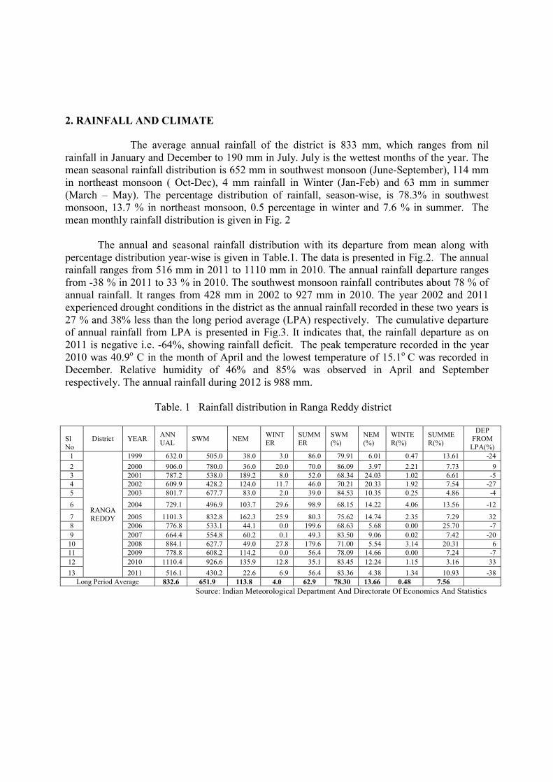
The average annual rainfall of the district is 833 mm, which ranges from nil rainfall in January and December to 190 mm in July. July is the wettest months of the year. The mean seasonal rainfall distribution is 652 mm in southwest monsoon (June-September), 114 mm in northeast monsoon ( Oct-Dec), 4 mm rainfall in Winter (Jan-Feb) and 63 mm in summer (March – May). The percentage distribution of rainfall, season-wise, is 78.3% in southwest monsoon, 13.7 % in northeast monsoon, 0.5 percentage in winter and 7.6 % in summer. The mean monthly rainfall distribution is given in Fig. 2 The annual and seasonal rainfall distribution with its departure from mean along with percentage distribution year-wise is given in Table.1. The data is presented in Fig.2. The annual rainfall ranges from 516 mm in 2011 to 1110 mm in 2010. The annual rainfall departure ranges from -38 % in 2011 to 33 % in 2010. The southwest monsoon rainfall contributes about 78 % of annual rainfall. It ranges from 428 mm in 2002 to 927 mm in 2010. The year 2002 and 2011 experienced drought conditions in the district as the annual rainfall recorded in these two years is 27 % and 38% less than the long period average (LPA) respectively. The cumulative departure of annual rainfall from LPA is presented in Fig.3. It indicates that, the rainfall departure as on 2011 is negative i.e. -64%, showing rainfall deficit. The peak temperature recorded in the year 2010 was 40.9o C in the month of April and the lowest temperature of 15.1o C was recorded in December. Relative humidity of 46% and 85% was observed in April and September respectively. The annual rainfall during 2012 is 988 mm. Table. 1 Rainfall distribution in Ranga Reddy district
Sl No
District YEAR ANN UAL
SWM NEM WINTER
SUMMER
SWM (%)
NEM (%)
WINTER(%)
SUMMER(%)
DEP FROM
LPA(%) 1
RANGA REDDY
1999 632.0 505.0 38.0 3.0 86.0 79.91 6.01 0.47 13.61 -24
2 2000 906.0 780.0 36.0 20.0 70.0 86.09 3.97 2.21 7.73 9 3 2001 787.2 538.0 189.2 8.0 52.0 68.34 24.03 1.02 6.61 -5 4 2002 609.9 428.2 124.0 11.7 46.0 70.21 20.33 1.92 7.54 -27 5 2003 801.7 677.7 83.0 2.0 39.0 84.53 10.35 0.25 4.86 -4
6 2004 729.1 496.9 103.7 29.6 98.9 68.15 14.22 4.06 13.56 -12
7 2005 1101.3 832.8 162.3 25.9 80.3 75.62 14.74 2.35 7.29 32 8 2006 776.8 533.1 44.1 0.0 199.6 68.63 5.68 0.00 25.70 -7
9 2007 664.4 554.8 60.2 0.1 49.3 83.50 9.06 0.02 7.42 -20 10 2008 884.1 627.7 49.0 27.8 179.6 71.00 5.54 3.14 20.31 6 11 2009 778.8 608.2 114.2 0.0 56.4 78.09 14.66 0.00 7.24 -7
12 2010 1110.4 926.6 135.9 12.8 35.1 83.45 12.24 1.15 3.16 33
13 2011 516.1 430.2 22.6 6.9 56.4 83.36 4.38 1.34 10.93 -38 Long Period Average 832.6 651.9 113.8 4.0 62.9 78.30 13.66 0.48 7.56
Source: Indian Meteorological Department And Directorate Of Economics And Statistics

Fig. 2 Monthly rainfall distribution and LPA, Ranga Reddy district
Fig. 3 Annual rainfall and RF departure from LPA, Ranga Reddy district 3. GEOMORPHOLOGY The present day landforms in the district are the products of different geomorphic processes such as erosion, deposition, crustal movements coupled with climatic changes operating on the surface. The specific geomorphic groups are (i) Residual hills (ii) Plateau (Deccan traps) (iii) Pediment Inselberg complex (iv) Pediplain and (v) Flood plain. i) Residual Hills: These geomorphic forms occur as massive hills comprising of forest areas in Kulakacherla, Manchal and in Yacharam mandals with a maximum elevation of 691 m amsl. The residual hills occurring around Ghatkesar, Shamirpet and Rajendernagar mandals , the soil cover is thin and devoid of vegetation except with low trees, thorny bushes and shrubs. Other forms in the area include Mesa/Butt, having flat topped hills comprising of laterite and basalts. ii) Plateau (Deccan traps): This geomorphic unit is characterized by elevated uplands with steep slope and dissected by deep and narrow valleys occupied by different flows.

iii) Pediment Inselberg Complex: Pediment inselberg complex is a gently undulating plain abounding with a number of small hills, mounds, tors etc. iv) Pediplain: Pediplains are characterized by flat or gentle sloping surface which is the end product of coalescence of several pediments at the foot of hill slopes. Pediplains are characterized by the vast area of low lying flat terrain with gentle slopes covered by red brown and black clayey soils ranging in thickness from 20 cm to 60 cm. v) Flood plain: Alluvial deposits occur along major river courses mostly derived from catchments, transported and deposited. 4.0 DRAINAGE The district is drained by the river Musi. The reservoirs Osmansagar and Himayatsagar are constructed across rivers Musi and Musa respectively. These reservoirs supply drinking water to Hyderabad and Secunderabad cities. Kagna river originates in Vikarabad mandal and drains Vikarabad and Tandur areas. All the streams are ephemeral in nature. Dendritic pattern of drainage is seen in Kagna catchment area where granitic rocks are exposed. Trellis type of drainage is observed in Musi catchment area. The drainage density varies from 0.4 to 4.0 km/sq.km. 5.0 IRRIGATION The chief sources of irrigation in the district are tanks, wells and canals. The major irrigation projects are nil and three medium irrigation projects have been completed (Kotepally vagu, Jutepally and Lakhapur projects) creating registered Ayacut of 13927 acres, while 11797 acres has been utilized.
6.0 GEOLOGY
The district is underlain by various geological formations like Archaean granites and gneisses, Proterozoic Bhima series and the younger Deccan traps. The Archaean crystalline rocks occupy nearly three fourths of the district comprising older metamorphic rocks, peninsular gneissic complex (migmatites) and younger intrusive rocks. Intrusive of dolerite dyke are common in the area. The upper pretoerozoic sediments of Bhima group comprising of limestones and shales occur in the western most corner of the district, NW of Kotepally. The shale beds show intercalations of limestone. The basaltic flows of the Deccan Traps cover either the Bhima sediments or the granitoids around Vikarabad, Tandur and Parigi. The thickness of each flow varies from 15 to 20 m. Intra-trappean beds are thin and comprise conglomerates, chert and sandstone. The thickness of infra-trappeans varies from 0.5 to 8 m and these are fossiliferous. A series of WNW – ESE trending faults are seen in the southeastern part of the area.

7.0 HYDROGEOLOGY The map depicting hydrogeological conditions in the district is presented in Fig.3. Depth and yield ranges of wells constructed by CGWB in basalts and granitic formations are furnished in the Table-2.
Fig.3 : Hydrogeology of Ranga Reddy district, A.P
Table-2 Depth range and yield ranges in basalts and granitic terrain
7.1 Depth to water level
Ground water levels are monitored from a network of 84 observation wells, four times in a year spread all over the district. The depth to water levels observed during pre-monsoon (2011) season are between 1.4-33.50m. Deeper water levels of >10 m bgl are recorded in the Central, North Eastern and South Eastern parts of the area. The depth to water levels observed during post-monsoon (2012) are between 0.20-28.32. The depth to Water level during the pre and post monsoon period (2012) is shown in the Figs.4 &5. The water level fluctuation between the pre and post monsoon are shown in the Fig.6.
Depth Range (m)
No. of EW Yield Range(lps)
Basalts Granites Basalts Granites
20 – 30 0 1
30 – 40 1 20 1 – 3 8 18
40 – 50 2 15 3 – 5 1 2
50 – 60 4 4 >5 4 2
60 – 70 6 2
70 – 100 14 2
100 – 150 5 1
150 - 200 2 0

Fig.4
Fig.5

Fig.6
8. GROUND WATER RESOURCES
Based on the Ground Water Estimation Committee (GEC 97) norms, ground water assessment was done in 2008-09. The mandal-wise categorization of Ranga Reddy district is presented in the Table-3 The total ground water resources available in the district are 62,199 Ham. The ground water annual draft is 46,136 Ham and the balance ground water resource available for irrigation being 17195 Ham. The overall stage of ground water development in the district is 74%, and falls under safe category. Based on the ground water resource estimation, 1 mandal has been classified as Over-Exploited (OE), 4 mandals as Semi Critical and rest of mandals as Safe. The Mandal wise categorization in respect of ground water development is presented in the Fig.7
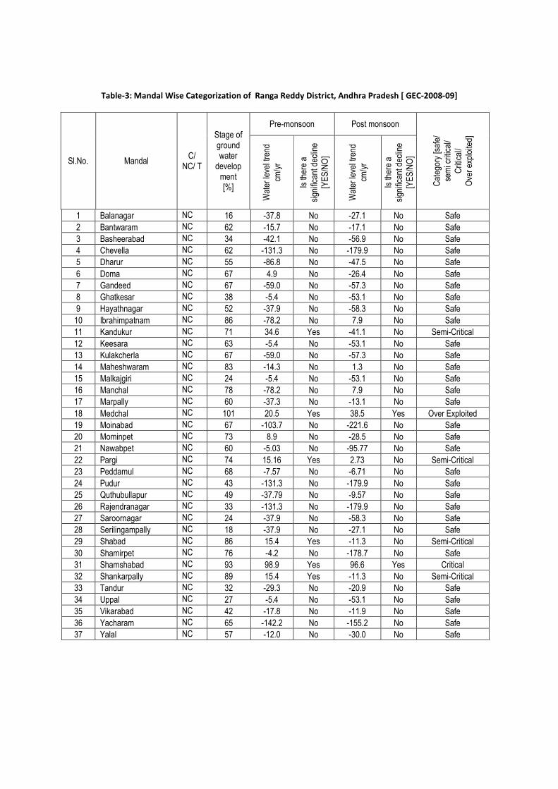
Table-3: Mandal Wise Categorization of Ranga Reddy District, Andhra Pradesh [ GEC-2008-09]
Sl.No. Mandal C/
NC/ T
Stage of ground water
develop ment [%]
Pre-monsoon Post monsoon
Cat
egor
y [s
afe/
se
mi c
ritic
al/
Crit
ical
/ O
ver
expl
oite
d]
Wat
er le
vel t
rend
cm
/yr
I s th
ere
a si
gnifi
cant
dec
line
[YE
S/N
O]
Wat
er le
vel t
rend
cm
/yr
I s th
ere
a si
gnifi
cant
dec
line
[YE
S/N
O]
1 Balanagar NC 16 -37.8 No -27.1 No Safe
2 Bantwaram NC 62 -15.7 No -17.1 No Safe
3 Basheerabad NC 34 -42.1 No -56.9 No Safe
4 Chevella NC 62 -131.3 No -179.9 No Safe
5 Dharur NC 55 -86.8 No -47.5 No Safe
6 Doma NC 67 4.9 No -26.4 No Safe
7 Gandeed NC 67 -59.0 No -57.3 No Safe
8 Ghatkesar NC 38 -5.4 No -53.1 No Safe
9 Hayathnagar NC 52 -37.9 No -58.3 No Safe
10 Ibrahimpatnam NC 86 -78.2 No 7.9 No Safe
11 Kandukur NC 71 34.6 Yes -41.1 No Semi-Critical
12 Keesara NC 63 -5.4 No -53.1 No Safe
13 Kulakcherla NC 67 -59.0 No -57.3 No Safe
14 Maheshwaram NC 83 -14.3 No 1.3 No Safe
15 Malkajgiri NC 24 -5.4 No -53.1 No Safe
16 Manchal NC 78 -78.2 No 7.9 No Safe
17 Marpally NC 60 -37.3 No -13.1 No Safe
18 Medchal NC 101 20.5 Yes 38.5 Yes Over Exploited
19 Moinabad NC 67 -103.7 No -221.6 No Safe
20 Mominpet NC 73 8.9 No -28.5 No Safe
21 Nawabpet NC 60 -5.03 No -95.77 No Safe
22 Pargi NC 74 15.16 Yes 2.73 No Semi-Critical
23 Peddamul NC 68 -7.57 No -6.71 No Safe
24 Pudur NC 43 -131.3 No -179.9 No Safe
25 Quthubullapur NC 49 -37.79 No -9.57 No Safe
26 Rajendranagar NC 33 -131.3 No -179.9 No Safe
27 Saroornagar NC 24 -37.9 No -58.3 No Safe
28 Serilingampally NC 18 -37.9 No -27.1 No Safe
29 Shabad NC 86 15.4 Yes -11.3 No Semi-Critical
30 Shamirpet NC 76 -4.2 No -178.7 No Safe
31 Shamshabad NC 93 98.9 Yes 96.6 Yes Critical
32 Shankarpally NC 89 15.4 Yes -11.3 No Semi-Critical
33 Tandur NC 32 -29.3 No -20.9 No Safe
34 Uppal NC 27 -5.4 No -53.1 No Safe
35 Vikarabad NC 42 -17.8 No -11.9 No Safe
36 Yacharam NC 65 -142.2 No -155.2 No Safe
37 Yalal NC 57 -12.0 No -30.0 No Safe

Fig. 7: Mandal- wise categorization in respect of ground water development
9. GROUND WATER QUALITY
The ground water in the district is in general suitable for both domestic and irrigation purposes. The Electrical Conductivity ranges from 550 to 1790 micro Siemens/cm at 25°C. Distribution of EC is shown in shown in Fig.8. Fluoride concentration in some areas of the district is more than permissible limit and ranges from 0.25-3.6 mg/l. Range of Chemical Constituents in Ground water (Pre-monsoon, 2012) of Ranga Reddy district in given in Table-4.
Table. 4. Range of Chemical Constituents in Ground water of Ranga Reddy District
Chemical Constituents Basalts Granites Piezometer wells
Min. Max. Min. Max. Min. Max.
pH 7.1 7.8 7.1 8.9 6.93 8.7
EC (µS/cm at 25°C) 483 1220 311 4000 445 7220
Total hardness as Ca CO3 (mg/l) 206 807 213 1760 85 3180
Ca (mg/l) 8 84 8 265 24 680
Mg (mg/l) 1.0 49 2 208 6.1 360
Na (mg/l) 12 236 2 382 12 552
K (mg/l) Nil 40 Nil 15 Trace 19
CO3(mg/l) -- -- -- -- Nil 6
HCO3 (mg/l) 79 668 67 586 116 664
Cl (mg/l) 11 245 11 915 18 1844
SO4 (mg/l) 2 46 1 576 Nil 624
NO3 (mg/l) 1 48 1 248 2 576
F (mg/l) 0.2 2.7 0.32 2.6 0.27 5.68

Fig.8 Distribution of Electrical Conductivity in Ground Water – Ranga Reddy District
(Pre monsoon 2012)
10. 0 GROUND WATER DEVELOPMENT The district is mainly dependent on ground water for its irrigation and domestic needs. Ground water development is through deep bore wells in the non-command areas and through dug wells and shallow bores in other areas. The wells yield low during summer months. 11.0 GROUND WATER RELATED ISSUES AND PROBLEMS Ground water pollution in Ranga Reddy district is mainly by industrial and human activities. 12.0 CONCLUSIONS
1. It is seen from the exploration data that most of the potential zones were encountered within the depth range of 70-150 m and beyond this depth, potential fractures through occur, but rare.
2. Conjunctive use practices have to be adopted in the command area by utilizing both
surface and ground water resources. Ground water potential zones in the command area are to be identified and developed. Ground water development through bore wells can be restricted to 70-120 m
3. Large-scale artificial recharge structures need to be constructed in the non-command
areas and over-exploited mandals and corpus fund has to be created to maintain those structures.

4. Exploring the possibilities of diversion of surface water through canals/pipes for filling up of existing dried up tanks in over-exploited mandals.
5. Rainwater harvesting structures like contour bunding, check dams, percolation tanks,
farm ponds are already in vogue. The construction of the artificial recharge structures should be taken up on the watershed basis and designed for 50 % of non-committed run-off so as to not to deprive the downstream watersheds.
6. It is important to take up artificial recharge structures based on topography, soil,
slope, surface run-off of available and hydrogeological conditions rather than target oriented in achieving the numbers. A technical team consisting of Scientists, Engineers, and Bureaucrats should monitor the structures on regular basis.
7. In safe mandals, the artificial recharge to ground water should go hand-in-hand with
ground water development further development of ground water should be restricted upto a depth of 100 m to avoid failures of bore wells.
8. Further ground water development through bore wells has to be avoided by strictly
implementing APWALTA Act in the villages that are categorized as OE villages. However, ground water development in villages / mandals falling in safe to semi-critical/critical category can be developed on scientific lines. Roof Top harvesting both in urban and rural areas should be made mandatory to enhance the ground water resources.