Green Heron - Audubon Washingtonwa.audubon.org/sites/g/files/amh546/f/puget_booklet_8_7_2012.pdf ·...
13
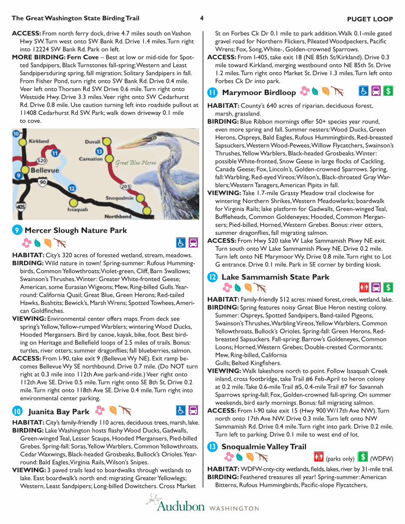
Sites Page INFO KEY 1 1 Discovery Park 2 2 Union Bay Natural Area (Montlake Fill) 3 Magnuson Park 4 Seward Park Environmental & Audubon Center 5 Alki Beach 3 6 Quartermaster Harbor 7 Tramp Harbor 8 Fisher Pond Preserve 9 Mercer Slough Nature 4 Park 10 Juanita Bay Park 11 Marymoor Birdloop 12 Lake Sammamish State Park 13 Snoqualmie Valley Trail 14 Cedar River Trail Park 5 15 Green River Natural Area (Kent Ponds) 16 Soos Creek Park 17 Flaming Geyser State 6 Park 18 Mt. Rainier National Park - Sunrise 19 Foothills Trail 20 Dash Point State Park 21 West Hylebos Wetlands Park INDEX Sites Page © Ed Newbold PUGET LOOP Balg Eagles 22 Commencement Bay 7 23 Point Defiance Park 24 Tacoma Nature Center 25 Fort Steilacoom Park 26 Penrose Point State Park 27 Sinclair Inlet 8 28 Lions Park 29 Old Mill Park-Clear Creek Trail 30 Liberty Bay 31 Fort Ward Park 9 32 Point No Point 33 Possession Point State Park 34 South Whidbey State Park 35 Crockett Lake 10 and More 36 Penn Cove 37 Fort Ebey State Park 38 Swan Lake and More 39 Deception Pass State Park 40 San Juan Island 11 41 Lopez Island 42 Orcas Island CREDITS 12
Transcript of Green Heron - Audubon Washingtonwa.audubon.org/sites/g/files/amh546/f/puget_booklet_8_7_2012.pdf ·...

Sites Page
INFO KEY 1
1 Discovery Park 22 Union Bay Natural Area
(Montlake Fill)
3 Magnuson Park
4 Seward Park Environmental & Audubon Center
5 Alki Beach 36 Quartermaster Harbor
7 Tramp Harbor
8 Fisher Pond Preserve
9 Mercer Slough Nature 4 Park
10 Juanita Bay Park11 Marymoor Birdloop12 Lake Sammamish State Park 13 Snoqualmie Valley Trail14 Cedar River Trail Park 515 Green River Natural Area
(Kent Ponds)16 Soos Creek Park17 Flaming Geyser State 6
Park18 Mt. Rainier National Park
- Sunrise 19 Foothills Trail20 Dash Point State Park21 West Hylebos Wetlands
Park
INDEX
Sites Page
©EdNewbold
PUGETLOOP
Balg Eagles
22 Commencement Bay 723 Point Defiance Park 24 Tacoma Nature Center25 Fort Steilacoom Park26 Penrose Point State Park27 Sinclair Inlet 828 Lions Park29 Old Mill Park-Clear Creek
Trail30 Liberty Bay
31 Fort Ward Park 9
32 Point No Point
33 Possession Point State Park
34 South Whidbey State Park
35 Crockett Lake 10and More
36 Penn Cove
37 Fort Ebey State Park
38 Swan Lake and More 39 Deception Pass State Park40 San Juan Island 1141 Lopez Island42 Orcas Island
CREDITS 12

1TheGreatWashingtonStateBirdingTrail PUGETLOOP
LOcaLSErvIcESaNDHIGHLIGHTSWashington visitor information: www.experiencewashington.com Vaux’s Swift September migration, Monroe, WA:
www.pilchuckaudubon.org Cascadia Marine Trail: www.wwta.org/trails/CMT/index.asp Sites 1-5; 9-17, 20: Seattle’s Convention & Visitor’s Bureau
866-732-2695 www.visitseattle.org; www.kingcounty.gov Sites 6-8: Vashon Maury Chamber of Commerce
206-463-6217 www.vashonchamber.comSite 18, 19, 22-26: Tacoma Regional Convention & Visitor Bureau
800-272-2662 www.traveltacoma.com Sites 27-32: Kitsap Peninsula Visitor & Convention Bureau
800-337-0580 www.visitkitsap.comSites 33-39: Whidbey and Camano Islands Tourism
www.whidbeycamanoislands.com Sites 40-42: San Juan Islands Visitors Bureau
888-468-3701 www.visitsanjuans.com
INFOKEYMaPIcONS
Bestseasonsforbirding (spring, summer, fall, winter)
Developedcamping available, including restrooms; fee required restroom available at day-use site aDa restroom, and trail or viewing access Site located in an ImportantBirdarea Feerequired. Passes best obtained prior to travel.
Washington Dept. of Fish and Wildlife (WDFW) and state parks require Discover Pass 866-320-9933, www.discoverpass.wa.gov; USFS, USFWS and national monuments & parks 888-275-8747, www.nps.gov/passes
Publicbusorferry. King County: http://metro.kingcounty.gov. Pierce County: www.piercetransit.org. Kitsap County: www.kitsaptransit.org. Whidbey Island : www.islandtransit.org. Washington State Ferries: www.wsdot.wa.gov/ferries.

2TheGreatWashingtonStateBirdingTrail PUGETLOOP
1DiscoveryPark HaBITaT:City’s 534 acres: forest, thickets, meadows, 3-mile shore-
line.BIrDING:Rich variety of habitats = rich variety of species: Pileated
Woodpeckers, Pacific Wrens, Savannah Sparrows. Fall-spring: Red-breasted Mergansers; Red-throated, Common Loons; Western Grebes; Varied Thrushes. Spring-summer: Rufous Hummingbirds, Western Tanagers. Winter: Golden-, Ruby-crowned Kinglets; Fox, Lincoln, Golden-crowned Sparrows; Dark-eyed Juncos. Year-round: Cooper’s Hawks; Barn, Barred, Northern Saw-whet Owls; Anna’s Hummingbirds, Bushtits, Spotted Towhees, Song Sparrows.
vIEWING:visitor-EnvironmentalLearningcenter has maps, interpretive exhibits. SouthParking – Walk west on Loop Trail for meadows, forest edge, thickets. At 0.8 mile, veer left for 0.5-mile South Beach Trail to saltwater; or continue 3-mile circle. WolfTreeNatureTrail – Take 0.3-mile deep forest loop for spring-summer warblers: Orange-crowned, Yellow, Black-throated Gray, Townsend’s, Wilson’s; plus Pacific-slope Flycatchers, Swainson’s Thrushes, Black-headed Grosbeaks. Bonus: Daybreak Star Indian Cultural Center.
accESS:From I-5, take exit 169 (NE 45th St/NE 50th St). Turn west onto NE 45th. Drive 0.9 mile. Turn left onto Stone Way N. Drive 0.9 mile. Turn right onto NE 34th St. Drive 0.3 mile. Turn left onto Fremont Ave N. Drive 0.2 mile. Turn right onto Nickerson St/W Nickerson. Drive 1.3 miles. Stay left to Ballard Bridge/W Emerson. Drive 0.2 mile. Turn left to stay on W Nickerson. Drive 0.2 mile. Turn left onto W Emerson (Port of Seattle/Fisherman’s Terminal). Drive 0.5 mile. Turn right onto Gilman Ave W/Discovery Park Blvd. Drive 1.1 mile to parkvisitorcenter.SouthParking – From visitor center, return to park entrance. Turn right onto 36th Ave NW. Drive 0.3 mile. Turn right onto W Emerson St. Drive 0.4 mile.
Turn right into park. Drive 0.1 to parking. WolfTree – From visi-tor center turn left onto main park road. Drive 1.3 miles, veering right at Y. Turn left into parking. Drive 0.1 mile to trailhead.
2UnionBayNaturalarea(MontlakeFill)
HaBITaT:U of WA’S 74 acres: reclaimed marsh, ponds, lakeshore. BIrDING:Marvelous microhabitats attract migrants – Cinnamon
Teal, Western Sandpipers, Common Yellowthroats, American Goldfinches – plus resident Pied-billed Grebes; Great Blue, Green Herons; Bald Eagles; Cooper’s, Red-tailed Hawks; Virginia Rails, Belted Kingfishers, Marsh Wrens. Spring-summer: Ospreys, Vaux’s Swifts; Tree, Violet-green, Northern Rough-winged, Cliff Swallows. Fall-spring: Cackling Geese, Northern Shovelers, Green-winged Teal, Hooded Mergansers.
vIEWING:Walk west through Botanic Gardens to meadow, trail-head kiosk (free maps). Take 0.8-mile circle of Wahkiakum, Loop trails. By South Pond, 0.1-mile path leads to view of mud island for Wood Ducks, Killdeer, Wilson’s Snipes. Also take 0.3-mile Yesler Swamp Trail from east end of parking. Bonus: beaver lodge.
accESS:From I-5, take exit 169 (NE 45th St/NE 50th St). Turn east onto NE 45th. Drive 1.1 miles. Turn left onto Montlake Blvd NE. Drive 0.2 mile. Veer right onto Mary Gates Memorial Dr/NE 41st St. Drive 0.3 mile. Turn right into Botanic Garden. Park in lot on left.
3MagnusonPark HaBITaT:City’s 350 acres: ponds, marsh, trees, 1-mile lakeshore. BIrDING:Lavish spring-summer singing and swooping: Western
Wood- Pewees, Willow Flycatchers, Warbling Vireos; Tree, Violet-green, Barn Swallows; Bullock’s Orioles, American Goldfinches. Fall-spring: Gadwalls, Green-winged Teal, Common Goldeneyes, Common Mergansers; Mew, Ring-billed, California Gulls. Year-round: California Quail, Red-tailed Hawks, Barn Owls.
vIEWING:To east, take 0.3-mile trail through 16-acre wetland for Killdeer, Spotted Sandpipers, Wilson’s Snipes. Walk north 0.5 mile by trees, thickets for sparrows: Golden-crowned, Fox, Lincoln’s fall-spring. Walk Kite Hill for Northern Shrikes fall-winter, return 0.6 mile on ADA Lake Shore Promenade for Bald Eagles, waterbirds. Take 0.5-mile Promontory Point Trail for Sharp-shinned, Cooper’s Hawks (see also woodland birds of 1 Discovery Park).
accESS: From I-5, take exit 169 (NE 45th St/NE 50th St). Turn east onto NE 45th. Drive 1.1 miles. Turn left onto Montlake Blvd NE/NE 45th/Sand Point Wy. Drive 1.8 miles. Turn right onto NE 65th St. Drive 0.5 mile to boat ramp parking.
4SewardParkEnvironmental&auduboncenter
HaBITaT:City’s 277 acres old-growth, mixed forest, marsh,
2.5-mile lakeshore. BIrDING:Ancient forest headliners: nesting Bald Eagles; Sharp-
shinned, Cooper’s Hawks; Western Screech-, Barred Owls; Anna’s Hummingbirds, Pileated Woodpeckers. Spring-fall: Ospreys, Rufous Hummingbirds, Swainson’s Thrushes, Western Tanagers. Fall-spring: Common Mergansers; Western, Eared Grebes; Double-crested Cormorants, Varied Thrushes. Year-round: Pied-billed Grebes, Great
GENEraLINFOrMaTION• Use Birding Trail map along with a state highway map.• Driving directions may list mileage plus a fraction, e.g., “mile-
post 37.5”, which means continue 0.5 mile beyond milepost 37.0. Mileage markers are on east or south side of state highways; mileage goes south to north, and west to east.
• Many WDFW sites allow hunting fall-winter. Check dates at www.wdfw.wa.gov/wlm/game/seasons.htm. Use caution.
• Check saltwater tides at www.saltwatertides.com.• Disclaimer: Hiking and birding can be dangerous. Audubon
does not warrant conditions on or safety of any site, and as-sumes no liability for injuries suffered as a result of travel or other activities associated with this map.
Green Heron

3TheGreatWashingtonStateBirdingTrail PUGETLOOP
5alkiBeach HaBITaT:City’s family-friendly park lining 2-mile saltwater shore. BIrDING:Fall-winter wealth of waterbirds: Lesser Scaups, Surf
Scoters; Common, Barrow’s Goldeneyes; Red-breasted Mergansers, Common Loons; Horned, Red-necked, Western Grebes; Pelagic, Double-crested Cormorants; Pigeon Guillemots, Rhinoceros Auklets.
vIEWING:Marshallreserve – Viewing platform across Harbor Ave SW from park sign for Black Turnstones, Surfbirds fall-winter. alkiBathhouse – Viewing platform 0.2 mile south for Harle-quin Ducks. charlesricheyviewpoint for Brant in eelgrass. Me-Kwa-MooksPark – 20 acres. Marine view to SW, tidepools. Bonus: sea lions, seals.
accESS:From I-5 take exit 163A (W Seattle Br/6th Ave S/Colum-bian Wy). Drive 1.6 miles over bridge. Take exit to Harbor Ave SW/Avalon Wy. Turn right onto Harbor Ave SW/Alki Ave SW. Drive 1.6 miles. Park in waterside pullout on right across from Marshallreserve sign. Continue 1.7 miles to Bathhouse. Continue 0.9 mile to viewpoint. Continue 0.7 mile to Me-Kwa-Mooks.
MOrE BIrDING:Port of Seattle’s 15-acre JackBlockPark for Yellow-rumped Warblers, White-crowned Sparrows, American Goldfinches. From Alki Bathhouse, return 2.4 miles on Alki Ave SW/Harbor Ave SW. Turn left into entrance. Drive 0.2 mile to parking. Take 1.0-mile ADA loop to pier, 45-foot high observation platform.
6QuartermasterHarbor HaBITaT:3000-acre saltwater bay; shoreline, mudflats, mixed forest.BIrDING:Concentration of wintering Western Grebes plus 35+
other marine species: Greater Scaups; Surf, Black, White-winged Scoters; Buffleheads; Common, Barrow’s Goldeneyes; Pacific, Com-mon Loons; Horned, Eared, Red-necked Grebes; Brandt’s, Pelagic
Cormorants. Gulls abound: Bonaparte’s, Mew, California. Fall-spring: Sanderlings. Bald Eagle, Osprey nests ring harbor.
vIEWING:Scan OuterHarbor. Portage’s inner harbor shelters Ruddy Ducks, Red-throated Loons; cross kitty-corner to marsh for Virginia Rails, Wilson’s Snipes. raab’sLagoon – Fall: Band-tailed Pigeons, Cedar Waxwings. Winter: Common Mergansers, Greater Yellowlegs. Fall-spring: Savannah, Lincoln’s, White-, Golden-crowned Sparrows. Year-round: Anna’s Hummingbirds, Golden-crowned Kinglets. Also bird by ferry: W Seattle-Vashon.
accESS:From north ferry dock, drive 9.6 miles south on Vashon Hwy SW. OuterHarbor – Park in waterside pullout by IBA sign. Portage – From Outer Harbor, drive north 1.7 miles on Vashon Hwy SW. Turn right onto SW Quartermaster Dr. Drive 1.3 miles. Park in waterside pullout by IBA sign. raab’sLagoon – From Portage, drive 0.1 mile further on SW Quartermaster Dr. At T, turn right onto Dockton Rd SW. Drive 0.3 mile. Turn right onto Kingsbury Rd SW. Drive 0.7 mile to parking at King County Natural Area.
MOrE BIrDING:PointrobinsonPark – Not to be missed! In fall see: Harlequin Ducks, Black Scoters, Common Terns, Pigeon Guillemots, Rhinoceros Auklets; plus Peregrine Falcons, Merlins. Spring brings Northern Rough-winged Swallows, Swainson’s Thrushes, Black-throated Gray Warblers. From Raab’s Lagoon, return on Kingsbury. Turn right onto Dockton Rd. Drive 0.3 mile. Continue straight onto SW Pt Robinson Rd. Drive 2.6 miles. At T, turn right staying on SW Pt. Robinson Rd. Drive 0.2 mile to lighthouse’s upper parking.
7TrampHarbor HaBITaT:Saltwater bay; shore of Vashon and Maury islands, mudflats.BIrDING:Dependable spot for wintering flocks of American
Wigeons, Greater Scaups; Common, Barrow’s Goldeneyes; Red-necked, Eared Grebes. Purple Martins nest spring-summer. Year-round: Bald Eagles. (See also birds of Quartermaster Harbor.)
vIEWING:Vashon Park District’s fishing pier. Also bird by ferry: W Seattle-Vashon.
accESS:From north ferry dock, drive 6.3 miles south on Vashon Hwy SW. Turn east onto SW 204th St/SW Ellisport Rd. Drive 1.1 miles. At T veer right onto Dockton Rd. Drive 0.3 mile. Park at fishing pier. (Continue 0.5 mile to Quartermaster Harbor’s Portage on right.)
MOrE BIrDING:From pier return north 0.3 mile to T, park in waterside pullout for fall Brant, Semipalmated Plovers; Western, Least Sandpipers.
8FisherPondPreserve
HaBITaT:Land trust-public 145 acres of mixed forest, pond, creek.BIrDING:Serene forest surrounds pond with Wood Ducks, North-
ern Shovelers, Green-winged Teal, Ring-necked Ducks, Buffleheads, Hooded Mergansers. Spring: migrating Western Sandpipers. Spring-summer: Killdeers; Tree, Violet-green, Northern Rough-winged, Barn Swallows. Fall-spring: Townsend’s Warblers. Year-round: Pileated Woodpeckers, Hutton’s Vireos, Golden-crowned Kinglets, Brown Creepers, Pacific Wrens.
vIEWING:Take trail at meadow’s east edge. Right fork leads 0.2 mile to closest views of water, shore. Take left fork 0.2 mile to Fisher Pond Trail, covered overlook, and 0.8-mile forest loop. Also bird by ferry: W Seattle-Vashon.
Blue Herons, American Coots, Belted Kingfishers, Steller’s Jays, Chestnut-backed Chickadees, Bushtits, Red-breasted Nuthatches, Brown Creepers, Pacific Wrens.
vIEWING:Follow paved 2.4-mile loop path along shore. Spine trail #1 leads 0.9 mile through woods, 8 side loops. Bonus: Seward Park Environmental & Audubon Center.
accESS:From I-5, take exit 163A (W Seattle Br/6th Ave S/Co-lumbian Wy). Turn east onto S Columbian Wy/15th Ave S. Drive 0.9 mile. Veer left onto S Columbian Wy. Drive 0.4 mile. Turn right onto Beacon Ave S. Drive 0.6 mile. Turn left onto S Orcas St. Drive 2.0 miles. At Y, veer right onto Lake Washington Blvd S. Drive 0.1 mile. Turn left into Seward Park.
4TheGreatWashingtonStateBirdingTrail PUGETLOOP
accESS:From north ferry dock, drive 4.7 miles south on Vashon Hwy SW. Turn west onto SW Bank Rd. Drive 1.4 miles. Turn right into 12224 SW Bank Rd. Park on left.
MOrE BIrDING:Ferncove – Best at low or mid-tide for Spot-ted Sandpipers, Black Turnstones fall-spring; Western and Least Sandpipersduring spring, fall migration; Solitary Sandpipers in fall. From Fisher Pond, turn right onto SW Bank Rd. Drive 0.4 mile. Veer left onto Thorsen Rd SW. Drive 0.6 mile. Turn right onto Westside Hwy. Drive 3.3 miles. Veer right onto SW Cedarhurst Rd. Drive 0.8 mile. Use caution turning left into roadside pullout at 11408 Cedarhurst Rd SW. Park; walk down driveway 0.1 mile to cove.
St on Forbes Ck Dr 0.1 mile to park addition. Walk 0.1-mile gated gravel road for Northern Flickers, Pileated Woodpeckers, Pacific Wrens; Fox, Song, White-, Golden-crowned Sparrows.
accESS:From I-405, take exit 18 (NE 85th St/Kirkland). Drive 0.3 mile toward Kirkland, merging westbound onto NE 85th St. Drive 1.2 miles. Turn right onto Market St. Drive 1.3 miles. Turn left onto Forbes Ck Dr into park.
11MarymoorBirdloop
HaBITaT:County’s 640 acres of riparian, deciduous forest, marsh, grassland.
BIrDING:Blue Ribbon mornings offer 50+ species year round, even more spring and fall. Summer nesters: Wood Ducks, Green Herons, Ospreys, Bald Eagles, Rufous Hummingbirds, Red-breasted Sapsuckers, Western Wood-Pewees, Willow Flycatchers, Swainson’s Thrushes, Yellow Warblers, Black-headed Grosbeaks. Winter: possible White-fronted, Snow Geese in large flocks of Cackling, Canada Geese; Fox, Lincoln’s, Golden-crowned Sparrows. Spring, fall: Warbling, Red-eyed Vireos; Wilson’s, Black-throated Gray War-blers; Western Tanagers, American Pipits in fall.
vIEWING:Take 1.7-mile Grassy Meadow trail clockwise for wintering Northern Shrikes, Western Meadowlarks; boardwalk for Virginia Rails; lake platform for Gadwalls, Green-winged Teal, Buffleheads, Common Goldeneyes; Hooded, Common Mergan-sers; Pied-billed, Horned, Western Grebes. Bonus: river otters, summer dragonflies, fall migrating salmon.
accESS:From Hwy 520 take W Lake Sammamish Pkwy NE exit. Turn south onto W Lake Sammamish Pkwy NE. Drive 0.2 mile. Turn left onto NE Marymoor Wy. Drive 0.8 mile. Turn right to Lot G entrance. Drive 0.1 mile. Park in SE corner by birding kiosk.
12LakeSammamishStatePark
HaBITaT:Family-friendly 512 acres: mixed forest, creek, wetland, lake.BIrDING:Spring features noisy Great Blue Heron nesting colony.
Summer: Ospreys, Spotted Sandpipers, Band-tailed Pigeons, Swainson’s Thrushes, Warbling Vireos, Yellow Warblers, Common Yellowthroats, Bullock’s Orioles. Spring-fall: Green Herons, Red-breasted Sapsuckers. Fall-spring: Barrow’s Goldeneyes, Common Loons; Horned, Western Grebes; Double-crested Cormorants; Mew, Ring-billed, California Gulls; Belted Kingfishers.
vIEWING:Walk lakeshore north to point. Follow Issaquah Creek inland, cross footbridge, take Trail #6 Feb-April to heron colony at 0.2 mile. Take 0.6-mile Trail #5, 0.4-mile Trail #7 for Savannah Sparrows spring-fall; Fox, Golden-crowned fall-spring. On summer weekends, bird early mornings. Bonus: fall migrating salmon.
accESS:From I-90 take exit 15 (Hwy 900 W/17th Ave NW). Turn north onto 17th Ave NW. Drive 0.3 mile. Turn left onto NW Sammamish Rd. Drive 0.4 mile. Turn right into park. Drive 0.2 mile. Turn left to parking. Drive 0.1 mile to west end of lot.
13SnoqualmievalleyTrail
(parks only) (WDFW)
HaBITaT:WDFW-cnty-city wetlands, fields, lakes, river by 31-mile trail. BIrDING:Feathered treasures all year! Spring-summer: American
Bitterns, Rufous Hummingbirds, Pacific-slope Flycatchers,
9MercerSloughNaturePark
HaBITaT:City’s 320 acres of forested wetland, stream, meadows. BIrDING:Wild nature in town! Spring-summer: Rufous Humming-
birds, Common Yellowthroats; Violet-green, Cliff, Barn Swallows; Swainson’s Thrushes. Winter: Greater White-fronted Geese; American, some Eurasian Wigeons; Mew, Ring-billed Gulls. Year-round: California Quail; Great Blue, Green Herons; Red-tailed Hawks, Bushtits; Bewick’s, Marsh Wrens; Spotted Towhees, Ameri-can Goldfinches.
vIEWING:Environmental center offers maps. From deck see spring’s Yellow, Yellow-rumped Warblers; wintering Wood Ducks, Hooded Mergansers. Bird by canoe, kayak, bike, foot. Best bird-ing on Heritage and Bellefield loops of 2.5 miles of trails. Bonus: turtles, river otters; summer dragonflies; fall blueberries, salmon.
accESS:From I-90, take exit 9 (Bellevue Wy NE). Exit ramp be-comes Bellevue Wy SE northbound. Drive 0.7 mile. (Do NOT turn right at 0.3 mile into 112th Ave park-and-ride.) Veer right onto 112th Ave SE. Drive 0.5 mile. Turn right onto SE 8th St. Drive 0.2 mile. Turn right onto 118th Ave SE. Drive 0.4 mile. Turn right into environmental center parking.
10JuanitaBayPark HaBITaT:City’s family-friendly 110 acres, deciduous trees, marsh, lake.BIrDING:Lake Washington hosts flashy Wood Ducks, Gadwalls,
Green-winged Teal, Lesser Scaups, Hooded Mergansers, Pied-billed Grebes. Spring-fall: Soras, Yellow Warblers, Common Yellowthroats, Cedar Waxwings, Black-headed Grosbeaks, Bullock’s Orioles. Year-round: Bald Eagles, Virginia Rails, Wilson’s Snipes.
vIEWING:3 paved trails lead to boardwalks through wetlands to lake. East boardwalk’s north end: migrating Greater Yellowlegs; Western, Least Sandpipers; Long-billed Dowitchers. Cross Market

5TheGreatWashingtonStateBirdingTrail PUGETLOOP
Swainson’s Thrushes; Orange-crowned, Yellow, Black-throated Gray Warblers; Western Tanagers, Black-headed Grosbeaks, Bullock’s Orioles. Fall-spring: Gadwalls, Pied-billed Grebes; Fox, Golden-crowned Sparrows. Winter: Trumpeter Swans, Pine Siskins. Year-round: Wood Ducks, Hooded Mergansers, Great Blue Herons, Bald Eagles, Virginia Rails, Belted Kingfishers, Red-breasted Sapsuckers; Downy, Hairy, Pileated Woodpeckers; Common Ravens, Brown Creepers, White-crowned Sparrows.
vIEWING: Bird by foot, bike, boat. ThreeForksNaturalarea – Spring-summer: Wilson’s Warblers, possible Lazuli Buntings. Fall-spring: Greater Scaups, Double-crested Cormorants. Win-ter: Golden-, Ruby-crowned Kinglets. Take 2nd gate to trail, walk south for resident Yellow-rumped Warblers. Walk north for summer’s Warbling, Red-eyed Vireos. Bonus: Meadowbrook Farm, elk herd, 500-year-old cedar tree. Tolt-MacDonaldPark – Spring: Purple Finches, Evening Grosbeaks. Cross swinging bridge, turn right, walk 0.5 mile by river. Hike hillside. Take ADA trail. Check marsh. Walk under highway bridge to Tolt River for American Dippers. StillwaterUnit – Spring-summer: nesting Spotted Sandpipers, Bank Swallows. Walk 0.7 mile on east side trail to river. MccormickPark – Spring-fall: American Gold-finches. Fall-spring: Common Mergansers. Walk west to river or ADA trail to pond; best birding south for 0.5 mile on Snoqualmie Valley Trail.
accESS:ThreeForks – From I-90 take exit 31 (Hwy 202/North-Bend), turn north onto Hwy 202/ Bendingo Blvd. Drive 1.4 miles. Turn right onto Boalch Ave NW/SE Park St. Drive 1.5 miles. Turn right into parking. Tolt-MacDonald – From Hwy 203 at milepost 5.7/Tolt Ave in Carnation, turn west onto 40th St. Drive 0.4 mile. Turn left into parking. Stillwater – From Hwy 203 at milepost 8.9 turn west into WDFW parking area.Mccormick – From Hwy 203 at milepost 14.7/Main St NE in town of Duvall, turn west onto NE Stephens St. Drive 0.1 mile to parking.
14cedarriverTrailPark
HaBITaT:City’s family-friendly 24 acres: river, freshwater estuary.BIrDING:Lake guarantees great gull spotting: Mew, Ring-billed,
Herring, Western, California, Thayer’s; occasional rarities like Slaty-backed, Glaucous; Buffleheads; Barrow’s, Common Golden-eyes; Western Grebes, Double-crested Cormorants. See Greater White-fronted Geese on grass; Yellow-rumped Warblers, Spotted Towhees; Song, White-crowned Sparrows in shrubs.
vIEWING:Walk 0.1 mile to boathouse platform: see sandbars, logs in lake. Bird first 0.5 mile of 4.5-mile riverside trail.
accESS:From I-405 take exit 5 (N Park Ave/Sunset Blvd). Veer right onto N Park Ave. Drive 0.9 mile. Turn right onto N 6th St. Drive 0.2 mile. Cross intersection; veer right into park/Nishiwaki La. Drive to north end parking.
15GreenriverNaturalarea(KentPonds)
HaBITaT:304 acres of restored marsh, meadow, deciduous forest.BIrDING: A magnet for avian wetland lovers. Spring-summer:
Ospreys, Willow Flycatchers; Tree, Violet-green, Cliff, Barn Swal-lows; Common Yellowthroats, Lazuli Buntings.Fall-winter: Hooded Mergansers. Fall-spring ducks: Wood, Ring-necked, Ruddy; plus Northern Shovelers, Northern Pintails. Year-round: Pied-billed
Grebes, American Bitterns, Great Blue Herons, Bald Eagles; Cooper’s, Red-Tailed Hawks; Bewick’s, Marsh Wrens.
vIEWING:Ponds – Walk 0.3 mile to ponds overlook. Naturalarea – Take 1.3-mile trail through meadows to viewing towers.
accESS:Ponds – From I-5 take exit 152 (S 188th St/Orillia Rd). Turn east, then right onto Orillia Rd/S 212th. Drive 2.7 miles. Turn right onto 64th Ave S. Drive 0.7 mile. Turn right onto 226th St; turn right again into small parking area by chain-link gate. Naturalarea – Turn right onto 64th Ave. Drive 0.3 mile. Turn right onto 228th Ave. Drive 0.9 mile. Turn right onto Russell Rd. Drive 0.9 mile. Turn right into parking.
16SooscreekPark
HaBITaT:720 acres of mixed riparian woods, wetlands, fields.BIrDING:Neotropical migrants fill woods with spring singing:
Western Wood-Pewees; Olive-sided, Willow, Pacific-slope Flycatchers; Warbling Vireos, Swainson’s Thrushes; Orange-crowned, Black-throated Gray Warblers; Black-headed Grosbeaks. Spring-fall: Great Horned Owls, Common Yellowthroats. Year-round: Red-tailed Hawks, Red-breasted Sapsuckers, Pileated Woodpeckers, Chestnut-backed Chickadees.
vIEWING:Bird by bike or foot: 6.2-mile ADA trail extends north, south. North: 0.5 mile through riparian to willow/cattail marsh at 2 miles. South: 100 yards to Great Blue Heron nests, 0.5 mile to forested wetlands. Bonus: fall salmon spawning.
accESS:From Hwy 167 at milepost 20.0, take Hwy 516/Willis/Des Moines exit. Turn east onto Hwy 516. Drive 4.8 miles (through town of Kent). Turn left onto 132nd Ave SE. Drive 0.9 mile. Turn right onto SE 256th St. Drive 0.9 mile. Turn left onto 148th Ave SE. Drive 0.4 mile. Turn right into parking.
MOrEBIrDING:GaryGrantPark for eye-to-eye views of Hut-ton’s Vireos, Hairy Woodpeckers, Purple Finches. Turn right onto 148th Ave SE. Drive 0.3 mile. Veer left onto SE 240th St. Drive 0.1 mile. Veer right onto 148th Ave SE. Drive 2.2 miles. Turn left onto SE 208th St. Drive 0.2 mile to park.
17FlamingGeyserStatePark HaBITaT:480 family-friendly acres, mixed forest, marsh, 3-mile
river shoreline. BIrDING:Feathers flash in spring, summer: Cassin’s, Warbling Vireos
(Red-eyed possible); Swainson’s Thrushes, Pacific-slope Flycatch-ers, Western Tanagers, Vaux’s Swifts; Tree, Violet-green Swallows.

6TheGreatWashingtonStateBirdingTrail PUGETLOOP
Spring-fall: Virginia Rails; Willow, Olive-sided Flycatchers; Common Yellowthroats. Year-round: Common Mergansers, Red-breasted Sapsuckers; Downy, Hairy Woodpeckers; Belted Kingfishers, Ameri-can Dippers, Steller’s Jays, Common Ravens.
vIEWING:Mornings best. Walk meadow edges, perimeter loop, Salmon Interpretive Trail.
accESS:From Hwy 167 at milepost 6.0, take Hwy 18E/Auburn exit. Turn east onto Hwy 18. Drive 3.3 miles. Take Auburn-Black Diamond Rd exit. Turn right onto Auburn-Black Diamond Rd. Drive 0.1 mile. Turn right onto SE Green Valley Rd. Drive 8.2 miles. Turn right onto SE Flaming Geyser Rd. Drive 0.3 mile. Turn right. Drive 0.7 mile to picnic parking.
birds, Black-headed Grosbeaks, Lazuli Buntings. Fall: Turkey Vultures. Winter: Northern Pygmy-Owls; Lincoln’s, Golden-crowned Spar-rows; Varied Thrushes. Year-round: Red-breasted Sapsuckers.
vIEWING:Best birding within 3 miles of South Prairie trailhead. 1) Go east 0.1 mile to bridge for American Dippers. 2) Go west 0.9 mile past homes, fields to riparian woods for Western Tanagers; to picnic area wetland at 1.8 miles for Green Herons, Solitary Sand-pipers, Wilson’s Snipes. Caution: summer weekend bicycles.
accESS:From Hwy 167 at milepost 7.1, take Hwy 410/Sumner-Ya-kima exit. Turn east onto Hwy 410. Drive 5.8 miles. Turn right onto S Prairie Rd E. Drive 4.1 miles. Turn right onto Hwy 162. Drive 0.2 mile. Turn left into trailhead parking.
20DashPointStatePark HaBITaT:398 acres of mixed forest, 0.6-mile saltwater shore.BIrDING:Scope nearshore waters dur-ing mid-to-high tide for Surf, White-winged Scoters; Common Loons, Horned Grebes, Mew Gulls. In spring: Pacific-slope Flycatchers; Orange-crowned, Black-throated Gray, Wilson’s Warblers; Western Tanagers. Fall-spring: Great Blue Herons, Bald Eagles, Band-tailed Pigeons; Downy, Hairy, Pileated Woodpeckers; Steller’s Jays, Hutton’s Vireos, Pacific Wrens, Townsend’s Warblers.vIEWING:Beach – From Picnic Point, bluff
trail drops to beach; from beach parking, walk shoreline, ravine trail. Woods – Walk 0.5-mile loop through campground.
accESS:From I-5, take exit 143 (Federal Way/S 320th St).Turn west onto S 320th St. Drive 4.6 miles. At T, turn right onto 47th Ave SW. Drive 0.4 mile. Turn left onto Hwy 509/Dash Pt Rd. Drive 0.8 mile. Beach – Turn right into park. Drive 1 block. At T, turn right. Drive 0.3 mile to Picnic Point parking. Return to T. Drive straight 0.5 mile to beach parking. Woods – Cross Dash Pt Rd to camping area of park. Park in pullout on left after kiosk.
MOrE BIrDING:DumasBayWildlifeSanctuary for Barred Owls; Ruby-, Golden-crowned Kinglets in woods; American Wi-geons (possible Eurasians), Barrow’s Goldeneyes, Bonaparte’s Gulls at bay. From Dash Point State Park, turn left onto Hwy 509/Dash Pt Rd. Drive 0.8 mile. Turn left onto 44th Ave SW. Drive 0.2 mile to parking on right.
21WestHylebosWetlandsPark
HaBITaT:120 acres of forest, marsh, creek, pond, meadow, orchard.BIrDING:Hylebos Creek nourishes rich birdlife: Red-tailed, Sharp-
shinned Hawks; Barred Owls; Downy, Hairy, Pileated Woodpeckers plus Red-breasted Sapsuckers, Northern Flickers; Steller’s Jays, Brown Creepers; Bewick’s, Pacific Wrens. Spring-summer: Wood Ducks, Rufous Hummingbirds, Swainson’s Thrushes, Wilson’s War-blers, Western Tanagers, Green Herons. Fall-winter: Gadwalls, Ring-necked Ducks; Golden-, Ruby-crowned Kinglets; Fox Sparrows.
vIEWING:Take 0.1-mile gravel path to kiosk, 1.0-mile boardwalk loop with Brooklake viewing platform. 0.1-mile gravel path leads through orchard to Marlake. Bonus: historic log cabins, summer dragonflies.
accESS:From I-5, take exit 142-B (Hwy 18 W). Turn west onto Hwy 18/S 348th St. Drive 0.9 mile. Turn left into parking.
18Mt.rainierNationalPark-Sunrise
HaBITaT:6400-foot elevation meadows, subalpine old-growth forest. BIrDING:Visit northeast side of Mt. Rainier during snow-free
August-September for prize species: White-tailed Ptarmigan, Sooty Grouse, Northern Saw-whet Owls, Mountain Bluebirds; Gray-crowned Rosy-, Cassin’s Finches; Red Crossbills – plus Vaux’s Swifts, Rufous Hummingbirds.
vIEWING:Check trees by visitor center for Gray Jays, Clark’s Nutcrackers, Mountain Chickadees, Pine Grosbeaks. In fall, take 1.5-mile Sunrise Nature Trail, 3-mile Sourdough Ridge Trail for mi-grating raptors: Northern Goshawks, Rough-legged Hawks, Golden Eagles, American Kestrels, Merlins, Prairie Falcons. Best chance for rosy-finches, ptarmigan: strenuous 4.8-mile Burroughs Mountain Trail. Bonus: marmots, pikas, elk.
accESS:At intersection of highways 167 and 410, turn east onto Hwy 410. Drive 56 miles to White River entrance to park. At milepost 62, turn west onto Sunrise Park Rd. Drive 16 miles to visitor center.
MOrEBIrDING:Paradise(5560-foot elevation on south side of Mt. Rainier) has trails with easy access to open subalpine parkland, wildflower meadows for nesting Horned Larks, American Pipits. In the town of Elbe, take Hwy 706. Drive 14.6 miles. Turn east onto Paradise-Longmire Rd. Drive 16.2 miles to parking.
19FoothillsTrail
HaBITaT:County’s 8-mile rails-to-trails greenbelt; creek, wetlands, riparian foliage.
BIrDING:Sweet suite of migrants nest in spring: Hammond’s, Willow Flycatchers; Warbling, Cassin’s, Red-eyed Vireos; Orange-crowned, Black-throated Gray, Wilson’s Warblers; plus possible Eastern King-

7TheGreatWashingtonStateBirdingTrail PUGETLOOP
22commencementBay
HaBITaT:Port of Tacoma-city’s river estuary, wetland, saltwater.BIrDING:THE place in Puget Sound to find Thayer’s Gulls Nov-Feb.
Plus more gulls: Ringed-billed, Glaucous-winged, California, oc-casional Herring, hybrid mixes. Check river for American Wigeons, Green-winged Teal, Belted Kingfishers; ponds for Great Blue, Green Herons. Spring, fall shorebird migration: Greater Yellowlegs; Western, Least Sandpipers; Dunlin, Long-billed Dowitchers.
vIEWING:Gog-Le-Hi-TeWetlands – 0.1-mile ADA trail leads to viewing platform. Take 0.5-mile dike trail to left. Bonus: harbor seals, salmon migration. LesDavisPier – Up-close sightings of wintering Barrow’s Goldeneyes; Pacific, Common, occasional Yel-low-billed Loons; Horned Grebes. Bonus: winter scuba divers.
accESS:Wetlands – From I-5 southbound, take exit 135 (Puyal-lup/Portland Ave N). From I-5 northbound, take exit 134 (Port of Tacoma/Portland Ave N). Turn north onto Portland Ave. Drive 0.7 mile. Turn right onto Lincoln Ave. Drive 0.3 mile. Turn right into wetlands parking. LesDavisPier – Return to Portland Ave. Turn left. Drive 0.2 mile. Turn right onto Hwy 509 S toward City Center. Drive 1.0 mile. Take exit onto Shuster Pkwy. Drive 2.3 miles. Veer left onto Ruston Way N. Drive 1.4 miles. Turn right into parking.
MOrE BIrDING:Julia’sGulch for year-round Downy Wood-peckers, Yellow-rumped Warblers, Bushtits. From Gog-Le-Hi-Te Wetlands, return to Portland Ave, turn left. Drive 0.4 mile. Turn left onto Puyallup Ave/Pacific Hwy E/Hwy 99. Drive 2.4 miles. Turn left onto 54th Ave E. Drive 0.9 mile. Turn right onto Hwy 509/Ma-rine View Dr. Drive 1.7 miles. Turn right onto Norpoint Way NE. Drive 0.4 mile. Turn right into parking. Walk north to 0.5-mile steep, primitive ravine trail.
23PointDefiancePark
HaBITaT:703 acres of old-growth, mixed forest; saltwater shore. BIrDING:Biologically rich waters beckon avian array: Pelagic,
Brandt’s, Double-crested Cormorants; Bonaparte’s, Mew Gulls; Common Murres, Pigeon Guillemots, Rhinoceros Auklets, Purple Martins. Woodlands in winter: Varied Thrushes, Townsend’s War-blers. Year-round: Bald Eagles, Pileated Woodpeckers, Hutton’s Vir-eos, Steller’s Jays, Chestnut-backed Chickadees, Golden-crowned Kinglets, Red Crossbills.
vIEWING:Maps at entrance kiosk. Bird by bike, drive 5-mile Scenic Dr. Hike 4.5-mile Square Trail: from Zoo LotB, walk 0.2 mile north on trail into forest to picnic overlook; from OwenBeach, walk 0.2 mile northwest to clay banks for Belted Kingfisher nest
holes; FortNisqually, check meadow edges for Vaux’s Swifts, Vio-let-green Swallows. Bonus: 450-year-old Mountaineers Tree, harbor seals. Caution: walk shoreline only at low tide.
accESS:From I-5 take exit 132 (Hwy 16 W/Gig Harbor/Bremer-ton). Drive 4.0 miles. Take exit 3 (Hwy 163N/Ruston/6th Ave). At light, stay straight onto Bantz Blvd. Drive 0.2 mile. Turn right onto Pearl St. Drive 3.0 miles to Point Defiance Park. Zoo LotB – From entrance drive straight 0.8 mile. OwenBeach– From Lot B, drive 0.9 mile. Turn right, drive 0.1 mile to beach parking. FortNisqually – From Owen Beach, return 0.1 mile to intersection, drive straight 0.8 mile. Park in first lot.
24TacomaNaturecenter
HaBITaT:City’s family-friendly 70-acre freshwater wetland/forest.BIrDING:Fancy ducks rule lake: Wood Ducks, Mallards, Hooded
Mergansers. Wetlands, woods bustle with Bewick’s and Marsh Wrens, Golden-crowned Kinglets, Cedar Waxwings, Spotted To-whees; Song, Golden-crowned Sparrows; Dark-eyed Juncos.
vIEWING:Take 0.5-mile ADA loop trail; 0.5-mile 1st Bridge Trail loop; 1.0-mile 2nd Bridge Trail; 0.7-mile Hillside Trail loop.
accESS:From I-5, take exit 132 (Hwy 16 W/Gig Harbor/Bremer-ton/ Sprague Ave). Merge onto Hwy 16 West. Drive 3.2 miles. Take exit 2A (S 19th St E), turn right onto S 19th St. Drive 0.5 mile. Turn right onto S Tyler St. Turn left into parking.
25FortSteilacoomPark HaBITaT:Municipal 340 acres with lake, woods, meadow, orchard. BIrDING:Spot spring’s baby American Coots in lily pads. Bullock’s
Orioles nest. Tree, Violet-green, Cliff, Barn Swallows forage. Fall-spring: Wood Ducks, Northern Shovelers, occasional Canvasbacks, Redheads, Ring-necked Ducks, Lesser Scaups, Pied-billed Grebes, Double-crested Cormorants, Belted Kingfishers.
vIEWING:walk 1-mile ADA trail around lake. Take 0.5-mile orchard trail up hill for Western Screech-Owls; check barns for Great Horned, Barn Owls.
accESS:From I-5 take exit 25 (Bridgeport Wy/McCord Field). Turn north onto Bridgeport Wy SW. Drive 2.2 miles. Turn left onto Steilacoom Blvd SW. Drive 1.7 miles, staying left. Turn left onto 87th Ave SW. Drive 0.1 mile. Turn right into park and left onto Waughop Lake Rd SW. Drive 0.5 mile. Park at Discovery Trail trailhead by barns.
MOrE BIrDING:adrianaHessauduboncenter in 2-acre secluded wetland park (ADA trail, viewing platform). Return to Steilacoom Blvd SW. Turn right. Drive 1.7 miles. Turn left onto Bridge-port Wy. Drive 4.5 miles. Turn right onto 27th St W. Drive 0.1 mile. Turn right onto Morrison Rd W. Drive 0.1 mile. Turn left into parking.
26PenrosePointStatePark
HaBITaT:152 acres of mixed shrubs, woods; 2-mile saltwater shore. BIrDING:Fingers of sand stretch into saltwater world of Harlequin
Ducks, Pacific Loons; Common, Barrow’s Goldeneyes; Hooded Mergansers. Forest sustains Black-capped, Chestnut-backed Chickadees; Brown Creepers; Bewick’s, Pacific Wrens.
vIEWING:Walk 0.2-mile Touch of Nature interpretive trail; 1.0-mile Penrose Point loop; 0.5-mile sand spit at low tide. Explore 2.5 miles of woodland trails. Bonus: harbor seals.
Red-breasted Merganser

8TheGreatWashingtonStateBirdingTrail PUGETLOOP
accESS:From Hwy 16 take Purdy/Hwy 302 W/Key Center exit. Drive 1.1 miles. Turn west onto Hwy 302/Key Peninsula Hwy N. Drive 5.3 miles. Veer left onto Key Peninsula Hwy N/Gig Harbor Longbranch Rd. Drive 9.0 miles. Turn left onto Cornwall Rd KPS. Drive 0.4 mile. Turn right onto Delano Rd KPS. Drive 0.8 mile. Turn left onto 158th Ave KPS. Drive 0.5 mile. At T, turn right. Drive 0.1 mile. Park at interpretive trail.
MOrEBIrDING:JoemmaBeachStatePark for wintering Common Loons, Red-necked Grebes; spring’s Purple Martins in nest boxes on piers; year-round: Downy, Hairy Woodpeckers, Northern Flickers. Return to 158th.Turn left. Drive 0.5 mile. Turn right onto Delano Rd KPS. Drive 0.8 mile. Turn left onto Cornwall Rd KPS. Drive 0.4 mile. Turn left onto Key Peninsula Hwy. Drive 0.5 mile. Turn right onto Whiteman Rd. Drive 2.2 miles staying left. Turn right onto Bay Rd KPS. Drive 0.8 mile. Turn left into parking.
Goldeneyes; Red-breasted Mergansers. American, Eurasian Wi-geons; Horned, Red-necked, Western Grebes.
vIEWING:Survey Port Washington Narrows from shoreside trail, pier. accESS:From Hwy 3 in Bremerton at milepost 38.7, turn east
onto Hwy 310/Kitsap Wy. Drive 1.4 miles. Turn left onto 11th St. Drive 1.1 miles. Turn left onto Hwy 303/Warren Ave. Drive 0.9 mile. Exit right onto Clare Ave. Drive 0.2 mile. Turn right onto Lebo Blvd. Drive 0.5 mile. Turn left onto Hefner St. Drive 1 block to parking.
MOrE BIrDING:EvergreenrotaryPark for Hooded Mergan-sers. Return to Lebo Blvd. Turn right. Drive 0.4 mile. Turn left onto Juniper St. Drive 0.2 mile; becomes highway on-ramp. On Hwy 303/Warren Ave, drive 0.9 mile. Turn left onto 11th Ave. Drive 0.1 mile. Turn left onto Park St. Drive 0.1 mile. Turn right onto 14th St. Drive 1 block. Turn left onto Sheldon Blvd into park.
EvENMOrE BIrDING:LowerrotavistaPark for inland colony of roosting, nesting Pelagic Cormorants plus nesting Peregrine Falcons – all on bridge supports. From Evergreen Park, return to 14th St. Turn right onto 14th St. Drive 1 block. Turn right onto Park Ave. Drive 0.1 mile. Turn left onto 17th St. Drive 1 block. Turn right onto Elizabeth St. Drive 0.1 mile. Park at street end. Walk down steps.
29OldMillPark-clearcreekTrail
(Old Mill) HaBITaT:Co nty’s 6 acres on saltwater; 6.5-mile trail by creek, woods. BIrDING:Find favorites in saltwater, freshwater, forest, field. Fall-
winter: Buffleheads; Common, Barrow’s Goldeneyes; Dunlins; plus summer’s Ospreys, Caspian Terns. Winter: Green-winged Teal. Spring-summer: Orange-crowned, Yellow, Yellow-rumped, Townsend’s Warblers; Tree, Violet-green, Barn Swallows; American Goldfinches. Summer-fall: Cedar Waxwings. Year-round: Great Blue Herons, Bald Eagles, Red-tailed Hawks, American Kestrels, North-ern Flickers, Steller’s Jays, Spotted Towhees.
vIEWING:OldMillPark – Take trail to left along Dyes Inlet 0.2 mile to 0.5-mile paved path on water, or cross Bucklin Hill Rd to Clear Creek Interpretive Centerfor map, start of 5.0-mile trail. clearcreekMeadows offer 2.5-mile looping paths.
accESS:OldMill – From Hwy 3 southbound, take exit 45 (Sil-verdale/Kitsap Mall). Turn right onto Kitsap Mall Blvd. Drive 0.9 mile. From Hwy 3 northbound, take exit 45A (Silverdale/Kitsap Mall) onto Hwy 303/Kitsap Mall Blvd. Drive south 0.5 mile. Turn right onto Silverdale Wy NW. Drive 0.2 mile. Turn left onto NW Bucklin Hill Rd. Drive 0.2 mile. Turn right into parking lot. clearcreekMeadows–Return 0.2 mile on Bucklin Hill Rd. Turn right onto Silverdale Wy NW. Drive 1.8 miles. Turn left onto NW Schold Pl. Drive 0.2 mile. Turn left on Schold Rd NW. Drive 0.1 mile. Park in pullout on right.
30LibertyBay
HaBITaT:4 city parks by saltwater; mixed woods, creek, wetland, fields.
BIrDING:OysterPlantPark’s nest gourds attract summer’s Purple Martins. LibertyBay sustains thick marine flocks fall-winter: See birds of Sinclair Inlet plus Buffleheads, Western Grebes; Red-throated, Common Loons; Belted Kingfishers. FishPark estuary in fall hosts Green-winged Teal, Greater Yellowlegs.
27SinclairInlet
HaBITaT:Port’s waterfront park on Puget Sound.BIrDING:Wintering waterbirds to right, left, ahead, overhead!
Thousands of American Wigeons, some Eurasians; hundreds of Surf Scoters, Western Grebes; dozens of White-winged Scoters; Common, Barrow’s Goldeneyes. Also abundant Hooded, Red-breasted Mergansers; Horned, Red-necked Grebes; some Greater Scaups. Double-crested, Pelagic Cormorants; Bald Eagles perch on pilings. Fall: Black Turnstones, Surfbirds, Bonaparte’s Gulls.
vIEWING:Scan inlet from 0.1-mile boardwalk promenade. accESS:From Hwy 16 at milepost 26.8 (Old Clifton/Tremont St),
exit onto Tremont St. Drive 0.9 mile. Turn left onto Sidney Ave. Drive 1.3 miles (crossing Hwy 166/Bay St). Turn right. Drive 0.1 mile to 2-hour parking at waterfront by restrooms.
MOrE BIrDING:annapolisFerryDock for Mew Gulls. Return to Hwy 166/Bay St. Turn left. Drive 1.3 miles (veering left at 0.4 mile). Turn left into park-and-ride lot. PortofWatermanPier for Harlequin Ducks, Brandt’s Cormorants. Return to Bay St/Beach Dr E. Turn left. Drive 2.6 miles. Turn left into parking.
EvENMOrE BIrDING:ManchesterStatePark – See birds of 31Fort Ward Park (across saltwater). Continue on Bay St/Beach Dr E. 1.9 miles. Turn left onto E Hillgate Rd. Drive 0.9 mile to beach parking. Walk to shore; take path to right.
28LionsPark
HaBITaT:City’s 15 family-friendly acres, saltwater shoreline. BIrDING:Marine birds flock to sheltered bay. Main highlights: Long-
tailed Ducks! Plus Surf, White-winged Scoters; Common, Barrow’s

9TheGreatWashingtonStateBirdingTrail PUGETLOOP
vIEWING:Walk OysterPlant pier; Lib-ertyBayPark boardwalk to americanLegionPark; FishPark’s 0.3-mile inter-pretive loop. Bonus: Suquamish Museum, www.suquamish.nsn.us/Museum.aspx
accESS:From Route 305 at milepost 11.4 in Poulsbo, turn west onto NE Hostmark Dr. Drive 0.1 mile. Turn left on 6th Ave NE. Drive 0.4 mile. Turn left onto Fjord Dr NE. Drive 0.1 mile to OysterPlant park-ing on right. LibertyBayPark-ameri-canLegionPark – Turn around; drive 0.5 mile north on Fjord Dr NE. Turn left onto Front St NE. Drive 0.1 mile. Turn left onto King Harald V Vei/Anderson Pkwy. Drive 1 block to Liberty Bay Park lot. FishPark – Return to Front St. NE. Turn left. Drive 0.9 mile. Veer left onto Lindvig Way NE. Drive 0.1 mile. Turn right into parking.
migrating Western Tanagers, Cedar Waxwings. Summer: Heermann’s Gulls, Rhinoceros Auklets, occasional Western Scrub-Jays. Year-round: Bald Eagles, Anna’s Hummingbirds, Pileated Woodpeckers, Pacific Wrens.
vIEWING:Best at change of tides. Walk 0.1 mile to lighthouse. Take 0.1-mile trail through thickets to platform for saltwater, wetland vistas. Trail continues 1.1 miles to and through upland forest.
accESS:From Hwy 104 at milepost 22.0 (2.2 miles west of down-town Kingston), turn north onto Hansville Rd NE. Drive 7.5 miles. Turn right onto Point No Point Rd NE. Drive 0.9 mile to parking area.
MOrEBIrDING:NorwegianPointParkfor fall’s Black-bellied Plovers, Sanderlings, Dunlins; year-round Pigeon Guillemots; Brandt’s, Double-crested, Pelagic Cormorants. Return on Point No Point Rd NE. Turn right onto Hansville Rd NE. Drive 0.1 mile. Turn right to park.
EvENMOrE BIrDING:BuckLake for summer’s Pied-billed Grebes, Ospreys; year-round Marsh Wrens. From Norwegian Point, return 0.1 mile south on Hansville Rd NE. Turn right onto NE Buck Lake Rd. Drive 0.7 mile to park.
33PossessionPointStatePark HaBITaT:Mixed upland forest, bluffs, cobble beach on saltwater.BIrDING:Colliding currents serve up avian feasts close to shore.
Fall-spring: Common, Red-breasted Mergansers; Common Loons; Horned, Red-necked, Western Grebes; Double-crested, Pelagic Cormorants. Pigeon Guillemots, Belted Kingfishers, Northern Rough-winged Swallows nest in bluffs. Spring migrants: Western Tanagers, Bullock’s Orioles. Summer: Swainson’s Thrushes. Winter: Ruby-, Golden-crowned Kinglets; Golden-crowned Sparrows. Year-round: Bald Eagles, Anna’s Hummingbirds, Red-breasted Nuthatch-es, Pacific Wrens.
vIEWING:Take steep 0.2-mile trail down to Cascadia Marine Trail campsites; walk 0.2 mile south on beach to tip of island. Also bird by ferry: Mukilteo-Clinton.
accESS:From Hwy 525 at milepost 11.2, turn west onto Cultus Bay Rd. Drive 4.8 miles. Continue straight onto Possession Rd. Drive 1.6 miles. Turn right onto Franklin Rd. Drive 0.3 mile to parking.
34SouthWhidbeyStatePark
(except Sunday)
HaBITaT:347 acres of old mixed forest, saltwater shoreline. BIrDING:Rich woodlands nourish resident Hairy, Pileated Wood-
peckers; Pacific Wrens, Chestnut-backed Chickadees, Red-breasted Nuthatches, Brown Creepers, Golden-crowned Kinglets. Ruby-crowns come fall-spring. Winter: Varied Thrushes, Fox Sparrows. Year-round: Northern Saw-whet Owls, Common Ravens.
31FortWardPark HaBITaT:City’s 137-acre mixed forest, 0.8 mile of saltwater shore.BIrDING:Winter hillside comes alive at sunrise with Chestnut-
backed, Black-capped Chickadees; Bushtits, Golden-crowned Kinglets; White-, Golden-crowned Sparrows; Yellow-rumped Warblers. Saltwater fall-spring: American Wigeons; Surf, White-winged, Black Scoters; Buffleheads; Common, Barrow’s Goldeneyes; Horned, Red-necked, Western Grebes. Summer: Ospreys, Rufous Hummingbirds. Year-round: Bald Eagles, Great Blue Herons; Sharp-shinned, Cooper’s Hawks; Downy, Hairy, Pileated Woodpeckers; Hutton’s Vireos, Pacific Wrens.
vIEWING:Scan saltwater. Walk or bike east on old 0.7-mile flat road. Take trail to right at 0.1 mile to bird blind. At 0.2 mile: wide water views with Brandt’s, Pelagic, Double-crested Cormorants on pilings. 1.8-mile forest trail loops from boat ramp to upper parking, trail to Blakely Harbor. Bonus: sea lions on buoys.
accESS:From Hwy 305 on Bainbridge Island at milepost 1.0, turn west onto High School Rd. Turn left onto Fletcher Bay Rd. Drive 1.3 miles. Turn right onto Lynwood Center Rd/Pleasant Beach Dr NE. Drive 1.7 miles, veering right at Y, to parking.
MOrE BIrDING:Schel-chelbEstuary for summer’s Caspian Terns; spring, fall shorebirds; winter’s Green-winged Teal. From park gate, return 1.2 miles on Pleasant Beach Dr NE (veering left at Y). Turn left onto Pt White Dr NE. Drive 0.1 mile. Park in pullout on right. Walk 0.1 mile further to estuary on right, sand shoreline on left.
32PointNoPoint HaBITaT:60 acres of saltwater shore, wetland, upland forest. BIrDING:Churning tides create banquet for thousands of winter-
ing Bonaparte’s Gulls. Feast also draws Buffleheads; Red-throated, Pacific, Common Loons; Common Murres; Marbled, Ancient Murrelets. Fall: Common Terns pursued by Parasitic Jaegers. Spring:

10TheGreatWashingtonStateBirdingTrail PUGETLOOP
vIEWING:Walk 0.4-mile Discovery Trail loop spring-summer for Band-tailed Pigeons, Hutton’s Vireos, Pacific-slope Flycatchers. Take 0.8-mile Wilbert Trail (across Smugglers Cove Rd) for summer’s Black-throated Gray, Townsend’s Warblers; Western Tanagers.
accESS:From Hwy 525 at mile-post 19, turn west onto Bush Point Rd/Smugglers Cove Rd. Drive 4.9 miles. Turn left into park, left again into parking.
rafts of dozens-to-thousands of scoters, hundreds of grebes. Grasser’sLagoonfor carpets of shorebirds. Red-tailed, Rough-legged Hawks soar inland.
accESS:From Hwy 20 at milepost 21.8, turn north onto N Main St. Drive 0.5 mile. Turn right onto NE 9th St. Drive 0.3 mile. Turn left into capt.ThomascoupePark. Return on NE 9th to N Main. Turn right onto N Main. Drive 1 block. Turn left onto Coveland St. Drive 0.2 mile. Veer left onto Madrona Wy. Drive 2.5 miles. Turn right into unsigned WDFW parking circle for Grasser’sLagoon. Continue west 0.6 mile on Madrona Wy. Turn right onto Hwy 20. Drive 0.8 mile. Turn right onto Holbrook Rd. Drive 1 block. At T, turn left onto Penn Cove Rd. Drive 1.8 miles. Turn right into MonroeLanding parking.
37FortEbeyStatePark
HaBITaT:645 acres of evergreens, pond, marsh, bluffs, saltwater shore. BIrDING:Conifer repast sustains flocks of Red Crossbills year-
round. In forest: Olive-sided, Pacific-slope, Willow Flycatchers in summer; Sharp-Shinned, Cooper’s Hawks; Merlins, plus mixed winter flocks of Black-capped, Chestnut-backed Chickadees; Red-breasted Nuthatches, Golden-crowned Kinglets; Pacific, Bewick’s Wrens. On pond: wintering Ring-necked Ducks, Buffleheads, Common Goldeneyes. In saltwater fall-spring: Harlequin Ducks; Horned, Red-necked Grebes.
vIEWING:Take 0.1-mile trail to LakePondilla, continue around pond to left 0.2 mile up to bluffs. Bonus: spring wildflowers, mi-grating gray whales; harbor, Dall’s porpoises. Great Horned, Barred, Northern Saw-whet Owls nest along OldGunBatteryTrail.
accESS:From Hwy 20 at milepost 25.3, turn west onto Libbey Rd. Drive 0.9 mile. Turn left onto Hill Valley Rd. Drive 0.6 mile. Turn right. Drive 0.3 mile. At T, turn right onto Lake Pondilla Rd. Drive 0.4 mile to LakePondilla parking. OldGunBattery – Return to T. Go straight. Drive 0.3 mile. Turn right. Drive 0.1 mile to parking.
38SwanLakeandMore HaBITaT:County’s salt-marsh restoration; ocean bluffs, saltwater.BIrDING:Set scope for freshwater, coastal, and saltwater spe-
cies. On lake: Gadwalls, Northern Pintails, Greater Scaups, Ruddy Ducks. By bluffs: Pigeon Guillemots’ aerial courtship displays. On shore: Greater Yellowlegs, Whimbrels, Long-billed Dowitchers. In ocean: Long-tailed Ducks; Pacific, Common Loons.
vIEWING:Walk across W Beach Rd, down to lakeshore, dike. Also check marine waters, beach, bluffs.
accESS:From Hwy 20 at milepost 30.8, turn west onto Swantown Ave. Drive 2.8 miles. At T, turn left onto W Beach Rd. Drive. 0.9 mile to parking pullout on right.
MOrEBIrDING:JosephWhidbeyStatePark for American Bitterns, Virginia Rails, Soras, Common Yellowthroats; Yellow, Yellow-rumped Warblers spring-summer. Return 0.8 mile on W Beach Rd. Park,pullout on left. Walk 0.6-mile trail by freshwater wetlands, willows.
39DeceptionPassStatePark
HaBITaT:Marine waters, beaches, lake; old-growth, mixed forest.BIrDING:Wintering loons steal the show! In pass see rafts of
Red-throated, Pacific, Common. Fall-spring find Brandt’s, Pelagic, Double-crested Cormorants; Western, Red-necked Grebes; Mew,
35crockettLakeandMore
(except Sunday)
HaBITaT:State1200 acres: 2-mile saltwater spit, lake, uplands.BIrDING:3 distinct habitats – marine, lake, uplands – support var-
ied, distinct birdlife.vIEWING:KeystoneSpit#1 – Walk to beach for Pacific Loons
fall-winter. Cross highway to crockettLake for shorebirds fall-spring: Black-bellied Plovers, Greater Yellowlegs, Western Sandpipers, Dunlins. Plentiful birds of prey: Northern Harriers, Red-tailed Hawks, Short-eared Owls.KeystoneSpit#2 – On spit watch for Lapland Longspurs (possible), Horned Larks in fall; Snow Buntings in winter. At crockettLake check pilings for Purple Martins in summer; Peregrine Falcons fall-spring; Trumpeter Swans, Northern Pintails in winter. StateUnderwaterPark – Cormorants – Brandt’s, Double-crested, Pelagic – perch on old dock, Pigeon Guillemots nest underneath; on jetty see Heermann’s Gulls in summer; Harlequin Ducks, Bonaparte’s Gulls fall-spring. FortcaseyStateParkPicnicarea – Take 0.1-mile trail east through conifers for House Wrens in summer, Great Horned Owls year-round. Picnic area spring-fall: Cassin’s Vireos; Orange-crowned, Wilson’s Warblers; Evening Grosbeaks. Summer: Olive-sided Flycatchers. Year-round: California Quail. Also bird by ferry: Coupeville-Pt Townsend.
accESS:From intersection of Hwy 525 at milepost 30.5/Hwy 20 mp 17.6, turn west onto Hwy 20. Drive 2.1 miles. Turn left into #1 Spit parking area. Drive 1 block to T. Turn right. Drive 0.1 mile to viewing platform. Return to highway. Turn left. Drive 0.5 mile. Turn left into #2Spit parking area. Return to highway. Turn left. Drive 0.6 mile. Turn left into UnderwaterPark. Return to highway. Turn left. Drive 0.5 mile. Turn left to lighthouse. Drive 0.6 mile. Park at Admiralty Head Interpretive Center for Fortcasey Picnicarea.
36Penncove (except Sunday)
HaBITaT:WDFW-county-city shoreline on saltwater.BIrDING:Superstars in the spotlight: Western Grebes; Surf, White-
winged Scoters; Black Turnstones, Surfbirds, Sanderlings – with cameos by other marine species and birds of prey.
vIEWING:capt.ThomascoupePark,MonroeLanding for

11TheGreatWashingtonStateBirdingTrail PUGETLOOP
40SanJuanIsland
HaBITaT:Port-state-federal 1800+ acres on saltwater, prairie, forests.BIrDING:Island-wide, see Bald Eagles, Black Oystercatchers,
Common Ravens all year; Rufous Hummingbirds all summer; swallows spring-summer; Pacific, Common Loons offshore winter-spring; Harlequin Ducks near shore fall-spring. JacksonBeach – Griffin Bay hosts Long-tailed Ducks fall-spring; Rhinoceros Auklets in summer. San Juan Channel: Purple Martins nest on pilings, Horned Grebes fall-spring. At lagoon: Green-winged Teal fall-spring, Greater Yellowlegs in winter. americancamp – At NPS visitor center find California Quail in mornings, songbirds fall-spring: Bewick’s, House Wrens; Wilson’s Warblers, American Goldfinches. Cattle Point in winter: Surf, White-winged Scoters. South Beach: Sanderlings, Dunlin fall-spring; Western Sandpipers during migration; Heermann’s Gulls summer-fall. Redoubt: Mountain Bluebirds in spring; Vesper, Savannah Sparrows spring-summer; Short-eared Owls in winter, plus Northern Harriers. LimeKilnStatePark – Scope Haro Strait for Marbled Murrelets and “bird balls.” In forest: Brown Creepers, Red Crossbills year-round. Englishcamp– Ospreys nest above in meadow to east. In woods: Pacific-slope Flycatchers, Warbling Vireos, House Wrens, Townsend’s Warblers spring-fall; Pileated Woodpeckers year-round. In meadow: Greater White-fronted (occasional), Cackling, Canada Geese in winter.
vIEWING:Jackson – Scan saltwater, lagoon; best early mornings. americancamp – Map at visitor center shows trails, roads to Cattle Pass (Bonus: fall-spring Steller sea lions, lighthouse) and South Beach, Redoubt (Bonus: spring Camas meadows, resident red foxes). LimeKiln – Take 0.2-mile ADA path to overlook, 1.6-mile hiking trail. (Bonus: summer whale watching, lighthouse). Englishcamp – Map at kiosk shows trail to meadow, Bell Point, Young Hill (Bonus: 360° summit view). Also bird by ferry: Anacortes-Friday Harbor/Inter-island.
accESS:Jackson – From ferry dock drive east on Spring St 0.2 mile. Turn left onto Argyle Ave. Drive 0.7 mile. Turn left onto Pear Point Rd. Drive 0.4 mile. Turn right to Jackson Beach. Drive 1 block to parking on left. americancamp – Return on Pear Point Rd. Turn left onto Argyle Ave. Drive 0.3 mile. Turn left onto Cattle Point Rd. Drive 4.6 miles. Turn right. Drive 0.2 mile to visi-tor center. LimeKiln – Return to park entrance. Turn left onto Cattle Point Rd. Drive 1.2 miles. Turn left onto False Bay Rd. Drive 3.4 miles. (At 2.5 miles, stop at pullout on left for wintering rafts of American Wigeons, occasional Eurasians.) At T, turn left onto Bailer Hill Rd/West Side Rd. Drive 4.9 miles to park. Drive 1 block to parking. Englishcamp – Return to park entrance. Turn left onto West Side Rd. Drive 4.3 miles. Veer right onto Mitchell Bay Rd. Drive 1.3 miles. At T, turn left onto West Valley Rd. Drive 1.5 miles to park entrance. Turn left. Drive 0.3 mile to parking.
41LopezIsland (Odlin) HaBITaT:278 state-county acres in 4 places by saltwater, marsh; forest. BIrDING:See island-wide birding of San Juan Island. Fall-spring,
seabirds on parade: Surf, White-winged Scoters; Horned, Red-necked Grebes; Common Murres, Rhinoceros Auklets. On shore: Long-billed Dowitchers in fall, Black-bellied Plovers in winter, Belted Kingfishers year-round. In forest spring-summer: Cassin’s Vireos; Black-throated Gray, Townsend’s, Wilson’s War-blers; Western Tanagers.
vIEWING:Walk beaches. OdlincountyPark,SpencerSpitStatePark – Take forest trails. OtisPerkinsDaycountyPark – Check salt marsh. FishermanBaySpitPreserve – Follow mowed paths. (Bonus: Island Marbled Butterflies in summer.) Note: Spencer Spit closed in winter to vehicles, camping. Also bird by ferry: Anacortes-Friday Harbor/Inter-island.
accESS:Odlin – From ferry dock, drive south on Ferry Rd 1.2 miles. Turn right onto Odlin Park Rd. Drive 0.2 mile to parking. OtisPerkins – Return to Ferry Rd. Turn right. Drive 0.8 mile. Veer right onto Fisherman Bay Rd. Drive 3.8 miles (through village). Turn right onto Bayshore Rd. Drive 0.6 mile. Park on left. FishermanBay – Continue on Bayshore Rd 0.7 mile. Turn left onto Peninsula Rd. Drive 0.8 mile to parking. SpencerSpit – Return on Peninsula and Bayshore to Fisherman Bay Rd. Turn left. Drive 1.6 miles. Turn right onto Hummel Lake Rd. Drive 1.2 miles. Turn left onto Port Stanley Rd. Drive 0.9 mile. Turn right onto Bakerview Rd. Drive 0.5 mile to park; continue 0.4 mile to parking on right.
42OrcasIsland HaBITaT:Private wetland; WDFW lake; 5252 state alpine acres, forest. BIrDING:See island-wide birding of San Juan Island. Frank
richardsonWildfowlPreserve – Popular wetland home for Soras, Common Yellowthroats, Willow Flycatchers spring-sum-mer; Pied-billed Grebes, Virginia Rails, Marsh Wrens year-round.
Ring-billed, Thayer’s Gulls; Common Murres, Marbled Murrelets, plus Black Oystercatchers. Year-round in treetops: Bald Eagles; in forest: Red-breasted Sapsuckers; Downy, Hairy, Pileated Wood-peckers; Northern Flickers, plus Pacific Wrens, Varied Thrushes (fall-winter), Yellow-rumped Warblers.
vIEWING:WestBeach-cranberryLake – Walk north for Deception Pass, Strait of Juan de Fuca. Walk south on ADA 1.2-mile Sand Dune Interpretive Trail for Yellow, Black-throated Gray Warblers spring-fall. At 0.4 mile take short side path to lake viewing platform for nesting Pied-billed Grebes plus Soras, Marsh Wrens, Cedar Waxwings. Above lake: Vaux’s Swifts spring, fall; Os-preys; Tree, Violet-green Swallows in summer. Bonus: harbor seals, harbor porpoise, deer. HoypusHill – Past gate, walk old road 0.8 mile to trailhead for 3-mile main loop in one of state’s largest lowland old-growth forests.
accESS:Beach-Lake– From Hwy 20 at milepost 40.8, turn west into state park. Drive 0.4 mile. At T, turn left. Drive 0.8 mile to West Beach parking. Hoypus – From Hwy 20 at milepost 40.8, turn east onto Cornet Bay Rd. Drive 1.4 miles to boat launch parking.

12TheGreatWashingtonStateBirdingTrail PUGETLOOP
MissionTo conserve and restore natural ecosystems – focusing on birds,
other wildlife, and their habitats – for the benefit of humanity and earth’s biological diversity.
ImportantBirdareasThe worldwide Important Bird Areas (IBA) program identifies
sites essential to healthy, long-term bird populations, and works for conservation of these sites. Audubon is the lead U.S. organization for the IBA program.
BirdInformation• Audubon Washington, wa.audubon.org with links to: Eastside,
Kitsap, Rainier, San Juan, Seattle, Tahoma, Vashon-Maury, and Whidbey Audubon societies
• Washington Ornithological Society, www.wos.org• A Birder’s Guide to Washington, by Hal Opperman, 10th printing
2011, American Birding Assn, Colorado Springs, CO, www.americanbirding.org
• Birds of the Puget Sound Region, by Bob Morse, Tom Aversa, Hal Opperman, 2003, RW Morse Co., Olympia, WA, www.rwmorse.com
• Tweeters, online discussion hosted by U of WA, www.scn.org/earth/tweeters • BirdWeb, Seattle Audubon’s online WA bird guide,
www.birdweb.org • BirdNote! Audio bird portraits, www.BirdNote.org
Thanks!Applause to the dedicated chapter volunteers from the Eastside,
Kitsap, Rainier, San Juan, Seattle, Tahoma, Vashon-Maury, and Whidbey Audubon societies • our many Birding Trail volunteers • Washington Ornithological Society • our business and agency partners. Audubon Washington is grateful for financial support from Eastside Audubon Society, Horizons Foundation, Puget Sound Energy Foundation, Seattle Audubon Society, WDFW ALEA Grant Program, WA State Dept. of Transportation, and individual contributors.
SupporttheGreatWashingtonStateBirdingTrail– JoinaudubonWashington–
TheGreatWashingtonStateBirdingTrail,PugetLoop
© Audubon Washington 2011,© 2011 Paintings by Ed Newbold
© 2011 Artwork, design/layout by Al Tietjen (Fusion Studios)Christi Norman (Audubon Washington) directs the
Birding Trail Program.
wa.audubon.org, 206-652-2444 5902 Lake Washington Blvd. S, Seattle, WA 98118
KillebrewLake – Island’s most reliable spot for MacGillivray’s Warblers spring-summer; Wood Ducks spring-fall. MoranStatePark – At higher elevation: Sooty Grouse, Common Nighthawks. In woods: Swainson’s Thrushes, Purple Finches spring-fall; Hairy, Pileated Woodpeckers; Varied Thrushes year-round.
vIEWING:richardson – View marsh from roadside. Killebrew – Primitive trail leads around marsh to right; bird by non-motorized boat. Moran – Map at Cascade Lake kiosk shows trails, road to Cascade Falls, Mt. Constitution. Spot American Dippers in creek by
0.2-mile Cascade Falls Trail. Bonus: 360° view from 1930s Civilian Conservation Corps summit lookout tower. Also bird by ferry: Anacortes-Friday Harbor/Inter-island.
accESS:richardson – From ferry dock, turn west onto Orcas Rd. Drive 2.5 miles. Turn left onto Deer Harbor Rd. Drive 4.5 miles. Turn right onto Channel Rd. Drive 1.1 miles. Park in pullout on right. Killebrew – From ferry dock, turn east onto KillebrewLake Rd. Drive 2.4 miles. Park in pullout on left. Moran – Continue on Kil-lebrew one block. Veer left onto Dolphin Bay Rd. Drive 5.4 miles (road turns right at 4.9 miles). At Y, stay straight onto Horseshoe Hwy/Orcas Rd. Drive 2.8 miles. Turn right onto Main St. Drive 1.2 miles. Turn right onto Olga Rd. Drive 3.6 miles to Cascade Lake parking on left.