Tectonic controls on Cenozoic foreland basin development in the ...
### ##
##
#### #
# #### # ##### ## ###### ##
#####
####### ##### ## ######## ################################
ÊÚ
ÊÚ
ÊÚÊÚ ÊÚ
ÊÚ
ÊÚ
ÊÚ
ÊÚ
ÊÚ
ÊÚ
ÊÚ
0 250 500 KILOMETERS
ArabianSea
Ahmadabad
Jaipur
NewDelhi
Islamabad
AmritsarLahore
Kandahar
Hyderabad
Karachi
Afghanistan
Pakistan
India
20
25
30
80757065
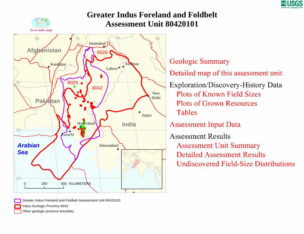
80428025
8026
Greater Indus Foreland and FoldbeltAssessment Unit 80420101
Other geologic province boundary
Indus Geologic Province 8042
Greater Indus Foreland and Foldbelt Assessment Unit 80420101
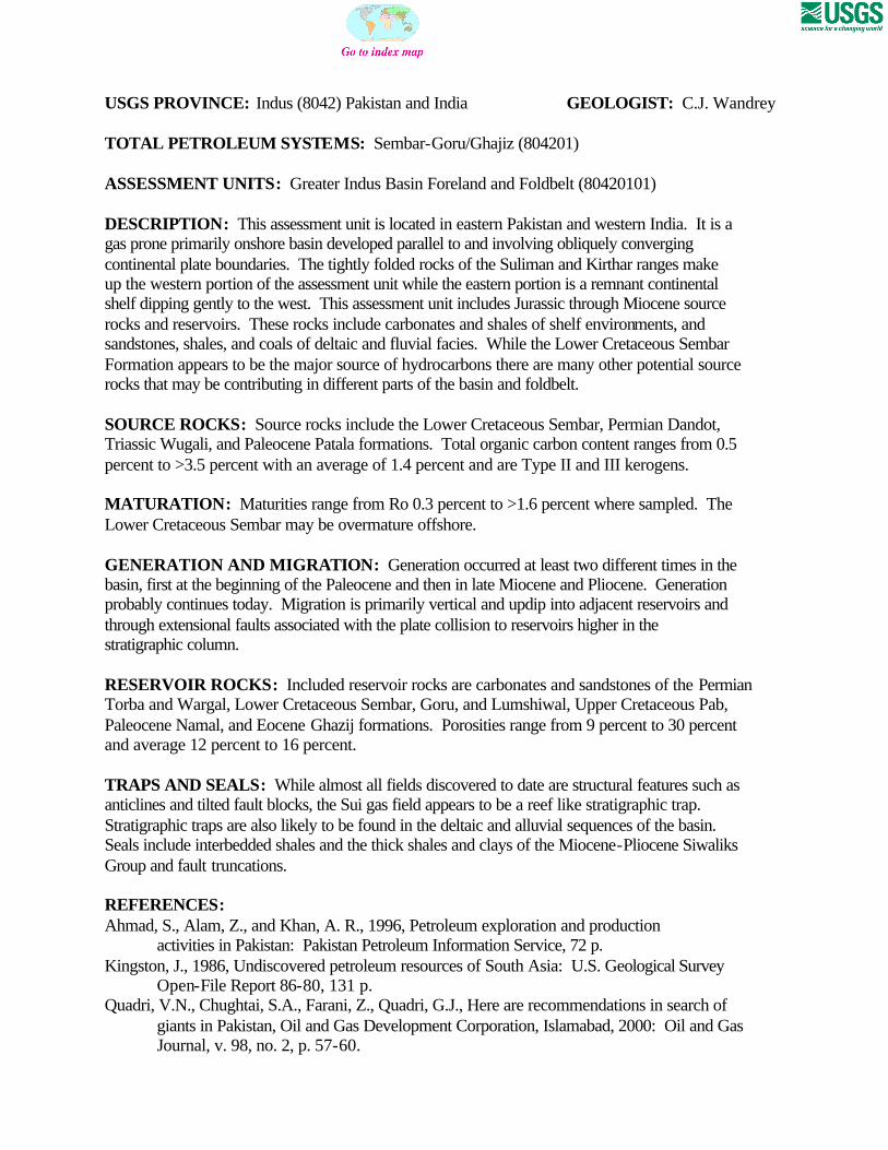
USGS PROVINCE: Indus (8042) Pakistan and India GEOLOGIST: C.J. Wandrey TOTAL PETROLEUM SYSTEMS: Sembar-Goru/Ghajiz (804201) ASSESSMENT UNITS: Greater Indus Basin Foreland and Foldbelt (80420101) DESCRIPTION: This assessment unit is located in eastern Pakistan and western India. It is a gas prone primarily onshore basin developed parallel to and involving obliquely converging continental plate boundaries. The tightly folded rocks of the Suliman and Kirthar ranges make up the western portion of the assessment unit while the eastern portion is a remnant continental shelf dipping gently to the west. This assessment unit includes Jurassic through Miocene source rocks and reservoirs. These rocks include carbonates and shales of shelf environments, and sandstones, shales, and coals of deltaic and fluvial facies. While the Lower Cretaceous Sembar Formation appears to be the major source of hydrocarbons there are many other potential source rocks that may be contributing in different parts of the basin and foldbelt. SOURCE ROCKS: Source rocks include the Lower Cretaceous Sembar, Permian Dandot, Triassic Wugali, and Paleocene Patala formations. Total organic carbon content ranges from 0.5 percent to >3.5 percent with an average of 1.4 percent and are Type II and III kerogens. MATURATION: Maturities range from Ro 0.3 percent to >1.6 percent where sampled. The Lower Cretaceous Sembar may be overmature offshore. GENERATION AND MIGRATION: Generation occurred at least two different times in the basin, first at the beginning of the Paleocene and then in late Miocene and Pliocene. Generation probably continues today. Migration is primarily vertical and updip into adjacent reservoirs and through extensional faults associated with the plate collision to reservoirs higher in the stratigraphic column. RESERVOIR ROCKS: Included reservoir rocks are carbonates and sandstones of the Permian Torba and Wargal, Lower Cretaceous Sembar, Goru, and Lumshiwal, Upper Cretaceous Pab, Paleocene Namal, and Eocene Ghazij formations. Porosities range from 9 percent to 30 percent and average 12 percent to 16 percent. TRAPS AND SEALS: While almost all fields discovered to date are structural features such as anticlines and tilted fault blocks, the Sui gas field appears to be a reef like stratigraphic trap. Stratigraphic traps are also likely to be found in the deltaic and alluvial sequences of the basin. Seals include interbedded shales and the thick shales and clays of the Miocene-Pliocene Siwaliks Group and fault truncations. REFERENCES: Ahmad, S., Alam, Z., and Khan, A. R., 1996, Petroleum exploration and production
activities in Pakistan: Pakistan Petroleum Information Service, 72 p. Kingston, J., 1986, Undiscovered petroleum resources of South Asia: U.S. Geological Survey
Open-File Report 86-80, 131 p. Quadri, V.N., Chughtai, S.A., Farani, Z., Quadri, G.J., Here are recommendations in search of
giants in Pakistan, Oil and Gas Development Corporation, Islamabad, 2000: Oil and Gas Journal, v. 98, no. 2, p. 57-60.
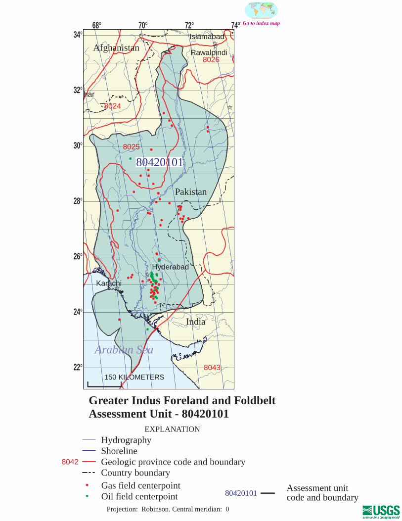
80420101
80420101Assessment unitcode and boundary
8024
8025
8026
8043
8042
Assessment Unit - 80420101Greater Indus Foreland and Foldbelt
EXPLANATION
HydrographyShorelineGeologic province code and boundaryCountry boundaryGas field centerpointOil field centerpoint
Projection: Robinson. Central meridian: 0
150 KILOMETERS
68 70 72 74
22
24
26
28
30
32
34
Pakistan
Islamabad
Rawalpindi
har
Hyderabad
Karachi
Arabian Sea
India
Afghanistan

SEVENTH APPROXIMATIONNEW MILLENNIUM WORLD PETROLEUM ASSESSMENTDATA FORM FOR CONVENTIONAL ASSESSMENT UNITS
Date:………………………….. 10/12/99Assessment Geologist:…….. C.J. WandreyRegion:……………………….. South Asia Number: 8Province:……………………… Indus Number: 8042Priority or Boutique.………… PriorityTotal Petroleum System:…… Sembar-Goru/Ghazij Number: 804201Assessment Unit:…………… Greater Indus Foreland and Foldbelt Number: 80420101* Notes from Assessor Lower 48-all growth function. Inert gas is N2.
CHARACTERISTICS OF ASSESSMENT UNIT
Oil (<20,000 cfg/bo overall) or Gas (>20,000 cfg/bo overall):… Gas
What is the minimum field size?………. 1 mmboe grown (>1mmboe)(the smallest field that has potential to be added to reserves in the next 30 years)
Number of discovered fields exceeding minimum size:………… Oil: 22 Gas: 52 Established (>13 fields) X Frontier (1-13 fields) Hypothetical (no fields)
Median size (grown) of discovered oil fields (mmboe):1st 3rd 18.4 2nd 3rd 6.4 3rd 3rd 15.6
Median size (grown) of discovered gas fields (bcfg):1st 3rd 124 2nd 3rd 89 3rd 3rd 168
Assessment-Unit Probabilities: Attribute Probability of occurrence (0-1.0)1. CHARGE: Adequate petroleum charge for an undiscovered field > minimum size……………… 1.02. ROCKS: Adequate reservoirs, traps, and seals for an undiscovered field > minimum size…… 1.03. TIMING OF GEOLOGIC EVENTS: Favorable timing for an undiscovered field > minimum size 1.0
Assessment-Unit GEOLOGIC Probability (Product of 1, 2, and 3):……...…….....…. 1.0
4. ACCESSIBILITY: Adequate location to allow exploration for an undiscovered field > minimum size……………………………………………………..………………..……..………… 1.0
UNDISCOVERED FIELDS
Oil fields:…………………………………min. no. (>0) 5 median no. 20 max no. 50Gas fields:……………………………….min. no. (>0) 20 median no. 100 max no. 250
Size of Undiscovered Fields: What are the anticipated sizes (grown) of the above fields?:
Oil in oil fields (mmbo)………………..……min. size 1 median size 4 max. size 50Gas in gas fields (bcfg):……………………min. size 6 median size 70 max. size 10000
Assessment Unit (name, no.)Greater Indus Foreland and Foldbelt, 80420101
(variations in the sizes of undiscovered fields)
(uncertainty of fixed but unknown values)Number of Undiscovered Fields: How many undiscovered fields exist that are > minimum size?:
Page 1
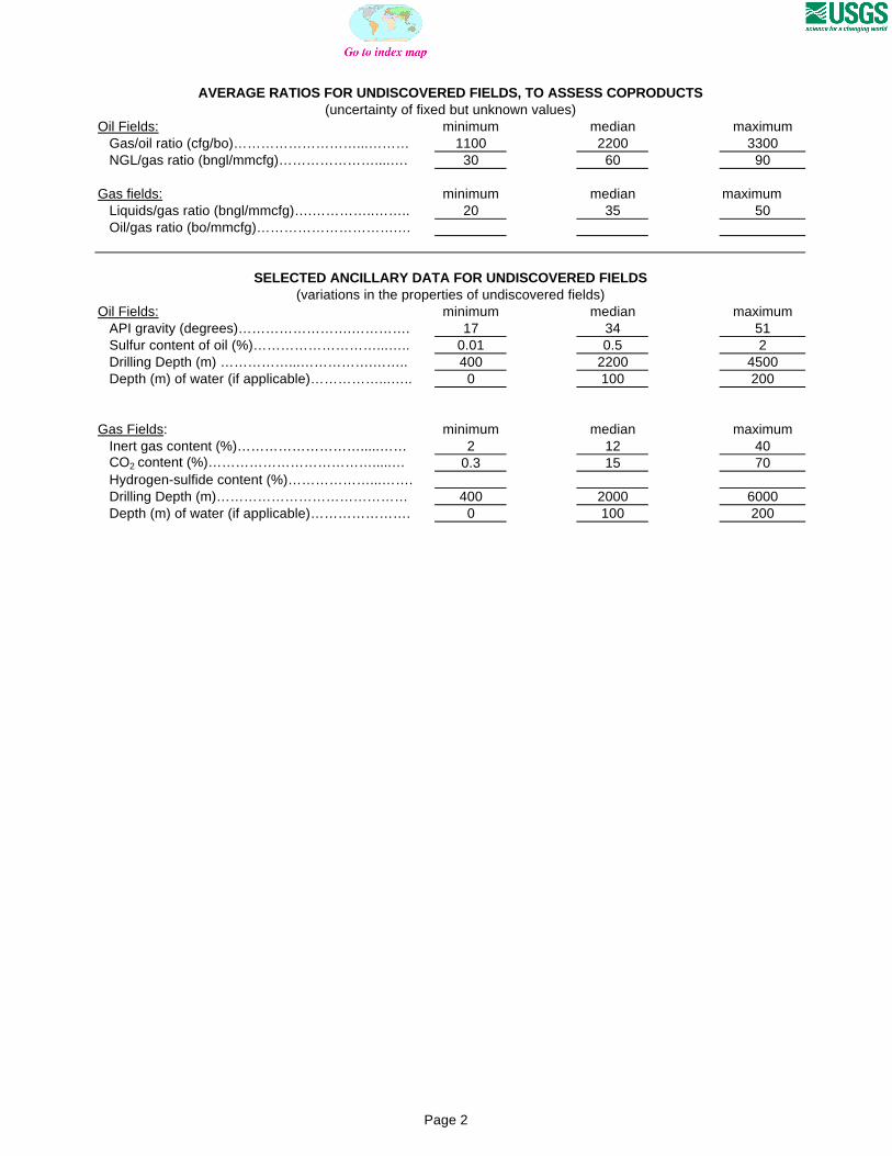
AVERAGE RATIOS FOR UNDISCOVERED FIELDS, TO ASSESS COPRODUCTS
Oil Fields: minimum median maximum Gas/oil ratio (cfg/bo)………………………...……… 1100 2200 3300 NGL/gas ratio (bngl/mmcfg)…………………....…. 30 60 90
Gas fields: minimum median maximum Liquids/gas ratio (bngl/mmcfg)….…………..…….. 20 35 50 Oil/gas ratio (bo/mmcfg)………………………….…
SELECTED ANCILLARY DATA FOR UNDISCOVERED FIELDS(variations in the properties of undiscovered fields)
Oil Fields: minimum median maximum API gravity (degrees)…………………….…………. 17 34 51 Sulfur content of oil (%)………………………...….. 0.01 0.5 2 Drilling Depth (m) ……………...…………….…….. 400 2200 4500 Depth (m) of water (if applicable)……………...….. 0 100 200
Gas Fields: minimum median maximum Inert gas content (%)……………………….....…… 2 12 40 CO2 content (%)……………………………….....… 0.3 15 70 Hydrogen-sulfide content (%)………………...……. Drilling Depth (m)…………………………………… 400 2000 6000 Depth (m) of water (if applicable)…………………. 0 100 200
(uncertainty of fixed but unknown values)
Page 2
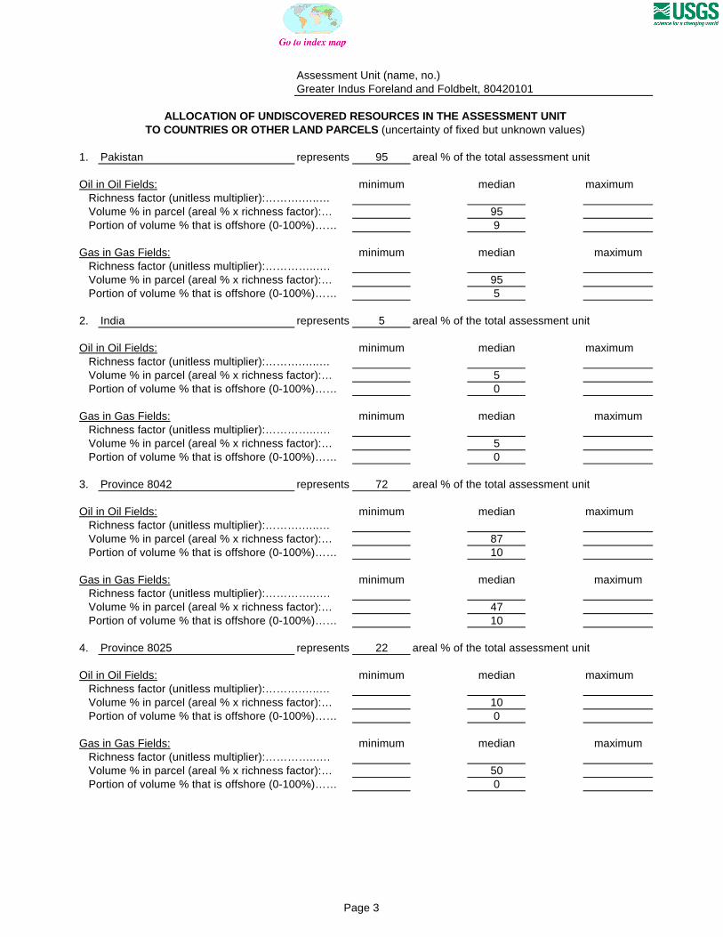
Assessment Unit (name, no.)Greater Indus Foreland and Foldbelt, 80420101
ALLOCATION OF UNDISCOVERED RESOURCES IN THE ASSESSMENT UNITTO COUNTRIES OR OTHER LAND PARCELS (uncertainty of fixed but unknown values)
1. Pakistan represents 95 areal % of the total assessment unit
Oil in Oil Fields: minimum median maximum Richness factor (unitless multiplier):……….…..… Volume % in parcel (areal % x richness factor):… 95 Portion of volume % that is offshore (0-100%)…… 9
Gas in Gas Fields: minimum median maximum Richness factor (unitless multiplier):…………..…. Volume % in parcel (areal % x richness factor):… 95 Portion of volume % that is offshore (0-100%)…… 5
2. India represents 5 areal % of the total assessment unit
Oil in Oil Fields: minimum median maximum Richness factor (unitless multiplier):……….…..… Volume % in parcel (areal % x richness factor):… 5 Portion of volume % that is offshore (0-100%)…… 0
Gas in Gas Fields: minimum median maximum Richness factor (unitless multiplier):…………..…. Volume % in parcel (areal % x richness factor):… 5 Portion of volume % that is offshore (0-100%)…… 0
3. Province 8042 represents 72 areal % of the total assessment unit
Oil in Oil Fields: minimum median maximum Richness factor (unitless multiplier):……….…..… Volume % in parcel (areal % x richness factor):… 87 Portion of volume % that is offshore (0-100%)…… 10
Gas in Gas Fields: minimum median maximum Richness factor (unitless multiplier):…………..…. Volume % in parcel (areal % x richness factor):… 47 Portion of volume % that is offshore (0-100%)…… 10
4. Province 8025 represents 22 areal % of the total assessment unit
Oil in Oil Fields: minimum median maximum Richness factor (unitless multiplier):……….…..… Volume % in parcel (areal % x richness factor):… 10 Portion of volume % that is offshore (0-100%)…… 0
Gas in Gas Fields: minimum median maximum Richness factor (unitless multiplier):…………..…. Volume % in parcel (areal % x richness factor):… 50 Portion of volume % that is offshore (0-100%)…… 0
Page 3
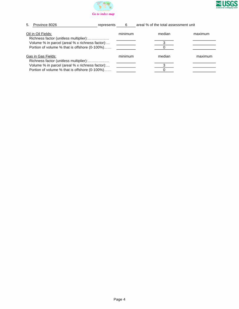
5. Province 8026 represents 6 areal % of the total assessment unit
Oil in Oil Fields: minimum median maximum Richness factor (unitless multiplier):……….…..… Volume % in parcel (areal % x richness factor):… 3 Portion of volume % that is offshore (0-100%)…… 0
Gas in Gas Fields: minimum median maximum Richness factor (unitless multiplier):…………..…. Volume % in parcel (areal % x richness factor):… 3 Portion of volume % that is offshore (0-100%)…… 0
Page 4

0
1
2
3
4
5
6
7
8
9
1-<2 2-<4 4-<8 8-<16 16-<32 32-<64 64-<128 128-<256
256-<512
512-<1024
1024-<2048
2048-<4096
OIL-FIELD SIZE (MMBO)
UN
DIS
CO
VE
RE
D O
IL F
IEL
DS
(N
o.)
Minimum field size: 1 MMBO
Mean number ofundiscovered fields: 21.7
Greater Indus Foreland and Foldbelt, AU 80420101 Undiscovered Field-Size Distribution

0
5
10
15
20
25
6-<12 12-<24 24-<48 48-<96 96-<192 192-<384 384-<768 768-<1536
1536-<3072
3072-<6144
6144-<12288
GAS-FIELD SIZE (BCFG)
UN
DIS
CO
VE
RE
D G
AS
FIE
LD
S (
No
.)
Minimum field size: 6 BCFG
Mean number ofundiscovered fields: 108.1
Greater Indus Foreland and Foldbelt, AU 80420101 Undiscovered Field-Size Distribution