Greater Goose Pond Forest (GGPF) is ... - ci.keene.nh.us Management Plan... · 81.1% Keene 11.9%...
65
Greater Goose Pond Forest Management Plan July 06 22 APPENDICES
-
Upload
duonghuong -
Category
Documents
-
view
214 -
download
0
Transcript of Greater Goose Pond Forest (GGPF) is ... - ci.keene.nh.us Management Plan... · 81.1% Keene 11.9%...
Greater Goose Pond Forest Management Plan July 06
22
APPENDICES

Greater Goose Pond Forest Management Plan July 06
23
APPENDIX I:
GGPF User Survey Results
DRAFT – Greater Goose Pond Forest Management Plan 24-Jun-11
24
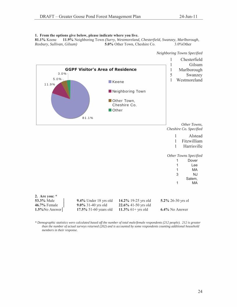
1. From the options give below, please indicate where you live. 81.1% Keene 11.9% Neighboring Town (Surry, Westmoreland, Chesterfield, Swanzey, Marlborough, Roxbury, Sullivan, Gilsum) 5.0% Other Town, Cheshire Co. 3.0%Other
Neighboring Towns Specified
Other Towns, Cheshire Co. Specified
Other Towns Specified
1 Dover 1 Lee 1 MA 3 NJ
1 Salem,
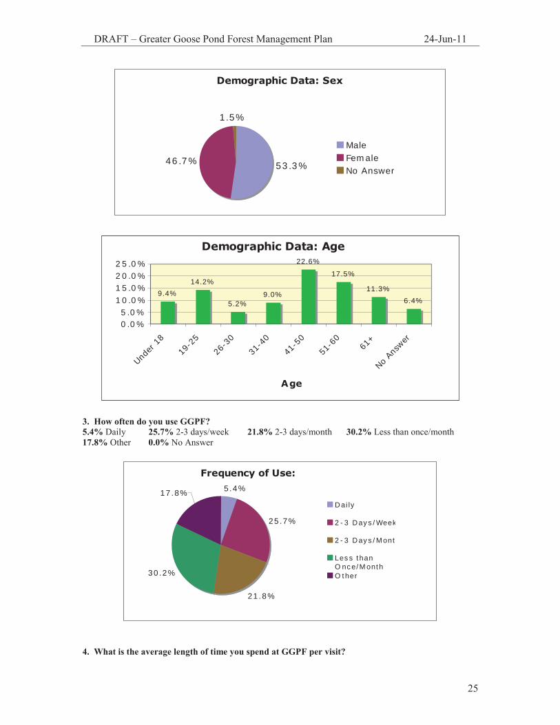
MA 2. Are you: * 53.3% Male │ 9.4% Under 18 yrs old 14.2% 19-25 yrs old 5.2% 26-30 yrs ol 46.7% Female │ 9.0% 31-40 yrs old 22.6% 41-50 yrs old 1.5%No Answer│ 17.5% 51-60 years old 11.3% 61+ yrs old 6.4% No Answer * Demographic statistics were calculated based off the number of total male/female respondents (212 people). 212 is greater
than the number of actual surveys returned (202) and is accounted by some respondents counting additional household members in their response.
1 Chesterfield 1 Gilsum 1 Marlborough 5 Swanzey 1 Westmoreland
1 Alstead 1 Fitzwilliam 1 Harrisville
GGPF Visitor's Area of Residence
11.9%
5.0%
3.0%
81.1%
Keene
Neighboring Town
Other Town,Cheshire Co.Other
DRAFT – Greater Goose Pond Forest Management Plan 24-Jun-11
25
Demographic Data: Sex
53.3%46.7%
1.5%
MaleFemaleNo Answer
Demographic Data: Age
9.4%14.2%
5.2%9.0%
22.6%
17.5%
11.3%6.4%
0.0%5.0%
10.0%15.0%20.0%25.0%
Unde
r 18
19-2
526
-30
31-4
041
-50
51-6
061
+
No A
nswer
Age
3. How often do you use GGPF? 5.4% Daily 25.7% 2-3 days/week 21.8% 2-3 days/month 30.2% Less than once/month 17.8% Other 0.0% No Answer
Frequency of Use: 5.4%
25.7%
21.8%
30.2%
17.8%Daily
2-3 Days/Week
2-3 Days/Mont
Less thanO nce/MonthO ther
4. What is the average length of time you spend at GGPF per visit?

DRAFT – Greater Goose Pond Forest Management Plan 24-Jun-11
26
7.4% 30 minutes 45.0% 1 hour 32.7% 1 ½ hours 12.9% 2+ hours 3.5% No Answer
Time Spent at GGPF
7.4%
45.0%32.7%
12.9%3.5%
30 Minutes1 Hour1 1/2 Hours2+ HoursNo Answer
5. During what seasons do you use GGPF? (Respondents checked all that applied) 70.3% Spring 87.6% Summer 79.7% Fall 45.0% Winter 2.5%
No Answer
Seasonal Use
70.3%
87.6%79.7%
45.0%
2.5%0%
10%20%30%40%50%60%70%80%90%
100%
Spring Summer Fall Winter No Answer
z
DRAFT – Greater Goose Pond Forest Management Plan 24-Jun-11
27
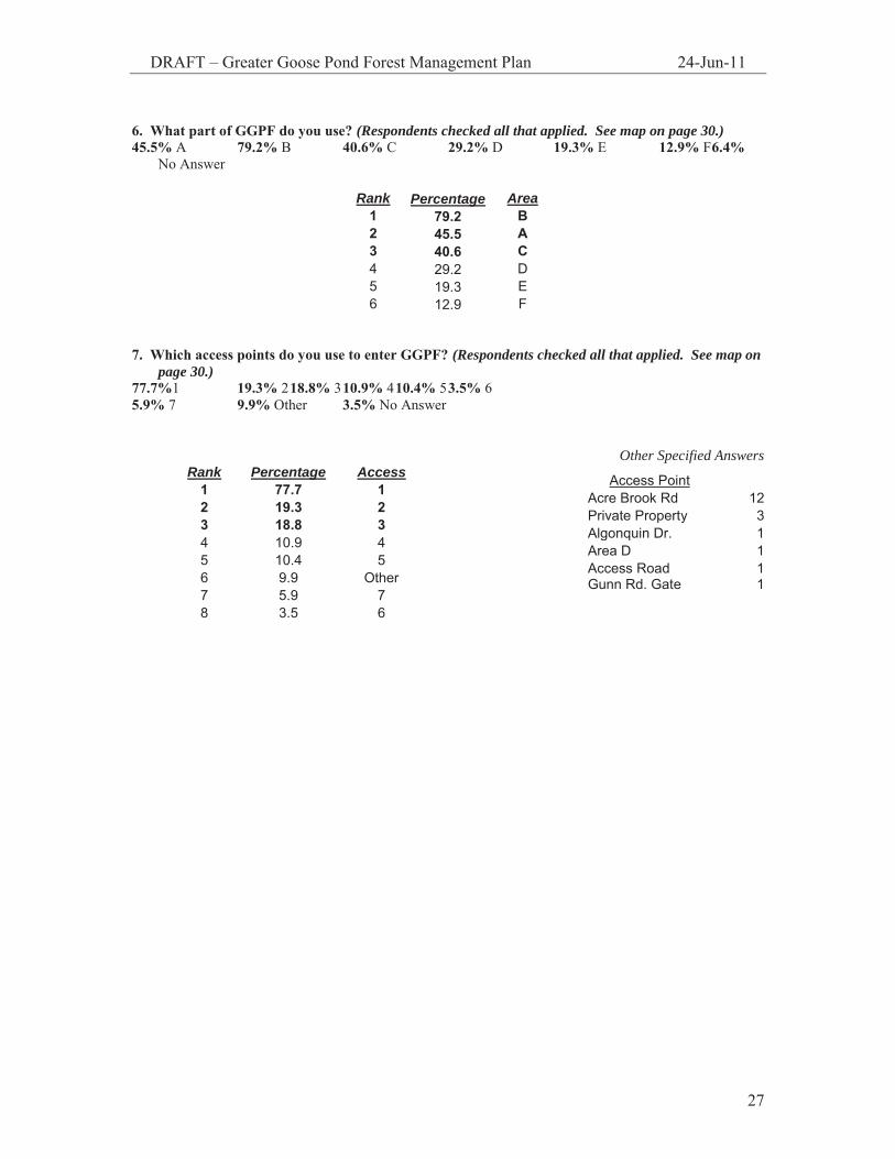
6. What part of GGPF do you use? (Respondents checked all that applied. See map on page 30.) 45.5% A 79.2% B 40.6% C 29.2% D 19.3% E 12.9% F 6.4%
No Answer
Rank Percentage Area 1 79.2 B 2 45.5 A 3 40.6 C 4 29.2 D 5 19.3 E 6 12.9 F
7. Which access points do you use to enter GGPF? (Respondents checked all that applied. See map on
page 30.) 77.7%1 19.3% 2 18.8% 3 10.9% 4 10.4% 5 3.5% 6 5.9% 7 9.9% Other 3.5% No Answer
Other Specified Answers
Access Point Acre Brook Rd 12 Private Property 3 Algonquin Dr. 1 Area D 1 Access Road 1 Gunn Rd. Gate 1
Rank Percentage Access 1 77.7 1 2 19.3 2 3 18.8 3 4 10.9 4 5 10.4 5 6 9.9 Other 7 5.9 7 8 3.5 6

DRAFT – Greater Goose Pond Forest Management Plan 24-Jun-11
28
8. What activities do you enjoy at GGPF? 42.1% Dog walking 23.3% Biking 46.0% Hiking 11.9% Cross-country skiing 8.4% Fishing 78.2% Walking 19.3% Snowshoeing 17.8% Running 2.0% Boating 40.1% Wildlife viewing/nature study 13.9% Other 2.5% No Answer
Identified User Activities: GGPF
78.2%
40.1%
19.3% 17.8%11.9%
8.4%2.0% 2.5%
46.0%42.3%
13.9%
23.3%
0.0%
10.0%
20.0%
30.0%
40.0%
50.0%
60.0%
70.0%
80.0%
90.0%
walking
hiking
dog walk
ing
wildlife
biking
snow
shoe
ing
runn
ingothe
r
X-co
untry
ski
fishin
g
boat
ing
no an
swer
Activity
9. When you visit GGPF, do you visit: (Respondents checked all that applied) 46.0% Alone 65.3% As a group (2-3 people) 20.3% As a group (4+ people) 39.6% With pets 15.3% Without pets 3.5% No Answer
Group Data GGPF
46.0%
20.3%
39.6%
65.3%
15.3%
3.5%0%
10%
20%
30%
40%
50%
60%
70%
A lone Group (2-3people)
Group (4+people)
With Pets WithoutPets
No A nswer
DRAFT – Greater Goose Pond Forest Management Plan 24-Jun-11
29
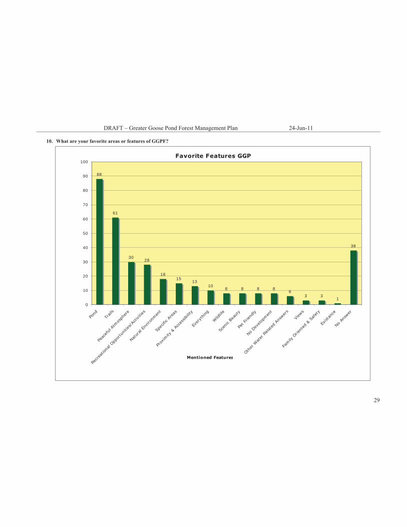
10. What are your favorite areas or features of GGPF?
Favorite Features GGP
88
61
3028
1815
1310
8 8 8 86
3 31
38
0
10
20
30
40
50
60
70
80
90
100
Pond
Trail
s
Peac
eful
Atmos
pher
e
Recrea
tiona
l Opp
ortu
nities
/Acti
vities
Natur
al En
viron
men
t
Spec
ific A
reas
Prox
imity
& A
cces
sibilit
y
Ever
ythin
g
Wild
life
Scen
ic Be
auty
Pet F
riend
ly
No Dev
elopm
ent
Other
Wat
er R
elated An
swer
s
View
s
Family
Orie
nted
& S
afet
y
Exist
ance
No An
swer
Mentioned Features
DRAFT – Greater Goose Pond Forest Management Plan 24-Jun-11
30
11. What things about GGPF would you change or improve?
Things to Improve: GGPF
4239
13
86 5 4 3 3 2
14
52 2 1 1
14 14
8
42 2
85
24 3 2 1 1 1
68
0
10
20
30
40
50
60
70
80
Do
Not
hing
Trai
ls
Impr
ove/
Mai
ntai
n
Brig
des
@ H
20 C
ross
ings
Map
s
Mar
king
s
Bike
tra
ils
Wet
/Mud
dy A
reas
Win
ter
Gro
omin
g/M
aint
enan
ce
Kee
p C
lear
Use
Kee
p N
atur
al
Allo
w S
wim
min
g
Picn
ic A
rea
Bath
room
s
Boat
s
Impr
ove
Park
ing
Litt
er
Bett
er E
nfor
cem
ent
Part
ies
ATV'
s
Swim
min
g
Pets
Pet
Was
te
Nee
d Le
ashe
s
Wat
er Q
ualit
y
Acce
ssib
ility
Bett
er A
cces
s
Less
Acc
ess
Esta
b. L
and
Use
Edu
catio
n
Mor
e Av
aila
ble
Info
No
Answ
er
Areas for Improvement

DRAFT – Greater Goose Pond Forest Management Plan 24-Jun-11
31
12. What do you think are priorities for future management of GGPF? (Please check all that apply) 49.5% Forest health 21.3% Forest diversity 41.1% Passive recreation 47.5% Trail network 53.5% Wildlife habitat 49.0% Water quality 29.7% Educational/study purposes 33.7% Leave it as is 7.4% Timber harvest 14.4% Sustainable forestry 3.5% Other 5.9% No Answer
Rank Percentage Management Priorities 1 53.7 wildlife habitat 2 49.8 forest health 3 49.3 water quality 4 47.8 trail network 5 41.3 passive recreation 6 33.8 leave as is 7 29.9 educational purposes 8 21.4 forest diversity 9 14.4 sustainable forestry
10 7.5 timber harvest 11 3.5 other
Other Specified Answers
swimming 1 easement/land acquisition 2 town park 1 clean up Drummer Hill pond 1
DRAFT – Greater Goose Pond Forest Management Plan 24-Jun-11
32
12.9%
40.6%
19.3%
29.2%
79.2%
45.5%
77.1%
19.3%
5.9%
10.4%
10.9% 18.8%
DRAFT – Greater Goose Pond Forest Management Plan 24-Jun-11
33
APPENDIX II:
GGPF Trail Map
DRAFT – Greater Goose Pond Forest Management Plan 24-Jun-11
34

DRAFT – Greater Goose Pond Forest Management Plan 24-Jun-11
35
APPENDIX III:
Goose Pond Trail Report
DRAFT – Greater Goose Pond Forest Management Plan 24-Jun-11
36
November 27, 2005 Peter Throop City Planner 3 Washington Street Keene, NH 03431 Dear Pete, I thoroughly enjoyed the opportunity to walk the trail system of Goosepond Preserve with yourself and members of the Keene Conservation Commission. With few exceptions, the trails are in great shape. I feel that with the accomplishment of some priority projects, the trails could easily be brought to a solid state. To help with planning, I have taken the liberty to prioritize the sites we visited into seven projects. These are:
1. Bridge Re-Construction and Reroute 1 2. Bridge Construction and Reroute 2 3. Entrance Timber Stairs 4. Entrance Drainage 5. Brushing of Entire Trail System 6. Step Stones Along Wet Sections 7. Tread Work to Allow Proper Drainage
As mentioned on the trail, I have a crew that can accomplish the above mentioned projects. There are, however, other local labor resources that could be used for the less technical projects. I could be available to provide tools and supervision during construction for that type of endeavor. Please contact me with any questions related to the attached information or to schedule construction. Thanks again for the opportunity. Onward, Joshua Ryan Timber & Stone

DRAFT – Greater Goose Pond Forest Management Plan 24-Jun-11
37
Goose Pond Preserve Project Prioritization Submitted by Joshua Ryan
Project 1
Bridge Re-Construction and Reroute 1
Details
The current bridge was washed out by the
recent storms. The existing trail is extremely close to the water’s edge and is allowing for no drainage.
Bridge = 20’ long x 4’ feet wide Re-construct bridge up stream Move trail to connect with new bridge site and
to re-connect with old trail Brush in old trail
Project 2
Bridge Construction & Reroute 2
Details
This section of trail offers
the hiker no clear option of crossing this wide drainage.
Bridge = 15’ long x 4’ wide Construct bridge at
narrowest location, use stone to build up cribbing
Relocate trail to connect with bridge from both directions
This reroute has the potential to be extensive due to the problems encountered down trail where there is no clear path to follow.

DRAFT – Greater Goose Pond Forest Management Plan 24-Jun-11
38
Project 3
Entrance Timber Stairs
Details
Entrance to trail system is worn due to erosion and user impact. By installing a timber staircase, hikers will have a safer and more enjoyable entrance to the
trails. Staircase could extend to the
top of the rise, by the large boulder.
8x8 or 6x6 pressure treated timbers
Ballast stone 1/2” Rebar Crushed granite surfacing Handrail optional $8,000—$12,000, including
materials, depending on final length of staircase
Timber Staircase in North Carolina
Project 4
Entrance Drainage
As the entrance trail heads uphill toward the pond, there is a need for extensive drainage
work. Water is running down the trail from multiple
seeps. Drainage ditches and turnpiking will help to
elevate the tread and keep hikers on a specific trail.
Ballast stone, timbers, mineral soil

DRAFT – Greater Goose Pond Forest Management Plan 24-Jun-11
39
Project 5
Brushing the Entire Trail System
Details
The trail is choked with branches that limit the hiker’s vision of the path. By removing the branches, the hikers will be less likely to cause the trail to widen.
Sunlight will reach the trail and help to dry wet sections. These branches hang much lower when laden with snow.
Remove trees that confuse trail intersections Remove branches that hang lower than 10 feet Establish a consistent trail corridor that is 4 x 10
DRAFT – Greater Goose Pond Forest Management Plan 24-Jun-11
40
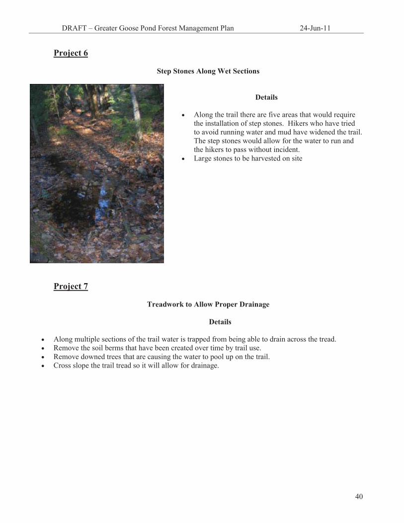
Project 6
Step Stones Along Wet Sections
Details
Along the trail there are five areas that would require
the installation of step stones. Hikers who have tried to avoid running water and mud have widened the trail. The step stones would allow for the water to run and the hikers to pass without incident.
Large stones to be harvested on site
Project 7
Treadwork to Allow Proper Drainage Details
Along multiple sections of the trail water is trapped from being able to drain across the tread. Remove the soil berms that have been created over time by trail use. Remove downed trees that are causing the water to pool up on the trail. Cross slope the trail tread so it will allow for drainage.
DRAFT – Greater Goose Pond Forest Management Plan 24-Jun-11
41
APPENDIX IV:
Timber Cruise Report

DRAFT – Greater Goose Management Plan 24-Jun-11
42
Timber Cruise Report Greater Goose Pond Forest
Keene, NH
Completed for the Greater Goose Pond Forest Land Management Committee
by Heidi Brannon
Antioch New England Graduate School
August 2004
Special thanks goes to: Timber Cruise Design Team
Leo Maslan Pete Throop
Chris Hilke Tom Sintros
Keene High School AP Environmental Science Students Timber Cruise Group Leaders
Emily Hague Mike Burgess
Carl Jacobs Kristen Armstrong
Luke & Heather Brannon

DRAFT – Greater Goose Management Plan 24-Jun-11
43
TIMBER CRUISE REPORT GREATER GOOSE POND FOREST – KEENE, NH
INTRODUCTION
The focus of this study is to provide the Greater Goose Pond Forest Management Committee (Committee) with quantitative data regarding health, stand diversity, and structure of the Greater Goose Pond Forest (GGPF). The Committee felt a timber cruise was necessary because despite several previous natural resource inventories (NRIs) completed for the property, little data existed regarding GGPF’s timber resources. In this study, we focused on the contiguous properties surrounding Goose Pond, excluding the Drummer Hill, Grant, and Minister’s Lot parcels, by running East-West transects from Old Gilsum Road. (Figure 1)
Figure 1: Greater Goose Pond Forest, Transect Map

DRAFT – Greater Goose Management Plan 24-Jun-11
44
METHODS In order to collect the necessary data, ten transects were set one thousand feet apart on Old Gilsum Road. Along each transect, sample sites were established every five hundred feet using compass (bearing due West) and pacing techniques. At the sampling sites, the sampling group was selected using a 10-factor angle gauge. The following data was recorded for each tree determined to be a part of the sampling group: diameter at breast height (dbh); number of eight-foot log lengths, log type (saw log or pulp wood); and species type. (Appendix A) Other data also noted were: species type for understory and sapling layers; any identifiable wildlife indicators; and forest health. Once completed, all data collected was entered into MultiCruise, a computer program, to calculate mean dbh, species composition, and timber volume. RESULTS The total acreage subject to this study was 485 acres out of GGPF’s total 1,046 acres. Within this area, data was collected from forty-one sampling sites. Average trees/acre was calculated to be 173, with a mean stand diameter at 9.7 inches dbh. Hardwoods comprised nearly eighty percent of species sampled. Red oak is the predominant hardwood species found within the area sampled. Softwoods (hemlock and white pine) comprise the remaining twenty percent of species sampled. The following graphs show percentages by species for basal area (Graph 1), saw log volume (Graph 2), and pulp wood volume (Graph 3). Graphically represented are hardwood species exceeding ten percent in each selected category. Hemlock and white pine are represented individually due to the fact that hemlock exceeded ten percent in all categories and white pine is the only other softwood species sampled.
Graph 1: Basal Area57
16 720
0204060
Red O
ak
Hemloc
k
Wht.
Pine
Mxd. H
ard.
Species
% B
asal
Are
a
% Basal Area

DRAFT – Greater Goose Management Plan 24-Jun-11
45
Graph 2: Saw Log Volume
64
14 12 100
20406080
Red O
ak
Hemloc
k
Wht.
Pine
Mxd. H
ard.
Species
% V
olum
e % Saw Log Volume
Graph 3: Pulp Wood Volume
48
183 12 19
0102030405060
Red O
ak
Hemloc
k
Wht. Pine
Red M
aple
Mxd. H
ard.
Species
% P
ulp
Woo
d
%Pulp Wood Volume

DRAFT – Greater Goose Management Plan 24-Jun-11
46
Table 1, below, gives the percentages for all species sampled during the inventory.
Table 1: Species Composition by Percent
Species Basal Area Saw Log Volume Pulpwood Cords
Red Oak 57.2 64.3 48.4 Hemlock 16.0 14.3 17.8 Red Maple 9.1 4.9 11.7 White Pine 6.9 12.7 3.4 White Birch 3.3 1.2 5.6 Beech 3.0 1.2 6.3 Sugar Maple 1.7 0.6 2.8 Black Birch 1.4 0.6 1.9 Yellow Birch 0.8 0.0 1.0 White Ash 0.6 0.3 1.1 All Hardwoods 77.1 73.0 78.8 All Softwoods 22.9 27.0 21.2
To determine the present stocking levels of GGPF, the all species average of basal area per acre (88.3 dbh) is graphed against the number of trees per acre. (Figure 2) GGPF falls between the A (overstocked) and B (target stocking level) trend lines.
Figure 2: Stocking Level Diagram

DRAFT – Greater Goose Management Plan 24-Jun-11
47
DISCUSSION In reviewing Sperduto and Nichols Natural Communities of New Hampshire, GGPF is most characteristic of a hemlock-beech-oak-pine forest. Hemlock-beech-oak-pine forest is a sub-category of the Northern Hardwood Forest classification and is a “broadly defined community found on glacial till and terrace soils of low to mid elevations…” (59). Characteristic tree species in hemlock-beech-oak-pine forests are eastern hemlock, American beech, red oak, and white pine. Canopy dominance by these species, is relative to different successional stages. In early to mid-succesional forests, hemlock and American beech may mostly be present in the understory and will increase in prominence over time (Sperduto and Nichols 2004). In the GGPF, red oak comprises fifty-seven percent of the total basal area for species sampled, while hemlock and beech were noted as the predominant understory species. It is likely, if left to natural succession, GGPF will shift over time to a forest that has a greater dominance of hemlock and beech in the canopy. Other species indicative of a hemlock-beech-oak-forest sampled during this study are: paper birch; red maple; black birch; sugar maple; white ash; and yellow birch (Sperduto and Nichols 2004). Soils found in hemlock-beech-oak-pine forests are moderate to extremely well drained sandy loams or loamy sands formed in glacial till (Sperduto and Nichols 2004). Of the soils listed in the City of Keene Natural Resource Inventory for Greater Goose Pond Forest and Stearns Hill Natural Area (Dubois and King 2002), all but two are derived from glacial till and nearly all the soils described, except those found in wet or depressional areas, are moderately well drained to excessively well drained with textures that vary between sandy loam and loamy sand. Many indications of past human disturbance exist on the property. Given the history of land use within the region, it is logical to assume that at one time GGPF was logged and converted to agricultural uses. The multitude of stonewalls that crisscross the property as well as relatively even aged timber stands support such an assumption (Wessels 1997). Although logging may have historic significance to the property, its application as a management tool today bears careful consideration, especially under management guidelines set by the GGPF Master Plan. The 1992 Greater Goose Pond Forest Master Plan recommends “lumbering operations” within the GGPF “should be designed to diversify and improve the wildlife habitat to attract a larger variety of wildlife” and have the overall goals of “sound management to improve the stands of species… and to benefit the overall Goose Pond area and forest” (p. 31). Therefore under guidelines set in the GGPF Master Plan, the potential scope of timber management project is limited to ecological considerations. With red oak comprising fifty-seven percent of the basal area sampled, a thinning cut to remove red oak from the canopy to increase species diversity could be a potential recommendation for forest management. While red oak is a valuable timber resource, several factors need to be taken into account when determining a timber management plan for GGPF. The presence of productive, high-quality red oak stands often make forests like GGPF susceptible to timber harvesting practices that result in the selective removal or “high-grading” of red oak. An article provided by the Massachusetts Forestry Association (MFA) defines high-grading as: “… a term used to describe forest harvesting which removes the valuable trees, leaving behind trees primarily of poor form, health, value or potential value. The direct benefit of high-grading
DRAFT – Greater Goose Management Plan 24-Jun-11
48
is short-term economic gain. … The costs of high-grading, however, are borne primarily by the landowner alone, costs which may not even be revealed until long after the harvest.” (MFA 08-01-05) High-grading tends to leave invaluable trees behind which are more “prone to damage by weather and pests” decreasing the actual quality of the remaining stand of timber (MFA 08-01-05). The practice of high-grading has made oak dominated forests rare in New England since most oak has been removed to take advantage of historically strong market prices (Wessels, personal communication). The heavy removal of oaks could have an impact on wildlife. Oaks are New England’s primary nut bearing species (Wessels, personal communication) and provide a reliable source of food and shelter for wildlife (Baughman and Jacobs 1992). While the intent behind cutting red oak may be to increase the diversity of species (both plant and animal) it may put strain on wildlife populations that have come to depend on the resources a predominantly oak forest provides. The importance of red oak to wildlife for forage and shelter needs to be taken into consideration before harvesting as red oak does not necessarily “grow back” once removed. Red oaks (and most oaks in general) are difficult to regenerate (Baughman and Jacobs 1992). Oaks regenerate in two ways, either from seed (acorns) or by stump sprouting. According to Baughman and Jacob’s “Woodland Owner’s Guide to Oak Management,” oaks mast (produce a large crop of seeds) every two to five years, but while the masting cycle seems frequent, oaks produce few seeds compared to many other tree species (Wessels, personal communication). Oak seeds that are not eaten by animals need to be covered by forest litter (Wessels, personal communication) or they will deteriorate rapidly (Baughman and Jacobs 1992). Oaks will also stump sprout by sending up shoots from their root system when damaged by fire, drought, and sometimes after harvesting. Typically, younger trees receiving lots of sunlight are more vigorous at stump sprouting than older, large diameter trees (Baughman and Jacobs 1992). If the regeneration of red oak is desired after a cut, cuts should occur during a mast year and provide plenty of sunlight to the forest floor, as red oak is not shade tolerant. Masting cycles however are unpredictable, making planned red oak regeneration problematic (Wessels, personal communication). Additionally, according to Log Pro, Incorporated’s June 2005 Update!, which gives price changes and updates for log markets, low red oak log prices have experienced only a slight rebound. Red oak prices have “sank further than the level that can be explained by lumber prices alone” (1-2). Low market prices for red oak have left many sawmills with a substantial amount of “expensive, winter-cut red oak logs in inventory that are too expensive to saw at current lumber prices. As long as this inventory hangs over the market, there can be little movement in log or lumber prices” (Log Pro, Inc. 2005, 2). While there are many factors that contribute to depressed market prices for red oak, a primary factor has been market competition from overseas (Maslan, personal communication). This study provides little conclusive evidence that the proportional distribution of tree species sampled in GGPF is ecologically unsound. Little is presently known about the processes of hemlock-beech-oak-pine forest because there are few mature examples that have been studied through their various successional stages (Sperduto and Nichols 2004) (Thompson and Sorenson 2000). The rarity of oak dominated forests in New England and apparent lack of successional information bears careful consideration when developing a timber management plan for GGPF.
DRAFT – Greater Goose Management Plan 24-Jun-11
49
Before any specific timber management plan can be recommended for GGPF, a certified forester, or other qualified forest manager, needs to more fully inventory and map GGPF’s natural communities. Whatever plan is adopted, it should be based on information gathered about locally occurring successional trends and encourage species occurring in the area at their natural proportions.
WORKS CITED Baughman, Melvin J. and Rodney D. Jacobs. “Woodland Owner’s Guide to Oak Management.” U.S. Forest
Service. (1992) University of Minnesota Extension Service. 01 August 2005. http://www.extension.umn.edu/distribution/naturalresources/DD5938.html#Management%20Considerations
Duboise & King. “City of Keene Natural Resources Inventory: Greater Goose Pond Forest.” 2002 City of Keene. Greater Goose Pond Forest Master Plan, 1992 Log Pro, Inc. Update! Fairlee, VT. June 2005 Maslan, Leo. Personal Communication. 08 August 2005. Sperduto, Daniel D. and William F. Nichols. Natural Communities of New Hampshire. New
Hampshire Natural Heritage Bureau. 2004 Wessels, Tom. Reading the Forested Landscape: A natural history of New England. Woodstock:
Countryman Press, 1997 Wessels, Tom. Personal Communication. 15 August 2005. Thompson, Elizabeth H. and Eric R. Sorenson. Wetland, Woodland, Wildland: A guide to the Natural
Communities of Vermont. Hanover: University Press of New England, 2000.
DRAFT – Greater Goose Management Plan 24-Jun-11
50
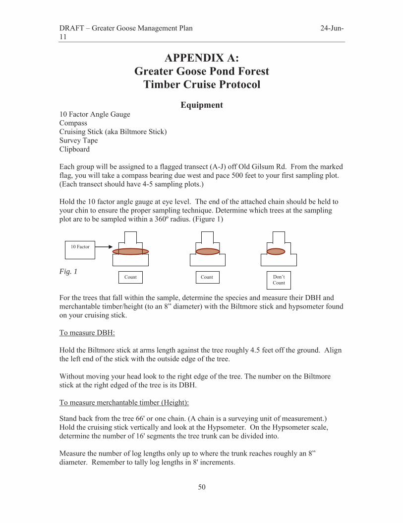
APPENDIX A: Greater Goose Pond Forest
Timber Cruise Protocol
Equipment 10 Factor Angle Gauge Compass Cruising Stick (aka Biltmore Stick) Survey Tape Clipboard Each group will be assigned to a flagged transect (A-J) off Old Gilsum Rd. From the marked flag, you will take a compass bearing due west and pace 500 feet to your first sampling plot. (Each transect should have 4-5 sampling plots.) Hold the 10 factor angle gauge at eye level. The end of the attached chain should be held to your chin to ensure the proper sampling technique. Determine which trees at the sampling plot are to be sampled within a 360º radius. (Figure 1) Fig. 1 For the trees that fall within the sample, determine the species and measure their DBH and merchantable timber/height (to an 8” diameter) with the Biltmore stick and hypsometer found on your cruising stick. To measure DBH: Hold the Biltmore stick at arms length against the tree roughly 4.5 feet off the ground. Align the left end of the stick with the outside edge of the tree. Without moving your head look to the right edge of the tree. The number on the Biltmore stick at the right edged of the tree is its DBH. To measure merchantable timber (Height): Stand back from the tree 66' or one chain. (A chain is a surveying unit of measurement.) Hold the cruising stick vertically and look at the Hypsometer. On the Hypsometer scale, determine the number of 16' segments the tree trunk can be divided into. Measure the number of log lengths only up to where the trunk reaches roughly an 8” diameter. Remember to tally log lengths in 8' increments.
Count Count Don’t Count
10 Factor
DRAFT – Greater Goose Management Plan 24-Jun-11
51
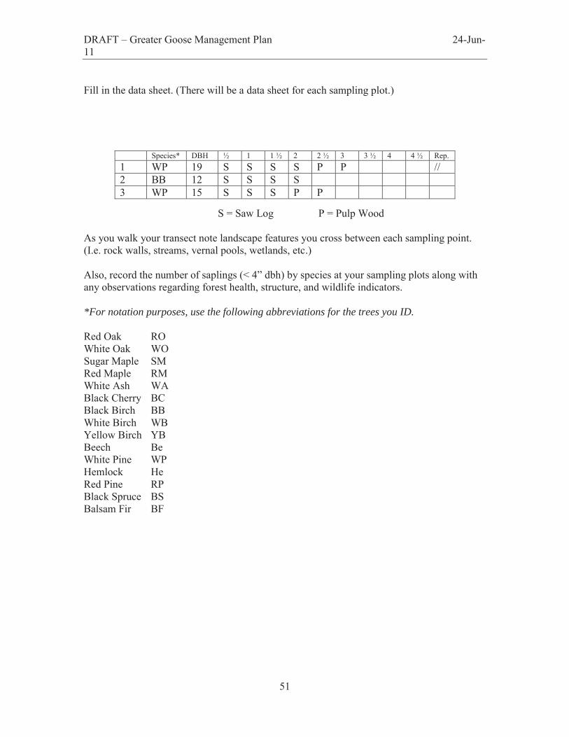
Fill in the data sheet. (There will be a data sheet for each sampling plot.)
S = Saw Log P = Pulp Wood As you walk your transect note landscape features you cross between each sampling point. (I.e. rock walls, streams, vernal pools, wetlands, etc.) Also, record the number of saplings (< 4” dbh) by species at your sampling plots along with any observations regarding forest health, structure, and wildlife indicators. *For notation purposes, use the following abbreviations for the trees you ID. Red Oak RO White Oak WO Sugar Maple SM Red Maple RM White Ash WA Black Cherry BC Black Birch BB White Birch WB Yellow Birch YB Beech Be White Pine WP Hemlock He Red Pine RP Black Spruce BS Balsam Fir BF
Species* DBH ½ 1 1 ½ 2 2 ½ 3 3 ½ 4 4 ½ Rep. 1 WP 19 S S S S P P // 2 BB 12 S S S S 3 WP 15 S S S P P
DRAFT – Greater Goose Management Plan 24-Jun-11
52
APPENDIX V:
Grant Parcel Vegetation Analysis
DRAFT – Greater Goose Management Plan 24-Jun-11
53
Vegetation Analysis of the City of Keene’s Grant Parcel in the Greater Goose Pond Forest Keene, New Hampshire – Spring 2005
Christopher J. Hilke Natural Resource Inventory
Grant Parcel (Lot 15) 05/10/05
DRAFT – Greater Goose Management Plan 24-Jun-11
54
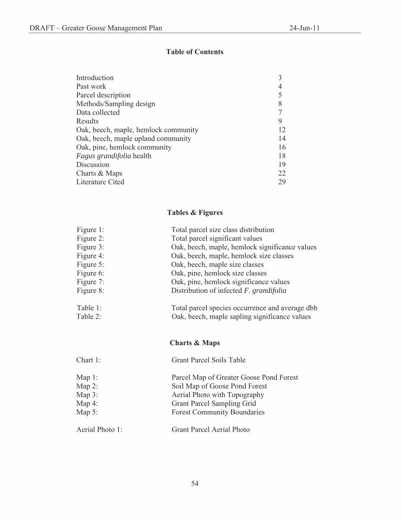
Table of Contents
Introduction 3 Past work 4 Parcel description 5 Methods/Sampling design 8 Data collected 7 Results 9 Oak, beech, maple, hemlock community 12 Oak, beech, maple upland community 14 Oak, pine, hemlock community 16 Fagus grandifolia health 18 Discussion 19 Charts & Maps 22 Literature Cited 29
Tables & Figures
Figure 1: Total parcel size class distribution Figure 2: Total parcel significant values Figure 3: Oak, beech, maple, hemlock significance values Figure 4: Oak, beech, maple, hemlock size classes Figure 5: Oak, beech, maple size classes Figure 6: Oak, pine, hemlock size classes Figure 7: Oak, pine, hemlock significance values Figure 8: Distribution of infected F. grandifolia Table 1: Total parcel species occurrence and average dbh Table 2: Oak, beech, maple sapling significance values
Charts & Maps Chart 1: Grant Parcel Soils Table Map 1: Parcel Map of Greater Goose Pond Forest Map 2: Soil Map of Goose Pond Forest Map 3: Aerial Photo with Topography Map 4: Grant Parcel Sampling Grid Map 5: Forest Community Boundaries Aerial Photo 1: Grant Parcel Aerial Photo
DRAFT – Greater Goose Management Plan 24-Jun-11
55
Introduction
The Greater Goose Pond Forest (GGPF) is public recreational land, managed by the City of Keene.
The GGPF is located within Cheshire County in southwestern New Hampshire, 4 miles north of Keene, NH.
Totaling 1044.9 acres (425.05 ha), the forest is comprised of 15 parcels of acquired land, and is directly
managed by the City of Keene Conservation Committee. In 2004, the committee requested that an up-to-
date resource inventory be conducted on the property. A Conservation Subcommittee was formed to oversee
the implementation of a Natural Resource Inventory (NRI) of the vegetation within the entirety of GGPF.
The data for the NRI was collected during April 2005 in cooperation with the City of Keene Conservation
Subcommittee, Peter Throop, Leo P. Maslan, Antioch New England graduate students Heidi Brannon and
Christopher J. Hilke, and Tom Sintros. The scope of this proposal, however, will focus exclusively on the
Grant lot, parcel #15 of the GGPF (Map 1).
Christopher J. Hilke, a student in the Department of Environmental Science at Antioch New England
Graduate School, conducted the NRI of the Grant parcel. Field assistance was provided by Antioch student
Robert Baranek, as well as Keene High School students Charles Bruch and Nick Sarsfield. Parcel 15 was
both qualitatively and quantitatively analyzed, utilizing sampling methods determined by the GGPF NRI
investigative members, and modified to include suggested protocols outlined by Antioch New England NRI-
Vegetation class, as well as several methods found within Field and Laboratory Methods for General
Ecology (Brower, Zar, and Ende, 1998). Data collection focused on the quantitative analysis of the upper
and middle synusia, with specific emphasis on the delineation of community type, as well as the qualitative
assessment of American beech (Fagus grandifolia) health within the parcel. The quantitative evaluation of
community type was based upon compositional features, species dominance and frequency. Qualitative
determination of community health included the delineation of the extent of beech bark scale disease among
American beech within the parcel. The combination of a quantitative and qualitative assessment provided a
comprehensive floristic analysis of the dominant community types within parcel 15.
DRAFT – Greater Goose Management Plan 24-Jun-11
56
Past Work
Several NRIs have been conducted in the past fifteen years within GGPF. The City of Keene
management plan for GGPF was drafted in 1992, and included an incomplete analysis of “Biologically
Significant Interest Areas” (BSAI) within the GGPF. Andrew Jennings and Edwin Dehler-Seter, from
Antioch New England Graduate School, conducted a “Winter Mammal and Habitat Survey of the Greater
Goose Pond Forest” submitted in May of 1994. The forest cover types delineated by that NRI included:
hardwoods, softwoods, mixed woods, mixed hardwood dominated, and mixed softwood dominated
communities. In the fall of 1994, a group of Antioch students, led by Rick Van de Poll, conducted an NRI of
“Four Biologically Significant Interest Areas.” This was a preliminary investigation for the City of Keene
which aimed to update/complete the City of Keene management plan for GGPF. In 1996, the “Deer
Wintering Area and Vernal Pool Assessment” NRI was conducted, and in 2002 the “City of Keene Natural
Resources Inventory of Greater Goose Pond Forest and Stearns Hill Natural Area” was conducted by
DuBois and King, Inc. DuBois and King delineated four primary cover types: hardwood dominated,
softwood dominated, mixed hardwood/softwood dominated, as well as wetland dominated communities.
NRI – Lot 15 – Grant Parcel
The macro-scale ecoregion wherein the Greater Goose Pond Forest is located is classified as
Vermont/New Hampshire Upland. The property is specifically located between the Sunapee Uplands and
the Hillsboro Inland Hills and Plains (NH Heritage Inventory). The geology of GGPF is characterized by
numerous formations of folded Oliverian gneiss, which, after millions of years of erosion of Ammonoosuc
volcanics, now lies exposed at the surface throughout much of the GGPF property (Moore 1949). The
outlying area includes swaths of New Hampshire Devonian/Littleton formation comprised of low-high grade
metasediments and minor metvolcanics (Van Diver 1987). The surficial geology of the GGPF region is
composed primarily of glacial till and sedimentary deposition from glacial Lake Ashuelot. As such,
DRAFT – Greater Goose Management Plan 24-Jun-11
57
lowlands have thick accumulated outwash deposition, while the uplands show signs of lakeshore features
including glacial lakeshore terracing (Van Diver 1987).
The Soil Survey of Cheshire County, New Hampshire delineates the primary soil types within the
Grant parcel as Tunbridge-Lyman Rock Outcrop Complex (8-15% slopes), Tunbridge-Lyman Rock Outcrop
Complex (15-25% slopes), Monadnock Fine Sandy Loam (8-15% slopes, very stony), and Monadnock Fine
Sandy Loam (15-25% slopes, very stony)
(Map 2). Utilizing a modified acreage grid, I estimated the total acres of each of the four soil types found
within the boundaries of the parcel. The Tunbridge-Lyman Rock Outcrop Complex (8-15% slopes)
accounts for 19.2 acres within the parcel. The Tunbridge-Lyman Rock Outcrop Complex (15-25% slopes)
accounts for 25 acres, the Monadnock Fine Sandy Loam (8-15% slopes, very stony) for 34 acres, and the
Monadnock Fine Sandy Loam (15-25% slopes, very stony) for approximately 15 acres (Chart 1).
The Grant parcel is composed of 96.7 acres (39.2 ha), and is located to the southeast of Goose Pond
proper, and west of Rt. 10. The site is of varied topography, containing sections of three low hilltops (high
elevation 342m), with a primary slope orientation of east-southeast (Map 3). The forest within the parcel is a
southern mixed hardwood containing: mixed hardwood dominated, hardwood dominated, as well as
softwood dominated communities. These general classifications were supported by the results of an NRI
conducted by DuBois and King Inc., 2002. They found the mixed hardwood forests to be dominated by red
oak (Quercus rubra), red maple (Acer rubrum), white pine (Pinus strobus), American beech, and eastern
hemlock (Tsuga canadensis) to varying percentages. The softwood communities were found to be
dominated by hemlock and white pine, while the hardwood communities were dominated by A. beech, red
maple, and to a lesser extent, paper birch (Betula papyrifera), black birch (Betula lenta), and grey birch
(Betula populifolia).
There are no buildings, structures, or roads within the property. The parcel is intersected by two
state-maintained power-lines which run northeast-southwest, and northwest-southeast respectively (Aerial
photo 1). The Grant lot is primarily forested, except for the power-line cuts. There are numerous stone walls
DRAFT – Greater Goose Management Plan 24-Jun-11
58
within the site, some comprised of only large stones and others containing both large and small stones. The
property has only sporadic and shallow (worn) pillow and cradle. These clues, in combination with a
number of split-trunk white pine (indicating full sun grown, weevil hit trees), reveal a history of both pasture
and agricultural land-use. Decaying remnants of old white pine and red oak stumps, and numerous coppice
trunks, indicate a history of timber harvest as well. The disturbances suggest human land use activity dating
back to at least the early 1800’s.
Another disturbance immediately evident within the Grant parcel is the widespread presence of the
fungus Nectria coccinea. The disease is a commensalist relationship between a scale insect and the fungus,
wherein the fungus is spread from tree to tree by the insect (Wessels 1997). The immediate result is the
“pitting” and “cracking” of the beech bark, which provides progressive access to the vulnerable inner-wood
for a host of other species, and disrupts internal biochemical processing to the extent that the tree eventually
succumbs to stress (Wessels 1997).
Methods Sampling Design
The data for this study was collected during April of 2005. Utilizing a systematic sampling
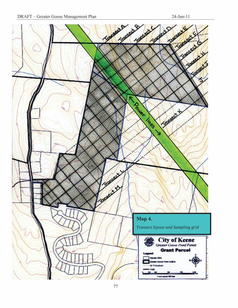
approach, a 200 x 200ft grid was superimposed on the property. The grid delineates 13 transects (A-M)
(Map 4), with a sample point plotted for each line intersection. The layout creates 97 total forested sample
points, with transects running southwest and northeast respectively. Given the transition edge imposed by
the denuded area occupied by the power-line, the sample points began 50ft past treeline on either side. Data
ceased to be collected 200ft from a developed edge on the southern boundary of the parcel (Map 3). An
examination of the aerial photo of the property indicated homogeneity in community type, northeast of the
power lines (Aerial photo 1). As such, the density of sampling points was scaled down to a 400 x 400ft
sampling grid within the area of obvious homogeneity. Given the vegetative homogeneity in conjunction
with the proximity of developed land to the south, the total number of informative forested sample points
DRAFT – Greater Goose Management Plan 24-Jun-11
59
was reduced to 74 (Map 4). The sampling design supported an unbiased approach in that the plot locations
along transects were evenly spaced, regardless of the terrain or community type.
Data Collected
Given the time of year, data collection focused primarily on woody plants within lot 15. Stand data
was acquired using the variable radius plot (VRP) (Avery and Burkhart 2002). Trees > 4” (dbh) were
defined as woody vegetation, while saplings consisted of all woody vegetation between 1” – 4” dbh. In
utilizing a 10 Basal Area Factor (BAF) prism (10 square ft of basal area per acre per tallied tree), the VRP
data in combination with dbh measurements (diameter at breast height), allowed for the calculation of the
individual total basal area (ft2/acre) per species, the number of trees per acre, and mean stand diameter
distributions throughout the parcel. These measurements provided the ability to estimate frequency, density,
and coverage, which ultimately allow for the calculation of an importance value for each species. The
importance value is a comprehensive categorization that facilitates comparative analysis between species as
well as between communities. Apart from the VRP data, every measured American beech was identified as
either infected or not infected with beech bark scale disease With this information, I was able to calculate
what percentage of the measured trees were beech, and what percentage of the beech were infected.
Determining the extent of the disease within the parcel is one way of describing stand health, and aids in
forecasting the successional direction of the delineated community.
Results
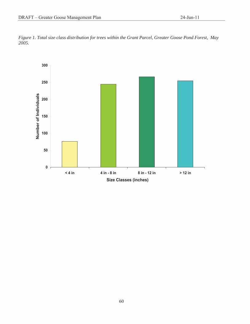
The collected data indicates that the Grant parcel contains an average of 334.3 stems/acre and 110
ft2/acre of total basal area. The upper synusium (trees ≥ 4in), made up 90% of the total number of trees
measured. The 738 measured individuals of the upper synusium had an average dbh of 10.95 ± 4.8in, while
the saplings (trees > 4in), which accounted for 10% of the trees measured, had an average dbh of 2.07 ±
0.8in. As such, the majority of trees on the property fell within the 8 – 12in dbh size class (Figure 1).
DRAFT – Greater Goose Management Plan 24-Jun-11
60
0
50
100
150
200
250
300
< 4 in 4 in - 8 in 8 in - 12 in > 12 in
Size Classes (inches)
Num
ber o
f Ind
ivid
uals
Figure 1. Total size class distribution for trees within the Grant Parcel, Greater Goose Pond Forest, May 2005.
DRAFT – Greater Goose Management Plan 24-Jun-11
- 61 -
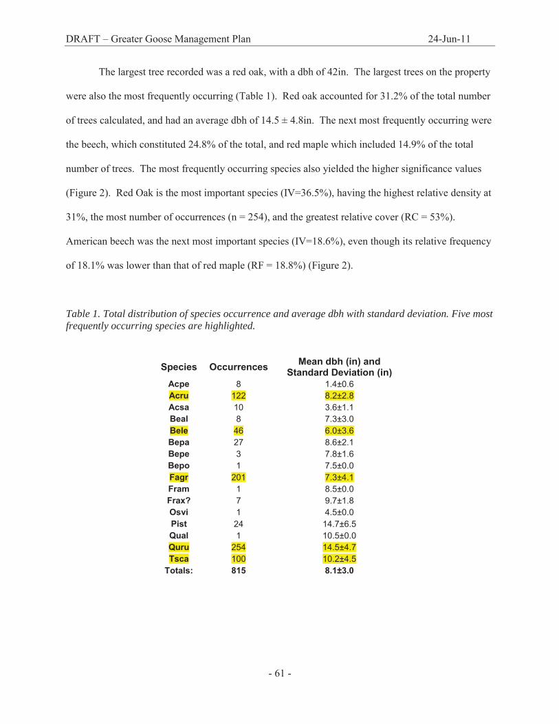
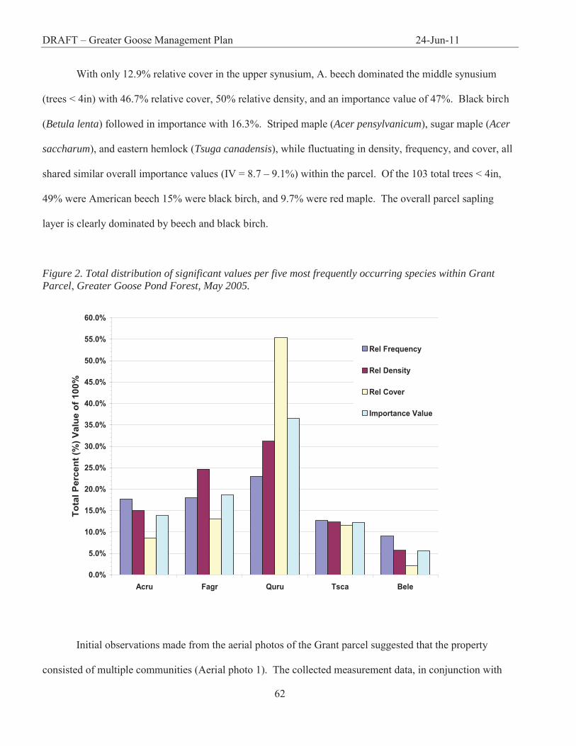
The largest tree recorded was a red oak, with a dbh of 42in. The largest trees on the property
were also the most frequently occurring (Table 1). Red oak accounted for 31.2% of the total number
of trees calculated, and had an average dbh of 14.5 ± 4.8in. The next most frequently occurring were
the beech, which constituted 24.8% of the total, and red maple which included 14.9% of the total
number of trees. The most frequently occurring species also yielded the higher significance values
(Figure 2). Red Oak is the most important species (IV=36.5%), having the highest relative density at
31%, the most number of occurrences (n = 254), and the greatest relative cover (RC = 53%).
American beech was the next most important species (IV=18.6%), even though its relative frequency
of 18.1% was lower than that of red maple (RF = 18.8%) (Figure 2).
Table 1. Total distribution of species occurrence and average dbh with standard deviation. Five most frequently occurring species are highlighted.
Species Occurrences Mean dbh (in) and Standard Deviation (in)
Acpe 8 1.4±0.6 Acru 122 8.2±2.8 Acsa 10 3.6±1.1 Beal 8 7.3±3.0 Bele 46 6.0±3.6 Bepa 27 8.6±2.1 Bepe 3 7.8±1.6 Bepo 1 7.5±0.0 Fagr 201 7.3±4.1 Fram 1 8.5±0.0 Frax? 7 9.7±1.8 Osvi 1 4.5±0.0 Pist 24 14.7±6.5 Qual 1 10.5±0.0 Quru 254 14.5±4.7 Tsca 100 10.2±4.5
Totals: 815 8.1±3.0
DRAFT – Greater Goose Management Plan 24-Jun-11
62
With only 12.9% relative cover in the upper synusium, A. beech dominated the middle synusium
(trees < 4in) with 46.7% relative cover, 50% relative density, and an importance value of 47%. Black birch
(Betula lenta) followed in importance with 16.3%. Striped maple (Acer pensylvanicum), sugar maple (Acer
saccharum), and eastern hemlock (Tsuga canadensis), while fluctuating in density, frequency, and cover, all
shared similar overall importance values (IV = 8.7 – 9.1%) within the parcel. Of the 103 total trees < 4in,
49% were American beech 15% were black birch, and 9.7% were red maple. The overall parcel sapling
layer is clearly dominated by beech and black birch.
Figure 2. Total distribution of significant values per five most frequently occurring species within Grant Parcel, Greater Goose Pond Forest, May 2005.
Initial observations made from the aerial photos of the Grant parcel suggested that the property
consisted of multiple communities (Aerial photo 1). The collected measurement data, in conjunction with
0.0%
5.0%
10.0%
15.0%
20.0%
25.0%
30.0%
35.0%
40.0%
45.0%
50.0%
55.0%
60.0%
Acru Fagr Quru Tsca Bele
Tota
l Per
cent
(%) V
alue
of 1
00%
Rel Frequency
Rel Density
Rel Cover
Importance Value
DRAFT – Greater Goose Management Plan 24-Jun-11
63
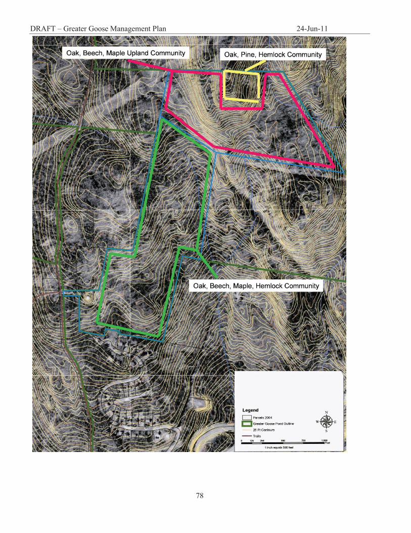
numerous ground-referencing trips to the parcel, confirmed this suspicion. The Grant parcel is composed of
3 distinct communities (Map 5). The 250ft-wide, denuded, power-line strip running NE-SW through the
parcel acts as a physical boundary between the two primary communities. The south half of the parcel
consists of an oak, beech, maple, hardwood community with a hemlock component that totals 39.7 acres
(16.1ha), and is the largest of the three communities. This section of the property is topographically less
severe than the northern section and has one small stream and two seasonal drainage routes running SW
through the community. The north end of the parcel is designated as an oak, beech, maple upland, and totals
37 acres (14.9ha). The north end of the property is primarily dry upland, despite a small moist lowland area
to the east end of the parcel. The third community is a small subsection of the upland oak, beech, maple
community composing 4.98 acres (2ha) atop the ridgeline at the far north end of the property. The habitat
within this area is that of a dry, rocky upland hardwood / softwood transitional forest.
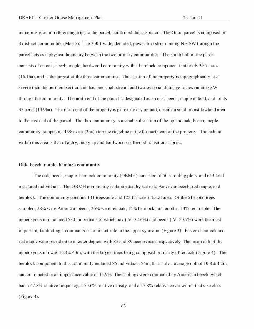
Oak, beech, maple, hemlock community
The oak, beech, maple, hemlock community (OBMH) consisted of 50 sampling plots, and 613 total
measured individuals. The OBMH community is dominated by red oak, American beech, red maple, and
hemlock. The community contains 141 trees/acre and 122 ft2/acre of basal area. Of the 613 total trees
sampled, 28% were American beech, 26% were red oak, 14% hemlock, and another 14% red maple. The
upper synusium included 530 individuals of which oak (IV=32.6%) and beech (IV=20.7%) were the most
important, facilitating a dominant/co-dominant role in the upper synusium (Figure 3). Eastern hemlock and
red maple were prevalent to a lesser degree, with 85 and 89 occurrences respectively. The mean dbh of the
upper synusium was 10.4 ± 43in, with the largest trees being composed primarily of red oak (Figure 4). The
hemlock component to this community included 85 individuals >4in, that had an average dbh of 10.8 ± 4.2in,
and culminated in an importance value of 15.9% The saplings were dominated by American beech, which
had a 47.8% relative frequency, a 50.6% relative density, and a 47.8% relative cover within that size class
(Figure 4).
DRAFT – Greater Goose Management Plan 24-Jun-11
64
0
20
40
60
80
100
120
AcpeAcru
AcsaBeal
BeleBepa
BepeBepo
FagrFram
Frax?Pist
QuruTsca
Oak, Beech, Maple, Hemlock Community Species
Num
ber o
f Ind
ividu
als
< 4 in
4 in - 8 in
8 in - 12 in
> 12 in
Figure 3. Distribution of significance values per five most occurring species of the oak, beech, maple, hemlock community. Grant Parcel, Greater Goose Pond Forest, May 2005.
Figure 4. Size distribution within oak, beech, maple, hemlock community. Grant Parcel, Greater Goose Pond Forest, May 2005.
American
beech was
0.0%
5.0%
10.0%
15.0%
20.0%
25.0%
30.0%
35.0%
40.0%
45.0%
50.0%
AcruAcsa
BealBele
BepaBepe
BepoFagr
FramFrax?
PistQuru
Tsca
Species
Perc
ent (
%) o
f 100
Rel. Frequency
Rel Density
Rel. Cover
Importance Value
DRAFT – Greater Goose Management Plan 24-Jun-11
65
overwhelmingly the most dominant species of the lower synusium, with an importance percentage of 47.3%
that vastly exceeded other IV values. The next most important species was black birch (IV=14.8%).
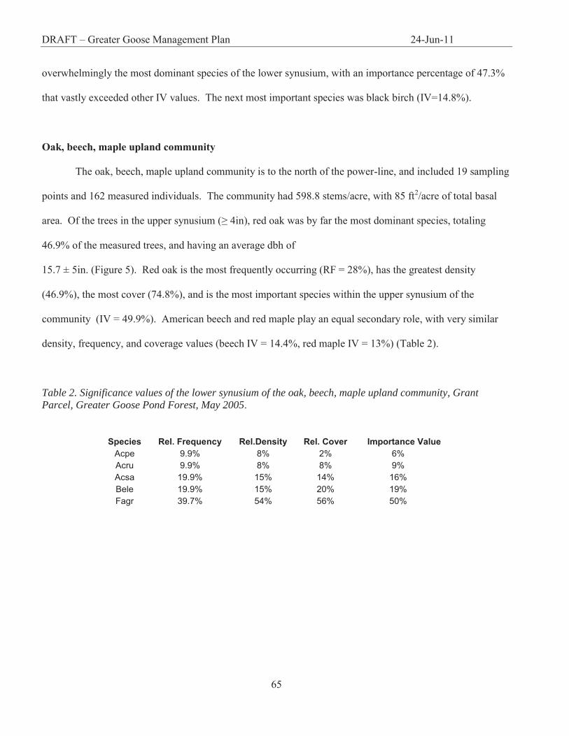
Oak, beech, maple upland community
The oak, beech, maple upland community is to the north of the power-line, and included 19 sampling
points and 162 measured individuals. The community had 598.8 stems/acre, with 85 ft2/acre of total basal
area. Of the trees in the upper synusium (≥ 4in), red oak was by far the most dominant species, totaling
46.9% of the measured trees, and having an average dbh of
15.7 ± 5in. (Figure 5). Red oak is the most frequently occurring (RF = 28%), has the greatest density
(46.9%), the most cover (74.8%), and is the most important species within the upper synusium of the
community (IV = 49.9%). American beech and red maple play an equal secondary role, with very similar
density, frequency, and coverage values (beech IV = 14.4%, red maple IV = 13%) (Table 2).
Table 2. Significance values of the lower synusium of the oak, beech, maple upland community, Grant Parcel, Greater Goose Pond Forest, May 2005.
Species Rel. Frequency Rel.Density Rel. Cover Importance Value Acpe 9.9% 8% 2% 6% Acru 9.9% 8% 8% 9% Acsa 19.9% 15% 14% 16% Bele 19.9% 15% 20% 19% Fagr 39.7% 54% 56% 50%

DRAFT – Greater Goose Management Plan 24-Jun-11
66
Figure 5. Size distribution within the oak, beech, maple upland community. Grant Parcel, Greater Goose Pond Forest, May 2005.
The sapling layer is dominated primarily with American beech, which accounted for 53.8% of the
total number of trees < 4in, and had an importance value of 50%. The next most important saplings in this
size class are black birch (IV = 19%), and sugar maple (IV = 16%), which each accounted for 15.4% of the
total number of individuals measured (Table 3).
Table 3. Total oak, beech, maple upland community species significance values, with the three most important species highlighted. Grant Parcel, Greater Goose Pond Forest, May 2005.
Species Mean dbh and SD tree ba Rel. Freq Rel.Density Rel. Cover Importance Acpe 2.0±0.0 0.02 1.6% 0.6% 0.0% 0.7% Acru 7.7±2.0 9 17.2% 16.0% 5.9% 13.0% Acsa 3.8±1.5 0.42 6.2% 3.1% 0.3% 3.2% Beal 12.0±0.0 0.79 1.6% 0.6% 0.5% 0.9% Bele 4.8±2.1 0.59 4.7% 2.5% 0.4% 2.5% Bepa 9.3±1.3 3.35 7.8% 4.3% 2.2% 4.8% Bepe 8.8±0.4 0.83 1.6% 1.2% 0.5% 1.1% Fagr 7.3±4.2 10.28 20.3% 16.0% 6.7% 14.4% Frax? 10.0±0.9 1.64 1.6% 1.9% 1.1% 1.5% Pist 12.9±6.1 8.71 4.7% 4.9% 5.7% 5.1% Qual 10.5±0.0 0.6 1.6% 0.6% 0.4% 0.9%
0
10
20
30
40
50
60
Acpe
Acru Acsa
Beal
BeleBep
aBep
eFag
rFrax
?Pist
QualQuru
Tsca
Oak, Beech, Maple Community Species
Num
ber o
f Tre
es
< 4 in
4 in - 8 in
8 in - 12 in
> 12 in
DRAFT – Greater Goose Management Plan 24-Jun-11
67
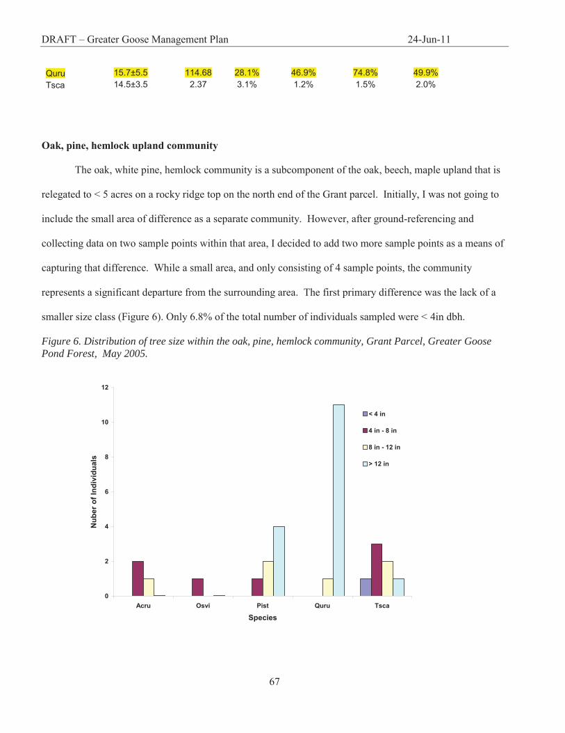
Quru 15.7±5.5 114.68 28.1% 46.9% 74.8% 49.9% Tsca 14.5±3.5 2.37 3.1% 1.2% 1.5% 2.0%
Oak, pine, hemlock upland community
The oak, white pine, hemlock community is a subcomponent of the oak, beech, maple upland that is
relegated to < 5 acres on a rocky ridge top on the north end of the Grant parcel. Initially, I was not going to
include the small area of difference as a separate community. However, after ground-referencing and
collecting data on two sample points within that area, I decided to add two more sample points as a means of
capturing that difference. While a small area, and only consisting of 4 sample points, the community
represents a significant departure from the surrounding area. The first primary difference was the lack of a
smaller size class (Figure 6). Only 6.8% of the total number of individuals sampled were < 4in dbh.
Figure 6. Distribution of tree size within the oak, pine, hemlock community, Grant Parcel, Greater Goose Pond Forest, May 2005.
0
2
4
6
8
10
12
Acru Osvi Pist Quru Tsca
Species
Nub
er o
f Ind
ivid
uals
< 4 in
4 in - 8 in
8 in - 12 in
> 12 in

DRAFT – Greater Goose Management Plan 24-Jun-11
68
Figure 7. Distribution of species significance within the oak, pine, hemlock community, Grant Parcel, Greater Goose Pond Forest, May 2005.
The second difference was the increased importance of white pine and hemlock as evergreen
components of this hardwood forest (Figure 7). While red oak remained the dominant species (IV = 45.6%),
pine and hemlock provided important compositional components as well (Pist IV = 22.2%, Tsca IV =
17.4%). The two co-dominant species had the same number of individuals sampled, as well as similar
frequency and density values, however, they differed in percent cover (pine RC = 21.8%, hemlock RC =
17.3%). This difference can be attributed to the comparatively lower number of hemlocks > 12in dbh, which
resulted in lower overall relative coverage.
Fagus grandifolia health
Of the 815 total individuals measured, 201, or 24.7% were American beech. Of that 24%, 89.1% (or
179 individuals), were infected with beech bark scale disease (Figure 8). Within the oak, beech, maple,
hemlock community, beech accounted for 28.7% (or 176 individuals), of the total number of measured trees.
Of that 28.7%, 90.3% were infected. The oak, beech, maple upland community displayed similarly high
0.0%
10.0%
20.0%
30.0%
40.0%
50.0%
60.0%
70.0%
80.0%
Acru Osvi Pist Quru Tsca
Species
Perc
ent (
%) o
f 100
Rel. Frequency
Rel. Density
Rel. Cover
Importance Value

DRAFT – Greater Goose Management Plan 24-Jun-11
69
numbers, with beech accounting for 16.4% of the measured population, of which 80.8% were infected. Zero
beech were measured within the oak, pine, hemlock community. In order to determine if there was a
significant difference (P = 0.05) between size classes and the presence or absence of infection, I performed
nonparametric analysis utilizing the Wilcoxon signed-rank test for the analysis of matched pairs. There was
no significant difference in the distribution of infection among different size classes (Wilcoxon signed-rank,
z = -3, P = 0.25). A qualitative assessment regarding the degree of infection of each infected tree indicated
that > 65% of the infected trees were severely infected (severely equals > 45% visible exterior damage).
Figure 8. Distribution of infected and not-infected Fagr between the two primary communities within the Grant Parcel, Greater Goose Pond Forest, May 2005.
.
0
10
20
30
40
50
60
70
80
90
100
Oak, Beech, MapleUpland
Oak, Beech, Maple,Hemlock Upland
Total Parcel
Community Type
% o
f Tot
al
% Fagr of Total
% Infected
% Not Infected

DRAFT – Greater Goose Management Plan 24-Jun-11
70
Discussion
The soils and species composition within the Grant parcel indicate that the forest is a southern,
transitional, mixed hardwood, oak, beech, maple acidic upland forest. The oak, beech, maple community to
the north of the power-lines, is a clear representation of this categorization. The oak, beech, maple, hemlock
community is essentially a more lowland variant of the oak, beech, maple community, with the exception
that the shift from the upland Tunbride-Lyman “outcrop” soils to the lowland sandy loams, provided a
substrate more ideal for hemlock germination subsequent to disturbance. Both the oak, beech, maple upland,
and the oak, beech, maple, hemlock community, are broadly defined by the NH natural communities
classification system as an S5 Hemlock, beech, oak, pine forest. This community type is widely represented
in southern New Hampshire, and includes numerous variations depending on the microhabitat and land-use
history. The community can vary from hardwood, hardwood-softwood, or mostly softwood dominated
stands (Sperduto and Nichols 2004).
The size distributions of trees within the parcel suggest an early to mid successional forest (Figure 1).
This is evidenced by the fact that the majority of trees are 8-12 in dbh, as well as the fact that there is a
general absence of hemlock (considered a “late successional species”) as a canopy species. Furthermore,
numerous even-aged red oak with the extensive evidence of past land use history that includes: agriculture,
pasturing, and logging as recently as 50 years ago, limits the time of undisturbed succession. The coppiced
trunks of red oak and white pine indicate that the property has been logged at least once. Also, the absence of
white pine growth after that event suggests that the most recent logging was not a clear-cut, but a selective
cut, thus reducing the amount of full sun that is a prerequisite for white pine seedling establishment.
The widespread presence of red oak, in combination with the reduced number of saplings, indicates
that the successional direction of the forest is toward an oak-beech dominated canopy, with large scale
structural changes initiated only through widespread canopy disturbance. Save human disturbance, the most
likely structural fluctuations to occur would be within stands where American beech have particularly high
importance values. The prevalence of the fungus Nectria coccinea on the property indicates that it is only a

DRAFT – Greater Goose Management Plan 24-Jun-11
71
matter of time before the canopy opens up as the beech give way to the disease. Given that beech tends to
respond to parasitic disturbance with clonal reproduction, one can expect the middle synusium to be beech
dominated for the foreseeable future, possibly hampering the maturation of the present red maple and black
birch saplings.
New Hampshire’s forested landscapes are full of physical indicators evidencing a history of poor
logging practices. Even-aged stands lacking diversity within a maze of old logging roads are an abundant
reminder of the clear-cutting that took place only a few decades ago. Logging that occurred during that time
had few protocols regarding timber harvest within ecologically “sensitive” areas, or concerns regarding
issues of erosion within clear-cuts. It is only recently that timber harvests have begun to incorporate
ecological considerations into their practices. The primary data provided by this NRI will help to facilitate
informed land use management decisions made by the City of Keene, and contribute to baseline data for
future ecological studies within the Greater Goose Pond Forest.
DRAFT – Greater Goose Management Plan 24-Jun-11
72
Chart 1: Grant Parcel Soils Table Soils associated with the Grant Parcel (lot 11) of the Greater Goose Pond Forest, Keene, NH

DRAFT – Greater Goose Management Plan 24-Jun-11
73
1Erosion Hazard – the probability that erosion can occur as a result of site preparation or cutting. Slight – no particular measures need to be taken to prevent erosion under normal conditions Moderate – erosion control measures are needed for silviculture activities Severe – special precautions are necessary to control erosion in most silviculture activities 2Wind Throw – the likelihood that trees will be uprooted by wind Slight – no trees are normally uprooted by wind Moderate – moderate or strong winds occasionally uproot trees when soil is wet Severe – moderate or strong winds may blow down many trees when soil is wet 3Site Index – average height in feet that a dominant or co-dominant tree can reach in a specified number of years *Source: United States Department of Agriculture. 1989. Soil Survey of Cheshire County New Hampshire. National Cooperative Soil Survey (United States Department of Agriculture Soil Conservation Service and New Hampshire Agricultural Experimental Station).
Soil Code
Soil Name
Slope Acreage Hardwood and
Coniferous Tree Habitat
Management Concerns
Productivity
Erosion Hazard1
Wind Throw2
Species Site Index3
143C Monadnock fine sandy loam, very stony
8-15% 15.2 Good Slight Slight P. strobus Q. rubra P. rubens P. glauca
63 55 60 55
143D Monadnock fine sandy loam, very stony
15-25%
25.0 Good Moderate Slight P. strobus Q. rubra P. rubens P. glauca
63 55 60 55
61C Tunbridge-Lyman outcrop complex
8-15% 24.9 Good - Tunbridge /
Poor - Lyman
Slight Moderate P. strobus Q. rubra A. saccharum P. rubens B. alleghaniensis P. glauca F. americana
70 70 60 45 55 55 65
61D Tunbridge-Lyman outcrop complex
15-25%
34.0 Good - Tunbridge /
Poor - Lyman
Moderate Moderate P. strobus Q. rubra A. saccharum P. rubens B. alleghaniensis P. glauca F. americana
70 70 60 45 55 55 65

DRAFT – Greater Goose Management Plan 24-Jun-11
74
Map 1. Greater Goose Pond Parcel Map City of Keene (From DuBois and King 2002)

DRAFT – Greater Goose Management Plan 24-Jun-11
75
Map 2. Grant Parcel Soil Map City of Keene Planning Office

DRAFT – Greater Goose Management Plan 24-Jun-11
76
Map 3. Grant Parcel Topography City of Keene Planning Office
DRAFT – Greater Goose Management Plan 24-Jun-11
77
Map 4. Transect layout and Sampling grid
DRAFT – Greater Goose Management Plan 24-Jun-11
78

DRAFT – Greater Goose Management Plan 24-Jun-11
79
Aerial Photo 1
DRAFT – Greater Goose Management Plan 24-Jun-11
80
Literature Cited
Albers, J. 2000. Hands on the Land: A History of the Vermont Landscape. Orton Family Foundation, Rutland, VT. Avery, T.E., and Burkhart, H.E. 2002. Forest Measurements. McGraw Hill. NY. Brower, J.E., J.H Zar, and C.N von Ende. 1997. Field and Laboratory Methods for General Ecology. 4th ed. Wm C. Brown Publishers, Dubuque, IA. City of Keene, City Planning Department. 3 Washington St. Keene, NH 03431. (603) 352-5474 Dubois and King, Inc. City of Keene Natural Resources Inventory – Greater Goose Pond Forest and Sterns Hill Natural Area. (2002). 25 Wentworth Drive. Williston, VT. 05495. Moore, G.E. 1949. Geological Map and Structure Sections of the Keene and Brattleboro Quadrangles, New Hampshire. Petrides, G.A. 1986. Peterson Field Guide to Trees and Shrubs. Second edition. Houghton Mifflin, Boston. Sorenson, E.R. and Thompson, E.H. 2000. Wetland,Woodland,Wildland: A Guide to the Natural Communities of Vermont. University Press of New England, Hanover, NH. Sperduto, D.D., and Nichols, W.F. 2004. Natural Communities of New Hampshire. The New Hampshire Natural Heritage Bureau and The Nature Conservancy. UNH Cooperative Extension, Durham, NH. Terraserver.com homepage. http://www.terraserver.com
Trelease, W. 1967. Winter Botany: An identification guide to native trees and shrubs. Dover Publications Inc. New York, NY. Van de Poll, R. and Donahue, C. Vegetation Analysis of Four Biologically Significant Interest Areas of the Greater Goose Pond Forest. (1996). Antioch New England Graduate School. 40 Avon St. Keene, NH. 03431 Van Diver, B.B 1987. The Roadside Geology of Vermont and New Hampshire. Mountain Press Publishing Co. Missoula, MT. USDA Soil Conservation Service, 1989. Soil Survey of Cheshire County, New Hampshire. Wessels, T. 1997. Reading the Forested Landscape: A Natural History of New England. The Countryman Press, Woodstock, VT.

DRAFT – Greater Goose Management Plan 24-Jun-11
81
APPENDIX VI: Additional Information – Forestry Resources

DRAFT – Greater Goose Management Plan 24-Jun-11
82
Forest Management Resources – New Hampshire UNH – Cooperative Extension http://extension.unh.edu/Forestry/Forestry.htm The UNH Forest and Trees Cooperative Extension provides information and assistance regarding the management of New Hampshire’s forest resources. Assistance is provided through County Extension Programs. The County Extension Forestry and Wildlife program provides technical assistance and information and educational services in the field of forest resources to private woodland owners, primary processors, organizations, communities, and the general public. Some of the areas in which assistance is provided include:
Woodland management and planning Utilization and marketing Community forestry Wildlife management Multiple-use management Insect and disease concerns Christmas tree production Maple syrup production Forest taxation and finances Permanent land protection
Assistance is provided through individual contacts and site visits, workshops, newsletters, publications and demonstrations. Sound utilization and conservation of the forest resource is the prime objective of the County Forestry Program. Society for the Protection of New Hampshire’s Forests http://www.spnhf.org/ The Society for the Protection of New Hampshire’s Forests (SPNHF) is dedicated to protecting the state's most important landscapes while promoting the wise use of its renewable natural resources. SPNF provides assistance to land trusts, municipalities, state and federal agencies, and other conservation organization to protect land throughout the state. Since 1901, SPNF has protected over one million acres of open space, promoted good land stewardship through education and example, and advocated for public policies that encourage wise conservation. New Hampshire Timberland Owners Association http://www.nhtoa.org New Hampshire Timberland Owners Association (NHTOA) is a non-profit statewide coalition of landowners, forest industry professionals, government officials, and supporters who work together to promote better forest management, conserve New Hampshire’s working forests, and insure a strong forest products industry.
DRAFT – Greater Goose Management Plan 24-Jun-11
83
Forestry Certification Organizations Forestry certification provides many added benefits to forest management operations. Primarily, bearing the trademark of a certifying organization provides industry and consumers with the assurance that the forest products used were harvested in a sustainable manner. Forest Stewardship Council (FSC) - http://www.fsc.org/en/ FSC Small and Low Intensity Managed Forests Initiative http://www.fsc.org/slimf/ FSC has been recognized as an international organization that provides a system for different stakeholders interested in forest issues to work towards responsible forest management. The forestry standards and requirements developed by the FSC are capable of being applied to any size forest. The Small and Low Intensity Managed Forest (SLIMF) initative created by the FSC is designed so small and low intensity forestry operations can take advantage of FSC certification. Under SLIMF, a small forest is defined as comprising less than 100 hectares (247 acres) while a low intensity forest operation is where harvesting removes less than twenty percent of a forest’s mean annual increment of forest production. SmartWood http://www.rainforest-alliance.org/programs/forestry/smartwood SmartWood, established in 1989, was the world’s first independent forestry certifier. Today, SmartWood is the world’s leading non-profit forest certifier and leading FSC certifier. SmartWood certifies all types and sizes of forest management operations from large plantations to small family-owned operations. Beyond FSC certification programs, SmartWood offers four additional programs:
Verification – provides companies using or purchasing forest products third party verification of the source and legality of raw materials being used in their products.
SmartStep – provides more opportunities and incentives for forest management operation to pursue FSC certification.
Controlled Wood Verification – gives acknowledgement to companies, under FSC’s Controlled Wood Program, that the wood products used are not coming from controversial sources.
SmartLogging – provides third party audit and certification system for loggers and enables them to demonstrate to customers that logging will be done responsibly.
Sustainable Forestry Initiative http://www.aboutsfi.org/core.asp The Sustainable Forestry Initiative (SFI) was developed by the American Forest & Paper Association (AF&PA). The program was developed to document the commitment of AF&PA members to keep our forests healthy and practice the highest level of sustainable forestry. SFI is a comprehensive system of principles, objectives and performance measures developed by professional foresters, conservationists, and scientists that combines the perpetual growing and harvesting of trees with the long-term protection of wildlife, plants, soil and water quality.
DRAFT – Greater Goose Management Plan 24-Jun-11
84
American Tree Farm System http://www.treefarmsystem.org/ The American Tree Farm System (ATFS) is a part of the American Forests Foundation. The mission of ATFS is to promote the growing of renewable forest resources on private lands while protecting environmental benefits and increasing public understanding of all the benefits of productive forestry. ATFS seeks to sustain forests, watersheds, and healthy habitats through private stewardship. To become a certified tree farm, landowners must submit a management plan to ATFS that meets strict environmental standards and undergo inspection by an ATFS certified forester every five years.
DRAFT – Greater Goose Management Plan 24-Jun-11
85
APPENDIX VII: Friends of Open Space Letter
DRAFT – Greater Goose Management Plan 24-Jun-11
86
Mr. John Bordenet, Chair October 5, 2005 Keene Conservation Commission 3 Washington St. Keene, NH 03431 Dear John, The Friends of Open Space recently completed an inventory of open space land on the hillsides of Keene. We have developed this inventory to give us a picture of what land needs to be protected so that these hillsides remain forested in the future. This will protect our ‘viewscape’ as well as reduce the effects of runoff from development. The survey includes both private and city-owned land.
The Greater Goose Pond Forest is a key area which covers a good part of the hill side to the north east of Keene as viewed from the center of the city. This land is owned by the City. However, at some future date the land could be rezoned and sold by the City, if a future council so decided. The area could be developed for housing or for commercial use. While this scenario may sound highly unlikely to occur, it has happened in other communities under the pressure of city financial needs or of need for house lots.
One solution to the long term protection of this property is for the City to put a conservation easement on the land with a recognized land trust. The Friends of Open Space in Keene would like the opportunity of presenting to you the structure of such an easement with the hope that your group would include in your new long range plan for the Greater Goose Pond Forest a recommendation that the City place a conservation easement on a major part of the forest to insure that it would remain undeveloped forever. We would appreciate having 30 minutes or so at one of your upcoming meetings to make this presentation. Very truly yours, Peter D. Hansel President
![Sigma 3-30KS Sigma 3-30KHS€¦ · Diameter x length [mm] 10.8 x 46.5 10.7 x 42 10.7 x 42 17 x 60 12 x 75 12 x 100 12 x 100 16.1 x 81.1 16.1 x 81.1 16.1 x 81.1 Tube. MTP DWP. . 3](https://static.fdocuments.us/doc/165x107/6039aebeb6429c21e472bcf4/sigma-3-30ks-sigma-3-30khs-diameter-x-length-mm-108-x-465-107-x-42-107-x-42.jpg)