Grays Arch Trail #205 Map, D. Boon Hut Trail #209 Map, Red ...
3
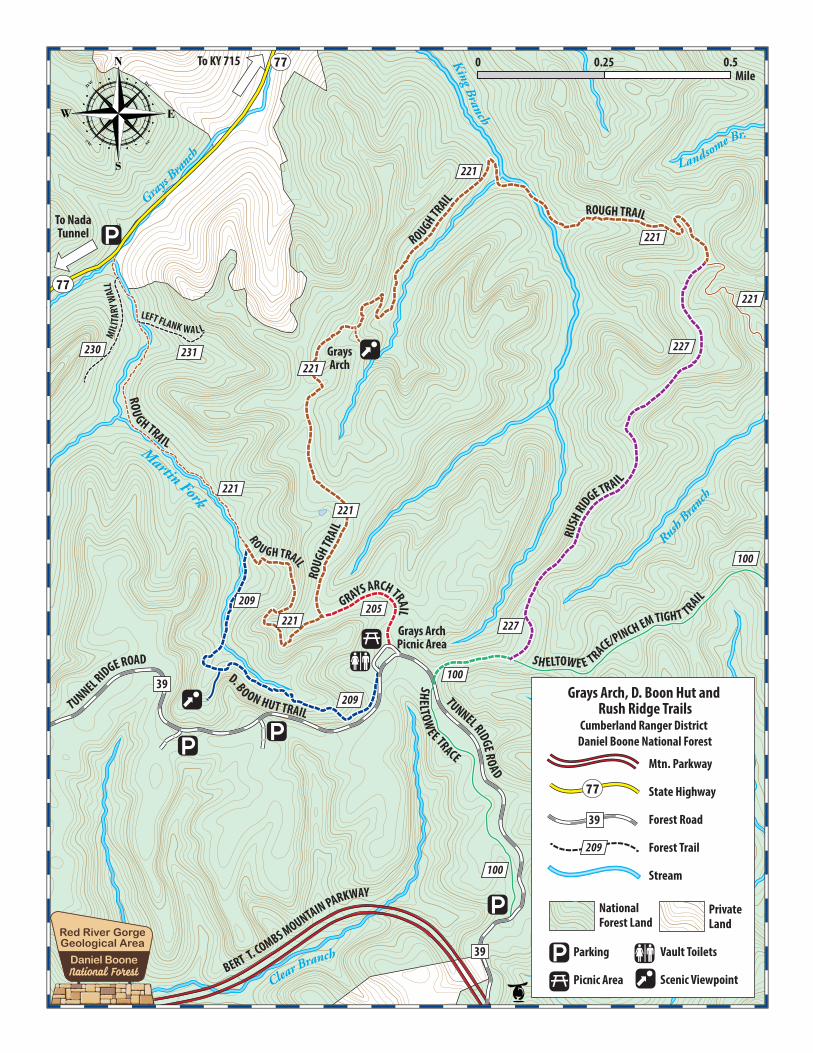
Gladie Visitor Center 3451 Sky Bridge Road Stanton, KY 40380 606-663-8100 Open 7 days a week March to November. Directions to Trailhead Traveling east on the Mountain Parkway, take exit 33 at Slade. Turn left and then right onto KY 15; travel east 3.2 miles to Tunnel Ridge Road on the left. Follow Tunnel Ridge Road 0.7 miles to the Grays Arch Picnic Area on the right. Parking Grays Arch Picnic Area Open Dates Trails areopen all year. Trail Fees None. Permit You must buy a permit if camping in the Red River Gorge between 10 p.m. and 6 a.m. Accessibility These trails do not meet accessibility standards for persons with disabilities. These hiking-only trails are closed to motorized vehicles. Consumption of alcohol and open containers of alcohol are prohibited. Camping and firebuilding in rock shelters is prohibited. Camping is prohibited within 600 feet of Grays Arch. These trails are located on the Cumberland Ranger District in the Red River Gorge. They are accessed from the Grays Arch Picnic Area on Tunnel Ridge Road. The picnic area has tables and accessible vault toilets, but no drinking water. You can make a short loop hike by combining Grays Arch Trail, D. Boon Hut Trail and a short portion of Rough Trail. For a longer loop hike, follow Grays Arch Trail to Rough Trail, which will take you past Grays Arch. After Grays Arch, continue north on Rough Trail and the Kings Branch creek crossing, going east to its junction with Rush Ridge Trail. After its junction with the Sheltowee Trace, travel west back to Tunnel Ridge Road and Grays Arch Picnic Area. Quad: Slade Closest Town: Slade County: Powell Latitude: 37.807575 Surface: Dirt Longitude: -83.657581 Grays Arch Trail #205 Grays Arch Trail begins at the Grays Arch Picnic Area. After 1/4-mile, the trail follows Rough Trail #221 down the ridge and then off into a drain to King Branch. The trail again forks, continuing to Grays Arch. The trail is scenic and rich in native flora. During wet weather, a beautiful waterfall occurs at the arch. Grays Arch is 50 feet high and spans 80 feet across. The arch extends off the end of a cliff and forms a buttress. Begins: Grays Arch Picnic Area Difficulty: Moderate Ends: Grays Arch Length: .25 mile D. Boon Hut Trail #209 D. Boon Hut Trail leaves the picnic area and descends into a deep gorge under towering cliffs. Below the cliffs are cove hardwoods with a thick rhododendron understory and other native flora. The trail leads to a large fenced rock shelter that was once mined for saltpeter. Begins: Grays Arch Picnic Area Difficulty: Moderate Ends: Rough Trail #221 Length: 1 mile Rush Ridge Trail #227 Rush Ridge Trail is a connector trail that passes along a wooded ridge with several scenic overlooks into the gorge. The trail connects the Sheltowee Trace #100 (Pinch-Em-Tight section) with Rough Trail #221. U.S. Department of Agriculture - Forest Service Southern Region - Daniel Boone National Forest http://www.fs.usda.gov/dbnf USDA is an equal opportunity provider, employer and lender. Cliffline Safety The cliffs of the Red River Gorge add to the scenic beauty, but getting too close to the edge can be extremely dangerous. The cliffs in this area average nearly 100 feet. A fall from the cliff can be fatal or cause serious injury. Accidental falls usually involve one or more of the following: • Camping too close to the edge of a cliff. Maintain a safe distance away from cliff edges to avoid accidental falls. • Walking around after dark. At night, visual perception is impaired. The edge of a cliff may not be easily recognized. • Drinking alcohol or using drugs. Intoxication reduces coordination, distorts perception, and impairs judgment. • Risky behavior or stunts. Use good judgement, and never cross barriers or ignore warning signs. Camp 300 feet AWAY from any road or trail.
Transcript of Grays Arch Trail #205 Map, D. Boon Hut Trail #209 Map, Red ...
Gladie Visitor Center3451 Sky Bridge RoadStanton, KY 40380606-663-8100Open 7 days a week March to November.
Directions to TrailheadTraveling east on the Mountain Parkway, take exit 33 at Slade. Turn left and then right onto KY 15; travel east 3.2 miles to Tunnel Ridge Road on the left. Follow Tunnel Ridge Road 0.7 miles to the Grays Arch Picnic Area on the right.
ParkingGrays Arch Picnic AreaOpen Dates Trails areopen all year.
Trail FeesNone.
PermitYou must buy a permit if camping in the Red River Gorge between 10 p.m. and6 a.m.
AccessibilityThese trails do not meet accessibility standards for persons with disabilities.
These hiking-only trails are closed to motorized vehicles.
Consumption of alcohol and open containers of alcohol are prohibited.
Camping and firebuilding in rock shelters is prohibited. Camping is prohibited within 600 feet of Grays Arch.
These trails are located on the Cumberland Ranger District in the Red River Gorge. They are accessed from the Grays Arch Picnic Area on Tunnel Ridge Road. The picnic area has tables and accessible vault toilets, but no drinking water.You can make a short loop hike by combining Grays Arch Trail, D. Boon Hut Trail and a short portion of Rough Trail. For a longer loop hike, follow Grays Arch Trail to Rough Trail, which will take you past Grays Arch. After Grays Arch, continue north on Rough Trail and the Kings Branch creek crossing, going east to its junction with Rush Ridge Trail. After its junction with the Sheltowee Trace, travel west back to Tunnel Ridge Road and Grays Arch Picnic Area.
Quad: Slade Closest Town: SladeCounty: Powell Latitude: 37.807575Surface: Dirt Longitude: -83.657581
Grays Arch Trail #205Grays Arch Trail begins at the Grays Arch Picnic Area. After 1/4-mile, the trail follows Rough Trail #221 down the ridge and then off into a drain to King Branch. The trail again forks, continuing to Grays Arch. The trail is scenic and rich in native flora. During wet weather, a beautiful waterfall occurs at the arch. Grays Arch is 50 feet high and spans 80 feet across. The arch extends off the end of a cliff and forms a buttress.
Begins: Grays Arch Picnic Area Difficulty: ModerateEnds: Grays Arch Length: .25 mile
D. Boon Hut Trail #209D. Boon Hut Trail leaves the picnic area and descends into a deep gorge under towering cliffs. Below the cliffs are cove hardwoods with a thick rhododendron understory and other native flora. The trail leads to a large fenced rock shelter that was once mined for saltpeter.
Begins: Grays Arch Picnic Area Difficulty: ModerateEnds: Rough Trail #221 Length: 1 mile
Rush Ridge Trail #227Rush Ridge Trail is a connector trail that passes along a wooded ridge with several scenic overlooks into the gorge. The trail connects the Sheltowee Trace #100 (Pinch-Em-Tight section) with Rough Trail #221.
U.S. Department of Agriculture - Forest ServiceSouthern Region - Daniel Boone National Foresthttp://www.fs.usda.gov/dbnfUSDA is an equal opportunity provider, employer and lender.
Cliffline SafetyThe cliffs of the Red River Gorge add to the scenic beauty, but getting too close to the edge can be extremely dangerous. The cliffs in this area average nearly 100 feet. A fall from the cliff can be fatal or cause serious injury. Accidental falls usually involve one or more of the following:
• Camping too close to the edge of a cliff. Maintain a safe distance away from cliff edges to avoid accidental falls.
• Walking around after dark. At night, visual perception is impaired. The edge of a cliff may not be easily recognized.
• Drinking alcohol or using drugs. Intoxication reduces coordination, distorts perception, and impairs judgment.
• Risky behavior or stunts. Use good judgement, and never cross barriers or ignore warning signs.
Camp 300 feet AWAY from any road or trail.
All outdoor activities have inherent risks and you may encounter a variety of unexpected and/or dangerous conditions. It is your responsibility to be informed and take precautions. Learn more at www.fs.usda.gov/r8.
GladieVisitor Center
Storing Your Food and Trash
Unless cooking or eating, store your food inside a closed vehicle with a solid top, a closed, hard-body trailer, or a bear-resistant container. Store your food garbage in the same manner where trash cans are not installed. Do not burn or bury foods, refuse, or bear attractants.
When camping in the backcountry, suspend food and trash at least 10 feet clear of the ground at all points, suspended at least 4 feet horizontally from the supporting tree or pole, and suspended at least 4 feet from any other tree or pole adjacent to the supporting pole or tree.Food and trash storage is mandatory (DB-02-15)
Put your trash in bear-resistant trash cans, in areas where they are provided.
Store food and trash inside a closed vehicle with a solidtop.
Hang food and trash from a tree, out of bear’s reach in backcountry areas where bear-resistant trash cans and vehicles are not nearby.
Rules and RegulationsObserve these rules to help protect the forest resources, facilities and visitor experience.
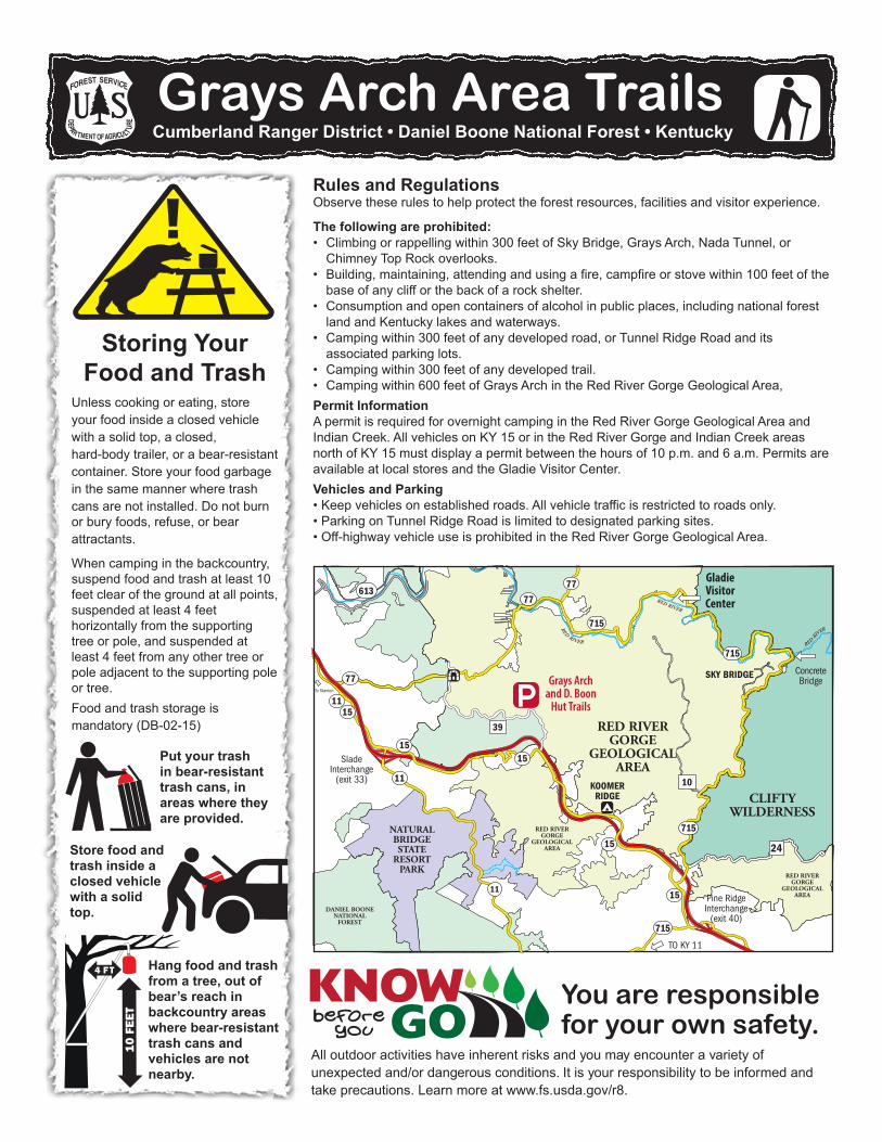
The following are prohibited: • Climbing or rappelling within 300 feet of Sky Bridge, Grays Arch, Nada Tunnel, or
Chimney Top Rock overlooks.• Building, maintaining, attending and using a fire, campfire or stove within 100 feet of the
base of any cliff or the back of a rock shelter.• Consumption and open containers of alcohol in public places, including national forest
land and Kentucky lakes and waterways.• Camping within 300 feet of any developed road, or Tunnel Ridge Road and its
associated parking lots.• Camping within 300 feet of any developed trail.• Camping within 600 feet of Grays Arch in the Red River Gorge Geological Area,Permit InformationA permit is required for overnight camping in the Red River Gorge Geological Area and Indian Creek. All vehicles on KY 15 or in the Red River Gorge and Indian Creek areas north of KY 15 must display a permit between the hours of 10 p.m. and 6 a.m. Permits are available at local stores and the Gladie Visitor Center.Vehicles and Parking• Keep vehicles on established roads. All vehicle traffic is restricted to roads only.• Parking on Tunnel Ridge Road is limited to designated parking sites.• Off-highway vehicle use is prohibited in the Red River Gorge Geological Area.