Grassy Butte Ranch Brothers, OR ebook
40
Grassy Butte Ranch – Central Oregon For more information contact: Pam Mayo-Phillips, Principal Broker C: 541-480-1513 [email protected] or Brook Havens, Principal Broker C: 541-604-0788 [email protected] O: 541-923-1376 ~ 650 SW Bond St Suite 100 Bend, OR 97702 www.desertvalleygroup.com ~ www.cascadesothebysrealty.com All Brokers are licensed in the Sate of Oregon. Each office is independently owned & operated. All information is deemed reliable, but not guaranteed by Cascade Sotheby’s International Realty. Purchaser shall have sole responsibility to inspect the property and inform themselves of the true condition thereof. Purchaser accepts the responsibility before submitting any offer or executing contract. Any grazing permits /leases/water rights are NOT Guaranteed by Seller or Cascade Sotheby’s International Realty, Buyer is responsible for due diligence.
-
Upload
desert-valley-group-cascade-sothebys-international-realty -
Category
Documents
-
view
215 -
download
2
description
Â
Transcript of Grassy Butte Ranch Brothers, OR ebook

Grassy Butte Ranch – Central Oregon
For more information contact:
Pam Mayo-Phillips, Principal Broker
C: 541-480-1513 [email protected] or
Brook Havens, Principal Broker
C: 541-604-0788 [email protected]
O: 541-923-1376 ~ 650 SW Bond St Suite 100 Bend, OR 97702 www.desertvalleygroup.com ~ www.cascadesothebysrealty.com
All Brokers are licensed in the Sate of Oregon. Each office is independently owned & operated. All information is deemed reliable, but not guaranteed by Cascade Sotheby’s International Realty. Purchaser shall have sole responsibility to inspect the property and inform themselves of the true condition thereof. Purchaser accepts the responsibility before submitting any offer or executing contract. Any grazing permits /leases/water rights are NOT Guaranteed by Seller or Cascade Sotheby’s International Realty, Buyer is responsible for due diligence.

Grassy Butte Ranch
Address: 56300 Montgomery Road Brothers, OR 97712 Directions: Highway 20 east from Bend approximately 42 miles. Property is off of Camp Creek/Pringle Flat Rd, Merrill Rd, Montgomery Rd, & Fredrick Butte Rd
Tax Maps: Deschutes County: 2019000000400, 2018000002600, 2018000002800, 2118000000200, 2118000000900, 2119000000200 Crook County: 1919000003000, 1919000002900, 1919000002100, 1920000001700, 1919000003200, 1919000003100, 2020000001100, 2020000001000, 1920000002000, 2020000001300
Property: • 9587.42 Deeded Acres • 25,701 Acres of BLM Grazing Allotment with 3018 AUM’s - Grazing Fee $1.69 per AUM –
Season long turnout dates • Property Fenced and Crossed Fenced
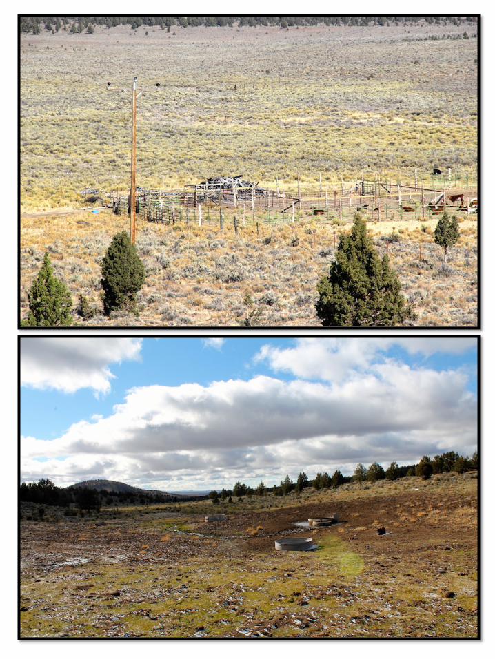
Improvements: • Good Corrals and Livestock Handling Facilities. Good Corrals with loading chute on Hwy 20 and
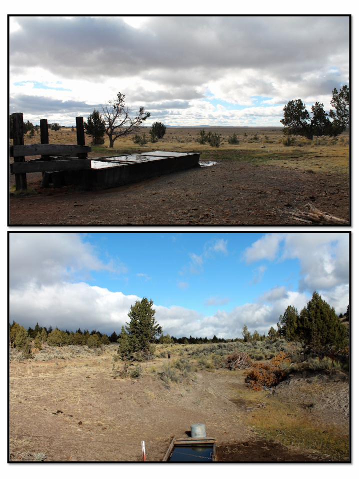
on Deeded Land on Crook County Side. • Extensive Piping and Water Troughs System from Springs and Wells serviced by windmills and
PPL power. • Pringle Flat Reservoir is registered with State. (Could be improved) Reservoir services small pivot
and may be dry in drought years. • No homes on property.
Domestic Water: no domestic wells on property, multiple livestock wells on property.
Utilities: PPL Pacific Power & Light and Windmills for livestock wells.
Taxes: 2014 $1,421.04 – Property is in farm deferral-Buyer is responsible for farm deferment.
Zoning: EFU
Terms: Cash, Owner will not Carry a Contract or Split the Property.
Price: $2,450,000. Disclosure Remarks: See Disclosure Statement Attached. Seller and sellers agents have no history of production, functioning wells and springs or quality of piping/water trough system on property. Sold “As-Is” Buyer is responsible for due diligence with BLM on Grazing Allotment there a section that may need to be repaired/rested because of new pipe installed. Property is in “Core” Sage Grouse Habitat – see ODFW map and will have restrictions. MLS 201511136 - Shown By Appointment Only, Gates on Property are locked. All information Provided by Cascade Sotheby’s International Realty and Agents is deemed reliable but not guaranteed 541-923-1376 www.desertvalleygroup.com


19190000021002760 ac.
1919000002900320 ac.
1919000003100320 ac.
1920000002000992.43 ac.
2020000001300320 ac.
1919000003000160 ac.
191900000320040 ac.
1920000001700317.12 ac.
202000000100076.44 ac.
2020000001100629.83 ac.
Crook County
Cro
ok C
ounty
Deschutes County
De
schute
s C
ounty
SE VANLAKE RD
SE CAMP CREEK RD
SE BEAR CREEK RD
SE
PR
ING
LEFL
ATR
D
SE MERRILL RD
HA
RM
ON
RDVAN LAKE RD
FRE
DE
RIC
KB
UT
TER
D
CAMP CREEK RD
MERRILL RDM
ON
TG
OM
ER
Y R
D
HWY 20
GRASSY BUTTE -GRASSY BUTTE PASTURE
GRASSY BUTTE -VARGO PASTURE
GRASSY BUTTE -HOLDING PASTURE
GRASSY BUTTE -SOUTH BUTTE PASTURE
GRASSY BUTTE -HOMESTEAD PASTURE GRASSY BUTTE -
SOUTH WELL PASTURE
GRASSY BUTTE -JUNIPER BUTTES PASTURE
GRASSY BUTTE -JUNIPER BUTTES PASTURE
211800000020040 ac.
211800000090040 ac.
2018000002600320 ac.
2018000002800950.06 ac.
20190000004002061.54 ac.
2119000000200240 ac.
DisclaimerThis map was derived from data provided by Deschutes County. AmeriTitle has provided this information as a courtesy and assumes no liability for errors, omissions, or positional accuracy in the data, and does not warranty the fitness of this product for any particular purpose.
11/17/2015
[0 1 20.5
Miles
Copyright © 2015 by AmeriTitle. All Rights Reserved. Printed in the USA.
Coats-Brothers PropertiesGrazing Allotments
Map Symbols
Coats Parcel
Other Taxlot
County Line
Grazing Allotment -Pasture Name
BLM
State Agency
www.amerititle.com
Service Layer Credits: Source: Esri,DigitalGlobe, GeoEye, Earthstar Geographics,CNES/Airbus DS, USDA, USGS, AEX,Getmapping, Aerogrid, IGN, IGP, swisstopo,
PHOTO DATE: JULY, 2014
Coats Property 18x24h.mxd
Assessed acres shown except where noted
Part of2019000000400
Observed Fence Lineor Pasture Edge
NotePastures shown on this map are from BLM data and conform to BLM DataAccuracy Standards. Those standards note that pasture boundaries andfences lines do not always coincide. Pasture boundaries shown on this mapinclude segments digitized from hardcopy maps that carry an "unknown" or "noreliable estimate available" accuracy level, and should be used only as ageneral reference.

T20S R19ET20S R18E
T21S R19E
T19S R19E
T21S R18E
T19S R18E
T20S R20E
T21S R20E
T19S R20E
tu20
SE Merri l l Rd
Ha
rmo
n R
dVan Lake Rd
S E Pr ing le F lat Rd
Mo
ntg
om
ery
Rd
Fre
de r
ick
But
teR
dCamp C
reek Rd
Grassy But te
SE
Van
Lake Rd
Camp Cre
ek Rd
Camp Creek R
d
Mo
nt g
ome
ryR
d
Grassy But te
GRASSY BUTTEGRASSY BUTTE
GRASSY BUTTE
GRASSY BUTTE
GRASSY BUTTE
GRASSY BUTTE
GRASSY BUTTE
GRASSY BUTTE
GRASSY BUTTE
GRASSY BUTTE
TODD
VARGO
MARION
SOUTH WELLHOMESTEAD
SOUTH BUTTE
HOLDING
JUNIPER BUTTES
JUNIPER BUTTES
GRASSY BUTTE
Grassy Butte Allotment
Grassy Butte Allotment
Major Highways with shields DISTRICT
Collector Road
Local or Resource Road
Division State Lands
Bureau of Land ManagementPrivate/Unknown
No warranty is made by the Bureau of Land Management as to the accuracy,reliability, or completeness of these data for individual or aggregate usewith other data. Original data were compiled from various sources and maybe updated without notification.Last Modified Date: 9/10/2015 3:30:29 PM
¯

81,7('�67$7(6�'(3$570(17�2)�7+(�,17(5,25%85($8�2)�/$1'�0$1$*(0(17$//270(17�0$67(5�5(325725���������*5$66<�%877(
'$7(�35,17('�����������
//253�����
����� *5$66<�%877(
'(6&+87(6�5$
$OORWPHQW�1XPEHU��1DPH��
2IILFH��
$OORWPHQW�*URXS��
0DQDJHPHQW�3ODQ�,PSOHPHQWHG�'DWH��
$03�,03/(0(17('0DQDJHPHQW�3ODQ�7\SH��
����������
0DQDJHPHQW�6WDWXV�&RGH�� 0$,17$,1�&$7(*25<0
(SKHPHUDO�(FRV\VWHP��
2ZQHUVKLS $FUHV $806
/DQG�,QIRUPDWLRQ,QWHUQDO�2IILFH�8VH
������ �����
� �����
��� �
������ �����
3XEOLF�/DQG�
2WKHU�)HGHUDO�
6WDWH�
3ULYDWH�
7RWDO� ������ ������
�)LHOG���
�)LHOG���
�)LHOG���
3DVWXUHV
2.$<�'LVWULEXWLRQ�
�)LHOG���
$
���
-81,3(5�%877(69$5&2+20(67($'
���
0$5,21*5$66<�%877(6287+�:(//
���
+2/',1*6287+�%877(72''
�
�)LHOG���
�)LHOG���
�)LHOG���
�)LHOG���
(0,/<
*UD]LQJ�$YDLODELOLW\�
'HFLVLRQ��
< <(6
��
�����25������25���25������25���
3/���'(6&+87(6�5$25(*21'(6&+87(6&522.
2IILFH6WDWH&RXQW\&RXQW\
��� ��� ������ ����
������
����������������������������������������
7\SH�/DQG�6XPPDU\
&RGH 'HVFULSWLRQ $FUH�� $806��)XQG�6\PERO ([HF�2UGHU
2IILFH�$FUHV�
6WDWH�$FUHV�
&RXQW\�$FUHV��/HYHO
//253�����//253�����
��������������
9$1'(5)25'��-2+1���7(55,//��*(25*(-2<&(�(��&2$76�5(92&$%/(�75867
����������
��
����������
$XWKRUL]DWLRQ�&URVV�5HIHUHQFH$XWKRUL]DWLRQ�
2IILFH$XWKRUL]DWLRQ�
1XPEHU 2SHUDWRU�1DPH$FWLYH�$806
6XVSHQGHG�$806
3HUPLWWHG�8VH
����� � �����$OORWPHQW�7HUPV�DQG�&RQGLWLRQV
7KH�WHUPV�DQG�FRQGLWLRQV�GLVSOD\HG�EHORZ�DUH�SULQWHG�RQ�VHOHFWHG�GRFXPHQWV�IRU�SHUPLWWHHV�RU�OHVVHHV�DXWKRUL]HG�JUD]LQJ�XVH�RI�WKLV�DOORWPHQW��0DQGDWRU\�DQG��RWKHU�WHUPV�DQG�FRQGLWLRQV�DUH�DOVR�LQFOXGHG�RQ�JUD]LQJ�DXWKRUL]DWLRQV�IRU�WKLV�DOORWPHQW���7KH�GRFXPHQWV�RQ�ZKLFK�WKHVH�WHUPV�DQG�FRQGLWLRQV�PD\�EH�SULQWHG�LQFOXGH�SHUPLWV��OHDVHV��H[FKDQJH�RI�XVH�DJUHHPHQWV��DSSOLFDWLRQV�DQG�ELOOV�
7HUPV�DQG�&RQGLWLRQV
(1'�2)�5(3257
Brook Havens
Brook Havens
Brook Havens
Brook Havens
Brook Havens
Brook Havens
Brook Havens
Brook Havens
Brook Havens
Brook Havens

Hi Brook,
Attached is a map of the Grassy Butte Allotment. The grazing fee is $1.69 per AUM. Please let me know if you need anything else,
Thanks,
Emily
--Emily LentRangeland Management SpecialistPrineville District BLM3050 N.E. Third StreetPrineville, OR 97754541.416.6789
On Thu, Sep 10, 2015 at 11:12 AM, Brook Havens <[email protected]> wrote:Thank you! Just the fee/year for the Grazing Allotment.
Brook Havens | Principal Broker | Cascade Sothebys International Realty
C: 541-604-0788 O: 541-923-1376 E: [email protected] W: desertvalleygroup.com & cascadesothebysrealty.com
650 SW Bond St Suite 100 Bend, OR 97702
licensed in the State of Oregon
Please Review Oregon Agency Disclosure Pamphlet
On Sep 10, 2015, at 10:59 AM, "Lent, Emily" <[email protected]> wrote:
Hi Brook,
I can get a map to you early next week. I do need some clarification on what you mean by cost/year.
Thanks for your patience on this as I know you requested this information a while ago.
Regards,
Emily
--Emily LentRangeland Management SpecialistPrineville District BLM3050 N.E. Third StreetPrineville, OR 97754541.416.6789
"Lent, Emily" <[email protected]>To: Brook Havens <[email protected]>Re: Request - BLM Info Coates
September 14, 2015 8:29 AM
1 Attachment, 402 KB


SELLER'S PROPERTY DISCLOSURE STATEMENT ATTACHMENT
Question #
Details:
Property Address:
(Responses marked "yes" on items with an * require a written explanation. See below)
1
2
3
4
43 SELLER Date SELLER Date
OREF 028
Produced with zipForm® by zipLogix 18070 Fifteen Mile Road, Fraser, Michigan 48026 www.zipLogix.com
REQUIRE A SIGNATURE OF BUYER AND/OR SELLER AND DATELINES WITH THIS SYMBOLCopyright Oregon Real Estate Forms, LLC 2015 www.orefonline.com
No portion may be reproduced without express permission of Oregon Real Estate Forms, LLCPage of
EXPLANATION / ADDITIONAL INFORMATION
5
6
7
8
9
10 Attachment Identified as
11 Question #
12 Details:
13
14
15
16
17
18 Attachment Identified as
19 Question #
20 Details:
21
22
23
24
25
26 Attachment Identified as
27 Question #
28 Details:
29
30
31
32
33
Attachment Identified as34
35 Question #
36 Details:
37
38
39
40
41
42 Attachment Identified as
Buyer Initials / Date
56300 Montgomery Road, Brothers, OR 97712
Water
Wells (power and wind generated) and springs on property are designed for livestockwater only and are not for domestic use. There is a huge piping system throughout thedeeded and BLM property. Wells and springs are "AS IS" Sellers and agents have noknowledge of these systems. Buyers responsible for their own due diligence.
TITLE/BLM
There is approximately 25,701 acres of BLM with 3018 Active AUMS-BLM Master report andmaps are not accurate to current use. Seller recommends that Buyer meet with BLM duringdue diligence to review grazing allotment, apply/fill out required application. Leaseeinstalled new water line in grazing allotment-Allotment may need to be rested/restoredper BLM requirements. Buyer will be responsible for corrections after COE.
see BLM master report/map
TITLE/FENC
Property is fenced and cross fenced but most of the BLM grazing allotments are notfenced off from the deeded acreages. Not all fences are on the property line - Fences"As Is, Where Is".
WATER/IRR
Property includes a reservoir called Pringle Flats Reservoir. Sellers pays fee to StateWater Master. Lessee's have irrigated property with pivot when reservoir has water.Call State Water Master for additional information. Sellers have no knowledge aboutthis reservoir, pivot and/or water usage is "AS IS".
TITLE/CNTY
BLM and Counties have requirements for the Sage Grouse Habitat. Deschutes County andCrook County have adopted policies to protect the Sage Grouse. Buyer to do duediligence on Counties requirements and building restrictions required by the sagegrouse conservation overlay.
see ODFW sage grouse map
Joyce E Coats Revocable Trust
This form has been licensed for use solely by Pamela Mayo Phillips pursuant to a Forms License Agreement with Oregon Real Estate Forms, LLC.
1 1
DocuSign Envelope ID: BE286449-B2D5-4859-9B9F-766A9985CAFB
������������������� ���