Grand River Dredging - Ottawa County, Michigan
27
Part 1: Grand River Mapping and Sediment Sampling - Past, Present, and Future Dr. Peter Wampler Professor Department of Geology Provost Making Waves Faculty Fellow Grand Valley State University Kory Konsoer, PhD Assistant Professor Dept. of Geography and Anthropology Coastal Studies Institute (CSI) Fellow Louisiana State University
Transcript of Grand River Dredging - Ottawa County, Michigan

Part 1: Grand River Mapping and Sediment Sampling - Past,
Present, and FutureDr. Peter WamplerProfessorDepartment of GeologyProvost Making Waves Faculty FellowGrand Valley State University
Kory Konsoer, PhDAssistant ProfessorDept. of Geography and AnthropologyCoastal Studies Institute (CSI) FellowLouisiana State University
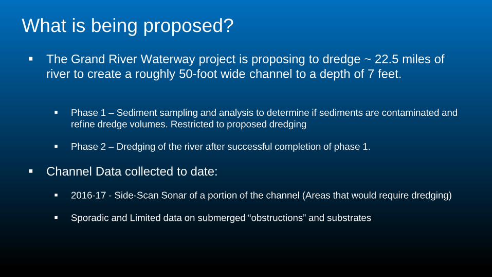
What is being proposed? The Grand River Waterway project is proposing to dredge ~ 22.5 miles of
river to create a roughly 50-foot wide channel to a depth of 7 feet.
Phase 1 – Sediment sampling and analysis to determine if sediments are contaminated and refine dredge volumes. Restricted to proposed dredging
Phase 2 – Dredging of the river after successful completion of phase 1.
Channel Data collected to date:
2016-17 - Side-Scan Sonar of a portion of the channel (Areas that would require dredging)
Sporadic and Limited data on submerged “obstructions” and substrates
Churches and Wampler (2013)
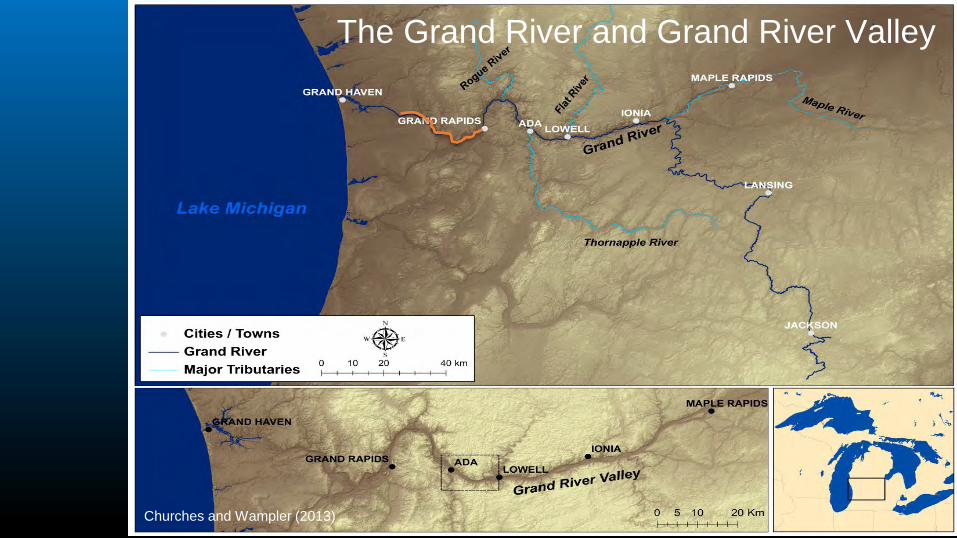
The Grand River and Grand River Valley

Some clarifications● The Grand River Waterway project (dredging ~ 23 miles of river) is completely
unrelated to the Grand River Rapids Restoration in Grand Rapids

What we know about the Grand River• The overall shape and structure was set as the glaciers retreated.• The river outlet has moved progressively north and west since glacial times.
As the river broke thorough natural dams (glacial moraines)• The river was used as a transportation route for indigenous people for
hundreds to thousands of years.
http://i821.photobucket.com/albums/zz139/Ojibwa/chippewa-indians-2.jpg
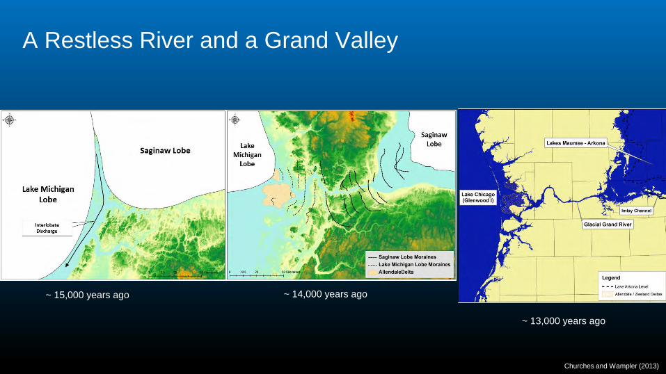
A Restless River and a Grand Valley
~ 15,000 years ago ~ 14,000 years ago
~ 13,000 years ago
Churches and Wampler (2013)
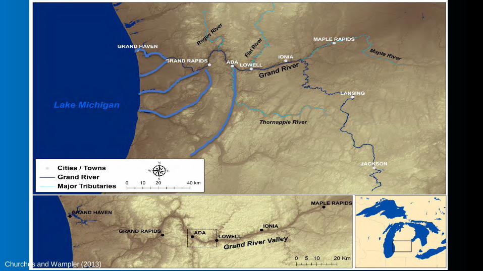
The Grand River and Grand River Valley
Churches and Wampler (2013)

Changes to the Grand River Post-settlement• Mid- to late-1800’s - extensive use of the river for log transport leads to
flooding, bank modifications, in-channel structures, dredging, and other physical changes to the river
• Late 1800’s - training walls and dredging used to reduce width, increase flow velocity, and “train” the river.
• April 1906 - a detailed bathymetric survey was conducted to document river depths and the location of training walls and dredging.
• ~1900 to present - Industries and urbanization in Grand Rapids, Lansing, and other urban areas have contributed contaminants to sediments including heavy metals, PCBs, PFOs, and other human-created compounds.

Physical surveys of the Grand River
1830’s Public Land Survey Detailed notes and survey data
along section lines and property boundaries
1838 Public Land Survey of Tallmadge Township
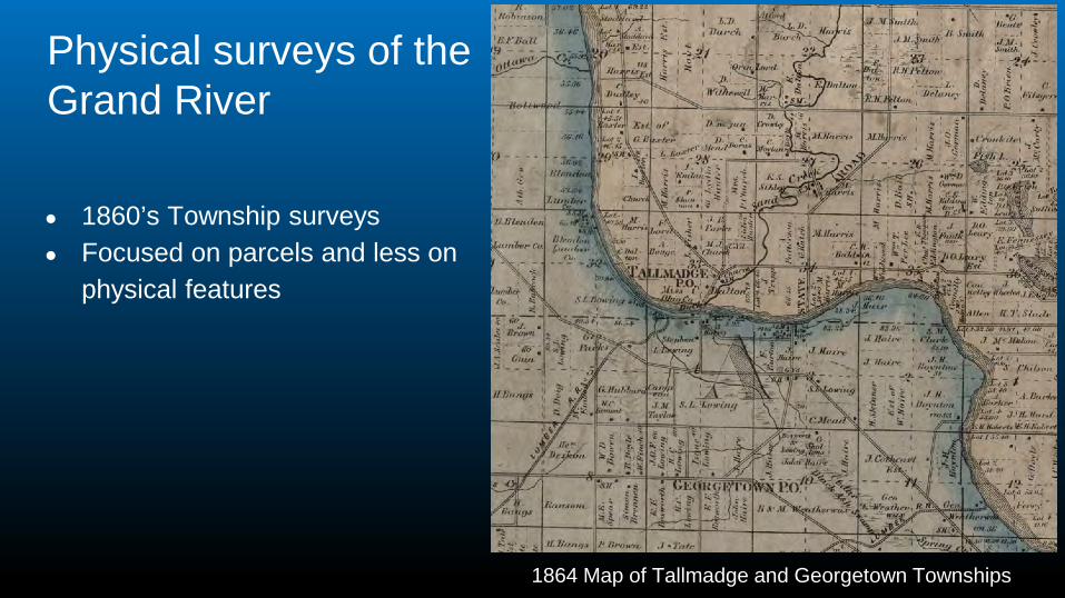
Physical surveys of the Grand River
● 1860’s Township surveys● Focused on parcels and less on
physical features
1864 Map of Tallmadge and Georgetown Townships
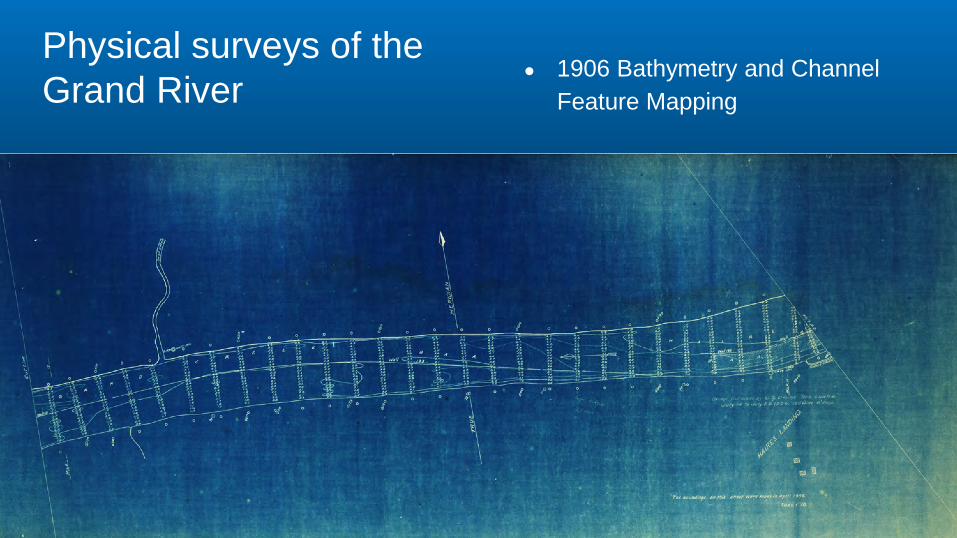
Physical surveys of the Grand River
● 1906 Bathymetry and Channel Feature Mapping

1906 Mapping Details
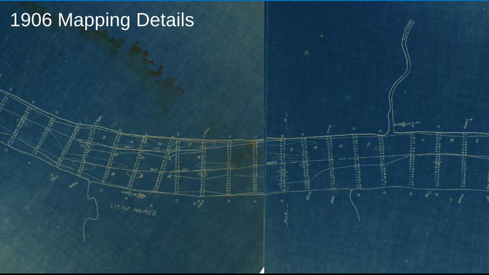
1906 Mapping Details

1906 Mapping Details
● Very detailed depths reported to the 0.1 feet (~20-25 per line)
● Lines spaced about 200-250 feet apart
● Training walls locations and dredging mapped in detail
● Vertical datum is problematic due to missing water level data

2016-2017 Dredging Feasibility Study
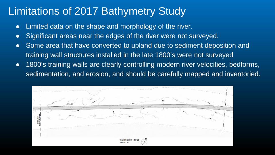
Limitations of 2017 Bathymetry Study● Limited data on the shape and morphology of the river. ● Significant areas near the edges of the river were not surveyed. ● Some area that have converted to upland due to sediment deposition and
training wall structures installed in the late 1800’s were not surveyed● 1800’s training walls are clearly controlling modern river velocities, bedforms,
sedimentation, and erosion, and should be carefully mapped and inventoried.
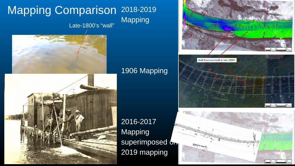
Mapping Comparison 2018-2019 Mapping
1906 Mapping
2016-2017 Mapping superimposed on 2019 mapping
Late-1800’s “wall”

• 2019 MBES survey
• 1906 georeferenced map
• 2017 Edgewater Survey proposed dredge map

High Resolution Bathymetry Collected in 2019
Depth (m)0
3.5
7
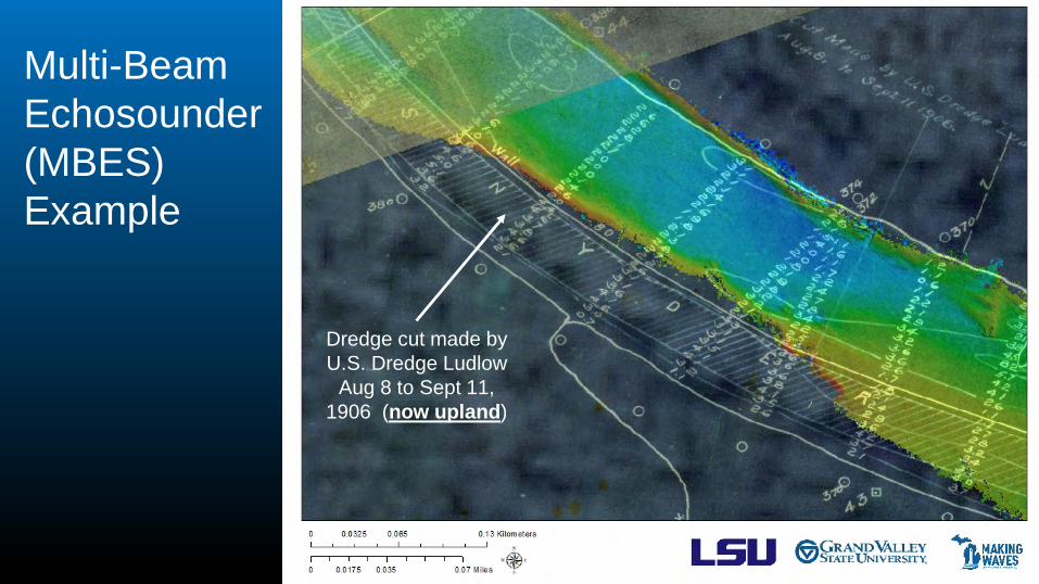
Multi-Beam Echosounder (MBES) Example
Dredge cut made by U.S. Dredge Ludlow
Aug 8 to Sept 11, 1906 (now upland)
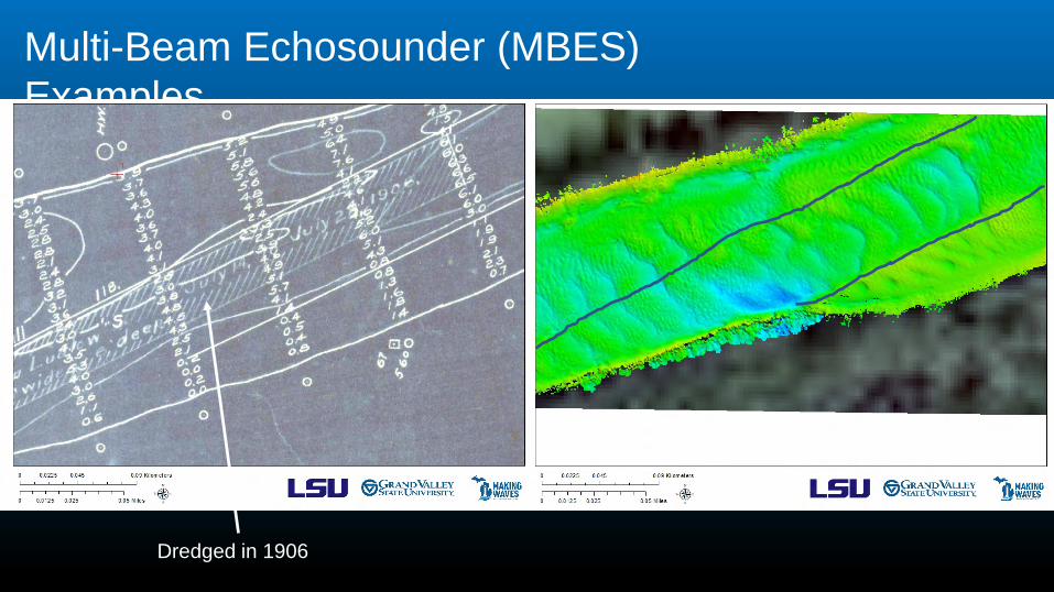
Multi-Beam Echosounder (MBES) Examples
Dredged in 1906

Multi-Beam Echosounder (MBES) Examples
Art prize “peace sign”
Bedrock or larger cobbles

Multi-Beam Echosounder (MBES) Example
Outfall Pipe Bedrock or glacial till?
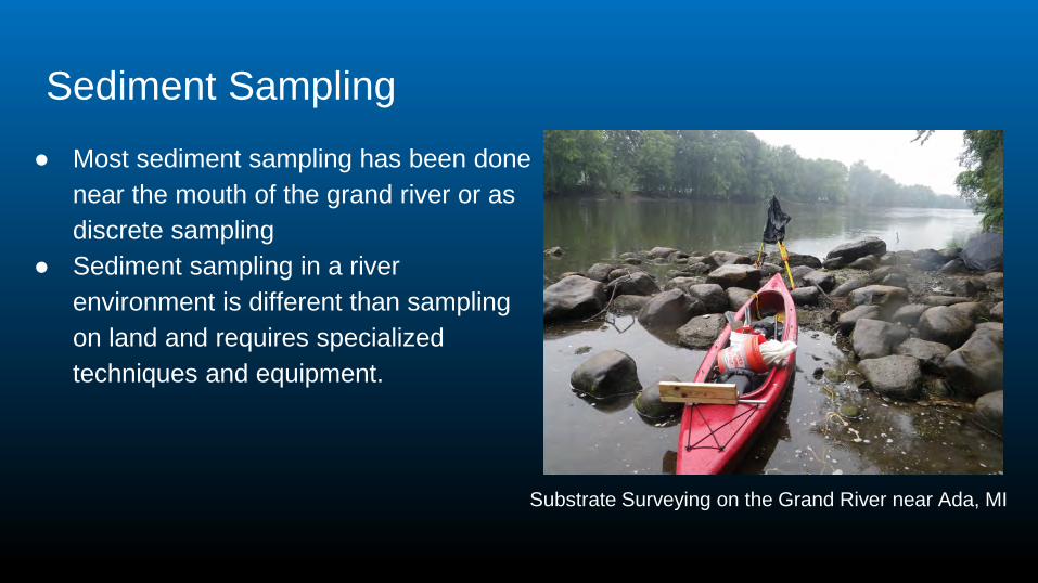
Sediment Sampling● Most sediment sampling has been done
near the mouth of the grand river or as discrete sampling
● Sediment sampling in a river environment is different than sampling on land and requires specialized techniques and equipment.
Substrate Surveying on the Grand River near Ada, MI

Limitations of Proposed Sediment Sampling Plan● Focused on the dredging plan and locations where material will be removed
rather than the geomorphic settings in the river that are likely to contain sediments of different ages.
● Proposed “soil boring” sampling methods appear to be more suitable for sampling an upland site rather than within an active waterway.
● Proposed methods will not fully sample fine materials (likely sites for adsorption of contaminants of concern).
● Sediments should be sampled in a way that preserves the position of different sediment layers and interstitial water.

Freeze-Core Method for Sampling Sediments
● Create less disturbance of the bed and water column
● Provide a more representative sample of different parts of the sediment column in a river environment
● Capture interstitial water as well as sediments
Source: https://www.geology.lu.se/

Data needed to make science-based decisions
● Accurate and complete bathymetry integrated with LIDAR (elevation data) for areas outside the channel (to capture areas that have converted to upland).
● Comprehensive and complete sampling of modern sediments and legacy sediments using a method appropriate for a river environment.
● Modern and historic sediment transport, erosion, and deposition patterns.