GRADE 10 NOVEMBER 2018 GEOGRAPHY P1
16
NATIONAL SENIOR CERTIFICATE GRADE 10 NOVEMBER 2018 GEOGRAPHY P1 MARKS: 225 TIME: 3 hours This question paper consists of 16 pages and an addendum of 12 pages.
Transcript of GRADE 10 NOVEMBER 2018 GEOGRAPHY P1
NATIONAL SENIOR CERTIFICATE
GRADE 10
NOVEMBER 2018
GEOGRAPHY P1
MARKS: 225
TIME: 3 hours
This question paper consists of 16 pages and an addendum of 12 pages.
2 GEOGRAPHY P1 (EC/NOVEMBER 2018)
Copyright reserved Please turn over
INSTRUCTIONS AND INFORMATION 1. This question paper consists of FOUR questions. 2. Answer ANY THREE questions of 75 marks each. 3. All diagrams are included in the ADDENDUM. 4. Leave a line between subsections of questions answered. 5. Start EACH question on a NEW page. 6. Number the answers correctly according to the numbering system used in
this question paper.
7. Number the answers in the centre of the line. 8. Do NOT write in the margins of the ANSWER BOOK. 9. Draw fully labelled diagrams when instructed to do so. 10. Answer in FULL SENTENCES, except where you have to state, name,
identify or list.
11. Write neatly and legibly.
(EC/NOVEMBER 2018) GEOGRAPHY P1 3
Copyright reserved Please turn over
SECTION A: THE ATMOSPHERE AND GEOMORPHOLOGY Answer at least ONE question in this section. If you answer ONE question in SECTION A, you MUST answer TWO questions in SECTION B.
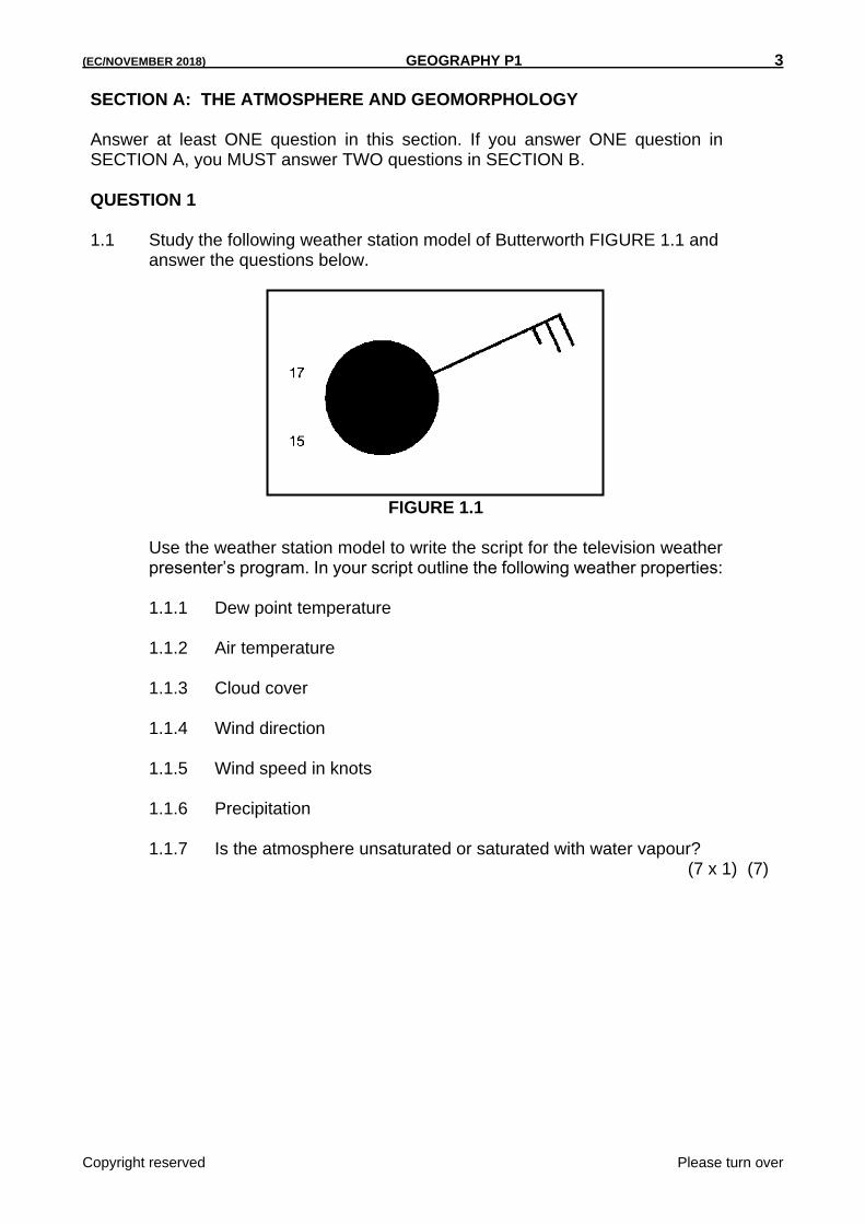
QUESTION 1 1.1 Study the following weather station model of Butterworth FIGURE 1.1 and
answer the questions below.
FIGURE 1.1 Use the weather station model to write the script for the television weather
presenter’s program. In your script outline the following weather properties: 1.1.1 Dew point temperature 1.1.2 Air temperature 1.1.3 Cloud cover 1.1.4 Wind direction 1.1.5 Wind speed in knots 1.1.6 Precipitation 1.1.7 Is the atmosphere unsaturated or saturated with water vapour?
(7 x 1) (7)
4 GEOGRAPHY P1 (EC/NOVEMBER 2018)
Copyright reserved Please turn over
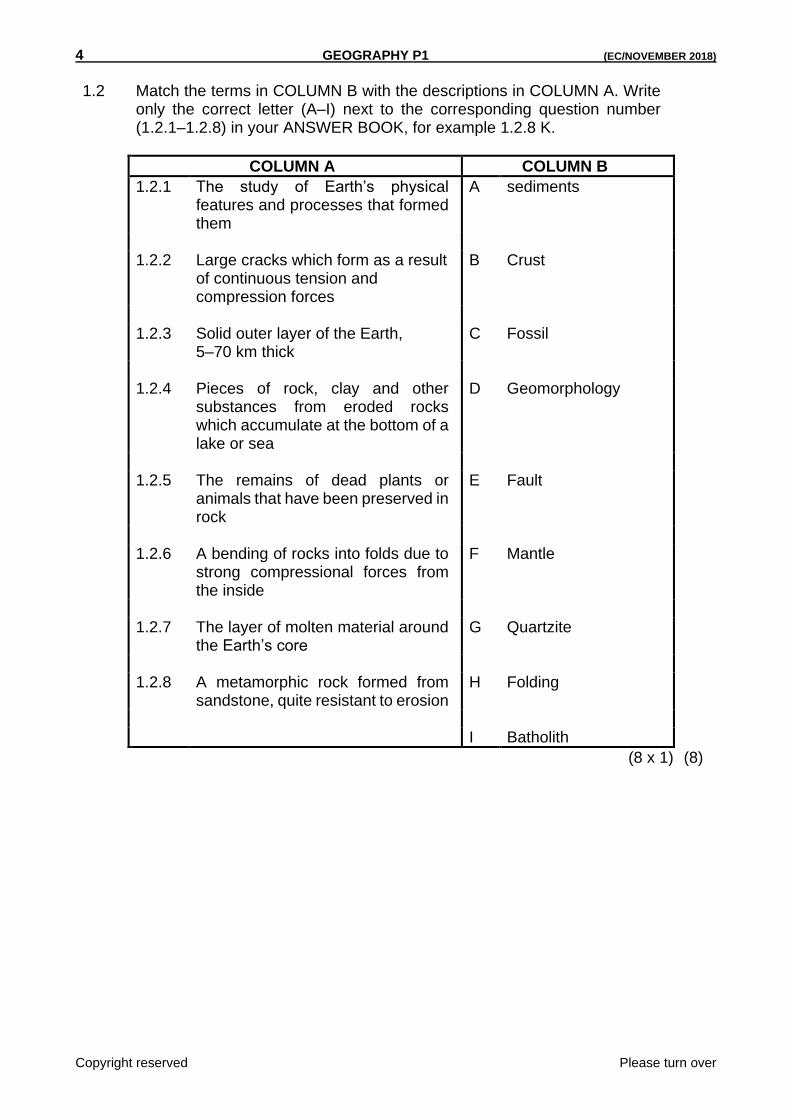
1.2 Match the terms in COLUMN B with the descriptions in COLUMN A. Write
only the correct letter (A–I) next to the corresponding question number (1.2.1–1.2.8) in your ANSWER BOOK, for example 1.2.8 K.
COLUMN A COLUMN B
1.2.1 The study of Earth’s physical features and processes that formed them
A sediments
1.2.2 Large cracks which form as a result
of continuous tension and compression forces
B Crust
1.2.3 Solid outer layer of the Earth,
5–70 km thick C Fossil
1.2.4 Pieces of rock, clay and other
substances from eroded rocks which accumulate at the bottom of a lake or sea
D Geomorphology
1.2.5 The remains of dead plants or
animals that have been preserved in rock
E Fault
1.2.6 A bending of rocks into folds due to
strong compressional forces from the inside
F Mantle
1.2.7 The layer of molten material around
the Earth’s core G Quartzite
1.2.8 A metamorphic rock formed from
sandstone, quite resistant to erosion H Folding
I Batholith
(8 x 1) (8)
(EC/NOVEMBER 2018) GEOGRAPHY P1 5
Copyright reserved Please turn over
1.3 Refer to FIGURE 1.3 showing ozone depletion. 1.3.1 Define the term ozone depletion. (1 x 1) (1) 1.3.2 In which layer of the atmosphere is ozone concentrated? (1 x 1) (1) 1.3.3 What does the acronym CFC stand for? (1 x 1) (1) 1.3.4 Identify THREE causes of ozone depletion in FIGURE 1.3. (3 x 1) (3) 1.3.5 Describe ONE way in which the depletion of the ozone layer will
affect humans. (1 x 2) (2) 1.3.6 In a paragraph of approximately EIGHT lines, discuss sustainable
strategies (ways) to reduce ozone depletion. (4 x 2) (8) 1.4 Refer to FIGURE 1.4 showing a cloud type. 1.4.1 Label A and B on the diagram as warm air and cold air respectively.
(2 x 1) (2) 1.4.2 Identify the type of cloud in FIGURE 1.4. (1 x 1) (1) 1.4.3 (a) Is this cloud type associated with snow or lighting? (1 x 1) (1) (b) Justify your answer in QUESTION 1.4.3(a) by providing TWO
reasons. (2 x 2) (4) 1.4.4 Thunderstorm is another form of precipitation. Discuss ONE positive
and TWO negative impacts of thunderstorms on people and the environment. (3 x 2) (6)
1.5 Carefully read the extract in FIGURE 1.5 on earthquakes. 1.5.1 Provide a geographical term for the following: (a) The vibration in the Earth’s crust due to sudden movements
of the crust along a fault (b) The point on the Earth’s surface immediately above the focus
of an earthquake (2 x 1) (2) 1.5.2 Give the magnitude of this earthquake and the number of people
who died respectively. (2 x 1) (2) 1.5.3 Which instrument is used to measure the magnitude of an
earthquake? (1 x 1) (1) 1.5.4 Explain why most earthquakes happen close to plate boundaries.
(1 x 2) (2)
6 GEOGRAPHY P1 (EC/NOVEMBER 2018)
Copyright reserved Please turn over
1.5.5 Briefly describe the negative results or damage caused by the
earthquake in Kashmir. (2 x 2) (4) 1.5.6 Discuss why less developed countries are unable to cope with
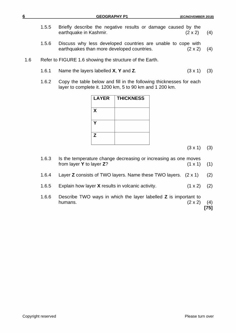
earthquakes than more developed countries. (2 x 2) (4) 1.6 Refer to FIGURE 1.6 showing the structure of the Earth. 1.6.1 Name the layers labelled X, Y and Z. (3 x 1) (3) 1.6.2 Copy the table below and fill in the following thicknesses for each
layer to complete it. 1200 km, 5 to 90 km and 1 200 km.
LAYER THICKNESS
X
Y
Z
(3 x 1) (3) 1.6.3 Is the temperature change decreasing or increasing as one moves
from layer Y to layer Z? (1 x 1) (1) 1.6.4 Layer Z consists of TWO layers. Name these TWO layers. (2 x 1) (2) 1.6.5 Explain how layer X results in volcanic activity. (1 x 2) (2) 1.6.6 Describe TWO ways in which the layer labelled Z is important to
humans. (2 x 2) (4) [75]

(EC/NOVEMBER 2018) GEOGRAPHY P1 7
Copyright reserved Please turn over
QUESTION 2 2.1 Various options are provided as possible answers to the following questions.
Choose the correct answer and write only the letter (A–D) next to the question number (2.1.1–2.1.8) in the ANSWER BOOK, for example 2.1.9 D.
2.1.1 Which of the following is not a greenhouse gas? A Methane B CFC C Carbon dioxide D Oxygen 2.1.2 Incoming solar radiation is called … A convection. B insolation. C reflection. D conduction. 2.1.3 The warm ocean current found along the east coast of South Africa
is the … current. A Indian B Benguela C Mozambique D Kuroshio 2.1.4 Clouds of great vertical extension are … A cumulo-stratus. B cumulo-nimbus. C cirrus. D strato-cumulus. 2.1.5 Lines joining places of the same pressure: A Isotherms B Isobars C Longitudinal lines D Latitudinal

8 GEOGRAPHY P1 (EC/NOVEMBER 2018)
Copyright reserved Please turn over
2.1.6 The layers of the atmosphere where there is inversion of
temperature increase are the … A troposphere and thermosphere. B mesosphere and stratosphere. C stratosphere and thermosphere. D troposphere and mesosphere. 2.1.7 Convectional rain is the type of rainfall that is common in the …
Province during summer. A Free State B Western Cape C Eastern Cape D Gauteng 2.1.8 Water vapour is moisture in the atmosphere in its … state. A liquid B gaseous C solid D condensation (8 x 1) (8)
2.3 Refer to FIGURE 2.3 which shows a rainfall type. 2.3.1 Is the type of rainfall depicted by FIGURE 2.3, a convectional rainfall
or a frontal rainfall? (1 x 1) (1) 2.3.2 Give the name of the boundary between warm air and cold air.
(1 x 1) (1) 2.3.3 Identify warm air and cold air in FIGURE 2.3 as sinking or rising air
respectively. (2 x 1) (2)
2.2 Refer to FIGURE 2.2 which shows various igneous intrusions. 2.2.1 Label the igneous intrusions indicated by letters A, B, C and D as
dyke, sill, batholith and laccolith. (4) 2.2.2 Name the process that is responsible for the exposure of intrusive
igneous features on the Earth surface. (1) 2.2.3 Which letter indicates a volcanic pipe? (1) 2.2.4 Name ONE intrusive igneous feature that is associated with granite. (1)

(EC/NOVEMBER 2018) GEOGRAPHY P1 9
Copyright reserved Please turn over
2.3.4 (a) Are clouds likely to form in X or Y? (1 x 1) (1) (b) Justify your answer in QUESTION 2.3.4 (a) by providing ONE
reason. (1 x 2) (2) 2.3.5 In a paragraph of approximately EIGHT lines, discuss the positive
and negative impact of the rainfall type mentioned in QUESTION 2.3.1 in the Western Cape Province. (4 x 2) (8)
2.4 Carefully read the case study in FIGURE 2.4 about drought in Ethiopia as a
result of climate change. 2.4.1 Define the term drought. (1 x 1) (1) 2.4.2 Mention TWO human causes of droughts in the case study. (2 x 1) (2) 2.4.3 Provide TWO effects of drought on the people of Ethiopia. (2 x 2) (4) 2.4.4 Drought is a threat to the environment. Discuss TWO point of
evidence from the case study to support this statement. (2 x 2) (4) 2.4.5 Describe TWO sustainable strategies that can be put in place to
manage drought. (2 x 2) (4) 2.5 Study the extract in FIGURE 2.5 about tsunamis. 2.5.1 Differentiate between tsunami and an earthquake. (2 x 1) (2) 2.5.2 Excluding South Africa, list TWO countries affected by this tsunami.
(2 x 1) (2) 2.5.3 Give the total number of people killed in South Africa. (1 x 1) (1) 2.5.4 Explain why South Africa had few deaths as compared to other
countries affected by this tsunami. (1 x 2) (2) 2.5.5 Discuss the main dangers (threats) to the survivors of the tsunami in
Sumatra. (2 x 2) (4) 2.5.6 Suggest TWO methods that can be used in these countries to reduce
the impact of a tsunami. (2 x 2) (4)
10 GEOGRAPHY P1 (EC/NOVEMBER 2018)
Copyright reserved Please turn over
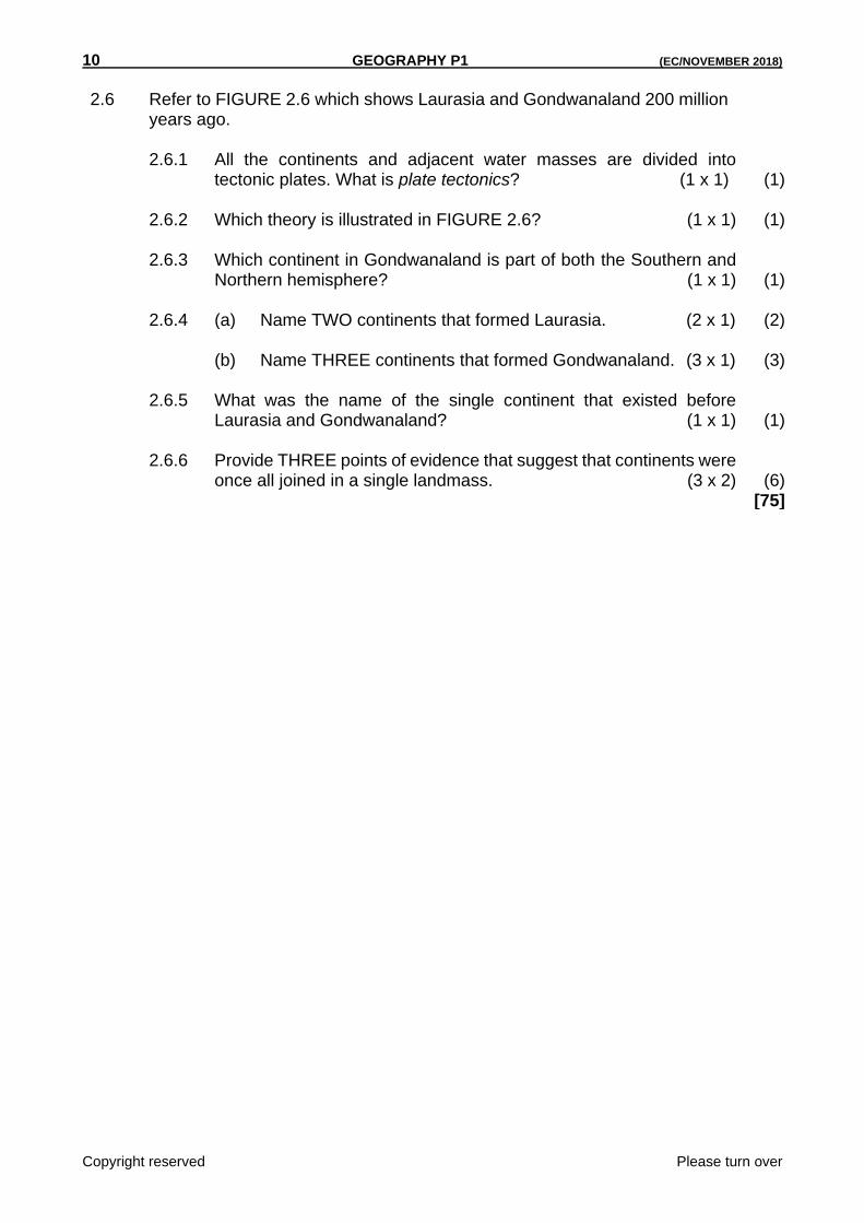
2.6 Refer to FIGURE 2.6 which shows Laurasia and Gondwanaland 200 million
years ago. 2.6.1 All the continents and adjacent water masses are divided into
tectonic plates. What is plate tectonics? (1 x 1) (1) 2.6.2 Which theory is illustrated in FIGURE 2.6? (1 x 1) (1) 2.6.3 Which continent in Gondwanaland is part of both the Southern and
Northern hemisphere? (1 x 1) (1) 2.6.4 (a) Name TWO continents that formed Laurasia. (2 x 1) (2) (b) Name THREE continents that formed Gondwanaland. (3 x 1) (3) 2.6.5 What was the name of the single continent that existed before
Laurasia and Gondwanaland? (1 x 1) (1) 2.6.6 Provide THREE points of evidence that suggest that continents were
once all joined in a single landmass. (3 x 2) (6) [75]
(EC/NOVEMBER 2018) GEOGRAPHY P1 11
Copyright reserved Please turn over
3.2 Match the term/concept in COLUMN A with the correct relevant descriptions in COLUMN B. Write only the correct letter (A–I) next to the corresponding number (3.2.1–3.2.8) in your ANSWER BOOK, for example 3.2.9 K.
COLUMN A COLUMN B
3.2.1 Birth rate A The way people are spread out over an area
3.2.2 Population density B The number of deaths per 1 000 population per year
3.2.3 Death rate C Number of children who die before they reach age 5
3.2.4 Life expectancy D The number of babies born per 1 000 population per year
3.2.5 Infant mortality rate E The number of people per square km
3.2.6 Growth rate F A person who moves to a foreign country
3.2.7 Population distribution G Calculated by finding the difference between birth rate and death rate
3.2.8 Fertility rate H Average number of years a person can be
expected to live
I Average number of children per woman
(8 x 1) (8)
SECTION B: POPULATION AND WATER RESOURCES
ANSWER at least ONE question from this section. If you answer ONE question from SECTION B, you must answer TWO questions from SECTION A.
QUESTION 3
3.1 Choose the correct word(s) between brackets to make the statements true. Write ONLY the word(s) next to the question number (3.1.1–3.1.7) in your ANSWER BOOK.
3.1.1 (Water distribution / Rainfall distribution) is the spread of rainfall across an area.
3.1.2 The process where liquid changes into ice is called (freezing / melting). 3.1.3 (Desalination / Sublimation) is the process of turning salty water into fresh
water. 3.1.4 The process of absorption of water by plants, the transfer of the water through
the plant and release to the atmosphere is (transpiration / evaporation). 3.1.5 (Infiltration / Run-off) is the process where water seeps into the soil. 3.1.6 Most precipitation happens over the (rivers / oceans). 3.1.7 (Marine pollution / Land pollution) is the pollution of the oceans (7 x 1) (7)

12 GEOGRAPHY P1 (EC/NOVEMBER 2018)
Copyright reserved Please turn over
3.3 Study the ARTICLE in FIGURE 3.3 on the population of South Africa. 3.3.1 Define the term population. (1 x 1) (1) 3.3.2 What was South Africa’s population in 2001 and 2015 respectively?
(2 x 1) (2) 3.3.3 Name the province with the lowest population and the number of
people living in this province. (2 x 1) (2) 3.3.4 Comment on the trend from 2001 to 2016 in the article regarding the
population of South Africa. (1 x 2) (2) 3.3.5 Discuss TWO negative impacts that the increased population growth
has shown on the natural resources of the country. (2 x 2) (4) 3.3.6 Suggest any TWO strategies that can be put in place to manage the
population growth in South Africa. (2 x 2)
(4) 3.4 Refer to FIGURE 3.4 which illustrates HIV/Aids infection rate per province. 3.4.1 Write the acronym Aids in full. (1 x 1) (1) 3.4.2 Name TWO symptoms that might be experienced by people who
have contracted HIV/Aids. (2 x 1) (2) 3.4.3 List provinces with the highest and lowest infection rate respectively.
(2 x 1) (2)
3.4.4 South Africa is one of the countries with the highest HIV/Aids infection rate. Explain ONE factor that contributes to high infection rate in a country like South Africa. (1 x 2) (2)
3.4.5 Suggest TWO ways in which HIV is passed from one person to
another. (2 x 2) (4) 3.4.6 Suggest the best strategies to decrease the humiliation (shame) that
people with HIV/Aids experience. (2 x 2) (4) 3.5 Carefully study FIGURE 3.5 illustrating inter-basin water transfer. 3.5.1 Explain what is meant by water transfer. (1 x 1) (1) 3.5.2 Mention ONE municipality and the province that benefits from this
water transfer. (2 x 1) (2) 3.5.3 Give TWO activities that water is used for in this municipality.
(2 x 1) (2)

(EC/NOVEMBER 2018) GEOGRAPHY P1 13
Copyright reserved Please turn over
3.5.4 Explain the way water is transferred from the Great Fish River basin
to the Sundays River basin. (2 x 2) (4) 3.5.5 There is an increased demand for water in South Africa, but the
supply of usable water is decreasing. Discuss THREE human and physical factors influencing the availability of water in South Africa. (3 x 2) (6)
3.6 Refer to FIGURE 3.6 and answer the questions that follow. 3.6.1 Give a suitable term that describes electricity generated from water.
(1 x 1) (1) 3.6.2 Is water a renewable or non-renewable resource? (1 x 1) (1) 3.6.3 What is water used for in FIGURE 3.6. (1 x 1) (1) 3.6.4 Provide TWO other examples of how rural communities use their
water resources excluding the one illustrated in FIGURE 3.6. . (2 x 1) (2)
3.6.5 Briefly explain how groundwater contributes to the availability of water
in South Africa. (1 x 2) (2) 3.6.6 In a paragraph of approximately EIGHT lines suggest how
individuals can sustainably save water at home, garden and in the community. (4 x 2) (8)
[75]
14 GEOGRAPHY P1 (EC/NOVEMBER 2018)
Copyright reserved Please turn over
QUESTION 4 4.1 Select the correct answer from the list provided below to match the
statements (4.1.1–4.1.7). Write only the correct word next to each question number, for example 4.1.8 pyramid.
Immigration; emigration; voluntary migration; push factor; pull factor; refugees; xenophobia
4.1.1 This encourages people to move away from a specific area. 4.1.2 Movement of people from one place to another by choice. 4.1.3 When people move to a new country. 4.1.4 People leave their homes and flee to another country out of fear for
their lives. 4.1.5 Unreasonable fear, distrust and hatred of foreign nationals. 4.1.6 When people move out of a country. 4.1.7 This attracts people to an area. (7 x 1) (7) 4.2 Describe the hydrological cycle by choosing correct word(s) in brackets in the
following paragraph. Write the number (4.2.1–4.2.8) and correct word next to it.
Most water evaporates from 4.2.1 (oceans / rivers) to form moist air. Moist
air is pushed over the land from 4.2.2 (high pressure / low pressure) over the sea to the 4.2.3 (high pressure / low pressure) over the land. When the 4.2.4 (dry / moist) air is forced up it condenses and 4.2.5 (clouds / run-off) will form. 4.2.6 (Precipitation / Percolation) takes place and the water lands on the earth’s surface. Water drains into rivers and this is called 4.2.7 (surface run-off / base flow). As the water infiltrates, the water table will 4.2.8 (rise / subside). (8 x 1) (8)
(EC/NOVEMBER 2018) GEOGRAPHY P1 15
Copyright reserved Please turn over
4.3 Read the case study in FIGURE 4.3 carefully before you answer the questions
that follow. 4.3.1 Give the geographical term that best describes the movement of the
Tsitsa family from one place to another. (1 x 1) (1) 4.3.2 Choose the correct word in relation to the Tsitsa family’s relocation
from South Africa to England. (a) Regional / International (b) Voluntary / Forced (c) Permanent / Temporary (3 x 1) (3) 4.3.3 Explain why the Tsitsa family moved from South Africa to England.
(1 x 1) (1) 4.3.4 Discuss TWO pull factors that attracted the Tsitsa family to England.
(2 x 2)
(4) 4.3.5 Suggest THREE negative impacts of the voluntary migration on the
Tsitsa’s place of origin (South Africa). (3 x 2) (6) 4.4 Read the case study in FIGURE 4.4 carefully before you answer the questions
that follow. 4.4.1 Define demographic transition model. (1 x 1) (1) 4.4.2 Identify the stage where birth rate is high and death rate falls rapidly.
(1 x 1)
(1) 4.4.3 Indicate the stage where both death rate and birth rate are low.
(1 x 1) (1) 4.4.4 Compare the level of birth rate and level of death rate in stage 1.
(1 x 2)
(2) 4.4.5 In stage 2 the death rate is starting to drop rapidly. Suggest TWO
reasons why this is the case. (2 x 2) (4) 4.4.6 In stage 3 the birth rate starts to level out as the population growth rate
decreases. Discuss THREE factors that affect birth rates. . (3 x 2) (6)
16 GEOGRAPHY P1 (EC/NOVEMBER 2018)
Copyright reserved Please turn over
4.5 Carefully study FIGURE 4.5. 4.5.1 Define the term over-fishing. (1 x 1) (1) 4.5.2 Give TWO reasons that cause over-fishing. (2 x 1) (2) 4.5.3 Provide TWO negative effects of over-fishing on people and the
environment. (2 x 2) (4) 4.5.4 ‘The oceans are one of our greatest resources for life.’
In a paragraph of approximately EIGHT lines, discuss the importance of the oceans in people’s lives. (4 x 2)
(8)
4.6 Read the extract in FIGURE 4.6 carefully before you answer the questions
that follow. 4.6.1 Name the country affected by flooding in the extract. (1 x 1) (1) 4.6.2 Which country was called upon to assist the affected country?
(1 x 1) (1) 4.6.3 Mention the organisation that was deployed to the flooded area to
provide relief to people. (1 x 1) (1) 4.6.4 Explain why the houses illustrated in FIGURE 4.6 are referred to as
‘informal’. (1 x 2) (2) 4.6.5 Provide TWO examples of poor infrastructure that led to
inaccessibility in the area affected by flooding. (2 x 2) (4) 4.6.6 Suggest THREE strategies to reduce the impact of flooding in the
informal settlement. (3 x 2) (6) [75] GRAND TOTAL: 225