GR UND TRUTH - Housatonic · GR UND TRUTH: Curated by Robbin Zella and Susan Sharp January 13 -...
7
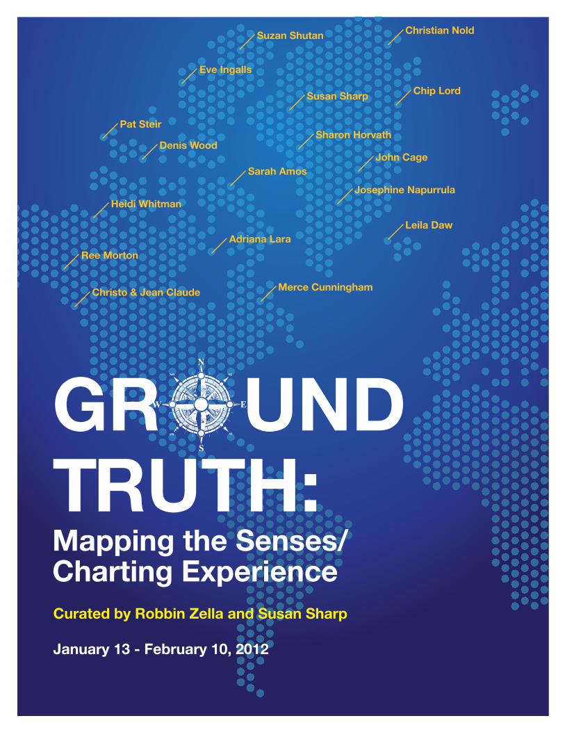
Mapping the Senses/ Charting Experience GR UND TRUTH: Curated by Robbin Zella and Susan Sharp January 13 - February 10, 2012 Christian Nold Susan Sharp Heidi Whitman Denis Wood Sarah Amos Ree Morton Suzan Shutan Chip Lord Pat Steir Adriana Lara Eve Ingalls John Cage Sharon Horvath Leila Daw Merce Cunningham Christo & Jean Claude Josephine Napurrula
Transcript of GR UND TRUTH - Housatonic · GR UND TRUTH: Curated by Robbin Zella and Susan Sharp January 13 -...
Mapping the Senses/Charting Experience
GR UND TRUTH: Curated by Robbin Zella and Susan Sharp
January 13 - February 10, 2012
Christian Nold
Susan Sharp
Heidi Whitman
Denis Wood
Sarah Amos
Ree Morton
Suzan Shutan
Chip Lord
Pat Steir
Adriana Lara
Eve Ingalls
John Cage
Sharon Horvath
Leila Daw
Merce CunninghamChristo & Jean Claude
Josephine Napurrula
Ground Truth: Mapping the Senses/Charting Experience
1 Wood, Denis. Everything Sings: Maps for a Narrative Atlas. (Los Angeles: Siglio Press, 2010) p. 25.
2 Ibid, p. 25.
3 http://www.nytimes.com/2011/10/25/us/suburban-poverty-surge- challenges-communities.html
Sex in the Suburbs by Suzan Shutan
The Map
Land lies in water; it is a shadowed green,
Shadows, or are they shallows, at its edges
showing the line of long sea-weeded ledges
where weeds hang to the simple blue from green.
Or does the land lean down to lift the sea from under,
Drawing it unperturbed around itself?
Along the fine tan sandy shelf
Is the land tugging at the sea from under?
The shadow of Newfoundland lies flat and still.
Labrador’s yellow, where the moony Eskimo
has oiled it. We can stroke these lovely bays,
under a glass as if they were expected to blossom,
or as if to provide a clean cage for invisible fish.
The names of seashore towns run out to sea,
The names of cities cross the neighboring mountains
- the printer here experiencing the same excitement
as when emotion too far exceeds its cause.
These peninsulas take the water between thumb and finger
Like women feeling for the softness of yard-goods.
Mapped waters are more quiet than the land is,
Lending the land their waves’ own conformation:
And Norway’s hare runs south in agitation,
Profiles investigate the sea, where land is.
Are they assigned, or can the countries pick their colors?
-What suits the character or the native waters best.
Topography displays no favorites; North’s as near as West.
More delicate than the historians’ are the map-makers’ colors.
Elizabeth Bishop
Looking out into the wider-world requires us to first develop
a method of finding our way -- signs and symbols that lead
us to new destinations; and second, to rely on memory—an
internalized map. The first way situates us within a space as
it relates to the cardinal points on a compass—north, south,
east, and west; and the second, is in relation to our own home-
--the place where we live. Mapping is a way of ordering the
world, and of finding our place in it.
The artists included in Ground Truth: Mapping the Senses/
Charting Experience take the term “ground truth,” which refers
to the use of an image to determine the identity and location of
an area, as their point of departure. By combining the semiotics
of cartography with their own experiences and imagination, each
artist has developed a personal iconography to record the sites,
movements, and responses to “place” that are highly invested
with meaning and memories.
For cartographer, scholar, and artist Denis Wood, whose work is
included here, “mapmaking is an expressive form, a way of coming
to terms with place.”1 Wood’s romance with maps is experienced
in his wonderful book, Everything Sings: Maps for a Narrative
Atlas that maps the occupations, mailboxes, porches, clotheslines,
garages, postal routes, and street lights of Boylan Heights, North
Carolina. Wood says that for him, “neighborhoods are experienced
as a collection of patterns of light and sound and smells and taste
and communication with others…[maps] catch those patterns in
black and white and arrange them so that the larger pattern, the
pattern of the neighborhood itself, can emerge.”2
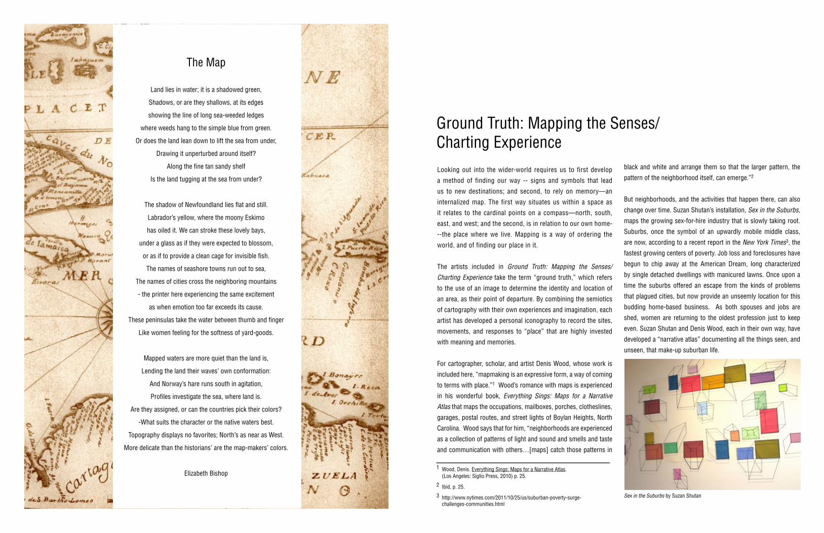
But neighborhoods, and the activities that happen there, can also
change over time. Suzan Shutan’s installation, Sex in the Suburbs,
maps the growing sex-for-hire industry that is slowly taking root.
Suburbs, once the symbol of an upwardly mobile middle class,
are now, according to a recent report in the New York Times3, the
fastest growing centers of poverty. Job loss and foreclosures have
begun to chip away at the American Dream, long characterized
by single detached dwellings with manicured lawns. Once upon a
time the suburbs offered an escape from the kinds of problems
that plagued cities, but now provide an unseemly location for this
budding home-based business. As both spouses and jobs are
shed, women are returning to the oldest profession just to keep
even. Suzan Shutan and Denis Wood, each in their own way, have
developed a “narrative atlas” documenting all the things seen, and
unseen, that make-up suburban life.
4 Monmonier, Mark. How Maps Restrict and Control. (The University Press Chicago, 2010)
5 Ibid. pp. 86-116.
untitled 2004, by Josephine Naparrula
Maps create a material memory for the maker. Josephine Napur-
rula’s map, on view here, reflects the spiritual traditions, history,
beliefs, cultural practices and socio-political circumstances of Aus-
tralia’s indigenous people. The patterns used by Central Australian
artists, such as the Papunya, are translations of original motifs or
symbols used to represent place or movement. Dreamtime stories
are painted from an aerial perspective and Napurrula’s map/story
follows the lay of the land that was created by her ancestors at
the beginning of time. Her colors and patterns reflect the moods,
expression and spirituality of “place.”
Napurrula’s work offers another reading as well, although perhaps
not intentionally. Perceived as a science, cartography is generally
understood to be “objective,” to hold no bias. Yet maps are highly
political, according to geographer and author Mark Monmonier4,
allowing the re/claiming of territory, the shaping of public opinion
and national identity. Maps, which serve as instruments for explo-
ration, expansion and imperialism, are historical documents. They
tell a story of discovery, exploration, trade, war, exploitation and
power. Maps shape our knowledge, our identity and our percep-
tions of the world, as well as our place in it. In the case of Australia,
the application of “Terra Nullius” or “no man’s land,” Monmonier
tells us, provided the British with the authority to lay claim to lands
they deemed “empty,” but, in fact, were occupied by indigenous
people. Maps simplified land acquisition through omission and so-
lidified the power and domination of the cartographer. In our own
country, political redistricting is all the rage in the run up to the
next 2012 Presidential election. Cartographic manipulation has the
ability to effectively reduce or eliminate competition and to help
determine political outcomes.5
Maps communicate all kinds of information as shown by Leila
Daw’s Flow, Stick Charts and Map Icons series. She presents a
broad range of maps to include climate maps that chart levels of
rain and snow; physical maps that record the features of the land-
scape to include mountains, rivers and wetlands; and maps that
identify the stars in the night sky. The compass roses are left un-
marked by the cardinal points of North, South, East and West to
emphasize how maps can “dislocate” or skew information. Daw
says “How can we know where we are in the world, when what we
are looking for determines what we see?”6 Daw fashions contem-
porary stick charts, putting a twist on those historically construct-
ed by Polynesian sailors to record wave swells, and to navigate the
vast expanse of water that separates the many islands. These maps
are so personal they only serve to guide the maker.
Personal symbols and imagery that document the memories and
emotions associated with a specific location are also found in the
maps, real or imagined, created by Susan Sharp, Ree Morton, Pat
Steir, Sharon Horvath and Adriana Lara. Emancipated from com-
munal meaning, these works explore a more expressive side of
map-making.
Charting subjective feelings above objective observations, Susan
Sharp’s Terra series reflects the mapping of an internal world rather
than the topography of a physical place. Her imagery is expressive
in nature, using strong colors and vivid brushstrokes to convey
emotional and psychological states.
Less dramatic than Sharp, Ree Morton’s Untitled piece included in
this show, explores spaces, enclosures and boundaries of a par-
ticular location. This drawing, made in 1973 while visiting New-
foundland, blends traditional art with the structural mapping of
space and was a radical step away from the dominant art-making
strategies of the time, namely Minimalism and Conceptual Art.
A contemporary of Morton, Pat Steir borrowed the grid from Minimal-
ism and used it as a scaffold to construct her own personal iconogra-
phy using letters, numbers, pictures, words and symbols. Her piece,
titled Kyoto Chrysanthemum,1982, is a commentary on developments
in art-making over time. The words Form/Illusion are inscribed on the
lower left hand side of the drawing, and Illusion/Belief on the lower right.
Maps, in the same way, are abstractions of a “real” thing—a diagram-
matic representation of the world—which we understand and believe.
Ancient poets, philosophers, historians, and cartographers mapped an
imaginary world; one that was flat, or floating, or surrounded by water
that rested on a tree or was suspended from the sky with four corners
each fastened with raw-hide. Aristotle and Ptolemy offered a model
of the universe with the sun and planets revolving around the earth.
Copernicus challenged that notion, and placed the sun at the center of
the universe, while 16th century master map-maker, Gerardus Merca-
tor, using a system of longitudinal and latitudinal lines, systematically
divided and conquered both earth and heaven.
Sharon HorvathOver Me 2011
Pigment, ink and polymer on paper on canvas46 x 45 inches
LBFA-4281
Over Me by Sharon Horvath6 Harmon, Katherine. The Map as Art: Contemporary Artists Explore Cartography. (London: Thames and Hudson, 2009) 7 Søren Kierkegaard, Letter to Peter Wilhelm Lund dated August 31, 1835.
Forbidden Path, by Leila Daw
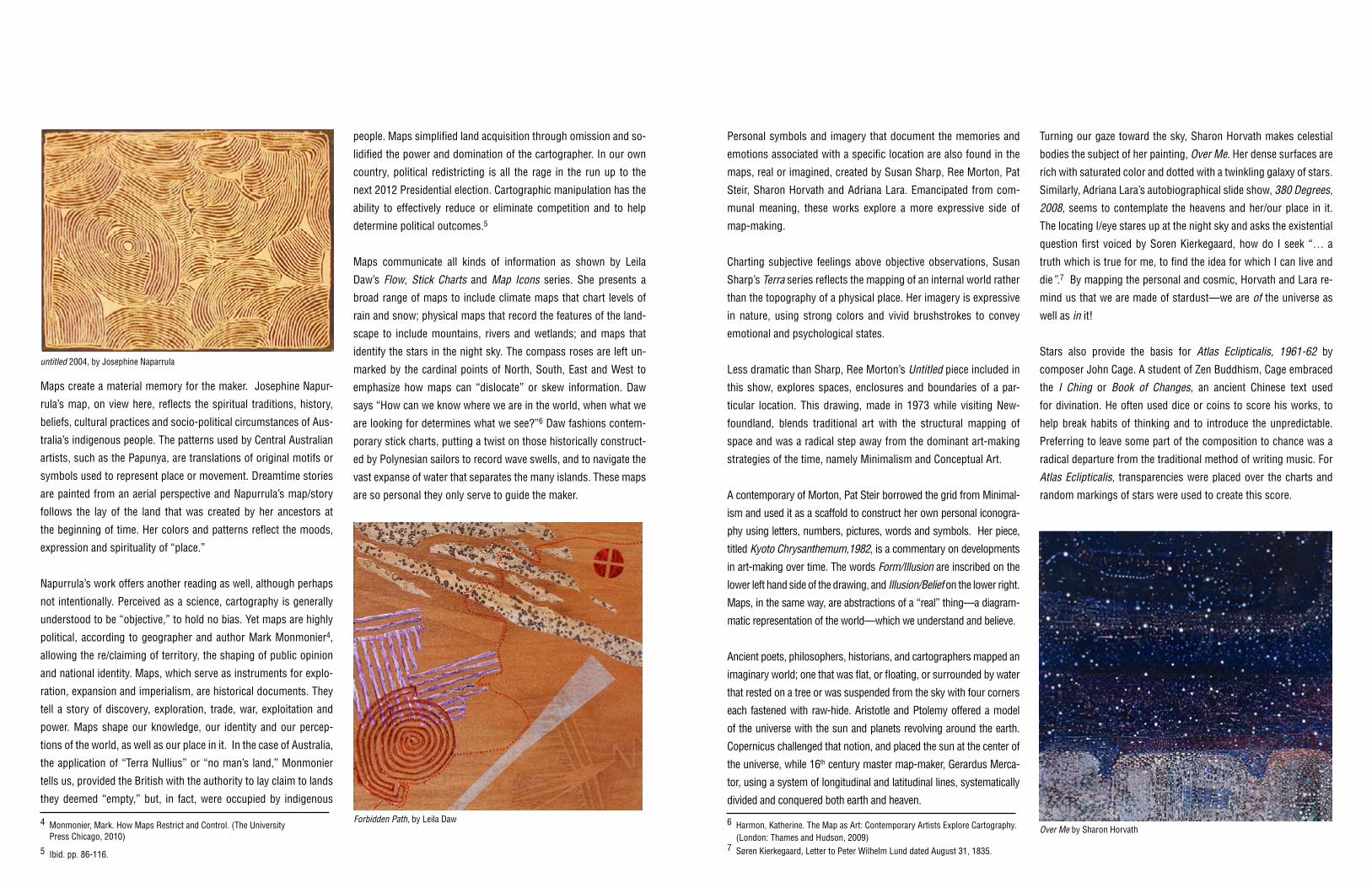
Turning our gaze toward the sky, Sharon Horvath makes celestial
bodies the subject of her painting, Over Me. Her dense surfaces are
rich with saturated color and dotted with a twinkling galaxy of stars.
Similarly, Adriana Lara’s autobiographical slide show, 380 Degrees,
2008, seems to contemplate the heavens and her/our place in it.
The locating I/eye stares up at the night sky and asks the existential
question first voiced by Soren Kierkegaard, how do I seek “… a
truth which is true for me, to find the idea for which I can live and
die”.7 By mapping the personal and cosmic, Horvath and Lara re-
mind us that we are made of stardust—we are of the universe as
well as in it!
Stars also provide the basis for Atlas Eclipticalis, 1961-62 by
composer John Cage. A student of Zen Buddhism, Cage embraced
the I Ching or Book of Changes, an ancient Chinese text used
for divination. He often used dice or coins to score his works, to
help break habits of thinking and to introduce the unpredictable.
Preferring to leave some part of the composition to chance was a
radical departure from the traditional method of writing music. For
Atlas Eclipticalis, transparencies were placed over the charts and
random markings of stars were used to create this score.
8 Crestohl, Laura. http://mappingourworlds.wordpress.com/category/mappingourselves 9 Harmon, Katherine. Maps as Art. p 138.10 Amos, Sarah. Artist’s statement given to curator.11 Gablik, Suzy. Has Modernism Failed?, London: Thames and Hudson: 1984 and 1992) pp. 76-77.
Chip Lord
Merce Cunnigham, Cage’s partner, also incorporated the notion
of chance into his dance event, Points in Space. Choreography,
itself a form of mapping, documents patterns of movement
that can be repeated by other performers. Cunningham
revolutionized dance, which had always been a symbolic and
expressive form of story-telling, by bringing a “new realism”
to the form whereby the only parameters were space (physical)
and time (duration). Cage composed the music for Points in
Space, which was inspired by Einstein’s comment that “there
are no fixed points in space.” In fact, the dance was intentionally
developed to be seen from any angle and the performers move
freely within the music rather than to it.
Moving through spaces is the impetus for Christian Nold’s Emotion
Maps. Laura Crestohl points out in her on-line essay Mapping
Ourselves, “that the map in the digital age has transformed our
thoughts and experiences, our bodies, and even our personalities
into locations, proving that material experience can be measured,
analyzed and critiqued. Wearing Galvanic Skin Response (GSR)
units, participants move through a variety of geographical locations
which is then pin-pointed on a map of the area.” 8 Perhaps more
than any other artist in this exhibit, Nold draws upon all the senses,
mapping the responses to sight, sound, smell, taste and touch.
Emotion impacts memory, and by documenting the subjective
feelings associated with each place, he destabilizes the notion of
“maps”, with its emphasis on accuracy and objectivity.
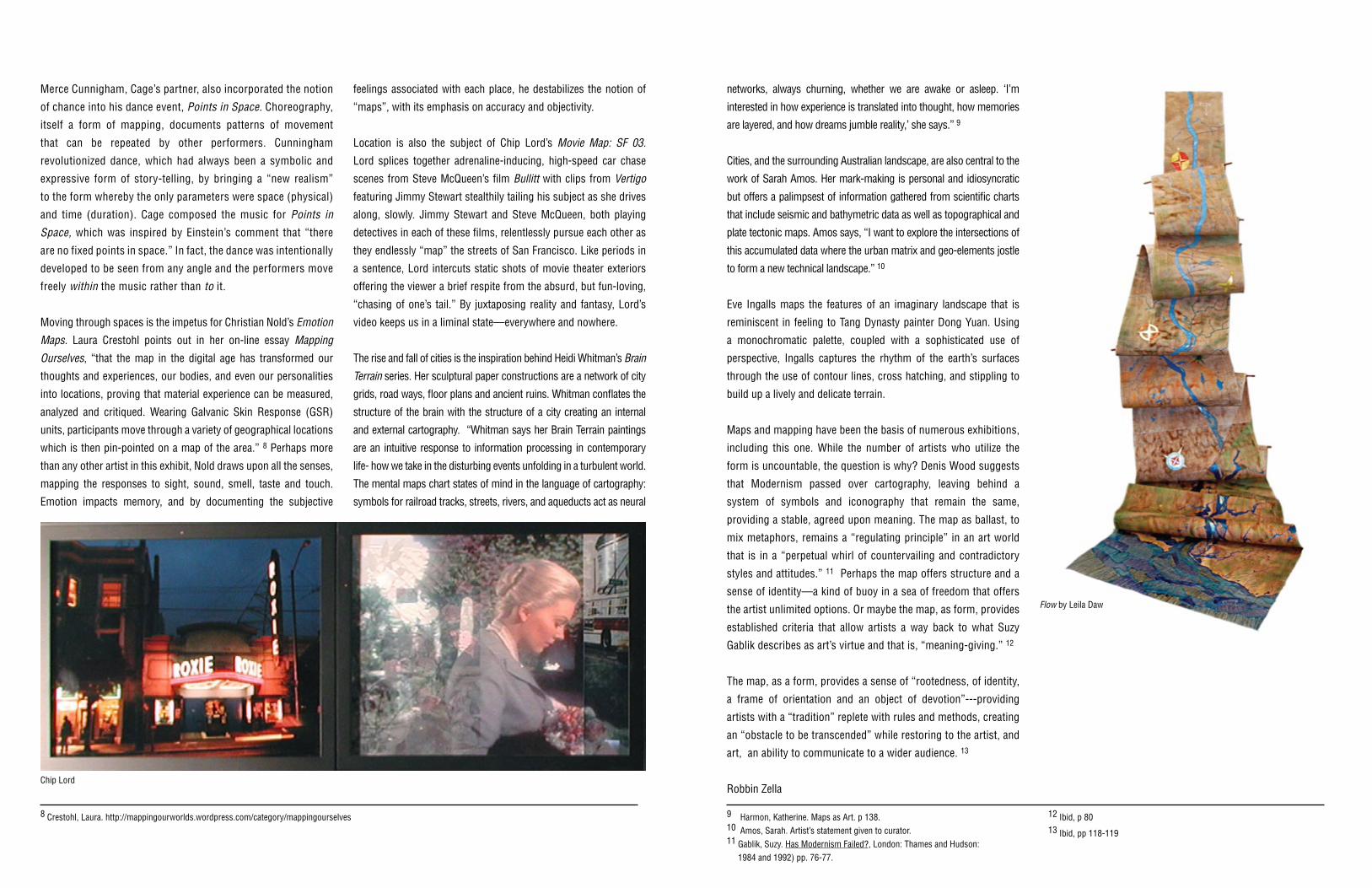
Location is also the subject of Chip Lord’s Movie Map: SF 03.
Lord splices together adrenaline-inducing, high-speed car chase
scenes from Steve McQueen’s film Bullitt with clips from Vertigo
featuring Jimmy Stewart stealthily tailing his subject as she drives
along, slowly. Jimmy Stewart and Steve McQueen, both playing
detectives in each of these films, relentlessly pursue each other as
they endlessly “map” the streets of San Francisco. Like periods in
a sentence, Lord intercuts static shots of movie theater exteriors
offering the viewer a brief respite from the absurd, but fun-loving,
“chasing of one’s tail.” By juxtaposing reality and fantasy, Lord’s
video keeps us in a liminal state—everywhere and nowhere.
The rise and fall of cities is the inspiration behind Heidi Whitman’s Brain
Terrain series. Her sculptural paper constructions are a network of city
grids, road ways, floor plans and ancient ruins. Whitman conflates the
structure of the brain with the structure of a city creating an internal
and external cartography. “Whitman says her Brain Terrain paintings
are an intuitive response to information processing in contemporary
life- how we take in the disturbing events unfolding in a turbulent world.
The mental maps chart states of mind in the language of cartography:
symbols for railroad tracks, streets, rivers, and aqueducts act as neural
networks, always churning, whether we are awake or asleep. ‘I’m
interested in how experience is translated into thought, how memories
are layered, and how dreams jumble reality,’ she says.” 9
Cities, and the surrounding Australian landscape, are also central to the
work of Sarah Amos. Her mark-making is personal and idiosyncratic
but offers a palimpsest of information gathered from scientific charts
that include seismic and bathymetric data as well as topographical and
plate tectonic maps. Amos says, “I want to explore the intersections of
this accumulated data where the urban matrix and geo-elements jostle
to form a new technical landscape.” 10
Eve Ingalls maps the features of an imaginary landscape that is
reminiscent in feeling to Tang Dynasty painter Dong Yuan. Using
a monochromatic palette, coupled with a sophisticated use of
perspective, Ingalls captures the rhythm of the earth’s surfaces
through the use of contour lines, cross hatching, and stippling to
build up a lively and delicate terrain.
Maps and mapping have been the basis of numerous exhibitions,
including this one. While the number of artists who utilize the
form is uncountable, the question is why? Denis Wood suggests
that Modernism passed over cartography, leaving behind a
system of symbols and iconography that remain the same,
providing a stable, agreed upon meaning. The map as ballast, to
mix metaphors, remains a “regulating principle” in an art world
that is in a “perpetual whirl of countervailing and contradictory
styles and attitudes.” 11 Perhaps the map offers structure and a
sense of identity—a kind of buoy in a sea of freedom that offers
the artist unlimited options. Or maybe the map, as form, provides
established criteria that allow artists a way back to what Suzy
Gablik describes as art’s virtue and that is, “meaning-giving.” 12
The map, as a form, provides a sense of “rootedness, of identity,
a frame of orientation and an object of devotion”---providing
artists with a “tradition” replete with rules and methods, creating
an “obstacle to be transcended” while restoring to the artist, and
art, an ability to communicate to a wider audience. 13
Robbin Zella
12 Ibid, p 8013 Ibid, pp 118-119
Flow by Leila Daw
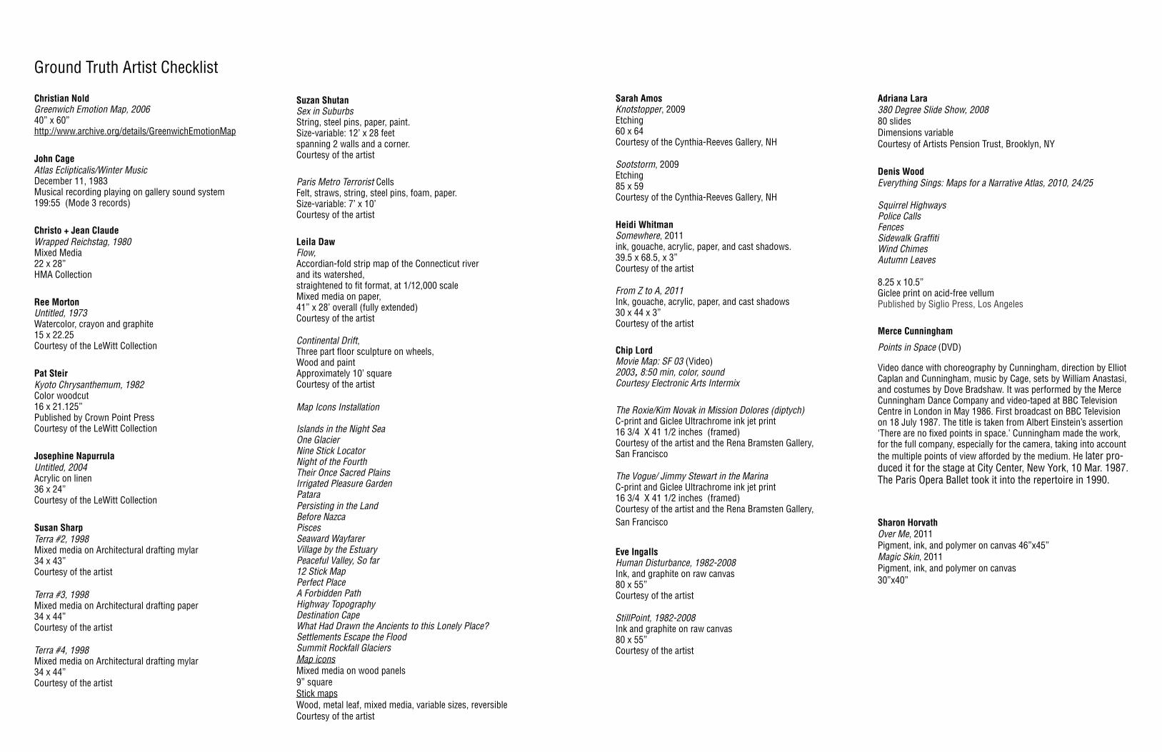
Ground Truth Artist Checklist
Christian NoldGreenwich Emotion Map, 200640” x 60”http://www.archive.org/details/GreenwichEmotionMap
John CageAtlas Eclipticalis/Winter MusicDecember 11, 1983Musical recording playing on gallery sound system 199:55 (Mode 3 records)
Christo + Jean ClaudeWrapped Reichstag, 1980Mixed Media22 x 28”HMA Collection
Ree Morton Untitled, 1973Watercolor, crayon and graphite15 x 22.25Courtesy of the LeWitt Collection
Pat Steir Kyoto Chrysanthemum, 1982Color woodcut16 x 21.125”Published by Crown Point PressCourtesy of the LeWitt Collection
Josephine NapurrulaUntitled, 2004Acrylic on linen36 x 24”Courtesy of the LeWitt Collection
Susan SharpTerra #2, 1998Mixed media on Architectural drafting mylar34 x 43”Courtesy of the artist Terra #3, 1998Mixed media on Architectural drafting paper34 x 44”Courtesy of the artist Terra #4, 1998Mixed media on Architectural drafting mylar34 x 44”Courtesy of the artist
Suzan Shutan Sex in Suburbs String, steel pins, paper, paint. Size-variable: 12’ x 28 feet spanning 2 walls and a corner. Courtesy of the artist
Paris Metro Terrorist CellsFelt, straws, string, steel pins, foam, paper. Size-variable: 7’ x 10’Courtesy of the artist
Leila Daw Flow, Accordian-fold strip map of the Connecticut river and its watershed,straightened to fit format, at 1/12,000 scale Mixed media on paper, 41” x 28’ overall (fully extended)Courtesy of the artist
Continental Drift, Three part floor sculpture on wheels, Wood and paintApproximately 10’ square Courtesy of the artist Map Icons Installation
Islands in the Night Sea One Glacier Nine Stick Locator Night of the Fourth Their Once Sacred PlainsIrrigated Pleasure GardenPataraPersisting in the LandBefore NazcaPiscesSeaward Wayfarer Village by the EstuaryPeaceful Valley, So far12 Stick MapPerfect PlaceA Forbidden PathHighway TopographyDestination CapeWhat Had Drawn the Ancients to this Lonely Place?Settlements Escape the FloodSummit Rockfall GlaciersMap icons Mixed media on wood panels 9” square Stick mapsWood, metal leaf, mixed media, variable sizes, reversible Courtesy of the artist
Sarah Amos Knotstopper, 2009Etching60 x 64Courtesy of the Cynthia-Reeves Gallery, NH Sootstorm, 2009Etching 85 x 59Courtesy of the Cynthia-Reeves Gallery, NH
Heidi Whitman Somewhere, 2011ink, gouache, acrylic, paper, and cast shadows.39.5 x 68.5, x 3” Courtesy of the artist
From Z to A, 2011Ink, gouache, acrylic, paper, and cast shadows30 x 44 x 3”Courtesy of the artist
Chip Lord Movie Map: SF 03 (Video) 2003, 8:50 min, color, soundCourtesy Electronic Arts Intermix
The Roxie/Kim Novak in Mission Dolores (diptych)C-print and Giclee Ultrachrome ink jet print16 3/4 X 41 1/2 inches (framed)Courtesy of the artist and the Rena Bramsten Gallery, San Francisco The Vogue/ Jimmy Stewart in the Marina C-print and Giclee Ultrachrome ink jet print16 3/4 X 41 1/2 inches (framed)Courtesy of the artist and the Rena Bramsten Gallery, San Francisco
Eve IngallsHuman Disturbance, 1982-2008Ink, and graphite on raw canvas80 x 55”Courtesy of the artist
StillPoint, 1982-2008Ink and graphite on raw canvas80 x 55”Courtesy of the artist
Adriana Lara380 Degree Slide Show, 200880 slidesDimensions variableCourtesy of Artists Pension Trust, Brooklyn, NY
Denis Wood Everything Sings: Maps for a Narrative Atlas, 2010, 24/25
Squirrel HighwaysPolice CallsFencesSidewalk GraffitiWind ChimesAutumn Leaves
8.25 x 10.5”Giclee print on acid-free vellumPublished by Siglio Press, Los Angeles
Merce Cunningham
Points in Space (DVD)
Video dance with choreography by Cunningham, direction by Elliot Caplan and Cunningham, music by Cage, sets by William Anastasi, and costumes by Dove Bradshaw. It was performed by the Merce Cunningham Dance Company and video-taped at BBC Television Centre in London in May 1986. First broadcast on BBC Television on 18 July 1987. The title is taken from Albert Einstein’s assertion ‘There are no fixed points in space.’ Cunningham made the work, for the full company, especially for the camera, taking into account the multiple points of view afforded by the medium. He later pro-duced it for the stage at City Center, New York, 10 Mar. 1987. The Paris Opera Ballet took it into the repertoire in 1990.
Sharon HorvathOver Me, 2011Pigment, ink, and polymer on canvas 46”x45”Magic Skin, 2011Pigment, ink, and polymer on canvas30”x40”

Programs and exhibitions are sponsored, in part, by the Werth Family Foundation, The Housatonic Community College Foundation, The Housatonic Community College, Target, United Illuminating, as well as individual donors.
www.HousatonicMuseum.com
(203) 203-332-5052


![Mathematische Logik und Beweistechniken · 2020. 12. 3. · Mathematische Logik und Beweistechniken Mathematics, rightly viewed, possesses not only truth, but supreme beauty [...]](https://static.fdocuments.us/doc/165x107/60db965c57936e2daa511dc3/mathematische-logik-und-beweistechniken-2020-12-3-mathematische-logik-und-beweistechniken.jpg)