Gps
32
LOCATION TRACKING (LT) & LOCATION TRACKING (LT) & GLOBAL POSITIONING SYSTEMS (GPS) GLOBAL POSITIONING SYSTEMS (GPS)
-
Upload
naveen-sihag -
Category
Documents
-
view
572 -
download
0
Transcript of Gps

LOCATION TRACKING (LT) & LOCATION TRACKING (LT) & GLOBAL POSITIONING SYSTEMS (GPS)GLOBAL POSITIONING SYSTEMS (GPS)

AGENDAAGENDA
Introduction to LT & GPS
Necessity of technology
Architecture and design
Functionality
Utilities and Applications
Drawbacks of GPS

INTRODUCTIONINTRODUCTION
GPS tracking means to trace something or someone with the Global Positioning SystemGlobal Positioning System.
The GPS consists of a set of 24 operational satellites and land-based control stations.
The system was designed for and is operated by the U. S. military, owned by the US Department
of Defense (DOD). Since 1994 the Global Positioning System has
been available for civilian use at no cost. By using GPS satellites, local land-based
networks and wireless radio signals LT will find you, wherever you are.

Why GPS?Why GPS?

NECESSITY OF TECHNOLOGYNECESSITY OF TECHNOLOGY
Department of Defense were facing challenges to increase security of the US.
During emergencies we require immediate tracking of important people.
Logistic companies need tracing of their fleet for reliable operations.
Personal valuables vehicles and goods when stolen or lost were not easier to locate.

Architecture and design Architecture and design
CONTROL USER
SPACE
GPS
Three major segments

SPACE SEGMENTSPACE SEGMENT

SPACE SEGMENTSPACE SEGMENT
The space segment consists of 27 Earth-orbiting satellites (24 in operation and three extras in case one fails).
Each in its own orbit 20,200 kilometers above the Earth.
Orbit the earth in 12 hours.
There are six orbital planes with nominally four satellites in each, equally spaced (60 degrees apart).
This constellation provides the user with between five to eight satellites visible (with respect to communication) from any point on the earth.

CONTROL SEGMENTCONTROL SEGMENT

CONTROL SEGMENTCONTROL SEGMENT
Master controlStation
Monitorstation
Monitorstation
Monitorstation
Monitorstation
HAWAII
KWAJALEIN
DIEGO GARCIA
ASCENSION ISLAND
COLORADO

CONTROL SEGMENTCONTROL SEGMENT The Control Segment consists of a system of tracking stations
located around the world.
One Master Control station and four monitor stations.
The Master Control unit, located at Schriever Air Force Base in Colorado, is responsible for overall management of the remote monitoring and transmission sites.
The 4 Monitor Stations are unmanned stations located around the world (Hawaii and Kawajalein in the Pacific Ocean; Diego Garcia in the Indian Ocean; Ascension Island in the Atlantic Ocean. They track up to 11 satellites twice a day.

USER SEGMENTUSER SEGMENT

USER SEGMENTUSER SEGMENT
The user segment consists of GPS-receivers, located in cars, planes or even in GPS collars for wildlife.
They can be as small as a mobile phone.
Biosensor
Handheld

FUNCTIONALITYFUNCTIONALITY
GPS receiver has to know two things:
The location of at least three satellites above you.
The distance between you and each of those satellites
A GPS receiver's job is to locate three or more GPS satellites, figure out the distance to each, and use this information to deduce its own location.
This operation is based on a simple mathematical principle called trilateration.
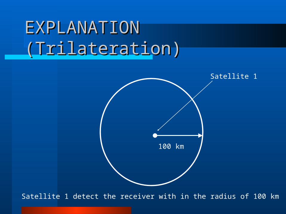
EXPLANATION (Trilateration)EXPLANATION (Trilateration)
Satellite 1
100 km
Satellite 1 detect the receiver with in the radius of 100 km

EXPLANATION (Trilateration)EXPLANATION (Trilateration)
Satellite 1
100 km
Satellite 2 detect the receiver with in the radius of 200 km
200 km
Satellite 2

EXPLANATION (Trilateration)EXPLANATION (Trilateration)
Satellite 1
100 km
Satellite 3 detect the receiver with in the radius of 50 km
200 km
Satellite 2
50 km
Satellite 3

EXPLANATION (Trilateration)EXPLANATION (Trilateration)
Satellite 1
100 km
The intersection point of these three circles will be the exact location of Target
200 km
Satellite 2
50 km
Satellite 3

UTILITES & APPLICATIONUTILITES & APPLICATION
Vehicle Fleet Tracking
GPS Single Vehicle Tracking
GPS Data Logging
Real Time Tracking

UTILITES & APPLICATIONUTILITES & APPLICATION


Vehicle Tracking Vehicle Tracking


Real Time Vehicle TrackingReal Time Vehicle Tracking

Military ApplicationMilitary Application
Military GPS user equipment has been integrated into fighters, bombers, tankers, helicopters, ships, submarines, tanks, jeeps, and soldiers' equipment.
In addition to basic navigation activities, military applications of GPS include target designation of cruise missiles and precision-guided weapons and close air support.
To prevent GPS interception by the enemy, the government controls GPS receiver exports
GPS satellites also can contain nuclear detonation detectors.

Civilian ApplicationCivilian Application
Automobiles are often equipped GPS receivers.
– They show moving maps and information about your position on the map, speed you are traveling, buildings, highways, exits etc.
– Some of the market leaders in this technology are Garmin and Tom Tom, not to mention the built in GPS navigational systems from automotive manufacturers.

Civilian ApplicationCivilian Application For aircraft, GPS provides
– Continuous, reliable, and accurate positioning information for all phases of flight on a global basis, freely available to all.
– Safe, flexible, and fuel-efficient routes for airspace service providers and airspace users.
– Potential decommissioning and reduction of expensive ground based navigation facilities, systems, and services.
– Increased safety for surface movement operations made possible by situational awareness.

Civilian ApplicationCivilian Application
Agriculture
– GPS provides precision soil sampling, data collection, and data analysis, enable localized variation of chemical applications and planting density to suit specific areas of the field.
– Ability to work through low visibility field conditions such as rain, dust, fog and darkness increases productivity.

Civilian ApplicationCivilian Application
Disaster Relief
– Deliver disaster relief to impacted areas faster, saving lives.
– Provide position information for mapping of disaster regions where little or no mapping information is available.
– Example, using the precise position information provided by GPS, scientists can study how strain builds up slowly over time in an attempt to characterize and possibly anticipate earthquakes in the future.

DRAWBACKS OF GPSDRAWBACKS OF GPS
System are very costly and required professional experience.
A stolen object can’t be traced out if Receiver is switched off or facing power failure.
Position of the receiver can’t be traced if kept under high EM insulation.
The drawbacks to GPS are that it requires a minimum of 4-5 satellites in order to give accurate locations.
The Hijacker is not guaranteed to catch.