GPS Software Attacks
12
GPS Software Attacks Tyler Nighswander Carnegie Mellon University Pittsburgh, PA, USA [email protected] Brent Ledvina Coherent Navigation San Mateo, CA, USA [email protected] Jonathan Diamond Coherent Navigation San Mateo, CA, USA [email protected] Robert Brumley Coherent Navigation San Mateo, CA, USA [email protected] David Brumley Carnegie Mellon University Pittsburgh, PA, USA [email protected] ABSTRACT Since its creation, the Global Positioning System (GPS) has grown from a limited purpose positioning system to a ubiquitous trusted source for positioning, navigation, and timing data. To date, re- searchers have essentially taken a signal processing approach to GPS security and shown that GPS is vulnerable to jamming and spoofing. In this work, we systematically map out a larger attack surface by viewing GPS as a computer system. Our surface includes higher level GPS protocol messages than previous work, as well as the GPS OS and downstream dependent systems. We develop a new hardware platform for GPS attacks, and develop novel attacks against GPS infrastructure. Our experiments on consumer and professional- grade receivers show that GPS and GPS-dependent systems are sig- nificantly more vulnerable than previously thought. For example, we show that remote attacks via malicious GPS broadcasts are ca- pable of bringing down up to 30% and 20% of the global CORS navigation and NTRIP networks, respectively, using hardware that costs about the same as a laptop. In order to improve security, we propose systems-level defenses and principles that can be deployed to secure critical GPS and dependent systems. Categories and Subject Descriptors C.2.0 [Computer Systems Organization]: Computer-Communication Networks—Security and Protection General Terms Experimentation,Security Keywords GPS,Security,RF Attacks 1 Introduction The Global Position System (GPS) transmits timing information at atomic clock precision to receivers throughout the world. GPS has Permission to make digital or hard copies of all or part of this work for personal or classroom use is granted without fee provided that copies are not made or distributed for profit or commercial advantage and that copies bear this notice and the full citation on the first page. To copy otherwise, to republish, to post on servers or to redistribute to lists, requires prior specific permission and/or a fee. CCS’12, October 16–18, 2012, Raleigh, North Carolina, USA. Copyright 2012 ACM 978-1-4503-1651-4/12/10 ...$10.00. grown from a limited purpose positioning system to a ubiquitous trusted source for positioning, navigation, and timing (PNT) data. While GPS is commonly known for personal navigation, it is also widely used for precise timing and frequency calibration. For ex- ample, cell phone towers (e.g., Verizon) use GPS to calibrate the frequency and timing for transmissions, and the power grid uses GPS to coordinate time stamps for phasor measurements in order to locate power line faults. All GPS receivers work on the same basic principles to calculate a navigation solution in 3D space and time. The navigation solution is calculated by trilateration where the receiver measures its dis- tance from four (or more) satellites: one to resolve each dimension in space-time. Each satellite generates and broadcasts a unique, public pseudo-random number (PRN) stream called the coarse ac- quisition (C/A) code, which repeats every 1ms. The current time, as determined by an atomic clock on each satellite, week number, and other navigation information is modulated as a navigation mes- sage on top of the C/A code. GPS receivers generate their own lo- cal replica of each satellite’s C/A code and estimate the time delta required to align the local replica to the received copy. The time delta, along with the transmission times of each C/A code signal form the distance measurements called pseudoranges. The receiver also decodes the navigation data in order to calculate the satellites’ positions and clock offsets. All this information is used to accu- rately estimate the 3D position and time. In this paper, we focus on the civil GPS signal, which is transmitted without authentication information. Previous research has focused on two attacks against GPS: jam- ming and spoofing. Jamming simply transmits noise in the GPS frequency band, preventing a receiver from locking onto the GPS signal. Spoofing attacks are a very specific type of attack that forge the information used to calculate pseudoranges. These attacks are not on the receiver itself per se, as the receiver operates properly just with bogus input data. At a high level, previous work was lim- ited to showing that receivers when given bogus data will output a bogus navigation solution. They did not test for flaws in the actual receiver, or how malicious input flows down to dependent systems. In this paper, we investigate a larger attack surface against GPS, including the GPS software stack and how errors affect dependent systems. In order to do this, we create new system that allows novel attacks compared to spoofing and jamming. For example, unlike spoofing which misleads and jamming which prevents sig- nal acquisition, we show a 45 second GPS message can disable over 30% of the Continually Operating Reference Station (CORS) network, which is used for safety and life-critical applications. The overall landscape of GPS vulnerabilities is startling, and our exper- iments demonstrate a significantly larger attack surface than previ-
Transcript of GPS Software Attacks
GPS Software Attacks
Tyler NighswanderCarnegie Mellon University
Pittsburgh, PA, [email protected]
Brent LedvinaCoherent NavigationSan Mateo, CA, USA
Jonathan DiamondCoherent NavigationSan Mateo, CA, USA
Robert BrumleyCoherent NavigationSan Mateo, CA, USA
David BrumleyCarnegie Mellon University
Pittsburgh, PA, [email protected]
ABSTRACTSince its creation, the Global Positioning System (GPS) has grownfrom a limited purpose positioning system to a ubiquitous trustedsource for positioning, navigation, and timing data. To date, re-searchers have essentially taken a signal processing approach toGPS security and shown that GPS is vulnerable to jamming andspoofing.
In this work, we systematically map out a larger attack surfaceby viewing GPS as a computer system. Our surface includes higherlevel GPS protocol messages than previous work, as well as theGPS OS and downstream dependent systems. We develop a newhardware platform for GPS attacks, and develop novel attacks againstGPS infrastructure. Our experiments on consumer and professional-grade receivers show that GPS and GPS-dependent systems are sig-nificantly more vulnerable than previously thought. For example,we show that remote attacks via malicious GPS broadcasts are ca-pable of bringing down up to 30% and 20% of the global CORSnavigation and NTRIP networks, respectively, using hardware thatcosts about the same as a laptop. In order to improve security, wepropose systems-level defenses and principles that can be deployedto secure critical GPS and dependent systems.
Categories and Subject DescriptorsC.2.0 [Computer Systems Organization]: Computer-CommunicationNetworks—Security and Protection
General TermsExperimentation,Security
KeywordsGPS,Security,RF Attacks
1 IntroductionThe Global Position System (GPS) transmits timing information atatomic clock precision to receivers throughout the world. GPS has
Permission to make digital or hard copies of all or part of this work forpersonal or classroom use is granted without fee provided that copies arenot made or distributed for profit or commercial advantage and that copiesbear this notice and the full citation on the first page. To copy otherwise, torepublish, to post on servers or to redistribute to lists, requires prior specificpermission and/or a fee.CCS’12, October 16–18, 2012, Raleigh, North Carolina, USA.Copyright 2012 ACM 978-1-4503-1651-4/12/10 ...$10.00.
grown from a limited purpose positioning system to a ubiquitoustrusted source for positioning, navigation, and timing (PNT) data.While GPS is commonly known for personal navigation, it is alsowidely used for precise timing and frequency calibration. For ex-ample, cell phone towers (e.g., Verizon) use GPS to calibrate thefrequency and timing for transmissions, and the power grid usesGPS to coordinate time stamps for phasor measurements in orderto locate power line faults.
All GPS receivers work on the same basic principles to calculatea navigation solution in 3D space and time. The navigation solutionis calculated by trilateration where the receiver measures its dis-tance from four (or more) satellites: one to resolve each dimensionin space-time. Each satellite generates and broadcasts a unique,public pseudo-random number (PRN) stream called the coarse ac-quisition (C/A) code, which repeats every 1ms. The current time,as determined by an atomic clock on each satellite, week number,and other navigation information is modulated as a navigation mes-sage on top of the C/A code. GPS receivers generate their own lo-cal replica of each satellite’s C/A code and estimate the time deltarequired to align the local replica to the received copy. The timedelta, along with the transmission times of each C/A code signalform the distance measurements called pseudoranges. The receiveralso decodes the navigation data in order to calculate the satellites’positions and clock offsets. All this information is used to accu-rately estimate the 3D position and time. In this paper, we focus onthe civil GPS signal, which is transmitted without authenticationinformation.
Previous research has focused on two attacks against GPS: jam-ming and spoofing. Jamming simply transmits noise in the GPSfrequency band, preventing a receiver from locking onto the GPSsignal. Spoofing attacks are a very specific type of attack that forgethe information used to calculate pseudoranges. These attacks arenot on the receiver itself per se, as the receiver operates properlyjust with bogus input data. At a high level, previous work was lim-ited to showing that receivers when given bogus data will output abogus navigation solution. They did not test for flaws in the actualreceiver, or how malicious input flows down to dependent systems.
In this paper, we investigate a larger attack surface against GPS,including the GPS software stack and how errors affect dependentsystems. In order to do this, we create new system that allowsnovel attacks compared to spoofing and jamming. For example,unlike spoofing which misleads and jamming which prevents sig-nal acquisition, we show a 45 second GPS message can disableover 30% of the Continually Operating Reference Station (CORS)network, which is used for safety and life-critical applications. Theoverall landscape of GPS vulnerabilities is startling, and our exper-iments demonstrate a significantly larger attack surface than previ-

ously thought. In order to help secure GPS systems, we also pro-pose and develop GPS attack defenses not previously considered inthe literature.
In particular, we design novel:1. GPS Data Level Attacks. Previous spoofing attacks are limitedto only modifying pseudo-ranges of satellites in view each by somefractional amount. In this paper, we investigate producing good,bad, and wrong data at higher-levels such as the navigation messagein real time with the valid GPS signal. We call these GPS data-level attacks to distinguish them with previous work in spoofing,which was not capable of carrying out attacks of this nature. Theadvantage is data-level attacks can cause more damage than simplespoofing. For example, we show data-level attacks can remotelycrash a high-end professional receiver.2. GPS Receiver Software Attacks. GPS receivers are computers.Low-end receivers run a basic OS stack (like Windows CE) andsimple software. High-end receivers add networking capabilitiesand complex software, including web-servers and FTP servers, andthus are significantly more complex. We show the software stackcan be compromised, in some cases remotely. Since GPS receiversare typically treated as devices, not computers, such vulnerabilitiesare likely to go unpatched, and represent a serious vulnerability incritical applications.3. GPS Dependent System Attacks. Higher-level software andsystems routinely treat GPS navigation solutions as trusted inputs.We investigate how our attacks at the GPS level can flow up to de-pendent software. For example, we show that we can permanentlyde-synchronize the date of Phasor Measurement Units (PMUs) usedin the smart grid. We also show we can cause UNIX epoch rolloverin a few minutes, and year 100,000 (the first 6-digit year) rolloverin about 2 days. These attacks are carried out via RF, showing theattacks can remotely exploit latent bugs that depend upon time anddate, that cannot be carried out by spoofers described in previouswork which modify only the PRN.Challenges. Typical software testing assumes generating input forthe software is easy. Things are quite different in the RF domain.In particular, in order to test data-level GPS attacks via RF, we needto be able to generate and broadcast our own GPS signal just like areal satellite. Further, receivers have antennas that can distinguishif there are multiple signals, making it potentially possible for areceiver to detect spoofing. Finally, receivers are literally boxeswith no programmable API.
Previous work in spoofing has relied upon simulators which costseveral thousand dollars and are not suitable for long-range spoof-ing, or created specialized platforms that performed relatively spe-cialized spoofing attacks against pseudo-range measurements (e.g., [4]).They also have not shown that they can affect the software stack,only that when given garbage input, they will output a correct withrespect to the garbage navigation solution.
In order to address the above challenges, we detail the designand development of a novel GPS phase-coherent signal synthesizer(PCSS). The PCSS is like a hybrid receiver and satellite in a box.The PCSS has an input antenna that receives live GPS signals, andoutputs malicious signals. In order to be stealthy, our output signalis phase coherent, meaning it is in code phase sync with the realGPS satellites. Phase coherence means a receiver won’t perceivea difference in phase, making our attacks more stealthy. 1 Moreimportantly, the PCSS hardware and software is designed to allowfull programmatic control over the GPS signals in real time. ThePCSS allows us to generate good, bad, and malicious GPS data totest the larger attack surface.1An antenna can still distinguish direction. However, launching theattacks from overhead, e.g., via a UAV, is trivial.
The total hardware cost of the PCSS is about the same as a laptop– around $2,500.
Our attacks are applicable in several settings, such as:1. Manipulate Positioning, Navigation, and Timing (PNT). Planes,cars, trucks, ships, and people all rely on civil GPS to get frompoint A to point B. GPS is also used extensively for tracking, e.g.,the State of California uses GPS-enabled ankle bracelets to trackparolees in real time [11]. Cell phone towers, traffic lights, powerstations, air traffic control towers, SCADA systems, and other cyber-physical infrastructure use GPS to coordinate activities precisely inthe time and frequency domain [20]. Like previous work, our at-tack can be used to fool receivers into thinking they are somewherethey are not. However, we also show novel attacks that target thedata level, such as showing that we can reset the current year of areceiver, e.g., to 2038, the year of UNIX epoch rollover.2. Manipulate Reference Stations to Amplify Attacks. Thereare a variety of other critical positioning, navigation, and timingnetworks that provide PNT information, such as the CORS net-work [10], Networked Transport of RTCM via Internet Protocol(NTRIP) network [1], and the FAA Wide Area Augmentation Sys-tem (WAAS). Reference stations maintain a static position p, andalso use GPS to calculate their perceived updated position in space-time p′. They can then calculate differential information p − p′,which they then use to estimate GPS error to broadcast to other re-ceivers. Reference stations allow dependent receivers to calculatesub-centimeter accurate navigation solutions using civilian GPS.This information is essential to safety and life-critical applications,e.g., WAAS is used in all phases of airplane flight.
We demonstrate spoofing against reference stations, which thenamplifies our attack by re-transmitting the faulty information to de-pendent systems. In addition, our experiments show we can re-motely crash over 30% of the CORS and NTRIP receivers, whichare used in a variety of applications ranging from surveying to un-manned vehicle navigation.3. Manipulate Down-stream Systems. GPS receivers feed com-puter systems. Unlike a typical computer, however, there are twoaccess points to attacking a receiver: the RF port and the ethernetport. We show both ports have vulnerabilities which can be ex-ploited. For example, we show data-level attacks via the GPS RFcan remotely trigger UNIX epoch rollover, simulate a year 100Krollover in 2 days, and remote ethernet attacks can give us a rootshell on the receiver itself.
GPS Defenses. Our findings suggest despite the fact that GPS isan unauthenticated broadcast protocol, current receivers treat anyincoming signal as guaranteed correct. Worse, receivers often runfull OSes with network services. Together, the possibility of RFand ethernet attacks creates a large attack surface. Previous workhas suggested long-term fixes such as adding authentication to thecivilian signal, adding new directional antennas, and other changesthat require hardware modifications [4, 6, 13, 15]. However, suchmodifications face potentially lengthy deployment cycles, becausesignificant hardware infrastructure must be changed. While we be-lieve such defenses are necessary in the long term, they (a) don’thelp protect critical services dependent on GPS in the short term,and (b) don’t address attacks at the software level.
We suggest shorter-term defenses along two lines to limit the at-tack surface. First, in order to defend against data-level attacks,we suggest an Electronic GPS Attack Detection System (EGADS)that can at least warn when an attack is underway, and an ElectronicGPS Whitening System (EGWS) that re-broadcasts a whitened sig-nal to otherwise vulnerable receivers. Unlike adding authentication

(e.g., as done with military GPS), EGADS and EGWS would re-quire no changes to already deployed hardware or software. Sec-ond, we suggest stronger verification of GPS receiver software tohelp prevent errors. Third, in order to defend against GPS OS at-tacks, we recommend regular software updates for IP-enabled de-vices. GPS receivers have the benefit of running a known set of pro-grams on a fixed hardware platform. As a result, patching should besignificantly easier than on a general purpose computing platform.
Contributions Overall, our contributions are:
• A systematic investigation of the attack surface for GPS. Weshow several new practical attacks that can disable a largepercentage of receivers used in critical operations.• We design and build a PCSS, a novel hardware platform for
demonstrating data-level attacks are feasible.• Novel attacks against GPS software. Although on the one
hand all software has bugs, we demonstrate a unique entrypoint: the RF port.• We propose, design, and build an electronic GPS attack de-
tection system that does not require changes to existing re-ceivers as a short-term defense. We also make recommen-dations for systematic changes in the GPS architecture thatwould increase overall security.
2 The GPS Signal and Previous Attacks2.1 The GPS SignalThe Global Positioning System is a constellation of nominally 30satellites in medium-Earth orbit (satellites on occasion fail and arereplaced by new satellites, so the exact number at any given timeis variable). Each satellite broadcasts ranging signals that can beused by GPS receivers to calculate the receiver’s position and thecurrent time. These satellites are controlled by the GPS ControlSegment on Earth, which is responsible for estimating each satel-lite’s orbital and clock parameters and uploading this informationto the satellites. Each of these satellites has an on-board atomicclock for accurate time-keeping. The satellites broadcast GPS sig-nals at two L-band carrier frequencies called L1 (1575.42 MHz)and L2 (1227.6 MHz). Newer satellites also broadcast at the L5frequency (1176.45 MHz). In this section we recap the basics ofthe GPS signal; textbooks such as [9] provide more details.
The L1 GPS signal consists of a military signal called Y-codethat is modulated in phase-quadrature with a civil signal called theCoarse Acquisition (C/A) code. Some newer satellites are also ca-pable of broadcasting a second military code called M-code. Themilitary Y and M codes are encrypted, which provides a means formilitary receivers to authenticate the signal. The civil C/A code isnot encrypted and does not contain a built-in authentication mech-anism. Only special military hardware is capable of receiving themilitary codes, and details of how to generate those codes are clas-sified. Furthermore, receivers capable of decoding the military sig-nals are relatively expensive, their inner workings a closely guardedsecret, and are available to only a very small percentage of usersauthorized by the US Department of Defense. The vast majorityof receivers, including all receivers providing information to UScritical infrastructure, network time servers, cell phones, and auto-mobiles, utilize the unauthenticated civil signals. For these reasons,the civil signal is the focus of this work.
Simplistically, signal production begins on the satellite with thegeneration of a sine wave (also called the carrier) at the broad-cast frequency. The L1 carrier is a continuous-wave carrier sig-nal broadcast from each satellite at precisely 1575.42 MHz (ignor-
L1 Carrier (1575.42 MHZ)
C/A Code (1.023 MHZ)
Navigation Message (50 HZ)
P(Y)-Code (10.23 MHZ)
L2 Carrier (1227.6 MHZ) Military SignalL2
L1 Civilian and
Military Signal
Figure 1: An overview of the GPS radio signal production. (⊕ rep-resents modulo two addition of signals,⊗ represents signal mixing)
ing satellite clock frequency error). Bits are then modulated ontothis carrier using Binary Phase-Shift Keying (BPSK). In BPSK, bitchanges are encoded by switching the phase of the broadcast sinewave by 180 degrees, essentially inverting the broadcast sine wave.Fundamentally, there are two types of information modulated ontothis carrier: a high-rate ranging code (1.023 million bps for C/Acode) and a low-rate navigation message (50 bps).
The Coarse Acquisition (C/A) ranging code is a time-based pseudo-random number (PRN) sequence unique to each GPS satellite. ThePRN codes are quasi-orthogonal, which enables code-division mul-tiple access (CDMA) transmission of the GPS signals. This meansthat multiple satellites broadcasting at the same frequency but withdifferent PRN sequences can be independently tracked and differ-entiated from each other. Consistent with CDMA convention, eachbit of PRN code is called a chip.
The nominal broadcast time of each chip in the C/A code is wellknown and can be calculated from the GPS Interface Control Doc-ument (ICD) [3]. GPS receivers generate their own local replicaof the code broadcast by each satellite and shift it in time until itlines up with the incoming signal. Simplistically, if the receiverhas to delay its local PRN generation time relative to the nominaltransmit time by td for it to line up with the incoming signal fromthe satellite, then it must have taken the signal that same time tdto travel from the satellite to receiver. The range from the receiverto the satellite must therefore be ρ = c · td, where c is the speedof light. Practically speaking, the quantity ρ differs from the truerange due to a variety of factors, most significantly the fact that thereceiver’s clock can not a priori be considered well aligned withGPS time (even 1 µs of error in the receiver’s clock would equateto 300 m of error in the range measurement). Some other signifi-cant errors are satellite clock error and atmospheric delays. Sinceit differs from the true range to the satellite, the quantity ρ = c · tdis typically called the pseudorange, and it is the fundamental rawmeasurement made by the receiver.
The purpose of the high-rate PRN ranging code (again, some-what simplistically) is to allow the receiver to make the pseudor-ange measurement just described. The purpose of the low-rate nav-igation data message is to provide information used by higher-levelapplications in the receiver to derive a navigation solution from thesuite of pseudorange measurements (one for each GPS satellite in
view). To do that, the receiver needs to know (1) the position ofthe satellite at the time of signal transmission, which is encodedin the navigation message and satellite ephemerides, and (2) anydeviations in the signal’s time of transmit from nominal, which isencoded in the navigation message as satellite clock error coeffi-cients. The message itself is divided into frames and subframes.The specific content of this message is critical to the attacks de-scribed later in this paper, and is therefore described in more detailbelow.
The first navigation subframe contains the time of week in sec-onds and week number that the navigation data was issued, as wellas an identifier for the current set of navigation data called theIODC, information regarding the broadcasting satellite’s clock pa-rameters, and the health of the satellite.
The second and third navigation subframes primarily contain thesatellite’s ephemeris. This data provides sufficient information tothe receiver to calculate the satellite’s position to a few meters orbetter, and consists of numerous parameters as well as a numberused to signify an ephemeris update, called the IODE. While theseparameters are not strictly constant, it is worth noting that in normaloperation, many of the parameters change only slowly (e.g., updateevery 2-4 hours). The ephemeris data takes about 30 seconds toreceive.
The fourth and fifth navigation subframes primarily contain thealmanac. This contains location data similar to that found in theephemeris, but less accurate and for the entire constellation. Italso has information regarding predictions of ionospheric condi-tions which can change the time of flight for a signal traveling fromouter space to the Earth. The complete almanac is 25 frames total,requiring about 12.5 minutes total to receive.
In order to form a navigation solution, a receiver will (1) gener-ate pseudorange observables by continuously tracking all in-viewGPS L1 C/A code signals and decoding the navigation messages,then (2) solve for receiver position using the pseudorange observ-ables and the information in the navigation message. Typically thereceiver has four unknowns – it’s X,Y, Z position and its own re-ceiver clock error. Therefore it needs pseudorange measurementsfrom four satellites to solve for these four unknowns.
2.2 Previous AttacksThe concept of GPS spoofing has been known for over a decadein the civil community (and much longer within the military com-munity), with the first public documentation of the spoofing threatoccurring in 2001 Volpe report [2]. A key finding of this reportpredicts most aptly that “[a]s GPS further penetrates into the civilinfrastructure, it becomes a tempting target that could be exploitedby individuals, groups or countries”.
Previous discussed attacks on GPS receivers have included jam-ming and spoofing. In jamming, significant RF noise is transmittedso that the receiver can no longer pull the satellite signal out ofthe noise. More interestingly, spoofing attacks generate counterfeitGPS signals that cause the receiver to have incorrect position andtime solutions. Since the civil C/A code contains no authenticationmechanism and all required signal details are in a public ICD, thegeneration of these spoofed signals is straightforward.
Note that both of these previous styles of attack target the for-mation of the receiver’s pseudorange, or step (1) from the pre-vious section. They are not attacks on the receiver software it-self. Rather, they just give the receiver’s software incorrect mea-surements, yielding an incorrect position solution. Previous workhas accomplished these incorrect measurements in two main ways:simple GPS simulator attacks and more sophisticated C/A codespoofing attacks.
Simple attacks use GPS simulators, which are commercial de-vices used to test the performance of GPS receivers. Simulatorsgenerate the L1 signal using either default data, or the user can up-load the specification of a signal in a standard format, e.g., Spirentuses NMEA [16]. The main purpose of simulators is offline test-ing. Simulators for a constellation of satellites typically cost severalthousand dollars. In 2002 researchers rented a simulator, added anamplifier, and showed that nearby receivers would lock onto thesignal [19].
Simulators are designed to be able to create any realistic suiteof GPS signals, and can therefore be programmed to create signalsconsistent with what a receiver would see at any specific place onthe planet. However, they are designed to be connected directly toa receiver for testing purposes. When simply connected to a broad-cast antenna, their signals compete with the true satellite signals thereceiver was already tracking. Since the simulator has no knowl-edge nor mechanism to process what is currently being broadcastby the GPS satellites (it only knows what it was programmed to do),its signals will generally be dramatically inconsistent with what thereceiver was already tracking. A well-designed receiver can usethis inconsistency to detect and reject the spoofed signal.
A more sophisticated C/A code spoofing attack, pioneered in thecivil domain by Humphreys et al. [4], contains a GPS receiverthat allows it to decode the precise signal being broadcast by satel-lites in the area. This is then rebroadcast to victim receivers, butwith a transmit delay that can be varied relative to the real sig-nal. This causes the satellites to appear to be at a different rangesto the receiver than they really are, causing the receiver to outputan incorrect navigation solution. The intriguing thing about thisstyle of attack is that the spoofed signal can originally be madeto replicate the broadcast signals perfectly, then gradually movedoff target. Since the error is created gradually, this style of attackcan be made very difficult to detect. However, it also implies thatit takes significant time to create significant navigation errors thisway. Note that this style of attack is not fundamentally changingthe navigation message, it is just adjusting the apparent pseudo-range to the satellite. Our PCSS attack platform is conceptuallysimilar to this style of attack, except that it is designed to allow forlive programmatic changes to the GPS data stream.
For stealthy GPS spoofing and satellite lock takeover, severalrequirements are discussed in depth in Tippenhaurer et al. [17].Although an attacker can spoof multiple receivers to an arbitraryposition (eventually), maintaining the perceived configuration ofthe receivers is shown to limit the locations from which an attackercan broadcast.
Recall from the previous subsection that the formation of a navi-gation solution can be divided into two steps: (1) the creation of thepseudorange observables and decoding of the navigation message,and (2) the formation of a navigation solution from the pseudorangeobservables and the information contained in the data message. Al-though the GPS spoofing experiments just described are interesting,all work to date has been designed to form incorrect pseudorangeobservables, targeting Step 1 of the process. Although an incorrectnavigation solution is achieved, the software applications inside thereceiver are unaffected, and are always doing what they were de-signed to do – they just received incorrect input and therefore gaveincorrect output.
Our approach is unique in that we do not typically target thepseudorange measurements of Step (1) at all (although our systemis also capable of that). Instead we focus on targeting the soft-ware applications necessary to implement Step (2). The spoofedGPS signal becomes a carrier for a malicious data stream that tar-gets software applications running inside the receiver, exploiting

specific vulnerabilities in those applications. The weaknesses ex-ploited could be in the applications that form the navigation solu-tion, or in downstream applications that interface with or use thenavigation solution. They also could be in the applications run-ning on external computers that utilize information obtained over anetwork from the receiver.
This style of attack is not jamming, nor is it traditional spoofing.This paper documents what we believe to be the first practical cyberattack launched on a system using a spoofed RF GPS signal.
Our attacks are novel over simulators because we can manipulateindividual navigation message bits and re-broadcast our attack suchthat it is a code-phase aligned attack in real time. It is novel overC/A spoofing again because the navigation message can be changedin an arbitrary way. Like existing work [4], we can take over alive satellite lock. There are fewer limitations to our attack overC/A code replay, because we can change the navigation message(ephemeris and almanac) and C/A PRN sequence live.
Another unique aspect of our approach is that it has the poten-tial to be effective across multiple receivers over a large geographicarea. To be effective, a single spoofer has to target a specific an-tenna in a known location [4]. This stems from the fact that it has toproduce from one antenna a composite signal that replicates signalsfrom multiple satellites, while still forming a consistent solutionat the receiver. Our approach does not suffer from that limitationbecause the spoofed waveform is really only used as a vehicle tocarry the malicious data sequence, not attempting to replicate anyspecific satellite geometry. Potentially, the only thing limiting therange of our attack’s effectiveness, or the number of receivers af-fected, is the power with which the signal is broadcast and line ofsight to the receiving antennas.
3 The Phase-Coherent Signal SynthesizerThe phase-coherent signal synthesizer (PCSS) is a device that si-multaneously receives and transmits civil GPS signals. It has beenin part derived from the civil GPS spoofer described in [4] and assuch, many details about the performance and implementation ofthe PCSS are similar. It is a software-defined radio (SDR) con-structed using commercial hardware as well as hardware and soft-ware we developed.
Figure 2: Photograph of the PCSS with its top cover removed
The input analog signal to the PCSS, shown in Figure 2, is thecomposite of the broadcast GPS satellite signals received at a localantenna. The antenna connects to the RF input to the PCSS. ThePCSS also contains an RF output, that one connects to a transmitantenna for local area broadcast or to a coaxial cable that directlyconnects to the target receiver.
The PCSS acquires and tracks broadcast GPS signals using stan-dard techniques that can be found in [18]. Here, we define broad-cast GPS signals as the legitimate signals broadcast from the GPS
satellites on orbit. The PCSS uses the estimated parameters fromeach broadcast GPS satellite signal, such as code phase, carrierDoppler shift frequency, and carrier phase, to synthesize new GPSsignals from scratch in real time. The synthesized signals alsoinclude the modulated navigation data (described in [3]) that isderived either from the received satellite signals, arbitrary user-defined data, or a combination thereof. Additionally, navigationdata prediction is used to minimize digital delays within the PCSSthat would manifest as a time delay in the navigation data. Min-imizing these delays that can be on the order of milliseconds, forexample, can improve the stealth of a traditional GPS spoofing at-tack such as the one described in [4] or our new attacks.
The PCSS hardware consists of (i) radio frequency (RF) down-conversion and up-conversion circuitry, (ii) analog-to-digital (ADC)and digital-to-analog (DAC) converters, (iii) a high-end digital sig-nal processor (DSP), (iv) an FPGA and hardware TCP/IP chip, (v)an embedded microcomputer, (vi) a digitally-controlled attenua-tor, and (vii) a large amount of flash memory. Figure 3 showsa block diagram of how these different hardware components areconnected. The total cost of the commercial-off-the shelf hardwareis about $2,500 USD.
These hardware components, along with digital signal process-ing and estimation software, all written in C++, implement a GPSL1 C/A code receiver and a GPS L1 C/A code signal synthesizer.The receiver tracks 10 GPS C/A code signals and the synthesizergenerates 10 GPS C/A code signals in real time.
SBC
DSP FPGA
TCPFlash
Memory
Oscillator
RFDown−
Conversion
DAC
ADC
GPS
Phase−Coherent Signal Synthesizer
Conversion
Up−RF Synthesized
RF Signals
GPS RF In
Figure 3: Block Diagram detailing the design and operation of thePCSS
The input RF port on the PCSS receives the broadcast GPS L1signals from all satellites in view. The RF down-conversion cir-cuitry mixes the composite GPS signal to an intermediate frequency.The ADC then digitizes the signal to 2 bits. Quantizing the compos-ite signal to 2 bits (4 levels) is sufficient for GPS signals, becausethey are below the noise floor in the L1 band, thus one is sim-ply quantifying the additive Gaussian white noise that, in the worstcase, causes loss of≈ 0.7 dB [18] of the GPS signals. This digitalsignal is processed by a GPS software-defined receiver running onthe high-end Texas Instruments TMS3206455 DSP clocked at 1.2GHz. The output of the receiver is a set of estimated parametersincluding the satellites in view, their pseudoranges, carrier Dopplershift frequencies, carrier phases, and the time, position, and veloc-ity of this receiver’s antenna. These parameters are input into theGPS signal synthesizer, which is also implemented in software andalso runs on the DSP chip. The GPS signal synthesizer takes theinput parameters, manipulates them based on the specific attack se-lected, generates a set of GPS signals containing the time-phasedPRN codes and the navigation data, adds them together and then

outputs them to the DAC. The output of the DAC is connected tothe RF up-converter that has two stages of up-conversion, with anarrowband band-pass filter between the two stages to eliminatethe sampling images. The up-converted signal is centered at theGPS L1 frequency and sent to the output RF port on the PCSS. Thedigitally-controlled attenuator provides the ability to dynamicallycontrol the power level of the output RF signal during an attack.
The PCSS has the same capabilities as the spoofer in [4], but thePCSS has the following improvements:• The PCSS generates and transmits code-phase coherent GPS
signals• The PCSS intentionally manipulates the information content
of the 50bps GPS navigation message• The PCSS contains internal digital IF data record and play-
back circuitry and 32 GB of flash memory for storing thedata• The PCSS has an API to control spoofing attacks• The PCSS transmitter hardware contains a 2 MHz bandpass
filter
These improvements are described in more detail below.First, the PCSS generates code-phase-coherent GPS signals that
can be aligned in phase with the satellites’ broadcast GPS signalsarriving at the PCSS’s input antenna. The accuracy of the phasecoherency is a small fraction of a GPS L1 C/A code chip, whoseduration is nominally 1 microsecond or equivalently 300 meters.Thus, the phase-coherency is typically better than 10 meters. Gen-erating code-phase coherent signals allows the PCSS to target aGPS receiver, possibly at a long stand-off distance, by aligning itsgenerated GPS signals to the broadcast GPS signals that arrive atthe target receiver’s antenna. This is beneficial, because it is neces-sary to have the target receiver track and process the PCSS’s signalsfor an attack on the target to be successful. The PCSS output powercan be adjusted, e.g., to start at the noise floor and slowly ramp upuntil a stealthy lock is obtained. A key component to generatingcode-phase coherent signals is knowing the GPS data bits in thenavigation message a priori. Since this is typically impractical, re-liable GPS data bit prediction is used. Note that it was recentlyreported that Wesson et al. have also recently created a spoofer thatis code-phase coherent [20].
Second, the PCSS can modify the information content of theGPS navigation message on each generated GPS signal (one foreach satellite in view) in real time. To the best of our knowledge,the PCSS is the first to offer this ability. The specific modificationsenabled in the current version of the PCSS are the ability to set thesquare root of the semi-major axis of the GPS satellites’ orbits, bothin the ephemeris and in the almanac, to an arbitrary number; to re-place all of a satellite’s ephemeris parameters in subframes 1-3 withthat of another satellite; to set the GPS week number in subframe 1to an arbitrary number; to set the IODE and IODC parameters foreach satellite to arbitrary numbers; and to set the leap seconds insubframe 4, page 18 to an arbitrary number. Modifying any param-eter in the navigation message typically requires real-time calcula-tion of a new 6-bit parity code in the (32,26) Hamming code foreach word. Furthermore, since the navigation message implementsa bit-inversion process that is a function of the previous word’s lastbit (except for word 3), this has to be taken into consideration too.
Third, the PCSS contains an API that allows for programmaticmodification in real time of the phase of the GPS PRN codes andthe navigation message data. Specific attacks are created using theAPI, and can be selected to run via a web interface.
Fourth, the PCSS has the ability to record to an internal flashdrive either the input digital IF data stream containing the broad-cast GPS signals or the output digital IF data stream containing the
0
200
400
600
800
1000
1200
1400
1600
1800
2000
P-XII3
UZ-12
Z-XII3
GRX1200 G
G P
GRX1200+ G
NSS
GRX1200 P
RS500
SR530
WAAS G
II
SNR-8000
SNR-8
TPS NET G
3
4000SSE
4000SSI
47005700
NetR
5
NETR
9
NetR
S
OTH
ER
Num
ber
of U
nits
AshtechLeica
NovaTelOtherTPS
TrimbleRogue
Figure 4: Distribution of receivers on CORS network
synthesized GPS signals. Recorded signals can be played back toa target receiver by the PCSS. Playback corresponds to streamingof the digital data at the correct cadence to the DAC and then up-conversion to the GPS L1 frequency. The PCSS contains a smallFPGA and hardware TCP/IP IC that connects to both the ADC andDAC. The digital signal to be recorded can be selected and thentransferred via TCP packets to the embedded computer and thenstored on a 32 GB flash drive. Having this record capability em-bedded in the PCSS is convenient. This is because the generationof new GPS signals is based on top of the live broadcast GPS signal,which practically means no two sets of synthesized signals are thesame. Having the ability to record and then play back the signalsprovides the ability to identically repeat an experiment.
Fifth, the PCSS uses a two-stage RF up-conversion process witha 2-MHz bandpass filter to remove artifacts of the digital samplingprocess. This filter helps remove information in the synthesizedGPS signal that could be used to distinguish a spoofer’s signalsfrom a legitimate GPS satellite signal.
4 MethodologyReceivers Investigated We investigated attacks against sevendifferent receivers. Each of these receivers have their own purposesand therefore security considerations. The receivers span from con-sumer grade, costing a few hundred dollars, to professional grade,costing up to about $17,500.
Our consumer receivers investigated are the Magellan eXplorist310, Garmin eTrex Legend HCX, GlobalSat ND-100S, uBlox EVK-6H, LOCOSYS 23060 and iFly 700. The first two devices are hand-held receivers primarily targeted for personal navigation, for ex-ample hiking or biking, while the iFly is used by private pilots fornavigation. The LOCOSYS chip is an OEM device consisting of aGPS antenna and chipset. It was borrowed from researchers whowere using it inside quadcopter UAVs. The GlobalSat is a pack-aged version of the SiRF-III GPS chip, used widely for high-endconsumer devices. The uBlox is an evaluation kit for the uBloxGPS chip, which is sold for industrial and automotive applications.Both the eXplorist and iFly receivers run on Windows CE, whilethe eTrex receiver runs on a custom operating system.
The first professional receiver is the Trimble NetRS. The NetRSis intended to be used as a reference station, with a retail cost ofabout $17,500. The NetRS is widely used in safety-critical settings,such as the CORS network (operated by the United States NationalGeodetic Survey) and the NTRIP network. We picked the NetRSbecause it is by far the most popular deployed reference station in

the CORS (about 30% of all receivers, see Figure 4) and NTRIP(1126 out of 3963 stations surveyed, or about 22% of all receivers)networks. The NetRS runs Linux on a PPC chip, provides an eth-ernet port, and runs several network services such as a web server(for configuration and displaying data), an FTP server, and a NTPserver.
The second professional receiver is an Arbiter 1094B SubstationClock, which is marketed for use as an accurate time source forPhasor Measurement Units (PMUs) in power stations. PMUs areintended to monitor the power phase at multiple points in the powergrid, with any change in phase between two PMUs at the same timeindicating a change in power flow. The Arbiter clock aims to besynchronized to within 100ns of GPS time so that PMU readingsacross geographically distant regions are synchronized. We boughtthis unit for $1,350, which is the price of similar timing receivers.This specific receiver was chosen due to its high accuracy, serialcommunications capabilities, and because it is advertised for usewithin the power grid.
Note that all receivers calculate the navigation solution in firmware,which is closed-source. The main implication is that receivers actas a black box: we often have no idea how it is processing data, orwhy a fault may occur. Open-source daemons such as gpsd read thenavigation solution via a serial link protocol from the appropriatedevice driver. If the firmware was open-sourced, we could poten-tially use classic software testing strategies (e.g., symbolic execu-tion, model checking, and fuzzing 2). Thus in our study the PCSSwas absolutely essential since we are effectively only given blackbox access to the GPS via the RF port.
Testing All our GPS RF attacks are transmitted via the PCSS overcoaxial cable using an SMA port. For the professional receivers, nomodification was required, as each has ports for external antennas.However, each of our consumer receivers had to be retrofitted withan SMA antenna port through which our signal could be broadcast.This modification required disassembling the GPS receiver, remov-ing the internal antenna, and soldering on an SMA port. Althoughthe iFly receiver had an external antenna port available, we alsoreplaced it with an SMA port for easier interfacing.
The GPS signal reaching the surface of the earth is approxi-mately -160 dBW (1 × 10⁻¹⁶ watts), roughly the equivalent ofviewing a 25-watt light bulb in Japan from Los Angeles [19]. Broad-casting at any power would likely affect receivers outside the au-thors’ control, and besides being dangerous, would also potentiallybe a violation of US law. Although using the coaxial cable has theunfortunate limitation that we cannot investigate atmospheric andionospheric effects and antenna angle-of-arrival effects (gain andpolarization) on the attacks, it is the safest approach. Of coursea real attacker need not be constrained by US law, and would notuse a coaxial cable. A sufficiently large protected chamber thatshields RF emissions, e.g., an anechoic chamber could allow moreexperimentation with antenna effects and multiple GPS sources.However, protected chambers also typically shield incoming sig-nals (including the real GPS signal), making it difficult to come upwith a safe yet realistic experiment. With the RF output connectedto an antenna rather than directly to a device, our spoofing rangefor a receiver would be limited primarily by power output, line ofsight, and knowledge of a target’s location. If these conditions aresatisfied, spoofing of receivers up to 100km away is feasible.
The PCSS is connected to an antenna mounted on the roof. Sig-2Blackbox fuzzing is impractical for GPS due to the amount of timeit takes for the receiver to get navigation data (tens of seconds) andthe inability to get feedback from GPS devices due to their closednature.
nals were synthesized in real time as the experiments were per-formed. We verified that each receiver could acquire satellite lockand compute a navigation solution when the PCSS simply passed-through the real GPS signal before proceeding with our testing.
5 AttacksOur attacks view GPS receivers as a software system. Each layerof the system is roughly analogous to layers in the OSI model, withits own set of security vulnerabilities and associated defenses. Inthis section we detail our attacks. In the next section we addressdefenses. We investigated several attacks in the course of our re-search; due to space we only detail attacks that were successfulagainst at least one receiver. Table 1 shows our overall results.
5.1 Data Layer AttacksThe below attacks are carried out by manipulating data in the nav-igation message of the GPS signal. Therefore, previous spooferswhich could only change the offsets in the PRN are not capableof carrying out any of these higher level attacks. Further, vulner-abilities at this level are due to software bugs in the processing ofthe navigation message, making them an entirely different class ofattack from previous spoofing.
Middle-of-the-Earth Attack Recall the ephemeris data con-tains sufficient information for a receiver to calculate each satel-lite’s position. Part of the ephemeris data is the square root of thesemi-major axis
√A of the satellite’s orbit. In our attack, we set√
A = 0. This is similar to telling the receiver that the satellite isin the middle of the Earth.
We performed this attack on all receivers in order to determinewhich would reject the bogus data. All receivers except the NetRSrejected the data. In the Trimble NetRS, the gpssd daemon caughtan exception and died. We speculate that the exception was adivision-by-zero error, though there is no way to verify this withoutsource (the actual error seems to be triggered in the closed-sourcefirmware). Let µ be the WGS-84 value of the Earth’s gravitationalconstant. The GPS specification has the receiver compute the meanmotion n0 of the satellite (rad/sec) as [3]:
a = (√A)2 n0 =
õa3
The NetRS attempted to resolve the error by rebooting. Unfor-tunately, the NetRS appears to cache ephemeris data. Caching isquite common and is the reason a warm-boot of a GPS receivertakes less time to acquire lock. Since the ephemeris was cached,the receiver made the same faulty calculation, again erred, and thesystem entered an infinite reboot cycle. The receiver only recov-ered after a full hardware reset was manually performed.
The almanac data also contains the same parameter√A. We
carried out the attack successfully against the NetRS, again withthe same continual reboot behavior, using the almanac parameter√A = 0. This experiment shows that the NetRS does not appear
to correlate the ephemeris data with the almanac data.To the best of our knowledge, our attack is the first demonstra-
tion of a cyber-attack (a DoS) over RF against GPS. Overall, inour attack the attacker needs only transmit the bogus data until thereceiver decodes the ephemeris, which typically takes 30 seconds.After the ephemeris is decoded, the receiver will enter a rebootcycle even after the attack is stopped. Thus, the attack achievesa similar goal to jamming: denying service, but unlike jamming,does not require continual broadcast. While DoS is not consideredespecially harmful in typical computer networks, availability of theGPS heartbeat is typically critical in applications that actually use
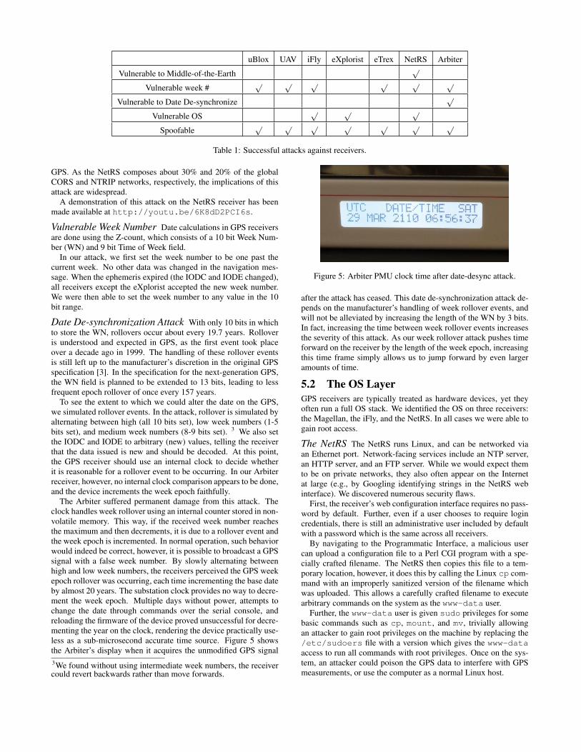
uBlox UAV iFly eXplorist eTrex NetRS Arbiter
Vulnerable to Middle-of-the-Earth√
Vulnerable week #√ √ √ √ √ √
Vulnerable to Date De-synchronize√
Vulnerable OS√ √ √
Spoofable√ √ √ √ √ √ √
Table 1: Successful attacks against receivers.
GPS. As the NetRS composes about 30% and 20% of the globalCORS and NTRIP networks, respectively, the implications of thisattack are widespread.
A demonstration of this attack on the NetRS receiver has beenmade available at http://youtu.be/6K8dD2PCI6s.
Vulnerable Week Number Date calculations in GPS receiversare done using the Z-count, which consists of a 10 bit Week Num-ber (WN) and 9 bit Time of Week field.
In our attack, we first set the week number to be one past thecurrent week. No other data was changed in the navigation mes-sage. When the ephemeris expired (the IODC and IODE changed),all receivers except the eXplorist accepted the new week number.We were then able to set the week number to any value in the 10bit range.
Date De-synchronization Attack With only 10 bits in whichto store the WN, rollovers occur about every 19.7 years. Rolloveris understood and expected in GPS, as the first event took placeover a decade ago in 1999. The handling of these rollover eventsis still left up to the manufacturer’s discretion in the original GPSspecification [3]. In the specification for the next-generation GPS,the WN field is planned to be extended to 13 bits, leading to lessfrequent epoch rollover of once every 157 years.
To see the extent to which we could alter the date on the GPS,we simulated rollover events. In the attack, rollover is simulated byalternating between high (all 10 bits set), low week numbers (1-5bits set), and medium week numbers (8-9 bits set). 3 We also setthe IODC and IODE to arbitrary (new) values, telling the receiverthat the data issued is new and should be decoded. At this point,the GPS receiver should use an internal clock to decide whetherit is reasonable for a rollover event to be occurring. In our Arbiterreceiver, however, no internal clock comparison appears to be done,and the device increments the week epoch faithfully.
The Arbiter suffered permanent damage from this attack. Theclock handles week rollover using an internal counter stored in non-volatile memory. This way, if the received week number reachesthe maximum and then decrements, it is due to a rollover event andthe week epoch is incremented. In normal operation, such behaviorwould indeed be correct, however, it is possible to broadcast a GPSsignal with a false week number. By slowly alternating betweenhigh and low week numbers, the receivers perceived the GPS weekepoch rollover was occurring, each time incrementing the base dateby almost 20 years. The substation clock provides no way to decre-ment the week epoch. Multiple days without power, attempts tochange the date through commands over the serial console, andreloading the firmware of the device proved unsuccessful for decre-menting the year on the clock, rendering the device practically use-less as a sub-microsecond accurate time source. Figure 5 showsthe Arbiter’s display when it acquires the unmodified GPS signal3We found without using intermediate week numbers, the receivercould revert backwards rather than move forwards.
Figure 5: Arbiter PMU clock time after date-desync attack.
after the attack has ceased. This date de-synchronization attack de-pends on the manufacturer’s handling of week rollover events, andwill not be alleviated by increasing the length of the WN by 3 bits.In fact, increasing the time between week rollover events increasesthe severity of this attack. As our week rollover attack pushes timeforward on the receiver by the length of the week epoch, increasingthis time frame simply allows us to jump forward by even largeramounts of time.
5.2 The OS LayerGPS receivers are typically treated as hardware devices, yet theyoften run a full OS stack. We identified the OS on three receivers:the Magellan, the iFly, and the NetRS. In all cases we were able togain root access.
The NetRS The NetRS runs Linux, and can be networked viaan Ethernet port. Network-facing services include an NTP server,an HTTP server, and an FTP server. While we would expect themto be on private networks, they also often appear on the Internetat large (e.g., by Googling identifying strings in the NetRS webinterface). We discovered numerous security flaws.
First, the receiver’s web configuration interface requires no pass-word by default. Further, even if a user chooses to require logincredentials, there is still an administrative user included by defaultwith a password which is the same across all receivers.
By navigating to the Programmatic Interface, a malicious usercan upload a configuration file to a Perl CGI program with a spe-cially crafted filename. The NetRS then copies this file to a tem-porary location, however, it does this by calling the Linux cp com-mand with an improperly sanitized version of the filename whichwas uploaded. This allows a carefully crafted filename to executearbitrary commands on the system as the www-data user.
Further, the www-data user is given sudo privileges for somebasic commands such as cp, mount, and mv, trivially allowingan attacker to gain root privileges on the machine by replacing the/etc/sudoers file with a version which gives the www-dataaccess to run all commands with root privileges. Once on the sys-tem, an attacker could poison the GPS data to interfere with GPSmeasurements, or use the computer as a normal Linux host.

Second, Trimble uses a single master Linux image for all instal-lations, called the “firmware” at their website. The current firmwarehas a relatively old Linux revision: 2.4.19. The image contains acopy of all programs, which allow an attacker to easily find addi-tional vulnerabilities. Worse, the firmware has a default passwordfor root in /etc/passwd with no public interface to change it. Thus,it appears likely that most receivers on the Internet share the sameroot password. Although we used a password cracker to attemptto find the password, we were not successful after running it formonths on a modern CPU. This suggests that at least the passwordused in the NetRS is relatively strong.
Finally, we note the NetRS image did not have modern OS de-fenses such as ASLR enabled. The NetRS also did not appear tohave any way to perform software updates other than installing anew firmware image, making patching onerous.
Windows System Both the Magellan and iFly receivers run ontop of Windows CE 5.0. Both allow access to their file systemsthrough USB or an SD card slot for the purpose of updating GPSmaps and device firmware. By uploading executables through ei-ther of these two interfaces, we are able to run arbitrary code, in-cluding Windows Explorer and its associated tools. This could leadto malware or identification of new software vulnerabilities whichcould be exploited on the Data Layer.
This problem has been seen in mobile devices, such as smart-phones, in the past. In general, manufacturers can solve this byrequiring code to be signed in order to run or by restricting directaccess to the file system on the device. While some users may seethe ability to use their GPS receiver as a general purpose computeras a feature rather than a vulnerability, and indeed such communi-ties exist for using GPS devices effectively as PDAs, the securityramifications of running untrusted code on devices intended to nav-igate and track people are serious.
5.3 GPS-Dependent SystemsGPS systems are used as an authoritative time source in many ap-plications. Here we show the ramifications of the ability to spoofand damage GPS receivers to dependent systems. Our goal is not toprovide an extensive list (which is likely very long), but to demon-strate that attacks on dependent systems are indeed practical.
Fixed-Width Year Attacks Recall that we can increment thedate by approximately 20 years per ephemeris decoded by the re-ceiver. The date de-synchronization attack gives us a black-boxway to remotely (via RF) cause rollover in fixed-width date fields,similar to the Y2K problem.
For example, the Arbiter provides a time synchronization ser-vice for Windows XP. Windows XP dates must be in the range1980-2099. Although the system will continue to operate after thisrange of times, some critical aspects of the system, such as filetime-stamps used in FAT file systems will not work, as they arestored as unsigned 7 bit integers. In our experiments, we confirmedthe date could be incremented at least up to 2110 (see Figure 5) andalter Windows XP dates.
A second example is the UNIX epoch roll-over will happen in2038 for software that uses a 32-bit signed number for the date(e.g., time_t on Debian Squeeze). We experimented with 32-bitDebian Squeeze install, and found that the time_t and structtimeval data structures use 64-bits. However, the ext3 file sys-tem was vulnerable: after incrementing the date past 01/18/203822:14:14, rollover occurred in the time stamps for files, as well asthe output of the date command. Therefore, applications that trustthe date command, or perform critical operations based upon filesystem dates, may be vulnerable to attack.
Decoding takes about 30 seconds, which means in principle wecan increment about 40 years per minute. The first 6-digit date isthe year 100,000. So we would need to increment about 97,989years to cause rollover, which would take about 1.7 days.
NTRIP The NetRS is often deployed as a reference station whichnot only receives GPS information, but also transmits correctiondata to other receivers. The CORS and NTRIP networks are de-signed to facilitate locating nearby correction data sources and trans-mitting of the correction data to clients. Since deliberate GPS sig-nal degradation was disabled, a typical GPS receiver will experi-ence a position error of around 10-15 meters [1]. NTRIP attemptsto give centimeter-level accuracy, e.g., for autonomous driving oftractors or other vehicles.
Decimeter-level accuracy is possible by using differential GPStechniques. For example, several stationary NetRS’s can be con-figured to use differential GPS to calculate accurate true positioninformation. The NetRS then continues to calculate the currentposition and use measured position changes to estimate GPS er-rors, which can be broadcast as a correction solution for nearbydevices. Variations are due to changes in local atmosphere, satel-lite ephemerides, etc. NTRIP sources broadcast the correction dataover the NTRIP protocol, which can run on top of IP, EDGE, orother network protocols. The protocol is designed to also helpclients find the closest NTRIP source. The closest source is de-sirable because relative error sources, e.g., atmospheric conditions,are most likely to be similar. The NetRS and NTRIP are also ca-pable of supplying Real Time Kinematic data, which provide evenmore accurate positioning information for nearby receivers.
We set up a NTRIP testbed consisting of the NetRS, which servedas the correction data server (called a Caster in NTRIP), and severalreceivers. We confirmed that our attacks flowed through to clientsconnecting to our server, causing them in turn to calculate erro-neous navigation solutions. We note that joining the global NTRIPnetwork only requires filling out an appropriate form. 4 We did nottest this as the network operators request a long-term commitmentto provide data.
NTP Modern computers use NTP extensively time synchroniza-tion, with NTP clients packaged by default on nearly all modernoperating systems. In turn, this time is used for many other pur-poses including cryptographic communication, shared file systems,and even data for the Health Insurance Portability and Accountabil-ity Act (HIPAA) which requires accurate timestamps on medicalrecords.
NTP relies on computers connected directly to high precisionclocks. In general, NTP servers are classified by their Strata, witha Stratum-1 server being directly connected to a clock, a Stratum-2server connecting directly to a Stratum-1 server, and so on. GPS iscommonly used as a Stratum-1 time source.
Our analysis showed that of the Stratum-1 servers in the publicNTP.org pool, at least 148 servers 5 used GPS for time synchro-nization, or at least 65% of the pool.
NTP works by retrieving time estimates as well as error intervals(t ± λ) from some client-specified list of servers. A time intervalon which at least half of the queried servers agree is then selected,and the actual time reported is then based on a clock in this range.This means that directly spoofing the time for a client connectedto multiple Stratum-1 servers could be done only if an attacker had4http://igs.bkg.bund.de/ntrip/registerprovider5Some NTP servers do not list the devices they use for time syn-chronization, so only a lower bound may be obtained.
the capability to spoof at least half of the servers used by a client atthe same time. Although this may be feasible for a dedicated orga-nization, it can be difficult especially if clients specify numerous,geographically separated NTP servers.
However, given an NTP client which normally reports a time in-terval I = [t − λ, t + λ], an attacker who can modify only oneNTP server (say, by spoofing the GPS clock used by the server)may change the time reported to the client to a subset of I or pre-vent the client from selecting a clock by forcing that there does notexist an interval on which a majority of servers agree. If a clientqueries only a small number of servers, which was typical, suchattacks are readily done. This would lead to growing inaccuraciesin the client’s clock over time, though the inaccuracies would notbe entirely under attacker control. [7]
Monitoring an NTP client on an author’s computers, (see Figure6) we noted that interval widths in typical operation were typicallyfrom hundreds milliseconds to one second.
This amount is small for most consumer purposes, but consid-ering NTP accuracy should be on the order of 10ms over a WAN,pushing time towards an extreme end of the interval could havea large impact. For example, industrial automation, SCADA sys-tems, and operations management commonly need sub-second tim-ing for proper operation, and commonly use NTP to accomplishthis.[14]
5.4 Pseudorange AttackWe have also independently verified the results of previous work inspoofing [4]. In this attack we estimated the received GPS signalsparameters, and then synthesized new signals at different relativePRN code offsets.
Recall a receiver calculates its position in space-time via trilat-eration. If we modify one of the satellite’s PRN offsets, but notothers, then we affect one dimension of the navigation solution. Ifwe shift all PRNs by an offset of the same amount, we only affectthe time dimension of the navigation solution. More generally, byvarying the PRN phase for particular satellites in a concerted way,we can make a receiver’s navigation solution move in space-time.
We created two categories of spoofing attacks: one that manipu-lated position and one for time. The time and position spoofing canbe carried out independently, or in combination. For position, wecreated two spoofed modes. First, we spoofed receivers going ina particular direction at a particular velocity. Second, we spoofedreceivers going in a circle, with a configurable diameter, speed,and direction parameter. For the time spoofing, we have developedthree attacks that varied the rate at which time is changed as ei-ther linear, exponentially, or logarithmic. All receivers acceptedthe spoofed data for all attacks.
6 DefensesPrevious work has proposed several hardware defenses to detectspoofers, e.g., [4, 6, 13, 20]. Example solutions include usingmultiple antennas to detect the spoofer and adding cryptographicauthentication to the civilian signal. These are good long-termsuggestions to improving GPS security. However, current propos-als require hardware or other significant modifications, e.g., byadding new antennas or adding a hardware decryption unit (calledthe SAASM in military receivers), making them inadequate in theshort term. Papadimitratos et al. [12], discuss a detection methodbased on Doppler Shift observations during satellite takeover. Thistechnique can detect some spoofing attacks on certain high-end re-ceivers without any hardware modification. In this section we de-
scribe device-specific software security recommendations, as wellas propose electronic GPS attack detection and whitening systems.
As this defense system functions at the data-level and higher, itfunctions only to protect against attacks at a similarly high level.Protecting against traditional spoofing attacks would still requirethe capability to examine the physical-layer of the signal, whichnecessitates some form of hardware device as detailed in previouswork.
6.1 Device-Specific RecommendationsData-Level Protection One observation is that sanity check-ing on input is spotty in receivers. The NetRS software notices anerror and attempts to reboot the receiver during our attack. How-ever, it does not recognize that the cache should be cleared as well,leading to a reboot loop. The date de-desynchronization attack isa failure to check for consistency of the GPS week number withwhat could be known from a cheap internal clock. The fact that thedamage is permanent on the Arbiter seems to be a software flaw:Arbiter provides a serial configuration console which should allowchanging the date, but it does not work correctly to reset the date.
It is also interesting to note the more expensive receivers tendedto have more problems than cheaper receivers in our experience.One possible explanation would be that more expensive receivershave more functionality and perform more complicated processingof the GPS signal, and thus have an increased risk to programmererror.
OS-Level Defenses Our experiments show that GPS users andmanufacturers view receivers as hardware devices, not computers.Nonetheless, they contain software vulnerabilities. While these at-tacks may come as no surprise for those well acquainted with soft-ware security, they appear often ignored by those in charge of de-ploying GPS receivers for widespread usage.
At first glance our remote attack against the NetRS may seemnaïve: one may not expect most GPS receivers to be networked,least of all accessible through the internet. However, simple Googlesearches revealed over a dozen NetRS receivers whose web in-terfaces were accessible remotely (despite the web server of theNetRS disallowing indexing on all pages by default). Further, be-cause these are CORS receivers, they are almost always on sometype of network in order to send their correction data to other de-vices. In fact, we were able to find publicly accessible websitesfor other CORS receivers such as the Trimble NetR5 and the LeicaGRX1200+, showing that it is not uncommon for CORS receiversto be accessible from the public internet. Apart from simply us-ing access to these devices to disrupt GPS measurements, there aremany other attack scenarios. For example, several receivers whichare web accessible reported internal NAT IP addresses, meaninga compromise of the GPS receiver could function as a launchingpoint for attacks on the internal network.
The issue of running untrusted code on GPS receivers is more ofa symptom rather than a problem itself. The requirement of physi-cal access makes this vulnerability a very unlikely attack vector, butis indicative of a larger attack surface. First, because these receiverscommonly run very large software stacks with full blown operatingsystems and due to the specialized nature of these devices, muchof the included software does nothing but contribute to the alreadylarge number of programs in which bugs may be found. Second,the manufacturers of these devices did not have security in mindwhen developing these systems. Even if loading code onto a physi-cal device is not a likely vector for widespread attacks, code signingon embedded systems at some level should be a common practice,

as untrusted code posing as maps, games, or firmware updates mayeasily break a user’s device either maliciously or accidentally.
One immediate best practice would be for GPS receiver man-ufacturers to build and deploy automated software update mech-anisms. At present, users typically must go to the manufacturershome page, download the update, and then transfer it to the re-ceiver. Other recommendations include receivers white-listing pro-grams that can run, and implementing modern OS defenses such asASLR and DEP.
GPS Dependent Systems The NTP protocol uses a filter tolimit the damage of malicious navigation information. This is apromising sign for protocols which rely upon GPS assuming thatmultiple independent sources are used. We speculate, however, thatmany corporate and government environments will only use a sin-gle internal GPS time source as a time server in order to limit out-side connectivity in their firewall, or as a matter of convenience.We recommend users re-evaluate their risk levels with respect toour findings: using only a single receiver as a time source leaves auser vulnerable to spoofing and other attacks, while using externaltime sources via NTP likely require appropriate holes in the fire-wall.
Reference networks, such as CORS and NTRIP, broadcast cor-rection data and are used for a large number of applications, andthus should also adopt defenses that utilize multiple independentsources. The NTRIP network consists of three types of entities:NTRIP sources (the GPS receivers), NTRIP servers (for broadcast-ing correction data), and NTRIP clients (which receive the correc-tion data) [1]. NTRIP is used widely in agriculture, navigation,and surveying. Unfortunately, the NTRIP protocol does not spec-ify how aggregation among multiple sources is to be performed.One recommendation is to specifically address counter-measuresto detect or filter out anomalous readings.
6.2 EGADSOur attacks show that serious damage can be done to life and safety-critical applications using only a few thousand dollars worth ofhardware. Since replacing or updating existing equipment may bedifficult, we propose deploying Electronic GPS Attack DetectionSystems (EGADS). An EGADS is similar in spirit to a network orhost IDS system, but designed to detect GPS attacks. To the bestof our knowledge, we are the first to propose using an IDS stylesystem to detect GPS spoofing attacks 6.
Our EGADS design has a rule-based and anomaly-based com-ponent. The rule-based component detects known bad values, e.g.,√A = 0, while the anomaly-based engine detects deviations given
known good almanac data. We have implemented EGADS on topof a GlobalSat ND-100S USB GPS Receiver module based off ofthe SiRF-III GPS chipset. This provides an output data streamconsisting of normal positioning values as well as almanac andephemeris data from the satellites.
The rule-based engine performs a pattern match on GPS pa-rameters. To detect anomalies, we modified gpsd to check theephemeris data reported by a receiver against the freely availablealmanac data provided by the United States Coast Guard. In Fig-ure 7, we show typical discrepancies over a two week time span,measured every two hours, between historical ephemeris values for√A (retrieved from the NASA Crustal Dynamics Data Information
System) and the reference almanac used in EGADS for each partic-ular day. Because these values are relatively static (though not all6GAARDIAN is a proposed system for detecting interference, suchas from multipath errors, weather conditions, or jamming, and isnot designed for detecting spoofing attacks [8].
remain as static as the√A parameter), we find that the straight for-
ward approach to detection is effective. We combine these record-ings with our own measurements, and double 7 the largest discrep-ancy historically seen for each ephemeris field and for all satelliteswe observed, giving us a range outside of which we should neverfall. If the receiver does report values outside of this range, EGADSwill issue a warning to the user.
Assisted GPS (AGPS) techniques also provide a fallback for ac-curate navigation in areas where the GPS navigation message isbeing disrupted. AGPS uses a set of ephemerides and almanac datafrom external sources to acquire a GPS fix more quickly. An AGPSreceiver could be modified (as standard AGPS devices only useexternal data to establish a fix) to ignore the Navigation Messagecompletely, and instead rely on data from a secure side channel tocontinue operation.
Although this technique does not detect GPS spoofing of posi-tion and timing data from the C/A code, it will warn of attempts tocrash receivers by creating bogus data in the GPS navigation mes-sage. Our system can also detect attempted date de-synchronizationattacks easily, as it does not trust the GPS more than the inter-nal computer clock. Further, this method detects things such asfuzzing of ephemeris or almanac fields, and to some extent a replayof recorded GPS data, all within seconds of broadcast.
As future work, we propose GPS whitening systems. Whiteningtakes in a potentially anomalous or malicious signal, and retrans-mits a known good signal. For example, we could augment thePCSS to remove attacks from the GPS stream and rebroadcast aclean signal to nearby receivers. This would improve upon the de-vice in [5] by protecting against data-level attacks.
7 ConclusionThe intricate nature of today’s GPS devices has created a large at-tack surface. Previous approaches have treated GPS security as anissue of hardware and signal analysis, but many traditional softwaresecurity lessons have yet to be learned by GPS manufacturers. Inthis paper, we introduced novel attacks on GPS devices at the datalevel, many of which have serious ramifications to safety systems.Our attacks required hardware that cost only about $2,500, which isabout the same as a laptop. We have shown our attacks are success-ful against consumer and professional receivers. We also proposedefenses such as hardening GPS software against RF and networkattacks, as well as an attack detection system. Until GPS is se-cured, life and safety-critical applications that depend upon it arelikely vulnerable to attack.
8 AcknowledgementsWe would like to thank Srdjan Capkun and the anonymous review-ers for their helpful feedback.
References[1] RTCM Special Committee No. 104. RTCM Standard
10410.1: Networked Transport of RTCM via InternetProtocol (NTRIP) Version 2.0. Radio Technical Commissionfor Maritime Services, June 2008.
[2] James Carroll, Karen Van Dyke, John Kraemer, and CharlesRodgers. Vulnerability Assessment of the TransportationInfrastructure Relying on the Global Positioning System. InION National Technical Meeting, 2001.
7We chose to double our difference to ensure no false positiveswere reported, though this could be adjusted easily for differentusage scenarios/attacker models.

[3] ARINC Research Corporation. Navstar GPS spacesegment/navigation user interfaces (the interface controldocument). Technical Report IRN-200E-004, 2010.
[4] Todd E Humphreys, Brent M Ledvina, Mark L Psiaki, BradyW O Hanlon, and Paul M Kintner. Assessing the SpoofingThreat: Development of a Portable GPS Civilian Spoofer. InProceedings of the Institute of Navigation GNSS (ION GNSS2008), 2008.
[5] Brent M Ledvina, William J Bencze, Bryan Galusha, andIsaac Miller. An In-Line Anti-Spoofing Device for LegacyCivil GPS Receivers. In Proceedings of the Institute ofNavigation International Technical Meeting (ION ITM2009), January 2009.
[6] Sherman Lo, David Lorenzo, Per Enge, Dennis Akos, andPaul Bradley. Signal authentication: A secure civil GNSS fortoday. Inside GNSS, October 2009.
[7] D. Mills, Ed. J. Martin, J. Burbank, and W. Kasch. NetworkTime Protocol Version 4: protocol and algorithmspecification. Request for Comments RFC 5905, 2010.
[8] Carl Milnder, Washington Ochieng, Wolfgang Schuster,Marco Porretta, and Charles Curry. A regional spacesegment health monitor for local gps integrity monitoring.Journal of Navigation, pages 657–671, 2011.
[9] Pratap Misra and Per Enge. Global Positioning System:Signals, Measurements, and Performance. Ganga-JamunaPress, 2nd edition, 2006.
[10] National Oceanic and Atmospheric Administration.Continually operating reference station (CORS).http://www.ngs.noaa.gov/CORS/.
[11] California Department of Corrections and Rehabilitiation.Electronic monitoring unit.http://www.cdcr.ca.gov/Parole/Electronic_Monitoring_Unit/index.html.
[12] P. Papadimitratos and A. Jovanovic. GNSS-basedPositioning: Attacks and Countermeasures. In MilitaryCommunications Conference, 2008.
[13] Mark L. Psiaki, Brady W. O’Hanlon, Jahshan A. Bhatti,Daniel P. Shepard, and Todd E. Humphreys. Civilian GPSSpoofing Detection based on Dual-Receiver Correlation ofMilitary Signals. In Proceedings of the Institute ofNavigation GNSS (ION GNSS 2011), September 2011.
[14] Schneider Electric. PowerLogic SCADA: Power Monitoringand Control Software, 2008.
[15] Logan Scott. Anti-spoofing and authenticated signalarchitectures for civilian navigation systems. In Proceedingsof the Institute of Navigation GPS/GNSS 2003, pages1543–1552, 2003.
[16] Spirent. Using receiver NMEA data in a simulator testscenario. Technical Report DAN007-TM Issue 1-00, Spirent,unmarked year.
[17] Nils Ole Tippenhauer, Christina Pöpper, Kasper BonneRasmussen, and Srdjan Capkun. On the requirements forsuccessful GPS spoofing attacks. Proceedings of the ACMConference on Computer and Communications Security(CCS), 22:75–85, 2011.
[18] A J Van Dierendonck. Global Positioning System: Theoryand Applications, chapter 8: GPS Receivers, pages 329–407.American Institute of Aeronautics and Astronautics,Washington, D.C., 1996.
[19] Jon S Warner and Roger G Johnston. A SimpleDemonstration that the Global Positioning System (GPS) isVulnerable to Spoofing. Journal of Security Administration,2003.
[20] Kyle Wesson, Daniel Shepard, and Todd Humphreys.Straight talk on anti-spoofing. In GPS World, January 2012.
APPENDIXAlthough the main body of the paper reflects our overallexperimental results, the raw data collected can be seen in Figures6 and 7.
Figure 6: NTP time interval observed over a 3 hour period,polling from time.windows.com, time.ubuntu.com, andtime.nist.gov.
0 %
0.0002 %
0.0004 %
0.0006 %
0.0008 %
0.001 %
0.0012 %
0.0014 %
0 50 100 150 200 250 300 350
Diff
ere
nce
Hours
Figure 7: The level of difference of the√A value of the ephemeris
against that of our reference almanac over a two week period.