Government of Mauritius - United Nations Development Programme
77
UNDP PROJECT DOCUMENT Government of Mauritius United Nations Development Programme Global Environment Facility Food and Agricultural Organisation Capacity Building for Sustainable Land Management in Mauritius including Rodrigues Brief Description The objective of this project is to build capacities for sustainable land management (SLM) in appropriate government and civil society institutions/user groups in Mauritius and Rodrigues, and SLM is mainstreamed into government planning and strategy development. It will benefit a land surface area estimated at 50,000 ha and will contribute towards the achievement of the following long-term goal: The agricultural, pasture, forest and other terrestrial land management in Mauritius and Rodrigues are sustainable, productive systems that maintain ecosystem productivity and ecological functions while contributing directly to the environmental, economic and social well-being of the country. Mauritius SLM MSP developed under the LDC-SIDS Umbrella Project -- 1
Transcript of Government of Mauritius - United Nations Development Programme

UNDP PROJECT DOCUMENT
Government of Mauritius
United Nations Development Programme
Global Environment Facility
Food and Agricultural Organisation
Capacity Building for Sustainable Land Management in Mauritius including Rodrigues
Brief Description The objective of this project is to build capacities for sustainable land management (SLM) in appropriate government and civil society institutions/user groups in Mauritius and Rodrigues, and SLM is mainstreamed into government planning and strategy development. It will benefit a land surface area estimated at 50,000 ha and will contribute towards the achievement of the following long-term goal: The agricultural, pasture, forest and other terrestrial land management in Mauritius and Rodrigues are sustainable, productive systems that maintain ecosystem productivity and ecological functions while contributing directly to the environmental, economic and social well-being of the country.
Mauritius SLM MSP developed under the LDC-SIDS Umbrella Project -- 1

Table of Contents List of Acronyms/Abbreviations Used in This Report...............................................................4
BACKGROUND AND CONTEXT..........................................................................................6 Environmental context........................................................................................................................ 6 Socio-Economic Context ..................................................................................................................... 8 Policy and Institutional Context ...................................................................................................... 10
Root causes of land degradation.............................................................................................13
• Root Causes .........................................................................................................................13
• Potential Corrective/ Mitigating Measures...........................................................................13
• Key causes of land degradation are summarized in the following paragraphs: ....................13 PROJECT DESCRIPTION 15
Baseline course of action .........................................................................................................15
Capacity and mainstreaming needs .......................................................................................18
Project rationale and objectives .............................................................................................19
Expected project outcomes, and outputs ...............................................................................20
Linkages to Implementing Agency’s Activities and Programs............................................21
Stakeholder Involvement Plan................................................................................................22 High Importance .................................................................................................................................. 24
FINANCIAL PLAN 25
Streamlined Incremental Costs Assessment..........................................................................25
Project Budget ..........................................................................................................................26 PROJECT IMPLEMENTATION PROCESS..........................................................................27
Institutional framework and project implementation arrangements .................................27 Technical Coordination with FAO Forest Policy Project.............................................................. 28 Technical Roles for MSIRI............................................................................................................... 29
Audit Requirements.................................................................................................................29
Legal Context ...........................................................................................................................29
Monitoring and Evaluation Plan ............................................................................................30
Response to GEF Secretariat Review.....................................................................................30 Annex A: MAURITIUS LAND DEGRADATION ROOT CAUSE MATRIX .....................31
Root Causes ..................................................................................................................................31
Potential Corrective/ Mitigating Measures .......................................................................................31 Unsustainable vegetable gardening and mixed cropping .............................................................. 33 Sugar cane plantations...................................................................................................................... 33
Annex B 36 Logical Framework for Sustainable Land Management in Mauritius and Rodrigues ........36
Mauritius SLM MSP developed under the LDC-SIDS Umbrella Project -- 2

Annex C Detailed Activity Budget .............................................................................................52 Annex D: Stakeholder Involvement Matrix..............................................................................57 Annex E 60 Terms of Reference for Project Manager, Steering Committee .............................................60 And Technical Advisory Committee .........................................................................................60 ANNEX F: Major Land Uses in Mauritius- .............................................................................62 Annex G 63 M&E Plan and Budget for FSP and MSP.................................................................................63Annex H Error! Bookmark not defined. Capacity Building for Sustainable Land Management in Mauritius (including Rodrigues)Error! BookmFinancing Plan 74 Annex I 74
Co-Financing Sources ....................................................................................................................... 74 Annex J 74 Total Project Workplan and Budget……………………....………………………………… 74 Annex K 77 LPAC Minutes………………………………………………………………………………… 77
Mauritius SLM MSP developed under the LDC-SIDS Umbrella Project -- 3
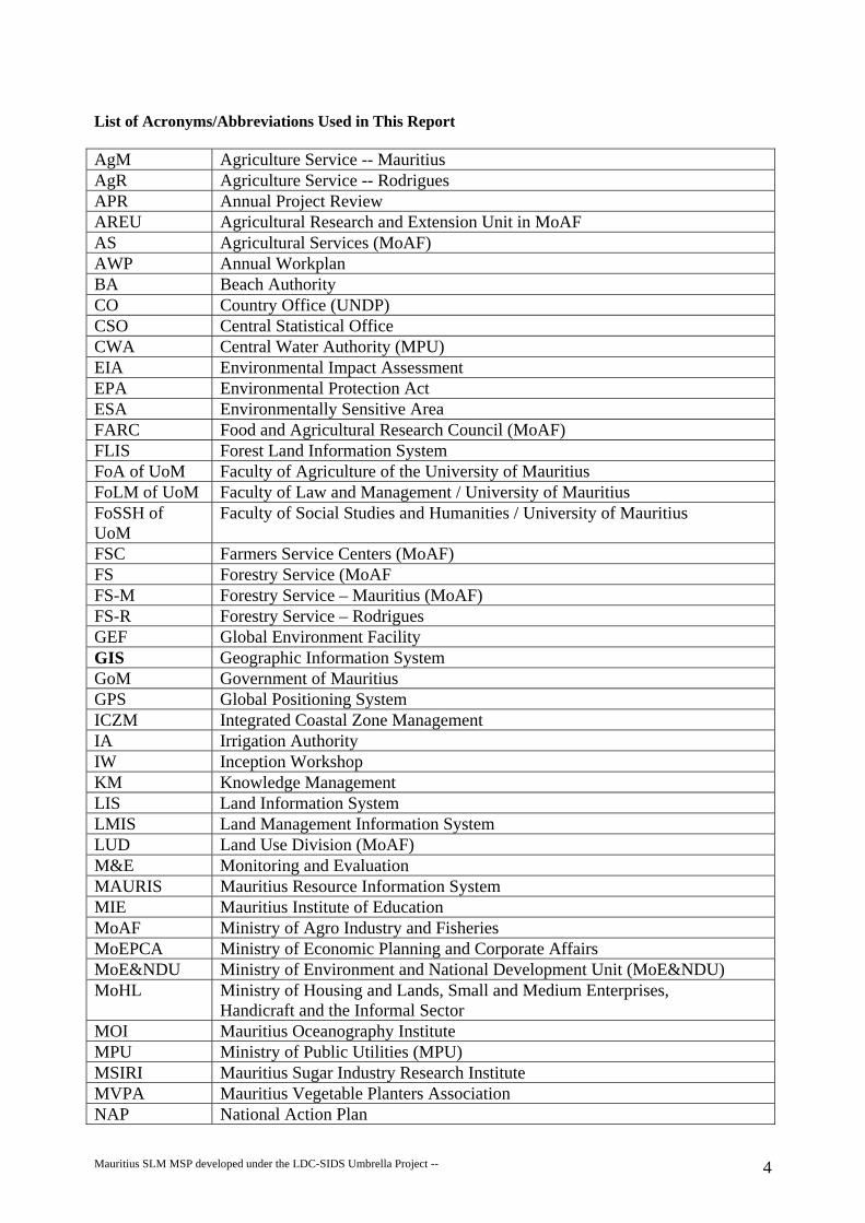
List of Acronyms/Abbreviations Used in This Report
AgM Agriculture Service -- Mauritius AgR Agriculture Service -- Rodrigues APR Annual Project Review AREU Agricultural Research and Extension Unit in MoAF AS Agricultural Services (MoAF) AWP Annual Workplan BA Beach Authority CO Country Office (UNDP) CSO Central Statistical Office CWA Central Water Authority (MPU) EIA Environmental Impact Assessment EPA Environmental Protection Act ESA Environmentally Sensitive Area FARC Food and Agricultural Research Council (MoAF) FLIS Forest Land Information System FoA of UoM Faculty of Agriculture of the University of Mauritius FoLM of UoM Faculty of Law and Management / University of Mauritius FoSSH of UoM
Faculty of Social Studies and Humanities / University of Mauritius
FSC Farmers Service Centers (MoAF) FS Forestry Service (MoAF FS-M Forestry Service – Mauritius (MoAF) FS-R Forestry Service – Rodrigues GEF Global Environment Facility GIS Geographic Information System GoM Government of Mauritius GPS Global Positioning System ICZM Integrated Coastal Zone Management IA Irrigation Authority IW Inception Workshop KM Knowledge Management LIS Land Information System LMIS Land Management Information System LUD Land Use Division (MoAF) M&E Monitoring and Evaluation MAURIS Mauritius Resource Information System MIE Mauritius Institute of Education MoAF Ministry of Agro Industry and Fisheries MoEPCA Ministry of Economic Planning and Corporate Affairs MoE&NDU Ministry of Environment and National Development Unit (MoE&NDU) MoHL Ministry of Housing and Lands, Small and Medium Enterprises,
Handicraft and the Informal Sector MOI Mauritius Oceanography Institute MPU Ministry of Public Utilities (MPU) MSIRI Mauritius Sugar Industry Research Institute MVPA Mauritius Vegetable Planters Association NAP National Action Plan
Mauritius SLM MSP developed under the LDC-SIDS Umbrella Project -- 4

NBSAP National Biodiversity Strategy and Action Plan NCSA National Capacity Self Assessment NDS National Development Strategy NEX National Execution (UNDP) NPCS National Park and Conservation Service (MoAF) NRSC National Remote Sensing Center (MoAF) NYFC National Young Farmers Club OGA Onion Growers Association PGA Potato Growers Association PGRU Plant Genetics Resource Unit PIR Project Implementation Review PM Project Manager RCU Regional Coordination Unit PMU Project Management Unit RRA Rodrigues Regional Assembly SBAA Standard Basic Assistance Agreement SC Steering Committee SGP Small Grants Program (UNDP/GEF) SLM Sustainable Land Management TAG Technical Advisory Committee TOR Terms of Reference TPR Tripartite Project Review TRAC Technical Resources Allocated from Core (category of UNDP funding) TTR Terminal Tripartite Review UNCBD United Nations Convention on Biodiversity UNCCD United Nations Convention to Combat Desertification UNDP United National Development Program UNEP United National Environment Program WRU Water Resources Unit (WRU) WSSD World Summit on Sustainable Development
Mauritius SLM MSP developed under the LDC-SIDS Umbrella Project -- 5

BACKGROUND AND CONTEXT 1. The island of Mauritius is a small tropical volcanic island of about 1,865 km2 situated in the West
Indian Ocean, 800 km off the east coast of Madagascar. Mauritius enjoys two main seasons: a cool one between May to October and a warm one between November to April. The warmer months are also the time when the island receives its maximum precipitation in terms of rainfall intensity and quantity. The average rainfall is about 2100 mm per annum. The island is subject to maritime influences and is visited more or less annually by cyclones, of varying intensity, usually in the months of November to March. In addition to the mainland island of Mauritius, the Republic of Mauritius also comprises of the outer islands: Rodrigues, Agalega, St. Brandon, Tromelin and some small islets. The total area of the Republic of Mauritius is some 2045 km2, with an Exclusive Economic Zone (EEZ) of 1.9 million km2.
2. The one other island of significant size is Rodrigues. Rodrigues is also a volcanic island, situated 560
km northeast of Mauritius, with a total area of about 108 km2. It is hotter and drier than Mauritius and is regularly visited by cyclones, and is subject to short, heavy, erosive precipitation. Both can cause great havoc to humans and animals and have had serious economic consequences in the past. Long spells of drought are not uncommon – the last severe protracted drought occurred in the 1970s.
Environmental context 3. General Mauritius and Rodrigues were both uninhabited until about 400 years ago. Before the
arrival of man, both islands were almost completely covered with natural forests. As one would expect for such isolated islands, both had high levels of endemicity. Mauritius was the home of the dodo, a large, flightless bird and Rodrigues had a similar bird called the solitaire. Natural forests were progressively cleared, primarily for agriculture, until only small areas of natural forests remained on each of the islands.
4. Ecological history of Mauritius The Dutch East India Company exploited the forests heavily in the
1600s, mostly for its ebony. They introduced a species of deer (Cervus timorensis) from Java that remains today the principal source of locally produced red meat on the island. Under the French administration, the development of large sugarcane plantations or “estates” lead to the clearing of large areas of forests starting in the 1700s. Sugarcane agriculture remains today the predominant land use on Mauritius, occupying 41% of the land area. As recently as the late 1970s, a “sugar boom” fueled by a highly subsidized producer price for sugar lead to accelerated clearing of remaining forest areas, much of it on increasingly marginal sites and steep slopes. On the much dryer woodlands of the sub humid mountain slopes on the northwestern portion of the island, fire played a major role in the destruction of the natural forests.
5. Of the original forest, less than 2% remains in relatively good shape and these blocks and fragments
of forests are largely restricted to the southwestern portion of the island. However, even in the best forests, invasive exotics form undergrowth so dense that there is very little natural regeneration of these aging forests. About 700 species of indigenous plants are present, of which 300 are found only in Mauritius.
6. Mauritius has three climatic zones: a) the sub-humid zone (occurring primarily on the northwest
“wind shadow” slopes on the northwest of the island; b) the much larger humid zone and b) the hyper-humid zone at higher elevations in the center of the island. The greenness of the island gives the impression that it has rich and fertile soils. However, Mauritian soils generally have low fertility, especially in the high altitudes, where excessive precipitation has leached the soluble bases and nutrients and has led to the formation of acidic to very acidic soils. Over time, the natural fertility of the volcanic soil has been depleted.
7. Land degradation on Mauritius is caused by three main factors: deforestation, unsustainable
agriculture and recurring wildfires on grass-covered mountain slopes. Data on recent deforestation is
Mauritius SLM MSP developed under the LDC-SIDS Umbrella Project -- 6

very scant. The commonly quoted statistics on forest areas are at least a couple of decades old. There is no recent forest cover map of Mauritius and there is no forest cover type map. However, the main causes of deforestation are quite well known. Of the roughly 57,000 hectares of “forest” land, roughly 34000 hectares are privately owned. Private forest owners are free to convert their forestland to other land uses, except on the 6,540 has that have been classified as river reserves or mountain reserves. However, clearing of forests for agriculture does occur on both types of reserves because of a paucity of monitoring and enforcement. Sustaining agriculture on cleared mountain reserves is problematic because of the steep slopes. Clearing of river reserves leads to soils and agricultural chemicals being washed directly into streambeds and into the lagoons. Deer ranching is widely practiced on both privately owned forestland and on State forest lands. On private forestlands, owners are free to clear their forest to create more pastureland for the deer. On State forest lands that are leased for deer ranching, clearing for pastures is not supposed to exceed 5%, but this is not effectively monitored or enforced. Boundaries of State forestlands have been surveyed, but are often not known on the ground. Where boundaries are not marked, there has been forest loss through encroachment by farmers onto State forestlands.
8. Much of what is classified as forest land in the humid and hyper-humid zones of Mauritius is actually occupied by extremely dense thickets that are a few meters in height and that are composed largely of invasive exotics. These thickets fully cover and protect the soil from erosion. They represent a totally different type of ecosystem when compared with the natural forest. They are far from any type of equilibrium. Their effect on the hydrology when compared to the natural forests, is probably not a large one. It is only on the dry slopes of the sub-humid zone where grass cover predominates and wildfires leave the shallow soil exposed to the erosive powers of the first rains of each rainy season. The hydrology of these degraded dry slopes has also been severely altered, with much higher rates of runoff, lowered soil moisture much of the year. The altered hydrology must also impact on mangroves and coral reefs, with decreased salinity in lagoons following heavy rains.
9. Unsustainable agriculture is primarily a problem on farmland where vegetables and crops other than
sugarcane are grown. Much of the vegetable and pineapple crops are grown on steep slopes without any soil conservation measures being practiced – crop rows often run up and down the slope. The main manifestation of unsustainable agriculture is loss of soil. Many soils in Mauritius are very rocky making soil loss an especially severe problem. Eroded agricultural soil that is washed into streams is carried into the lagoons that almost completely surround the island. This leads to sedimentation of lagoons, coral smothering and pollution from nutrients and agricultural chemicals. The intensive, somewhat chaotic, agrochemical use (fertilizers and pesticides) by small farmers has also led to soil degradation, e.g. increase in soil acidity, destruction of soil organisms, reduction in soil organic matter and in soil fertility, and destruction of agricultural organisms in rivers and streams.
10. Sugar cane agriculture seems to be remarkably sustainable (if one discounts its dependence on non-
renewable fossil fuels). In recent times, planters have adopted the practices of leaving nearly all residues on the fields, thereby protecting the soil from erosion and maintaining soil organic matter. However, with rapidly increasing mechanization and use of heavy machinery, there may be a problem of soil compaction. Two different research studies have been done – one showing a significant problem of compaction and the other one indicating that compaction is not a problem. Soil compaction is associated with the degradation of soil properties (physical, chemical and biological), particularly in terms of infiltration of water, soil aeration, and soil microorganisms. No significant problems with adverse impacts of agricultural chemicals on soil fertility have been identified. The potential pollution of groundwater by agricultural chemicals used on sugarcane is largely unknown as is the effects of these chemicals in runoff going into the lagoons. MSIRI scientists conducted a large-scale multidisciplinary study with the participation of the Queensland Department of Natural Resources and the Australian Center for International Agricultural Research on the measurement and prediction of agrochemical movement and soil in tropical sugar cane production.
11. Grasslands that are totally different from the original forest ecosystems that covered these slopes
characterize the fire-degraded dry mountain slopes. There is a light tree cover with these grasslands but the species are almost entirely fire-adapted invasive exotics. There is often quite abundant
Mauritius SLM MSP developed under the LDC-SIDS Umbrella Project -- 7

“natural” regeneration of these woody exotics, but this regeneration is almost completely “killed back” with each passage of a wildfire. Wildfires commonly occur in the mid-to late dry season, burning off nearly all of the grass cover and leaving the soil almost fully exposed to the first rains of the next rainy season. Soil and nutrients are washed away. Soils are very thin and much of the surface is exposed rock.
12. Ecological history of Rodrigues Rodrigues developed very differently from Mauritius. The barrier
reef that completely encircles the island prevented any routine marine commerce and contact from developing until the 20th century. This, combined with the much steeper topography, led to the development of a largely subsistence agricultural economy until relatively recent times. By the early 1970s, most of the natural forests had been destroyed except on some of the steepest slopes, and the island was mostly covered with grasslands that were quite intensively used for pasturing domestic livestock – cattle, goats and sheep.
13. Most of Rodrigues is hilly to mountainous with only 37% of the island having slopes of less than
20%. The most fertile soils of Rodrigues are found in valley bottoms, occupying a small area of about 720 ha, but are often poorly drained and compacted. Soils are generally very shallow and stony and agriculture is concentrated on the better sites. Flat lands of less than 5% slope do exist on the island occupying about 410 ha in the region of La Ferme, Manique and south of La Fouche. The areas suitable for dry season irrigation are very limited.
14. In the past 40 years, the island has been transformed through a massive reforestation program that
has covered 40% of the island with plantations of exotic tree species. This has been done for watershed protection and the rehabilitation of degraded lands. It has also been done with little thought given to potential commercial uses of these extensive plantations.
15. Land degradation on Rodrigues is caused primarily by overgrazing and unsustainable agriculture.
The overgrazing is in greatest evidence at the end of the dry season towards December when most of the grasses have been eaten right down to the soil. With the first rains, sheet erosion carries off topsoil with its organic matter and nutrients. For the most part, the root systems remain intact, however, and completely bare soils and gullies are uncommon. Most of the forest plantations are fenced and livestock are excluded – for the time being. The fences are rapidly rusting away from the salt air. There seem to be no data available, but the overgrazing has almost certainly diminished the quality and productivity of the pasturelands. With the prevailing livestock pressures, it is unlikely that preferred forage species would have the opportunity to complete their vegetative cycle to produce the seed necessary for the propagation of most species.
16. Unsustainable agriculture on Rodrigues manifests itself both through soil erosion and through
decreased soil fertility. Unlike Mauritius, a considerable part of the agricultural production on Rodrigues is for home consumption and purchased soil amendments are rarely used on such crops. Loss of soil fertility is obvious in the chlorotic, stunted growth of maize, one of the main non-commercial crops on Rodrigues. Soil testing in the area of La Ferme has shown soil phosphate depletion to be a serious problem. Further testing would be needed to determine how widespread this problem is.
Socio-Economic Context 17. Mauritius has a population of over 1,2 million inhabitants with a density of approximately 578
inhabitants per sq km. 18. Ranked 64 according the UNDP Human Development Index (HDI), the Republic of Mauritius has
experienced an average annual GDP growth of 5.5 percent over the past two decades. Until very recently, the main sector of the economy contributing to the GDP were: Manufacturing 23%, Agriculture 5,7 %, and Tourism and Services: 62%. Mauritius is a middle-income country with a per capita income of about US$3,890. Poverty prevalence on the mainland of Mauritius is around 9.7%.
Mauritius SLM MSP developed under the LDC-SIDS Umbrella Project -- 8

19. In recent years, with a stable political landscape, sound fiscal management, export promotion, preferential free trade agreements, support of private sector, foreign direct investments (FDI) inflows, foreign aid, and a social welfare system, Mauritius has experienced a period of economic stability.
20. Yet, with a decrease in FDI and phasing out of the preferential trade agreements, Mauritius’
economic structure is increasingly undergoing an important transformation shifting from a chiefly sugar producing and textile industry-based economy to a service and knowledge economy (e.g. ICT Sector and hopes of Mauritius becoming a Cyber Island). These changes, and the uncertainties attached, could critically challenge the Mauritian social welfare system.
21. The island of Rodrigues has a population of about 36,000 inhabitants with a density roughly
estimated at 333 inhabitants per sq km. Rodrigues does not have an individual HDI ranking given that it is part of the Republic of Mauritius, but it has poverty levels at about 37.6%.
22. Rodrigues’ economy centers on subsistence and self-reliant agriculture, with animal rearing and
lagoon fishing. Manufacturing is currently being developed with the setting up of small and medium size enterprises. Handicrafts also represent a small portion of the socio-economic activity of Rodriguans. With recent openings of an international airport in 2003 and direct regional flights from Reunion Island, tourism, with a core focus on eco-tourism, will increasingly become an important pillar of the Rodriguan economy.
23. The highest priority for Rodrigues is to reduce poverty levels and to fully integrate its own
development with the main growth centers on mainland Mauritius. This will be achieved through participatory development of home-based, sustainable development strategies suited to the local specificities of the island.
24. Land Tenure in Mauritius Most of the productive land in Mauritius, including all agricultural land,
is privately owned. State lands consist primarily of “wild” lands including natural forests, degraded or scrub forest, forest plantations, and grasslands on degraded dry mountain slopes.
25. Land tenure in Rodrigues is very different. As such, 80-90 % of the land in Rodrigues is State-
owned including nearly all the croplands and pasturelands. There used to be a lease system for agricultural land, but this lease system is no longer functional. Land use on State-owned pasturelands is characterized by uncontrolled, open access grazing.
26. Land Use on Mauritius Most of the useable land in Mauritius has been put to productive use and
the amount of vacant land for development is limited. Out of a total land area of 185,000 ha, 45% is devoted to agriculture, 31% to forests, scrub/thickets or other “wild” areas and the remainder is either built upon or unusable (NES, 2000). The trend revealed by the NES and NDS shows that during the past 10 years agricultural and forest/scrubland has declined by approximately 16,000 ha. Developed land for settlement and housing now accounts for a quarter of the land area of the island of Mauritius, up from only 16% in 1986. The NDS (2003) forecasts that over the next 20 years up to 15,000 ha of land may be released from the agricultural sector to meet the projected needs for community development for housing and social amenities. This will increase the pressures on the high quality agricultural land and also on the remaining forestland while exacerbating the ecological and land degradation impacts resulting from the anticipated land conversions.
27. Out of some 57,000 ha of land classified as forestland, some 34,500 ha are privately owned. This
includes the 6,540 ha that are protected by law as mountain or river reserves. The latest estimates provided by the Forestry Service indicate that one third of the privately owned area is under serious threat of being cleared for other land uses. As clearly recognized in the NBSAP, the direct use potential of these forests for timber and minor forest products has diminished in recent years in the face of cheaper timber imports. This has increased the relative value to landowners of forest conversion to agriculture and deer ranching and is triggering land degradation through deforestation.
Mauritius SLM MSP developed under the LDC-SIDS Umbrella Project -- 9

28. With regard to the Agricultural sector, although Mauritius has achieved a fair degree of farming system diversification (mainly based on sugar in the 1970’s), sugar cane production followed by vegetable, fruit and flower cultivation still remain the major agricultural products. While agricultural practices employed in sugar cane fields are generally viewed as environmentally appropriate by the Mauritius Sugar Industry Research Institute, agricultural practices in certain areas are subject to limited controls, running the risk of pollution to the lagoonal ecosystem and sub surface water.
29. The tourism industry is not considered be a significant cause of land degradation in Mauritius. The
major land uses for Mauritius are presented in table form in Annex F. 30. Land use on Rodrigues is also very different than that of Mauritius. Recent estimates provided by
the Forest and Agricultural Services of the RRA indicated that there are about 5500 ha of land used for pastures (cattle, goats, sheep, pigs and poultry), 3410 ha as forest plantations (more than one third of which has been reforested in the last 10 years) and 3500 ha utilized for small-scale semi-subsistence agricultural activities (e.g. crops such as maize, onion, beans, chilly and lemons). Agriculture is nearly all rain fed and water is very often the main limiting factor on land use. Only about 1000 ha are in fact efficiently used for agriculture. In the recent past, the Government implemented a cattle de-stocking scheme with a view to reducing overgrazing. This was, however, only a one-time measure with no long-term impact. Most agriculture in Rodrigues is currently practiced without significant recourse to synthetic fertilizers and pesticides. The Government’s Non Sugar Sector Strategic Plan (NSSSP) of 2003 lays great emphasis on developing Rodrigues as an important ‘Organic Production Base’ for the Republic of Mauritius. A central component of land use planning will be the development of appropriate irrigation and water resource management schemes to foster increase in agricultural productivity.
Policy and Institutional Context 31. Over the past several years, government authorities have expressed a growing concern regarding the
increasing incidence of land degradation observed throughout both Mauritius and Rodrigues. The first National Environmental Action Plan for Mauritius (1988) identified sustainable land management as one of the major environmental issues confronting Mauritius and a number of studies were carried out as part of efforts to develop the first Environmental Investment Programme (EIP 1). The first National Physical Development Plan (1993) provided a stronger basis for integrating land planning than had existed hitherto. However, compliance with the NPDP guidelines remained sub optimal owing to incomplete derogation and rezoning mechanisms, lack of capacity for enforcement and lack of countervailing incentives for developers.
32. Internal policies for land use in Mauritius have also been guided by the National Physical
Development Plan (NPDP – developed in 1994 and updated in 2003); the Tirvengadum Report; the Sugar Industry Efficiency (SIE) Act of 1988, 1998 and 2002; the Finance Act of 1994; the Environmental Protection Act (EPA), the “Morcellement” Act as well as the Municipal and District Council Regulations, the Zoning Committee of the Ministry of Housing and Lands, and the Sugar Productivity and Efficiency Unit of the MoAF.
33. Key policy elements from the above that are related to sustainable land use include the following:
Conservation of prime agricultural land as far as possible, in order to maintain sugar production quotas, and self-sufficiency in food crop production;
Development in compact settlements (industry, tourism and infrastructure); Provision for future land requirements for housing, industrial, tourist and ancillary services; Agricultural diversification; Provision for land requirements for major field crops such as tea, tobacco, food crops and for
forestry; Promotion of sustainable agriculture and environmental protection; Analysis of the suitability of land for irrigation; Improvement of land utilization; Land for livestock production and availability of suitable pasture lands;
Mauritius SLM MSP developed under the LDC-SIDS Umbrella Project -- 10

Rehabilitation of abandoned lands (about 900-1000 ha of arable land is presently being abandoned);
De-rocking of land to make it more productive and amenable to mechanization; Land subdivision and land conversion legislation and amendments.
34. In 2002, Government commissioned the National Development Strategy (NDS) for Mauritius and
Rodrigues, following a review of the NPDP. The NDS has already been completed and approved by the government in early 2003 and a high level committee has been established to follow up implementation of the recommendations. The NDS has identified a number of gaps in the development framework, which have bearing on the processes underpinning land degradation. With regard to the environment, the NDS has identified the following strategic priorities, to underpin sustainable development interventions: • To safeguard valued elements of the natural and built environments; • To use natural resources in a sensitive and sustainable manner; • To promote land and property development and management practices which will benefit the
environment, and • To ensure that development makes a positive contribution to the environment.
35. The NDS also provides summary policy guidance for the agricultural and forestry sectors. Key
guidance related to agricultural lands cover include; a) the need to zone high quality agricultural land so that it cannot be developed; b) review of farming practices, agricultural diversification in line with the recommendations made under the Non- Sugar Sector Strategic Plan for Mauritius; c) monitoring the long term effects of the sustained use of pesticides and fertilizers in the agriculture sector including on water quality and human health, and; d) promotion of organic farming.
36. The government is also placing a high emphasis on land management through the implementation of
the recommendations made under the National Environmental Strategies (NES) and the second Environment Investment Program (EIP II). A range of issues was identified as demanding immediate attention, including the identification and delineation of Environmentally Sensitive Areas (ESAs). Three programs that are presently underway at the Ministry of Environment and National Development Unit (MoE&NDU), and which will directly influence sustainable land planning policies, are the compilation of a basic Environmental Information System (EIS), studies to identify and quantify ESAs and the establishment of an Integrated Coastal Zone Management (ICZM) mechanism and Plan.
37. In 2002, the Government of Mauritius voted the Rodrigues Regional Assembly (RRA) Bill to
provide more political and economic autonomy to Rodrigues and to allow Rodriguans to chart out their own sustainable development priorities. Capacity building needs as regards the formulation and implementation of decentralized policies and programs and greater coordination with mainland policies shall be an area of particular interest for sustainable land management. Specificities regarding the tenure systems in Rodrigues shall also be taken into account.
38. At the global level, Mauritius has also signed and ratified a number of conventions, which are of
relevance to sustainable land management. The most relevant ones include the UNCCD, UNFCCC, UNCBD, and the Ramsar Conventions on Wetlands. Mauritius has so far not yet fulfilled the obligation of the UNCCD for the preparation, implementation and evaluation of a National Action Program. The Government has pledged its commitment to complete its NAP by the end of 2005. In that context, the Ministry of Environment and National Development Unit (MoE&NDU) would act as the focal Ministry. The Conservator of Forests of the Forestry Service, Ministry of Agro Industry and Fisheries has been nominated as the National Focal Point and has been entrusted with the responsibility for initiating the consultative process needed to elaborate the NAP and for its eventual implementation.
39. The government has therefore initiated a numbers of activities and has formulated a number of policy
frameworks that relate to land planning and management in Mauritius. However, in view of the intense pressures on prime agricultural, coastal, and forest land, it is likely that the process of land
Mauritius SLM MSP developed under the LDC-SIDS Umbrella Project -- 11

degradation will accelerate unless cost effective mitigation measures are employed, including capacity building.
40. The key stakeholders recognize that the absence of an appropriate management framework and
capacities is hampering efforts to control and manage land degradation countrywide. There is a need for integrated cross-sectoral approaches to foster sustainable land management. This need is reinforced by the fact that there is apparent institutional fragmentation regarding land management issues as presented above. Lessons learned from past experience underline also the need to revisit above mentioned legislative frameworks and create new more appropriate ones, as well as to foster adequate enforcement of policies and legislation with a view to ensure coherence with sustainable land management principles and requirements.
41. Institutional framework related to land use in Mauritius Planning related to land use in Mauritius
is mainly carried out by the Ministry of Housing and Lands and executed by the local authorities (presently, there are 5 municipalities and 4 district councils). Following the entry into force of the new Local Authorities Act 2003, Mauritius is being sub-divided into 12 municipalities with greater autonomy than previously accorded. Powers will be conferred on the councils to ensure better management and control of local development. The Government has recently approved the new Town and Country Planning Bill (2004), and this has facilitated the granting of development permits. The MoE&NDU enforces good land stewardship through the Environment Impact Assessment Act. The Ministry of Environment and National Development Unit (MoE&NDU) issues EIA licenses for major development projects.
42. Contrary to land planning processes, the responsibilities for land management practices and related
issues lie with a number of agencies, each working under their own respective legal and institutional frameworks. The Ministry of Environment and National Development Unit (MoE&NDU) acts as a coordinating body at the national level through its Environmental Coordination Committee regarding certain issues pertaining to this sector.
43. The table below gives an indication of the various actors involved in land management in Mauritius.
It also gives an indication of the level of institutional fragmentation characterizing the execution of land management functions in Mauritius.
Table 1: Institutional Fragmentation
Institutions Areas of intervention and relevant issues
Ministry of Housing and Lands, Min. of Tourism, Ministry of Local Government and Local Authorities
Planning Issues
Min. of Local Government; Rodrigues Regional Assembly; Forestry Service, National Park & Conservation Service; Mauritius Wildlife Foundation (NGO); Private Forest Owners; Sugar Estates and others
Degraded forest lands in Mauritius, Rodrigues and Islets
Agricultural Services (Min. of Agro Industry and Fisheries); Agricultural Research Extension Unit; Mauritius Chamber of Agriculture; Mauritius Sugar Industry Research Institute (MSIRI)
Degraded Agricultural Lands and improvement in soil fertility
Ministry of Environment and National Development Unit Ministry of Tourism Beach Authority, AHRIM, Min. of Local
Coastal Zone/ Belt
Mauritius SLM MSP developed under the LDC-SIDS Umbrella Project -- 12

Government, Forestry Service, Ministry of Agro Industry and Fisheries and others Irrigation Authority, Water Resources Unit, Central Water Authority, Agricultural Services, Min. of Public Utilities, Forestry Service
Dams, rivers, canals, etc.
Meteorological Services, Prime Minister’s Office
Early Warning System
Min. of Education, Ministry of Environment and National Development Unit Min. of Youth & Sports, Mauritius Institute of Education
Awareness Campaign
University of Mauritius, MSIRI Mauritius Research Council
Research on affected areas
Ministry of Environment and National Development Unit Remote Sensing Unit (Min. of Agro Industry and Fisheries)
Mapping of sensitive areas
State Law Office Legislative matters 44. Institutions involved with planning related to land use in Rodrigues The Rodrigues Regional
Assembly (RRA) is developing its own planning framework through the National Physical Development Plan (NPDP). RRA has authority to grant leases for state lands. There is absence of an operational cadastral plan as well as land planning and management tools adapted to the development of agriculture and sustainable natural resources management on Rodrigues.
Root causes of land degradation
45. All of the three main direct causes of land degradation – overgrazing, unsustainable agriculture and
deforestation – are found on the two islands. Great attention has been paid to the identification of root causes in order to design a project that addresses the causes of land degradation. Root causes have been identified through field visits/observation, stakeholder interviews and the review of technical and scientific literature and project evaluations. The initial root cause analysis was expanded and validated through stakeholder workshops on Rodrigues and on Mauritius. The causes of land degradation are very different between Rodrigues and Mauritius. The final, detailed Root Cause Matrix is presented in Annex A. It is composed of the following four columns:
• Type of Land Degradation • Bio-Physical Impacts • Root Causes • Potential Corrective/ Mitigating Measures • Key causes of land degradation are summarized in the following paragraphs:
46. Overgrazing The most severe form of land degradation on the two islands is on State-owned lands
on Rodrigues and is caused by overgrazing. The most important root cause is one of land tenure. Pastures are state-owned and livestock are privately owned. By the end of the dry season, grasses are typically grazed down to bare soil. Soil and nutrients are lost to sheet erosion and quality forage species rarely get a chance to complete their reproductive cycle leading to their replacement over time by low quality forage plants. Access to pastures is open. There has never been a lease system for pasturelands, there are no viable models of sustainable management for these unfenced pastures (range) and there are no effective policies or incentives to promote sustainable management. Past approaches have been characterized by non-participatory, top-down approaches that have not involved the livestock owners in the design, management, monitoring and evaluation of those techniques tested. There is a significant shortage of people with expertise in common pasture/range
Mauritius SLM MSP developed under the LDC-SIDS Umbrella Project -- 13

management and with the ability to conceive, test and to adaptively modify sustainable grazing systems. Similarly, one lacks expertise in participatory pasture/natural resource management approaches. Past attempts at improving pasture use and management have not been integrated with agriculture and forestry, especially with forestry. The metal fences around large areas of forest plantations are rusting away. These plantations run the risk of soon becoming open access grazing lands once again. There is a very recent GEF Small Grants Program-funded fishermen-based lagoon fisheries management project on Rodrigues that has shown early, positive results and that might be used as a reference for developing participatory range/pasture management schemes.
47. Overgrazing by domestic livestock is not a problem on Mauritius where economic conditions are no
longer favorable for domestic livestock husbandry. Overgrazing does occur on fenced deer ranches, but there is no data on how widespread or severe the problem is. Deer ranching is done on both privately owned forestlands and on State forestlands that are leased for this type of land use.
48. Unsustainable agriculture is the second most important direct cause of land degradation on Rodrigues. The root causes are found primarily in the land tenure system and the marginal financial viability of agriculture. All agriculture on Rodrigues is done by small farmers, but nearly all the land is State-owned. There used to be a lease system for agricultural lands, but it is no longer functional. Lack of security of land tenure leaves little incentive to invest in sustainable practices, especially major investments such as terracing. Nutrient demanding crops like maize that are raised mainly for home consumption receive very little soil amendments and soil nutrient depletion may be a major problem. Soil testing around La Ferme found soils to be severely depleted in phosphates. For long-term cultivation of cereal crops, soil fertility maintenance usually requires the purchase of phosphate containing soil amendments. The marginal financial viability of agriculture on Rodrigues makes phosphate replacement through purchased inputs very problematic.
49. Agriculture on Mauritius is highly commercialized. Most problems of agricultural unsustainability
here are associated with commercial vegetable farming on moderate to steep slopes without the use of appropriate soil conservation measures. Soil erosion is the main problem. Both islands suffer from top-down approaches to smallholder agricultural extension and lack of appropriate policies and incentives and monitoring systems.
50. On Mauritius, most large and small sugarcane farmers employ minimum tillage best practices that
minimize erosion and that maintain soil organic matter. These practices, combined with use of purchased soil amendments, generally maintain soil fertility at productive levels. There are still some planters that burn cane residues leaving soils exposed to erosion. Sugar cane agriculture is being rapidly mechanized and there has been limited research with conflicting results that indicates that soil compaction may or may not be a significant problem. MSIRI scientists have done studies on the mechanization suitability of the agricultural lands in Mauritius and on the de-rocking of cane lands in Mauritius. The ecological and financial sustainability of sugar cane over the past 30 years has been dependent on a major subsidy from the European Union – a subsidy that will probably be coming to an end in the near future. This will probably lead to the abandonment of sugar cane cultivation on many lands. There are major uncertainties about what the land use alternatives will be as well as uncertainty about the sustainability of these eventual alternatives.
51. Deforestation is currently only a problem on Mauritius – most of Rodrigues was deforested in past
centuries and what remains benefits from quite a high level of protection. Most deforestation on Mauritius is on privately owned forestlands, but the phenomenon is largely unmonitored, unquantified and the causes are poorly known. The ban on the clearing of river reserves and mountain reserves is not strongly enforced. Clearing of forest for deer pastures is a major cause of deforestation on both private and State lands. On private lands, it is unregulated. On State forest lands leased for deer ranching, clearing is not supposed to exceed five percent of the area leased. Although some leasees have cleared far more than five percent (easily detected on satellite imagery), there is no effective monitoring and enforcement of this regulation.
Mauritius SLM MSP developed under the LDC-SIDS Umbrella Project -- 14

52. Rodrigues has made very major progress in the past 30 years in reducing land degradation through reforestation of degraded lands using exotic species and, very recently, native species. However, the economic potential of these plantations has not been developed. These plantations do not yield financial returns that could contribute to their maintenance/management/protection/eventual replacement.
53. Fire-degraded mountain slopes occupy the western rain shadow side of mountains of northwestern
Mauritius. These grass-covered slopes were almost certainly once covered with natural forests. Fire has been a key factor in their conversion to grasslands and frequent, recurring, dry season wildfire is clearly the key factor that prevents their reforestation. The main species occupying these slopes now are fire-adapted exotics, especially African species. The slopes used to be used for grazing lands. Grazing pressures almost certainly diminished the fire risk and the intensity of fires by diminishing the height and biomass of the dry season grass cover. Grazing is no longer economically viable, and grass cover is undiminished throughout the dry season. Fires frequently burn in mid to late dry season when the negative impact is greatest on the woody cover, including the often-abundant “natural” regeneration of woody species. The causes of fires are largely unknown; there is no fire prevention program and no fire suppression capabilities. There are no proven methods for reforesting this hillside – a single test trial using fencing, firebreaks and hand planting of indigenous tree seedlings began two years ago and has been successful to date. The cost effectiveness of this approach needs to be analyzed.
PROJECT DESCRIPTION Baseline course of action 54. The Baseline is a description of the programs, initiatives and projects that are related to sustainable
land use and that would take place even in the absence of this proposed, GEF-funded capacity building project for sustainable land management (SLM). After the Baseline is presented, it is then analyzed to identify gaps and capacity building needs in relation to what is needed to overcome the root causes of land degradation. Baseline activities are grouped here under the headings of mainstreaming, human resource capacity building, knowledge management and preparation of the UNCCD National Action Plan (NAP)
55. Mainstreaming of SLM The Ministry of Agro Industry and Fisheries (MoAF) -- Forestry Service is
just now beginning the preparation of a new National Forest Policy (NFP) and National Forest Action Plan (NFAP). Both will be funded by FAO and will be completed and implemented during the time frame of the MSP.
56. The Ministry of Environment and National Development Unit (MoE&NDU) has prepared the
National Development Strategies (NDS) and its implementation is ongoing. The strategic goal of the land management program of the NDS is integrated land use planning that will maximize the economic return on the land within the constraints imposed by preserving equity and traditional rights, protecting natural resources and improving the quality of life of the population.
57. The MoE&NDU is presently working on a project to create and demarcate a network of
Environmentally Sensitive Areas (ESA) of Mauritius and will prepare guidelines for development taking place of these ESA. The National Parks and Conservation Service of the MoAF has set up a national working group on wetlands as per the RAMSAR Convention. Wetlands will be identified and monitored. Most of the areas to be classified as ESA are forestlands owned by the Forest Service or by private forestland owners. The policy development process of the FAO Forest Policy project will focus especially on this aspect.
58. New municipalities will be created during the project life, under the Local Government Act 2003.
With the coming into operation of the Planning and Development Act in 2005, the Town and Country Planning Board will cease to exist. Drawing of local plans will then become the
Mauritius SLM MSP developed under the LDC-SIDS Umbrella Project -- 15

responsibility of each local authority. Parceling of land will also be shifted from the Morcellement Board to the local authorities.
59. The Forestry Service Rodrigues (FSR) will continue their ongoing program of reforestation, now
using indigenous species. FSR has fenced in large areas of degraded mountain slopes where overgrazing has been the major cause of land degradation. Most of the fenced areas have also been planted with exotic tree species. Much of this initiative was funded by the EU under the Anti-Erosion Program that just ended in June 2004. The metal fencing is rapidly rusting away and there seems to be little probability that funds will be obtained to replace it. Recently a new tree planting program funded by the Rodrigues Regional Assembly is seeking to convert established stands of exotic species to native species by thinning, weeding and inter-planting with indigenous species. FSR is implementing this initiative.
60. The MoAF will maintain its staff of 15 agricultural extension officers. 61. Human Resource Capacities Needed for SLM The National Remote Sensing Center (NRSC) has
conducted a few training courses and awareness raising programs on GIS and remote sensing for relevant stakeholders. It is presumed that these activities will continue but they would not be applied specifically to land degradation.
62. The Faculty of Agriculture of the University of Mauritius (FoA/UoM) is presently running an
undergraduate program on Sustainable Agriculture and Organic Farming. The Faculty is also planning to run a Masters Program on Sustainable Agriculture next academic year. These courses have several modules dealing with Sustainable Land Management issues. The Agricultural Research and Extension Unit of the Ministry of Agro Industry and Fisheries has also ongoing projects in Sustainable Agriculture, especially in the non-sugar sector.
63. Several academics of the FoA/UoM have completed and ongoing projects in sustainable agriculture,
sustainable land management and integrated nutrient fertility management, integrated pest management, organic agriculture, etc. They are also involved in publication of their research findings in international peer-reviewed journals, technical reports, local magazines and newspapers and are involved in awareness-raising exercises on issues in sustainable agriculture among the general public.
64. The MoAF has set up a subcommittee to review land uses and adopt sustainable land management
practices under the Sugar Sector Strategic Plan. The Faculty of Engineering of the University of Mauritius is presently running a B.Sc. course in town and country planning that has several modules in sustainable land development. The University also has a B.Sc. program in environmental economics.
65. FSM is investing in MS-level overseas training for to prepare forest officers for positions of
assistant conservators. 66. Knowledge Management for SLM The MoHL has plans to develop a comprehensive and elaborate
land information system for the whole island of Mauritius. A pilot project covering 20 km2 of the northern part of Mauritius has been completed and it is envisaged that the LIS for the whole island would take 6 to 7 years. The LIS includes the boundaries of each parcel of land, ownership and information on land condition. The LIS database would be shared among relevant Ministries, municipalities and other approved bodies. The Government of Mauritius is presently debating the level of funding to be invested in the MoHL LIS. At a minimum, State lands will be digitized and integrated into the system.
67. The National Remote Sensing Center (NRSC) has an annual budget for the purchase of satellite
imagery for Mauritius, and their data are available to approved users. The NRSC has done an informal pilot study on local deforestation. In general, however, the use of remote sensing
Mauritius SLM MSP developed under the LDC-SIDS Umbrella Project -- 16

applications for SLM, natural resource management and monitoring and evaluation remain largely untested.
68. The SIFB has an elaborate database for sugar cane planters. It includes land ownership, surface area, rockiness, access to roads, etc. The information is updated annually during registration of sugar cane planters. MSIRI is involved with the inventory, assessment and mapping of the agricultural resources of Mauritius and Rodrigues so as to promote sustainable production of sugar cane and food crops and to protect the environment. Surveys carried out to date have led to the production of the following maps: • Soil maps of Mauritius • Agro-climatic map of Mauritius • Land resources and agricultural suitability map of Mauritius • Land suitability map of Rodrigues • Slope map of Mauritius
69. MSIRI maintains and updates continually the Land Index Database, a computerized database containing climatic and agronomic characteristics of each of the 85,000 sugar cane plots in Mauritius. This database also includes valuable data on land suitability for sugar cane and food crops (potato, maize, groundnut and tomato) and enables efficient analyses of information for improving productivity and sustainability of the land. Furthermore, integration of the Land Index databases in a GIS environment to create GISCANE (GIS for sugar CANE land management), has been achieved. It is being updated and maintained so as to broaden the perspective of spatial data analysis, to produce digital maps and to identify constraints to productivity so that corrective measures can be elaborated.
70. A visual display of the land index database is possible through GISCANE. A research and
development program is aiming at consolidating and enlarging the existing databases that serve to sustain the productivity of the sugar cane industry and monitoring its impact on the environment. Apart from a functional GIS and LIS, MSIRI is also aiming towards the creation of a soil information system (SIS) to transfer all soil data and maps into a central repository interface. This will permit online query through a menu driven interface can be realized to satisfy the frequent demand for soil data from researchers and other stakeholders. MSIRI is a training institution recognized by Mauritius Qualifications Authority and offers tailor-made training courses. In this context, MSIRI has, for instance, trained officers of Rodrigues Administration in maintenance and updating of the GIS established for Rodrigues.
71. The Rodrigues Regional Assembly and FSR have a new GIS system developed with EU and MSIRI
support that distinguishes between various land cover types (forest plantations, pasture, agriculture, etc). It is to be maintained and updated by Rodrigues Administration. MSIRI also did a preliminary study in May 2004 for the preparation of a soil fertility and suitability map of the agro pastoral areas of Rodrigues.
72. FSM has a Government of Mauritius-funded trial to attempt to restore and reforest 20 ha of badly
degraded land on the slopes of Signal Mountain directly above Port Louis. The site is typical of the sub humid mountain slopes where fire long ago was a key factor in their degradation and where frequent fires prevents the establishment of new forests from the abundant natural regeneration of trees and shrubs. The trial area has been fenced and replanted with native species. It is protected by firebreaks that are maintained with herbicides that are applied twice a year. Fire has successfully been kept out for the past two years.
73. The National Action Plan for UNCCD The MoAF is in the process of finalizing its First National
Report as per the requirements of UNCCD. Work on the National Action Plan (NAP) is only now being initiated, but Government is committed to completing the NAP in 2005.
Mauritius SLM MSP developed under the LDC-SIDS Umbrella Project -- 17

Capacity and mainstreaming needs
74. Despite growing official recognition of the problem of land degradation in Mauritius and Rodrigues, sustainable land management (SLM) objectives have not been mainstreamed into policies, regulations, strategies, plans, educational systems, etc. There is no general recognition on the part of politicians and decision makers that LD is a significant barrier to sustained economic development. Environment/natural resource economics need to be developed as tools for land use planning and policy development. This should include cost/benefit analyses of present land use systems – the cost of doing nothing – in comparison with similar analyses of SLM option. The National Action Plan for the UNCCD has not yet been developed. SLM needs to be integrated into the National Forestry Policy and the Forestry Action Plan that will be developed in the near future. Other policies and regulations for SLM will need to be developed as appropriate as the SLM knowledge base is developed.
75. Mauritius and Rodrigues need to develop a knowledge management system for SLM. This should
include assessments of the ecological sustainability of the present land use systems. Land use systems need to be economically and/or financially viable. For lands managed by the private sector, land use systems must be financially viable – if not, they will be abandoned. SLM incentives need to be developed and made operation for private land owners. The knowledge management system should include economic and financial analyses of the present land use systems and the use of these tools for identifying/developing new systems that are viable as needed. Best practices and lessons learned need to be synthesized and diffused. A status report of land degradation/SLM should be developed for both islands. Land owners/natural resource users needs to be made aware of these results. Key policy options need to be identified and presented in a suitable form to authorities and decision-makers.
76. Land information systems need to be further developed and used for the challenges of identifying sustainable land management systems, for planning SLM development, for monitoring the sustainability of land uses and for monitoring SLM and the application of SLM laws/legislation. A key need is the development of a forest land information system (FLIS) within the Forestry Service in Mauritius. Information systems need to integrate data on ownership, condition of land/resources, inventory data and other information needed for land/resource management, data on leases and zoning, etc. Harmonization of LIS systems needs to be developed including, a) a protocol on information sharing and conditions of access; b) identification of overlaps and avoidance of unnecessary duplication; and c) identification of key information gaps and of measures to fill the gaps.
77. Monitoring and evaluation (M&E) systems need to be developed for monitoring the sustainability of
pasture use/management, for agriculture and for forest management. The use of satellite imagery and other remote sensing tools need to be enhanced, as inputs both to LIS and M&E systems. The Ministry of Housing and Lands (MHL) is presently using aerial photographs for large scale digital mapping that will eventually be used for the NLIS. MHL may, in the future, however make use of high resolution satellite imagery to map large agricultural/forest areas if this imagery is made available by the NRSC.
78. Capacities for identifying and promoting sustainable, economically/financially viable alternatives to sugar cane agriculture need to be developed. The lease systems for state lands on both islands need to be reviewed and strengthened to incorporate incentives and safeguards for sustainable land use. The lease system for Rodrigues needs to be completely restructured. The leasing systems for deer ranching on Mauritius needs to incorporate measures to avoid overgrazing and to ensure the respect of conditions regarding the conversion of forest to pasture lands.
79. Training and human resource development is needed in several key areas. This includes training in land information systems, land management information systems, GIS, GPS, etc, especially for government planning bodies. Senior officers of MHL in the Survey Division will be particular beneficiaries. Training on participatory, integrated pasture management is a particular need on
Mauritius SLM MSP developed under the LDC-SIDS Umbrella Project -- 18

Rodrigues especially for CBOs (representing livestock owners) and NGOs. Training on sustainable agricultural practices is needed for agricultural extension agents and NGOs. CBOs representing local resource users and NGOs need training and assistance in the development of project proposals to allow them to better access available funding (from European Union’s planned Decentralized Participation Project for Rodrigues and from UNDP/GEF Small Grants) for natural resource management/SLM. Training is needed for government planners in the integration of LIS and SLM guidelines into planning at the local and national levels. Training in the application of environmental/natural resource economics to the analysis of existing land use systems and in the identification of economically and financially viable land management alternatives is needed in government planning bodies and at the university level.
80. Vulnerabilities and adaptations Mauritius has not prepared a National Adaptation Action Plan, but
the National Climate Committee prepared a Climate Change Action Plan (CCAP). Mauritius is quite susceptible to global warming. The coral reefs of the Indian Ocean are, geographically, the most susceptible in the world to global warming. Both Mauritius and Rodrigues are almost completely surrounded by coral reefs. Coral reefs are critically important to the tourism industry, to fisheries and to the protection against beach erosion. Institutional responsibilities for handling disasters are quite well defined. This includes responsibilities for torrential rains, floods, fire, tidal surges and drought. An integrated plan has been prepared to harness additional water resources to meet water requirements of the economy beyond 2002.
Project rationale and objectives
81. The project will contribute towards the achievement of the following long-term goal:
The agricultural, pasture, forest and other terrestrial land uses of Mauritius and Rodrigues are sustainable, productive systems that maintain ecosystem productivity and ecological functions while contributing directly to the environmental, economic and social well-being of the country.
82. The project will build capacity for sustainable land management in Mauritius and Rodrigues. The
project objective is stated as follows:
Capacities for sustainable land management are built in appropriate government and civil society institutions/user groups and mainstreamed into government planning and strategy development.
83. The principal direct global benefit is the enhanced capacity for ecologically sustainable land
management in Mauritius. Indirect global benefits include: • Cross-sectoral integration of sustainable land management into plans, policies, strategies,
programs, funding mechanisms and multi-sectoral stakeholder groups. • Maintenance of the structure and functions of ecological systems • Enhanced biodiversity conservation due to reduced deforestation and reduced sedimentation
in lagoons and improved health of coral reefs and ; • Enhanced carbon sequestration through improved capacities for sustainable pasture
management, sustainable agriculture and reduced deforestation. 84. This project is part of the UNDP/GEF LDC and SIDS Targeted Portfolio Approach for Capacity
Development and Mainstreaming of Sustainable Land Management. This project addresses all three of the outcomes under Immediate Objective 1 of this umbrella project: • Cost-effective and timely delivery of GEF resources to target countries – Mauritius will be one of
the first countries to be funded under the Portfolio Approach. • Individual and institutional capacities for SLM will be enhanced – a large part of this project is
directed towards these types of capacity building. • Systemic capacity building and mainstreaming of SLM principles – this project also addresses
policy development and mainstreaming of SLM.
Mauritius SLM MSP developed under the LDC-SIDS Umbrella Project -- 19

85. The Portfolio Project will also establish a Global Coordination Unit (GCU) which will provide services to countries like Mauritius from its global budget. The GCU will compile requests from participating countries and develop a workplan/strategy based on available funding, to provide services needed. The following types of services should be especially appropriate in support of the Mauritius SLM MSP: • Sharing of SLM experiences, lessons learned, best practices and guidelines developed; • In particular, guidance and support for the development of range management on Rodrigues; • Guidance and support on the development of natural resource/environmental economics for
SLM; • Guidance and support for the development of knowledge management systems for SLM; • Guidance and support for the development of monitoring and evaluation systems for SLM; • Guidance and support for the development of effective incentives for the integration of the
private sector into SLM; • Guidance and support for the development of cost effective approach for the restoration of sub
humid ecosystems severely degraded by fire; 86. The principal national benefits are the enhanced capacities for economic and financial sustainability
of the agricultural, pasture and forest use systems of the country. Indirect national benefits include the following:
• Enhanced productivity and livestock production from improved pastures. • Enhanced crop production through improved soil fertility maintenance; • Identification of new commercial uses of forest plantations; • SLM contributes to the health of lagoons and coral reefs that are in turn critical for the
tourism industry, for fishing and, in the mid to long-term, for avoiding catastrophic beach erosion.
• Greater empowerment and self-sufficiency of resource users and stakeholders to participate directly in the conception, monitoring and adaptive management of lands and resources.
• Reduced risks of natural disasters. Expected project outcomes, and outputs
87. The project will have four outcomes and 16 outputs as follows: Outcome 1: SLM is mainstreamed into national policies, plans and legislation. Total cost: US$202,449; Co-financing: FAO – US$164,000; GoM – US$2330; GEF request: US$36,119. Output 1.1 will be funded by FAO. Outputs 1.2 and 1.3 will be funded by GEF with sharing of project management costs between GEF and GoM (as is also true for all Outputs except for those of Outcome 4.)
Output 1.1. Integration of SLM into the new National Forestry Policy and Forest Action Plan; Output 1.2. Integration of SLM into macro-economic policies and regulatory and economic incentive frameworks regarding sustainable practices on non-forest land; Output 1.3. SLM Investment Plan linked to priority actions defined in the NAP is developed.
88. Outcome 2: Human resource capacities needed for SLM are developed. Total cost: US$197,717; Co-financing: GoM -- US$18,856; GEF request: US$178,861. GEF will fund Outputs 2.1 to 2.5 and will share project management costs for these outputs with the government.
Output 2.1. Enhanced capacities for use of integrated land information systems/GIS/ remote sensing; Output 2.2. Enhanced capacities for sustainable pasture management and sustainable agriculture; Output 2.3. Development of capacities for the use of LIS/LIMS and SLM guidelines for integrating SLM into planning at central and local authorities level; Output 2.4. Development of expertise in environmental/natural resource economics; Output 2.5. Enhanced capacities for restoration and management of fire-degraded sub humid mountain ecosystems
Mauritius SLM MSP developed under the LDC-SIDS Umbrella Project -- 20

89. Outcome 3: Capacities for knowledge management for SLM are developed. Total cost: US$919,110; Co-financing: GoM – 560,017; GEF request: US$359,093. Output 3.3 would be financed primarily by GoM with GEF participation. GEF would finance Outputs 3.1, 3.2 and 3.4 to 3.6. Project management costs would be shared with GoM.
Output 3.1. Participatory assessments of the sustainability of land use systems; Output 3.2. Sharing of Knowledge on SLM; Output 3.3. Development of Land Information Systems; Output 3.4. Development of monitoring and evaluation systems; Output 3.5. Enhanced SLM through improvements to the State lands leasing systems; Output 3.6 Planning for SLM alternatives to sugar cane cultivation.
90. Outcome 4: The National Action Program for the UNCCD is completed. Total cost: US$18,797; Co-financing: GoM US$18,797; GEF request: none
Output 4.1. Preparation of the NAP; Output 4.2. Adoption of the NAP by GoM.
91. Key assumptions underpinning project design include the following:
1. The various institutions will be willing to collaborate on integrated approaches to sustainable land management and on sharing access to land information systems;
2. Government authorities will remain committed to reviewing and strengthening the various lease systems for State-owned land;
3. Government and the key institutions involved will commit the resources needed to maintaining beyond the life of the project, the SLM monitoring and evaluation systems to be developed with project assistance.
4. Government commits the resources necessary for digitizing the land survey/ownership records needed to make the land information systems the most useful for SLM monitoring and planning.
Linkages to Implementing Agency’s Activities and Programs 92. Under the framework of the Country Program of 2003-2005 and 2005-2007, UNDP’s support to
Mauritius in the energy and environment sector focuses mainly on the provision of upstream policy advice, technical backstopping, partnership building and resource mobilization for the formulation and implementation of a number of strategic demonstration initiatives. UNDP is also increasingly taking a leading role in supporting the sustainable development of the island of Rodrigues, which recently became autonomous (2002). The UNDP program in Rodrigues emphasizes meeting the MDG targets and the protection of the environment. In addition, the UNDP is actively supporting the UN process for the 10-year review of the Barbados Plan of Action regarding sustainable human development of Small Island Developing States (SIDS). The Barbados +10 SIDS Conference will be hosted by the Government of Mauritius in January 2005. In this context, coordination and synergies shall be fostered with other initiatives which are funded by the GEF Implementing Agencies and other key donors such as the European Union (EU). Emphasis shall be laid on cross-cutting initiatives as well as those that involve capacity assessment and capacity building activities.
93. Linkages shall be established with the UNDP/GEF Partnerships for Marine Protected Areas in
Mauritius and Rodrigues, especially given that the co-management approach to Marine Protected Areas (MPA) is related to sustainable management of both land and water resources at the policy and programmatic levels. In connection with this, locally driven participatory management of coral reef and lagoon fisheries has very recently been introduced on Rodrigues through a the UNDP/GEF Small Grant Program (SGP) and has shown early, positive results to be validated through a final evaluation before the end of 2004. The opportunity for adapting such an approach for rangeland/pasture management on Rodrigues shall be analyzed.
94. Synergies shall be fostered with the “UNDP/GEF Enabling Activities for the Stockholm Convention
on Persistent Organic Pollutants (POPs): National Implementation Plan (NIP)”. This shall be particularly important on lands where the use of pesticides and the burning of sugar cane are further exacerbating the degradation of soil. In connection with this, attention shall be paid to agricultural
Mauritius SLM MSP developed under the LDC-SIDS Umbrella Project -- 21

lands now used for sugar cane – with the imminent loss of the EU sugar subsidy, some unknown portion of these shall be converted to other land uses.
95. The integration and mainstreaming of the MSP on Capacity Building for SLM into the
UNDP/Government of Mauritius (Rodrigues Regional Assembly-RRA) Project on “Sustainable Integrated Development Plan of Rodrigues (SIDPR)” shall be promoted. This shall increase the likelihood of a synergetic and coherent formulation and implementation of sustainable land management activities within the context of a sub-national strategic policy framework.
96. The National Capacity Needs Self Assessment (NCSA) Project funded by UNEP/GEF shall be
complementary to the UNDP/GEF MSP on SLM. The NCSA Process shall await the recommendations of the UNDP/GEF MSP on Capacity Building for SLM prior to proceeding further with respect to capacity building needs regarding land degradation and the UNCCD.
97. A UNEP/GEF MSP on “Demonstrating Integrated Land Management and Valuation of Ecosystem
Services as a Tool to Address Coastal Land Degradation in SIDS” is under preparation. The project hopes to demonstrate the impact of integrated SLM to SIDS on coastal degradation and beach erosion at two sites in Mauritius (Flic-en-Flac and Palmar Beaches). Experiences from the former shall contribute to identify capacity needs as regards SLM in Mauritius, with respect to sustainable management of coastal lands.
98. A UNEP/GEF MSP “Addressing Major Environmental Concerns of Inland Water Resources
Management in East African SIDS” is also currently being formulated. The project aims at developing appropriate institutional and legislative framework for managing water resources in Comoros, Seychelles and Mauritius and shall complement the current project through linkages with land related issues such as strengthening capacities for minimizing land erosion and water retention.
99. The active involvement and field presence of the SGP on Mauritius and Rodrigues shall be tapped,
particularly in relation to the MSP’s activities related to training and capacity building on proposal writing for NGOs and natural resource user groups. The SGP has shown a strong interest supporting field-based initiatives on land degradation with civil society.
100. The European Union (EU) is a major multilateral donor in Mauritius and has provided support,
on both Rodrigues and Mauritius through a number of cross-cutting initiatives. The lessons learnt from the “Anti-Erosion Program” implemented on Rodrigues has contributed to the design of UNDP/GEF MSP project and will further contribute to the Knowledge Management outcome of this project during implementation. The preparation of a “Participatory Decentralization” project for natural resource management on Rodrigues is also under development. Complementarity between the MSP and the EU project shall be encouraged. The forestry policy process in Rodrigues to be developed by the new FAO Forest Policy project, will build upon completed interventions completed by the EU. It will address all land-based and forestry issues.
Stakeholder Involvement Plan
101. The key Stakeholders identified in this project include government ministries and parastatal bodies, private sector groups, civil society bodies and resource users. A detailed Stakeholder Involvement Plan matrix is presented in Annex D with separate columns for the name of each stakeholder, the stakeholder’s interest in SLM, the justification for inclusion of stakeholder and the expected role of the stakeholder in the project.
102. The Ministry of Agro Industry and Fisheries (MoAF) is the most important stakeholder and
many of its divisions, (Forestry Service, AREU, FARC, Land Use Division, NRSC) have mandates and responsibilities that are directly or indirectly related to sustainable land management. The MoAF Forestry Service will be the lead Executing Agency and will house the Project Management Unit (PMU).
Mauritius SLM MSP developed under the LDC-SIDS Umbrella Project -- 22

103. Forest Officers, including Forest Surveyors, will be trained in the development and management of a forest land information system (FLIS), the monitoring of encroachment onto State forest lands, the monitoring of river and mountain reserves and of clearing of forest land for deer pastures, forest cover type mapping, digitization of boundaries, interpretation of satellite photos, etc. By the completion of this project, they should be able to independently manage and update the FLIS, monitor the various forms of forest lost (and intervene as needed) and periodically update forest cover maps.
104. AREU is already working on aspects of sustainable agriculture for crops other than sugarcane.
Some of its senior officers will act as resource persons. The agricultural extension package will be modified to incorporate SLM best practices and extension officers will receive additional training for this. The officers of AREU will receive further SLM training.
105. The Land Use Division of the MoAF has a major impact on land use sustainability through the
granting of land conversion permits. The Division officers will receive training in the application of SLM guidelines and criteria to the permitting process and State land leasing systems and in the integration of SLM clauses into leases of State lands.
106. The Rodrigues Regional Assembly (RRA) will be a very important beneficiary of this project.
Some Rodriguan officers have already received training on GIS under the recently completed EU-funded Anti-Erosion Project and can serve as resource persons for SLM workshops in Rodrigues. The NGOs in Rodrigues and RRA technicians will receive training on SLM and on participatory approaches for extensive pasture (range) management. NGOs and resource user groups will receive training on project proposal preparation and assistance in formulating SLM Projects for donors such as the new EU Decentralized Participation Project or the UNDP/GEF Small Grants Program.
107. The NRSC will have an important role in the project in providing satellite imagery for mapping
and monitoring and in providing assistance to resource managers and regulatory bodies who use remote sensing imagery. Their officers will also be resource persons for training courses on GIS and remote sensing.
108. The technical focal point of the UNCCD is an officer in the Ministry of Agro Industry and
Fisheries (MoAF). The Ministry of Environment and National Development Unit (MoE&NDU) will play an important role in the mainstreaming of SLM concerns into national plans, strategies and programs. MoE&NDU officers will receive SLM training including training on the use of satellite imagery for monitoring encroachment/condition on Environmentally Sensitive Areas (ESA) that the Ministry is in the process of identifying and gazetting.
109. The Permanent Secretary and/or designated representatives of the Ministry of Agro Industry and
Fisheries will chair the project Steering Committee. This ministry will be especially concerned with policy and strategic implications of analyses of the economic and financial viability of land management systems.
110. The University of Mauritius, through its Faculty of Agriculture, will have a central role in
capacity building for SLM. The Faculty of Agriculture will provide training, research and consultancies based on required inputs, as specified in project activities. Resource persons will be contracted as necessary. The Faculty of Agriculture will set up an internal steering committee as soon as project is approved for funding. All academics of Faculty of Agriculture in the relevant fields, will be called upon to contribute in the project activities. The Faculty is already running courses related to SLM, and will be actively involved in SLM knowledge sharing through training workshops, short courses, preparation of modules, preparation of booklets, flyers etc. The FoA of the University of Mauritius will play an important role in the creation of synergies between various ministries, institutions and civil society groups and will tap specialist resources people from these institutions for the various training courses and workshops. It will also identify and integrate traditional knowledge of SLM into SLM guidelines. It will identify international specialists in the various areas
Mauritius SLM MSP developed under the LDC-SIDS Umbrella Project -- 23

of SLM (e.g. management of extensive pastures, forest land information system development, etc). Some University environmental economists will be trained to carry out economic and financial analyses of the different land use systems in Mauritius and Rodrigues. They will then be able to impart their knowledge to other stakeholders and students.
111. The Mauritius Institute of Education (MIE) and its teacher education programs will work in close association with the University of Mauritius to include SLM components into their curricula for training of primary and secondary school teachers. The MIE will help in awareness raising on SLM in its various environmental workshops.
112. The Ministry of Housing and Lands (MoHL) has a clear mandate for land use planning in
Mauritius. This Ministry has already digitized all survey boundaries and developed a pilot LIS of a 20 km2 area in the northern part of the island. The GoM may provide funding to MoHL to expand their LIS to all of Mauritius. The digitization of survey boundaries will be a critical element for all GIS/LIS systems in the country that will be used for SLM and the MoHL system will “set the standards” for all other systems. State forest lands survey boundaries will be given priority for digitization and integration into the LIS. The new FLIS that will be developed will be compatible with the LIS of the Ministry of Housing and Lands. Key MoHL officers will be resource persons in the training courses and workshops on SLM. The junior level officers will receive training on GIS, LIS, remote sensing and on the use of SLM guidelines for land use zoning to enhance land use sustainability. The Town and Country Planning Board of MoHL will develop SLM guidelines to be incorporated into the conditions of development permits granted by the various municipalities.
113. The various civil society groups in Mauritius and Rodrigues (e.g. Young Farmers Club,
Mauritius Wildlife Foundation, Onion Growers Association, Mauritius Vegetable Planters Association, Mauritius Deer Meat Producers Association, etc) will be integrated into the project as beneficiaries and also as resource persons. They will be actively involved in the drafting of regulations and conditions for leases to incorporate SLM. They will contribute to traditional knowledge sharing in reviews, workshops and meetings. They will have part ownership of all the new regulations relating to SLM in Mauritius and Rodrigues. It is envisaged that the members of those civil societies will become good stewards for land in Mauritius & Rodrigues. These same civil society stakeholders will be closely associated with the FAO Forest Policy project. It will be very important to ensure that the two projects coordinate their interactions with these stakeholders to ensure coherent approaches and messages.
114. Other stakeholders who will form part of the Project include the Beach Authority, the Irrigation
Authority, and the Mauritius Oceanography Institute. These institutions already have some experience in SLM, but this will be further strengthened through their participation in the activities related to this Project.
115. Table 1 below classifies the important stakeholders identified in the Project, their influence on
the project (Influence), and the extent of the impact of the project (Importance) on them. Table 1 : Categorization of influence on, and impact, of project outcomes on different stakeholders Low Influence High Influence High Importance NGOs
Civil Society groups Land Use Division
Forestry Services AREU; MoE&NDU; MoHL
Low Importance Irrigation Authority Ministry of Public Utilities Beach Authority
MoFED; UoM; NRSC; MIE; MSIRI; FARC; MOI; Meteorological Services
Mauritius SLM MSP developed under the LDC-SIDS Umbrella Project -- 24
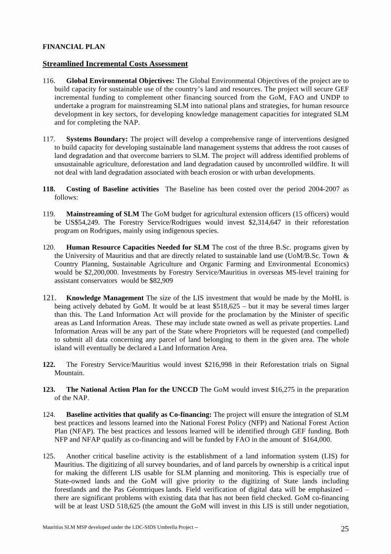
FINANCIAL PLAN
Streamlined Incremental Costs Assessment
116. Global Environmental Objectives: The Global Environmental Objectives of the project are to build capacity for sustainable use of the country’s land and resources. The project will secure GEF incremental funding to complement other financing sourced from the GoM, FAO and UNDP to undertake a program for mainstreaming SLM into national plans and strategies, for human resource development in key sectors, for developing knowledge management capacities for integrated SLM and for completing the NAP.
117. Systems Boundary: The project will develop a comprehensive range of interventions designed
to build capacity for developing sustainable land management systems that address the root causes of land degradation and that overcome barriers to SLM. The project will address identified problems of unsustainable agriculture, deforestation and land degradation caused by uncontrolled wildfire. It will not deal with land degradation associated with beach erosion or with urban developments.
118. Costing of Baseline activities The Baseline has been costed over the period 2004-2007 as
follows: 119. Mainstreaming of SLM The GoM budget for agricultural extension officers (15 officers) would
be US$54,249. The Forestry Service/Rodrigues would invest $2,314,647 in their reforestation program on Rodrigues, mainly using indigenous species.
120. Human Resource Capacities Needed for SLM The cost of the three B.Sc. programs given by
the University of Mauritius and that are directly related to sustainable land use (UoM/B.Sc. Town & Country Planning, Sustainable Agriculture and Organic Farming and Environmental Economics) would be $2,200,000. Investments by Forestry Service/Mauritius in overseas MS-level training for assistant conservators would be $82,909
121. Knowledge Management The size of the LIS investment that would be made by the MoHL is
being actively debated by GoM. It would be at least $518,625 – but it may be several times larger than this. The Land Information Act will provide for the proclamation by the Minister of specific areas as Land Information Areas. These may include state owned as well as private properties. Land Information Areas will be any part of the State where Proprietors will be requested (and compelled) to submit all data concerning any parcel of land belonging to them in the given area. The whole island will eventually be declared a Land Information Area.
122. The Forestry Service/Mauritius would invest $216,998 in their Reforestation trials on Signal
Mountain. 123. The National Action Plan for the UNCCD The GoM would invest $16,275 in the preparation
of the NAP. 124. Baseline activities that qualify as Co-financing: The project will ensure the integration of SLM
best practices and lessons learned into the National Forest Policy (NFP) and National Forest Action Plan (NFAP). The best practices and lessons learned will be identified through GEF funding. Both NFP and NFAP qualify as co-financing and will be funded by FAO in the amount of $164,000.
125. Another critical baseline activity is the establishment of a land information system (LIS) for
Mauritius. The digitizing of all survey boundaries, and of land parcels by ownership is a critical input for making the different LIS usable for SLM planning and monitoring. This is especially true of State-owned lands and the GoM will give priority to the digitizing of State lands including forestlands and the Pas Géomtriques lands. Field verification of digital data will be emphasized – there are significant problems with existing data that has not been field checked. GoM co-financing will be at least USD 518,625 (the amount the GoM will invest in this LIS is still under negotiation,
Mauritius SLM MSP developed under the LDC-SIDS Umbrella Project -- 25

and the final amount may be much higher than this minimum). MSIRI funding of $12,500 will cover the maintenance and updating of GISCANE and the broadening of its applications in spatial data analysis. GEF funding will be used to establish protocols for LIS information sharing, conditions of access and the use of LIS for SLM monitoring, use of LIS in land use planning and zoning.
126. 93% of the GEF funding would be concentrated on Outcomes 2 and 3 – on human resources
capacity development and on knowledge management. One of the greatest global benefits on the proposed GEF investments is the highly integrated approach to SLM capacity development of this project. Aspects of particular importance for this multi-sectoral integrated approach include; a) the emphasis on the development of land information systems with agreed protocols for data access and sharing; b) the emphasis on participatory, multi-stakeholder approaches; c) emphasis on mainstreaming SLM and on integrating best practices and lessons learned into land use planning; d) the use of environmental economics for analyzing and prioritizing SLM options and; e) all the emphasis on SLM knowledge generation and knowledge sharing.
127. Additional, Unquantified Co-financing The European Union’s planned Decentralized Participation Project on Rodrigues has not yet been designed nor has the amount of funding yet been decided upon. It will be a follow-on to the recently completed Anti-Erosion Project and will also target Rodrigues. Unlike past initiatives, this time the EU will fund NGO and other civil society groups to undertake natural resource management activities. Because this new EU project will work directly on the ground, its activities are seen as highly complementary to this SLM capacity building project. UNDP will seek to develop a close collaboration with EU, including the establishment of a UNDP/EU MOU to formalize forms of collaboration.
128. Project Budget A budget summary by outcome and by source of financing is present below. A
full, detailed activity budget is presented in Annex C. Note that project management costs listed separately in Annex C have here been spread proportionately across the four Outcomes.
129. The request for GEF funding in the amount of US$572,809, excluding preparatory assistance,
exceeds the $500,000 maximum recommended in the guidelines for the LDC-SIDS Umbrella Project. The justification for this request is as following: • Mauritius has a high cost economy compared to most other LDC and SIDS. • High travel costs – Mauritius and Rodrigues are two islands separated by 560 km – an hour and a
half travel time in a medium-size passenger plane; • It is the remote island of Rodrigues that has the most severe problems of land degradation; • Rodrigues now has its own autonomous government. Working with two sets of administrative
structures adds to project costs. •
Project Budget
Co-finance Outcome GEF Govt. Co-finance
Other co-finance
Total
1. Mainstreaming Output 1.1 NFP & NFAP Output 1.2 Policy frameworks Output 1.3 Investment Plan Project management costs
Total Outcome 1
7,234 18,800 11,736 37,770
2330 2330
FAO
164,000
204,100
2. Human resource capacities dvlpt. Output 2.1 LIS/GIS/RS Output 2.2 Stakeholder
21,70037,276 12,659
Mauritius SLM MSP developed under the LDC-SIDS Umbrella Project -- 26

participation Output 2.3. Planning guidelines Output 2.4 Environmental economics Output 2.5 Restoration degraded slopes Project management costs
Total Outcome 2
28,425 22,859 55,411
178,330
185,292
18856 204,148 197,186
3. Knowledge management for SLM Output 3.1 Sustainability assessments Output 3.2 Knowledge sharing Output 3.3 LIS Development Output 3.4 M&E development Output 3.5 Improved leasing systems Output 3.6 SLM sugarcane alternatives Project management costs
Total Outcome 3
41,400 14,467
140,816 17,702 10,850 21,508
111,230 357,973
333,333
41,394 374,727
917,990
4. Completion of NAP Output 4.1 Preparation NAP Output 4.2 NAP Adoption Project management costs
Total Outcome 4
14,467 1,808 2,520
18,795
18,797TOTAL MSP 574,073 600,000 164,000 1,338,073
PDFA 25,000 UNDP 15,000 40,000Grand Total 599,073 600,000 179,000 1,378,073
PROJECT IMPLEMENTATION PROCESS Institutional framework and project implementation arrangements 130. General Framework: The project will be implemented over a period of three years beginning in
March 2006. The implementation agency for the project will be the UNDP Mauritius Country Office. The project will be executed under UNDP National Execution (NEX) procedures. The lead executing agency for the project will be the Forestry Service (FSM) of MoAF. FSM will be directly responsible for the timely delivery of inputs and outputs and for coordination with all other executing agencies. The project will receive high level guidance and oversight from the SLM Steering Committee (SC). The SC will be composed of the Permanent Secretaries (PS) and/or designated representatives of MFED, MoAF, MoHL, MoE, the Vice Chancellor of the UoM and the UNDP Res Rep and will be chaired by MoAF. The TOR of the SC is presented in Annex E. The SC will normally meet once a year but may meet exceptionally as needed. A technical advisory group (TAG) will provide technical support to the project. It will be composed of individuals from both government and civil society who are selected on the basis of their competence in their respective fields. The international experts on the FAO Forestry Policy project will sit on the TAG whenever schedules permit. The TAG will meet quarterly during the first year of the project and every six months thereafter. To ensure close collaboration and coherence between the SLM project and the FAO Forest Policy Project, UNDP will sit on the steering committee for the FAO project.
Mauritius SLM MSP developed under the LDC-SIDS Umbrella Project -- 27

131. A Project Management Unit (PMU) will play a key role in project execution. It will be attached to FSM and will be headed by a Project Manager (PM) He/she will be a national professional recruited for the three-year duration of the project. The PM will work under the direction of the Conservator of Forests. He/she will be responsible for the application of all UNDP administrative and financial procedures and for the use of UNDP/GEF funds. The PM will have a small support staff (secretary/administrative assistant, accountant and driver) that will be provided by FSM/GoM. The PMU will have overall responsibility for project management, administrative, technical and financial reporting. The PMU will manage the selection process for all local contracts and recruitment of local consultants – this will be done in close consultation with other concerned executing agencies. This will include preparation of TOR, call for bids and organization of the selection process. This will all be done in close coordination with UNDP but the contracts will be awarded by the PMU. The PMU will manage and coordinate the execution of all local contracts.
132. Responsibilities by Outcome The Forest Service/Mauritius and the Regional Assembly of
Rodrigues will have lead responsibilities for Outcome 1 -- Mainstreaming. The Rodrigues Regional Assembly has agreed to second a Technical Officer or a Scientific Officer to provide technical assistance to the project. The FoA of the University of Mauritius and independently recruited consultants will play key roles in the execution of Outcome 2 – Capacity Building. FSM will be the lead agency for Outcome 3 – Knowledge Management, but will work in close collaboration with MoHL, NRSC, MSRI, and others. FS will be the lead for Outcome 4 – Preparation of the NAP.
133. Responsibilities for managing funds GEF funds will be administered by UNDP. The PMU will
manage all contracts with local service providers. The PM will manage the GoM funds for the functioning of the PMU. UNDP will advance funds for a three-month period. At the end of the three-month period, the PMU will submit justification for expenses and the funds spent will be renewed by UNDP.
134. Criteria and procedures will be developed for performance-based contracts with service
providers. Under performance-based contracts, the service provider will be paid only for work completed. Work partially completed will be paid on a pro rata basis.
135. The project will comply with UNDP’s monitoring, evaluation and reporting requirements as
spelled out in the UNDP Programming Manual. The PMU PM will have lead responsibility for reporting requirements to UNDP.
Technical Coordination with FAO Forest Policy Project 136. The FAO Forest Policy and Forestry Action Plan will be developed concurrently with the SLM
project. The international technical experts on the FAO project have many areas of expertise that could be very useful to the SLM project. It is critical that ways and means be found to exploit this opportunity. Two measures that have already been identified are to have UNDP sit on the FAO project steering committee and to have the FAO international expert sit on the SLM TAG. Further mechanisms for more intensive collaboration should be pursued. The current team of international experts have expertise directly related to the following outputs and activities from the SLM logframe:
1.1. Integration SLM into Forestry Policy and Forest Action Plan 1.1.1. Integrate SLM concerns into National Forestry Policy 1.1.2. Integrate SLM concerns into the new Forest Action Plan 1.2.1. Prepare draft policies/legislation for integrated SLM 2.2.1. Training on participatory integrated pasture management 2.5. Capacities for restoration of fire-degraded mountain ecosystems
Mauritius SLM MSP developed under the LDC-SIDS Umbrella Project -- 28

2.5.2. Provide training in restoration tools such as early burning 3.1.4. Status report land degradation Mauritius & Rodrigues 3.3.1. Develop Forestry Mgt. Information System Mauritius 3.3.1.2. Develop forest cover map for Mauritius 3.3.1.3. Digitize the boundaries of State Forest Lands 3.4.1.Monitoring the sustainability of pastureland use and mgt. 3.4.3. Develop a system for monitoring forestlands 3.5. Improvements to the State lands leasing systems 3.5.1 Review of strengths and weaknesses of lease systems 3.5.2. Participatory process to develop improved lease systems
Technical Roles for MSIRI 137. MSIRI proposes that they should be involved in (i) identifying land use alternatives to sugar cane
and in developing policy briefs and strategies for the promotion of sustainable land use alternative to sugar cane (section 3.6 of Outputs and Activities) and in, (ii) research methodology and provision of resource persons for GIS and soil erosion. The conditions of MSIRI’s participation will need to be defined after project start-up. MSIRI has acquired know-how on sustainable sugar cane production, land suitability assessment, land resource surveys, GIS and remote sensing. It is in a position to offer its services in the following activities of the logframe:
1.3.1 2.1.1 2.2.2 2.3.1 3.1.1 3.1.3 3.1.4 3.3.1 3.3.2 3.3.3 3.4.1 3.4.2 3.4.3
Audit Requirements 138. The project will be audited on a yearly basis for financial year January to December as per NEX
procedures and Global Environment Facility requirements. The National Auditor will conduct the audit.
139. The Forestry Service shall also certify the yearly Combined Delivery Reports issued by UNDP
based on financial statements prepared by the Project Accountant. Legal Context 140. This project document shall be the instrument referred to as such in Article 1 of the Standard
Basic Assistance Agreement (SBAA) between the Government of Mauritius and the United Nations Development Program as signed by the parties on 29th August 1974. The host country-implementing agency shall, for the purpose of the SBAA, refer to the government cooperating agency described in that Agreement.
141. UNDP acts in this project as Implementing Agency of the Global Environment Facility (GEF),
and all rights and privileges pertaining to the UNDP as per the terms of the SBAA shall be executed ‘mutatis mutandis’ to GEF.
142. The UNDP Resident Representative in Mauritius is authorized to effect in writing the following
types of revisions to this project document, provided s/he has verified the agreement thereto by the
Mauritius SLM MSP developed under the LDC-SIDS Umbrella Project -- 29

UNDP GEF unit and is assured that the other signatories of the project document have no objections to the proposed changes: (a) Revisions of, or addition to, any of the annexes to the Project Document; (b) Revisions which do not involve significant changes in the immediate objectives, outputs or
activities of the project, but are caused by the rearrangement of inputs already agreed to or by the cost increases due to inflation;
(c) Mandatory annual revisions which re-phase the delivery of agreed project inputs, or reflect increased expert or other costs due to inflation, or take into account agency expenditure flexibility, and;
(d) Inclusion of additional annexes and attachments relevant to the Project Document 143. Intellectual property rights on data, study results, reports, etc… All data, study results,
information, reports, etc, generated with UNDP/GEF project funds will be the property of GoM and UNDP.
Monitoring and Evaluation Plan 144. Project monitoring and evaluation will be conducted in accordance with established UNDP and
GEF procedures and will be provided by the Project Management Unit (PMU) and the UNDP Country Office (UNDP-CO) with support from UNDP/GEF. The Logical Framework Matrix in Annex B provides performance and impact indicators for project implementation along with their corresponding means of verification. These will form the basis on which the project's Monitoring and Evaluation system will be built.
145. The Forestry Service/Mauritius will monitor activities to ensure that they are carried out
appropriately and in a timely manner as per the workplan. The workplan is integrated into the activity budget in presented in Annex C. The Forest Service and PMU will ensure that project execution complies with UNDP’s monitoring, evaluation, auditing and reporting requirements, as spelled out in the UNDP Programming Manual. In accordance with the UNDP’s Programming Manual, progress and other reports will be submitted by the Forest Service to the UNDP CO. They will provide a brief summary of the status of activities and output delivery, explaining any variances from the pre-agreed work plan and presenting work plan for each successive quarter for review and endorsement. The Forestry Service will prepare and request quarterly advances and will also include the disbursement status in their financial report.
146. The Forestry Service will complete an annual review of the project following the current
UNDP/GEF format for Annual Project Review (APR)/Project Implementation Review (PIR). A project Terminal Report will be prepared by the Forestry Service and submitted through the Ministry of Finance and Economic Development to the UNDP CO assessing the delivery of inputs, the achievement of the project objectives and the project’s impact/results.
147. One external mid-term review (MTR) will be performed after 18 months and a final evaluation
will be conducted during the last three months of the project. Each review will consist of a three-week evaluation and will be conducted by one international consultant working with one national consultant. The focus of the MTR will be to make mid-term corrections to better achieve the project objective and outcomes during the remaining life of the project.
Response to GEF Secretariat Review
Mauritius SLM MSP developed under the LDC-SIDS Umbrella Project -- 30

Annex A: MAURITIUS LAND DEGRADATION ROOT CAUSE MATRIX Items in italics in the column “Potential Corrective/Mitigating Measures” are those that have been integrated into the project logframe.
Other mitigating measures not addressed by this project will be addressed by the SLM investment plan and through training and capacity building. Type of Land
Degradation
Bio-Physical Impacts
Root Causes Potential Corrective/ Mitigating Measures
• Open access grazing with little or no control on the number of cattle, sheep and goats grazed on common pastures (This problem used to be compounded by absentee ownership of livestock) ;
• Land tenure: land is owned by the state and livestock are owned by a multitude of individual livestock herders ;
• Government agents have little or no incentive to develop and implement sustainable pasture management systems ;
• There is no established mechanism, such as a lease system, for controlling herder/livestock access to range/pasture lands.
• Development of functional, equitable lease system that provides incentives for SLM and disincentives for overgrazing ;
• Development of capacities for monitoring and enforcing compliance with terms of the lease
• Development of a leasing system for State-owned pasture lands
• Development of framework of good governance and civil society oversight of lease system
• Privatization of pasture lands • Scant human resources with training in extensive pasture/range
management and with the capacity to conceive, test and adaptively modify pasture management systems
• Human resource capacity development for participatory pasture/range management
• Tradition of top-down approaches to pasture management that do not involve herders as key actors and decision makers ;
• Insufficient training in participatory approaches that can capitalize on indigenous technical knowledge of local herders and that can involve them as the key principal actors in testing pasture management systems ;
• No proven models for sustainable, productive pasture/range management ;
• Capacity development for participatory approaches for SLM/pasture management ;
• Inventory of traditional knowledge on pasture management
• Direct involvement of herders as key actors and decision makers in the conception and testing of sustainable pasture management models ;
• Adaptive management approach that uses results of M&E system
• A knowledge management approach that synthesizes lessons learned, develops and tests hypotheses and adaptively modifies management
• No solid information on the economic and financial costs and benefits of proper pasture management systems – especially the financial costs and benefits to the herders ;
• Develop capacities for economic and financial valuation of pasture use/management options ;
• Poorly developed understanding and support for extensive pasture management from authorities/decision makers ;
• Awareness raising for authorities and decision makers
1. Overgrazed, eroded range/pasture lands of decreased productivity and forage quality
• Soil erosion – mostly in the form of sheet – removing the most fertile top soil
• Decrease in pasture quality and productivity through loss/ decrease of preferred forage spp.
• Soil compaction by livestock
• Increased runoff rate increasing severity of flooding
• Decrease in infiltration resulting in reduced spring and dry season stream flow
• Sedimentation of dams and lagoons (less severe than believed)
• Forest plantations on Rodrigues are protected from grazing by metal fences that are rapidly rusting away with little possibility of replacement. If not replaced, they may become open access and suffer once again from overgrazing.
• Development of grazing systems that do not require fencing ;
• Development of multiple use SLM systems that generate adequate benefits to cover the cost of maintenance or replacement of fencing
31

Type of Land
Degradation
Bio-Physical Impacts
Root Causes Potential Corrective/ Mitigating Measures
• Clearing for pasture (and firing lanes?) on deer ranches (Mauritius only) • On State land leased for deer ranching
• No system for monitoring forest clearing for pastures • No accurate maps of lease lands • Few incentives for enforcement
• On privately owned forest land • Clearing for deer pastures or other uses is unregulated or weekly
regulated
• Awareness raising on forest loss • Develop remote-sensing based system for monitoring
forest clearing for pastures on state-land and for forest conversion on private land
• Diffusion of monitoring results to general public and decision makers
• Develop Forest Service capacity for enforcement of regulations on pasture clearing on lease land
• Develop forest management systems that combine pasture clearing with reforestation systems
• Develop regulations governing forest clearing on private land
• Clearing/conversion on privately owned land • Clearing of forest land and conversion to other land uses, especially
agriculture, in largely unregulated in Mauritius • The extent and nature of this problem is not known because Forestry
Department has no accurate forest cover maps, nor forest information system or monitoring capacity for privately owned forest lands
• Lake of awareness of general public/decision makers • Clearing/conversion on State forest lands
• Encroachment by adjoining private land owners • No monitoring system • Boundary markers lost/not visible – boundaries not marked
• Assessment of the nature and extent of the problem (using remote sensing/GIS)
• Assessment of the sustainability and environmental impacts of the alternative land uses
• Awareness raising • Participatory Development of appropriate regulations
where needed • Use of remote sensing to identify sites of obvious or
potential encroachment • Field checks by forest officers • Enforcement
2. Deforesta-tion
• Loss of habitat/ biodiversity
• Loss of vegetative cover resulting in soil erosion
• Sedimentation of lagoons and coral reefs, sedimentation of Port Mathurin et Port Louis
• Clearing for settlements • Clearing for housing • Clearing by squatters
• Development of land information system • Land use planning and zoning • Enforcement of zoning provision and land use
restriction • Increased transparency in the land allocation/
permitting systems
32

Type of Land
Degradation
Bio-Physical Impacts
Root Causes Potential Corrective/ Mitigating Measures
• Cross-cutting root causes: • Forest Dept does not have accurate, up-to date maps of forest cover by
cover type, ownership, condition, etc • There is no computerized Forest Information System (FIS) combining
forest type, land ownership, forest condition, etc. • Lack of political will • Insufficient trained manpower • Economic/financial incentives for forest protection/sustainable use are
not developed • Sustainable forest management systems are not developed • Capacity for enforcement is weak
• Participatory definition of FIS needs • Develop capacity for accurate forest cover mapping
using remote sensing and ground truthing • Develop GIS-based FIS capacity with data on forest
type, land ownership, forest condition, etc. • Use these tools to analyze causes of forest loss on
private and to develop appropriate measures • Awareness raising for decision makers, general
public • Develop tools and capacity for economic and
financial analysis of costs and benefits of forest use/management options and identification of economic/financial incentives for sustainable management of forests
3. Eroded, unproduc-tive and/or abandoned agricultural lands
• Erosion causes loss of fertility, decrease of soil depth, decrease in soil organic matter and water holding capacity, and leads to deposition of sediments in lagoons, reservoirs, check dams ;
• Depletion of soil phosphate and other nutrients leads to loss of fertility and productivity and limits the choice of crops that can be grown
• Diminished levels of soil organic matter and loss of water-holding capacity and degraded soil
Unsustainable vegetable gardening and mixed cropping • Land tenure – nearly all cropland on Rodrigues is State-owned and the land
lease system is largely dysfunctional. Insecurity of tenure is a major disincentive to investments in sustainable agriculture.
• Tradition of top-down approaches towards soil conservation measures ; • Poor development of participatory approaches to agricultural extension ; • Practice of agriculture on sloping land without adequate soil and water
conservation measures contour (bands of vetiver, terraces, mulching, etc) ; • Inadequate use of soil amendments leads to depletion of nutrients. This is
especially true on non-commercial cropland on Rodrgigues. Phosphate depletion has been shown to be an acute problem at La Ferme in Rodrigues ;
• Financially marginal agriculture, especially on Rodrigues, does not generate enough profit and incentives for investments in sustainability.
• Cultivation right up to river banks • Improper use of chemical fertilizers Sugar cane plantations • Some small planters and estate planters still burn residues and plow to
replant, leaving soil exposed to heavy rains
• Development of an equitable, functional leasing system for agricultural land.
• Development of incentives (such as Agricultural Development Certificates) for leasees to adopt sustainable, soil conserving practices and disincentives for destructive practices ;
• Analysis of pros and cons of privatization of agricultural land on Rodrigues
• Identification and synthesis of best practices for sustainable agriculture and their integration into agricultural development strategies and extension programs ;
• Development of strategies to improve the profitability of agriculture thereby making investments in sustainable agriculture more feasible ;
• Studies on soil nutrient depletion and development of capacities for soil testing to identify needs for soil amendments.
• Development of systems whereby downstream beneficiaries of erosion control and increased infiltration contribute to the costs of investments in sustainable practices.
• Remote sensing based monitoring and enforcement of regulations requiring vegetation strips left on each side of steam courses
Sugar cane plantations • Synthesis of best practices for sustainable sugar cane
cultivation and their integration into extension packages
33

Type of Land
Degradation
Bio-Physical Impacts
Root Causes Potential Corrective/ Mitigating Measures
structure • Soil compaction
reduces infiltra-tion and inhibits root growth
• UNDP study showed severe eutrophication of lagoons in onion-growing watershed
• Many planters use bulldozing to rake out topsoil and pile soil and residues • Mechanization and heavy equipment causes soil compaction. The severity of
this phenomenon is contested ; • Sharecroppers (metayeurs) have little incentive to invest in soil
conservation/sustainable agricultural practices • Ecological sustainability is dependent on the financial sustainability – this is
largely dependent on the sugar subsidy from the EU ; • The pending reductions or loss of the sugar subsidy may lead to major
changes in land use, some of which may be much less sustainable than the present systems of sugar cane cultivation.
• Cultivation right up to river banks • Improper use of chemical fertilizers
• Fiscal incentives for adoption of best practices • Analysis of impacts of mechanization and
development of strategies to minimize negative impacts ;
• Identification of alternative land uses and analysis of the ecological, economic/financial and social sustainability of each in order to identify the SLM practices to be encouraged through policy, regulations and incentives.
4. Severe degradation from fire on steep slopes in mountain rain shadow
• Repeated fires have converted natural forest to grasslands with scattered shrubs
• Repeated fires prevent the establishment of evergreen woody cover that is resistant to forest fires.
• Soil erosion • Diminished
groundwater recharge
• Excessive/rapid runoff rates. Danger of flooding
• Landslides
• Use of fire is considered to be the principle cause of the past degradation of these sites from forest to grassland or savanna grasslands and fire is the principal impediment at present preventing the reforestation of these areas. If closed canopy forests could be reestablished, they should be much less susceptible to fire.
• Slopes were once commonly burned by herders to obtain succulent regrowth from perennial grasses for goats/livestock during the dry season (The importance of this factor has diminished as goat herding has diminished) ;
• Other reasons for burning – including criminal burning ; • Limited budget/resources of the land management authority (Forest
Department) ; • No economically viable, proven models/techniques/models for restoring
these sites to full, evergreen forest cover and for sustainable management of the restored forest.
• Municipality contributes nothing towards restoration and sustainable land management.
• Squatters established illegally at the base of these mountains • Use of fire as a tool for clearing the land. • Land tenure – Land is owned by the State. Local populations have little
incentive to protect
• Identification and testing of innovative options for minimizing frequency and intensity of wildfires – such as grazing by deer or sheep to reduce grass cover and fire danger or use of very early, light, patchy, partial controlled burns to minimize dry season wildfires.
• Development of multi-disciplinary, participatory, intersectoral approaches including civil society groups;
• Development of adaptive management approaches for monitoring fire risk management and reforestation options tested and for modifying techniques accordingly ;
• Economic/financial analyses to identify the most cost effective fire control and reforestation systems
• Program of awareness raising, fire prevention and control
• Enforcement to prevent settlement by squatters ;
5. Loss of wetlands (Lack of monitoring system does not allow quantification)
• Loss of hydrological functions
• Loss of biodiversity
• Strong pressures for development of these economically high value sites ; • Condition/loss of wetlands is not being monitored systematically ; • 2002 Environment Protection Act required EIA for any development of
wetlands but lack of monitoring system makes it impossible to analyze how well this law is being respected ;
• Many wetlands are on private lands making ground monitoring difficult ; • Institutional responsibilities and regulations for wetlands conservation are
fragmented and unclear.
• Awareness raising on importance of wetlands ; • Development of a wetlands conservation strategy for
definition of clear institutional responsibilities, mobilization of adequate resources for definition of site-specific priorities;
• Integration of wetlands into land information system • Development of wetlands monitoring system using
satellite imagery and ground visits and linked with clear enforcement capabilities.
6. Erosion in • Deposition of • Drains in settled areas are often not maintained (blockages) or inadequately • Adequate investments in proper design, upgrading
34

Type of Land
Degradation
Bio-Physical Impacts
Root Causes Potential Corrective/ Mitigating Measures
developed areas
sediments in streams, lagoons and on reefs
designed leading to erosion and property damages during cyclones/heavy rains ;
• Careless construction techniques leave bare soil exposed to heavy rains. Construction on steep slopes without adequate engineering and soil protective measures
and maintenance of drainage systems ; • Development and enforcement of appropriate
regulations minimizing risk of erosion from construction sites.
35

Annex B Logical Framework for Sustainable Land Management in Mauritius and Rodrigues
Outcomes Key Performance Impact Indicators Means of Verification
Critical Assumptions/Risks
Long-Term Goal: The agricultural, pasture, forest and other terrestrial land uses of Mauritius and Rodrigues are sustainable, productive systems that maintain ecosystem productivity and ecological functions while contributing directly to the environmental, economic and social well-being of the country.
Project Objective: Capacities for sustainable land management are built in appropriate government and civil society institutions/user groups and mainstreamed into government planning and strategy development.
• NAP approved by Cabinet • Best practices and guidelines for
SLM are broadly disseminated and used for development planning, zoning and agricultural extension.
• Cabinet decisions are published on the Internet
• Published best practices and guidelines
• Survey of users
• Continued political support for integrating SLM into national development planning
Outcome 1: Integration of SLM into macro-economic policies and regulatory and economic incentive frameworks regarding sustainable practices on non-forest land.
• The National Forest Policy and National Forest Action Plans contain specific sections on land degradation and sustainable land management. Baseline: NFP & NFAP not yet started. MT: Work on integration of SLM into NFP in progress. Central
• Copies of the NFP and the NFAP
• Published
• Funding is mobilized for the NFP and NFAP
• Continued political support
36

government develops and applies guidelines for integrating SLM into development permits issued by municipalities Baseline: Guidelines don’t exist MT: Guidelines under development
• The Ministry of Finance and Economic Development and other ministries concerned with land use planning use environmental economic analyses of land use options (and of the cost of doing nothing) as a tool for economic development planning and/or the development of macro-economic policies. Baseline: These tools don’t exist MT: NR economic evaluations have been used for two cases of policy development/land use planning
guidelines • Planning
and policy documents accompanied by relevant NR economic analyses
• MTR
• Authorities and planners will see
the advantages of using NR economics for planning and policy development
Outcome 2: Human resource capacities needed for SLM are developed.
• The staff of NRSC, FSM, FSR, MoHL, AREU, UoM and MSIRI have the capacity to integrate new satellite imagery obtained by NRSC into their LISs and to use it for monitoring and or analyses related to SLM. Baseline: Only NRSC has the capacity to integrate imagery into their LIS. No one has the capacity to use for SLM analyses. MT: 15 technicians trained in integration of imagery into LIS. 5 of them have conducted SLM-related analyses using the LIS of their home institution.
MTR, TAG, PMU MTR, TAG, PMU
• NRSC makes imagery available to all institutions with LIS capability
• Local and national planning bodies are committed to the integration of SLM considerations into development planning
GoM remains committed to direct implication of CBOs and NGOs in
37

• Six CBOs and 3 NGOs have participated in tests/applications of range management principles and techniques that they have been trained in. 2 NGOs have participated in tests/applications techniques for the restoration of fire-degraded sub humid mountain slopes. Baseline: No CBOs or NGOs have these types of capacities. MT: The first tests of range management and rehabilitation of degraded slopes are being initiated.
natural resource management
Outcome 3: Capacities for knowledge management for SLM are developed
• The boundaries of all State-owned lands have been digitized and are integrated into land information systems of the Forest Service, MoHL, UoM, NRSC and any others that wish to integrate this information. Baseline: MoHL has digitized all survey boundaries of nearly all lands (private and public) on a 20km2 pilot coastal area in Mauritius. MT: Digitization of state lands surveys underway for Mauritius
• A clearly defined, transparent mechanism will be in place for other government and civil society institutions to gain access to information from the SLM-related land information systems. Baseline: No such mechanism exists. MT: Draft protocol has been prepared.
• SLM M&E systems are operational
• MTR, PMU project reports, TAG
• MTR, PMU
project reports, SC, TAG
• MTR, PMU
project reports,
• The various institutions will be willing to collaborate on integrated approaches to sustainable land management and to sharing access to land information systems developed;
• Government authorities will remain committed to reviewing and strengthening the various lease systems for State-owned land;
• Government and the key institutions involved will commit the resources needed to maintain beyond the life of the project, the SLM monitoring and evaluation systems to be developed.
• Government commits the resources necessary for digitizing the land survey/ownership records needed to make the land information systems the most
38

for agricultural, pasture, forest lands and wetlands and operational costs are covered by non-project sources Baseline: No M&E systems exist for these sectors. MT: M&E systems for agriculture and pasturelands are under development and testing. They are functional for monitoring of forest encroachment, river reserves, mountain reserves, clearing for deer pastures, encroachment of wetlands and for expansion of settlements. Negotiations underway for covering recurrent costs.
TAG
useful for SLM monitoring and planning.
Outcome 4: The National Action Program for the UNCCD is completed
• NAP approved by Cabinet of Ministers
• Cabinet decisions are published on the Internet
• Funds are mobilized
39

Outputs and Activities
Output Indicator Activities and Sub-Activities Responsibility
Annual Targets
Outcome 1 : Mainstreaming 1.1.1. Integrate SLM concerns into the
new National Forestry Policy FS-M Specific sections on SLM
in NFP in Yr 1 Outputs
1.1.Integration of SLM into the new National Forestry Policy and Forest Action Plan
• Specific sections in the National Forest Policy and Forest Action Plan integrate SLM lessons learned and best practices. Baseline: NFP not yet started
1.1.2. Integrate SLM concerns into the new Forest Action Plan
FS-M Specific sections on SLM in NFAP in Yr 1
1.2.1. Prepare draft policies and legislation for integrated SLM as appropriate
State Law Office/AgM/ AgR/ FS-M/UoM
Draft policies and legislation prepared
1.2.2. Conduct workshops for stakeholder inputs and validation
Forestry Service/UoM
Stakeholder workshops in Yr 2
1.2.Development of policy, regulatory and economic incentive frameworks regarding sustainable practices on non-forest land
• New policies, legislation and regulations adopted including incentives for SLM and penalties for destructive practices Baseline: SLM Task Force set under the Sugar Sector Strategic Plan 2001 to deal with SLM issues Guidelines prepared by AREU for SLM for Vegetable Growers
• SLM is mainstreamed into Millenium Development Goals processes Baseline: UNDP is assisting with MDG processes, but nothing is being done to integrate SLM. MT: Same as EOP indicator
1.2.3. Guide the new policies and legislation through the approval process
State Law Office/AgM /AgR/ FS
One workshop of 25 participants for 1 day held in Yr 2
1.3.An SLM Investment Plan is developed
• The UNCCD National Coordinating Body (NCB),
1.3.1. Identify priority SLM investment needs and opportunities
PMU/Local contract
2-man team local consultants
40

Outputs and Activities
Output Indicator Activities and Sub-Activities Responsibility
Annual Targets
1.3.2. Develop a costed SLM Investment Plan including brief concept papers for priority investments
PMU/Local contract
2-man team local consultants
UNCCD Focal Point and the Ministry of Finance use the SLM Investment Plan to mobilize, coordinate and direct investments needed for sustainable land management in Mauritius. Baseline: There is little recognition of the need for investments in SLM, no NCB and no SLM Investment Plan.
• The SLM investment plan integrates priorities identified in the NAP (Outcome 4) and investments are made in conformity with the investment plan. Baseline: The SLM investment plan has not yet been initiated. MT: Work on the investment plan has been initiated
1.3.3. Sourcing of investments for SLM
NCB/UNCCD FP/MF/PMU/FSM/Local contract
2-man team local consultants
41

Outputs and Activities
Output Indicator Activities and Sub-Activities Responsibility
Annual Targets
Outcome 2 : Training and Human Resource Capacity Building for SLM Outputs
2.1.Enhanced capacities for use of integrated land information systems/GIS/ remote sensing for SLM
• 25 technicians are trained and know how to integrate GIS and satellite image data into an LIS for SLM applications Baseline: Some people have training on LIS/GIS at the UoM, NRSC, MoHL, MSIRI and FSR/Regional Assembly Rodrigues. Very little use of remote sensing imagery.
2.1.1. Conduct training on the use of LIS/GIS to SLM
2.1.2. Conduct training on remote
sensing applications to SLM
FoA of UoM /NRSC FoA of UoM /NRSC
1 x 2 wk. training course for 25 participants at the UoM (certificates awarded) in Yr 1
2.2.1. Conduct training on participatory management of open pasture systems (rangelands) – Rodrigues
International consultant
One training course for 25 participants for 1 wk held in Yr 1 – Rodrigues
2.2.Enhanced capacities for sustainable pasture management and sustainable agriculture
• 15 individuals understand the fundamentals of how to manage pastures to minimize soil erosion, to favor the growth of preferred forage spp., and the fundamentals of participatory approaches to NRM.
• 15 ag extension agents and 5 other individuals understand best practices
2.2.2. Conduct training on sustainable agricultural practices
2.2.2.1.Develop and apply training modules for Mauritius
2.2.2.2.Develop and apply training modules for Rodrigues
FoA of UoM FoA of UOM/ AgR
Two 1 wk training course for total 25 participants for held in Yr 1
42
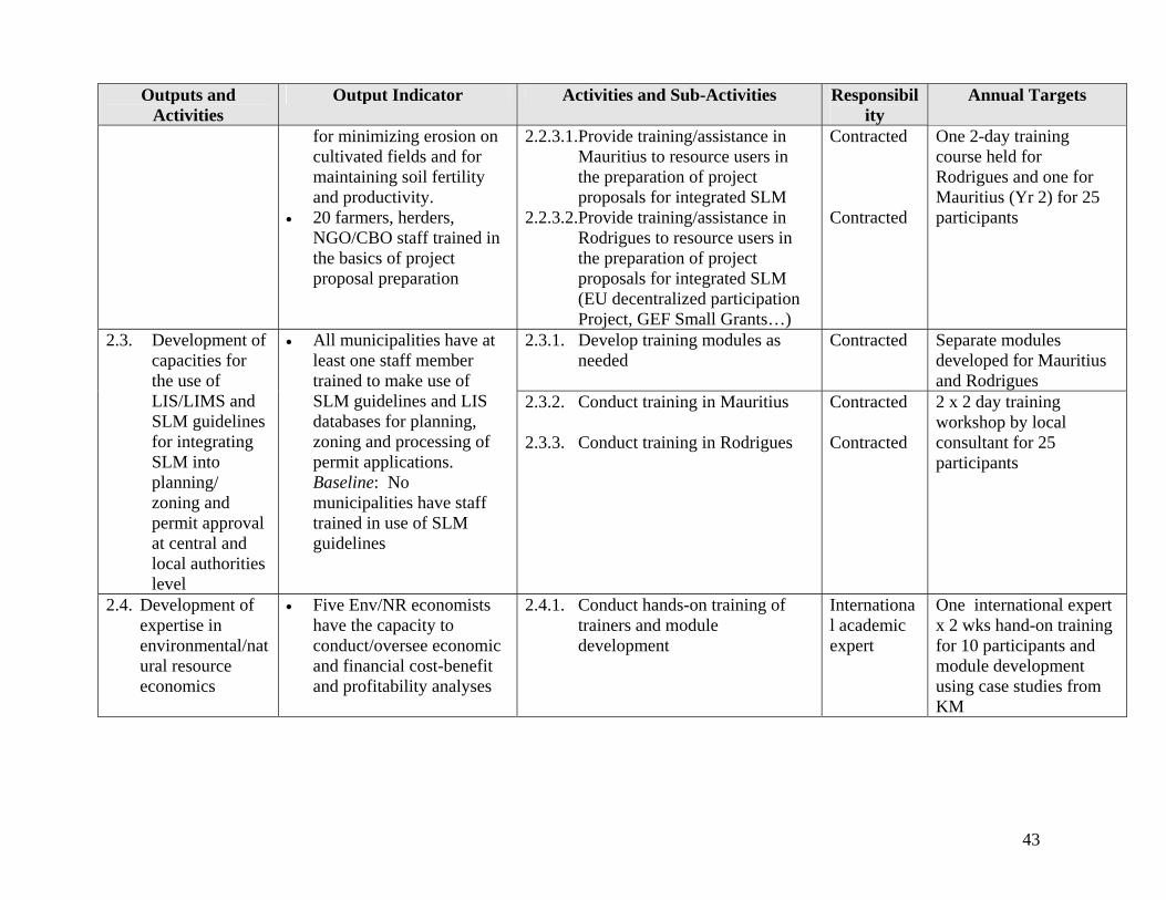
Outputs and Activities
Output Indicator Activities and Sub-Activities Responsibility
Annual Targets
for minimizing erosion on cultivated fields and for maintaining soil fertility and productivity.
• 20 farmers, herders, NGO/CBO staff trained in the basics of project proposal preparation
2.2.3.1.Provide training/assistance in Mauritius to resource users in the preparation of project proposals for integrated SLM
2.2.3.2.Provide training/assistance in Rodrigues to resource users in the preparation of project proposals for integrated SLM (EU decentralized participation Project, GEF Small Grants…)
Contracted Contracted
One 2-day training course held for Rodrigues and one for Mauritius (Yr 2) for 25 participants
2.3.1. Develop training modules as needed
Contracted
Separate modules developed for Mauritius and Rodrigues
2.3. Development of capacities for the use of LIS/LIMS and SLM guidelines for integrating SLM into planning/ zoning and permit approval at central and local authorities level
• All municipalities have at least one staff member trained to make use of SLM guidelines and LIS databases for planning, zoning and processing of permit applications. Baseline: No municipalities have staff trained in use of SLM guidelines
2.3.2. Conduct training in Mauritius 2.3.3. Conduct training in Rodrigues
Contracted Contracted
2 x 2 day training workshop by local consultant for 25 participants
2.4. Development of expertise in environmental/natural resource economics
• Five Env/NR economists have the capacity to conduct/oversee economic and financial cost-benefit and profitability analyses
2.4.1. Conduct hands-on training of trainers and module development
International academic expert
One international expert x 2 wks hand-on training for 10 participants and module development using case studies from KM
43

Outputs and Activities
Output Indicator Activities and Sub-Activities Responsibility
Annual Targets
of land use systems. 10 staff of key institutions have capacity to conduct basic cost-benefit analyses under supervision of the first five Baseline: Mauritius has eight professionals (FoA,UoM, MEPD and AREU) with training in environmental/ NR economics but none are trained to analyze land use systems
2.4.2. Conduct basic NR economics training of staff in FSM, FSR, AgM, AgR, RRA, MoHL
Contracts with people trained in activity 2.4.1.
1 wk training course for 15 participants
2.5.1. Develop cost-effective strategies for restoration/ reforestation of grass-dominated, fire-degraded mountain slopes
International fire ecology expert
1.5 week mission Yr 1
2.5.2. Provide training in restoration tools including a) early controlled burning and grazing for fire risk reduction, and b) wildfire prevention and wildfire suppression.
International fire management and control expert (preferably the same as 2.5.1)
1.5 week mission Yr 1
2.5. Enhanced capacities for restoration and management of fire-degraded subhumid mountain ecosystems
• Forestry Service in Mauritius uses their training and equipment to conduct early, light controlled burns as part of a set of monitored restoration trials on degraded mountain slopes. Baseline: Forest agents have no training and no equipment and do not use controlled burns as land management tools. 2.5.3. Procure basic equipment for
controlled burning and fire suppression
Equipment recommended by IC
Procurement Yr 2
44

Outputs and Activities
Output Indicator Activities and Sub-Activities Responsibility
Annual Targets
Outcome 3 : Knowledge management for SLM 3.1.1. Conduct assessments of
ecological sustainability of land use systems for agriculture, pasture use/management and forest use/management (identifying land degradation problems and their causes and identifying best practices – whether traditional or modern) strengths and weaknesses identified for each.
FoA of UOM/ Forestry Services through student research
3 reports in Year II
3.1.2. Conduct analyses of the economic costs and benefits and the financial profitability of the main agriculture, pasture and forest management systems.
FoSSH of UoM through student research thesis /FS-M&R
Analysis of the Economic costs and benefits for the three systems completed in the form of students thesis
Outputs 3.1.Participatory
assessments of the sustainability of land use systems
• The causes and the severity of soil loss and fertility loss have been identified for each of the major types of agriculture on the two islands and best practices/lessons learned for each ag system have been summarized
• The causes and the severity of soil loss and of productivity loss (especially loss of preferred forage spp) have been identified on grazing lands and the lessons learned/best practices have been identified.
• The ability of all forest plantation species to retain soil/ prevent erosion has been analyzed and ranked
3.1.3. Develop synthesis of lessons learned, best practices, knowledge gaps and research needs;
FoA of UoM/ Forestry Services
One report in Year 2
45

Outputs and Activities
Output Indicator Activities and Sub-Activities Responsibility
Annual Targets
and management practices for improving soil holding capacity of each species have been identified/proposed.
• The economic and financial viability/profitability of each of the main forms/systems of sustainable agriculture, and sustainable pasture use and forest uses have been analyzed and summarized. and the
• Opportunities for improving financial returns for sustainable forest plantation management have been identified
3.1.4. Prepare status report on land degradation in Mauritius and Rodrigues
FoA of UoM
Two reports in Yr 2 (One for Mauritius & one for Rodrigues)
3.2.1. Develop and implement an awareness raising program for farmers and herders (Mauritius)
Forestry Services/ FoA of UoM
One booklet on SLM practices for agriculture and pasture management to be published and distributed. One training course for 25 Mauritians
3.2.Sharing of Knowledge on SLM
• 90% of all farmers and herders on two islands receive booklets on ecologically sound and financially profitable SLM practices.
• Agricultural extension materials are modified to enhance SLM techniques
• All agricultural extension officers receive training in sustainable agricultural techniques
• All members of national
3.2.2. Develop and implement an awareness raising program for farmers and herders (Rodrigues)
Forestry Services/ FoA of UoM/RRA
One booklet on SLM practices for agriculture and pasture management to be published and distributed. One training course for 25 Rodriguans
46
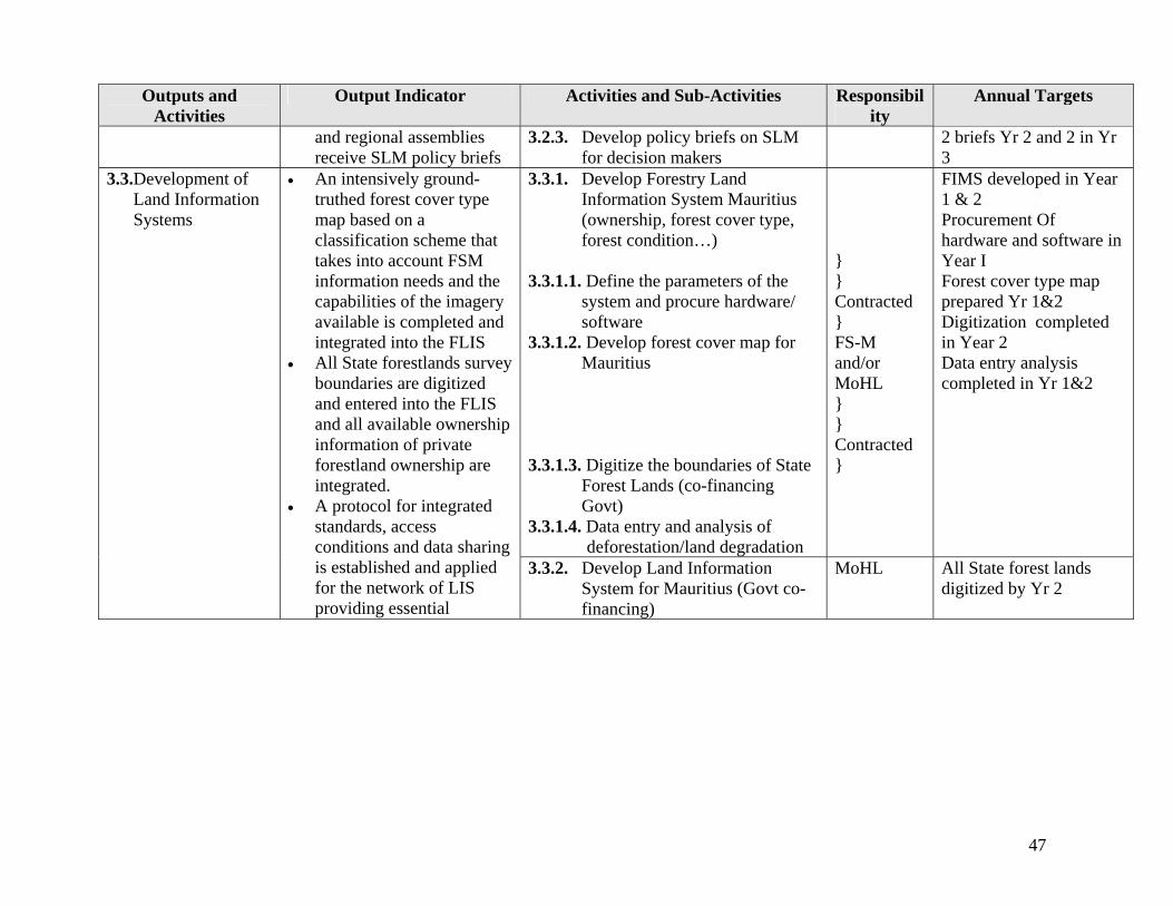
Outputs and Activities
Output Indicator Activities and Sub-Activities Responsibility
Annual Targets
and regional assemblies receive SLM policy briefs
3.2.3. Develop policy briefs on SLM for decision makers
2 briefs Yr 2 and 2 in Yr 3
3.3.1. Develop Forestry Land Information System Mauritius (ownership, forest cover type, forest condition…)
3.3.1.1. Define the parameters of the
system and procure hardware/ software
3.3.1.2. Develop forest cover map for Mauritius
3.3.1.3. Digitize the boundaries of State
Forest Lands (co-financing Govt)
3.3.1.4. Data entry and analysis of deforestation/land degradation
} } Contracted } FS-M and/or MoHL } } Contracted }
FIMS developed in Year 1 & 2 Procurement Of hardware and software in Year I Forest cover type map prepared Yr 1&2 Digitization completed in Year 2 Data entry analysis completed in Yr 1&2
3.3.Development of Land Information Systems
• An intensively ground-truthed forest cover type map based on a classification scheme that takes into account FSM information needs and the capabilities of the imagery available is completed and integrated into the FLIS
• All State forestlands survey boundaries are digitized and entered into the FLIS and all available ownership information of private forestland ownership are integrated.
• A protocol for integrated standards, access conditions and data sharing is established and applied for the network of LIS providing essential
3.3.2. Develop Land Information System for Mauritius (Govt co-financing)
MoHL All State forest lands digitized by Yr 2
47
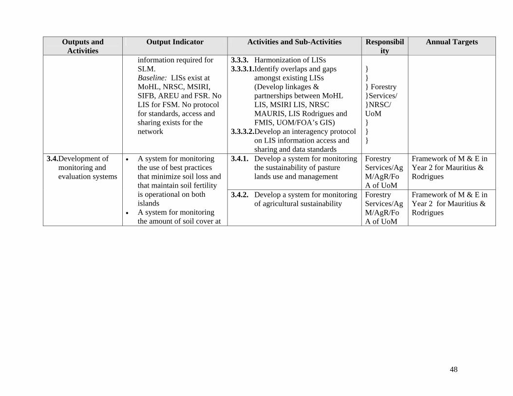
Outputs and Activities
Output Indicator Activities and Sub-Activities Responsibility
Annual Targets
information required for SLM. Baseline: LISs exist at MoHL, NRSC, MSIRI, SIFB, AREU and FSR. No LIS for FSM. No protocol for standards, access and sharing exists for the network
3.3.3. Harmonization of LISs 3.3.3.1.Identify overlaps and gaps
amongst existing LISs (Develop linkages & partnerships between MoHL LIS, MSIRI LIS, NRSC MAURIS, LIS Rodrigues and FMIS, UOM/FOA’s GIS)
3.3.3.2.Develop an interagency protocol on LIS information access and sharing and data standards
} } } Forestry }Services/ }NRSC/ UoM } } }
3.4.1. Develop a system for monitoring the sustainability of pasture lands use and management
Forestry Services/AgM/AgR/FoA of UoM
Framework of M & E in Year 2 for Mauritius & Rodrigues
3.4.Development of monitoring and evaluation systems
• A system for monitoring the use of best practices that minimize soil loss and that maintain soil fertility is operational on both islands
• A system for monitoring the amount of soil cover at
3.4.2. Develop a system for monitoring of agricultural sustainability
Forestry Services/AgM/AgR/FoA of UoM
Framework of M & E in Year 2 for Mauritius & Rodrigues
48

Outputs and Activities
Output Indicator Activities and Sub-Activities Responsibility
Annual Targets
the end of the dry season and the abundance of quality forage grasses/spp. is operational for the pasture lands on Rodrigues
• A system for monitoring forest encroachment, clearing of forest for deer pastures, the clearing of forests on river and mountain reserves, encroachment on wetlands and for monitoring the expansion of settlements is functional. Baseline: None of these monitoring systems exist MT: Ag and pasture monitoring systems are under development/testing and the forest monitoring system is operational
3.4.3. Develop a system for monitoring forest and forest pasture lands
3.4.3.1.Forest encroachment studies
using satellite imagery 3.4.3.2.Monitoring of clearing for deer
pastures from satellite imagery 3.4.3.3.Monitoring of clearing of river
and mountain reserves and conversion of wetlands from satellite imagery
3.4.4. Develop a system for monitoring the expansion of settlements and their encroachment on other land uses
} } } AgM/AgR/ }NRSC/MoHL/ }FoA of UoM/ }FS-M&R }Overseas }Expert } } } } } }
Monitoring system in Yr 1&2 Encroachment study Yr 1 Monitoring of deer pastures Yr 1 Monitoring of river and mountain reserves and wetlands Yr 1 Monitoring system expansion settlements Yr 2
3.5.Enhanced SLM through improvements to
• All new leases as well as renewal of leases include incentives for SLM and/or
3.5.1. Conduct a participatory review of strengths and weaknesses of lease systems in regards to SLM
AgM&R /FS-M&R/RRA/ MoHL
One 2 day workshop for 25 stakeholders/ participants, and submit report thereon
49

Outputs and Activities
Output Indicator Activities and Sub-Activities Responsibility
Annual Targets
the State lands leasing systems
penalties for land degradation. Baseline: Lease systems for forest and “pas géométrique” lands on Mauritius are functional but do not integrate SLM clauses. Lease system for Rodrigues has fallen into abeyance.
3.5.2. Facilitate a participatory process to develop improved, strengthened lease systems that provide incentives, regulations and monitoring/enforcement for SLM
AgM&R /FS-M&R/RRA/ MoHL
One 2 day workshop for 25 stakeholders/ participants, and submit report thereon
3.6.1 Identify land use alternatives to sugar cane and analyze the ecological sustainability and economic/financial viability of each
FoA of UOM /AgM/AgR/ MSIRI
One report in Year 2 3.6.Planning for SLM alternatives to sugar cane cultivation
• Alternative land uses to sugar cane have been identified. The ecological sustainability and the profitability of each has been analyzed and ranked. Baseline: A task force comprising various stakeholders already working on SLM aspect of Sugar Sector Strategic Plan.
• Decision makers are informed of tradeoffs between land use alternative
3.6.2 Develop policy briefs and strategies for the promotion of sustainable land use alternatives to sugar cane.
AgM/AgR/ FoA of UOM/ MSIRI
1 policy brief each Yr 1 & 2 Strategy completed Yr 3
50

Outputs and Activities
Output Indicator Activities and Sub-Activities Responsibility
Annual Targets
Outcome 4: Completion of National Action Program for UNCCD 4.1.1. Develop a draft NAP including
problem and root cause analysis and prioritization of actions
Forestry Ser-vices/national consultant
Draft NAP prepared Yr 1 Outputs 4.1. Preparation of the NAP
• Final draft of NAP completed
• Baseline national report of land degradation submitted
4.1.2. Complete the modification and validation of the NAP through stakeholder workshops
Forestry Ser-vices/national consultant
One stakeholders workshop of 25 participants for 1 day in Mauritius and 1 in Rodrigues Yr 1
4.2.Adoption of the NAP
• NAP adopted by Government and stakeholders
4.2.1. Formal adoption of NAP by Government and negotiation of allocation of national budget for NAP implementation
Forestry Services/ national consultant
Final NAP submitted to Government for funding and implementation in Year 3
• NAP published 4.2.2. Formal publication and dissemination of the NAP through awareness and media programs
Forestry Services/AgM/AgR/ National Consultant
NAP made public at press conference. Press release Yr 3
51

Annex C Detailed Activity Budget Mauritius & Rodrigues Sustainable Land Management Project Budget
Outputs Year Responsibility Donor Budget Description GEF Co-Financ- Totals 1 2 3 US$ ing US$
Key Activities 1. Outcome 1 : Mainstreaming of SLM 1.1. Integration SLM into Forestry Policy and Forest Action Plan 1.1.1. Integrate SLM concerns into National Forestry Policy x Forestry Services FAO Co-Financing} 82000 820001.1.2. Integrate SLM concerns into the new Forest Action Plan x Forestry Services FAO Co-Financing} 82000 82000Output Sub-Total 1.1 164000 164000
1.2. Development of policy, regulatory economic frameworks 1.2.1. Prepare draft policies/legislation for integrated SLM x SLO/AgM/AgR/FS/Uo
M GEF Funds to be shared equally among
the institutions 3,617 3,617
1.2.2. Conduct two workshops (1 in Mauritius & 1 in Rodrigues) x SLO/AgM/AgR/FS/UoM Includes resource person 3,617 3,617 for stakeholder inputs and validation fees, accommodation & transport 1.2.3. Guide the new policies and legislation through approval x AgM/AgR/SLO/FS Output Sub-Total 1.2 7,234 7,234
1.3. An SLM Investment Plan is developed 1.3.1. Identify priority SLM investment needs and opportunities x Team of National
Consultants GEF Consultancy fees 3,300 3,300
1.3.2. Develop a costed SLM Investment Plan x Team of National Consultants
GEF One 2-day national workshop 7,500 7,500
1.3.3. Sourcing of investments for SLM x NCB/UNCCDFP/MF GEF 8,000 PMU/FSM/Natl consult
Consultancy fees
Output Sub-Total 1.3 18,800 18,800 Total Outcome 1 26,034 164000 190034
2. Outcome 2 : Training/Human Resource Capacity Building 2.1. Enhanced capacities LIS/GIS/remote sensing 2.1.1. Conduct training in LIS, LMIS, GIS, GPS x FoA, UoM/NRSC GEF Includes local&overseas resource 10,850 10,850
person fees, accommodation, transport, meals, course materials
2.1.2. Training in remote sensing applications for SLM x FoA, UoM/NRSC GEF Includes local&overseas resource 10,850 10,850 person fees, accommodation, transport, meals, course materials
Output Sub-Total 2.1 21,700 21,700
52

Mauritius & Rodrigues Sustainable Land Management Project Budget Outputs Donor GEF Co-Financ- Totals
1 2 US$ ing US$ Year Responsibility Budget Description
3
2.2. Enhanced capacities for stakeholder participation in SLM 2.2.1. Training on participatory integrated pasture x International
Consultant GEF IC fees, airfare, DSA, course 9,042 9,042
management (Rodrigues) materials, meals for participants
2.2.2. Conduct training on sustainable agricultural practices 2.2.2.1. Develop & apply training modules for agric. staff, x FoA, UoM GEF Resource persons fees, course 10,000 10,000 extension agents and NGOs in Mauritius materials, meals for participants
logistics 2.2.2.2. Develop & apply training modules for agric. staff, x FoA, UoM/AgR GEF Resource persons fees, airfares, 11,000 11,000 extension agents and NGOs in Rodrigues accommodation, logistics, course
materials, meals for participants 2.2.3.1.Training resource users on preparation project proposals x Contracted GEF Resource persons fees, course 3,617 3,617 (Mru) materials, meals for participants 2.2.3.2.Training resource users on preparation project proposals x Contracted GEF Resource persons fees, course 3,617 3,617 (Rod) materials, meals for participants Output Sub-Total 2.2 37,276 37,276
2.3. Integrating SLM into planning at central/local levels 2.3.1.Develop training modules as needed x Contracted GEF Resource persons fees,
preparation 3,617 3,617
of course materials 2.3.2. Conduct training in Mauritius x Contracted GEF Resource persons fees, course 3,617 3,617
materials, meals for participants 2.3.3. Conduct training in Rodrigues x Contracted GEF Resource persons fees, airfares, 5,425 5,425
accommodation, course materials, meals for participants 12,659 12,659
2.4. Development environmental/NR economics expertise 2.4.1. Develop training modules & train trainers using case studies x International
Academic Expert GEF Expert's fees, airfare, DSA 21,000 21,000
2.4.2. Basic NR economics training for staff x People trained in activity 2.4.1to act as resource persons
GEF Resource persons fees, course 7,425 7,425
Output Sub-Total 2.4 28,425 28,425
Output Sub-Total 2.3
53

Mauritius & Rodrigues Sustainable Land Management Project Budget Outputs Year Responsibility Donor Budget Description GEF Co-Financ- Totals
1 2 3 US$ ing US$ 2.5. Capacities restoration fire-degraded mountain ecosystems 2.5.1. Develop cost-effective strategies restoration/ reforestation and concrete field application
x International +National Consultants + FS
GEF FS
}Int Consultant; training materials, meals for participants work on reforestation
7,000185,292
192,292
2.5.2. Provide training in restoration tools such as early burning x International + National Consultants
GEF }materials, venue, meals, etc 8,009 8,009
2.5.3. Procure basic equipment controlled burning/fire suppressn x International + National Consultants
GEF CIF+ taxes for equipment 7,850 7,850
Output Sub-Total 2.5 22,859 22,859 Total Outcome 2 122,919 122,919
3. Outcome 3 : Knowledge management for SLM 3.1. Assessments of sustainability of land use systems 3.1.1. Assess ecological sustainability of land use systems x FoA,UoM/FS GEF 50,000 MRU per student
dissertation 16,083 16,083
3.1.2. Analyze econ. costs & benefits & financial profitability x FoSSH,UoM/FS GEF 50,000 MRU per student dissertation
5,425 5,425
3.1.3. Synthesize lessons learned/best practices/gaps/needs x FoA of UoM/FS GEF Cost of 1 report 5,425 5,425 3.1.4. Status report land degradation Mauritius & Rodrigues x FoA, UoM GEF 200,000 MRU per report 14,467 14,467 Output Sub-Total 3.1 41,400 41,400
3.2. Sharing of Knowledge on SLM 3.2.1. Awareness raising of farmers & other stakeholders (Mru) x FoA, UoM/FS GEF 1 workshop and 1 booklet on SLM 3,617 3,617 3.2.2. Awareness raising farmers, herders, others (Rod) x FoA, UoM/FS/RRA GEF 1 workshop and 1 booklet on SLM 5,425 5,425 3.2.3. Develop policy briefs on SLM for decision makers FS GEF 2 briefs Yr 2 and 2 in Yr 3 5,425 5,425 Output Sub-Total 3.2 14,467 14,467
3.3. Development of Land Information Systems 3.3.1. Develop Forestry Mgt Information System Mauritius 3.3.1.1. Define the parameters & procure hardware/ software x x Contracted GEF Contract with an institution 81,416 81,416 3.3.1.2. Develop forest cover map for Mauritius x x Contractor & FS-M GEF Same contract 16,000 16,000 3.3.1.3. Digitize the boundaries of State Forest Lands x x Contractor & FS-M GEF Same contract 18,083 18,083 3.3.1.4. Data entry and analysis of deforestation/land degrad. x x Contractor & FS-M GEF Same contract 18,083 18,083 3.3.2. Develop Land Information System in MoHL and satellite imagery with the remote sensing Unit, MoA
x MoHL, MoA GoM Co-Financing 333,333 333,333
3.3.3. Harmonization of LISs 3.3.3.1. Identify overlaps & gaps, & develop links & partnerships x FS/UoM/NRSC GEF 1 report and validation workshop 3,617 3,617 3.3.3.2. Develop interagency LIS protocol access & sharing x FS/UoM/NRSC GEF Protocol preparation 3,617 3,617 Output Sub-Total 3.3 140,816 518625 659,441
54
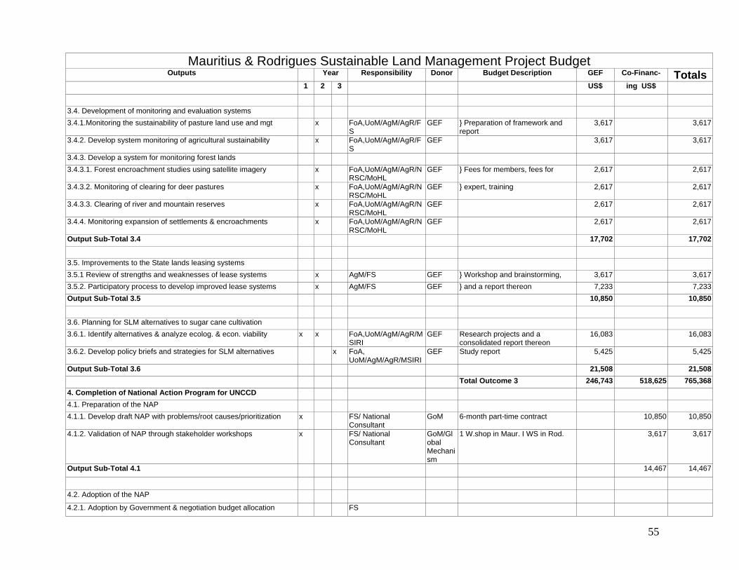
Mauritius & Rodrigues Sustainable Land Management Project Budget Outputs Year Responsibility Donor Budget Description GEF Co-Financ- Totals
1 2 3 US$ ing US$
3.4. Development of monitoring and evaluation systems 3.4.1.Monitoring the sustainability of pasture land use and mgt x FoA,UoM/AgM/AgR/F
S GEF } Preparation of framework and
report 3,617 3,617
3.4.2. Develop system monitoring of agricultural sustainability x FoA,UoM/AgM/AgR/FS
GEF 3,617 3,617
3.4.3. Develop a system for monitoring forest lands 3.4.3.1. Forest encroachment studies using satellite imagery x FoA,UoM/AgM/AgR/N
RSC/MoHL GEF } Fees for members, fees for 2,617 2,617
3.4.3.2. Monitoring of clearing for deer pastures x FoA,UoM/AgM/AgR/NRSC/MoHL
GEF } expert, training 2,617 2,617
3.4.3.3. Clearing of river and mountain reserves x FoA,UoM/AgM/AgR/NRSC/MoHL
GEF 2,617 2,617
3.4.4. Monitoring expansion of settlements & encroachments x FoA,UoM/AgM/AgR/NRSC/MoHL
GEF 2,617 2,617
Output Sub-Total 3.4 17,702 17,702
3.5. Improvements to the State lands leasing systems 3.5.1 Review of strengths and weaknesses of lease systems x AgM/FS GEF } Workshop and brainstorming, 3,617 3,617 3.5.2. Participatory process to develop improved lease systems x AgM/FS GEF } and a report thereon 7,233 7,233 Output Sub-Total 3.5 10,850 10,850
3.6. Planning for SLM alternatives to sugar cane cultivation 3.6.1. Identify alternatives & analyze ecolog. & econ. viability x x FoA,UoM/AgM/AgR/M
SIRI GEF Research projects and a
consolidated report thereon 16,083 16,083
3.6.2. Develop policy briefs and strategies for SLM alternatives x FoA, UoM/AgM/AgR/MSIRI
GEF Study report 5,425 5,425
Output Sub-Total 3.6 21,508 21,508 Total Outcome 3 246,743 518,625 765,368
4. Completion of National Action Program for UNCCD 4.1. Preparation of the NAP 4.1.1. Develop draft NAP with problems/root causes/prioritization x FS/ National
Consultant GoM 6-month part-time contract 10,850 10,850
4.1.2. Validation of NAP through stakeholder workshops x FS/ National Consultant
GoM/Global Mechanism
1 W.shop in Maur. I WS in Rod. 3,617 3,617
Output Sub-Total 4.1 14,467 14,467
4.2. Adoption of the NAP
4.2.1. Adoption by Government & negotiation budget allocation FS
55

Mauritius & Rodrigues Sustainable Land Management Project Budget Outputs Year Responsibility Donor Budget Description GEF Co-Financ- Totals
1 2 3 US$ ing US$ 4.2.2. Formal publication/dissemination & awareness raising x FS/AgM/AgR/National
Consultant GoM Brochures, leaflets, public talks, 1,808 1,808
Output Sub-Total 4.2 1,808 1,808
Total Outcome 4 16,275 16,275
5. Project Management Costs 5.1. Project Director x x x Salary for 3 years 91,139 91,139 5.2. Administrative Assistant (Mauritius) x x x GoM Salary for 3 years 15,624 15624 5.3. Technical Assistant (Rodrigues) x x x GoM Salary for 3 years 26,040 26,040 5.4. Driver/Attendant (Mauritius) x x x GoM Salary for 3 years 10,416 10,416 5.5. Vehicle (4 x 4) x x x 36,166 36,166 5.6. Running costs for vehicle x x x GoM Petrol, servicing, maintenance 13,020 13,020 5.6. Travel and DSA (PMU) for Project Director x x x 3,906 3,906 5.7. Mid-Term Review x 18,083 18,083 5.8 Final Evaluation x 18,083 18,083 5.8. Annual Audits x x x 4,000 4,000 5.9 Inception workshop x 2,000 5.9 Local contracts for monitoring x x x 5,000Management Costs Sub-Total 178,377 65,100 243477
Core GEF funding 574,073 Total Co-Financing 764,000
27.65 MUR/$ Exchange rate Total Project Funding 1,338,073
56

Annex D: Stakeholder Involvement Matrix
57
Name of Stakeholder
Stakeholder’s interest in SLM Justification for inclusion of stakeholder
Expected role of stakeholder
MoAF (Forestry Service)
National coordination for project; Forest laws and Pas Geometriques
Responsible for granting of forest leases for game hunting; Regulatory body for conversion of forests into pasturelands; Provide information on forest activities; Reforestation activities
Officers will be trained on GIS, LIS, Forest Cover Maps, Forest type Maps, digitization of boundaries, etc. Will provide valuable input during workshops and training
MoE&NDU Dealing with all environmental issues including capacity building
Mandate; Focal point for UNCCD and other Conventions; Overall supervision
Will act as facilitator and develop synergies between various environmental & rural projects. And will be responsible for preparing the UNCCD/NAP in close collaboration with FS of the MoA.
MoFED Coordinating body; Funding; Financial control; Incremental cost
All GEF projects have to be channeled through this Ministry
Facilitation for funds and government commitments
MoHL (Survey Division)
Mandate for State lands management
Presently developing LIS for Mauritius and digitization of island boundaries; Has all maps, hard copy and digital
Act as resource persons in SLM workshops, contribute to harmonization of an integrated LIS; provide valuable inputs on Pas Geometriques
MoHL (LIS) Data of all land (State and private) Mandate LIS FoA, UoM Research, training, capacity
building; extension and outreach This is the only tertiary institution dealing with training and capacity building in SLM and Sustainable Agriculture
Will run training courses, award certificates, provide resource persons for Workshops on SLM; will provide information and research data on SLM
MSIRI Research in sugarcane production and extension
Have some GIS data on sugarcane lands; have an ongoing project on soil erosion
Research methodology; provide some resource persons and research findings
Mauritius Institute of Education (MIE)
Training of primary & secondary school teachers in environmental education; Public awareness
This is the only tertiary institution dealing specifically with training of primary & secondary school teachers in agricultural and environmental issues
Public awareness; preparation of brochures; talks
MoAF (Land Use Division)
Land use survey; Land settlement survey
Is responsible for land use conversion and granting of land leases for agricultural purposes
Provide information on areas of land settlement and policy issues; will benefit as trainees in the SLM

workshops MoAF (AREU) Research and extension in non-sugar
agriculture Responsible for research and extension on crops other than sugarcane
Providing detailed data on individual planters and fields; share research results; policy issues
MoAF (FARC) Apex body for funds and policy on agricultural research
Advisor to Government on agricultural policies, especially related to research.
Coordinating and funding body for agricultural research; Focal point for FAO; can contribute as co-financier of SLM projects
MoAF (NPCS) Biodiversity conservation Provides synergy between UN Convention on Biodiversity and UNCCD
As resource persons in SLM workshops, as participants in SLM workshops
MoAF (NRSC) Satellite photos and their interpretation; remote sensing
Provider of satellite images; Training Interpretation of land degradation images; Satellite photo interpretation and ground truth; geo-referencing
MoAF (FSCs) Interest in small sugarcane planters Service provider (advise, mechanization, agro-chemicals, etc)
Provide profiles of small sugarcane planters and fields; as participants in SLM workshops
Ministry of Public Utilities
Domestic, industrial and agricultural water supply and waste water management; River and stream flow; surface and underground water
Responsible for domestic, industrial and agricultural water supply, and safe waste water disposal; Regulating and implementing authority for waste water disposal
Providing data on water quality; incidence of organic, inorganic and heavy metal pollutants; Information on river and stream flows, drainage maps, etc.; provide volume of waste water generated and treated; disposal methods
Meteorological Services
Meteorological data (intensity, duration and distribution pattern of rainfall; drought forecasting; cyclones; floods; climate change
Focal point for UNCCC; synergy between UNCCC and UNCCD
Provide valuable input on climatological data related to land degradation
Irrigation Authority
Irrigation methods; irrigation plans; irrigation water
Regulate and implement Government policy on irrigation
Provide data on quantity and quality of irrigation water; contribute to zoning for irrigation areas
Beach Authority All aspects of beach management
Responsible for beach management and beach erosion control
Control of beach erosion; Awareness raising on beach management
Mauritius Oceanography Institute (MOI)
All aspects of the marine environment
Responsible for research on ocean currents, marine tides, corals, etc.
Provide data on marine data, waves, marine and brackish organisms and marine environment; provide resources person, will be participants in SLM
58

workshops Mauritius Vegetable Planters Association
Vegetable crop production Association grouping most vegetable producers
As participants in SLM workshops; provide indigenous/traditional knowledge on SLM practices; eventually will contribute to SLM through sustainable agricultural practices and good land stewardship
National Young Farmers Club
Young farmers NGO grouping young people interested in agriculture
As participants in SLM workshops; eventually will contribute to SLM through sustainable agricultural practices and good land stewardship
Northern Planters Association
Sugarcane cultivation in the north of the island
Association grouping sugarcane planters of the north of the country
As participants in SLM workshops; eventually will contribute to SLM through sustainable agricultural practices and good land stewardship
Onion Producers Association
Onion production Association grouping onion planters As participants in SLM workshops; eventually will contribute to SLM through sustainable agricultural practices and good land stewardship
Deer Meat Producers Association
Production of deer meat in private forests and state leased forests
Responsible for good forest management, including clearing forest for pastures
As participants in SLM workshops; eventually will contribute to SLM through sustainable practices and good land stewardship; will be party to new regulations/legislation on forest leases for deer ranching
59

Annex E Terms of Reference for Project Manager, Steering Committee And Technical Advisory Committee
1. Project Manager Background: The Project Manager (PM) will be responsible for the implementation of the project, including the mobilization of all project inputs, supervision over project staff, consultants and sub-contractors. The PM will manage the Capacity Building for SRM MSP, will be fully accountable to the Conservator of Forests and to the Steering Committee for satisfactory execution of the entire project and will be responsible for meeting government obligations under the Project, under the national execution modality. The Project Manager will be the head of the Project Management Unit. The PMU will have operational and financial autonomy, including the authority to select and sub-contract specific project activities or components to local consultants and local institutions. The PM shall perform a liaison role with government, UNDP, and all stakeholders involved with the project. Duties and Responsibilities
1. Overall management of the project. 2. Supervise and coordinate the production of project outputs as per the project document; 3. Ensure the technical coordination of the project; 4. Mobilize all project inputs in accordance with UNDP procedures for nationally executed projects; 5. Finalize the ToR for the consultants and subcontractors; 6. Coordinate the recruitment and selection of project personnel; 7. Supervise and coordinate the work of all project staff, consultants and sub-contractors; 8. Work closely with project partners to closely coordinate all the actors involved with achieving
Project Outcomes, Outputs and Activities ; 9. Supervise the work of all PMU staff, including national staff. 10. Prepare and revise project work and financial plans, as required Government and UNDP; 11. Manage procurement of goods and services under UNDP guidelines and oversight of contracts; 12. Ensure proper management of funds consistent with UNDP requirements, and budget planning
and control; 13. Establish project monitoring and reporting; 14. Arrange for audit of all project accounts for each fiscal year; 15. Prepare and ensure timely submission of quarterly financial consolidated reports, quarterly
consolidated progress reports, PPER, mid-term reports, and other reports as may be required by UNDP.
16. Disseminate project reports to and respond to queries from concerned stakeholders; 17. Report progress of project to the Steering Committee. 18. Oversee the exchange and sharing of experiences and lessons learned with relevant conservation
and development projects nationally and internationally. 19. Preparing a detailed annual workplan for the project 20. Undertaking any other activities that may be assigned by the Steering Committee.
Selection Criteria
1. Post-graduate degree in natural resources management or other relevant academic and profession qualifications with at least 10 years professional experience;
2. Proven extensive experience and technical ability to manage a large project and a good technical knowledge in the fields related to SLM, participatory approaches and/or environmental economics;
3. Effective interpersonal and negotiation skills proven through successful interactions with all levels of project stakeholder groups, including senior government officials, business executives,
60
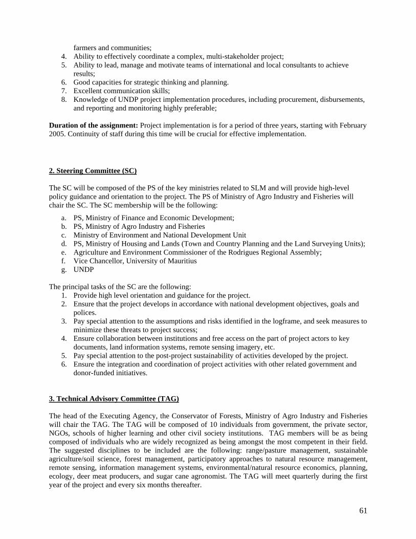
farmers and communities; 4. Ability to effectively coordinate a complex, multi-stakeholder project; 5. Ability to lead, manage and motivate teams of international and local consultants to achieve
results; 6. Good capacities for strategic thinking and planning. 7. Excellent communication skills; 8. Knowledge of UNDP project implementation procedures, including procurement, disbursements,
and reporting and monitoring highly preferable; Duration of the assignment: Project implementation is for a period of three years, starting with February 2005. Continuity of staff during this time will be crucial for effective implementation. 2. Steering Committee (SC) The SC will be composed of the PS of the key ministries related to SLM and will provide high-level policy guidance and orientation to the project. The PS of Ministry of Agro Industry and Fisheries will chair the SC. The SC membership will be the following:
a. PS, Ministry of Finance and Economic Development; b. PS, Ministry of Agro Industry and Fisheries c. Ministry of Environment and National Development Unit d. PS, Ministry of Housing and Lands (Town and Country Planning and the Land Surveying Units); e. Agriculture and Environment Commissioner of the Rodrigues Regional Assembly; f. Vice Chancellor, University of Mauritius g. UNDP
The principal tasks of the SC are the following:
1. Provide high level orientation and guidance for the project. 2. Ensure that the project develops in accordance with national development objectives, goals and
polices. 3. Pay special attention to the assumptions and risks identified in the logframe, and seek measures to
minimize these threats to project success; 4. Ensure collaboration between institutions and free access on the part of project actors to key
documents, land information systems, remote sensing imagery, etc. 5. Pay special attention to the post-project sustainability of activities developed by the project. 6. Ensure the integration and coordination of project activities with other related government and
donor-funded initiatives.
3. Technical Advisory Committee (TAG) The head of the Executing Agency, the Conservator of Forests, Ministry of Agro Industry and Fisheries will chair the TAG. The TAG will be composed of 10 individuals from government, the private sector, NGOs, schools of higher learning and other civil society institutions. TAG members will be as being composed of individuals who are widely recognized as being amongst the most competent in their field. The suggested disciplines to be included are the following: range/pasture management, sustainable agriculture/soil science, forest management, participatory approaches to natural resource management, remote sensing, information management systems, environmental/natural resource economics, planning, ecology, deer meat producers, and sugar cane agronomist. The TAG will meet quarterly during the first year of the project and every six months thereafter.
61
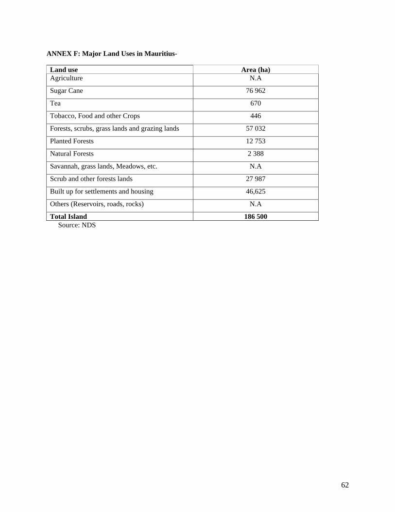
ANNEX F: Major Land Uses in Mauritius-
Land use Area (ha) Agriculture N.A
Sugar Cane 76 962
Tea 670
Tobacco, Food and other Crops 446
Forests, scrubs, grass lands and grazing lands 57 032
Planted Forests 12 753
Natural Forests 2 388
Savannah, grass lands, Meadows, etc. N.A
Scrub and other forests lands 27 987
Built up for settlements and housing 46,625
Others (Reservoirs, roads, rocks) N.A
Total Island 186 500 Source: NDS
62

Annex G M&E Plan and Budget for FSP and MSP Project monitoring and evaluation will be conducted in accordance with established UNDP and GEF procedures and will be provided by the Project Management Unit (PMU) and the UNDP Country Office (UNDP-CO) with support from UNDP/GEF. The Logical Framework Matrix in B 1 provides performance and impact indicators for project implementation along with their corresponding means of verification. These will form the basis on which the project's Monitoring and Evaluation system will be built. 1. MONITORING AND REPORTING 1.1. Project Inception Phase A Project Inception Workshop will be conducted with the full project team, relevant government counterparts, co-financing partners, the UNDP-CO and representation from the UNDP-GEF Regional Coordinating Unit as appropriate. A fundamental objective of this Inception Workshop will be to assist the project team to understand and take ownership of the project’s goals and objectives, as well as finalize preparation of the project's first annual work plan on the basis of the project's logframe matrix. This will include reviewing the logframe (indicators, means of verification, assumptions), imparting additional detail as needed, and on the basis of this exercise finalize the Annual Work Plan (AWP) with precise and measurable performance indicators, and in a manner consistent with the expected outcomes for the project.
Additionally, the purpose and objective of the Inception Workshop (IW) will be to: (i) introduce project staff with the UNDP-GEF expanded team which will support the project during its implementation, namely the CO and responsible Regional Coordinating Unit staff; (ii) detail the roles, support services and complementary responsibilities of UNDP-CO and RCU staff vis à vis the project team; (iii) provide a detailed overview of UNDP-GEF reporting and monitoring and evaluation (M&E) requirements, with particular emphasis on the Annual Project Implementation Reviews (PIRs) and related documentation, the Annual Project Report (APR), Tripartite Review Meetings, as well as the Mid-Term Review. Equally, the IW will provide an opportunity to inform the project team on UNDP project related budgetary planning, budget reviews, and mandatory budget rephasings. The IW will also provide an opportunity for all parties to understand their roles, functions, and responsibilities within the project's decision-making structures, including reporting and communication lines, and conflict resolution mechanisms. The Terms of Reference for project staff and decision-making structures will be discussed again, as needed, in order to clarify for all, each party’s responsibilities during the project's implementation phase. 1.2. Monitoring responsibilities and events A detailed schedule of project reviews meetings will be developed by the project management, in consultation with project implementation partners and stakeholder representatives and incorporated in the Project Inception Report. Such a schedule will include: (i) tentative time frames for Tripartite Reviews, Steering Committee Meetings, Technical Advisory Group (TAG) meetings and (ii) project related Monitoring and Evaluation activities. Day to day monitoring of implementation progress will be the responsibility of the Project Manager (depending on the established project structure) based on the project's Annual Work Plan and its indicators. The Project Manager will inform the UNDP-CO of any delays or difficulties faced during
63

implementation so that the appropriate support or corrective measures can be adopted in a timely and remedial fashion. The Project Manager will fine-tune the progress and performance/impact indicators of the project in consultation with the full project team at the Inception Workshop with support from UNDP-CO and assisted by the UNDP-GEF Regional Coordinating Unit. Specific targets for the first year implementation progress indicators together with their means of verification will be developed at this Workshop. These will be used to assess whether implementation is proceeding at the intended pace and in the right direction and will form part of the Annual Work Plan. The local implementing agencies will also take part in the Inception Workshop in which a common vision of overall project goals will be established. Targets and indicators for subsequent years would be defined annually as part of the internal evaluation and planning processes undertaken by the project team. Measurement of impact indicators related to global benefits will occur according to the schedules defined in the Inception Workshop and tentatively outlined in the indicative Impact Measurement Template at the end of this Annex. The measurement, of these will be undertaken through subcontracts or retainers with relevant institutions (e.g. vegetation cover via analysis of satellite imagery, or populations of key species through inventories) or through specific studies that are to form part of the projects activities (e.g. measurement carbon benefits from improved efficiency of ovens or through surveys for capacity building efforts) or periodic sampling such as with sedimentation. Periodic monitoring of implementation progress will be undertaken by the UNDP-CO through quarterly meetings with the project proponent, or more frequently as deemed necessary. This will allow parties to take stock and to troubleshoot any problems pertaining to the project in a timely fashion to ensure smooth implementation of project activities. UNDP Country Offices and UNDP-GEF RCUs as appropriate, will conduct yearly visits to projects that have field sites, or more often based on an agreed upon scheduled to be detailed in the project's Inception Report /Annual Work Plan to assess first hand project progress. Any other member of the Steering Committee can also accompany, as decided by the SC. A Field Visit Report will be prepared by the CO and circulated no less than one month after the visit to the project team, all SC members, and UNDP-GEF. Annual Monitoring will occur through the Tripartite Review (TPR). This is the highest policy-level meeting of the parties directly involved in the implementation of a project. The project will be subject to Tripartite Review (TPR) at least once every year. The first such meeting will be held within the first twelve months of the start of full implementation. The project proponent will prepare an Annual Project Report (APR) and submit it to UNDP-CO and the UNDP-GEF regional office at least two weeks prior to the TPR for review and comments.
The APR will be used as one of the basic documents for discussions in the TPR meeting. The project proponent will present the APR to the TPR, highlighting policy issues and recommendations for the decision of the TPR participants. The project proponent also informs the participants of any agreement reached by stakeholders during the APR preparation on how to resolve operational issues. Separate reviews of each project component may also be conducted if necessary. Terminal Tripartite Review (TTR) The terminal tripartite review is held in the last month of project operations. The project proponent is responsible for preparing the Terminal Report and submitting it to UNDP-CO and LAC-GEF's Regional Coordinating Unit. It shall be prepared in draft at least two months in advance of the TTR in order to allow review, and will serve as the basis for discussions in the TTR. The terminal tripartite review
64

considers the implementation of the project as a whole, paying particular attention to whether the project has achieved its stated objectives and contributed to the broader environmental objective. It decides whether any actions are still necessary, particularly in relation to sustainability of project results, and acts as a vehicle through which lessons learnt can be captured to feed into other projects under implementation of formulation. The TPR has the authority to suspend disbursement if project performance benchmarks are not met. Benchmarks will be developed at the Inception Workshop, based on delivery rates, and qualitative assessments of achievements of outputs. 1.3. Project Monitoring Reporting The Project Coordinator in conjunction with the UNDP-GEF extended team will be responsible for the preparation and submission of the following reports that form part of the monitoring process. Items (a) through (f) are mandatory and strictly related to monitoring, while (g) through (h) have a broader function and the frequency and nature is project specific to be defined throughout implementation. (a) Inception Report (IR)
A Project Inception Report will be prepared immediately following the Inception Workshop. It will include a detailed First Year/ Annual Work Plan divided in quarterly time-frames detailing the activities and progress indicators that will guide implementation during the first year of the project. This Work Plan would include the dates of specific field visits, support missions from the UNDP-CO or the Regional Coordinating Unit (RCU) or consultants, as well as time frames for meetings of the project's decision-making structures. The Report will also include the detailed project budget for the first full year of implementation, prepared on the basis of the Annual Work Plan, and including any monitoring and evaluation requirements to effectively measure project performance during the targeted 12 months time frame. The Inception Report will include a more detailed narrative on the institutional roles, responsibilities, coordinating actions and feedback mechanisms of project related partners. In addition, a section will be included on progress to date on project establishment and start-up activities and an update of any changed external conditions that may effect project implementation. When finalized the report will be circulated to project counterparts who will be given a period of one calendar month in which to respond with comments or queries. Prior to this circulation of the IR, the UNDP Country Office and UNDP-GEF’s Regional Coordinating Unit will review the document. (b) Annual Project Report (APR) The APR is a UNDP requirement and part of UNDP’s Country Office central oversight, monitoring and project management. It is a self-assessment report by project management to the CO and provides input to the country office reporting process and the ROAR, as well as forming a key input to the Tripartite Project Review. An APR will be prepared on an annual basis prior to the Tripartite Project Review, to reflect progress achieved in meeting the project's Annual Work Plan and assess performance of the project in contributing to intended outcomes through outputs and partnership work. The format of the APR is flexible but should include the following:
• An analysis of project performance over the reporting period, including outputs produced and, where possible, information on the status of the outcome
• The constraints experienced in the progress towards results and the reasons for these • The three (at most) major constraints to achievement of results
65

• AWP, CAE and other expenditure reports (ERP generated) • Lessons learned • Clear recommendations for future orientation in addressing key problems in lack of progress
(c) Project Implementation Review (PIR) The PIR is an annual monitoring process mandated by the GEF. It has become an essential management and monitoring tool for project managers and offers the main vehicle for extracting lessons from ongoing projects. Once the project has been under implementation for a year, the CO together with the project must complete a Project Implementation Report. The PIR can be prepared any time during the year (July-June) and ideally prior to the TPR. The PIR should then be discussed in the TPR so that the result would be a PIR that has been agreed upon by the project, the executing agency, UNDP CO and the concerned RC. The individual PIRs are collected, reviewed and analyzed by the RCs prior to sending them to the focal area clusters at the UNDP/GEF headquarters. The focal area clusters supported by the UNDP/GEF M&E Unit analyze the PIRs by focal area, theme and region for common issues/results and lessons. The TAs and PTAs play a key role in this consolidating analysis. The focal area PIRs are then discussed in the GEF Interagency Focal Area Task Forces in or around November each year and consolidated reports by focal area are collated by the GEF Independent M&E Unit based on the Task Force findings. The GEF M&E Unit provides the scope and content of the PIR. In light of the similarities of both APR and PIR, UNDP/GEF has prepared a harmonized format for reference. (d) Quarterly Progress Reports Short reports outlining main updates in project progress will be provided quarterly to the local UNDP Country Office and the UNDP-GEF regional office by the project team. See format attached. (e) Periodic Thematic Reports
As and when called for by UNDP, UNDP-GEF or the Implementing Partner, the project team will prepare Specific Thematic Reports, focusing on specific issues or areas of activity. The request for a Thematic Report will be provided to the project team in written form by UNDP and will clearly state the issue or activities that need to be reported on. These reports can be used as a form of lessons learnt exercise, specific oversight in key areas, or as troubleshooting exercises to evaluate and overcome obstacles and difficulties encountered. UNDP is requested to minimize its requests for Thematic Reports, and when such are necessary will allow reasonable timeframes for their preparation by the project team.
(f) Project Terminal Report During the last three months of the project the project team will prepare the Project Terminal Report. This comprehensive report will summarize all activities, achievements and outputs of the Project, lessons learnt, objectives met, or not achieved, structures and systems implemented, etc. and will be the definitive statement of the Project’s activities during its lifetime. It will also lay out recommendations for any further steps that may need to be taken to ensure sustainability and replicability of the Project’s activities. (g) Technical Reports (project specific- optional)
66

Technical Reports are detailed documents covering specific areas of analysis or scientific specializations within the overall project. As part of the Inception Report, the project team will prepare a draft Reports List, detailing the technical reports that are expected to be prepared on key areas of activity during the course of the Project, and tentative due dates. Where necessary this Reports List will be revised and updated, and included in subsequent APRs. Technical Reports may also be prepared by external consultants and should be comprehensive, specialized analyses of clearly defined areas of research within the framework of the project and its sites. These technical reports will represent, as appropriate, the project's substantive contribution to specific areas, and will be used in efforts to disseminate relevant information and best practices at local, national and international levels.
(h) Project Publications (project specific- optional) Project Publications will form a key method of crystallizing and disseminating the results and achievements of the Project. These publications may be scientific or informational texts on the activities and achievements of the Project, in the form of journal articles, multimedia publications, etc. These publications can be based on Technical Reports, depending upon the relevance, scientific worth, etc. of these Reports, or may be summaries or compilations of a series of Technical Reports and other research. The project team will determine if any of the Technical Reports merit formal publication, and will also (in consultation with UNDP, the government and other relevant stakeholder groups) plan and produce these Publications in a consistent and recognizable format. Project resources will need to be defined and allocated for these activities as appropriate and in a manner commensurate with the project's budget. 2. INDEPENDENT EVALUATION The project will be subjected to at least two independent external evaluations as follows:
(i) Mid-term Evaluation An independent Mid-Term Evaluation will be undertaken at the end of the second year of implementation. The Mid-Term Evaluation will determine progress being made towards the achievement of outcomes and will identify course correction if needed. It will focus on the effectiveness, efficiency and timeliness of project implementation; will highlight issues requiring decisions and actions; and will present initial lessons learned about project design, implementation and management. Findings of this review will be incorporated as recommendations for enhanced implementation during the final half of the project’s term. The organization, terms of reference and timing of the mid-term evaluation will be decided after consultation between the parties to the project document. The Terms of Reference for this Mid-term evaluation will be prepared by the UNDP CO based on guidance from the Regional Coordinating Unit and UNDP-GEF. (ii) Final Evaluation
An independent Final Evaluation will take place three months prior to the terminal tripartite review meeting, and will focus on the same issues as the mid-term evaluation. The final evaluation will also look at impact and sustainability of results, including the contribution to capacity development and the achievement of global environmental goals. The Final Evaluation should also provide recommendations for follow-up activities. The Terms of Reference for this evaluation will be prepared by the UNDP CO based on guidance from the Regional Coordinating Unit and UNDP-GEF. Audit Clause The Government will provide the Resident Representative with certified periodic financial statements, and with an annual audit of the financial statements relating to the status of UNDP (including GEF) funds
67

according to the established procedures set out in the Programming and Finance manuals. The Audit will be conducted by the legally recognized auditor of the Government, or by a commercial auditor engaged by the Government. TABLE H-1: INDICATIVE MONITORING AND EVALUATION WORK PLAN AND CORRESPONDING BUDGET
Type of M&E activity
Responsible Parties Budget US$ Excluding project
team Staff time
Time frame
Inception Workshop Project Manager UNDP CO UNDP GEF
$2000 Within first two months of project start up
Inception Report Project Team UNDP CO None Immediately
following IW Measurement of Means of Verification for Project Purpose Indicators
Project Coordinator will oversee the hiring of specific studies and institutions, and delegate responsibilities to relevant team members
To be finalized in Inception Phase and Workshop. Indicative cost $3000
Start, mid and end of project
Measurement of Means of Verification for Project Progress and Performance (measured on an annual basis)
Oversight by Project GEF Technical Advisor and Project Manager
Measurements by regional field officers and local IAs
To be determined as part of the Annual Work Plan's preparation. Indicative cost $2000
Annually prior to APR/PIR and to the definition of annual work plans
APR and PIR Project Team UNDP-CO UNDP-GEF
None Annually
TPR and TPR report Government Counterparts
UNDP CO Project team UNDP-GEF Regional
Coordinating Unit
None Every year, upon receipt of APR
Steering Committee Meetings
Project Coordinator UNDP CO
None Following Project IW and subsequently at least once a year
Periodic status reports
Project team None To be determined by Project team and UNDP CO
Technical reports Project team Hired consultants as
15,000 To be determined by
68

needed Project Team and UNDP-CO
Mid-term External Evaluation
Project team UNDP- CO UNDP-GEF Regional
Coordinating Unit External Consultants (i.e.
evaluation team)
18,083 At the mid-point of project implementation.
Final Evaluation Project team UNDP- CO UNDP-GEF Regional
Coordinating Unit External Consultants (i.e.
evaluation team)
18,083
During the last three months of the project.
Terminal Report Project team UNDP-CO External Consultant
None At least one month before the end of the project
Lessons learned Project team UNDP-GEF Regional
Coordinating Unit (suggested formats for documenting best practices, etc)
10,000
Yearly
Audit UNDP-CO Project team 4,000 Yearly
Visits to field sites (UNDP staff travel costs to be charged to IA fees)
UNDP Country Office UNDP-GEF Regional
Coordinating Unit (as appropriate)
Government representatives
3,906
Yearly
TOTAL INDICATIVE COST Excluding project team staff time and UNDP staff and travel expenses
US$ 76,072
69


Annex J
Total Budget and Annual Work Plan
Award ID: 42526 Award Title: Capacity Building for Sustainable Land Management in Mauritius (including Rodrigues) Project ID: 49100/ PIMS#: 3092
Project Title: Capacity Building for Sustainable Land Management in Mauritius (including Rodrigues) Implementing Partner/Executing Agency: Ministry of Agro-Industry & Fisheries (Forestry Services)
Amount Amount Amount
GEF Outcome/ ATLAS Activity
Responsible Party/ Implementing Agency
Source of funds
ERP/ATLAS Budget Description
2006 (USD)
2007 (USD)
2008 (USD)
Total (USD)
Forestry Services FAO 82000 82000 0 164000
71300Local Consultants 15190 49187 33679 98056
72200 Equipment 36166 0 0 36166
71600 Travel 1302 1302 1302 3906
74500Miscellaneous Expenses 3333 23033 26917 53283
SLO/AgM/AgR/FS/UoM 72100
Contractual Services - Companies 1667 1666 1667 5000
NCB/UNCCDFP/MF/PMU GEF 71400
Contractual Services - Individual 0 0 8000 8000
SLM Mainstreamed into national policies, plans and legislation
GOM 72200 Equipment 4340 4340 4340 13020
71

71300
Local Consultants 17360 17360 17360 52080
Sub-total GEF 57658 75188 71565 204411
Sub-total Outcome 1 161358 178888 93265 433511
FoA, UoM/NRSC/AgR 71200International Consultants 19892 39000 0 58892
foA, UoM 71300Local Consultants 0 13617 0 13617
FoA, UoM/NRSC 74500
Miscellaneous Expenses (Training) 10850 8009 0 18859
72100
Contractual Services - Companies 0 3617 0 3617
74100Professional Services 0 7234 0 7234
71600 Travel 0 5425 0 5425
71400
Contractual Services - Individual 0 7425 0 7425
GEF 72200 Equipment 0 7850 0 7850
GOM 71200International Consultants 0 185292 0 185292
Sub-total GEF 30742 92177 122919
Human resource capacities needed for SLM are developed Sub-total Outcome 2 30742 277469 0 308211
Capacities for knowledge management FoA, UoM/FS/RRA GEF 72100
Contractual Services - Companies 40074 98933 0 139007
72

FS/UoM/NRSC 74100Professional Services 0 7234 5425 12659
FoA, UoM/AgM/AgR/NRSC/MoHL 71200
International Consultants 0 2617 0 2617
FoA, UoM/AgM/AgR/ 74500Miscellaneous Expenses 8041 81706 2713 92460
MoHL, MoA GOM 74500Miscellaneous Expenses 333333 0 0 333333
Sub-total GEF 48115 190490 8138 246743
for SLM developed
Sub-total Outcome 3 381448 190490 8138 580076
71300Local Consultants 10850 0 0 10850
FS GOM 74500Miscellaneous Expenses 3617 1808 5425
The National Action Program for the UNCCD is completed Sub-total Outcome 4 14467 1808 0 16275
TOTAL GEF 136515 357855 79703 574073
Total 573548 646847 101403 1321798
Summary of Funds: • GEF: US$ 574,073 • Donor (FAO – parallel funding): US$ 164,000 • Government (in Kind): US$ 600,000
Total US$ 1,338,073
73

Annex I Financing Plan Co-Financing Sources Name of Co-financier (Source)
Classification Type Amount (USD) Status
Ministry of Agro-Industry & Fisheries
Government In kind 118,084 (3.5 million Rs)
Confirmed
Ministry of Housing and Lands Government In Kind 202,429 (6 million Rs)
Confirmed
Forestry Services Government In kind 253,036 (7.5 million Rs)
Confirmed
UNDP Implementing Agency
TRAC 15,000 Confirmed
FAO Executing Agency
164,000 Confirmed
Total 588,549
74

Annex K Notes of meeting of the Local Project Appraisal Committee meeting on Capacity Building for Sustainable Land Management in Mauritius (including Rodrigues) held on Wednesday 08 February 2006 at 11:30 in the Conference Room, UNDP, 6th floor, Anglo Mauritius Building, Port Louis. Present: Mr R. Alcindor - Environment Programme Manager, UNDP, Chairperson Mr S. Paupiah - Conservator of Forests, Forestry Services Mr N. Luchoo - Ag Principal Surveyor, Ministry of Housing and Lands Ms R. Ramsurn - Economist, Ministry of Finance & Economic Development Mrs D. Seesurrun - Environment Officer, Ministry of Environment & NDU Mr Y. Fukushima - Environment Programmed Officer, UNDP Ms U. Namdarkhan - Programme Assistant, UNDP
1. Welcome 1.1 The Chairperson welcomed all members present to the meeting. He stated that the LPAC
meeting was being held in order to reach an agreement from all parties concerned on the final draft of the ‘MSP – Capacity Building for Sustainable Land Management in Mauritius (including Rodrigues)’ before submission to GEF.
1.2 The committee went through the notes of meeting held on 14 April 2005. 2. Discussions 2.1 Item 6 of notes of meeting of 14 April 2005 2.1.1 Members were informed that the cost of USD 76,072 for Monitoring and Evaluation
activities (Table H-1; page 61 of project document) was included as part of the whole budget under various items and that the project team mentioned in the same table referred to the project management unit which would be set up for the project.
2.2 Government and FAO contributions
2.2.1 The representatives present informed that the Government’s contribution amounting to USD 600,000 was part of the budget of each of the stakeholders (Ministry of Housing and Land, and Forestry Services) and thus, would be an in-kind contribution.
2.2.2 The representative of the Ministry of Finance & Economic Development pointed out
that in the Project Budget on page 27 (of present document), budget lines for Government contribution for output 2.5 and output 3.3 had to be rectified to reflect budget lines 2.5.1 and 3.3.2 on page 48, totaling USD 518,625.
75

2.2.3 The representatives further informed that the FAO contribution amounting to USD 164,000 was a parallel funding.
2.3 Project Management and Implementation 2.3.1 All members present agreed that, for timely implementation of the project,
recruitment of the project personnel and setting up of the Project Management Unit, had to be done soonest possible.
2.3.2 It was further agreed that, since UNDP procedures for recruitment were less lengthy
that the Ministry’s, procedures for the recruitment of the Project Management Team would be done by the UNDP.
2.3.3 The Terms of Reference for the posts would be finalized by Forestry Services and
circulated for consultations prior to advertisement and recruitment.
2.4 Other changes in Document 2.4.1 Paragraph 130, 1st sentence: It is proposed to change the beginning date from
February 2005 to March 2006. 2.4.2 Signature page: The contribution of Government of Mauritius would be amended to
reflect that it is a contribution in kind and that of FAO to reflect that it is a parallel funding.
2.4.3 Signature page: The Representative of the Coordination Agency would be changed
from Conservator of Forest to the Permanent Secretary, Ministry of Agro Industry & Fisheries.
3. Other Comments 3.1 LIS System 3.1.1 The representative of Ministry of Housing and Land informed that the Ministry had
commissioned a report on the Land Information System for state-owned lands which was completed in 2005 and the draft report was ready.
3.2 SLM and NCSA projects 3.2.1 It was agreed that the MSP proposal on Sustainable Land Management project would
be completed prior to the NCSA Strategy Report.
3.2.2 The representative of Ministry of Finance & Economic Development informed that the NCSA Strategy Report has been completed and, as a follow-up to the NCSA project, an MSP on cross-cutting capacity building is being formulated.
76

3.3 Preparatory Steps for project Implementation
3.3.1 The Chairperson pointed out that the executing agency would need to open a separate bank account for the project as soon as the project started in which the UNDP will disburse the project’s funds.
3.3.2 He also stated that a Project Director and an alternate would have to be nominated by the Executing Agency. The Project Director would have administrative responsibilities for the project. He would also sign the financial reports, cheques and other official documents.
The meeting ended at 12:30. The Chairperson thanked all the participants for their inputs.
77