Govermental Unit Reference Map...0 2 4 6 8 10 Miles10 Miles The plotted map scale is 1:115144 INSET...
1
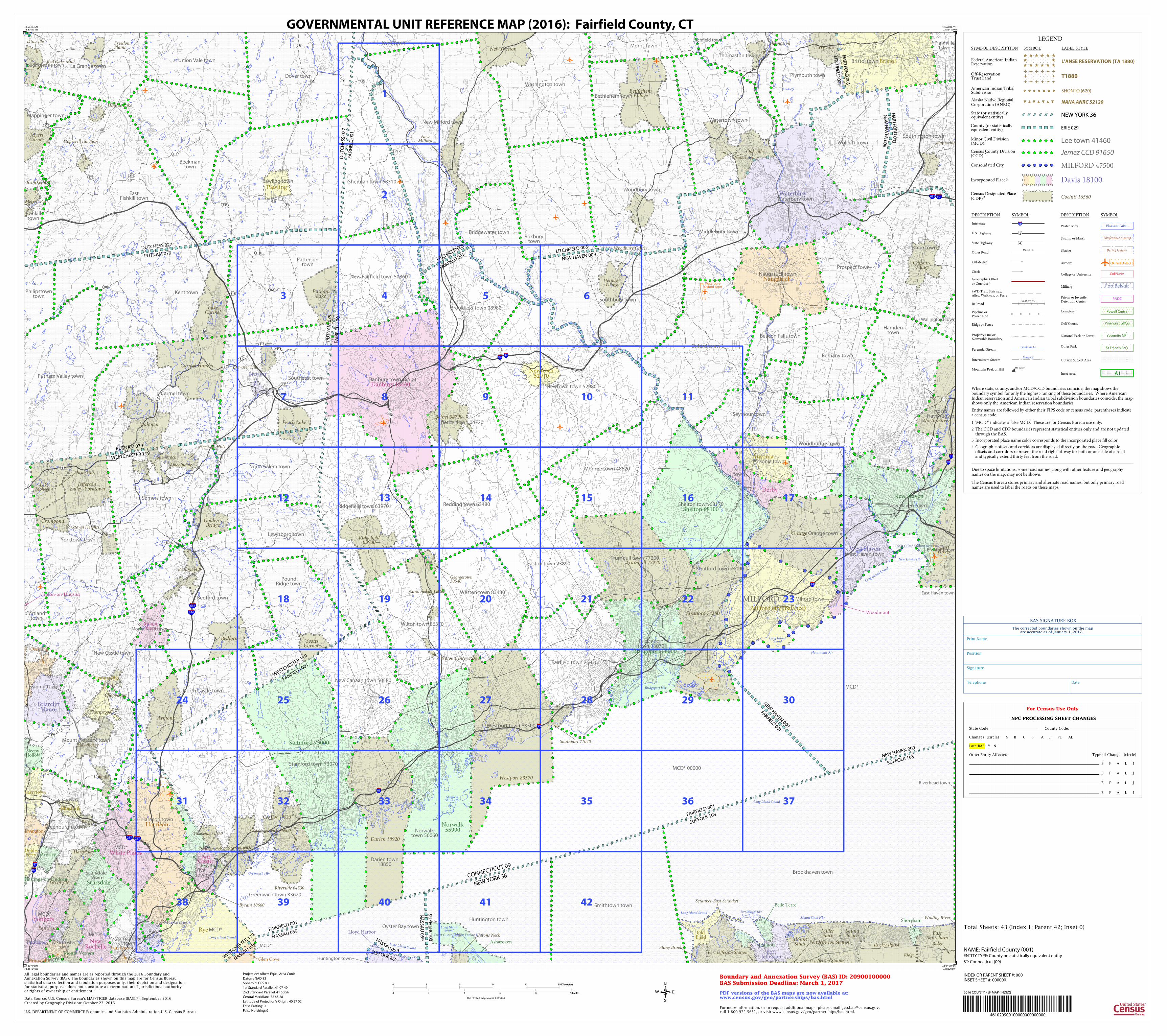
3 2 1 42 41 40 39 38 37 36 35 34 33 32 31 30 29 28 27 26 25 24 23 22 21 20 19 18 17 16 15 14 13 12 11 10 9 8 7 6 5 4 Coast Guard Station New Haven Coast Guard Station Eatons Neck Waterbury- Oxford Arprt Long Island Sound Long Island Sound Huntington Bay Long Island Sound Long Island Sound Long Island Sound Allens Cv Titicus Reservoir Sheffield Island Hbr Mount Sinai Hbr Croton Falls Reservoir Wescott Cv Bridgeport Hbr Rye Lk New Haven Hbr Port Jefferson Hbr Stamford Hbr Long Island Sound Greenwich Hbr Long Island Sound Housatonic Riv Kensico Reservoir Redding town 63480 Bethel town 04720 Easton town 23890 Fairfield town 26620 Trumbull town 77200 Weston town 83430 Westport town 83500 Brookfield town 08980 Darien town 18850 Greenwich town 33620 Monroe town 48620 New Canaan town 50580 New Fairfield town 50860 Newtown town 52980 Ridgefield town 63970 Sherman town 68310 Stratford town 74190 Wilton town 86370 MCD* 00000 MCD* MCD* MCD* MCD* MCD* MCD* MCD* Beekman town Bethany town Middlebury town Carmel town Prospect town Beacon Falls town East Fishkill town Bedford town Yorktown town Kent town Somers town Roxbury town Woodbridge town Bethlehem town Watertown town Woodbury town Wolcott town Riverhead town Oxford town Southbury town Branford town Dover town Pawling town Cheshire town Mamaroneck town Southeast town Philipstown town Huntington town East Haven town Oyster Bay town Brookhaven town Smithtown town Plainville town Southington town Patterson town Putnam Valley town Seymour town Union Vale town Wappinger town Hamden town North Haven town Orange town Wallingford town Bridgewater town Kent town Morris town Litchfield town New Milford town Thomaston town Washington town Fishkill town La Grange town Poughkeepsie town Plymouth town Cortlandt town Ossining town Eastchester town Greenburgh town Mount Pleasant town New Castle town North Castle town Rye town Lewisboro town North Salem town Pound Ridge town Huntington town Rye town Norwalk town 56060 Bridgeport town 08070 Danbury town 18500 Shelton town 68170 Stamford town 73070 Ansonia town Naugatuck town Waterbury town West Haven town Harrison town Scarsdale town Mount Kisco town Derby town Bristol town New Haven town Milford town FAIRFIELD 001 PUTNAM 079 NEW HAVEN 009 FAIRFIELD 001 NEW HAVEN 009 LITCHFIELD 005 SUFFOLK 103 FAIRFIELD 001 FAIRFIELD 001 NASSAU 059 FA I RF I ELD 0 0 1 LI T C H F I EL D 005 FAIRFIELD 001 WESTCHESTER 119 F A I R F I ELD 0 0 1 DUTCHESS 027 WESTCHESTER 119 NASSAU 059 N E W H A V E N 00 9 H A R T F O R D 0 0 3 SUFFOLK 103 NEW HAVEN 009 L I T C H F I EL D 0 05 H AR T F O R D 0 03 SUFFOLK 103 NASSAU 059 PUTNAM 079 WESTCHESTER 119 DUTCHESS 027 PUTNAM 079 SU F F O L K 1 0 3 N AS S A U 0 5 9 CONNECTICUT 09 N E W YORK 36 Southport 71040 Cos Cob 17520 Riverside 64530 Old Greenwich 56900 Greenwich 33690 Glenville 31520 Pemberwick 59210 Darien 18920 Stratford 74260 Byram 10660 Bethel 04790 Georgetown 30540 Ridgefield 63900 Trumbull 77270 Westport 83570 Wilton Center 86380 Cannondale 11990 Yorktown Heights Bedford Hills Katonah Lake Mohegan Lincolndale Peach Lake Shenorock Plantsville Bethlehem Village New Milford Oakville Woodbury Center Shrub Oak Thornwood Valhalla Watertown Freedom Plains Hopewell Junction Sound Beach Thomaston Cheshire Village Heritage Village Brewster Hill Carmel Hamlet Lake Carmel Mahopac Bedford Chappaqua Crompond Fairview Eatons Neck Miller Place Mount Sinai Putnam Lake Wading River Armonk Eastchester Brinckerhoff Myers Corner Red Oaks Mill Scotts Corners New Preston Terryville Port Jefferson Station Ridge Rocky Point Merritt Park Titusville Stony Brook Setauket-East Setauket East Shoreham East Haven North Haven Orange Hawthorne Heritage Hills Jefferson Valley-Yorktown Golden's Bridge Greenville Hartsdale Hillside Lake Port Jefferson Station Port Jefferson Station Ridge MILFORD Newtown 52910 Norwalk 55990 Bridgeport 08000 Danbury 18430 Shelton 68100 Stamford 73000 Old Field Poquott Port Jefferson Brewster Naugatuck Shoreham Elmsford Ansonia Waterbury West Haven Woodmont Tuckahoe White Plains Mount Kisco Pleasantville Ardsley Bronxville Pawling Belle Terre Harrison Scarsdale Dobbs Ferry Hastings-on-Hudson Irvington Briarcliff Manor Larchmont Rye Brook Bristol Lloyd Harbor Mount Vernon Derby Milford city (balance) New Haven Mamaroneck Croton-on-Hudson New Rochelle Port Chester Yonkers Ossining Rye Tarrytown Glen Cove Sleepy Hollow Asharoken 287 287 684 684 91 87 87 95 95 91 84 84 691 691 95 8 22 312 22 55 55 55 55 15 52 301 312 312 311 117 8 164 311 376 117 22 292 216 216 22 52 82 376 22 72 7 7 7 7 7 6 6 6 202 7 7 461020900100000000000000 LEGEND SYMBOL DESCRIPTION SYMBOL LABEL STYLE Lee town 41460 Minor Civil Division (MCD) 1 Jemez CCD 91650 Census County Division (CCD) 2 MILFORD 47500 Consolidated City Davis 18100 Incorporated Place 3 Cochiti 16560 Census Designated Place (CDP) 2 L'ANSE RESERVATION (TA 1880) Federal American Indian Reservation T1880 Off-Reservation Trust Land SHONTO (620) American Indian Tribal Subdivision NANA ANRC 52120 Alaska Native Regional Corporation (ANRC) NEW YORK 36 State (or statistically equivalent entity) ERIE 029 County (or statistically equivalent entity) DESCRIPTION SYMBOL DESCRIPTION SYMBOL 3 Interstate Marsh Ln Other Road Cul-de-sac Circle Geographic Offset or Corridor 4 4WD Trail, Stairway, Alley, Walkway, or Ferry Southern RR Railroad Pipeline or Power Line Ridge or Fence Property Line or Nonvisible Boundary Tumbling Cr Perennial Stream Piney Cr Intermittent Stream Mt. Baker Mountain Peak or Hill Outside Subject Area Pleasant Lake Water Body Okefenokee Swamp Swamp or Marsh Bering Glacier Glacier Oxnard Airport Airport Coll/Univ College or University Fort Belvoir Military P/JDC Prison or Juvenile Detention Center Powell Cmtry Cemetery Pinehurst GlfCrs Golf Course Yosemite NP National Park or Forest St Francis Park Other Park A1 Inset Area 4 State Highway 2 U.S. Highway Where state, county, and/or MCD/CCD boundaries coincide, the map shows the boundary symbol for only the highest-ranking of these boundaries. Where American Indian reservation and American Indian tribal subdivision boundaries coincide, the map shows only the American Indian reservation boundaries. Entity names are followed by either their FIPS code or census code; parentheses indicate a census code. 1 'MCD*' indicates a false MCD. These are for Census Bureau use only. 2 The CCD and CDP boundaries represent statistical entities only and are not updated through the BAS. 3 Incorporated place name color corresponds to the incorporated place fill color. 4 Geographic offsets and corridors are displayed directly on the road. Geographic offsets and corridors represent the road right-of-way for both or one side of a road and typically extend thirty feet from the road. Due to space limitations, some road names, along with other feature and geography names on the map, may not be shown. The Census Bureau stores primary and alternate road names, but only primary road names are used to label the roads on these maps. For Census Use Only NPC PROCESSING SHEET CHANGES State Code: County Code: Changes: (circle) N B C F A J PL AL Late BAS: Y N Other Entity Affected Type of Change (circle) B F A L J B F A L J B F A L J B F A L J Telephone Date Signature Position Print Name The corrected boundaries shown on the map are accurate as of January 1, 2017. BAS SIGNATURE BOX 2016 COUNTY REF MAP (INDEX) Total Sheets: 43 (Index 1; Parent 42; Inset 0) 41.684835N 73.874131W 41.690187N 72.864179W 40.933089N 72.86295W 40.927798N 73.861246W All legal boundaries and names are as reported through the 2016 Boundary and Annexation Survey (BAS). The boundaries shown on this map are for Census Bureau statistical data collection and tabulation purposes only; their depiction and designation for statistical purposes does not constitute a determination of jurisdictional authority or rights of ownership or entitlement. U.S. DEPARTMENT OF COMMERCE Economics and Statistics Administration U.S. Census Bureau Created by Geography Division: October 23, 2016 Boundary and Annexation Survey (BAS) ID: 20900100000 BAS Submission Deadline: March 1, 2017 ENTITY TYPE: County or statistically equivalent entity For more information, or to request additional maps, please email [email protected], call 1-800-972-5651, or visit www.census.gov/geo/partnerships/bas.html. NAME: Fairfield County (001) PDF versions of the BAS maps are now available at: www.census.gov/geo/partnerships/bas.html Projection: Albers Equal Area Conic Datum: NAD 83 Spheroid: GRS 80 1st Standard Parallel: 41 07 49 2nd Standard Parallel: 41 50 56 Central Meridian: -72 45 28 Latitude of Projection's Origin: 40 57 02 False Easting: 0 False Northing: 0 Data Source: U.S. Census Bureau's MAF/TIGER database (BAS17), September 2016 ST: Connecticut (09) 0 3 6 9 12 15 Kilometers 15 Kilometers 0 2 4 6 8 10 Miles 10 Miles The plotted map scale is 1:115144 INSET SHEET #: 000000 INDEX OR PARENT SHEET #: 000 GOVERNMENTAL UNIT REFERENCE MAP (2016): Fairfield County, CT
Transcript of Govermental Unit Reference Map...0 2 4 6 8 10 Miles10 Miles The plotted map scale is 1:115144 INSET...
3
2
1
4241403938
37363534333231
30292827262524
232221201918
171615141312
1110987
654
Coast Guard Station New Haven
Coast Guard Station Eatons Neck
Waterbury-Oxford Arprt
Long Island Sound
Long Island Sound
HuntingtonBay
Long IslandSound
Long Island Sound
Long Island Sound
Allen
s Cv
TiticusReservoir
SheffieldIsland Hbr
Mount Sinai Hbr
Cro
ton
Fa
lls Reserv
oir
WescottCv
Bridgeport Hbr
Rye Lk
New Haven Hbr
Port Jefferson Hbr
StamfordHbr
Long IslandSound
Greenwich Hbr
Long Island Sound
Housatonic Riv
KensicoReservoir
Redding town 63480
Bethel town 04720
Easton town 23890
Fairfield town 26620
Trumbull town 77200
Weston town 83430
Westport town 83500
Brookfield town 08980
Darien town18850
Greenwich town 33620
Monroe town 48620
New Canaan town 50580
New Fairfield town 50860
Newtown town 52980
Ridgefield town 63970
Sherman town 68310
Stratford town 74190
Wilton town 86370
MCD* 00000
MCD*
MCD*
MCD*
MCD*
MCD*
MCD*
MCD*
Beekmantown
Bethany town
Middlebury town
Carmel town
Prospect town
Beacon Falls town
EastFishkill town
Bedford town
Yorktown town
Kent town
Somers town
Roxburytown
Woodbridge town
Bethlehem town
Watertown town
Woodbury town
Wolcott town
Riverhead town
Oxford town
Southbury town
Branford town
Dover town
Pawling town
Cheshire town
Mamaronecktown
Southeast town
Philipstowntown
Huntington town
East Haven town
Oyster Bay town
Brookhaven town
Smithtown town
Plainvilletown
Southington town
Pattersontown
Putnam Valley town
Seymour town
Union Vale town
Wappinger town
Hamdentown
NorthHaven town
Orange town
Wallingford town
Bridgewater town
Kent townMorris town
Litchfield town
New Milford town
Thomaston town
Washington town
Fishkilltown
La Grange townPoughkeepsie town
Plymouth town
Cortlandttown
Ossining town
Eastchestertown
Greenburgh town
Mount Pleasant town
New Castle town
North Castle town
Ryetown
Lewisboro town
North Salem town
PoundRidge town
Huntington town
Ryetown
Norwalktown 56060
Bridgeporttown 08070
Danbury town 18500
Shelton town 68170
Stamford town 73070
Ansonia town
Naugatuck town
Waterbury town
West Haven town
Harrison town
Scarsdaletown
Mount Kisco town
Derbytown
Bristol town
New Haven town
Milford town
FA
IRF
IELD
00
1
PU
TN
AM
07
9
NEW HAVEN 009
FAIRFIELD 001
NEW HAVEN 009LITCHFIELD 005
SUFFOLK 103FAIRFIELD 001
FAIRFIELD 001
NASSAU 059
FAIRFIELD 001LITCHFIELD 005
FAIRFIELD 001
WESTCHESTER 119
FAIR
FIEL
D 0
01
DU
TC
HE
SS
02
7
WESTCHESTER 119
NASSAU 059
NEW
HA
VEN
009
HA
RT
FOR
D 003
SUFFOLK 103NEW HAVEN 009
LITC
HFIELD
005
HA
RT
FOR
D 003
SU
FF
OLK
10
3
NA
SS
AU
05
9
PUTNAM 079
WESTCHESTER 119
DUTCHESS 027
PUTNAM 079
SUFFOLK 103
NASSAU 05 9
CONNECTICUT 09
NEW YORK 36
Southport 71040
Cos Cob 17520
Riverside 64530
Old Greenwich 56900
Greenwich33690
Glenville 31520
Pemberwick 59210
Darien 18920
Stratford 74260
Byram 10660
Bethel 04790
Georgetown30540
Ridgefield63900
Trumbull 77270
Westport 83570
Wilton Center 86380
Cannondale 11990
Yorktown Heights
Bedford Hills
Katonah
LakeMohegan
Lincolndale
Peach Lake
Shenorock
Plantsville
BethlehemVillage
NewMilford
Oakville
Woodbury Center
Shrub Oak
Thornwood
Valhalla
Watertown
FreedomPlains
Hopewell Junction
SoundBeach
Thomaston
CheshireVillage
HeritageVillage
Brewster HillCarmel Hamlet
LakeCarmel
Mahopac
Bedford
Chappaqua
Crompond
Fairview
Eatons NeckMillerPlace
MountSinai
PutnamLake
Wading River
Armonk
Eastchester
Brinckerhoff
MyersCorner
Red Oaks Mill
ScottsCorners
New Preston Terryville
Port Jefferson Station
RidgeRocky Point
Merritt Park
Titusville
Stony Brook
Setauket-East Setauket
EastShoreham
EastHaven
North Haven
Orange
Hawthorne
Heritage Hills
JeffersonValley-Yorktown
Golden'sBridge
Greenville
Hartsdale
Hillside Lake
Port Jefferson Station
Port Jefferson Station
Ridge
MILFORD
Newtown52910
Norwalk55990
Bridgeport 08000
Danbury 18430
Shelton 68100
Stamford 73000
OldField
Poquott
PortJefferson
Brewster
Naugatuck
Shoreham
Elmsford
Ansonia
Waterbury
West Haven
Woodmont
Tuckahoe
White Plains
MountKisco
Pleasantville
Ardsley
Bronxville
Pawling
Belle Terre
Harrison
Scarsdale
DobbsFerry
Hastings-on-Hudson
Irvington
BriarcliffManor
Larchmont
Rye Brook
Bristol
Lloyd Harbor
Mount Vernon
Derby
Milford city (balance)
New Haven
Mamaroneck
Croton-on-Hudson
NewRochelle
PortChester
Yonkers
Ossining
Rye
Tarrytown
Glen Cove
SleepyHollow
Asharoken
287 287
684
684
91
87
87
95
95
91
8484
691 691
95
8
22
312
22
5555 55
55
15
52
301
312
312
311
117
8
164
311
376
117
22
292
216
216
22
52
82
376
22
72
7
7
7
7
7
6
6
6
202
7
7
461020900100000000000000
LEGEND
SYMBOL DESCRIPTION SYMBOL LABEL STYLE
Lee town 41460Minor Civil Division(MCD)1
Jemez CCD 91650Census County Division(CCD) 2
MILFORD 47500Consolidated City
Davis 18100Incorporated Place 3
Cochiti 16560Census Designated Place(CDP) 2
L'ANSE RESERVATION (TA 1880)Federal American IndianReservation
T1880Off-ReservationTrust Land
SHONTO (620)American Indian TribalSubdivision
NANA ANRC 52120Alaska Native RegionalCorporation (ANRC)
NEW YORK 36State (or statisticallyequivalent entity)
ERIE 029County (or statisticallyequivalent entity)
DESCRIPTION SYMBOL DESCRIPTION SYMBOL
3Interstate
Marsh LnOther Road
Cul-de-sac
Circle
Geographic Offset
or Corridor 4
4WD Trail, Stairway,Alley, Walkway, or Ferry
Southern RRRailroad
Pipeline orPower Line
Ridge or Fence
Property Line orNonvisible Boundary
Tumbling CrPerennial Stream
Piney CrIntermittent Stream
Mt. BakerMountain Peak or Hill
Outside Subject Area
Pleasant LakeWater Body
Okefenokee SwampSwamp or Marsh
Bering GlacierGlacier
Oxnard AirportAirport
Coll/UnivCollege or University
Fort BelvoirMilitary
P/JDCPrison or JuvenileDetention Center
Powell CmtryCemetery
Pinehurst GlfCrsGolf Course
Yosemite NPNational Park or Forest
St Francis ParkOther Park
A1Inset Area
4State Highway
2U.S. Highway
Where state, county, and/or MCD/CCD boundaries coincide, the map shows theboundary symbol for only the highest-ranking of these boundaries. Where AmericanIndian reservation and American Indian tribal subdivision boundaries coincide, the mapshows only the American Indian reservation boundaries.
Entity names are followed by either their FIPS code or census code; parentheses indicatea census code.
1 'MCD*' indicates a false MCD. These are for Census Bureau use only.
2 The CCD and CDP boundaries represent statistical entities only and are not updatedthrough the BAS.
3 Incorporated place name color corresponds to the incorporated place fill color.
4 Geographic offsets and corridors are displayed directly on the road. Geographicoffsets and corridors represent the road right-of-way for both or one side of a roadand typically extend thirty feet from the road.
Due to space limitations, some road names, along with other feature and geographynames on the map, may not be shown.
The Census Bureau stores primary and alternate road names, but only primary roadnames are used to label the roads on these maps.
For Census Use Only
NPC PROCESSING SHEET CHANGES
State Code: County Code:
Changes: (circle) N B C F A J PL AL
Late BAS: Y N
Other Entity Affected Type of Change (circle)
B F A L J
B F A L J
B F A L J
B F A L J
Telephone Date
Signature
Position
Print Name
The corrected boundaries shown on the mapare accurate as of January 1, 2017.
BAS SIGNATURE BOX
2016 COUNTY REF MAP (INDEX)
Total Sheets: 43 (Index 1; Parent 42; Inset 0)
41.684835N73.874131W
41.690187N72.864179W
40.933089N72.86295W
40.927798N73.861246W
All legal boundaries and names are as reported through the 2016 Boundary andAnnexation Survey (BAS). The boundaries shown on this map are for Census Bureaustatistical data collection and tabulation purposes only; their depiction and designationfor statistical purposes does not constitute a determination of jurisdictional authorityor rights of ownership or entitlement.
U.S. DEPARTMENT OF COMMERCE Economics and Statistics Administration U.S. Census Bureau
Created by Geography Division: October 23, 2016
Boundary and Annexation Survey (BAS) ID: 20900100000BAS Submission Deadline: March 1, 2017
ENTITY TYPE: County or statistically equivalent entity
For more information, or to request additional maps, please email [email protected],call 1-800-972-5651, or visit www.census.gov/geo/partnerships/bas.html.
NAME: Fairfield County (001)
PDF versions of the BAS maps are now available at:www.census.gov/geo/partnerships/bas.html
Projection: Albers Equal Area Conic
Datum: NAD 83
Spheroid: GRS 80
1st Standard Parallel: 41 07 49
2nd Standard Parallel: 41 50 56
Central Meridian: -72 45 28
Latitude of Projection's Origin: 40 57 02
False Easting: 0
False Northing: 0
Data Source: U.S. Census Bureau's MAF/TIGER database (BAS17), September 2016
ST: Connecticut (09)
0 3 6 9 12 15 Kilometers15 Kilometers
0 2 4 6 8 10 Miles10 Miles
The plotted map scale is 1:115144
INSET SHEET #: 000000 INDEX OR PARENT SHEET #: 000
GOVERNMENTAL UNIT REFERENCE MAP (2016): Fairfield County, CT