Google earth: Anja Mikic November 12, 2009. A 3D mapping program from Google that covers the entire...
14
Google earth: Anja Mikic November 12, 2009
-
Upload
jasper-small -
Category
Documents
-
view
216 -
download
0
Transcript of Google earth: Anja Mikic November 12, 2009. A 3D mapping program from Google that covers the entire...

Google earth:Anja Mikic
November 12, 2009

A 3D mapping program from Google that covers the entire globe from satellite images.
- How does Google Earth work?: It maps the Earth by superimposition of images obtained from satellite imagery, aerial photography, and GIS 3D globe.
- GIS 3D globe:(geographic information system)a world mapping software with GPS tracking, which utilizes custom national geographic maps, topographic maps, aerial photos and more.

GPS: global positioning system
- a U.S. owned utility that provides users with positioning, navigation, and timing services
- GPS was developed by the US Department of Defense for use by the United States Air Force and Navy
- it consists of 24 operating satellites that orbit the Earth
- GPS is made up of 3 parts: 1)satellites orbiting the Earth; 2) control and monitoring stations on Earth; and 3) the GPS receivers owned by users.

history of google earth:
- created by KeyHole Inc., and originally called Earthviewer 3D
- Earthviewer 3D was released in 2001 and in 2004 Google acquired the company and relaunched and renamed it Google Earth one year later in 2005
- as of now, the most recent version is Google Earth 5.0

Features & accuracy-Most land areas are covered in satellite imagery with a resolution of about 15 m per pixel.
- “Google Earth acquires the best imagery available, most of which is approximately one to three years old.”
- However, Google Earth’s maps are being updated every 5 minutes
- available in 37 languages- flight stimulator- google sky- street view- oceans- Mars- Moon
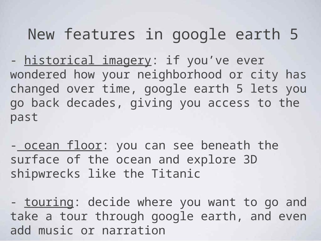
New features in google earth 5
- historical imagery: if you’ve ever wondered how your neighborhood or city has changed over time, google earth 5 lets you go back decades, giving you access to the past
- ocean floor: you can see beneath the surface of the ocean and explore 3D shipwrecks like the Titanic
- touring: decide where you want to go and take a tour through google earth, and even add music or narration

ucla (4000 FT)


crater on mars

underwater view

google sky

the future
"Google's mission statement is to make all the world's information universally available and useful”
- virtual worlds: incorporate the images into video & computer games

privacy- U.S. laws do not prohibit Google from taking photographs in public places
- because of the potential of terrorists to use Street View/ Google Maps, Google blurs some areas for security reasons such as the White House and the U.S. Naval Observatory
- for Street View, Google has an algorithm that automatically blurs the faces of people on the streets, billboards, even KFC’s Colonel face

resourceshttp://en.wikipedia.org/wiki/Google_Earth
http://www.ethioplanet.com/news/2009/10/13/worldview-2-satellite-to-provide-google-earth-with-high-resolution-images/
http://www.google.com/enterprise/earthmaps/earth_pro.html
http://www.gps.gov
http://news.cnet.com/Google-tools-to-power-virtual-worlds/2100-1043_3-6212325.html?tag=mncol;txt