
Göttingen & Windhoek · water demand (Moalafhi et al., 2012). The Notwane, Taung, Metsemas-waane,...
11
Transcript of Göttingen & Windhoek · water demand (Moalafhi et al., 2012). The Notwane, Taung, Metsemas-waane,...


© University of Hamburg 2018 All rights reserved
Klaus Hess PublishersGöttingen & Windhoekwww.k-hess-verlag.de
ISBN: 978-3-933117-95-3 (Germany), 978-99916-57-43-1 (Namibia)
Language editing: Will Simonson (Cambridge), and Proofreading PalTranslation of abstracts to Portuguese: Ana Filipa Guerra Silva Gomes da PiedadePage desing & layout: Marit Arnold, Klaus A. Hess, Ria Henning-LohmannCover photographs: front: Thunderstorm approaching a village on the Angolan Central Plateau (Rasmus Revermann) back: Fire in the miombo woodlands, Zambia (David Parduhn)Cover Design: Ria Henning-Lohmann
ISSN 1613-9801
Printed in Germany
Suggestion for citations:Volume:Revermann, R., Krewenka, K.M., Schmiedel, U., Olwoch, J.M., Helmschrot, J. & Jürgens, N. (eds.) (2018) Climate change and adaptive land management in southern Africa – assessments, changes, challenges, and solutions. Biodiversity & Ecology, 6, Klaus Hess Publishers, Göttingen & Windhoek. Articles (example):Archer, E., Engelbrecht, F., Hänsler, A., Landman, W., Tadross, M. & Helmschrot, J. (2018) Seasonal prediction and regional climate projections for southern Africa. In: Climate change and adaptive land management in southern Africa – assessments, changes, challenges, and solutions (ed. by Revermann, R., Krewenka, K.M., Schmiedel, U., Olwoch, J.M., Helmschrot, J. & Jürgens, N.), pp. 14–21, Biodiversity & Ecology, 6, Klaus Hess Publishers, Göttingen & Windhoek.
Corrections brought to our attention will be published at the following location: http://www.biodiversity-plants.de/biodivers_ecol/biodivers_ecol.php

Biodiversity & EcologyJournal of the Division Biodiversity, Evolution and Ecology of Plants, Institute for Plant Science and Microbiology, University of Hamburg
Volume 6:
Climate change and adaptive land management in southern Africa
Assessments, changes, challenges, and solutions
Edited by
Rasmus Revermann1, Kristin M. Krewenka1, Ute Schmiedel1, Jane M. Olwoch2, Jörg Helmschrot2,3, Norbert Jürgens1
1 Institute for Plant Science and Microbiology, University of Hamburg 2 Southern African Science Service Centre for Climate Change and Adaptive Land Management
3 Department of Soil Science, Faculty of AgriSciences, Stellenbosch University
Hamburg 2018

RPlease cite the article as follows:
Moalafhi, D.B., Kenabatho, P.K., Parida, B.P. & Matlhodi, B. (2018) Predictability of daily
precipitation using data from newly established automated weather stations over Notwane
catchment in Botswana. In: Climate change and adaptive land management in southern Africa –
assessments, changes, challenges, and solutions (ed. by Revermann, R., Krewenka, K.M.,
Schmiedel, U., Olwoch, J.M., Helmschrot, J. & Jürgens, N.), pp. 46-51, Biodiversity & Ecology, 6,
Klaus Hess Publishers, Göttingen & Windhoek. doi:10.7809/b-e.00304
46 C A
Clim
ate
Abstract: Already semi-arid, due to the eff ects of climate change, Botswana has been experiencing unreliable water sup-plies over the past several years. However, the limited climate information over diff erent catchments makes engaging in an informed decision-making process diffi cult. The Notwane catchment at Gaborone dam, located in the headstreams of the Notwane River in eastern Botswana, is a major water supply for the country. However, due to the sparse network of hydro-meteorological measurement stations, no reliable predictions can be made and, thus, creating a reliable runoff estimation for the reservoir has been diffi cult. Through SASSCAL, an experimental set of automated weather stations has been set up in the Notwane catchment. Preliminary analysis using artifi cial neural networks (ANNs) to examine the predictive capac-ity of the monitored variables (from July 15, 2016, through June 25, 2017: 346 days) on precipitation at four individual stations reveals that the gathered hydro-meteorological data may be useful given an increase in record length coupled with consideration of diff erent modeling approaches to validate inherent relationships with precipitation. Study also revealed that simulated precipitation for the area exhibits similar mean and variability to the observations despite poor simulations for extreme precipitation events. These results give insight into prospects for improved hydrologic and water resource modeling over the catchment.
Resumo: O Botswana semi-árido tem sofrido com um fornecimento incerto de água ao longo dos anos, devido aos impactos das alterações climáticas. Mesmo as informações climáticas escassas/limitadas das diferentes bacias hidrográfi cas difi cultam o processo de tomada de uma decisão informada. A bacia hidrográfi ca de Notwane na barragem de Gaborone, localizada na nascente do Rio Notwane no Este do Botswana, é uma importante fonte de abastecimento de água no país. Porém, devido à esparsa rede de estações de medição hidrometeorológica, não foi possível fazer previsões fi áveis e, por isso, foi difícil estimar de forma segura a escorrência para o reservatório. Através do SASSCAL, foi criado um conjunto experimental de Estações Meteorológicas Automáticas na bacia de Notwane. Uma análise preliminar usando Redes Neuronais Artifi ciais (ANNs) na capacidade preditiva de variáveis monitorizadas (de 15/07/2016 a 25/06/2017: 346 dias) na precipitação em qua-tro estações individuais revela que os dados hidrometeorológicos poderão ser possivelmente úteis com o aumento do número de registos, juntamente com a consideração de diferentes abordagens de modelação para validações de relações inerentes com a precipitação. É também evidenciado que a precipitação simulada exibe uma média e variabilidade semelhantes às observadas, apesar das escassas simulações para eventos de precipitação extremos. Estes resultados dão-nos uma expectativa para uma melhor modelação dos recursos hídricos e hidrológicos na bacia hidrográfi ca.
Predictability of daily precipitation using data from newly established automated weather stations over Notwane catchment in BotswanaDitiro B. Moalafhi1, Piet K. Kenabatho1*, Bhagabat P. Parida2, Botlhe Matlhodi1
1 Department of Environmental Science, University of Botswana, Private Bag UB 00704, Gaborone, Botswana
2 Department of Civil Engineering, University of Botswana, Private Bag 0061, Gaborone, Botswana
* Corresponding author: [email protected]
Introduction
Gaborone, the capital city of Botswana, is the country’s major population cluster, with accelerated rural-urban migrations to the city leading to increased water demand. As a result, the Notwane catch-
ment, which is the main source of wa-ter for the city, has required inter-basin transfer of water from the relatively wet northeastern part of Botswana. However, transporting water over 500 km to sup-plement the Gaborone reservoir comes at great costs. Despite this, hydro-mete-
orological data availability regarding the catchment is almost nonexistent (Kena-batho et al., 2017). The very sparse sta-tions over the catchment monitor only precipitation and temperature, and leave considerable data gaps. With the installa-tion of automated weather stations (AWS)
B E 6 2018 47
Clim
ate
made possible through the Southern Afri-can Science Service Centre for Climate Change and Adaptive Land Management (SASSCAL) project, eff orts towards im-proving hydro-meteorological monitor-ing to aid hydrologic modeling and river basin and water resource management could be realised. The weather stations are already operational and have allevi-ated the challenge of working with only limited, poor-quality data.
Artifi cial neural networks (ANNs), a computational tool based on the neural structure of brain systems, have been adopted for the study. ANNs have gained prominence in data science, being par-ticularly useful in modelling the com-plex interactions between rainfall and runoff in fl ow regime studies. These are uniquely powerful tools in applications where formal analysis would be diffi cult or impossible, such as pattern recognition and nonlinear system identifi cation and control (Furundzic, 1997; Anmala et al., 2000; Uvo et al., 2000; Sivakumar et al., 2002). ANNs were also found to be better
than using the multiplicative autoregres-sive integrated moving average (MA-RIMA) when forecasting rainfall and temperature over Botswana (Kenabatho et al., 2015). Non-linearity is a prime characteristic of issues related to the at-mospheric and hydrologic sciences and thus, ANNs are ideally suited for such problems because, like their biological counterparts, a neural network can learn, and therefore can be trained to fi nd so-lutions, recognise patterns, classify data, and even forecast future events (Hsu et al., 2002; Parida & Moalafhi, 2008; Kenabatho et al., 2015). The feedforward multi-layer architectures of ANNs have been shown to have computational supe-riority in comparison to other paradigms (Adeloye & Munari, 2006; Parida et al., 2006; Kenabatho et al., 2015).
The main aim of this paper is to test the utility of the hydro-meteorological variables from the newly developed SASSCAL AWS in modelling rainfall by way of establishing and using the re-lationships between the measured inde-
pendent/predictor variables (i.e,. temper-ature and humidity) and the predictand/target variable (rainfall). This will assist in improved simulation of rainfall events at these sites, especially during instances when rainfall data become unavailable as a result of malfunctions by rainfall recorders, among other situations. The model results will also give an indication of the data’s potential utility for simu-lating rainfall events, urgently needed for future water resources planning. It is anticipated that future operation and maintenance of the AWS, supplemented with streamfl ow gauging, will help to improve hydrologic and water resources modelling and, therefore, improve water resources management over the highly urbanised Notwane catchment of Bot-swana. The catchment, with improved monitoring, will also play an important role as an experimental basin for teaching regarding hydrology and water resources management, especially at the University of Botswana.
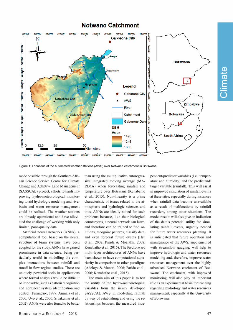
Figure 1: Locations of the automated weather stations (AWS) over Notwane catchment in Botswana.

48 C A
Clim
ate
Methods
Study siteThe catchment is located upstream of the Gaborone dam within the south-east district, and within close proximity to Gaborone, the capital of Botswana (Fig. 1). Its spatial extent is longitude 25.5°E to 26.0°E, and latitude 24.5°S to 25.5°S. Due to its proximity to the capi-tal and the associated ‘pull factors of mo-dernity’, there have been rapid land use changes and increased demand for water with implications for runoff generation and water supply, respectively. In 1991, census data showed that about 50% of Botswana’s population lived within a 100 km radius of the capital, Gaborone (CSO, 2001). Inhabitants of Gaborone and its immediate surroundings within the Notwane catchment have become more affl uent, which, coupled with the boom in population over the catchment, has led to an ever-increasing per-capita water demand (Moalafhi et al., 2012).
The Notwane, Taung, Metsemas-waane, and Nywane rivers drain the area. These rivers are intermittent due to the semi-arid conditions of the region. The catchment experiences annual rainfall averaging 500 mm, with high mean an-nual temperatures averaging 25°C that lead to high evaporation rates. Rainfall, as is the case for the rest of the country, is seasonal. Rains mostly start around No-vember and end in April.
DataSix variables are considered at daily time steps from 15 July 2016 to 25 June 2017 (346 days) from four out of a total of fi ve AWS over Notwane catchment in Botswana. Only four stations were cho-
sen based on data availability. The vari-ables are precipitation (mm); tempera-ture (maximum, average, and minimum in °C); relative humidity (%); and global radiation (mJ/km2). Currently, there is no river discharge monitoring over the catchment; thus, precipitation is being used as a key hydro-meteorological vari-able with implications for runoff genera-tion at the atmosphere-biosphere inter-face. Precipitation is therefore being used as a proxy for river discharge; it is also used for demonstration purposes regard-ing the predictive capacity of the AWS variables among themselves. For this reason, the measured rainfall values (de-pendent variable) together with tempera-ture (minimum, average, and maximum), relative humidity, and global radiation (independent/predictor variables) are used to develop an ANN model structure to simulate rainfall for the catchment. The model is run for each of the four AWS stations—Ranaka, Mogobane, Mo-lapowabojang, and Lotlkhakane East—to assess the predictability of rainfall at locations of the newly established AWS.
Back-propagation artifi cial neu-ral network (BPANN) modellingThe dependent variables are used as the inputs to the ANN model architecture, while precipitation is used as the output (target variable) being simulated. A mul-ti-layer feedforward back-propagation ANN is adopted.
The back-propagation training algo-rithm begins by setting a set of random weights; during training, weights are itera-tively modifi ed on the basis of the diff er-ences between the training output and the desired output. To facilitate this, a rule or function g(x) together with an initial value
P0 is set for computing successive terms. A sequence of values {Pk} is then obtained using the iterative rule Pk+1 = g(Pk). In this case, an ANN is presented with inputs (here, fi ve independent hydro-meteoro-logical variables) and the target variable to be reproduced (precipitation in this case). The network is then trained to learn the relationships between the input vari-ables and the target variable, with the ul-timate aim of reproducing the target vari-able (precipitation) based on the learned relationships. The structure of the ANN topology adopted in this study is shown in Figure 2; it consists of fi ve input variables (predictors), 25 neurons for processing the information, and one output neuron for the target precipitation (predictant).
The Levenberg–Marquardt (L-M) al-gorithm, which is commonly used for back-propagation algorithm training (Hagan & Menhaj, 1994; Samani et al., 2007), is adopted in this study. Early stopping is implemented by dividing data randomly into three subsets: train-ing, validation and testing (Adeloye & Munari, 2006). Selecting the three sub-sets randomly helps accommodate a rea-sonable range of extreme events, which helps to make good predictions (Minns & Hall, 2004; Thirumalaiah & Deo, 1998). The training set is used for computing the gradient and updating the network weights and biases, in which the error on the validation set is monitored during the training process. When the validation error increases for some specifi ed and/or default number of iterations, training is stopped and the weights and biases at the minimum of the validation error are returned. The model is then ready to be tested using the remaining dataset. The log-sigmoidal is used for the hidden layer neurons and the linear transfer function is used for the output layer neuron.
For model performance evaluation, the closeness of fi t of the simulated precipita-tion to the observed precipitation is assessed through Pearson correlation coeffi cient (r) and mean squared error (MSE). The Pear-son correlation coeffi cient (r-value) evalu-ates the goodness of fi t by performing linear regression between the predicted and target precipitation, while mean squared error is the average sum of squares of the diff erence between predictions and targets.
Figure 2: The ANN structure showing the average optimum network architecture that was adopted with fi ve (5) input layers and twenty-fi ve (25) hidden layer neurons (where a hidden layer neuron is a neuron whose output is connected to the inputs of other neurons and is therefore not visible as a network output; W and b represent weights and activity patterns, respectively, assigned to the independent variables).

B E 6 2018 49
Clim
ate
Results
For each station (Fig. 3), four plots are given for model performance through cor-relation coeffi cient of the predicted pre-cipitation and the observed precipitation during training, validation, and testing and when all the three subsets are combined together. The individual plots are labeled
‘Training’, ‘Validation’, ‘Test’, and ‘All’, showing blue, green, red, and grey best linear fi t lines, respectively. The dotted lines show how the best-fi t lines would appear for correlation coeffi cients of 1.
Each plot shows the observed precipi-tation as the target (‘Target’ or ‘T’) on the x-axis and the predicted precipitation (‘Output’ or ‘Y’) on the y-axis. The label
of the y-axis shows the equation of the best linear fi t relating the predicted pre-cipitation (Output) and the observed pre-cipitation (Target). The predictions show correlation coeffi cients well over 0.5 at all the stations. The highest correlation (0.85) was achieved at Lotlhakane East and the lowest (0.63) at Mogobane, considering the three subsets combined (Tab. 1).
0 20 40
0
10
20
30
40
50
Target
Out
put ~
= 0.
5*Ta
rget
+ 0
.92
Training: R=0.75705
Data
FitY = T
0 10 20-5
0
5
10
15
20
25
Target
Out
put ~
= 0.
57*T
arge
t + 0
.77 Validation: R=0.76632
Data
FitY = T
0 10 20 30 40
0
10
20
30
40
Target
Out
put ~
= 0.
4*Ta
rget
+ 0
.76
Test: R=0.65774
Data
FitY = T
0 20 40
0
10
20
30
40
50
Target
Out
put ~
= 0.
5*Ta
rget
+ 0
.88
All: R=0.7439
Data
FitY = T
0 20 40 60
0
20
40
60
TargetOut
put ~
= 0.
55*T
arge
t + 0
.67 Training: R=0.77796
Data
FitY = T
0 10 20 30
0
10
20
30
Target
Out
put ~
= 0.
5*Ta
rget
+ 1
.2 Validation: R=0.64813
Data
FitY = T
0 20 40 60 80
0
20
40
60
80
Target
Out
put ~
= 0.
12*T
arge
t + 1
.3 Test: R=0.51558
Data
FitY = T
0 20 40 60 80
0
20
40
60
80
Target
Out
put ~
= 0.
35*T
arge
t + 1
All: R=0.63139
Data
FitY = T
0 20 40
-10
0
10
20
30
40
TargetOut
put ~
= 0.
94*T
arge
t + 0
.16
Training: R=0.95127
Data
FitY = T
0 50 100
0
50
100
TargetOut
put ~
= 0.
23*T
arge
t + 0
.32 Validation: R=0.85789
Data
FitY = T
0 20 40
-10
0
10
20
30
40
TargetOut
put ~
= 0.
41*T
arge
t + -0
.079 Test: R=0.62277
Data
FitY = T
0 50 100
0
50
100
TargetOut
put ~
= 0.
39*T
arge
t + 0
.56 All: R=0.72909
Data
FitY = T
0 20 40
0
10
20
30
40
50
Target
Out
put ~
= 0.
5*Ta
rget
+ 0
.92
Training: R=0.75705
Data
FitY = T
0 10 20-5
0
5
10
15
20
25
Target
Out
put ~
= 0.
57*T
arge
t + 0
.77 Validation: R=0.76632
Data
FitY = T
0 10 20 30 40
0
10
20
30
40
Target
Out
put ~
= 0.
4*Ta
rget
+ 0
.76
Test: R=0.65774
Data
FitY = T
0 20 40
0
10
20
30
40
50
Target
Out
put ~
= 0.
5*Ta
rget
+ 0
.88
All: R=0.7439
Data
FitY = T
Figure 3: Correlation coeffi cients of precipitation simulations with observations for (a) Ranaka; (b) Mogobane; (c) Molapowabojang; and (d) Lotlhakane East.
a b
c d
Table 1: Summary performance of precipitation simulations at the individual stations over the catchment. r= correlation coeffi cient, rcomb. = r for combined data set; MSE = root mean square error (mm).

50 C A
Clim
ate
Mean squared error (MSE), based on the validation component, showed that the best predictions were obtained at Ranaka station, while Mogobane dis-played the worst performance (Tab. 1). An example of performance using MSE is shown in Figure 4, taken from Ranaka station, which shows performance during training, validation, and testing before the model convergence. The minimisation of error during the model run is shown for the three subsets of ‘Training’, ‘Valida-tion’, and ‘Testing’. These are shown in blue, green, and red, respectively. The minimum validation error during the model run was achieved after 13 epochs (iterations) with MSE of 13.5, as shown by Figure 4. Using Ranaka station as an example, low and high precipitation events are simulated relatively poorly (Fig. 5). Here, the predicted precipitation is shown in red while the observed pre-cipitation is shown in blue.
Discussion
The hydro-meteorological variables did not predict precipitation very well at the individual stations (Tab. 1). In particular, extreme precipitation events (e.g., very low and very high amounts of rainfall) were predicted poorly. This poor perfor-mance might be a result of limitations of the model itself, and possibly due to the short length of data records (less than one year). As can be seen from the correlation plots (Fig. 3), there is a possibility that the network architecture is not learning the relationships suffi ciently, as is espe-cially visible with its failure to simulate extreme precipitation events well (Fig. 5). The model also demonstrates some challenges in diff erentiating between rain and no rain as shown in Figure 5. For most zero-rainfall events, the model predicted at least some rainfall. Despite these complications, training, valida-
tion, and testing runs converged closely as shown in Figure 5, where there are no noticeable improvements across the three data divisions in minimisation of mean squared error beyond 13 iterations.
There is another variation of the com-monly used BPANN, the nonlinear au-toregressive network with exogenous inputs (NARX), which appears to be gaining popularity in modelling process-es related to climate sciences, including in semi-arid environments. Predictions made over longer time frequencies like months and the addition of more exog-enous variables of precipitation with con-sideration of lag times have been found to signifi cantly improve precipitation pre-dictions using the NARX (Abarhouei and Hosseini, 2016). NARX is an important class of discrete-time nonlinear systems which predicts a current value of a time series based on current and past values of the exogenous series (Safavieh et al., 2007). Byakatonda et al. (2016) used the NARX to forecast dryness severity over the iconic Okavango Delta in Botswana with impressive model performance. Thus, this ANN variant confi guration could be considered in the future.
Some correlations between the predict-ed and observed precipitation are below 0.60 in certain instances. These correla-tions were, however, found to be statisti-cally signifi cant, as they are greater than the p-critical values at 0.05 signifi cance level. Simulations at Molapowabojang station are almost joint second best with those at Ranaka station in terms of repro-ducing temporal correlations between predicted and observed precipitation. Reproduction of precipitation mean via the simulations at Mogobane station is slightly worse than at the rest of the sta-tions, with mean squared error of 28.26. All the stations are within the infl uence of the easterlies, and this could partly ex-plain the similarities in performance of the model across the stations. Notably, rankings of performance of the model at the individual stations diff er between MSE and temporal correlation. It is thus important to always use both mean and variability performance measures in evaluating simulations. In this regard, recommendations can be made on suit-ability of simulations for both mean and
0 2 4 6 8 10 12 14 16 1810
0
101
102
103
Best Validation Performance is 13.5255 at epoch 13M
ean
Squ
ared
Err
or (
mse
)
19 Epochs
Train
ValidationTest
Best
Figure 4: Performance of simulations during training, validation, and testing using mean squared error (MSE) for Ranaka station.
0 50 100 150 200 250 300 3500
10
20
30
40
50
60
Pre
cipi
tatio
n (m
m)
Time (Days)
PredictedObserved
Figure 5: Observed and simulated precipitation at Ranaka station showing deteriorating performance especially for low precipitation events. Blue = observed precipitation; red = predicted precipitation.

B E 6 2018 51
Clim
ate
variability individually and collectively (Moalafhi et al., 2016).
Inclusion of other independent predic-tors like El Niño Southern Oscillations (ENSO), and reanalysis precipitation and temperature data may possibly improve simulation of extreme events (Kenabatho et al., 2012). It would also be interesting to determine how much of total variation in precipitation each individual hydro-meteorological predictor variable con-tributes. Through principal component analysis, it would be important to remove redundant input variables for improved effi ciency if more exogenous variables with some delayed times are to be con-sidered.
Conclusion
The modelling exercise revealed that the chosen modeling framework using ANNs was suitable for this catchment. However, precipitation is not simulated very well at each individual station. Pre-dicted precipitation was found to exhibit similar mean and variability with the ob-servations. However, stations for which precipitation variability was simulated best do not necessarily show the best precipitation mean simulations, empha-sising the need to use both mean and variability performance measures in as-sessing simulations. Simulations tend to deteriorate towards low and high precipi-tation events. During the refi nement of this work, other model algorithms will be tested.
These results give some insight into the challenges of short time series and limited numbers of predictor variables, as well as illustrating the need for further refl ection on which model algorithm is best suited to the situation being evaluated. Further-more, exogenous variables like ENSO, reanalysis temperature, and precipitation should be incorporated to improve the simulations. With improvements, AWS data could be used to simulate future rainfall, assisting in cases where meas-urements may not be available, as is com-mon in monitoring networks. Ultimately, this will support hydrological modeling applications and water resource manage-ment over the catchment.
Acknowledgements
The research was carried out in the framework of SASSCAL and was spon-sored by the German Federal Ministry of Education and Research (BMBF) under promotion number 01LG1201M. The au-thors would like to thank SASSCAL and the Offi ce of Research and Development (University of Botswana) for providing fi nancial support to this research. Appre-ciation also goes to the Ministry of Basic Education and the Ministry of Land Man-agement, Water, and Sanitation Services for hosting the automated weather sta-tions in the Notwane catchment.
ReferencesAbarghouei, H.B. & Hosseini, S.Z. (2016) Using
exogenous variables to improve precipitation predictions of ANNs in arid and hyper-arid climates. Arabian Journal of Geosciences, 9, 663.
Adeloye, A.J., & de Munari, A. (2006) Artifi cial neural network-based generalised storage-yield-reliability models using the Levenberg-Marquardt algorithm. Journal of Hydrology, 362, 215-230.
Anmala, J., Zhang, B. & Govindaraju, R.S. (2000) Comparison of ANNs and empirical approaches for predicting watershed runoff . Journal of Water Resources Planning and Managment, 126, 156-166.
Byakatonda, J., Parida, B.P., Kenabatho, P.K.,& Moalafhi, D.B. (2016) Modeling dryness se-verity using artifi cial neural networks at the Okavango Delta, Botswana. Global NEST Journal, 18, 463-481
Central Statistics Offi ce. (2001) Population and Housing Census Preliminary Brief. Statistics Botswana, Gabarone, Botswana.
Coulibaly, P., Anctil, F., Aravena, R. & Bobée, B. (2001) Artifi cial neural network modelling of water table depth fl uctuations. Water Re-sources Research, 37, 885-896.
Furundzic, D. (1997) Application example of neural networks for time series analysis: Rain-fall runoff modelling. Signal Processing, 64, 383-396.
Hagan, M.T., & Menhaj, M.B. (1994) Training feedforward networks with the Marquardt algorithm. IEEE Transactions on Neural Net-works, 5, 989-993.
Hsu, K., Gupta, H.V., Gao, X., Sorooshian, S. & Imam, B. (2002) Self-organising linear output map (SOLO): An artifi cial neural network suitable for hydrologic modelling and analy-sis. Journal of Hydrology, 38, 1-17.
Johnson, V.M. & Rogers, L.L. (2000) Accuracy of neural network approximators in simula-tion optimisation. Journal of Water Resources Planning and Management, 126, 48-56.
Kenabatho P.K., Parida B.P. & Moalafhi D.B. (2012) The value of large-scale climate vari-ables in climate change assessment: The case of Botswana’s rainfall. Physics and Chemistry of the Earth 50-52, 64-71.
Kenabatho P.K., Parida B.P., Moalafhi D.B., & Segosebe T. (2015) Analysis of rainfall and large-scale predictors using a stochastic model and artifi cial neural network for hydrological applications in southern Africa. Hydrological Sciences Journal, 60, 1943-1955.
Kenabatho P.K., Parida, B.P. Moalafhi D.B., & Matlhodi B. (2017) Linking scientifi c re-search to development agenda: The case of a hydro-meteorological project in the Notwane catchment. Handbook of Research on Geo-spatial Science and Technologies (ed. by J.G. Maphanyane & R. Mapeo), pp. 374–391. IGI Global, Hershey, Pennsylvania.
Lischeid, G. (2001) Investigating short-term dy-namics and long-term trends of SO4 in the run-off of a forested catchment using artifi cial neu-ral networks. Journal of Hydrology, 243, 31-42.
Minns, A.W. & Hall, M.J. (2004) Rainfall-runoff modeling. Neural Networks for Hydrological Modeling (ed. by R.J. Hart, P.E. Kneale, & L.M. See), pp. 157–176. A.A. Balkema Pub-lishers, Leiden, the Netherlands.
Moalafhi D.B., Evans J.P. & Sharma A. (2016) Evaluating global reanalysis datasets for pro-vision of boundary conditions in regional cli-mate modelling. Climate Dynamics: Observa-tional, theoretical and computational research on the climate system, pp. 1-19, http://dx.doi.org/10.1007/s00382-016-2994-x.
Moalafhi D.B., Parida B.P., & Kenabatho P.K. (2012) New population forecasting techniques for realistic water demand management in ur-ban centres of Botswana. Proceedings of the IASTED International Conference on Science and Technology: A Platform for Sustainable Development, Gaborone, pp191-197 (in CD).
Parida, B.P. & Moalafhi, D.B. (2008) Regional rainfall frequency analysis for Botswana using L-moments and radial basis function network. Physics and Chemistry of the Earth, 33, 614-620.
Parida B.P., Moalafhi D.B. & Kenabatho P.K. (2006) Forecasting runoff coeffi cients using ANN for water resources management: The case of Notwane catchment in eastern Bot-swana. Physics and Chemistry of the Earth, 31, 928-934.
Safavieh, E., & Andalib, S.A. (2007) Forecasting the unknown dynamics in NN3 database us-ing a nonlinear autoregressive recurrent neu-ral network. International Joint Conference on Neural Networks, pp. 2105-2109.
Sahoo, G.B., & Ray, C. (2006) Flow forecasting for Hawaii stream using rating curves and neu-ral networks. Journal of Hydrology, 317, 63-80.
Samani, N., Gohari-Moghadam, M., & Safavi, A.A. (2007) A simple neural network model for the determination of aquifer parameters. Journal of Hydrology, 340, 1-11.
Shamseldin, A.Y. (1997) Application of a neural network technique to rainfall-runoff model-ling. Journal of Hydrology, 199, 272-294.
Sivakumar, B., Jayawardena, A.W. & Fernando, T.M.K.G. (2002) River fl ow forecasting: Use of phase-space reconstruction and artifi cial neural networks approaches. Journal of Hy-drology, 265, 225-245.
Thirumalaiah, K., & Deo, M.C. (1998) River stage forecasting using artifi cial neural networks. Journal of Hydrologic Engineering, 3, 26-32.
Uvo, C.B., Tolle, U. & Berndtsson, R. (2000) Forecasting discharge in Amazon using artifi -cial neural networks. International Journal of Climatology, 20, 1495-1507.

References [CrossRef]
Abarghouei, H.B. & Hosseini, S.Z. (2016)
Using exogenous variables to improve
precipitation predictions of ANNs in arid
and hyper-arid climates. Arabian Journal of
Geosciences, 9, 663. CrossRef
Adeloye, A.J., & de Munari, A. (2006)
Artificial neural network-based generalised
storage-yield-reliability models using the
Levenberg-Marquardt algorithm. Journal of
Hydrology, 362, 215-230. CrossRef
Anmala, J., Zhang, B. & Govindaraju, R.S.
(2000) Comparison of ANNs and empirical
approaches for predicting watershed runoff.
Journal of Water Resources Planning and
Managment, 126, 156-166. CrossRef
Byakatonda, J., Parida, B.P., Kenabatho,
P.K.,& Moalafhi, D.B. (2016) Modeling
dryness severity using artificial neural
networks at the Okavango Delta, Botswana.
Global NEST Journal, 18, 463-481
Central Statistics Office. (2001) Population
and Housing Census Preliminary Brief.
Statistics Botswana, Gabarone, Botswana.
Coulibaly, P., Anctil, F., Aravena, R. & Bobée,
B. (2001) Artificial neural network
modelling of water table depth fluctuations.
Water Resources Research, 37, 885-896.
CrossRef
Furundzic, D. (1997) Application example of
neural networks for time series analysis:
Rainfall runoff modelling. Signal
Processing, 64, 383-396. CrossRef
Hagan, M.T., & Menhaj, M.B. (1994) Training
feedforward networks with the Marquardt
algorithm. IEEE Transactions on Neural
Networks, 5, 989-993. CrossRef
Hsu, K., Gupta, H.V., Gao, X., Sorooshian, S.
& Imam, B. (2002) Self-organising linear
output map (SOLO): An artificial neural
network suitable for hydrologic modelling
and analysis. Journal of Hydrology, 38, 1-
17.
Johnson, V.M. & Rogers, L.L. (2000)
Accuracy of neural network approximators
in simulation optimisation. Journal of Water
Resources Planning and Management, 126,
48-56. CrossRef
Kenabatho P.K., Parida B.P. & Moalafhi D.B. (2012) The value of large-scale climate
variables in climate change assessment: The
case of Botswana’s rainfall. Physics and Chemistry of the Earth 50-52, 64-71.
CrossRef
Kenabatho P.K., Parida B.P., Moalafhi D.B., &
Segosebe T. (2015) Analysis of rainfall and
large-scale predictors using a stochastic
model and artificial neural network for hydrological applications in southern Africa.
Hydrological Sciences Journal, 60, 1943-
1955. CrossRef
Kenabatho P.K., Parida, B.P. Moalafhi D.B., &
Matlhodi B. (2017) Linking scientific
research to development agenda: The case of
a hydro-meteorological project in the
Notwane catchment. Handbook of Research
on Geospatial Science and Technologies (ed.
by J.G. Maphanyane & R. Mapeo), pp. 374–
391. IGI Global, Hershey, Pennsylvania.
Lischeid, G. (2001) Investigating short-term
dynamics and long-term trends of SO4 in the
runoff of a forested catchment using
artificial neural networks. Journal of
Hydrology, 243, 31-42. CrossRef
Minns, A.W. & Hall, M.J. (2004) Rainfall-
runoff modeling. Neural Networks for
Hydrological Modeling (ed. by R.J. Hart,
P.E. Kneale, & L.M. See), pp. 157–176.
A.A. Balkema Publishers, Leiden, the
Netherlands. CrossRef
Moalafhi D.B., Evans J.P. & Sharma A. (2016)
Evaluating global reanalysis datasets for
provision of boundary conditions in regional
climate modelling. Climate Dynamics:
Observational, theoretical and
computational research on the climate
system, pp. 1-19. CrossRef
Moalafhi D.B., Parida B.P., & Kenabatho P.K.
(2012) New population forecasting
techniques for realistic water demand
management in urban centres of Botswana.
Proceedings of the IASTED International
Conference on Science and Technology: A
Platform for Sustainable Development,
Gaborone, pp191-197 (in CD). CrossRef
Parida, B.P. & Moalafhi, D.B. (2008) Regional
rainfall frequency analysis for Botswana
using L-moments and radial basis function
network. Physics and Chemistry of the
Earth, 33, 614-620. CrossRef
Parida B.P., Moalafhi D.B. & Kenabatho P.K.
(2006) Forecasting runoff coefficients using ANN for water resources management: The
case of Notwane catchment in eastern
Botswana. Physics and Chemistry of the Earth, 31, 928-934. CrossRef
Safavieh, E., & Andalib, S.A. (2007)
Forecasting the unknown dynamics in NN3
database using a nonlinear autoregressive
recurrent neural network. International Joint
Conference on Neural Networks, pp. 2105-
2109. CrossRef
Sahoo, G.B., & Ray, C. (2006) Flow
forecasting for Hawaii stream using rating
curves and neural networks. Journal of
Hydrology, 317, 63-80. CrossRef
Samani, N., Gohari-Moghadam, M., & Safavi,
A.A. (2007) A simple neural network model
for the determination of aquifer parameters.
Journal of Hydrology, 340, 1-11. CrossRef
Shamseldin, A.Y. (1997) Application of a
neural network technique to rainfall-runoff
modelling. Journal of Hydrology, 199, 272-
294. CrossRef
Sivakumar, B., Jayawardena, A.W. &
Fernando, T.M.K.G. (2002) River flow
forecasting: Use of phase-space
reconstruction and artificial neural networks
approaches. Journal of Hydrology, 265, 225-
245. CrossRef
Thirumalaiah, K., & Deo, M.C. (1998) River
stage forecasting using artificial neural
networks. Journal of Hydrologic
Engineering, 3, 26-32. CrossRef
Uvo, C.B., Tolle, U. & Berndtsson, R. (2000)
Forecasting discharge in Amazon using
artificial neural networks. International
Journal of Climatology, 20, 1495-1507.
CrossRef


