Global SBAS Status
34
Global SBAS Status Satellite Based Augmentation System (SBAS) Interoperability Working Group (IWG) November 2013
description
Global SBAS Status. Satellite Based Augmentation System (SBAS) Interoperability Working Group (IWG) November 2013. Agenda. Background Benefits Interoperability System Status System Evolution Issues. 1. SBAS Background . - PowerPoint PPT Presentation
Transcript of Global SBAS Status
Global SBAS Status
Satellite Based Augmentation System (SBAS) Interoperability Working Group (IWG) November 2013
Agenda
• Background• Benefits• Interoperability• System Status• System Evolution• Issues
1

SBAS Background
• Satellite Based Augmentation System (SBAS) provides the accuracy, integrity, service continuity and availability needed to rely on Global Navigation Satellite System (GNSS) navigation for all phases of flight, from en route through Category I equivalent approach
• SBAS technology provides the opportunity to cover very large areas of airspace and areas formerly not served by other navigation aids
• SBAS adds increased capability, flexibility, and often, more cost-effective navigation options than adding additional legacy ground-based navigation aids
• SBAS can be used in many non-aviation applications
2

SBAS Background
• International Civil Aviation Organization (ICAO) Standards And Recommended Practices (SARPs) provides overarching standards and guidance for Global SBAS implementation
• SARPs criteria define Approach with Vertical guidance (APV) as being a stabilized descent using vertical guidance
• SBAS Interoperability Working Group (IWG) is the forum for SBAS service providers to assure common understanding and implementation of the SARPs
• IWG forum allows coordination to enable use of a single avionics technology designed to easily transition from one SBAS region to another
3

SBAS Benefits
• SBAS service is available for free
• SBAS provides Performance Based Navigation (PBN) capability– PBN improves efficiency and capacity while reducing environmental impacts
• SBAS is the lowest cost equipage to achieve Required Navigation Performance (RNP)
• SBAS clock and ephemeris corrections improve the availability of RNP for users throughout the entire GEO footprint
• SBAS is an enabler for Federal Aviation Administration (FAA) Next Generation Transportation System (NEXTGEN) and the European Commission (EC) Single European Sky Air Traffic Management Research (SESAR)
4

SBAS Benefits
• SBAS supports the decommissioning of ground-based Navigation Aids (NAVAIDs) down to a minimum operational network sufficient for safe recovery and acceptable level of sustained operations in the event of GNSS interference
• SBAS benefits extend beyond aviation to all modes of transportation, including maritime, highways, and railroads
• SBAS benefits also extend to applications other than transportation
5

SBAS Benefits – En Route/Terminal
• SBAS is a primary navigation system
• SBAS provides Area Navigation (RNAV) and RNP capability
– Improves availability for all RNAV 'T' and 'Q' routes
– Eliminates the operational requirement to ensure GPS availability using RAIM prediction tools
– Flexibility to design more efficient airspace and instrument procedures
• Significant potential reduction in track dispersion
• Supports Trajectory Based Operations (TBO)– 4-D Operations (Continuous Descent Approach (CDA))
– Significant reductions in fuel consumption
6
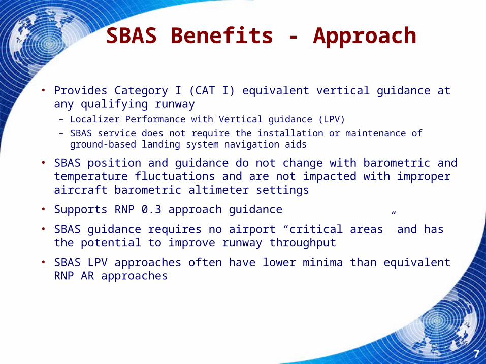
SBAS Benefits - Approach
• Provides Category I (CAT I) equivalent vertical guidance at any qualifying runway– Localizer Performance with Vertical guidance (LPV)
– SBAS service does not require the installation or maintenance of ground-based landing system navigation aids
• SBAS position and guidance do not change with barometric and temperature fluctuations and are not impacted with improper aircraft barometric altimeter settings
• Supports RNP 0.3 approach guidance
• SBAS guidance requires no airport “critical areas” and has the potential to improve runway throughput
• SBAS LPV approaches often have lower minima than equivalent RNP AR approaches
7

SBAS Interoperability - SARPs
• ICAO SARPs Annex 10 and Aviation Minimum Operational Performance Standards support the interoperability of different SBAS systems– Seamless transition between SBAS service areas
8

SBAS Interoperability Working Group (IWG)
• SBAS IWG objectives established to support technical interoperability and cooperation – Objective 1: Harmonize SBAS modernization plans
– Objective 2: Forum for discussion on SBAS requirements
– Objective 3: Harmonize technical improvements based upon operational and user feedback
– Objective 4: Research and Development (R&D) cooperation on key SBAS technologies
– Objective 5: Support joint SBAS promotion
9

SBAS Status:Operational Systems
• Wide Area Augmentation System (WAAS) – United States– Operational since 2003– Supports en route, terminal and approach operations
• CAT I-like approach capability (LPV-200)
• Multi-function Transport Satellite (MTSAT) Satellite-based Augmentation System (MSAS) - Japan– Operational since 2007– Supports en route, terminal and non-precision approach operations
• European Geostationary Navigation Overlay Service (EGNOS) – European Union– Open Service was declared in October 2009– Safety-Of-Life Service has been operational since March 2011– Supports En Route, Terminal and Approach operations
• APV-1 (LPV equivalent) operational capability
10
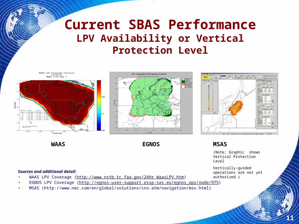
Current SBAS PerformanceLPV Availability or Vertical Protection Level
Sources and additional detail: • WAAS LPV Coverage (http://www.nstb.tc.faa.gov/24Hr_WaasLPV.htm)• EGNOS LPV Coverage (http://egnos-user-support.essp-sas.eu/egnos_ops/node/975)• MSAS (http://www.nec.com/en/global/solutions/cns-atm/navigation/msv.html)
MSAS(Note: Graphic shows Vertical Protection Level
Vertically-guided operations are not yet authorized.)
EGNOSWAAS
11

Current SBAS PerformanceNon-Precision Approach Availability
(such as LNAV 0.3)
Sources and additional detail: •WAAS (http://www.nstb.tc.faa.gov/24Hr_WaasRNP3.htm)•EGNOS (http://egnos-user-support.essp-sas.eu/egnos_ops/service_performances/global/NPA_availability)•MSAS (http://www.nec.com/en/global/solutions/cns-atm/navigation/msv.html)
MSAS(Horizontal Protection Level Display)
EGNOSWAAS
12

SBAS Status:Developing Systems
• Global Positioning System (GPS) Aided Geostationary Earth Orbit (GEO) Augmented Navigation (GAGAN) - India– In development with plans for horizontal and vertical guidance
– Completed Final System Acceptance Testing in 2012
– Completed HMI, SAR documentation needed for Certification
– Target Certification in 2013
• System of Differential Correction and Monitoring (SDCM) - Russia– In development with plans for horizontal and vertical guidance
– L1 SBAS coverage over Russian territory by 2016
– L1/L5 SBAS service and L1/L3 GLONASS precise point positioning service in 2018
– SDCM certification for APV-2
13
AVS Enterprise
India and Russia comment

SBAS under developmentAnticipated Precision Approach Availability
GAGAN SDCM
14
Sources and additional detail:
GAGAN (http://www.aai.aero/public_notices/aaisite_test/faq_gagan.jsp)
SDCM (IWG-25 Brief - SDCM 25-27 Jun 2013 ENG)

SBAS under developmentNon-Precision Approach Availability
GAGAN SDCM
15
Sources and additional detail:
GAGAN (http://www.aai.aero/public_notices/aaisite_test/faq_gagan.jsp)
SDCM (IWG-25 Brief - SDCM 25-27 Jun 2013 ENG)

SBAS EvolutionDual Frequency
• GNSS Dual Frequency Operations– Increases SBAS availability and performance by direct avionics
correction of ionospheric signal delay• Specifically during ionospheric storms and in equatorial regions
– Improves robustness against unintentional interference
• SBAS Service Provider Objectives– Avionics manufacturers support multi-constellation/multi-frequency
avionics as flight-certified navigation solutions
– Provide continued support to legacy L1-only users
– Support cooperative development of future SBAS standards consistent with ICAO Block upgrades
The slides that follow show a progression of scenarios in which combined SBAS coverage can provide LPV-200 service. These scenarios are based on a generalized set of assumptions across all systems and may not represent exact individual SBAS service levels.
16

SBAS EvolutionMultiple Constellation
• GNSS Multiple-Constellation Operations– Evaluate use of multiple constellations by SBAS
• Improve broadcast messages to support
• Define avionics requirements
– Assess modifications to equipment MOPS• Requires inclusion of GNSS constellations in ICAO Annex 10
– Galileo, Beidou
• Cost and complexity to implement versus benefit
17

Current Reference Networks
18

Current Potential Coverage
Assessment of potential LPV-200 Service Availability given use of MT-28 and kriging algorithms for ionosphere
delay and GIVEs
19
AVS Enterprise
Add chart or charts for RNP 0.1 and RNP 0.3

Current Plans for Expanded Reference Networks
20

Improved Single Frequency Coverage
Potential LPV-200 Service Availability with Expanded Networks
21

Dual Frequency Coverage (WAAS, EGNOS, MSAS)
Potential Dual-Frequency LPV-200 Service Availability
22
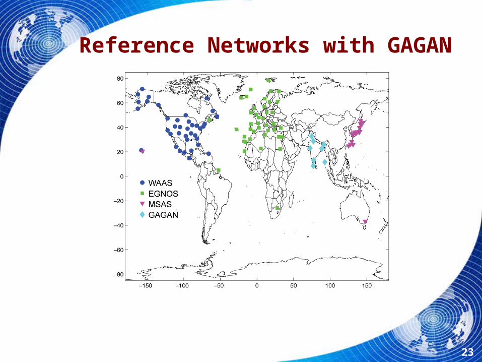
Reference Networks with GAGAN
23

Dual Frequency Coverage (with GAGAN)
LPV-200 Service Availability
24

Reference Networks with GAGAN and SDCM
25
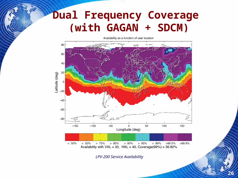
Dual Frequency Coverage (with GAGAN + SDCM)
LPV-200 Service Availability
26
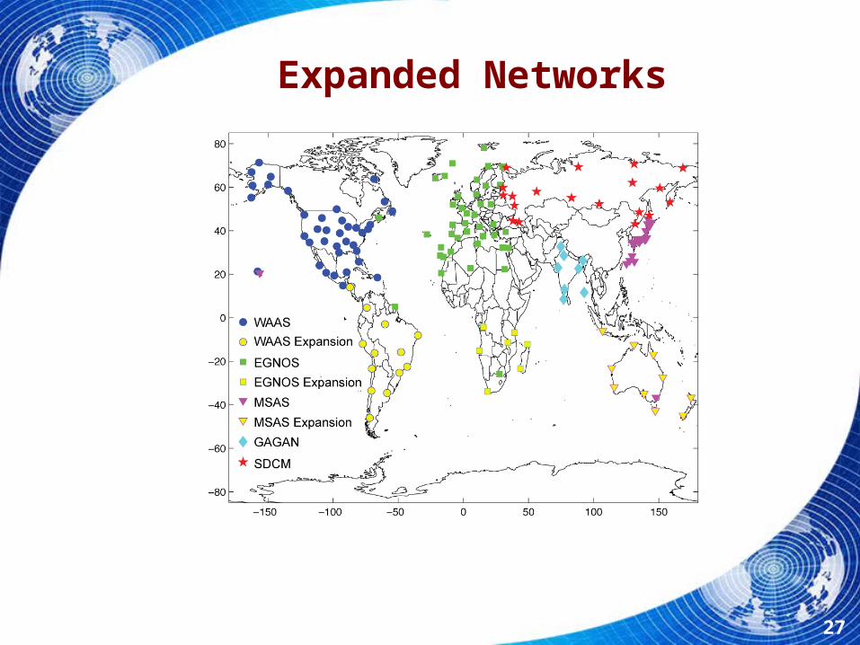
Expanded Networks
27

Dual Frequency, Expanded Networks
LPV-200 Service Availability
28
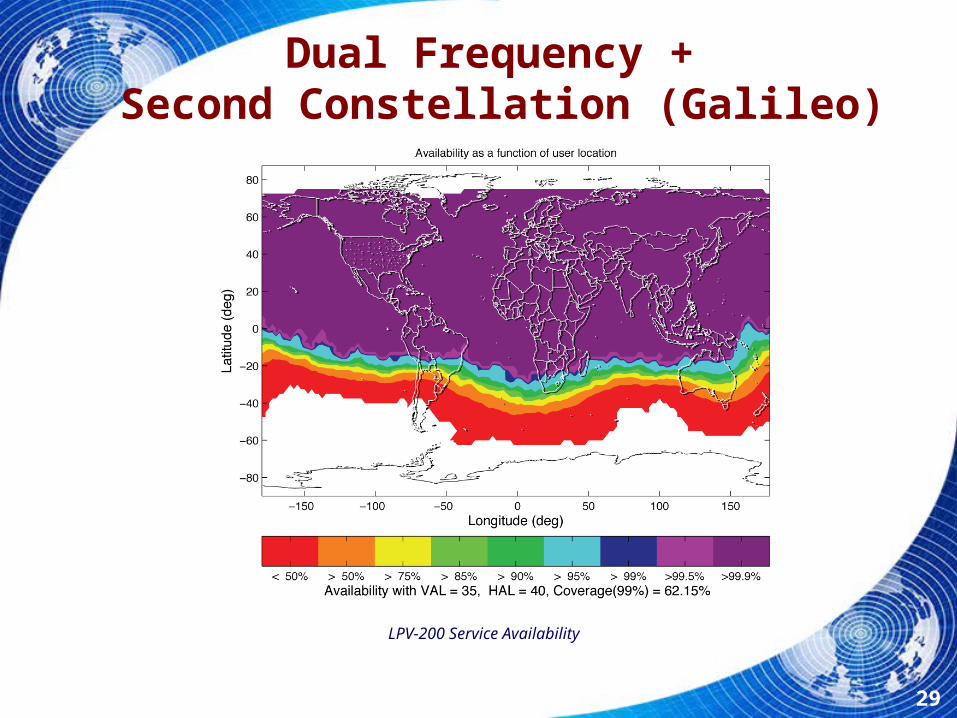
Dual Frequency + Second Constellation (Galileo)
LPV-200 Service Availability
29

Dual Frequency, Dual GNSS, Expanded Networks
LPV-200 Service Availability
30
Issues Being Addressed
• Seamless transition between SBAS service areas– Evaluating transitions between SBAS and RAIM, along with transitions
between two SBASs, and between SBAS and GBAS
• Common interpretation of standards among SBAS developers– Established a work plan for development of a definition document to
support a dual-frequency, multi-constellation user
• Increased Global coverage percentage with addition of GAGAN and SDCM
• Availability of worldwide LPV-200 service expected with addition of a second frequency, multiple constellations and extended reference networks
31

Conclusions
• Single Frequency SBAS offers significant benefits within covered service areas
• Dual Frequency extends precision approach coverage outside reference networks and allows LPV operation in equatorial areas and during ionospheric storms
• Expanding SBAS networks into southern hemisphere will allow global coverage of land masses
• Additional GNSS constellations improve availability away from reference stations and result in lower achievable protection levels
32

ADS-B
33
![StarFireTM: A Global SBAS for Sub-Decimeter Precise Point ... · [Hatch et al 2003]. ... GPS satellite when using the station elevation mask of ... A Global SBAS for Sub-Decimeter](https://static.fdocuments.us/doc/165x107/5c16718309d3f25e0b8c86d9/starfiretm-a-global-sbas-for-sub-decimeter-precise-point-hatch-et-al-2003.jpg)