GLOBAL HUB OF THE GEOSPATIAL COMMUNITY · 2018-06-11 · Gemeinsame Kommission Recht und Geodaten...
8
SPONSORS: Host: DVW e.V. Conference organiser: DVW GmbH Trade fair organiser: HINTE GmbH WWW.INTERGEO.DE GLOBAL HUB OF THE GEOS PATIAL COMMUNITY FRANKFURT 2018 16 – 18 OCTOBER INFORMATION FOR VISITORS DIGITALIZATION SMART CITIES INTERAERIAL SOLUTIONS BIM
-
Upload
truongtuyen -
Category
Documents
-
view
214 -
download
0
Transcript of GLOBAL HUB OF THE GEOSPATIAL COMMUNITY · 2018-06-11 · Gemeinsame Kommission Recht und Geodaten...
SPONSORS:
Host: DVW e.V.Conference organiser: DVW GmbHTrade fair organiser: HINTE GmbH
WWW.INTERGEO.DE
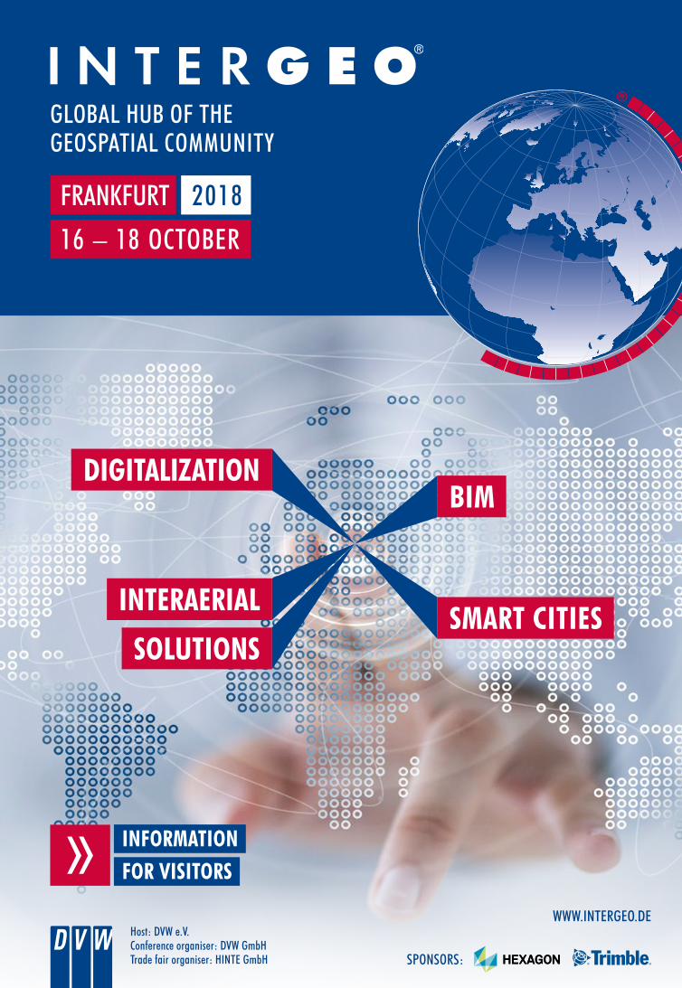
GLOBAL HUB OF THE GEOSPATIAL COMMUNITY
FRANKFURT 2018
16 – 18 OCTOBER
INFORMATION FOR VISITORS
DIGITALIZATION
SMART CITIESINTERAERIAL
SOLUTIONS
BIM

PROF. HANSJÖRG KUTTERER
PRESIDENT OF THE DVW
Dear Sir/Madam and fellow members of the industry!
I would like to extend a warm invitation to come to INTERGEO in Frankfurt am Main. It is your opportunity to attend the geo-event of the year and be part of the geo community.
You can find out about the key geo issues of digitalisation and the digital revolution. Without digitalisation there can be no smart cities and villages, no BIM and no eGovernment. Our industry is currently undergoing rapid change, as geoinformation is a vital element of the digital revolution. It helps make our environment available digitally in three dimensions and opens up a wealth of applications when combined with specialist data. This in turn gives rise to a whole range of new and innovative business models. In addition, the importance of artificial intelligence processes, augmented reality and virtual reality is also on the rise. These will have a huge impact on our work processes, transforming our jobs forever. INTERGEO will address these issues in its trade fair and conference.
Come along to the presentations and visit our exhibitors. Get talking to fellow specialists. Use the opportunity to meet experts face-to-face at INTERGEO and grow your network. Visit us in Frankfurt in October.
We look forward to seeing you!
Professor Hansjörg Kutterer, President of the DVW
INTERGEO
WORLD’S NO. 1 EVENT
FOR THE GEOSPATIAL
COMMUNITY!
130+ SPEAKERS
18,000+ PROFESSIONAL VISITORS FROM MORE THAN 100 COUNTRIES
580 EXHIBITORS FROM 37 COUNTRIES
35+FLIGHTS IN EUROPE‘S BIGGEST FLIGHT ZONE
INTERGEO is the most important communications and networking forum for geo-IT anywhere in the world. A high level of innovation makes it the annual must-attend event for the industry.
Digitalisation and the innovations it brings in terms of BIM, virtual and augmented reality, UAVs and smart cities will be at the top of the agenda from 16 to 18 October in Frankfurt.
SIMULTANEOUS TRANSLATION
1,400+CONFERENCE PARTICIPANTS

DIGITAL CONSTRUCTION
AUTONOMOUS DRIVING
VIRTUAL AND AUGMENTED REALITY TECHNOLOGIES
FUTURE TECHNOLOGIES / PRACTICAL APPLICATIONS
TOPICS 2018
With geoinformation forming the DNA of the digital transfor-mation, INTERGEO will be exploring the cosmos of a digitalised working world and presenting ultramodern industry solutions for business and consumer applications. Ongoing developments in the core industry, engineering geodesy and the influences of related disciplines will all be on show.
Augmented and virtual reality are increasingly becoming key building blocks in photogrammetry and cartography. Planning, design and navigation are reaching whole new dimensions. Just how important is this development for the geoindustry?
PHOTOGRAMMETRY AND CARTOGRAPHY
DIGITALISATION
The big step the building industry is about to take towards digitalisation also directly affects the geospatial community. This development will be presented and discussed in great detail together with related disciplines at INTERGEO. The third dimension will take on a new, far-reaching significance, initially for surveying.
The potential applications of UAVs are many and varied. With the ongoing technological advances new applications are constantly being added. It is therefore interesting to look at commercial users’ actual reasons for using UAVs. One in three drone flights is for monitoring or surveillance, eight out of ten drones fly for surveying.
UAV / IASEXPO
BUILDING INFORMATION MODELING – BIM
All business is local. And digitalisation is no exception. Local administrations are facing a huge challenge. In this context, the geoindustry can and must realise its potential and assume its coordinating role. The conference will discuss new approaches and highlight practical experiences.
EMPHASIS ON LOCAL AUTHORITIES
The digitalisation of entire cities and the creation of digital twins for urban areas are two other areas where geoinformation takes centre stage. Geodata is some of the most important data worldwide and the basis for the city of the future.
SMART CITIES

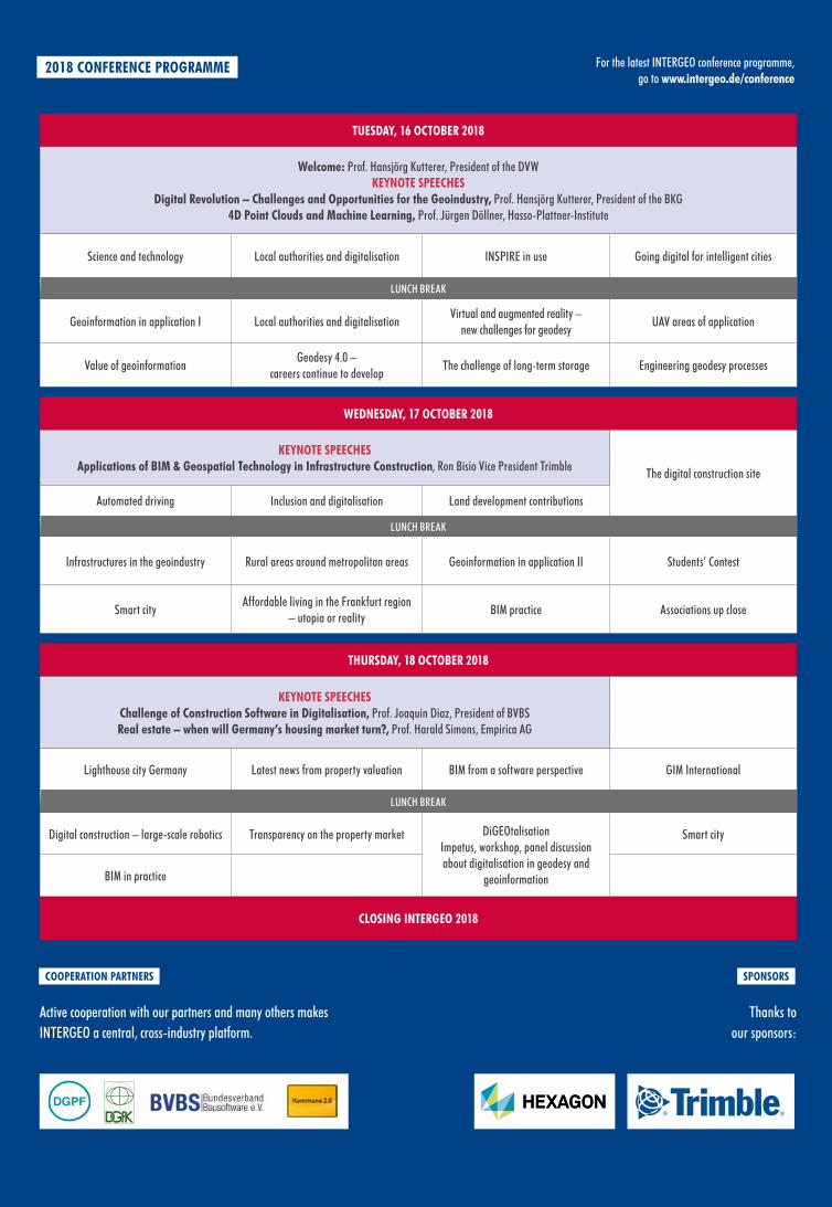
TUESDAY, 16 OCTOBER 2018
DIGITALIZATION
RON BISIOVICE PRESIDENT TRIMBLE
Numerous fascinating links are developing between BIM and geospatial technology. Ron Bisio’s keynote speech uses the example of infrastructure measures to emphasise this and highlight the potential of cutting-edge technologies.
WEDNESDAY, 17 OCTOBER 2018
BIM
PROF. JOAQUIN DIAZPRESIDENT OF BVBS
The construction industry is also facing major changes as a result of digitalisation. BIM is the word on everyone’s lips. Professor Diaz’s keynote speech focuses on the opportunities and role of construction software.
PROF. HARALD SIMONS EMPIRICA AG
For some time now, the real estate sector has been characterised by a shortage of land available to build on, rising prices and heated discussions about the lack of living space. Professor Simons looks at underlying connections and their possible impact on property valuation.
THURSDAY, 18 OCTOBER 2018
CONSTRUCTION SOFTWARE
KEYNOTE SPEECHES
LOOK TO THE FUTURE
ALL KEYNOTES AND PRESENTATIONS IN THE FORUM ARE OPEN FOR ALL CONFERENCE AND TRADE SHOW PARTICIPANTS.
PROF. HANSJÖRG KUTTERERPRESIDENT OF THE BKG
The geodesy profession has changed significantly in recent years. This is also reflected in the ever-evolving nature of INTERGEO and makes the question of what changes are still to come as a result of increasing digitalisation even more interesting. Professor Kutterer’s keynote speech offers some answers.
PROF. JÜRGEN DÖLLNERHASSO-PLATTNER-INSTITUTE
Artificial intelligence and deep learning are prominent concepts in the overall dialogue surrounding digitalisation. Professor Döllner’s keynote speech discusses the associated potential for the geospatial community.
SIMULTANEOUS INTERPRETING WILL BE PROVIDED FOR MOST OF THE CONFERENCE.
TUESDAY, 16 OCTOBER 2018
Welcome: Prof. Hansjörg Kutterer, President of the DVW KEYNOTE SPEECHES
Digital Revolution – Challenges and Opportunities for the Geoindustry, Prof. Hansjörg Kutterer, President of the BKG 4D Point Clouds and Machine Learning, Prof. Jürgen Döllner, Hasso-Plattner-Institute
Science and technology Local authorities and digitalisation INSPIRE in use Going digital for intelligent cities
LUNCH BREAK
Geoinformation in application I Local authorities and digitalisationVirtual and augmented reality –
new challenges for geodesyUAV areas of application
Value of geoinformationGeodesy 4.0 –
careers continue to developThe challenge of long-term storage Engineering geodesy processes
WEDNESDAY, 17 OCTOBER 2018
KEYNOTE SPEECHES Applications of BIM & Geospatial Technology in Infrastructure Construction, Ron Bisio Vice President Trimble The digital construction site
Automated driving Inclusion and digitalisation Land development contributions
LUNCH BREAK
Infrastructures in the geoindustry Rural areas around metropolitan areas Geoinformation in application II Students’ Contest
Smart cityAffordable living in the Frankfurt region
– utopia or realityBIM practice Associations up close
THURSDAY, 18 OCTOBER 2018
KEYNOTE SPEECHES Challenge of Construction Software in Digitalisation, Prof. Joaquin Diaz, President of BVBS Real estate – when will Germany’s housing market turn?, Prof. Harald Simons, Empirica AG
Lighthouse city Germany Latest news from property valuation BIM from a software perspective GIM International
LUNCH BREAK
Digital construction – large-scale robotics Transparency on the property market DiGEOtalisation Impetus, workshop, panel discussion about digitalisation in geodesy and
geoinformation
Smart city
BIM in practice
CLOSING INTERGEO 2018
COOPERATION PARTNERS SPONSORS
Active cooperation with our partners and many others makes INTERGEO a central, cross-industry platform.
Thanks to our sponsors:
2018 CONFERENCE PROGRAMME For the latest INTERGEO conference programme, go to www.intergeo.de/conference
Urheberrecht leicht gemacht – DGfK Recht und Geodaten – 12/2015 Seite 1/6
Deutsche Gesellschaft für Kartographie e.V. Gesellschaft für Kartographie und Geomatik
Gemeinsame Kommission Recht und Geodaten von DGfK, DGPF und DVW
Urheberrecht leicht gemacht –
Karten und Geodaten für Unterricht, Wissenschaft und Beruf nutzen und publizieren
Was schützt das Urheberrechtsgesetz?Das Gesetz über Urheberrecht und verwandte Schutzrechte schützt den Urheber und bestimmte Leistungserbringer vor Nach-ahmung und vor wirtschaftlicher Ausbeutung ihrer Leistung. Der Schutz des geistigen Eigentums steht als Grundrecht gleichbe-rechtigt neben der Freiheit der Wissenschaft und der Information.
Die Gemeinsame Kommission Recht und Geo-daten stellt Ihnen diese Information zur Verfü-gung, um Ihnen die Nutzung und Weiterver-wendung von Geodaten zu erleichtern. Diese Information soll Ihnen dabei helfen, rechtliche Auseinandersetzungen mit den Inhabern der Rechte an den Geodaten zu vermeiden.
Die Gemeinsame Kommission leistet jedoch keine Rechtsberatung. Im Falle eines Rechts-streits empfehlen wir Ihnen, sich an einen Rechtsanwalt Ihres Vertrauens zu wenden.
Werke
Urheberrechtlich schutzfähig sind Werke der Literatur, Wissenschaft und Kunst. Als Werke gelten persönliche geistige Schöpfungen, also z.B. wissenschaftliche Arbeiten mit Texten, Bildern, Zeichnungen und Karten. Ohne die Erlaubnis des Urhebers darf grundsätzlich nie-mand dessen Werk vervielfältigen, verbreiten oder öffentlich wiedergeben, insbesondere im Internet öffentlich zugänglich machen.
Der Urheberrechtsschutz beginnt mit der Er-stellung des Werkes, ohne dass irgendwelche
Formalien wie z.B. eine Registrierung erfüllt sein müssen. Der Urheberrechtsschutz endet siebzig Jahre nach dem Tod des Urhebers. Bei Werken, die von Verlagen, Behörden oder an-deren Institutionen im eigenen Namen heraus-gegeben werden, endet der Urheberrechts-schutz siebzig Jahre nach dem Erscheinen.
Beispiele für urheberrechtlich geschützte Geo-daten sind Stadtpläne (Abb. 1) oder topogra-phische Karten (Abb. 4) in ihrer charakteristi-schen Darstellung.
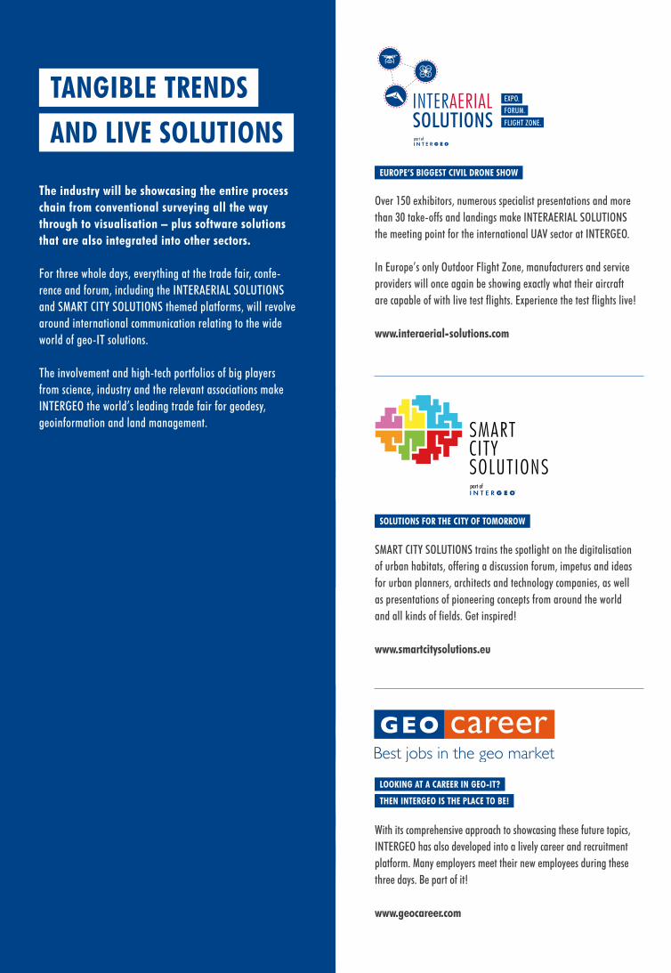
The industry will be showcasing the entire process chain from conventional surveying all the way through to visualisation – plus software solutions that are also integrated into other sectors.
For three whole days, everything at the trade fair, confe-rence and forum, including the INTERAERIAL SOLUTIONS and SMART CITY SOLUTIONS themed platforms, will revolve around international communication relating to the wide world of geo-IT solutions.
The involvement and high-tech portfolios of big players from science, industry and the relevant associations make INTERGEO the world’s leading trade fair for geodesy, geoinformation and land management.
TANGIBLE TRENDS
AND LIVE SOLUTIONS part of
Over 150 exhibitors, numerous specialist presentations and more than 30 take-offs and landings make INTERAERIAL SOLUTIONS the meeting point for the international UAV sector at INTERGEO. In Europe’s only Outdoor Flight Zone, manufacturers and service providers will once again be showing exactly what their aircraft are capable of with live test flights. Experience the test flights live!
www.interaerial-solutions.com
EUROPE’S BIGGEST CIVIL DRONE SHOW
SMART CITY SOLUTIONS trains the spotlight on the digitalisation of urban habitats, offering a discussion forum, impetus and ideas for urban planners, architects and technology companies, as well as presentations of pioneering concepts from around the world and all kinds of fields. Get inspired!
www.smartcitysolutions.eu
SOLUTIONS FOR THE CITY OF TOMORROW
part of
With its comprehensive approach to showcasing these future topics, INTERGEO has also developed into a lively career and recruitment platform. Many employers meet their new employees during these three days. Be part of it!
www.geocareer.com
LOOKING AT A CAREER IN GEO-IT?
THEN INTERGEO IS THE PLACE TO BE!

SAMPLE THE LOCAL “APPELWOI”
APPLE CIDER
S
U
U
S
U
U
U
U
U
S
U
U
U
U
S
S
U
U
S
U
U
S
SU
U
U
S
U
U
U
U
U
U
S
U
U
U
U
U
U
U
U
FRIEDR.- EBERT-
LYONER
HAUSEN
SDLG.
HEIM
FR.-WILH.-v.-STEUBEN-
CARL-
SIEDLUNG
SIEDLG.
GALLUS
KUHWALD-
ADOLF-
NIEDER-
WESTEND
FRITZ-
SACHSENHAUSEN
HELLERHOF-
MIERSCH-
KISSEL-
SIEDLG.
RAD
SCHURZ-
DORNBUSCH
LERCHESBERG
NORDEND
BOCKEN-
SDLG.
HEIMAT-
C.-v.-
ALTSTADT
SIEDLG.
SIEDLG.
WEINBG.-SDLG.
INNENSTADT
BRUNDERT-
INDUSTRIEHOF
GUTLEUTVIERTEL
SIEDLG.
BAHNHOFS-
SDLG.
SIEDLG.
POST-
WILLI-
EUROPAVIERTEL
VIERTEL
Schwanheimer U fer
Westhafen
kreisel
Brief-
Sch.
Volta- str.
Bruchfeldstr.
Sch.
M.
H ambur ger A l lee
Bf. Ffm.- Adalbertstr.
Rennbahn
Bockenheimer
Sch.
Mörfe ld
er
Galopp-
Miqu e lall e
e
Base
ler S
t r.
M.
Taun
us-
Campus Westend
Am Dornbusc h
Kaise r-
M.
parkschild-
Sch.
M.
Sch.
Sch.
Sch.
Schwe izer
Sch.
M.
M.M.Schaumainkai
Steg
M.M.
Turm
Bleichstr.
Finance &
Sch.
SüdBf. Ffm.-
Fried berg er
Anlage
Niederrad
Sch.
Katharinen-
Str.
Lan dst r .
zentrum
Adolf-Miersch-Str.
Sch.
und Ausstellungs-
G innhe
imer
Str.
Ginn-he
imer
Sch.
Sch.
Universitäts-
Sch.
Gutleu t-
str.
Galluswarte
a llee
Main -Neckar-
Hafen-
Sch.
M.
(Zentrale)
Louisa
M.
park
anl.Taunus-
Roth-
Bockenh ei m
er
Hochstr.
B rem
er
Str.
Sch.
M.
Eiserner
Sachsenhsr. Ufer
Sch.
M.
bibl.
Sch.
Sachsenhäuser
bad
M. M.
Konstablerwache
Sch.
Sch.
Krkhs.
Hauptfriedhof
Rebstockbad
bad
La n dma n n -
Klärwerk
Am
Römerh
of
A mHohen
We g
Th eodo r- Heu ss-A l l ee
Sch.
West
Sch.
Tri fts tr.
Brücke
Sch.
AS-Ffm.-
Sch.
Behörden-
Sch.
M.
M.
Garten
Botanischer
Raimund-
str.
Kennedya l le
e
Sch.
M i q u e l a l l e e
M.
str.
anl a
ge
A d i c ke s a l l e e
Sch.
Sch.
Land
str.
Str.
M.
M. Mainkai
Römer
Dre i
e ich
s tr.
M.
M.
Sch.
Krkhs.
21
Sch.
Gutleuts tr.
K leyer-
Sch.
5
Freibad
Ni eder räde r
Sch.
Katharinenkreisel
Niederrad
Sch.
B 44
Messe
Leipzige r
Str.
Rennbahnstr.
Sch.
Messe-
Sch.
Warte
str.
Hü
gels tr.
NiederräderLandstr.
zentrum
Sch.
Palmen-
Friedensbrücke
Sch.
burg-Grüne-
Goethe-Universität
Sch.
Stresemann-
ma nn -
Untermain
-Mainufer-
brücke
Neue
Alte
Sch.
Hochsch.
Sch.
Sch.
Berl inerStr.
M.
Kaiser -S igmund-Str.
Dom
dezernat
Zeil
Sch.Seilers tr.
Bubi
s-
AS-Ffm.-
AS-Ffm.-
Schmidtstr.
Biegwald
W i e s b a d e n e r S t r .
20
Am I n dus- triehof
Praunheimer Landstr.
6
Europa-Allee
Messe-
M.
Ros a-Lu xem
burg -
S t r.
Senc
k en b
e rg a
n la g
e
bibl.
21
Sch.
Sch.
garten
Deutsche
Park
Strese-
Sch.
Bundesbank
H ans a-a l lee
allee
M.
Holbeinsteg
M.
Oper
Sch.
Marbachweg
Sch.
Zeil
Oede
r
We g
Frankf. School of
Textor- Bf. Ffm.-Lokalbahnhof
I gn a
tz-
Deu tsch-herrn-
ufer
Lyoner
Str.
Sch.
Friedrich-W
il helm-v.-Steuben-Str.
Franken-
Wäldchen
Ginnheimer
Niederräder
Ufer
Sch.
Krkhs.
Schwa rzwaldstr.
Deut
scho
rden
str.
turm
Fr iedrich -Ebert-Anl.
Fra nz -Rü c k er-
All ee
Sch. EuropaturmWilhelm- Epstein -Str.
Theodor-Stern-
Kai
Bundesbank
Sch.
Grüneburg-
M.
Sch.
Bf. Ffm.-
M.
R eut er w eg
Eschenheimer
f. Musik u.D. Kunst
M.
weg
Sch.
E scher sh ei mer
L an ds tr.
Sch.
präsidiumM.
RundfunkHessischer
Sch.
Sch.
M.
Sch.
Walter-Ko lb-
S t r.
M.
Krkhs.
Bf. Ffm.-
Esc hen heimer Anla ge
Sch.
Dt.
Sch.
M.
M.
F rie
dber
ger
Land
str.
zentrum
Brentano-
R öde l - heimer
Brentano-
Brück e
Goldstein- str.
AS-Ffm.-Sch.
Sch.
N i d d a t a l
st r.
warteGallus-
Sch.
Sch.
Schloßstr.
Sch.
Krkhs.M.
kliniken
Bf Ffm.-
Sch.
gelände
Center
Festhalle
Campus Bockenheim
Univers.-
Lands
tr.
Miquelallee
Krkhs.
Ken n
e dya
ll ee
Westhafen
s tr.
M.
Sch.Garten-
str.
Deutsche
Hauptverw.
Stresemannallee
al lee
Schaumainkai
Städt. Bühnen
Bf. Ffm.-
M.
MainzerS tr.
Sch.
Polizei-
kai
HauptwacheM.
Anlag e
park
Alte BrückeK ur t-S chum acher-Str.
Planungs-
Sch.
Nordend-str.
N i b e l u n g e n a l l e e
FRA-UAS
schutz-
AS-Ffm.-
AS-Ffm.-Ludwig-
Bf. Ffm.-
M.
Bf. Ffm.-
Sophien-
Congress
M.
M.
Goethe-Universität
Zeppel i na llee
Universitäts-
Mainze r
Lands t r.
Ffm.- Hauptbahnhof
Bock enheimer
Landst r.
Bf. Ffm.-Louisa
Landstr.
kliniken B 43,
44
Taunus-
M.
park
Sch.
Mörfelder
Sch.
Untermain-
str.
Sch.
Sch.
Holz- hausenstr.
Sch.
M.
M.
Börse
Sch.
Ecken h ei me r
L andst r.
B 8 Manag.
National-
Boehle-
Darm
städterL andstr.
M.
Bf. Ffm.-
K.-Ad en aue r-S tr.
Sch.
Lang
eSt
r.
Krkhs.
S
S U
StadtvermessungsamtKurt-Schumacher-Straße 1060311 Frankfurt am Main
Auszug aus denGeobasisdaten FrankfurtStadtkarte 1:30.000
Ausgabedatum:Sachbearbeiter:Antragsnr.:
18.04.2018Frau Melcher
Maßstab 1 : 30000300 600 900 1200 1500 Meter
© Stadtvermessungsamt Frankfurt am Main
DYNAMIC METROPOLE
ON THE MAIN RIVER Frank
furt
am M
ine at
nigh
t, Ge
rman
y © fo
tolia.
com
apple
cide
r © vi
sitfra
nkfu
rt/Ho
lger U
llman
n
THE TRADE FAIR BENEFITS
FROM A CENTRAL LOCATION
TRADE FAIR
CENTRAL STATION
CITY CENTRE
The INTERGEO team has put together a selection of restaurants, bars and sightseeing options if you want to take a couple of days to enjoy yourself before or after INTERGEO or you and your customers are planning some unforgettable experiences together.
Allow yourself to be captivated by the delights of Frankfurt and enjoy INTERGEO 2018 in this exciting metropole.
Frankfurt offers many different attractions – from big business, trade fairs and shopping to culture, traditions and a warm welcome. The city really does have something for everyone!
Our event website has everything you need in terms of travel arran-gements, accommodation and tips for a perfect stay in Frankfurt.
It also describes specialist INTERGEO excursion offers that will provide thrilling insights and experiences to complement the conference programme: intergeo.de/exkursionen
THE LOCATION FOR 2018
IS FRANKFURTMESSE FRANKFURT
INCLUDE SOME TIME TO EXPLORE
FRANKFURT WHEN YOU PLAN YOUR VISIT TO INTERGEO
N 50º 6’ 41”
E 8º 38’ 21”
Basic
geod
ata ©
City
Surve
ying O
ffice
Fran
kfurt
am M
ain, 0
4.20
18, s
cale
1:30,0
00
There are two entrances to Hall 12: Access to INTERGEO is via the Torhaus entrance and the Portalhaus entrance. The INTERGEO conference takes place in the Portalhaus.
ENTRANCES
CONFERENCE PASS incl. trade fair 3-Days ticket € 400 € 330 2-Days ticket € 320 € 2801-Day ticket € 160 € 140
TRADE FAIR ONLY Permanent ticket € 90 € 120 Day ticket € 35 € 50
EARLY-BIRD DISCOUNT available until 19 August 2018
3-Days ticket 350 € 285 €
Facebook “f ” Logo CMYK / .eps Facebook “f ” Logo CMYK / .eps
main red
PMS 1795CC0 M96 Y90 K2
YOUTUBE LOGO SPECS
PRINTgradient bottom
PMS 1815CC13 M96 Y81 K54
on dark backgroundson light backgrounds
standard
no gradients
watermark
stacked logo (for sharing only)
standard
no gradients
watermark
stacked logo (for sharing only)
white
WHITEC0 M0 Y0 K0
black
BLACKC100 M100 Y100 K100
WWW.INTERGEO.DE
HOSTDVW – the German Society for Geodesy, Geoinformation and Land Management www.dvw.de
TRADE FAIR ORGANISERHINTE Messe- und Ausstellungs-GmbH www.hinte-messe.de
TV
Kap Europa
Kongresshaus
Skyline Plaza
Shoppingcenter
HauptbahnhofMain Station
Brüsseler Straße
Den H
aager Straße
Platz der
Einheit
Frankenallee
Halle/Hall 12
S-Bahn-Haltestelle
„Torhaus“
0 10 20
EBENE 0 LEVEL 0
EBENE 1 LEVEL 1
16 – 18 October 2018daily from 9 a.m. to 6 p.m.
Standard price
onlineDVW/DGfK member
on-site
Registration and tickets from 18 June 2018 Full details at www.intergeo.de/tickets AD
MIS
SIO
N PR
ICES
INTERGEO’s official partner Hotelservice-Deutschland.de has agreed special group booking rates for INTERGEO exhibitors and visitors at various hotels in the vicinity of the exhibition centre. Bookings can be made via: www.intergeo.de/hotel-reservations
Discounted travel tickets and accommodation can be found at www.intergeo.de/getting-there
ACCOMMODATION
ENTRANCE „TORHAUS“ENTRANCE „PORTALHAUS“
TRADE FAIR / IASEXPO / SCSEXPOCONFERENCEFLIGHT ZONE
DIRECTIONS
To get to INTERGEO by public transport, head for the “Torhaus” S-Bahn stop, then take the moving walkway on the exhibition grounds to reach Hall 12. If you are arriving by car, follow the signs to Messe Frankfurt and then to Messe-Parkhaus Rebstock. Use the “Portal-haus” entrance to get from the car park to Hall 12.
MESSE FRANKFURT Hall 12Ludwig-Erhard-Anlage 160327 Frankfurt am Main, Germany
HALLE 12 / HALL 12


![Berlin DGfK Hurni.ppt [Kompatibilitätsmodus]berlin-brandenburg.dgfk.net/20100304_Berlin_DGfK_Hurni... · 2010. 3. 5. · Cartographers replaced by des igners and laymen, Web 2.0](https://static.fdocuments.us/doc/165x107/607b2342fd7ca8655325b340/berlin-dgfk-hurnippt-kompatibilittsmodusberlin-2010-3-5-cartographers.jpg)