Glencoe - Earth Science - Geology, the Environment, and...
26
498 BIG Idea Volcanoes develop from magma moving upward from deep within Earth. 18.1 Volcanoes MAIN Idea The locations of volcanoes are mostly determined by plate tectonics. 18.2 Eruptions MAIN Idea The composition of magma determines the char- acteristics of a volcanic eruption. 18.3 Intrusive Activity MAIN Idea Magma that solid- ifies below ground forms geo- logic features different from those formed by magma that cools at the surface. GeoFacts • All the lava from Kilauea could pave a road three times around Earth. • There are 500 active volcanoes on Earth today. • Magma comes from the Greek word meaning dough. • Many of Earth’s geographic features are caused by volcanoes. Destruction by lava Volcanism Lava river Volcanic eruption (t)Douglas Peebles/CORBIS, (c)Roger Ressmeyer/CORBIS, (b)Stephen & Donna O’Meara/Volcano Watch Int’l/Photo Researchers, (bkgd)George Steinmetz/CORBIS
Transcript of Glencoe - Earth Science - Geology, the Environment, and...

498
BIG Idea Volcanoes develop from magma moving upward from deep within Earth.
18.1 VolcanoesMAIN Idea The locations of volcanoes are mostly determined by plate tectonics.
18.2 EruptionsMAIN Idea The composition of magma determines the char-acteristics of a volcanic eruption.
18.3 Intrusive ActivityMAIN Idea Magma that solid-ifies below ground forms geo-logic features different from those formed by magma that cools at the surface.
GeoFacts
• All the lava from Kilauea could pave a road three times around Earth.
• There are 500 active volcanoes on Earth today.
• Magma comes from the Greek word meaning dough.
• Many of Earth’s geographic features are caused by volcanoes.
Destruction by lava
Volcanism
Lava river
Volcanic eruption
(t)D
ougl
as P
eebl
es/C
OR
BIS
, (c)
Rog
er R
essm
eyer
/CO
RB
IS , (
b)S
teph
en &
Don
na O
’Mea
ra/V
olca
no W
atch
Int’l
/Pho
to R
esea
rche
rs , (
bkgd
)Geo
rge
Ste
inm
etz/
CO
RB
IS
498_499_C18_CO_874636.indd 498498_499_C18_CO_874636.indd 498 2/6/07 3:30:36 PM2/6/07 3:30:36 PM
Section 1 • XXXXXXXXXXXXXXXXXX 499
Start-Up ActivitiesStart-Up Activities
Chapter 18 • Volcanism 499
Visit glencoe.com to
study entire chapters online;
explore animations:• Interactive Time Lines• • Interactive Figures• • Interactive Tables
access Web Links for more information, projects, and activities;
review content with the Interactive Tutor and take Self-Check Quizzes.
What makes magma rise?Magma is molten rock that lies beneath Earth’s sur-face. In this activity, you will model the movement of magma within Earth by making a “lava lamp.”
Procedure 1. Read and complete the lab safety form.2. Pour about 300 mL of water into a 600-mL
beaker.3. Pour about 80 mL of vegetable oil into the
beaker.4. Sprinkle table salt on top of the oil while
you slowly count to 5.5. Add more salt to keep the movement going.
Analysis1. Identify which component of your model
represents magma.2. Describe what happened to the oil before
and after you added the salt.3. Hypothesize what causes the “magma”
to rise.
LLAAUUNCH NCH LabLab Classification of Volcanoes Make this Foldable to help you understand volcanoes.
STEP 1 Stack two sheets of notebook paper approximately 1.5 cm apart.
STEP 2 Fold up the bottom edges to form four tabs.
STEP 3 Staple along the folded edge. With the sta-pled end at the top, label the tabs as follows: Volcano Types, Shield Volcano, Composite Volcano, and Cinder Cone.
FOLDABLES Use this Foldable with Section 18.1. As you study the section, write about the characteristics of each kind of volcano under each tab.
Volcano TypesShield VolcanoComposite VolcanoCinder Cone
Mat
t Mea
dow
s
498_499_C18_CO_874636.indd 499498_499_C18_CO_874636.indd 499 2/6/07 3:30:52 PM2/6/07 3:30:52 PM

SouthAmerica
Pacific Ocean
Atlantic Ocean
IndianOcean
Arctic Ocean
IndianOcean
Active volcanoPlate boundaryCircum-Pacific belt
TamboraKrakatoa
Pinatubo
Fujiyama
MaunaLoa
Augustine
Mount St. HelensSurtsey Vesuvius Santorini
Etna
Katmai
Kilauea Pelée
FernandinaCotopaxi
NorthAmerica
Europe
Africa
Asia
Australia
ParícutinPopocatepetl
500 Chapter 18 • Volcanism
Section 1188.1 .1 Objectives! Describe how plate tectonics influ-
ences the formation of volcanoes.! Locate major zones of volcanism.! Identify the parts of a volcano.! Differentiate between volcanic
landforms.
Review Vocabularyconvergent: tending to move toward one point or to approach each other
New Vocabularyvolcanismhot spotflood basaltfissureconduitventcratercalderashield volcanocinder conecomposite volcano
Volcanoes
MAIN Idea The locations of volcanoes are mostly determined by plate tectonics.
Real-World Reading Link Road crews spread salt on icy winter roads because salt makes the ice melt at a lower temperature. At extremely high tem-peratures, rocks can melt. Often, if heated rocks are in contact with water, they melt more easily.
Zones of VolcanismVolcanoes are fueled by magma. Recall from Chapter 5 that magma is a slushy mixture of molten rock, mineral crystals, and gases. As you observed in the Launch Lab, once magma forms, it rises toward Earth’s surface because it is less dense than the sur-rounding mantle and crust. Magma that reaches Earth’s surface is called lava. Volcanism describes all the processes associated with the discharge of magma, hot fluids, and gases.
As you read this, approximately 20 volcanoes are erupting. In a given year, volcanoes will erupt in about 60 different places on Earth. The distribution of volcanoes on Earth’s surface is not random. A map of active volcanoes, shown in Figure 18.1, reveals striking pat-terns on Earth’s surface. Most volcanoes form at plate boundaries. The majority form at convergent boundaries and divergent boundar-ies. Along these margins, magma rises toward Earth’s surface. Only about 5 percent of magma erupts far from plate boundaries.
" Figure 18.1 Most of Earth’s active volcanoes are located along plate boundaries.
500_507_C18_S01_874636.indd 500500_507_C18_S01_874636.indd 500 2/6/07 2:47:40 PM2/6/07 2:47:40 PM

Volcano
Magma
Continentalplate
Oceanicplate
Interactive Figure To see an animation of subduction, visit glencoe.com.
Section 1 • Volcanoes 501
Convergent volcanism Recall from Chapter 17 that tec-tonic plates collide at convergent boundaries, which can form subduction zones — places where slabs of oceanic crust descend into the mantle. As shown in Figure 18.2, an oceanic plate descends below another plate into the mantle. As the oceanic plate descends, magma forms. The magma moves upward because it is less dense than the surrounding solid material. As it rises, the magma mixes with rock, minerals, and sediment from the overlying plate. Most volcanoes located on land result from oceanic-continental subduction. These volcanoes are characterized by explosive eruptions
Reading Check Define What is convergent volcanism?
Two major belts The volcanoes associated with convergent plate boundaries form two major belts, shown in Figure 18.1. The larger belt, the Circum-Pacific Belt, is also called the Pacific Ring of Fire. The name Circum-Pacific gives a hint about the location of the belt. Circum means around (as in circumference). The outline of the belt corresponds to the out-line of the Pacific Plate. The belt stretches along the western coasts of North and South America, across the Aleutian Islands, and down the eastern coast of Asia. Volcanoes in the Cascade Range of the western United States and Mount Pinatubo in the Philippines are some of the volcanoes in the Circum-Pacific Belt. The smaller belt, which is called the Mediterranean Belt, includes Mount Etna and Mount Vesuvius, two volcanoes in Italy. Its general outlines correspond to the boundaries between the Eurasian, African, and Arabian plates.
Data Analysis labData Analysis labBased on Real Data*Interpret the Graph
How do zones of volcanism relate to lava production? Researchers classify types of volca-nic eruptions and study how much lava each type of volcano emits during an average year. The circle graphs show data from 5337 eruptions and annual lava production for each zone.
Think Critically1. Describe the relationship between the type
of volcanism and annual lava production.2. Consider Why is it important for scientists
to study this relationship? 3. Evaluate What could be the next step in
the researchers’ investigation?
Data and Observations
*Data obtained from: Crisp, J. 1984. Rates of magma emplacement and volcanic output. Journal of Volcanology and Geothermal Research 20: 177–211.
" Figure 18.2 In an oceanic-continental subduction zone, the denser oceanic plate slides under the continental plate into the hot mantle. Parts of the plate melt and magma rises, eventu-ally leading to the formation of a volcano.Identify a volcano from Figure 18.1 that is associated with oceanic-continental convergence.
Convergent
Number of Eruptionsin Average Year Lava Production
Rift
Hot spot
500_507_C18_S01_874636.indd 501500_507_C18_S01_874636.indd 501 2/6/07 2:47:48 PM2/6/07 2:47:48 PM

Interactive Figure To see an animation of divergent plate boundaries, visit glencoe.com.
502 Chapter 18 • Volcanism
Divergent volcanism Recall from Chapter 17 that at diver-gent plate boundaries tectonic plates move apart and new ocean floor is produced as magma rises to fill the gap. At ocean ridges, this lava takes the form of giant pillows like those in Figure 18.3, and is called pillow lava. Unlike the explosive volcanoes detailed in Figure 18.4, volcanism at divergent boundaries tends to be non-explosive, with effusions of large amounts of lava. About two-thirds of Earth’s volcanism occurs underwater along divergent boundaries at ocean ridges.
Reading Check Convert the fraction of volcanism that happens underwater to a percentage.
Hot spots Some volcanoes form far from plate boundaries over hot spots. Scientists hypothesize that hot spots are unusually hot regions of Earth’s mantle where high-temperature plumes of magma rise to the surface.
" Figure 18.3 Eruptions at divergent boundaries tend to be nonexplosive. At the divergent boundary on the ocean floor, eruptions often form huge piles of lava called pillow lava.
" Figure 18.4Volcanoes in Focus Volcanoes constantly shape Earth’s surface.
4845 B.C. Mount Mazama erupts in Oregon. The mountain collapses into a 9-km-wide depression, known today as Crater Lake (topographic map).
A.D. 79 Mount Vesuvius in Italyerupts, burying two cities in ash.
1630 B.C. In Greece, Santorini explodes, causing tsunamis 200 m high. Nearby, Minoan civilization on the Isle of Crete disappears.
VOCABULARYSCIENCE USAGE V. COMMON USAGE
PlumeScience usage: an elongated column
Common usage: a large, showy feather of a bird
(t)Science VU/NURP/Visuals Unlimited , (bl)courtesy of University of Oregon , (br)Roger Ressmeyer/CORBIS
500_507_C18_S01_874636.indd 502500_507_C18_S01_874636.indd 502 2/6/07 2:47:51 PM2/6/07 2:47:51 PM

NorthAmerica
Meiji
Kauai
Aleutian Islands
Big Island ofHawaii
Pacific OceanDaikakuji
500 Km0
Direction ofplate movement
Hawaiian-Emperor Volcanic Chain
Emperor
Seamounts
Hawaii
Maui
Hot spot
Molokai
Oahu
Kauai
Section 1 • Volcanoes 503
Hot spot volcanoes Some of Earth’s best-known volcanoes formed as a result of hot spots under the ocean. For example, the Hawaiian islands, shown in the map in Figure 18.5, are located over a plume of magma. As the rising magma melted through the crust, it formed volcanoes. The hot spot formed by the magma plume remained stationary while the Pacific Plate slowly moved northwest. Over time, the hot spot has left a trail of volcanic islands on the floor of the Pacific Ocean. The volcanoes on the oldest Hawaiian island, Kauai, are inactive because the island no longer sits above the stationary hot spot. Even older volcanoes to the northwest are no longer above sea level. The world’s most active vol-cano, Kilauea, on the Big Island of Hawaii, is cur-rently located over the hot spot. Another volcano, Loihi, is forming on the seafloor southeast of the Big Island of Hawaii and might eventually rise above the ocean surface to form a new island.Hot spots and plate motion Chains of volca-noes that form over stationary hot spots provide information about plate motions. The rate and direction of plate motion can be calculated from the positions of these volcanoes. The map in Figure 18.5 shows that the Hawaiian islands are at one end of the Hawaiian-Emperor volcanic chain. The oldest seamount, Meiji, is at the other end of the chain and is about 80 million years old, which indicates that this hot spot has existed for at least that many years. The bend in the chain at Daikakuji Seamount records a change in the direc-tion of the Pacific Plate that occurred 43 mya.
1883 In Indonesia, Krakatoa erupts, destroying two-thirds of the island and generating a tsunami that kills more than 36,000 people.
1912 Katmai erupts in Alaska with ten times more force than Mount St. Helens. This eruption is one of the most powerful in recorded history.
Interactive Time Line To learn more about these discoveries and others, visitglencoe.com.
1980 In Washington, Mount St. Helens’ eruption blasts through the side of the vol-cano. Most of the 57 fatalities are from ash inhalation.
! Figure 18.5 The Hawaiian islands have been forming for millions of years as the Pacific Plate moves slowly over a stationary hot spot that is currently located under the Big Island of Hawaii.
1991 Mount Pinatubo erupts in the Philippines, releasing 10 km3 of ash, reducing global temperatures by 0.5ºC.
(bl)Ho/Reuters/CORBIS
500_507_C18_S01_874636.indd 503500_507_C18_S01_874636.indd 503 02/09/07 2:38:35 PM02/09/07 2:38:35 PM

ColumbiaRiver
basalts
Washington
Oregon
Idaho
California Nevada
100 200 km0
504 Chapter 18 • Volcanism
Flood basalts When hot spots occur beneath con-tinental crust, they can lead to the formation of flood basalts. Flood basalts form when lava flows out of long cracks in Earth’s crust. These cracks are called fissures. Over hundreds or even thousands of years, these fissure eruptions can form flat plains called pla-teaus, as shown in Figure 18.6. As in other erup-tions, when the lava flows across Earth’s surface, water vapor and other gases escape.Columbia River Basalts The volume of basalt erupted by fissure eruptions can be tremendous. For example, the Columbia River basalts, located in the northwestern United States and shown on the map in Figure 18.7, contain 170,000 km3 of basalt. This vol-ume of basalt could fill Lake Superior, the largest of the Great Lakes, 15 times. However, the Columbia River Basalts are small in comparison to the Deccan Traps.Deccan Traps About 65 mya in India, a huge flood basalt eruption created an enormous plateau called the Deccan Traps. The volume of basalt in the Deccan Traps is estimated to be about 512,000 km3. That volume would cover the island of Manhattan with a layer 10,000 km thick , or the entire state of New York with a layer 4 km thick. Some geologists hypothesize that the eruption of the Deccan Traps caused a global change in climate that might have influenced the extinction of the dinosaurs.
" Figure 18.7 More than 17 mya, enormous amounts of lava poured out of large fissures, producing a basaltic plateau more than 1 km thick in the northwestern part of the United States.
" Figure 18.6 Huge amounts of lava erupting from fissures accumulate on the surface, often forming layers 1 km thick. Over time, streams and other geologic forces erode the layers of basalt, leaving plateaus like this one in Palouse Canyon, Washington.
Mic
hael
T. S
edam
/CO
RB
IS
500_507_C18_S01_874636.indd 504500_507_C18_S01_874636.indd 504 2/6/07 2:48:04 PM2/6/07 2:48:04 PM

Caldera
Magmachamber
Crater
Vent
Conduit
Interactive Figure To see an animation of caldera formation, visit glencoe.com.
Section 1 • Volcanoes 505
Anatomy of a VolcanoAs you read in Chapter 5, when magma reaches Earth’s surface it is called lava. Lava reaches the sur-face by traveling through a tubelike structure called a conduit, and emerges through an opening called a vent. As lava flows through the vent and out onto the surface, it cools and solidifies around the vent. Over time, layers of solidified lava can accumulate to form a mountain known as a volcano. At the top of a vol-cano, around the vent, is a bowl-shaped depression called a crater. The crater is connected to the magma chamber by the conduit. Locate the crater, conduit, and vent of the volcano shown in Figure 18.8.
Volcanic craters are usually less than 1 km in diameter. Larger depressions, called calderas, can be up to 50 km in diameter. Calderas often form after the magma chamber beneath a volcano empties from a major eruption. The summit or the side of a volcano collapses into the emptied magma chamber, leaving an expansive, circular depression. After the surface material collapses, water sometimes fills the caldera, forming scenic lakes. The caldera known as Crater Lake in southern Oregon formed when Mount Mazama collapsed.
Model a CalderaHow do calderas form? Calderas are volcanic craters that form when the summit or the side of a volcano collapses into the magma cham-ber that once fueled the volcano.
Procedure 1. Read and complete the lab safety form.2. Obtain a small box, a 10-cm length of
rubber tubing, a clamp, and a balloon from your teacher.
3. Line the box with newspaper and make a small hole in the box and the newspaper with scissors.
4. Thread the neck of the balloon through the hole, insert the rubber tubing into the neck, securing it with tape, inflate the bal-loon by blowing through the tubing, and use the clamp to close the tubing.
5. Pour six cups of flour over the balloon.6. Sculpt the flour into the shape of a vol-
cano. You might need to vary the amount of flour and type of box to reach the desired effect.
7. Remove the clamp, releasing the air from the balloon. Observe your caldera forming, and record your observations
8. Compare your caldera to your classmates’.
Analysis1. Sequence the formation of the caldera.2. Compare the features of a caldera with
those of a crater.3. Infer how the caldera will form if you vary
how much you inflate the balloon.
" Figure 18.8 Magma moves upward from deep within Earth through a conduit and erupts at Earth’s surface through a vent. The area around the vent is called a crater. A caldera can form when the crust collapses into an empty magma chamber.
Dav
id M
uenc
h/C
OR
BIS
500_507_C18_S01_874636.indd 505500_507_C18_S01_874636.indd 505 2/6/07 2:48:06 PM2/6/07 2:48:06 PM

506 Chapter 18 • Volcanism
Table 18.1 Types of Volcanoes
Description Example of Volcanoes
Shield Volcanoes• Largest of the three types of volcanoes• Long, gentle slopes• Composed of layers of solidified
basaltic lava• Quiet eruptions
Cinder Cones• Smallest of the three types of volcanoes• Steep-sloped, cone-shaped• Usually composed of basaltic lava• Explosive eruptions• Usually form at edges of larger
volcanoes
Composite Volcanoes• Considerably larger than cinder cones• Tall, majestic mountains• Composed of layers of granitic rock and
lava flows• Cycle through periods of quiet and
explosive eruptions
Interactive Table To explore more about types of volcanoes, visit glencoe.com.
Mauna Loa, Hawaii
Mount Augustine, Alaska
Crater
Vent
Magmachamber
Layers ofbasaltic lava
Lassen Volcanic Park, California
CraterVent
Magmachamber
Layers oftephra
CraterVent
Magmachamber
Layers oflava andtephra
(t)Roger Ressmeyer/CORBIS, (c)Kevin Schafer/CORBIS , (b)Steve Kaufman/Accent Alaska
500_507_C18_S01_874636.indd 506500_507_C18_S01_874636.indd 506 2/6/07 2:48:13 PM2/6/07 2:48:13 PM

Self-Check Quiz glencoe.com Section 1 • Volcanoes 507
Types of VolcanoesThe appearance of a volcano depends on two factors: the type of material that forms the volcano and the type of eruptions that occur. Based on these two criteria, three major types of volcanoes have been identified and are shown in Table 18.1. Each differs in size, shape, and composition.Shield volcanoes A shield volcano is a mountain with broad, gently sloping sides and a nearly circular base. Shield volcanoes form when layers of lava accumulate during nonexplosive erup-tions. They are the largest type of volcano. Mauna Loa, which is shown in Table 18.1, is a shield volcano.Cinder cones When eruptions eject small pieces of magma into the air, cinder cones form as this material, called tephra, falls back to Earth and piles up around the vent. Cinder cones have steep sides and are generally small; most are less than 500 m high. The Lassen Volcanic Park cinder cone shown in Table 18.1 is 700 m high. Cinder cones often form on or very near larger volcanoes.Composite volcanoes Composite volcanoes are formed of layers of hardened chunks of lava from violent eruptions alternat-ing with layers of lava that oozed downslope before solidifying. Composite volcanoes are generally cone-shaped with concave slopes, and are much larger than cinder cones. Because of their explosive nature, they are potentially dangerous to humans and the environment. Some examples of these are Mount Augustine in Alaska, shown in Table 18.1, and several in the Cascade Range of the western United States, such as Mount St. Helens.
Section 1818..11 AssessmentSection Summary!! Volcanism includes all the processes
in which magma and gases rise to Earth’s surface.
!! Most volcanoes on land are part of two major volcanic chains: the Circum-Pacific Belt and the Mediterranean Belt.
!! Parts of a volcano include a vent, magma chamber, crater, and caldera.
!! Flood basalts form when lava flows from fissures to form flat plains or plateaus.
!! There are three major types of volcanoes: shield, composite, and cinder cone.
Understand Main Ideas1. MAIN Idea Explain how the location of volcanoes is related to the theory of
plate tectonics.
2. Identify two volcanoes in the Mediterranean Belt.
3. Draw a volcano, labeling the parts.
4. Propose Yellowstone National Park is an area of previous volcanism. Using a map of the United States, suggest the type(s) of tectonic processes associated with this area.
Think Critically5. Evaluate the following statement: Volcanoes are only found along coastlines.
6. Decide whether a flood basalt is or is not a volcano.
Earth ScienceMATH in7. If the Pacific Plate has moved 500 km in the last 4.7 million years,
calculate its average velocity in centimeters per year. Refer to the Skillbuilder Handbook for more information.
Careers In Earth Science
Volcanologist Scientists who study eruptions, lava, magma, and the conditions under which these form are volcanologists. Some work in the field, studying active volcanoes. Many volcanologists also work in the laboratory to understand how rocks melt to form magma. To learn more about Earth science careers, visit glencoe.com.
FOLDABLES
Incorporate information from this section into your Foldable.
500_507_C18_S01_874636.indd 507500_507_C18_S01_874636.indd 507 2/6/07 2:48:41 PM2/6/07 2:48:41 PM

508 Chapter 18 • Volcanism
Section 1188..2 2
Eruptions
MAIN Idea The composition of magma determines the character-istics of a volcanic eruption.
Real-World Reading Link Have you ever shaken a can of soda and then opened it? If so, it probably sprayed your hand, clothes, and maybe even your friends. This is similar to the process that underlies explosive volcanic eruptions.
Making MagmaWhat makes the eruption of one volcano quiet, and the eruption of another explosively violent? The activity of a volcano depends on the composition of the magma. As shown in Figure 18.9, lava from an eruption can be thin and runny or thick and lumpy. In order to understand why volcanic eruptions are not all the same, you first need to understand how rocks melt to make magma.Temperature Depending on their composition, most rocks begin to melt at temperatures between 800°C and 1200°C. Such temperatures are found in the crust and upper mantle. Recall from Chapter 5 that temperature increases with depth beneath Earth’s surface. In addition to temperature, pressure and the presence of water also affect the formation of magma.Pressure Pressure increases with depth because of the weight of overlying rocks. As pressure increases, the temperature at which a substance melts also increases. Figure 18.10 shows two melting curves for a type of feldspar called albite. Note that at Earth’s surface, albite, in the absence of water, melts at about 1100°C, but at a depth of about 12 km, its melting point is about 1150°C. At a depth of about 100 km, the melting point of dry albite increases to 1440°C. The effect of pressure explains why most of the rocks in Earth’s lower crust and upper mantle do not melt.
Mount Etna Mount St. Helens
! Figure 18.9 The way in which lava flows depends on the composition of the magma. Mount Etna’s lava is thin and runny compared to the thick and lumpy lava that erupts at Mount St. Helens.
Objectives" Explain how magma type influ-
ences volcanic activity." Describe the role of pressure and
dissolved gases in eruptions." Recognize classifications of mate-
rial ejected by eruptions.
Review Vocabularybasaltic: relates to a group of rocks rich in dark-colored minerals containing magnesium and iron
New Vocabularyviscositytephrapyroclastic flow
(r)Doug Beghtel/The Oregonian/CORBIS, (l)Reuters/CORBIS
508_513_C18_S02_874636.indd 508508_513_C18_S02_874636.indd 508 2/6/07 2:49:57 PM2/6/07 2:49:57 PM

800600 1000 1200
Pres
sure
from
dep
th o
f bur
ial (
km)
Temperature (ºC)
Solid albite
Melting temperaturefor dry albite
Melted albitewith water
Melting temperaturefor albite with water
Meltedalbite
Albite Melting Curves0
3
6
9
12
Section 2 • Eruptions 509
Composition of MagmaThe composition of magma determines a vol-cano’s explosivity, which is how it erupts and how its lava flows. What are the factors that determine the composition of magma? Scientists now know that the factors include magma’s interaction with overlying crust, its temperature, pressure, amounts of dissolved gas, and — very significantly — the amount of silica a magma contains. Understanding the factors that determine the behavior of magma can aid scientists in predicting the explosivity of volcanic eruptions.
Dissolved gases In general, as the amount of gases in magma increases, the magma’s explo-sivity also increases. In the same way that gas dissolved in soda gives the soda its fizz, the gases dissolved in magma give a volcano its “bang.” Important gases in magma are water vapor, carbon dioxide, sulfur dioxide, and hydrogen sulfide. Water vapor is the most com-mon dissolved gas in magma. The presence of water vapor determines where magma forms. As shown in Figure 18.10, minerals in the mantle, such as albite melt at high temperatures. The presence of dissolved water vapor lowers the melting temperature of minerals, causing mantle material to melt into magma. This even-tually forms volcanoes and fuels their eruptions.
Viscosity The physical property that describes a material’s resistance to flow is called viscosity. Temperature and silica content affect the viscosity of a magma. In general, cooler magma has a higher viscosity. In other words, cool magma, much like chilled honey, tends to resist flowing.
Reading Check Infer Which has a higher viscosity: syrup or water?
Magma with high silica content tends to be thick and sticky. Because it is thick, magma with high silica content tends to trap gases, which produces explosive eruptions. In general, magma with low silica content has low viscosi-ty — it tends to be thin and runny, like warm syrup. Magma with low silica content tends to flow easily and produce quiet, nonexplosive eruptions.
! Figure 18.10 Both the pressure and water content of the mineral albite affect how the mineral melts. Locate the melting curve of wet albite. How does the melt-ing point of wet albite compare to that of dry albite at a depth of 3 km? At a depth of 12 km?
VOCABULARYACADEMIC VOCABULARY
Aid to provide with what is useful or necessary in achieving an endGlasses aid Omar in seeing clearly.
508_513_C18_S02_874636.indd 509508_513_C18_S02_874636.indd 509 2/6/07 2:50:03 PM2/6/07 2:50:03 PM

510 Chapter 18 • Volcanism
Types of MagmaThe silica content of magma determines not only its explosivity and viscosity, but also which type of volcanic rock it forms as lava cools. Refer to Figure 18.11 to summarize types of magma.Basaltic magma When rock in the upper mantle melts, basaltic magma typically forms. Basaltic magma has the same silica content as the rock basalt — less than 50 percent silica. This magma rises from the upper mantle to Earth’s surface and reacts very little with over-lying continental crust or sediments. Its low silica con-tent produces low-viscosity magma. Dissolved gases escape easily from basaltic magma. The resulting vol-cano is characterized by quiet eruptions. Figure 18.12 shows how properties of magma affect the types of eruptions that occur. Volcanoes such as Kilauea and Mauna Loa actively produce basaltic magma. Surtsey, a volcano that was formed south of Iceland in 1963, is another volcano that produces basaltic magma.Andesitic magma Andesitic (an duh SIH tihk) magma has the same silica content as the rock andesite — 50 to 60 percent silica. Andesitic magma is found along oceanic-continental subduction zones. The source material for this magma can be either oceanic crust or oceanic sediments. The higher silica content results in a magma that has intermediate vis-cosity. Thus, the volcanoes it fuels are said to have intermediate explosivity. Colima Volcano in Mexico and Tambora in Indonesia are two examples of andesitic volcanoes. Both volcanoes have produced massive explosions that sent huge volumes of ash and debris into the atmosphere. This not only devastated the local communities, but also impacted the global environment.Rhyolitic magma When molten material rises and mixes with the overlying continental crust rich in silica and water, it forms rhyolitic (ri uh LIH tihk) magma. Rhyolitic magma has the same composition as the rock granite — more than 60 percent silica. The high viscosity of rhyolitic magma slows down its movement. High viscosity, along with the large vol-ume of gas trapped within this magma, makes the volcanoes fueled by rhyolitic magma very explosive. The dormant volcanoes in Yellowstone National Park in the western United States were fueled by rhyolitic magma. The most recent of these eruptions, which occurred 640,000 years ago, was so powerful that it released 1000 km3 of volcanic material into the air.
! Figure 18.11 Generally, magma and lava with a low percentage of silica have low viscosity, and those with a higher percentage of silica have high viscosity.
• Little interaction with overlying crust• Low silica content—flows freely• Erupts nonexplosively
Rhyolitic lava: high viscosity
Andestic lava: intermediate viscosity
Basaltic lava:low viscosity
• Source material is oceanic crust and sediments
• 50 to 60 percent silica• Erupts explosively
• Source material is continental crust• More than 60 percent silica• Erupts explosively
(t)R
oger
Res
smey
er/C
OR
BIS
, (c)
Luis
Mag
ana/
AP
Imag
es, (
b)R
oger
Res
smey
er/C
OR
BIS
508_513_C18_S02_874636.indd 510508_513_C18_S02_874636.indd 510 2/6/07 2:50:04 PM2/6/07 2:50:04 PM

Section 2 • Eruptions 511
Figure 18.12 As magma rises due to plate tectonics and hot spots, it mixes with Earth’s crust. This mixing causes differences in the temperature, silica content, and gas content of magma as it reaches Earth’s surface. These properties of magma determine how volcanoes erupt.
Visualizing Eruptions
To explore more about plate tectonics resulting in volcanism, visit glencoe.com.
Explosive eruptions Dangerous eruptions occur where magma high in silica passes through con-tinental crust. This magma traps gases, causing tremendous pres-sure to build. The release of pres-sure drives violent eruptions.
Quiet eruptions Earth’s most active volcanoes are associated with hot spots under oceanic crust. Magma that upwells through oceanic crust main-tains high temperature and low silica and gas contents. Lava oozes freely out of these volcanoes in eruptions that are relatively gentle.
Underwater eruptions The most com-mon type of lava on Earth is pillow lava. Most pillow lava forms at diverging plate boundaries along oceanic crust. Lava oozes out of fissures in the ocean floor and forms bubble-shaped lumps as it cools.
Oceaniccrust
Mid-ocean ridge
Volcano
Oceanic Plate
Volcanoes
Hot spot
Mantle
(l)Paul A. Souders/CORBIS , (c)Robert Hessler/Planet Earth Pictures , (r)Game McGimsey/Epa/CORBIS
508_513_C18_S02_874636.indd 511508_513_C18_S02_874636.indd 511 2/6/07 2:50:09 PM2/6/07 2:50:09 PM

512 Chapter 18 • Volcanism
Explosive EruptionsWhen lava is too viscous to flow freely from the vent, pressure builds up in the lava until the volcano explodes, throwing lava and rock into the air. The erupted materials are called tephra. Tephra can be pieces of lava that solidified during the eruption, or pieces of the crust carried by the magma before the eruption. Tephra are classified by size. The smallest fragments, with diameters less than 2 mm, are called ash, as shown in Figure 18.13. The largest tephra thrown from a volcano are called blocks. The one shown in Figure 18.13 is only about 1 m high, but some blocks can be the size of a car. Large explosive eruptions can disperse tephra over much of the planet. Ash can rise 40 km into the atmosphere during explosive eruptions and pose a threat to aircraft and can even change the weather. The 1991 eruption of Mount Pinatubo in the Philippines, shown in Figure 18.14, sent up a plume of ash 40 km high. Tiny sulfuric acid droplets and particles remained in the stratosphere for about two years, blocking the Sun’s rays and lower-ing global temperatures.
Ash Block
! Figure 18.13 Fine ash is the smallest type of tephra. The block shown here, ejected from Cotopaxi in Ecuador, is an example of the largest category of tephra.Compare the two types of tephra. What do they have in common?
! Figure 18.14 In 1991, the eruption of Mount Pinatubo in the Philippines sent so much ash into the stratosphere that it lowered global temperatures for two years.
(tl)D
r. J
ohn
D. C
unni
ngha
m/V
isua
ls U
nlim
ited ,
(tr
)Jer
emy
Hor
ner/
CO
RB
IS , (
br)S
tock
Tre
k/G
etty
Imag
es
508_513_C18_S02_874636.indd 512508_513_C18_S02_874636.indd 512 2/6/07 2:50:15 PM2/6/07 2:50:15 PM
Self-Check Quiz glencoe.com Section 2 • Eruptions 513
Pyroclastic FlowsSome tephra cause tremendous damage and kill thousands of peo-ple. Violent volcanic eruptions can send clouds of ash and other tephra down a slope at speeds of nearly 200 km/h. Rapidly moving clouds of tephra mixed with hot, suffocating gases are called pyroclastic flows. They can have internal temperatures of more than 700°C. Figure 18.15 shows a pyroclastic flow pouring down Mayon Volcano in Mexico in 2000. One widely known and deadly pyroclastic flow occurred in 1902 on Mount Pelée, on the island of Martinique in the Caribbean Sea. More than 29,000 people suffo-cated or were burned to death. What little was left of the town of St. Pierre after the eruption is shown in Figure 18.15.
Pyroclastic flow 1902 Eruption of Mount Pelée
! Figure 18.15 A pyroclastic flow from Mount Pelée was so powerful that it destroyed the entire town of St. Pierre in only a few minutes.
Section 1188..22 AssessmentSection Summary"" There are three major types of
magma: basaltic, andesitic, and rhyolitic.
"" Because of their relative silica con-tents, basaltic magma is the least explosive magma and rhyolitic magma is the most explosive.
"" Temperature, pressure, and the pres-ence of water are factors that affect the formation of magma.
"" Rock fragments ejected during erup-tions are called tephra.
Understand Main Ideas1. MAIN Idea Discuss how the composition of magma determines an eruption’s
characteristics.
2. Restate how the viscosity of magma is related to its explosivity.
3. Predict the explosivity of a volcano having magma with high silica content and high gas content.
4. Differentiate between sizes of tephra.
Think Critically5. Compare and contrast the tectonic processes that made Kilauea and Mount Etna.
6. Infer the composition of magma that fueled the A.D. 79 eruption of Mount Vesuvius that buried the town of Pompeii.
Earth Science
7. Write a news report covering the 1902 eruption of Mount Pelée.
(l)B
ullit
Mar
quez
/AP
Imag
es , (
r)M
orris
J. E
lsin
g/N
atio
nal G
eogr
aphi
c Im
age
Col
lect
ion
508_513_C18_S02_874636.indd 513508_513_C18_S02_874636.indd 513 2/6/07 2:50:20 PM2/6/07 2:50:20 PM

VolcanoLava flow
Batholith
Dike
Sill
Dike
Laccolith
Stock
Stock
514 Chapter 18 • Volcanism
Section 1188..3 3 Objectives! Compare and contrast features
formed from magma that solidifies near the surface with those that solidify deep underground
! Classify the different types of intrusive rock bodies.
! Describe how geologic processes result in intrusive rocks that appear at Earth’s surface.
Review Vocabularyigneous rock: rock formed by solidi-fication of magma
New Vocabularyplutonbatholithstocklaccolithsilldike
Intrusive Activity
MAIN Idea Magma that solidifies below ground forms geologic features different from those formed by magma that cools at the surface.
Real-World Reading Link Have you ever been surprised when the icing on the inside of a layer cake was a different color or flavor than the icing on the outside? You might also be surprised if you could look inside Earth’s layers because much volcanism cannot be seen at Earth’s surface.
PlutonsMost of Earth’s volcanism happens below the surface because not all magma emerges at the surface. Before it gets to the sur-face, rising magma can interact with the crust in several ways, as illustrated in Figure 18.16. Magma can force the overlying rock apart and enter the newly formed fissures. Magma can also cause blocks of rock to break off and sink into the magma, where the rocks eventually melt. Finally, magma can melt its way through the rock into which it intrudes. What happens deep in Earth as magma slowly cools? Recall from Chapter 5 that when magma cools, minerals begin to crystallize.
Over a long period of time, minerals in the magma solidify, forming intrusive igneous rock bodies. Some of these rock bodies are ribbonlike features only a few centimeters thick and several hundred meters long. Others are massive, and range in volume from about 1 km3 to hundreds of cubic kilometers. These intru-sive igneous rock bodies, called plutons (PLOO tahns), can be exposed at Earth’s surface as a result of uplift and erosion and are classified based on their size, shape, and relationship to surrounding rocks.
" Figure 18.16 Magma moving upward solidifies and forms bodies of rock both at the surface and deep within Earth.
514_517_C18_S03_874636.indd 514514_517_C18_S03_874636.indd 514 2/6/07 2:51:49 PM2/6/07 2:51:49 PM
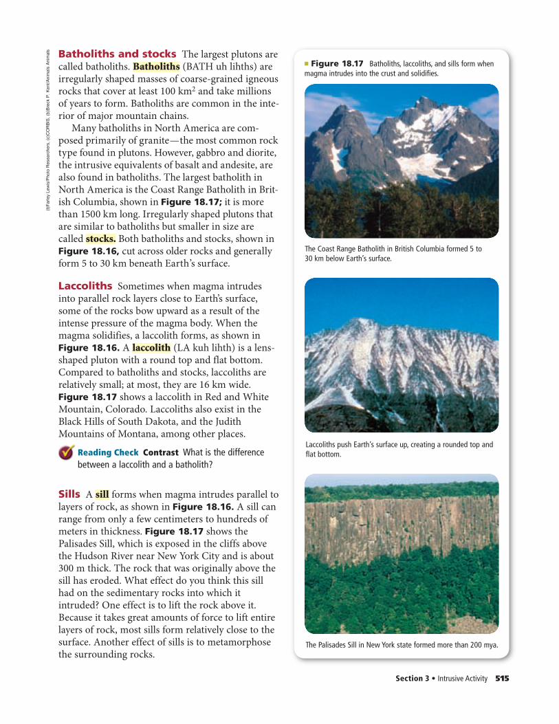
The Coast Range Batholith in British Columbia formed 5 to 30 km below Earth’s surface.
Laccoliths push Earth’s surface up, creating a rounded top and flat bottom.
The Palisades Sill in New York state formed more than 200 mya.
Batholiths and stocks The largest plutons are called batholiths. Batholiths (BATH uh lihths) are irregularly shaped masses of coarse-grained igneous rocks that cover at least 100 km2 and take millions of years to form. Batholiths are common in the inte-rior of major mountain chains.
Many batholiths in North America are com-posed primarily of granite — the most common rock type found in plutons. However, gabbro and diorite, the intrusive equivalents of basalt and andesite, are also found in batholiths. The largest batholith in North America is the Coast Range Batholith in Brit-ish Columbia, shown in Figure 18.17; it is more than 1500 km long. Irregularly shaped plutons that are similar to batholiths but smaller in size are called stocks. Both batholiths and stocks, shown in Figure 18.16, cut across older rocks and generally form 5 to 30 km beneath Earth’s surface.
Laccoliths Sometimes when magma intrudes into parallel rock layers close to Earth’s surface, some of the rocks bow upward as a result of the intense pressure of the magma body. When the magma solidifies, a laccolith forms, as shown in Figure 18.16. A laccolith (LA kuh lihth) is a lens-shaped pluton with a round top and flat bottom. Compared to batholiths and stocks, laccoliths are relatively small; at most, they are 16 km wide. Figure 18.17 shows a laccolith in Red and White Mountain, Colorado. Laccoliths also exist in the Black Hills of South Dakota, and the Judith Mountains of Montana, among other places.
Reading Check Contrast What is the difference between a laccolith and a batholith?
Sills A sill forms when magma intrudes parallel to layers of rock, as shown in Figure 18.16. A sill can range from only a few centimeters to hundreds of meters in thickness. Figure 18.17 shows the Palisades Sill, which is exposed in the cliffs above the Hudson River near New York City and is about 300 m thick. The rock that was originally above the sill has eroded. What effect do you think this sill had on the sedimentary rocks into which it intruded? One effect is to lift the rock above it. Because it takes great amounts of force to lift entire layers of rock, most sills form relatively close to the surface. Another effect of sills is to metamorphose the surrounding rocks.
Section 3 • Intrusive Activity 515
" Figure 18.17 Batholiths, laccoliths, and sills form when magma intrudes into the crust and solidifies.
(t)F
arle
y Le
wis
/Pho
to R
esea
rche
rs , (
c)C
OR
BIS
, (b)
Bre
ck P
. Ken
t/Ani
mal
s A
nim
als
514_517_C18_S03_874636.indd 515514_517_C18_S03_874636.indd 515 2/6/07 2:51:54 PM2/6/07 2:51:54 PM

Dike Volcanic neck
Coarse-grained dike Fine-grained sill
Dikes Unlike a sill, which is parallel to the rocks it intrudes, a dike is a pluton that cuts across preexisting rocks. Dikes often form when magma invades cracks in surrounding rock bodies. Dikes range in size from a few centimeters to several meters wide and can be tens of kilometers long. The Great Dike in Zimbabwe, Africa is an exception—it is about 8 km wide and 500 km long.
Some dikes intrude into the vent of a volcano. When the vol-cano around it erodes, these dikes, called volcanic necks, are exposed at Earth’s surface, leaving a structure like the one called Ship Rock in New Mexico, shown in Figure 18.18.
Textures While the textures of sills and dikes vary, most are coarse-grained. Recall from Chapter 5 that grain size is related to the rate of cooling. The coarse-grained texture of most sills and dikes suggests that they formed deep in Earth’s crust, where magma cooled slowly enough for large mineral grains to develop, as shown in Figure 18.19. Dikes and sills with a fine-grained tex-ture formed closer to the surface where many crystals began grow-ing at the same time, such as minerals of the sill in Figure 18.19.
516 Chapter 18 • Volcanism
" Figure 18.18 Unlike sills, dikes cut across the rock into which they intrude. Sometimes dikes intrude into the conduit of a volcano. When the volcano erodes, the more erosion-resistant dike is left standing. Try to imagine the volcano that once surrounded this volcanic neck in New Mexico.Infer how big the volcano must have been.
" Figure 18.19 Plutons forming deep in Earth cool slowly, giving crystals time to grow. Larger crystals produce a coarse-grained rock. Intrusive rocks that form closer to Earth’s surface cool more quickly. As a result, many crystals form rapidly at the same time, and the rock is finer-grained.
(tc)
Mar
li M
iller
/Vis
uals
Unl
imite
d , (
tr)J
ess
Alfo
rd/G
etty
Imag
es , (
bl)J
erom
e W
ycko
ff/A
nim
als
Ani
mal
s , (
br)D
r. M
arli
Mill
er/V
isua
ls U
nlim
ited
514_517_C18_S03_874636.indd 516514_517_C18_S03_874636.indd 516 2/6/07 2:51:57 PM2/6/07 2:51:57 PM

Self-Check Quiz glencoe.com
Section 118.8.33 AssessmentSection Summary!! Intrusive igneous rocks are classified
according to their size, shape, and relationship to the surrounding rocks.
!! Most of Earth’s volcanism happens below Earth’s surface.
!! Magma can intrude into rock in different ways, taking different forms when it cools.
!! Batholiths form the core of many mountain ranges.
Understand Main Ideas1. MAIN Idea Compare and contrast volcanic eruptions at Earth’s surface with
intrusive volcanic activity.
2. Describe the different types of plutons.
3. Relate the size of plutons to the locations where they are found.
4. Identify processes that expose plutons at Earth’s surface.
Think Critically5. Predict why the texture in the same sill might vary with finer grains along the
margin and coarser grains toward the middle.
6. Infer what type of pluton might be found at the base of an extinct volcano.
Earth Science
7. Write a defense or rebuttal for this statement: Of the different types of plutons, sills form at the greatest depths beneath Earth’s surface.
Section 3 • Intrusive Activity 517
Plutons and TectonicsMany plutons form as the result of mountain-build-ing processes. In fact, batholiths are found at the cores of many of Earth’s mountain ranges. From where did the enormous volume of cooled magma that formed these igneous bodies come? The pro-cesses that result in batholiths are complex. Recall from Chapter 17 that many major mountain chains formed along continental-continental convergent plate boundaries. Scientists think that some of these collisions might have forced continental crust down into the upper mantle where it melted, intruded into the overlying rocks, and eventually cooled to form batholiths.
Plutons are also thought to form as a result of tectonic convergence. Again, recall from Chapter 17 that a subduction zone develops when an oceanic plate converges with another plate. Water from the subducted plate causes the overlying mantle to melt. Plutons often form when the melted material rises but does not erupt at the surface.
The Sierra Nevada batholith formed from at least five episodes of this type of igneous activity beneath what is now California. The famous granite cliffs found in Yosemite National Park, some of which are shown in Figure 18.20, are part of this vast batho-lith. Although they were once far below Earth’s sur-face, uplift and erosion have brought them to their present position.
" Figure 18.20 The granite cliffs that tower over Yosemite National Park in California are part of the Sierra Nevada batholith that has been exposed at Earth’s surface.
Roy
alty
-Fre
e/C
OR
BIS
514_517_C18_S03_874636.indd 517514_517_C18_S03_874636.indd 517 2/6/07 2:52:01 PM2/6/07 2:52:01 PM

eXpeditions!
ON SITE:HawaiiANVolcanoObservatory
518 Chapter 18 • Volcanism
Kilauea, a shield volcano on the island of Hawaii, is one of the world’s most active volcanoes and the most dangerous volcano in the United States, according to the United States Geological Survey (USGS). Scientists monitor the conditions of Kilauea at the nearby Hawaiian Volcano Observatory (HVO). The observatory also serves as a laboratory where sam-ples gathered in and around Kilauea can be studied.
Lava collection Imagine standing next to mov-ing lava that is 1170oC. To get a direct measure-ment of the temperature or to collect a sample, scientists must withstand high temperatures and watch where they step. Samples are collected with heat-resistant materials and immediately cooled in a container with water to prevent contamination from the surrounding air. To pro-tect themselves, volcanologists wear some of the gear shown in the photo.
Seismic activity Earthquake activity beneath a volcano is an indicator of impending eruptions. One way to monitor earthquakes is to check seismic activity. Scientists place seismometers in and around the vents of volcanoes to monitor seismic activity.
Gas samples Volcanologists collect samples of gases released at vents that they will analyze for sulfur dioxide and carbon dioxide in the HVO laboratory. An increase in sulfur-dioxide or carbon-dioxide emission can indicate a potential eruption.
Ground monitoring An instrument called an electronic distance meter (EDM) helps scientists monitor the ground around volcanoes and pre-dict an eruption. As magma rises toward Earth’s surface, the ground might tilt, sink, or bulge from pressure.
Volcanologists at HVO are constantly recording data, running tests, and making advances around the world. Without their research, we might not understand volcanoes as well as we do today.
Volcanologists often wear helmets, climbing gear, heat-resistant clothing, gas masks, and other gear to protect themselves from dangerous conditions in and around active volcanoes. Once this volcanologist climbs down to the test site, he will put on heat-resistant gloves.
Research the methods scientists use to
predict time, size, and type of eruption.
Visit glencoe.com for more information.
Summarize your findings and share your
research with your classmates.
Earth Science
Car
sten
Pet
er/N
atio
nal G
eogr
aphi
c Im
age
Col
lect
ion
518_519_C18_Lab_874636.indd 518518_519_C18_Lab_874636.indd 518 2/6/07 2:53:06 PM2/6/07 2:53:06 PM

GeoLab 519
INTERNET: PREDICT THE SAFETY OF A VOLCANO
Background: Some volcanoes are explosively dan-gerous. Along with clouds of ash and other volcanic debris, pyroclastic flows, landslides, and mudflows are common volcanic hazards. However, an explosive volcano might not be a hazard to human life and property if it is located in a remote area or if it erupts infrequently.Question: What factors should be considered when evaluating a volcano?
MaterialsInternet access to glencoe.com or volcano data provided
by your teachercurrent reference books with additional volcano datamarkers or colored pencils
ProcedureImagine that you work for the United States Geological Survey (USGS) and are asked to evaluate several volca-noes around the world. Your job is to determine if the volcanoes are safe for the nearby inhabitants. If the vol-canoes are not safe, you must make recommendations to ensure the safety of the people around them.
1. Read and complete the lab safety form.2. Form a team of scientists of three to four people.3. Within your team, brainstorm some factors you
might use to evaluate the volcanoes. Record your ideas. You might include factors such as eruption interval, composition of lava, approximate number of people living near the volcano, and the date of the last known eruption.
4. With your group, decide which factors you will include.
5. Use the factors you have chosen to create a data table. Make sure your teacher approves your table and your factors before you proceed.
6. Visit glencoe.com (or use the information your teacher provides) and select a country where there is a known volcano.
7. Complete your data table for your first country.Repeat Step 6 for at least two more countries.
8. Repeat Steps 6 and 7 for two more countries.
Analyze and Conclude1. Interpret Data Is it safe for people to live close to
any of the volcanoes? Why or why not?2. Interpret Data Do any of the volcanoes pose an
immediate threat to the people who might live nearby? Why or why not?
3. Conclude Prepare to present your findings to a group of scientists from around the world. Be sure to include your predictions and recommendations, and be prepared for questions. Display your data table to help communicate your findings.
Helicopters transport researchers to remote volcanic sites. Researchers analyze data to determine hazards to humans.
SHARE YOUR DATAPeer Review Visit glencoe.com and post a summary of your recommendations for each of your volcanoes. Compare and contrast your data with that of other students who completed this lab.
Rog
er R
essm
eyer
/CO
RB
IS
518_519_C18_Lab_874636.indd 519518_519_C18_Lab_874636.indd 519 2/6/07 2:53:18 PM2/6/07 2:53:18 PM

Vocabulary PuzzleMaker biologygmh.com520 Chapter 18 • Study Guide520 Chapter 18 • Study Guide
Vocabulary Key ConceptsSection 18.1 Volcanoes
• caldera (p. 505)• cinder cone (p. 507)• composite volcano (p. 507)• conduit (p. 505)• crater (p. 505)• fissure (p. 504)• flood basalt (p. 504)• hot spot (p. 502)• shield volcano (p. 507)• vent (p. 505)• volcanism (p. 500)
MAIN Idea The locations of volcanoes are mostly determined by plate tectonics.
• Volcanism includes all the processes in which magma and gases rise to Earth’s surface.
• Most volcanoes on land are part of two major volcanic chains: the Circum-Pacific Belt and the Mediterranean Belt.
• Parts of a volcano include a vent, magma chamber, crater, and caldera.• Flood basalts form when lava flows from fissures to form flat plains or
plateaus.• There are three major types of volcanoes: shield, composite, and cinder
cone.
Section 18.2Section 18.2 Eruptions
• pyroclastic flow (p. 513)• tephra (p. 512)• viscosity (p. 509)
MAIN Idea The composition of magma determines the characteristics of a volcanic eruption.
• There are three major types of magma: basaltic, andesitic, and rhyolitic.• Because of their relative silica contents, basaltic magma is the least explo-
sive magma and rhyolitic magma is the most explosive. • Temperature, pressure, and the presence of water are factors that affect
the formation of magma.• Rock fragments ejected during eruptions are called tephra.
Section 18.3Section 18.3 Intrusive Activity
• batholith (p. 515)• dike (p. 516)• laccolith (p. 515)• pluton (p. 514)• sill (p. 515)• stock (p. 515)
MAIN Idea Magma that solidifies below ground forms geologic features different from those formed by magma that cools at the surface.
• Intrusive igneous rocks are classified according to their size, shape, and relationship to the surrounding rocks.
• Most of Earth’s volcanism happens below Earth’s surface.• Magma can intrude into rock in different ways, taking different forms
when it cools. • Batholiths form the core of many mountain ranges.
Download quizzes, key terms, and flash cards from glencoe.com.
Vocabulary PuzzleMaker glencoe.com
BIG Idea Volcanoes develop from magma moving upward from deep within Earth.
520_523_C18_CA_874636.indd 520520_523_C18_CA_874636.indd 520 2/6/07 2:54:40 PM2/6/07 2:54:40 PM

Chapter 18 • Assessment 521Chapter Test glencoe.com
Vocabulary Review
Make each of the following sentences true by replacing the italicized words with terms from the Study Guide. 1. In the most explosive types of eruptions, lava accu-
mulates to form a shield volcano. 2. Lava travels through a conduit to erupt through a
fissure at the top of a volcano.
3. Hot spots refer to all processes associated with the discharge of magma, hot water, and steam.
4. Ash is the smallest type of lava flow.
Complete the sentences below using vocabulary terms from the Study Guide. 5. A(n) ________ is a bowl-shaped depression that
surrounds the vent at a volcano’s summit.
6. A(n) ________ forms in the depression left when an empty magma chamber collapses.
7. The type of volcano that is the smallest and has the steepest slopes is called a(n) ________.
Match each description below with the correct vocabu-lary term from the Study Guide. 8. any rock body that has formed at great depths
underground
9. plutons having an area of more than 100 km2; often forms the core of mountains
10. flowing cloud of tephra and lava mixed with hot, suffocating gases
11. formed when magma intrudes across existing rock
Use what you know about the vocabulary terms on the Study Guide to describe what the terms in each pair have in common. 12. laccolith, sill
13. shield volcano, flood basalt
14. fissure, conduit
15. sill, dike
Understand Key Concepts
16. Which area is surrounded by the Ring of Fire?A. the Atlantic OceanB. the United StatesC. the Mediterranean SeaD. the Pacific Ocean
Use the diagram below to answer Questions 17 and 18.
17. In the diagram, what is the structure labeled 1?A. batholithB. laccolithC. dikeD. sill
18. In the diagram, what is the structure labeled 2?A. batholithB. laccolithC. dikeD. sill
19. Which is not true?A. An increase in silica increases the viscosity of
a magma.B. Andesitic magma has both an intermediate gas
content and explosiveness.C. An increase in temperature increases a magma’s
viscosity.D. Basaltic magma has a low viscosity and
retains little gas.
2
1
520_523_C18_CA_874636.indd 521520_523_C18_CA_874636.indd 521 2/6/07 2:54:44 PM2/6/07 2:54:44 PM

Use the figure below to answer Questions 20 and 21.
20. Which type of volcano is shown?A. shield volcanoB. composite volcanoC. flood basalt volcanoD. cinder cone
21. What is the feature labeled 1?A. craterB. cinder coneC. ventD. magma chamber
22. What causes the magma to rise upward in a mantle plume?A. The magma is less dense than the surrounding
material.B. The magma is denser than the surrounding
material.C. The magma is pulled upward by the air
pressure.D. The magma is pushed upward by the surround-
ing rock.
23. Which type of volcanism produces the most lava annually?A. convergentB. divergentC. hot spotD. rifting
Constructed Response
24. Differentiate among batholiths, stocks, and lacco-liths according to their relative sizes and shapes.
25. Infer A particular outcrop has a narrow ribbon of basalt that runs almost perpendicular to several layers of sandstone. What feature is shown?
26. Describe hot spots.
27. Identify one specific example of the three types of volcanoes.
28. Compare and contrast Kilauea and the Columbia River flood basalt in terms of the processes related to their development.
29. Analyze why volcanic blocks are uncommon on shield volcanoes.
Use the diagram below to answer Question 30.
30. Distinguish which island is the oldest and in which direction the plate is moving. Explain your reasoning.
31. Decide Is the Pacific Ring of Fire an accurate name? Explain.
32. Explain the relationship between the viscosity of a magma and its temperature.
33. Explain how volcanic activity can affect global weather.
34. Draw a diagram of the three volcano types, show-ing their relative sizes.
35. Analyze why smaller plutons are more likely to be fine-grained, and larger plutons more likely to be coarse-grained.
522 Chapter 18 • Assessment Chapter Test glencoe.com
1
A
B
C
520_523_C18_CA_874636.indd 522520_523_C18_CA_874636.indd 522 2/6/07 2:54:45 PM2/6/07 2:54:45 PM
Additional AssessmentThink Critically .
Use the table below to answer Questions 29 to 30.
36. Analyze and rank the types of magma in terms of explosiveness based on the data. Explain your reasoning.
37. Categorize each of the three types of volcanoes in terms of the characteristics of magma shown in the table.
38. Predict what would happen if there were no plate tectonics.
Concept Mapping
39. Create a concept map using the following terms: pluton, vertical, batholith, cuts across, stock, paral-lel, laccolith, sill, and dike. For more help refer to the Skillbuilder Handbook.
Challenge Question
40. Formulate a way to recognize the difference between an ancient lava flow and an intrusive igneous rock.
Chapter 18 • Assessment 523Chapter Test glencoe.com
41. Earth Science Imagine you are in charge of a volcano observatory. One day, GPS measurements indicate that a volcano is expand-ing, there have been several earthquakes, and the flux of volcanic gases has increased. Should you issue a warning of an impending eruption? Write a press release to warn people about the situation.
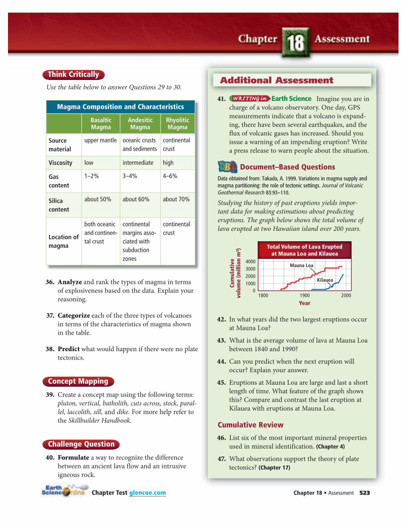
Document–Based QuestionsData obtained from: Takada, A. 1999. Variations in magma supply and magma partitioning: the role of tectonic settings. Journal of Volcanic Geothermal Research 83:93–110.
Studying the history of past eruptions yields impor-tant data for making estimations about predicting eruptions. The graph below shows the total volume of lava erupted at two Hawaiian island over 200 years.
42. In what years did the two largest eruptions occur at Mauna Loa?
43. What is the average volume of lava at Mauna Loa between 1840 and 1990?
44. Can you predict when the next eruption will occur? Explain your answer.
45. Eruptions at Mauna Loa are large and last a short length of time. What feature of the graph shows this? Compare and contrast the last eruption at Kilauea with eruptions at Mauna Loa.
Cumulative Review
46. List six of the most important mineral properties used in mineral identification. (Chapter 4)
47. What observations support the theory of plate tectonics? (Chapter 17)
Magma Composition and Characteristics
Basaltic Magma
Andesitic Magma
Rhyolitic Magma
Source material
upper mantle oceanic crusts and sediments
continental crust
Viscosity low intermediate high
Gas content
1–2% 3–4% 4–6%
Silica content
about 50% about 60% about 70%
Location of magma
both oceanic and continen-tal crust
continental margins asso-ciated with subduction zones
continental crust
1800 1900 2000
Cum
ulat
ive
volu
me
(mill
ion
m!)
Year
Mauna Loa
Kilauea
Total Volume of Lava Eruptedat Mauna Loa and Kilauea
4000300020001000
0
520_523_C18_CA_874636.indd 523520_523_C18_CA_874636.indd 523 2/6/07 2:54:48 PM2/6/07 2:54:48 PM