Glasgow’s Medieval City development between 1150 and 1550
2
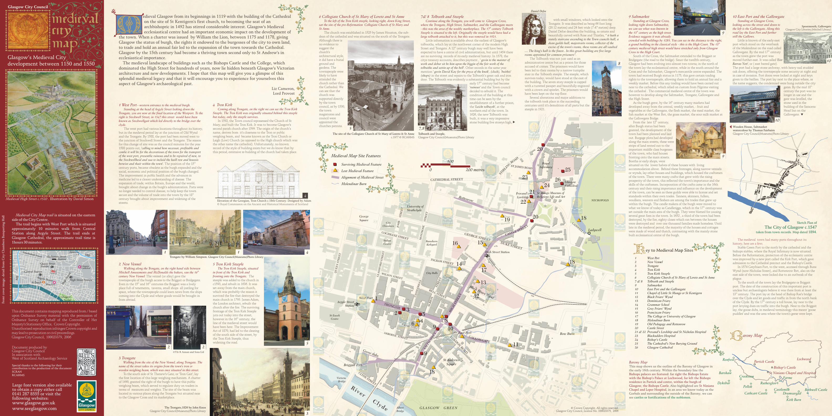
Goose dubs Briggait Port West Port East Port Rottenrow Black Friars Wynd ALBION BELL STREET STREET G A L L OWGATE LONDON ROAD IN GRAM STREET BLACKFRIARS STREET GEORGE STREET DUKE STREET TRONGATE HIGH STREET T E E R T S E L T S A C St Andrews Square CANDLERIGGS GLASSFORD STREET WILSON STREET OSBORNE STREET COCHRANE STREET QUEEN STREET CLYDE STREET City Chambers JOHN STREET MONTROSE STREET COLLEGE STREET Bow Butts CATHEDRAL STREET D A O R G N I L R I T S LADYWELL ST Ladywell SHUTTLE STREET ST JAMES ROAD SALTMARKET PARNIE STREET 1 3 7/8 13 10 5 9 11 14 12 4 15 16 17 18 19 20 21 22 26 23 25 24 20 18 2 6 9 18 1 West Port 2 New Vennel 3 Trongate 4 Tron Kirk 5 Tron Kirk Steeple 6 Collegiate Church of St Mary of Loreto and St Anne 7 & 8 Tolbooth and Steeple 9 Saltmarket 10 East Port and the Gallowgate 11 Chapel of Little St Mungo or St Kentigern 12 Black Friars’ Wynd 13 Dominican Friary 14 Grammar School 15 Grey Friars’ Wynd 16 Franciscan Friary 17 The College or University of Glasgow 18 Molendinar Burn 19 Old Pedagogy and Rottenrow 20 Castle Street 21 & 22 Provand’s Lordship and St Nicholas Hospital 23 Blackadders Hospital 24 Bishop’s Castle 25 The Cathedral’s New Burying Ground 26 Glasgow Cathedral ey to Medieval Map Sites Medieval Map Site Features 0 100 200 metres Medieval City Map trail is situated on the eastern side of the City Centre. The trail begins with West Port which is situated approximately 10 minutes walk from Central Station along Argyle Street. The trail ends at Glasgow Cathedral, the approximate trail time is 1hours 30 minutes. Medieval High Street c.1520 . Illustration by David Simon Glasgow City Council l y r C d ve Ri e M8 M8 Central Station George Square Junction 15 Glasgow Green High Street Argyle Street Sauchiehall Street Queen Street Station High Street Station S St Enoch Glasgow Cathedral Buchanan Street Station West Port Glasgow’s Medieval City development between 1150 and 1550 Front cover image; detail from City Chambers Banqueting Hall Large font version also available to obtain a copy either call 0141 287 8555 or visit the following websites: www.glasgow.gov.uk www.seeglasgow.com Document produced by Glasgow City Council In association with West of Scotland Archaeology Service Special thanks to the following for their contribution to the production of the document SCRAN RCAHMS This document contains mapping reproduced from / based upon Ordnance Survey material with the permission of Ordnance Survey on behalf of the Controller of Her Majesty's Stationery Office, Crown Copyright. Unauthorised reproduction infringes Crown copyright and may lead to prosecution or civil proceedings. Glasgow City Council, 100023379, 2006 Elevation of the Georgian, Tron Church c.18th Century. Designed by Adam © Royal Commission on the Ancient and Historical Monuments of Scotland ©T& R Annan and Sons Ltd Trongate by William Simpson. Glasgow City Council(Museums)Photo Library The Trongate,1826 by John Knox Glasgow City Council(Museums)Photo Library The site of the Collegiate Church of St Mary of Loreto & St Anne c.1977 © RCAHMS Tolbooth and Steeple, Glasgow City Council(Museums)Photo Library Daniel Defoe Spoutmouth, Gallowgate Glasgow City Libraries,(Mitchell Library) Wooden House, Saltmarket watercolour by Thomas Fairbairn Glasgow City Council(Museums)Photo Library 10 East Port and the Gallowgate Standing at Glasgow Cross, looking across the street and down to the left is the Gallowgate. Along this road lay the East Port and further still the Gallows. The medieval town had many ports throughout its history, here are a few; Little is known of the early east port which stood on the westbank of the Molendinar on the road called th Gallowgate. By the mid 17 century as the town grew the port was moved further east. It was called 'Eist Barras Yett' , or ( east barred gate). The port had a large stone archway, with heavy nail studded oak doors, offering the townspeople some security at night and in case of invasion. Port doors were locked at night and keys given to the baillies. The port lay next to the place where, as the name suggests, the condemned were hung outside the city th gates. By the mid 18 century the port was no longer in use and the gate was levelled, the stone used in the building of the Saracens Head Inn on the Gallowgate. Stable Green Port to the north by the cathedral and the bishops stables, where the Royal Infirmary is now situated. Before the Reformation, protection of the ecclesiastic centre was improved by a new port called the Kirk Port, which gave admission to the Cathedral precinct and the Bishop's Castle. In 1574 Greyfriars Port, to the west, accessed through Buns Wynd (now Nicholas Street), and Rottenrow Port, also on the east side of the town, were locked due to an outbreak of the plague. To the south of the town lay the Bridgegate or Briggait port. The date of the construction of this important port is unclear but archaeologists believe it was there from at least the th 13 century. The port lay at the head of Bishop Rae's bridge over the Clyde and let goods and traffic in from the north bank th of the Clyde. By the 17 century a toll house, lay near to the port levying dues on traffic into the burgh. Near to the Briggait lay, the goose dubs, in medieval terminology this meant 'goose puddles' and was the area where the town's geese were kept. 1 West Port western entrance to the medieval burgh. Standing at the head of Argyle Street looking down the Trongate, you are now at the final location of the Westport. To the right is Stockwell Street, in 1547 this street would have been known as Stockwellgait which led directly to the bridge over the clyde. - The west port had various locations throughout its history, but in the medieval period lay at the junction of Old Wynd and the Trongate. By 1588, the port had been moved west to the junction of Stockwell Street and the Trongate. The reason for this change of site was as the council minutes for the year 1588 points out, 'calling to mind how necessar, profitable and comlie it will be for the decoratioun of the town for the transport of the west port, presentlie ruinous and to be repaired of new, to the Stockwellheid and sua to incluid the haill rew and houssis th betwixt and thair within the town'. The position of the 15 century ports, became obsolete as the burgh expanded and the social, economic and political position of the burgh changed. The improvement in public health and the advances in medicine led to a clearer understanding of disease. The expansion of trade, within Britain, Europe and the world, brought about change in the burgh's administration. Ports were no longer needed to control disease, to help keep the town th secure and the volume of trade into the town by the 18 century brought about improvement and widening of the streets. 2 New Vennel Walking along the Trongate, on the right hand side between th Mitchell Amusements and McDonalds the bakers, ran the 16 century New Vennel . The vennel (or alley) gave the townspeople of the burgh access to the Briggait or Bridgegate. th th Even in the 15 and 16 centuries the Briggait was a lively place full of tenements, taverns, small shops all jostling for space, where the townspeople could learn news from the ships coming into the Clyde and where goods would be brought in from abroad. 3 Trongate Walking from the site of the New Vennel, along Trongate. The name of the street takes its origins from the town's tron or wooden weighing beam, which was once situated in this street. To the south side of St Thenew's Gate, or 'Tron Gait', lay the first location of this large weighing mechanism. A charter of 1490, granted the right of the burgh to have this public weighing beam, which served to regulate duty on traders in terms of measures and weights. The site of the beam was located in various places along the Trongate but situated near to the Glasgow Cross and its marketplace. 4 Tron Kirk Coming along Trongate, on the right we can see the Tron Kirk Steeple. The Tron Kirk was originally situated behind this steeple but today, only the steeple survives. In 1592, the Town council repossessed the Church of St Mary, and built the Tron Kirk. It was to become Glasgow's second parish church after 1599. The origin of the church’s name, derives from it's closeness to the Tron or public weighing beam, and became known as the Tron Church or Laigh (Low) Church (as opposed to the High church which was the other name the cathedral). Unfortunately, no known record of the style of building exists but we do know that by this period, extensive re-building of the church had taken place. 5 Tron Kirk Steeple The Tron Kirk Steeple, situated in front of the Tron Kirk and fronting onto the Trongate. The steeple was added to the church in c1593, and rebuilt in 1636. It was set away from the main church, which was probably the reason it survived the fire that destroyed the main church in 1793. James Adam, the London architect, rebuilt the church after the fire. The surviving frontage of the Tron Kirk Steeple juts out today into the street, th however in the 16 century, the line of the medieval street would have been here. The Improvement Act of 1870, had led to the clearing of the south side of the street, by the Tron Kirk Steeple, thus widening the road. 6 Collegiate Church of St Mary of Loreto and St Anne To the left of the Tron Kirk steeple, looking right, down King Street, sat the site of the pre-Reformation Collegiate Church of St Mary and St Anne. The church was established in 1525 by James Houston, the sub- dean of the cathedral and was situated on the south of the Trongate. Although there is no evidence to suggest the church's architectural style, it did have a burial ground and gardens. The townspeople were likely to have attended the church rather than the Cathedral. We can see that the church was supported directly by the town council, as by 1530, the town magistrates and council were appointed the churches patrons. 7& 8 Tolbooth and Steeple Continue along the Trongate, you will come to Glasgow Cross, where the Trongate, High Street, Saltmarket, and the Gallowgate meets th - this was the area of the weekly marketplace. The 17 century Tolbooth Steeple is situated to the left. Originally the steeple would have had a large tolbooth attached to it, but this was removed in 1921. Little information is available about the earliest of Glasgow's tolbooths, which lay at the northwest corner of the modern High th Street and Trongate. A 12 century burgh may well have been expected to have a centre of civil administration, but until 1454 there are no surviving records of its early medieval history. In 1578, the citys treasury accounts, describes payment , ' gevin to the maister of work and debur sit be him upon the biggin of the foir work of the tolbuithe and settin up of the bell'. Other records in the same year mention ' gevin David Kay for the pryce of the knok', (clock), 'buithis' (shops) in the street and repairs to the Tolbooth’s great oak and iron door. The Tolbooth was evidently a substantial building but by the th early 17 century had become 'ruinous' and the Town council decided to rebuild it. The condition of the building at this time can be seen by the establishment of a further prison, the 'Leicht tolbuyth', at the northern end of the town. In 1626, the new Tolbooth was built, it was a very impressive stone building five storeys high, 9 Saltmarket Standing at Glasgow Cross, looking right down Saltmarket, we can see what was known in th the 13 century as the high street. Evidence suggests it was already crowded with buildings by 1285. You can see in the distance to the right, th a grand building in the classical style - this is the High Court. The 13 century medieval high street would have stretched only from Glasgow Cross to the High Court. South of the Cross, the Saltmarket extended to the Briggait or Bridgegate (the road to the bridge). Since the twelfth century, Glasgow had been evolving into almost two towns; in the north of the town lay the ecclesiastical centre, while in the south around the Cross and the Saltmarket, Glasgow's mercantile centre expanded. The town had received Burgh status in 1175, this gave certain trading rights to the townspeople, allowing them to hold an annual fair and a weekly market. Before this any trading would have been carried out near to the cathedral, which relied on custom from Pilgrims visiting the cathedral . The commercial medieval centre of the town was however to develop along the Saltmarket, Trongate, Gallowgate and the High Street. th As the burgh grew, by the 16 century many markets had developed away from the central, weekly market, - fruit and vegetables at the Gallowgate, the flesh market, the meal market, the fish market at the West Port, the grass market, the sour milk market at the Gallowgate Bridge. th From the late 12 century, after Burgh status had been granted, the development of the town had been planned and laid out. Burgage plots had developed along the main streets, these were strips of land rented out to the important middle class burgesses of the town, who had houses fronting onto the main streets. Booths or early shops, were situated on the lower halves of these houses with living accommodation above. Behind these frontages, along narrow vennels or wynds, lay other houses and buildings, which housed the craftsmen of the town. There were many crafts that grew with the rising prosperity of the town, this reflected the town's importance and the skills of the craftsmen. Incorporation of the crafts came in the 16th century and their rising importance and influence on the development of the town, can be seen as these guilds were able to license and set standards within their own trades. Tanners, skinners, fullers, waulkers, weavers and fleshers are among the trades that grew up within the burgh. The candle makers of the burgh were moved to th what we know of today as Candleriggs, which in the 17 century was set outside the main area of the burgh. They were blamed for causing several great fires in the town. In 1652 , a third of the town had been destroyed, by the fire, eighty closes which ran between the houses were destroyed and over one thousand families made homeless. Until late in the medieval period, the majority of the houses and cottages were made of wood and thatch, contrasting with the mainly stone built ecclesiastical centre of the burgh. with small windows, which looked onto the Trongate. It was described as being 66 foot long (20.12 metres) and 24 feet wide (7.47 metres) deep. Daniel Defoe describes the building, as ornate and beautifully carved with Rose and Thistles, “ it hath a stately staircase ascending to the Town councils hall, a dean guilds hall, majestraits rooms, collector of the excise of the town's rooms, these rooms are all vaulted .... The king's hall is the finest.. In this great building are five large rooms appointed for common prisoners”. The Tollbooth was not just used as an administrative centre but as a prison for those accused of crimes. The prisoners would have been led to their rooms by a narrow turnpike stair in the Tolbooth steeple. The steeple, which survives today, would have stood at the east of the building. The seven story steeple is capped with a turreted parapet and beautifully engraved with a crown and spirelet. The prisoners would have been kept on the top floor. Several alterations and major additions to the tolbooth took place in the succeeding centuries until it's demolition of all parts but the steeple in 1921. edieval Glasgow from its beginnings in 1119 with the building of the Cathedral on the site of St Kentigern's first church, to becoming the seat of an archbishopric in 1492 has stirred considerable interest. Glasgow's Medieval ecclesiastical centre had an important economic impact on the development of the town. When a charter was issued by William the Lion, between 1175 and 1178, giving Glasgow the status of burgh, the rights it endowed to the burgesses of the city to own land, to trade and hold an annual fair led to the expansion of the town towards the Cathedral. Glasgow by the 15th century had become a thriving town second only to St Andrew's in ecclesiastical importance. The medieval landscape of buildings such as the Bishops Castle and the College, which dominated the High Street for hundreds of years, now lie hidden beneath Glasgow's Victorian architecture and new developments. I hope that this map will give you a glimpse of this splendid medieval legacy and that it will encourage you to experience for yourselves this aspect of Glasgow's archaeological past. Liz Cameron, Lord Provost © Crown Copyright. All rights reserved. Glasgow City Council, Licence No. 100023379, 2006 Surviving Medieval Feature Lost Medieval Feature Alignment of Medieval Street Molendinar Burn 4 4 1 1 2 2 5 3 5 7,8 8 10 10 9 9 Barony Map Bishops palaces are featured: far right the Bishops Estate with the Bishop’s Palace at Lochwood, far left the Bishops residence in Partick and centre, within the burgh of Glasgow, the Bishops Castle. St Ninians Chapel and Leper Hospital This map shows us the outline of the Barony of Glasgow in the early 16th century. Within the boundary line the Also highlighted are , in an area we know today as the Gorbals and surrounding the outside of the Barony, we can see . castles or fortifications of the noblemen Lochwood Bishop’s Castle Partick Castle Barshaw Dykebar Crookston Pollok Cathcart Castle Castlemilk Drumsargad Bothwell Castle Farme Rutherglen Kirk Burn Renfrew St Ninians Chapel and Hospital arony Map Sketch Plan of The City of Glasgow c.1547 taken from town records. Map dated 1894. City Halls Ramshorn Kirkyard George Square St Enoch Centre Italian Centre High Street Station Glasgow Cathedral NECROPOLIS River Clyde St Mungo Museum of Religious Life and Art Royal Infirmary University of Strathclyde GLASGOW GREEN Victoria Bridge Albert Bridge Provand’s Lordship Argyle Street Station
Transcript of Glasgow’s Medieval City development between 1150 and 1550
Goose dubs
Briggait Port
West Port
East Port
Rottenrow
Black Friars Wynd
AL
BIO
N
BELL STREET
STR
EE
T
GALLOWGATE
LON
DO
N RO
AD
INGRAM STREET
BLACKFRIARS STREET
GEORGE STREETDUKE STREET
TRONGATE
HIG
H S
TR
EE
T
TEERTS ELTSAC
St Andrews Square
CA
ND
LE
RIG
GS
GL
AS
SF
OR
D S
TR
EE
T
WILSON STREET
OSBORNE STREET
COCHRANE STREET
QU
EE
N S
TR
EE
T
CLYDE STREET
City Chambers JO
HN
S
TR
EE
T
MO
NT
RO
SE
ST
RE
ET
COLLEGE STREET
Bow Butts
CATHEDRAL STREET
DAOR
GNILRITS
LADYW
ELL STLadywell
SHU
TTLE
ST
RE
ET
ST JAMES ROAD
SALT
MA
RK
ET
PARNIE STREET
1
3
7/8
13
10
5
9
11
14
12
4
1516
17
1819 20
21
22
2623
25
24
20
18
2
69
18
1 West Port 2 New Vennel3 Trongate4 Tron Kirk5 Tron Kirk Steeple6 Collegiate Church of St Mary of Loreto and St Anne7 & 8 Tolbooth and Steeple9 Saltmarket10 East Port and the Gallowgate11 Chapel of Little St Mungo or St Kentigern12 Black Friars’ Wynd13 Dominican Friary 14 Grammar School15 Grey Friars’ Wynd16 Franciscan Friary17 The College or University of Glasgow18 Molendinar Burn19 Old Pedagogy and Rottenrow20 Castle Street21 & 22 Provand’s Lordship and St Nicholas Hospital23 Blackadders Hospital24 Bishop’s Castle25 The Cathedral’s New Burying Ground26 Glasgow Cathedral
ey to Medieval Map Sites
Medieval Map Site Features
0
100
200 metres
Medieval City Map trail is situated on the eastern side of the City Centre.
The trail begins with West Port which is situated approximately 10 minutes walk from Central Station along Argyle Street. The trail ends at Glasgow Cathedral, the approximate trail time is 1hours 30 minutes.
Medieval High Street c.1520 . Illustration by David Simon
Glasgow City Council
lyr C dveRi e
M8
M8
Central Station GeorgeSquare
Junction 15
GlasgowGreen
Hig
h St
reet
Argyle Street
Sauchiehall Street
Queen Street Station
High Street StationSSt Enoch
GlasgowCathedral
Buchanan Street Station
West Port
Glasgow’s Medieval Citydevelopment between 1150 and 1550
Fro
nt
cover
im
age;
det
ail
fro
m C
ity
Ch
amb
ers
Ban
qu
etin
g H
all
Large font version also available to obtain a copy either call 0141 287 8555 or visit the following websites:www.glasgow.gov.ukwww.seeglasgow.com
Document produced by Glasgow City Council In association with West of Scotland Archaeology Service
Special thanks to the following for their contribution to the production of the documentSCRANRCAHMS
This document contains mapping reproduced from / based upon Ordnance Survey material with the permission of Ordnance Survey on behalf of the Controller of Her Majesty's Stationery Office, Crown Copyright.Unauthorised reproduction infringes Crown copyright and may lead to prosecution or civil proceedings.Glasgow City Council, 100023379, 2006
Elevation of the Georgian, Tron Church c.18th Century. Designed by Adam © Royal Commission on the Ancient and Historical Monuments of Scotland
©T& R Annan and Sons Ltd
Trongate by William Simpson. Glasgow City Council(Museums)Photo Library
The Trongate,1826 by John KnoxGlasgow City Council(Museums)Photo Library
The site of the Collegiate Church of St Mary of Loreto & St Annec.1977 © RCAHMS
Tolbooth and Steeple, Glasgow City Council(Museums)Photo Library
Daniel Defoe
Spoutmouth, GallowgateGlasgow City Libraries,(Mitchell Library)
Wooden House, Saltmarket watercolour by Thomas FairbairnGlasgow City Council(Museums)Photo Library
10 East Port and the GallowgateStanding at Glasgow Cross,
looking across the street and down to the left is the Gallowgate. Along this road lay the East Port and further still the Gallows.
The medieval town had many ports throughout its history, here are a few;
Little is known of the early east port which stood on the westbank of the Molendinar on the road called
thGallowgate. By the mid 17 century as the town grew the port was moved further east. It was called 'Eist Barras Yett', or ( east barred gate). The port had a large stone archway, with heavy nail studded oak doors, offering the townspeople some security at night and in case of invasion. Port doors were locked at night and keys given to the baillies. The port lay next to the place where, as the name suggests, the condemned were hung outside the city
thgates. By the mid 18 century the port was no longer in use and the gate was levelled, the stone used in the building of the Saracens Head Inn on the Gallowgate.
Stable Green Port to the north by the cathedral and the bishops stables, where the Royal Infirmary is now situated. Before the Reformation, protection of the ecclesiastic centre was improved by a new port called the Kirk Port, which gave admission to the Cathedral precinct and the Bishop's Castle.
In 1574 Greyfriars Port, to the west, accessed through Buns Wynd (now Nicholas Street), and Rottenrow Port, also on the east side of the town, were locked due to an outbreak of the plague.
To the south of the town lay the Bridgegate or Briggait port. The date of the construction of this important port is unclear but archaeologists believe it was there from at least the
th13 century. The port lay at the head of Bishop Rae's bridge over the Clyde and let goods and traffic in from the north bank
thof the Clyde. By the 17 century a toll house, lay near to the port levying dues on traffic into the burgh. Near to the Briggait lay, the goose dubs, in medieval terminology this meant 'goose puddles' and was the area where the town's geese were kept.
1 West Port western entrance to the medieval burgh. Standing at the head of Argyle Street looking down the
Trongate, you are now at the final location of the Westport. To the right is Stockwell Street, in 1547 this street would have been known as Stockwellgait which led directly to the bridge over the clyde.
-
The west port had various locations throughout its history, but in the medieval period lay at the junction of Old Wynd and the Trongate. By 1588, the port had been moved west to the junction of Stockwell Street and the Trongate. The reason for this change of site was as the council minutes for the year 1588 points out, 'calling to mind how necessar, profitable and comlie it will be for the decoratioun of the town for the transport of the west port, presentlie ruinous and to be repaired of new, to the Stockwellheid and sua to incluid the haill rew and houssis
thbetwixt and thair within the town'. The position of the 15 century ports, became obsolete as the burgh expanded and the social, economic and political position of the burgh changed. The improvement in public health and the advances in medicine led to a clearer understanding of disease. The expansion of trade, within Britain, Europe and the world, brought about change in the burgh's administration. Ports were no longer needed to control disease, to help keep the town
thsecure and the volume of trade into the town by the 18 century brought about improvement and widening of the streets.
2 New VennelWalking along the Trongate, on the right hand side between
thMitchell Amusements and McDonalds the bakers, ran the 16 century New Vennel. The vennel (or alley) gave the townspeople of the burgh access to the Briggait or Bridgegate.
th thEven in the 15 and 16 centuries the Briggait was a lively place full of tenements, taverns, small shops all jostling for space, where the townspeople could learn news from the ships coming into the Clyde and where goods would be brought in from abroad.
3 TrongateWalking from the site of the New Vennel, along Trongate. The
name of the street takes its origins from the town's tron or wooden weighing beam, which was once situated in this street.
To the south side of St Thenew's Gate, or 'Tron Gait', lay the first location of this large weighing mechanism. A charter of 1490, granted the right of the burgh to have this public weighing beam, which served to regulate duty on traders in terms of measures and weights. The site of the beam was located in various places along the Trongate but situated near to the Glasgow Cross and its marketplace.
4 Tron Kirk Coming along Trongate, on the right we can see the Tron Kirk
Steeple. The Tron Kirk was originally situated behind this steeple but today, only the steeple survives.
In 1592, the Town council repossessed the Church of St Mary, and built the Tron Kirk. It was to become Glasgow's second parish church after 1599. The origin of the church’s name, derives from it's closeness to the Tron or public weighing beam, and became known as the Tron Church or Laigh (Low) Church (as opposed to the High church which was the other name the cathedral). Unfortunately, no known record of the style of building exists but we do know that by this period, extensive re-building of the church had taken place.
5 Tron Kirk SteepleThe Tron Kirk Steeple, situated
in front of the Tron Kirk and fronting onto the Trongate. The steeple was added to the church in c1593, and rebuilt in 1636. It was set away from the main church, which was probably the reason it survived the fire that destroyed the main church in 1793. James Adam, the London architect, rebuilt the church after the fire. The surviving frontage of the Tron Kirk Steeple juts out today into the street,
thhowever in the 16 century, the line of the medieval street would have been here. The Improvement Act of 1870, had led to the clearing of the south side of the street, by the Tron Kirk Steeple, thus widening the road.
6 Collegiate Church of St Mary of Loreto and St AnneTo the left of the Tron Kirk steeple, looking right, down King Street,
sat the site of the pre-Reformation Collegiate Church of St Mary and St Anne.
The church was established in 1525 by James Houston, the sub-dean of the cathedral and was situated on the south of the Trongate. Although there is no evidence to suggest the church's architectural style, it did have a burial ground and gardens. The townspeople were likely to have attended the church rather than the Cathedral. We can see that the church was supported directly by the town council, as by 1530, the town magistrates and council were appointed the churches patrons.
7& 8 Tolbooth and Steeple Continue along the Trongate, you will come to Glasgow Cross,
where the Trongate, High Street, Saltmarket, and the Gallowgate meets th- this was the area of the weekly marketplace. The 17 century Tolbooth
Steeple is situated to the left. Originally the steeple would have had a large tolbooth attached to it, but this was removed in 1921.
Little information is available about the earliest of Glasgow's tolbooths, which lay at the northwest corner of the modern High
thStreet and Trongate. A 12 century burgh may well have been expected to have a centre of civil administration, but until 1454 there are no surviving records of its early medieval history. In 1578, the citys treasury accounts, describes payment , ' gevin to the maister of work and debur sit be him upon the biggin of the foir work of the tolbuithe and settin up of the bell'. Other records in the same year mention ' gevin David Kay for the pryce of the knok', (clock), 'buithis' (shops) in the street and repairs to the Tolbooth’s great oak and iron door. The Tolbooth was evidently a substantial building but by the
thearly 17 century had become 'ruinous' and the Town council decided to rebuild it. The condition of the building at this time can be seen by the establishment of a further prison, the 'Leicht tolbuyth', at the northern end of the town. In 1626, the new Tolbooth was built, it was a very impressive stone building five storeys high,
9 SaltmarketStanding at Glasgow Cross,
looking right down Saltmarket, we can see what was known in
ththe 13 century as the high street. Evidence suggests it was already crowded with buildings by 1285. You can see in the distance to the right,
th a grand building in the classical style - this is the High Court. The 13century medieval high street would have stretched only from Glasgow Cross to the High Court.
South of the Cross, the Saltmarket extended to the Briggait or Bridgegate (the road to the bridge). Since the twelfth century, Glasgow had been evolving into almost two towns; in the north of the town lay the ecclesiastical centre, while in the south around the Cross and the Saltmarket, Glasgow's mercantile centre expanded. The town had received Burgh status in 1175, this gave certain trading rights to the townspeople, allowing them to hold an annual fair and a weekly market. Before this any trading would have been carried out near to the cathedral, which relied on custom from Pilgrims visiting the cathedral . The commercial medieval centre of the town was however to develop along the Saltmarket, Trongate, Gallowgate and the High Street.
thAs the burgh grew, by the 16 century many markets had developed away from the central, weekly market, - fruit and vegetables at the Gallowgate, the flesh market, the meal market, the fish market at the West Port, the grass market, the sour milk market at the Gallowgate Bridge.
thFrom the late 12 century, after Burgh status had been granted, the development of the town had been planned and laid out. Burgage plots had developed along the main streets, these were strips of land rented out to the important middle class burgesses of the town, who had houses fronting onto the main streets. Booths or early shops, were situated on the lower halves of these houses with living accommodation above. Behind these frontages, along narrow vennels or wynds, lay other houses and buildings, which housed the craftsmen of the town. There were many crafts that grew with the rising prosperity of the town, this reflected the town's importance and the skills of the craftsmen. Incorporation of the crafts came in the 16th century and their rising importance and influence on the development of the town, can be seen as these guilds were able to license and set standards within their own trades. Tanners, skinners, fullers, waulkers, weavers and fleshers are among the trades that grew up within the burgh. The candle makers of the burgh were moved to
thwhat we know of today as Candleriggs, which in the 17 century was set outside the main area of the burgh. They were blamed for causing several great fires in the town. In 1652 , a third of the town had been destroyed, by the fire, eighty closes which ran between the houses were destroyed and over one thousand families made homeless. Until late in the medieval period, the majority of the houses and cottages were made of wood and thatch, contrasting with the mainly stone built ecclesiastical centre of the burgh.
with small windows, which looked onto the Trongate. It was described as being 66 foot long (20.12 metres) and 24 feet wide (7.47 metres) deep. Daniel Defoe describes the building, as ornate and beautifully carved with Rose and Thistles, “ it hath a stately staircase ascending to the Town councils hall, a dean guilds hall, majestraits rooms, collector of the excise of the town's rooms, these rooms are all vaulted
.... The king's hall is the finest.. In this great building are five large rooms appointed for common prisoners”.
The Tollbooth was not just used as an administrative centre but as a prison for those accused of crimes. The prisoners would have been led to their rooms by a narrow turnpike stair in the Tolbooth steeple. The steeple, which survives today, would have stood at the east of the building. The seven story steeple is capped with a turreted parapet and beautifully engraved with a crown and spirelet. The prisoners would have been kept on the top floor.
Several alterations and major additions to the tolbooth took place in the succeeding centuries until it's demolition of all parts but the steeple in 1921.
edieval Glasgow from its beginnings in 1119 with the building of the Cathedral on the site of St Kentigern's first church, to becoming the seat of an archbishopric in 1492 has stirred considerable interest. Glasgow's Medieval ecclesiastical centre had an important economic impact on the development of
the town. When a charter was issued by William the Lion, between 1175 and 1178, giving Glasgow the status of burgh, the rights it endowed to the burgesses of the city to own land, to trade and hold an annual fair led to the expansion of the town towards the Cathedral. Glasgow by the 15th century had become a thriving town second only to St Andrew's in ecclesiastical importance.
The medieval landscape of buildings such as the Bishops Castle and the College, which dominated the High Street for hundreds of years, now lie hidden beneath Glasgow's Victorian architecture and new developments. I hope that this map will give you a glimpse of this splendid medieval legacy and that it will encourage you to experience for yourselves this aspect of Glasgow's archaeological past.
Liz Cameron,Lord Provost
© Crown Copyright. All rights reserved. Glasgow City Council, Licence No. 100023379, 2006
Surviving Medieval Feature
Lost Medieval Feature
Alignment of Medieval Street
Molendinar Burn
4
411
2 25
3
5 7,8
810
10
9
9
Barony Map
Bishops palaces are featured: far right the Bishops Estate with the Bishop’s Palace at Lochwood, far left the Bishops residence in Partick and centre, within the burgh of Glasgow, the Bishops Castle. St Ninians Chapel and Leper Hospital
This map shows us the outline of the Barony of Glasgow in the early 16th century. Within the boundary line the
Also highlighted are , in an area we know today as the
Gorbals and surrounding the outside of the Barony, we can see . castles or fortifications of the noblemen
Lochwood
Bishop’s Castle
Partick Castle
Barshaw
Dykebar
Crookston
Pollok
Cathcart CastleCastlemilk
DrumsargadBothwell Castle
Farme
Rutherglen
Kirk Burn
Renfrew
St Ninians Chapel and Hospital
arony Map
Sketch Plan of
The City of Glasgow c.1547taken from town records. Map dated 1894.
City Halls
RamshornKirkyard
George Square
St Enoch Centre
Italian Centre
High Street Station
GlasgowCathedral
NECROPOLIS
River C lyde
St Mungo Museum ofReligious Life and Art
RoyalInfirmary
University ofStrathclyde
G L A S G O W G R E E N
VictoriaBridge
AlbertBridge
Provand’sLordship
Argyle StreetStation

© U
niv
ersi
ty o
f S
trat
hcl
yd
e. L
icen
sor
ww
w.s
cran
.ac.
uk
GROUND PLAN OF LITTLE ST. MUNGO’S CHAPEL, &c.(Drawn for Glasghu Facies, by John Buchanan Esq., Banker)
A
A
A
AB
J
F
J
KI
J
H
C
D
E
JL
Lands of Dovehill
The poet Thomas Campbell’s house High Street/ Nicholas StreetGlasgow City Libraries(Mitchell Library)
View of the University of Glasgow &Blackfriars’ Church, 1693Glasgow City Council(Museums)Photo Library
Dominican Friary and Black Friars’ Wynd, c.18th centuryGlasgow City Libraries(Mitchell Library)
Etching of the Molendinar by Robert Paulc.18th Century, GCL(Mitchell Library)
Hydraulic Pumping StationHigh Street/ Rottenrow
Glasgow City Libraries(Mitchell Library)
above right, 24Engraving representing a view of the Bishop’s Castle from the south-westbefore the reformationGlasgow City Council(Museums)Photo Library
Bishop’s Castle by Hugh William Williams,1812
shows St Nicholas’ Hospital (centre)Glasgow City Council(Museums)Photo Library
Excavation of site of Bishops Palace, 1991
Vicars Choral Stone, commemorating the patronage of Bishop Andrew MuirheadGlasgow City Council(Museums)Photo Library
Ruins of the Old Pedagogy, c.1830Glasgow City Libraries(Mitchell Library)
Mary, Queen of Scots, as a young womanCopy of a painting by CzortonschiGlasgow City Council(Museums)Photo Library
Glasgow Cathedral, by Robert Paul, c.18th Century
Glasgow City Libraries(Mitchell Library)
North end of college garden by Robert Paul, 1762Glasgow City Council(Museums)Photo Library
Grammar School, c.1650Glasgow City Libraries(Mitchell Library)
Old Houses in Castle Street, opposite the cathedral,1843by William Simpson, Glasgow City Council(Museums)Photo Library Site of Blackadder Hospital - aerial image, April 2002
Seal of Bishop Wishart Glasgow City Libraries(Mitchell Library)
Site of Franciscan Friary - aerial image, June 2005
14 Grammar SchoolComing up High Street, you will come across Ingram Street. In
medieval times you would have just passed the entrance to the Grammar School Wynd. This lane would have taken you, at an angle up to the original grammar school situated on the west side of the High Street.
Teaching of the young had primarily rested on the shoulders of the medieval church, aimed mostly at those entering the church
service. By 1460 the town council had become more instrumental in the education of its citizens, the magistrates
and council were appointed 'patrons' and 'governors' to the newly gifted tenement and lands by Simon Dalgleish,
which were to become the grammar school. Before the Reformation the master of the grammar school was a
priest but in 1508 the town authorities asserted their right to have other masters come into the school.
In 1600, the grammar school had fallen into an 'altogidder ruinous', state and was partially reconstructed using stones from an almshouse. By 1656, the school was thriving and was rebuilt with a steeple and school bell. In 1600, the schoolmaster had only one assistant, by 1663 he had two! In this period other schools existed
throughout Glasgow, a 'sang schule', which later turned into a school for elementary education and
was known variously as a 'Scottish' school, an 'inglis' school, 'New Kirk scole' and 'Trongate scole' .By the late
17th century many schools existed in Glasgow, seven men and nine women were permitted to teach in the
schools, teaching writing, English, French, manners, dancing and fencing.
15 Grey Friars’ Wynd Coming along High Street,
you will come to a small cobbled street, today known as Nicholas Street. On the corner of the street is an impressive red sandstone building designed by William Forrest Salmon for the British Linen Bank. The building lies on the corner of High Street and the line of the medieval street which would also have been part of Grey Friars’ Wynd. Come along this street and you will find Shuttle Street, a continuation of Grey
thFriars’ Wynd - in the 15 century this street would have led you to the Franciscan friary.
16 Franciscan FriaryTo the rear of the west of the high street, on the lands of Craignaught and
Ramshorn, lay the Grey Friars friary. It was nearly two and a half centuries after the first arrival in Britain of the Franciscans, followers of St Francis of Assisi, that their friary was established in Glasgow. The order had established themselves between 1473 -1479, on a site granted by Bishop Laing. Their house and yard (or orchard) which may well have been fed, by the Deanside burn, brought water to the friary. The Grey Friars, who came to Glasgow, were observants who adhered strictly to their vows of poverty, dedicating their friary church to the Blessed Virgin Mary on 8th August 1477. Over the next eighty years, the Franciscans played a vital role in the ecclesiastic life of the burgh, helping the sick and poor. However very little is known about the order, until the time of the Reformation, when the friary is thought to have been ransacked in 1559 by troops under the Duke of Chatelherault and the Earl of Argyll. The Friary Chronicle Records tell us that Jeremy Russell, one of the friars, was burnt as a heretic in the same year. By the late 1560's we know that the Grey Friars’ Kirk and friary buildings were still in good repair. By the late 16th century, the Grey Friars’ house and yard had passed by charter from the church, to the Town Council, then after several other changes in ownership by 1705, came into the possession of the Incorporation of Gardeners, 'all and haill the great yard or orchard and stone wall surrounding '.
In 2003, the site of the Grey Friars was excavated by archaeologists, peeling away the layers of history to get to the core of this prestigious medieval building. The excavation was carried out before the new City Science project was built on the site, and a number of intriguing objects were found ; stained glass, window lintels and a number of burials, set within the cloister of the friary. No one can be sure exactly who the twelve men and seven women were, perhaps friars or benefactors of the friary, but to be buried within the friary, shows us that these individuals were closely linked to the order. The skeletons found were re-interred in the Southern Necropolis in the Gorbals, with due ceremony, on the 18th March 2005.
18 MolendinarContinuing north along High Street, you will come across
Duke Street running across the High Street. Looking right down Duke Street, we can locate the last place where the Molendinar burn can be seen.
The Molendinar burn was central to the development of ththe early medieval town, up until the 17 century the burn
was an essential water supply to the townspeople encouraging trade and commerce. Mills were situated along the Molendinar, the textile and craft industries used the water sources in the preparation of their goods and the town grew up around the burn. The growth of the town eastwards was prevented as the need for a good water supply was essential to the life of the burgh. Today the Molendinar has been absorbed into the landscape, and can only just be seen along Duke Street.
19 Old Pedagogy and RottenrowContinuing along High Street, you will begin to climb up a slight
incline. As you come up the hill called the Bell of the Brae, imagine this sloping hill being 14 foot higher in the medieval period than it is today. Approaching a crossroads, the little road to the right was called the Drygate and to the left was Rottenrow.
Rottenrow or Ratounraw - running east across the High Street, is one of the oldest streets in Glasgow. On the south side of the street, stood the site of the 'Auld Pedagogy', founded in around 1457. The building appears to have been rented out by the University of Glasgow to hold its arts faculty, paid for out of the town's common purse. The site came to be known as the Pedagogium or Auld Pedagogy taken from the Greek paedagogia , thus giving the building its unusual name. The history of this building is largely unknown, due to the levelling of the archaeological remains carried out in the 19th century. However we do know that the building probably had a steeply pitched roof, two storeys and had accommodation for students and a common hall for university classes. Along Rottenrow, at this time many fine buildings existed which were used as manses and were built for the visiting clergy. After the College transferred to the High Street in the late 15th century, we do know that the 'pedagogy' became the property of John Layng, Parson of Luss, in the 16th century who held it as a manse and orchard. Today the Pedagogy is no longer there but it stood at the south side of the street, where the red stone buildings
that house the student residences are today.
20 Castle StreetAs you pass Rottenrow, the
street continues as Castle Street and ends what we know today as the High Street. Castle Street was in existence from the time of the Bishop’s Castle, the castle was eventually removed and the street widened in around 1778.
21 & 22 Provand’s Lordship and St Nicholas HospitalContinuing along Castle Street, you will come upon the gable end of
the 15th century Provand’s Lordship, this is Glasgow's second oldest building from the medieval period and is situated across the square from the cathedral.
The upper town of Glasgow was dominated by buildings associated with the Cathedral, which reflected the power of the Bishops. The building’s name derives from its use as the manse belonging to the clergy of Barlanark or Provan, but it is believed to have been built as a manse for the hospital of St Nicholas. The hospital, which lay to the side of Provand’s Lordship and today is roughly in the same place as the Barony Hall, was erected sometime around 1471, with accommodation for twelve poor men and was presided over by a priest.
Today the manse is known as Provand’s Lordship which was built about 1471, by Andrew Muirhead (Bishop of Glasgow from 1455-73), whose Coat of Arms can be seen on the southside of the building. The floors of the building held many rooms, some of which had wooden balconies over looking the street. Many of these manses would have been
richly furnished with splendid furniture, ornaments and tapestries. The original entrance on the west, was through an extensive garden, leading to a three storey building, with a central stairway.
Today we can see the re-establishment of the medieval ‘physik' garden, once planted with medicinal and culinary herbs at the back of the building. This garden also features a number of stone heads called
ththe Tontine Faces. The story of these faces begins in the 18 century, when these strange shapes were carved as keystones on the newly
thbuilt town hall. Unfortunately the faces were lost in the 19 century, until 1995 when most were found and rehoused in the garden.
Mary Queen of Scots is said to have stayed in Provand’s Lordship thin the 16 century, to be near to her husband Darnley who was
suffering from the pox and lay in a nearby cottage. It is in Provand’s Lordship that it is said that Mary wrote the 'Casket letters', thus
implicating herself by revealing her affair with her supporter Lord Bothwell and incriminating herself in her husband's death in Kirk O’Field, in Edinburgh shortly after their visit to Glasgow.
23 Blackadder HospitalStill standing at Provand’s Lordship, looking further up on the left
of Castle Street, at the junction of St James Road, on the site of a car park, opposite the Royal Infirmary, lay in medieval times, the Blackadder Hospital.
The Blackadder hospital was founded in 1524 by Roland Blackader, sub dean of Glasgow Cathedral and nephew of Robert Blackader, the first Archbishop of Glasgow. The hospital ' for the support of the poor and indigent coming into the city', lay to the north of the Stable Green Port on the corner of Dobbies Loan and was to have six beds with a keeper appointed by the master of the hospital. The hospital seems to have had few comforts, and those, such as they were, included two large bowls, one for gruel and one to wash the feet of the poor.
The hospital continued even after the Reformation because of its charitable status. The town council appointed Sir William Crawford as keeper in 1589 and described the hospital with 'sex stand beddis of aik sufficient', 'hospital sufficient i ruif, tymmer, sklait and watterfast '. By 1605, the crafts of Glasgow had acquired the property through Thomas Cloggie, but the hospital had become 'rwynit and decayit'. The proposal of the crafts to restore the hospital for use of poor craftsmen, didn't come about, preferring the site of the Parson of Morebattles Manse to build the new hospital which adjoined the hospital of St Nicholas. By 1610 Blackadder Hospital had been fued out.
24 Bishop’s CastleOn the right of Castle Street within the cathedral precinct on the site
of St Mungo Museum of Religious Life and Art, lay the medieval Bishop’s Castle.
Life in the medieval town revolved around the church and it is not surprising that the bishop, the most important man in the town, had a magnificent castle overlooking Glasgow. When Glasgow became an Archbishopric in 1492, the bishop's court was given the responsibility for the affairs of Argyll, Dunblane, Dunkeld and Galloway. With this responsibility came wealth and status, reflected in the additions to the
thcastle in the 16 century. The Bishop’s Castle was a further attempt at securing the
ecclesiastical part of the northern end of the town. The site lay on the main thoroughfare into the town and was built as a protective retreat. The first castle was built of earth and timber and was surrounded by a circular ditch and bridge. The castle was certainly in existence in the
th12 century, as recent archaeological excavations have revealed, a tree - which formed part of the timber castle dating to the spring of 1191 was taken from the site. Records show us that in 1300, the castle of Glasgow was placed under an English garrison to support Anthony Bec, nominated to the bishopric by Edward I. In the absence of any
other castle in early Glasgow, we can assume that the Bishop’s Castle was the site overrun by the English.
In the fifteenth century, the early castle was demolished and replaced by more modern stone buildings. Bishop Cameron was responsible for the construction of a great tower, sometime around 1438, which held vaulted kitchens, a great hall and various other chambers. Archbishop Beaton built a separate tower at the southern corner of the castle complex between 1511 and 1516. By 1522, the castle was enclosed by a 4.5 metre (15 ft) high wall and by around 1526 further works had been carried out by Archbishop Dunbar who added a gatehouse on the east of the castle complex.
The castle had been attacked in 1516 by the Mures of Caldwell, it was garrisoned against the Earl of Arran by the pro-English Earl of Lennox. During the Reformation it was occupied by French troops and in 1568 besieged by the Earl of Argyll. In 1561, the castle of Glasgow was described as 'the principal mansioun and duelling place of the bishop thereof ', but the Reformation had left the castle derelict and by early
th17 century, the fabric was apparently out of repair. Beaton’s tower was used as a prison at this time. In the Glasgow journal published in 1742, the castle, house and gardens were offered on a seventy year lease, with the provision that the tenant could take away stones from the ruin to build other houses.
Today the site of the Bishop’s splendid castle has been occupied by St Mungo Museum of Religious Life and Art.
25 The Cathedral’s New Burying GroundThe burial ground to the north of the cathedral is the site of the hall and residences of the Cathedral office bearers known as the Vicars Choral and the Vicar's Close, before the Reformation.
The Ladywell is a natural spring from the foot of the medieval Wester Craigs, now the site of the Necropolis. The spring would have been used by travellers or pilgrims entering Glasgow from the Eist Brig. The name of the spring is dedicated to the pre-reformation Virgin Mary. The well head can still be seen today, as it was restored in 1830 and rebuilt in 1874.
A.A.A.A. Dotted Lines. Supposed Line of Church -Yard DykeB. Little St. Mungo’s Chapel, surrounded by Burying GroundC. A small Piece of Wall remaining in a Close.D. East Port, taken down by Provost Cochrane in 1749.E. Old Houses(No.182 Gallowgate,) against which the South end of the port rested . The North end of the Port joined the South end of the Kirk-Yard Dyke; and where Dovehill was opened the West part of the old Dyke was allowed to remain until House were Built along its lineF. Saracen’s Lane or Brass Bell Lane. An ancient Thoroughfare to the North, - supposed to be the Priests’ Road to the Cathedral; amplified when the Saracen Head Inn was Built, as a private Entry to the Stables. This Road went along the East side of the old Kirk-Yard Dyke.H. Great Dovehill. The West side of the old Kirk Yard. This was the Carriage Entry to the Ball Room, &c., Marked.I. Ball Room of the Saracen’s Head Inn.J.J.J.J. Indicate the Area occupied by the Saracen’s Head Inn built within the ancient Kirk-Yard, and partly on the Site of the Chapel. The Frontage to the Road or Gallowgate was 100 feet.K. Court Yard of the Inn.L. Gallowgate to Camlachie
No.26 Glasgow CathedralNow standing in Cathedral Square, the Cathedral is
unmissable and sits with the Necropolis to the east.
his completes our tour. The Provand’s Lordship, Glasgow Cathedral and St Mungo Museum of Religion and Art are open to the public, providing refreshments and facilities.
The first church at Glasgow on the site of the cathedral may have been founded by Saint Kentigern, also known as St Mungo, at the place where Saint Ninian had consecrated a cemetery and St Fergus was reputed to have been buried. Associations with these early Celtic saints of the 6th and 7th centuries cannot now be substantiated but we do know that a church was founded in Glasgow in 1136 on this site, blessed in the presence of David I. The original church building on the site may well have been a simple church built from timber, however as the importance of St Kentigern grew as a cult figure, more pilgrims were attracted to the site. As visitors flocked to the church, with them grew a large religious community, who built many buildings which served the needs
of the pilgrims and clerics. The 12th century cathedral would have been built from stone and development of the site as a cathedral continued throughout the next century, firstly with the choir and crypt which was designed to hold St Kentigern's tomb, then the nave or public part of the church. The great
thchurch we see today, largely dates from the 13 century. Building work slowed down during the Wars of Independence. Bishop Wishart (1271-1361), was accused of diverting timber intended for the cathedral to make siege engines, to fight the English army of Edward I. Works did not fully begin again until
thsometime in the late 14 century. By the fifteenth century Glasgow had developed into a
large and important religious centre, becoming an archbishopric by 1492 and eventually developing second only to St Andrews in importance. The dominance of the centre can be seen, by the building of at least 32 prebendary manses, each with a manse in the area of the cathedral, some two stories high, others with wooden balconies, turrets and large gardens - ‘these churchmen, bound to give attendance at the cathedral during a considerable part of the year, must always have suitable residences'.
Around 1406, the cathedral was struck by lightning, which necessitated repair work throughout the first half of the 1400's. Between 1483 and 1508, Glasgow’s first archbishop, Robert Blackader completed the southern aisle, today it is know as the 'Blackadder', aisle. The archbishop added vaulting and set about adding fine touches to the interior of the cathedral, providing furnishings for the altars which were being endowed into the 16th century. Some of these altars and their chaplains were supported by the Craft Guilds of the city. St Eloy was supported by the hammermen and the altar of St Ninian by the cordinars or leatherworkers.
11 Chapel of Little St Mungo or St KentigernAlong the Gallowgate, about 250 metres beyond the east
port, lay the Little Chapel of St Mungo. It no longer exists but records show us something of the nature of its history.
The Chapel of Little St Mungo or St Kentigern was endowed in 1500, by David Cunninghame Archdeacon of Argyle, at his own expense and situated outside the town. The church was to the east of the burgh, on the Gallowgate near St Kentigern’s trees and probably acted as a chapel of ease for pilgrims and visitors to the burgh. The diocese records of 1504 show that Cunninghame whilst acting on behalf of Archbishop Blackader, instructed John Gibson Master of Work to 'disperse monies', for small things about the Church of Little St Mungo. The site of the chapel and its enclosing burial ground is mentioned in records dated May 1593, when Donal Cuonyninghame of Aikenbar sold the chapel to the town council. The records describe the church as 'the chapell and hows callet St Mungo's chaplanrie with kirk yaird','lyand on the east side of the toune of Glasgow beyong the Gallowgair betwixt the lands of doohill on the north and the high street on the east parts'. The property was acquired for the use as 'ane hospital for the puir, to be foundit by the said provost, bailies and council' but the scheme was apparently abandoned and in 1600 the Town council had ordered the timber, stone and trees of the little chapel, to be used in the repair of the Tron Kirk. The remainder of the chapel was cleared in 1754, when the Saracen’s Head Inn was built on the site.
13 Dominican FriaryThe house of the Dominican Black Friars in Glasgow was
established by the Bishop and chapter of Glasgow Cathedral at a date prior to 1246. A papal bull of that year mentions the building of the church and other buildings by the, 'Friars Preachers of Glasgow '. The Dominicans came to Glasgow, to preach to the people of the town and were named Black Friars, because of the colour of their robes. Their vows of poverty and renunciation of all worldly goods, became less strictly adhered to by the 16th century as the friary possessed considerable lands through endowments given to them by wealthy landowners.
The friary was given a large amount of land to the east of the High Street to set about building their church and house and in 1304 Bishop Robert Wishart granted the friars access to the meadow well, which brought water to their friary. By 1487, we can see a church or chapel associated with the order, set back a little from the frontage onto the High Street. By 1557 ten friars were resident in the order, by 1560 however 'the order had been broken up and the brothers dispersed during times of trouble and danger'. A view of the church in 1693 illustrates an oblong buttressed building with Gothic windows, a steeply pitched roof and a tower crowned with a spire. The Black Friars’ Kirk passed from the university to the Town Council in 1635 after the new College buildings were complete, and at this time was detailed as ' altogidder ruinous and decayit '.
12 Black Friars’ WyndComing along
High Street, you will come to Blackfriars Street. Opposite the entrance on the other side of the road, is the Andrew Ure Hall. This is where the medieval Black Friars’ Wynd, led to the Black Friars site over 500 years ago.
HIGH STREETHIGH STREET
GEORGE STREET
GEORGE STREET
INGRAM STREET
INGRAM STREET
CATHEDRAL STREET
CATHEDRAL STREET
ST JAMES ROADST JAMES ROAD
CASTLE STREET
CASTLE STREET
RoyalInfirmary
RoyalInfirmary
17 The College or University of GlasgowComing back along Nicholas Street, you will meet the High Street
once more. Across the other side of the road where now new thdevelopments of student accommodation are being built, was in the 15
thcentury the site of the college. By the 17 century the College had been beautifully rebuilt and its splendid grounds were much admired.
In 1451 Glasgow University was founded by a bull of Pope Nicholas V, modelled on the University of Bologna, with a faculty of arts, divinity, law and medicine. Initially the arts faculty of the university had been held at the old pedagogy on Rottenrow and the main teaching was done in the Dominicans chapter house. By 1467, a tenement on the high street used by the Dominicans along with other houses and lands was given over to the university by its then owner
stthe 1 Lord Hamilton. Further grants of land to the north of the university, by Sir Thomas Arthurlie gave the university land that ran from the Molendinar to the High Street. Little else is known about the university until a grant is made by Mary Queen of Scots of the 'manses and Kirk rowme', of the Dominican friars and thirteen acres of land, for the purpose of making 'ane parte of the scholes and chamlmeris being biggit'.
No substantial building work began until after 1630, despite financial aid from Alexander Boyd and Michael Wilson. It was the Principal of the University, John Strang who began carrying out major work to the buildings. The new college was built on the site granted by Lord Hamilton, and by 1632 the inner court was partially finished and a large orchard planted. Twenty five years later the frontage onto the high street was particularly impressive, being completed in the Scottish Renaissance style and designed by the architect John Clerk. The facade was three storeys high, with heavily decorated dormers, panels, balconies and coats of arms. By 1660 accommodation for the principal and professor of divinity was built on the land granted by Arthurlie and for the next two hundred years the buildings were extended. In 1804 William Stark completed a new building in the Roman Doric style to house William Hunter’s ethnographic collections, which today can be seen at the Hunterian museum which is still attached to Glasgow university. In 1860 the university was moved to its present location in Gilmorehill.
St MungoMuseum
St MungoMuseum
Professors from Glasgow University
20
20
19
22
24 24
21
21
1919171715
15
12
13 14
14 17 24 26
18 18
18
16 23 25 26
adywell