GKUTHAARN AND KUKATJ...Establishment of the Normanton Ranger Group in 2008, including the...
52
GKUTHAARN AND KUKATJ LAND AND SALTWATER COUNTRY PLAN Aboriginal management of land, rivers and coastal areas between the Leichhardt and Norman Rivers in the southeast Gulf of Carpentaria Prepared by the Carpentaria Land Council Aboriginal Corporation in collaboration with Gkuthaarn and Kukatj Traditional Owners July 2014
Transcript of GKUTHAARN AND KUKATJ...Establishment of the Normanton Ranger Group in 2008, including the...

GKUTHAARN AND KUKATJLAND AND SALTWATER COUNTRY PLAN
Aboriginal management of land, rivers and coastal areas between the
Leichhardt and Norman Rivers in the southeast Gulf of Carpentaria
Prepared by the Carpentaria Land Council Aboriginal Corporationin collaboration with Gkuthaarn and Kukatj Traditional Owners
July 2014
Copyright: © 2014 Gkuthaarn and Kukatj People and the Carpentaria Land Council Aboriginal Corporation
Cover artwork: Jabirus and Barramundi - This original artwork was produced by Gkuthaarn artist Maljah Cathy Snow.
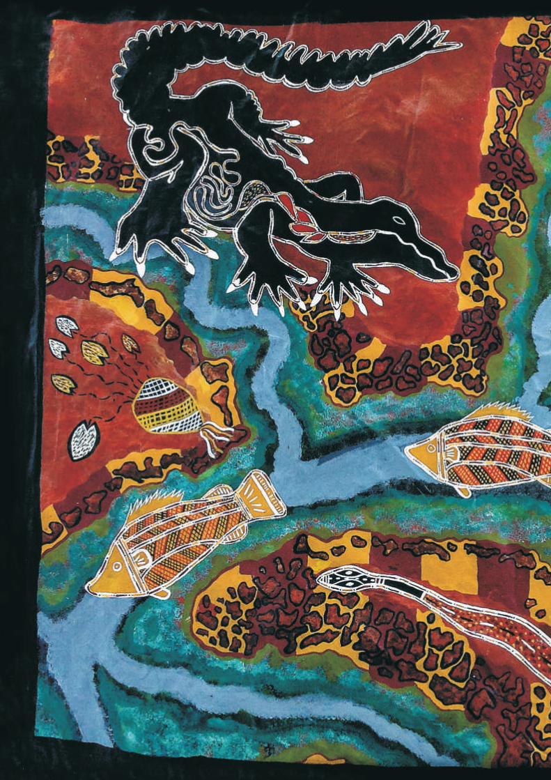
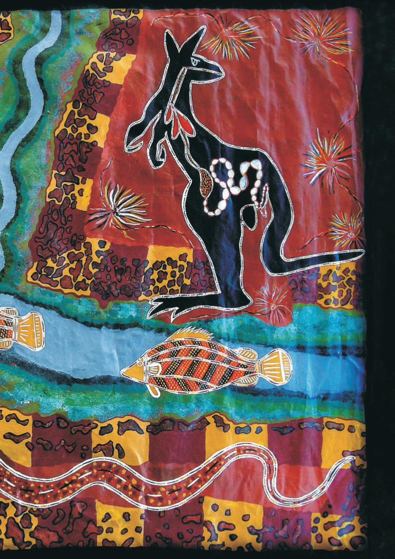
Centre insert artwork: Gulf Tribes - This original artwork was produced by Barry George. It shows what Gkuthaarn Kukatj country means for himself as a Kukatj man – the importance of the rivers, the kangaroo, crocodile, snake, barramundi, and lotus plant and the lands that connect Gkuthaarn and Kukatj people with their Kurtijar neighbours.
AcknowledgmentsThis Land and Saltwater Country Plan was developed by Gkuthaarn and Kukatj People with the support of the Carpentaria Land Council Aboriginal Corporation and facilitated by consultants Melanie Dulfer-Hyams and Dermot Smyth.
Sincere thanks to all Gkuthaarn and Kukatj Traditional Owners who attended planning meetings, contributed their knowledge, experience, ideas and concerns, and who reviewed drafts of the Plan. Thank you to Neil Banjo, Hedrick Bee, June Bee, Pauline Bee, Veronica Bee, Denise Brown, Barry George, Caine George, Derek George, Effie George, Francine George, Laurie George, Lawrie George Junior, Marcus George, Merna George, Phillip George, Rebecca George, Roslin George, Margaret Geordie, Claude Logan, Marlene Logan, Paul Logan, Paul Richardson, Kenny Sambo, Reggie Sambo, Susan Sambo, Cathy Snow, Gavin Toby, and Hilda Toby.
Special thanks also to all of the Normanton Indigenous Land and Sea Rangers, and their Coordinator Mark Hogno for their valuable contribution to arranging and supporting planning meetings and providing important information and photographs included in the Plan. Without the support of all the CLCAC Normanton Rangers it would not have been possible to complete this planning process so smoothly and effectively.
Thanks and acknowledgment also to the Northern Gulf Resource Management Group and the Queensland Government for their contribution to funding the development of this Plan.
Photo acknowledgments: Photos supplied by Australian Government Department of the Environment; the Carpentaria Land Council Aboriginal Corporation; Commonwealth Scientific and Industrial Research Organisation; D. Smyth; Fisheries Research and Development Organisation; Gkuthaarn and Kukatj Traditional Owners; M. Dulfer-Hyams; M. Heithaus; Queensland Government Department of Agriculture, Fisheries and Forestry; Queensland Government Department of Environment and Heritage Protection; Queensland Government Department of National Parks, Recreation, Sport and Racing; R. Jaensch; Seagrass Watch; and the Western Australian Government Department of Fisheries.
Further InformationCopies of this Plan and further information about implementation of the Plan are available from:
Carpentaria Land Council Aboriginal Corporation11 Wurrup Street, PO Box 464, Normanton QLD 4890
www.clcac.com.au
It depicts jabirus and barramundi, which are seen throughout the Gulf region and all over the top end of Australia. They are the artist’s favourite animals.
1
Dedication ............................................................................................................................ 3
Vision for Gkuthaarn and Kukatj Land and Saltwater Country ........................................... 4
1 Introduction.................................................................................................................... 5
2 Gkuthaarn and Kukatj People and Country ................................................................... 6
3 Our Shared History ........................................................................................................ 9
4 Native Title Claim and Existing Tenures ..................................................................... 11
5 Why Our Country is Important to Us .......................................................................... 14
6 Conservation Significance of Country......................................................................... 15
7 Using and Managing Gkuthaarn Kukatj Country ........................................................ 22
8 Threats to Country ....................................................................................................... 35
9 Priority Actions ............................................................................................................ 39
10 Partnerships and Implementation................................................................................. 44
References and Further Reading ........................................................................................ 48
CONTENTS

2
3
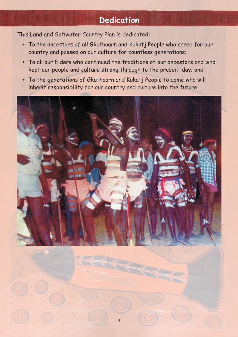
Dedication
This Land and Saltwater Country Plan is dedicated:
! To the ancestors of all Gkuthaarn and Kukatj People who cared for our
country and passed on our culture for countless generations;
! To all our Elders who continued the traditions of our ancestors and who
kept our people and culture strong through to the present day; and
! To the generations of Gkuthaarn and Kukatj People to come who will
inherit responsibility for our country and culture into the future.

4
Vision for Gkuthaarn and Kukatj Land and Saltwater Country
Our vision is to acknowledge, respect, and care for our land and saltwater country so that we can give strength to our identity and connection to country for generations to come.
Gkuthaarn and Kukatj people have made a commitment to:! Protect our culture on country; ! Sustainably use our natural resources; ! Work with the wider community to sustainably manage country;! Strengthen our relationship with local industries to support healthy
country;! Provide our younger generations with true connection to country;! Care for country so that is can support our people, and the community,
for generations to come.
Gkuthaarn and Kukatj Traditional Owners attending a planning meeting in Normanton, February 2014Front row (L-R): Laurie George, Marcus George, Susan Sambo, Effie George
Middle row (L-R): Phillip George, Barry George, Pauline Bee, Marlene Logan, Veronica BeeBack row (L-R): Kenny Sambo, Hendrick Bee, Paul Richardson, Derek George, Neil Banjo, Claude Logan
“Country has always been there, and is still with us.”

5
1. Introduction
We, the Gkuthaarn and Kukatj people, have developed this Land and Saltwater Country Plan to:
! Identify the important values of Gkuthaarn and Kukatj land and saltwater country and promote an understanding of the threats to those values;
! Communicate our vision, aspirations and commitments to sustainably use and manage Gkuthaarn and Kukatj land and saltwater country; and
! Set out priority activities to achieve our vision, aspirations and commitments in collaboration with government agencies, pastoralists, fishing organisations, research institutions and other partner organisations.
The Gkuthaarn and Kukatj Land and Saltwater Country Plan is a strategic document that provides a framework for our people and our partners to work together to care for all the natural and cultural values of our country, while providing a sustainable livelihood for our community and others with rights and interests in our land and saltwater country. The area covered by the plan includes the land and intertidal coastal region within our registered native title claim area (see Section 4), as well as the adjacent marine areas that are culturally and ecologically connected to our country.
The development of the Plan was facilitated by the Carpentaria Land Council Aboriginal Corporation (CLCAC) and assisted by two planning consultants in collaboration with the Normanton Indigenous Land and Sea Ranger Group (CLCAC Normanton Rangers) through the following processes:
! Initial consultation workshop with Gkuthaarn and Kukatj Traditional Owners in October 2013;
! Initial consultations with CLCAC Normanton Rangers regarding their current land and saltwater country management activities, and their concerns and aspirations for future management of country;
! Research and information collection regarding issues raised at the initial consultations;
! Preliminary discussions with government agencies and other relevant organisations
regarding potential collaboration with Gkuthaarn and Kukatj People and CLCAC Normanton Rangers in future management of our land and saltwater country;
! Preparation of a preliminary summary poster of the Land and Saltwater Country Plan for presentation and discussion at the second round of consultations with Traditional Owners and CLCAC Normanton Rangers in Normanton in February 2014;
! Preparation of a Draft Gkuthaarn and Kukatj Land and Saltwater Country Plan for presentation at the third round of consultations with Traditional Owners and CLCAC Normanton Rangers in Normanton in April 2014;
! Facilitated discussion between Traditional Owners and invited representatives of government agencies and other organisations with interests in our land and saltwater country during the April 2014 consultation workshop;
! Finalisation of the Gkuthaarn and Kukatj Land and Saltwater Country Plan based on feedback at the April consultations;
! Launch of the Gkuthaarn and Kukatj Land and Saltwater Country Plan at the implementation workshop involving Traditional Owners, CLCAC Normanton Rangers, and invited representatives of our collaboration partners.
The development of this Plan builds on existing initiatives by Gkuthaarn and Kukatj People to strengthen our connection to our land and saltwater country and to enhance our engagement in caring for our country and culture. These initiatives include:
! Registration of our native title claim in March 2013;
! Establishment of the Normanton Ranger Group in 2008, including the appointment of Gkuthaarn and Kukatj Rangers and Kurtijar Rangers (funded through the Queensland Government Wild Rivers Ranger program, now the Queensland Indigenous Land and Sea Ranger program); and
! Collaboration with researchers to better understand the natural and cultural values of our land and saltwater country.

6
2. Gkuthaarn and Kukatj People and Country
(L-R) Mr B. Richards, Rolly Gilbert, Mr Edwards, Mr Toby, Johnny Mosquito and others
Leichhardt River, Wernadinga Station
This section describes:
! Who we are as Gkuthaarn and Kukatj People;
! The extent of our country;
! Who are our neighbours;
! Environments, resources and industries on our country.
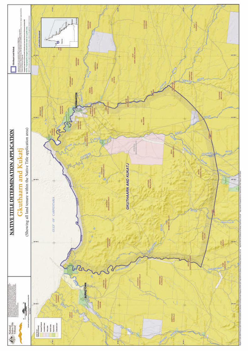
Gkuthaarn and Kukatj People are the Traditional Owners of the land, rivers and saltwater country in the south-east Gulf of Carpentaria between the Leichardt River and the Norman River, and extending about 100 km inland – see map page 8.
Some Traditional Owners gain their identity more from their Gkuthaarn ancestors, while others gain their identity more from their Kukatj ancestors, but we are one people with responsibility for looking after our land and saltwater country together.
Our traditional society was based on patrilineal clans associated with and responsible for specific totemic sites and other culturally and economically important places and areas, and which formed the basis for our law and cultural practices, including rules for selecting marriage partners and the wider kinship structure.
collaboration between Ranger groups, participationin the pastoral industry, sporting competitions and other cultural, social and economic activities.
Our neighbouring coastal Traditional Owner groups are the Gangalidda People to the west and the Kurtijar People to the east. Traditionally our interaction with our neighbours included trading networks and kinship ties through marriage. These links continue to the present day and have expanded to include governance of the Carpentaria Land Council Aboriginal Corporation,
Gkuthaarn Kukatj country has a wet-dry tropical climate, with the majority of the rainfall associated with the monsoonal trough occurring from November through to March. The dry season months (April to September) are accompanied by strong south-easterly trade winds while the wet season typically has lighter winds from the north. This region is prone to severe tropical cyclones during the wet season.
Gkuthaarn and Kukatj country contains many different environments and resources that sustained our people for thousands of years. The fish, crab and shellfish resources of the rivers and estuaries, especially the Norman River, are particularly important to us, but our people also took care of and sustainably used resources of the extensive woodlands, grasslands, escarpments and sandstone ranges of the Gulf plains as well as the
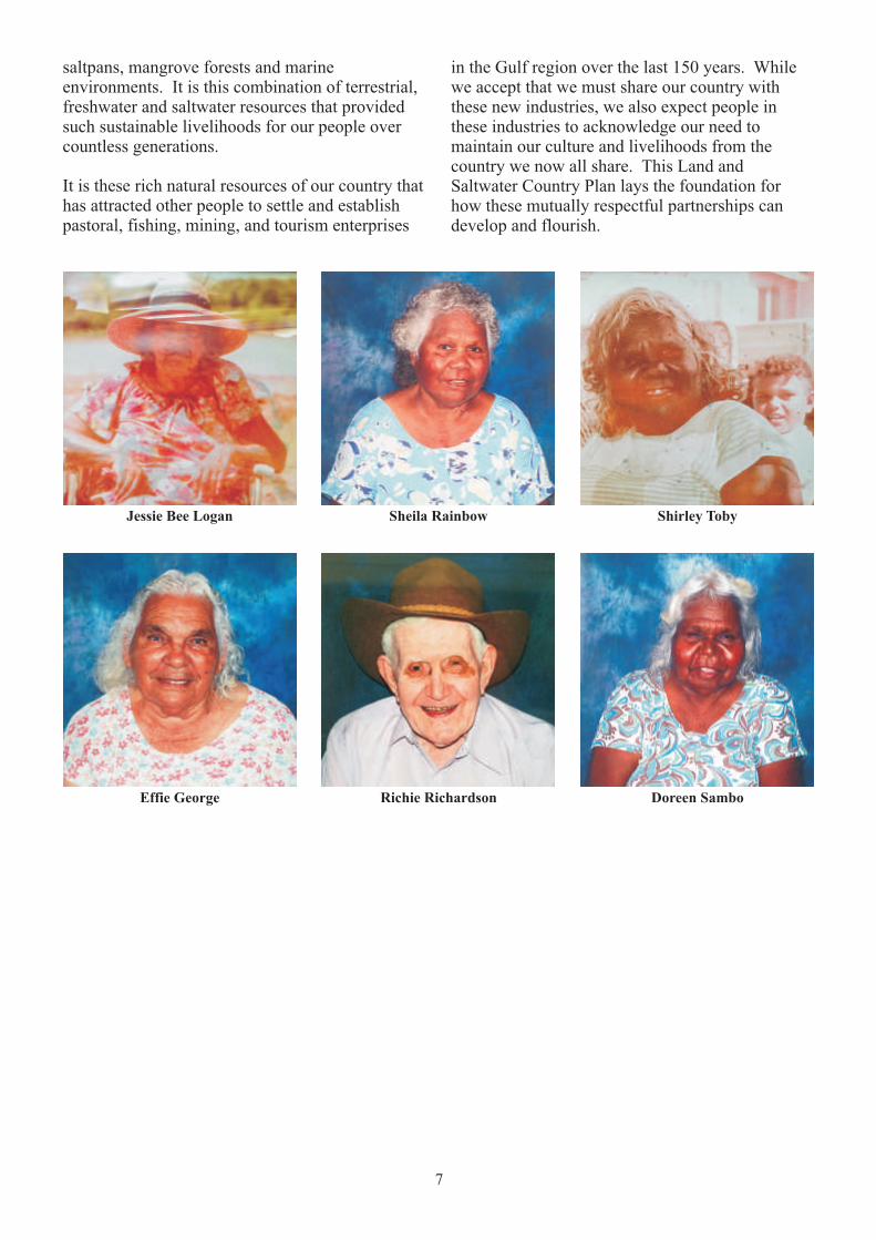
7
Jessie Bee Logan
saltpans, mangrove forests and marine environments. It is this combination of terrestrial, freshwater and saltwater resources that provided such sustainable livelihoods for our people over countless generations.
It is these rich natural resources of our country that has attracted other people to settle and establish pastoral, fishing, mining, and tourism enterprises
in the Gulf region over the last 150 years. While we accept that we must share our country with these new industries, we also expect people in these industries to acknowledge our need to maintain our culture and livelihoods from the country we now all share. This Land and Saltwater Country Plan lays the foundation for how these mutually respectful partnerships can develop and flourish.
Sheila Rainbow Shirley Toby
Effie George Richie Richardson Doreen Sambo

9
3. Our Shared History
This section describes:
! The arrival of Europeans and their impacts on our people, culture and country;
! Our involvement in the in cattle industry;
! History of Normanton Reserve (R78/R79);
! Past and current life in Normanton;
! Recent developments, including the registration of our native title claim, establishing CLCAC Normanton Rangers, and the development of this Land and Saltwater Country Plan.
In the 1600s, European 'explorers' passed along the coast of the Gulf of Carpentaria, and then by land into our country in the 1840-60s. Burke and Wills
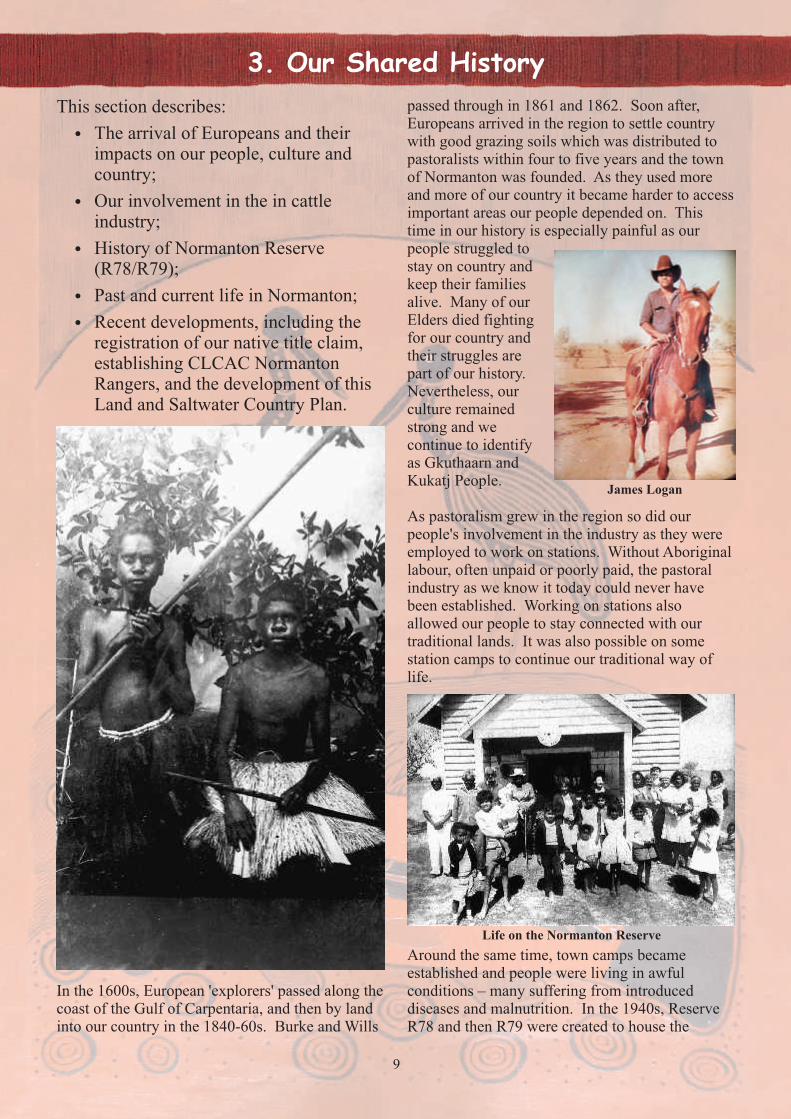
passed through in 1861 and 1862. Soon after, Europeans arrived in the region to settle country with good grazing soils which was distributed to pastoralists within four to five years and the town of Normanton was founded. As they used more and more of our country it became harder to access important areas our people depended on. This time in our history is especially painful as our people struggled to stay on country and keep their families alive. Many of our Elders died fighting for our country and their struggles are part of our history. Nevertheless, our culture remained strong and we continue to identify as Gkuthaarn and Kukatj People.
As pastoralism grew in the region so did our people's involvement in the industry as they were employed to work on stations. Without Aboriginal labour, often unpaid or poorly paid, the pastoral industry as we know it today could never have been established. Working on stations also allowed our people to stay connected with our traditional lands. It was also possible on some station camps to continue our traditional way of life.
James Logan
Life on the Normanton Reserve
Around the same time, town camps became established and people were living in awful conditions – many suffering from introduced diseases and malnutrition. In the 1940s, Reserve R78 and then R79 were created to house the

10
Despite what has happened in the past, we still hold connection to our traditional culture, lands, rivers and saltwater country. We feel a strong responsibility to continue to look after it for our future generations. In 1997, we became signatories of the Gulf Communities Agreement (GCA) – the Agreement about land use and benefit-sharing between four Indigenous Groups, the MMG Mining Company developing Century Mine and the State of Queensland. From the GCA, we joined the Century Environment Committee Century Liaison Advisory Committee, and Gulf Aboriginal Development Corporation to support Gkuthaarn and Kukatj Traditional Owner interests. In 2008, the CLCAC Normanton Ranger group was established to help us manage our country together with our neighbouring Traditional Owner groups and other partners. In 2013, our native title claim was registered. We are also represented by several local Traditional Owner organisations.
The development of this Land and Saltwater Country Plan is the next important step on our Remains of one of the Normanton Reserve buildings
journey to honour our cultural obligations and commitment to take care of Gkuthaarn and Kukatj country, people and culture and to help to guide the sustainable development of our people and country in collaboration with our government, community and industry partners.
growing number of families that were being pushed off country. For decades our people lived here with other neighbouring Aboriginal groups who had also been removed from their country. Life was hard for our people here as they suffered many injustices and exclusion from the developing society in Normanton.
However, many of us also have good memories of our time together at the reserve. In 1996, the four parcels of the former reserve were turned into Thawil Thuddawaarn Pikew Reserve and held by the Normanton Aboriginal Land Trust for the benefit of our people and descendants.
Thawil Thuddawaarn Pikew Reserve along the Norman River
Life on the Normanton Reserve
11
4. Native Title Claim and Existing Tenures
This section describes:
! Our native title claim, including the claim area and our claimed native title rights and interests;
! Opportunities arising from possible co-existing native title on pastoral leases as a basis for improved access to country and enhanced collaboration with pastoralists;
! The relationship between native title, land and saltwater country planning and partnership-building for the future management of country.
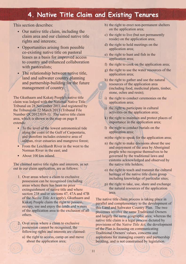
The Gkuthaarn and Kukatj People's native title claim was lodged with the National Native Title Tribunal on 28 November 2011 and registered by the Tribunal on 22 March 2013 (Tribunal File Number QC2012/019-1). The native title claim area, which is shown in the map on page 8 extends:
! To the level of the lowest astronomical tide along the coast of the Gulf of Carpentaria, and therefore includes extensive area of saltpan, river estuaries and mangrove forest;
! From the Leichhardt River in the west to the Norman River in the east; and
! About 100 km inland.
The claimed native title rights and interests, as set out in our claim application, are as follows:
1. Over areas where a claim to exclusive possession can be recognised (including areas where there has been no prior extinguishment of native title and where section 238 and/or sections 47, 47A and 47B of the Native Title Act apply), Gkuthaarn and Kukatj People claim the right to possess, occupy, use and enjoy the lands and waters of the application area to the exclusion of all others.
2. Over areas where a claim to exclusive possession cannot be recognised, the following rights and interests are claimed:
a) the right to access, camp on and move about the application area;
b) the right to erect non-permanent shelters on the application area;
c) the right to live (but not permanently reside) on the application area;
d) the right to hold meetings on the application area;
e) the right to hunt and fish in the application area;
f) the right to cook on the application area;
g) the right to use the water resources of the application area;
h) the right to gather and use the natural resources of the application area (including food, medicinal plants, timber, stone, ochre and resin);
i) the right to conduct ceremonies on the application area;
j) the right to participate in cultural activities on the application area;
k) the right to maintain and protect places of importance in the application area;
l) the right to conduct burials on the application area;
m)the right to speak for the application area;
n) the right to make decisions about the use and enjoyment of the area by Aboriginal people who recognise themselves to be governed by the traditional laws and customs acknowledged and observed by the native title holders;
o) the right to teach and transmit the cultural heritage of the native title claim group including knowledge of particular sites;
p) the right to take, use, share and exchange the natural resources of the application area.
The native title claim process is taking place in parallel and complementary to the development of this Land and Saltwater Country Plan. The two processes involve the same Traditional Owners and largely the same geographic area; whereas the native title claim is a legal process dictated by provisions of the Native Title Act, the development of the Plan is focusing on communicating Traditional Owners' values, concerns and aspirations for managing country and partnership building, and is not constrained by legislation.
12
Gkuthaarn and Kukatj Native Title Meeting
While the native title claim is fundamentally important in achieving recognition of our inherent legal rights to occupy, use and manage our country, the Land and Saltwater Country Plan provides guidance on how we will exercise those rights in collaboration with Government agencies and other partners.
In particular we are hopeful that recognition of our native title rights and interests over the extensive pastoral lands and the commercial fishing grounds in the river estuaries and intertidal areas will lead to greater mutual understanding and collaboration with participants in the pastoral and fishing industries.
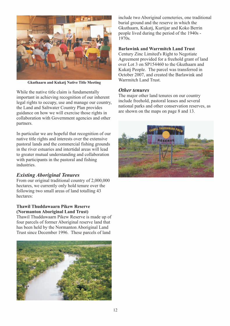
Existing Aboriginal TenuresFrom our original traditional country of 2,000,000 hectares, we currently only hold tenure over the following two small areas of land totalling 43 hectares:
Thawil Thuddawaarn Pikew Reserve (Normanton Aboriginal Land Trust)Thawil Thuddawaarn Pikew Reserve is made up of four parcels of former Aboriginal reserve land that has been held by the Normanton Aboriginal Land Trust since December 1996. These parcels of land
include two Aboriginal cemeteries, one traditional burial ground and the reserve in which the Gkuthaarn, Kukatj, Kurtijar and Koko Berrin people lived during the period of the 1940s - 1970s.
Barlawink and Warrmitch Land TrustCentury Zinc Limited's Right to Negotiate Agreement provided for a freehold grant of land over Lot 3 on SP154460 to the Gkuthaarn and Kukatj People. The parcel was transferred in October 2007, and created the Barlawink and Warrmitch Land Trust.
Other tenuresThe major other land tenures on our country include freehold, pastoral leases and several national parks and other conservation reserves, as are shown on the maps on page 8 and 13.
13
(Sho
win
g al
l la
nd t
enur
e w
ithi
n th
e N
ativ
e T
itle
app
lica
tion
are
a)
14
5. Why Our Country is Important to Us
“For us down here, the rivers are important
for community” Francine George
This section describes why our country is important to us for:
! Our identity;
! Our livelihood, food, water, medicines;
! Our sacred sites and stories;
! Our cultural knowledge and practices.
Our people and our country are interconnected. It is important for us that country is healthy, and that the younger generations have the same opportunities to know, use and manage the land and rivers as our Elders did. The health of our country and our continuing connection to it gives our younger generations their identity.
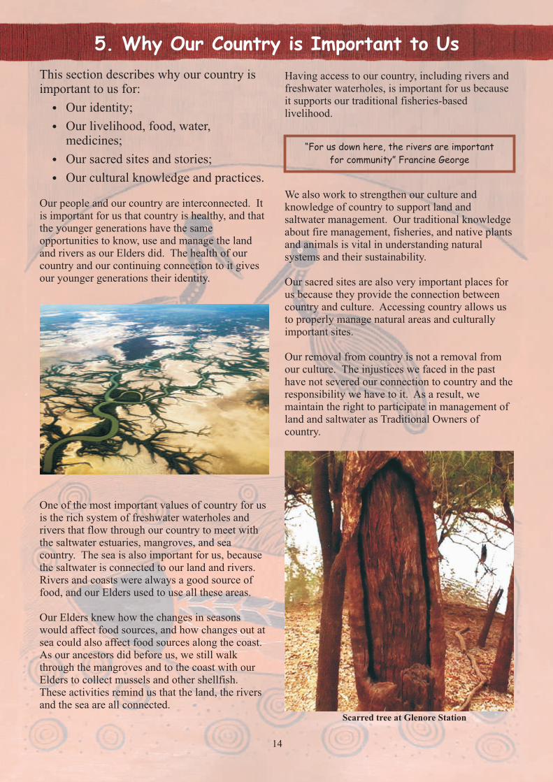
One of the most important values of country for us is the rich system of freshwater waterholes and rivers that flow through our country to meet with the saltwater estuaries, mangroves, and sea country. The sea is also important for us, because the saltwater is connected to our land and rivers. Rivers and coasts were always a good source of food, and our Elders used to use all these areas.
Our Elders knew how the changes in seasons would affect food sources, and how changes out at sea could also affect food sources along the coast. As our ancestors did before us, we still walk through the mangroves and to the coast with our Elders to collect mussels and other shellfish. These activities remind us that the land, the rivers and the sea are all connected.
Having access to our country, including rivers and freshwater waterholes, is important for us because it supports our traditional fisheries-based livelihood.
We also work to strengthen our culture and knowledge of country to support land and saltwater management. Our traditional knowledge about fire management, fisheries, and native plants and animals is vital in understanding natural systems and their sustainability.
Our sacred sites are also very important places for us because they provide the connection between country and culture. Accessing country allows us to properly manage natural areas and culturally important sites.
Our removal from country is not a removal from our culture. The injustices we faced in the past have not severed our connection to country and the responsibility we have to it. As a result, we maintain the right to participate in management of land and saltwater as Traditional Owners of country.
Scarred tree at Glenore Station

15
6. Conservation Significance of Country
This section describes:
! Why our country is important to the region, Queensland, Australia and the world;
! Particular species, environments and areas on our land and saltwater country that have special conservation significance.
Gkuthaarn Kukatj country is made up of impressive natural systems that are unique and support distinct ecosystems and our people. Our country is not only important for us, but holds regional, national and international significance for its conservation values. There is value in the far-reaching river systems that run through country and drain northward into the Gulf of Carpentaria; the estuarine ecosystems that support juvenile fisheries and rich biodiversity; the alluvial plains that shape our coasts; and the grasslands, forests and savannah landscapes. These distinct natural features are also what support the region's main industries. The native pastures support the region's cattle grazing industry, and the estuarine wetlands and watersheds support the commercial and recreational fishing industries.
Gulf Plains Bioregion
Gulf Plains BioregionOur country lies within the Gulf Plains Bioregion, an area dominated by extensive coastal wetlands, alluvial plains, and tropical savannah vegetation.
The land zones within the Gulf Plains include:! Tidal flats and beaches! Coastal dunes! Alluvium (river and creek flats)! Old loamy and sandy plains! Ironstone jump-ups! Basalt plains and hills! Undulating country on fine grained
sedimentary rocks! Sandstone ranges! Hills and lowlands on metamorphic rocks! Hills and lowlands on granitic rocks

16
There are 84 regional ecosystems within the Gulf 1Plains bioregion, three of which are listed as
endangered and 32 of which are 'of concern' under the Queensland Vegetation Management Act 1999. There are also 35 threatened ecosystems in the region, most of which are in decline and 19 of which do not occur anywhere else in the world.
Cattle grazing on native pastures (within pastoral leases) covers approximately 93% of the Gulf Plains Bioregion, and also a large part of Gkuthaarn Kukatj country. Grazing areas have a wide variety of soils, ranging from relatively infertile saline coastal plains to clays and alluvial soils from the wide floodplains and channels of far-reaching alluvial plains and major rivers. Gkuthaarn Kukatj country covers subregions classified by dominant landscape-scale attributes, and includes Donors plateau, Woondoola plains and Karumba plains. Common regional ecosystems in the area include blue grass to browntop grasslands (Woondoola plains and Donors plateau). The diversity of landscapes across the region also drives biodiversity. For example, the diversity of fauna found on grazing properties is usually high. Management of biodiversity across these landscapes is very important to us because it supports ecosystem services that are valued by ourselves as well as others using our country.
There are 44 flora and fauna species listed as rare or threatened in the Gulf Plains Bioregion. This includes 27 animal species, 10 of which are
Animal Species Class NCA Act EPBC Act 1992 (Qld) 1999 (Cth)
E C PEV
– endangered; – least concern; – extinct in the wild;and – vulnerable
Australian painted snipe birds V E
Beach stone-curlew birds V
Black-throated finch birds E E
Brush-tailed tree-rat mammals C V
Crimson finch birds E V
Dugong mammals V
Estuarine crocodile reptiles V
Flatback turtle reptiles V V
Freshwater sawfish cartilaginous Vfishes
Ghost bat mammals V
Golden-shouldered parrot birds E E
Gouldian finch birds E E
Green turtle reptiles V V
Hawksbill turtle reptiles V V
Julia Creek dunnart mammals E E
Little tern birds E
Loggerhead turtle reptiles E E
Masked owl birds V V
Mount Cooper striped lerista reptiles V V
Olive Ridley turtle reptiles E E
Painted honeyeater birds V
Purple necked rock wallaby mammals V
Purple-crowned fairy-wren birds V
Red goshawk birds E V
Squatter pigeon birds V V
Yellow chat birds V
Yellow chat (gulf) birds V
1 Regional ecosystems 2.3.39 (Springs on recent alluvium); 2.10.3 (Eucalyptus spp., Corymbia citriodora and Eucalyptus acmenoides open forest on high plateaus on earths and sands); and 2.10.8 (Springs associated with quartzose sandstone or lateritised sandstone gullies and gorges)
Table: Animal species listed as rare or 3
threatened within the Gulf Plains Bioregion
2 Oldenlandia spathulata, Eriocaulon carsonii and Eriocaulon carsonii subsp. orientale3 EHP (2014)
considered endangered (see table); and 11 plant 2species, three of which are endangered .
17
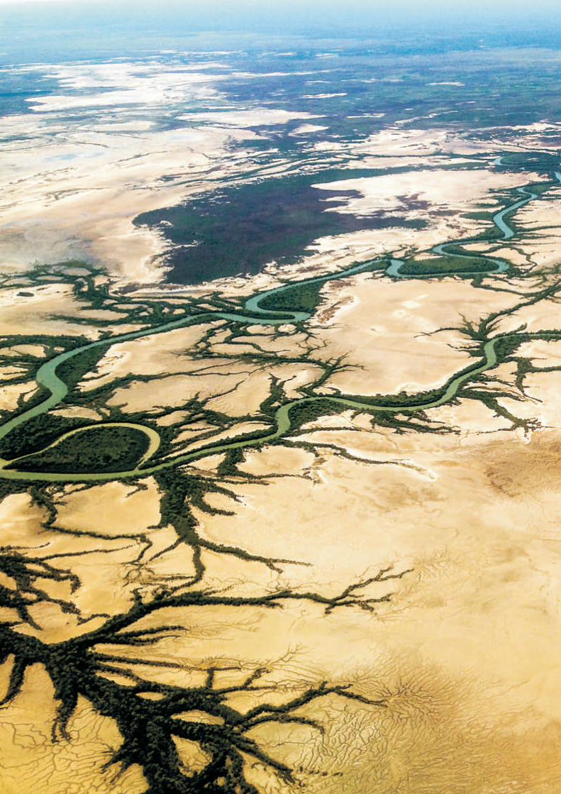
Wetland AreasWetlands on Gkuthaarn Kukatj country are part of three larger catchments that drain into the southern Gulf of Carpentaria - the Flinders River catchment, Leichhardt River catchment, and Morning Inlet catchment.
Our coastline and estuarine wetland systems are part of the Southern Gulf Aggregation, an internationally significant migratory and shore bird wetland area and the largest continuous estuarine wetland in northern Australia. It is also listed
under the Directory of Important Wetlands in Australia (DIWA) as nationally important.
On Gkuthaarn Kukatj country, Mutton Hole Wetland Conservation Park, Morning Inlet Wild River Area, and Morning Inlet Fish Habitat Area have significant conservation value.
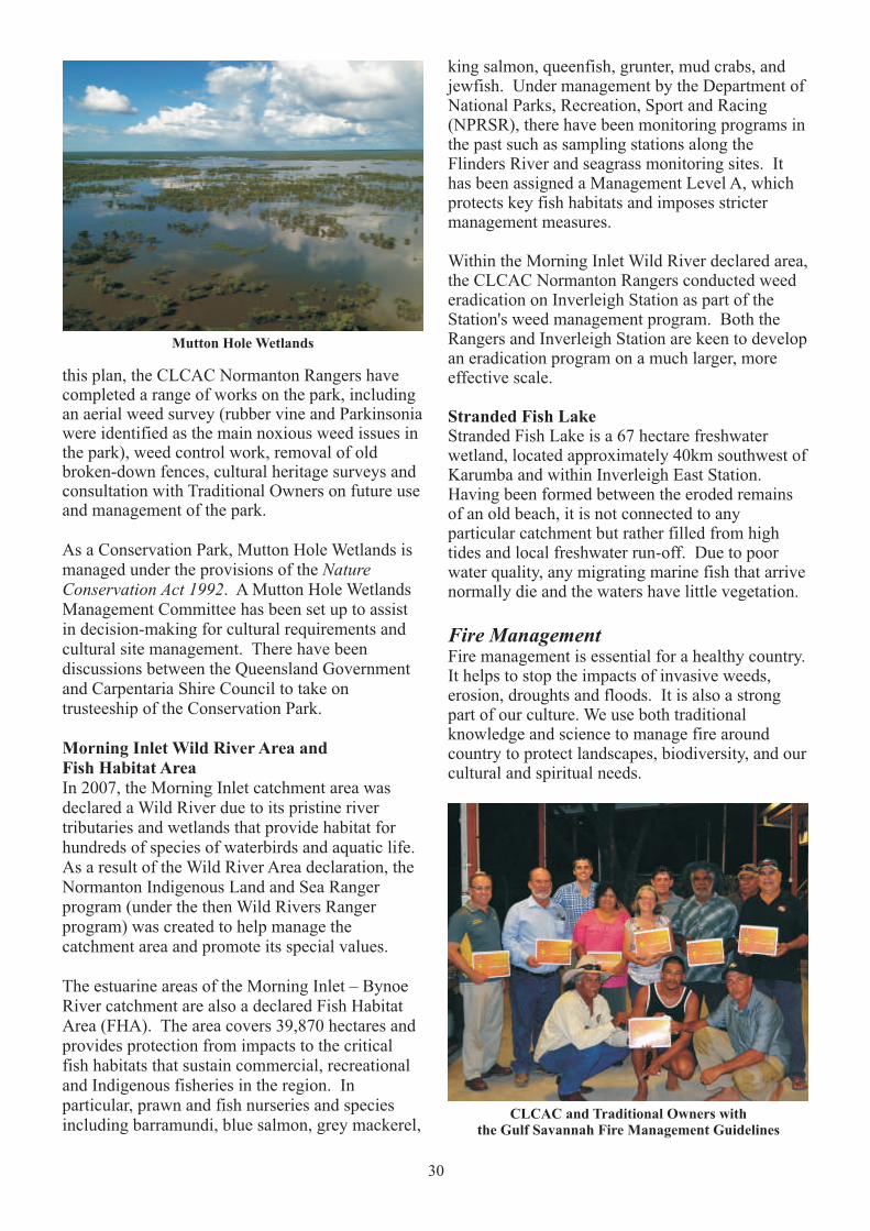
Forming the eastern edge of the Southern Gulf Aggregation is the Mutton Hole Wetland Conservation Park (7,860 hectares), a complex system of estuarine and freshwater wetlands. Previously part of Mutton Hole Station's cattle grazing land, it is now listed on the Register the National Estate as a natural indicative place. Lying within the Norman River Catchment, the hydrology of the wetland is complex with tidal influences from the southern Gulf of Carpentaria, and rainfall and flood all affecting the wetland's numerous creeks, channels, lagoons and gilgai hollows (small, shallow depressions).
Vegetation types within Mutton Hole Wetland include saltmarsh, open grassy eucalypt woodland, gutta percha scrub, freshwater lagoon shoreline, riparian zone, and saline mudflat and mangrove fringes. Aquatic life – marine prawns, fish, macro invertebrates – are abundant and vary between different locations and wet and dry seasons. The wetlands also provide habitats for migratory shorebirds, waterbird colonies and bush birds.
Karumba coastline, Gulf of Carpentaria
Mutton Hole wetlands
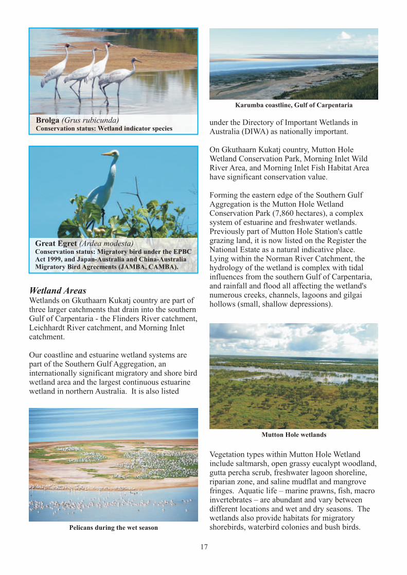
Brolga (Grus rubicunda)Conservation status: Wetland indicator species
Great Egret (Ardea modesta)Conservation status: Migratory bird under the EPBC Act 1999, and Japan-Australia and China-Australia Migratory Bird Agreements (JAMBA, CAMBA).
Pelicans during the wet season
18
The Morning Inlet Fish Habitat Area covers coastal and intertidal wetlands between and including Morning Inlet and Bynoe River, and is important for protecting the important diversity of fish in the area, such as barramundi, queenfish, king salmon and grey mackerel, as well as the local mangrove communities. Rare and threatened species such as Worrells turtle, the red goshawk, Gouldian finch and estuarine crocodile all inhabit this beautiful area. Commercial, recreational and Indigenous fisheries are managed within the area as it is an important prawn and fish nursery, which is dependent on the natural flows to ensure the health of fisheries. Part of the area is protected under the Wild Rivers Act 2005.
Rivers and estuariesThe ecology of the freshwater sections of rivers within Gkuthaarn Kukatj country has not been well studied, in comparison to the saltwater estuary systems that have been better researched to support management of the commercial fisheries in those environments.
The East Asian-Australasian Flyway: One of nineglobally recognized major migratory routes
Estuarine mangroves and freshwater wetlands along rivers of the Gulf Plains bioregion provide habitat for waterbird breeding colonies. Over a five-year period (2009-2013), Wetlands International worked with the CLCAC Normanton Ranger Group to conduct a study that recorded 32 active colonies in the region, most of which met globally accepted criteria for international importance. Eleven waterbird species were among
the colonies including royal spoonbill, little egret and pied heron. In particular, several surveyed colonies in the bioregion meet Ramsar Convention on Wetlands criteria as the colonies provide habitats for critical stages in waterbird life cycles, and some sites support at least 20,000 waterbirds and/or at least 1% of the total size of a waterbird
4population . Such a high concentration of breeding colonies is presently unknown elsewhere in tropical Australia other than in the Top End of Northern Territory.
The intertidal mudflats and saltmarshes of the south-east Gulf of Carpentaria provide a near-continuous shorebird habitat extending for about 350km along the Gulf Coast. This area is recognised as the third most important site for migratory shorebirds in Australia and is of outstanding importance. It is internationally important for 16 shorebird species and supports well in excess of 20,000 individual shorebirds.
Location of bird colonies inSoutheast Gulf of Carpentaria
4 Jaensch (2013), p7

However, a survey of the freshwater fish fauna of 5the Norman River undertaken in 2006 concluded
that there is a total of 48 freshwater fish species living in the river, including 7 species not previously recorded in the catchment and an undescribed eel-tailed catfish, goby and river sprat. Of particular conservation significance are the freshwater sawfish and the freshwater whipray.
Freshwater sawfishConservation status: critically endangeredThe freshwater sawfish was once widely distributed in the Indo-Pacific region but is now virtually extinct in most of its range due to over-fishing – especially for shark-fin soup and Chinese medicinal purposes. This species is now only found in rivers and estuaries across northern Australia, including the rivers in Gkuthaarn Kukatj country (see map below).
Freshwater whiprayConservation status: data deficientThe freshwater whipray is a rare, recently described species of ray found in rivers and estuaries across northern Australia, including Gkuthaarn Kukatj country, but its distribution and abundance is poorly known.
6Recent research has demonstrated the ecological and economic linkages between all these terrestrial, freshwater and saltwater environments of Gkuthaarn Kukatj country, including the importance of maintaining freshwater flows into the river estuaries for the health and sustainability of estuarine fish populations.
Research undertaken by the Southern Gulf Catchment Group in 2005 found that bore drains (small artificial wetlands associated with water bores often installed many decades ago), may be providing habitat for an undescribed fish species, indicating that some man-made environments on Gkuthaarn Kukatj country may have conservation significance.
SeagrassSeagrass meadows on Gkuthaarn Kukatj saltwater country near the port of Karumba are the most significant seagrass habitats in the south-east Gulf. They provide essential food sources for dugongs and several marine turtle species of high cultural and scientific significance. Seagrass communities also provide ecological functions in the coastal zone including provision of primary productivity in the marine environment and nursery habitat for key fisheries species. The extent and health of seagrass habitats also provide important indicators of the health of intertidal and marine environments more broadly.
19
The Norman River
6 Halliday and others (2012)5 Burrows and Pern, C. (2006)
Known distribution of freshwater sawfish in Australia

20
7 McKenna and Rasheed (2011)8 Kennett and others (2004)
Green Turtle
While Gkuthaarn and Kukatj people obtain most of their aquatic livelihood resources from our rivers and estuaries, dugongs and marine turtles are culturally significant animals to us, and it is our responsibility to ensure that the seagrasses and water quality in our saltwater country continue to remain healthy and clean to support dugongs and all marine turtle species.
7Research undertaken in 2010 indicates that the seagrass meadows near Karumba were in good condition, but will require regular monitoring to ensure port dredging and commercial shipping are not adversely impacting on this critical component of our saltwater country.
Dugongs and marine turtlesSurveys undertaken over the last decade indicate that the Gulf of Carpentaria is one of Australia's and the world's most significant environments for dugongs, supporting a total population of about 12,500 individual, of which about 4,000 are located in the eastern Gulf.
Six of Australia's seven marine turtle species are found in the Gulf of Carpentaria, including a particularly significant population of green turtles.
8Genetic studies of green turtle populations have shown that green turtles found in the Gulf of Carpentaria only move between feeding grounds, mating areas and nesting beaches within the Gulf itself – they do not migrate long distances around the Australian coastline or internationally as other Australian green turtle populations do. This means that all Traditional Owner groups around the Gulf have a special responsibility to collectively take care of the green turtle habitats on their saltwater country to ensure the survival of this most important species.
© Seagrass Watch
21
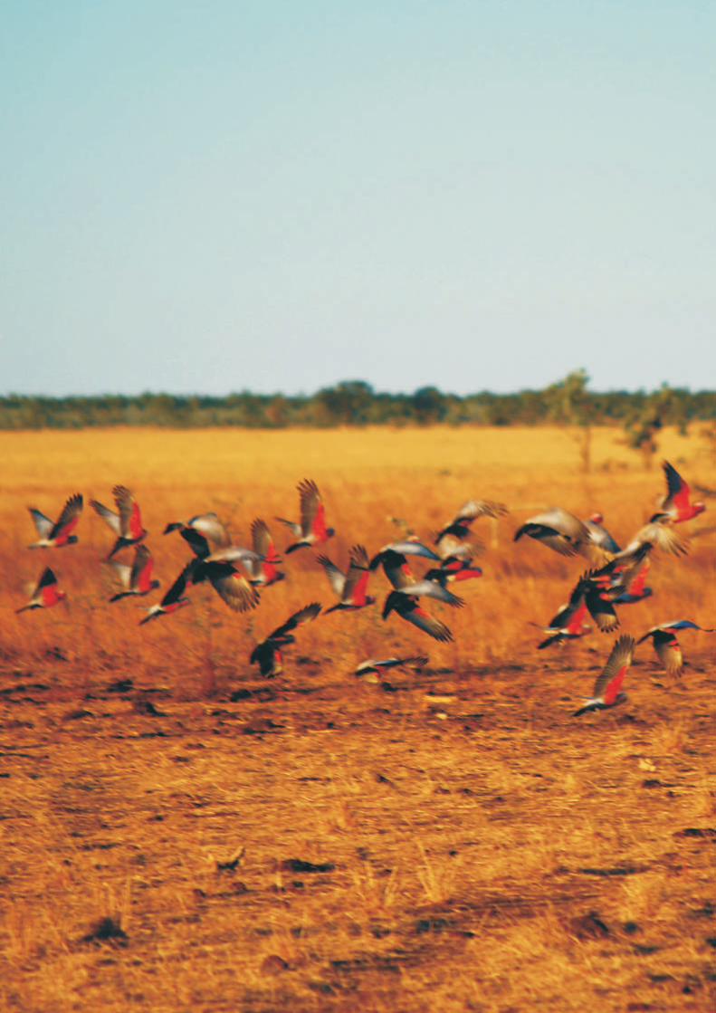
Biodiversity Snapshots from Gkuthaarn and Kukatj Country
Far eastern curlewBlack swan
Gilbert's dragon Rainbow bee-eater
Red kangaroo Centralian blue tongue
Galah (rose-breasted) cockatoo Brolga
22
7. Using and Managing Gkuthaarn Kukatj Country
Under section 14 of the Fisheries Act 1994 (Qld), a Traditional Owner acting under their local Aboriginal tradition is permitted to take, use or keep fisheries resources, or use fish habitats, for personal, domestic or non-commercial communal need.
If a larger supply of fish is needed for ceremony or cultural events, Traditional Owners can apply for a General Fisheries Permit to use fishing gear that is larger (for example - nets).
Taking or using fisheries resources is permitted as long as it is carried out with recreational or traditional fishing gear.
Permitted fishing gear includes:
! Cast net up to 3.7 metres, scoop net (maximum size 2m) and seine net up to 16m;
! A maximum of four crab pots, dillies or collapsible traps;
! Three fishing lines with no more than six hooks;
! A handheld fork for taking worms, a hand pump for yabbies and a shell dredge for molluscs;
! A spear or spear gun.
This section describes how Gkuthaarn Kukatj country is used and managed today, including:
! Indigenous fishing;
! Recreational fishing;
! Commercial fishing;
! Pastoral industry;
! Mining;
! Tourism;
! Urban development and infrastructure;
! Protected areas;
! Fire Management;
! Normanton Ranger Group:
#Patrolling land and saltwater country;
#Controlling pest plants and animals;
#Caring for cultural sites;
#Monitoring turtle nests;
#Removing marine debris.
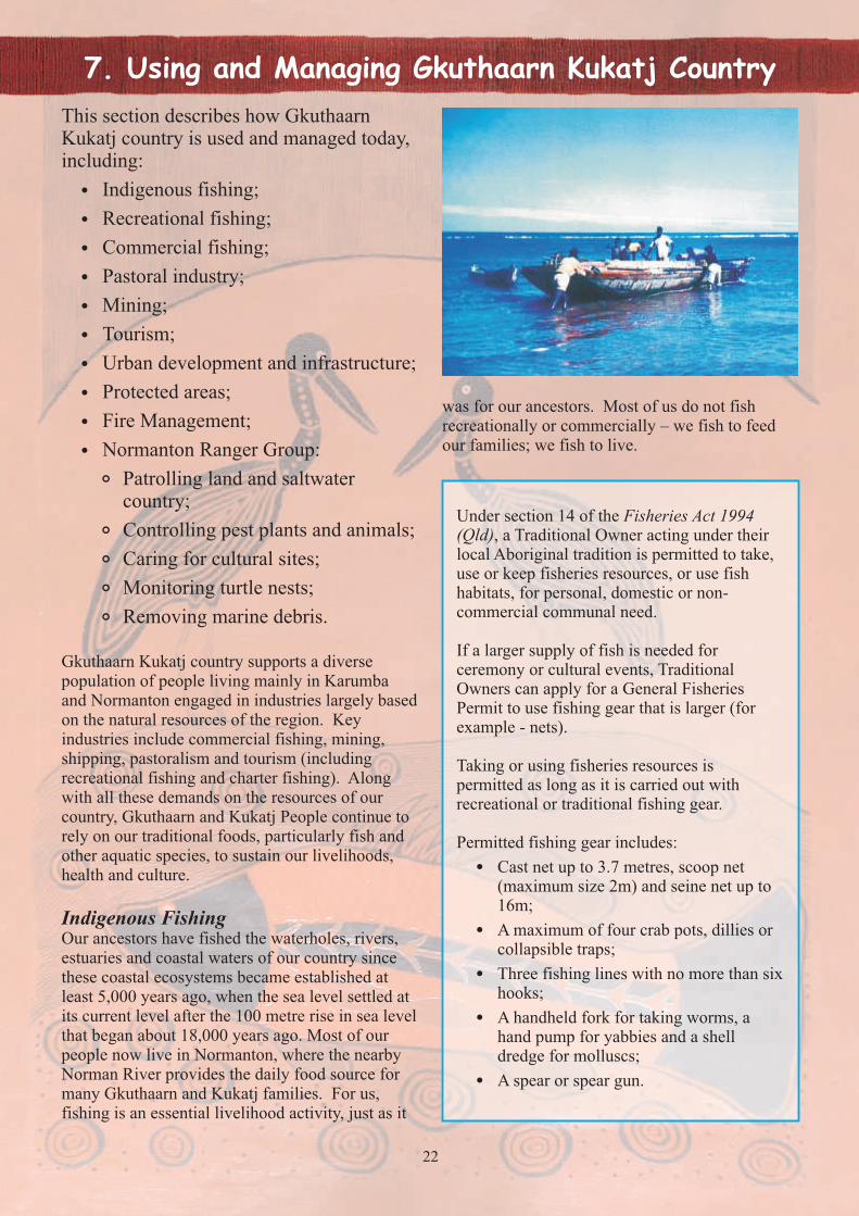
Gkuthaarn Kukatj country supports a diverse population of people living mainly in Karumba and Normanton engaged in industries largely based on the natural resources of the region. Key industries include commercial fishing, mining, shipping, pastoralism and tourism (including recreational fishing and charter fishing). Along with all these demands on the resources of our country, Gkuthaarn and Kukatj People continue to rely on our traditional foods, particularly fish and other aquatic species, to sustain our livelihoods, health and culture.
Indigenous FishingOur ancestors have fished the waterholes, rivers, estuaries and coastal waters of our country since these coastal ecosystems became established at least 5,000 years ago, when the sea level settled at its current level after the 100 metre rise in sea level that began about 18,000 years ago. Most of our people now live in Normanton, where the nearby Norman River provides the daily food source for many Gkuthaarn and Kukatj families. For us, fishing is an essential livelihood activity, just as it
was for our ancestors. Most of us do not fish recreationally or commercially – we fish to feed our families; we fish to live.
23
The Queensland Fisheries Act 1994 recognises Indigenous fishing as distinct and separate from commercial and recreational fishing. Section 26(1)(a) of the Act seeks to ensure the “fair division of access to fisheries resources for commercial, recreational and indigenous use”.
Until recently these provisions in the Act were developed further in the Gulf of Carpentaria Fin Fish Management Plan, which required that the fishery is managed to ensure “adequate access to fin fish under Aboriginal tradition”. The Management Plan also required the then Queensland Fisheries Management Authority to:
! Undertake surveys of Aboriginal participation in fishing and an agreed consultation process with Aboriginal fishers by 2002; and
! To review the Fin Fish Management Plan ifa survey of participation in traditional or customary fishing shows a significant decline in catches or participation.
Regrettably, the promised surveys of Aboriginal participation did not take place and the Gulf Inshore Fin Fish Management Plan is no longer in effect. Despite the vital importance of fishing in our daily lives, the Indigenous fishery remains poorly understood, undervalued and generally neglected by the current fisheries management arrangements in the Gulf. Options to address this unacceptable situation are proposed as one of our urgent priority actions in section 9 of this Plan.
We note that our rights to access our traditional fishery resources, and our bush tucker on land, are protected under the Convention of Biological Diversity and the United Nations Declaration on the Rights of Indigenous Peoples, for both of which Australia is a signatory nation.
Recreational Fishing (including charter boat and fishing guide sectors)Recreational and charter boat/fishing guide sectors target barramundi, king threadfin, blue threadfin and mud crabs along with other species that include mangrove jack, fingermark bream, grunter, black jewfish, jewel fish and triple tail cod. Based on information compiled from surveys carried out in the early 2000s, 1.2% of the State's 596,800 recreational saltwater fishers indicated that they mostly went fishing in the 12 months prior to the telephone survey in the north west region, which includes the Gulf towns of Karumba, Normanton and Burketown. 46% of anglers fishing in the north west region indicated they fished for a particular species of saltwater fish, which is a higher percentage than for any other saltwater fishery region in Queensland. In the same survey, 31.8 % of anglers indicated they had fished for barramundi, 13.1% indicated they had fished for mud crabs and 9.7% indicated they had fished for blue or king threadfins.
Recreational fishers primarily use hook and line to catch target fish species and cast and seine nets to catch baitfish species. Charter boat operators use the same fishing apparatus and methods as the recreational fishery. There are restrictions on the type of fishing apparatus allowed in the recreational fishery, which can be either shore based or vessel based. Methods for line fishing are diverse and largely dependent on the target species and the location fished. However, generally lines with bait or lures attached are cast at likely fish holding areas such as snags, submerged reefs, gutters, undercut banks and tidal drainage areas. Lures are retrieved to cause a fish to strike and become hooked.
Fred Pascoe Community Fishing Place, Norman River
CLCAC Normanton Rangers preparing for boating work
Areas popular with Gulf of Carpentaria recreational fishers include mangrove-lined rivers and creeks (especially in estuaries adjacent to towns and ports), rocky and coral reef structures and foreshore gutters. Boat-based fishers either anchor and fish at a suitable site or allow the vessel to drift by likely fish holding locations to which lures are cast and retrieved.
There is a large annual migration of recreational fishers who expend weeks or months during the dry season based at Karumba concentrating their fishing effort on the Norman River and other nearby estuaries, as well as in coastal waters. While the ecological impact of this large number of recreational fishers may not be significant with regard to the state-wide populations of the target species, there is almost certainly an impact on local populations, which in turn is likely to impact on our traditional fishery.
Commercial FishingThe rivers, estuaries and marine areas of Gkuthaarn Kukatj country support a substantial commercial fishing industry, based largely at Karumba.
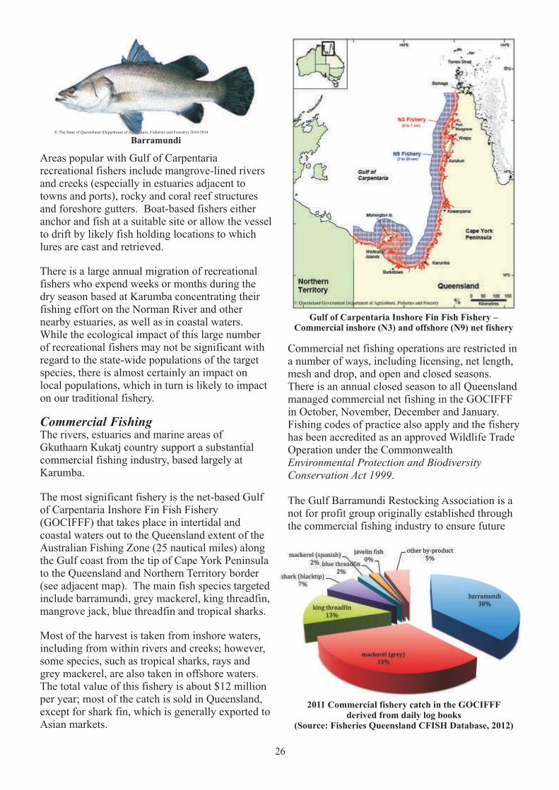
The most significant fishery is the net-based Gulf of Carpentaria Inshore Fin Fish Fishery (GOCIFFF) that takes place in intertidal and coastal waters out to the Queensland extent of the Australian Fishing Zone (25 nautical miles) along the Gulf coast from the tip of Cape York Peninsula to the Queensland and Northern Territory border (see adjacent map). The main fish species targeted include barramundi, grey mackerel, king threadfin, mangrove jack, blue threadfin and tropical sharks.
Most of the harvest is taken from inshore waters, including from within rivers and creeks; however, some species, such as tropical sharks, rays and grey mackerel, are also taken in offshore waters. The total value of this fishery is about $12 million per year; most of the catch is sold in Queensland, except for shark fin, which is generally exported to Asian markets.
26
Barramundi
Gulf of Carpentaria Inshore Fin Fish Fishery –Commercial inshore (N3) and offshore (N9) net fishery
Commercial net fishing operations are restricted in a number of ways, including licensing, net length, mesh and drop, and open and closed seasons. There is an annual closed season to all Queensland managed commercial net fishing in the GOCIFFF in October, November, December and January. Fishing codes of practice also apply and the fishery has been accredited as an approved Wildlife Trade Operation under the Commonwealth Environmental Protection and Biodiversity Conservation Act 1999.
The Gulf Barramundi Restocking Association is a not for profit group originally established through the commercial fishing industry to ensure future
2011 Commercial fishery catch in the GOCIFFFderived from daily log books
(Source: Fisheries Queensland CFISH Database, 2012)
Ó The State of Queensland (Department of Agriculture, Fisheries and Forestry) 2010-2014Ó The State of Queensland (Department of Agriculture, Fisheries and Forestry) 2010-2014

27
Since much of country is already used for grazing, some intensively, there is all the more need to look after areas that are less damaged and can be managed to conserve landscapes and biodiversity that support the industry.
The CLCAC Normanton Rangers have developed good relationships with some pastoral stations to help manage the threats of weeds and feral animals. This work not only leads to healthy country, but also supports sustainable pastoral management and local employment on country. Developing relationships with pastoralists also gives us the chance to show them why our country is important to us, how we look after it, and how important it is to visit certain sites.
A list of pastoral stations on Gkuthaarn Kukatj country, and current engagement with them is provided on the next page.
fish stocks and sustainability for industry and recreational fishing into the future. Today the restocking group has recently undergone significant changes and Carpentaria Shire Council now operate the hatchery and the Barramundi Discovery Centre. The restocking group will provide volunteer input and support for future hatchery and restocking activities to support fish stocks across the region.
A commercial crab fishery also operates in the estuaries and coastal waters of Gkuthaarn Kukatj country. Mud crabs are widely distributed throughout coastal Queensland waters. Juveniles and adults generally occupy the same habitat within sheltered estuaries, tidal reaches of mangrove-lined rivers and streams, mangrove forests and mud flats. A range of input and output controls are in place to manage the harvest of mud crabs by commercial and recreational fishers, including:
! a minimum legal size limit;! a prohibition on taking female crabs;! apparatus restrictions (50 pots per licence for
the commercial fishery and four pots per person for the recreational fishery);
! limited entry to the commercial fishery (C1 endorsement required); and
! prescriptions on the size of the float that may be used.
The Gulf of Carpentaria commercial crab harvest averages about 130 tonnes, which represents about 15% of the total Queensland mud crab fishery. At an average return of about $16/kg, the total gross value of the Gulf of Carpentaria mud crab fishery is about $2 million per year.
Pastoral IndustryOur country's native pastures have been supporting the cattle industry for over 100 years. It is a very important part of our region's economy. Many of us also work, or have worked, in the industry and value the connections to country that it provides.
There is great potential for industry growth due to international demand, but this can be stopped by a lack of port services, competition from other
regions, and damages to biodiversity and pasture due to unsustainable grazing practices. As Traditional Owners of country, we support sustainable grazing practices that will continue to look after landscape health and our communities.
Indigenous Stockmen
Ó Fisheries Research and Development Corporation, 2012
28
Gkuthaarn and Kukatj CountryPastoral stations and Traditional Owner management
Station Company Traditional Owner management of country
4 Mile Gallagher
Augustus Downs Stanbroke
Donors Hills Stanbroke
Glenore Stanbroke Water quality testing
Inverleigh East Inverleigh Prickly acacia management Pastoral Co.
Inverleigh West Arafura Prickly acacia trialsCattle Co.
Kelwood Gallagher
McAllister Stanbroke
Magowra WesternGrazing Co.
Neumayer Valley NeumayerValley Pastoral Co.
Old Glenore Private
Sawtell Creek Gallagher
Talawanta Private
Uralla Gallagher
Warren Vale Stanbroke Significant cultural site - spring
Wernadinga Private Past work with CLCAC Normanton Rangers
Wondoola AACo
Woodview Gallagher
Table: Animal species listed as rare or threatened within the Gulf Plains Bioregion.
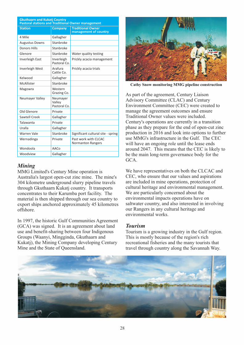
Cathy Snow monitoring MMG pipeline construction
Mining MMG Limited's Century Mine operation is Australia's largest open-cut zinc mine. The mine's 304 kilometre underground slurry pipeline travels through Gkuthaarn Kukatj country. It transports concentrates to their Karumba port facility. The material is then shipped through our sea country to export ships anchored approximately 45 kilometres offshore.
In 1997, the historic Gulf Communities Agreement (GCA) was signed. It is an agreement about land use and benefit-sharing between four Indigenous Groups (Waanyi, Mingginda, Gkuthaarn and Kukatj), the Mining Company developing Century Mine and the State of Queensland.
As part of the agreement, Century Liaison Advisory Committee (CLAC) and Century Environment Committee (CEC) were created to manage the agreement outcomes and ensure Traditional Owner values were included. Century's operations are currently in a transition phase as they prepare for the end of open-cut zinc production in 2016 and look into options to further use MMG's infrastructure in the Gulf. The CEC will have an ongoing role until the lease ends around 2047. This means that the CEC is likely to be the main long-term governance body for the GCA.
We have representatives on both the CLCAC and CEC, who ensure that our values and aspirations are included in mine operations, protection of cultural heritage and environmental management. We are particularly concerned about the environmental impacts operations have on saltwater country, and also interested in involving our Rangers in any cultural heritage and environmental works.
TourismTourism is a growing industry in the Gulf region. This is mostly because of the region's rich recreational fisheries and the many tourists that travel through country along the Savannah Way.

29
We support the sustainable development of tourism in the region and on country, and would like to be more involved to ensure our culture on country is acknowledged by all who visit our region.
Our country has a rich natural beauty that we are proud to share with locals and tourists. Our main concern is that tourism does not damage what we have for future generations. One of the biggest aims is to ensure that the future of fishing is sustainable for all fisheries – commercial, recreational and Indigenous. It is also important to us that people visiting respect the land as we respect it, and make sure that only footprints are left behind. There are also many cultural sites that are heavily impacted by tourism. Providing information about these sites and our culture is important for us because it lets us tell our story of country to people who come. We would like to continue working to see these areas protected for the benefit of all that come.
It is our cultural knowledge and skills that will support the sustainable development of tourism on country. We understand the seasonal changes and natural diversity that support tourism in the region. We would like to increase Indigenous owned businesses and employment in the local tourism industry.
The CLCAC's economic development plan, Indigenous Economic and Business Development in the Gulf of Carpentaria, identifies some of our aspirations and provides recommendations for opportunities and pathways to further develop tourism on country.
Urban development and infrastructureThe development of roads and infrastructure has improved significantly over the last 30 years with the growth of the commercial fishing industry, tourism, and mining. The region has full bitumen links on all major roads, and has received airport upgrades, and water and sewage services, at both Normanton and Karumba.
One significant impact on the region's infrastructure is the lack of water during the dry season, and floods during the wet season. In 1974 and 2010 the region experienced two major floods. Every wet season the main roads are also cut off, often for long periods of time. During the dry, water becomes very scarce and it becomes hard to share the limited water supply amongst community and industries that support road infrastructure.
The strengthening of urban development, roads and infrastructure is vital in supporting our local communities and industry, but it must also acknowledge the paths our older generations made and the sites that are important to our people. Under the Aboriginal Heritage Act 2003 (Qld), there is a duty of care that requires a person carrying out an activity to take all reasonable and practical measures to ensure the activity does not harm our cultural heritage.
The Carpentaria Shire Council has a specific Aboriginal Cultural Heritage Policy that outlines the Act's Cultural Heritage Duty of Care Guidelines. This means that we are recognised as the primary guardians, keepers and knowledge holders of Gkuthaarn Kukatj cultural heritage; that our cultural heritage is recognised, protected and conserved during council works, and we are involved in this process; and that our knowledge and practices are respected and maintained to promote the understanding of our cultural heritage.
Protected areas – national parks, conservation reserves, Fish Habitat Areas
Mutton Hole Wetlands Conservation ParkMutton Hole Wetlands Conservation Park is an area that is important for both ourselves and Kurtijar people. During the time that people still lived on the reserves, many locals would use the wetlands as a source of food and cultural practices. Many special cultural sites and traditional knowledge about the area still exist today. Locals still also visit the wetlands and connecting creeks for fishing, crab-potting, collecting mussels and aquatic plants, hunting turtles and other culturally important practices.
In 2009, the Northern Gulf Resource Management Group developed a Mutton Hole Wetlands Draft Management Plan in consultation with local Indigenous groups and stakeholders. The initial community outcomes that were proposed for the use of the Mutton Hole Wetlands included developing tourism to improve economic development, employment opportunities for local Indigenous residents, increased education and conservation awareness on the importance of the wetlands, and increased awareness of Aboriginal traditions and wetland management.
There was also strong interest from all Indigenous groups to develop the preservation of cultural sites and knowledge, and improve management by the CLCAC Normanton ranger group. In line with
30
CLCAC and Traditional Owners with the Gulf Savannah Fire Management Guidelines
Mutton Hole Wetlands
this plan, the CLCAC Normanton Rangers have completed a range of works on the park, including an aerial weed survey (rubber vine and Parkinsonia were identified as the main noxious weed issues in the park), weed control work, removal of old broken-down fences, cultural heritage surveys and consultation with Traditional Owners on future use and management of the park.
As a Conservation Park, Mutton Hole Wetlands is managed under the provisions of the Nature Conservation Act 1992. A Mutton Hole Wetlands Management Committee has been set up to assist in decision-making for cultural requirements and cultural site management. There have been discussions between the Queensland Government and Carpentaria Shire Council to take on trusteeship of the Conservation Park.
Morning Inlet Wild River Area andFish Habitat AreaIn 2007, the Morning Inlet catchment area was declared a Wild River due to its pristine river tributaries and wetlands that provide habitat for hundreds of species of waterbirds and aquatic life. As a result of the Wild River Area declaration, the Normanton Indigenous Land and Sea Ranger program (under the then Wild Rivers Ranger program) was created to help manage the catchment area and promote its special values.
The estuarine areas of the Morning Inlet – Bynoe River catchment are also a declared Fish Habitat Area (FHA). The area covers 39,870 hectares and provides protection from impacts to the critical fish habitats that sustain commercial, recreational and Indigenous fisheries in the region. In particular, prawn and fish nurseries and species including barramundi, blue salmon, grey mackerel,
king salmon, queenfish, grunter, mud crabs, and jewfish. Under management by the Department of National Parks, Recreation, Sport and Racing (NPRSR), there have been monitoring programs in the past such as sampling stations along the Flinders River and seagrass monitoring sites. It has been assigned a Management Level A, which protects key fish habitats and imposes stricter management measures.
Within the Morning Inlet Wild River declared area, the CLCAC Normanton Rangers conducted weed eradication on Inverleigh Station as part of the Station's weed management program. Both the Rangers and Inverleigh Station are keen to develop an eradication program on a much larger, more effective scale. Stranded Fish Lake Stranded Fish Lake is a 67 hectare freshwater wetland, located approximately 40km southwest of Karumba and within Inverleigh East Station. Having been formed between the eroded remains of an old beach, it is not connected to any particular catchment but rather filled from high tides and local freshwater run-off. Due to poor water quality, any migrating marine fish that arrive normally die and the waters have little vegetation.
Fire ManagementFire management is essential for a healthy country. It helps to stop the impacts of invasive weeds, erosion, droughts and floods. It is also a strong part of our culture. We use both traditional knowledge and science to manage fire around country to protect landscapes, biodiversity, and our cultural and spiritual needs.

31
Junior Ranger postcard competition entry
We use fire to manage vegetation, but the benefits spread out across ecosystems and landscapes. A plant community with many different species has more resilience to environmental disturbances, and
Fire management on Inverleigh Station
Ranger Derek George monitoring control fires
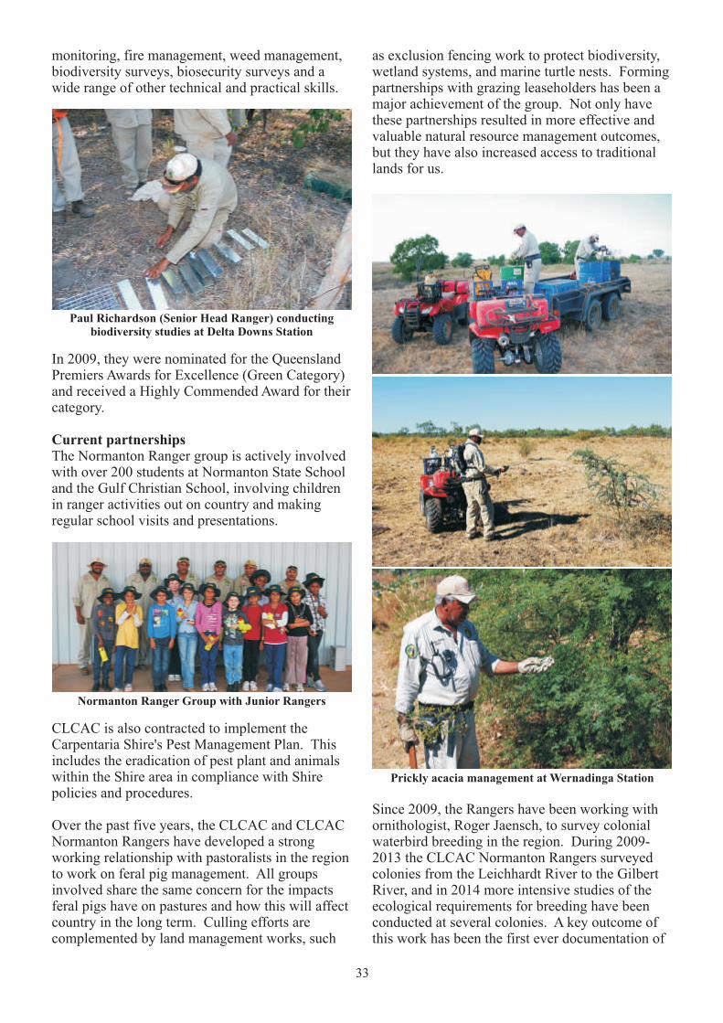
will help to support animal populations and the wider ecosystems. There are also many species that were once common which are beginning to disappear from some places where plant communities are changing. This could be due to many factors – cattle grazing impacts, feral plants and animals, habitat fragmentations, and climate change. Our knowledge and observations on wildlife, ecology, ecosystems, managing cattle, climate variation, and vegetation patterns can improve our understanding of using the right fire regime to help reduce the impacts. Over the past years, unmanaged fires have caused large areas to be burnt and have damaged grazing areas and natural biodiversity of country. The CLCAC Normanton Rangers have been working hard to carry out local fire management. They are fully equipped and trained in fire management, and have worked with pastoral stations and the Rural Fire Service to improve firefighting across the region.
CLCAC Normanton RangersWe have a great sense of pride in the Normanton Indigenous Land and Sea Ranger Group (CLCAC Normanton Rangers) - for what they have achieved and continue to work hard at for our country.
The Normanton Ranger group was formed in 2008 with three Rangers representing the Kukatj people, the Gkuthaarn people and the Kurtijar people. They are Paul Richardson (Senior Heard Ranger), Phillip George (Head Ranger), and Lance Rapson. In 2010, Alfred Pascoe, Derek George, and Marcus George joined the group. The group is led by coordinator, Mark Hogno, and is part of the CLCAC's Land and Sea Unit.
Using the correct fire regime is very important in maintaining biodiversity in particular habitats and ecosystems. The CLCAC's Gulf Savannah Fire Management Guidelines were developed to help land managers plan hazard reduction burning, and planned burns for improved production and conservation, across the 13 landscape types in the Gulf Savannah. These fire landscapes include:
! Mangroves;
! Saltmarsh and Saltwater Couch;
! Foreshore beach scrub;
! Saltpans with islands of vegetation;
! Permanent Lakes, billabongs and river lagoons;
! Old dunes and grassland;
! Tea tree woodlands;
! Flood plains and wetlands;
! Sand ridge;
! Forest country;
! Fringing riverine woodlands;
! Sandstone ridges and escarpments;
! Downs country.

32
Paul Richardson (Senior Head Ranger) presenting to Junior Rangers
Past and present activities include:
! Biodiversity monitoring to measure the success of management projects;
! Preserving key wetlands or ecosystems of high biodiversity or cultural significance through activities such as weed and feral animal control;
! Developing partnerships with neighbouring communities, landholders and research
The Rangers work on the traditional country of the three groups between the Staaten and Leichhardt Rivers. Their role as Indigenous Rangers means that we have Traditional Owners working on country for cultural and environmental projects. Importantly, they use their traditional knowledge together with science to contribute to natural resource management on country. It is also thanks to them that we have strong partnerships with the community and local industries. Their community and visitor education work strengthens people's understanding of our cultural and natural values on country; and their hard work with pastoralists, Carpentaria Shire Council, government groups, researchers, and resource management groups shows our commitment to a healthy country for all.
agencies to identify and preserve areas of high cultural and natural values and management practices;
! Community and visitor education about cultural and natural values;
! Developing and implementing landscape fire regimes for biodiversity improvement on country and within communities, incorporating both cultural and scientific practices;
! Northern Australian Quarantine Strategy (NAQS) biosecurity surveys;
! Protection of cultural sites;
! Ghost nets surveys and collection of old nets;
! Marine debris removal;
! Turtle and dugong surveys and monitoring;
! Marine and freshwater turtle, and crocodile, surveys;
! Migratory shorebird and local waterbird breeding colony surveys, and assessments of wetland condition;
! Weed control and eradication;
! Feral animal management;
! Fire management;
! Research partnerships with government, non-government organisations and universities (both in Australia and internationally) and other Indigenous Ranger groups;
! School visits and field trips as part of the Junior Ranger program;
! Assisting the CLCAC Native Title unit with community engagement activities.
Phillip George (Head Ranger) working with I-Trackerdata at Wernadinga Station
Ranger work camp, Wernadinga Station
The group has built their capacities through completing training in turtle and dugong
33
CLCAC is also contracted to implement the Carpentaria Shire's Pest Management Plan. This includes the eradication of pest plant and animals within the Shire area in compliance with Shire policies and procedures.
Over the past five years, the CLCAC and CLCAC Normanton Rangers have developed a strong working relationship with pastoralists in the region to work on feral pig management. All groups involved share the same concern for the impacts feral pigs have on pastures and how this will affect country in the long term. Culling efforts are complemented by land management works, such
monitoring, fire management, weed management, biodiversity surveys, biosecurity surveys and a wide range of other technical and practical skills.
In 2009, they were nominated for the Queensland Premiers Awards for Excellence (Green Category) and received a Highly Commended Award for their category.
Current partnershipsThe Normanton Ranger group is actively involved with over 200 students at Normanton State School and the Gulf Christian School, involving children in ranger activities out on country and making regular school visits and presentations.
Paul Richardson (Senior Head Ranger) conductingbiodiversity studies at Delta Downs Station
Normanton Ranger Group with Junior Rangers
Prickly acacia management at Wernadinga Station
as exclusion fencing work to protect biodiversity, wetland systems, and marine turtle nests. Forming partnerships with grazing leaseholders has been a major achievement of the group. Not only have these partnerships resulted in more effective and valuable natural resource management outcomes, but they have also increased access to traditional lands for us.
Since 2009, the Rangers have been working with ornithologist, Roger Jaensch, to survey colonial waterbird breeding in the region. During 2009-2013 the CLCAC Normanton Rangers surveyed colonies from the Leichhardt River to the Gilbert River, and in 2014 more intensive studies of the ecological requirements for breeding have been conducted at several colonies. A key outcome of this work has been the first ever documentation of
34
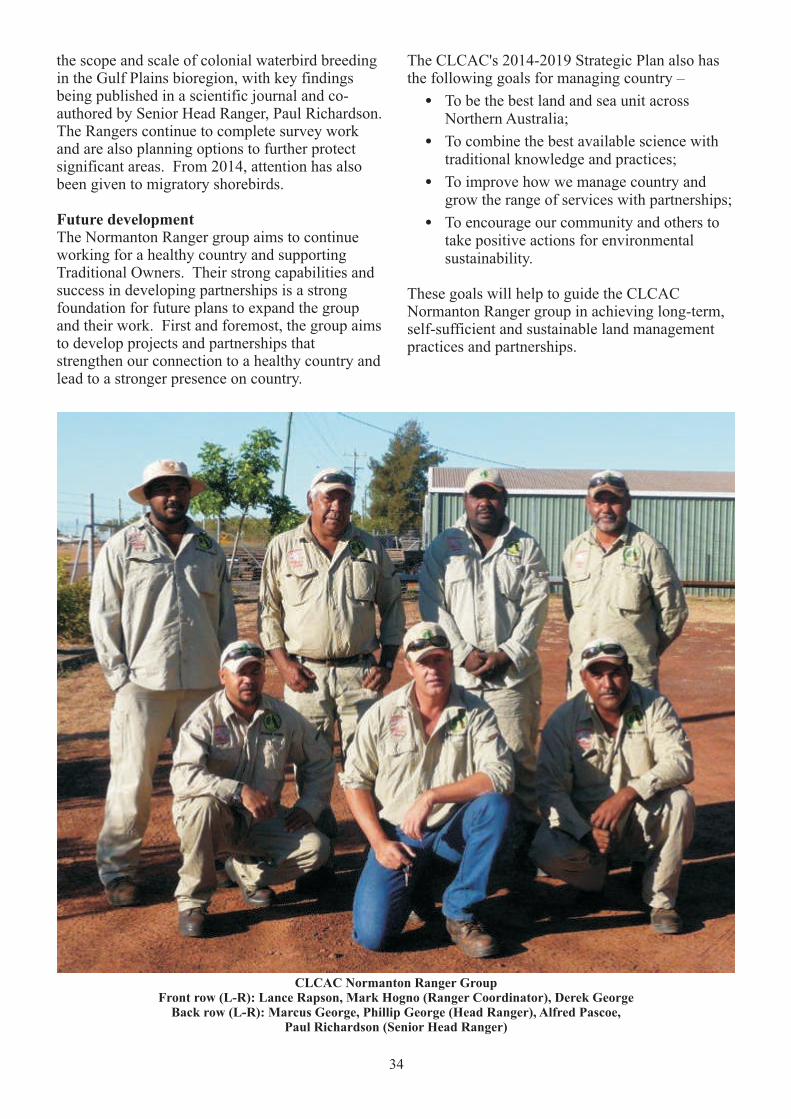
CLCAC Normanton Ranger GroupFront row (L-R): Lance Rapson, Mark Hogno (Ranger Coordinator), Derek George
Back row (L-R): Marcus George, Phillip George (Head Ranger), Alfred Pascoe, Paul Richardson (Senior Head Ranger)
the scope and scale of colonial waterbird breeding in the Gulf Plains bioregion, with key findings being published in a scientific journal and co-authored by Senior Head Ranger, Paul Richardson. The Rangers continue to complete survey work and are also planning options to further protect significant areas. From 2014, attention has also been given to migratory shorebirds.
Future developmentThe Normanton Ranger group aims to continue working for a healthy country and supporting Traditional Owners. Their strong capabilities and success in developing partnerships is a strong foundation for future plans to expand the group and their work. First and foremost, the group aims to develop projects and partnerships that strengthen our connection to a healthy country and lead to a stronger presence on country.
The CLCAC's 2014-2019 Strategic Plan also has the following goals for managing country –
! To be the best land and sea unit across Northern Australia;
! To combine the best available science with traditional knowledge and practices;
! To improve how we manage country and grow the range of services with partnerships;
! To encourage our community and others to take positive actions for environmental sustainability.
These goals will help to guide the CLCAC Normanton Ranger group in achieving long-term, self-sufficient and sustainable land management practices and partnerships.

35
8. Threats to Country
This section describes activities and changes that may be damaging to the cultural and natural values of our country and its resources, including:
! Impact of commercial and recreational fishing;
! Pest animals and plants;
! Proposed dams and irrigated agriculture;
! Barriers to Traditional Owners accessing country;
! Impacts of tourism on cultural sites;
! Increased population and water shortages.
Commercial and recreational fishingWe understand the need to share the fish resources of Gkuthaarn Kukatj country, but it is important for our livelihoods, our culture and our country that these resources are shared equitably and sustainably.
Current threats from commercial and recreational fishing result from:
! Poor level of information about the impacts of these fisheries locally;
! Lack of information about the needs, practices and trends within the Indigenous fishing sector; and
! Fisheries management arrangements that do not provide an adequate local voice for the Indigenous sector in resource allocation and monitoring decision-making – i.e. fisheries governance.
Although the Gulf Fin Fish Fishery and the Mud Crab Fishery are regarded as sustainable from the perspective of state fish populations and economic return to commercial fishers, these fisheries cannot be regarded as culturally sustainable and equitable until the issues raised above are addressed.
We welcome the Queensland Government's current review into fisheries management arrangements and through the Carpentaria Land Council Aboriginal Corporation we will be contributing to the review in an attempt to have our concerns addressed – as explained further in section 9 of this Plan.
Pest AnimalsGkuthaarn Kukatj country is threatened by impacts from pest (non-native) animals including feral pigs, feral cats, cane toads, and wild dogs.
Pigs are identified as the most significant threat to country. Feral pigs impact pastoral properties as they damage pastoral production by grazing and rooting, damage fences and watering facilities, and transport and creating conditions for weed growth and establishment. One of the main ecological impacts feral pigs have is through soil disturbance, which can disrupt nutrient and water cycles, change soil micro-organism and invertebrate populations, change plant succession and species composition patterns, cause erosion, and spread plant and animal species and plant diseases. Feral pigs also threaten our country's wetland ecosystems and their significant waterbird breeding colonies. Feral pigs are also capable of carrying infectious diseases and parasites that are both endemic and still exotic to Australia.
Although feral pigs are a resource, we have long been concerned at the impacts feral pigs are having on country - especially for wetlands, river systems and coastal habitats. The region is home to 11 endangered, vulnerable and threatened species that are directly impacted by feral pigs. Many traditional food species are also becoming scarce as a result of their impacts. There is strong concern that with more extreme drought and flooding cycles expected under climate change models, and after a number of very wet years, we will see unsustainable growth of pig populations that could cause a lot of damage on important wetland areas when the weather goes into a very dry cycle.
36
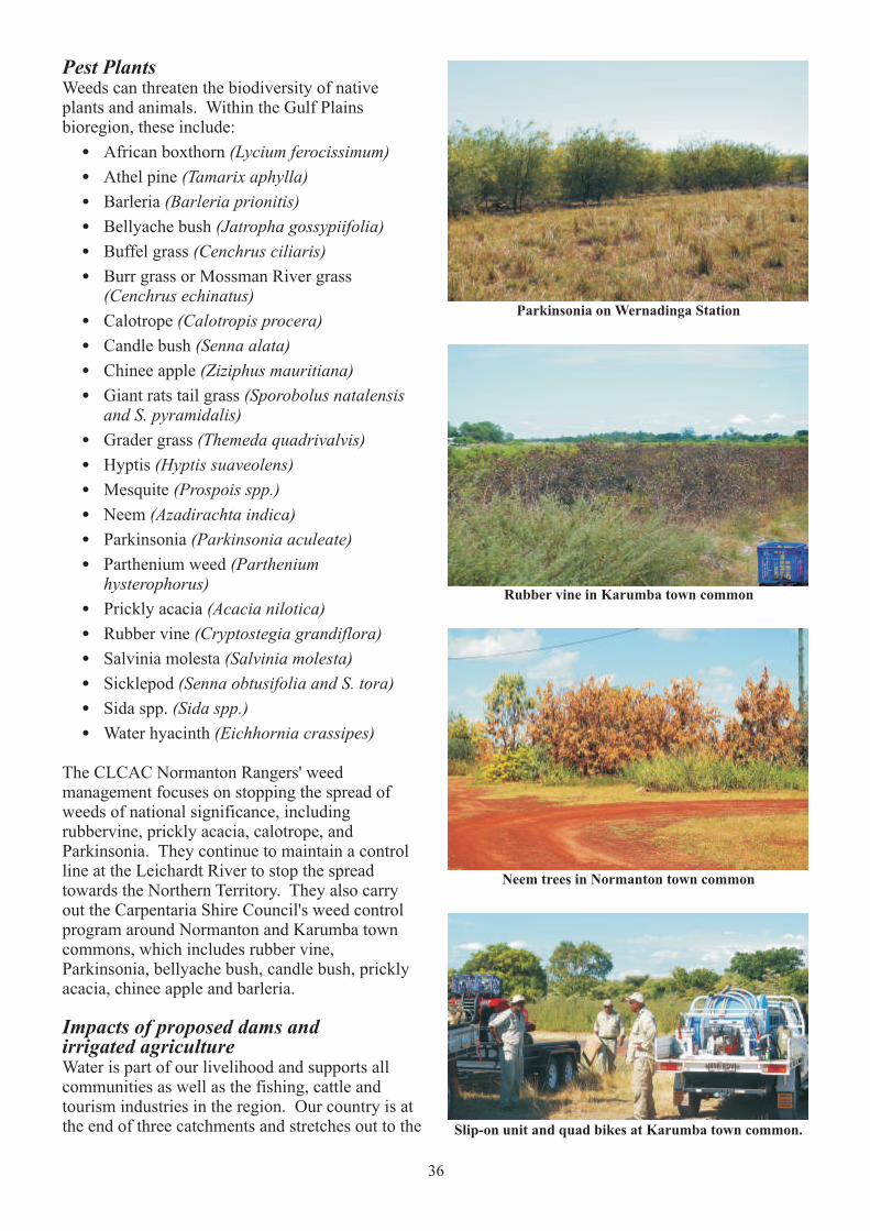
Slip-on unit and quad bikes at Karumba town common.
Neem trees in Normanton town common
Rubber vine in Karumba town common
Parkinsonia on Wernadinga Station
Pest PlantsWeeds can threaten the biodiversity of native plants and animals. Within the Gulf Plains bioregion, these include:
! African boxthorn (Lycium ferocissimum)
! Athel pine (Tamarix aphylla)
! Barleria (Barleria prionitis)
! Bellyache bush (Jatropha gossypiifolia)
! Buffel grass (Cenchrus ciliaris)
! Burr grass or Mossman River grass (Cenchrus echinatus)
! Calotrope (Calotropis procera)
! Candle bush (Senna alata)
! Chinee apple (Ziziphus mauritiana)
! Giant rats tail grass (Sporobolus natalensis and S. pyramidalis)
! Grader grass (Themeda quadrivalvis)
! Hyptis (Hyptis suaveolens)
! Mesquite (Prospois spp.)
! Neem (Azadirachta indica)
! Parkinsonia (Parkinsonia aculeate)
! Parthenium weed (Parthenium hysterophorus)
! Prickly acacia (Acacia nilotica)
! Rubber vine (Cryptostegia grandiflora)
! Salvinia molesta (Salvinia molesta)
! Sicklepod (Senna obtusifolia and S. tora)
! Sida spp. (Sida spp.)
! Water hyacinth (Eichhornia crassipes)
The CLCAC Normanton Rangers' weed management focuses on stopping the spread of weeds of national significance, including rubbervine, prickly acacia, calotrope, and Parkinsonia. They continue to maintain a control line at the Leichardt River to stop the spread towards the Northern Territory. They also carry out the Carpentaria Shire Council's weed control program around Normanton and Karumba town commons, which includes rubber vine, Parkinsonia, bellyache bush, candle bush, prickly acacia, chinee apple and barleria.
Impacts of proposed dams and irrigated agricultureWater is part of our livelihood and supports all communities as well as the fishing, cattle and tourism industries in the region. Our country is at the end of three catchments and stretches out to the

37
CLCAC Normanton Ranger Junior Ranger Program
Our country's water systems are all interconnected and any changes to natural flows could have unpredictable impacts. The first flood flush at the end of the dry season is critical for cleansing out stagnant waters and replenishing oxygen levels in the water. In our floodplains, 'flood pulses' are important in transporting species and nutrients between channels and coastal wetlands. If water volume and velocity is reduced due to irrigation and damming then whole ecosystems and productivity are affected. Soil erosion from irrigation will also increase sediment and nutrient in the water, which will block wetland’s fragile
filtration systems. Damming can also affect important vegetation communities and species richness in certain areas, and can block stream flows that are needed to replenish waterways and waterholes.
Furthermore, it is assumed that sufficient environmental flows will meet Traditional Owners' social and cultural needs, but this is dependent on existing extraction values rather than actual Indigenous rights and interests. There are currently no national guidelines to ensure the inclusion of Indigenous rights or interests in water
9reform . There is also not enough information available to Traditional Owners for us to make informed decisions about the impacts water extraction will have on environmental and cultural values. One of the biggest threats for us is that water is not sustainably managed as part of country and that our values, rights and interests are not included in decision-making processes.
Barriers to Traditional Ownersaccessing countryBeing on country gives us a physical and spiritual connection to our culture. Even though most Gkuthaarn and Kukatj People now live in Normanton, visiting country is still a part of who we are and our culture. It is especially important for us to visit sites that are important for certain ceremonies, or waterholes and rivers for hunting.
Flinders River catchment
9 NWC (2007)
waters of the Gulf. Any developments upstream will have flow-on effects down river and into the Gulf.
Traditional Owners have serious concern that water developments in the region will significantly impact both important cultural and environmental systems. Water shortages and climate-based threats to agricultural production in other parts of Australia have meant that there is now more interest in the possible development of catchments in north Queensland. It is still unknown if our unique landscapes can support this without damaging natural ecosystems, dependent industries, and important cultural sites. Irrigated agriculture will require large amounts of water and any proposed dams would need to alter natural water systems dramatically. The extreme wet and dry seasons also means that water availability will be unreliable for crop productivity throughout the year.
As history has played out, others in the wider community now share our country – small businesses, non-Indigenous landowners, government bodies, pastoralists, mining companies, commercial and recreational fishers and tourists. We respect the tenures that have

38
been placed over country, but cannot forget our connections because this would be to forget who we are. For us, the barrier to accessing country is not the people who are now using it, but that we have not had many chances to build strong relationships with them. If there is a better understanding between us, then we can learn how to work together for a healthy country for all.
Impact of tourism on cultural sitesFor us, country is a living thing and has many places that keep our culture alive. Gkuthaarn and Kukatj Traditional Owners work hard to take care of country and its sacred areas. As long as we continue to take care of them, our generations to come will have a connection to their culture and know who they are.
We are proud to share the beauty of our country with locals and tourists, but lack of cultural awareness and lack of information about what tourists are doing on our country are a threat to the protection of our cultural sites and values. We recognise that we have a responsibility to help manage tourism so that it does not damage country and our cultural sites. Currently, there is only one sign up to protect cultural sites that are visited by tourists. Our concern is that if people continue to visit cultural areas that they do not know about then they will not understand the importance of protecting them. There are also many sacred sites non-Traditional Owners cannot visit by themselves or without permission.
Increased population and water shortagesBecause of the growing population of the Gulf region, and with the potential for more growth associated with proposals for irrigated agricultural developments, we all need to take into account the region's highly variable water resources to avoid increasing threats to the natural and cultural values of our country – including threats to the region's industries such a fishing and pastoralism.
39
9. Priority Actions
This section outlines our priority actions we propose to take to manage our land and saltwater country in collaboration with our government, community and industry partners:1. Continued support of land and saltwater
management
! Biodiversity, fire, feral animal and weed management
2. Fishery Management:
! Build partnership with Fisheries Queensland
! Cultural awareness for commercial fishers
! Reduce impacts of commercial fishing
! Collect information on Indigenous fishing
! Take part in fishery management decisions
3. Water Planning
! Take part in catchment wide water planning processes
4. CLCAC Normanton Rangers
! Develop a CLCAC Normanton Ranger strategic plan
! Strengthen Rangers' role in fisheries management
! Increase number of Rangers
! Research partnerships
! Develop land management partnerships
5. Access to Country
! Negotiate access to pastoral leases on country
6. Research on Country
! Biodiversity research
! Cultural site surveys
! Traditional knowledge recording
! Seagrass monitoring
! Climate Change
7. Protected Areas
! Monitor Fish Habitat Areas
! Managing national parks and other conservation reserves
! Consider:
#East Asian-Australian Flyway Partnership
#Ramsar Wetland Site
#Indigenous Protected Area
Continued Land and Saltwater ManagementThe Carpentaria Land Council Aboriginal Corporation's Land and Sea Program currently undertakes biodiversity monitoring, fire, feral animal and weed management to support Traditional Owners and a healthy country. This program is considered one of the best Indigenous Land and Sea Programs of its kind in Australia, and the CLCAC Normanton Rangers are central to its success.
Biodiversity, fire, feral animal and weed management are key features of the work undertaken by the rangers. As well as improving the health of country, this work has developed the skills of rangers to perform as professional land and sea managers and support Traditional Owner knowledge and living culture.
It is important to continue to implement CLCAC's current Land and Sea Program. At the same time, strengthening natural resource management capacity through the following priority actions will support Traditional Owners strategic goals for managing country and support their livelihoods from their sustainable use of traditional resources from their land and saltwater country.
Fishery ManagementThrough the implementation of this Land and Saltwater Country Plan we are committed to achieving Indigenous, recreational and commercial fisheries that are equitable to all sectors as well as ecologically, culturally and economically sustainable. To achieve this objective we will seek to:
! Build partnerships with Fisheries Queensland, recreational fishers and commercial fishers in the research, monitoring and management of fish resources on Gkuthaarn Kukatj country;
! Develop and deliver cultural awareness training and accreditation for commercial fishers operating on Gkuthaarn Kukatj country;
! Reduce impacts of recreational and commercial fishing where necessary to achieve equitable outcomes for the Indigenous fishing sector as required by the Queensland Fisheries Act 1994;

40
! Collect information on Indigenous fishing to support recognition of the Indigenous fishery in fisheries management and resource sharing;
! Collaborate with the CLCAC in their submissions to and participation in the review into fisheries management being undertaken by the Queensland Government.
Progress towards these objectives will be made in the first instance through the following strategies:
1. A Memorandum of Understanding (MoU) between Fisheries Queensland and the CLCAC Normanton Rangers regarding collaboration with the Qld Boating and Fisheries Patrol (QBFP) in the monitoring and management of fisheries and aquatic environments in the Norman River, and other areas of Gkuthaarn Kukatj country, where possible and appropriate. The MoU could address a range of issues including:
a. Joint patrols on QBFP and/or CLCAC Normanton Ranger vessels;
b. Joint training, education and exercises;
c. Shared resources where possible and mutually beneficial.
2. A research project to document the extent, cultural significance and economic importance of Indigenous fishing in Gkuthaarn Kukatj country, with a focus on the Normanton region and the Norman River in particular. The research project will gather information that can be used in negotiating greater recognition for the Indigenous fishery and more equitable fisheries management. The scope of the information, how the information will be collected, stored and use will be discussed and negotiated among Gkuthaarn and Kukatj People, the CLCAC Normanton Rangers and the consultant fisheries researcher contracted to undertake the project.
Funding for the project will be sought from the Commonwealth Government's Fisheries Research and Development Corporation (FRDC). A possible tool for undertaking this research is the Indigenous Subsistence Fishing Survey Kit developed by the then Qld Department of Environment and Heritage, Department of Primary Industries, and Balkanu Aboriginal Development Corporation in the late 1990s.
Water PlanningOur concern for sustainable water management is at the wider catchment scale, and we have strong interest in managing water resources so that they are sustainable to support the natural environment, Traditional Owners, the local community and industry.
! Continue to work with researchers to strengthen our understanding of sustainable water management; and
! Ensure that Gkuthaarn and Kukatj interests are recognised in the State government'sreview of the Water Resource (Gulf) Plan 2007.
CLCAC Normanton RangersManaging Gkuthaarn Kukatj land and saltwater country is not possible without the efforts of the CLCAC Normanton Ranger group. They have achieved a great deal for country, their families and themselves. Their expertise, and success in developing partnerships, shows that there is great potential to support future plans for country. With increasing opportunities in land and saltwater management, the group needs a strategic approach that will support Traditional Owner aspirations and the ongoing development of the group. Strategies to develop the effectiveness of the CLCAC Normanton Ranger group during the life of this Plan are set out below.
Develop a Normanton Ranger Strategic PlanBy developing their own strategic plan, the CLCAC Normanton Rangers will be able to identify their long-term goals, including increasing ranger numbers, capacities and resources over time to meet the needs of implementing this Land and Saltwater Country Plan.
Strengthen Rangers' role in fisheries managementDevelop a Memorandum of Understanding with Fisheries Queensland to enhance collaboration between the two agencies and strengthen the role of Rangers in fisheries management and compliance.
Develop research partnershipsThere are a growing number of research opportunities available to the CLCAC Normanton Rangers that could help develop their skills as well as strengthen their knowledge about country. Having the Rangers directly working with researchers also means that Traditional Owners will be having real input into research projects conducted on our country.
41
Develop land management partnershipsCollaborate with MMG on mutually beneficial opportunities for joint land and sea management and monitoring of Century mine activities, including the maintenance of the pipeline corridor through Gkuthaarn Kukatj country.
Access to CountryAccess to country is a priority for achieving a healthy country and healthy community. Being on country will allow us to sustainably manage what is culturally important for us as well as the natural systems that support all land users.
Our priority actions will be to:
! Records the stories of our Elders so that they can pass on their knowledge and we can continue to practice our culture;
! Access country for cultural heritage surveying and mapping, so that we have a record of country and its condition for future cultural and natural resource management;
! Continue to visit parts of country that are important to us for fishing, ceremonies, hunting, and taking care of country.
There are a range of approaches that can be used to develop relationships and achieve access to country without compromising the needs of others. Each tenure on country will be different, and so must be dealt with one by one so that everyone involved is satisfied. Furthermore, with our native title claim in process our aim is to establish good relationships with all land users through land and saltwater country management so that solid foundations have been laid for all parties when our claim is determined.
Access to pastoral leases on country is particularly important to us. The CLCAC Normanton Rangers have achieved a lot for us in developing relationships with the pastoral stations. Their work has proved that Traditional Owner activities can be co-beneficial and sustainably support the natural resources that we all depend on. However, there are many more opportunities to build relationships and negotiate access to country.
Finally, in supporting our Native Title claim we would like the opportunity to educate pastoralists and the broader public on the exercise of our native title rights. This could include strengthened cultural awareness, partnerships for environmental
management, and a strong mutual respect for each other's needs and values.
Research on CountryResearch on the environments, natural resources, cultural heritage and impacts of climate change on our country is as important to us as it is to the researchers that undertake the work. Our goal is to have the opportunity to work with any researcher or research institutions engaged in activities on our land and saltwater country. Our involvement in this research will be mutually beneficial to us and to the researchers.
We are committed to continuing to work with our current research partners, as well as develop new collaborations with other institutions and individuals wishing to conduct research on Gkuthaarn Kukatj country.
During the life of this plan we will develop a registry of information on previous research work undertaken on our country, as well as research institutions with interest and expertise in conducting research that will improve the management of our country and the sustainable use of our resources.
Protected Areas
East Asian-Australian Flyway PartnershipIn 2014, the Rangers have helped local land managers to consider becoming involved in the Flyway Site Network of the East Asian – Australasian Flyway Partnership (EAAFP), as a step to raise the international profile of key shorebird habitat in the region. The EAAFP is a cooperative international arrangement of governments and other types of partners within the East Asian – Australasian Flyway (one of nine globally recognised major migratory routes). It is an informal, voluntary, and non-binding mechanism that aims to recognise areas of international importance for migratory waterbirds and to protect migratory waterbirds, waterbird habitats and the livelihoods of local communities.
Nominating a site to the Flyway Site Network of the EAAFP can provide opportunities for international cooperation for migratory waterbird conservation. Once a site is established as part of the Flyway Site Network, it may benefit from:
! a higher profile through engagement in this highly regarded international initiative;
42
! opportunities to connect with managers of other sites in the flyway to share information and expertise;
! added features for promotion of ecotourism in the region; and
! potentially also greater prospects to secure resources for habitat management.
Ramsar Wetland SiteThe Convention on Wetlands of International Importance Especially as Waterfowl Habitat (the Ramsar Convention) is an intergovernmental treaty that lists wetland sites of international significance. Listing under the convention provides wetlands with international recognition, and increases opportunities for wetland management. Ramsar wetlands in Australia are also protected as a matter of national environmental significance under the Environment Protection and Biodiversity Conservation Act 1999.
The Ramsar Convention has a wise use policy that acknowledges wetland services to humans and encourages that any necessary development should be sustainable. It also provides various guidelines, which support policy and management of listed wetlands. These guidelines enhance participatory management in wetlands, but do not create binding obligations on Ramsar members. For Traditional Owners, there is the opportunity to strengthen local knowledge and needs through participation in planning and management of wetland areas.
Nominations can be initiated by any group. Developing a Ramsar site nomination is a collaborative process between landowners and the Australian and state/territory governments. Consultation with key stakeholders is also important for negotiations of ongoing management of the wetlands. The final decision to list wetlands under the Ramsar Convention lies with the Australian Government Environment Minister. Once agreed, the Australian Government will forward the nomination to the Ramsar Convention Secretariat for inclusion on the Ramsar List.
There are two possible sites that have the potential to be nominated –
! Karumba Plains, significant for its little curlew populations; and
! The intertidal mudflats, beach ridges and surrounding saltflats of the South-East Gulf of Carpentaria (from west of the Nicholson River estuary to at least the Smithburneestuary), which is the third most important site for migratory shorebirds in Australia.
One option would be to nominate a migratory shorebird site to the Flyway Site Network of the the East Asian-Australasian Flyway Partnership, and then review whether or not a Ramsar nomination would further benefit the areas based on our aspirations.
Mutton Hole Wetlands Conservation ParkThe proper management of Mutton Hole Conservation Park is urgently needed to protect cultural sites from further damage:
! Negotiate with the Department of National Parks, Recreation, Sport and Racing and Carpentaria Shire Council on future park management and a finalised management plan;
! Properly manage vehicle access and develop signage to protect cultural sites.
Morning Inlet Wild River Area andFish Habitat AreaThe CLCAC Normanton Rangers will maintain their weed eradication and control program in the Morning Inlet Wild River Area in collaboration with Inverleigh Station.
We will also seek to formalise the role of the CLCAC Normanton Rangers in monitoring and managing the Morning Inlet Fish Habitat Area, building on information previously collected by Fisheries Queensland when that agency was responsible for Fish Habitat Areas throughout Queensland. We will also investigate whether our role in caring for the Morning Inlet Fish Habitat Area could be enhanced through a Memorandum of Understanding with NRPSR and by incorporating the Area into a possible Gkuthaarn Kukatj Indigenous Protected Area (see below).
Indigenous Protected AreaDuring the implementation of this Plan we wish to explore whether it would be feasible and beneficial to dedicate some of Gkuthaarn Kukatj country as an Indigenous Protected Area (IPA).
An IPA is an area dedicated by its Traditional Owners as a protected area for the protection and sustainable use of its environmental and cultural values, in collaboration with appropriate government agencies, tenure holders and others with rights and interests in the area. IPAs are recognised by the Queensland and Commonwealth governments, and by the International Union for the Conservation of Nature (IUCN), as part of Australia's National Reserve System (NRS) of Protected Areas.
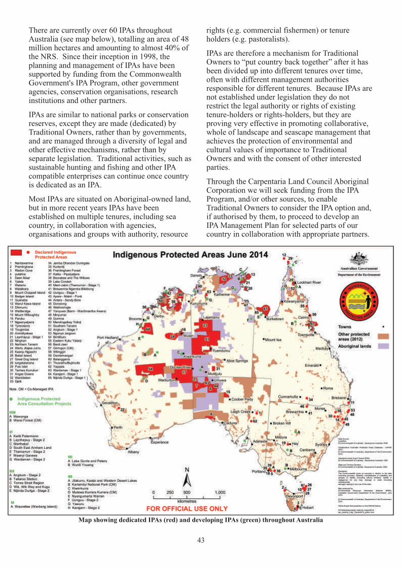
43
Map showing dedicated IPAs (red) and developing IPAs (green) throughout Australia
There are currently over 60 IPAs throughout Australia (see map below), totalling an area of 48 million hectares and amounting to almost 40% of the NRS. Since their inception in 1998, the planning and management of IPAs have been supported by funding from the Commonwealth Government's IPA Program, other government agencies, conservation organisations, research institutions and other partners.
IPAs are similar to national parks or conservation reserves, except they are made (dedicated) by Traditional Owners, rather than by governments, and are managed through a diversity of legal and other effective mechanisms, rather than by separate legislation. Traditional activities, such as sustainable hunting and fishing and other IPA compatible enterprises can continue once country is dedicated as an IPA.
Most IPAs are situated on Aboriginal-owned land, but in more recent years IPAs have been established on multiple tenures, including sea country, in collaboration with agencies, organisations and groups with authority, resource
rights (e.g. commercial fishermen) or tenure holders (e.g. pastoralists).
IPAs are therefore a mechanism for Traditional Owners to “put country back together” after it has been divided up into different tenures over time, often with different management authorities responsible for different tenures. Because IPAs are not established under legislation they do not restrict the legal authority or rights of existing tenure-holders or rights-holders, but they are proving very effective in promoting collaborative, whole of landscape and seascape management that achieves the protection of environmental and cultural values of importance to Traditional Owners and with the consent of other interested parties.
Through the Carpentaria Land Council Aboriginal Corporation we will seek funding from the IPA Program, and/or other sources, to enable Traditional Owners to consider the IPA option and, if authorised by them, to proceed to develop an IPA Management Plan for selected parts of our country in collaboration with appropriate partners.
44
10. Partnerships and Implementation
This section describes how our Land and Saltwater Country Plan will be implemented in collaboration with our government, community and industry partners, including through:
! Publication and distribution of the Plan and a poster summarising key aspects of the Plan;
! Identification of partners and their potential roles in implementation;
! An Implementation Workshop bringing together representatives of Traditional Owners, CLCAC Normanton Rangers and partners to develop agreed pathways to implement this Plan;
! A process for monitoring and evaluating and reviewing the implementation of this Plan.
Distribution of the PlanCopies of our Land and Saltwater Country Plan will be made available to all Gkuthaarn and Kukatj People and distributed to all our partner agencies and organisations. A wall poster that summarises the main features of the Plan will also be circulated and made available to community organisations in the region, such as primary schools, secondary schools and local government offices.
The Plan and poster will also be available for download from the Carpentaria Land Council Aboriginal Corporation website.
Our Collaboration PartnersWe recognise that many of the priority actions identified in this Plan can only be achieved in collaboration with government agencies, community groups, industry bodies, landholders, research institutions and other partners with rights, interests, resources and expertise that can assist us to look after our country.
The following organisations have been identified as existing or potential collaboration partners, with suggestions on how they can assist us to implement our Plan.
Indigenous organisationsCarpentaria Land Council Aboriginal CorporationThe Carpentaria Land Council Aboriginal Corporation (CLCAC) is the native title representative body coordinating the Gkuthaarn and Kukatj People's native title claim:
! Coordinate production and distribution of the Plan and poster;
! Administer the CLCAC Normanton Rangers, supported by Queensland Department of Environment and Heritage Protection;
! Facilitate collaboration with partner agencies and organisations in implementing the Plan;
! Facilitate monitoring and evaluation of the plan, including a formal plan review after 5 years; and
! Coordinate the proposed Implementation Workshop to explore additional opportunities for supporting implementation of our Land and Saltwater Country Plan.
Local GovernmentCarpentaria Shire CouncilCarpentaria Shire Council is the local government authority responsible for the Gulf region in which Gkuthaarn Kukatj country is located:
! Manage contracts for pest animal and plant activities undertaken by CLCAC Normanton Rangers on Council land;
! Negotiate with Qld Department of National Parks, Recreation, Sport and Racing (NPRSR) and CLCAC Normanton Rangers regarding future management arrangements for Mutton Hole Wetland Conservation Park;
! Collaborate with CLCAC Normanton Rangers on mutually beneficial opportunities for joint training and resource sharing, where appropriate;
! Participate in the proposed Implementation Workshop to explore additional opportunities

45
for supporting implementation of our Land and Saltwater Country Plan.
Queensland GovernmentFisheries Queensland (Department of Agriculture, Forestry and Fisheries)Fisheries Queensland is responsible for fisheries management, monitoring and research throughout Queensland:
! Negotiate a Memorandum of Understanding regarding collaboration between Queensland Boating and Fisheries Patrol and CLCAC Normanton Rangers for fisheries monitoring, management and compliance on Gkuthaarn Kukatj country;
! Support CLCAC and CLCAC Normanton Rangers in their funding application for, and implementation of, an Indigenous fishery research project on Gkuthaarn Kukatj country;
! Collaborate with CLCAC Normanton Rangers on mutually beneficial opportunities for joint training and resource sharing, where appropriate; and
! Participate in the proposed Implementation Workshop to explore additional opportunities for supporting implementation of our Land and Saltwater Country Plan.
Department of National Parks, Recreation, Sport and RacingDepartment of National Parks, Recreation, Sport and Racing (NPRSR) is responsible for planning and managing protected areas throughout Queensland, including national parks, conservation reserves and fish habitat areas:
! Negotiate an MoU with Gkuthaarn and Kukatj people and CLCAC Normanton Rangers regarding the monitoring and management of Morning Inlet Wild River Area and Fish Habitat Area;
! Collaborate with CLCAC Normanton Rangers on mutually beneficial opportunities for joint training and resource sharing, where appropriate;
! Participate in the proposed Implementation Workshop to explore additional opportunities for supporting implementation of our Land and Saltwater Country Plan.
Department of Environment and Heritage Protection Department of Environment and Heritage Protection (EHP) is the agency responsible for protecting and managing species, environments and cultural heritage throughout Queensland:
! Continue collaboration with CLCAC Normanton Rangers on developing a joint program for crocodile monitoring and management on Gkuthaarn Kukatj country;
! Collaborate with CLCAC Normanton Rangers on mutually beneficial opportunities for joint training and resource sharing, where appropriate;
! Participate in the proposed Implementation Workshop to explore additional opportunities for supporting implementation of our Land and Saltwater Country Plan.
Australian GovernmentDepartment of the Prime Minister and CabinetThe Environment Programmes Branch of the Department of the Prime Minister and Cabinet is responsible for implementing the Indigenous Protected Area Program and the Working on Country Program:
! Support Gkuthaarn and Kukatj People, through the CLCAC, to explore the option of dedicating appropriate portions of Gkuthaarn Kukatj country as an Indigenous Protected Area (IPA);
! Provide appropriate resources to the CLCAC Normanton Rangers (through the Working on Country Program, or its equivalent) to facilitate the expansion and development of the Normanton Indigenous Land and Sea Ranger program;
! Participate in the proposed Implementation Workshop to explore additional opportunities for supporting the implementation of our Land and Saltwater Country Plan.
Department of the EnvironmentDepartment of the Environment (DoE) is responsible for administrating the Environment Protection and Biodiversity Conservation Act 1999, including overseeing the National Reserve System of Protected Areas and undertaking ecological sustainability assessments of export fisheries:

46
! If requested by Traditional Owners, support the process of planning, dedicating and managing a possible Gkuthaarn Kukatj IPA, through information sharing, technical support and recognition of the IPA as part of the National Reserve System of Protected Areas;
! Take into account Gkuthaarn and Kukatj Peoples' rights and interests with respect to our traditional fishery when undertaking ecological assessments of export fisheries sourced from our country under the Environment Protection and Biodiversity Conservation Act 1999;
! Participate in the proposed Implementation Workshop to explore additional opportunities for supporting implementation of our Land and Saltwater Country Plan.
Department of Agriculture, Fisheries and ForestryDepartment of Agriculture, Fisheries and Forestry (DAFF) is responsible for delivering biosecurity programs across northern Australia through the North Australia Quarantine Strategy (formerly delivered by the Australian Quarantine and Inspection Service (AQIS):
! Continue to collaborate with and support the CLCAC Normanton Rangers in their quarantine monitoring activities in coastal, including autopsies of culled pigs and monitoring for invasive organisms in marine debris;
! Participate in the proposed Implementation Workshop to explore additional opportunities for supporting implementation of our Land and Saltwater Country Plan.
Commonwealth Scientific and Industrial Research OrganisationThe Commonwealth Scientific and Industrial Research Organisation (CSIRO) is Australia's national science agency, undertaking research to support agribusiness, energy and transport, environment and natural resources, health, information technology, telecommunications, manufacturing and mineral resources.
! Continue to collaborate with Traditional Owners and CLCAC Normanton Rangers to research potential impacts of the irrigated agriculture proposals in the Flinders Ricer catchment, including potential impacts on the sustainability of our Indigenous fishery resources.
Fisheries Research and Development Corporation Fisheries Research and Development Corporation (FRDC) is responsible for funding research relating to Indigenous recreational and commercial fisheries throughout Australia, advised by their Indigenous Reference Group and advisory bodies in each state and territory:
! Through the FRDC's Indigenous Reference Group, support the development of a funding application to undertake an Indigenous fisheries research project on Gkuthaarn Kukatj country;
! Develop an ongoing relationship with Gkuthaarn and Kukatj peoples, CLCAC and the CLCAC Normanton Rangers to support ongoing research and monitoring requirements for sustainable fishing for all fishing sectors on our country;
! Participate in the proposed Implementation Workshop to explore additional opportunities for supporting the implementation of our Land and Saltwater Country Plan.
Non-government and community organisationsSouthern Gulf Catchments LtdSouthern Gulf Catchments Ltd is a community-based organisation working through partnershipsto care for natural and cultural resources in the southern Gulf region, including Gkuthaarn Kukatj country:
! Continue collaboration with Normanton Rangers, including investment in identified land management projects, to achieve outcomes on Gkuthaarn Kukatj country that are consistent with both our Land and Saltwater Country Plan and the Southern Gulf Natural Resource Management Plan;
! Collaborate with Normanton Rangers on mutually beneficial opportunities for joint training and resource sharing, where appropriate;
! Participate in the proposed Implementation Workshop to explore additional opportunities for supporting the implementation of our Land and Saltwater Country Plan.
47
Gulf of Carpentaria Commercial Fishermen's AssociationGulf of Carpentaria Commercial Fishermen's Association (GoCCFA) represents the interests of licenced commercial fishers in the Gulf of Carpentaria and promotes sustainable fisheries practices in the region:
! Collaborate with Gkuthaarn and Kukatj People, CLCAC and CLCAC Normanton Rangers to develop and implement a cultural awareness accreditation process for Gulf commercial fishermen;
! Support the development and implementation of an Indigenous fisheries research project;
! Collaborate with CLCAC Normanton Rangers and Fisheries Queensland in the efforts to jointly monitor and manage fisheries resources and environments on Gkuthaarn Kukatj country;
! Participate in the proposed Implementation Workshop to explore additional opportunities for supporting the implementation of our Land and Saltwater Country Plan.
MMG Limited MMG Limited are signatories of the Gulf Communities Agreement (GCA), which support land use and benefit-sharing between Century Mine operations, the State of Queensland, and Gkuthaarn and Kukatj People. The GCA can continue to support through:
! Continued support of Gkuthaarn and Kukatj Traditional Owner interests through the Century Environment Committee, Century Liaison Advisory Committee and Gulf Aboriginal Development Corporation;
! Collaborate with CLCAC Normanton Rangers on mutually beneficial opportunities for joint land and sea management and monitoring of mine activities, including maintenance of the pipeline corridor;
! Support development of Traditional Owner traineeships for Century mine' current operations and decommissioning phase.
Pastoral IndustryMany owners and managers of pastoral stations on country are currently developing relationships with Traditional Owners that are co-beneficial, and support sustainable pastoral management:
! Further develop relationships with Traditional Owners to create mutually beneficial land and sea management on country;
! Support access to country for Traditional Owners for sustainable management of cultural heritage.
James Cook UniversityJames Cook University's (JCU) Tropical Water and Aquatic Ecosystem Research group (TropWATER) provides support for the World Seagrass Association and manages the Seagrass-Watch monitoring project. JCU also conducts research on dolphins around northern Australia:
! Collaborate with Traditional Owners and CLCAC Normanton Rangers in monitoring of seagrass health and habitats along our coastline; and
! Collaborate with CLCAC Normanton Rangers in any potential monitoring, survey or research programs, including dolphin research.
Implementation WorkshopThe Carpentaria Land Council Aboriginal Corporation will convene an Implementation Workshop within three months of completing this Plan to bring together Gkuthaarn and Kukatj Traditional Owners, CLCAC Normanton Rangers and our collaboration partners (listed above) to confirm existing commitments and to map out a pathway to implement our agreed Priority Actions.
Monitoring, Evaluation and ReviewThe Implementation Workshop will develop an agreed timeline for achieving the Priority Actions identified in this Plan. The timeline and agreed steps to achieve milestones for each Priority Action will form the basis for monitoring the implementation of this Plan.
Progress on the implementation of the Plan will be documented in the Annual Report of CLCAC and the Plan will be reviewed after a period of five years.
Burrows, D.W and Pern, C. 2006. A Survey Of Freshwater Fish And Fish Habitats Of The Norman River, Gulf Of Carpentaria. Report No. 06 of the NHT project “A Comprehensive Survey of Freshwater Fish and their Key Management Issues throughout Northern Australia”.
Bynoe, C. 1992. Memories of Normanton – An Aboriginal Perspective. Published by Normanton State School, Normanton. Queensland.
Department of Agriculture, Fisheries and Forestry (DAFF), 2013, Gulf of Carpentaria Inshore Fin Fish Fishery: 2011 fishing year report, State of Queensland, available online at http://bit.ly/1swePHy.
Department of Environment and Heritage and Protection (EHP), 2014, Animals of Gulf Plains (GUP) bioregion, WetlandInfo, Queensland, available online at http://bit.ly/1l5GASY.
Department of Environment and Heritage Protection (EHP), 2014b, Regional Ecosystems: Gulf Plains, State of Queensland, available online at http://bit.ly/1oGGMvo.
Halliday, I.A., Saunders, T., Sellin, M.J., Allsop, Q., Robins, J.B., McLennan, M. and Kurnoth, P. 2012. Flow impacts on estuarine finfish fisheries of the Gulf of Carpentaria FRDC Project No 2007/002 Final Report. Queensland Department of Agriculture, Fisheries and Forestry, Brisbane.
Jaensch, R. 2013. Waterbird breeding colonies in the Gulf Plains region, 2009-2013. Report to Carpentaria Land Council Aboriginal Corporation.
Kennett, R., Munungurritj, N. and Yunupingu, D. 2004. Migration patterns of marine turtles in the Gulf of Carpentaria, northern Australia: implications for Aboriginal managementWildlife Research 31(3) 241 – 248.
Kutt, A., Vanderduys, E., Colman, N., Perry, J., and Perkins, G. 2009. Technical Manual: Healthy country and healthy biodiversity in Queensland Rangelands: the Gulf Plains Bioregion. Southern Gulf Catchments. April.
McKenna, S.A. & Rasheed, M.A. 2011. Port of Karumba Long-term Seagrass Monitoring, October 2010. DEEDI Publication, Fisheries Queensland, Cairns, 25pp.
Memmot, P. and Channells, G. 2004. Living on Saltwater Country: Southern Gulf of Carpentaria Sea Country Management, Needs and Issues. Report prepared for the Australian Government's National Oceans Office in Association with the Aboriginal Environment Research Centre, University of Queensland on behalf of the Carpentaria Land Council Aboriginal Corporation.
Memmott, P. & Kelleher, P. 1995. “Social Impact Study of the Proposed Century Project On the Aboriginal People of Normanton and Surrounds”. [Prepared for the Bynoe Community Advancement Cooperative Society Limited] Aboriginal Environments Research Centre, Department of Architecture, University of Queensland, St Lucia.
Memmott, P. 1994. Report to the Minister for Family Services and Aboriginal and Islander Affairs on the Proposed Appointment of Aboriginal Trustees for the Transferable Reserve Lands at Normanton. Aboriginal Environments Research Centre, Department of Architecture, University of Queensland, St Lucia.
NWC 2007: 39, NWC 2011: 44-46 in TRaCK/NAILSMA 2012. Facilitator's Guide to Indigenous Water Planning: Indigenous water planning and engagement overview, available online at http://bit.ly/18qpsDj.
NLWRA, 2002. Australian Assessment of Terrestrial Biodiversity, Land and Water Australia, Canberra.
48
References and Further Reading