GIS, modeling, and politics: On the tensions of collaborative decision support
9
GIS, modeling, and politics: On the tensions of collaborative decision support Kevin Ramsey * University of Washington, Box 353550, Seattle, WA 98195, USA article info Article history: Received 30 September 2006 Received in revised form 30 April 2007 Accepted 16 August 2007 Available online 9 June 2008 Keywords: GIS Collaboration Environmental disputes Stakeholder processes Public participation Water resource management abstract A tension exists at the heart of efforts to support collaboration with GIS. Many scholars and practitioners seek to support two separate objectives: (1) problem solving and (2) the exploration of diverse problem understandings. GIS applications designed for problem solving often pre-define the problem space by structuring the kind of information that can be considered or the way in which the problem is conceptualized. In doing so, they necessarily privilege particular perspectives and understandings of the problem while marginalizing others. As a result, these initiatives undermine their second objective. This is problematic in the context of contentious environmental decisions which have broad-reaching impacts on people with diverse perspectives and interests. In such contexts, I argue that equitable collaboration is impossible without first emphasizing the exploration of diverse problem understandings. I support this argument theoretically by turning to the literatures on collaborative planning and spatial decision support, and empirically in my analysis of a case study of an effort to construct a GIS for supporting collaborative water resource management in rural Idaho. Reflecting upon the case, I provide a set of recommendations to those seeking to better negotiate the tensions of supporting collaboration with GIS in the context of contentious environmental and natural resource decisions. Ó 2008 Elsevier Ltd. All rights reserved. 1. Introduction Many scholars and practitioners herald ‘‘collaboration’’ as a for- ward thinking new style of environmental and natural resource management that can effectively balance social, economic, and ecological goals. The notion that agencies, advocacy organizations, and private stakeholders should work together to identify mutually acceptable solutions to environmental and natural resource prob- lems is gaining prominence (Innes and Booher, 2000; Wondolleck and Yaffee, 2000). Proponents have documented dozens of suc- cessful collaborative processes as examples to follow (e.g., Susskind et al., 1999; Wondolleck and Yaffee, 2000). Yet significant chal- lenges remain for environmental and resource managers seeking to introduce collaboration into their daily practice. High on this list of challenges is the fact that the problems faced by these practitioners, such as hazardous waste cleanup, ecological restoration, and water resource management, often have wide reaching impacts that affect the lives and livelihoods of many different kinds of people in many different kinds of ways. Furthermore, these problems are often characterized by uncertainty and scientific complexity. Whereas in the past these decisions were often considered the domain of specially trained experts, political and pragmatic realities (not to mention democratic ideals) dictate that a much wider range of affected parties be drawn into collaborative decision making processes. These parties may include technical and scien- tific experts, business interests, local residents, community groups, and environmental advocates. As a result, those seeking to devise and facilitate new collaborative approaches often struggle to find ways in which these diverse constituencies can effectively and equitably work together when each bring such different situated understandings of the problem at hand. One suggested way to help bridge these divides in the practice of environmental management is the use of geographic information systems (GIS). Balram and Dragicevic (2006a, p. 11) call for increased research into ‘‘collaborative GIS’’ (CGIS), which they de- scribe as ‘‘a networked collection of computer hardware, software, and user groups with the objective to capture, store, manipulate, visualize, and analyze geographically referenced data and knowl- edge, so as to provide new information in an institutional setting for solving unstructured planning problems.’’ In other words, CGIS is a model in which diverse collaboration participants share information and create knowledge that can help serve the purpose of collective environmental and resource management. At the heart of the CGIS research endeavor is a tension that has remained within the GIS and decision support community for over a decade – a tension between the dual objectives of using GIS to support both group problem solving activity and the collaborative exploration of diverse problem understandings. While these may * Tel.: þ1 206 713 4977; fax: þ1 206 543 3313. E-mail address: [email protected] Contents lists available at ScienceDirect Journal of Environmental Management journal homepage: www.elsevier.com/locate/jenvman 0301-4797/$ – see front matter Ó 2008 Elsevier Ltd. All rights reserved. doi:10.1016/j.jenvman.2007.08.029 Journal of Environmental Management 90 (2009) 1972–1980
-
Upload
kevin-ramsey -
Category
Documents
-
view
212 -
download
0
Transcript of GIS, modeling, and politics: On the tensions of collaborative decision support
lable at ScienceDirect
Journal of Environmental Management 90 (2009) 1972–1980
Contents lists avai
Journal of Environmental Management
journal homepage: www.elsevier .com/locate/ jenvman
GIS, modeling, and politics: On the tensions of collaborative decision support
Kevin Ramsey*
University of Washington, Box 353550, Seattle, WA 98195, USA
a r t i c l e i n f o
Article history:Received 30 September 2006Received in revised form 30 April 2007Accepted 16 August 2007Available online 9 June 2008
Keywords:GISCollaborationEnvironmental disputesStakeholder processesPublic participationWater resource management
* Tel.: þ1 206 713 4977; fax: þ1 206 543 3313.E-mail address: [email protected]
0301-4797/$ – see front matter � 2008 Elsevier Ltd.doi:10.1016/j.jenvman.2007.08.029
a b s t r a c t
A tension exists at the heart of efforts to support collaboration with GIS. Many scholars and practitionersseek to support two separate objectives: (1) problem solving and (2) the exploration of diverse problemunderstandings. GIS applications designed for problem solving often pre-define the problem space bystructuring the kind of information that can be considered or the way in which the problem isconceptualized. In doing so, they necessarily privilege particular perspectives and understandings of theproblem while marginalizing others. As a result, these initiatives undermine their second objective. Thisis problematic in the context of contentious environmental decisions which have broad-reaching impactson people with diverse perspectives and interests. In such contexts, I argue that equitable collaboration isimpossible without first emphasizing the exploration of diverse problem understandings. I support thisargument theoretically by turning to the literatures on collaborative planning and spatial decisionsupport, and empirically in my analysis of a case study of an effort to construct a GIS for supportingcollaborative water resource management in rural Idaho. Reflecting upon the case, I provide a set ofrecommendations to those seeking to better negotiate the tensions of supporting collaboration with GISin the context of contentious environmental and natural resource decisions.
� 2008 Elsevier Ltd. All rights reserved.
1. Introduction
Many scholars and practitioners herald ‘‘collaboration’’ as a for-ward thinking new style of environmental and natural resourcemanagement that can effectively balance social, economic, andecological goals. The notion that agencies, advocacy organizations,and private stakeholders should work together to identify mutuallyacceptable solutions to environmental and natural resource prob-lems is gaining prominence (Innes and Booher, 2000; Wondolleckand Yaffee, 2000). Proponents have documented dozens of suc-cessful collaborative processes as examples to follow (e.g., Susskindet al., 1999; Wondolleck and Yaffee, 2000). Yet significant chal-lenges remain for environmental and resource managers seeking tointroduce collaboration into their daily practice. High on this list ofchallenges is the fact that the problems faced by these practitioners,such as hazardous waste cleanup, ecological restoration, and waterresource management, often have wide reaching impacts thataffect the lives and livelihoods of many different kinds of people inmany different kinds of ways. Furthermore, these problems areoften characterized by uncertainty and scientific complexity.Whereas in the past these decisions were often considered thedomain of specially trained experts, political and pragmatic
All rights reserved.
realities (not to mention democratic ideals) dictate that a muchwider range of affected parties be drawn into collaborative decisionmaking processes. These parties may include technical and scien-tific experts, business interests, local residents, community groups,and environmental advocates. As a result, those seeking to deviseand facilitate new collaborative approaches often struggle to findways in which these diverse constituencies can effectively andequitably work together when each bring such different situatedunderstandings of the problem at hand.
One suggested way to help bridge these divides in the practice ofenvironmental management is the use of geographic informationsystems (GIS). Balram and Dragicevic (2006a, p. 11) call forincreased research into ‘‘collaborative GIS’’ (CGIS), which they de-scribe as ‘‘a networked collection of computer hardware, software,and user groups with the objective to capture, store, manipulate,visualize, and analyze geographically referenced data and knowl-edge, so as to provide new information in an institutional settingfor solving unstructured planning problems.’’ In other words, CGISis a model in which diverse collaboration participants shareinformation and create knowledge that can help serve the purposeof collective environmental and resource management.
At the heart of the CGIS research endeavor is a tension that hasremained within the GIS and decision support community for overa decade – a tension between the dual objectives of using GIS tosupport both group problem solving activity and the collaborativeexploration of diverse problem understandings. While these may
K. Ramsey / Journal of Environmental Management 90 (2009) 1972–1980 1973
seem to be compatible objectives, in many cases a GIS designed tosupport one would be ill suited to support the other. In this article, Iexplore this tension in the context of the use of GIS to supportcollaborative environmental and resource management. Drawingupon evidence from a case study of water resource management inrural Idaho, I will argue that GIS initiatives that prematurely orientthemselves towards problem solving undermine the importantprocess of reconciling diverse problem understandings amongthose affected by the problem.
This article proceeds as follows. First I review the literature onthe theory and practice of collaborative planning. More specifically,I discuss the ways in which scholars and practitioners have con-ceptualized the problem of reconciling different situated un-derstandings of environmental and resource problems incollaborative processes, as well as the challenges they face whenattempting to support collaboration in contentious real-lifedecision situations. Next I relate this literature to work by GIS andenvironmental modeling researchers regarding the appropriate-ness of different designs and applications of information technol-ogy in the context of collaborative group decision support. I thenempirically illustrate the challenges and tensions inherent in thisfield through my discussion of a case study of a water resourceconflict in rural Idaho. Finally, I conclude with a set of recommen-dations for scholars and practitioners considering the use of GIStechnology and methods in highly contentious environmental andresource management contexts.
2. Collaboration and the negotiation of disparate problemunderstandings
In the context of environmental planning and resource man-agement, collaboration usually refers to practices where peoplerepresenting a diversity of perspectives work together to addressproblems of shared concern (Innes and Booher, 2000; Wondolleckand Yaffee, 2000). These people may be associated with state reg-ulatory agencies, businesses, community groups, interest groups,property owners, or concerned members of the public. In mostaccounts, deliberation is a key component of successful collabora-tion. In other words, collaboration is thought to depend upon openand inclusive discussions oriented towards mutual cooperation andlearning with the goal of collectively identifying solutions that canwork for everybody. Innes and Booher (2000) contrast collaborativeplanning with three other models of planning that frame the waythat different actors engage in the policy arena. The technical bu-reaucratic model privileges the role that quantitative and technicalanalysis can play in identifying an ‘‘optimal’’ solution to a problem.Political influence planning emphasizes behind-the-scene politicalpower brokering by powerful actors. Finally, social movementplanning focuses on the ways in which interest groups band to-gether to exert political pressure on decision makers. Innes andBooher justify collaborative planning by arguing that, unlike theseother three models, it supports a diversity of interests and con-sideration of the interdependencies of those interests.
Collaborative planning fits within a broader trend in the plan-ning discipline towards theorizing the planning process as com-municative action. This framing draws from Habermas’s notion thatrationality is constructed socially through inter-subjective com-munication (Healey, 1992). Thinking about rationality and reason inthis way has profound implications for planning and environ-mental management practice. For example, rather than appealingonly to ‘‘rigorous’’ scientific analysis in order to identify the ‘‘opti-mal’’ solution to a planning problem, planners and environmentalmanagers should instead create and facilitate arenas wheredeliberation about the problem can occur and sharedunderstandings can be collectively sought. These new shared un-derstandings – which may be informed, but not determined, by
scientific findings – should then be the basis for reason-giving anddecision making.
Recognizing that knowledge and rationality in successful col-laborations is constructed socially motivates research that exam-ines the social process of this knowledge production. Such researchis essential when evaluating the ways in which disparate un-derstandings of complex environmental management problems arereconciled. One example of such research is Poncelet’s (2001)ethnographic case study of a collaborative environmental ‘‘part-nership’’ between business and non-governmental organizations inthe European Union. He found that participants often appealed toa dominant discourse of ‘‘ecological modernization’’ (Hajer, 1995) inefforts to rationalize the role the partnership could play in bringingabout positive environmental change. As a result, alternative ideasposed by participants that were inconsistent with the ecologicalmodernization discourse were never seriously considered nor de-bated by the group. Other researchers draw attention to the role offacilitation in shaping the formation of communicative rationality.For example, in an analysis of a collaborative planning exercise inNewcastle, Australia, McGuirk (2001) observed that well-meaningplanners’ efforts to negotiate disparate and often conflictingaccounts and arguments from participants in a collaboration reg-ularly involved appeals to professional and expert knowledge, thusre-framing the source of conflict technically while removing it fromits social context. In doing so, they systematically privileged onekind of rationality over all others.
These cases and others demonstrate that, in practice, collabo-ration is far more complex and problematic than the normativeideals and policy proscriptions typically suggest. They alsoemphasize how the deliberative process gets undermined by con-scious or unconscious efforts to conform deliberations to one par-ticular discourse, understanding, or disciplinary perspective inorder to expedite progress towards a consensual agreement. Inother words, collaboration is undermined when moves are madeto initiate problem solving before differences in problemunderstandings are fully explored. While this move may makesense in more homogenous groups without significant differencesin problem understanding, such as may be the case in a singlecorporate board of directors, it is fundamentally against the spirit ofcollaboration in complex public decisions where people witha broad diversity of perspectives are affected.
3. The tensions of technology-supported collaboration
This tension – between the urge to facilitate an equitable processof building consensus and the need to narrow the problem defini-tion in order to make agreement possible – is also evident withinthe literature on collaborative decision support technology. Forexample, Balram and Dragicevic (2006a) point to research on spatialdecision support systems (SDSS) as a significant element in theintellectual origins of CGIS. SDSS scholars have long promoted theutility of information technology and GIS for structuring complexspatial problems to aid decision makers in identifying solutions(Armstrong, 1993; Carver, 1991; Densham, 1991; Eastman et al.,1995; Thill, 1999). In many cases, these systems rely upon problemstructuring methodologies, such as multicriteria analysis (e.g.,Jankowski, 1995; Thill, 1999), which require pre-defining manyimportant aspects of the problem (e.g., the criteria to be consideredin solution identification). When SDSS are adapted for group use,the problem in question tends to be pre-defined in advance of anycollaborative process as a necessity for data gathering and systemdesign (Jankowski et al., 1997; Jankowski and Nyerges, 2001;Nyerges et al., 1998; Nyerges et al., 2006a; Sengupta, 2006).
While SDSS research has made great advances in areas such asthe application of multicriteria analysis techniques to spatial de-cision problems, it has also been critiqued for its failure to account
1 Negotiating my role as an independent researcher and a consultant of IDWRwas not without challenges. I discuss this issue in detail elsewhere (Ramsey, 2004).Although much of my research was conducted while I was working for IDWR, theideas and opinions expressed in this paper are solely my own.
K. Ramsey / Journal of Environmental Management 90 (2009) 1972–19801974
for the political realities of many spatial decision problems. Spe-cifically, critics argue that SDSS approaches are too reliant uponaccurate quantitative data, lack flexibility in handling uncertainty,and fail to account for the discursive and qualitative dimensions ofthe political disputes characteristic of planning and environmentalmanagement decision problems (Couclelis and Monmonier, 1995).Instead, Couclelis and Monmonier call for spatial understandingsupport systems (SUSS) designed according to an alternative set oftheoretic principles. First, they argue that the clean distinctionbetween the problem solution space and the decision environmentcharacteristic of many SDSS is problematic. Rather, in their view,systems and collaborative processes must account for the fact thatdecision environments (such as politics, the media, etc.) shape theproblem space, and therefore the definition of the problem itselfmust be opened up to broad participation and deliberative critique.Secondly, they argue that SDSS work tends to implicitly assumea mostly homogenous group of decision making participants whoagree upon the form of rationality (e.g., scientific) to guide decisionmaking. Instead, they propose that SUSS be flexible enough toaccommodate the variety of discourses and rationalities thatemerge in a debate.
An example of this tension between the problem solvingapproach proposed by SDSS scholars and the more communicativeproblem exploration approach proposed by Couclelis and Mon-monier can be seen in efforts to use GIS to resolve the problem oflocating an undesirable public facility. A problem solving approachmay seek to structure the problem as a series of spatial criteria (e.g.,must be at least 0.5 miles from schools), which, with the help of GISspatial analysis, can reveal ‘‘appropriate’’ locations. In a collabora-tive setting, stakeholders may discuss which criteria to include orexclude, or to weigh most heavily in the analysis. None-the-less,this approach presupposes a specific definition of the problem –that the facility must be built and that it must be sited at anappropriate location within a particular geographic area. However,many political debates over facility locations are characterized bydisagreement over the definition of the problem itself, not simplythe criteria used in problem solving analysis. For example, someresidents may argue that the facility is not necessary and that otheralternatives have not been fully explored. Others may argue thatthe problem cannot be understood without attention to the his-torical social, economic, and environmental injustices of past de-cisions regarding public infrastructure. These concerns fall outsideof the definition pre-supposed by the problem solving approachdescribed above. A GIS could be used to help stakeholders exploreboth of these latter concerns, but it would need to be a very dif-ferent kind of GIS application which allows for different kinds ofdata and modes of analysis.
More recent research into the use of models in collaborativedecision support share this call to avoid pre-defining the problemin the advance of collaborative process. Korfmacher (2001) arguesthat stakeholders must be involved in determining the modelingobjectives in advance of any model development, while Costanzaand Ruth (1998) contend that the model construction process itselfshould be a form of collaborative problem scoping. Each of theseauthors maintains that modeling is always a subjective processwhich is shaped by the judgments and inherent biases of the modeldevelopers (see also King and Kraemer, 1993), therefore the par-ticipation of all affected stakeholders during the very earliest stagesof model development is not only appropriate, but it is essential forsupporting an equitable collaboration.
GIS researchers are also beginning to examine ways in whichtechnology can be used to represent and model diverseunderstandings of social and environmental problems (e.g., Kwan,2002; Pavlovskaya, 2002; Elwood and Leitner, 2003; Weiner andHarris, 2003). In some cases, these scholars are investigating howGIS can be used to support collaborative processes in which diverse
participants can explore different problem understandings for thepurpose of building shared understandings. For instance, Horita(2000) designed a system which enables participants to botharticulate and examine the interactions between the multiplediscursive and geographic dimensions of urban redevelopmentconflicts. Likewise, Talen (2000) explore how GIS can be used tosupport the expression and representation of complex and inter-connected resident perspectives about urban space. Others pro-mote methods of collaborative GIS support which explicitlyencourage participant deliberation about the problem space itself(e.g., Hawthorn et al., 2006; Nyerges et al., 2006b; Rinner, 2006).
This research demonstrates that GIS can be a useful tool forsupporting collaborative problem exploration in ways that mini-mize the forms of marginalization caused by pre-defining theproblem. Indeed, in most of these examples the primary goal ofthe collaborative activity is exploration and working towardsa problem definition, not actually solving it or making a decision.However, a tension is found in efforts to support both problem ex-ploration and problem solving with GIS. This is because GIS appli-cations designed to support collaborative problem solving are oftenstructured to reflect a particular problem definition – one whichnecessarily excludes other ways of making sense of the problem.This structure may be in the form of pre-supposing a particulardisciplinary perspective for problem solving activity, or pre-de-termining how the problem will be modeled in a GIS environment.However, as discussed in the previous section, maximizing equityrequires an inclusive process of deliberative problem explorationbefore imposing any structuring on the problem. In other words, fora collaborative process to be truly equitable any decision to imposestructure for the purpose of aiding problem solving activity mustemerge out of collaborative problem exploration.
An example of this tension can be seen in Balram and Dragice-vic’s (2006b) work on collaborative agent-based modeling. Theymake a distinction between exploratory projects, where no pre-constructed design is provided to collaborators, and projects wherea proposed design is offered to initially focus the collaborative de-sign effort. They argue that the latter is one way to make the processmore efficient when many collaborators are involved. In otherwords, in order to achieve the goal of maximizing equity in thecollaborative process, one has to compromise on efficiency, and vice-versa. GIS scholars must always keep this problematic tension inmind when considering how GIS may be used to supportcollaborative process. I now turn to a case study which empiricallyillustrates this tension.
4. Research methodology
This case study concerns a persistent conflict over limited waterresources in rural Idaho. I conducted this research while working asa consultant for the Idaho Department of Water Resources (IDWR).In 2003 IDWR hired me to support a surface water modeling projectinitiated in response to numerous complaints of water shortages ina small agricultural region of southern Idaho. Their goal, which Iwill describe in more detail below, was to develop a GIS-basedmodel to assist the agency and affected water users in efforts toidentify where water shortages exist and how to best address thoseshortages. I was hired with the understanding by IDWR staff andstakeholder-participants that, in addition to my work assisting inthe development of the GIS model, I would be conducting my ownindependent research to evaluate the process.1
K. Ramsey / Journal of Environmental Management 90 (2009) 1972–1980 1975
In this study I was interested in examining not simply the out-comes of a decision making process, but rather the social processesthrough which knowledge was produced. This would allow meto examine the extent to which different stakeholder’sunderstandings of the water shortages were able to be voiced andheard, and conversely the degree to which certain understandingswere marginalized. Therefore I adopted an ethnographic approachfor data collection. Ethnography is a method that allows re-searchers to collect valuable first-hand observations of the socialnegotiations that occur throughout a process (Atkinson andHammersley, 1994; Herbert, 2000).
The data I collected during my year-long consultation withIDWR can be organized into four categories. First I observed andparticipated in the daily work practices of IDWR staff and consul-tants at numerous stages during the development and presentationof the GIS model. Of particular note, I observed and participated infour public meetings. During these meetings IDWR staff and con-sultants presented the modeling project to water users concernedabout the shortages and received feedback. Second, I interviewed12 individual water users about their understandings of the watershortage problem, their experiences with IDWR, and the opinionsregarding the best ways to address the problem. I selected theseinterviews with a snowball sampling method – seeking out waterusers affected by the shortages in some way and who could providea variety of different perspectives on the problem. Thirdly, theseinterviews were supplemented by a survey mailed to every wateruser in the region (w250) and handed out at public meetings. Thesurvey included a number of open-ended questions inviting therespondent to describe their concerns. Forty water users completedand returned the survey. Finally, I observed one public meetingorganized by a local water user group during which they discussedconcerns and potential actions for addressing the water shortageproblem. During the interviews and participant observation activ-ity I kept detailed notes that served as my data for this case study.2
My findings were drawn inductively through a systematic processof coding and data analysis.
5. Case study: collaboration, GIS, and waterconflict in rural idaho
This case study examines efforts by IDWR to involve water usersin the development and assessment of a GIS surface water model toassist in local water resource management decision making. It isa study of the initially unsuccessful attempts by IDWR staff to ini-tiate a more collaborative form of water resource managementwithin the bounds of existing legal, regulatory, and institutionalstructures. In both design and execution this effort fell far short ofthe ideal of collaboration discussed above. None-the-less, it isrepresentative of the baby steps towards collaboration taken bymany environmental and natural resource managers while main-taining (rather than replacing or undermining) existing legal andregulatory regimes (Wondolleck and Yaffee, 2000). Therefore, itprovides an excellent illustration of the kinds of challenges faced byGIS practitioners and researchers who seek to apply their work inreal-life settings characterized by politics, social conflict, in-stitutional boundaries, conflicting legal precedents, inflexible reg-ulatory apparatuses, and all of the other messiness that comes withcontentious public environmental and resource decisions.
Conflicts over limited supplies of water have emerged in manyareas of rural Idaho, particularly since the early 1990s. The
2 Due to the sensitive and litigious nature of the water disputes none of the in-terviews were audio-recorded. Therefore I am not able to quote directly from any ofthe interviews. All quotes in this article are taken from written comments on thesurveys.
Thousand Springs Area of southern Idaho is a particularly acutecase. The water users in this region can be divided, roughly, intotwo groups. First there are spring water users. These are mostlysmall-scale farms, aquaculture businesses, and homeowners whoreceive their water from a number of natural springs that spill fromthe walls of the Snake River canyon. The springs are fed by theEastern Snake Plain Aquifer (Baldwin et al., 2000; IDWR, 1997),which stretches across much of Idaho (see Fig. 1). Spring water isdiverted and carried to water users through a complex network ofditches (earthen canals) and pipes. Spring water users argue thatspring flows have significantly diminished in recent years. Theresulting water shortages, they argue, are causing significanthardships for the businesses and homeowners in their region.
Another group of water users live and work above the aquifer.This group includes many large-scale farming and dairy businesses.In the past, farmers here irrigated with ditches and canals carryingwater from a reservoir on the Snake River. Increasingly, however,pumping ground water directly from the aquifer has becomea dominant mode of irrigation.
Water in Idaho is allocated by IDWR based on a water rightssystem. According to Idaho law, water right holders with the mostsenior (i.e., oldest) water rights are given priority in times of watershortage. In general, the water rights held by spring water users inthe Thousand Springs Area are older, and therefore higher inpriority, than the water rights of ground water users located abovethe aquifer. A number of these senior spring water users haveargued that their water rights are not being delivered in full andhave requested action from the IDWR to rectify the problem (e.g.,Musser v. Higginson, 1994; Rangen Inc., 2004). These disputes overwater have caused a great deal of conflict and animosity betweenthe spring water users and the ground water users above theaquifer, including two bouts of litigation and numerous threats ofadditional litigation. In some cases these disputes have also resul-ted in spring water user animosity towards the IDWR for not takingdirect action to address their concerns.
Unfortunately there is much uncertainty regarding the properand/or best actions for IDWR to take. While it is widely recognizedthat the pumping of water from aquifers can affect spring waterflows (Sehlke, 2000; Tuthill, 2002), limitations in hydrologicknowledge makes it expensive and time consuming to identify withany certainty which pumps are responsible for a reduction in springflows (Sehlke, 2000). Gathering and developing legally defensibledata to support an argument for water delivery action is even morechallenging (Sehlke, 2000). Water professionals also recognize thatground water pumping is not the only cause of reduced springflows.
In response to this problem, IDWR initiated the ThousandSprings Area surface water modeling project. This project in-volved the development of a GIS surface water model designed toallow both IDWR staff and interested water users to analyze howwater flows through the Thousand Springs Area. Specifically, themodel was designed to eventually reveal where, precisely,shortages may be occurring, where more information is stillneeded, and what kind of solutions may help the situation. Fur-thermore, IDWR staff chose to initially restrict the scope of themodel to only include rivers, ditches, and pipes below the springs,arguing that the models and engineering studies which examinehow water flows underground through the aquifer were not yetfine enough in resolution to be useful in this local-scale decisionsupport tool.
The explicit goal of the modeling project was to support adap-tive management, or ‘‘a step by step approach to improvement ofmanagement over time’’ (Tuthill, 2002). An implicit goal of thisproject was to resolve or reduce the persistent conflicts over limitedwater resources in the Thousand Springs Area. IDWR staff membersoften discussed the importance of generating ‘‘shared
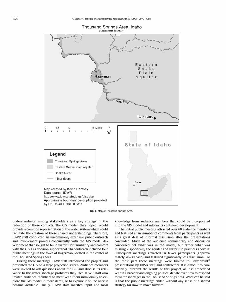
Fig. 1. Map of Thousand Springs Area.
K. Ramsey / Journal of Environmental Management 90 (2009) 1972–19801976
understandings’’ among stakeholders as a key strategy in thereduction of these conflicts. The GIS model, they hoped, wouldprovide a common representation of the water system which couldfacilitate the creation of these shared understandings. Therefore,IDWR staff conducted an uncommonly extensive public outreachand involvement process concurrently with the GIS model de-velopment that sought to build water user familiarity and comfortwith the GIS as a decision support tool. That outreach included fourpublic meetings in the town of Hagerman, located in the center ofthe Thousand Springs Area.
During these meetings IDWR staff introduced the project andpresented the GIS on a large projection screen. Audience memberswere invited to ask questions about the GIS and discuss its rele-vance to the water shortage problems they face. IDWR staff alsoinvited audience members to meet with them individually to ex-plore the GIS model in more detail, or to explore it online once itbecame available. Finally, IDWR staff solicited input and local
knowledge from audience members that could be incorporatedinto the GIS model and inform its continued development.
The initial public meeting attracted over 60 audience membersand featured a fair number of comments from participants as wellas a great deal of informal discussion after the presentationsconcluded. Much of the audience commentary and discussionconcerned not what was in the model, but rather what wasmissing – specifically the aquifer and water use practices above it.Subsequent meetings attracted far fewer participants (approxi-mately 20–30 each) and featured significantly less discussion. Forthe most part these meetings were limited to PowerPoint�
presentations by IDWR staff and contractors. It is difficult to con-clusively interpret the results of this project, as it is embeddedwithin a broader and ongoing political debate over how to respondto water shortages in the Thousand Springs Area. What can be saidis that the public meetings ended without any sense of a sharedstrategy for how to move forward.
K. Ramsey / Journal of Environmental Management 90 (2009) 1972–1980 1977
5.1. Case study analysis and discussion
At the heart of this water conflict were significant differences inunderstandings regarding the water shortage problem and how itshould be addressed. These differences reflected the situated per-spectives of actors in the conflict. Here I will focus specifically onthe differences in understandings expressed by IDWR staff and byspring water users.
The goal of IDWR staff in regards to this project was to ‘‘identifyand address unmet demand of senior water rights.’’3 This is a legaldescription of the problem. ‘‘Demand’’ is a legal measure calculatedbased on the water right as well as a number of other factors. Thisdescription of the problem represents IDWR’s institutionally andpolitically situated position as the agency responsible for managingwater rights in accordance with Idaho law and the belief/expecta-tion that they can do so in an objective and politically neutralmanner.
This situated perspective significantly influenced the ways inwhich IDWR staff interpreted the value and relevance of the GIS tothe problem at hand. For example, their commitment to objectivityappeared to motivate their decision to construct a singular model ofthe water system which included only empirically verifiable datasuch as water flow measurements of various springs, canals, andditches. This model excluded both the aquifer and water use prac-tices above the aquifer, thus preventing examinations of the impactsof ground water pumping and other practices on spring flows. In-stead, IDWR staff designed the GIS model specifically to focus at-tention on where water is flowing in the spring water users’ ownbackyards in order to identify who is short of water, and who is not.
Spring water users, meanwhile, presented a very differentdescription of the problem and a very different set of goals for thedecision process. Specifically, they were concerned with restoringthe physical water system on which they depend. For example, theyexpressed a desire to ‘‘[restore] historic spring [flow] levels’’, stopthe ‘‘aquifer declines’’, and maintain ‘‘dependable’’ water availability.These goals in part reflect their experiential knowledge of thephysical water system. Most have lived in the area for decades andmany have observed the springs decline steadily as agriculture, dairyproduction facilities, and residential development spread across theEastern Snake River Plain above the aquifer. They directly relatereductions in spring flows to increases in ground water pumpingfrom the aquifer as well as other shifts in agricultural practice thatreduce the amount of water seeping into the aquifer. Furthermore,many of the spring water users I interviewed, and some of those whospoke out during the meetings, expressed frustration with IDWR’slegal description of the problem. They argued that the ways in whichdemand is calculated is not transparent and openly speculated thatcalculations may be fixed so that spring water users end up gettingless water than they feel they are legally entitled.
A GIS-based model could be constructed to represent either ofthese two distinct understandings of the water shortage problem.In fact a single GIS could include all of the elements of the watersystem described by both IDWR staff and spring water users.However, a problem solving tool requires a single definition of theproblem which is to be solved. It also requires a clear definition ofwhat kinds of knowledge or information are admissible into theGIS, and which are not.
Based on the explicit project goals articulated by IDWR staff, theGIS they constructed was designed first and foremost to bea problem solving tool. Indeed, its design reflected this goal. The
3 Quoted from Dave Tuthill’s 2003 presentation at the Thousand Springs Surfaceand Ground Water Users Stakeholder Public Meeting in Hagerman, ID‘‘Development of modeling tools and public interfaces to be used in the im-plementation of adaptive management in the Thousand Springs Area’’.
model contained elements of the water system that were necessaryto identify where unmet ‘‘demand’’ may be occurring and excludedmany other elements of concern to spring water users. Further-more, IDWR staff members’ belief that only objective and mea-surable evidence should be considered in analyses of the watershortage problem severely constrained the kinds of informationthat could be considered for inclusion in the GIS model. During thepublic meetings and in interviews spring water users describeda wide variety of experiential insights into the water shortageproblem – from hypotheses regarding the relationship betweenspecific water use changes above the aquifer and observed declinesin specific springs, to knowledge of collaborative water use strat-egies employed by spring water users during times of shortage.These insights were rarely backed up with measurable data.Therefore, at best, IDWR staff treated such insights as opportunitiesfor future engineering studies or the installation of additional waterflow measurement devices – activities which may result in ap-propriate data for the GIS model many years down the road. In theshort-term, however, this resulted in the exclusion of the contri-butions of spring water users and the further alienation of the GISmodel from their concerns.
These findings indicate that the way in which IDWR staff posi-tioned the GIS model as an objective, problem solving tool resultedin it being ill suited to support collaborative problem exploration.In essence, the GIS became an imposition of a particular un-derstanding of the water shortage problem which was quite dif-ferent than the understandings of many spring water users. In otherwords, constructing a GIS to aid in problem solving necessarilyprivileged one understanding (or rationalization) of the problem.Knowledge and concerns which did not fit that particular ration-alization of the problem become difficult, if not impossible, torepresent in the GIS. As a result, the GIS was no longer useful asa tool for sharing and exploring different problem understandings.
Not only was the GIS constructed by IDWR staff ill suited forcollaborative problem exploration, it also appeared to have littlesupport as a collaborative problem solving tool. Many commentsexpressed by spring water users indicated that they did not shareIDWR’s notion that the GIS is a neutral and objective tool that couldbe used to support decision making. For example, during interviewstwo spring water users explicitly expressed concern over the pos-sibility of bias in the model due to the disparity in influence be-tween the spring and ground water users. Many others expressedfear that the model would indicate something that they know to befalse based on first-hand experience – such as the notion thatcurrent spring flow levels are sufficient. This sentiment was echoedby public meeting participants who argued that they do not needa computer to tell them what the problem is because they alreadyknow that ground water pumping reduces spring flows. It isimpossible to ascertain whether or not a more flexible GIS – onewhich could incorporate other perspectives about the watershortage problem – would have been viewed more favorably byspring water users. However it can be said that the lack of flexibilitycertainly did not help win their favor.
It is not hard to imagine why IDWR staff chose to conduct thepublic involvement process in the ways that they did. Much asMcGuirk (2001) found in her collaborative planning case study, theIDWR staff facilitating the meetings did not (and, I would argue,could not) isolate their situated perspective as arbiters of the waterdispute from their role as facilitators of an effort to identify sharedunderstandings and shared strategies for addressing the watershortages. When faced with disparate and conflicting accountsabout the water shortage problem and what to do about it, theyunderstandably relied on their professional knowledge and train-ing to identify those aspects of the problem that could be un-derstood and predictably addressed with traditional water resourceengineering practice. Other aspects of the problem still clouded by
K. Ramsey / Journal of Environmental Management 90 (2009) 1972–19801978
uncertainty (e.g., impacts of ground water pumping on springflows) were not so easily addressed with their training and practice,and therefore were necessarily marginalized in their mediation ofthis process. Furthermore, using GIS for problem exploration ac-tivity would have likely necessitated representing multiple, andpotentially conflicting, accounts of the water shortages. Such ef-forts, from the perspective of IDWR staff, would undermine thesymbolic authority of GIS as a neutral and objective tool. It wouldalso, from this perspective, undermine the utility of GIS for sup-porting problem solving activity that is consistent with IDWR’sparticular problem understanding.
One interpretation of this case is that it represents only a uniqueexample of human misjudgment in the facilitation of GIS-supported public involvement. I wish to argue, however that, a keycomponent of this (mis)judgment was a failure to explicitly dealwith tension between the dual objectives of problem solving andthe creation of shared understandings. Furthermore, this tension isnot unique. Rather it can be observed in a wide variety of ‘‘collab-orative’’ GIS initiatives. Greater attention to this tension by GISresearchers, I argue, can help to avoid many of the pitfalls observedin this study. In the following section, I propose a set of recom-mendations regarding how GIS researchers can design systemsand processes that enable more equitable opportunities for thecollaborative exploration of disparate situated understandings ofcomplex environmental and resource management problems – anexploration which is necessary before collaborative problemsolving can begin.
6. Recommendations for CGIS research and practice
Reflecting upon this case study, I propose three recommenda-tions for GIS researchers and practitioners seeking to design sys-tems and processes to support collaboration in the context ofcontentious public decisions about environmental and naturalresource management. A key principle underlying each of theserecommendations is the need to initially emphasize support forproblem exploration over problem solving. As the case studyillustrates, when a GIS is designed to support both problemexploration and problem solving, problem exploration inevitablyloses out. These recommendations attempt to avoid this pitfall.
6.1. Find a ‘‘neutral’’ facilitator
One lesson from the case study stems from the conflict inherentin having an interested participant in the collaboration also servingas the facilitator. While IDWR staff did not have a monetary stake inthe outcome of the collaboration, they did have a professionalstake. In other words, their professional commitment to a particu-lar way of understanding and addressing water resource disputessignificantly undermined their openness to other approaches andways of defining or rationalizing the water shortage problem. Thepresence of a more ‘‘neutral’’4 facilitator could have helped tominimize this form of marginalization.
6.2. Avoid pre-defining the problem
In the case study above, the GIS constructed by IDWR pre-de-fined the problem space by modeling and representing particular
4 The scare quotes around ‘‘neutral’’ of course allude to the fact that completeneutrality is impossible. All people make sense of the world based on their previousexperiences and training, and therefore they are ‘‘biased’’ towards particular waysof making sense of the world. None-the-less there are professional facilitators withexperience mediating collaborations between people with disparate experiences,understandings, and interests.
kinds of phenomena while excluding others. It also pre-definedwhat kinds of knowledge or information about the problem areallowable for inclusion in the model, and what kinds are not.Similarly, GIS applications which include multicriteria analysisfunctionality (e.g., Jankowski and Stasik, 2006; Malczewski, 2006)also work to pre-determine the ways in which the problem can beconceptualized, such as a trade-off between multiple quantitativecriteria. These kinds of applications are only useful to the extentthat all the participants involved in the collaboration already agreeupon the definition of the problem and conceptualization of theproblem space. When this is not the case, such applications make itmore difficult for alternative perspectives to be expressed andheard.
In many cases, as in the water dispute described above, there arelegal or policy constraints which may prescribe how the problemcan or cannot be addressed. These constraints should mostcertainly be acknowledged and represented in a collaborative GISapplication. However, these constraints should neither determinethe design of the application nor bound how participants are ableto discuss and approach the problem. There are a number ofexamples of successful collaborations where existing laws andpolicy frameworks are adjusted to make way for innovative newapproaches identified by the collaborators (Wondolleck and Yaffee,2000).
Problem definitions should emerge through collaborativeproblem exploration. Flexible GIS applications may be able to helpin this process. If and when a ‘‘consensus’’ emerges (partial, pro-visional, or otherwise) it may be appropriate to collaborativelydesign a new problem solving oriented GIS application to help incollaboratively identifying potential solutions. However, thisshould be seen as a separate GIS application which has entirelydifferent design considerations that emerge out of the initialproblem exploration process.
6.3. Support problem exploration with flexible GIS applications
GIS scholars have suggested a number of methods for support-ing flexibility in problem exploration (e.g., Ramasubramanian,1999; Talen, 2000; Weiner and Harris, 2003; Ramsey, in press).Drawing in part from these earlier approaches, I outline one that isparticularly relevant to the case study described above. In thismodel, each self-affiliating group of like-minded stakeholder-par-ticipants would have the opportunity to work with a GIS specialistto construct a new GIS model that represents the water shortageproblem from their unique perspective. This includes both thephysical functioning of the water system and the various factorsthat are understood to influence who receives water and how much(legal, political, economic, environmental, etc.). When it is possibleto visualize and spatialize these factors, they are added directly tothe map. When they cannot, annotations with text or other mediacan be included. There is no limit to how the problem can bedefined or what factors are considered to be outside of the scope ofthe problem.
When groups are satisfied with their GIS a collaborative forummay be convened. In this forum, IDWR would be positioned assimply one group alongside the others, with their own perspectiveand GIS model. Each group shares their representations of theproblem. Participants can discuss the commonalities and dispar-ities between the multiple representations. The technical consul-tants can perform GIS operations and analyses (e.g., overlays,networks analyses) to aid in these comparisons if the participantsfind this helpful. Disparities found will present opportunities forexploring in more detail the differences in perspectives of collab-oration participants. When participants find commonalities theycan agree on, they can begin the process of constructing a newmodel with those elements.
K. Ramsey / Journal of Environmental Management 90 (2009) 1972–1980 1979
By focusing the collaboration on the review and comparison ofmultiple representations of the problem, rather than a singularmodel, participants may begin to appreciate that every map andmodel tells a particular kind of story that represents a particularperspective (Ramsey and Wilson, in press). This can help to open upthe discussion about the problem and problem space in ways thatacknowledge participant differences and allows for ideas beexpressed in their own terms. Without this openness it is impos-sible to work towards a shared communicative rationality thatreflects an equitable deliberation.
7. Conclusion
In this article I proposed that collaborative GIS initiativesprematurely oriented towards the activity of problem solving un-dermine the important process of exploring and reconciling diverseproblem understandings among those affected by the problem.Furthermore, without this kind of problem exploration, I argued,equitable collaboration with diverse participants is impossible. Isupported this argument theoretically by turning to the literaturescollaborative planning and spatial decision support, and empiri-cally in my analysis of a case study into water resource manage-ment in rural Idaho. Finally I provided a set of recommendations toCGIS researchers and practitioners who wish to find ways to bettersupport collaborative problem exploration in the context ofcontentious environmental and resource decisions.
In closing, I wish to clarify that I do not claim that collaborativeproblem solving is necessarily impossible or a bad thing that shouldalways be avoided. Rather I argue that the activity of problemsolving, which necessarily involves defining the problem and a wayof identifying and rationalizing potential solutions to that problem,is always problematic in the context of contentious public decisionswhere participants bring very different perspectives andunderstandings. This is because defining the problem, and thereforethe ways in which it can be addressed, always – and necessarily –involves privileging particular perspectives and understandingswhile marginalizing others. Such decisions should evolve out of openand inclusive deliberation among all collaboration participants, theyshould not be pre-determined by the ways in which our GISapplications structure and represent the problem. Only after theseexploratory deliberations can truly equitable collaborative problemsolving begin.
Acknowledgements
This research was supported in part by the Idaho Department ofWater Resources; however, the ideas and opinions expressed in thispaper are solely my own. I would also like to thank Scott Miles,Michael Brown, and two anonymous reviewers for their helpfulfeedback on early drafts of this paper.
References
Armstrong, M.P., 1993. Perspectives on the development of group decision supportsystems for locational problem solving. Geographic Systems 1, 69–81.
Atkinson, P., Hammersley, M., 1994. Ethnography and participant observation. In:Denzin, N.K., Lincoln, Y.S. (Eds.), Handbook of Qualitative Research. Sage Pub-lications, Thousand Oaks, pp. 248–261.
Baldwin, J., Brandt, D., Hagan, E., Wicherski, B., 2000. Cumulative Impacts Assessment,Thousand Springs Area of the Eastern Snake River Plain, Idaho: Ground WaterTechnical Report No. 14. Idaho Department of Environmental Quality, Boise.
Balram, S., Dragicevic, S., 2006a. Collaborative geographic information systems: ori-gins, boundaries, and structures. In: Balram, S., Dragicevic, S. (Eds.), CollaborativeGeographic Information Systems. Idea Group Pub., Hershey, PA, p. xviii, 364 p.
Balram, S., Dragicevic, S., 2006b. Collaborative Geographic Information Systems.Idea Group Pub., Hershey, PA.
Carver, S., 1991. Integrating multicriteria evaluation with GIS. International Journalof Geographical Information Systems 5, 321.
Costanza, R., Ruth, M., 1998. Using dynamic modeling to scope environmentalproblems and build consensus. Environmental Management 22, 183–195.
Couclelis, H., Monmonier, M., 1995. Using SUSS to resolve NIMBY: how spatial un-derstanding support systems can help with the ‘not in my backyard’ syndrome.Geographical Systems 2, 83–101.
Densham, P.J., 1991. Spatial decision support systems. In: Maguire, D.J.,Goodchild, M.F., Rhind, D.W. (Eds.), Geographical Information Systems: Princi-ples and Applications. John Wiley and Sons, New York.
Eastman, J.R., Jin, W., Kyem, P.A.K., Toledano, J., 1995. Raster procedures for multi-criteria/multiobjective decisions. Photogrammetric Engineering and RemoteSensing 61, 539.
Elwood, S., Leitner, H., 2003. GIS and spatial knowledge production for neighbor-hood revitalization: negotiating state priorities and neighborhood visions.Journal of Urban Affairs 25, 139–157.
Hajer, M.A., 1995. The Politics of Environmental Discourse: Ecological Modernizationand the Policy Process. Clarendon Press; Oxford University Press, Oxford; New York.
Hawthorne, T.L., Dougherty, M., Elmes, G., Fletcher, C., McCusker, B., Pinto, M.,Weiner, D., 2006. Beyond the public meeting: building a field-based partici-patory GIS for land use planning in Monongalia County, West Virginia. In:Balram, S., Dragicevic, S. (Eds.), Collaborative Geographic Information Systems.Idea Group Pub., Hershey, PA.
Healey, P., 1992. Planning through debate: the communicative turn in planningtheory. Town Planning Review 63, 143–162.
Herbert, S., 2000. For ethnography. Progress in Human Geography 24, 550–568.Horita, M., 2000. Mapping policy discourse with CRANES: spatial understanding
support systems as a medium for community conflict resolution. Environmentand Planning B: Planning and Design, 801–814.
Upper Snake River Basin Study, 1997. IDWR, Boise, ID.Innes, J.E., Booher, D.E., 2000. Public participation in planning: new strategies for the 21st
Century. Annual Conference of the Association of Collegiate Schools of Planning.Jankowski, P., 1995. Integrating geographic information systems and multiple cri-
teria decision making methods. International Journal of Geographical In-formation Systems 9, 251.
Jankowski, P., Nyerges, T.L., 2001. GIS-supported collaborative decision making:results of an experiment. Annals of the Association of American Geographers91, 48–70.
Jankowski, P., Nyerges, T.L., Smith, A.G., Moore, T.J., Horvath, E., 1997. Spatial groupchoice: A SDSS tool for collaborative spatial decision making. InternationalJournal of Geographical Information Systems 11, 577–602.
Jankowski, P., Stasik, M., 2006. An experimental study using SDS tools for a par-ticipatory approach to local land use planning. In: Balram, S., Dragicevic, S.(Eds.), Collaborative Geographic Information Systems. Idea Group Pub., Her-shey, PA.
King, J.L., Kraemer, K.L., 1993. Models, Facts, and the Policy Process: The PoliticalEcology of Estimated Truth. Center for Research on Information Systems andOrganizations (CRITO), Irvine, CA.
Korfmacher, K.S., 2001. The politics of participation in watershed modeling. Envi-ronmental Management 27, 161–176.
Kwan, M.-P., 2002. Feminist visualizations: re-envisioning GIS as a method infeminist geographic research. Annals of the Association American Geographers92, 645–660.
Malczewski, J., 2006. Multicriteria decision analysis for collaborative GIS. In:Balram, S., Dragicevic, S. (Eds.), Collaborative Geographic Information Systems.Idea Group Pub., Hershey, PA, p. 167.
McGuirk, P., 2001. Situating communicative planning theory: context, power, andknowledge. Environment and Planning A 33, 195–217.
Musser v. Higginson, 871 P.2d 809, 1994.Nyerges, T., Montejano, R., Oshiro, C., Dadswell, M., 1998. Group-based geographic
information systems for transportation site selection. Transportation ResearchC: Emerging Technologies 5, 349–369.
Nyerges, T., Jankowski, P., Tuthill, D., Ramsey, K., 2006a. Collaborative water re-source decision support: results of a field experiment. Annals of the AmericanAssociation of Geographers 96, 699–725.
Nyerges, T., Ramsey, K.S., Wilson, M.W., 2006b. Design considerations for an in-ternet portal to support public participation in transportation improvementdecision making. In: Dragicevic, S., Balram, S. (Eds.), Collaborative GIS. IdeaGroup Inc., Hershey, PA, pp. 208–236.
Pavlovskaya, M.E., 2002. Mapping urban change and changing GIS: other views ofeconomic restructuring. Gender, Place and Culture: A Journal of FeministGeography 9, 281.
Poncelet, E.C., 2001. A kiss here and a kiss there’’: conflict and collaboration inenvironmental partnerships. Journal of Environmental Management 27, 13.
Ramasubramanian, L., 1999. Nurturing community empowerment: participatorydecision making and community based problem solving using GIS. In:Craglia, M., Onsrud, H. (Eds.), Geographic Information Research: Trans-AtlanticPerspectives. Taylor and Francis, New York, pp. 87–102.
Ramsey, K. A call for agonism: GIS and the politics of collaboration, Environmentand Planning A, in press.
Ramsey, K.S., 2004. Stakeholder Involvement and Complex Decision Making: A CaseStudy into the Design and Implementation of a GIS for Supporting Local WaterResource Management. Department of Geography, University of Washington,Seattle, pp. i–iv, 119.
Ramsey, K.S., Wilson, M.W., Rethinking the ‘informed’ participant: precautions andrecommendations for the design of online deliberation, in: Davies T., Noveck B.(Eds.), Online Deliberation: Design, Research, and Practice, CSLI Publications,Stanford, CA, in press.

K. Ramsey / Journal of Environmental Management 90 (2009) 1972–19801980
Rangen Inc.. Priority Call for Water, 2004.Rinner, C., 2006. Argumentation mapping in collaborative spatial decision making.
In: Balram, S., Dragicevic, S. (Eds.), Collaborative Geographic Information Sys-tems. Idea Group Pub., Hershey, PA, pp. 85–102.
Sehlke, G., 2000. An Evaluation of the Conjunctive Management of Surface Waterand Ground Water Resouces in Idaho. Hydrology. University of Idaho.
Sengupta, R., 2006. Simulation modeling within collaborative spatial decisionsupport systems using ‘‘Cause-Effect’’ models and software agents. In:Balram, S., Dragicevic, S. (Eds.), Collaborative Geographic Information Systems.Idea Group Pub., Hershey, PA, p. 150.
Susskind, L., McKearnan, S., Thomas-Larmer, J., 1999. The Consensus BuildingHandbook: A Comprehensive Guide to Reaching Agreement. Sage Publications,Thousand Oaks, CA.
Talen, E., 2000. Bottom-up GIS - A new tool for individual and group expression inparticipatory planning. Journal of American Planning Association 66,279–294.
Thill, J.-C., 1999. Spatial Multicriteria Decision Making and Analysis: A Geo-graphic Information Sciences Approach. Ashgate, Aldershot, England;Brookfield, VT.
Tuthill, D., 2002. Utilization of Emergind Geo-Spatial Technologies in the Im-plementation of Conjunctive Administration of Surface and Ground Water. CivilEngineering. University of Idaho, Boise.
Weiner, D., Harris, T.M., 2003. Community-integrated GIS for land reform in SouthAfrica. URISA Journal 15, 61–73.
Wondolleck, J.M., Yaffee, S.L., 2000. Making Collaboration Work: Lessons From In-novation in Natural Resource Management. Island Press, Washington, D.C.