
GIS - Graphical Web · Client SVG Map Viewer GIS (MapInfo,GeoMedia, ArcGIS).csv, .svg, .e00, .mif,...
25
-
Upload
truongcong -
Category
Documents
-
view
231 -
download
0
Transcript of GIS - Graphical Web · Client SVG Map Viewer GIS (MapInfo,GeoMedia, ArcGIS).csv, .svg, .e00, .mif,...


Client
SVG Map Viewer
GIS(MapInfo,GeoMedia,
ArcGIS)
.csv, .svg, .e00, .mif, .shp
Dynamic Generation of SVG documents
MySQL, PGSQL
Stuttgart University Applied Science
“Show Us”

C, needs root access
Java, root access might be necessary
Data provision unclear
Powerful, costly, partially difficult to install, focus on proprietary data formats
Fascinating, but no product

“is able to automatically overlay map images obtained from multiple dissimilar map servers, regardless of map scale, projection, earth coordinate system or digital format” (OGC 2004)

http://www.easywms.com/suasdemo/WMS/getmapcap.php?VERSION=1.1.1&SERVICE=WMS&REQUEST=GetCapabilities

http://www.easywms.com/suasdemo/WMS/getmapcap.php?VERSION=1.1.1&BBOX=189775.33,...&LAYERS=airports&STYLES=,&REQUEST=GetMap&style=default&SRS=EPSG:26715&WIDTH=800&HEIGHT=600&FORMAT=image/svg+xml&EXCEPTIONS=application/vnd.ogc.se_xml

http://www.easywms.com/suasdemo/WMS/getmapcap.php?VERSION=1.1.1&BBOX=4.569,.&QUERY_LAYERS=city&SERVICE=WMS&REQUEST=GetFeatureInfo&RADIUS=2&SRS=SRS_not_defined&WIDTH=800&HEIGHT=600&X=400&Y=400&INFO_FORMAT=text/xml
Y=pixel_row

htt
p:/
/ww
w.c
arto
.net
/pap
ers/
svg/
tuer
lers
ee/

• combination with other XML technologies like XLink
• True geo-data, used as visualization for GML
• conformant to DOM, analysis & modification using JavaScript

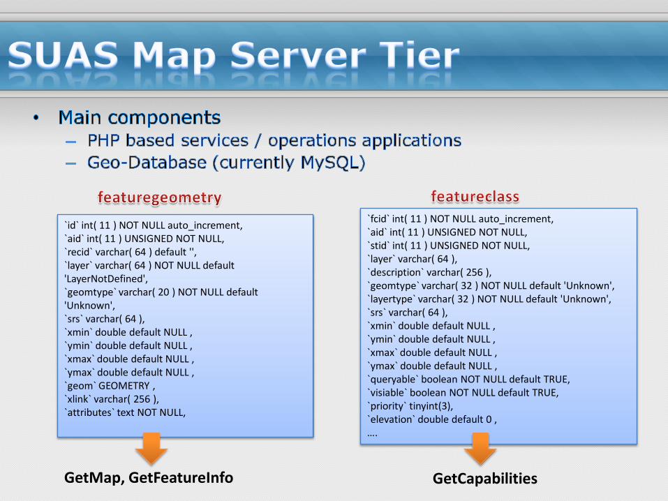
`id` int( 11 ) NOT NULL auto_increment,`aid` int( 11 ) UNSIGNED NOT NULL,`recid` varchar( 64 ) default '',`layer` varchar( 64 ) NOT NULL default 'LayerNotDefined',`geomtype` varchar( 20 ) NOT NULL default 'Unknown',`srs` varchar( 64 ),`xmin` double default NULL ,`ymin` double default NULL ,`xmax` double default NULL ,`ymax` double default NULL ,`geom` GEOMETRY ,`xlink` varchar( 256 ),`attributes` text NOT NULL,
`fcid` int( 11 ) NOT NULL auto_increment,`aid` int( 11 ) UNSIGNED NOT NULL,`stid` int( 11 ) UNSIGNED NOT NULL,`layer` varchar( 64 ),`description` varchar( 256 ),`geomtype` varchar( 32 ) NOT NULL default 'Unknown',`layertype` varchar( 32 ) NOT NULL default 'Unknown',`srs` varchar( 64 ),`xmin` double default NULL ,`ymin` double default NULL ,`xmax` double default NULL ,`ymax` double default NULL ,`queryable` boolean NOT NULL default TRUE,`visiable` boolean NOT NULL default TRUE,`priority` tinyint(3),`elevation` double default 0 ,….
GetMap, GetFeatureInfo GetCapabilities


• JavaScript based GUI
• Use Asynchronous JavaScript and XML (AJAX) technology - asynchronous progress of data exchanging with servers as background process

• Server selection
• zoom
• Pan


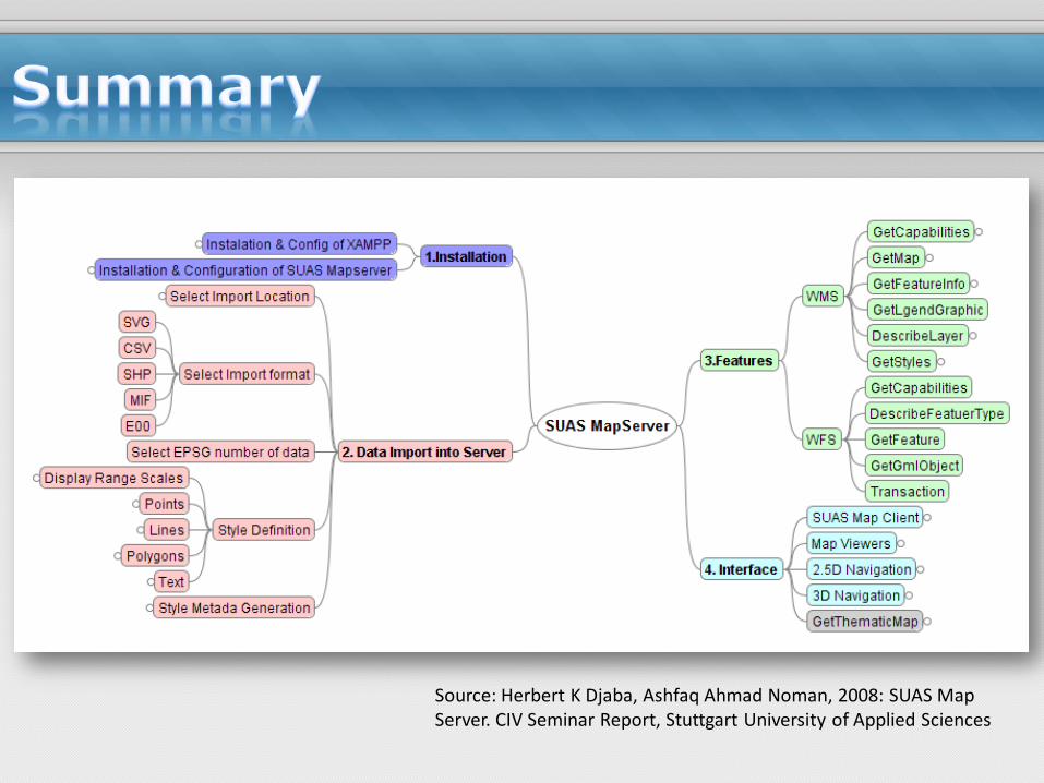
Source: Herbert K Djaba, Ashfaq Ahmad Noman, 2008: SUAS Map Server. CIV Seminar Report, Stuttgart University of Applied Sciences


