GIS and Society: A Critical Assessment. Critiques in the academic literature: Sheppard, E. 1995. GIS...
22
GIS and Society: A Critical Assessment
-
date post
20-Dec-2015 -
Category
Documents
-
view
215 -
download
0
Transcript of GIS and Society: A Critical Assessment. Critiques in the academic literature: Sheppard, E. 1995. GIS...

GIS and Society: A Critical Assessment
Critiques in the academic literature:
Sheppard, E. 1995. GIS and Society: Towards a Research Agenda. Cartography and Geographic Information Systems 22(1):5-16.
Pickles, J. (ed). 1995. Ground Truth http://www.geo.wvu.edu/i19/
papers/position.html
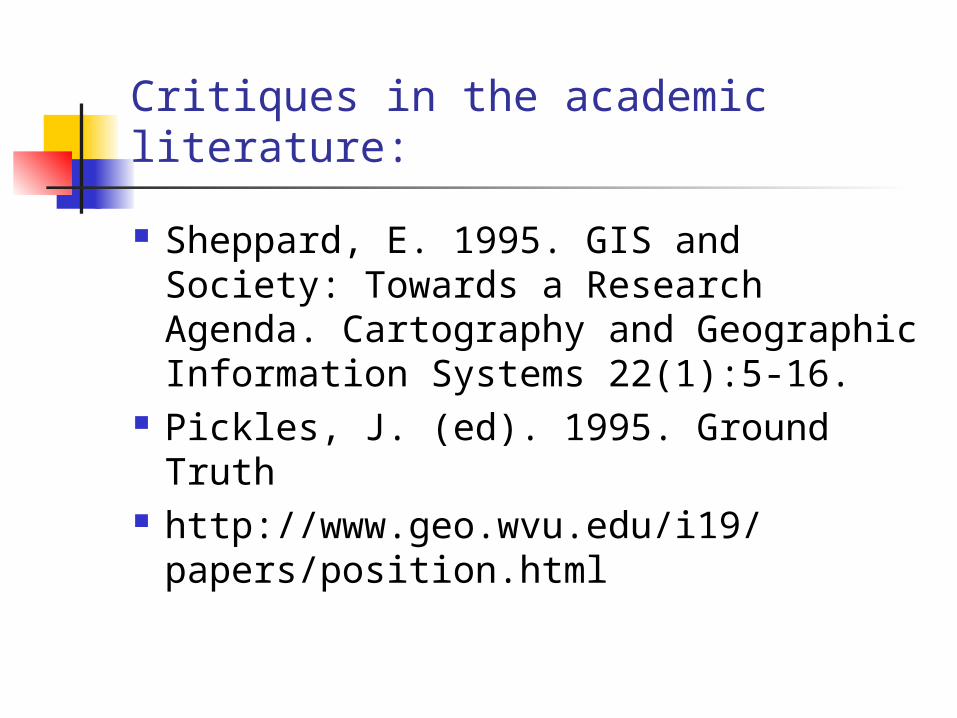
Initiative 19: GIS and Society: The Social Implications of How People, Space, and Environment are Represented in GIS (began February 1996).
The initiative focused attention on the social contexts of GIS production and use and addresses a series of conceptual issues:
In what ways have particular logic and visualization techniques, value systems, forms of reasoning, and ways of understanding the world been incorporated into existing GIS techniques, and in what ways have alternative forms of representation been filtered out?
How has the proliferation and dissemination of databases associated with GIS, as well as differentiatial access to spatial databases, influenced the ability of different social groups to utilize information for their own empowerment?
How can the knowledge, needs, desires, and hopes of marginalized social groups be adequately represented in GIS-based decision-making processes?
What possibilities and limitations are associated with using GIS as a participatory tool for more democratic resolution of social and environmental conflicts?
What ethical and regulatory issues are raised in the context of GIS and Society research and debate?

GIS as a tool? The idea that GIS, or any technology, is
simply a problem-solving tool views technology as the means to achieve a certain end. In this view, the goals are set independently, and technological development is the process of finding the tool that offers the best means to achieve that goal. In practice, however, it is difficult to separate means from ends.”

In other words, the social consequences of technologies go far beyond problem-solving to actually influencing the goals themselves, sometimes in dramatic ways (development of trade, cataloging of resources, definition of property ownership).

GIS is not just a tool for processing geographical information.
It is a social technology incorporating an entire institutionaland intellectual infrastructure that delivers and markets GIS. It has to be understood within the social context in which it was developed.

Much of the lead in GIS technology has been taken in North America and Great Britain. Thus it reflects:
Priorities of US society, such as demands for military surveillance,
The degree to which the private sector has dominated the development of GIS,
Type types of problems that potential customers for GIS wish to solve,
Factors affecting data availability and cost, Weakness of geography as an intellectual
discipline in the US, which affects the degree to which geographic expertise is used in the development of GIS.
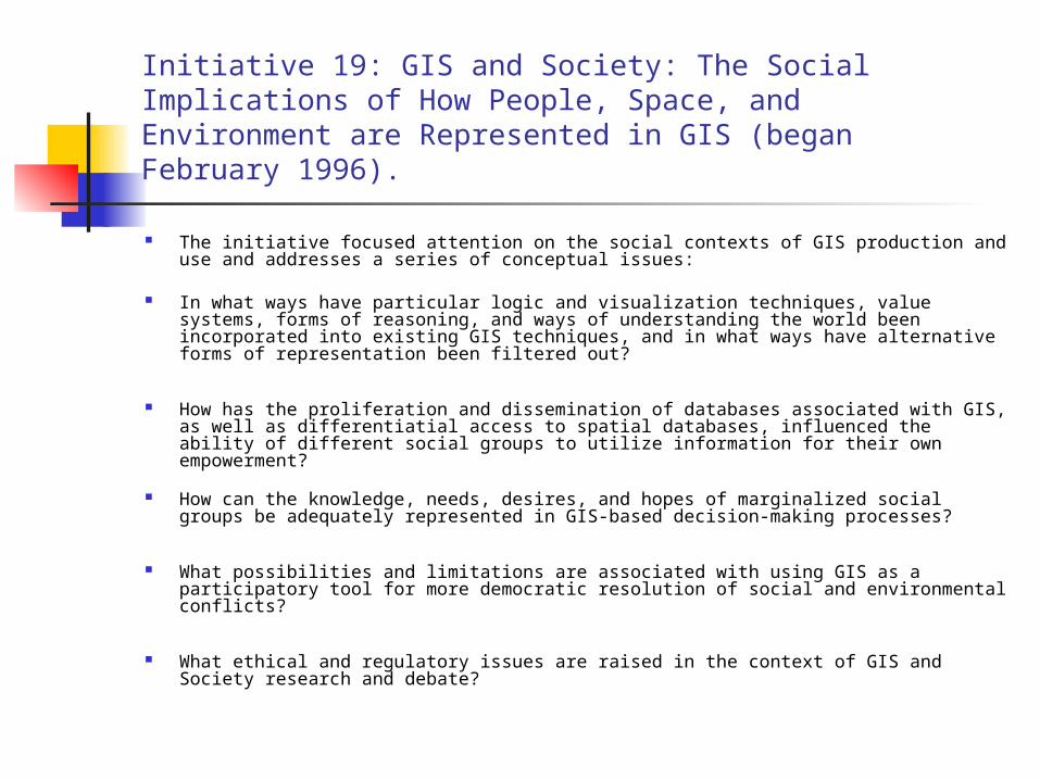
GIS is based on Boolean or mathematical logic:
Deductive logic thought to allow absolute truth or falsity of analytical statements to be assessed. But no absolute grounds exist for asserting the validity of mathematical logic. Alternative logics cannot be dismissed as inferior or subjective.
Boolean logic is fundamentally an instrumental, or agorithmic, logic, directed to finding solutions to problems. But communication involves a different form of rationality.
The focus on logic and problem-solving may hide other options and opportunities (eg siting of toxic waste dump).

Does GIS place limits on ways of representing space?
Computational operations on spatially referenced information must conform to basic geometric rules and assumptions, such as those specifying the continuity or divisibility of space, and excluding simultaneous occupancy of the same location in space-time by different objects.
In non-Western thought the range of possible conceptions of space is presumably much greater.

Problems with pattern analysis:
Different processes may produce the same pattern and the same pattern may be produced by different processes.
This requires a theory to identify what the important relations are. GIS lacks this, often ignoring underlying theories.
It provides a list of winners and losers, but provides no understanding as to why the differences occur.
GIS reinforces a tendency to rely on secondary data sources for empirical analyses.
Geographical analysis driven by the availability of data, rather than letting data collection be driven by theory.
Social power of information systems: private firms can get our credit card ratings, but we cannot get detailed financial information about those private firms…
Does GIS facilitate equal access to geographical information for all social classes?
Information technology has placed information and the equipment to process it in the hands of more users, linked in increasingly complex ways.
But the rapid development has resulted in increasingly sophisticated ways of using the information infrastructure to monitor and influence behavior.
Groups with access to GIS maybe able to make a better argument in conflictual political processes.
Polarization of users and non-users.

Socio-economic applications in GIS
Is there any real substance? Real estate, energy delivery, agribusiness, tourism,
and communications, insurance, retailing, market analyses, delivery services, telecommunications, fast food location strategies, and so on.
Missing are the analyses of ethical and political questions that emerge as GIS institutions and practices are extended into socioeconomic domains.
Concepts, practices, and institutional linkages remain unproblematized; treated as normal and reasonable ways of thinking and acting.

The pursuit of social goals (eg land distribution) through GIS is a political process and cannot ignore this fact, no matter how much GIS may allow us to simulate possible alternative decision-making scenarios. Value-neutral GIS does not exist.
GIS empowers the powerful and disenfranchises the weak and not so powerful through the selective participation of groups and individuals.

Data are usually treated unproblematically, except for technical concerns about errors.
But every data set represents a multitude of social relations.
In general, the more powerful do the finding out about the less powerful.
Since most data are collected by the state (eg census data), GIS can be criticized as being a handmaiden of the state.
This wouldn’t be a problem if all states were benign, but they aren’t.

GIS neglects themes that are not included in the data.
The poorer the country, the worse and less the data. Thus much of the world is neglected within GIS analyses.
Alternative worlds for which there are no data are ruled out or excluded.
Information gathering as a commercial activity, producing a product for sale (eg weather information)
Disadvantaged groups are least able to purchase the information that they need, especially information that is expensive to collect.
Although more accurate information can improve understanding, it can also enable actors to act in more complex ways (eg airline pricing).
The more complex a society becomes, the more complex and expensive the information it needs to make sense of itself.
GIS does not incorporate ”indigenous” knowledge. Diverse information possessed by different racial
groups, classes, and genders is usually excluded.

Surveillance capabilities of GIS
GIS has been linked with the academy, the state, and capital.
”Information society” as a misnomer that hides the increasing surveillant capability of state institutions and transnational corporate enterprises (see Pickles 1991).
Example: Montes Azules Biosphere Reserve Settlers were already living in the reserve
when it was established in 1979. Others have moved in more recently.
Conservation International routinely monitors the situation in this biosphere reserve to detect illegal deforestation.
The Mexican military has access to this information and has evicted entire villages (coincides with efforts to wipe out EZLN).
GIS seen by many as an ominous system of surveillance.

The power of GIS should not be underestimated, but at the same time GIS should not be overpromoted or blindly attacked. GIS provides a tool to use on geographical information. What they are used for and how to make best use of them depends on the attitudes and mindsets of their users and what they want to do with them.

Discussion…
GIS as ”the escalator that geography can ride to finally occupy its legitimate position as a significant member of the quantitative and empirical sciences” (Sheppard 1995, p. 5)
Discussion
Does GIS contribute to ”a growing split between ’techies’ and ’intellectuals’ in contemporary geography”?
(Sheppard 1995, p. 5)