GIS and Public Sector Reform Local Government Perspective · GIS and Public Sector Reform Local...
51
www.forthvalleygis.gov.uk Fax 01786 442818 Tel 01786 442976 GIS and Public Sector Reform Local Government Perspective Alan Moore Head of Forth Valley GIS 24 th November 2006
Transcript of GIS and Public Sector Reform Local Government Perspective · GIS and Public Sector Reform Local...

www.forthvalleygis.gov.ukFax 01786 442818Tel 01786 442976
GIS and Public Sector Reform
Local Government Perspective
Alan Moore
Head of Forth Valley GIS
24th November 2006

www.forthvalleygis.gov.ukFax 01786 442818Tel 01786 442976
Public Services
• Services provided by public bodies have a wide sphere of influence
• If you have…– registered with/visited a doctor or been to hospital
– travelled on a ferry or plane to one of the Scottish islands
– children in nursery, been to school, taken a higher/further education course
– had your refuse collected
– received Council Tax benefits
– borrowed a library book
– visited museums or galleries
– used water or sewerage services
– walked in the countryside or on the hills
– been to a swimming pool or leisure facility
– used careers advice services
– used legal aid
– had a student loan………………
• Public bodies contribute in all these areas and many more
• Delivered by Central Government, Local Government, Voluntary andCommunity Organisations and wide/varying partnerships

www.forthvalleygis.gov.ukFax 01786 442818Tel 01786 442976
Central Government
• The Scottish Executive is the devolved government for Scotland• The Scottish Executive is responsible for 77 national and 64
local Public Bodies:– 31 Executive Non-departmental Public Bodies– 45 Advisory Non-departmental Public bodies (including 32 Justice
of the Peace Advisory Committees)– 39 Tribunals (including 32 Children's Panels)– 2 nationalised industries– 1 public corporation– 23 NHS bodies
• Employs c.249,000 staff• Administers an annual budget of c.£30 billion• Distributed through public bodies (c. £21bn) and local
authorities (c.£9bn)

www.forthvalleygis.gov.ukFax 01786 442818Tel 01786 442976
Local Government
• 32 Local Authorities
• 8 Police Authorities
• 8 Fire and Rescue Services
• 14 Health Boards
• 14 Valuation Joint Boards
• 8 Local Enterprise Companies
• 38 Community Health Partnerships
• 32 Community Planning Partnerships
• Local authorities employ c. 323,000 staff
• Annual budget of c. £9bn

www.forthvalleygis.gov.ukFax 01786 442818Tel 01786 442976
Tensions
• Multilevel, distributed mix of public service organisations
• Central ‘v’ regional ‘v’ local
• Partnership ‘v’ organisation
• Customer ‘v’ community
• Community ‘v’ region
• Public ‘v’ private
• Scotland ‘v’ UK ‘v’ Europe
• Mixed geographies

www.forthvalleygis.gov.ukFax 01786 442818Tel 01786 442976
Drivers for Change
� More diverse and individualistic society� Higher expectations of service quality� Services tailored to needs� Global issues – climate change, sustainable
development� Increasing globalisation � Increasing competition from India, Eastern
Europe, China etc.� Significant technology changes� New ways of working and delivering services� Demographic change – increasing elderly
population� shrinking workforce� increased pressure on health, care, transport
services etc.� Reducing engagement in democratic processes� Social disadvantage and exclusion

www.forthvalleygis.gov.ukFax 01786 442818Tel 01786 442976
Drivers for Change
� Transforming GovernmentPublic services must :� Be user-focused and personalised� Drive up quality and encourage innovation� Improve efficiency and productivity� Join up services and minimise separation� Strengthen accountability
� Efficient Government� Modernising Government Fund� Integrated service delivery� Collaboration and shared working� Investing in technology� Investing in the workforce� £1.2bn cash efficiencies by 2010
� Shared Services� Corporate support functions� Service improvements � Efficiency savings

www.forthvalleygis.gov.ukFax 01786 442818Tel 01786 442976
Public Service Reform
� Central and Local services become …..– More accessible– More responsive– More convenient– More consistent– More transparent– More cost effective– More inclusive
� Central and Local Service providers…– Improve resource management– Improve information management
– Collect once use many times– Data sharing and data exchange
– Improve business processes– Improve accountability– Improve decision making– Improve operating efficiency– Improve partnership working
� Enabled by new technology and improved use of information

www.forthvalleygis.gov.ukFax 01786 442818Tel 01786 442976
e-Government

www.forthvalleygis.gov.ukFax 01786 442818Tel 01786 442976
Customer First
� Scottish Executive funded programme� Now managed by the Improvement Service
• Aims to :– Deliver more convenient and responsive public services. – Encourage take up of online (self-service) access to services. – Ensure that at least 75% of core service requests can be dealt
with at the first point of contact.
� 4 key sub programmes� National infrastructure/Citizen Account� National voluntary entitlement card� CRM/Customer Services� Definitive National Address for Scotland (DNAS)
� DNAS sub programme� Definitive address dataset� Standards based (BS7666)� Unique identifiers, accurate georeferencing� Linked to Local Street Gazetteer� Linked to other address datasets
www.forthvalleygis.gov.ukFax 01786 442818Tel 01786 442976
Within a Council…..
Planning
Street
Naming
Building
Standards
Assessors
&
Revenues
Integrate to
Maintain
Integrate to Share
Other Back Office Systems
GIS
CAG
LSG
Customer Staff
CRMPublic
Website Intranet

www.forthvalleygis.gov.ukFax 01786 442818Tel 01786 442976
National Address Gazetteer
Revenue
Collectione-Planning Land Terrier
Asset
Management
Shared Services (possible examples being considered)
Community
Planning
SN&N
DNA
Gazetteer
(BS7666)
Royal
Assessor
OS
ROS
X 32
Other Council Systems
CAG
(BS7666)

www.forthvalleygis.gov.ukFax 01786 442818Tel 01786 442976
Assessor’s Portal
• Single-point access to business rate and council tax banding details for all properties in Scotland (www.saa.gov.uk )
• Part of the CustomerFirst/DNA-
Scotland programme
• Two ‘views’ are available
• public access
• government access
• Operational since Summer 2004 with
use high – more than 120,000 ‘page
views’ per week on the public site
alone

www.forthvalleygis.gov.ukFax 01786 442818Tel 01786 442976
E-Planning
• Efficient Government Funded Programme
• c.£12m investment – opportunity to release c.£27m-£44m savings
• Led by Scottish Executive, involves 32 local authorities, 2 National Parks, SEPA, SNH, Historic Scotland, Scottish Water and Transport Scotland
• 5 workstreams
– Online applications and appeals
– Online planning information systems
– Expert systems
– eConsultations
– Online Local Plans
• Shared services, joint procurement, best practice and modernisation of the planning system
• Integration of GIS, Address Gazetteers and business systems to support the planning processes

www.forthvalleygis.gov.ukFax 01786 442818Tel 01786 442976
Local Government Services
• Some are obvious – planning, roads, schools, social work, refuse……• But, how many different services are provided by local authorities?
– 10?, 50?, 100?• Glasgow Council lists c.485 services……..
� Local government facing immense pressure to innovate, change andimprove service delivery….
� Creates a framework for change in local government use of GIS and corporate information resources
Access Centre
Accident Prevention
Abandoned Vehicles
Advocacy
Air Quality
Active Glasgow
Access Guides
Animals – Dangerous/Wild
Animals - Fouling Assessors/ERO
Asbestos
Attendance Allowance
Asylum Seekers
Agenda 21 Alcohol Related Problems
Addiction Services
Adoption and Fostering
Anti-PovertyArchaeologyAdults with Incapacity Anti-Fraud and Anti-Corruption
ASBOs
Arts Development
Art Galleries and Museums
Archives and Special CollectionsAnti-Social Behaviour
Adopted Roads
Allotments

www.forthvalleygis.gov.ukFax 01786 442818Tel 01786 442976
Joined up Services
• Councils need to move from services working independently to working in a joined up way across services, directorates and other public service agencies.
1. Individual services
2. Joined up services within a directorate
3. Joined up council
4. Joined up local
eGovernment
5. Joined up central/local eGovernment
• Single service focus
• Many points of contact within each directorate
• Different point solutions
• Staff feel part of their service
• One point of contact for directorate
• Consolidation of IT systems
• Introduction of new channels
• Staff feel part of their directorate
• One point of contact for council
• Integrated consolidated IT systems across council
• End to end process Staff feel part of the council
• One point of contact for all local pubic services
• Consistent service level irrespective of body providing service
• One point of contact for all government service, local and central

www.forthvalleygis.gov.ukFax 01786 442818Tel 01786 442976
Corporate Information Management
� Increasing convergence of core enterprise systems e.g.
� CRM� GIS� Workflow� EDRMS� Asset Mngt� Finance
� Increased need for improved systems and data integration
� Increased requirement for business driven, process-based approach
� Increased requirement for robust information management practices

www.forthvalleygis.gov.ukFax 01786 442818Tel 01786 442976
Forth Valley GIS Case Study
www.forthvalleygis.gov.ukFax 01786 442818Tel 01786 442976
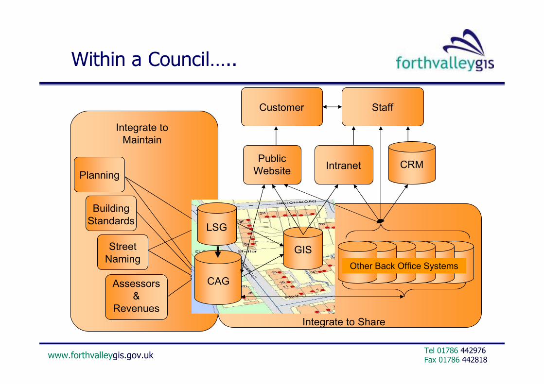
FVGIS Background
� Established at local government reorganisation in 1996
� Shared service partnership unit for the provision of corporate GIS services to the three local authorities of Clackmannanshire, Falkirk and Stirling.
� Stirling Council are lead authority, host the unit and provide support services
• Funded by internal Council contributions and revenue generated by provision of external services
• Employs 21 staff, wide range of GI consulting services
• FVGIS reports to a Joint Management Group with Senior Management representation from each Council.
• Primary benefits include :
– joint working – equal share in costs and benefits
– best value - economies of scale for specialist services
– development and sharing of best practice
– enhanced reputation of the partner Councils

www.forthvalleygis.gov.ukFax 01786 442818Tel 01786 442976
Tri-Council GIS Services
• Core services– Data Management
– Application Development
– Training
– Support/Helpdesk
– Bureau Services
• Corporate development projects– Corporate Address Gazetteer (CAG)
– GIS/CAG and Business systems integration
– Web and Desktop GIS solutions
– Data sharing projects
• Service projects/Specialised consultancy– Local plans
– Gritting Routes
– Contaminated Land Management
– Open Space Management
– Woodlands In and Around Towns
– School Transport Enquiries
– Waste Collection/Disposal
– Asset Management
– and more……
www.forthvalleygis.gov.ukFax 01786 442818Tel 01786 442976
External Consultancy Services

www.forthvalleygis.gov.ukFax 01786 442818Tel 01786 442976
Forth Valley GIS Infrastructure
GeoLink Portal
Council Intranets Council WebsitesBusiness Systems
Desktop GIS
Update Applications
Export Applications
Database Connection
Business Systems
Mobile GIS
Web ServicesWeb Mapping ServicesWeb Feature Services
Schema Translation
Regional Partners
National Partners
Regional Partners
Regional Partners

www.forthvalleygis.gov.ukFax 01786 442818Tel 01786 442976
Google JavaScript
Web ComponentsWeb ServicesFlash
SVG
Intranet/Internet Applications

www.forthvalleygis.gov.ukFax 01786 442818Tel 01786 442976
GeoStore – the Spatial Warehouse
• Centralised, regional spatial database
• Oracle 9i with supporting productivity tools (GO Loader, Cadcorp SIS, ESRI)
• Contains over 400 geographic datasets with c. 80 third party products
• OS MasterMap migration
• PAI data management
• Corporate address gazetteers
• Integrated with web/desktop GIS clients, enterprise applications
www.forthvalleygis.gov.ukFax 01786 442818Tel 01786 442976
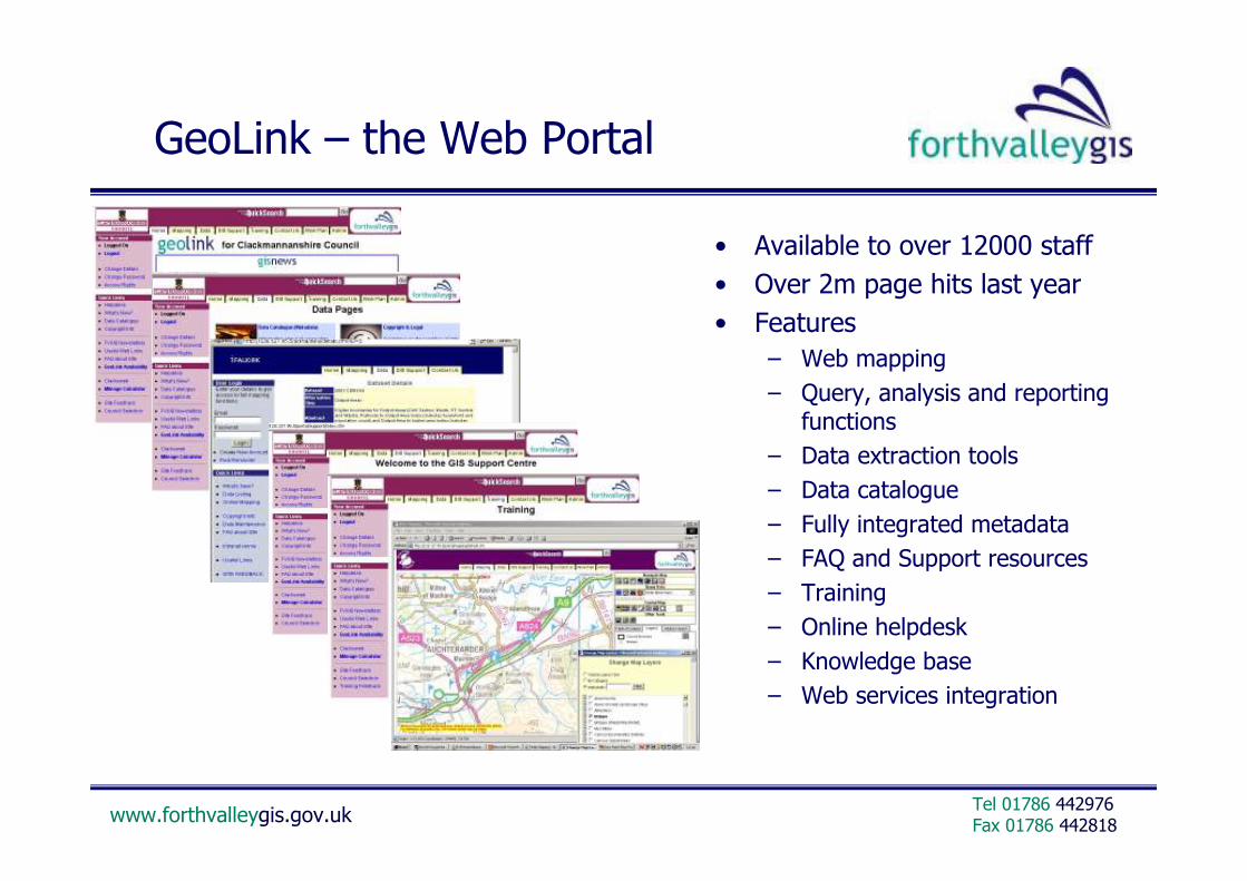
GeoLink – the Web Portal
• Available to over 12000 staff
• Over 2m page hits last year
• Features
– Web mapping
– Query, analysis and reporting functions
– Data extraction tools
– Data catalogue
– Fully integrated metadata
– FAQ and Support resources
– Training
– Online helpdesk
– Knowledge base
– Web services integration

www.forthvalleygis.gov.ukFax 01786 442818Tel 01786 442976
Waste Route Design Tool (RDT)
Provides controlled access to:
a) Route design;
b) Route reporting;
c) Route browsing;
d) Performance information.
Integrates with:
a) CAG
b) Commercial Waste
Contract Management
System
c) Call Centre Work Flow
Management System
(EWORK)
Modular Intranet-based system

www.forthvalleygis.gov.ukFax 01786 442818Tel 01786 442976
School Placements
• School catchment analysis
• School placement requests
• Determining safe routes for pupils
• Calculate and assess eligibility for free transport
• Evaluate transport contracts
• Route optimisation
• Assess access to transport

www.forthvalleygis.gov.ukFax 01786 442818Tel 01786 442976
Spatial Analysis

www.forthvalleygis.gov.ukFax 01786 442818Tel 01786 442976
Spatial Analysis
Housing Tenure - Balfron 2000
Local Authority
22.5%
Housing
Assoc iations
2.8%
Private Rented
1.3%
Owner
Occupied
73.3%

www.forthvalleygis.gov.ukFax 01786 442818Tel 01786 442976
Performance Reporting

www.forthvalleygis.gov.ukFax 01786 442818Tel 01786 442976
Internet GIS
• Address and Postcode search
• Where’s my nearest…?
• Online planning
• Paths/Rights of Way
• Development Plan
• Local Plans
• Archaeology
• Council Service information

www.forthvalleygis.gov.ukFax 01786 442818Tel 01786 442976
Data Sharing

www.forthvalleygis.gov.ukFax 01786 442818Tel 01786 442976
Community Planning
• Community Planning is "… a process ... whereby public services in the area of the local authority are planned and provided after consultation and (on-going) co-operation … among all public bodies ... and with community bodies…".
• Local Government in Scotland Act (2003) gave Community Planning a statutory basis
• Aims are to :– make sure people and communities are engaged in
the decisions made on public services which affect them
– commit organisations to work together, not apart, in providing better public services
– provide an over-arching framework that helps to co-ordinate and rationalise other initiatives and partnerships
– improve the joining up between national priorities and those at regional, local or community levels
• Core partners include Local Authorities, NHS, Police, Fire and Enterprise Networks

www.forthvalleygis.gov.ukFax 01786 442818Tel 01786 442976
Partnership Working
Community Planning
ModernisingGovernment
EfficientGovernment
PerformanceManagement
InformationLegislation
Community Care
..and many more
• Greater need than ever to :– adopt citizen and community-centric focus
– take cross-sectoral, inter-agency approach
– improve and integrate planning, management and delivery of services
– seek best value in service delivery
– target services and resources
• By :– combining resources
– combining skills and expertise
– sharing services
– integrating processes
– exploiting use of technology
– sharing information
Child Protection
Anti-Social Behaviour

www.forthvalleygis.gov.ukFax 01786 442818Tel 01786 442976
Information Sharing
“Information Sharing is essential to success of Community Planning and better joint working between agencies for the benefit of customers and citizens”
LGIS Act 2003, Advice Note 8

www.forthvalleygis.gov.ukFax 01786 442818Tel 01786 442976
Data Sharing Partnerships
• New governance structure– Scottish Executive Data Sharing and Standards Division
– Senior Officials Steering Group (Efficient Govt/Public Reform)
– National Data Sharing Forum
– 14 Regional, multi-agency Data Sharing Partnerships
– Regional Chairs
– Data Sharing Manager/support resources
– 3 year funding up to c.£150k per annum
• National Priorities– Community Care/eCare
– Child Protection
• Local/Regional Priorities– ASB
– Emergency Planning
– Others…

www.forthvalleygis.gov.ukFax 01786 442818Tel 01786 442976
GIS Opportunities
Crime Pattern
AnalysisCommand
and Control Risk
Assessment
Social
Inclusion Inward
Investment
Shared
Assessment
Service
Planning and
Integration
Fire Safety
Sustainable
development
Development
Process
Facilities
Management
Crime
Intelligence
Road Safety
Asset
Management
Health
Improvement
Deprivation
Analysis
Where is?
What is at?
Issues affecting customers,
communities, businesses
and service suppliers
happen in places

www.forthvalleygis.gov.ukFax 01786 442818Tel 01786 442976
Information Sharing

www.forthvalleygis.gov.ukFax 01786 442818Tel 01786 442976
Spatial Data Infrastructure(s)

www.forthvalleygis.gov.ukFax 01786 442818Tel 01786 442976
Spatial Data Infrastructure
• Spatial Data Infrastructure (SDI) – a framework where spatial data sharing and integration can take place over the internet
• SDI’s are characterised by – Shared technical infrastructure
– Sharing of data, metadata and access services
– Interoperation of standardised web services
– Open geospatial and web standards
– Governance, business processes and policies
– Shared resources
• SDI evolution– shifting from access to find, view and exchange
spatially distributed data to…..
– infrastructure of services, translating requests into workflow, finding, comparing and linking services
– ….a Service-Oriented Infrastructure
(From “International standards in support of interoperable SDI
– a Norwegian example”)

www.forthvalleygis.gov.ukFax 01786 442818Tel 01786 442976
Industry Developments
• Established open standards/specifications
– ISO191xx
– OGC (WMS, WFS, WCS etc.)
• Internationally active standards development community
• Established common spatial data transfer and metadata standards
• Increasing adoption and compliance by system and data suppliers
• Intelligent data products and commercially enhanced data
• Spatial data support in commercial RDBMS
• GIS functions in standard software development tools
• GIS functionality embedded in mainstream business applications
• Growing Open Source GIS community and industry movement

www.forthvalleygis.gov.ukFax 01786 442818Tel 01786 442976
Changing Face of GIS
• Advent of the web has vitalised opportunities for GI publishing, sharing and development of new business solutions
• Role of GIS is still fundamentally to capture, manage, analyse data and communicate information, but emphasis is shifting…

www.forthvalleygis.gov.ukFax 01786 442818Tel 01786 442976
Lots of SDI’s……….
UK Government
RegionalGovernment
LocalGovernment
Defence Academia Commercial
Citizens
Local Government
Central Government
Communities
Business
Portal
Portal
Portal
Portal
Portal
PortalPortal
Portal

www.forthvalleygis.gov.ukFax 01786 442818Tel 01786 442976
Some characteristics
• Often focussed on individual policy or political imperatives
• Ring fenced funding
• Predicated on government interoperability frameworks (OSIAF, e-GIF) but limited regulation
– and limited recognition of GI/GIS
• Limited overall co-ordination to ensure maximum efficiency and shared resources
– Risk of developing infrastructure silos
– Limited interoperability across or between infrastructures
– Inconsistent application of standards
– Duplication of data, content, technology, resources
– Limited data sharing
– Competition v complementing

www.forthvalleygis.gov.ukFax 01786 442818Tel 01786 442976
Need for better interoperability
• Technical interoperability is already achievable
• Need to agree a common reference framework of GIS data, metadata, web and service standards
• Organisations to work from multi-level distributed data and services
• Rationalisation of common information resources
• Integrated collection of spatial databases
• Interoperability driven by business needs to combine and share resources
• Develop new GI web services/OGC specifications– image processing, sensor web enablement
• But…..more complex policy issues e.g. brokerage, distribution, pricing, legal/IP, access controls, information security

www.forthvalleygis.gov.ukFax 01786 442818Tel 01786 442976
Need for better information management
We still need :
• Defined policy context for public data– Governance and co-ordination– Core geographies– Access, sharing, custodianship, archiving– Funding– Licensing and Charging– Information privacy and security
• Data Management– Organisational commitment– Still a low priority– Quality gaps– Stewardship for trusted data sources
• Data Sharing– Still in a state of cultural “unreadiness”– Overheads of data hoarding– Separation of data collection, management
and brokerage functions
www.forthvalleygis.gov.ukFax 01786 442818Tel 01786 442976
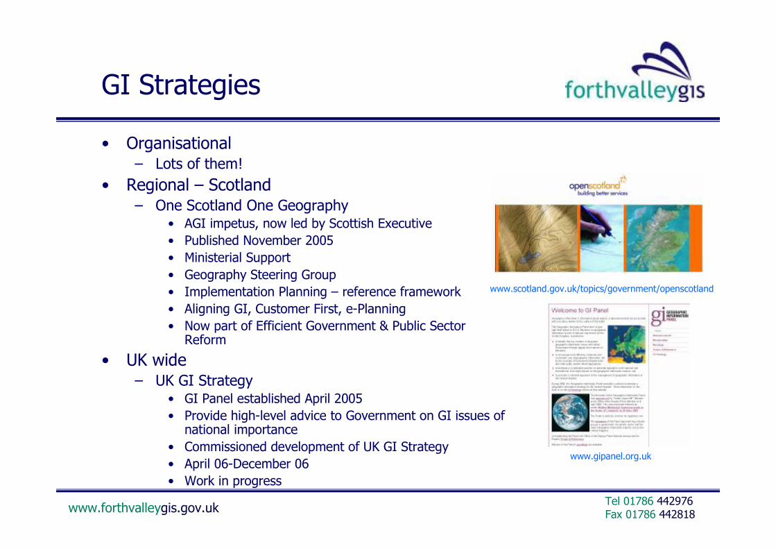
GI Strategies
• Organisational– Lots of them!
• Regional – Scotland– One Scotland One Geography
• AGI impetus, now led by Scottish Executive
• Published November 2005
• Ministerial Support
• Geography Steering Group
• Implementation Planning – reference framework
• Aligning GI, Customer First, e-Planning
• Now part of Efficient Government & Public Sector Reform
• UK wide– UK GI Strategy
• GI Panel established April 2005
• Provide high-level advice to Government on GI issues of national importance
• Commissioned development of UK GI Strategy
• April 06-December 06
• Work in progress
www.gipanel.org.uk
www.scotland.gov.uk/topics/government/openscotland

www.forthvalleygis.gov.ukFax 01786 442818Tel 01786 442976
Challenges across all levels….
• Business Case• Leadership• Governance• Information• Business Processes• Technical Infrastructure• Partnership Working• Interoperability• Capacity Building• Communication• Sustainable Funding• Benefits Realisation

www.forthvalleygis.gov.ukFax 01786 442818Tel 01786 442976
GI Benefits
• Improvements in the use of public resources – better informed and more effectively deployed staff
– more informed, evidence-based decision making
– improved planning, targeting and performance management of resources
– a more strategic management of land and property assets
– better use, improved quality and integration of information resources that already exist
– improved means of visualising and communicating easily understood and appropriate geographically based performance information
• Improved understanding of citizen/community needs and expectations – now and how this may change due to demographic, economic and
environmental factors
– improved levels of customer service and greater customer satisfaction
• An information sharing culture and framework – that will facilitate and encourage joint working between services and with
partner agencies
– leading to better services and strategic advantage for public services

www.forthvalleygis.gov.ukFax 01786 442818Tel 01786 442976
But there are limits…….

www.forthvalleygis.gov.ukFax 01786 442818Tel 01786 442976
Thank You