Gilles OLLIERHead of Sector EUROPEAN COMMISSIONEarth Observation DG RTD 15 September 2006 (Constanta...
28
Gilles OLLIER Head of Sector EUROPEAN COMMISSION Earth Observation DG RTD 15 September 2006 15 September 2006 (Constanta - Romania) (Constanta - Romania) Europe and the GEO initiative Europe and the GEO initiative GEO welcomes FP7
-
Upload
randolf-marshall -
Category
Documents
-
view
214 -
download
0
Transcript of Gilles OLLIERHead of Sector EUROPEAN COMMISSIONEarth Observation DG RTD 15 September 2006 (Constanta...

Gilles OLLIER Head of Sector EUROPEAN COMMISSION Earth Observation
DG RTD
15 September 200615 September 2006 (Constanta - Romania) (Constanta - Romania)
Europe and the GEO initiativeEurope and the GEO initiative
GEO welcomes FP7

2
KEY INITIATIVES FOR KEY INITIATIVES FOR EARTH OBSERVATIONEARTH OBSERVATION
The EU has a long-standing commitment to meet the challenges of sustainable development. The research policy of the Commission contributes to this commitment through the funding of environmental research, including research dealing with Earth Observation. The observation of the Earth plays a key role in the assessment of the environment and in policy making.
GEOSS (Global Earth Observation System of Systems): GLOBAL DIMENSIONGLOBAL DIMENSION
INSPIRE directive: Will provide the regulatory framework to Will provide the regulatory framework to facilitate the exchange of data in Europe.facilitate the exchange of data in Europe.
GMES (Global Monitoring for Environment and Security): SERVICE ORIENTEDSERVICE ORIENTED

3
What is drivingWhat is driving the GEO initiative? the GEO initiative?
• 3 top science and technology priorities identified at the G8 meeting in Evian in 2003: agriculture, energy and Earth observations
• FROM first EO SUMMIT in Washington in July 2003
• CALL FOR A GREATER INTEGRATION OF EARTH OBSERVATION SYSTEMS INTERNATIONALLY
• DEVELOPMENT OF A “GLOBAL EARTH OBSERVATION SYSTEM OF SYSTEMS”
4
• Reducing loss of life and property from natural and human induced disasters;• Understanding environmental factors affecting human health and well being;• Improving management of energy resources;• Understanding, assessing, predicting, mitigating and adapting to climate variability and change;• Improving water resources management through better understanding of the water cycle;• Improving weather information, forecasting and warning;• Improving the management and protection of terrestrial, marine and coastal ecosystems;• Supporting sustainable agriculture and combating desertification;• Understanding, monitoring and conserving biodiversity;
9 Societal benefit areas of 9 Societal benefit areas of GEOSSGEOSS

5
• GEOSS (Global Earth Observation System of Systems):
• Acquire observational data from all different EO platforms;
• Process data into useful products;
• Exchanges, disseminates and archives shared data, metadata and products;
• Undertakes activities to continue EO related Research, capacity building and outreach.
Main objectives for GEOMain objectives for GEO
6
GEO STRUCTUREGEO STRUCTURE
• Membership open to all countries of the worldMembership open to all countries of the world – 60 countries (plus the EC) endorsed the GEOSS 10-year
Implementation plan and are current GEO members;– Contribution to GEOSS on a voluntary basis (no fixed membership
fees)
• International organisations are participantsInternational organisations are participants – 43 organizations are represented in GEO
• GEO SecretariatGEO Secretariat– Permanent GEO Secretariat is being installed at WMO (Geneva)
since autumn 2005
• GovernanceGovernance– Plenary meetings of all members and participating organisations– Executive committee to ensure the fulfilment of GEO plenary
decisions00
7
• 12 Members elected for 2 years term
• Regional representations:– Africa (2): Morocco; South Africa (chair)– Americas (3): Brazil; Honduras; US (chair)– Asia + Oceania (3): Japan; Thailand; China (chair) – CIS (1): Russian Federation (Chair)– Europe (3): Germany; Italy; EC (Chair)
• Elected by regional caucuses
GEO Executive GEO Executive CommitteeCommittee
8
• 4 Co-Chairs
– Elected by Plenary from Executive Committee members;
– 2 from Developing Countries, 2 from Developed Countries:
• Zheng Guoguang – China (CMA)• José Manuel Silva Rodríguez – Europe (EC)• Phil MJWARA – South Africa (DST)• Conrad Lautenbacher – United States (NOAA)
GEO Executive GEO Executive CommitteeCommittee
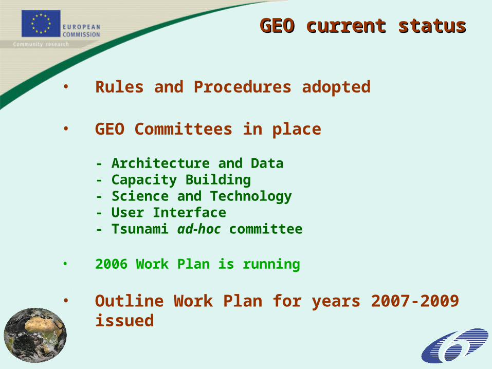
GEO current statusGEO current status
• Rules and Procedures adopted
• GEO Committees in place
- Architecture and Data- Capacity Building- Science and Technology- User Interface - Tsunami ad-hoc committee
• 2006 Work Plan is running
• Outline Work Plan for years 2007-2009 issued
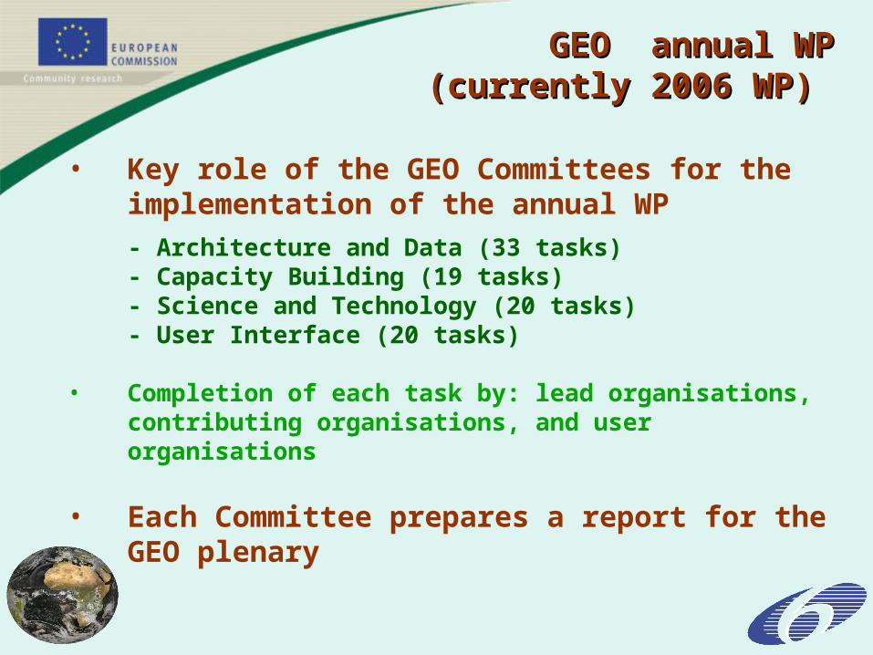
GEO annual WPGEO annual WP (currently 2006 WP) (currently 2006 WP)
• Key role of the GEO Committees for the implementation of the annual WP- Architecture and Data (33 tasks)- Capacity Building (19 tasks)- Science and Technology (20 tasks)- User Interface (20 tasks)
• Completion of each task by: lead organisations, contributing organisations, and user organisations
• Each Committee prepares a report for the GEO plenary
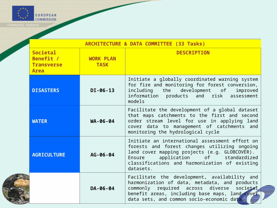
ARCHITECTURE & DATA COMMITTEE (33 Tasks)
Societal Benefit /Transverse Area
WORK PLANTASK
DESCRIPTION
DISASTERS DI-06-13
Initiate a globally coordinated warning system for fire and monitoring for forest conversion, including the development of improved information products and risk assessment models
WATER WA-06-04
Facilitate the development of a global dataset that maps catchments to the first and second order stream level for use in applying land cover data to management of catchments and monitoring the hydrological cycle
AGRICULTURE AG-06-04
Initiate an international assessment effort on forests and forest changes utilizing ongoing land cover mapping projects (e.g. GLOBCOVER). Ensure application of standardized classifications and harmonization of existing datasets.
DATA MANAGEMENT
DA-06-04
Facilitate the development, availability and harmonization of data, metadata, and products commonly required across diverse societal benefit areas, including base maps, land-cover data sets, and common socio-economic data.

12
USER INTERFACE COMMITTEE (20 Tasks)
Societal Benefit /
Transverse Area
WORK PLANTASK
DESCRIPTION
WATER
WA-06-01
Organize workshops on water observations, encompassing space-based, airborne, and in-situ observing systems, and focusing on (i) water quality, including fresh, estuarine, and marine water quality, (ii) ground water, (iii) precipitation, soil moisture, surface water, and (iv) hydrological ensemble-based prediction and new observing techniques and products.
SCIENCE & TECHNOLOGY COMMITTEE (20 Tasks)
Societal Benefit /Transverse Area
WORK PLAN TASK
DESCRIPTION
AGRICULTURE
AG-06-03
Utilizing global and regional high-resolution land-cover datasets (e.g. GLOBCOVER) and earlier 1-km resolution land cover data sets (e.g. Global Land Cover 2000), implement production of a high-resolution global land-cover change dataset and report. Propose mechanisms for regular analysis and reporting on land cover change building on current efforts and promulgate the use of these products, especially in developing countries.
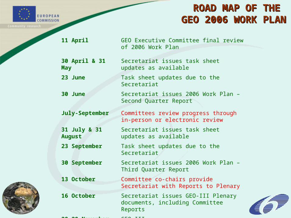
ROAD MAP OF THE ROAD MAP OF THE GEO 2006 WORK PLANGEO 2006 WORK PLAN
11 April GEO Executive Committee final review of 2006 Work Plan
30 April & 31 May Secretariat issues task sheet updates as available
23 June Task sheet updates due to the Secretariat
30 June Secretariat issues 2006 Work Plan – Second Quarter Report
July-September Committees review progress through in-person or electronic review
31 July & 31 August Secretariat issues task sheet updates as available
23 September Task sheet updates due to the Secretariat
30 September Secretariat issues 2006 Work Plan – Third Quarter Report
13 October Committee co-chairs provide Secretariat with Reports to Plenary
16 October Secretariat issues GEO-III Plenary documents, including Committee Reports
28-29 November GEO-III
2007-2009 WORK PLAN2007-2009 WORK PLAN
• Longer term planning: a 3 year WP
• Continuity with the 2006 WP:80 of the 97 2006 tasks are to be continued
• 30 new tasks are proposed
Early warning of slowly developing disasters
Strengthen health observation systems
Environment impact of energy extraction/transport
International weather/climate and Earth-system science initiative
Further use of EO within fishery and aquaculture
Apply Earth Observation to protected areas
Etc….
Example of new tasksExample of new tasks
17
Setting up of a European Geo High Level Working Setting up of a European Geo High Level Working Group (HLWG)Group (HLWG)
– The Commission provides a secretariat for and The Commission provides a secretariat for and chairs the HLWGchairs the HLWG
– Role of the HLWG: to develop a European Role of the HLWG: to develop a European convergent approach within GEOconvergent approach within GEO
– Example: European position on the GEO 2007-2009 Example: European position on the GEO 2007-2009 WP - Next meeting 11th October 2006WP - Next meeting 11th October 2006
How are we organised in Europe?How are we organised in Europe?
18
EUROPEAN PARTICIPATION EUROPEAN PARTICIPATION IN GEOIN GEO
MembershipEurope provides 21 of the current GEO membership of 58 countries + European Commission & 7 of the current 43 GEO participating organisations
GEO SecretariatGEO Secretariat is supported significantly by European countries and the European Commission (1,8 M€ in 2005-06)
GovernanceEuropean members participate to the Plenary meetings and Executive Committee meetings (Co-chaired by European Commission)
CommitteesEurope co-chair capacity building, S&T, and User Interface Committees. Also active in the Architecture & Data Committee
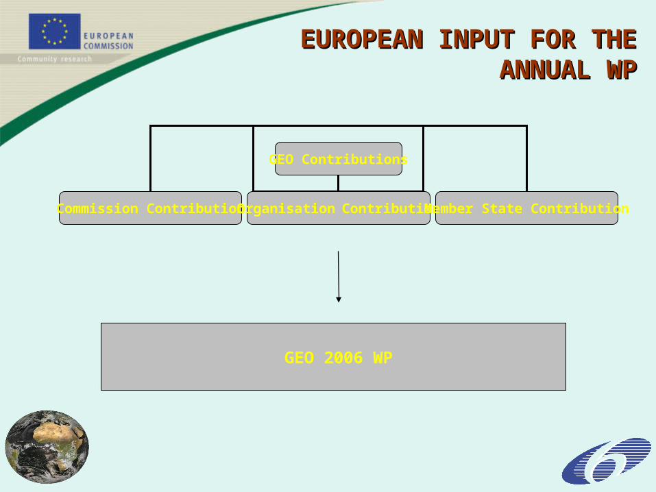
GEO Contributions
Commission Contribution Organisation Contribution Member State Contribution
GEO 2006 WP
EUROPEAN INPUT FOR EUROPEAN INPUT FOR THE ANNUAL WPTHE ANNUAL WP

EUROPEAN CONTRIBUTION EUROPEAN CONTRIBUTION TO GEO 2006 WPTO GEO 2006 WP
EUROPEAN ORGANISATIONS
Organisations well committed to the GEO tasks (ECMWF, EUMETSAT, ESA, EEA, etc….)
EUROPEAN COUNTRIES
Large number of institutions contributing at various level (effort still needed to take into account existing national initiatives)
EUROPEAN COMMISSION
FP6 projects relevant to GEO 2006 WP (SPACE/GMES, ENV, INFSO)
- Need still to be properly linked to the GEO tasks
- Commission started to contact the projects
- New FP6 projects structured to produce GEO deliverables
- FP7 organised towards GEO

21
GMES fast track servicesGMES fast track services
to be implemented by 2008to be implemented by 2008
• Information for Crisis (Emergency) Management
• Land Monitoring Services
• Marine Core Services
• Proposed GMES Pilot Atmospheric Services (2009 ?)

22
The GMES The GMES Marine Service chainMarine Service chain

23
Project GEOLAND: GMES Integrated Project on Land Monitoring and Vegetation
Objective: to develop and demonstrate a range of reliable, affordable and cost efficient European geo-information services, supporting the implementation of European directives and their national implementation, as well as European and International policies.
to integrate existing technology with innovative and scientifically sound elements into sustainable services.
Partners: http://www.gmes-geoland.info/TEAM/all.php
56 from Italy, Belgium, Austria, Germany, The Netherlands, France, Sweden, Czech Republic, UK, Norway, Spain, Portugal, Poland, Greece, Russia and Switzerland
COORDINATOR: Leibniz-Zentrum für Agrarlandschafts- und Landnutzungsforschung
Total Costs: 12 M€ - EC Contribution: 9.2 M€
LAND MONITORING LAND MONITORING (Gmes Fast Track Service(Gmes Fast Track Service))
24
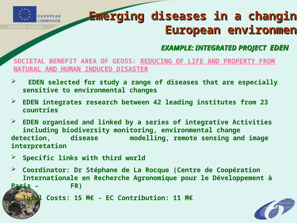
EXAMPLE: INTEGRATED PROJECT EXAMPLE: INTEGRATED PROJECT EDENEDEN
SOCIETAL BENEFIT AREA OF GEOSS: REDUCING OF LIFE AND PROPERTY FROM NATURAL AND HUMAN INDUCED DISASTER
EDEN selected for study a range of diseases that are especially sensitive to environmental changes
EDEN integrates research between 42 leading institutes from 23 countries
EDEN organised and linked by a series of integrative Activities including biodiversity monitoring, environmental change detection, disease modelling, remote sensing and image interpretation
Specific links with third world
Coordinator: Dr Stéphane de La Rocque (Centre de Coopération Internationale en Recherche Agronomique pour le Développement à
Paris – FR)
Total Costs: 15 M€ - EC Contribution: 11 M€
Emerging diseases in a changingEmerging diseases in a changingEuropean environmentEuropean environment
25
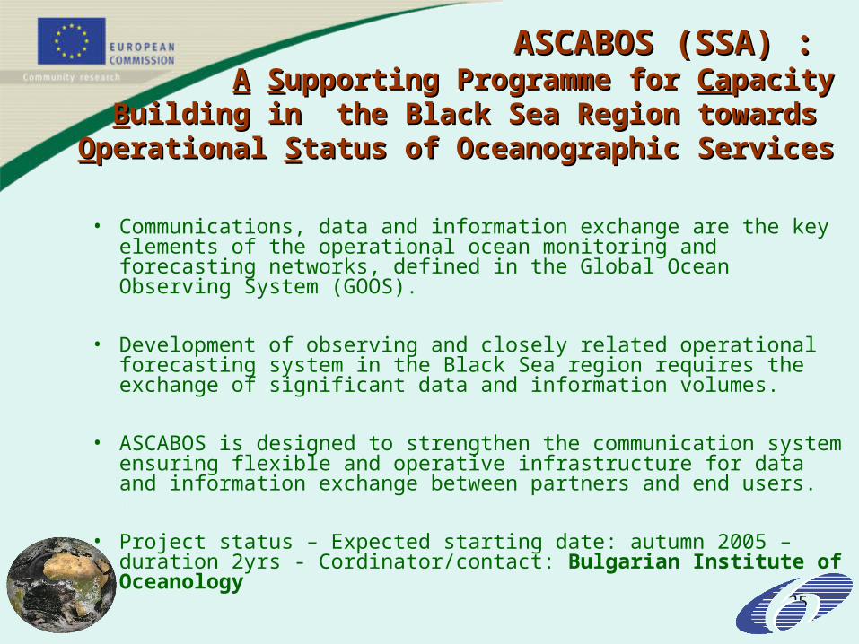
ASCABOS (SSA) : ASCABOS (SSA) : AA SSupporting Programme for upporting Programme for CaCapacitypacity
BBuilding in the Black Sea Region towards uilding in the Black Sea Region towards OOperational perational SStatus of Oceanographic Servicestatus of Oceanographic Services
• Communications, data and information exchange are the key elements of the operational ocean monitoring and forecasting networks, defined in the Global Ocean Observing System (GOOS).
• Development of observing and closely related operational forecasting system in the Black Sea region requires the exchange of significant data and information volumes.
• ASCABOS is designed to strengthen the communication system ensuring flexible and operative infrastructure for data and information exchange between partners and end users.
• Project status – Expected starting date: autumn 2005 – duration 2yrs - Cordinator/contact: Bulgarian Institute of Oceanology
26
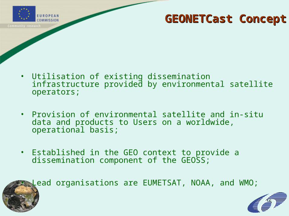
GEONETCast ConceptGEONETCast Concept
• Utilisation of existing dissemination infrastructure provided by environmental satellite operators;
• Provision of environmental satellite and in-situ data and products to Users on a worldwide, operational basis;
• Established in the GEO context to provide a dissemination component of the GEOSS;
• Lead organisations are EUMETSAT, NOAA, and WMO;
• Through its involvement in GEO, the EU will have the possibility to use GEONETCast for distributing and broadcasting data products generated within GMES and other European Earth Observation initiatives
• GEONETCast would be a useful tool to support the EU policy towards developing countries
• Opportunity to demonstrate European capability in technology initially developed through EUMETcast (EUMETSAT)
EU INTEREST EU INTEREST IN GEONETCastIN GEONETCast
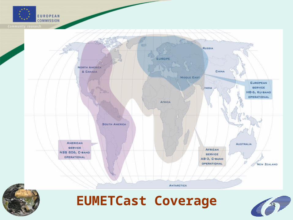
28EUMETCast Coverage

29
Funding aspects of GEOFunding aspects of GEO
GEO is not a funding institution
The GEO secretariat has limited resources available to support the basic organisational activities of GEO
The development of GEOSS must be supported by the participating organisation
GEO has already started to impact on funding agencies plans involving Earth Observation activities (European Commission FP7)