Gib Lane, Blackburn · (Acer pseudoplatanus) 13.0 600* 6.0 Average (MS) 2.0 Fair/Good M...
37
Gib Lane, Blackburn Tree Survey November 2013 Prepared for: Rule 5 Land Ltd 47068789 UNITED KINGDOM & IRELAND
Transcript of Gib Lane, Blackburn · (Acer pseudoplatanus) 13.0 600* 6.0 Average (MS) 2.0 Fair/Good M...

Gib Lane, Blackburn
Tree Survey
November 2013
Prepared for: Rule 5 Land Ltd 47068789
UNITED KINGDOM & IRELAND

Gib Lane, Blackburn – Tree Survey
TREE SURVEY REPORT
December 2013
ii
REVISION SCHEDULE
Rev Date Details Prepared by Reviewed by Approved by
01 18/12/13 Draft Issue Tim Arkell
Arboricultural Consultant
Adam King
Associate
Adam King
Associate
02 23/12/13 Final Issue Tim Arkell
Arboricultural Consultant
Adam King
Associate
Adam King
Associate
URS Mayflower House Armada Way Plymouth Devon PL1 1LD Tel: +44 (0)1752 676 700 Fax: +44 (0)870 238 6023

Gib Lane, Blackburn – Tree Survey
TREE SURVEY REPORT
December 2013
iii
Limitations
URS Infrastructure & Environment UK Limited (“URS”) has prepared this Report for the sole use of Rule 5 Land Ltd (“Client”) in accordance with the Agreement under which our services were performed. No other warranty, expressed or implied, is made as to the professional advice included in this Report or any other services provided by URS. This Report is confidential and may not be disclosed by the Client nor relied upon by any other party without the prior and express written agreement of URS.
The conclusions and recommendations contained in this Report are based upon information provided by others and upon the assumption that all relevant information has been provided by those parties from whom it has been requested and that such information is accurate. Information obtained by URS has not been independently verified by URS, unless otherwise stated in the Report.
The methodology adopted and the sources of information used by URS in providing its services are outlined in this Report. The fieldwork described in this Report was undertaken on the 9th and 11th December 2013 and is based on the conditions encountered and the information available during the said period of time. The scope of this Report and the services are accordingly factually limited by these circumstances.
Where assessments of works or costs identified in this Report are made, such assessments are based upon the information available at the time and where appropriate are subject to further investigations or information which may become available.
URS disclaim any undertaking or obligation to advise any person of any change in any matter affecting the Report, which may come or be brought to URS’ attention after the date of the Report.
Certain statements made in the Report that are not historical facts may constitute estimates, projections or other forward-looking statements and even though they are based on reasonable assumptions as of the date of the Report, such forward-looking statements by their nature involve risks and uncertainties that could cause actual results to differ materially from the results predicted. URS specifically does not guarantee or warrant any estimate or projections contained in this Report.
Copyright
© This Report is the copyright of URS Infrastructure & Environment UK Limited. Any unauthorised reproduction or usage by any person other than the addressee is strictly prohibited.

Gib Lane, Blackburn – Tree Survey
TREE SURVEY REPORT
December 2013
iv
TABLE OF CONTENTS
1 INTRODUCTION ......................................................12 METHODOLOGY .....................................................1 3 SCHEDULE OF EXISTING TREES ..........................2
3.1 Key to Abbreviations Used in the Survey ...................... 5
4 FIELDWORK OBSERVATIONS ...............................6
4.1 General Principles .......................................................... 11
5 APPENDICES ........................................................ 12
Gib Lane, Blackburn – Tree Survey
TREE SURVEY REPORT December 2013
1
1 INTRODUCTION
URS has been commissioned to undertake a survey of existing trees within and immediately adjacent to agricultural land broadly bounded by Gib Lane, A6062 Livesey Branch Road and Horden Rake/Broken Stone Road to the south west of Blackburn, Lancashire.
It is understood the information contained within this report will be used in support of the Planning Application for the proposed redevelopment of the site. The survey and the accompanying notes provide guidance as to the nature and quality of the existing tree stock both on and immediately adjacent to the site and the implications of any known construction works in the vicinity of these trees including best practice for retention of trees in this context.
2 METHODOLOGY
The tree survey was based upon existing topographical information relating to the site provided by TriCAD Solutions Ltd Existing Site Survey drawings TRI-1083-01 to TRI-1083-01 dated 27th September 2013 and conducted in accordance with the requirements of BS5837:2012.
Fieldwork was undertaken between the 9th and 11th December 2013 during which dimensional data and observational information were collected. A DBH tape measure and Leica Disto™ laser distance meter were used in the collection of this, which now form the basis of this report.
Features comprising multiple trees, scrub or other arboreal features have, where appropriate been categorised as grouped features listing species composition, age and condition ranges etc. to best describe each feature. Within these, principal trees may have also been identified.
The fieldwork informing this report has comprised of a non-intrusive, visual survey undertaken from ground level. Where further inspection is deemed appropriate to ascertain the condition of the tree or other arboreal features, this has been identified within the preliminary management recommendations. Average dimensions or dimensional ranges have occasionally been used where appropriate to best describe arboreal features. References to habitat value should be taken as comparative observations compared with a base-line situation with no tree present.
It should be noted that topographical information relating to the positions of existing trees or tree groups was locally limited at the time of inspection. The locations of some trees and other arboreal features have therefore been located on the attached plan drawings by a combination of aerial photography and site observation/measurements. Should the exact location(s) become critical to the feasibility of the proposals, the location(s) of such features should be verified on site prior to the commencement of construction operations.

Gib Lane, Blackburn – Tree Survey
TREE SURVEY REPORT December 2013
2
3 SCHEDULE OF EXISTING TREES
Ref. No
Species Est. Height
(m)
Stem Dia.
(mm)
Canopy Spread (m)
First significant branch (m)
Canopy Clearance
(m)
Physiological Condition
Age Structural Condition Preliminary Management Recommendations Est. Remaining
Contribution (yrs)
Cat.
N S E W
G1
Golden Conifer, Fir (Abies sp.),
Holly (Ilex aquifolium), Hawthorn
(Crataegus monogyna), Silver Birch
(Betula pendula ‘Youngii’),
Pine (Pinus sp.) & Privet
(Ligustrum ovalifolium)
4.0 - 8.0
Up to 300*
Fair -Good Y – SM
Intermittent small trees and woody boundary vegetation growing within rear garden areas near site boundary. Of variable condition.
Of general screening and amenity value.
T2 Willow (Salix sp.) 12.0 500* 7.7* Average
3.0 (E-W Fork)
1.6 Fair/Good M Garden tree growing near site boundary. (No direct access).
Of general screening and amenity value near site boundary.
20+ B2
T3 2No. Wild
Cherry (Prunus avium)
9.0 350* 4.0* Average 3.0
(Average) 2.5 Fair/Good SM
Garden tree growing near site boundary (No direct access).
Of general screening and amenity value near site boundary.
20+ C2
H4
Hawthorn (Crataegus
monogyna) & Elderberry (Sambucus
nigra)
2.0 – 6.0
Fair/Poor
Intermittent remains of out-grown hedgerow boundary. Grazing and livestock compaction damage at base including bark loss/damage. Deadwood visible with further fallen branches remaining in-situ.
Of nominal current value.
G5
Cherry Laurel (Prunus
laurocerasus), Hawthorn
(Crataegus monogyna),
Conifers, Privet
(Ligustrum ovalifolium) & Holly (Ilex sp.)
2.0 – 6.0
Y – SM
Intermittent small trees and woody boundary vegetation growing within rear garden areas near site boundary. Of variable condition.
Of general screening and amenity value.
T6 Willow (Salix sp.) 12.0 500* 7.0* Average N/A N/A Good M
Well branched tree with generally balanced canopy. (No direct access).
Of general screening and amenity value near site boundary.
20+ B1/2
T7 Sycamore
(Acer pseudoplatanus)
13.0 600* 6.0 Average (MS) 2.0 Fair/Good M Multi-stemmed tree growing with five main trunks rising up from base. Growing near site boundary. (No direct access).
Of general screening and amenity value near site boundary.
20+ C2
T8 Wild Cherry (Prunus avium) 11.0 500* 5.3* Average 1.2 (NW) 2.0 Fair/Good M
Growing on site boundary at end of garden area. Historic torn branch wound and fallen limb on SW side with wound wood developing. Included bark developing at junction of three main trunks. (No direct access).
Of general screening and amenity value near site boundary. Monitor trunk junction for decay and integrity.
20+ C1/2
T9 Small Leaved
Lime (Tilia cordata)
13.0 450* 5.0* Average 1.8 (NW-SE Fork)
3.5 Fair/Good M Growing within garden space with occasional pruning wounds visible and high canopy developing. (No direct access).
Of general screening and amenity value near site boundary. Monitor pruning wounds for decay.
20+ B1/2

Gib Lane, Blackburn – Tree Survey
TREE SURVEY REPORT December 2013
3
Ref. No
Species Est. Height
(m)
Stem Dia.
(mm)
Canopy Spread (m)
First significant branch (m)
Canopy Clearance
(m)
Physiological Condition
Age Structural Condition Preliminary Management Recommendations Est. Remaining
Contribution (yrs)
Cat.
N S E W
T10
Sycamore (Acer
pseudoplatanus)
10.0 400* 3.5* (Average) 3.0 (E-W
Fork) 4.0 Fair M
Growing within garden space near site boundary. Historic pruning wounds to main trunk and canopy lopped back at high level with approx. two years re-growth. Wound wood forming on some pruning wounds.
Of nominal screening and amenity value near site boundary.
10+ C1
T11 Sycamore
(Acer pseudoplatanus)
15.0+ 900* 6.5 Average 2.5 (Fork) 3.0 Fair OM
Growing near site boundary of two garden areas with boundary fence abutting trunk. Forks into three main trunks with possible internal fault present below trunk junction. Occasional pruning and torn limb wounds with some wound wood and occasional decay.
Of amenity and possible habitat value to garden spaces near site boundary.
20+ B2/3
G12
Conifers, Hawthorn
(Crataegus monogyna), Elderberry (Sambucus
nigra), Sycamore
(Acer pseudoplatanus)
, Wild Plum (Prunus
domestica), Holly (Ilex sp.), Horse Chestnut
(Aesculus hippocastanum),
Golden Rain (Laburnum
anagyroides), Wild Cherry
(Prunus avium) & Small Leaved
Lime (Tilia cordata)
2.0 – 6.0
Fair - Good Y –M
Intermittent garden boundary woody vegetation and small trees with occasional scrub thicket(s) also.
Of general screening and possible habitat value on site boundary.
H13 Hawthorn
(Crataegus monogyna)
2.0 – 4.0
Poor Remains of boundary hedgerow vegetation now very intermittent with stunted, skeletal vegetation and significant deadwood.
Of nominal habitat value without further restoration and management.
T14 English Oak (Quercus robur) 11.0 650 5.4 4.8 5.5 5.0 3.5 (SE) 2.5 Fair/Poor M
Growing within remains of hedgerow/field boundary. Large wound at base of trunk on E side with decay and linear defect/cavity extending up main trunk, now partly occluded with wound wood. Occasional torn branch wounds and deadwood also visible. Some grazing compaction and standing water within rootzone.
Of possible habitat value to site. Monitor cavity for extent of decay development. Consider livestock management to reduce further rootzone compaction.
20+ C1/3
T15 Silver Birch (Betula pendula) 12.0
280 325
3.0 Average 1.3 (E-W
Fork) 2.0 Fair/Poor M
Growing on site boundary in close proximity and competition with T16. Large trunk/limb lost on S side with large, linear cavity forming and exposed heartwood/decay. Asymmetrical canopy developing. Grazing compaction and standing water within rootzone.
Of general habitat value on site boundary whilst in decline.
10+ C3

Gib Lane, Blackburn – Tree Survey
TREE SURVEY REPORT December 2013
4
Ref. No
Species Est. Height
(m)
Stem Dia.
(mm)
Canopy Spread (m)
First significant branch (m)
Canopy Clearance
(m)
Physiological Condition
Age Structural Condition Preliminary Management Recommendations Est. Remaining
Contribution (yrs)
Cat.
N S E W
T16 Silver Birch (Betula pendula) 11.0
430 210
3.5* Average 1.3 (NW-SE Fork)
1.7 Fair/Poor M
Growing on site boundary in close proximity and competition with T15. Large lost limb on SW side with exposed heartwood, decay and extensive linear wound as a result. Several other lost/torn branch wounds also visible with decay. Waterpocket forming at trunk junction. Grazing compaction and standing water within rootzone.
Of general habitat value on site boundary whilst in decline.
10+ C3
G17
Privet (Ligustrum
ovalifolium), Field Rose
(Rosa arvensis) & Hawthorn (Crataegus monogyna)
4.0 – 8.0
Intermittent, generally unmanaged woody boundary vegetation.
Of nominal screening value.
G18
Wild Cherry (Prunus avium), Holly (Ilex sp.),
Common Beech (Fagus
sylvatica), Cultivated Apple
(Malus domestica),
Willow (Salix sp.), Hawthorn
(Crataegus monogyna), Yew (Taxus
baccata), Cherry Laurel
(Prunus laurocerasus),
Silver Birch (Betula pendula)
& Conifers.
3.0 – 5.0
Intermittent garden boundary vegetation including woody vegetation and small trees.
Of nominal screening value.
T19 Snow Gum (Eucalyptus pauciflora)
12.0 600* 4.0 Average 0.0 (N-S
Fork) 2.5 Fair/Good M
Multi-stemmed tree growing on garden boundary adjacent to site. Several main trunks rising up from base with former pruning/lopping wounds visible. (No direct access).
Of general amenity and arboricultural value to garden space on site boundary. Monitor pruning wounds for decay.
20+ C1/2

Gib Lane, Blackburn – Tree Survey
TREE SURVEY REPORT December 2013
5
Ref. No
Species Est. Height
(m)
Stem Dia.
(mm)
Canopy Spread (m)
First significant branch (m)
Canopy Clearance
(m)
Physiological Condition
Age Structural Condition Preliminary Management Recommendations Est. Remaining
Contribution (yrs)
Cat.
N S E W
G20
English Oak (Quercus robur)
& Common Beech (Fagus
sylvatica) – Mature.
Silver Birch
(Betula pendula),
Wild Cherry (Prunus avium), Elm (Ulmus sp.), Rowan (Sorbus
aria), Sycamore
(Acer pseudoplatanus)
, Holly (Ilex aquifolium) &
Elderberry (Sambucus
nigra) – Semi-mature
with some Common Beech
(Fagus sylvatica)
regeneration.
Up to 15.0+
M: Up to
1000
SM: 100-
300 Av
Woodland copse bounding Gib Lane. Generally open understorey with small watercourse running approximately north-south. Some trees locally becoming drawn up and leggy through competition. Occasional standing/fallen deadwood with other trees showing further deadwood and fungal bodies noted. Range of tree ages noted with some modest regeneration of Beech. Some modest encroachment by Rhododendron. Internal E-W bank of unknown origin noted with dilapidated drystone wall to S boundary. Some dumped green waste also noted. Informal footpath link running through SE to NW.
Of habitat and amenity value to location. Consider selective thinning out of some younger trees to allow development of better, longer lived specimens. Ensure copse boundaries remain in stock-proof condition to prevent livestock compaction and browsing. Remove Rhododendron to prevent further spread.
N/A A2/3
H21 Hawthorn
(Crataegus monogyna)
3.0 – 5.0
Up to 350*
Fair M Intermittent, out-grown remains of hedgerow adjacent to slightly dilapidated dry stone boundary wall.
Of nominal habitat/shelter value.
T22 Common Beech
(Fagus sylvatica)
15.0+ 940 10.5 7.9 8.5 7.6 4.0 (N) 2.0 Fair/Good M
Growing on edge of woodland group G20. Staining to bark on S site including bark loss indicative of pathogen attack. Associated with linear fault within trunk with wound wood forming and possible decay. Livestock compaction noted within rootzone.
Of general landscape/habitat value to site. Inspect internal fault for extent of decay and general safety. Identify fungal infection and significance to health. Consider livestock management to reduce compaction.
20+ B2/3
T23 English Oak (Quercus robur) 15.0+ 505 6.5 5.0 4.2 2.6 5.0 (S) 4.5 Fair M
Growing within area of rough grazing and beginning to compete with adjacent trees. Slightly thin canopy with some deadwood visible.
Of nominal landscape and habitat value. Monitor health re: thinning canopy.
10+ C2/3
T24 Common Beech
(Fagus sylvatica)
15.0+ 685 7.1 6.3 4.3 5.9 3.5 (SW) 4.5 Fair M
Growing within area of rough grazing and beginning to compete with adjacent tree. Bark loss to areas of main trunk and localised branches with some wound wood and decay visible and cavities forming in main trunk, (possible pathogen infection). Minor deadwood visible.
Of general landscape and habitat value to site. Monitor trunk wound for decay. Identify pathogen infection and significance to health. Consider management of livestock access to reduce rootzone compaction.
20+ B2/3
T25 English Oak (Quercus robur) 11.0 540 8.0* 5.8 5.3 8.2 2.0 (N) 2.0 Fair/Good M
Low, spreading tree growing within area of rough grazing. Of slightly crooked form with occasional deadwood and beginning to compete with adjacent tree to S. Large wound at approx. 1.0m Ht. on lower trunk, SE side with wound wood developing. Possible livestock compaction within rootzone.
Of general landscape and habitat value to site. Monitor trunk wound for decay. Consider management of livestock to reduce rootzone compaction.
40+ B2/3

Gib Lane, Blackburn – Tree Survey
TREE SURVEY REPORT December 2013
6
Ref. No
Species Est. Height
(m)
Stem Dia.
(mm)
Canopy Spread (m)
First significant branch (m)
Canopy Clearance
(m)
Physiological Condition
Age Structural Condition Preliminary Management Recommendations Est. Remaining
Contribution (yrs)
Cat.
N S E W
T26 Hawthorn
(Crataegus monogyna)
6.0 280 2.5 2.2 5.3 1.5 1.5 (W) 2.0 Fair/Poor M
Out-grown hedgerow remnant growing on field boundary adjacent to ditch. Wounds to base of trunk on N and S sides with decay visible. Canopy heavily bias to E through exposure.
Of modest cultural and habitat value. Monitor extent of basal decay to trunk.
20+ C3
T27 English Oak (Quercus robur) 11.0 460 3.7 6.7 7.5
3.5* 2.0 (NW) 2.0 Fair/Good M
Growing on field boundary with low, spreading canopy, bias to E through exposure. Minor deadwood and torn branch wounds visible.
Of general landscape and habitat value to site. 40+ B2/3
T28 English Oak (Quercus robur) 11.0 560 4.1 6.8 6.9
4.0* 1.5 (SW) 2.0 Fair/Good M
Growing on field boundary with low, spreading canopy, bias to E through exposure. Minor deadwood and torn branch wounds visible.
Of general landscape and habitat value to site. 40+ B2/3
T29 English Oak (Quercus robur) 11.0 550 6.0 5.1 6.5
3.8*
2.0 (E-W Fork)
2.0 Fair/Good M Growing on field boundary with spreading canopy. Minor deadwood and torn branch wounds visible.
Of general landscape and habitat value to site. 40+ B2/3
T30 English Oak (Quercus robur) 6.0 420 2.5 5.5 7.0
2.0* 1.8 (E) 1.2 Fair/Good M
Growing on field boundary with low, squat canopy, bias to E. Occasional deadwood and torn branch wounds visible. Large linear wound on NW side of trunk where large limb historically lost with decay and cavity now forming.
Of general landscape and habitat value to site. Monitor trunk wound for extent of decay.
20+ C2/3
T31 Holly (Ilex aquifolium) 4.0
200 160 90
2.3 Average 0.0 (MS) 1.0 Fair/Good M
Growing on field boundary adjacent to gated access. Livestock compaction and grazing damage noted at base of trunk(s). Low canopy developing through exposure.
Of habitat and shelter value to site. 20+ C2/3
T32 Rowan (Sorbus
aucuparia) 8.0 150 120 100
1.5 Average 1.2 (Fork) 1.5 Good SM Single tree growing within area of scrub/gorse. Of upright form with three main trunks rising up into well branched canopy.
Of general landscape and habitat potential to site.
20+ C3
T33 Hawthorn
(Crataegus monogyna)
5.0 450 3.8 Average 0.7 (W) 1.5 Fair OM
Out-grown hedgerow remnant growing on field boundary adjacent to dilapidated dry stone wall. Of crooked form with various crossing branches and minor deadwood visible. Occasional torn branch wounds and small cavities forming.
Of cultural and habitat value within current context. Monitor extent of cavity development and possible decay.
20+ C3
T34 Hawthorn
(Crataegus monogyna)
5.0 340 2.1 Average 1.7 (N-S
Fork) 1.5 Fair M
Out-grown hedgerow remnant growing on former field boundary. Of crooked form with occasional crossing branches, deadwood and small cavities forming. Large, linear, historic torn branch wound on S side of main trunk with cavity/split forming.
Of cultural and habitat value within current context. Monitor extent of cavity development and possible decay.
20+ C3

Gib Lane, Blackburn – Tree Survey
TREE SURVEY REPORT December 2013
7
Ref. No
Species Est. Height
(m)
Stem Dia.
(mm)
Canopy Spread (m)
First significant branch (m)
Canopy Clearance
(m)
Physiological Condition
Age Structural Condition Preliminary Management Recommendations Est. Remaining
Contribution (yrs)
Cat.
N S E W
G35
Sycamore (Acer pseudoplatanus)
& Common Beech (Fagus
sylvatica) – Mature.
Silver Birch
(Betula pendula), Holly
(Ilex aquifolium), Common Alder
(Alnus glutinosa) –
Young/Semi-mature
Hawthorn
(Crataegus monogyna) –
Out-grown hedge
Up to 15.0+
430 – 860
Poor - Good Y – OM
Broadly linear woodland edge group with generally open understorey character with some natural regeneration. Localised compaction from livestock access on E edge with locally poor drainage and small pockets of standing water. Includes gappy, out-grown remains of hedgerow on E edge of group. Variable condition including deadwood, decay and trees which have failed/fallen in-situ. Occasional encroachment by Rhododendron from adjacent group.
Of landscape and habitat value as a group in this context. Remove any encroaching Rhododendron prevent any further regeneration of this species. Consider management of livestock to limit access and reduce rootzone compaction.
B2/3
G36
Rhododendron (Rhododendron
ponticum), Holly (Ilex
aquifolium), Silver Birch
(Betula pendula) & Rowan (Sorbus
aucuparia)
Up to 15.0+
Up to 300
Fair/Poor – Fair/Good
Y - M
Woodland copse heavily dominated by Rhododendron, especially on group margins where broadleaved trees have become excluded. Species poor with lower diversity within herb layers also due to lower light levels.
Of reduced landscape and habitat value due to encroachment of Rhododendron. Recommend Rhododendron is cleared and natural regeneration of broad leafed species encouraged.
C2
T37 English Oak (Quercus robur) 15.0 800 6.0 7.2 6.5 8.5 3.0 (E) 2.0 Fair/Good M
Lone field oak growing adjacent to former ditch course with occasional deadwood and torn branch wounds visible. Livestock damage to buttress roots at base of trunk. Of generally balanced form.
Of landscape value to location. 40+ B1/2
G38
Sycamore (Acer
pseudoplatanus) & Common
Beech (Fagus sylvatica)
Up to 15.0+
600 - 1200
7.0 Overhanging SE site boundary
12.0 overhanging NE site boundary
Fair/Good M - OM
Small stand of trees growing off site in mutual competition/shelter. Several trees have become drawn up through competition and have developed high canopies with generally open understorey.
Of shelter and landscape value to location as a group.
40+ B1/2
H39 Hawthorn
(Crataegus monogyna)
1.5
Bounding field and access track/public footpath. Evidence of possible historic hedge laying management. Now faced up/flail cut and mostly intact.
Of general habitat and shelter value in current context.
Gib Lane, Blackburn – Tree Survey
TREE SURVEY REPORT December 2013
8
Ref. No
Species Est. Height
(m)
Stem Dia.
(mm)
Canopy Spread (m)
First significant branch (m)
Canopy Clearance
(m)
Physiological Condition
Age Structural Condition Preliminary Management Recommendations Est. Remaining
Contribution (yrs)
Cat.
N S E W
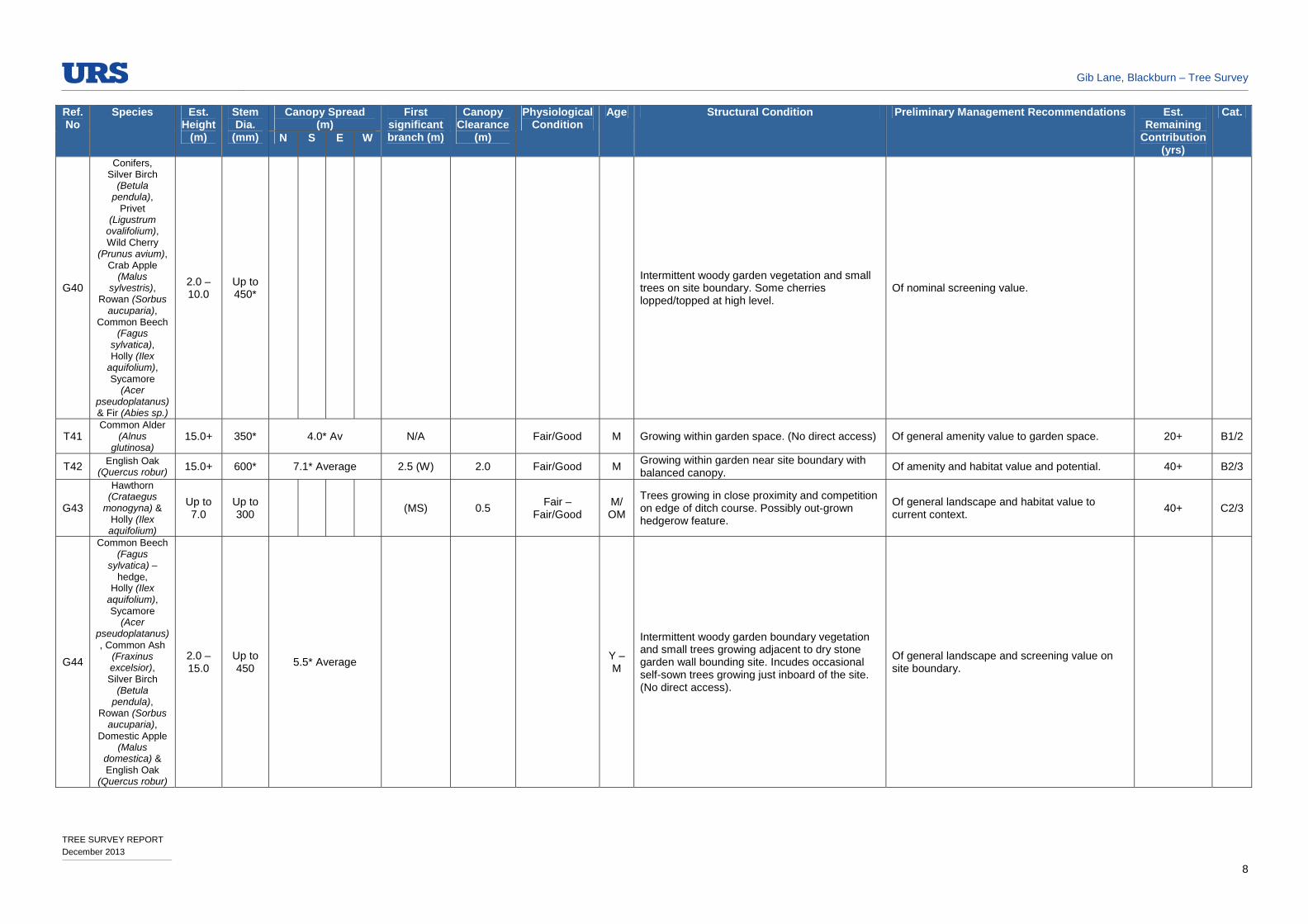
G40
Conifers, Silver Birch
(Betula pendula),
Privet (Ligustrum
ovalifolium), Wild Cherry
(Prunus avium), Crab Apple
(Malus sylvestris),
Rowan (Sorbus aucuparia),
Common Beech (Fagus
sylvatica), Holly (Ilex
aquifolium), Sycamore
(Acer pseudoplatanus) & Fir (Abies sp.)
2.0 – 10.0
Up to 450*
Intermittent woody garden vegetation and small trees on site boundary. Some cherries lopped/topped at high level.
Of nominal screening value.
T41 Common Alder
(Alnus glutinosa)
15.0+ 350* 4.0* Av N/A Fair/Good M Growing within garden space. (No direct access) Of general amenity value to garden space. 20+ B1/2
T42 English Oak (Quercus robur) 15.0+ 600* 7.1* Average 2.5 (W) 2.0 Fair/Good M
Growing within garden near site boundary with balanced canopy.
Of amenity and habitat value and potential. 40+ B2/3
G43
Hawthorn (Crataegus
monogyna) & Holly (Ilex aquifolium)
Up to 7.0
Up to 300
(MS) 0.5 Fair –
Fair/Good M/ OM
Trees growing in close proximity and competition on edge of ditch course. Possibly out-grown hedgerow feature.
Of general landscape and habitat value to current context.
40+ C2/3
G44
Common Beech (Fagus
sylvatica) – hedge,
Holly (Ilex aquifolium), Sycamore
(Acer pseudoplatanus), Common Ash
(Fraxinus excelsior), Silver Birch
(Betula pendula),
Rowan (Sorbus aucuparia),
Domestic Apple (Malus
domestica) & English Oak
(Quercus robur)
2.0 – 15.0
Up to 450
5.5* Average Y – M
Intermittent woody garden boundary vegetation and small trees growing adjacent to dry stone garden wall bounding site. Incudes occasional self-sown trees growing just inboard of the site. (No direct access).
Of general landscape and screening value on site boundary.

Gib Lane, Blackburn – Tree Survey
TREE SURVEY REPORT December 2013
9
Ref. No
Species Est. Height
(m)
Stem Dia.
(mm)
Canopy Spread (m)
First significant branch (m)
Canopy Clearance
(m)
Physiological Condition
Age Structural Condition Preliminary Management Recommendations Est. Remaining
Contribution (yrs)
Cat.
N S E W
T45 Holly (Ilex aquifolium) 7.0
13No. x 100
2.1 Average 0.0 (MS) 1.2 Fair OM
Hedgerow remnant growing on former field boundary adjacent to shallow ditch. Several stems rising up from the base. Grazing damage to lower trunk and bark.
Of general landscape and habitat value to current context.
20+ C1/2
T46 Holly (Ilex aquifolium) 6.0
6No. x 110
1.3 Average 0.0 (MS) 1.2 Fair OM
Hedgerow remnant growing on former field boundary adjacent to shallow ditch. Several stems rising up from the base. Grazing damage to lower trunk and bark.
Of general landscape and habitat value to current context.
20+ C1/2
T47 3No. Holly (Ilex aquifolium) 11.0
9No. x 200* Av
3.5* Average 0.0 (MS) 1.0 Fair/Good OM
Several multi-stem trees crowded into small linear area on site boundary and growing in competition. Possible out-grown hedgerow remnant. (No direct access).
Of general screening and habitat value on site boundary.
20+ B2/3
G48
Norway Maple (Acer
platanoides), Mahonia,
Holly (Ilex sp.), Common Beech
(Fagus sylvatica) & English Oak
(Quercus robur)
3.0 – 10.0
Up to 300
7.0 Average Varies 2.0 Av Fair –
Fair/Good Y – SM
Intermittent woody garden boundary vegetation and small trees growing adjacent to site boundary. (No direct access).
Of general landscape and screening value on site boundary.
T49 English Oak (Quercus robur) 15.0 700* 7.2 Average 3.5 (Fork) 2.0 Fair/Good M
Former field tree growing on site/garden boundary. Deadwood and occasional torn branch wounds visible including further pruning/lopping wounds also. Cavity forming at base of trunk on SW side with possible decay.
Of landscape and habitat value to location. Remove deadwood where deemed to be posing an unacceptable risk to adjacent persons or property. Inspect base of trunk for extent of decay. Monitor pruning and torn branch wounds for decay.
40+ B2/3
T50 English Oak (Quercus robur) 15.0+ 800
7.0 Overhanging site boundary
5.0 (E-W Fork)
3.0 Fair M
Former field tree growing on site boundary with domestic garden. Lopped back at high level with some subsequent regeneration but slightly thin remaining canopy. Deadwood and occasional torn branch wounds within canopy. Chain swing fixed to lower branch. (No direct access).
Of general screening and landscape value in current context. Monitor pruning/lopping wounds for decay. Remove deadwood where posing an unacceptable hazard to persons or property. Carefully remove chain swing.
20+ B1/2
G51
Rhododendron (Rhododendron
ponticum), Golden Rain (Laburnum
anagyroides), Hawthorn
(Crataegus monogyna),
Cherry Laurel (Prunus
laurocerasus), Holly (Ilex sp.),
Conifers, Sycamore
(Acer pseudoplatanus)
& Ornamental Cherry (Prunus
sp.)
2.0 – 8.0
Up to 300
Fair –
Fair/Good Y – SM
Intermittent belt of woody vegetation and young trees including short sections of hedgerow.
Of general screening and shelter value.

Gib Lane, Blackburn – Tree Survey
TREE SURVEY REPORT December 2013
10
Ref. No
Species Est. Height
(m)
Stem Dia.
(mm)
Canopy Spread (m)
First significant branch (m)
Canopy Clearance
(m)
Physiological Condition
Age Structural Condition Preliminary Management Recommendations Est. Remaining
Contribution (yrs)
Cat.
N S E W
T52 English Oak (Quercus robur) 13.0 650* 3.5* Average
2.0 (E-W Fork)
2.0 Fair M
Growing on site boundary with garden space and in close proximity to modern single storey house extension immediately to W. Heavily lopped back at high level with some subsequent regeneration. Further historic pruning wounds/stubs and decay visible. Rope swing tied to low branch.
Of nominal residual value following unsympathetic management. Remove deadwood where posing an unacceptable risk to persons or property. Monitor pruning wounds/stubs for decay.
10+ C1
T53 Rowan (Sorbus aucuparia) 11.0 700* 5.5* Average 1.5 (SW) 2.5 Fair/Poor OM
Growing on site boundary. Of crooked form with occasional large crossing branches. High proportion of deadwood, dying branches and decay within several areas of canopy. Large specimen appears to be in decline. (No direct access).
Of habitat value whilst in decline. Remove deadwood where posing an unacceptable hazard to persons or property. Assess for safety in current context.
<10 C3
T54 English Oak (Quercus robur) 12.0 700
7.8 Overhanging site
3.0 (Average)
2.0 Fair M
Growing on site boundary with garden space adjacent to drainage ditch/culvert. Of slightly squat, vase shaped form with locally heavy pruning/lopping wounds to house side of canopy. Minor deadwood also noted.
Of general habitat/screening value to location. Monitor pruning/lopping wounds for decay.
20+ C2/3
T55 English Oak (Quercus robur) 13.0 600
5.0 Overhanging site
3.0 (S) 2.5 Fair/Poor M
Growing on garden/site boundary. Heavy pruning/lopping wounds with much reduced residual asymmetrical canopy. Poor form with deadwood also noted. (No direct access)
Of nominal residual habitat/screening value following unsympathetic management. Monitor pruning/lopping wounds for decay.
10+ C2/3
T56 English Oak (Quercus robur) 11.0 700
5.3 Overhanging site
3.0 (N) 2.0 Fair M
Slightly squat tree growing on boundary of site with adjacent domestic drive/garden space. Possibly impacted by construction of drive during construction. Heavy pruning wounds on W side adjacent to house/drive access. (No direct access).
Of nominal residual habitat/screening value following unsympathetic management. Monitor pruning wounds for decay.
20+ C2/3
G57
Holly (Ilex aquifolium),
Cotoneaster, Golden Rain (Laburnum
anagyroides), English Oak
(Quercus robur) & Sycamore
(Acer pseudoplatanus)
4.0 – 12.0
Fair –
Fair/Good Y – SM
Remains of woody hedgerow/garden boundary vegetation and small trees adjacent to modern housing development. Some natural regeneration also.
Of general screening value on site boundary.
G58
1No. Sycamore (Acer
pseudoplatanus) & 1No. Silver Birch (Betula
pendula)
15.0 Av
500 Av 6.3 Average 3.0
(Average) 2.0
(Average) Fair M
Growing on site boundary near domestic drive and in close proximity/competition. Pruning wounds generally visible with Birch lopped and topped at high level.
Of nominal residual screening value. Monitor pruning/lopping wounds for decay.
10+ C2
G59 2No. Sycamore
(Acer pseudoplatanus)
15.0 Av
600Av 6.8 Overhanging
site 0.3 (MS)
2.5 (Average)
Fair M 2No. Multi-stemmed trees growing in close proximity/competition adjacent to domestic drive. Occasional pruning wounds visible.
Of general remaining screening value. Monitor pruning wounds for decay.
20+ C2
G60
1No. English Oak (Quercus
robur) & 1No. Wild
Cherry (Prunus avium)
10.0 Av
500* Av
6.3 Average 1.2 Av 1.7 Av Fair M
Two trees growing within separate garden areas adjacent to site boundary. Concrete block-work wall immediately adjacent to one tree. Oak to W topped at high level with some dead wood visible also.
Of general screening value to location. Remove deadwood where posing an unacceptable hazard to persons or property.
10+ C2
Gib Lane, Blackburn – Tree Survey
TREE SURVEY REPORT December 2013
11
Ref. No
Species Est. Height
(m)
Stem Dia.
(mm)
Canopy Spread (m)
First significant branch (m)
Canopy Clearance
(m)
Physiological Condition
Age Structural Condition Preliminary Management Recommendations Est. Remaining
Contribution (yrs)
Cat.
N S E W
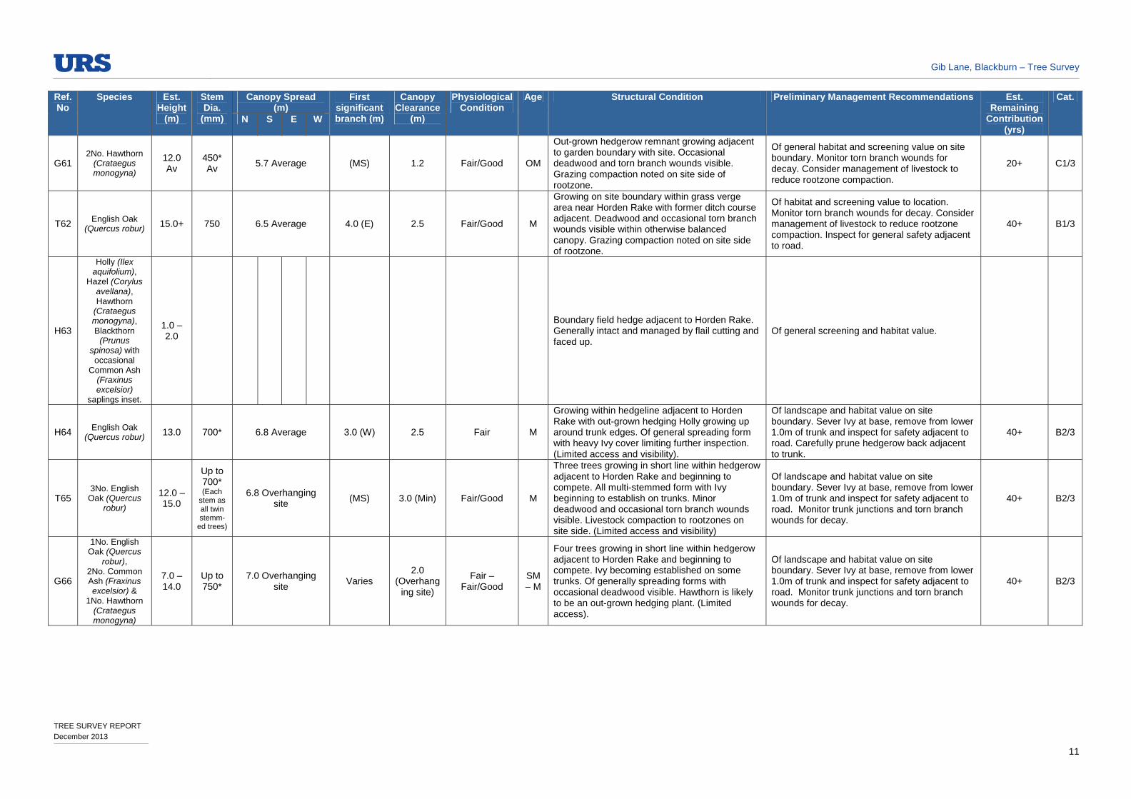
G61 2No. Hawthorn
(Crataegus monogyna)
12.0 Av
450* Av
5.7 Average (MS) 1.2 Fair/Good OM
Out-grown hedgerow remnant growing adjacent to garden boundary with site. Occasional deadwood and torn branch wounds visible. Grazing compaction noted on site side of rootzone.
Of general habitat and screening value on site boundary. Monitor torn branch wounds for decay. Consider management of livestock to reduce rootzone compaction.
20+ C1/3
T62 English Oak (Quercus robur) 15.0+ 750 6.5 Average 4.0 (E) 2.5 Fair/Good M
Growing on site boundary within grass verge area near Horden Rake with former ditch course adjacent. Deadwood and occasional torn branch wounds visible within otherwise balanced canopy. Grazing compaction noted on site side of rootzone.
Of habitat and screening value to location. Monitor torn branch wounds for decay. Consider management of livestock to reduce rootzone compaction. Inspect for general safety adjacent to road.
40+ B1/3
H63
Holly (Ilex aquifolium),
Hazel (Corylus avellana), Hawthorn
(Crataegus monogyna), Blackthorn
(Prunus spinosa) with occasional
Common Ash (Fraxinus excelsior)
saplings inset.
1.0 – 2.0
Boundary field hedge adjacent to Horden Rake. Generally intact and managed by flail cutting and faced up.
Of general screening and habitat value.
H64 English Oak (Quercus robur) 13.0 700* 6.8 Average 3.0 (W) 2.5 Fair M
Growing within hedgeline adjacent to Horden Rake with out-grown hedging Holly growing up around trunk edges. Of general spreading form with heavy Ivy cover limiting further inspection. (Limited access and visibility).
Of landscape and habitat value on site boundary. Sever Ivy at base, remove from lower 1.0m of trunk and inspect for safety adjacent to road. Carefully prune hedgerow back adjacent to trunk.
40+ B2/3
T65 3No. English
Oak (Quercus robur)
12.0 – 15.0
Up to 700* (Each
stem as all twin stemm-
ed trees)
6.8 Overhanging site
(MS) 3.0 (Min) Fair/Good M
Three trees growing in short line within hedgerow adjacent to Horden Rake and beginning to compete. All multi-stemmed form with Ivy beginning to establish on trunks. Minor deadwood and occasional torn branch wounds visible. Livestock compaction to rootzones on site side. (Limited access and visibility)
Of landscape and habitat value on site boundary. Sever Ivy at base, remove from lower 1.0m of trunk and inspect for safety adjacent to road. Monitor trunk junctions and torn branch wounds for decay.
40+ B2/3
G66
1No. English Oak (Quercus
robur), 2No. Common Ash (Fraxinus excelsior) &
1No. Hawthorn (Crataegus monogyna)
7.0 – 14.0
Up to 750*
7.0 Overhanging site
Varies 2.0
(Overhanging site)
Fair – Fair/Good
SM – M
Four trees growing in short line within hedgerow adjacent to Horden Rake and beginning to compete. Ivy becoming established on some trunks. Of generally spreading forms with occasional deadwood visible. Hawthorn is likely to be an out-grown hedging plant. (Limited access).
Of landscape and habitat value on site boundary. Sever Ivy at base, remove from lower 1.0m of trunk and inspect for safety adjacent to road. Monitor trunk junctions and torn branch wounds for decay.
40+ B2/3

Gib Lane, Blackburn – Tree Survey
TREE SURVEY REPORT December 2013
12
Ref. No
Species Est. Height
(m)
Stem Dia.
(mm)
Canopy Spread (m)
First significant branch (m)
Canopy Clearance
(m)
Physiological Condition
Age Structural Condition Preliminary Management Recommendations Est. Remaining
Contribution (yrs)
Cat.
N S E W
G67
Elderberry (Sambucus
nigra), English Oak
(Quercus robur), Sycamore
(Acer pseudoplatanus)
, 1No. Silver Birch (Betula
pendula), Common Ash
(Fraxinus excelsior)
regeneration & Hawthorn
(Crataegus monogyna) –
out-grown hedgerow plants
8.0 – 15.0
75 - 650
6.2 3.0
Overhanging site boundary
Varies 2.0
(Overhanging site)
Fair - Good Y - M
Informal group of trees growing on site boundary adjacent to Horden Rake and beginning to compete. Includes some self-sown trees within road verge areas, (mostly Ash). Some trees becoming drawn up through competition, with others becoming locally suppressed.
Of general screening and habitat value on site boundary. Undertake inspection for safety of trees bounding road. Consider selective thinning to allow development of better specimens.
H68 Holly (Ilex aquifolium) 2.0
Slightly gappy hedgerow bounding drive access. Cut and generally faced up to 2.0m Ht. with occasional gaps. Occasional young Cherry Laurel planting within gaps.
Of general screening and habitat value. Replace cherry Laurel with indigenous hedging species.
T69 Sycamore
(Acer pseudoplatanus)
15.0+ 750* 6.5* Average 2.5 (S) 2.5 Fair/Good M
Growing within hedgeline on site boundary adjacent to drive access to barn conversions. Large buttress roots and sucker growth at base. Occasional pruning wounds visible with wound wood developing and in various stages of occlusion. Generally balanced form.
Of landscape and amenity value to location. Monitor pruning wounds for decay.
40+ B2
T70 Hawthorn
(Crataegus monogyna)
5.0 3No. x 175 Av
1.8 Average (0.0) 1.2 Fair OM
Out-grown hedging plant of much character with asymmetrical canopy growing adjacent to former ditch course. Three main trunks, much fluted and hollowed with some decay visible. Grazing and compaction damage within rootzone.
Of cultural and general habitat value. 10+ C3
T71 Common Alder
(Alnus glutinosa)
14.0 400 600
5.8 5.0 6.5 5.5*
1.2 (N-S Fork)
1.8 Fair OM/
V
Tree of much character growing on site boundary adjacent to former ditch course. Large, much hollowed trunk with further cavities and large, exposed buttress roots. Wound wood and natural regeneration forming on edges of trunk cavity. Grazing compaction from adjacent livestock.
Of cultural and general habitat value. Monitor extent of decay within cavities. Consider management of livestock to reduce rootzone compaction.
20+ B3
G72
English Oak (Quercus robur),
Common Ash (Fraxinus excelsior),
Common Alder (Alnus
glutinosa), Holly (Ilex
aquifolium) & Hawthorn
(Crataegus monogyna)
Up to 15.0+
Up to 750
Up to 7.5 Overhanging site
Varies 2.0 Av Fair –
Fair/Good Y - OM
Growing adjacent to Horden Rake Boundary with site comprises mature field trees, out-grown hedgerow plants and occasional self-sown saplings also. Occasional deadwood and torn branch wounds visible. Side of hedge faced up by flail cutting.
Of landscape and habitat value. Undertake safety check for trees bounding road. Consider thinning out of saplings to allow development of better specimens. Cut back top of hedge, (currently out-grown) to prevent undue competition with trees.
40+ B2/3

Gib Lane, Blackburn – Tree Survey
TREE SURVEY REPORT December 2013
13
Ref. No
Species Est. Height
(m)
Stem Dia.
(mm)
Canopy Spread (m)
First significant branch (m)
Canopy Clearance
(m)
Physiological Condition
Age Structural Condition Preliminary Management Recommendations Est. Remaining
Contribution (yrs)
Cat.
N S E W
T73
1No. Common Alder (Alnus glutinosa) & 1No. English
Oak (Quercus robur)
Up to 15.0+
750 Av Up to 10.5
Overhanging site 2.5 Av 1.8 Av
Fair – Fair/Good
M/OM
Two trees growing on site boundary adjacent to Horden Rake and beginning to compete. Deadwood and occasional torn branch wounds visible. Grazing compaction noted within rootzone on site side. Heavy Ivy growth limits further inspection.
Of Landscape and habitat value on site boundary. Sever Ivy at base and remove from lower 1.0m of trunk. Undertake safety check for trees overhanging road.
40+ B2/3
G74
English Oak (Quercus robur), Common Alder
(Alnus glutinosa), Holly (Ilex
aquifolium), Hawthorn
(Crataegus monogyna) & 1No. Silver
Birch (Betula pendula)
4.0 – 15.0
Up to 850
Up to 5.0 Overhanging site
Varies 1.2m Fair –
Fair/Good Y-M
Intermittent boundary vegetation comprising out-grown gappy hedgerow plants, mature field trees and young self-sown trees inset. Occasional deadwood and torn branch wounds visible. Grazing compaction and damage within rootzone on site side. Ivy growth becoming established on some trees.
Of Landscape and habitat value on site boundary. Sever Ivy at base and remove from lower 1.0m of trunk. Undertake safety check for trees overhanging road.
40+ B2/3
T75 English Oak (Quercus robur) 11.0 490 5.0 Average
3.0 (N-S Fork)
2.0 Fair/Poor M
Growing on site boundary adjacent to Broken Stone Road. Large fork at approx. 3.0m Ht. with associated large historical vertical split within main trunk and cavity/decay visible. Further deadwood and torn branch wounds within slightly low, crooked canopy. Damaged and decaying buttress roots through grazing damage at base.
Of general landscape and habitat value on site boundary. Sever Ivy at base and remove from lower 1.0m of trunk. Undertake safety check for trees overhanging road. Consider livestock management to reduce rootzone compaction.
20+ C2/3
T76 English Oak (Quercus robur) 13.0 790 6.5 6.6 6.9 6.0 3.5 (E) 1.8 Fair/Good M
Isolated trees, (possibly boundary remnant) with generally balanced canopy. Deadwood and torn branch wounds visible. Exposed buttress roots much eroded and damaged by historic livestock compaction.
Of landscape and habitat value. Consider livestock management to reduce rootzone compaction.
40+ B2/3
T77 English Oak (Quercus robur) 15.0+ 750
7.0 Average overhanging site
2.5 (N) 2.0 Fair/Good M
Growing on site boundary adjacent to Broken Stone Road. Spreading slightly thin/open canopy. Deadwood and occasional torn branch wounds visible. Livestock compaction and minor damage within rootzone.
Of landscape and habitat value. Consider livestock management to reduce rootzone compaction.
20+ B2/3
T78 English Oak (Quercus robur) 15.0 850
7.8 Overhanging site
2.0 (E-W Fork)
2.0 Fair/Good M
Growing on site boundary adjacent to Broken Stone Road. Forks at approx. 2.0m Ht. with spreading canopy. Deadwood and occasional torn branch wounds visible. Ivy becoming established. Livestock compaction within rootzone.
Of landscape and habitat value. Consider livestock management to reduce rootzone compaction. Inspect trunk junction for decay.
40+ B2/3
G79
2No. Common Beech (Fagus
sylvatica) & 2No. English
Oak (Quercus robur)
Up to 15.0+
430 - 850
Up to 11.5 1.5 – 4.0 Locally down to
0.2
Fair/Good - Good
3No. M / 1No. SM
Small stand of trees growing adjacent to dry stone wall and beginning to compete. Spreading forms with occasional deadwood, (including some hanging) and torn branch wounds visible. Ganoderma bracket fungus noted on Beech.
Of general habitat and landscape value. Monitor torn branch wounds for decay. Consider livestock management to prevent undue rootzone compaction. Inspect trunk junction for decay.
40+ B2/3

Gib Lane, Blackburn – Tree Survey
TREE SURVEY REPORT December 2013
14
Ref. No
Species Est. Height
(m)
Stem Dia.
(mm)
Canopy Spread (m)
First significant branch (m)
Canopy Clearance
(m)
Physiological Condition
Age Structural Condition Preliminary Management Recommendations Est. Remaining
Contribution (yrs)
Cat.
N S E W
G80
3No. Sycamore (Acer
pseudoplatanus) & 1No. Common
Beech (Fagus sylvatica)
290-520
(Syc)
265 140 800 540
(Beech)
Up to 15.0+
0.5 – 2.5 Locally down to
1.5 Fair/Good
SM -
OM
Small, informal stand of trees beginning to compete. Deadwood and occasional torn branch wounds visible within mature Beech. Includes crossing limbs, fused stems and water pocket within mature Beech of much character.
Of general habitat and landscape value. Monitor torn branch wounds for decay. Consider livestock management to prevent undue rootzone compaction. Inspect trunk junctions for decay.
40+ B2/3
T81 2No. English
Oak (Quercus robur)
360 & 500
12.0 Av
2.0 Av Locally down to
1.5 Fair M
Two trees growing in close proximity and shelter. Occasional deadwood and torn branch wounds visible with wire fencing fixed to tree trunks. Large, linear wound at base of one tree with some decay visible.
Of general habitat and landscape value. Monitor torn branch wounds for decay. Monitor trunk wound for extent of decay.
20+ C2/3
G82
English Oak (Quercus robur),
Silver Birch (Betula pendula)
Sycamore (Acer
pseudoplatanus), Common
Beech (Fagus sylvatica) & Gorse (Ulex europaeus)
Up to 15.0+
Locally up to 1200
Fair/Poor – Fair/Good
SM -
OM
Slightly dispersed woodland group including small groups of trees and isolated lines of trees with some natural regeneration. Variable condition with mostly open understorey. Historic ditches and mounding suggest previous land management systems, now lapsed. Generally unmanaged with torn branch wounds, deadwood, (including some hanging/fallen) and cavities to mature and over-mature trees. Some areas of livestock compaction.
Of landscape and habitat value. Undertake safety check for trees bounding road. Consider livestock management to reduce rootzone compaction.
40+ B2/3
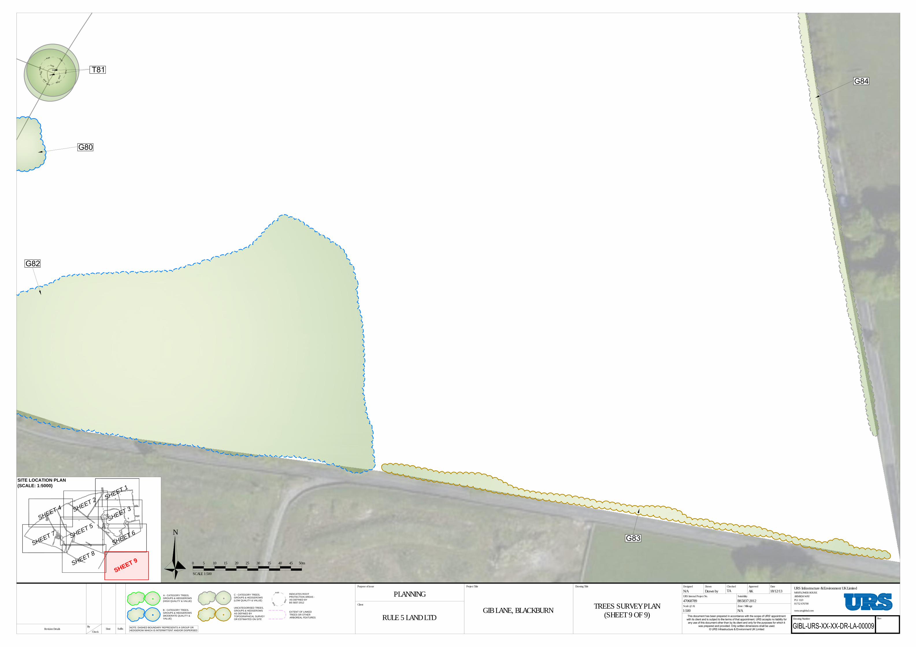
G83
Sycamore (Acer pseudoplatanus)
, Hawthorn (Crataegus monogyna),
Common Ash (Fraxinus
excelsior) & Common Beech
(Fagus sylvatica),
Gorse (Ulex europaeus), Bay
Willow (Salix pentandra),
Purple Willow (Salix Purpurea) – Mostly Semi-
mature. 2No. English
Oak (Quercus robur)
6.0 – 10.0
Up to 600
(Oak) Fair - Good
Y - M
Boundary trees and woody understorey growing within road verge area adjacent to Broken Stone Road and outside field boundary. Locally gappy including some out-grown hedging plants.
Of general screening and habitat value on site boundary. Inspect trees for safety bounding road. Consider thinning out to encourage development of better specimens. Undertake pre-emptive formative pruning for long term highway clearance.
G84
English Oak (Quercus robur)
& Sycamore (Acer
pseudoplatanus)
8.0 – 12.0
Up to 250
Fair –
Fair/Good Y - SM
Highly dispersed trees growing within road verge area on Gib Lane and bounding dry stone boundary wall. Likely to comprise natural regeneration.
Of nominal screening and habitat value. Consider thinning out to encourage development of better specimens. Undertake pre-emptive formative pruning for long term highway clearance.
40+ C2/3

Gib Lane, Blackburn - Tree Survey
TREE SURVEY REPORT December 2013
4
Notes: 1) All trees and hedgerows subject to full arboricultural inspection for safety, with respect of both
existing and proposed site uses/users (targets). 2) Any management recommendations in this report subject to protection status of trees (e.g. TPO or
Conservation area etc.) and LPA approval.
3) Any management recommendations in this report subject to presence of nesting birds or protected species (e.g. Bats)
4) Any tree surgery recommendations contained within this report to be undertaken in accordance with
BS3998:2010
5) Fieldwork survey information subject to seasonal/access constraints.
This schedule should be read in conjunction with URS Tree Survey drawing No. GIBL-URS-XX-XX-RR-LA-00001 to GIBL-URS-XX-XX-RR-LA-00009 within Appendix A N/A - Measurement not accessible. * - Indicates estimated position of tree (not indicated on topographical survey) or value based
upon average of remaining measurements or visual estimate.

Gib Lane, Blackburn - Tree Survey
TREE SURVEY REPORT December 2013
5
3.1 Key to Abbreviations Used in the Survey
Ref No Corresponding number on plan – T=Tree/H=Hedge/G=Group
Species Common name followed by botanical name shown in italics
RPA Root Protection Area (As defined by BS5837)
Stem diameter Diameter measured in millimetres at 1.5 m above ground level. (MS = Multi-stem tree measured in accordance with BS5837
Av / Average: indicates an average representative measured dimension for the group or feature
Spread Measured on the four compass points
Crown clearance
The height to the lowest branch attachments
Category 1=Arboricultural quality/value 2=Landscape quality/value 3=Cultural quality/value (including conservation) A=High quality/value 40yrs+ B=Moderate quality/value 20yrs+ C=Low quality/value min 10yrs/stem diameter less than 150mm U=Unsuitable for retention
Age Young (Y) Semi-Mature (SM) Mature (M) Over Mature (OM) Veteran (V) Classification is given in relation to the life expectancy of the specific species.
Physiological condition
G = Good F = Fair P = Poor D = Dead F/G = Indicates an intermediate condition F – G = Indicates a range of conditions (e.g. within a group)

Gib Lane, Blackburn - Tree Survey
TREE SURVEY REPORT December 2013
6
4 FIELDWORK OBSERVATIONS
The survey area included trees and hedgerow boundaries associated with several fields and small woodland copses to the south-west of Blackburn.
Many of the tree and hedgerow species encountered were reflective, (or tolerant) of the damp underlying ground conditions within the site. The damp conditions are likely to have affected tree growth and the incidence of decay fungi. The vast majority of trees and woody vegetation within the site comprised UK native species with ornamental varieties being more common on the site boundaries with domestic garden spaces.
Many of the hedgerows appeared out grown and much degraded, occasionally with scant remains of mostly Holly and Hawthorn hedging plants on some boundaries, (Photograph 1). Many hedging plants appeared subject to exposure, grazing damage and/or compaction to some degree, (Photograph 2). Several hedging plants exhibited sculptural forms as a result of the challenging growing conditions, (Photograph 3).
Photograph 1 Photograph 2 Photograph 3

Gib Lane, Blackburn - Tree Survey
TREE SURVEY REPORT December 2013
7
Field trees were less common that might have been expected, (Photograph 4). Again, many trees had historically been subject to grazing damage/compaction resulting in exposed buttress roots and occasional decay, (Photographs 5 and 6). Field trees typically exhibited torn branch wounds and some dead wood, both of which are typical of mature trees in this context. Both features are generally regarded as being of habitat value. Field trees bounding domestic garden spaces have variously been impacted by both domestic construction works and often misguided management works. Several of these trees are now in decline and/or have reduced useful life expectancies as a result, (Photograph 7).
Photograph 4 Photograph 5
Photograph 6 Photograph 7

Gib Lane, Blackburn - Tree Survey
TREE SURVEY REPORT December 2013
8
Three small areas of woodland were recorded within the survey area comprising Cockridge Wood and Greenhills Wood, (with the former wood now comprising two separate areas). Greenhills Wood comprises small groups and scattered individual trees with a generally open character, (Photograph 8). The wood appears less impacted by grazing livestock, perhaps due to the localised presence of Gorse and Bramble within the understorey areas which locally limit movement/access. The wood includes a number of over-mature Beech with decay fungi associated with the natural aging process, (Photograph 9). The wood is likely to be of moderate habitat value and forms a vegetated screen adjacent to Broken Stone Road to the south.
Photograph 8 Photograph 9

Gib Lane, Blackburn - Tree Survey
TREE SURVEY REPORT December 2013
9
Cockridge Wood appears historically to have comprised one wood, but now consists eastern and western portions, each of distinctive character. The western portion is of generally lower quality and value being dominated by a dense halo of Rhododendron regeneration, (Photograph 10). This appears to have suppressed much of the native tree and shrub species leaving a low, dark, dense understorey layer, (Photograph 11). The central portion is more open and contains some Birch and Holly of modest size, (Photograph 12). The north-western and north-eastern edges of the wood appear to contain a greater species diversity and age range with a contrastingly open understorey, (Photograph 13). Several trees are of over-mature age and again, contain decay fungi associated with the natural aging process.
Photograph 10 Photograph 11
Photograph 12 Photograph 13

Gib Lane, Blackburn - Tree Survey
TREE SURVEY REPORT December 2013
10
The eastern portion of Cockridge Wood includes a greater age and species diversity than that within the western side. The wood appears to be bounded by stock proof fencing and walling with a small watercourse and informal footpath link dissecting the wood, (Photographs 14 and 15). The wood has a broadly open understorey with occasional small clearings. Several over-mature trees are again present with decay fungi including a variety of deadwood habitats, (Photographs 16 and 17). The wood is overall of higher amenity and habitat value and provides a vegetated boundary adjacent to Gib Lane to the east.
Photograph 14 Photograph 15
Photograph 16 Photograph 17

Gib Lane, Blackburn - Tree Survey
TREE SURVEY REPORT December 2013
11
GENERAL ARBORICULTURAL RECOMMENDATIONS
4.1 General Principles
The Root Protection Area (RPA) defines the approximate underground area occupied by the tree roots based on a calculation relating to the girth of the tree, point above ground at which the trunk begins to branch out and the number of stems. BS5837:2012 outlines the calculation of RPA as follows:
Trees with more than one stem below 1.5m height are given an aggregate stem diameter using either of the following two calculations as outlined in BS5837:2012. This diameter is then used in the above calculation to estimate RPA:
a) For trees with two to five stems:
√ (stem diameter 1)² + (stem diameter 2)² … + (stem diameter 5)²
b) For trees with more than five stems:
√ (mean stem diameter)² x number of stems
The RPA of existing tree stock is an important material consideration when considering site constraints and planning development activities.
Construction operations, materials storage or changes in level should generally be avoided within the RPA of a tree to be retained on a developed site. This is because these operations have the potential to damage or kill the tree, the safe retention of which may be a condition of Planning Approval. This is significant when considering construction in close proximity to off site/third party. Special construction techniques, i.e. no-dig construction/permeable surfacing may be considered for light loadings i.e. pedestrian footpaths etc. within the RPA.
It should be noted that the RPA often varies in size to the physical area occupied by the canopy spread, (due to particular tree species or management practices to artificially alter the canopy size). This is of particular importance when integrating new development in close proximity of existing trees. Similarly, the canopy heights (as identified in the Schedule of Existing Trees) should be considered as the usable space below a low branching tree will be severely restricted without specific arboricultural works to raise the canopy (which may not always be appropriate).
It should also be noted that BS5837:2012 states that although RPAs should be plotted as a circle centred on the base of the stem, pre-existing site conditions or other factors may indicate that rooting has occurred asymmetrically and so RPAs may instead be represented as a polygon of equivalent area.
π (3.142)

Gib Lane, Blackburn - Tree Survey
TREE SURVEY REPORT December 2013
12
5 APPENDICES
Gib Lane, Blackburn - Tree Survey
TREE SURVEY REPORT December 2013
13
Appendix A: Tree Survey
RP
A
R
P
A
R
P
A
A - CATEGORY TREES,
GROUPS & HEDGEROWS
(HIGH QUALITY & VALUE)
INDICATES ROOT
PROTECTION AREAS -
AS DEFINED BY
BS 5837:2012
B - CATEGORY TREES,
GROUPS & HEDGEROWS
(MODERATE QUALITY &
VALUE)
C - CATEGORY TREES,
GROUPS & HEDGEROWS
(LOW QUALITY & VALUE)
UNCATEGORISED TREES,
GROUPS & HEDGEROWS
AS DEFINED BY
TOPOGRAPHICAL SURVEY
OR ESTIMATED ON SITE
EXTENT OF LINKED
TREES OR OTHER
ARBOREAL FEATURES
NOTE: DASHED BOUNDARY REPRESENTS A GROUP OR
HEDGEROW WHICH IS INTERMITTENT AND/OR DISPERSED
R
P
A
R
P
A
R
P
A
R
P
A
R
P
A
R
P
A
R
P
A
R
P
A
R
P
A
R
P
A
Drawing Number Rev
DateApprovedCheckedDrawn
URS Internal Project No.
Drawing TitleProject Title
Client
Suitability
Scale @ A1 Zone / Mileage
URS Infrastructure & Environment UK LimitedPurpose of issue
www.ursglobal.com
Designed
SuffixBy
Revision Details DateCheck
PLANNINGTREES SURVEY PLAN
(SHEET 9 OF 9)
N/A Drawn by TA AK 18/12/13
BS5837:2012
1:500 N/A
RULE 5 LAND LTDGIB LANE, BLACKBURN
47068789
MAYFLOWER HOUSEARMADA WAYPL1 1LD01752 676700
N
SCALE 1:500
151050 20 25 30 35 40 45 50m
SITE LOCATION PLAN
(SCALE: 1:5000)
S
H
E
E
T
3S
H
E
E
T
2
S
H
E
E
T
4
S
H
E
E
T
7
S
H
E
E
T
5
S
H
E
E
T
6
S
H
E
E
T
8
S
H
E
E
T
1
S
H
E
E
T
9

RP
A
R
P
A
R
P
A
A - CATEGORY TREES,
GROUPS & HEDGEROWS
(HIGH QUALITY & VALUE)
INDICATES ROOT
PROTECTION AREAS -
AS DEFINED BY
BS 5837:2012
B - CATEGORY TREES,
GROUPS & HEDGEROWS
(MODERATE QUALITY &
VALUE)
C - CATEGORY TREES,
GROUPS & HEDGEROWS
(LOW QUALITY & VALUE)
UNCATEGORISED TREES,
GROUPS & HEDGEROWS
AS DEFINED BY
TOPOGRAPHICAL SURVEY
OR ESTIMATED ON SITE
EXTENT OF LINKED
TREES OR OTHER
ARBOREAL FEATURES
NOTE: DASHED BOUNDARY REPRESENTS A GROUP OR
HEDGEROW WHICH IS INTERMITTENT AND/OR DISPERSED
R
P
A
R
P
A
R
P
A
R
P
A
R
P
A
R
P
A
RPA
R
P
A
R
P
A
R
P
A
R
P
A
R
P
A
R
P
A
R
P
A
R
P
A
RPA
R
P
A
R
P
A
R
P
A
R
P
A
R
P
A
R
P
A
R
P
A
R
P
A
R
P
A
R
P
A
R
P
A
R
P
A
RPA
R
P
A
R
P
A
R
P
A
R
P
A
R
P
A
R
P
A
R
P
A
R
P
A
RPA
R
P
A
R
P
A
R
P
A
R
P
A
R
P
A
R
P
A
R
P
A
R
P
A
R
P
A
R
P
A
R
P
A
R
P
A
R
P
A
R
P
A
R
P
A
R
P
A
R
P
A
R
P
A
R
P
A
R
P
A
R
P
A
R
P
A
R
P
A
R
P
A
RP
A
R
P
A
R
P
A
R
P
A
R
P
A
R
P
A
R
P
A
R
P
A
R
P
A
R
P
A
R
P
A
R
P
A
R
P
A
R
P
A
R
P
A
R
P
A
R
P
A
R
P
A
Drawing Number Rev
DateApprovedCheckedDrawn
URS Internal Project No.
Drawing TitleProject Title
Client
Suitability
Scale @ A1 Zone / Mileage
URS Infrastructure & Environment UK LimitedPurpose of issue
www.ursglobal.com
Designed
SuffixBy
Revision Details DateCheck
PLANNINGTREES SURVEY PLAN
(SHEET 8 OF 9)
N/A Drawn by TA AK 18/12/13
BS5837:2012
1:500 N/A
RULE 5 LAND LTDGIB LANE, BLACKBURN
47068789
MAYFLOWER HOUSEARMADA WAYPL1 1LD01752 676700
N
SCALE 1:500
151050 20 25 30 35 40 45 50m
SITE LOCATION PLAN
(SCALE: 1:5000)
S
H
E
E
T
3S
H
E
E
T
2
S
H
E
E
T
4
S
H
E
E
T
7
S
H
E
E
T
5
S
H
E
E
T
6
S
H
E
E
T
9
S
H
E
E
T
1
S
H
E
E
T
8

RP
A
R
P
A
R
P
A
A - CATEGORY TREES,
GROUPS & HEDGEROWS
(HIGH QUALITY & VALUE)
INDICATES ROOT
PROTECTION AREAS -
AS DEFINED BY
BS 5837:2012
B - CATEGORY TREES,
GROUPS & HEDGEROWS
(MODERATE QUALITY &
VALUE)
C - CATEGORY TREES,
GROUPS & HEDGEROWS
(LOW QUALITY & VALUE)
UNCATEGORISED TREES,
GROUPS & HEDGEROWS
AS DEFINED BY
TOPOGRAPHICAL SURVEY
OR ESTIMATED ON SITE
EXTENT OF LINKED
TREES OR OTHER
ARBOREAL FEATURES
NOTE: DASHED BOUNDARY REPRESENTS A GROUP OR
HEDGEROW WHICH IS INTERMITTENT AND/OR DISPERSED
R
P
A
R
P
A
R
P
A
R
P
A
R
P
A
R
P
A
R
P
A
R
P
A
R
P
A
R
P
A
R
P
A
R
P
A
R
P
A
R
P
A
R
P
A
R
P
A
R
P
A
R
P
A
R
P
A
R
P
A
R
P
A
R
P
A
R
P
A
R
P
A
R
P
A
RPA
R
P
A
R
P
A
R
P
A
R
P
A
R
P
A
R
P
A
R
P
A
R
P
A
R
P
A
R
P
A
R
P
A
R
P
A
R
P
A
R
P
A
R
P
A
R
P
A
R
P
A
R
P
A
R
P
A
R
P
A
R
P
A
R
P
A
R
P
A
R
P
A
R
P
A
R
P
A
RP
A
R
P
A
R
P
A
R
P
A
R
P
A
R
P
A
R
P
A
RPA
R
P
A
R
P
A
R
P
A
R
P
A
R
P
A
R
P
A
R
P
A
R
P
A
R
P
A
R
P
A
R
P
A
R
P
A
R
P
A
R
P
A
R
P
A
R
P
A
R
P
A
R
P
A
R
P
A
R
P
A
RP
A
R
P
A
R
P
A
R
P
A
R
P
A
R
P
A
R
P
A
R
P
A
RPA
R
P
A
R
P
A
R
P
A
R
P
A
R
P
A
R
P
A
R
P
A
R
P
A
R
P
A
R
P
A
R
P
A
R
P
A
R
PA
R
P
A
R
P
A
R
P
A
R
P
A
R
P
A
R
PA
R
P
A
R
P
A
R
PA
R
P
A
R
P
A
R
P
A
R
P
A
R
P
A
R
PA
R
P
A
R
P
A
R
PA
R
P
A
R
P
A
R
P
A
R
P
A
R
P
A
R
P
A
R
P
A
R
P
A
R
P
A
R
P
A
R
P
A
R
P
A
R
P
A
R
P
A
RP
A
R
P
A
R
P
A
R
P
A
R
P
A
R
P
A
R
P
A
RPA
R
P
A
R
P
A
R
P
A
R
P
A
R
P
A
R
P
A
R
P
A
R
P
A
RPA
R
P
A
R
P
A
R
P
A
R
P
A
R
P
A
R
P
A
R
P
A
R
P
A
RPA
R
P
A
R
P
A
R
P
A
R
P
A
R
P
A
R
P
A
R
P
A
R
P
A
RPA
R
P
A
R
P
A
R
P
A
R
P
A
R
P
A
R
P
A
R
P
A
R
P
A
RP
A
R
P
A
R
P
A
T54
T55
G51
Drawing Number Rev
DateApprovedCheckedDrawn
URS Internal Project No.
Drawing TitleProject Title
Client
Suitability
Scale @ A1 Zone / Mileage
URS Infrastructure & Environment UK LimitedPurpose of issue
www.ursglobal.com
Designed
SuffixBy
Revision Details DateCheck
PLANNINGTREES SURVEY PLAN
(SHEET 7 OF 9)
N/A Drawn by TA AK 18/12/13
BS5837:2012
1:500 N/A
RULE 5 LAND LTDGIB LANE, BLACKBURN
47068789
MAYFLOWER HOUSEARMADA WAYPL1 1LD01752 676700
NSCALE 1:500
151050 20 25 30 35 40 45 50m
SITE LOCATION PLAN
(SCALE: 1:5000)
S
H
E
E
T
3S
H
E
E
T
2
S
H
E
E
T
4
S
H
E
E
T
5
S
H
E
E
T
6
S
H
E
E
T
9
S
H
E
E
T
8
S
H
E
E
T
1
S
H
E
E
T
7

RP
A
R
P
A
R
P
A
A - CATEGORY TREES,
GROUPS & HEDGEROWS
(HIGH QUALITY & VALUE)
INDICATES ROOT
PROTECTION AREAS -
AS DEFINED BY
BS 5837:2012
B - CATEGORY TREES,
GROUPS & HEDGEROWS
(MODERATE QUALITY &
VALUE)
C - CATEGORY TREES,
GROUPS & HEDGEROWS
(LOW QUALITY & VALUE)
UNCATEGORISED TREES,
GROUPS & HEDGEROWS
AS DEFINED BY
TOPOGRAPHICAL SURVEY
OR ESTIMATED ON SITE
EXTENT OF LINKED
TREES OR OTHER
ARBOREAL FEATURES
NOTE: DASHED BOUNDARY REPRESENTS A GROUP OR
HEDGEROW WHICH IS INTERMITTENT AND/OR DISPERSED
RP
A
R
P
A
R
P
A
R
P
A
R
P
A
R
P
A
R
P
A
R
P
A
R
P
A
R
P
A
RP
A
R
P
A
R
P
A
R
P
A
R
P
A
R
P
A
R
P
A
RP
A
R
P
A
R
P
A
R
P
A
R
P
A
R
P
A
R
P
A
R
P
A
R
P
A
RP
A
R
P
A
R
P
A
R
P
A
R
P
A
RP
A
R
P
A
RP
A
R
P
A
R
P
A
R
P
A
R
P
A
RPA
R
P
A
R
P
A
R
P
A
R
P
A
R
P
A
R
P
A
R
P
A
R
P
A
R
P
A
R
P
A
R
P
A
R
P
A
R
P
A
R
P
A
R
P
A
R
P
A
R
P
A
R
P
A
Drawing Number Rev
DateApprovedCheckedDrawn
URS Internal Project No.
Drawing TitleProject Title
Client
Suitability
Scale @ A1 Zone / Mileage
URS Infrastructure & Environment UK LimitedPurpose of issue
www.ursglobal.com
Designed
SuffixBy
Revision Details DateCheck
PLANNINGTREES SURVEY PLAN
(SHEET 6 OF 9)
N/A Drawn by TA AK 18/12/13
BS5837:2012
1:500 N/A
RULE 5 LAND LTDGIB LANE, BLACKBURN
47068789
MAYFLOWER HOUSEARMADA WAYPL1 1LD01752 676700
N
SCALE 1:500
151050 20 25 30 35 40 45 50m
SITE LOCATION PLAN
(SCALE: 1:5000)
S
H
E
E
T
3S
H
E
E
T
2
S
H
E
E
T
4
S
H
E
E
T
7
S
H
E
E
T
5
S
H
E
E
T
9
S
H
E
E
T
8
S
H
E
E
T
1
S
H
E
E
T
6

RP
A
R
P
A
R
P
A
A - CATEGORY TREES,
GROUPS & HEDGEROWS
(HIGH QUALITY & VALUE)
INDICATES ROOT
PROTECTION AREAS -
AS DEFINED BY
BS 5837:2012
B - CATEGORY TREES,
GROUPS & HEDGEROWS
(MODERATE QUALITY &
VALUE)
C - CATEGORY TREES,
GROUPS & HEDGEROWS
(LOW QUALITY & VALUE)
UNCATEGORISED TREES,
GROUPS & HEDGEROWS
AS DEFINED BY
TOPOGRAPHICAL SURVEY
OR ESTIMATED ON SITE
EXTENT OF LINKED
TREES OR OTHER
ARBOREAL FEATURES
NOTE: DASHED BOUNDARY REPRESENTS A GROUP OR
HEDGEROW WHICH IS INTERMITTENT AND/OR DISPERSED
R
P
A
R
P
A
R
P
A
RP
A
R
P
A
R
P
A
R
P
A
R
P
A
R
P
A
R
P
A
R
P
A
R
P
A
R
P
A
R
P
A
R
P
A
R
P
A
R
P
A
R
P
A
R
P
A
Drawing Number Rev
DateApprovedCheckedDrawn
URS Internal Project No.
Drawing TitleProject Title
Client
Suitability
Scale @ A1 Zone / Mileage
URS Infrastructure & Environment UK LimitedPurpose of issue
www.ursglobal.com
Designed
SuffixBy
Revision Details DateCheck
PLANNINGTREES SURVEY PLAN
(SHEET 5 OF 9)
N/A Drawn by TA AK 18/12/13
BS5837:2012
1:500 N/A
RULE 5 LAND LTDGIB LANE, BLACKBURN
47068789
MAYFLOWER HOUSEARMADA WAYPL1 1LD01752 676700
NSCALE 1:500
151050 20 25 30 35 40 45 50m
SITE LOCATION PLAN
(SCALE: 1:5000)
S
H
E
E
T
3S
H
E
E
T
2
S
H
E
E
T
4
S
H
E
E
T
7
S
H
E
E
T
6
S
H
E
E
T
9
S
H
E
E
T
8
S
H
E
E
T
1
S
H
E
E
T
5

RP
A
R
P
A
R
P
A
A - CATEGORY TREES,
GROUPS & HEDGEROWS
(HIGH QUALITY & VALUE)
INDICATES ROOT
PROTECTION AREAS -
AS DEFINED BY
BS 5837:2012
B - CATEGORY TREES,
GROUPS & HEDGEROWS
(MODERATE QUALITY &
VALUE)
C - CATEGORY TREES,
GROUPS & HEDGEROWS
(LOW QUALITY & VALUE)
UNCATEGORISED TREES,
GROUPS & HEDGEROWS
AS DEFINED BY
TOPOGRAPHICAL SURVEY
OR ESTIMATED ON SITE
EXTENT OF LINKED
TREES OR OTHER
ARBOREAL FEATURES
NOTE: DASHED BOUNDARY REPRESENTS A GROUP OR
HEDGEROW WHICH IS INTERMITTENT AND/OR DISPERSED
R
P
A
R
P
A
R
P
A
R
P
A
R
P
A
R
P
A
R
P
A
R
P
A
R
P
A
R
P
A
R
P
A
R
P
A
R
P
A
R
P
A
R
P
A
R
P
A
R
P
A
R
P
A
R
P
A
R
P
A
R
P
A
R
P
A
R
P
A
R
P
A
R
P
A
R
P
A
R
P
A
R
P
A
R
P
A
R
P
A
R
P
A
R
P
A
R
P
A
R
P
A
R
P
A
R
P
A
R
P
A
R
P
A
R
P
A
R
P
A
T49
T50
G51
Drawing Number Rev
DateApprovedCheckedDrawn
URS Internal Project No.
Drawing TitleProject Title
Client
Suitability
Scale @ A1 Zone / Mileage
URS Infrastructure & Environment UK LimitedPurpose of issue
www.ursglobal.com
Designed
SuffixBy
Revision Details DateCheck
PLANNINGTREES SURVEY PLAN
(SHEET 4 OF 9)
N/A Drawn by TA AK 18/12/13
BS5837:2012
1:500 N/A
RULE 5 LAND LTDGIB LANE, BLACKBURN
47068789
MAYFLOWER HOUSEARMADA WAYPL1 1LD01752 676700
NSCALE 1:500
151050 20 25 30 35 40 45 50m
SITE LOCATION PLAN
(SCALE: 1:5000)
S
H
E
E
T
3S
H
E
E
T
2
S
H
E
E
T
7
S
H
E
E
T
5
S
H
E
E
T
6
S
H
E
E
T
9
S
H
E
E
T
8
S
H
E
E
T
1
S
H
E
E
T
4

RP
A
R
P
A
R
P
A
A - CATEGORY TREES,
GROUPS & HEDGEROWS
(HIGH QUALITY & VALUE)
INDICATES ROOT
PROTECTION AREAS -
AS DEFINED BY
BS 5837:2012
B - CATEGORY TREES,
GROUPS & HEDGEROWS
(MODERATE QUALITY &
VALUE)
C - CATEGORY TREES,
GROUPS & HEDGEROWS
(LOW QUALITY & VALUE)
UNCATEGORISED TREES,
GROUPS & HEDGEROWS
AS DEFINED BY
TOPOGRAPHICAL SURVEY
OR ESTIMATED ON SITE
EXTENT OF LINKED
TREES OR OTHER
ARBOREAL FEATURES
NOTE: DASHED BOUNDARY REPRESENTS A GROUP OR
HEDGEROW WHICH IS INTERMITTENT AND/OR DISPERSED
R
P
A
R
P
A
R
P
A
R
P
A
R
P
A
R
P
A
R
P
A
R
P
A
R
P
A
R
P
A
RPA
R
P
A
R
P
A
R
P
A
R
P
A
R
P
A
R
P
A
R
P
A
R
P
A
R
P
A
R
P
A
R
P
A
R
P
A
R
P
A
R
P
A
R
P
A
R
P
A
R
P
A
R
P
A
R
P
A
R
P
A
R
P
A
R
P
A
R
P
A
RPA
R
P
A
R
P
A
R
P
A
R
P
A
R
P
A
R
P
A
RPA
R
P
A
R
P
A
R
P
A
R
P
A
R
P
A
R
P
A
R
P
A
R
P
A
R
P
A
R
P
A
R
P
A
R
P
A
R
P
A
R
P
A
RP
A
R
P
A
R
P
A
R
P
A
R
P
A
R
P
A
R
P
A
R
P
A
R
P
A
R
P
A
Drawing Number Rev
DateApprovedCheckedDrawn
URS Internal Project No.
Drawing TitleProject Title
Client
Suitability
Scale @ A1 Zone / Mileage
URS Infrastructure & Environment UK LimitedPurpose of issue
www.ursglobal.com
Designed
SuffixBy
Revision Details DateCheck
PLANNINGTREES SURVEY PLAN
(SHEET 3 OF 9)
N/A Drawn by TA AK 18/12/13
BS5837:2012
1:500 N/A
RULE 5 LAND LTDGIB LANE, BLACKBURN
47068789
MAYFLOWER HOUSEARMADA WAYPL1 1LD01752 676700
NSCALE 1:500
151050 20 25 30 35 40 45 50m
SITE LOCATION PLAN
(SCALE: 1:5000)
S
H
E
E
T
2
S
H
E
E
T
4
S
H
E
E
T
7
S
H
E
E
T
5
S
H
E
E
T
6
S
H
E
E
T
9
S
H
E
E
T
8
S
H
E
E
T
1
S
H
E
E
T
3
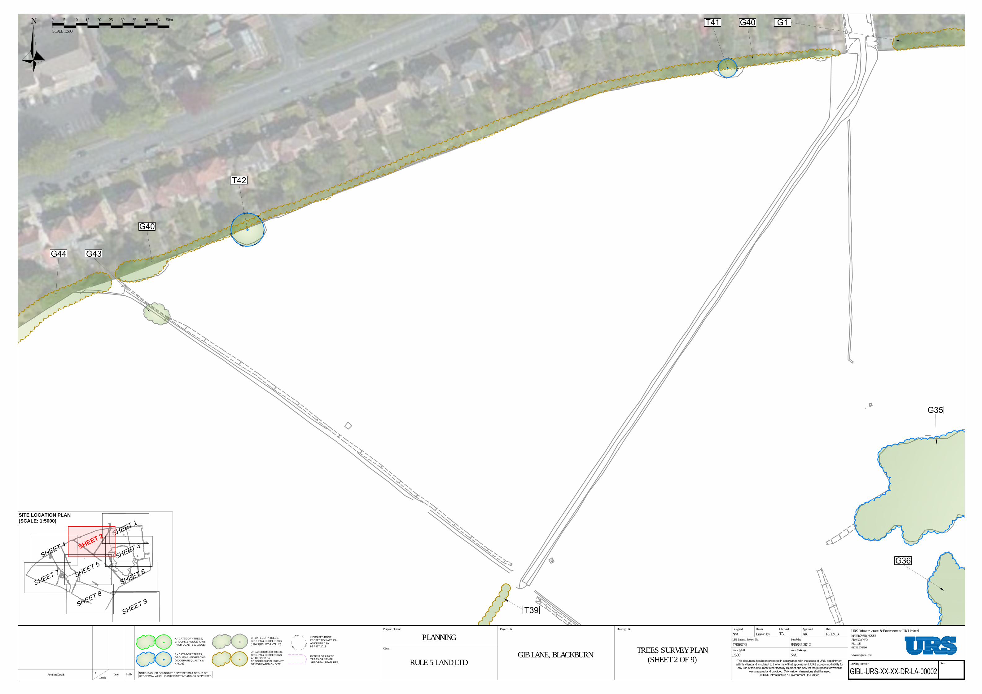
RP
A
R
P
A
R
P
A
A - CATEGORY TREES,
GROUPS & HEDGEROWS
(HIGH QUALITY & VALUE)
INDICATES ROOT
PROTECTION AREAS -
AS DEFINED BY
BS 5837:2012
B - CATEGORY TREES,
GROUPS & HEDGEROWS
(MODERATE QUALITY &
VALUE)
C - CATEGORY TREES,
GROUPS & HEDGEROWS
(LOW QUALITY & VALUE)
UNCATEGORISED TREES,
GROUPS & HEDGEROWS
AS DEFINED BY
TOPOGRAPHICAL SURVEY
OR ESTIMATED ON SITE
EXTENT OF LINKED
TREES OR OTHER
ARBOREAL FEATURES
NOTE: DASHED BOUNDARY REPRESENTS A GROUP OR
HEDGEROW WHICH IS INTERMITTENT AND/OR DISPERSED
R
P
A
R
P
A
R
P
A
R
P
A
R
P
A
RPA
R
P
A
R
P
A
R
P
A
R
P
A
R
P
A
Drawing Number Rev
DateApprovedCheckedDrawn
URS Internal Project No.
Drawing TitleProject Title
Client
Suitability
Scale @ A1 Zone / Mileage
URS Infrastructure & Environment UK LimitedPurpose of issue
www.ursglobal.com
Designed
SuffixBy
Revision Details DateCheck
PLANNINGTREES SURVEY PLAN
(SHEET 2 OF 9)
N/A Drawn by TA AK 18/12/13
BS5837:2012
1:500 N/A
RULE 5 LAND LTDGIB LANE, BLACKBURN
47068789
MAYFLOWER HOUSEARMADA WAYPL1 1LD01752 676700
NSCALE 1:500
151050 20 25 30 35 40 45 50m
SITE LOCATION PLAN
(SCALE: 1:5000)
S
H
E
E
T
3
S
H
E
E
T
4
S
H
E
E
T
7
S
H
E
E
T
5
S
H
E
E
T
6
S
H
E
E
T
9
S
H
E
E
T
8
S
H
E
E
T
1
S
H
E
E
T
2

RP
A
R
P
A
R
P
A
A - CATEGORY TREES,
GROUPS & HEDGEROWS
(HIGH QUALITY & VALUE)
INDICATES ROOT
PROTECTION AREAS -
AS DEFINED BY
BS 5837:2012
B - CATEGORY TREES,
GROUPS & HEDGEROWS
(MODERATE QUALITY &
VALUE)
C - CATEGORY TREES,
GROUPS & HEDGEROWS
(LOW QUALITY & VALUE)
UNCATEGORISED TREES,
GROUPS & HEDGEROWS
AS DEFINED BY
TOPOGRAPHICAL SURVEY
OR ESTIMATED ON SITE
EXTENT OF LINKED
TREES OR OTHER
ARBOREAL FEATURES
NOTE: DASHED BOUNDARY REPRESENTS A GROUP OR
HEDGEROW WHICH IS INTERMITTENT AND/OR DISPERSED
R
P
A
R
P
A
RPA
R
P
A
R
P
A
R
P
A
R
P
A
R
P
A
R
P
A
R
P
A
R
P
A
R
P
A
R
P
A
R
P
A
RP
A
R
P
A
R
P
A
R
P
A
R
P
A
RP
A
R
P
A
R
P
A
R
P
A
R
P
A
R
P
A
R
P
A
R
P
A
R
P
A
RPA
R
P
A
R
P
A
R
P
A
R
P
A
R
P
A
R
P
A
R
P
A
R
P
A
R
P
A
R
P
A
R
P
A
R
P
A
R
P
A
R
P
A
R
P
A
R
P
A
R
P
A
R
P
A
R
P
A
R
P
A
R
P
A
R
P
A
R
P
A
R
P
A
R
P
A
R
P
A
R
P
A
R
P
A
R
P
A
R
P
A
R
P
A
R
P
A
R
P
A
R
P
A
R
P
A
R
P
A
R
P
A
R
P
A
RP
A
R
P
A
R
P
A
R
P
A
R
P
A
R
P
A
R
P
A
R
P
A
R
P
A
R
P
A
Drawing Number Rev
DateApprovedCheckedDrawn
URS Internal Project No.
Drawing TitleProject Title
Client
Suitability
Scale @ A1 Zone / Mileage
URS Infrastructure & Environment UK LimitedPurpose of issue
www.ursglobal.com
Designed
SuffixBy
Revision Details DateCheck
PLANNINGTREES SURVEY PLAN
(SHEET 1 OF 9)
N/A Drawn by TA AK 18/12/13
BS5837:2012
1:500 N/A
RULE 5 LAND LTDGIB LANE, BLACKBURN
47068789
MAYFLOWER HOUSEARMADA WAYPL1 1LD01752 676700
LEGEND
NOTES:
• TREE CATEGORIES AS
DEFINED BY BS5837:2012
• TREE LOCATIONS BASED
ON TOPO SURVEY BY
TRICAD SOLUTIONS LTD
REF:TRI-1083-01 TO 08
(27/09/13), SITE VISIT AND
AERIAL PHOTOGRAPHY
NSCALE 1:500
151050 20 25 30 35 40 45 50m
SITE LOCATION PLAN
(SCALE: 1:5000)
S
H
E
E
T
3S
H
E
E
T
2
S
H
E
E
T
4
S
H
E
E
T
7
S
H
E
E
T
5
S
H
E
E
T
6
S
H
E
E
T
9
S
H
E
E
T
8
S
H
E
E
T
1