Get Moor Active on Goss Where is Goss Moor? Goss Goss Moor … · 2014-01-06 · A30 A30 A30...
3
Using the trail - code of conduct To all users - please be considerate to other users. Also be aware that cattle roam freely on the moor. Walkers - if you are walking with a dog, please keep it under close control and clear up any mess. Horse riders - please proceed at a walk when passing other users, and at no more than a trot at any time to protect the trail surface. Cyclists - Don't expect to use the trail at high speeds and be prepared to slow down or stop if necessary; Be careful at junctions, bends and entrances; Give way to walkers, wheelchair users and horse riders and leave them plenty of room; Remember that some people cannot hear or see well - don't assume they can; Fit a bell and use it - don't surprise people. Motorbikes are NOT permitted on the traffic-free trail. Cars - if you need to bring your car, please park in designated parking areas. Walking and cycling are two of the most pleasurable and effective ways of getting and keeping fit. Not only does the body benefit from exercising outdoors but being in the natural environment also has positive effects on mental wellbeing. And of course, Get Moor Active on Goss the views and fresh air are superb! The “old A30” section of the trail is particularly suitable for the less able. For information about walking or cycling at your own pace with a friendly group in the area, get advice from the Mobilise! team on For more information about health walking see www.mobilise-cornwall.org.uk www.wfh.naturalengland.org.uk Goss Moor Multi-use Trail Recreational routes in Cornwall: www.cornwall.gov.uk www.visitcornwall.com www.claytrails.co.uk www.nationalcyclenetwork.org.uk The Cornish Way is a network of over 200 miles of inter-linking trails. Many of these routes connect with the National Cycle Network. Close to Goss Moor, in the St Austell area, are The Clay Trails. For maps, guides and information: (T. 0300 1234 222); ; ; (T.0845 1130065) Help us protect Goss Moor Goss Moor is managed by Natural England. Please help look after this Reserve by following the Countryside Code and, in particular, keep dogs under control. We hope that you enjoy your visit. For your own safety keep to marked paths. Be aware of dangerous pools and bogs. Keep away from livestock. For further information contact the Senior Reserve Manager on 0300 060 1765. www.naturalengland.org.uk BUDE LAUNCESTON PLYMOUTH BODMIN A39 A30 A30 A30 A390 Goss Moor PENZANCE LISKEARD A390 ST AUSTELL NEWQUAY The Goss Moor Multi-use Trail has been developed through a partnership of: Cornwall Council; The Environment Agency; The Highways Agency & their contractors, Alfred McAlpine & Scott Wilson; Imerys; Local Parish Councils and the local community; National Grid; Natural England; Objective One; Sustrans, and Tregothnan Estate. With funding support from: The Aggregates Levy Sustainability Fund; Cornwall Local Transport Programme; National Grid; Natural England; SITA Cornwall Trust Ltd and The South West of England Regional Development Agency. Photo credits: Natural England (NE); M Davey / NE; P Glendell / NE; G Haley / NE; R Key / NE; D Marriott / NE; Graphic Words; B Ray. Leaflet by Graphic Words www.graphicwords.com. Where is Goss Moor? part of the cycle network Explore the rich natural heritage of this National Nature Reserve TRURO Printed on paper containing 80% recycled fibre. 10/09/40k
Transcript of Get Moor Active on Goss Where is Goss Moor? Goss Goss Moor … · 2014-01-06 · A30 A30 A30...

Using the trail - code of conduct
To all users - please be considerate to other users.Also be aware that cattle roam freely on the moor.
Walkers - if you are walking with a dog, please keep it under close control and clear up any mess.
Horse riders - please proceed at a walk when passing other users, and at no more than a trot at any time to protect the trail surface.
Cyclists - Don't expect to use the trail at high speeds and be prepared to slow down or stop if necessary; Be careful at junctions, bends and entrances; Give way to walkers, wheelchair users and horse riders and leave them plenty of room; Remember that some people cannot hear or see well - don't assume they can; Fit a bell and use it - don't surprise people.
Motorbikes are NOT permitted on the traffic-free trail.
Cars - if you need to bring your car, please park in designated parking areas.
Walking and cycling are two of the most pleasurable and effective ways of getting and keeping fit. Not only does the body benefit from exercising outdoors but being in the natural environment also has positive effects on mental wellbeing. And of course,
Get Moor Active on Goss
the views and fresh air are superb! The “old A30” section of the trail is particularly suitable for the less able.
For information about walking or cycling at your own pace with a friendly group in the area, get advice from the Mobilise! team on
For more information about health walking see
www.mobilise-cornwall.org.uk
www.wfh.naturalengland.org.uk
GossMoorMulti-use Trail
Recreational routes in Cornwall:
www.cornwall.gov.ukwww.visitcornwall.com www.claytrails.co.ukwww.nationalcyclenetwork.org.uk
The Cornish Way is a network of over 200 miles of inter-linking trails. Many of these routes connect with the National Cycle Network. Close to Goss Moor, in the St Austell area, are The Clay Trails.
For maps, guides and information: (T. 0300 1234 222);
; ; (T.0845 1130065)
Help us protect Goss MoorGoss Moor is managed by Natural England. Please help look after this Reserve by following the Countryside Code and, in particular, keep dogs under control. We hope that you enjoy your visit.
For your own safety keep to marked paths.Be aware of dangerous pools and bogs.Keep away from livestock.
For further information contact the Senior Reserve Manager on 0300 060 1765.
www.naturalengland.org.uk
BUDE
LAUNCESTON
PLYMOUTH
BODMIN
A39
A30 A30
A30
A390
Goss Moor
PENZANCE
LISKEARDA390
ST AUSTELL
NEWQUAY
The Goss Moor Multi-use Trail has been developed through a partnership of: Cornwall Council; The Environment Agency; The Highways Agency & their contractors, Alfred McAlpine & Scott Wilson; Imerys; Local Parish Councils and the local community; National Grid; Natural England; Objective One; Sustrans, and Tregothnan Estate.
With funding support from: The Aggregates Levy Sustainability Fund; Cornwall Local Transport Programme; National Grid; Natural England; SITA Cornwall Trust Ltd and The South West of England Regional Development Agency.
Photo credits: Natural England (NE); M Davey / NE; P Glendell / NE; G Haley / NE; R Key / NE; D Marriott / NE; Graphic Words; B Ray.Leaflet by Graphic Words www.graphicwords.com.
Where is Goss Moor?
part of the cycle network
Explore the rich natural heritageof this National Nature Reserve
TRURO
Printed on paper containing80% recycled fibre. 10/09/40k

A30
A30
A30
Castle-an-Dinas
B3279
Victoria
Roche
Fraddon
GOSS MOOR multi-use trail
St Dennis
Bugle
A391
A391
A392
B3279
B3274
B3374
Nanpean
WC
1 km
1 mile
ScreechOwl
Sanctuary
To Bodmin
To St Austell
To Newquay
To Wadebridge
To Truro
A39
St Columb RoadSt Columb Road
A39
Indian Queens
St Columb Road
©Crown copyright. Cornwall Council 100019590, 2009
WCP
BugleClay Trail
P
PP
P
P
Tregoss
St Columb Major
32
32
multi-use
trail
Goss Moor is a 480 hectare National Nature Reserve (NNR), the largest surviving remnant of the Mid-Cornwall moors.
The name is believed to derive from the Celtic word “cors” meaning a boggy or marshy place. The moor has a rich and interesting history. It is a legendary hunting ground of King Arthur, and was later recorded in the 1086 Domesday Book as part of the manor of Tremodret. Tin was extracted here between the 11th and 19th centuries, and sand and gravel quarried between the 1930s and 1950s.
Today’s fascinating mosaic of wetland, heathland and scrub is the result of tin streaming and livestock grazing carried out across the centuries, forming a wild windswept landscape which provides a habitat for an outstanding range of rare plants and animals.
From a distance, the view is deceptive, for the heathland hides a maze of waterways, marshes and still, mysterious pools.
Goss Moor is a National Nature Reserve, a unique wild and undeveloped environment to explore and enjoy.
Facilities such as shops, places to eat or stay and public toilets can be found in the neighbouring villages - see the map above. There are also attractions, sites of historical interest and places to eat in the surrounding area - so enjoy your cycle or walk on Goss Moor and then visit one of these to make a full day out in mid-Cornwall.
The Multi-use trail The Goss Moor area
Goss Moor
cycling, horse-riding and for wheelchair or mobility scooter users and buggies. There are additional links and trails on neighbouring Tregoss Moor.
Note: If you are using a wheelchair / mobility scooter you may need to have someone with you in some areas, as there are gates to open on parts of the trail.
This 7 mile (c. 12 km) circular trail winds its way around the little known expanse of Goss Moor. It is mostly flat and relatively easy - much of it off road - allowing novice walkers and cyclists and the disabled easy and safe access to the moors.
The trail is surfaced to be suitable for walking,
If travelling by car From the A30: use the Highgate Hill Junction for Indian Queens, Screech Owl Sanctuary and St Dennis; or the Victoria Junction for Roche and Tregoss. From St Austell and the south, take the B3279 to St Dennis.
Cycle Hire A range of bicycles can be hired at Screech Owl Sanctuary, which is alongside the Trail near Indian Queens. Tel. 01726 860182
Public TransportBus
www.westerngreyhound.com
Train
www.firstgreatwestern.co.uk
www.travelinesw.com
www.cornwallpublictransport.info
: A network of local buses cross the area. Key services include: Western Greyhound No.521 St Austell - Newquay via St Dennis and Indian Queens. Runs along south west edge of the Moor. c. 16 services each way, Mon - Sat; c. 5 on Suns
Western Greyhound No.593 St. Columb Major - Bodmin. Runs along the top of the Moor. c.13 services each way, Mon - Sat only
: The Par - Newquay Branchline calls at Roche and St Columb Road (for Indian Queens). 6 services each way Mon - Fri all year & winter Sats. 3 services Summer Sundays.
For all public transport services, Traveline South West
or Tel. 0871 200 22 33
Cornwall Public Transport Information Website:
KEY
P
WC
Par- Newquay Branch LineBus StopCar ParkGoss Moor Cycle hirePublic Toilets PubRefreshments - café/ restaurant/take away Local shop(s) Accommodation/ Camping & Caravan Site Visitor/heritage attraction
National Cycle Route (NCR) 32 Link to NCR 32
32
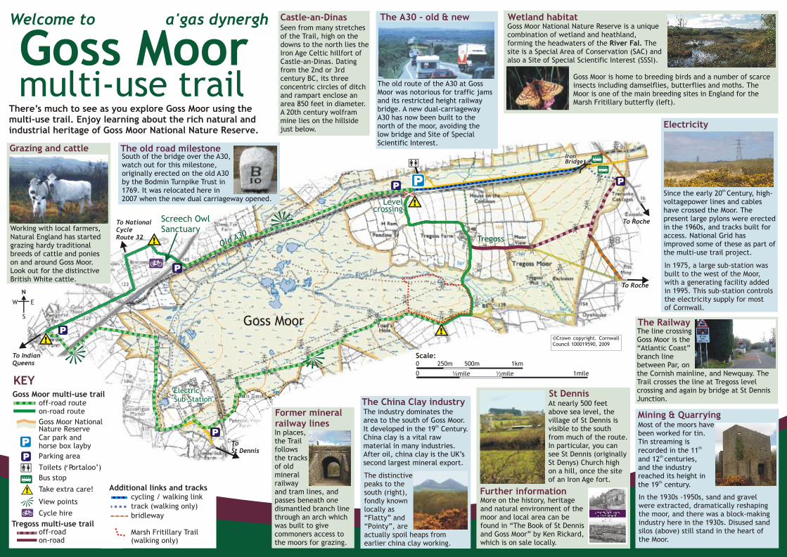
Working with local farmers, Natural England has started grazing hardy traditional breeds of cattle and ponies on and around Goss Moor. Look out for the distinctive British White cattle.
Grazing and cattle
Screech Owl Sanctuary
South of the bridge over the A30, watch out for this milestone, originally erected on the old A30 by the Bodmin Turnpike Trust in 1769. It was relocated here in 2007 when the new dual carriageway opened.
The old road milestone
Goss Moor
ElectricSub-Station
!
River Fal
Old A30
To IndianQueens
To St Dennis
To Roche
To Roche
Tregoss
To National Cycle Route 32
P
P
P
P P
!
!
!
Level crossing
Level crossing
Level crossing
IronBridgeIronBridgeIronBridge
©Crown copyright. Cornwall Council 100019590, 2009
0 1mile¼mile ½mile
0 250m 500m 1km
The old route of the A30 at Goss Moor was notorious for traffic jams and its restricted height railway bridge. A new dual-carriageway A30 has now been built to the north of the moor, avoiding the low bridge and Site of Special Scientific Interest.
Castle-an-DinasSeen from many stretches of the Trail, high on the downs to the north lies the Iron Age Celtic hillfort of Castle-an-Dinas. Dating from the 2nd or 3rd century BC, its three concentric circles of ditch and rampart enclose an area 850 feet in diameter. A 20th century wolfram mine lies on the hillside just below.
There’s much to see as you explore Goss Moor using the multi-use trail. Enjoy learning about the rich natural and industrial heritage of Goss Moor National Nature Reserve.
Welcome to a'gas dynergh
Goss Moormulti-use trail
Mining & QuarryingMost of the moors have been worked for tin. Tin streaming is
threcorded in the 11 th
and 12 centuries, and the industry reached its height in
ththe 19 century.
The RailwayThe line crossing Goss Moor is the “Atlantic Coast” branch line between Par, on the Cornish mainline, and Newquay. The Trail crosses the line at Tregoss level crossing and again by bridge at St DennisJunction.
Electricity
Goss Moor National Nature Reserve is a unique combination of wetland and heathland, forming the headwaters of the River Fal. The site is a Special Area of Conservation (SAC) and also a Site of Special Scientific Interest (SSSI).
Goss Moor is home to breeding birds and a number of scarce insects including damselflies, butterflies and moths. The Moor is one of the main breeding sites in England for the Marsh Fritillary butterfly (left).
St DennisAt nearly 500 feet above sea level, the village of St Dennis is visible to the south from much of the route. In particular, you can see St Dennis (originally St Denys) Church high on a hill, once the site of an Iron Age fort.
Further informationMore on the history, heritage and natural environment of the moor and local area can be found in “The Book of St Dennis and Goss Moor” by Ken Rickard, which is on sale locally.
The industry dominates the area to the south of Goss Moor.
thIt developed in the 19 Century. China clay is a vital raw material in many industries. After oil, china clay is the UK’s second largest mineral export.
The China Clay industry
In places, the Trail follows the tracks of old mineral railway and tram lines, and passes beneath one dismantled branch line through an arch which was built to give commoners access to the moors for grazing.
Former mineral railway lines
N
S
W E
off-road routeon-road route
Goss Moor National Nature Reserve Car park and horse box layby Parking area
Toilets ( Portaloo’)
Bus stop
Take extra care!
View points
Cycle hire
off-road on-road
KEYGoss Moor multi-use trail
!
P
cycling / walking link
track (walking only)
bridleway
Marsh Fritillary Trail (walking only)
Additional links and tracks
Tregoss multi-use trail
Scale:
P
P
‘
The A30 - old & new Wetland habitat
th Since the early 20 Century, high-voltagepower lines and cables have crossed the Moor. The present large pylons were erected in the 1960s, and tracks built for access. National Grid has improved some of these as part of the multi-use trail project.
In 1975, a large sub-station wasbuilt to the west of the Moor,with a generating facility addedin 1995. This sub-station controls the electricity supply for mostof Cornwall.
In the 1930s -1950s, sand and gravelwere extracted, dramatically reshapingthe moor, and there was a block-makingindustry here in the 1930s. Disused sandsilos (above) still stand in the heart ofthe Moor.
The distinctivepeaks to the south (right),fondly knownlocally as “Flatty” and“Pointy”, areactually spoil heaps fromearlier china clay working.