Geoweb Services for Sharing Modelling Results in Biodiversity ...
21
Research Article Geoweb Services for Sharing Modelling Results in Biodiversity Networks Karla Donato Fook National Institute of Space Research (INPE) / Instituto Federal de Educação, Ciência e Tecnologia do Maranhão (IFMA) Antônio Miguel Vieira Monteiro National Institute of Space Research (INPE) Gilberto Câmara National Institute of Space Research (INPE) Marco Antônio Casanova Informatics Department, PUC-Rio Rio de Janeiro, Brazil Silvana Amaral National Institute of Space Research (INPE) Abstract Biodiversity researchers in different institutions deal with predictive models for species distribution. These models are useful for biodiversity conservation policies. Species distribution modelling tools need large datasets from different sources and use many algorithms. To improve biodiversity science, scientists need to share models, data and results, and should be able to reproduce experiments from others. This article presents a geoweb service architecture that supports sharing of modelling results and enables researchers to perform new modelling experiments. We show the feasibility of the proposed architecture by developing a set of prototype services, called Web Biodiversity Collaborative Modelling Services – WBCMS. They provide a set of geospatial web services that support the sharing of species distribution models. The article includes an example of a model instance that explains the WBCMS prototype. We believe that WBCMS shows how to set up a cooperative research network on biodiversity research. Address for Correspondence: Karla Donato Fook, IFMA – Campus Monte Castelo, DAI – Depar- tamento Acadêmico de Informática, Avenida Getúlio Vargas, 04. Monte Castelo. CEP 65025-001. São Luís, MA, Brazil. E-mail: [email protected] Transactions in GIS, 2009, 13(4): 379–399 © 2009 Blackwell Publishing Ltd doi: 10.1111/j.1467-9671.2009.01170.x
Transcript of Geoweb Services for Sharing Modelling Results in Biodiversity ...

Research Article
Geoweb Services for Sharing ModellingResults in Biodiversity Networks
Karla Donato FookNational Institute of SpaceResearch (INPE) / Instituto Federalde Educação, Ciência e Tecnologiado Maranhão (IFMA)
Antônio Miguel VieiraMonteiroNational Institute of SpaceResearch (INPE)
Gilberto CâmaraNational Institute of SpaceResearch (INPE)
Marco Antônio CasanovaInformatics Department, PUC-RioRio de Janeiro, Brazil
Silvana AmaralNational Institute of SpaceResearch (INPE)
AbstractBiodiversity researchers in different institutions deal with predictive modelsfor species distribution. These models are useful for biodiversity conservationpolicies. Species distribution modelling tools need large datasets from differentsources and use many algorithms. To improve biodiversity science, scientistsneed to share models, data and results, and should be able to reproduceexperiments from others. This article presents a geoweb service architecture thatsupports sharing of modelling results and enables researchers to perform newmodelling experiments. We show the feasibility of the proposed architecture bydeveloping a set of prototype services, called Web Biodiversity CollaborativeModelling Services – WBCMS. They provide a set of geospatial web servicesthat support the sharing of species distribution models. The article includes anexample of a model instance that explains the WBCMS prototype. We believe thatWBCMS shows how to set up a cooperative research network on biodiversityresearch.
Address for Correspondence: Karla Donato Fook, IFMA – Campus Monte Castelo, DAI – Depar-tamento Acadêmico de Informática, Avenida Getúlio Vargas, 04. Monte Castelo. CEP 65025-001.São Luís, MA, Brazil. E-mail: [email protected]
Transactions in GIS, 2009, 13(4): 379–399
© 2009 Blackwell Publishing Ltddoi: 10.1111/j.1467-9671.2009.01170.x
1 Introduction
Biodiversity research needs measurements or inferences about species location and abun-dance. Since comprehensive surveys are unaffordable for large areas, species distributionmodels are used as indicators of species diversity. These models combine in situ data withenvironmental layers to predict the species distribution over a geographic area. Theyestimate species potential niches by comparing known occurrences and known absenceswith ecological limits, also called environmental variables, such as precipitation andtemperature (Soberón and Peterson 2004). Their results support biodiversity protectionpolicies, are useful to forecast the impacts of climate change, and help to detect problemsrelated to invasive species.
Scientists working with predictive species distribution modelling need access tolarge sets of geospatial data such as climate, vegetation, topography, and land use(Giovanni 2005). Since such datasets may be archived by different institutions, a sci-entist needs to locate them and make them interoperate. This creates a technical chal-lenge of representing, managing, storing, and accessing distributed geospatial data.Accessing distributed geospatial data is more complex than accessing conventionaldata, given its large semantic and geometric variation (Breitman et al. 2006). In addi-tion, the scientist needs algorithms, which may also be available elsewhere. After s/heproduces a result, s/he can share it with her (his) community and compare it withsimilar work.
This scenario points out the need for a computational infrastructure that supportscollaborative biodiversity studies, allowing sharing of data, models, and results (Rama-murthy 2006). Sharing data needs information about location of repositories, archivalformats, and semantic information. Sharing models needs understanding of the applica-bility of each algorithm to the species being modelled; it also needs good documentationabout the explicit and implicit assumptions of each model. For sharing results, thescientist needs to publish the species distribution maps in a way that allows exchangingof reports, comments and ideas.
Collaboration among researchers is not only about exchanging data but also aboutcomparisons between scientific models and experimental results. To perform compari-sons between models and results, provenance information is critical (Simmhan et al.2005). “Provenance data are essential if experiments are to be validated and verified byothers, or even by those who originally performed them. It is also important in assessingthe quality, and timeliness of results” (Greenwood et al. 2003). Therefore, provenancedata needs to be available when models are shared.
This article proposes a geoweb service architecture to support collaboration forspecies distribution modelling networks. We show the feasibility of the proposed archi-tecture by developing prototype services: the Web Biodiversity Collaborative ModellingServices – WBCMS. These services provide a set of geospatial web services that supportsharing of species distribution models. WBCMS protocols allow sharing of data, mod-elling results and information about data and results provenance. They also enablebiodiversity researchers to conduct new experiments using existing models. For an earlydiscussion of WBCMS, see Fook et al. (2007). The WBCMS architecture is part of theOpenModeller Project, a framework for collaborative building of biodiversity models(Muñoz 2004, Giovanni 2005, OpenModeller 2005).
This article is structured as follows. Section 2 provides a general discussion onspecies distribution models, and related work. Section 3 describes the WBCMS
380 K D Fook et al.
© 2009 Blackwell Publishing LtdTransactions in GIS, 2009, 13(4)

specification. Section 4 shows a WBCMS prototype and an example. Finally, section 5discusses further work.
2 Review of Previous Work
2.1 Species Distribution Models
This subsection briefly describes how species distribution modelling works. Speciesdistribution models are “empirical models relating field observations to environmentalpredictor variables based on statistically or theoretically derived response surfaces thatbest fit the realized niche of species” (Guisan and Zimmermann 2000, Guisan 2004). Itsobjective is to produce a model that predicts the species’ potential geographic distribu-tion. The resulting maps can be used to predict effects of climate change, to specify sitesfor field sampling of genetically modified organisms, and to predict the best places to setup new protected areas. Biodiversity applications must be able to locate and deal withspatial data.
Figure 1 presents an overall process of species distribution modelling. As input, themodels use data about species occurrence and environmental variables such as precipi-tation, temperature and topography. Based on these data, the species modelling algo-rithm estimates the likelihood that the species might be present at each location of thestudy area. Algorithms for predictive species distribution modelling include GeneticAlgorithm for Rule-set Production – GARP (Stockwell and Peters 1999), Bioclimatic
Figure 1 Species distribution modelling process (adapted from Siqueira 2005)
Geoweb Services for Sharing Modelling Results in Biodiversity Networks 381
© 2009 Blackwell Publishing LtdTransactions in GIS, 2009, 13(4)

Envelope – BIOCLIM (Busby 1991), and the Maximum Entropy Method (Phillips et al.2006). For a comprehensive review of different species distribution models, see Guisanand Zimmermann (2000). Model results are expressed as thematic maps of the potentialspecies distribution. The species distribution model allows researchers to make inferencesabout the diversity, abundance, and spatial distribution of species over differentgeographical areas.
2.2 Web Services for Geospatial and Biodiversity Applications
As seen in the previous section, species distribution modelling needs data from differentsources. This leads to the idea of using web services for such applications, which is themain subject of this article. We start with a brief discussion of the general background –the use of web services for geospatial and biodiversity applications.
The W3C consortium defines a web service as “a software system designed tosupport interoperable machine-to-machine interaction over a network” (Newcomer2002). Web services use XML (Extensible Markup Language), a set of related specifica-tions in which all web services technologies are built. Technologies such as SOAP, WSDL(Web Services Description Language), and UDDI (Universal Description, Discovery, andIntegration) supply the basic web services infrastructure. SOAP provides the envelope forsending the Web Services messages. WSDL is an abstraction which software systems useto map the web service. It is the exposed interface of web services. The UDDI registryaccepts information describing web services, and allows web services searches anddiscoveries (Newcomer 2002).
In this scenario the Service Oriented Architecture – SOA arises as an importantparadigm. Friis-Christensen et al. (2007) define SOA as “an open and interoperableenvironment, which is based on reusability and standardized components”. This archi-tecture provides data and processing capabilities required for a given processing activitynot locally, but decentralized (Friis-Christensen et al. 2007).
Given the distributed nature of geospatial applications, Spatial Data Infrastructurealso emerges as an important element. It can be considered a set of elements which allowusers to provide, manage, and access spatial data. These users can be providers, con-sumers and intermediaries of spatial data. SDI components comprise metadata andcollaboration between users and organizations, and politics are elaborated and agreed(Nebert 2004).
In a geospatial context, the international standards of the OGC (Open GeospatialConsortium) and ISO (International Organization for Standardization) provide the basicweb services specifications. OGC proposes a set of web services to cover geospatial data,including WMS (Web Map Service), WFS (Web Feature Service), WCS (Web CoverageService), WPS (Web Processing Service), and CWS (Catalog Web Service). A WMShandles a set of spatial layers by geographical extent as an image that can be used byseveral clients, such as a web browser. WFS provides the exchange of GML (GeographyMarkup Language) data. Developers use the WCS for raster data and predictive habitatmodel outputs. A WPS specification defines a way for a client to submit a processing taskto a server. Catalogue web services are used to publish and search collections of metadatafor data, services, and related information objects (Vaccari et al. 2009). Most existingSDI (Spatial Data Infrastructure) implementations use OGC and ISO specifications.
There are various proposals of web services, where the application is divided into aseries of tasks, organized in a workflow. Alameh (2001, 2003) proposed an architecture
382 K D Fook et al.
© 2009 Blackwell Publishing LtdTransactions in GIS, 2009, 13(4)

in which client applications are dynamically chaining various standards-based GIS Webservices. Bernard et al. (2003) suggest a “road blockage” service, which solves morecomplex tasks by static chaining of several simple services. Aditya and Lemmens (2003)propose a service chaining approach to solve geographical problems in the Spatial DataInfrastructure scenario. They apply the service architecture for national disaster man-agement and for incorporating commercial services in the daily activities. Lemmens et al.(2007) use semantic and syntactic service descriptions, called deep services descriptions,in an integrated form for enhancing Geo-Service chaining. They combined the Geo-MatchMaker prototype to deal with geoservice discovery abstract composition, and theIntegrated Component Designer prototype to support concrete composition and execu-tion of geoservices. Tsou and Buttenfield (2002) presented a dynamic architecture fordistribution of Geographical Information Services with Grid Networking Peer-To-Peertechnology. A framework based on existing languages, computational architectures andweb services was implemented.
Another approach is WS-GIS, an SOA-based Spatial Data Infrastructure, which aimsto integrate, locate, and catalog scattered spatial data sources (Leite-Jr et al. 2007).Granell et al. (2007) explore how distributed geoprocessing services can manage largeamounts of Earth Observation data in their AWARE project (a tool for monitoring andforecasting Available WAter REsources in mountain environments; see http://www.aware-eu.info/ for additional details). Di et al. (2003) developed a project thatapplies Grid technology to the Earth observation environment through the integration ofthe Globus Toolkit with the NASA Web GIS Software Suite (NWGISS). The GlobusToolkit facilitates the creation of usable Grids, enabling high-speed coupling of comput-ers, databases, instruments, and human expertise, and NWGISS is a web-based, multipleOGC-standard compliant geospatial data distribution and service system. The EarthSystem Science Workbench (ESSW) is a metadata management and data storage systemfor earth science researchers. Their infrastructure captures and keeps lineage (or prov-enance) metadata, which are critical for proving credibility of investigator-generated data(Frew and Bose 2001).
Biodiversity applications have attracted the attention of the web services community.The WeBIOS project (Web Service Multimodal Tools for Biodiversity Research, Assess-ment and Monitoring) supports exploratory multimodal queries over diverse biodiversitydata sources (WeBios 2005). Alvarez et al. (2005) describe the BioWired project, a P2Parchitecture that supports biodiversity data access to large distributed databases. TheBiodiversityWorld project proposes a way to use biodiversity analytic tools over varieddata sources (Jones et al. 2003, Pahwa et al. 2006). Serique et al. (2007) propose the MoPorã, an environment for sharing files and data among research groups in the LBAProgram (Large-Scale Biosphere-Atmosphere Experiment in Amazonia; see http://lba.inpa.gov.br/mopora/ and http://lba.inpa.gov.br/lba/ for additional details).
The Global Biodiversity Information Facility (GBIF; http://www.gbif.org/) adoptsstandards and protocols for exchanging biodiversity data. This approach also providesa client browser which uses the OpenModeller Web Service – OMWS (http://openmodeller.cria.org.br/) for remote execution of species distribution models. Thisservice is part of the OpenModeller Project, and is available for performing OpenMod-eller jobs (Giovanni 2005, Sutton et al. 2007). The GBIF application uses only onemodelling algorithm, with default parameters (GBIF 2008). The LifeMapper Project(http://www.lifemapper.org/) also uses the OpenModeller Web Service – OMWS, andenables remote execution of species models. The LifeMapper provides an up-to-date and
Geoweb Services for Sharing Modelling Results in Biodiversity Networks 383
© 2009 Blackwell Publishing LtdTransactions in GIS, 2009, 13(4)
comprehensive database of species maps and predictive models using available data onspecies locations (Stockwell et al. 2006). This approach allows species distribution mapvisualization, but does not provide a model assessment.
In the MyGRID Project, data and metadata about workflows of bioinformaticsexperiments and provenance logs are stored in the myGrid Information Repository(mIR). The provenance metadata records data about each performed experiment in theworkflow (Wroe et al. 2003, Zhao et al. 2003).
These approaches aim at integrating and sharing geographical data as well asperforming experiments. However, they do not aim at sharing model description, results,and the researcher’s comments and assessment for a species distribution modellingexperiment. Our approach, described in the next section, allows sharing descriptiveinformation about both spatial data and biodiversity models. The shared informationallows researchers to perform new experiments based on previous ones. Our goal is alsoto extract implicit knowledge used in the species distribution modelling process and tomake it explicitly available in a model description catalogue.
3 The Web Biodiversity Collaborative Modelling Services (WBCMS)
This section describes the Web Biodiversity Collaborative Modelling Services (WBCMS),a set of geospatial Web services that supports the sharing of modelling results. Theseservices also allow the inclusion of comments and provenance information. These pro-tocols aim at capturing implicit knowledge of species distribution experiments and toallow reuse and sharing. WBCMS address a current lack of means to exchange modelsdescriptions of W3C web services, which do not allow sharing of model description andresults at the same time. The proposed service also enables users to produce new modelsbased on available ones.
WBCMS protocols use the idea of model instances. A model instance describes anexperiment as a whole, including data and metadata related to models, results, andalgorithms. When the researcher examines a model instance, s/he gets information onhow the results were produced. S/he can then compare experiment results and use themfor her (his) own modelling purposes. Possible queries on model instances include:“What species are being modelled?”, “Where does the data come from?”, “What are theenvironmental variables?”, “What are the algorithms?”, “How does the algorithmperform?”, “If I have a question, how can I look for similar results?” We detail the ideaof a model instance as follows.
3.1 Model Instance
This section describes a model instance in WBCMS. The model instance has twoabstraction levels. The first level supplies a general experiment description (blue area inFigure 2), and the second level gives the first level part descriptions (green area inFigure 2). The last one is specified according to the domain application. In these levels,a model instance has three sections, as shown in Figure 2: object description, modelgeneration, and results. The model instance also contains its own metadata, includinginformation related to modelling experiment, such as name, title, description, author,affiliation, creation date, and running time. It also contains notes and comments to helpother scientists analyze and reproduce the experiment.
384 K D Fook et al.
© 2009 Blackwell Publishing LtdTransactions in GIS, 2009, 13(4)
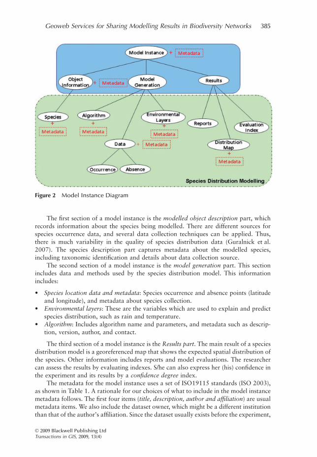
The first section of a model instance is the modelled object description part, whichrecords information about the species being modelled. There are different sources forspecies occurrence data, and several data collection techniques can be applied. Thus,there is much variability in the quality of species distribution data (Guralnick et al.2007). The species description part captures metadata about the modelled species,including taxonomic identification and details about data collection source.
The second section of a model instance is the model generation part. This sectionincludes data and methods used by the species distribution model. This informationincludes:
• Species location data and metadata: Species occurrence and absence points (latitudeand longitude), and metadata about species collection.
• Environmental layers: These are the variables which are used to explain and predictspecies distribution, such as rain and temperature.
• Algorithm: Includes algorithm name and parameters, and metadata such as descrip-tion, version, author, and contact.
The third section of a model instance is the Results part. The main result of a speciesdistribution model is a georeferenced map that shows the expected spatial distribution ofthe species. Other information includes reports and model evaluations. The researchercan assess the results by evaluating indexes. S/he can also express her (his) confidence inthe experiment and its results by a confidence degree index.
The metadata for the model instance uses a set of ISO19115 standards (ISO 2003),as shown in Table 1. A rationale for our choices of what to include in the model instancemetadata follows. The first four items (title, description, author and affiliation) are usualmetadata items. We also include the dataset owner, which might be a different institutionthan that of the author’s affiliation. Since the dataset usually exists before the experiment,
Figure 2 Model Instance Diagram
Geoweb Services for Sharing Modelling Results in Biodiversity Networks 385
© 2009 Blackwell Publishing LtdTransactions in GIS, 2009, 13(4)
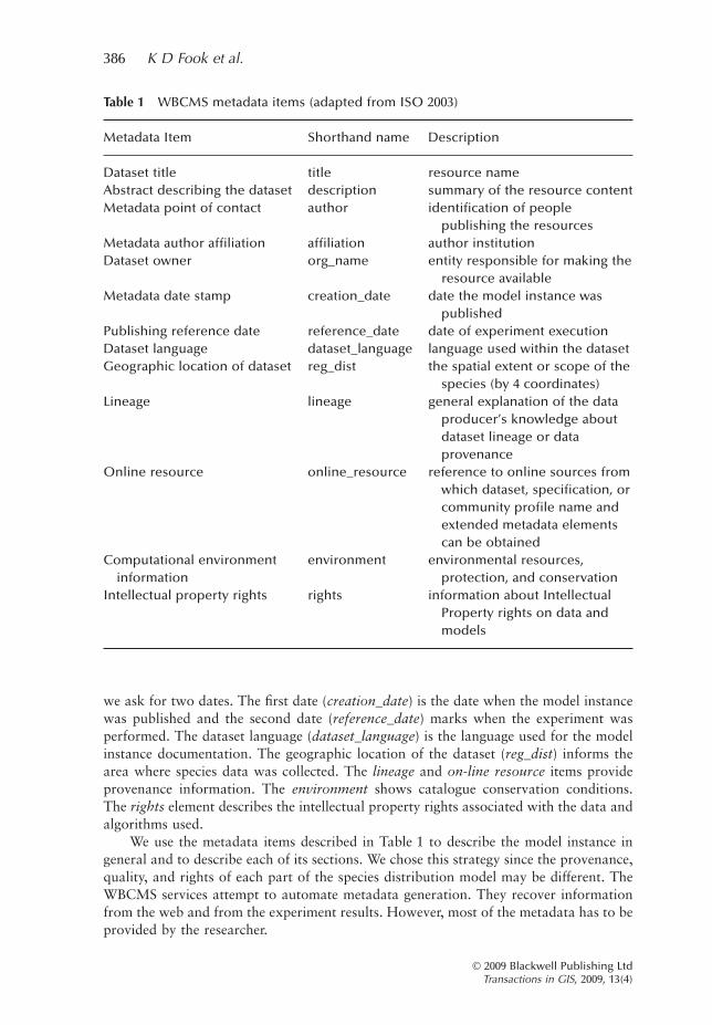
we ask for two dates. The first date (creation_date) is the date when the model instancewas published and the second date (reference_date) marks when the experiment wasperformed. The dataset language (dataset_language) is the language used for the modelinstance documentation. The geographic location of the dataset (reg_dist) informs thearea where species data was collected. The lineage and on-line resource items provideprovenance information. The environment shows catalogue conservation conditions.The rights element describes the intellectual property rights associated with the data andalgorithms used.
We use the metadata items described in Table 1 to describe the model instance ingeneral and to describe each of its sections. We chose this strategy since the provenance,quality, and rights of each part of the species distribution model may be different. TheWBCMS services attempt to automate metadata generation. They recover informationfrom the web and from the experiment results. However, most of the metadata has to beprovided by the researcher.
Table 1 WBCMS metadata items (adapted from ISO 2003)
Metadata Item Shorthand name Description
Dataset title title resource nameAbstract describing the dataset description summary of the resource contentMetadata point of contact author identification of people
publishing the resourcesMetadata author affiliation affiliation author institutionDataset owner org_name entity responsible for making the
resource availableMetadata date stamp creation_date date the model instance was
publishedPublishing reference date reference_date date of experiment executionDataset language dataset_language language used within the datasetGeographic location of dataset reg_dist the spatial extent or scope of the
species (by 4 coordinates)Lineage lineage general explanation of the data
producer’s knowledge aboutdataset lineage or dataprovenance
Online resource online_resource reference to online sources fromwhich dataset, specification, orcommunity profile name andextended metadata elementscan be obtained
Computational environmentinformation
environment environmental resources,protection, and conservation
Intellectual property rights rights information about IntellectualProperty rights on data andmodels
386 K D Fook et al.
© 2009 Blackwell Publishing LtdTransactions in GIS, 2009, 13(4)
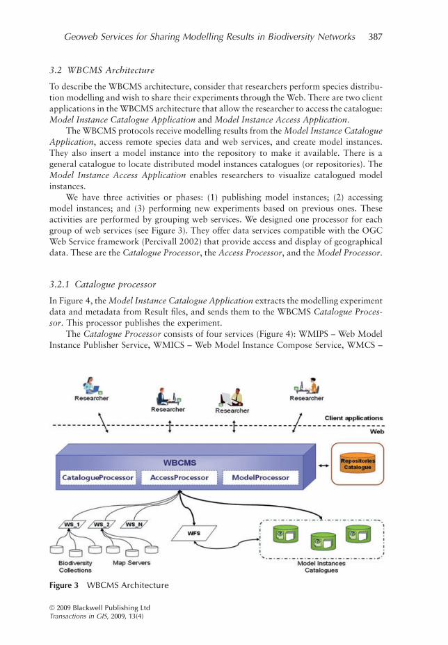
3.2 WBCMS Architecture
To describe the WBCMS architecture, consider that researchers perform species distribu-tion modelling and wish to share their experiments through the Web. There are two clientapplications in the WBCMS architecture that allow the researcher to access the catalogue:Model Instance Catalogue Application and Model Instance Access Application.
The WBCMS protocols receive modelling results from the Model Instance CatalogueApplication, access remote species data and web services, and create model instances.They also insert a model instance into the repository to make it available. There is ageneral catalogue to locate distributed model instances catalogues (or repositories). TheModel Instance Access Application enables researchers to visualize catalogued modelinstances.
We have three activities or phases: (1) publishing model instances; (2) accessingmodel instances; and (3) performing new experiments based on previous ones. Theseactivities are performed by grouping web services. We designed one processor for eachgroup of web services (see Figure 3). They offer data services compatible with the OGCWeb Service framework (Percivall 2002) that provide access and display of geographicaldata. These are the Catalogue Processor, the Access Processor, and the Model Processor.
3.2.1 Catalogue processor
In Figure 4, the Model Instance Catalogue Application extracts the modelling experimentdata and metadata from Result files, and sends them to the WBCMS Catalogue Proces-sor. This processor publishes the experiment.
The Catalogue Processor consists of four services (Figure 4): WMIPS – Web ModelInstance Publisher Service, WMICS – Web Model Instance Compose Service, WMCS –
Figure 3 WBCMS Architecture
Geoweb Services for Sharing Modelling Results in Biodiversity Networks 387
© 2009 Blackwell Publishing LtdTransactions in GIS, 2009, 13(4)
Web Model Classifier Service, and WMISS – Web Model Instance Storage Service.Figure 5 shows the Catalogue Processor Web services collaboration diagram.
The researcher calls the WBCMS Catalogue Processor to publish a species distribu-tion modelling experiment. The WMIPS (Web Model Instance Publisher Service) coor-dinates classification, composition, and storage of the model instance into the repository.The WMICS (Web Model Instance Compose Service) searches and recovers biodiversitydata and metadata from the web to complement the model instance. To do so, the service
Figure 4 Catalogue Processor Context
Figure 5 Catalogue Processor collaboration diagram
388 K D Fook et al.
© 2009 Blackwell Publishing LtdTransactions in GIS, 2009, 13(4)
calls external web services. The WMCS (Web Model Classifier Service) classifies themodel instance by species Kingdom. Finally, the WMISS (Web Model Instance StorageService) stores the model instance into the catalogue. The researcher receives a cataloguestatus.
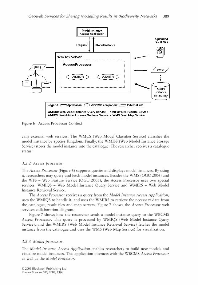
3.2.2 Access processor
The Access Processor (Figure 6) supports queries and displays model instances. By usingit, researchers may query and fetch model instances. Besides the WMS (OGC 2006) andthe WFS – Web Feature Service (OGC 2005), the Access Processor uses two specialservices: WMIQS – Web Model Instance Query Service and WMIRS – Web ModelInstance Retrieval Service.
The Access Processor receives a query from the Model Instance Access Application,uses the WMIQS to handle it, and uses the WMIRS to retrieve the necessary data fromthe catalogue, result files and map servers. Figure 7 shows the Access Processor webservices collaboration diagram.
Figure 7 shows how the researcher sends a model instance query to the WBCMSAccess Processor. This query is processed by WMIQS (Web Model Instance QueryService), and the WMIRS (Web Model Instance Retrieval Service) fetches the modelinstance from the catalogue and uses the WMS (Web Map Service) for visualization.
3.2.3 Model processor
The Model Instance Access Application enables researchers to build new models andvisualize model instances. This application interacts with the WBCMS Access Processoras well as the Model Processor.
Figure 6 Access Processor Context
Geoweb Services for Sharing Modelling Results in Biodiversity Networks 389
© 2009 Blackwell Publishing LtdTransactions in GIS, 2009, 13(4)

Figure 8 shows the Model Processor context. This WBCMS processor holds theWMRS – Web Model Run Service, and calls the external OMWS – OpenModeller WebService to produce new models (Giovanni 2005, Sutton et al. 2007). The OMWS makesalgorithm and environmental layers available for use, receives occurrence data from theclient, performs the model, and produces a species distribution model. The WMRSenables users to change algorithm parameters, to select OMWS available environmentallayers, and to run models reusing catalogued data.
Figure 9 shows the Model Processor web services collaboration diagram. Theresearcher calls WBCMS Model Processor to execute a new species distribution model
Figure 7 Access Processor collaboration diagram
Figure 8 Model Processor context
390 K D Fook et al.
© 2009 Blackwell Publishing LtdTransactions in GIS, 2009, 13(4)
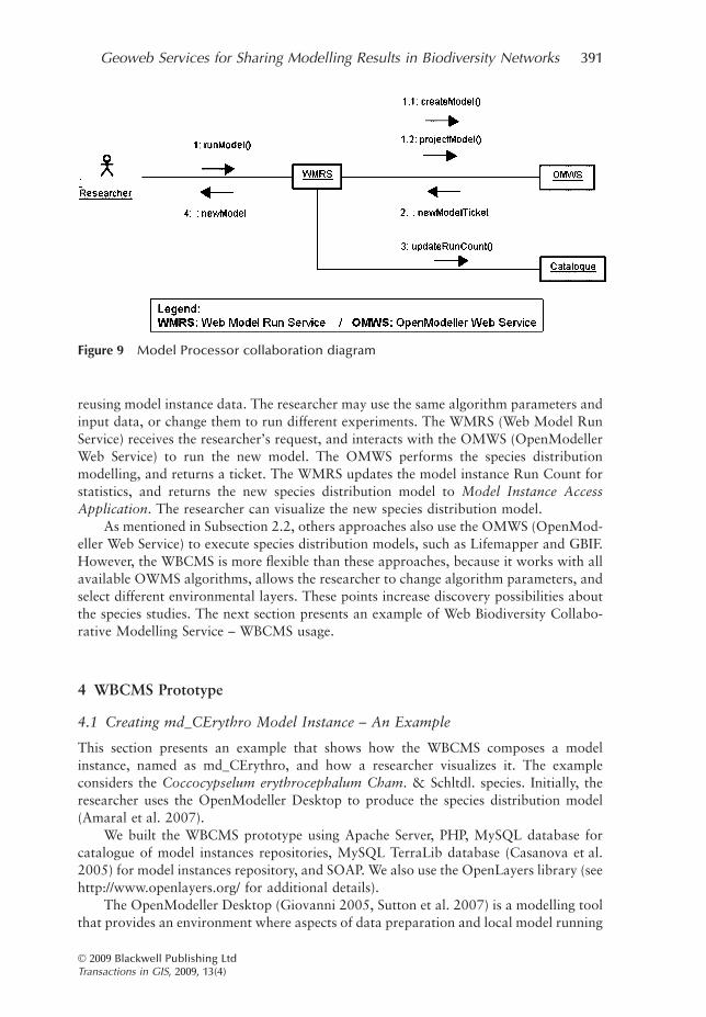
reusing model instance data. The researcher may use the same algorithm parameters andinput data, or change them to run different experiments. The WMRS (Web Model RunService) receives the researcher’s request, and interacts with the OMWS (OpenModellerWeb Service) to run the new model. The OMWS performs the species distributionmodelling, and returns a ticket. The WMRS updates the model instance Run Count forstatistics, and returns the new species distribution model to Model Instance AccessApplication. The researcher can visualize the new species distribution model.
As mentioned in Subsection 2.2, others approaches also use the OMWS (OpenMod-eller Web Service) to execute species distribution models, such as Lifemapper and GBIF.However, the WBCMS is more flexible than these approaches, because it works with allavailable OWMS algorithms, allows the researcher to change algorithm parameters, andselect different environmental layers. These points increase discovery possibilities aboutthe species studies. The next section presents an example of Web Biodiversity Collabo-rative Modelling Service – WBCMS usage.
4 WBCMS Prototype
4.1 Creating md_CErythro Model Instance – An Example
This section presents an example that shows how the WBCMS composes a modelinstance, named as md_CErythro, and how a researcher visualizes it. The exampleconsiders the Coccocypselum erythrocephalum Cham. & Schltdl. species. Initially, theresearcher uses the OpenModeller Desktop to produce the species distribution model(Amaral et al. 2007).
We built the WBCMS prototype using Apache Server, PHP, MySQL database forcatalogue of model instances repositories, MySQL TerraLib database (Casanova et al.2005) for model instances repository, and SOAP. We also use the OpenLayers library (seehttp://www.openlayers.org/ for additional details).
The OpenModeller Desktop (Giovanni 2005, Sutton et al. 2007) is a modelling toolthat provides an environment where aspects of data preparation and local model running
Figure 9 Model Processor collaboration diagram
Geoweb Services for Sharing Modelling Results in Biodiversity Networks 391
© 2009 Blackwell Publishing LtdTransactions in GIS, 2009, 13(4)

can be carried out. This application is part of the OpenModeller Project, an internationalproject for collaborative building of biodiversity models.
The OpenModeller Desktop produces several result files, such as a distribution map,reports, and configuration files. The researcher uses the Model Instance Catalogueapplication to retrieve the model instance metadata from results files, to inform personalcomments about the experiment (description, confidence degree, and motivationquestion), and to send the md_CErythro elements to the WBCMS (Figure 10).
The WBCMS Catalogue Process receives the md_CErythro elements, composes themodel instance and inserts it into the repository. Figure 11 shows part of the modelinstance with data and metadata.
The Model Instance Access application enables the researcher to visualize eachmodel instance component, and to perform new models. Figure 12 displays themd_CErythro model instance with its global data and metadata. This figure also presentsdata and metadata related to the modelled Species.
Besides data and metadata, this form contains the researcher’s personal comments,such as confidence degree and its justification. Figure 13 presents a form in the back-ground with the species distribution map, and evaluation indexes for the species distri-bution modelling. Figure 13 shows also species context maps. The researcher can assessthe experiment using the author’s personal comments and evaluation indexes.
The form shown in Figure 14 (background) allows the user to interact with theWBCMS Model Processor. The researcher uses this form to reuse input and algorithmsfrom a model instance, and to develop new models.
After model generation, the new species distribution model is shown. Figure 14shows also two new models based on the md_CErythro model instance. The researchercan compare these results with other model instance results, and make new inferencesand advances in her (his) studies.
Figure 10 Model instance catalogue application
392 K D Fook et al.
© 2009 Blackwell Publishing LtdTransactions in GIS, 2009, 13(4)

5 Conclusions and Future Work
Conservation of the Earth’s biological diversity involves models that are largely used toenable researchers to make inferences about diversity, abundance, and the spatial dis-tribution of species. Diversity and complexity of objects are increasing in biodiversityexperiments.
This article presented the Web Biodiversity Collaborative Modelling Services –WBCMS, a web services based architecture. The WBCMS conceptual framework aims tosupport collaboration in biodiversity on the Web by sharing of species distributionmodelling experiments: their results, modelling process, and provenance information. Itmust make implicit knowledge in a biodiversity experiment available in a research
<MdInst id="md_CErythro"> <description> The algorithm GARP (Best-Subsets) was used to develop a model of potential distribution for Coccocypselum erythrocephalum (Rubiaceae family) in the Brazilian territory. This model used climate and topographic variables and NDVI values as environmental data. </description> ... <kingdom>Plantae</kingdom> <phylum>Magnoliophyta </phylum> <class>Magnoliopsida</class> <order>Rubiales</order> <family>Rubiaceae</family> <source_database_url>http://www.kew.org/wcsp/</ source_database_url > <reference_date>2008-06-17 14:19:01</reference_date> <geographic_distribution>Brazil</geographic_distribution> ... <algorithm> <algorithmMetadata Id="GARP_BS" Name="GARP with Best Subsets - new openModeller implementation" Version="3.0.2 alpha" Author="Anderson, R. P., D. Lew, D. and A. T. Peterson." CodeAuthor="Ricardo Scachetti Pereira"> ... </algorithmMetadata> <algorithmParameters> <Param Id="CommissionSampleSize" Value="10000"/> <Param Id="CommissionThreshold" Value="50"/> <Param Id="ConvergenceLimit" Value="0.01"/> <Param Id="HardOmissionThreshold" Value="100"/> <Param Id="MaxGenerations" Value="400"/> <Param Id="MaxThreads" Value="1"/> <Param Id="ModelsUnderOmissionThreshold" Value="20"/> <Param Id="PopulationSize" Value="50"/> <Param Id="Resamples" Value="2500"/> <Param Id="TotalRuns" Value="20"/> <Param Id="TrainingProportion" Value="0.5"/> ... </algorithmParameters> </algorithm>
Figure 11 Model instance
Geoweb Services for Sharing Modelling Results in Biodiversity Networks 393
© 2009 Blackwell Publishing LtdTransactions in GIS, 2009, 13(4)

Figu
re12
Mo
del
inst
ance
acce
ssap
plic
atio
n–
Gen
eral
and
spec
ies
info
rmat
ion
394 K D Fook et al.
© 2009 Blackwell Publishing LtdTransactions in GIS, 2009, 13(4)

Figu
re13
Mo
del
inst
ance
acce
ssap
plic
atio
n–
Res
ult
s
Geoweb Services for Sharing Modelling Results in Biodiversity Networks 395
© 2009 Blackwell Publishing LtdTransactions in GIS, 2009, 13(4)

Figu
re14
Mo
del
inst
ance
acce
ssap
plic
atio
n–
Ru
nM
od
el
396 K D Fook et al.
© 2009 Blackwell Publishing LtdTransactions in GIS, 2009, 13(4)

network, and must enable the reuse of completed experiments to produce new modellingexperiments.
We proposed a data structure, named a model instance, to express a species distri-bution modelling experiment as a whole. The model instance idea holds data andmetadata in different levels, and facilitates the treatment of these resources. Then, weselected a set of ISO 19115 metadata elements to describe the model instance elements.In addition, we used OGC-compliant web services in the proposed architecture; however,we append web services to handle model instance complexity. The WBCMS handles thiscomplexity and a model instance catalogue.
In this article, we showed that the prototype enables users to share knowledgetailored to their individual experiments, and run new experiments. We also included amodel instance example illustrating the WBCMS usage.
We acknowledge that the concept of model instance, as presented in this work, isonly a first step towards a more general definition of scientific models that could beused. Even so, the need for an explicit definition of a model instance goes one stepbeyond the current research. This approach indicates the need for further research onthe area of “modelling models”, which investigates ways to computationally describescientific models. Further research also should cover additional architecturalapproaches, e.g. the Web Model Instance Query Service – WMIQS will have to handlemore complex query predicates. Another example is the specification of other kinds ofmodel instance for different modelling study areas, such as Land Use and CoverageChange Models.
Acknowledgements
Special thanks go to Dr Cristina Bestetti Costa for their very relevant comments and speciesoccurrence data; to the OpenModeller Project (FAPESP process: 04/11012-0; http://www.fapesp.br/); and to FAPEMA (In Portuguese: Fundação de Amparo à Pesquisa e aoDesenvolvimento Científico e Tecnológico do Maranhão; (http://www.fapema.br/) forpartially supporting this research.
References
Aditya T and Lemmens R 2003 Chaining distributed GIS services. In Prosiding Pertemuan IlmiahTahunan XII, International Institute for Geo-Information Science and Earth Observation,Bandung, Indonesia: 8–17
Alameh N 2001 Scalable and Extensible Infrastructures for Distributing Interoperable GeographicInformation Services on the Internet. Unpublished PhD Dissertation, Massachusetts Instituteof Technology
Alameh N 2003 Chaining geographic information web services. IEEE Internet Computing 7: 22–9Alvarez D, Smukler A, and Vaisman A A 2005 Peer-to-peer databases for e-Science: A biodiversity
case study. In Proceedings of the Twentieth Brazilian Symposium on Databases (SBBD 2005)and Nineteenth Brazilian Symposium on Software Engineering, Uberlândia, Brazil, 1: 220–34
Amaral S, Costa C B, and Rennó C D 2007 Normalized Difference Vegetation Index (NDVI)improving species distribution models: an example with the neotropical genus Coccocypselum(Rubiaceae). In Proceedings of the Thirteenth Brazilian Remote Sensing Symposium (SBSR2007), Florianopolis, Brazil: 2275–82
Geoweb Services for Sharing Modelling Results in Biodiversity Networks 397
© 2009 Blackwell Publishing LtdTransactions in GIS, 2009, 13(4)

Bernard L, Einspanier U, Lutz M, and Portele C 2003 Interoperability in GI service chains: The wayforward. In Proceedings of the Sixth AGILE Conference on Geographic Information Science,Lyon, France: 179–88
Breitman K, Casanova M A, and Truszkowski W 2006 Semantic Web: Concepts, Technologies andApplications. New York, Springer-Verlag
Busby J R 1991 BIOCLIM: A bioclimate analysis and prediction system. Plant Protection Quarterly(Australia) 6: 64–8
Casanova M A, Câmara G, Davis C, Vinhas L, and Queiroz G 2005 Bancos de Dados Geograficos(Spatial Databases). Curitiba, Editora MundoGEO
Di L, Chen A, Yang W, and Zhao P 2003 The integration of grid technology with OGC WebServices (OWS) in NWGISS for NASA EOS data. In Proceedings of the Twelfth IEEEInternational Symposium on High-Performance Distributed Computing (HPDC12) and theEighth Global Grid Forum (GGF8), Seattle, Washington: 24–7
Fook K D, Monteiro A M V, and Câmara G 2007 Web service for cooperation in biodiversitymodeling. In Davis C and Monteiro A M V (eds) Advances in Geoinformatics. New York,Springer: 203–16
Frew J and Bose R 2001 Earth system science workbench: A data management infrastructure forearth science products. In Proceedings of the Thirteenth IEEE International Conference onScientific and Statistical Database Management (SSDBM), Fairfax, Virginia: 180–9
Friis-Christensen A, Lutz M, Ostlander N, and Bernard L 2007 Designing service architectures fordistributed geoprocessing: Challenges and future directions. Transactions in GIS 11: 799–818
GBIF 2008 OpenModeller Web Service: OMWS, GBIF Niche Model. WWW document, http://data.gbif.org
Giovanni R D 2005 The OpenModeller project. WWW document, http://openmodeller.cria.org.br/Granell C, Díaz L, and Gould M 2007 Managing Earth observation data with distributed
geoprocessing services. In Proceedings of the International Geoscience and Remote SensingSymposium (IGARSS 2007), Barcelona, Spain
Greenwood M, Goble C, Stevens R, Zhao J, Addis M, Marvin D, Moreau L, and Oinn T 2003Provenance of e-Science experiments: Experience from bioinformatics. In Proceedings of theSecond UK e-Science All Hands Meeting, Nottingham, UK: 223–6
Guisan A 2004 Niche-based models as tools to assess climate change impact on the distribution anddiversity of plants in mountain reserves. In Proceedings of the Second Thematic Workshop onProjecting Global Change Impacts in Mountain Biosphere Reserves, L’Aquila, Italy: 80–91
Guisan A and Zimmermann N E 2000 Predictive habitat distribution models in ecology. EcologicalModelling 135: 147–86
Guralnick R P, Hill A W, and Lane M 2007 Towards a collaborative, global infrastructure forbiodiversity assessment. Ecology Letters 10: 663–72
ISO 2003 ISO 19115 Geographic Information – Metadata. WWW document, http://www.iso.org/iso/iso_catalogue/catalogue_tc/catalogue_detail.htm?csnumber=26020
Jones A C, White R J, Pittas N, Gray W A, Sutton T, Xu X, Bromley O, Caithness N, Bisby F A,Fiddian N J, Scoble M, Culham A, and Williams P 2003 BiodiversityWorld: An architecturefor an extensible virtual laboratory for analysing biodiversity patterns. In Proceedings of theUK e-Science All Hands Meeting, Nottingham, UK: 759–65
Leite-Jr F L, Baptista C S, Silva P A, and Silva E R 2007 WS-GIS: Towards a SOA-based SDIfederation. In Davis C and Monteiro A M V (eds) Advances in Geoinformatics. Berlin,Springer: 247–64
Lemmens R, Wytzisk A, de By R, Granell C, Gould M, and van Oosterom P 2007 EnhancingGeo-Service Chaining through Deep Service Descriptions. Transactions in GIS 11: 849–71
Muñoz M 2004 openModeller: A framework for biological/environmental modelling. WWWdocument, http://www.cria.org.br/eventos/iaed/agenda
Nebert D 2004 Developing Spatial Data Infrastructures: The SDI Cookbook. WWW document,http://www.gsdi.org/pubs/cookbook/
Newcomer E 2002 Understanding Web Services: XML, WSDL, SOAP and UDDI. Indianapolis,IN, Addison-Wesley Professional
OGC 2005 OpenGIS Web Feature Service (WFS) Implementation Specification. WWW document,http://portal.opengeospatial.org/modules/admin/license_agreement.php?suppressHeaders=0&access_license_id=3&target=http://portal.opengeospatial.org/files/index.php?artifact_id=8339
398 K D Fook et al.
© 2009 Blackwell Publishing LtdTransactions in GIS, 2009, 13(4)
OGC 2006 OpenGIS Web Map Server Implementation Specification. Wayland, Open GeospatialConsortium
OpenModeller 2005 OpenModeller: Static Spatial Distribution Modelling Tool. WWW document,http://openmodeller.cria.org.br/
Pahwa J S, White R J, Jones A C, Burgess M, Gray W A, Fiddian N J, Sutton T, Brewer P, YessonC, Caithness N, Culham A, Bisby F A, Scoble M, Williams P, and Bhagwat S 2006 AccessingBiodiversity Resources in computational environments from workflow applications. In Pro-ceedings of the IEEE Workshop on Workflows in Support of Large-Scale Science, Paris, France
Percivall G 2002 The OpenGIS Abstract Specification: Topic 12, OpenGIS Service ArchitectureVersion 4.3. WWW document, http://portal.opengeospatial.org/files/?artifact_id=1221
Phillips S J, Anderson R P, and Schapire R E 2006 Maximum entropy modeling of speciesgeographic distributions. Ecological Modelling 190: 231–59
Ramamurthy M K 2006 A new generation of cyberinfrastructure and data services for earth systemscience education and research. Advances in Geosciences 8: 69–78
Serique K J A, Santos J L C d, Costa F S, and Maia J M F 2007 Mo Porã: Um sistema gerenciadorde repositórios distribuídos e colaborativos no ambiente cientifico da Amazônia. In Proceed-ings of the Simpósio Brasileiro em Sistemas Colaborativos (SBSC’07), Rio Janiero, Brazil:1801–12
Simmhan Y L, Plale B, and Gannon D 2005 A survey of data provenance in e-Science. SIGMODRecord 34: 31–6
Siqueira M F 2005 Uso de modelagem de nicho fundamental na avaliação do padrão de distribuiçãogeográfica de espécies vegetais. Unpublished PhD Dissertation, Universidade de São Paulo(USP), São Carlos, Brazil
Soberón J and Peterson T 2004 Biodiversity informatics: Managing and applying primary biodi-versity data. The Royal Society 359: 689–98
Stockwell D and Peters D 1999 The GARP modelling system: Problems and solutions to automatedspatial prediction. International Journal Geographical Information Science 13: 143–58
Stockwell D R B, Beach J H, Stewart A, Vorontsov G, Vieglais D, and Pereira R S 2006 The use ofthe GARP genetic algorithm and Internet grid computing in the Lifemapper world atlas ospecies biodiversity. Ecological Modelling 195: 139–45
Sutton T, de Giovanni R, and de Siqueira M F 2007 Introducing openModeller: A fundamentalniche modelling framework. OSGeo Journal 1 (available at http://www.osgeo.org/ojs/index.php/journal/article/viewFile/62/48)
Tsou M H and Buttenfield B P 2002 A dynamic architecture for distributing geographic informationservices. Transactions in GIS 6: 355–81
Vaccari L, Shvaiko P, and Marchese M 2009 A geo-service semantic integration in Spatial DataInfrastructures. International Journal of Spatial Data Infrastructures Research 4: 24–51
WeBios 2005 WeBios: Web Service Multimodal Tools for Strategic Biodiversity Research, Assess-ment and Monitoring Project. WWW document, http://www.lis.ic.unicamp.br/projects/webios
Wroe C, Stevens R, Goble C, Roberts A, and Greenwood M 2003 A suite of Daml+Oil ontologiesto describe bioinformatics Web services and data. International Journal of Cooperative Infor-mation Science 12: 197–224
Zhao J, Goble C, Greenwood M, Wroe C, and Stevens R 2003 Annotating, linking and browsingprovenance logs for e-Science. In Proceedings of the Second International Semantic WebConference (ISWC2003), Workshop on Retrieval of Scientific Data, Sanibel Island, Florida:158–76
Geoweb Services for Sharing Modelling Results in Biodiversity Networks 399
© 2009 Blackwell Publishing LtdTransactions in GIS, 2009, 13(4)