Geothermal fluid and reservoir properties in the Upper ...
21
Institut für Angewandte Geowissenschaften - Abteilung Geothermie 1 KIT – Universität des Landes Baden-Württemberg und nationales Forschungszentrum in der Helmholtz-Gemeinschaft Institut für Angewandte Geowissenschaften – Abteilung Geothermie www.kit.edu Geothermal fluid and reservoir properties in the Upper Rhine Graben Ingrid Stober Strasbourg, 5. Februar 2015
Transcript of Geothermal fluid and reservoir properties in the Upper ...

Institut für Angewandte Geowissenschaften -Abteilung Geothermie
1 KIT – Universität des Landes Baden-Württemberg undnationales Forschungszentrum in der Helmholtz-Gemeinschaft
Institut für Angewandte Geowissenschaften – Abteilung Geothermie
www.kit.edu
Geothermal fluid and reservoir properties in the Upper Rhine Graben
Ingrid Stober
Strasbourg, 5. Februar 2015

Institut für Angewandte Geowissenschaften -Abteilung Geothermie
2
Geological situation of the Upper Rhine Graben
Uplift (several km) caused erosion on both flanks of the Graben, exhuming gneisses and granites.The former sedimentary cover is conserved within the Graben. The deeply burried sediments include several aquifers containing hot water.Additionally there are thick Tertiary and Quaternary sediments, formed during the subsidence of the Graben.
During Early Cenozoic and Late Eocene:• Subsidence of Upper Rhine Graben• Uplift of Black Forest and Vosges mountains
as Rift flanks
Prof. Dr. Ingrid Stober

Institut für Angewandte Geowissenschaften -Abteilung Geothermie
3
• Broken layers, partly with hydraulic connection, partly without
• Alternation between depression areas & elevated regions (horst – graben – structure)
• Hydraulic behavior of faults unknown
• There are extensional as well as compressive faults
• Main faults show vertical displacements of several 1,000 meters
• Thickness of the individual layers not constant.
Complex hydrogeological situation in the Graben
Prof. Dr. Ingrid Stober
Institut für Angewandte Geowissenschaften -Abteilung Geothermie
4
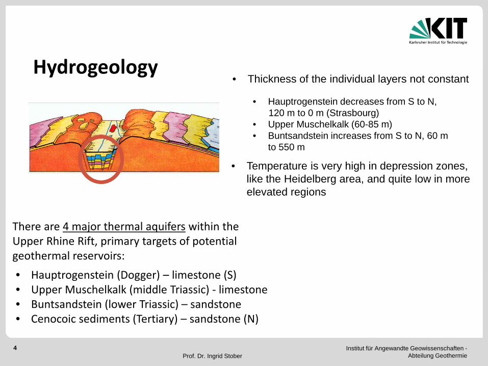
Hydrogeology
There are 4 major thermal aquifers within the Upper Rhine Rift, primary targets of potential geothermal reservoirs:• Hauptrogenstein (Dogger) – limestone (S)• Upper Muschelkalk (middle Triassic) - limestone• Buntsandstein (lower Triassic) – sandstone• Cenocoic sediments (Tertiary) – sandstone (N)
• Thickness of the individual layers not constant
• Hauptrogenstein decreases from S to N, 120 m to 0 m (Strasbourg)
• Upper Muschelkalk (60-85 m)• Buntsandstein increases from S to N, 60 m
to 550 m
• Temperature is very high in depression zones, like the Heidelberg area, and quite low in more elevated regions
Prof. Dr. Ingrid Stober

Institut für Angewandte Geowissenschaften -Abteilung Geothermie
5
Upper Muschelkalk
Hauptrogenstein
Examples
Buntsandstein
Prof. Dr. Ingrid Stober

Institut für Angewandte Geowissenschaften -Abteilung Geothermie
6
Cross sections through the eastern part of the Upper Rhine Graben, showing the 3 main thermal aquifers
VerticalDisplace-ment:3,000 m
Heidelberg
Breisach
VerticalDisplace-ment:3,700 m
Buntsandstein(lower Triassic)
Upper Muschelkalk(middle Triassic)
Hauptrogenstein(Dogger)
Northern Graben
Southern Graben
Prof. Dr. Ingrid Stober

Institut für Angewandte Geowissenschaften -Abteilung Geothermie
7
Temperature in the Upper Rhine Graben
Prof. Dr. Ingrid Stober

Institut für Angewandte Geowissenschaften -Abteilung Geothermie
8
Location of hydraulic test data from deep wells
• deep wells of the oil- / gas-industry• wells of spas• geothermal wells
Prof. Dr. Ingrid Stober

Institut für Angewandte Geowissenschaften -Abteilung Geothermie
9
Frequency distribution of hydraulic conductivity (T/H) in the thermal aquifers
T – transmissivity (m2/s)H – test length (m)
fractured sandstone, karstified limestone aquifers
Prof. Dr. Ingrid Stober

Institut für Angewandte Geowissenschaften -Abteilung Geothermie
10
Hydraulicconductivity: dependence ofdepth (?)
Prof. Dr. Ingrid Stober

Institut für Angewandte Geowissenschaften -Abteilung Geothermie
11
Box-Whisker-Plot: Comparison of drill core and well test derived dataexample: Upper Muschelkalk-aquifer
Hydraulic conductivity Kdc [m/s] in fractured or karstified aquifers derived from permeability κ measurements on drill cores, is always orders of magnitude lower than hydraulic conductivity Kwt (T/H) [m/s] derived from of hydraulic tests. Thus T/H data should be used for characterization of fluid flow in these aquifers.
Kwt = Hydraulic conductivity (T/H) [m/s] derived from well testsKdc = Hydraulic conductivity [m/s] derived from permeability (κ) [m2] measurements on drill cores
Hydraulic conductivitylog Kwt [m/s]
Hydraulic conductivitylog Kdc [m/s]
Prof. Dr. Ingrid Stober

Institut für Angewandte Geowissenschaften -Abteilung Geothermie
12 Prof. Dr. Ingrid Stober

Institut für Angewandte Geowissenschaften -Abteilung Geothermie
13
• Most water-samples are old (from archives). A lot of the samples originate from production tests of the oil-industry in the 1970th to 1990th; these boreholes are closed now.
Collection of hot, gas-rich, strongly mineralized waters
On a total, the quality of the samples should not be overestimated.Nevertheless the data seem to be very valuable, if scheduling a geothermal project or planning deep wells for other purposes like CO2-sequestration, thermal spas,….
Quality of the hydrochemical samples from deep wells
• The few new collected samples are from thermal spas and geothermal wells.
• Different laboratories analyzed the water-samples. So, first of all the analyses had to be controlled and checked on plausibility.
Prof. Dr. Ingrid Stober

Institut für Angewandte Geowissenschaften -Abteilung Geothermie
14
Hydraulic testing withwater sampling
Location of chemical water analyses from deep wells
Prof. Dr. Ingrid Stober

Institut für Angewandte Geowissenschaften -Abteilung Geothermie
15
• Deep thermal waters are always strongly mineralized.
• No weakly mineralized deep waters.
• Highest TDS in Hauptrogenstein (Dogger) aquifer with several 100 g/kg.
• All waters below halitesaturation. KCl and CaCl2saturation is about 0.5 log units higher than halite saturation.
Hydrochemical properties of deep seated hot waters
TDS = Total Dissolved Solids
Prof. Dr. Ingrid Stober

Institut für Angewandte Geowissenschaften -Abteilung Geothermie
16
bjHR: TDS: < 300 g/kgdepth: ≤ 2,100 mWater-type at shallow depth:
Ca-HCO3Water-type at great depth:
Na-Cl
s: TDS: ≤ 127 g/kgdepth: ≤ 3,200 mWater-type at shallow depth:
Ca-HCO3Water-type at great depth:
Na-Cl
mo: TDS: ≤ 79 g/kgdepth: ≤ 2,500 mWater-type at shallow depth:
Ca-SO4-HCO3Water-type at great depth:
Na-Cl
Hydrochemical properties of deep seated hot waters (> 500 m)
t: TDS: < 240 g/kgdepth: ≤ 1,700 mWater-type at shallow depth:
Ca-HCO3Water-type at great depth:
Na-Cl
Prof. Dr. Ingrid Stober

Institut für Angewandte Geowissenschaften -Abteilung Geothermie
17
Waters at shallow depth (500 – 800 m):• Middle & Lower Cenocoic: Ca-HCO3 waters, in sediments with carbonate
components, SO4 locally enriched due to occurrence of gypsum/anhydrite.• Hauptrogenstein: Ca-HCO3 waters, in fractured and karstified limestone• Upper Muschelkalk: Ca-SO4-HCO3 waters, in fractured and karstified limestone,
containing gypsum/anhydrite-rich layers.• Buntsandstein: Ca-HCO3 waters with elevated SO4-concentration, in fractured
sandstone. The fracture surfaces are usually covered with calcite. The sandstone contains relics of gypsum lenses.
Waters at greater depth (> 800 m):• Middle & Lower Cenocoic: Na-Cl waters. Gradually changing water type with TDS
and depth.• Hauptrogenstein: Na-Cl waters. Ca continuously increases with TDS. Gradually
changing water type with TDS and depth.• Upper Muschelkalk: Na-Cl waters. Abrupt change of water type from lower to higher
concentrations.• Buntsandstein: Na-Cl waters. ± Continuous transition from lower to higher
concentrations.
Deep waters are Na-Cl-rich, independent of nature of aquifer-rock.
Prof. Dr. Ingrid Stober

Institut für Angewandte Geowissenschaften -Abteilung Geothermie
18
Origin of deep Na-Cl-rich thermal waters
Latest seawater transgression in the Upper Rhine Graben during Eocene-Oligocene. Evaporite deposits with halite and sylvite formed from Upper Eocene to the Lower Oligocene. Halite-rich strata also locally within Middle Muschelkalk.
Quartz saturation temperatures from SiO2- geothermometers are typically higher than measured aquifer-temperatures, indicating upwelling thermal waters.
Cl/Br- and (Na+K)/Cl-ratios show: The high salinity in the Buntsandstein aquifer originates from upwelling saline waters from the crystalline basement, The salinity in the Upper Muschelkalk derives from halite in the underlying Middle Muschelkalk, The salinity in the Hauptrogenstein aquifer originates from halite in Tertiary strata.To some extend there exists additionally a NaCl component from fossil sea water.
Prof. Dr. Ingrid Stober

Institut für Angewandte Geowissenschaften -Abteilung Geothermie
19
Flow Model in the Upper Rhine Graben
Prof. Dr. Ingrid Stober

Institut für Angewandte Geowissenschaften -Abteilung Geothermie
20
Technical consequencesDeep thermal waters in the Upper Rhine Grabenare highly mineralized (Na-(Ca)-Cl) and rich in dissolvedgasses (CO2,…)• During production of hot water (reduction of pressure)
calcite is precipitating• during degassing of CO2 precipitation of calcite, very
rapidly• During contact with atmospheric oxygen (O2)
precipitation of iron and/or manganese oxide scales.Therefore the produced waters must be circulated in a closed system under pressure (10-25 bar) to prevent degassing and contact with surface conditions.
Bruchsal: coating in pipe
Baden-Baden:Aragonite in tubing
Bruchsal: pipe for degassing with scale
Ingrid Stober - Rhine rift valley

Institut für Angewandte Geowissenschaften -Abteilung Geothermie
21Prof. Dr. Ingrid Stober
Bundesministerium für Umwelt, Naturschutz und Reaktorsicherheit (BMU; FKZ: 0327615, 0327615, 0325136) und der Deutschen Forschungsgemeinschaft DFG für die Bereitstellung der Projektmittel.
Dem Service Géologique Régional Alsace des BRGM, dem RP Freiburg, LGRB, sowie den Firmen ExxonMobil, Gaz de France SUEZ, RWE Dea, Wintershall Holding GmbH für die Bereitstellung von Informationen über den Untergrund, sowie dem WEG für die Unterstützung und die Möglichkeit diese Daten auswerten und publizieren zu können.
Und Ihnen fürs Zuhören
Vielen herzlichen Dank
Stober, I. & Bucher, K. (2014): Hydraulic and hydrochemical properties of deep sedimentary aquifers of the Upper Rhine Graben, Europe.- Geofluids (doi: 10.1111/gfl.12122).Stober, I. & Bucher, K. (2006): Hydraulic properties of the crystalline basement.- Hydrogeology Journal, 15, p. 213-224.Stober, I., Jodocy, M., Hintersberger, B. (2012): Vergleich von Durchlässigkeiten aus unterschiedlichen Verfahren - Am Beispiel des tief liegenden Oberen Muschelkalk-Aquifers im Oberrheingraben und westl. Molassebecken.- Z. geol. Wiss., 40 (1), S. 1-18, Berlin.