Geotechnical and Geochemical Properties of Al-Nekhaila ...
16
JKAU: Earth Sci., vol. 11, pp. 161-176 (1420 A.H. / 1999 A.D.) 161 Geotechnical and Geochemical Properties of Al-Nekhaila Sabkha, South of Jeddah TALAL N. SERHAN and ABDULLAH A. SABTAN Faculty of Earth Sciences, King Abdulaziz University Jeddah, Saudi Arabia Received: 1/12/98 Revised: 9/4/2000 Accepted: 10/4/2000 ABSTRACT. Sabkhas are widespread along the coastal plains of the Red Sea. The development of sabkha is mostly attributed to the hot climate where evaporation, which is responsible of the development of brines, largely exceeds precipitation. The soil poses several geo- technical problems specially when wet. The high sulfate and chloride content in the groundwater may also cause corrosive action on re- inforced concrete. The city of Jeddah is rapidly expanding and new residential and commercial buildings are constructed each year in the area close to the shoreline where sabkhas exist. If the expansion extends southward, it will reach Al-Nekhaila sabkha. Therefore, the geotechnical and geo- chemical characteristics of this sabkha were considered. The field in- vestigations were performed by three in situ tests, namely Mackintosh probing, vane shear, and sand cone, to a maximum depth of 9 m. Three main soil units have been identified; sand (SM, SC, and SP), silt (ML, and MH) and clay (CL, and CH). The salts are present as ce- menting material between the soil grains in the top one meter. The sand ranges from loose to medium dense as indicated by the soil prob- ing. The average undrained shear strength for the silt is 84 kN/m 2 and for the clay is 90 kN/m 2 . Some geotechnical problems are expected from the clay layer. The groundwater level is 1 m to 2.5 m deep and is classified as saline to brine. Introduction The studied sabkha lies in the coastal plains of the Red Sea known as Tihama. The coastal plains vary in width from 2 km to 40 km where a series of isolated
Transcript of Geotechnical and Geochemical Properties of Al-Nekhaila ...

Geotechnical and Geochemical Properties of Al-Nekhaila... 161JKAU: Earth Sci., vol. 11, pp. 161-176 (1420 A.H. / 1999 A.D.)
161
Geotechnical and Geochemical Properties of Al-NekhailaSabkha, South of Jeddah
TALAL N. SERHAN and ABDULLAH A. SABTAN
Faculty of Earth Sciences, King Abdulaziz UniversityJeddah, Saudi Arabia
Received: 1/12/98 Revised: 9/4/2000 Accepted: 10/4/2000
ABSTRACT. Sabkhas are widespread along the coastal plains of theRed Sea. The development of sabkha is mostly attributed to the hotclimate where evaporation, which is responsible of the developmentof brines, largely exceeds precipitation. The soil poses several geo-technical problems specially when wet. The high sulfate and chloridecontent in the groundwater may also cause corrosive action on re-inforced concrete.
The city of Jeddah is rapidly expanding and new residential andcommercial buildings are constructed each year in the area close to theshoreline where sabkhas exist. If the expansion extends southward, itwill reach Al-Nekhaila sabkha. Therefore, the geotechnical and geo-chemical characteristics of this sabkha were considered. The field in-vestigations were performed by three in situ tests, namely Mackintoshprobing, vane shear, and sand cone, to a maximum depth of 9 m.
Three main soil units have been identified; sand (SM, SC, and SP),silt (ML, and MH) and clay (CL, and CH). The salts are present as ce-menting material between the soil grains in the top one meter. Thesand ranges from loose to medium dense as indicated by the soil prob-ing. The average undrained shear strength for the silt is 84 kN/m2 andfor the clay is 90 kN/m2. Some geotechnical problems are expectedfrom the clay layer. The groundwater level is 1 m to 2.5 m deep and isclassified as saline to brine.
Introduction
The studied sabkha lies in the coastal plains of the Red Sea known as Tihama.The coastal plains vary in width from 2 km to 40 km where a series of isolated
Talal N. Serhan and Abdullah A. Sabtan162
sabkhas extend from Ummlajj in the north to Jizan in the south. They are as-sociated with wadi outlets, lagoonal margins intertidal or supratidal flats andlow lands bounded by corals or sheets of sands close to the shore (Kinsman,1969; and Ali and West, 1983). To the east of the sabkha areas lies piedmontcut on Tertiary and Precambrian rocks. The piedmont is covered in part by al-luvial fans, eolian sand and wadi alluvium.
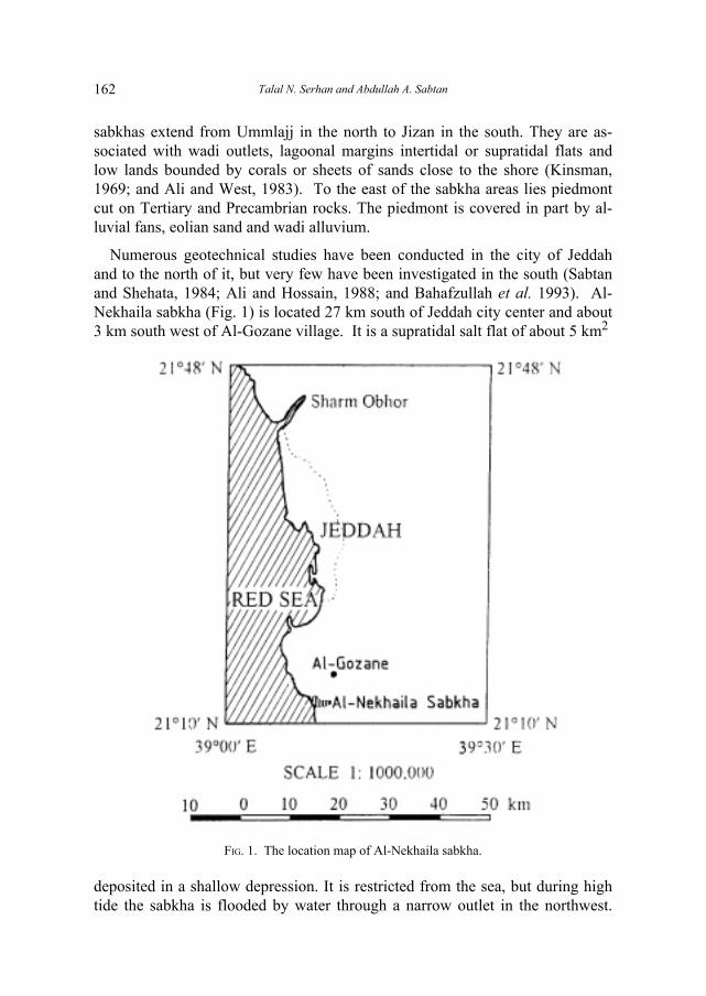
Numerous geotechnical studies have been conducted in the city of Jeddahand to the north of it, but very few have been investigated in the south (Sabtanand Shehata, 1984; Ali and Hossain, 1988; and Bahafzullah et al. 1993). Al-Nekhaila sabkha (Fig. 1) is located 27 km south of Jeddah city center and about3 km south west of Al-Gozane village. It is a supratidal salt flat of about 5 km2
FIG. 1. The location map of Al-Nekhaila sabkha.
deposited in a shallow depression. It is restricted from the sea, but during hightide the sabkha is flooded by water through a narrow outlet in the northwest.

Geotechnical and Geochemical Properties of Al-Nekhaila... 163
This outlet was however closed 20 years ago by a road pavement. The inlandflooding may occur through two small tributaries from east and northeast.
The upper layer of the sabkha soil consists of a thin (50 cm - 70 cm) and hardsalty crust with halite and disseminated gypsum, which is formed due to theevaporation of the groundwater. It is continuously wet due to capillarity andhas the ability to capture isolated veneers of eolian sand, which accumulatesaround dead bushes. The sabkha is surrounded by 2 m to 3 m high areas ofraised coral reefs. The area is characterized by desert climate with a maximumprecipitation of 124 mm in wet period (December through January).
The objective of this paper is to investigate the geotechnical and geochemicalcharacteristics of this sabkha, asses its engineering problems and discuss the ef-fect on foundation and Portland cement.
Field Investigation
The studied area was outlined using aerial photographs and Landsat images,while its boundary was visually identified in the field (Fig. 2). Surveying by the
FIG. 2. Al-Nekhaila sabkha boundary and surface soil type.
aid of an Abney level (hand level) was used to establish a grid of 210 pointsamong which 21 points, 500 m apart were chosen as stations for field in-vestigations. Soil sampling was carried out in each station at 15 cm depth inter-
Talal N. Serhan and Abdullah A. Sabtan164
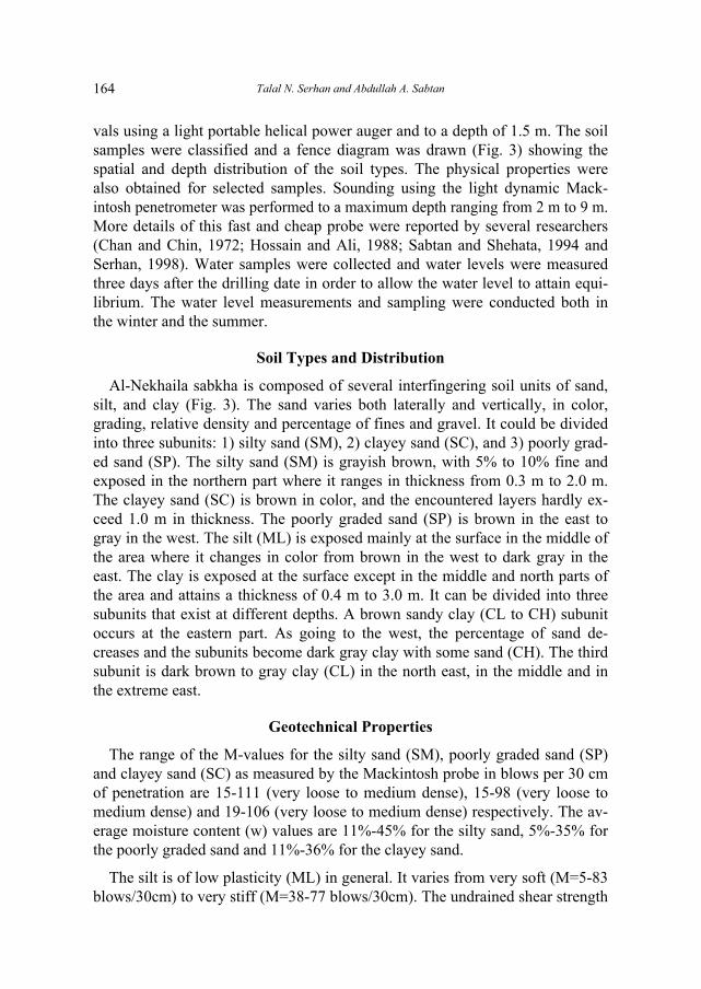
vals using a light portable helical power auger and to a depth of 1.5 m. The soilsamples were classified and a fence diagram was drawn (Fig. 3) showing thespatial and depth distribution of the soil types. The physical properties werealso obtained for selected samples. Sounding using the light dynamic Mack-intosh penetrometer was performed to a maximum depth ranging from 2 m to 9 m.More details of this fast and cheap probe were reported by several researchers(Chan and Chin, 1972; Hossain and Ali, 1988; Sabtan and Shehata, 1994 andSerhan, 1998). Water samples were collected and water levels were measuredthree days after the drilling date in order to allow the water level to attain equi-librium. The water level measurements and sampling were conducted both inthe winter and the summer.
Soil Types and Distribution
Al-Nekhaila sabkha is composed of several interfingering soil units of sand,silt, and clay (Fig. 3). The sand varies both laterally and vertically, in color,grading, relative density and percentage of fines and gravel. It could be dividedinto three subunits: 1) silty sand (SM), 2) clayey sand (SC), and 3) poorly grad-ed sand (SP). The silty sand (SM) is grayish brown, with 5% to 10% fine andexposed in the northern part where it ranges in thickness from 0.3 m to 2.0 m.The clayey sand (SC) is brown in color, and the encountered layers hardly ex-ceed 1.0 m in thickness. The poorly graded sand (SP) is brown in the east togray in the west. The silt (ML) is exposed mainly at the surface in the middle ofthe area where it changes in color from brown in the west to dark gray in theeast. The clay is exposed at the surface except in the middle and north parts ofthe area and attains a thickness of 0.4 m to 3.0 m. It can be divided into threesubunits that exist at different depths. A brown sandy clay (CL to CH) subunitoccurs at the eastern part. As going to the west, the percentage of sand de-creases and the subunits become dark gray clay with some sand (CH). The thirdsubunit is dark brown to gray clay (CL) in the north east, in the middle and inthe extreme east.
Geotechnical Properties
The range of the M-values for the silty sand (SM), poorly graded sand (SP)and clayey sand (SC) as measured by the Mackintosh probe in blows per 30 cmof penetration are 15-111 (very loose to medium dense), 15-98 (very loose tomedium dense) and 19-106 (very loose to medium dense) respectively. The av-erage moisture content (w) values are 11%-45% for the silty sand, 5%-35% forthe poorly graded sand and 11%-36% for the clayey sand.
The silt is of low plasticity (ML) in general. It varies from very soft (M=5-83blows/30cm) to very stiff (M=38-77 blows/30cm). The undrained shear strength

Geotechnical and Geochemical Properties of Al-Nekhaila... 165
FIG.
3. F
ence
dia
gram
of
the
diff
eren
t soi
l typ
es o
f A
l-N
ekha
ila S
abkh
a.

Talal N. Serhan and Abdullah A. Sabtan166
(Su-value) of the silt ranges from 12 kN/m2® very soft) to 140 kN/m2® very stiff).The range of the moisture content (w) is 16% - 73%. The low plasticity siltchanges gradually into silt with high plasticity (MH) in the north east. The aver-age M-value is 18 blows/30cm (soft) and the moisture content is 52%-64%.
The characteristics of the clay (CL or CH) at different locations are dem-onstrated in Table 1. The plastic limits of the lean clay (CL) and the fat clay
TABLE 1. Some characteristics of the clay
Station 2 8 10 11 13number (CL) (CH) (CL) (CL) (CL)
Field density 1.93 1.63 1.73 1.87 1.63(g/cm3)
Specific gravity 2.87 2.57 2.40 2.68 2.64
Dry density 1.53 1.02 1.25 1.40 1.09(g/cm3)
Saturated density 2.00 1.63 1.73 1.88 1.68(g/cm3)
Voids ratio 0.88 1.51 0.93 0.91 1.43
Porosity 0.47 0.60 0.48 0.48 0.59
Degree of 85.4 99.5 99.3 98.9 91.7 saturation (%)
M-value blows/30 20-110 11-56 10-24 17-63 15-24cm
Su (KN/m2) 36-60 27-45 24-35 70-155 57-78
Note: The first two properties were determined according to ASTM standards. Thethird through the seventh property were calculated using numerical equations.
(CH) vary between 18.5%-26.2% and 27.5% - 30.8% respectively. The liquidlimits for the lean clay and the fat clay are in the range of 27.2%-45.7% and51.0% - 67.4% respectively. The range of natural water content of CL is 11.9%-71.3%, and of CH is 11.4%-67.0%. From Table 2 it can be observed that themoisture content for the various types of clays is always larger than its plasticlimit but is smaller than its liquid limit. The M-value may be as low as 8 blows/30 cm for the brown soft lean sandy clay but could reach 110 blows for the graystiff clay. The M-value of the fat clay ranges from 6 to 43 blows/30cm. The un-drained shear strength (Su) values of the lean clay and the fat clay are 10 kN/m2
to 157 kN/m2 and 26 kN/m2 to 155 kN/m2 respectively which are very soft tovery stiff for both of them. Fig. 4 shows a section crossing Al-Nekhaila sabkha

Geotechnical and Geochemical Properties of Al-Nekhaila... 167
from south west to northeast. It shows the interfingering character of the differ-ent soil types, the lenticular character of the silt bodies and the extensiveness ofthe clay layer. It also shows the M-values and shear strength values at the differ-ent levels. The mineral smectite, kaolinite, illite and chlorite, arranged in theirrelative decreasing abundance, were identified as the existing clay minerals us-ing the X-Ray diffraction technique. No quantitative estimates of their abun-dance could be determined with the available equipment.
TABLE 2. The average natural water content (w%), plastic limit (PL) and liquidlimit (LL) of various types of clay .
Clay type Unified class w% PL PL
Soft clay CL 32 21 37
(10 blows/30 cm) CH 57 30 67
Medium clay CL 30 23 38
(25 blows/30 cm) CH 31 28 53
Very stiff clay CL 33 24 41
(45 blows/30 cm) CH � � �
Geochemistry of Soil and Groundwater
The salts in the soil concentrate in the upper crust and decrease graduallywith depth (Fig. 5). It is observed that the sulfate and calcium have the highestconcentrations. The average sulfate content at a depth of 1.5 m is about 2% to4% and the calcium is 4% to 6%. The dry salts do not attack concrete, but theybecome reactive under wet conditions. The depth to the water level in Al-Nekhaila sabkha ranges from 1.0 to 2.5 m and the fluctuation in the water levelbetween the dry period (summer) and the wet period (winter) varies between0.2 m to 0.3 m. It is therefore expected that the present salts will have a bad im-pact on any foundation placed in this soil.
The maximum water level fluctuation could be observed in the north, whichindicates that the sabkha is recharged mainly from the sea, and to a lesser extentfrom the valley in the north. About 24 groundwater samples were collected andthe major cations and anions were analyzed. Table 3 and Fig. 6 show the valuesof these cations and anions in both the summer and winter times. It is obviousthat the salt content increases during the summer because of the increase in therate of soil evaporation and the decrease in the fresh water recharge. The in-crease is clearer in the Cl and Na+K contents for being more mobile and easilysoluble in water. The average total dissolved solids (TDS) of the groundwater

Talal N. Serhan and Abdullah A. Sabtan168
FIG. 4
. T
he s
oil l
ayer
s in
a N
E-S
W c
ross
sec
tion,
sho
win
g th
e M
-val
ues,
and
the
undr
aine
d sh
ear
stre
nght
.

Geotechnical and Geochemical Properties of Al-Nekhaila... 169
ranges between 55000 to 95000 ppm in the winter. Therefore, the groundwatercan be classified mostly as saline water (less than 100,000 ppm). But thegroundwater exceeds this value during the summer and range from 75000 to115000 ppm and becomes brine according to the classification given by Carroll(1962)Æ
FIG. 5. Chemical analysis of the upper crust of Al-Nekhaila Sabkha.
TABLE 3. Anion and cation contents in the groundwater.
Average values
December 1995 August 1996epm ppm epm ppm
Na + K 475 14700 800 24800
Ca 50 1000 125 2500
Mg 100 1200 175 2100
Cl 525 18600 800 28400
SO4 51 2560 70 3500
HCO3 + 0 0 0 0
CO3
TDS 55000 - 95000 ppm 75000 - 115000 ppm range
Anion orcation

Talal N. Serhan and Abdullah A. Sabtan170
Geotechnical Practice
The weak clay layer is expected to be a source of geotechnical problems suchas low bearing capacity and settlement. It extends to a depth ranging from 1.5 mto about 3.0 m below the ground surface. An isopach map (Fig. 7) is drawn toshow the thickness of the clay layer in Al-Nekhaila sabkha. The thickness wasfound to range between zero to up to 4 m and special care should be consideredwhere the clay layer is thick. The smectite has a swelling characteristics and itspresence may cause additional geotechnical problems and should be considered.
According to Bowles (1982) the minimum SPT N-value of the medium densesand and the hard cohesive soils is 8. Based on Sabtan and Shehata (1994) it isequivalent to an M-value of 85 and 72 respectively. Therefore, the M-value of
FIG. 6. Chemical analysis of the groundwater of Al-Nekhaila Sabhka.

Geotechnical and Geochemical Properties of Al-Nekhaila... 171
FIG. 7
. Is
opac
h co
ntou
r m
ap o
f th
e pr
oble
mat
ic c
lay
laye
r.

Talal N. Serhan and Abdullah A. Sabtan172
85 and above (whether granular or cohesive) is considered to represent a safesoil layer that can withstand reasonable static construction load. A contour mapfor the depth of this layer in Al-Nekhaila sabkha and a surface map for the el-evation of its upper boundary were produced (Fig. 8). It can be seen that thedepth to the safe bed varies from 1.0 m to 5.7 m. Since the salts as cementingmaterial between the soil grains decreases rapidly with depth (Fig. 5), the saltcontent in the safe bed can be assumed to be minimum and the bed is chem-ically inactive. Furthermore, a refusal bed with an M-value of more than 300blows was encountered at 3 m to 9 m below the ground surface (Fig. 9) whichcan be considered in case of major construction projects.
FIG. 8. Structural contour map of the depth to the surface of the safe bed.

Geotechnical and Geochemical Properties of Al-Nekhaila... 173
FIG. 9. Structural contour map of the depth to the surface of the refusal bed.
Talal N. Serhan and Abdullah A. Sabtan174
The sulfate content in the groundwater ranges between 2560 and 3500 ppm.This indicates a condition of sever attack by the sulfate on concrete according toUSBR (1956). The normal practice in Jeddah is to place the foundation at adepth of 1.0 m to 1.5 m. This can be safely applied to the northern section ofAl-Nekhaila sabkha. Other areas, especially the south and east sections, need ei-ther deep foundations or soil improvements.
Conclusions
Al-Nekhaila sabkha is composed of three main soil units: sand, silt, and clay.Each unit is divided further into subunits due to differences in the physical and/or geotechnical properties. The sand subunits are SM, SC and SP while the siltis either ML or MH and the clay is CL or CH. The top crust is hard and saltywith gypsum and anhydrite as cementing material. The water level is 1 m to 2.5m deep and the sabkha is recharged mainly from the sea. The TDS of thegroundwater indicates that it is saline to brine in nature. The M-value of thesand varies from very loose to medium dense. The undrained shear strength ofthe clay shows that it is soft but locally it attains high values to be very stiff.The clay layers and the salt content of the groundwater are expected to causesome geotechnical problems. A safe layer could be located at depths ranging be-tween 1.0 m and 5.7 m. A safer layer for major construction is located at depths3.0 and 9.0 m.
Acknowledgement
The authors wish to express their gratitude to Dr. William Shehata for hishelpful comment, valuable criticisms and professional editing. Special recogni-tion and appreciation are due to Dr. Farook Sharief for his kindness and coop-eration.
References
Ali, Y.A. and West, I. (1983) Relationships of modern gypsum nodules in sabkha of loess tocomposition of brines and sediments in northern Egypt: Jour. Sedimentary Petrology, 53:1151-1168.
Ali, K.M. and Hossain, D. (1988) Geotechnical and geochemical characteristics of Obhor Sub-soil. J.K.A.U. Earth Sc. 1: 205-225.
Ali, S., Kazi, A. and Al-Quhtani, M.B. (1985)Geotechnical aspects of recent lagoonal sabkha de-posits in Jeddah, Proc. 8th South-east Asia Geotechnical Conference, 11-15 March 1985,Kuala Lumpur, 2.1-2.7.
Bahafzullah, A., Fayed, L.A., Kazi, A. and Al-Saify, M. (1993) Classification and distributionof the Red Sea coastal sabkha near Jeddah-Saudi Arabia. Carbonates and Evaporites, 8(1):23-38.
Bowles, J.E. (1982) Foundation Analysis and Design, McGraw-Hill Book Co., 816 p.

Geotechnical and Geochemical Properties of Al-Nekhaila... 175
Carroll, D. (1962) Rainwater as chemical agent of geologic processes-A review, U.S. GeologicalSurvey water-Supply Paper 1535-G, 18 p.
Chan, S.F. and Chin, F.K. (1972) Engineering characteristics of the soil along the Federal High-way in Kuala Lumpur. Proceedings, 3ed South-East Asian Conference on Soil Engineering,Hong Kong, 41-45.
Hossain, D. and Ali, K.M. (1988) Shear strength and consolidation characteristics of Obhorsabkha, Saudi Arabia; Q. J. Eng. Geol., London, 21: 347-359.
Hvorslev, M.J. (1949) Subsurface exploration and sampling of soil for civil engineering pur-poses. U.S. Waterway Experimental Station, Vicksburg, Mississippi, 521 p.
Kinsman, D.J.J. (1969) Modes of Formation, sedimentary associations and diagnostics featuresof shallow water and supratidal evaporites: A.A.P.G. Bull., 53: 830-840.
Sabtan, A.A. and Shehata, W.M. (1984) Siting for nuclear power plant in Saudi Arabia, Proc.Intern. Conf. Case Hist. In Geotech. Engng., St. Louis, Missouri, USA, 901-904.
Sabtan, A.A. and Shehata, W.M. (1994) Mackintosh probe as an exploration tool, Bull. of Inter.Assoc. of Eng. Geol. 50: 11-16.
Serhan, T.N. (1998) The effect of moisture and salts on the shear strength of Al-Nekhaila sabkha,South of Jeddah, M.Sc. Thesis, King Abdulaziz University, Jeddah, Saudi Arabia.
USBR, (1956)Concrete Manual, 6th ed., United States Bureau of Reclamation, 12 p.

Talal N. Serhan and Abdullah A. Sabtan176
�b� »uM� WKO�M�« W���� WOzUOLO�uO'«Ë WOMI�uO'« �«u)«
ÊU��� s� e�eF�« b�� tÒK�«b�� ��Ë�� ÊU�d� n�U� �ö�e�eF�« b�� pK*« WF�U� ,�÷�_« ÂuK� WOK�
W��uF��« WO�dF�« WJKL*«�−��b����
d?��K� W?OK�U?��« �u?N��« �«b?��« v?K� U�?�?��« dA?�M� Æ�hK�?��*«�«bI?� vD��� YO� �UM*« W�u?�� v�≈ U�?���« ÊuJ� ÈeF�Ë Æ�d?L�_«W�d� V?�?�?�Ë Æ��UD�_« U??O??L?� ÃU??�_« Êu?J�� V�??�*« u�Ë d??�??�??��«sJ1Ë Æ�W��� ÊuJ� U�bM� ÎW7U� WOMI�u?O'« q�UA*« s� b�bF�« U����«s� Á«u??�??�??� V�??�� W??�K�?*« W�U??�d??�K� q�P� w?�u??'« ¡U*« V�??�� Ê√
Æ�b�«�uKJ�«Ë U��d�J�«ÊUJ�≈ U�UM� b?O?O?A� ÎU�uM� r�?�Ë ,�WO?�UM�?� W?�d?�� �b?� WM�b?� l�?��ÊuJ�� Y?O?� T�U?A?�« s� W?��d??I�« o�UM*« w� Áb�b??� W��U?& ö??�?�ËW�?�� v�≈ qBO�?� »uM'« ÁU&« w� WM�b*« l�u� d?L��« «�≈Ë Æ� U�?���«ÁcN� W?OzUO?LO�u?O'«Ë W?OMI�uO'« U?HB�« W?�«�� - bI� p�c�Ë Æ�W?KO�M�«,��U�?�√ π oL� v�≈ b?��« w��«Ë ,�W?OKI(« U?7u�?H�« ÊuJ�� Æ�W�?���«Æ�q�d�« ◊Ëd��Ë W�Ëd*U� hI�« ,��u�M�U� f�� :� «�U���« W�ö� s�l� q�� ,�Ã�b?�?� q��® q�d�« :�W�d?��« �«u�_ «b?�Ë W�ö� 5O?F� -5�Ë ©W�Ëb�« w�U?�Ë W�Ëb�« iH?�M�® s�d� ,�©Ã�b?��« d?OI?� q��Ë 5�WL�ô �«u?� W�O� vK� Õö�_« b�u�Ë Æ�©W�Ëb�« w?�U�Ë W�Ëb�« iH�M�®t�≈ q�d�« d??�?� �� b?�Ë Æ�`D�?�« s� �Ë_« d?�*« w� W�d??��« U?�?O??�?� 5�hI�« �u?� WL?O� �bF?� ÊU�Ë Æ�p�U?L��« j�u?��Ë pJH?� 5� U� ÕË«d?��d?�?� qJ� s�u?O�uKO?� π∞ 5DK?�Ë l�d?� d�?� qJ?� s�u?O�uKO?� ∏¥ s�d?GK�mK��Ë Æ�5D�« WI�� s� W?OMI�uO'« q�UA*« s� �b� ÀËb?� l�u��Ë Æ�l�d�v�≈ `K� s?� ÕË«d?��Ë d?�?� ≤\µ v?�≈ b?�«Ë d?�?� s?� ¡U*« Èu?�?�??� oL?�
Æ�ÃU�√