Geospatial timeline Mount Vernon
25
Geospatially Enhancing George Washington’s Timeline The five fundamental themes of geography are Location (absolute and relative), Place (human and physical characteristics), Region (areas of similar physical and/or human characteristics), Movement, and Human-Environment Interaction. Here we use the themes of Location, Place, and Human- Environment Interaction to add geospatial perspective to four sections of the George Washington timeline - 1753 Ohio River Valley Mission 1776 Fortification of Ft. Boston 1787 Samuel Vaughn’s Journal of Mount Vernon and Source: http://www.mountvernon.org/georgewashington , accessed 11 Aug 2014
-
Upload
visualteachingtechnologies -
Category
Education
-
view
771 -
download
0
Transcript of Geospatial timeline Mount Vernon

Geospatially Enhancing George Washington’s Timeline
The five fundamental themes of geography are Location (absolute and relative), Place (human and physical characteristics), Region (areas of similar physical and/or human characteristics), Movement, and Human-Environment Interaction.
Here we use the themes of Location, Place, and Human-Environment Interaction to add geospatial perspective to four sections of the George Washington timeline -
1753 Ohio River Valley Mission1776 Fortification of Ft. Boston1787 Samuel Vaughn’s Journal of Mount Vernonand 1790 Selecting the Site for the CapitolSource: http://www.mountvernon.org/georgewashington, accessed 11 Aug
2014
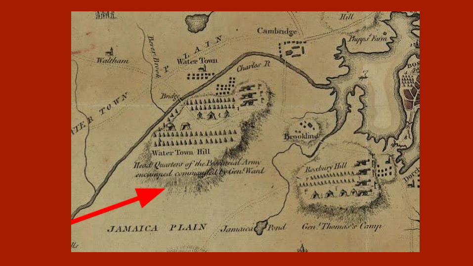
Map Title and text: A Plan of the Town and Harbour of Boston.and the country adjacent to the Road from Boston to Concord Showing the Place of the Late engagement between the King’s Troops & the Provincials, together with the several encampments of both Armies in & about Boston.Note the Headquarters of the “Provincial Army,” located on Water Town Hill west of Boston. The location discussed in the timeline is located due south of Boston -- Dorchester Heights (Encyclopedia Virginia)Also of note: The map shows troop locations and movement during and following the opening battle of the Revolutionary War.-Emmett Moloney
Map Title and text: A Plan of the Town and Harbour of Boston.and the country adjacent to the Road from Boston to Concord Showing the Place of the Late engagement between the King’s Troops & the Provincials, together with the several encampments of both Armies in & about Boston.Note the Headquarters of the “Provincial Army,” located on Water Town Hill west of Boston. The location discussed in the timeline is located due south of Boston -- Dorchester Heights (Encyclopedia Virginia)Also of note: The map shows troop locations and movement during and following the opening battle of the Revolutionary War.-Emmett Moloney
Full image of Boston and surrounding area currently in use on the Washington Timeline. Does not illustrate the events discussed in the timeline very well. However, the full image (not currently used on the website) is a good starting point.-Emmett Moloney

Ohio River Valley Mission1753
Source: http://www.mountvernon.org/georgewashington, accessed 11 Aug 2014

Location: Where is the Ohio River Valley? → The Ohio River Valley does not only refer to the modern state of Ohio. Place: What borders and boundaries were in place in 1753? How do these borders compare to today’s?
- Historical maps show that state boundaries in 1753 extended much further west.
This image is the title page of the journal that Major George Washington kept during his Ohio River mission.
Maps to enhance understanding→ http://www.loc.gov/resource/g3300.ar004200/ (date of publish: 13 Feb 1755)
Shows the world Ohio river valley as it was known in the time that Washington conducted his mission
Compare to the modern state lines, terrain, and Scale.
→ http://www.loc.gov/resource/g3707o.ar077200/ (No date found so far -- “Before 1753”)
Shows what kind of maps existed of the Ohio River Valley during that time period.
Good example of the way maps looked in the 1750s. Again, line up next to modern maps to show the differences that we are
talking about.
→ http://www.loc.gov/resource/g3820.ct000361/Washington’s own survey of the Ohio River Valley

Historical note: The colonies of Virginia, North Carolina, South Carolina, and Georgia all claimed land extending far beyond their modern western borders.
Major George Washington’s mission to survey the Ohio River Valley covered terrain that was not inside the modern state of Ohio. At the time of this mission, Washington was serving in the British Army, following orders by the colonial Governor.

Modern area of Ohio River Valley mission made using (https://www.mapbox.com/)
Compare the modern borders of states in the Ohio River Valley to the colonial territories

Source: The Journal of Major George Washington, Sent by the Hon. Robert Dinwittie, Esq., His Magisty’s Lieutienent Governor and Commander in Chief of Virginia...with a New Map of the Country as far as the Mississippi (October 1753-January 1754). University of Pittsburgh, University Library, University Library System -Internet Archive https://archive.org/details/journalofmajorge00wash (accessed 08 Aug 2014).
This map details the area that Major Washington scouted during the mission covered in the interactive timeline.
Like Slide 3, this map shows the colonial borders of North Carolina and Virginia.

Fortifying of Boston1776
Source: http://www.mountvernon.org/georgewashington, accessed 11 Aug 2014
Dorchester Heights
Location- The fortifications, referenced in the Mount Vernon timeline, were placed on Dorchester Heights (Encyclopedia Virginia).
Period maps can be used in conjunction with recent topographic or street maps to convey where events occurred in the context of modern locations.
Place- Consider the physical characteristics of Boston and its surrounding area. Describe these themes in 1776. How are they different today?
** Boston in the 1700s looked nothing like it does today → naturally Boston is a small area of land connected by a very thin land bridge.
Human-Environment Interaction- Consider the physical characteristics of Boston area in 1776. What could have been environmental challenges that would have impacted American and British militaries as well as the civilian population?
Create a clickable area that brings up the image in slide 5-Emmett Moloney
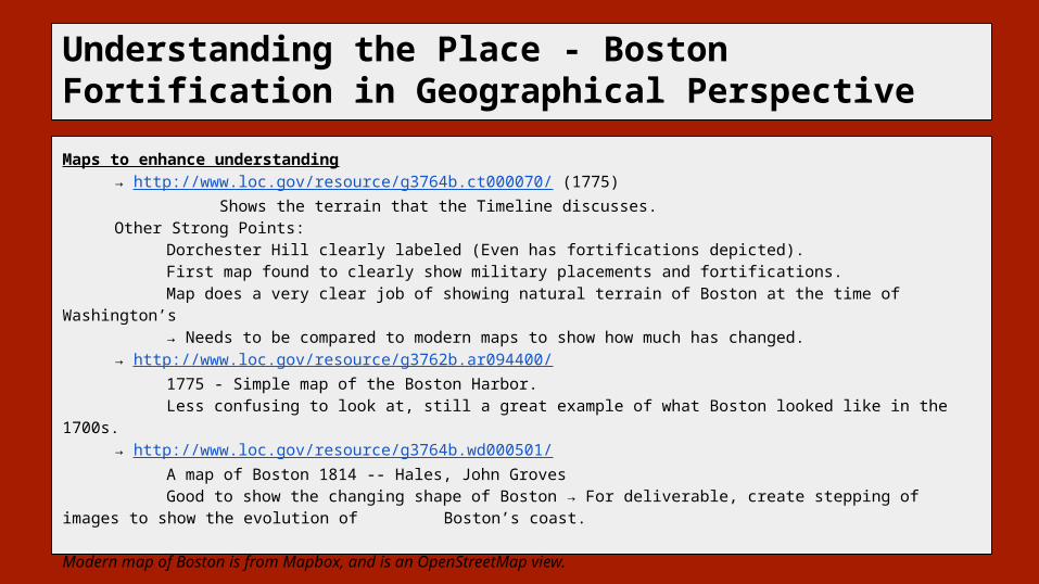
Understanding the Place - Boston Fortification in Geographical Perspective
Maps to enhance understanding→ http://www.loc.gov/resource/g3764b.ct000070/ (1775) Shows the terrain that the Timeline discusses. Other Strong Points:
Dorchester Hill clearly labeled (Even has fortifications depicted). First map found to clearly show military placements and fortifications.Map does a very clear job of showing natural terrain of Boston at the time of Washington’s → Needs to be compared to modern maps to show how much has changed.
→ http://www.loc.gov/resource/g3762b.ar094400/1775 - Simple map of the Boston Harbor. Less confusing to look at, still a great example of what Boston looked like in the 1700s.
→ http://www.loc.gov/resource/g3764b.wd000501/A map of Boston 1814 -- Hales, John GrovesGood to show the changing shape of Boston → For deliverable, create stepping of images to show
the evolution of Boston’s coast.
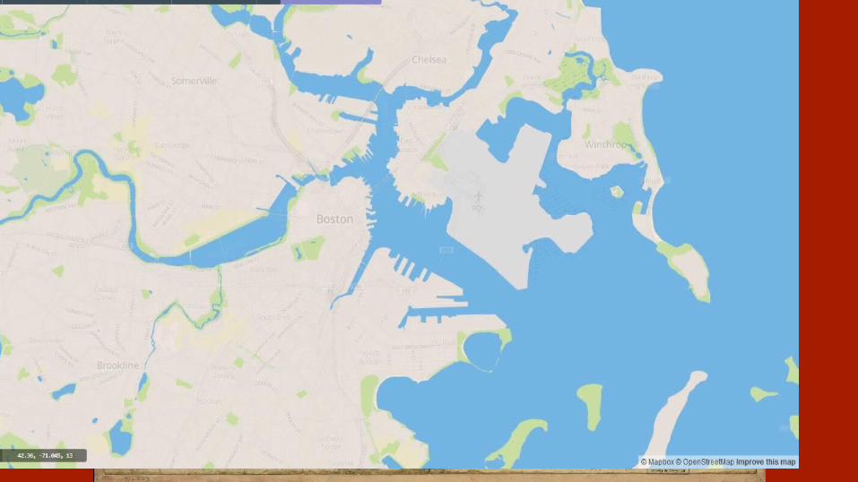
Modern map of Boston is from Mapbox, and is an OpenStreetMap view.

Points of Interest in this ImageThis map depicts the “Rebel Works” in the areas around Boston, which is referenced in the timeline.
1 Dorchester Heights, Location of Washington’s fortifications
2 Boston [Create embedded image that brings up the modern Boston shoreline and clearly illustrates landfill that has occurred].
3 Charlestown -Reference modern Boston
4 Illustration of troop placements near Boston
Allow Zoom on this Image, up to max resolution.
Allow Zoom on this Image, up to max resolution.-Emmett Moloney

Create a zoom/fade effect that helps maintain a mental connection with the terrain seen in the previous image.
Create image caption that explains the two different shorelines being shown on the same map.
(Possibly use a color highlight that fades up on button click to show the two different images more easily)
This map shows the historical and modern shorelines of Boston.
The historical shoreline is irregular and lined in several concentric lines.
This map shows the historical and modern shorelines of Boston.The historical shoreline is irregular and lined in several concentric lines.-Emmett Moloney

A plan of the town and Harbor of Boston
Map shows the countryside adjacent to the road from Boston to Concord. It illustrates the place of the late engagement between King’s troops and the Provincials, together with the several encampments of both Armies in and about Boston.
The location discussed in the timeline —Dorchester Heights--is located due south of Boston
Map Title and text: A Plan of the Town and Harbour of Boston.and the country adjacent to the Road from Boston to Concord Showing the Place of the Late engagement between the King’s Troops & the Provincials, together with the several encampments of both Armies in & about Boston.Note the Headquarters of the “Provincial Army,” located on Water Town Hill west of Boston. The location discussed in the timeline is located due south of Boston -- Dorchester Heights (Encyclopedia Virginia)Also of note: The map shows troop locations and movement during and following the opening battle of the Revolutionary War.-Emmett Moloney


It also shows the Headquarters of the “Provincial Army,” located on Water Town Hill west of Boston.
The map shows troop locations and movement during and following the opening battle of the Revolutionary War.
Map Title and text: A Plan of the Town and Harbour of Boston.and the country adjacent to the Road from Boston to Concord Showing the Place of the Late engagement between the King’s Troops & the Provincials, together with the several encampments of both Armies in & about Boston.Note the Headquarters of the “Provincial Army,” located on Water Town Hill west of Boston. The location discussed in the timeline is located due south of Boston -- Dorchester Heights (Encyclopedia Virginia)Also of note: The map shows troop locations and movement during and following the opening battle of the Revolutionary War.-Emmett Moloney
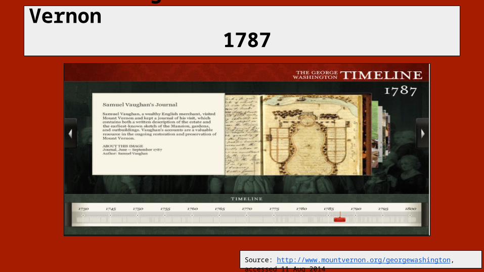
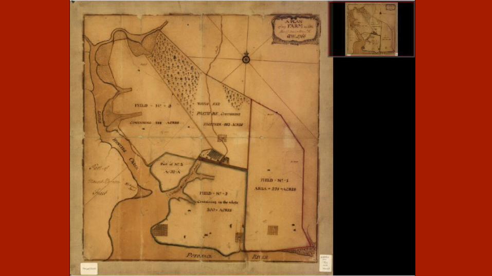
Samuel Vaughn’s Journal of Mount Vernon1787
Source: http://www.mountvernon.org/georgewashington, accessed 11 Aug 2014
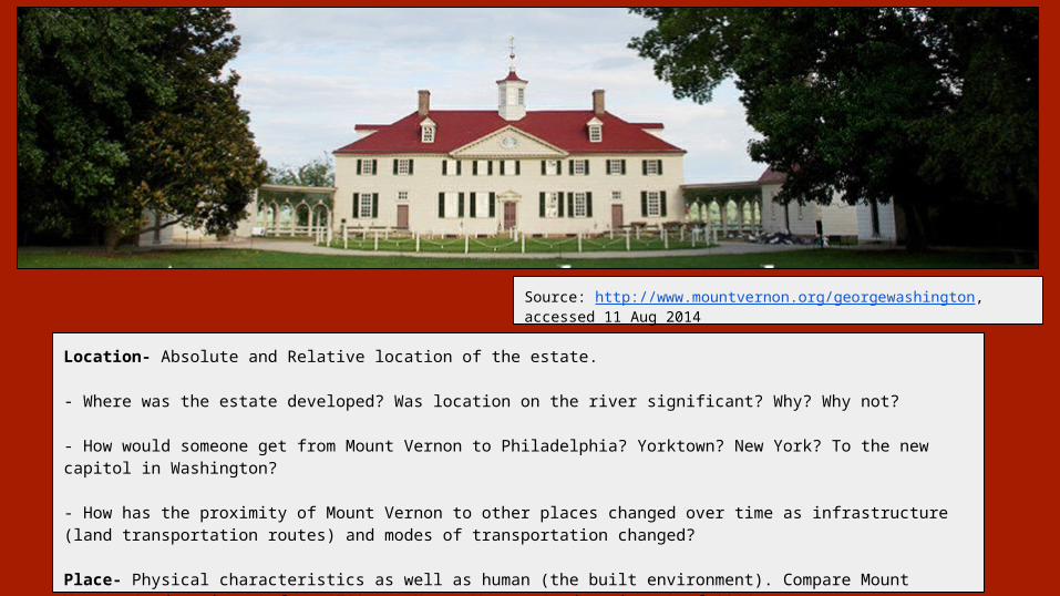
Location- Absolute and Relative location of the estate.
- Where was the estate developed? Was location on the river significant? Why? Why not?
- How would someone get from Mount Vernon to Philadelphia? Yorktown? New York? To the new capitol in Washington?
- How has the proximity of Mount Vernon to other places changed over time as infrastructure (land transportation routes) and modes of transportation changed?
Place- Physical characteristics as well as human (the built environment). Compare Mount Vernon (and environs) from 1790s to Mount Vernon (and environs) of 2014.
Source: http://www.mountvernon.org/georgewashington, accessed 11 Aug 2014

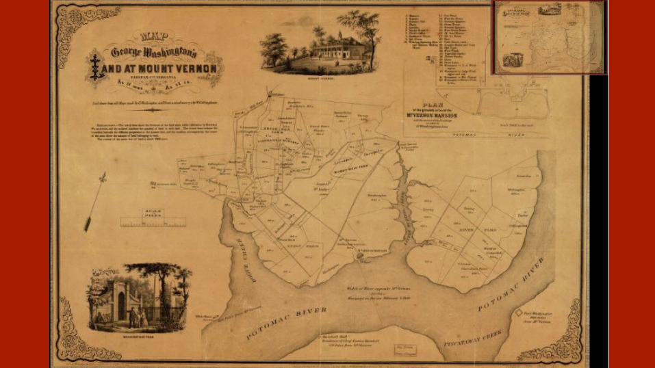
Maps to enhance understanding→ http://www.loc.gov/resource/g3882m.ct002394/
Context of the land surrounding the estate
This map already overlays historical and modern map data (Just needs to be done in a more user understandable fashion.)
Modern Example → E:\VTT\GoogleVernon
→ http://www.loc.gov/resource/g3882m.ct000085/ Drawn By G.W. - Good example of his
work, with signature easily discoverable by students. Perhaps a part of this could be creating
a “See the works of Gen. Washington” section, in the fashion of the timeline section.
→ http://www.loc.gov/resource/g3882m.ct000367/Second maps of the Mount Vernon
Property


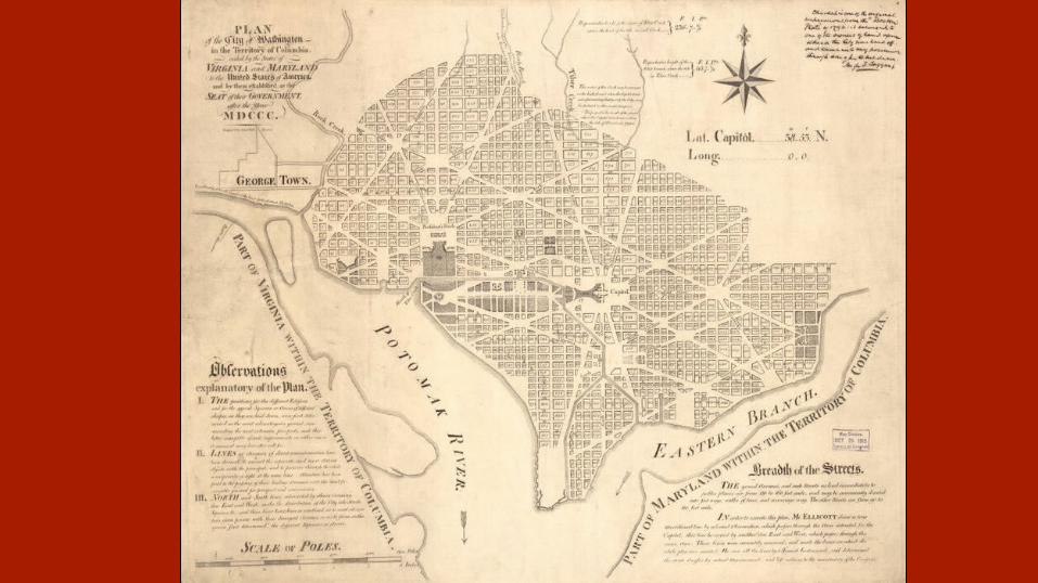
Selecting The Site of the Capital1790
Source: http://www.mountvernon.org/georgewashington, accessed 11 Aug 2014
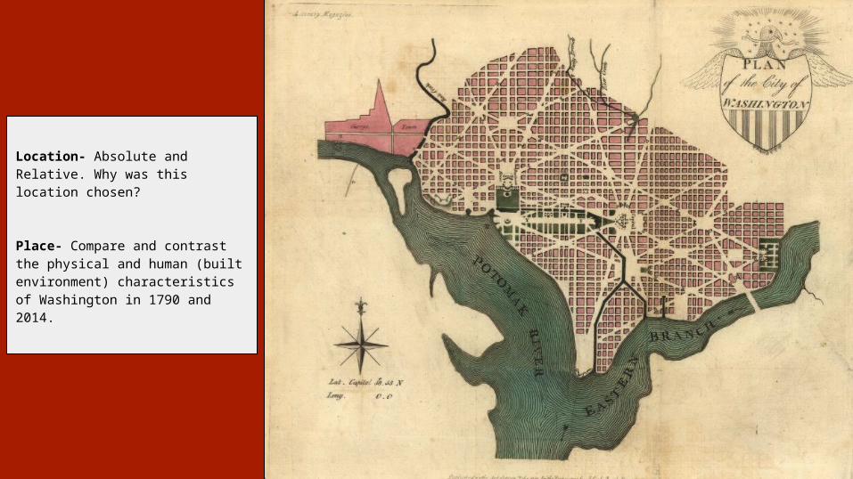
Location- Absolute and Relative. Why was this location chosen?
Place- Compare and contrast the physical and human (built environment) characteristics of Washington in 1790 and 2014.


![Mount Vernon signal.. (Mt. Vernon, Ky.) 1900-11-02 [p ].](https://static.fdocuments.us/doc/165x107/61d9522f8ef55a41e963bedc/mount-vernon-signal-mt-vernon-ky-1900-11-02-p-.jpg)