Geospatial Enabled Analytical Solutions for Defence ......• IBM i2 Analyst’s Notebook Connector...
17
Geospatial Enabled Analytical Solutions for Defence & Security Forces Col Pradeep Bhat (Retd) Associate Director, Govt Industry Solutions IBM India Pvt Ltd
Transcript of Geospatial Enabled Analytical Solutions for Defence ......• IBM i2 Analyst’s Notebook Connector...

Geospatial Enabled
Analytical Solutions for
Defence & Security Forces
Col Pradeep Bhat (Retd)
Associate Director, Govt Industry Solutions
IBM India Pvt Ltd
© 2018 IBM Corporation
Unlike all other natural resources, Data is a commodity,
which is created with time, will always be in abundance and
gets more enhanced the more it is consumed
2 IBM Proprietary05 Jun 2018
Data – The New Natural Resource

© 2018 IBM Corporation
Geo Enabled Data Analytics
3 IBM Proprietary11/01/2018
Captured
Detected
Inferred
Defence & Security Forces can improve their operational effectiveness by
increasing the level of geo-enabled analytical sophistication
Structured Data
Geospatial Data
Unstructured Content
Descriptive
Analytics
Prescriptive
Analytics
Predictive
Analytics
Made consumable and
accessible to everyone,
optimised for their
specific purpose, through:
What if
these
trends
continue?
Forecasting
How can we
achieve the best
outcome and
address variability?
Stochastic
Optimization
What
happened
?
What
exactly is
the
problem?
How
many, how
often,
where?
What
actions are
needed?
What could
happen?
Simulation
How can we
achieve the best
outcome?
Optimization
What will
happen
next if?
Predictive
Modelling
Analytics Sophistication
Cognitive
Analytics
How can we
interact in a
natural
language?
NLP
How can we
get reasoning
behind the
decisions?
Cognition
How can the
system learn
with
experience?
Cognition

© 2018 IBM Corporation
The Landscape – Devices & Apps
4 IBM Proprietary05 Jun 2018
Dets/
SubUnits
Field
Units
Field Fmn
HQs
Comd &
Army HQs
Mobile/ Rich
Client/ Web Client
Org Levels Devices App & GIS
Deployment
Local Server
applications
Private Cloud
Tri-Service &
External
Organisations
Federated Cloud/
Govt of India Cloud
Service Providers
App & GIS
Versions
Mobile/ Desktop
Workgroup
Enterprise
Cloud
As a ServicePlatforms
IaaS & PaaS
IBM Cloud & Cognitive
Services, Google, ESRI,
MapMyIndia, Digital Globe,
Mapbox, Pitney Bowes...Developers

© 2018 IBM Corporation
The Landscape – Users & Data
Communities
Ops & Int
Logistics
Admin
Self Service
5 IBM Proprietary05 Jun 2018
Democratization of IT - Analytics as a Service
User Interactions
Self Service – Individuals & Appointments
Collaborative – User Groups & Communities
Enterprise – Within & across the organisation
Services
Geolocation
Spatial Analytics
Decision Support
Analytical
Data Types
Structured
Semi-structured
Unstructured
GIS Data
Sources
Internal
Other Govt Orgs
Private Sources
Platform Providers
Security
Users/Appts – Ids, Role based Access
Apps – Code, Runtime, In Execution
Data – At Rest, In Transit Encryption
Content – Masking, Redaction
© 2018 IBM Corporation
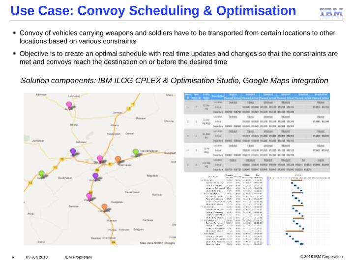
Use Case: Convoy Scheduling & Optimisation
▪ Convoy of vehicles carrying weapons and soldiers have to be transported from certain locations to other
locations based on various constraints
▪ Objective is to create an optimal schedule with real time updates and changes so that the constraints are
met and convoys reach the destination on or before the desired time
6 IBM Proprietary05 Jun 2018
Solution components: IBM ILOG CPLEX & Optimisation Studio, Google Maps integration

© 2018 IBM Corporation
IBM i2 Analyst’s Notebook ESRI Integration
7 IBM Proprietary05 Jun 2018
• IBM i2 Analyst’s Notebook Connector for Esri integrates Esri’s ArcGIS Server geospatial
functionalities to the visualization capabilities of IBM i2 Analyst’s Notebook.
• Enables users to perform association, temporal and geospatial analysis in a single work
environment and build a detailed and robust analysis picture more quickly.
WHO/WHAT
WHEN
WHERE
© 2018 IBM Corporation
IBM Proprietary
Link Analysis
WHO/WHAT
Temporal Analysis
WHEN
Specialized GIS
AnalysisIntel. Analysis
Related GIS
WHEREWHERE
Specialist GIS
Analysis Teams
Intelligence Analysis
Teams
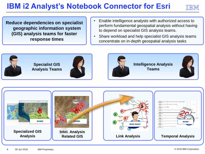
IBM i2 Analyst’s Notebook Connector for Esri
8 05 Jun 2018
• Enable intelligence analysts with authorized access to
perform fundamental geospatial analysis without having
to depend on specialist GIS analysis teams.
• Share workload and help specialist GIS analysis teams
concentrate on in-depth geospatial analysis tasks
Reduce dependencies on specialist
geographic information system
(GIS) analysis teams for faster
response times
IBM Proprietary

© 2018 IBM Corporation
Point Duty’s Esri GIS Connector for IBM i2 ANB
Point Duty’s Esri Connector for i2 Analyst’s Notebook provides i2 Users with access to full range
of Esri’s current functionality including ArcGIS Portal and persistent map to chart data linking
9 IBM Proprietary05 Jun 2018
© 2018 IBM Corporation
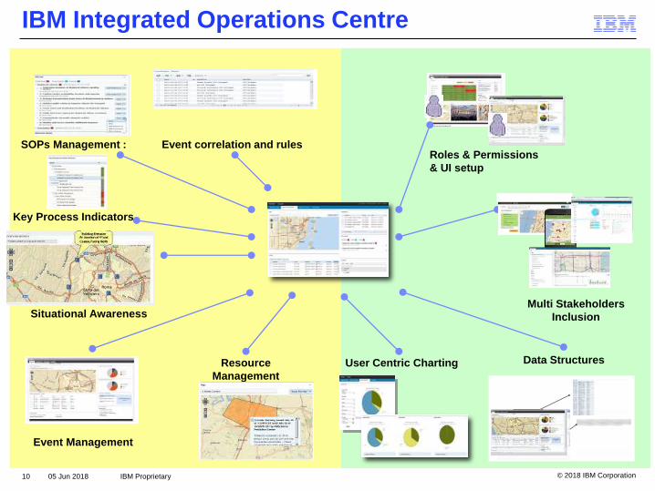
SOPs Management :
Key Process Indicators
Roles & Permissions
& UI setup
Data Structures
Event correlation and rules
Resource
Management
Situational Awareness
Event Management
User Centric Charting
Multi Stakeholders
Inclusion
IBM Integrated Operations Centre
10 IBM Proprietary05 Jun 2018
© 2018 IBM Corporation
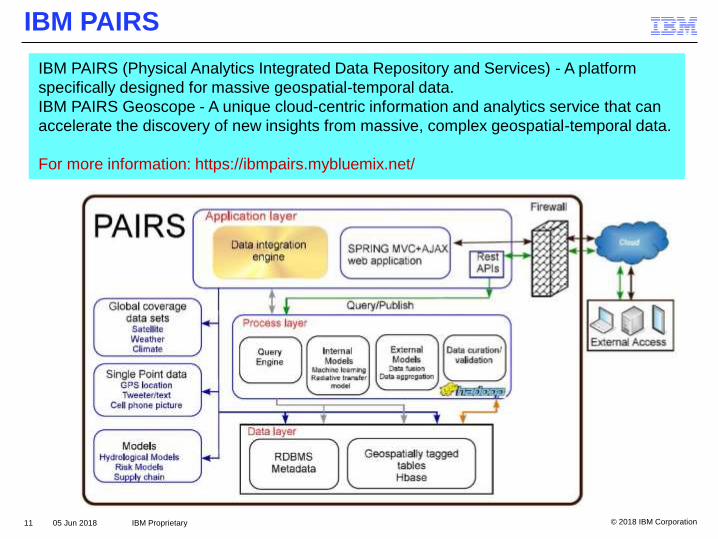
IBM PAIRS
11 IBM Proprietary05 Jun 2018
IBM PAIRS (Physical Analytics Integrated Data Repository and Services) - A platform
specifically designed for massive geospatial-temporal data.
IBM PAIRS Geoscope - A unique cloud-centric information and analytics service that can
accelerate the discovery of new insights from massive, complex geospatial-temporal data.
For more information: https://ibmpairs.mybluemix.net/

© 2018 IBM Corporation
IBM PAIRS Example – Landsat Imagery
Example of a query to produce a single
composite image for a larger area by
aggregating multiple timestamps
12 IBM Proprietary05 Jun 2018
▪ Satellite - Landsat 8, level 1 (USGS and NASA
satellite imagery)
▪ Landsat8 Level 1 Spectral Image of Band 4 (Red)
© 2018 IBM Corporation
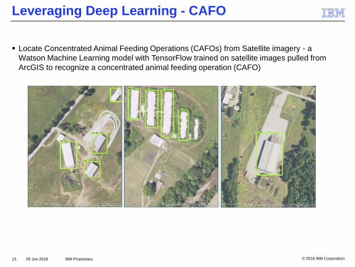
Leveraging Deep Learning - CAFO
▪ Locate Concentrated Animal Feeding Operations (CAFOs) from Satellite imagery - a
Watson Machine Learning model with TensorFlow trained on satellite images pulled from
ArcGIS to recognize a concentrated animal feeding operation (CAFO)
13 IBM Proprietary05 Jun 2018

© 2018 IBM Corporation
Leveraging Visual Recognition – Georgia Power
▪ Identifying broken electrical insulators at Georgia Power using Watson Visual Recognition
and Esri ArcGIS.
▪ Georgia Power uses aerial photography to capture images of their insulators. Then, we can
visualize the data and pass the images to Watson Visual Recognition which infers whether a
given image contains a damaged or broken insulator. Georgia Power has over 17,000 miles
of power lines and 160,000 structures to analyze.
14 IBM Proprietary05 Jun 2018

© 2018 IBM Corporation
Leveraging Visual Recognition – OmniEarth
▪ Application of machine learning to aerial imagery to help solve complicated, multi-layered
and information-heavy problems too daunting for conventional approaches.
▪ OmniEarth solution uses advanced geoanalytics, powered by the IBM Watson Visual
Recognition cognitive service, to process, clarify and fuse vast amounts of satellite and
aerial imagery with other data sets
▪ “If we can determine how much water a property needs on every given day,” says Chelsea
Minton, senior sales engineer at OmniEarth, “and then compare that to how much that
property is actually using, we can calculate exactly how much potential that property or that
homeowner has to save water.”
15 IBM Proprietary05 Jun 2018

© 2018 IBM Corporation
Geospatial Tools & APIs on IBM Cloud Platform
16 IBM Proprietary05 Jun 2018
Geospatial Analytics
GEO Web Services
Weather Company Data
APIs from Pitney Bowes
ESRI ArcGIS for Developers
Mapbox Maps

© 2018 IBM Corporation
Thank You