Geospatial Convergence - Homepage - … · Geospatial Convergence Geospatial Convergence Steven...
25
Geospatial Convergence Geospatial Convergence Steven Eglinton FBCS, FBCart.S Chair, Asset Management SIG, AGI Chair, Business Information Systems SG, BCS RICS, London – June 2015 Slide 1
Transcript of Geospatial Convergence - Homepage - … · Geospatial Convergence Geospatial Convergence Steven...

Geospatial Convergence
Geospatial Convergence
Steven Eglinton FBCS, FBCart.S
Chair, Asset Management SIG, AGI Chair, Business Information Systems SG, BCS
RICS, London – June 2015
Slide 1

Geospatial Convergence Slide 2
Geospatial Convergence
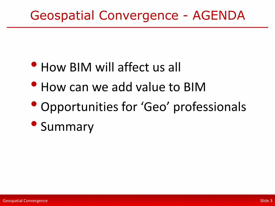
Geospatial Convergence - AGENDA
• How BIM will affect us all
• How can we add value to BIM
• Opportunities for ‘Geo’ professionals
• Summary
Slide 3

Geospatial Convergence
What is BIM?
• Depends who you ask!
• Building Information Models - things
• Building Information Modelling - tasks
• Building Information Management – standards / process(es)
Slide 4

Geospatial Convergence
Building Information Modelling (BIM)
• “An integrated digital process providing coordinated, reliable information about a project and assets throughout all phases, from design through construction and into operation”
• Better Information Management
• For all asset types – buildings and infrastructure
Slide 5

Geospatial Convergence
Building Information Modelling (BIM)
• Cross-discipline collaboration
• Standard methods and procedures
• Information provision is contracted
• Digital Plan of Works (DPoW)
• Enabling tools, workflows and validation
• Exchange formats and standards
• Information / data is a commodity
Slide 6

Geospatial Convergence
Information as a Commodity
• In economics, a commodity is a marketable item produced to satisfy wants or needs
Slide 7
• The challenge we have is the client (employer) might not know their needs!
• The client often knows their ‘wants’
• Often the client is not a Director
Geospatial Convergence
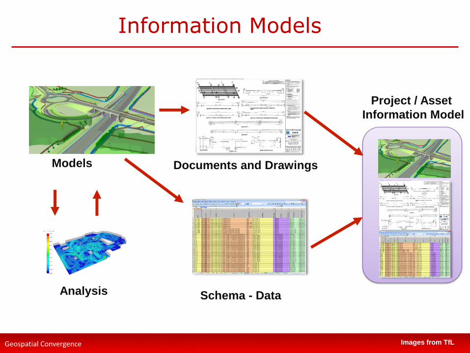
Information Models
Documents and Drawings
Schema - Data
Models
Analysis
Project / Asset
Information Model
Images from TfL

Geospatial Convergence
Common Data Environment
Slide 9
CDE
Plan
Design
Build
Operate
Maintain
Upgrade / Retire
Key is Information Governance
MDM
The REAL Key is PEOPLE

Geospatial Convergence
Common Data Environment - Context
• Common Data Environment (CDE)
• Defined in UK Standards BS 1192:2007
• Elaborated on in PAS 1192-2 and PAS 1192-3
Slide 10
Geospatial Convergence
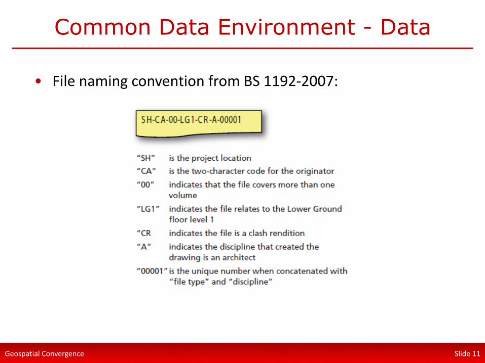
Common Data Environment - Data
Slide 11
• File naming convention from BS 1192-2007:

Geospatial Convergence
Geospatial Convergence
Slide 12
• Capture - Geomatics / Survey
• Plan – Planners, Town Planners
• Design - Architects / Designers
• Build - Client, Contractors, Supply chain
• Operate / Maintain - Client, Contractors, Supply chain
• Map Visualisation – validation, presentation, analytics/reporting, time sequencing, context to projects and assets
Geospatial Convergence
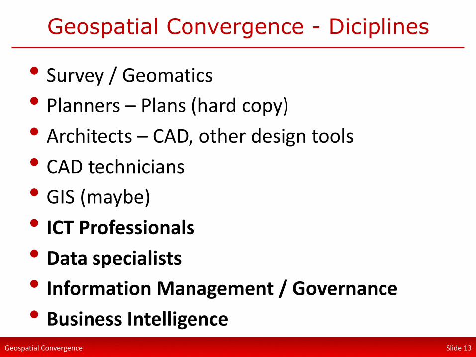
Geospatial Convergence - Diciplines
Slide 13
• Survey / Geomatics
• Planners – Plans (hard copy)
• Architects – CAD, other design tools
• CAD technicians
• GIS (maybe)
• ICT Professionals
• Data specialists
• Information Management / Governance
• Business Intelligence

Geospatial Convergence
Cross-discipline collaboration
Slide 14

Geospatial Convergence
There is lots or jargon
Slide 15
• We can have language challenges!
Shapefiles
Dangling segments
Link-node models
Projections
Vector
Raster
Joins and Links
Points
Polylines
Polygons
Vertices
Snapping
Buffering
GeoProcesses
Dissolve
Merge
Union
Spatial Join
Models
Dynamic segmentation
‘Plotting’ data
GeoCoding
GIS Self-intersecting Polygons
Doughnut
Polygon?

Geospatial Convergence
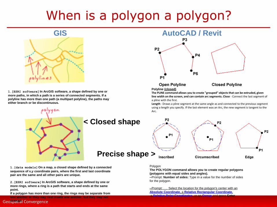
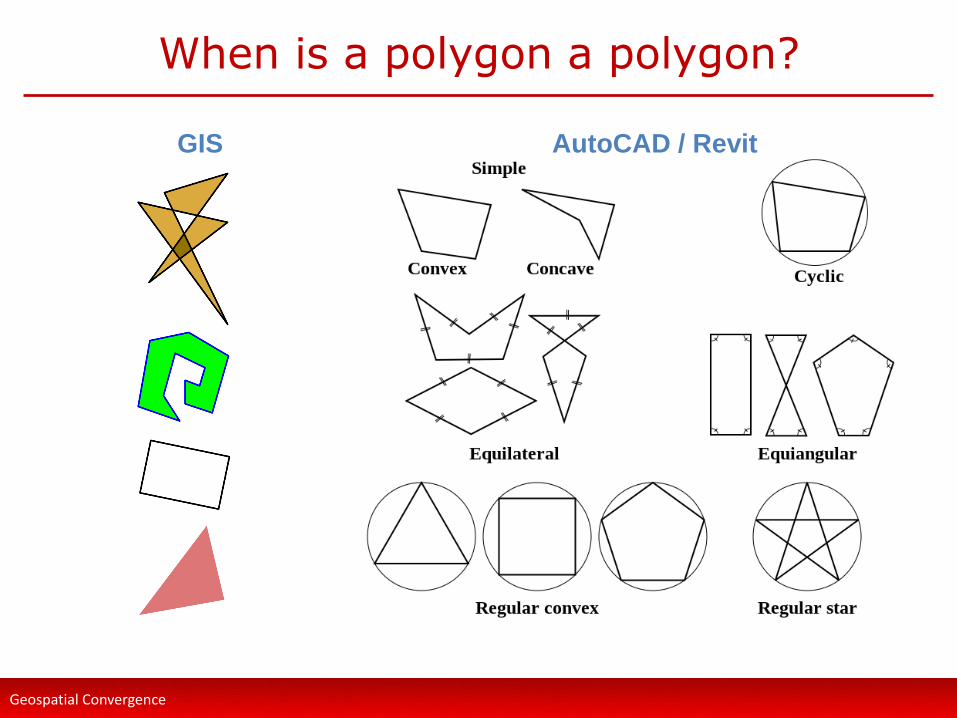
When is a Polygon a Polygon?
Geospatial Convergence
When is a polygon a polygon?
1.[ESRI software] In ArcGIS software, a shape defined by one or
more paths, in which a path is a series of connected segments. If a
polyline has more than one path (a multipart polyline), the paths may
either branch or be discontinuous.
1.[data models] On a map, a closed shape defined by a connected
sequence of x,y coordinate pairs, where the first and last coordinate
pair are the same and all other pairs are unique.
2.[ESRI software] In ArcGIS software, a shape defined by one or
more rings, where a ring is a path that starts and ends at the same
point.
If a polygon has more than one ring, the rings may be separate from
one another or they may nest inside one another, but they may not
overlap.
Polygon
The POLYGON command allows you to create regular polygons
(polygons with equal sides and angles).
--Prompt: Number of sides: Type in a value for the number of sides
for the polygon.
--Prompt: Edge/ <Center of polygon>: Select the location for the polygon's center with an
Absolute Coordinate, a Relative Rectangular Coordinate,
a Relative Polar Coordinates, or an Osnap and press Enter.
Polyline (closed) The PLINE command allows you to create "grouped" objects that can be extruded, given line width on the screen, and can contain arc segments. Close - Connect the last segment of a pline with the first. Length - Draws a pline segment at the same angle as and connected to the previous segment using a length you specify. If the last element was an Arc, the new segment is tangent to the Arc.
< Closed shape
GIS AutoCAD / Revit
Precise shape >
Geospatial Convergence
When is a polygon a polygon?
GIS AutoCAD / Revit

Geospatial Convergence
How does GIS add value to BIM?
• Persuading design teams to utilise (at any level) what GIS type data can bring to a project:
• Align project to World to other coordinates system
• Provides ability to utilise:
• BIM 360 Glue
• Sun tracking in Revit
• Ground topography
• Existing buildings / asset data
• Transport and services data
• Linear assets
• Augmented reality
• Laser scans
• Rights of light

Geospatial Convergence
How to tackle the language challenge?
Slide 20
Geospatial Convergence
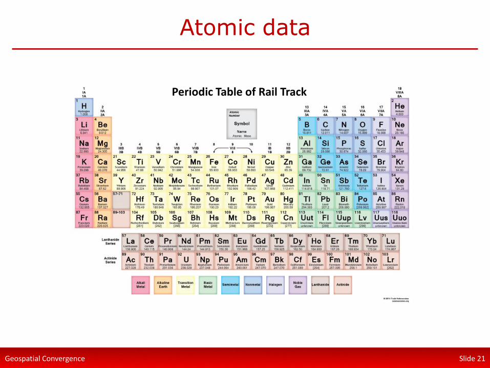
Atomic data
Slide 21
Periodic Table of CAD Periodic Table of GIS Periodic Table of Survey Periodic Table of ICT (Geo) Periodic Table of Rail Civils Periodic Table of Rail Track Periodic Table of Rail Track

Geospatial Convergence
The big challenge is communication
Slide 22
• Between systems
• Between data formats
• Between organisations
• Between disciplines
• Between grades

Geospatial Convergence
Common Location
Slide 23
• Location provides context to data
• Location provides patterns, trends & gaps
• Maps are easier to understand
• ‘Placed-based’ planning is understood
• Proximity can connect people / Orgs
• Services Delivery depends on Location
• See opportunities to consolidate/augment services

Geospatial Convergence
6 Major Opportunities / Challenges
1. Personal experience and expectation
2. Standards for data interoperability
3. We have demonstrated benefits
4. We need ‘discipline dictionaries’ for collaboration to truly work
5. Location is a common language for all disciplines
6. We are already blending skills
Slide 24

Geospatial Convergence Slide 25
Thank You