GEORGETOWN TO SOUTH PARK CONNECTION...Park Bridge, which is located just north of the South Park...
41
PREPARED BY: MIG I SVR ALTA PLANNING + DESIGN CONCORD ENGINEERING APRIL 2019 CONCEPTUAL ANALYSIS REPORT DRAFT GEORGETOWN TO SOUTH PARK CONNECTION
Transcript of GEORGETOWN TO SOUTH PARK CONNECTION...Park Bridge, which is located just north of the South Park...

PREPARED BY:
MIG I SVR
ALTA PLANNING + DESIGN
CONCORD ENGINEERING
APRIL 2019
CONCEPTUAL ANALYSIS REPORT
DRAFT
GEORGETOWN TO
SOUTH PARK CONNECTION

Georgetown to
South Park Connection
April 2019i
Page intentionally left blank

Georgetown to
South Park Connection
April 2019i i
Introduction ..................................................................... 1
The South Park Neighborhood ...................................... 2
The Georgetown Neighborhood ................................... 3
Existing Transportation Network .................................. 4
Existing Collision & Speed Data .................................... 6
Existing Street Cross Sections ...................................... 7
The Flume ........................................................................ 11
Existing Railroad & Operations ..................................... 12
Community Outreach ..................................................... 13
Traffic Data Collection & Analysis ................................. 14
Facility Types .................................................................. 20
Potential Alignments ...................................................... 22
Evaluation ........................................................................ 34
Short-Term Opportunities .............................................. 36
TABLE OF CONTENTS

1Georgetown to
South Park Connection
April 2019
The City of Seattle, through the Seattle Department
of Transportation (SDOT), is looking to develop an
all ages and abilities connection for people walking
and biking between the Georgetown and South Park
neighborhood centers. The City has produced several
reports on mobility, open space and opportunities for
improvements across city departments including the
Georgetown Mobility Study, 2017 and the Open Space
Vision and Framework, 2017 which were referenced in
the Duwamish Valley Action Plan in June of 2018. The
Georgetown Mobility Study, by SDOT, documented
the need for a connection between the Georgetown
and South Park neighborhood centers as a high
priority and identified two future projects:
1. A feasibility assessment to study potential
alignments.
2. Final design and construction of the preferred route.
This project report documents the findings of
the feasibility assessment and study of potential
alignments.
INTRODUCTIONSTUDY AREA
The study area for the project extends from the
Georgetown neighborhood center south to the South
Park Bridge, which is located just north of the South
Park neighborhood center; the South Park Bridge
opened in 2014 with new sidewalks and on-street bike
lanes on both sides of the street, that connect people
walking and cycling to the South Park neighborhood
center.
Potential alignments addressed in this report are
discussed and evaluated as three segments:
South Park Connection – from the intersection of 14th
Ave S and Dallas Ave S to the intersection of 16th Ave
S and E Marginal Way S.
E Marginal Way S Connection – from the intersection
of 16th Ave S and E Marginal Way S to the intersection
of Ellis Ave S and S Myrtle St.
Georgetown Connection – from the intersection of
Ellis Ave S and S Myrtle St to the intersection of S
Bailey St and 12th Ave S.
Figure 1 - Study area: South Park Bridge to Georgetown Neighborhood Center

2Georgetown to
South Park Connection
April 2019
THE SOUTH PARK NEIGHBORHOODThe City of Seattle’s Outside Citywide initiative published a South Park Neighborhood Profile in February 2019.
This summary notes how residents have dedicated a lot of time and energy in recent years to identifying and
addressing community priorities for a variety of issues. The community’s priorities as it relates to mobility and
transportation are: providing safe pedestrian and bicycle routes, traffic calming and safety along trucking routes
and speedways, and creating a comfortable street edge environment.
The South Park bridge constructed in 2014 provides improved access for all modes to and from South Park and
the Duwamish Trail also provides recreational access to and from the neighborhood.
The map of South Park’s neighborhood center shown in Figure 2 below identifies trail and transportation
connections and the location of neighborhood parks.
8th Ave S connection
to Duwamish River
Trail
Duwamish
River Trail
Connection to
Henderson St
Pedestrian Bridge
South Park
Bridge
Connection
to Green
River Trail
River Walk
99 / W
Marg
inal W
ay S
S Cloverdale St
14th
Ave S
10th
Ave S
S Sullivan St
Figure 2 - Map of South Park Neighborhood
South Park
Community Center
Cesar Chavez
Park
Future South
Park Plaza
Duwamish
Waterway
Park

3Georgetown to
South Park Connection
April 2019
THE GEORGETOWN NEIGHBORHOODThe Georgetown neighborhood has gone through several recent planning projects, including the Georgetown
Mobility Study and Open Space Vision and Framework Plan, to document opportunities to improve neighborhood
connections, safety, and access to and from services and stores in the neighborhood center.
The map of Georgetown’s neighborhood center shown in Figure 3 below identifies neighborhood parks,
including the Georgetown Festival Street. The neighborhood center does not have any all ages and abilities
facilities for people biking.
Georgetown
Festival Street
Carleto
n A
ve S
S Bailey St
Co
rso
n A
ve S
S Alb
ro P
l
Elli
s A
ve S
Airp
ort W
ay S
S Michigan St
12th
Ave S
I-5
Access to /
from I-5
Figure 3 - Map of Georgetown Neighborhood Center
Georgetown Old
City Hall
Ruby Chow
Park Oxbow Park
South Seattle College
To Georgetown
Playfields
4Georgetown to
South Park Connection
April 2019
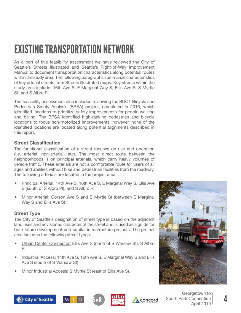
EXISTING TRANSPORTATION NETWORKAs a part of this feasibility assessment we have reviewed the City of
Seattle’s Streets Illustrated and Seattle’s Right-of-Way Improvement
Manual to document transportation characteristics along potential routes
within the study area. The following paragraphs summarize characteristics
of key arterial streets from Streets Illustrated maps. Key streets within the
study area include: 16th Ave S, E Marginal Way S, Ellis Ave S, S Myrtle
St, and S Albro Pl.
The feasibility assessment also included reviewing the SDOT Bicycle and
Pedestrian Safety Analysis (BPSA) project, completed in 2016, which
identified locations to prioritize safety improvements for people walking
and biking. The BPSA identified high-ranking pedestrian and bicycle
locations to focus non-motorized improvements; however, none of the
identified locations are located along potential alignments described in
this report.
Street Classification
The functional classification of a street focuses on use and operation
(i.e. arterial, non-arterial, etc). The most direct route between the
neighborhoods is on principal arterials, which carry heavy volumes of
vehicle traffic. These arterials are not a comfortable route for users of all
ages and abilities without bike and pedestrian facilities from the roadway.
The following arterials are located in the project area:
• Principal Arterial: 14th Ave S, 16th Ave S, E Marginal Way S, Ellis Ave
S (south of S Albro Pl), and S Albro Pl
• Minor Arterial: Corson Ave S and S Myrtle St (between E Marginal
Way S and Ellis Ave S)
Street Type
The City of Seattle’s designation of street type is based on the adjacent
land uses and envisioned character of the street and is used as a guide for
both future development and capital infrastructure projects. The project
area includes the following street types:
• Urban Center Connector: Ellis Ave S (north of S Warsaw St), S Albro
Pl
• Industrial Access: 14th Ave S, 16th Ave S, E Marginal Way S and Ellis
Ave S (south of S Warsaw St)
• Minor Industrial Access: S Myrtle St (east of Ellis Ave S).

5Georgetown to
South Park Connection
April 2019
Freight Routes
Freight routes are arterial streets that serve truck mobility and connectivity;
the freight network designation considers land uses that serve trucks. Key
freight routes through the project area that need to be maintained include
14th Ave S, 16th Ave S, and E Marginal Way S (major freight route); S
Bailey St (limited access route); and S Myrtle St between E Marginal Way
S and Ellis Ave S (industrial freight route).
Transit Routes
Streets that serve bus routes in the study area include: 14th Ave S, 16th
Ave S, E Marginal Way S, Ellis Ave S (south of S Albro Pl), S Albro Pl, and
13th Ave S.
Sidewalk Conditions
Current sidewalk conditions in the project area lack sidewalks in areas
and/or have several obstructions that limit user’s access and mobility; a
map in the Georgetown Mobility Study documents sidewalk obstructions
and streets with missing sidewalks.
Existing Bike Network
There are bike lanes on S Albro Pl, Ellis Ave S, E Marginal Way, 16th Ave
S and 14th Ave S in the study area; however, given the level of freight
use, vehicle volumes, and traffic speeds, these bike lanes do not provide
adequate protection for people of all ages and abilities as defined in the
Seattle Bicycle Master Plan.
Proposed Bike Network
Proposed bike facilities are shown in the 2014 City Bicycle Master Plan
and include protected bike lanes on S Albro Pl/Ellis Ave S and E Marginal
Way S.

6Georgetown to
South Park Connection
April 2019
SDOT provided sorted collision data from January 2013 to December
2017 and past speed studies from the project area. Figure 4 provides a
map of collisions by block segment and intersection and 85th percentile
speeds from past speed studies. Figure 5 summarizes the number of
collisions and associated injuries along each corridor and separates
collisions involving pedestrians and bicyclists.
EXISTING COLLISION & SPEED DATA
Figure 4 - Map of collision and speed data
Figure 5 - Summary of collisions and injuries by street corridor table
Speed Limits Throughout
Project Area
35 MPH
E Marginal Way S
30 MPH
Ellis Ave S
S Albro Pl
Corson Ave S
S Myrtle St
16th Ave S
14th Ave S
20 MPH
All residential, non-arterial streetsLegend: 1 collision# number of total collisions location of speed data
Table 1 – Summary of collisions and injuries by street corridor
All Collisions Bike/Ped Related Collisions
Street Corridor No. of
Collisions
No. of
Collisions
with
Injuries
Percent of
Collisions
with Injuries
No. of
Collisions
Percentage of
Collisions that
include Bike/Ped
No. of
Collisions
with
Injuries
Percent of
Collisions
with Injuries
E Marginal
Way 74 35 47% 3 4% 3 100%
Corson Ave S 66 23 35% 5 8% 4 80%
Carleton Ave S 12 0 0% 1 8% 0 0%
Flora Ave S 6 1 17% 0 n/a n/a n/a
Ellis Ave S 28 9 32% 1 4% 1 100%
S Bailey St 39 8 21% 5 13% 3 60%

7Georgetown to South Park Connection
April 2019
Existing street key map
In addition to reviewing existing city planning documents and available GIS information we conducted
site visits, walking potential routes, to confirm the context and condition along existing streets. The
following street sections depict typical existing sections, based on available GIS information and
limited field measurements, along the potential routes from the South Park neighborhood center, at the
intersection of 14th Ave S and Dallas Ave S, to the Georgetown neighborhood center, at the intersection
of S Bailey St and 12th Ave S.
EXISTING STREET CROSS SECTIONS
Figure 6 - (SP1) 14th Ave S: South Park Bridge
Figure 7 - (SP2) 16th Ave S: South Park Bridge (North Approach) to E Marginal Way S
SP1
SP2
Flo
ra A
ve S
E Marginal W
ay S
Elli
s A
ve S
S Myrtle St
16
th A
ve S

8Georgetown to South Park Connection
April 2019
68' CURB TO CURB
130' EXISTING ROW
27.5' 5' 6' 12' 11' 10' 11' 12' 6' 6'23.5'
Gravel/Grass Railroad Gravel/Grass Bike Lane Travel Lane Left Turn Lane Bike Lane Planter/SidewalkTravel Lane Travel Lane Travel Lane
79' CURB TO CURB
E MARGINAL WAY S - 16TH AVE S TO S WEBSTER ST
11.5' 6' 5' 11' 6' 12' 11' 10' 11' 12' 6' 8' 10'10'10.5'
5'
SidewalkSidewalk
Gravel/Grass Asphalt Walk* Gravel Buffer Railroad Gravel/Grass Bike Lane Travel Lane Left Turn Lane Bike Lane Planter Boeing SidewalkTurn Lane Travel Lane Travel Lane Travel Lane
130' EXISTING ROW
Existing street key map
EMW2
Flo
ra A
ve S
E Marginal W
ay S
Elli
s A
ve S
S Myrtle St
16
th A
ve S
Figure 8 - (EMW1) E Marginal Way S: 16th Ave S to S Webster St
Figure 9 - (EMW2) E Marginal Way S - S Webster St To Railroad Switches
EMW1
EXISTING CROSS SECTIONS

9Georgetown to South Park Connection
April 2019
EXISTING CROSS SECTIONS
71' -76' CURB TO CURB
130' EXISTING ROW
27.5' 5' 12' - 17' 11' 13' 11' 12' 6' 6'15.5' - 20.5' 0' - 6'
Railroad/Switches Railroad Gravel/Grass Bike Lane/Shoulder Travel Lane Left Turn Lane Bike Lane Planter/SidewalkTravel Lane Travel Lane Travel Lane
Travel Lane Travel LaneParking Left Turn Lane Sidewalk
(Width Varies)
Bike LaneBike LaneSidewalk
26-42' PAVEMENT WIDTH
EXISTING CROSS SECTION
ALTERNATIVE A: TWO WAY PBL ON EAST/SOUTH SIDE
40' CURB TO CURB
EXISTING CROSS SECTION
60' EXISTING ROW
5' 7' 5' 11' 5' 7' 3' MIN
S MYRTLE ST - EAST OF ELLIS AVE S S ALBRO PL - S EDDY ST TO 13TH AVE S
40' CURB TO CURB
ALTERNATIVE A: TWO WAY PBL ON EAST SIDE
60' EXISTING ROW
SHARED USE PATH CONFIGURATION POSSIBLE WITHIN THE PROPOSED BUFFER, TWO WAY PBL, SIDEWALK AND PLANTER.
72' EXISTING ROW
20' 18' 18' 16'
32-48' PAVEMENT WIDTH
72' EXISTING ROW
Asphalt Shoulder/Private Parking Travel Lane Travel Lane Gravel / Asphalt ShoulderSidewalk Parking Bike vel Lane Sidewalk PlanterBikevel Lane
5'
Planter
Figure 10 - (EMW3) E Marginal Way S: Railroad Switches to Ellis Ave S
Figure 11 - (EMW4) Ellis Ave S: E Marginal Way S to S Myrtle St Figure 12 - (EMW5) S Myrtle St: E of Ellis Ave S
Existing street key map
EMW3
EMW5
Flo
ra A
ve S
E Marginal W
ay S
Elli
s A
ve S
S Myrtle St
16
th A
ve S
EMW4

1 0Georgetown to South Park Connection
April 2019
26-42' PAVEMENT WIDTH
EXISTING CROSS SECTION
ALTERNATIVE A: TWO WAY PBL ON EAST/SOUTH SIDE
40' CURB TO CURB
EXISTING CROSS SECTION
60' EXISTING ROW
5' 7' 5' 12' 11' 5' 7' 3' MIN
S MYRTLE ST - EAST OF ELLIS AVE S S ALBRO PL - S EDDY ST TO 13TH AVE S
40' CURB TO CURB
ALTERNATIVE A: TWO WAY PBL ON EAST SIDE
60' EXISTING ROW
7' 11' 11' 3' 8'10'
SHARED USE PATH CONFIGURATION POSSIBLE WITHIN THE PROPOSED BUFFER, TWO WAY PBL, SIDEWALK AND PLANTER.
72' EXISTING ROW
16'
32-48' PAVEMENT WIDTH
72' EXISTING ROW
18' 3' 10' 6' 5'
Asphalt Shoulder/Private Parking Travel Lane Travel Lane Gravel / Asphalt Shoulder
Asphalt Shoulder/Private Parking Travel Lane Travel Lane Two Way PBLBuffer PlanterSidewalk
Sidewalk Parking Bike Travel Lane Sidewalk PlanterBikeTravel Lane
Parking Travel Lane SidewalkBufferTravel Lane Two Way PBL
5'
Planter
5'
Sidewalk
5'
Planter
60’ EXISTING ROW
30’ CURB TO CURB
5’ 4’ 7’ 16’-18’ 7’ 6’ 5’ 3’
Travel Lane LandscapeLandscapeSidewalk SidewalkParkingParking
7’
Figure 13 - (GT1) Ellis Ave S: S Myrtle St to S Eddy St
EXISTING CROSS SECTIONS
Landscape Concrete/
Planter
Sidewalk Parking Bike Lane Bike LaneTravel Lane Travel Lane
Figure 14 - (GT2) Ellis Ave S: S Eddy St to S Bailey St
& Flora Ave S: S Myrtle St to S Eddy St
Figure 15 - (GT3) S Albro Pl: S Eddy St to 13th Ave S
Figure 17 - (GT5) S Bailey St: 13th Ave S to Ellis Ave S
Figure 16 - (GT4) 13th Ave S: S Albro Pl to S Bailey St
40' CURB TO CURB
EXISTING CROSS SECTION
60' EXISTING ROW
10' 8' 12' 12' 8' 10'
13TH AVE S - S ALBRO PL TO S BAILEY ST
Parking Travel Lane SidewalkTravel LaneSidewalk Parking
31' CURB TO CURB
60' EXISTING ROW
12' 5' 12' 12' 7' 10'
Buffer Travel Lane SidewalkTravel LaneSUP Parking
ALTERNATIVE A: SHARED USE PATH ON WEST SIDE
2'
40' CURB TO CURB
EXISTING CROSS SECTION - LOOKING WEST
60' EXISTING ROW
7' 13' 13' 7' 10'
S BAILEY ST - BETWEEN 13TH AVE S AND ELLIS AVE S
Parking vel Lane Sidewalkvel LaneSidewalk Parking
31' CURB TO CURB
ALTERNATIVE A: SHARED USE PATH ON NORTH SIDE - LOOKING WEST
60' EXISTING ROW
7' 12' 12' 2'
Parking Travel Lane SUPvel LaneSidewalk
5'
Buffer
40' CURB TO CURB
EXISTING CROSS SECTION
60' EXISTING ROW
8' 12' 8'
13TH AVE S - S ALBRO PL TO S BAILEY ST
Parking Travel Lane SidewalkTravel LaneSidewalk Parking
31' CURB TO CURB
60' EXISTING ROW
ALTERNATIVE A: SHARED USE PATH ON WEST SIDE
40' CURB TO CURB
EXISTING CROSS SECTION - LOOKING WEST
60' EXISTING ROW
10' 7' 13' 13' 7' 10'
S BAILEY ST - BETWEEN 13TH AVE S AND ELLIS AVE S
Parking Travel Lane SidewalkTravel LaneSidewalk Parking
31' CURB TO CURB
ALTERNATIVE A: SHARED USE PATH ON NORTH SIDE - LOOKING WEST
60' EXISTING ROW
Existing street key map
GT1
13
th A
ve S
S Alb
ro P
l
Flo
ra A
ve S
S Bailey St 12
th
Ave S
E Marginal W
ay S
Elli
s A
ve S
S Myrtle St
16
th A
ve S
S Eddy StGT3
GT2
GT4
GT5

1 1Georgetown to
South Park Connection
April 2019
THE FLUMEThe Duwamish Valley Action Plan provides a brief history of the ‘Flume’
property, which is part of an abandoned 2,500-foot-long ditch system that
discharged cooling water from a steam plant to the Duwamish River at
Slip 4. The ‘Flume’ Property went into disuse when the plant closed in the
1960s. In 2008 Seattle City Light (SCL), who owns the property, cleaned
up contaminants as part of early actions to clean up the Duwamish River’s
Superfund site Slip 4.
The Duwamish Valley Action Plan also acknowledges that opportunities
for new open space in Georgetown are limited. During the Georgetown
Open Space Vision Framework process, community members identified
the ‘Flume’ property as both an important pedestrian link between
S Myrtle St and E Marginal Way S and a potential location for an Off-
Leash Area. Within the Georgetown Mobility Study the ‘Flume’ property
is envisioned as a pedestrian link providing access to E Marginal Way S
and existing bus stops.
As it relates to this feasibility study the ‘Flume’ property provides a direct
connection from E Marginal Way S to Ellis Ave S (via S Myrtle St) allowing
people walking and biking to bypass the intersection of E Marginal Way
S and Ellis Ave S. The potential alignments along the north side of E
Marginal Way S (presented later in this report) are dependent on the use
of the ‘Flume’ property as they allow a pedestrian and bicycle connection
to bypass driveways that serve the gas station and heavy vehicular traffic
turning from westbound E Marginal Way S to northbound Ellis Ave S.
Flo
ra A
ve S
Elli
s A
ve S
16th
Ave S
E Marginal W
ay S
S Myrtle St
“Flume”
Property
‘Flume’ property looking north from E Marginal Way S

1 2Georgetown to
South Park Connection
April 2019
An active railroad runs alongside E Marginal Way S. Based on available
information from SDOT and the Federal Rail Administration (FRA), trains
moving through the project area operate at slow speeds, typically 5 to 10
miles per hour with a maximum of 10 miles per hour. During site visit we
observed trains accompanied by on-site flaggers walking with moving
trains, however, we understand not all trains are walked by a flagger. Train
horns are used where the railroad crosses driveways and streets to alert
users of the oncoming train.
The FRA provides crossing inventory reports that describe the railroad
operations at street and driveway crossings. According to the crossing
inventory reports, revised in November 2018, the trains traveling along the
E Marginal Way S corridor are typically switching trains that utilize railroad
switches to access individual properties. Railroad switches are located in
the following three locations within the project area: between Ellis Ave S
and the Cedar Grove driveway, north of Carleton Ave S and south of 16th
Ave S. The following information from FRA crossing inventory reports
documents the type and approximate frequency of trains at the following
street and driveway crossings along E Marginal Way S:
• 16th Ave S: 4 switching trains*
• 14th Ave S: 4 switching trains*
• Cedar Grove: 5 trains per week, 1 through train per day, 1 through
train per night, 2 switching trains
• S Webster St: 4 switching trains*
• S Myrtle St: 4 switching trains*
EXISTING RAILROAD & OPERATIONS
Switches provide train access to industrial sites
*FRA reports did not
clarify if these numbers
were per day or per week.

1 3Georgetown to
South Park Connection
April 2019
COMMUNITY OUTREACHOutreach and community involvement have been
central in the planning of the future Georgetown
to South Park connection. The City of Seattle has
produced several reports on mobility, open space
and opportunities for improvements including the
following:
Duwamish Valley Action Plan (2018, City of Seattle):
created by the City of Seattle’s Duwamish Valley
Program (DVP), a multi-departmental effort led by the
Office of Sustainability & Environment (OSE) and the
Office of Planning & Community Development (OPCD),
this plan documents the community’s and City’s
shared vision to promote collaboration and guide
investment in the Duwamish Valley. Focused on the
Duwamish Valley neighborhoods of South Park and
Georgetown, the program is driven by environmental
justice guiding principles, racial equity outcomes,
community input, and community-led plans.
Georgetown Mobility Study (2017, SDOT): focuses
on evaluating and identifying opportunities for street
improvements to increase safety and health and
improve access for all users.
Open Space Vision and Framework (2017, Seattle
Parks Foundation): focuses on improvements to
open spaces to provide public green space in order
to improve the quality of life for community members.
Outside Citywide: South Park Neighborhood Profile
(2019, Seattle Office of Planning & Community
Development): captures the characteristics and
conditions of the South Park neighborhood and
the community’s vision for improving public space
in South Park including: neighborhood greening,
creating opportunities to walk or bike to parks and to
play, gather, and socialize, and for improving access
to nature and water. The profile is based on several
community events that took place in the summer of
2018.
For the feasibility analysis and study of potential
alignments to provide a Georgetown to South Park
connection, a stakeholder workshop was held in
August 2018 to verify project goals and objectives and
discuss potential route alignments and opportunities.
Key feedback from this workshop included:
• The community desire for an all ages and ability
connection that is convenient and accessible
between the Georgetown and South Park
neighborhood centers.
• The preference for a facility or trail that is both
safe and aesthetically pleasing and provides
environmental benefits (e.g. a trail that adds street
trees and planting area as buffers between people
walking and biking and motorized vehicles).
• Concerns were voiced about being uncomfortable
walking/biking alongside trains, particularly due
to the noise from train horns.
• General preference for locating proposed
improvements along the north/east side of
E Marginal Way S along Boeing with the
development of the “Flume” property.

1 4Georgetown to
South Park Connection
April 2019
Traffic counts were collected in September 2018 at key intersections to
facilitate the evaluation of proposed improvements and the impacts of
new non-motorized facilities on existing traffic. Traffic data was collected
at the following locations and is illustrated in Figure 18:
• 16th Ave S and E Marginal Way S
• 14th Ave S and E Marginal Way S
• Boeing driveways on E Marginal Way S north of 14th Ave S
• Ellis Ave S and E Marginal Way S
• Ellis Ave S and S Myrtle St
Figure 19 summarizes recorded turning movement counts.
The existing level of service and delay at each intersection was determined
using signal timing cards provided by SDOT and field traffic count data.
The future level of service and delay was estimated using traffic modeling
with added crosswalks or signal phases to support potential non-
motorized connections.
The following pages summarize findings for each of the intersections
evaluated; it is anticipated that additional traffic analysis will be required
after a preferred alignment has been identified.
TRAFFIC DATA COLLECTION & ANALYSIS
Figure 18 - Map of locations for traffic data collection
Counts to Collect
Signalized
Boeing Driveway

1 5Georgetown to South Park Connection
April 2019
S MYRTLE ST
EASTMARGINALWAYS
CARLETON
AVES
8THAVES
12THAVES
7THAVES
14THAVES
ELLISAVES
FLORAAVES
16THAVES
S RIVERSIDE DR
S WEBSTER ST
S ORCHARD ST
S OTHELLO ST
S GARDEN ST
Peak Hour Turning Movement CountsAM (PM) Stop Controlled SignalizedCounts
6 (9)2 (8)2 (17)
30 (
4)35
9 (3
49)
45 (
93)
4 (9)8 (3)
27 (76)
21 (
1)32
2 (2
79)
4 (5
)
108 (12)1563 (865)
91 (13)
2 (26)
12 (11)
34 (59)
107 (8)
668 (1184)15 (1)
27 (57)15 (8
)12 (1
03)
44 (93)
579 (473)
341 (782)
382 (506)
112
(65)
1176
(402
)
348
(352
)
13 (9
)
504 (828)
287 (252)
1251 (762)
15611
04
84019
STOP
11
33789 91583
STO
P
STOP
Figure 19 - Peak Hour Turning Movement Counts
ETOTT
13
th A
ve S
S Alb
ro P
l
Flo
ra A
ve S
S Bailey St 12
th
Ave S
Elli
s A
ve S
S Eddy St
E Marginal W
ay S
16
th A
ve
Existing Street Keymap
Yellow area shown in Peak Hour Turning
Movement Counts Diagram
S Myrtle St

1 6Georgetown to
South Park Connection
April 2019
16th Ave S and E Marginal Way S
There are no crosswalks at this intersection. Analysis at this intersection
included the addition of crosswalks at the south and east legs of the
intersection to provide at-grade crosswalks for people walking and
riding bicycles. The south crosswalk was presumed to have a protected
pedestrian phase (no right on red), restricting eastbound to southbound
right turn movements. The east crosswalk was adjusted to provide a
leading pedestrian interval (3 seconds). Figure 21 summarizes the AM
and PM intersection Level of Service (LOS) and Delay (in seconds) in the
existing condition to add crosswalks.
Note: Existing Boeing Tunnels, approximately 500-feet east of the
intersection and 350-feet south of the intersection, can be used by
the public and allow access to the north side of E Marginal Way S and
allow people to cross 16th Avenue S; however, the tunnels are not
ADA accessible with running slopes and cross slopes exceeding ADA
requirements.
Figure 20 - Model phasing diagram
Figure 21 - Traffic analysis results table
Delay LOS Delay LOS
Existing Condition 27 C 17 B
Add South and East Side Crosswalk
with a Protected Pedestrian Phase for South
Side Crossing (No Right Turn on Red for East
Bound Right) and a 3 second Leading
Pedestrian Interval for East Side Crossing
38 D 25 C
Delay LOS
Existing Condition 22
Divert Boeings South Bound Left Turn
volume (52vehs/hr) to 14th Ave S (AM only)
28
E Marginal Way S & 16th Ave S AM PM
E Marginal Way S & 14th Ave S AM
AM PM

1 7Georgetown to
South Park Connection
April 2019
14th Ave S and E Marginal Way S and Boeing Driveways
This intersection, which provides the only signal controlled access to
Boeing, was evaluated to determine impacts to traffic operations resulting
from restricting driveway access along E Marginal Way S to right in/right
out only. To provide a safe bicycle facility on the northbound side of E
Marginal Way S, two Boeing driveways located north of the intersection
were restricted to right in/right out only. Video cameras were installed to
document the number of vehicles that would be diverted from turning left
at the driveways to turning left at 14th Ave S during the AM peak hour
(7:30-8:30).
Analysis at this intersection evaluated the impacts to traffic operations
where 52 southbound left turning vehicles (based on counts) are diverted
from the Boeing driveways to 14th Ave S during the AM peak hour. Figure
23 summarizes the AM intersection LOS and Delay (in seconds) in the
existing condition and to accomodate additional left turning vehicles.
Figure 23 - Traffic analysis results table
Delay LOS Delay LOS
Existing Condition 27 17
Add South and East Side Crosswalk
with a Protected Pedestrian Phase for South
Side Crossing (No Right Turn on Red for East
Bound Right) and a 3 second Leading
Pedestrian Interval for East Side Crossing
38 25
Delay LOS
Existing Condition 22 C
Divert Boeings South Bound Left Turn
volume (52vehs/hr) to 14th Ave S (AM only)
28 C
Delay LOS Delay LOS
Existing Condition 16 13
Add Dedicated Bike Crossing on East Side
with No Right Turn on Red for the West 26 22
E Marginal Way S & 16th Ave S AM PM
E Marginal Way S & 14th Ave S AM
E Marginal Way S & Ellis Ave S AM PM
Figure 22 - Model phasing diagram

1 8Georgetown to
South Park Connection
April 2019
Ellis Ave S and E Marginal Way S
This intersection has existing crosswalks on the north and west legs of the
intersection. This intersection was evaluated to add a new crosswalk on
the east leg of the intersection, which could potentially reduce the number
of street crossings for people walking and riding bicycles depending
on the final alignment selected. To provide a protected crossing, right
turns on red would be restricted for westbound traffic turning right from
E Marginal Way S to Ellis Ave S. Figure 25 summarizes the AM and PM
intersection LOS and Delay (in seconds) in the existing condition and the
addition of a new dedicated bike crossing.
Figure 24 - Model phasing diagram
Figure 25 - Traffic analysis results table
Delay LOS Delay LOS
Existing Condition 27 17
Add South and East Side Crosswalk
with a Protected Pedestrian Phase for South
Side Crossing (No Right Turn on Red for East
Bound Right) and a 3 second Leading
Pedestrian Interval for East Side Crossing
38 25
Delay LOS
Existing Condition 22
Divert Boeings South Bound Left Turn
volume (52vehs/hr) to 14th Ave S (AM only)
28
Delay LOS Delay LOS
Existing Condition 16 B 13 B
Add Dedicated Bike Crossing on East Side
with No Right Turn on Red for the West
Bound Right movement
26 C 22 C
Delay LOS Delay LOS
Existing Condition
Add Diagonal Bike and Pedestrian Crossing 18 22
E Marginal Way S & 16th Ave S AM PM
E Marginal Way S & 14th Ave S AM
E Marginal Way S & Ellis Ave S AM PM
S Myrtle St & Ellis Ave S AM PM

1 9Georgetown to
South Park Connection
April 2019
Captions, if needed, can go beow an image as shown here.
Figure 26 - Model phasing diagram
Ellis Ave S and S Myrtle St
The existing condition at this intersection has crosswalks on all four legs.
A diagonal crossing was evaluated for people walking and riding bicycles
from the southwest corner to the northeast corner.
To provide a diagonal crossing for people walking a dedicated signal
phase with 7 seconds walk time and 27 seconds of flash Don’t Walk time
was evaluated. A longer vehicular cycle was provided to accommodate
the new diagonal bike and pedestrian phase and offset vehicle delay
for traffic on Ellis Ave S, increasing cycle times from 55 seconds to 110
seconds in the AM and 100 seconds in the PM. Figure 27 summarizes
the AM and PM intersection LOS and Delay (in seconds) in the existing
condition and to accommodate a diagonal crossing.
Figure 27 - Traffic analysis results table
Delay LOS Delay LOS
Existing Condition 27 17
Add South and East Side Crosswalk
with a Protected Pedestrian Phase for South
Side Crossing (No Right Turn on Red for East
Bound Right) and a 3 second Leading
Pedestrian Interval for East Side Crossing
38 25
Delay LOS
Existing Condition 22
Divert Boeings South Bound Left Turn
volume (52vehs/hr) to 14th Ave S (AM only)
28
Delay LOS Delay LOS
Existing Condition 16 13
Add Dedicated Bike Crossing on East Side
with No Right Turn on Red for the West
Bound Right movement
26 22
Delay LOS Delay LOS
Existing Condition 7 A 7 A
Add Diagonal Bike and Pedestrian Crossing 18 B 22 C
E Marginal Way S & 16th Ave S AM PM
E Marginal Way S & 14th Ave S AM
E Marginal Way S & Ellis Ave S AM PM
S Myrtle St & Ellis Ave S AM PM

2 0Georgetown to
South Park Connection
April 2019
FACILITY TYPESThe goal of the Georgetown to
South Park connection is to provide
an all ages and abilities facility for
people walking and riding bicycles.
The walking and biking facility
types being considered to provide
this connection are a shared use
path, a protected bike lane (which
would be paired with a sidewalk to
provide space for walking), and a
neighborhood greenway.
A shared use path typically
provides a minimum 5-foot
horizontal separation from the
roadway and is a shared path for
both walking and riding bicycles.
In addition to providing separation
from traffic, the setback from the
roadway also provides opportunity
for planting and street trees, which
is consistent with the type of safe
and comfortable experience the
community has envisioned.
A neighborhood greenway
provides a safe and comfortable
connection on low speed and low
volume streets with traffic calming
improvements such as pavement
markings, speed humps, diverters,
and wayfinding signage.
A protected bike lane (PBL)
combines the user experience of a
multi-use trail with a conventional
bike lane. They have different
forms, but all share common
elements providing space that is
used for bicycles and is physically
separated from vehicle travel
lanes, parking lanes and sidewalks.
Pedestrians are accommodated on
separate sidewalks.
Figure 28 - Shared use path
Figure 29 - Neighborhood greenway
Figure 30 - Protected bike lane

2 1Georgetown to
South Park Connection
April 2019
SHARED USE PATH VS. PROTECTED BIKE LANE (PBL)
The space to provide a shared use path versus a two-way protected bike lane and sidewalk is similar. For the
purposes of this report, and to align with community goals discussed at the community stakeholder workshop,
a shared use path has been shown in potential alignments where feasible. However, depending on site context
and project specific constraints, including funding, it may be more appropriate to provide a two-way protected
bike lane and sidewalk. Typically, a shared use path will require the relocation of an existing curb and impact
existing drainage infrastructure, whereas as a two-way protected bike lane can be provided by installing a
vehicular barrier and maintaining most of the existing storm drainage.
Figure 31 - Comparison of Space for Shared Use Path and Two-Way Protected Bike Lane
Two Way PBLShared Use Path
Landscape Shared
Use Path
Buffer Buffer 2 Way PBL Sidewalk
5’ 12’ 2’ 3’ 10’ 6’

2 2Georgetown to
South Park Connection
April 2019
A variety of routes, cross sections, and facility types
were explored to connect the Georgetown and South
Park neighborhood centers, based on the context,
street type, and classification of each corridor in
the project area. This section summarizes potential
alignments and cross sections that were developed.
For the purposes of summarizing and comparing
route alignments and alternatives, the neighborhood
to neighborhood connection has been divided into
three segments:
POTENTIAL ALIGNMENTS
Georgetown Connection:
from the intersection of Ellis
Ave S and S Myrtle St to the
intersection of S Bailey St and
12th Ave S.
E Marginal Way S Connection:
from the intersection of 16th
Ave S and E Marginal Way S to
the intersection of Ellis Ave S
and S Myrtle St.
South Park Connection:
from the South Park Bridge to
the intersection of 16th Ave S
and E Marginal Way S.
Through Albro
Greenway
Continue on Ellis
North Side Trail & North Side PBL
Trail by Rail
13th
Ave
S
E Marginal W
ay S
S Alb
ro P
l
Flo
ra A
ve S
S Bailey St
Elli
s A
ve S
16th
Ave S
S Eddy St
E Marginal W
ay S
West Side Trail
One-Way PBL to Bridge
12th
Ave S
S Myrtle St

2 3Georgetown to South Park Connection
April 2019
16th
Ave S
THE SOUTH PARK CONNECTION
The South Park connection extends from the intersection of
16th Ave S and E Marginal Way S to the south approach of the
South Park Bridge at 14th Ave S and S Dallas Ave. 16th Ave S
varies between E Marginal Way S and the South Park Bridge
to accommodate intersection channelization, on street parking,
bus stops, right turn lane, and access to the Boeing Tunnels.
The typical cross section is shown between the Boeing tunnels
and the north approach of the South Park Bridge; during design
the project team will work with SDOT to develop a layout that
works with each of the different conditions that occurs along
16th Ave S.
Changes to the South Park Bridge will need to be coordinated
with King County, owner of the South Park Bridge, to create a
seamless connection from 16th Ave S to 14th Ave S.
Figure 32 - (SP1) West Side Trail
Figure 33 - (SP1) One-Way PBL to Bridge
West Side Trail: Provides a shared
use path facility
One-way to Bridge: Provides a
protected bike lane at sidewalk
grade on the east and west side
of 16th Ave S
SP1 Looking south along 16th Ave S with access to the Boeing tunnels on the right side of the street.

2 4Georgetown to
South Park Connection
April 2019
The E Marginal Way S connection extends
from the intersection of E Marginal Way S and
16th Ave S to the intersection of Ellis Ave S
and S Myrtle St. This segment also includes
opportunities to use the “Flume” to provide
a safe off-street connection away from
busy streets. The Flume property provides
a minimum usable width of 40 feet and is
included in the North Side Trail and North
Side PBL alternatives. Options for each side
of E Marginal Way S were analyzed.
EAST MARGINAL WAY S CONNECTION
Alignments and Typical Sections
The following pages document typical proposed cross
sections for each of the three alignments listed below.
Trail by the Rail: provides a shared use path facility
• E Marginal Way S: 16th Ave S to S Webster St
• E Marginal Way S: S Webster St to Railroad Crossing
• E Marginal Way S: Railroad Crossing to Ellis Ave S
• Ellis Ave S: E Marginal Way S to S Myrtle St
North Side Trail: Provides a shared use path facility
• E Marginal Way S: 16th Ave S to S Webster St
• E Marginal Way S: S Webster St to Ellis Ave S
• Flume Connection
• S Myrtle St: East of Ellis Ave S
North Side PBL: Provides a two-way protected bike lane
and sidewalk
• E Marginal Way S: 16th Ave S to S Webster St
• E Marginal Way S: S Webster St to Ellis Ave S
• Flume Connection
• S Myrtle St: East of Ellis Ave S
E Marginal W
ay S
Elli
s A
ve S
16th
Ave S
E Marginal W
ay S
S Myrtle St
North Side Trail & North Side PBL
Trail by the Rail

2 5Georgetown to South Park Connection
April 2019
68' CURB TO CURB
130' EXISTING ROW
5' 6' 12' 11' 10' 11' 12' 6' 6'
9'
SETBACK
FROM CENTER
OF TRACKS
12'7' 24'
Gravel/Grass Railroad Gravel/Grass Bike Lane Travel Lane Left Turn Lane Bike Lane Planter/SidewalkTravel Lane Travel Lane Travel Lane
2'
79' CURB TO CURB
130' EXISTING ROW
12' 5' 11' 6' 12' 11' 10' 11' 12' 6' 8' 10'10'
9'
SETBACK
FROM CENTER
OF TRACKS
5'
Sidewalk Railroad Gravel/Grass Bike Lane Travel Lane Left Turn Lane Bike Lane Planter Boeing SidewalkTurn Lane Travel Lane Travel Lane Travel Lane
2'
E MARGINAL WAY S CONNECTION -
TRAIL BY THE RAIL
The Trail by the Rail takes advantage of underutilized public
right-of-way west of the railroad tracks. Existing channelization
on E Marginal Way S would remain the same. This alternative
provides greater separation from the vehicular traffic that is
traveling at a higher speed and volume than the occasional
attended train traveling at low speed. The alignment for this
alternative is south/west of the railroad from 16th Ave S until
the railroad switches near Ellis Ave S. At the railroad switches
the alignment crosses the railroad and continues on the north/
east side of the railroad to Ellis Ave S. The alignment uses the
existing crosswalk at Ellis Ave S to cross E Marginal Way S and
continues north to S Myrtle St.
Figure 34 - (EMW1) E Marginal Way S: 16th Ave S to S Webster St
Figure 35 - (EMW2) E Marginal Way S - S Webster St To Railroad Crossing
Shared Shared
Use PathUse Path
Shared Shared
Use PathUse PathUse Path
E Marginal W
ay S
Elli
s A
ve S
16th
Ave S
EMW1
EMW2
S Myrtle St
Trail by the Rail
Railroad
Switches

2 6Georgetown to South Park Connection
April 2019
The trail could also cross the railroad tracks at the existing
Cedar Grove Composting driveway, south of the switches, to
consolidate areas where pavement crosses the railroad tracks.
However, this route would require removing additional trees.
Figure 36 - (EMW3) E Marginal Way S: Railroad Crossing to Ellis Ave S
130' EXISTING ROW
27.5' 5' 5' 12' 6' 6'
9'
SETBACK
FROM CENTER
OF TRACKS
68' CURB TO CURB
11' 11' 11' 11'10' 5'
Railroad/Switches Railroad Buffer Bike Left Turn Lane Bike Lane Planter/SidewalkTravel Lane Travel Lane Travel Lane
2'
Travel Lane Travel LaneLeft Turn Lane Sidewalk
(Width Varies)
Shared
Use PathLandscapeLandscape
Figure 37 - (EMW4) Ellis Ave S: E Marginal Way S to S Myrtle St
Railroad switches near Ellis Avenue S
Shared
Use PathUse PathTravel Lane
E Marginal W
ay S
Elli
s A
ve S
16th
Ave S
Railroad
Switches
EMW3
EMW4
S Myrtle St
Trail by the Rail
E MARGINAL WAY S CONNECTION -
TRAIL BY THE RAIL

2 7Georgetown to South Park Connection
April 2019
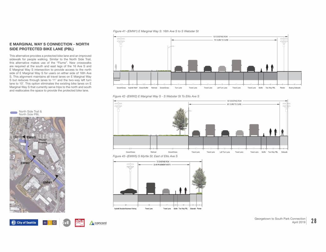
The North Side trail is a shared use path on the north side
of E Marginal Way S. A shared use path provides landscape
separation from traffic on E Marginal Way S and opportunities
for new street trees. This alignment includes the “Flume”
property to reduce the time a user is along E Marginal Way S.
New crosswalks are required at the south and east legs of the
16 Ave S and E Marginal Way S intersection to provide access
to the north side of E Marginal Way S for users on either side
of 16th Ave S. This alignment maintains all travel lanes on E
Marginal Way S but reduces through lanes to 11’ and the two-
way left turn lane to 10’. This option eliminates the existing bike
lanes on E Marginal Way S that currently serve trips to the north
and south and reallocates the space to provide the shared use
path.
ALTERNATIVE B: SHARED USE PATH ON NORTH SIDE
65' CURB TO CURB
130' EXISTING ROW
11' 11' 11' 4' 10' 8' 10'
11' 11' 11' 10' 11' 11' 5' 12' 5' 10'
11.5' 6' 5' 10'
11.5' 6' 5' 10'
Gravel/Grass Asphalt Walk* Buffer Railroad Gravel/Grass Travel Lane Left Turn Lane Buffer SUP Boeing SidewalkTravel Lane Travel Lane Travel Lane Planter
5'
Sidewalk
Gravel/Grass Asphalt Walk* Gravel Buffer Railroad Gravel/Grass Travel Lane Left Turn Lane Buffer Two Way PBL Boeing SidewalkTravel Lane Travel Lane Travel Lane Planter
5'
Sidewalk
10.5'
10.5'
Turn Lane
rn Lane
ALTERNATIVE A: TWO WAY PBL ON NORTH SIDE
68' CURB TO CURB
ALTERNATIVE B: SHARED USE PATH ON NORTH SIDE
54' CURB TO CURB
130' EXISTING ROW
130' EXISTING ROW
11' 11' 11' 11' 10'
11' 11' 10' 11' 11' 5' 12' 3'
E MARGINAL WAY S - S WEBSTER ST TO ELLIS AVENUE S
4'27.5' 5' 23'
27.5' 5' 23'
Gravel/Grass Railroad Gravel/Grass Travel Lane Left Turn Lane Buffer Two Way PBLTravel Lane Travel Lane Travel Lane Sidewalk
6'
Gravel/Grass Railroad Gravel/Grass Travel Lane Left Turn Lane Buffer SUPTravel Lane Travel Lane Travel Lane Planter
Figure 38 - (EMW1) E Marginal Way S: 16th Ave S to S Webster St
Figure 39 - (EMW2) E Marginal Way S: S Webster St to Ellis Ave S
Figure 40 - (EMW5) S Myrtle St: East of Ellis Ave S
Shared Shared
Use PathUse Path
Shared Shared
Use PathUse Path
Elli
s A
ve S
16th
Ave S
“Flume”
Property
EMW2
EMW5
E Marginal W
ay S
S Myrtle St
EMW1
North Side Trail & North Side PBL
E MARGINAL WAY S CONNECTION -
NORTH SIDE TRAIL
2 8Georgetown to South Park Connection
April 2019
Figure 42 - (EMW2) E Marginal Way S - S Webster St To Ellis Ave S
Figure 41 - (EMW1) E Marginal Way S: 16th Ave S to S Webster St
ALTERNATIVE B: SHARED USE PATH ON NORTH SIDE
ALTERNATIVE A: TWO WAY PBL ON NORTH SIDE
79' CURB TO CURB
65' CURB TO CURB
130' EXISTING ROW
130' EXISTING ROW
11' 11' 11' 10' 11' 11' 4' 10' 8' 10'
11' 11' 11' 10' 11' 5' 5'
E MARGINAL WAY S - 16TH AVE S TO S WEBSTER ST
11.5' 6' 5' 10'
11.5' 6' 5' 10'
Gravel/Grass Asphalt Walk* Buffer Railroad Gravel/Grass Travel Lane Left Turn Lane Buffer SUP Boeing SidewalkTravel Lane Travel Lane Travel Lane Planter
5'
Sidewalk
Gravel/Grass Asphalt Walk* Gravel Buffer Railroad Gravel/Grass Travel Lane Left Turn Lane Buffer Two Way PBL Boeing SidewalkTravel Lane Travel Lane Travel Lane Planter
5'
Sidewalk
10.5'
10.5'
rn Lane
Turn Lane
ALTERNATIVE A: TWO WAY PBL ON NORTH SIDE
68' CURB TO CURB
ALTERNATIVE B: SHARED USE PATH ON NORTH SIDE
54' CURB TO CURB
130' EXISTING ROW
130' EXISTING ROW
11' 11' 10' 11' 11' 10'
11' 11' 5' 3'
E MARGINAL WAY S - S WEBSTER ST TO ELLIS AVENUE S
4'27.5' 5' 23'
27.5' 5' 23'
Gravel/Grass Railroad Gravel/Grass Travel Lane Left Turn Lane Buffer Two Way PBLTravel Lane Travel Lane Travel Lane Sidewalk
6'
Gravel/Grass Railroad Gravel/Grass Travel Lane Left Turn Lane Buffer SUPTravel Lane Travel Lane vel Lane Planter
This alternative provides a protected bike lane and an improved
sidewalk for people walking. Similar to the North Side Trail,
this alternative makes use of the “Flume”. New crosswalks
are required at the south and east legs of the 16 Ave S and
E Marginal Way S intersection to provide access to the north
side of E Marginal Way S for users on either side of 16th Ave
S. This alignment maintains all travel lanes on E Marginal Way
S but reduces through lanes to 11’ and the two-way left turn
lane to 10’. This option eliminates the existing bike lanes on E
Marginal Way S that currently serve trips to the north and south
and reallocates the space to provide the protected bike lane.
E MARGINAL WAY S CONNECTION - NORTH
SIDE PROTECTED BIKE LANE (PBL)
Figure 43 - (EMW5) S Myrtle St: East of Ellis Ave S
Elli
s A
ve S
16th
Ave S
“Flume”
Property
EMW2
EMW5
E Marginal W
ay S
EMW1
S Myrtle St
North Side Trail & North Side PBL

2 9Georgetown to
South Park Connection
April 2019
The Georgetown Connection begins at the
intersection of Ellis Ave S and S Myrtle St
providing a connection to the Georgetown
neighborhood center at the intersection of S
Bailey St and S 12th St.
The alternatives shown along arterial streets
are shown as shared use paths, however,
the facility could also be a protected bike
lane with an adjacent sidewalk. Where the
proposed facility is constrained (e.g. along
grade changes and existing utilities along
Ellis Ave S and S Albro Pl) the design may
require walls, railings, and fences to be
rebuilt; a protected bike lane and sidewalk
may have greater impact to existing grades,
trees and utilities because the full width of
the facilities needs to be paved and level. The
evaluation of potential alignments discussed
later in this report assumes the use of a
shared use path along arterial streets.
GEORGETOWN CONNECTION
Alignments and Typical Sections
The following pages document typical proposed cross
sections for each of the three alignments listed below.
Through Albro: Provides a shared use path facility
• Ellis Ave S: S Myrtle St to S Eddy St
• S Albro Pl: S Eddy St to 13th Ave S
• 13th Ave S: S Albro Pl to S Bailey St
• S Bailey St: 13th Ave S to Ellis Ave S
Continue on Ellis: Combines a shared use path and
greenway connections• Ellis Ave S: S Myrtle St to S Eddy St – Shared Use Path
• Ellis Ave S: S Eddy St to S Bailey St – Greenway
• S Bailey St: 13th Ave S to Ellis Ave S – Shared Use Path
Greenway: Provides neighborhood greenway
• Flora Ave S: S Myrtle St to S Eddy St
• S Bailey St: 13th Ave S to Ellis Ave S
S Bailey St
13th
Ave S
S Myrtle St
Flo
ra A
ve S
13th
Ave S
S Alb
ro P
l
Elli
s A
ve S
S Myrtle St
13th
Ave S
12th
Ave S
S Alb
ro P
l
S Myrtle St
12th
A
ve S
12th
A
ve S
S Bailey StS Bailey St
Flo
ra A
ve S
Elli
s A
ve S
S Alb
ro P
l
Elli
s A
ve S
Flo
ra A
ve S
S Eddy StS Eddy St
S Eddy St
Through Albo
(Shared Use Path)
Continue on Ellis
(Shared Use Path
and Greenway)
Greenway
(Neighborhood
Greenway)

3 0Georgetown to
South Park Connection
April 2019
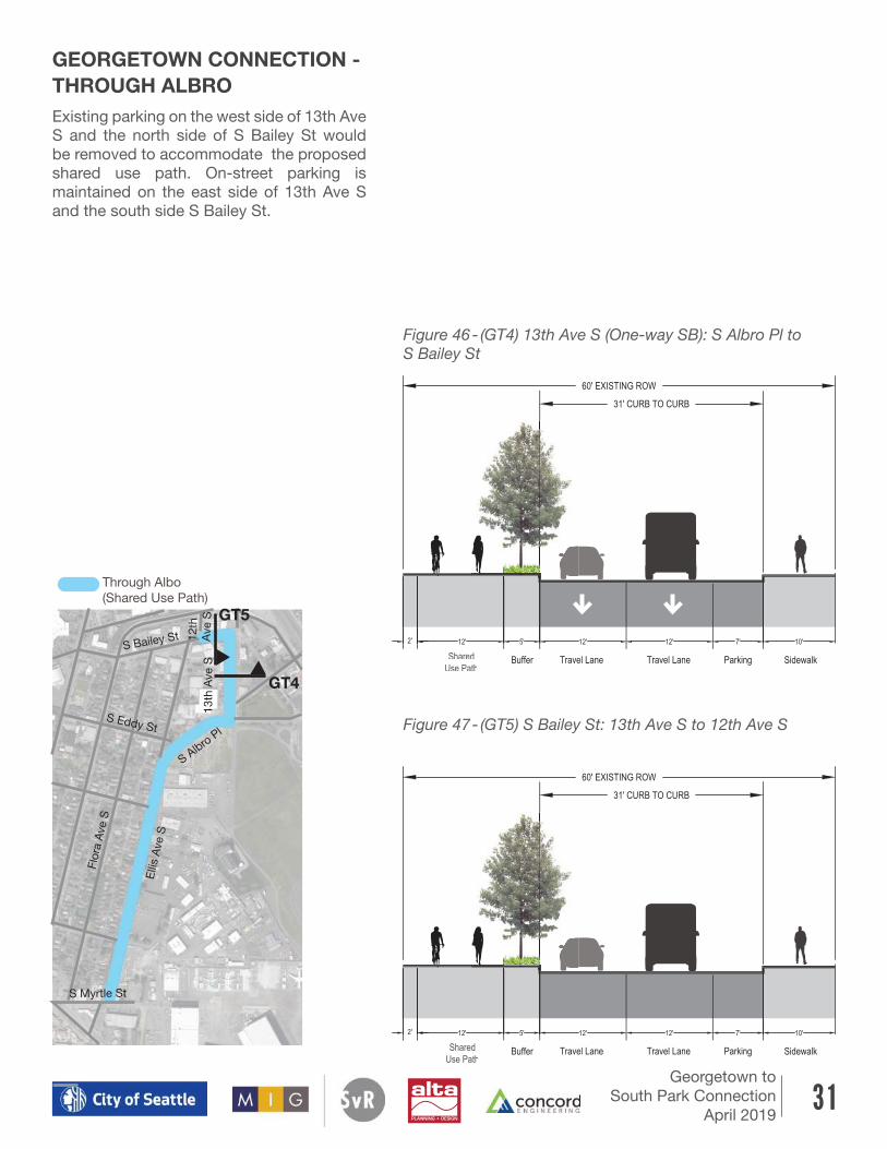
This alternative utilizes Ellis Ave S, S Albro
Pl, and 13th Ave S to get users to the
Georgetown business district and passes
along Ruby Chow Park and the potential
future Georgetown Transportation Center
(see the Georgetown Mobility Study Report
for additional information) on the east side
of 13th Ave S. Along Ellis Ave S and S Albro
Pl, the existing bike lanes are removed and
travel lanes narrowed to 11’ to make space
for the shared use path. On-street parking is
maintained along Ellis Ave S and S Albro Pl.
GEORGETOWN CONNECTION -
THROUGH ALBRO
Figure 44 - (GT1) Ellis Ave S: S Myrtle St to S Eddy St
Figure 45 - (GT3) S Albro Pl: S Eddy St to 13th Ave S
GT3
GT1
12th
Ave S
S Bailey St
13th
Ave S
Flo
ra A
ve S
Elli
s A
ve S
S Alb
ro P
l
S Myrtle St
Shared
Use PaththUse Path
Travel Lane Travel Lane ParkinglklkSidewalk Planter Buffer
Travel Lane Travel Lane Landscape Shared
Use PathConcrete/
Planter
ParkingLandscapeSidewalk
S Eddy St
Through Albo
(Shared Use Path)
3 1Georgetown to
South Park Connection
April 2019
40' CURB TO CURB
EXISTING CROSS SECTION
60' EXISTING ROW
10' 8' 12' 12' 8' 10'
Parking Travel Lane SidewalkTravel LaneSidewalk Parking
31' CURB TO CURB
60' EXISTING ROW
12' 5' 12' 12' 7' 10'
Buffer Travel Lane SidewalkTravel LaneSUP Parking
ALTERNATIVE A: SHARED USE PATH ON WEST SIDE
2'
Figure 46 - (GT4) 13th Ave S (One-way SB): S Albro Pl to
S Bailey St
Existing parking on the west side of 13th Ave
S and the north side of S Bailey St would
be removed to accommodate the proposed
shared use path. On-street parking is
maintained on the east side of 13th Ave S
and the south side S Bailey St.
Figure 47 - (GT5) S Bailey St: 13th Ave S to 12th Ave S
GEORGETOWN CONNECTION -
THROUGH ALBRO
40' CURB TO CURB
EXISTING CROSS SECTION
60' EXISTING ROW
10' 8' 12' 12' 8' 10'
13TH AVE S - S ALBRO PL TO S BAILEY ST
Parking Travel Lane SidewalkTravel LaneSidewalk Parking
31' CURB TO CURB
60' EXISTING ROW
12' 5' 12' 12' 7' 10'
Buffer Travel Lane SidewalkTravel LaneSUP Parking
ALTERNATIVE A: SHARED USE PATH ON WEST SIDE
2'
Shared Shared
Use PathUse Path
Shared Shared
Use PathUse Path
40' CURB TO CURB
EXISTING CROSS SECTION
60' EXISTING ROW
10' 8' 12' 12' 8' 10'
13TH AVE S - S ALBRO PL TO S BAILEY ST
Parking Travel Lane SidewalkTravel LaneSidewalk Parking
31' CURB TO CURB
60' EXISTING ROW
12' 5' 12' 12' 7' 10'
Buffer Travel Lane SidewalkTravel LaneSUP Parking
ALTERNATIVE A: SHARED USE PATH ON WEST SIDE
2'
EXISTING C
10'
S BAILE
Sidewalk
ALTERNATI
10'
Sidewalk
40' CURB TO CURB
EXISTING CROSS SECTION
60' EXISTING ROW
10' 8' 12' 12' 8' 10'
13TH AVE S - S ALBRO PL TO S BAILEY ST
Parking Travel Lane SidewalkTravel LaneSidewalk Parking
31' CURB TO CURB
60' EXISTING ROW
12' 5' 12' 12' 7' 10'
Buffer Travel Lane SidewalkTravel LaneSUP Parking
ALTERNATIVE A: SHARED USE PATH ON WEST SIDE
2'
GT5
GT4
S Bailey St
13th
Ave S
Flo
ra A
ve S
12th
A
ve S
Elli
s A
ve S
S Alb
ro P
l
S Myrtle St
S Eddy St
Through Albo
(Shared Use Path)

3 2Georgetown to
South Park Connection
April 2019
This route continues on Ellis Ave S for the
entire north segment requiring a street
crossing at the existing unsignalized
intersection of Ellis Ave S and S Albro Pl. Trail
users would cross from the east to the west
side of Ellis Ave S and continue on Ellis Ave
S. North of S Eddy St, the facility type would
transition to a Neighborhood Greenway to
maintain parking along the neighborhood
street. The existing crosswalk would allow
people to cross S Bailey St and a shared use
path would connect people to 12th Ave S.
60’ EXISTING ROW
30’ CURB TO CURB
5’ 4’ 7’ 7’ 6’ 5’16’-18’
Travel Lane with
2 Way SharrowLandscapeLandscape SidewalkSidewalk ParkingParking
40' CURB TO CURB
60' EXISTING ROW
12' 12' 8' 10'
ALBRO PL TO S BAILEY ST
vel Lane SidewalkTravel Lane Parking
31' CURB TO CURB
60' EXISTING ROW
12' 12' 7' 10'
ravel Lane SidewalkTravel Lane Parking
USE PATH ON WEST SIDE
40' CURB TO CURB
EXISTING CROSS SECTION - LOOKING WEST
60' EXISTING ROW
10' 7' 13' 13' 7' 10'
S BAILEY ST - BETWEEN 13TH AVE S AND ELLIS
Parking Travel Lane SidewalkTravel LaneSidewalk Parking
31' CURB TO CURB
ALTERNATIVE A: SHARED USE PATH ON NORTH SIDE - LOOKING WEST
60' EXISTING ROW
10' 7' 12' 12' 12' 2'
Parking Travel Lane SUPTravel LaneSidewalk
5'
Buffer
GEORGETOWN CONNECTION -
CONTINUE ON ELLISFigure 48 - (GT1) Ellis Ave S: S Myrtle St to S Eddy St
Figure 49 - (GT2) Ellis Ave S: S Eddy St to S Bailey St
Figure 50 - (G5) S Bailey St: 13th Ave S to Ellis Ave S
GT2
GT1
13th
Ave S
S Bailey St
Flo
ra A
ve S
12th
A
ve S
Elli
s A
ve S
S Alb
ro P
l
S Myrtle St
GT5
Shared
Use PathUse Path
31' CURB TO CURB
60' EXISTING ROW
12' 12' 7' 10'
el Lane SidewalkTravel Lane Parking
SE PATH ON WEST SIDE
31' CURB TO CURB
ALTERNATIVE A: SHARED USE PATH ON NORTH SIDE - LOOKING WEST
60' EXISTING ROW
10' 7' 12' 12' 12' 2'
Parking Travel Lane SUPTravel LaneSidewalk
5'
Buffer
31' CURB TO CURB
60' EXISTING ROW
12' 12' 7' 10'
Travel Lane SidewalkTravel Lane Parking
ED USE PATH ON WEST SIDE
31' CURB TO CURB
ALTERNATIVE A: SHARED USE PATH ON NORTH SIDE - LOOKING WEST
60' EXISTING ROW
10' 7' 12' 12' 12' 2'
Parking Travel Lane SUPTravel LaneSidewalk
5'
Buffer
31' CURB TO CURB
60' EXISTING ROW
12' 12' 7' 10'
Travel Lane SidewalkTravel Lane Parking
ED USE PATH ON WEST SIDE
31' CURB TO CURB
ALTERNATIVE A: SHARED USE PATH ON NORTH SIDE - LOOKING WEST
60' EXISTING ROW
10' 7' 12' 12' 12' 2'
Parking Travel Lane SUPTravel LaneSidewalk
5'
Buffer
31' CURB TO CURB
60' EXISTING ROW
5' 12' 12' 7' 10'
Buffer Travel Lane SidewalkTravel Lane Parking
VE A: SHARED USE PATH ON WEST SIDE
31' CURB TO CURB
ALTERNATIVE A: SHARED USE PATH ON NORTH SIDE - LOOKING
60' EXISTING ROW
10' 7' 12' 12' 12'
Parking Travel Lane SUPTravel LaneSidewalk
5'
BufferLandscape Landscape Shared
Use PathConcrete/
Planter
S Eddy St
Continue on Ellis
(Shared Use Path
and Greenway)

3 3Georgetown to
South Park Connection
April 2019
Figure 51 - (GT2) Flora Ave S: S Myrtle St to S Eddy St
Figure 52 - (GT5) S Bailey St: 13th Ave S to Ellis Ave S
60’ EXISTING ROW
30’ CURB TO CURB
5’ 4’ 7’ 7’ 6’ 5’16’-18’
Travel Lane with
2 Way SharrowLandscapeLandscape SidewalkSidewalk ParkingParking
40' CURB TO CURB
EXISTING CROSS SECTION
60' EXISTING ROW
10' 8' 12' 12' 8' 10'
13TH AVE S - S ALBRO PL TO S BAILEY ST
Parking Travel Lane SidewalkTravel LaneSidewalk Parking
31' CURB TO CURB
60' EXISTING ROW
12' 5' 12' 12' 7' 10'
Buffer Travel Lane SidewalkTravel LaneSUP Parking
ALTERNATIVE A: SHARED USE PATH ON WEST SIDE
2'
Provides a Neighborhood Greenway
connection along neighborhood streets
using pavement markings (sharrows),
signage, speed cushions, and other traffic
calming measures. This alternative maintains
parking along the neighborhood greenway
streets, but is less direct, using Flora Ave S,
S Eddy St, and Ellis Ave S. At S Bailey St,
the existing crosswalk would allow people to
cross the street and a short shared use path
would connect people to 12th Ave S.
GEORGETOWN CONNECTION -
GREENWAY
Shared
Use PathUse Path
G2
13th
Ave S
S Bailey St
Flo
ra A
ve S
12th
A
ve S
Elli
s A
ve S
S Alb
ro P
l
S Myrtle St
GT5
S Eddy St
Greenway
(Neighborhood
Greenway)

3 4Georgetown to
South Park Connection
April 2019
EVALUATIONPotential alignments presented in this report have
been evaluated using a comprehensive and holistic
approach that considers a variety of items, from
quantitative analysis of traffic modeling and potential
construction cost estimates to qualitative elements
such as user comfort. The categories evaluated
include: operations of signals, freight, railroad, transit
and parking; coordination with property owners;
access/impacts to existing facilities; comfort of
non-motorized users; impacts to urban forestry and
existing utilities; and the potential cost to implement.
Each of these categories included items that were
evaluated and rated in comparison to the other
potential alignments (see Figure 53 for a full list of the
items evaluated); the evaluation determined whether
potential alignments positively or adversely addressed
existing conditions.
Figure 53 - List of categories and items included in the evaluation
Figure 54 summarize the evaluation of potential
alignments. Green circles indicate categories that
are supported by or positively addressed by the
proposed concept, yellow circles are neutral, and
red circles indicate categories that are adversely
addressed by the proposed concept. It should be
noted that no weighting, or priority, was applied to
individual evaluation criteria. The final evaluation
has been developed to summarize findings with the
community regarding pros and cons for identifying a
preferred alignment and facility type.
Georgetown to South Park Connection – Rating Categories
Operations Traffic signal operations
Freight movements
Railroad operations
Transit stops and operations
On-street parking
Coordination and
Property Impacts
Boeing street frontage
Boeing facilities (parking and distribution center)
Property owners (general)
King County Airport
Fire Department
Railroad
Comfort All ages and abilities facility provided
Transitions including existing to proposed facility and between
varying cross sections
Community perception and directness of the alignment
Separation from Vehicles, Freight and Railroad
Non-motorized Arterial Crossing along the alignment
Non-motorized Driveway Crossings along the alignment
Urban Forestry xisting trees and opportunities for planting new trees
xisting planting areas and opportunities for planting new planting
areas
Impacts to Utilities Relocation of Seattle City Light power infrastructure
Relocation of franchise utilities
Relocation of street lights, consideration of additional streets
lighting
xisting fire hydrants
Stormwater impacts that will trigger permitting requirements
Relocation of existing storm drain
Cost Cost of constructing the potential alignment

3 5Georgetown to South Park Connection
April 2019
Georgetown to South Park Connection
Preliminary evaluation summary - for internal discussion
Decemeber 20, 2018
Evaluation Categories West Side Trail One-Way PBL
to BridgeTrail by the Rail North Side Trail North Side PBL Through Albro
Continue on
Ellis Greenway
Operations
Coordination and Property
Impacts
Comfort
Urban Forestry N/A
Impacts to Utilities N/A
Construction Cost
Georgetown Connection
supports/positive
South Park Connection E Marginal Way S Connection
neutral
Legend
adverse
Figure 54 - Evaluation Summary of Georgetown to South Park Connection
Georgetown to South Park Connection
Preliminary evaluation summary - for internal discussion
Decemeber 20, 2018
Evaluation Categories West Side Trail One-Way PBL
to BridgeTrail by the Rail North Side Trail North Side PBL Through Albro
Continue on
Ellis Greenway
Operations
Coordination and Property
Impacts
Comfort
Urban Forestry N/A
Impacts to Utilities N/A
Construction Cost
Georgetown Connection
supports/positive
South Park Connection E Marginal Way S Connection
neutral
Legend
adverse

3 6Georgetown to
South Park Connection
April 2019
SHORT-TERM OPPORTUNITIESThe next steps for this project include complete design
and construction of the preferred alignment along with
short-term opportunities for improving connections
and access within the project area. This section
summarizes a range of short-term opportunities
for improving accessibility and safety between the
Georgetown and South Park neighborhood centers
until a full build of the preferred concept can be
achieved.
Wayfinding signage and Neighborhood
Greenway route
Until the preferred route and street improvements
are provided, the installation of wayfinding signage
would improve connections north of E Marginal Way
S by providing low-cost opportunities to improve
connections and direct people walking and riding
bicycles to low speed, low volume streets.
Removing ADA barriers
In the short term, removing existing barriers along
the most direct, or preferred route, would assist in
providing access to all users. These improvements
would include providing curb ramps that meet ADA
standards, replacing sections of uplifted concrete
in sidewalks, and updating driveway crossings that
don’t meet ADA requirements.
Investigate feasibility of using ‘Flume’
property
The ‘Flume’ property is undergoing a transfer in
ownership from Seattle City Light to Seattle Parks
and Recreation (SPR), see page 10 for additional
information about the ‘Flume’ property. Because this
property is not public right-of-way, the feasibility of
using part of the property as a transportation facility
should be discussed and coordinated with SPR.
Improve visibility and signage at S Bailey St
crossing at Ellis Ave S
Improve signage and visibility at the existing street
crossing by reviewing sightlines, and providing
consistent signage for vehicles traveling on S Bailey
St from both directions; the east and west approaches
currently have different signage. This includes
trimming trees that obstruct sightlines and reviewing,
and removing or relocating existing traffic signs that
impact visibility. Additional crosswalk signs or new
rectangular rapid flashing beacons (RRFB) could be
considered to replace the existing traffic signs and
overhead flashing beacons to increase safety.
S Bailey St crossing at Ellis Ave S looking west

3 7Georgetown to
South Park Connection
April 2019
This intersection was identified by the community
as being a safety concern. The configuration of the
intersection, including how Flora Ave S meets S Myrtle
St and the proximity to E Marginal Way S, is unique
and is perceived as being unsafe by the community.
A future study should review opportunities to modify
or limit traffic at or through the intersection (e.g. how
might the use of a diverter that limits traffic at Flora
Ave S to northbound vehicles only improve traffic flow
and safety in and around the area).
Opportunities at Albro Triangle
The intersection of S Ellis Ave, S Eddy St, and S
Albro Pl could be reviewed to improve connections
from Ellis Ave S and S Albro Pl to the Georgetown
neighborhood center and residential areas.
Intersection of Flora Ave S and S Myrtle St at
E Marginal Way S
There are no crosswalks at this intersection. Figure
57, on the following page, shows a concept sketch
for adding crosswalks at the south and east legs of
the intersection to provide at-grade crosswalks for
people walking and riding bicycles. This improvement
would allow access from the east and west side of
16th Ave S to the north side of E Marginal Way S.
S Albro PI Triangle looking north
Crosswalks at E Marginal Way S
and 16th Ave S
S Albro PI Triangle looking south

3 8Georgetown to South Park Connection
April 2019
Figure 57 - E Marginal Way S and 16th Ave S: Concept Sketch
E Marginal Way S and 16th Ave S: Concept sketch for pedestrian crosswalks- concept shown to provide new crosswalks with minimal impacts to existing infrastructure; additional concepts could include adjustments to curb returns, drainage infrastructure and/or provide pedestrian refuge across a multiple stage crossing on E Marginal Way S
Existing signal
head
Existing Controller
- new wiring on existing
overhead from controller
to new pushbuttons/
signal heads
West corner:
- new concrete pad (to delineate crossing
location) and blended transition with detectable
warning for 16th crossing
- new pedestal pole with ped pushbutton and
ped head (conduit from pole to j-box)
- new crosswalk
- relocate stop bar (verify new distance between existing signal
head and new stop bar meets MUTCD)
- new traffic loops and j-box for relocated stop bar
South corner:
- new curb ramp for 16th crossing
- detectable warning for rail/E Marginal crossing
- new pedestal pole with ped pushbutton and ped
head (conduit from pole to j-box)
- remove existing extruded curb
- new crosswalk
- relocate stop bar (verify new distance between existing signal
head and new stop bar meets MUTCD)
- adjust existing video detection area for NW bound traffic
Northeast corner:
- new curb ramp for E Marginal crossing and
connect to sidewalk on private property
- remove existing traffic barrier (terminal end and
first section)
- new pedestal pole with ped pushbutton and ped
head (conduit from pole to j-box)
New wiring on
existing overhead
to pushbuttons and
signal heads
verify distance meets M
UTCD