GeoProfessional Terrain-Corrected Imagery - … · GeoProfessional Terrain-Corrected Imagery Geo...
4
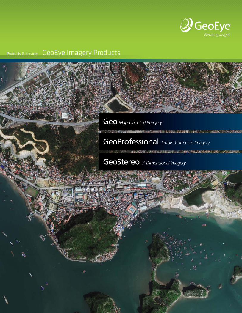
Products & Services GeoEye Imagery Products GeoProfessional Terrain-Corrected Imagery Geo Map-Oriented Imagery GeoStereo 3-Dimensional Imagery
Transcript of GeoProfessional Terrain-Corrected Imagery - … · GeoProfessional Terrain-Corrected Imagery Geo...
Products & Services GeoEye Imagery Products
GeoProfessional Terrain-Corrected Imagery
Geo Map-Oriented Imagery
GeoStereo 3-Dimensional Imagery

Which product can we deliver for you?Selecting the right product for your geospatial needs is easy. Whatever your imagery requirements, we have a solution for you.
GeoEye imagery products are categorized according to resolution and positional accuracy. From basic imagery to 3-D stereo processing, we deliver the right image, right the first time.
At GeoEye, we provide superior service and support at every level of our organization. It’s how we live up to the high expectations of our customers and maintain the lowest return rate in the industry. Salvador, Brazil
Product
.50-meter 1-meter .50-meter and 1-meter
Positional Accuracy Positional Accuracy Ortho Corrected
Target Elevation
Angle
Mosaics AvailableCE90 RMSE NMAS CE 90 RMSE NMAS
Geo1 5 meters 3 meters N/A 15 meters 8 meters N/A No >60º No
GeoProfessional 10 meters 5 meters 1:12,000 10 meters 5 meters 1:12,000 Yes >66º Yes
GeoProfessional Precision2, 3 4 meters 2 meters 1:5,000 4 meters 2 meters 1:5,000 Yes >72º Yes
CE90 LE 90 NMAS CE 90 LE 90 NMAS
GeoStereo 4 meters 6 meters 1:5,000 15 meters 22 meters 1:20,000
No >60º NoGeoStereo Precision4 2 meters 3 meters 1:2,500 4 meters 6 meters 1:5,000
1CE 90% exclusive of terrain displacement; Geo imagery is not terrain corrected. 2Ground control required, DEM from NED or stereo may be used as appropriate to achieve specified accuracy. 3Other accuracies are achievable; please contact a Service Expert with your requirements. 4Ground control required.
Specifications for GeoEye Imagery ProductsAll products are available with .50-meter or 1-meter resolution.The observed accuracy performance for GeoEye-1 Geo Products is consistently better than the 5m CE90 specification. To read about accuracy test results, visit www.geoeye.com/accuracy

Key Features
• The quickest turnaround and delivery of map-oriented satellite imagery commercially available
• Images applicable for a wide range of uses, including visualization and monitoring applications
• Includes Rational Polynomial Coefficient (RPC) data for use in photogrammetric applications
• Using your own Digital Elevation Model (DEM), skilled users can make terrain-corrected products
• Images available as panchromatic, multispectral, and pan-sharpened color
Key Features
• Images automatically orthorectified
• Various levels of accuracy to meet a wide range of mapping needs
• Suitable for base mapping and change detection
• Images available as panchromatic, multispectral, and pan-sharpened color
Key Features
• Dual images with stereo geometry
• Supports a wide range of stereo imagery applications
• Suitable for feature extraction
• Stereo products in either epipolar or map projections provided with Rational Polynomial Coefficient (RPC) data
• Images available as panchromatic, multispectral, and pan-sharpened color
Typical Applications›› Environmental monitoring›› Image interpretation›› Photogrammetric applications›› Disaster response
Typical Applications›› 3-D feature extraction›› DEM extraction›› Stereo visualization of natural features›› Building height extraction
GeoProfessional™
Terrain-Corrected Imagery
Geo™
Map-Oriented Imagery
GeoStereo™
3-Dimensional Imagery
For those who want satellite imagery for visual and interpretive applications that are geometrically accurate and cost effective.
Perfect for anyone demanding greater image positional accuracy. The optimal choice for regional mapping or for tasks requiring terrain-corrected imagery.
For those requiring images that deliver 3-dimensional viewing and feature recognition.
Typical Applications›› Base mapping›› Planning›› Infrastructure management›› Location services›› Visualization and simulation›› Online mapping

GeoFUSE | Find - Use - Serve - ExtendUsing GeoFUSE, our Search & Discovery tool, browse our GeoEye image catalog archives to quickly and easily locate the exact image you want. After previewing, you will have everything you need to communicate the specifics of your order to streamline the ordering process.
Visit: http://geofuse.geoeye.com
Contact a Customer Support ExpertGeoEye has a team of experts who are here to assist you with all of your imagery needs, technical support, tasking and analysis and order management inquiries. Additionally, our Service Experts are here to answer specific questions you may have regarding our products and services.
Please contact a GeoEye Service Expert by phone Sunday 8:00 p.m. ET (-5GMT) through Friday 8:00 p.m. ET (-5GMT) (excluding holidays)
Phone: 1.800.232.9037 (Within the United States)
+1.703.480.5670 (International)
Online: www.geoeye.com/contact
Contact a GeoEye Channel PartnerTo order GeoEye imagery products or market-specific geospatial solutions, we encourage you to search our network of global Channel Partners. Please visit the Global Network section of our Web site to find partners in your region who will best serve your imagery acquisition and project needs.
Visit: www.geoeye.com/channelpartners
For More InformationContact us for detailed product information or to learn more about how GeoEye can meet your mapping needs.
800.232.9037 / International +1.703.480.5670 GeoEye.com
Contact Your GeoEye Sales Representative
2325 Dulles Corner Blvd., Herndon, VA 20171 I U.S.A.: 800.232.9037 I International +1.703.480.5670©2011 GeoEye, Inc. All registered trademarks or servicemarks are property of respective owners. Rev 10/11
GeoEye Imagery Products
How to Purchase Imagery ProductsGeoEye offers many optionsfor purchasing our imagery products and services ››