Geophysical Update and Proposed OTML Joint Venture...
12
ADDRESS PHONE EMAIL PO Box 35 +61 (8) 9295 0388 [email protected] North Perth FAX WEBSITE WA 6906 Australia +61 (8) 9295 3480 www.frontierresources.com.au ABN 96 095 684 389 ASX : FNT ASX Limited Company Announcements Office Announcement 22nd March 2011 Geophysical Update and Proposed OTML Joint Venture Exploration Likuruanga and Leonard Schultz Exploration Licences, PNG Detailed aeromagnetic and radiometric data from the Likuruanga and Leonard Schultz Exploration Licences have demonstrated major anomalous zones (in each EL) with multiple and compelling geophysical and geochemical targets, that will be drill tested over the next 12 months. Ok Tedi Mining Ltd is moving to 'Advanced Exploration' in relation to all three granted Exploration Licences in the 2 Joint Ventures (2 JV Applications are yet to be granted). A 5,000m drilling program is proposed for the Esis and Bukuam porphyry copper- gold prospects at the Likuruanga Exploration Licence, commencing in late April with 2 rigs. A 3,000m drilling program is proposed for the Wasi porphyry copper- gold and Kru gold Prospects at the Leonard Schultz Exploration Licence, commencing in October with 1 rig. A 5,000m drilling program was recently announced for the Bulalo porphyry copper-gold and the Suguma high-grade gold Prospects at the Bulago Exploration Licence, commencing late April with 2 rigs. DETAILS Large and very detailed aeromagnetic and radiometric geophysical surveys were completed by Ok Tedi Mining Ltd (OTML) in later 2010 at the Likuruanga Joint Venture (EL 1351) and at the Leonard Schultz Joint Venture (EL 1597) in Papua New Guinea (Figures 1, 2 and 13). Initial interpretation of the data has demonstrated a number of 'Low Latitude Total Magnetic Intensity Anomalies' (probable intrusives) for each EL. The data is now being enhanced by further geophysical ground data collection and integration with the existing geological and geochemical information to discriminate and rank targets for the upcoming drilling programs. Various plans including total magnetic intensity –TMI, first vertical derivative TMI (1VD), radiometrics, digital elevation model and unconstrained inversion models are attached for evaluation as figures 3-9 (Likuruanga) and 14-17 (Leonard Schultz). Multiple, extensive/large area and strong copper and gold anomalous soil and trench zones have been demonstrated in previous grid based soil sampling at each Licence (Figures 10-11 and 18-20). OTML have indicated they intend to move to 'Advanced Stage Exploration' on all granted ELs in the two Joint Ventures with Frontier. A 5,000m drilling program will commence at Likuruanga with 2 rigs from late April and a 3,000m drilling program will commence at Leonard Schultz EL in October 2011. Holes are planned to average 350m depth, with some to 500m, however, they will drill to 700m maximum downhole depth if warranted.
Transcript of Geophysical Update and Proposed OTML Joint Venture...
ADDRESS PHONE EMAIL PO Box 35 +61 (8) 9295 0388 [email protected] North Perth FAX WEBSITE WA 6906 Australia +61 (8) 9295 3480 www.frontierresources.com.au
ABN 96 095 684 389
ASX : FNT
ASX Limited Company Announcements Office Announcement
22nd March 2011
Geophysical Update and Proposed OTML Joint Venture Exploration
Likuruanga and Leonard Schultz Exploration Licences, PNG
Detailed aeromagnetic and radiometric data from the Likuruanga and Leonard Schultz Exploration Licences have demonstrated major anomalous zones (in each EL) with multiple and compelling geophysical and geochemical targets, that will be drill tested over the next 12 months.
Ok Tedi Mining Ltd is moving to 'Advanced Exploration' in relation to all three granted Exploration Licences in the 2 Joint Ventures (2 JV Applications are yet to be granted).
A 5,000m drilling program is proposed for the Esis and Bukuam porphyry copper- gold prospects at the Likuruanga Exploration Licence, commencing in late April with 2 rigs.
A 3,000m drilling program is proposed for the Wasi porphyry copper- gold and Kru gold Prospects at the Leonard Schultz Exploration Licence, commencing in October with 1 rig.
A 5,000m drilling program was recently announced for the Bulalo porphyry copper-gold and the Suguma high-grade gold Prospects at the Bulago Exploration Licence, commencing late April with 2 rigs.
DETAILS
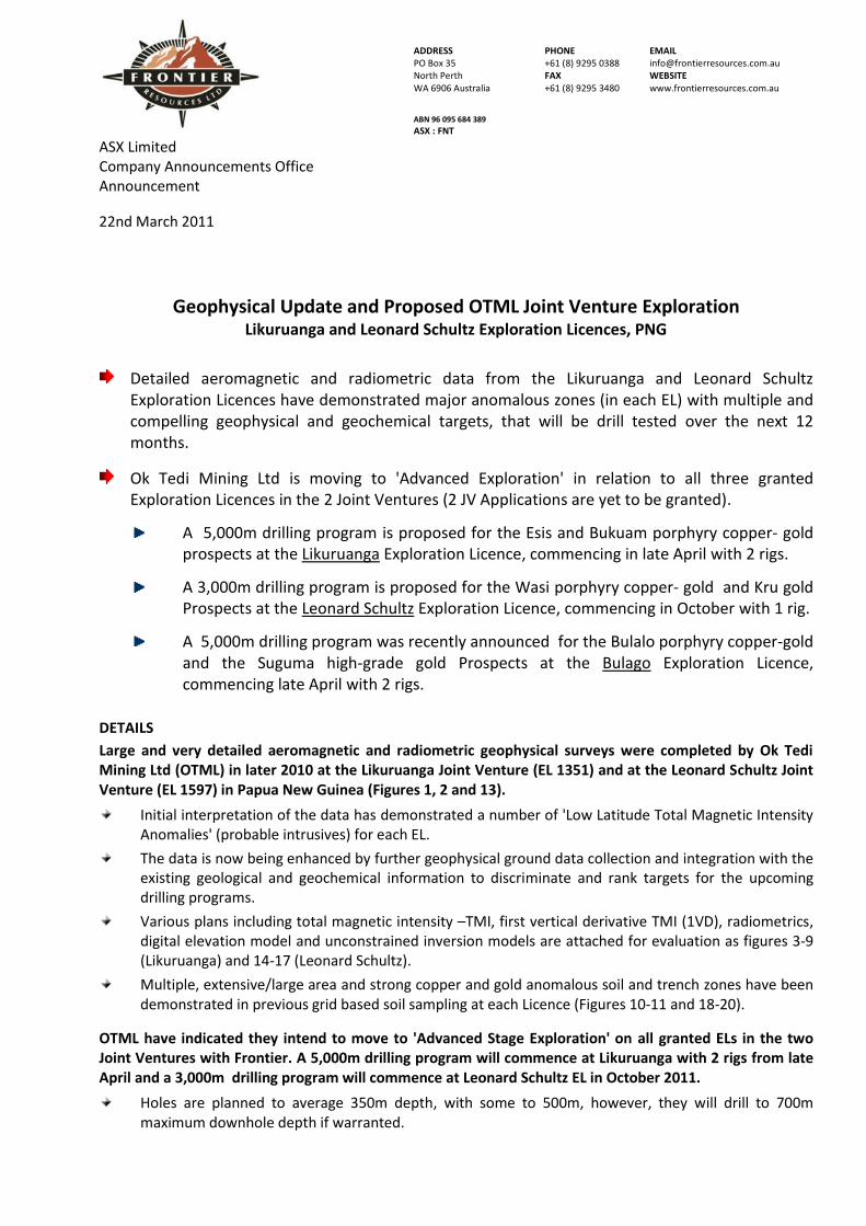
Large and very detailed aeromagnetic and radiometric geophysical surveys were completed by Ok Tedi Mining Ltd (OTML) in later 2010 at the Likuruanga Joint Venture (EL 1351) and at the Leonard Schultz Joint Venture (EL 1597) in Papua New Guinea (Figures 1, 2 and 13).
Initial interpretation of the data has demonstrated a number of 'Low Latitude Total Magnetic Intensity Anomalies' (probable intrusives) for each EL.
The data is now being enhanced by further geophysical ground data collection and integration with the existing geological and geochemical information to discriminate and rank targets for the upcoming drilling programs.
Various plans including total magnetic intensity –TMI, first vertical derivative TMI (1VD), radiometrics, digital elevation model and unconstrained inversion models are attached for evaluation as figures 3-9 (Likuruanga) and 14-17 (Leonard Schultz).
Multiple, extensive/large area and strong copper and gold anomalous soil and trench zones have been demonstrated in previous grid based soil sampling at each Licence (Figures 10-11 and 18-20).
OTML have indicated they intend to move to 'Advanced Stage Exploration' on all granted ELs in the two Joint Ventures with Frontier. A 5,000m drilling program will commence at Likuruanga with 2 rigs from late April and a 3,000m drilling program will commence at Leonard Schultz EL in October 2011.
Holes are planned to average 350m depth, with some to 500m, however, they will drill to 700m maximum downhole depth if warranted.

Page 2 of 12
JV terms for Leonard Schultz require OTML to expend US$12 million over 6 years (commencing May 2010) to earn 58% of EL 1597, then carry Frontier to completion of a Bankable Feasibility Study, with pro-rata (carried) repayments from 50% of future FNT metal sales. Under certain circumstances, OTML and the PNG National Government can purchase up to 80.1% equity in the project.
JV terms for Likuruanga require OTML to expend US$12 million over 6 years (commencing May 2010) to earn 80.1% of EL 1351, then carry Frontier to completion of a Bankable Feasibility Study, with pro-rata (carried) repayments from 50% of future FNT metal sales. Frontier cannot be further diluted from the 19.9% carried interest.
Background Information on the Likuruanga Exploration Licence
EL 1351 is highly prospective for World Class porphyry copper – gold, high-grade gold - silver -zinc skarns and structurally controlled and/or epithermal gold deposits. The EL contains the Esis porphyry Deposit and the over 4.8km long Bukuam porphyry related copper, molybdenum, gold and zinc soil anomaly (refer to the Conceptual Model in Figure 12).
The Bukuam Prospect in contained within a 5.5km long x 1km wide copper in stream sediment anomaly located on the eastern margin of the approximately 20km long x 6km wide Esis-Sai granitoid complex (opposite Esis).
Frontier defined an impressive multi element soil anomaly over 4,800m long (open to the north, south and east) and completed a limited ground magnetic survey (figure 10).
Historic trenching returned 55m of 5.8g/t gold, 10m of 5.1g/t gold and 70m of 1.7g/t gold in different zones.
Only 3 historic holes were drilled, returning 6m of 2.2g/t gold + 9.5g/t silver + 1.2% zinc, 2m of 3.5g/t gold + 9.5g/t silver and 10m of 1.7g/t gold + 2.7 g/t silver + 4.8% zinc. One hole did not reach the target.
A 55m long gold mineralised trench remains untested by drilling and according to the CRA geologists who drilled it, “the gold grade in the skarn could increase towards the shear zone with a possible bonanza at the contact”.
The Esis porphyry copper deposit is situated on a north-north-west trending ridgeline, on the western flanks of the Esis-Sai granitoid complex (opposite Bukuam).
Mineralisation is in quartz-diorite and magnetite breccias.
The strongly copper mineralised zone is more than 1,400m long before going under volcanic rocks to the north and is generally about 400m wide (but is up to 1,000m wide) (figure 11). Fifteen very shallow ‘Winkie’ reconnaissance holes were drilled into primary mineralisation.
Six holes had a weighted copper average for their entire length greater than 0.2% and were terminated in copper mineralisation.
The best holes included DW7 with 21.6m grading 0.50% copper and DW15 with 30.3m grading 0.41% copper.
These holes cover 1,000m of strike extent with the mineralized zone open to the north and south.
Four diamond holes (152.6m each) were drilled to test the supergene about 36 years ago.
The best result was from MD23, with 27m of supergene mineralisation grading 0.71% copper (from 33m depth), plus 66m of primary mineralisation grading 0.42% copper (from 86.6m to end of hole),.
The entire hole weighted assay average was 152.6m grading 0.39% copper + 24ppm molybdenum, with peak grades of 1.62% copper and 124 ppm molybdenum, proving a significantly mineralised system.
The hole was terminated in potentially economic copper mineralisation, with the last 7.6m of the hole grading 0.49% copper.
A resource has not been estimated to date.

Page 3 of 12
Background Information on the Leonard Schultz Exploration Licence
EL 1597 is highly prospective for World Class copper – gold -molybdenum at the Wasi porphyry occurrence and mesothermal base metal sulphide-gold veins and/or epithermal gold deposits at the Kru gold Prospect See figures 14 – 17 for geophysical images including DTM, TMI, TMI (1VD) and an unconstrained inversion model.
Major gold, copper and molybdenum in soil and rock anomalies have been demonstrated at the Wasi Prospect (figures 18 and 19).
The Wasi soil grid is located to the west of the Kru Prospect and copper occurs in two distinct zones.
The southern anomaly is approximately 1,800m long and 600 to 900m wide. Its peak copper in soil is 1080 ppm, Mo is 32 ppm and gold is 0.87 g/t.
The northern anomaly is approximately 600m wide and is totally unconstrained in terms of strike and orientation. Its peak copper in soil is 1160 ppm, molybdenum is 214 ppm and gold is 3.2 g/t.
Copper assays over the entire grid included 14 samples > 600 ppm copper, 35 samples between 400 and 600 ppm copper and 160 between 150 and 400 ppm copper.
Gold assays over the entire grid included 9 samples > 1.0 g/t gold, plus 13 samples between 0.3 and 1.0 g/t gold, 52 samples between 0.1 and 0.3 g/t gold and 75 samples between 0.05 and 0.1 g/t gold.
Gold, silver, copper and molybdenum have been located in outcrop and float.
High grade gold and silver was located in a massive sulphide vein outcrop that assayed 180 g/t gold + 1090 g/t silver + 3.43% copper + 1.34% zinc + 0.92% lead + 25 ppm molybdenum.
Outcrop rock chip channel sampling returned to 1m of 20.9 g/t gold + 243 g/t silver + 0.26% copper.
Rock chip grab samples from separate outcrops assayed to 8.48 g/t gold and 5.72 g/t gold.
The highest copper in rock chip channel samples assayed 4.12% copper + 0.70 g/t gold + 30 g/t silver, contained in a 3m wide quartz sulphide vein. Fifteen other samples ranged from a 0.5m outcrop grading 1.63% copper (+ weak silver) to grab samples assaying 0.20% copper (plus weak gold).
Silver was noted to 314 g/t silver + 1.65 g/t gold + 0.35% copper in outcrop rock grab samples.
Molybdenum in outcrop assayed to 872 ppm + 0.21% copper. Five float rock samples assayed >100 ppm molybdenum (+/- weak copper as expected peripheral to a porphyry copper system).
Additional rock outcrop and float samples collected include 10.5 g/t gold + 17 g/t silver, 8.99 g/t gold + 157 g/t silver + 0.37% copper + 157 ppm molybdenum, 1.06% copper + 0.84 g/t gold, 0.89% copper, 0.59% copper + 3.3 g/t gold + 57 g/t silver, 0.12% copper + 8.94 g/t gold + 13 g/t silver, 0.18% copper + 5.00 g/t gold + 16 g/t silver, 0.24% copper + 1.29 g/t gold + 16 g/t silver, 0.65% copper + 0.31 g/t gold + 17 g/t silver, 0.21% copper, 3.84 g/t gold + 29 g/t silver, 2.97 g/t gold + 12.6 g/t silver + 80 ppm molybdenum, 4.38 g/t gold + 153 ppm molybdenum.
The Kru Prospect (which has never been drilled) consists of over an area of approximately 2,500m by greater than 100m, that is located peripheral to the Wasi porphyry copper occurrence.
The Siaporufe Zone and the large size of the system can be seen through the generalised gold in soil sample data. Frontier re-located, joined together, deepened, extended and channel chip sampled the historically excavated hand trenches in the Siaporufe Zone demonstrating higher grade gold and longer lower grade gold intercepts (figure 20).
The first 384m long trench noted wraps around the SE terminating end of a ridgeline, as shown in the hand trench gold assay results plan, demonstrating excellent overall continuity to the gold mineralisation over an area of greater than 200m x greater than 125m.
The mineralisation is open in all directions, but notably to the NW.
Peak assay grades from the Kru trench sampling included 4m of 52.0 g/t gold and 5.6m of 9.46 g/t gold. The weighted average of the higher grade mineralisation analysed is 76m of 5.35 g/t gold, including 16m of 18.60 g/t gold, plus 10m of 1.33 g/t gold, 4m of 2.03 g/t gold and 16m of 0.97 g/t
Page 4 of 12
gold. The 22m zone of higher grade gold mineralisation appears to represent an approximate true width, as the trench trends E-ENE and the mineralisation appears to trend NW-SE.
The vertical interval (RL) between gold mineralisation noted in different parts of this trench and system is estimated to be approximately 80m vertically. This highlights the substantial minimum vertical component to the gold mineralisation that is already known.
Figure 1. Location of Frontier’s exploration licenses and applications in Papua New Guinea, showing some significant assay results.
Figure 2. An SRTM topographic image of EL 1351 - Likuruanga in West New Britain Province.
Figure 2
Figure 1
Figure 1

Page 5 of 12
Figure 4 Raw radiometric data, potassium channel
Figure 6 Digital Terrain model showing the area of the geophysical survey
Figure 3 Raw magnetic data
Figure 5
Raw magnetic data with surface rock sampling. Red>0.1% Cu

Page 6 of 12
Figure 7 Unconstrained inversion model of the entire Likuruanga survey block, block size 100m. Figure 8. Unconstrained 3D inversion model of the Esis area, block size 50m. Figure 9. Unconstrained 3D inversion model of the Bukuam area, block size 50m.

Page 7 of 12
Figure 10. Gold over gridded copper assays in soils at Bukuam demonstrate a more than 4,800m long cohesive and locally coincident copper, gold and molybdenum anomaly. A surrounding zinc halo demonstrates zinc – silver skarns proximal to the intrusion.
Figure 11. Copper in trenches at Esis.
Figure 12 Schematic cross section or conceptual model for the Esis to Bukuam area.
Figure 13. SRTM location plan of EL 1597 – Leonard Schultz, showing the Wasi- Kru Prospect locations. Major faults are seen as cross cutting linear features.
Figure 10
Figure 11
Figure 12
Figure 13
Page 8 of 12
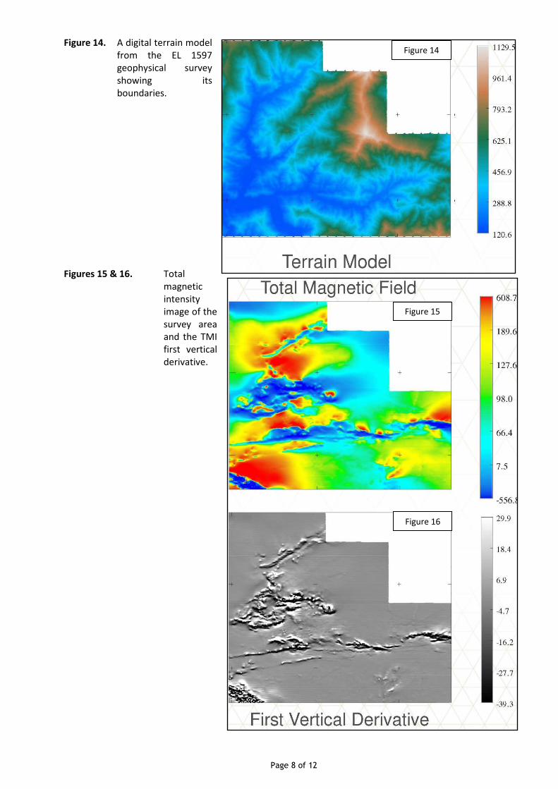
Figure 14. A digital terrain model from the EL 1597 geophysical survey showing its boundaries.
Figures 15 & 16. Total magnetic intensity image of the survey area and the TMI first vertical derivative.
Figure 15
Figure 14
Figure 16

Page 9 of 12
Figure 17. Unconstrained inverted of the aeromagnetic data at 50m resolution. A major anomaly exists on the SW edge as noted.
Figures 18 & 19. Copper and gold in soil samples at the Wasi porphyry copper-gold–molybdenum Prospect.
Figure 17

Page 10 of 12
Figure 20. Gold in trench channel chip samples at the Kru Prospect.
For additional information relating to the Likuruanga and Leonard Schultz Projects or Frontier Resources Ltd, please see previous ASX releases, visit our website at www.frontierresources.com.au or feel free contact me.
FRONTIER RESOURCES LTD
P.A.McNeil, M.Sc. CHAIRMAN / MANAGING DIRECTOR
The information in this report that relates to Exploration Results and Mineral Resources is based on information compiled by, or compiled under the supervision of Peter A. McNeil - Member of the Aust. Inst. of Geoscientists. Peter McNeil is the Managing Director of Frontier Resources, who consults to the Company. Peter McNeil has sufficient experience which is relevant to the type of mineralisation and type of deposit under consideration to qualify as Competent Person as defined in the 2004 Edition of the Australasian Code of Reporting Exploration Results, Mineral Resources and Ore Resources. Peter McNeil consents to the inclusion in the report of the matters based on the information in the form and context in which it appears.

Page 11 of 12
ABOUT FRONTIER RESOURCES LTD FRONTIER IS FOCUSED ON EXPLORING FOR AND DEVELOPING MINERAL DEPOSITS IN THE HIGHLY MINERALISED PACIFIC ‘RIM OF FIRE’ IN PAPUA NEW GUINEA AND THE HIGHLY PROSPECTIVE DOLCOATH GRANITE AND MT READ VOLCANICS OF TASMANIA, AUSTRALIA
The Company is an innovative and socially responsible ASX listed junior mineral explorer whose shares also trade on the Frankfurt, Berlin and Munich Stock Exchanges.
Frontier’s Directors have more than 150 years combined experience in PNG and Australia to serve the interests of the company and its shareholders.
Frontier operates with a general policy of ‘DRILLING’ our quality projects using our purpose built and self manufactured, cost effective, environmentally friendly, man-portable diamond core rig.
The Company has a 100% interest in four Exploration Licences (approx. 1,140 km²) and three Exploration Licence Applications
(approx. 2,212km²) in PNG. Three ELs and two ELAs are subject to Joint Ventures with PNG producer Ok Tedi Mining Ltd.
Frontier also has two Exploration Licences and a Retention Licence (123 km²), + three EL Applications and an ERA in Tasmania.
The tenement portfolio offers excellent mineral deposit potential. Primary targets are World Class copper-gold-molybdenum porphyry, high grade gold epithermal, gold–base metal & tungsten skarns + polymetallic VMS (zinc-lead-silver-gold) deposits.
The projects all have high-grade exploration results in rock, trenches and/or drill hole and are in the same or similar geological terranes as existing World Class and/or major mines.
THE 100% OWNED MT ANDEWA EL IN PNG HAS EXCELLENT GOLD AND COPPER MINERALISATION POTENTIAL
Frontier undertook a major three dimensional Induced Polarisation (3D-IP) geophysical program over a 21 sq km grid at the Andewa gold and copper Project on the island of New Britain in Papua New Guinea in 2010 and collected in excess of 5,000 soil and rock samples. The soil and rock assays are now being collated for announcement.
The 3D-IP survey was a remarkable success that showed three exceptionally extensive, voluminous and intense, chargeability anomalies that compellingly demonstrate the presence of very large sulphide systems from on-surface to more than 800m deep…
The total chargeability anomaly (>30ms) area is approximately seven square kilometres, consisting of three very large, spatially related and intense chargeability anomalies called the Core Chargeability (CCZ), Ber and Ekhos Zones. The Ekhos chargeability anomaly is 3.3 Km
2 in area, the CCZ is 3.0 km
2 and Ber is approximately 0.5 km
2 (at 150m below sea level).
The total anomalous chargeability area is approximately 5,400m long (E-W) and 3,000 wide (N-S). The Ekhos chargeability anomaly is approximately 3,850m long x 1,750m wide. It averages about 1,000m wide and has a higher grade chargeability core zone that is approximately 2,400m long and 1,000m wide (at >30ms and 400m below topography). The CCZ is approximately 2,900m long (NW to SE) and a maximum of 2,100m wide, averaging 1,000m wide.
Ekhos is the largest and closest to surface 3D-IP chargeability anomaly at Andewa, with much of it very intense at >45ms; it is open to the south and east but appears defined in general at depth. The CCZ chargeability anomaly is open to the south AND at depth, however, it’s very intense core (>45ms) appears to be adequately resolved. The CCZ also has large anomalous areas at >45ms chargeability that extend to depths greater than the 800m modelled maximum.
Each major chargeability anomaly is surrounded by a sub-circular high-resistivity anomaly that appears to merge near the edge and off the grid, to become one approximately 6km diameter resistivity anomaly in the centre of the Mt Andewa crater, with ‘holes’ in it where the strong chargeability anomalies exist .
Frontier has previously drilled gold mineralisation at Komsen on the western margin of the CCZ from surface to a maximum depth of 320m below surface in a limited program, with drill intercepts containing significant gold and base metals such as 2m of 5.43 g/t gold + 95 g/t silver + 11.1% zinc + 2.3% lead + 0.12% copper and 7.9m of 10.01g/t gold.
Field crews are again in the field conducting infill soil sampling and preparing for a deep drilling program scheduled for April 2011 with our own drilling rigs and crews.
HIGHLY PROSPECTIVE TENEMENTS AND FRONTIER’S EXPLORATION SUCCESS IN PNG CULMINATED IN AN EXCELLENT STRATEGIC ALLIANCE - JOINT VENTURE WITH WORLD CLASS COPPER PRODUCER OK TEDI MINING LTD (OTML)
Three ELs and two ELAs are subject to 2 joint ventures that require a total earn-in of US$60 million over 6 years, consisting of US$12 million for each of the 5 projects.
Frontier then has a deferred carry to completion of a Bankable Feasibility Study on each tenement.
The Company will retain a 42% interest (dilutable) in the Leonard Schultz and Leonard Schultz ELs and a 19.9% interest (non-dilutable) in the Likuruanga EL + Central and East New Britain ELAs, to the completion of a Bankable Feasibility Study.
The JVs cover a total area of 2,763 km2.
OTML have completed large aeromagnetic and radiometric programs at each EL in the Joint Venture to discriminate and rank targets for follow up exploration, including drilling in 2011.
OTML is a major producer of copper concentrate from the Ok Tedi mine (that started operations in 1984) and has become the single largest business contributor to the economy of PNG. In 2009, OTML's export earnings were K4 billion, representing 33% of PNG's total export earnings. The contributions of the mine to PNG are not simply economic, with employment, education and health services all facilitated by the mine.
PNG exploration results from the JV projects have included:
The Leonard Schultz JV has 10 zones of high-grade gold in outcrop channel samples at the Suguma and Funutu Prospects from continuous chip outcrop channel samples. Trench intercepts included 27m of 66.8 g/t gold, 4m of 135.6 g/t gold, 9m of 64.0
Page 12 of 12
g/t gold, 16m of 36.5 g/t gold, 18m of 40.3 g/t gold, 7.5m of 67.0 g/t gold and 9m of 24.0 g/t gold.
The Kru and nearby Wasi Prospects in the Leonard Schultz JV have excellent gold outcrop trench channel sample assay results including 16m of 18.60 g/t gold contained within 76m of 5.35 g/t gold. Additional significant assay results included 22m of 2.71 g/t and 36m of 1.15 g/t (within 384.3m of 0.67 g/t gold) in outcrop trench.
Likuruanga JV - Esis Prospect has 27m of supergene mineralisation grading 0.71% copper (from 33m depth), plus 66m of primary grading 0.42% copper (from 86.6m to end of hole), with the last 7.6m of the hole grading 0.49% copper.
EXPLORATION IS RAMPING UP ON FRONTIER'S TASMANIAN EXPLORATION AND RETENTION LICENSES, TARGETING KNOWN HIGH-GRADE (PLUS POTENTIALLY BULK MINEABLE) TUNGSTEN, GOLD AND BASE METAL DEPOSITS
The Cethana Project covers an E-W spine of the highly mineralised Dolcoath Granite and a number of skarn and vein deposits, from east to west (proximal to distal) including silver, tin, tungsten, molybdenum, gold+ silver + zinc + lead (Narrawa), zinc+ gold (not FNT's), fluorine (not FNT's) and gold + bismuth (Stormont).
Frontier is specifically targeting tungsten along with other metals in this highly mineralised district.
There are at least 55 historic workings (shafts, adits and small open pits) within the targeted area testifying to its highly prospective and mineralised status.
The primary commodity mined in the district was tungsten in at least 23 workings, tin in 9 workings and gold in 7 workings (many are unspecified).
Previous Frontier tungsten drill intersections included 1m grading 1.98% WO3 near the NW end of the Narrawa Deposit, within a broad low grade geochemical halo that averaged 14m of 0.20% WO3 (from 21m).
Narrawa is a stratabound/stratiform skarn Deposit hosted within 4 steeply dipping on/near surface lodes, which could be mined by open pit mining methods.
The deposit contains an Indicated and Inferred resource with 14,125 ounces of gold, plus 131,300 ounces of silver, 2,765 tonnes of lead and 2,335 tonnes of zinc (at 0.5g/t gold cut-off grade), that is up to 220m long, 20m wide and 60m deep, within 209,330 tonnes of rock grading 2.10 g/t gold, 19.5 g/t silver, 1.32% lead and 1.12% zinc.
The Indicated Resource consists of 162,755 tonnes grading 2.11 g/t gold, 20.5 g/t silver, 1.42% lead and 1.2% zinc.
The Inferred Resource consists of 46,574 tonnes grading 2.07 g/t gold, 16 g/t silver, 0.98% lead and 0.81% zinc.
Frontier's detailed exploration and expenditure submission to Mineral Resources Tasmania for the Stormont Deposit - ERA 834 was successful and should be granted in due course.
The 9 km2 ERA consolidates Frontier's tenement portfolio in the Central-North of Tasmania and provides additional highly
prospective ground for exploration.
ERA 834 contains the on-surface Stormont Deposit, with an Inferred Resource of 14,250 ounces of gold plus 304 tonnes bismuth, within 112,500 tonnes of mineralised rock grading 3.94 g/t gold plus 0.27% bismuth (1.0g/t gold cut-off grade).
It is planned to increase the size of the resource and upgrade it from Inferred to Indicated.

![DDS C ,bc ]^ · 17 % cell growth DMBL 100.00 ppm DMBL 33.33 ppm DMBL 11.11 ppm control DMBL 3.70 ppm DMBL 1.23 ppm DPBL 100.00 ppm DPBL 33.33 ppm DPBL 11.11 ppm DPBL 3.70 ppmDPBL](https://static.fdocuments.us/doc/165x107/5e775a5ea36baa321a57d8d8/dds-c-bc-17-cell-growth-dmbl-10000-ppm-dmbl-3333-ppm-dmbl-1111-ppm-control.jpg)