Geophysical Survey Report No. 15 · Geophysical Survey Report No. 15 ... Description and...
13
CAF GSR014 Cornashee, Co. Fermanagh: integrated earth resistance and magnetometry report 1 Geophysical Survey Report No. 15 Cornashee, Co. Fermanagh Integrated earth resistance and magnetometry report Dr Steven Trick
Transcript of Geophysical Survey Report No. 15 · Geophysical Survey Report No. 15 ... Description and...

CAF GSR014 Cornashee, Co. Fermanagh: integrated earth resistance and magnetometry report
1
Geophysical Survey Report No. 15
Cornashee, Co. Fermanagh Integrated earth resistance and magnetometry report
Dr Steven Trick
CAF GSR014 Cornashee, Co. Fermanagh: integrated earth resistance and magnetometry report
2
1 Introduction
This report presents and discusses the results of two seasons of geophysical survey
at Cornashee, Co. Fermanagh (SMR FERM 246:1, FERM 246:2, FERM246:3). In
February 2006 the CAF conducted an earth resistance survey of the site, and results
of this work were published in CAF GSR 007 (Trick 2006). In August 2006 the CAF
followed up the resistance survey with a magnetometer survey of the site, with the
results published in CAF GSR 013 (Trick 2007). This report brings together the
results of the two surveys, discusses the significance of the combined results, and
suggests further work at the site. Please see GSR007 or GSR013 for the background
on the site, and the individual reports for details on the respective survey methods.
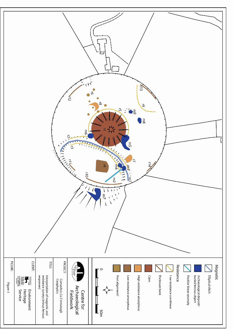
2 Earth Resistance Survey
The resistance survey used a standard survey resolution of 1m x 1m over a series of
20m x 20m grids. The majority of the interior of the circular enclosure (FERM 246:3)
was surveyed. This survey is fully described and reported on in CAF GSR 007. The
anomalies encountered are summarised in Table 2.1 below and are presented
graphically in Figure 1.
Table 2.1. Description and interpretation of resistance anomalies (see Fig. 1)
Code Description Interpretation
r1 A circular border of very
high-resistance values, up to
234 ohms.
This is the edge of the central cairn,
resistance values suggest it is uniformly
comprised of stone blocks with air-filled
cavities. Appears to overlie r2 below.
r2 Curving low-resistance
anomaly, c. 5m across,
tangential to r1.
This is the ditch of the elliptical
enclosure, the low-resistance nature
suggesting it has filled with rich silty
material since last cutting/re-cutting.
Appears to be overlain by r1 adjacent
to cairn.
r3 Incoherent curving low-
resistance anomaly, c. 6m
across which mirrors the
Gap between r2 and r3 suggests this is
not the signal made by the internal
bank of the elliptical enclosure but

CAF GSR014 Cornashee, Co. Fermanagh: integrated earth resistance and magnetometry report
3
path of r2. rather a further shallow, and poorly-
defined ditch internal to the bank.
r4 Rectlinear patch of low-
resistance, c. 13m x 14.5m,
internal to the elliptical
enclosure, marked on the
ground by a dense patch of
fibrous weeds.
No obvious interpretation, although its
position within the elliptical enclosure
might suggest the two are related.
r5 Low-resistance arc encircling
the mound, c. 3m in width.
Possible ditch around the central cairn.
r6 Spatially aggregated group
of sub-circular low-
resistance anomalies, each
1m -3m in diameter.
Resistance values suggest pits,
possibly of former post-hole or stone-
hole alignment.
r7, r8 Amorphous patches of high-
resistance readings.
r7 appears to be truncated by the ditch
of the elliptical enclosure and may be
related in some way. The
archaeological significance of r7 and r8
is uncertain.
r9 Curving anomaly, c. 1m
across, in the north-western
sector of the circular
enclosure.
Resistance values are suggestive of a
ditch, which may possibly continue
outside survey area, and the circular
enclosure.
r10-r14 Areas of high-resistance
encountered at the edge of
the circular enclosure, up to
140 ohms.
This is the bank of the circular
enclosure. Resistance values suggest it
is well-drained with possible stone–
core. Landowner stated that there was
once a wall on this bank suggesting the
footing of the wall may remain within
the bank.
CAF GSR014 Cornashee, Co. Fermanagh: integrated earth resistance and magnetometry report
4
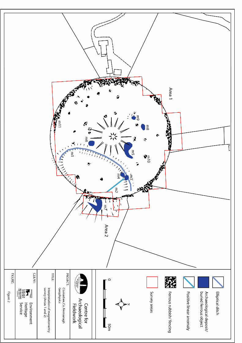
3 Magnetometry Survey
The magnetometry survey used a high-resolution sampling interval of 1m x 0.25m,
over a series of 20m x 20m grids, and covered the entirety of the circular enclosure
(FERM 246:3, ‘Area 1’ in GSR013 and this report). Also surveyed was a small portion
of a field to the east (‘Area 2’) where the EHS inspectors had noted and planned the
apparent continuation of the elliptical enclosure (see EHS SM7 file and Fig. 2). The
magnetometry survey is fully described in GSR013. The anomalies encountered are
summarised in Table 3.1 below, and are presented graphically in Fig. 2).
Table 3.1. Description and interpretation of magnetometry anomalies (see Fig.
2)
Code Description Interpretation
m1 A faintly positive, curving
anomaly, c. 5m across.
This is the ditch and bank of the
elliptical enclosure. The slight magnetic
response suggests that the ditch and
bank to not comprise much material
derived from nearby anthropogenic
activity.
m2 Positive linear anomaly c.
1m wide, on a northwest-
southeast alignment.
Possible ditch or gulley.
m3,m4 Two magnetic ‘spots’ at the
northwest terminus of m2,
just inside the elliptical
enclosure. These
correspond to Anomaly ‘2’ in
the preliminary
magnetometry survey
described in CAF GSR007.
Dipolar response and medium signal
strength suggest buried ferrous objects
at some depth. Alternatively, a hearth
or cache of ceramic material. Possibly
related to m2.
m5 Concentration of strong and
above average magnetic
responses in a curving
pattern
Whether this is a true concentration of
archaeological deposits or a
concentration of ferrous rubbish is
unclear. At the western end of the
deposits the strength of the signal (+-
3000nT) suggests ferrous rubbish near

CAF GSR014 Cornashee, Co. Fermanagh: integrated earth resistance and magnetometry report
5
the surface; perhaps debris of farming
activities. The proximity to the central
mound may forward a more
archaeological interpretation, perhaps a
deposit of metalwork in the liminal zone
around of the mound.
m6 Strong dipolar anomaly at
the edge of the mound,
similar to m5 but the signal
strength here is a modest
98nT.
The strength of signal suggests ferrous
rubbish, perhaps farm debris. This
anomaly is located at the edge of the
cairn where the façade is flatter,
suggesting a possible entrance. It is not
inconceivable that this is a metalwork
deposit a former entrance to the
monument.
m7 Anomaly m7 is an area of
increased magnetic
response in Area 2. A strong
dipolar response at the
western end, with a
positively magnetic tapering
‘tail’ to the south and east.
The spatially contained and dipolar
response at the western end of the
anomaly suggests a ferrous object
buried beneath the surface. However
this anomaly may also be
representative of a hearth or kiln or
dump of brick or tile. The positively
magnetic ‘tail’ suggests a ditch or
gulley. These anomalies spatially
coincide with an area of subtle
earthworks (see Figure 2 and hachure
plan in EHS SM7 file).
m8 This is a dipolar response
which corresponds with
Anomaly ‘1’ in the
preliminary magnetometry
survey described in CAF
GSR007.
The dipolar response suggests ferrous
rubbish, however the width of the
response (3m x 7m) suggests either a
large ferrous object near the surface or
a strong archaeological deposit.
m9 This is a dipolar response,
similar to m8 but smaller in
spatial influence.
The dipolar response suggests ferrous
rubbish, however an archaeological
source is possible and this anomaly
CAF GSR014 Cornashee, Co. Fermanagh: integrated earth resistance and magnetometry report
6
has been highlighted (amongst many
similar anomalies not discussed) since
it coincides spatially with the location of
one of the postulated satellite tombs
northwest of the cairn (see hachures on
Figure 2 transcribed from SM7 file) and
could therefore represent a grave
deposit.
m10 Dipolar magnetic ‘spike’. Anomaly m10 is highlighted as an
example of the many magnetic spikes
encountered which are most likely to be
ferrous rubbish such as foil sweet
wrappers or farm debris such as tractor
parts or barbed wire fragments.
m11 Agglomerated area of
magnetic spiking.
m11 has been highlighted as an
example of an area of strong magnetic
response encountered at the periphery
of the main circular enclosure. This is
caused by barbed wire or corrugated
iron fencing around the site.
4 Discussion of Results
Figure 3 shows the combined results of the resistivity and magnetometry survey
overlaid on the base mapping. It can be seen that geophysical methods have located
anomalies in all parts of the main enclosure and into the adjacent field.
The resistance survey highlighted a number of curvilinear anomalies and also more
defined areas of high/low resistance. Importantly, it showed the central cairn to be a
very high-resistance anomaly, strongly suggesting that rather than being an earthen
mound it is a stone cairn made of rough stone blocks with cavities between them.
The elliptical ditch showed up as a well-defined, low-resistance anomaly suggesting
a deeper ditch than can be seen today, with a fill that potentially contains
archaeological material.
CAF GSR014 Cornashee, Co. Fermanagh: integrated earth resistance and magnetometry report
7
The strong dipolar response of many of the magnetometry anomalies suggest they
are the result of surface or near surface ferrous rubbish most likely items related to
modern agricultural practice. However the possibility remains that some of these may
be archaeological in nature. The most interesting of the magnetic responses are
those associated with the elliptical enclosure, in particular anomalies m2 and m7.
These have a positively magnetic linear element to them suggesting ditches or
gullies, and both are spatially associated with strong dipolar responses suggesting
associated ferrous or fired ceramic objects.
Interestingly, only rarely have both techniques detected the same feature: the
elliptical ditch shows up in both, albeit very faintly in the magnetic survey. The
potential negative features highlighted by the resistance survey (ditches, pits etc)
have not produced a concomitant magnetic response, indicating that they have not
been filled with magnetically enhanced material. This may suggest that the soils on
the hill have not been enhanced through prolonged human habitation and the site
was only used for shorter-term ritual use.
5 Future Work
The complex of monuments at Cornashee remain enigmatic, and there are basic
unanswered questions concerning the origins and phasing of the individual
components of the complex. The central cairn has been postulated as a Neolithic
passage grave (see EHS SM7 file), which is potentially unexcavated and therefore of
immense archaeological potential. More commonly the monument is celebrated as
the place where the Maguires of Fermanagh were inaugurated during the later
medieval period (FitzPatrick 2004). However, as yet no firm archaeological evidence
exists to support either of these interpretations. It is suggested that a series of
exploratory trenches be opened at the site in order to address these ambiguities,
using the results of the geophysical surveys as a basis for their location.
The site is a Scheduled Monument and, as such, any such work would require
Scheduled Monument Consent from EHS: Built Heritage. By overlaying the
resistance and magnetic surveys we can make more informed decisions regarding
where to place excavation trenches, so that some of these can encompass
anomalies detected in both surveys. Figure 4 shows the suggested locations of these
trenches. The following trenches are recommended:

CAF GSR014 Cornashee, Co. Fermanagh: integrated earth resistance and magnetometry report
8
• Trench 1 encompasses the edge of the cairn and the ditch of the elliptical
enclosure. This will elucidate on the phasing of the cairn and elliptical
earthwork and provide dating evidence.
• Trench 2 spans the ditch of the elliptical enclosure again but also takes in
high-resistance Anomaly r7 and magnetic ‘hotspot’ m4, providing information
on the ditch chronology but also the origin of these geophysical anomalies.
• Trench 3 is a long strip trench internal to the elliptical enclosure that covers
the edge of low-resistance anomaly r4 and extends to take in linear positive
magnetic anomaly m2 providing information on both these anomalies.
• Trench 4 is a small exploratory trench over magnetic anomaly m9 which will
investigate the source of the magnetic signal, and determine whether there is
a satellite tomb in this position and whether the tomb and anomaly are
interlinked.
• Trench 5 is positioned at the southwest edge of the cairn to investigate high-
resistance anomaly r8, and anomaly r5 which is the subtle low-resistance ring
around the cairn, and also one of the possible post holes (Anomaly r6).
• Trench 6 is located to investigate the magnetic anomaly m6 which occurs at a
slight hollow in the slope of the mound hinting at a possible entrance into the
monument. This trench will discover the source of the magnetic signal and
investigate the possibility of an entrance at this point.
• Trench 7 is a long trench in Area 2 which is designed to investigate the nature
of the large magnetic response here and also the form of the earthworks in
this field, and whether they do represent an extension to the elliptical
enclosure in Area 1.
Acknowledgements
The following people are thanked for their help in the organisation and
implementation of the survey, and the writing of this report. Dr Eileen Murphy (GAP),
Ronan McHugh (CAF), Barrie Hartwell (GAP), John Patterson (landowner), Mrs

CAF GSR014 Cornashee, Co. Fermanagh: integrated earth resistance and magnetometry report
9
Patterson (landowner), Philip MacDonald (CAF), Colm Donnelly (CAF), John Reihill,
Rachel McAllister (Glover Site Investigations), Elizabeth FitzPatrick (NUI Galway).
Bibliography
Anon. 1977. Cornashee: mound and enclosures. SM7 File. Unpublished document
held by the Environment Heritage Service, Belfast.
Trick, S. 2006. Cornashee, Co. Fermanagh. CAF Geophysical Report No 7,
Unpublished report produced on behalf of EHS: Built Heritage by the Centre for
Archaeological Fieldwork, Queen’s University Belfast.
Trick, S. 2007. Cornashee, Co. Fermanagh, Season 2: Magnetometry survey. CAF
Geophysical Report No 13, Unpublished report produced on behalf of EHS: Built
Heritage by the Centre for Archaeological Fieldwork, Queen’s University Belfast.
FitzPatrick, E. 2004. Royal inauguration in Gaelic Ireland c. 1100-1600: a cultural
landscape study. Suffolk: Boydell Press.