Geophysical and geological analysis of a fault-like ...
134
Portland State University Portland State University PDXScholar PDXScholar Dissertations and Theses Dissertations and Theses 1971 Geophysical and geological analysis of a fault-like Geophysical and geological analysis of a fault-like linearity in the lower Clackamas River area, linearity in the lower Clackamas River area, Clackamas County, Oregon Clackamas County, Oregon Ronald Jay Schmela Portland State University Follow this and additional works at: https://pdxscholar.library.pdx.edu/open_access_etds Part of the Geology Commons, Geophysics and Seismology Commons, and the Tectonics and Structure Commons Let us know how access to this document benefits you. Recommended Citation Recommended Citation Schmela, Ronald Jay, "Geophysical and geological analysis of a fault-like linearity in the lower Clackamas River area, Clackamas County, Oregon" (1971). Dissertations and Theses. Paper 1426. https://doi.org/10.15760/etd.1425 This Thesis is brought to you for free and open access. It has been accepted for inclusion in Dissertations and Theses by an authorized administrator of PDXScholar. Please contact us if we can make this document more accessible: [email protected].
Transcript of Geophysical and geological analysis of a fault-like ...

Portland State University Portland State University
PDXScholar PDXScholar
Dissertations and Theses Dissertations and Theses
1971
Geophysical and geological analysis of a fault-like Geophysical and geological analysis of a fault-like
linearity in the lower Clackamas River area linearity in the lower Clackamas River area
Clackamas County Oregon Clackamas County Oregon
Ronald Jay Schmela Portland State University
Follow this and additional works at httpspdxscholarlibrarypdxeduopen_access_etds
Part of the Geology Commons Geophysics and Seismology Commons and the Tectonics and
Structure Commons
Let us know how access to this document benefits you
Recommended Citation Recommended Citation Schmela Ronald Jay Geophysical and geological analysis of a fault-like linearity in the lower Clackamas River area Clackamas County Oregon (1971) Dissertations and Theses Paper 1426 httpsdoiorg1015760etd1425
This Thesis is brought to you for free and open access It has been accepted for inclusion in Dissertations and Theses by an authorized administrator of PDXScholar Please contact us if we can make this document more accessible pdxscholarpdxedu
AN ABSTRACT OF THE THESIS OF Ronald Jay Schmela for the
Master of Science in Earth Science presented September 10 1971
Title Geophysical and Geological Analysis of a Fault-like
Linearity in the Lower Clackamas River Area
Clackamas County Oregon
APPROVED BY MEMBERS OF THE THESIS COMMITTEE
Leonard A
~E Allen
ninJ
Dale E C~urtney
A fault-like linearity along the lower Clackamas River is
evaluated by analysis of physiographic and structur-al aljgnmeOts
geological relationships and by gravity and magnetic data The
study has resulted in the verification of a structural feature extend-
ing along the Clackamas River and the eastern front of the Portland
Hill bullbull
Physiographic alignments were examined in twelve 15 minute
and two 7-12 minute quadrangle maps A significant northeasterly
morphologic trend N 20middot W and N 40deg W and other secondary
trends namely the N-S E-W and N 50-60deg E has developed in
the Portland area The consistent northwest trend is observed
throughout the entire area studied which strongly suggests that the
alignments are very good indicators of underlying structural features
Structural alignments show that approximately 60 of the known
mapped faults and fold axes concur with the dominant northwest
physiographic trend Seismic first motion analysis supports the
established morphologic trend
A series of regionally co aligned morphologic and structural
features striking S 40 50middot E across the state of Oregon suggest
the pre sence of a major structural fault system aligned with the
Portland Hills-Clackamas River structural alignment
The geologic cross sections developed from map and well data
generally lack any tangible evidence as to the nature of the physioshy
graphic alignment An apparent offset of the lower Pliocene Sandy
River mudstone suggests movement as recent as middle Pliocene
Geophysical information was obtained from six gravity
traverses and three magnetic traverses The consistency of the
size and shape of the gravity anomaly 218 miUigalsO 2 mile
downdropped to the east across the physiographic alignment
defines the zone of a fault or a steep fold developed in the Columbia
River basalt The magnetic anomalies show a consistent change in
the magnetic gradient corresponding to the structural zone
VITA
The writer Ronald Jay Schmela was born in Pasadena
California on April 15 1945 He graduated from Ventura High
School Ventura California in June 1963 He received his
Bachelor of Science degree from the University of Redlands
Redlands California in June 1967 In 1969 he enlisted in the
Oregon National Guard while attending the University of Oregon
as a gradqate student Afterward he transferred to Portland State
University in September 1969 and has since been a graduate
student
TO THE OFFICE OF GRADUA TE STUDIES
The member s of the Committee approve the thesis of
Ronald Jay Schmela prese~
er Chairman
Dale E Courtney
APPROVED
J
ACKNOW LEDGEMENTS
The writer wishes to express his gratitude to Dr L A
Palmer the thesis adviser for his suggestions and guiding assis-
tance in discussing problems and correcting the manuscript
The writer also wishes to thank Dr R Blank University of
Oregon for his unselfish donation of time in discussing the data
Thanks are also due to Dr R Couch and Dr D F Heinrichs
Oregon State University for their assistance in the project
Special thanks are due to Dr R Blank University of Oregon
for loan of the fluxgate magnetometer and Dr R Couch Oregon
State University for loan of the Worden gravity meter for without
these instruments this thesis would not have been possible bull
Thanks are due to Mr Tomaz Rupnik for his contributions
in writing the computer program for the theoretical gravity The
writer also wishes to thank Mr R E Corcoran Oregon Depart-
ment of Geology and Mineral Industries for his support of the
thesis and assistance in obtaining use of a state car
Appreciation is expressed to Dr J E Allen Dr M H
Beeson and Dr D J Cash for their criticism of the manuscript
v
Thanks are also due to the geology department for use of
their field and laboratory equipment and the duplicating department
The writer wishes to thank his wife Carol for her help in
the fieldwork and for her enduring patience and inspiration
TABLE OF CONTENTS
ACKNOW LEDGEMENTS
LIST OF TABLES
LIST OF FIGURES bull
INTRODUCTION bull bull bull bull bull
Purpose and Scope middot bull bull bull bull bull bull bull bull Location and Planimetric Base Control
PAGE
iv
bull ix
bull x
bull 1
1 2
Previous Work 5 Fieldwork 8
PHYSIOGRAPHIC AND STRUCTURAL ALIGNMENTS
GEOLOGICAL INVESTIGA TIONS bull
GEOPHYSICAL METHODS
Gra vimetric Magnetic
INTERPRETATIONS
bull
bull
bull bull
bull 13
bull bull 23
bull 24
bull 24 bull 25
bull bull 26
Physiographic and Structural Alignments bullbullbullbullbullbullbull 26 Geologic Thickness Relationships and Gravity Profiles bull 29
Milwaukie traverse Gladstone traverse Redland traverse bull Transmission Line traverse bullbullbull Paradise Park traverse bullbull bull bull Estacada traverse bull bull bull bull bull
Significance of the Geologic Cross Sections and
bull 30 bull 34 bull 36
bull bull bull bull 37 middot 38 bull 38
the Bouguer Anomalies bullbullbullbullbullbullbullbullbullbullbullbullbullbull 39
vii
PAGE
Magnetic Profiles bull 40
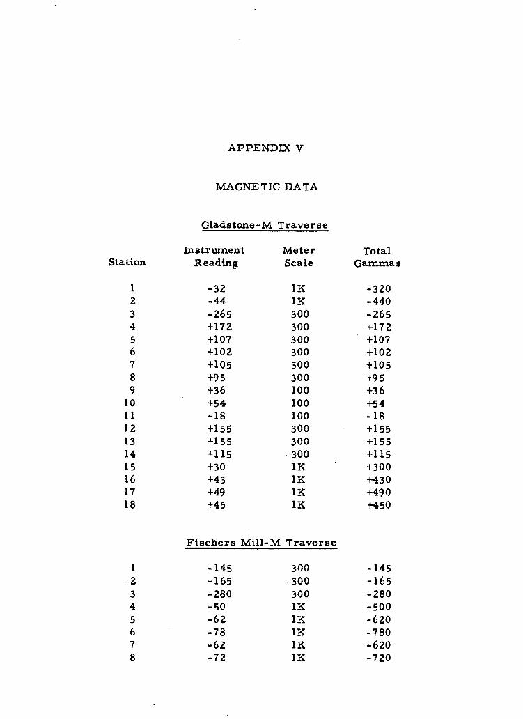
Gladstone-M traverse - - - 40 Fischers Mill-M traverse - - 43 Estacada-M traverse - 43
Significance of the Magnetic Anomalies 44
CONCLUSIONS AND RECOMMENDATIONS - - - bull bull bull bull bull bull 45
Recommendations bull - - bull bull 46
REFERENCES CITED bullbullbullbull bull bull bull bull bull bull bull 48
APPENDIX I DESCRIPTION OF BENCH MARKS bull 55
APPENDIX II GEOLOGY bull bull bull bull bull bull - bull bull bull bull bull - bull bull bull bull 57
Geologic Setting bull bull bull bull Stratigraphy bull bull bull bull bull
bull 57 bull 58
Tertiary System bull bull bull bull bull bull bull bull 59
Skamania Volcanic Series bull 59 Scappoose Formation- bull bull bull 59 Columbia River Basalt bull bull bull 61 Rhododendron Formation bull bull 62
Sandy River Mudstone bull 63 Troutdale Formation bull bull bull 64
Tertiary and Quaternary Systems bull 65
Boring Lava bull 65
Quaternary System bull 65
Springwater Formation bull bull 65 Gresham Formation bullbull 66 Estacada Formation bull bull 66 Alluvium of Abandoned
River Channel bull Recent Alluvium bull
bull 66 bull bull 67
Structure bull bull 67
bull bull bull bull bull bull bull
viii
PAGE
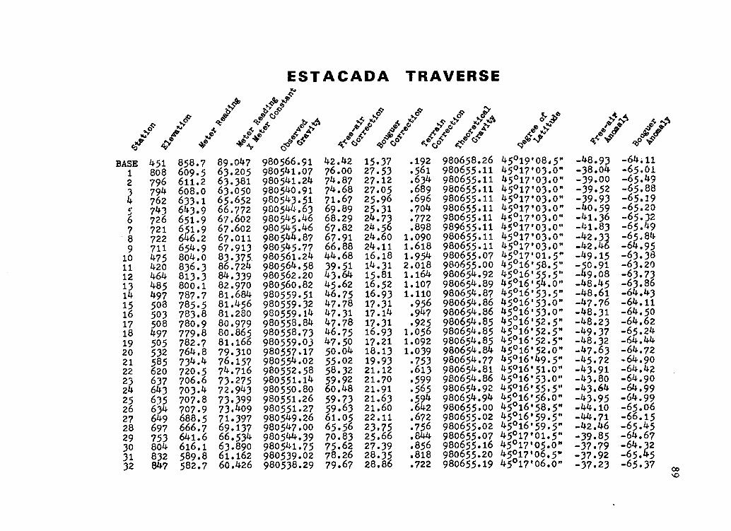
APPENDIX III GRAVITY REDUCTIONS middot 69
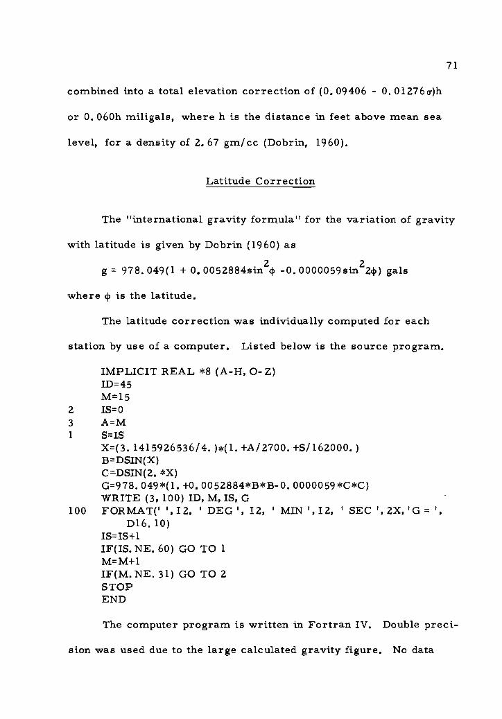
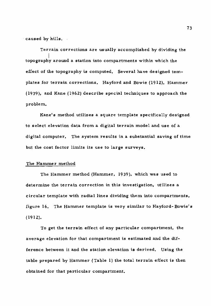
Free-air Correction middot bull 69 Bouguer Correction middot bull bull bull bull bull bull 70 Latitude Correction middot bull bull bull 71 Terrain Correction bull bull bull bull bull bull bull 72
The Hammer method 73
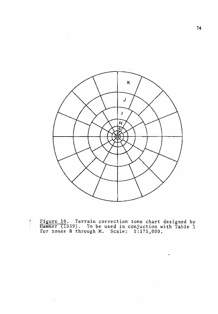
Drift Correction bull bull bull bull 76 Accuracy of Reductions bull bull bull bull bull bull bull 78
Instrument reading bull bull bull bull bull bull bull 78 Free-air correction bull bull bull bull bull 78 Bouguer -correction bull bull bull bull bull bull bull 80 Latitude correction bull bull bull bull bull bull bull 80 Terrain correction bull bull bull bull bull 81 Drift correction bull bull bull bull bull bull bull bull 81 Probable maximum error bullbullbullbull 82
The Bouguer Anomaly middot bull bull 82
APPENDIX IV GRAVITY CORRECTION TABLES middot bull 84
Key to Correction Tables middot bull bull bull 84
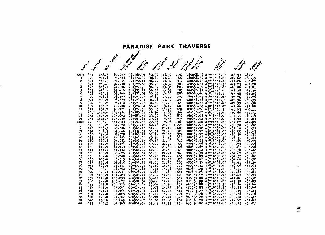
Milwaukie Traverse bull bull bull bull bull bull 85 Gladstone Traverse bull bull bull bull bull bull bull 85 Redland Traverse bull bull bull bull 86 Transmission Line Traverse bull bull 87 Paradise Park Traverse bullbullbull 88 Estacada Traverse bull bull bull bull bull 89
APPENDIX V MAGNETIC DATA bull bull middot bull middot middot middot middot 90
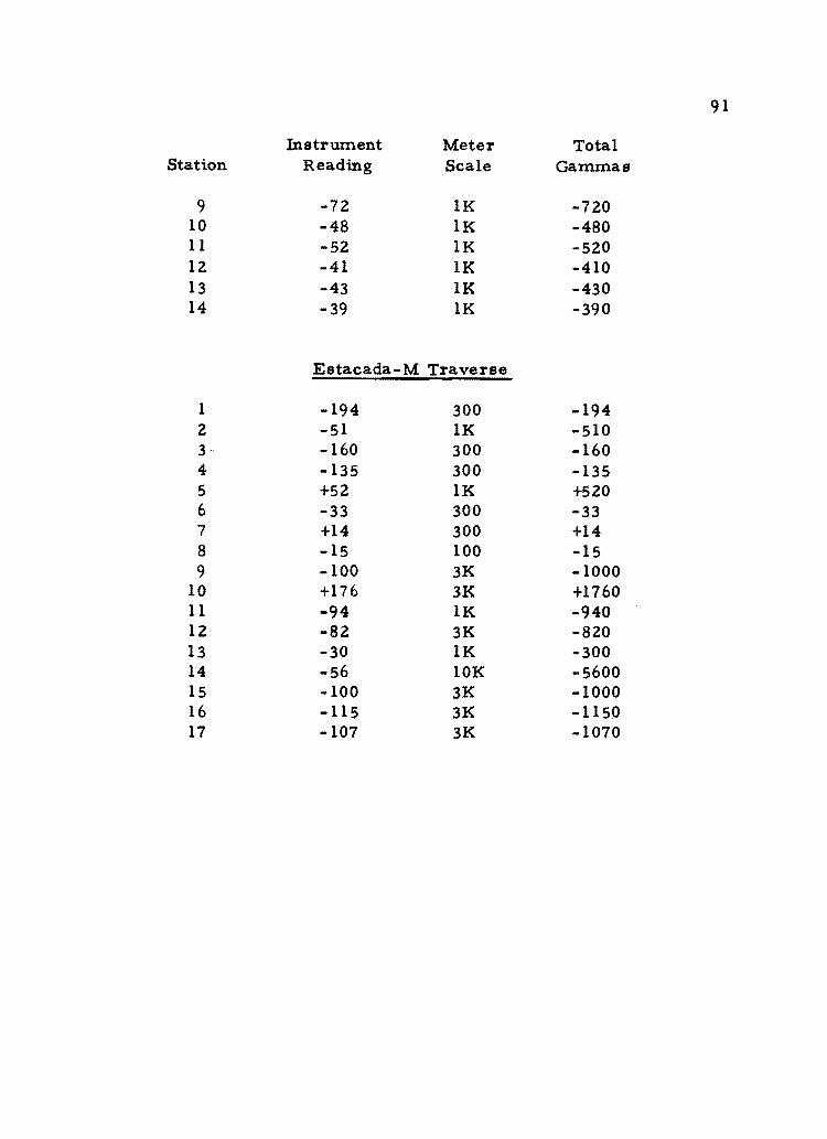
bull bull bull middot middot middot bullGladstone-M Traverse 90 Fischers Mill-M Traverse 90middot bull middot bull bull Estacada-M Traverse bull 91
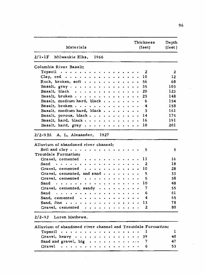
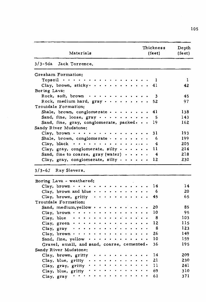
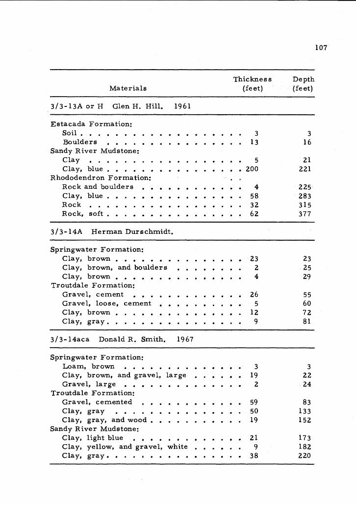
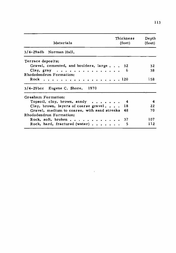
APPENDIX VI WELL LOGS bull bull bull bull bull bull bull bull bull bull middot bull 92
DrillersLogs of Representative Wells bull 94
LIST OF TABLES
TABLE PAGE
1 Terrain-correction Table bull bull bull bull bull bullbull 75
LIST OF FIGURES
FIGURES PAGE
1 Location rna p bullbullbullbullbull 3
2 Location of gravity traverses gravity stations and water wells bullbullbullbullbullbullbullbullbullbull 4
3 Location of magnetic traverses and magnetic stations bull bull bull bull bull bull 6
4 Location of gravity base stations in Portland Oregon bull 11
5 Demarcation of physiographic alignments bullbull 14
6 Orientation-length distribution of physiographic alignrnents bull 16
7 Orientation-length distribution of faults in the Portland area bull bull bull bull bull bull bull bull bull bull bull bull bull 18
8 Geologic map of Oregon bull bull bull bull bull bull bull bull bull bull bull bull 20
9 Summary of all orientation-length distribution of physiographic alignments bullbullbullbullbullbullbull bull bull bull 27
10 Complete Bouguer gravity anomaly map of northwe ste rn Ore gon bull bull bull bull bull bull bull bull bull bull bull bull bull bull bull 31
11 Graphic representation of various gravity anomalies and corresponding geometric forms bullbullbullbullbullbullbullbull 33
12 Graphic representation of one interpretation of the Bouguer gravity anomaly bull bull bull bull bull bull bull bull bull bull bull bull 35
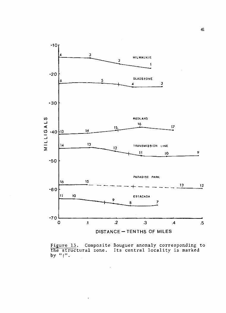
13 Composite Bouguer anomaly corresponding to the structural zone bull bull bull bullbull bull bull bull bull bull bull bull bull bull bull bull bull 41
xi
FIGURES PAGE
14 Graphic representation of various magnetic anomalies and corresponding geometric forms bull bull bull bull bull bull bull 42
lS Geologic map of thesis area middot 60
16 Terrain correction zone chart 74
17 Schematic outline of closed loop traverse method bull bull bull 77
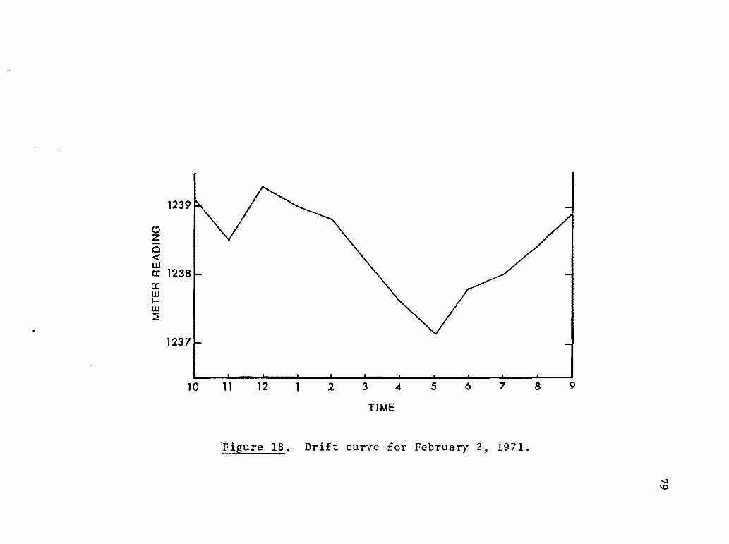
18 Drift curve bull bull bull bull bull bull bull 79
19 Milwaukie traverse bull bull bull bull In pocket
20 Gladstone traverse In pocket
21 Redland traverse bull bull -In pocket
22 Transmission Line traverse In pocket
23 Paradise Park traverse In pocket
24 Estacada traverse In pocket
25 Fischers Mill traverse middot In pocket
26 Explanation of well numbering system bull bull 93
INTRODUCTION
Purpose and Scope
A fault-like linearity along the lower Clackamas River is
evaluated by analysis of physiographic and structural alignments
geological relationships and by gravity and magnetic data The objecshy
tive of this investigation is to provide data which may verify the
existence of a structural feature extending along the Clackamas River
and the eastern front of the Portland Hills Lava flows alluvium
and vegetation obscure the nature of the linearity thus requiring the
use of indirect physiographic and geophysical methods
To obtain the neces sary data twelve 15 minute and two 7 -12
minute quadrangle maps were examined for physiographic alignments
Geophysical information was obtained from 6 gravity traverses
averaging 2 miles in length The 166 gravity stations and 50 magshy
netic stations are plotted as cross profiles correlated to surface
geology Geologic information was obtained from previous studies
especially from a report by Trimble (1963) and from analysis of
well logs
z
Location and Planimetric Base Control
The physiographic investigation included about 2623 square
miles in northwestern Oregon and southwestern Washington as shown
in figure 1 Physiographic alignments were plotted from twelve of
sixteen 15 minute quadrangles bounded by 122deg00 and 123deg00 west
longitude and 45deg 00 and 46deg 00 north latitude and two 7 -12 minute
quadrangles bounded by 12245 and 123deg00 west longitude and 46deg00
and 46deg 7 5 north latitude
The geophysical studies were conducted in a rectangular area
approximately 75 square miles bounded between the following geoshy
graphic points also shown on figure 1
West Longitude North Latitude
(1) 122deg41 45deg 24 (2) 122deg 38 45deg28 1
( 3) 122deg 17 45deg 18 (4) 122deg20 45deg 14
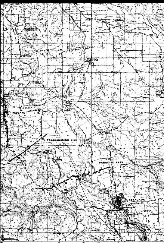
The six gravity traverses have been given locational names
Their location and the approximate location of each gravity station
is indicated in figure 2 Starting from the northwest end of the
inve stigated geophysical area the traverse names are (1) Milwaukie
~2) Gladstone (3) Red1and (4) Transmission Line (5) Paradise
Park and (6) Estacada Traverse All gravity stations were located
by reference to U S Geological Survey 7-12 minute quadrangle
3
N
1
SCALE raonoooo
OREGON
10crXJIIIO====iIO mi les
MOLALLA COLTON
-- Boundary of physiographic alignrltenl study
- Boundary of geophysically investjgated area
Figure 1 Location map
Figure 2 stations
1 1 5 0 HAAAA
bull GRAVITY STATION
o WATER WELL
0 WATER WELL -APPROXIMATE LOCATION
B BASE STATION
Scale 1125000
CONTOUR INTERVAL 40 FEET DATUM IS MEAN SEA LEVEL
Location of gravity traverses gravity and water wells
4
~
1 tJ
5
maps namely Lake Oswego Gladstone Damascus Oregon City
Redlands and Estacada
All base stations were located from existing bench marks
established by (1) U S Geological Survey (2) U S Coast and
Geodetic Survey or (3) City of Portland A full description of these
bench marks is listed in Appendix I
Elevation and terrain corrections were estimated in parts or
all of the Hillsboro Portland Camas Bridal Veil Beaverton
Oregon City Sandy Cherryville Molalla Colton and Fish Creek
15 minute quadrangle sheets
The three magnetic traverses have been given locational names
Their location and the approximate location of each magnetic station
is indicated in figure 3 From the northwest end of the geophysicaUy
investigated area the traverse names are (1) Gladstone~M (M stands
for magnetic) (2) Fischers Mill-M and (3) Estacada-M Traverse
Previous Work
Several geologic reconnaissance investigations have been con~
ducted in the general area under study Diller who was first to
believe a fault fronted the Tualatin Mountains (Portland Hills)
studied the area in 1896 and later in 1915 Darton (1909) Washburne
(1914) Williams (1916) Treasher (1924b) Gilchrist (1952) Elsey
(1955) and others have made limited geologic studies in the area
Figure 3 Location of magnetic traverses and magnet1c stations
6
7
Recent geologic studies since about 1955 have been more
detailed than their predecessors The first comprehensive study was
conducted by Trimble (1957 and 1963) Peck and others (1964)
studied the northern part of the Western Cascade Range in Oregon
and Snavely and Wagner (1964) conducted a geologic sketch of northshy
western Oregon Wells and Peck (1961) published a Geologic Map of
Oregon West of the 1Z1st Meridian The Troutdale formation was
first described by Hodge (1938) Treasher (l942b) published a reconshy
naissance map covering the Portland Camas Oregon City and
Sandy quadrangles
Brief historical accounts which include the Portland area are
contained within publications by Hodge (1933) Treasher (1942a)
Stauffer (1956) Baldwin (1957 and 1964) Snavely and Wagner (1963)
Trimble (1963) Mackin and Cary (1965) and Hogenson and Foxworthy
(1965) The effects of the Spokane (Missoula) Flood have been
reviewed by Bretz (1925 1928 1956 and 1959) and Allison (1932
1933 and 1935)
Earthquake studies in the region include those made of the
November 5 1962 earthquake by Dehlinger and Berg (1962) Westphal
(1962) and Dehlinger and others (1963) The January 27 1968 and
May 13 1968 Portland earthquakes have been studied by Heinrichs
and Pietrafesa (1968) and Couch and others (1968) respectively
Schlicker and others (1964) studied the earthquake geology of the
8
Portland area Berg and Baker (1963) reviewed Oregon earthquakes
from 1841 to 1958 and Couch and Lowell (1971) studied the earthshy
quakes and seismic energy release in Oregon
Gravity studies in the area include absolute gravity stations
established in Oregon at the Portland International Airport and at the
Portland Custom House by Wollard (1958) Woollard and Rose (1963)
published a regional Bouguer gravity map for the state of Oregon
More recent regional gravity studies in Oregon have been conducted
by Berg and Thiruvathukali1965 1967a 1967b and 1967c)
Thiruvathukal and Berg (1966) Thiruvathukal Berg and Henricks
(1970) Bromery and Snavely (1964) and Blank (1966) discuss geoshy
physical surveys in western Oregon
General references on geophysical techniques as used in this
study are discussed in texts such as Nettleton (1940) Heiskanen and
Meinesz (1958) Gutenberg (1959) Dobrin (1960) and Heiland (1968)
Density determination for gravimeter observations is given by
Nettleton (1939) Hammer (1939) and Sandberg (1958) discuss terrain
correction techniques Interpretation of anomalies is discuss~ by
Nettleton (1940 1942 and 1954) Dobrin (1960 and Skeels (1963)0
Fieldwork
Fieldwork was done during winter and spring of 1971 with some
preliminary work fall 1970 The fieldwork involved establishing
9
lateral and vertical control and making instrument readings
Lateral and vertical control was established by use of an autoshy
mobile odometer and by reference to physiographic and topographic
features on the 7 -12 minute quadrangle maps Use of a Paulin
microaltimeter was not practical due to diurnal barometric fluctuashy
tions To assure the detail of the local gravity and magnetic anomshy
alies a station spacing with one tenth mile interval was established
The gravity and magnetic stations were located for convenient access
The routes of the traverses are located upon established roads in the
area The Transmisslon Line traverse however was conducted
entirely off surface roads Topographic description of this line the
John Day-Keeler No1 was supplied by Portland General Electric
The description greatly facilitated the correct location of each station
along the line
1The instrument readings for gravlty were made from a Worden
gravity meter - Master Model (Meter No 575) loaned by the Departshy
ment of Oceanography at Oregon State University The instrument
has a sensitivity of bull 1037 milligals per division (ABSOLUTE) The
meter is self-compensating for normal ambient temperature changes
but can be operated with or without thermostating For the purpose
of this study the sensitivity of the instrument is excellent The
1 Trademark of Texas Instruments Incorporated
--~
10
instrument is able to detect gravity differences as low as 001
milHgals
Closed loop traverses were made on all observed readings to
correct for instrument drift earth tides and other factors that might
influence the observed reading Gravimetric field observations were
planned with assistance and advice from Dr Richard Couch Oregon
State University The method is described in more detail under
drift corrections
Two existing absolute gravity stations were occupied so that
the study could be tied to a national gravity network This allows
correction of values to terms of absolute gravity The absolute
gravity stations that were established by Woollard (1958) are located
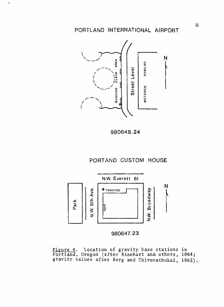
at Portland International Airport and at the Portland Custom House
(figure 4) The corrected values are 98064824 and 98064723
milligals respectively (Woollard 1958)
2A Model MF-l fluxgate magnetometer loaned by the Center of
Volcanology of the University of Oregon was used to obtain the magshy
netic data The instrument has a maximum total range of f 100 000
gammas The meter is a vertical component magnetometer which is
self-compensated for temperature variations and requires no direcshy
tional orientation The instrument reads directly in gammas The
2GISCO - Geophysical Instrument and Supply Company
11 PORTLAND INTERNATIONAL AIRPORT
--_
-- I I c
lu
shy -_
(1)
gt (1) J shyCD (1) shyen
0 z ~ a lt n
0 W a w t-w
N
98064824
PORTAND CUSTOM HOUSE
NW Everett St
Q) gtshy PARKING lt0Igt laquo tt -colt0 a [i~ Z
~ -0 lt0 0 m
N
~ z
98064723
figure 4 Location of gravity base stations in Portland Oregon (after Rinehart and others 1964 gravity values after Berg and Thiruvathukal 1965)
12
operation of the magnetometer was conducted under guidance of
Dr Richard Blank University of Oregon
In order to correct for diurnal variations and other factors
influencing the observed readings the magnetic stations were
occupied using the closed loop traverse method described for the
gravity meter
All data for both the gravity meter and the magnetometer are
presented in Appendix IV and V All elevations are in feet above
mean sea level All gravity and magnetic readings have been corshy
rected for drift and diurnal variations
PHYSIOGRAPHIC AND STR UCTURAL ALIGNMENTS
Morphological analysis of linear landforms represented on
topographic maps was performed to evaluate alignments for structural
significance Twelve 15 minute and two 7-12 minute U S Geologishy
cal Survey topographic quadrangle maps were studied and analyzed
for quantitative distribution of length and orientation of alignments
Geologic maps were similarly evaluated for orientation of faults and
fold axes and compared to the morphologically determined orientashy
tions
Linear landforms may be significant indicators of the undershy
lying geological structures Differential erosion commonly reflects
alignments such as faults joints or bedding (Ray 1960 von Bandat
1962)
The method used in analyzing linear landforms is not complishy
cated and is not subject to significant interpreter bias The proceshy
dure used in this study is illustrated in figure 5 and is as follows
(1) Preliminary marking of all linear landforms on the toposhy
graphic map longer than an arbitrary minimum preselected length
of about 12 inch The linear features include stream courses
ridge crests and linear breaks in slope angle
) 11li0~---- T4 S
Figure 5 Demarcation ofphysiographic alignments Portion of Fish Creek Mountain 15 quadrangle map
T5s
~
15
(2) Measurements of length and orientation of each linear
feature are tabulated in 10 degree orientation subdivisions for each
quadrangle map_
(3) Calculation of percentage fraction of lineation lengths for
each 10 degree subdivision for each map
(4) Graphical plotting of alignment statistics in rose-type diashy
grams for each map
(5) Summation of alignments for all maps into a composite
rose diagram
(6) Comparison with mapped faults and folds is done using
steps 2 through 5 on published fault lines
This procedure was followed for each of the 14 topographic
maps and is tabulated in figure 6
Anomalies from random orientation are believed to reflect the
regional structural alignment of the area In analyzing the fourteen
quadrangles (figure 6 summary diagram) a strong regional preferred
orientation is shown to be N 20deg and 40middot W There also exists a
less prominent N-S and N 50deg E preferred orientation The
prominence of the northwest trend over all other directions suggests
significant underlying structural orientations
Further confirmation of the structural significance of the northshy
westerly morphological trend is shown by the similarity to Orientashy
tion of known fault trends regional trends of fold axes and trends
N
I
OREGON
I 1220
450 _ I
Figure 6 Orientation-length distribution of physiographic alignments measured in individual quadrangle sheets Summary diagram represented by total for area Quadrangle names are listed on the location map figure 1
16
17
determined by seismic first motion analyses in the area Faults that
have been mapped in the Portland area show a very strong preferred
orientation of N 40deg W (figure 7) Secondary preferred orientations
ofN-S and N 50deg E occur
The regional trends of fold axes also reflect the dominant northshy
west trend The structural folds generally prefer an orientation of
N 40-45deg W
Seismic first motion analysis of the November 5 1962 Portland
earthquake suggests a motion source of a northwest-trending rightshy
lateral strike-slip fault The source motion data however fits a
northeast-trending left-lateral strike- slip fault equally as well
(Dehlinger and others 1963) Westphal (1962) suggested that the
seismic activity was related to the Portland Hills fault Gallagher
(1969) indicates that the motion from the November 5 earthquake
occurred along a normal fault striking N 54deg E or along a rightshy
lateral strike-slip fault striking N 12deg W The motion analysis
was reported most consistent with the N 54deg E trending fault
This generally agrees with the secondary morphological and strucshy
tural trend The N 12deg W trend however falls somewhat to the
north of the major morphological and geologic trend in the area
In general the various Portland-area geologic alignment trends
are consistently sympathetic and parallel to the Portland Hills fault
and the Clackamas River alignment
18
Figure 7 Orientation-length distribution of mapped faults-rn the Portland area (using data from Schlicker and Deacon 1967)
19
Further confirmation of the significance of the northwesterly
morphological trend is shown by a series of co-aligned linear morphoshy
logic features extending over 300 miles southeasterly across the state
of Oregon The regional features co-align with the Portland trend
and include segments of the Metolius River Crooked River and the
southern edge of Hampton Buttes These prominent linear features
align themselves in a general N 40-50deg WS 40-50deg E trend
across the state of Oregon The alignment is readUy seen on the
state 1250 000 relief map vertical exaggeration 2 1
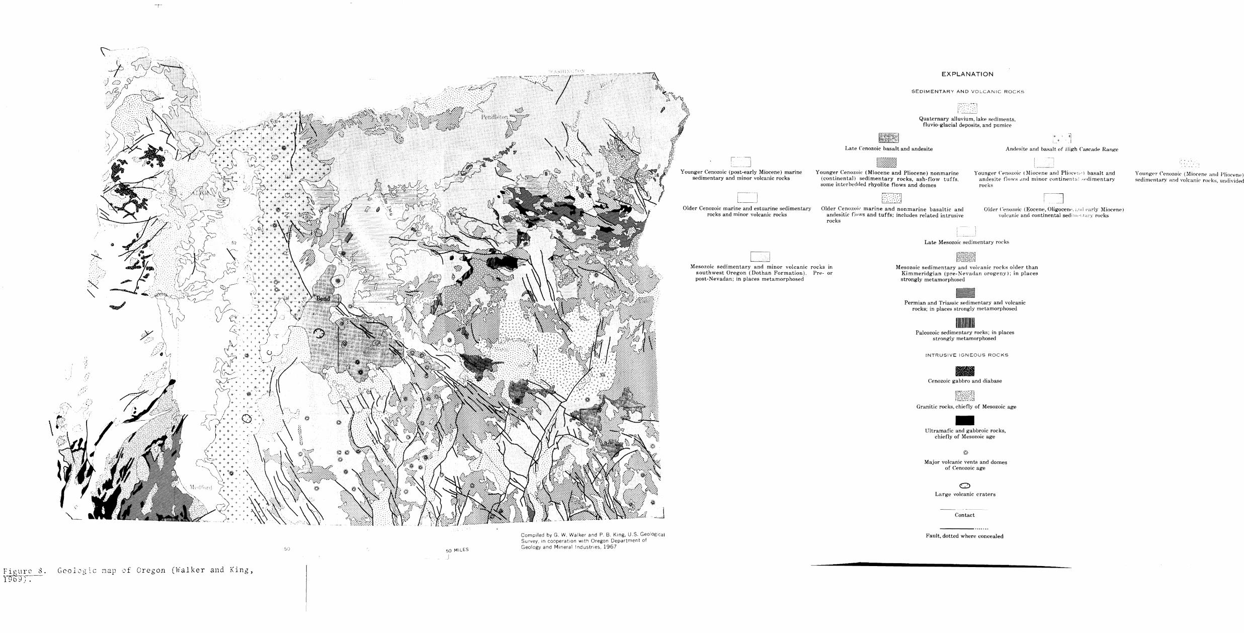
The geologic map of Oregon (Walker and King 1969) shows
numerous faults with a general regional trend of N 40-50deg W
occuring along the above mentioned trend(figure 8) The Brothers
fault zone is one segment of the co-linear features (Higgins and
Waters 1967) It is believed that the normal faults associated with
the Brothers fault zone and the small monoclinal folds to the faults
are a surface reflection of a deeply buried fault with lateral displaceshy
ment (Walker 1969) Furthermore several volcanic vents are conshy
centrated along this segment of the state wide alignment These
vents are generally of Pliocene and Pleistocene age however some
may be as late as Miocene and early Holocene age which indicates
the span of time associated with this area of crustal disturbance
(Walker 1969)
The significance of the dominant trend in the Portland area
Jf )~L
Gcologlc ~3p of Oregon (Walker and King
50 MILES
I
Compiled by G W Walker and P B King US GeologICal Survey In cooperation with Oregon Department of Geology and Mineral Industes 1967
I ~ ~ J Younger Cenozoic (post-early Miocene) marine
sedimentary and minor volcanic rocks
Older Cenozoic marine and estuarine sedimentary rocks and minor volcanic rocks
--1 L--J
EXPLANATION
SEDIMENTARY AND VOLCANIC ROCKS
llt~~ ~ 1
Quaternary alluvium lake sediments fluvio-glacial deposits and pumice
+ 1 I + I
Late Cenozoic basalt and andesite Andesite ann bal-lalt of ligh Cascade Rang-p
~rtlJ Younger Cenozoic (Miocene and Pliocene) nonmarine
(continental) sedimentary rocks ash-flow tuffs some interbedded rhyolite flows and domes
~ ~
Older Cenozoic marine and nonmarine basaltic and andesitic flows and tuffs includeH related in trusive rocks
Younger (trIozoic (Miocene and PliOCPli ) basalt and andesite flows 1Ild minor continent ~dimentary rocks
Older Cenololc (Eocene Oligocew ld (arly Miocene) volcanic and continental sedlllltmiddotttry rocks
Late Mesozoic -edimentary rocks
-~ k~~sect Mesozoic sedimentary and minor volcanic roc ks in
southwest Oregon (Dothan Formation) Pre- or post-Nevadan in places metamorphosed
Mesozoic sedimentary and volcanic rocks older than Kimmeridgian (pre-Nevadan orogenv) in plaeeB strongly metamorphosed -Permian and Triassic sedimentary and volcanic
rocks in places strongly metamorphosed
-Paleozoic sedimentary rocks in places strongly metamorphosed
INTRUSIVE IGN EOUS ROCKS Cenozoic gabbro and diabase
Granitic rocks chiefly of Mesozoic age -Ultramafic and gabbroic rocks chiefly of Mesozoic age
Major volcanic vents and domes of Cenozoic age
La rge volcanic craters
Contact
Fault dotted where concealed
YOllngfgtl CEn(l7oie (Miocene and Plioeene) sedirrHntaDr and vokanic rOlks undhided
21
appears to be supported by the physiographic and structural alignshy
ments and by seismic first motion analysis The indication of a
major regional aligned fault is shown by co-aligned topographic
features which are parallel to the mapped faults in the area ThereM
fore it is believed that this strikingly linear feature may be indicashy
tive of a structural feature of major importance
The time of origin and mechanism of the structural alignment
is not well known Mackin and Cary (1965) have shown major trend
development along a northwest-southeast alignment resulting from
the folding of the Eocene Weaver Plain They indicate that the recent
alignments are trends developed from the ancestral Calkins Range
named by Mackin and Cary (1965) a range dominant during Oligocene
time in the Pacific Northwest region Mackin and Cary believe that
the Calkins Range represents lithe last of a long series of crustal
yieldings along this fundamental pre- Cascade direction II
The present morphologic trends may be a reflection of continued
weakness in younger rock units along pre-established structural
alignments The further study of these linear features may bring
new light to buried structures in the older rocks now covered with
volcanics
The preferred northwest orientation of the physiographic alignM
ments is not in itself conclusive evidence for interpretation of the
geologic structure This statistical analysis method is intended as a
zz
preliminary indicator of probable structural features to guide geoshy
logic studies However the consistency and parallelism of geologic
and seismic alignments strengthen the interpretation that it represhy
sents a geologic structural trend of major significance
GEOLOGICAL INVESTIGA TIONS
Geologic data was derived primarily from previous investigashy
tions namely Trimble (1963) and well logs on file at the office of
the Oregon State Engineer Salem Oregon The local geology and
structure are briefly described in Appendix 11 Appendix VI contains
50 of the deepest and most representative of the well logs used in
constructing the geologic cross sections figures 19 through 25 in
map pocket The drillers logs have been interpreted for formashy
tional separation and edited for clarity of teminology and composition
The wells described in Appendix VI are located in figure 2
Lithologic differences used in recognition of Miocene and Plioshy
cene formational contracts are important to show geologic horizons
in construction of the geologic cross sections The depth of the
Miocene Columbia River basalt is important to this investigation
because the gravity and magnetic anomalies are based upon its
presence below ground surface The post Troutdale formations are
primary indicators of recent rejuvenation of the Clackamas River
The we 11 logs provide good data on the Pliocene units and their conshy
tacts but poor data on the Columbia River basalt due to too few
deep wells penetrating into the basalt
GEOPHYSICAL METHODS
Gravimetric
Gravimetric information was obtained from six gravity trav~
erses with a total of 166 gravity stations A Worden gravity meter
was used to test the possible presence of a consistent gravity
anomaly across the observed physiographic alignment along a line
co-linear with the eastern front of the Portland Hills and the Clackashy
mas River It is believed that the existence of an anomaly in this
locality could be due to either a fault or a steep fold in the Columbia
River basalt
Gravitational anomalies result from lateral variations in the
gravitational pull of the earth caused by contrasting near- surface
densities Sedimentary rocks are usually less dense than igneous
formations Locally the density of the Columbia River basalt is
from 272 to 294 averaging 284 gmcc (data from Schlicker and
Deacon 1967) The sedimentary formations are estimated to be less
than 24 gmt cc
To use the gravity data for structural interpretation a series of
corrections must be performed to correct for the station elevation
local topography latitude and instrument drift The correction
25
procedure is discussed in Appendix II - Gravity Reductions and the
corrected values are presented in Appendix III and shown graphically
in profile on figures 19 through 25 in map pocket
Magnetic
Magnetic data was obtained on three traverses with a total of
50 magnetic stations A f1uxgate magnetometer was used to examine
the topographic alignment for a possible consistent magnetic anomaly
All rock masses and rock types vary in their magnetic suscepshy
tibility due primarily to their content of magnetite and ilmenite The
magnetic susceptibility of sedimentary rocks is small as compared
to igneous rocks (Dobrin 1960) The existence of a magnetic
anomaly in the investigated area would probably be due to change in
depth of occurrence of the Columbia River basalt rather than to
geometric changes in the overlying sedimentary rocks It is possible
however that an irregular distribution of magnetite in the overlying
sedimentary units may alter the magnetic anomaly due to the
Columbia River basalt
The magnetic data has been corrected for diurnal fluctuations
by applying the closed loop method as discussed under drift correcshy
tions for the gravity measurements The corrected values are listed
in Appendix IV and shown graphically in profile in figures 20 24
and 25
INTERPRETATIONS
Physiographic and structural alignments geological relationshy
ships gravity data and magnetic data are analyzed for the possible
existence of a structural feature aligned with the Clackamas River
and the eastern front of the Portland Hills
Physiographic and Structural Alignments
Physiographic alignments are significant in the Portland area
as shown by the agreement with known structural trends The degree
of reliability of the physiographic alignments is dependent upon the
unbiased and representative physiographic sample and the representashy
tion of known structure It is my opinion that it would be difficult to
bias the physiographic alignment selection by more than 5 Furthershy
more I expect that the known structure is not biased for any orientashy
tion
The phYSiographic rose-type diagrams figures 6 and 9 show
that of all the physiographic alignments 50 represent the general
northwest trend nearly 2500 represent the N 20middot W and the N 40middot
W trend and 21 represent other secondary trends namely the
N-S E-W and N 50-60middot E The prominent northwesterly trend is
27
N
t
Figure 9 Summary of all orientation-length distribution of physiographic alignments Area within the circle represents the area of random alignment orientation Scale I inch = 4
28
present even in the quadrangles nearest the west flank of Mt Hood
where a dominant east-west trend is expected from consequent drainshy
age Due to the consistency and prominence of the northwesterly
morphologic trends a reliably strong structural framework orientashy
tion is indicated in the Portland area
The physiographic alignments are a secondary effect caused by
differential erosion However the consistency and prominence of
the physiographic alignment trends strongly suggest that they are very
good indicators of underlying structural features
The trend significance is further confirmed by exposed and
mapped structural alignments which are directly observed with which
physiographic alignments can be compared Even though in the
Portland area most faults are poorly exposed approximately 6000 of
the known mapped faults and fold axes concur with the dominant northshy
west physiographic trend (SchUcker Deacon and Twelker 1964
Schlicker and Deacon 1967)
A locally prominent underlying structural feature is suggested
by the dominant northwest trends Surficial units reflect continued
weakness along pre-established structural trends possibly the
Oligocene Calkins Range
29
Geologic Thickness Relationships and Gravity Profiles
The lower Clackamas River area is made up of a sequence of
Tertiary volcanics and terrestial sediments capped by Quaternary
mudflows terrace and channel deposits
Geologic cross sections figures 19 through 25 in map pocket
were drawn along the lines of the gravimetric and magnetic traverses
to reconstruct the underlying geologic structures from well logs and
maps in an attempt to test the possibility of offset in units along the
alignment Data available from well logs is not sufficient in itself
to determine conclusively the nature of the subsurface structure
along the alignment The cross sections have been constructed from
Trimbles (1963) geologic map figure 15 and from well data
Appendix VI
All gravity and magnetic traver se Sf except that of the R edland
traverse are suitably located to define the gravimetric charactershy
istics of the physiographic alignment The Redland traverse crosses
the structural trend more obliquely than the other traverses The
gravity and magnetic profiles are plotted above the geologic cross
sections figures 19 through 25 so the underlying structural conshy
figuration where known may be compared to the corresponding
anomaly
The gravity measurements are sensitive to changes in depth of
30
the denser Columbia River basalt and are considered significant
The gravity interpretations below are made for the entire area of
study and are also made on individual traverses The basic limitashy
tions are discussed in Appendix II
Negative Bouguer anomalies observed in all six gravity travshy
erses show the influence of low density Cascade Range volcanic rocks
in causing a 25 milligalmile decrease in gravity to the southeast
figure lO (Berg and Thiruvathukal 1967b) This eastward decrease
in gravity can indicate either an eastward thickening of the crust or
a less dense crust and or a mantle of low density (Berg and
Thiruvathukal 1967c) The gradient extends southeastward from
approximately -15 milligals in the Milwaukie area to approximately
-65 milligals near Estacada a distance of about 20 miles The
Bouguer values obtained in this survey are in general agreement with
the Oregon gravity map (Berg and Thiruvathukal 1967b) Isostatic
and regional gravity analysis are beyond the scope of this investigatic)il~
The traverses are discussedin order from the Milwaukie
traverse in the northwest to the Estacada traverse in the southshy
east
Milwaukie traverse (figure 19 - in map pocket)
The water wells drilled in the abandoned Clackamas River
channel are not normally deep enough to penetrate through the Sandy
Contour interval 10 milligals dashed where inferred
The gravity anomalies refer to the International Gravity Formula and a rock density of 267 gmcc
Data reductions based on mean sea level datum
Gravity map was prepared at the Department of Oceanography Oregon State University under the direction of Joseph W BergJr assisted by John V Thiruvathukal 1967
)
Complete Bouguer gravity anomaly map of northwestern Oregon and Thiruvathukal 1967b) No scale w
32
River mudstone into the Columbia River basalt the formation which
would most clearly reflect the presence or absence of a fault or fold
However the well logs display an apparent offset of the surface of the
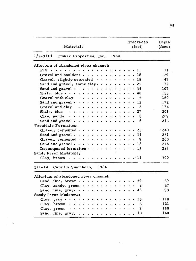
Sandy River mudstone The Omark Industries Inc well (12-31Pl)
penetrates the Sandy River mudstone at a depth of approximately
190 feet below sea level whereas the Camillo Giacchero well (21-
lA) penetrates the mudstone at a depth of approximately 5 feet above
sea level The offset of the mudstone might also be caused by eroshy
sion by the Clackamas River and not entirely by faulting or folding
Well logs do indicate the presence of the Columbia River basalt
near the landsurface between Kellogg Creek and Waverly Heights
This suggests that the Portland Hills fault lies on the eastern edge
of Waverly Heights
The steep gravity gradient of 3 74 milligalsO 2 mile across
the physiographic alignment indicates that the Columbia River basalt
is either dipping steeply to the northeast or has been faulted down to
the east at this location Shapes of various typical gravity anomalies
with their corresponding geometric subsurface structural forms are
illustrated in figure 11 numbers 1 and 2middotwould correspond to the
above mentioned geometric forms A fault and a steep fold may
have similar gravity anomalies Balsi1lie and Benson (1971) present
evidence favoring faulting in the Columbia River basalt as the cause
of the linear escarpmentmiddot along the portland Hills Their study
33
surface ~-- surface ~-bull
1 Vert ical fault 2 Steep fold
surface surface
3 Homogeneous mass 4 Less dense body 02gt CT1
surface surface
5 More dense body 6 Horizontal cylinder deg1gtdeg2
Figure 11 Graphic representation of various gravity anomalies and corresponding geometric forms (Dobrin1960 Lahee 1961)
34
utilized structural interpretation of columnar jointing to determine
bedding plane orientation
The precise location of the underlying structural offset is
questionable From the observed gravity gradient the structural
offset would be placed in the vicinity of station 2 However addishy
tional data by an extension of the gravity traverse to the northeast
might move the placement of the feature up to O 2 mile to the northshy
east Well logs also allow placement of the offset up to 02 mile to
the northeast The Portland Hills fault is not co-linear with Kellogg
Creek but Kellogg Creek is very straight and is parallel to the
Portland Hills fault so I think it is possible that a minor branch fault
parallels the creek
Rock weakness along this segment of the Portland Hillsshy
Clackamas River fault may form a zone of weakness followed by the
abandoned channel of the Clackamas River The apparent offset of
the lower Pliocene Sandy River mudstone suggests movement as
recent as middle Pliocene This date however is strictly shy
speculative
Gladstone traverse (figures 12 and 20 - in map pocket)
The Gladstone traverse shows an apparent offset of the Troutshy
dale formation and the Sandy River mudstone In this locality the
Sandy River mudstone may be offset as much as 120 feet as shown by
35
Tertiary ROCks
Density Material
NEsw ~ 15r-_______ Bouguer Anomaly
320 -------------J=middot25~
surfacet----_=-------------------t
-200
Columbia =24 gmcc-400
-600 --_~
-soo Early 284 gmcc
Figure 12 Graphic representation of one interpretation of the Bouguer gravity anomaly to geologic structure as seen in the Gladstone traverse
36
the following wells Byrum W Morehouse (22-L5D) Donald Hugart
(22-l6K) and Oak Lodge Water District (22-l6K3) A possible
fault or fold is indicated by the well log data
The form of the gravity gradient between stations 4 and 5 at
1 45 milligalsO 1 mile is suggestive of a fault or fold in which the
Columbia River basalt was downdropped to the east Movement of a
fault may have caused the offsetting of the Troutdale formation and
the Sandy River mudstone as indicated in the geologic cross sections
Redland traverse (figure 21 - in map pocket)
The Redland traverse does not show any definite geologic data
from well logs to indicate the presence or absence of a structural
fold or fault Interpretation of the Bouguer anomalies is also tenuous
due to the obliqueness of the traverse with respect to the main
structural trend
The Bouguer anomaly does show however two distinct levels
one approximating -405 milligals(stations 1-14) and the other
approximately - 395 milligals (stations 15- 29) which may reflect
the underlying structure By projecting the probable structural zone
established by the Milwaukie and Gladstone traverses and that
observed in the Transmission Line traverse to the Redland traverse
stations 14-16 would lie along the projected structural zone
The consistent gravity anomaly which occurs across the
37
physiographic a1ignment is reversed at this location The gravity
gradient dips to the south thus suggesting the southern block was
downdropped on the west More gravity measurements are needed
to determine the actual gravity distribution at this location and to
allow a more conclusive interpretation
Transmission Line traverse (figure 22 - in map pocket)
No definitive geologic data was obtained from well logs to indishy
cate the presence or absence of a structural fold or fault along the
physiographic a1ignment
Several irregular gravity anomalies are shown in the Bouguer
anomaly profile The irregular appearance of the gravity profile
between stations 21 and 31 is probably influenced by a combination of
errors from the elevation corrections and from over compensation
of the terrain correction values There is no obvious geologic
feature present which might explain the anoma1ies There may be a
Boring vent or dike concealed at depth
An anomaly is defined between stations 10 and 13 just east of
Clear Creek A 30 milligal change in the observed gravity gradient
is consistent with the other anomalies along the structural a1ignment
The gradient suggests a fault or fold between stations 11 and 12 with
the Columbia River basalt downdropped Qn the east
38
Paradise Park traverse (figure 23 - in map pocket)
The Paradise Park traverse lacks any subsurface geologic
evidence for a fault or fold The well logs indicate the general area
where the Columbia River basalt dips below the Rhododendron formashy
tion The approximate location of this interface is below station 23
Absence of the Troutdale formation on the eastern edge of the
traverse is due to erosion by the Clackamas River prior to the deposishy
tion of the Estacada formation
The Bouguer anomalies west of station 15 reflect probable
sources of error from the elevation corrections rather than an irregshy
ular gravity distribution caused by the Columbia River basalt or by
near surface Boring dikes
A change in the gravity gradient is seen east of station 15
amounting to approximately a 15 milligal drop on the east aide of
the physiographic linearity This suggests that the eastward side
has been downdropped by a fault or fold
Estacada traverse (figure 24 - in map pocket)
The well logs located near the Estacada traverse show no physhy
sical evidence for the existence of a structural fault or fold One
well the S S Dunlop (34- 2lcb) penetrated into the Columbia
River basalt at a depth of approximately 300 feet below sea level
A steep gravity gradient of 246 milligalsO 25 mile across the
39
physiographic alignment indicates that the Columbia River basalt
either has been faulted or folded in the vicinity of station 9 and 10
The Bouguer anomaly suggests that the basalt has been downdropped
east of station 8
Significance of the Geologic Cross Sections and the Bouguer Anomalies
The geologic cross sections across the fault-like linearity from
well logs generally lack any definitive data which may explain the lt
nature of the alignment However the Milwaukie and Gladstone
traverses do indicate the possible presence of a fault Structural
features cannot be confirmed or precisely located using presently
available well log information alone
Two gravity features are indicated by the Bouguer anomalies
The first is the more regional anomaly of a steadily westward
decreasing negative anomaly that suggests a westward rising of the
Columbia River basalt This conclusion is supported by well log
data
The second feature is the consistency of the size and shape of
the gravity gradients which average 218 milligalsO 2 mile down-
dropped to the east across the physiographic alignment Its alignshy
ment and consistency of direction and size define the zones of a posshy
sible fault or steep fold A composite Bouguer anomaly which
40
corresponds to the possible structural zone is illustrated in figure 13
The fault-like physiographic alignment is co-linear with the
apparent offset of the Columbia River basalt as seen in the gravity
profile It is concluded therefore that the topographic linearity is
most probably a reflection of a structural feature in which the
Columbia River basalt is dovrodropped to the east
Magnetic Profiles
All magnetic traverses cross the Portland Hills-Clackamas
River alignment figure 3 Simple interpretations of the magnetic
anomalies are made for each traverse The magnetic anomalies can
be indicators of the underlying geologic structure associated with the
alignment Typical magnetic anomalies with their corresponding
subsurface geometric forms are illustrated in figure 14 The
anomalies show a consistent magnetic break across the alignment
The cause of this change in gradient is not understood
The traverses are discussed from the northwest to the southshy
west The traverses discussed are the G1adstone-M Fischers Millshy
M and the Estacada-M traverses
G1adstone-M traverse (figure 20 - in map pocket)
A steep magnetic gradient of nearly 80 gammasO 25 mile is
shovro on the right hand side of the profile stations 2- 5 The
-10
41
4 3 MILWAUKIE
GLADSTONE6 5
4 3
C) REDLANO -I 16
17laquo 15 1413() -40
-I -I
1314 TRANSMISSION LINE E
910
-50
PARADISE PARK
16 15 - - - __ + _ _ _ 3 12-- - -_--- shy-60 11 10 ESTACADA
9 78
-70~------~--------~------~----------------~o 1 2 3 4 5
DISTANCE - TENTHS OF MILES
Figure 13 Composite Bouguer anomaly corresponding to the structural zone Its central locality is marked by I
42
surface
Ko Negligible
-- (ltbull bull f bull K1 K2
1 Vertical body 2 Contrasting rock types Ka K
~laquoc bullbullbullbull ill ~ I I
3 Inclined body 4 Irregular section
Figure 14 Graphic representation of various magnetic anomalies and corresponding geometric forms CDobrin 1960)
43
anomaly is consistent with a Boring dike located approximately 500
feet below landsurface figure 14 number 3
The irregular nature of the profile found between stations 7
through 15 may indicate several breaks in the Columbia River basalt
The nature of these breaks is not known The Columbia River baaalt
appear s to be downdropped to the east from a combination of magshy
netic and gravity data
Fischers Mill-M traverse (figure 25 - in map pocket)
The Fischers Mill-M traverse indicates a sharp gradient of
nearly 615 gammas04 mile between stations 2 and 6 The cause
of the abrupt change in the magnetic gradient is unknown The magshy
netic anomaly at station 6 however is consistent with the location
of the physiographic alignment
Estacada-M traverse (figure 24 - in map pocket)
Several single point anomalies are observed in the magnetic
profile stations 10 11 14 and 15 The cause of the anomalies is
unknown They could reflect a locally buried body with reversed
magnetic polarity in relation to the surrounding rock
The consistent magnetic anomaly which occurs across the
Portland Hills-Clackamas River alignment is seen between stations
7 and 13 This change in gradient approximately 900 gammasO 15
mile is apparent when a smooth curve is drawn to fit the magnetic
44
stations excluding the point anomalies The magnetic gradient
suggests a structural feature co-aligned with the physiographic
alignment
SiEificance of the Magnetic Anomalies
The magnetic anomalies show a consistent change in the magshy
netic gradient across the physiographic alignment which defines a
structural zone of unknown nature possibly a fault
CONCLUSIONS AND RECOMMENDATIONS
The physiographic and structural alignments are significant
indicators of underlying geologic structures The consistency of the
dominant northwest trend N 20 0 W and N 40 0 W is observed
over the entire area studied The trend is considered to be a reliable
structural indicator because the known faults and fold axes also preshy
sent a matching dominant northwest orientation when statistically
plotted
It is believed that a major regional fault system probably
exists along Portland Hills-Clackamas River alignment which may
possibly extend as far to the southeast as the Steens Mountains
The dominant northwest trend of the co-alinear regional physioshy
graphic and structural alignments suggests the existence of the fault
system
The dominant local northwest trends are suggestive of undershy
lying geologic features remnant from the Oligocene Calkins Range
The alignments including the secondary northeast trends may
reflect continued or renewed weakness along these pre-established
structural alignments
The geologic cross sections developed from map and well data
46
are considered to be as accurate as present data permits The cross
sections however do not present any tangible evidence as to the
nature of the physiographic alignment
The gravity traverses present a consistent and reliable indi
cator of an underlying structural feature corresponding to the physioshy
graphic alignment The consistency of the size and shape of the
Bouguer anomalies across the alignment defines the zone of a posshy
sible fault or steep fold developed in the Columbia River basalt I
tend to lean to the fault interpretation rather than a fold due to sup
porting evidence from seismic first motion analysis and by data
presented by Balsillie and Benson (1971)
The magnetic anomalies further indicate the probable undershy
lying geologic structure associated with the alignment A consistent
magnetic break occurs across the physiographic alignment
In general the various types of data have good consistency
The consistency strengthens their reliability as a structural indicator
The precise location of the observed structural feature is uncertain
The study establishes a prObable zone in which a structural anomaly
exists
Recommendations
The area studied is not gravimetrically complex The gravity
profiles of this investigation indicate that much more subsurface
47
information could be obtained from a more detailed gravimetric
study of the Portland basin The making of a gravity map with a
contour interval of less than 5 milligals would probably define the
underlying structure of the basin
The magnetic profiles indicate much surface noise caused by
local cultural features It is suggested that an airborne magnetoshy
meter might better be used to construct a magnetic map of the area
The analysis of the physiographic and structural alignments
should be extended to include the entire state of Oregon Their
statistical analysis would contribute needed information to direct
further geologic studies
---
---
---
REFERENCES CITED
Allen V T 1948 Formation of bauxite from basaltic rocks of Oregon Econ Geology v 43 no 8 p 619-626
Allison I S 1932 Spokane flood south of Portland Oregon EtbsJ Geol Soc America Bull v 43 no 1 p 133-134
1933 New version of the Spokane flood Geol Soc America Bull v 44 no 4 p 675-722
1935 Glacial erratics in Willamette Valley Geo1 Soc America Bull v 46 no 4 p 615- 632
Baldwin E M 1957 Drainage changes of the Willamette River at Oregon City and Oswego Oregon Northwest Sci v 31 no 3 p 109 -117
1964 Geology of Oregon 2d ed Ann Arbor Mich Edwards Bros Inc (distributed by Univ of Oregon Cooperashytive Book Store Eugene Oreg) 165 p
Ba1sillie J H and Benson G T 1971 Evidence for the Portland Hills fault The Ore Bin v 33 no 6 p 109-118
Berg J W Jr and Baker C D~ 1963 Oregon earthquakes 1814 through 1958 Seismo1 Soc Am Bull v 53 p 95shy108 (Condensation in The Ore Bin v 24 no 9 p 143-149 1962)
Berg J W Jr and Thiruvathukal J V 1965 Gravity base station network Oregon Jour Geophys Research v 70 p 3325-3330
___ 1967a Free-air gravity anomaly map of Oregon Oregon Dept Geology and Mineral Industries Map GMS-4a
___ 1967b Complete Bouguer gravity anomaly map of Oregon Oregon Dept Geology and Mineral Industries Map GMS-4b
49
Berg J W Jr and Thiruvathukal J V 1967c Regional gravity of Oregon The Ore Bin v 29 no 6 p 120-126
Blank H R Jr 1966 General features of the Bouguer gravity field in southwestern Oregon U S Geol Survey Prof Paper 550-C p 113-119
Bretz J H 1925 The Spokane flood beyond the channelled scablands pt 2 Jour Geology v 33 no 3 p 236-259
___ 1928 Bars of channeled scabland Geol Soc America Bull v 39 no 3 p 643-702
___ 1959 Washingtons channeled scabland Washington Div Mines and Geology Bull 45 57 p
Bretz J H Smith H T V and Neff G E 1956 Channeled scabland of Washington new data and interpretations Geol Soc America Bull v 67 p 957-1047
Bromery R W and Snavely P D Jr 1964 Geologic interpreshytation of reconnaissance gravity and aeromagnetic surveys in northwestern Oregon U S Geol Survey Bull 1181-N p NI-NI3
Couch R Johnson S and Gallagher J 1968 The Portland earthquake of May 13 1968 and earthquake energy release in the Portland area The Ore Bin v 30 no 10 p 185-190
Couch R and Lowell R P 1971 Earthquakes and seismic energy release in Oregon The Ore Bin v 33 no 4 p 61-84
DartonN H 1909 Structural materials in parts of Oregon and Washington U S Geol Survey Bull 387 33 p 9 pis
Dehlinger P and Berg J W Jr 1962 The Portland earthshyquake of November 5 1962 The Ore Bin v 24 no II p 185-188
Dehlinger P Bowen R G Chiburis E F and Westphal W Hbullbull 1963 Investigations of the earthquake of NovemberS 1962 north of Portland The Ore Bin v 25 no 4 p 53-68
50
Diller J S 1896 A geological reconnaissance in the northwestern Oregon U S Geol Survey 17th Ann Rept pt 3 p 441shy520
Diller J S and others 1915 Guidebook of the Western United States pt D The Shasta Route and Coast Line U S Geol Survey Bull 614
Dobrin M B 1960 Introduction to geophysical prospecting New York McGraw-Hill Book Co Inc 446 p
Elsey R C 1955 Geology of Portland and vicinity Geol Soc Oregon Country Newsletter v 21 no 4 p 29-32 Continued in v 21 no 5 p 39-42
Gallagher J N 1969 A method for determining the source mechanism in small earthquakes with application to the Pacific Northwest region Oregon State Univ doctoral dissertation 187 p
Gilchrist F G 1952 Clackamas River field trip Geol Soc Oregon Country Newsletter v 18 no 9 p 89-92
Gutenberg B 1959 PhYSics of the earths interior New York Academic Press Inc 239 p
Hammer S 1939 Terrain corrections for gravimeter stations Geophysics v 4 p 184-194
Hayford J E bullbull and Bowie W 1912 The effect of topography and isostatic compensation upon the intensity of gravity U S Geol Survey Spec Pub 10
Heiland C A 1968 Geophysical exploration New York Hafner Publishing Co Inc 1013 p
Heinrichs D F and Pietrafesa L J 1968 The Portland earthquake of January 27 1968 The Ore Bin v 30 no 2 p 37-40
Heiskanen W A and Vening Meinesz F A 1958 The earth and its gravity field New York McGraw-Hill Book Co bull Inc 470 p
---
51
Higgins M W and Waters A C 1967 Newberry caldera Oregon a preliminary report The Ore Bin v 29 no 3 p 37-60
Hodge E T 1933 Age of the Columbia River and lowe r canyon ~bsJ Geo Soc America Bull v 44 pt I p 156-157
___ 1938 Geology of the lower Columbia River Geol Soc Arne rica Bull v 49 no 6 p 831-930
Hogenson G M and Foxworthy B L 1965 Ground water in the east Portland area Oregon U S Geo1 Survey WatershySupply Paper 1793 78 p
Kane M F 1962 A comprehensive system of terrain corrections using a digital computer GeophysicB v 27 no 4 p 455shy462
Lahee F H 1961 Field geology New York McGraw-Hill Book Co Inc Sixth Edition 926 p
Lowry W D and Baldwin E M 1952 Late Cenozoic geology of the lower Columbia River valley Oregon and Washington Geo Soc America Bull v 63 no I p 1-24
Mackin J H and Cary A S 1965 Origin of Cascade landshyscapes Washington Div Mines and Geology Inf Circ 41 35 p
Nettleton L L 1939 Determination of density for reduction of gravimeter observations Geophysics v 4 p 176 183
___ 1940 Geophysical prospecting for oil New York McGrawshyHill Book Co Inc 421 p
1942 Gravity and magnetic calculations Geophysics v 7 p 293-310
___ 1954 Regionals residuals and structures Geophysics v 19 p 1- 22
Peck D L Griggs A B Schlicker H G Wells F G and Dole H M 1964 Geology of the central and northern parts of the Western Cascade Range in Oregon U S Geol Survey Prof Paper 449 56 p
52
Ray R G 1960 Aerial photograph$ in geologic interpretation and mapping U S Geol Survey Prof Paper 373 230 p
Rinehart W Bower R G and Chiburis E F 1964 Airport gravity base station network in Oregon The Ore Bin v 26 no 3 p 37-56
Sandberg C H 1958 Terrain corrections for an inclined plane in gravity computations Geophysics v 23 p 701-711
Schlicker H G Deacon R J and TwelkerN H 1964 Earthquake geology of the Portland area Oregon The Ore Bin v 26 no 12 pZ09 - 230
Schlicker H G and Deacon R J 1967 Engineering geology of the Tualatin Valley region Oregon Oregon Dept Geology and Mineral Industries Bull 60 103 p
Skeels D C 1963 An approximate solution of tne p1ilmlem of maximum depth in gravity interpretations Geophysics v 28 p 724-735
Snavely P D Jr and Wagner H C 1963 Tertiary geologic history of western Oregon and Washington Washington Div Mines and Geology Rept Inv 22 25 p
___ 1964 Geologic sketch of northwestern Oregon U S Geol Survey Bull 1181-M p MI-M17
Stauffer J 1956 Late Pleistocene flood deposits in the Portland area Geol Soc Oregon Country Newsletter v 22 no 3 p 2131
Texas Instruments Incorporated 1963 Worden gravity meter operating instruction manual n 81537-5 Texas Instruments Inc Houston Texas 89 p
Thiruvathukal J V and Berg J W Jr 1966 Gravity measurement program in Oregon The Ore Bin v 28 no 4 p 69-75 bull
Thiruvathukal J V Berg J W Jr and Henricks D F 1970 Regional gravity of Oregon Geol Soc America Bull v 81 no 3 p 725-738
53
Treasher R C 1942a Geologic history of the Portland area Oregon Dept Geology and Mineral Industries Short Paper 7
___ 1942b Geologic map of the Portland area Oregon Dept Geology and Mineral Industries Geol Map Series no 7
Trimble 1957 Geology of the Portland quadrangle Oregon and Washington U S Geol Survey Quadrangle Map GQ-I04
___ 1963 Geology of Portland Oregon and adjacent areas U S Geol Survey Bull 1119 119 p
Walker G W and King P B 1969 Geologic map of Oregon U S Geol Survey Map 1- 59 5
Walker G W 1969 Geology of the High Lava Plains province in Mineral and water resources of Oregon Oregon Dept Geology and Mineral Industries Bull 64 p 77-79
Warren W C Norbisrath H and Grivetti R M 1945 Geology of northwestern Oregon west of Willamette River and north of latitude 45deg 15 U S Geol Survey Oil and Gas Inv Map OM-42
Washburne C W 1914 Reconnaissance of the geology and oil prospects of northwestern Oregon U S Geol Survey Bull 590 III p
Wells F G and Peck D L 1961 Geologic map of Oregon west of the 121 st meridian U S Geo Survey Misc GeolbullInv Map 1-325 scale 1500 000
Westphal W H 1962 Seismic aftershock investigations--Project Vela Portland Oregon earthquake of November 6 1962 Stanford Research Institute Tech Rept 1 11 p
Williams I A 1916 The Columbia River gorge its geologic history interpreted from the Columbia River Highway Mineral Resources of Oregon Oregon Bur Mines and Geology v 2 no 3 130 p
Woollard G P 1958 Results for a gravity control network at airports in the United States Geophysics v 23 no 3 p 520- 535
54
Woollard G P and Rose J C 1963 International gravity measurements Soc Explor Geophysicists Tulsa Okla 1963
von Bandat H F 1962 Aerogeology Gulf Publishing Co Houston 350 p
APPENDICES
APPENDIX I
DESCRIPTION OF BENCH MARKS
The following bench marks were used as base stations for the
gravity traverses See liB in figure 2
(1) City of Portland CLB bench mark 679 Location SE corner of SE 13th and SE Malden in
Sellwood Oregon Elevation Not listed Map gives it as 121 feet Use Used as base station in the Milwaukie traverse
(2) U S Geological Survey bench mark JXI4 established in 1929 Location Intersection of Wise Road and the Southern
Pacific tracks near Clackamas Oregon Elevation Listed as 112 6 feet Use Used as base station in the Gladstone traverse
(3) U S Geological Survey bench mark PRIM TRAV ORE STA No4 Location 12 block west of intersection of Redland
Road and Grasle Road Approximately 12 mile west of Redland Oregon
Elevation Listed as 527 feet Use Used as base station in the Redland traverse
and Transmission Line traverse
(4) U S Geological Survey bench mark PRIM TRAV STA No 17 established in 1910 Location In Fischers Mill Oregon at left of gas station
and behind chainlink fence (in private yard) Elevation Listed as 293 feet Use Used as base station for part of the Paradise
Park traverse
56
(5) U S Coast and Geodetic Survey bench mark Y429 established in 1946 Location
Elevation Use
In yard north of Currinsville Oregon on Highway 211 A concrete block rests upon the bench mark Not listed Map gives it as 451 feet Used as base station for part of Paradise Park traverse and all of the Estacada traverse
APPENDIX II
GEOLOGY
Geologic Setting
Geographically the lower Clackamas River area is part of the
northern Willamette Valley The Willamette Valley extends westshy
ward to the Coast Range and eastward to the Cascade Range
The Clackamas River is a major tributary of the Willamette
River It heads in the Cascade Range and flows northwestward to
the Willamette River at Gladstone approximately one mile north of
Oregon City
In early Eocene time the lower Clackamas River area was
part of a 400 mile long eugeosynclinal trough (Snavely and Wagner
1963) The Clackamas and Portland area has since undergone
several periods of uplift and deformation Following the extrusion of
the Columbia River basalt in middle Miocene time the area became
a structural basin between the upwarped ancestral Portland Hills
and Cascade Range (Hogenson and Foxworthy 1965) The Sandy
River mudstone was deposited in a lake which formed in the deepenshy
ing basin Deformation of the Portland Hills Cascade Range and
58
secondary upwarps (Oatfield Heights ridge) continued as the Columbia
River and other streams flooded the area depositing the alluvial
gravels of the Troutdale formation (Trimble 1963) An erosional
surface developed on the Troutdale formation on which late Pliocene
to late ( ) Pleistocene Boring lava extruded in flows and formed
volcanic cones
Post- Boring alluviation began in early Quaternary time formshy
ing a piedmont plain of mudflows and gravels Locally the Clackashy
mas River formed valleys which were subsequently partially filled
with mudflows and gravel deposits (Trimble 1963) Following the
effects of the glacial Lake Missoula flood waters the Clackamas
River became fully entrenched Tectonic uplift had a part in causing
the rejuvenation of the Clackamas River and may still now be in
progress The recent rejuvenation however could also be caused
by non-tectonic processes such as an increase in stream competency
associated with glacial retreat and lowering of sea level
Stratigraphy
The Miocene and Pliocene rocks especially the Columbia
River basalt are important to this study because the gravity and
magnetic anomalies are based upon the distribution of the basalt and
because the recognition of formational units in drill logs is important
in constructing geologic cross sections Post-Troutdale formations
59
are important to this study primarily as an indication of recent
rejuvenation of the Clackamas River
No rocks older than middle Miocene crop out in the geophy
sically investigated area The Scappose formation or the Skamania
volcanic series underlies the Columbia River basalt Tertiary
volcanic rocks include the above and the Columbia River basalt the
Rhododendron formation and the Boring lava Other Tertiary rocks
being of terrestial origin include the Sandy River mudstone and the
Troutdale formation Quaternary formations include the Springwater
formation the Gresham formation the Estacada formation and
other recent terrace and channel deposits(figure 15)
Tertiary System
Skamania Volcanic Series
The late Eocene to early Miocene () Skamania volcanic series
is composed of altered basalt and basaltic andesite flows and
associated pyroclastic rocks (Trimble 1963) The formation undershy
lies the Scappoose formation and does not crop out in the geophysishy
cally investigated area or is it described in any of the well logs
Scappoose Formation
The Scappoose formation is dated as late Oligocene to early
Miocene age Warren and Norbisrath (1946) describe it as a gray
Qal Alluv ium
Qt - Terrace deposits
Qs - Sand and silt depo s its
Qe - Estacada formation
Qg - Gre sham formation
Qsw - Springwater formation
QTb - Boring lava
Tt - Troutdale formation
Tsr - Sandy River mudstone
Ir - Rhododendron formation
Ter - Columbia River basalt
Figure IS Geologic map of thesis area lTrimble 1963) No scale
61
yellowish-weathering firm fossiliferous sandy tuffaceous shale
and shaly sandstone commonly spotted with pumiceous material II
Being of sedimentary marine origin the formation contains connate
saline water (Hogenson and Foxworthy 1965) The City of Gladstone
well (ZZ-ZOFl) was drilled through the Columbia River basalt into
a shale containing saline water at a depth of 6z0 feet below sea level
It is believed that the well bottoms in the Scappoose formation
Columbia River Basalt
The middle Miocene Columbia River basalt is the oldest formashy
tion exposed in the lower Clackamas River area In the investigated
area the basalt crops out only in the Qatfield Heights ridge and
Waverley Heights The Portland Hills has well exposed outcrops
Qatfield Heights and the Portland Hills are anticlines comprised of
Columbia River basalt and older rocks
The petrologic features of the Columbia River basalt are
discussed by Trimble (1963) and Peck and Qtliers (1964) Weathered
Columbia River basalt produces a yellowish-brown to a reddish-gray
brown soil V T Allen (1948) determined that local weathering
occurs in places to depths of 170 feet Average specific gravity
taken from several quarries comprised of Columbia River basalt is
Z84 gmcc (data from Schlicker and Deacon 1967 p 74-75)
Thickness of the Columbia River basalt varies with location
6Z
Lowry and Baldwin (19 5Z) have determined the thickness to be as
much as 1000 feet in the Portland area A well drilled by the R ichshy
field Oil Company in the Portland Hills (SWl4 sec Z3T 1 N
R 1 W) penetrated between 700 and 800 feet of Columbia River
basalt (Balsillie and Benson 1971) The greatest drilled thickness in
the geophysically investigated area is about 610 feet of Columbia
River basalt as seen from a well drilled for water by the City of
Gladstone (ZZ-ZOF1)
Stratigraphically the Columbia River basalt unconformably
overlies the Scappoose formation and the Skamania volcanic series
and unconformably underlies the Sandy River mudstone in the vicinity
of Gladstone and the Rhododendron formation near Estacada
Rhododendron Formation
The Rhododendron formation in the lower Clackamas River
area is exposed along the Clackamas River southeast of Estacada
It is dated as middle to late Miocene by stratigraphic position and
by plant fossils
Locally the Rhododendron formation consists of marginal
volcanic mudflow breccia with lava flows intertonguing eastward
(Trimble 1963) Weathering of the formation results in a yellowshy
brown to reddish- brown soil
A water well drilled in 1963 for S S Dunlop (34-Z1N) infers
63
a thickness of 752 feet of Rhododendron formation The well termishy
nates in Columbia River basalt The formation is believed to strike
to the northeast and dips less than 2 degrees to the northwest in the
lower Clackamas River area (Trimble 1963) Wells drilled for
Ardel Zach (34-9F) and Glen H Hill (33-13Aor H) penetrate the
top of the Rhododendron formation indicating an apparent dip of 5
degrees to the southwest (5 70 0 W) See Paradise Park traverse
in map pocket figure 23
Sandy River Mudstone
The Sandy River mudstone is early Pliocene in age Its
distribution is extensive in that the formation underlies most of the
investigated area Excellent exposures are found along the lower
Clackamas River in what is now McIver State Park Most exposures
are heavily covered with vegetation and are distorted by slumping
and landsliding
Formational thickness varies depending upon locality The
maximum exposed thickness of the Sandy River mudstone in the
studied area is 250 feet along the Clackamas River near Paradise
Park The formation thickens to the northwest from Estacada A
well drilled near Paradise Park for Glen H Hill (33-13 A or H)
indicates nearly 270 feet of mudstone to be Sandy River The log of
a well for Ernest Evanson (33-7M) shows 330 feet of strata to be
64
Sandy River mudstone The C D Carlson well (23 l8J) infers
419 feet of Sandy River mudstone This thickening to the northwest
may indicate the east flank of the Willamette syncline
The well logs indicate lithologic units of sand shale clay and
silty clay which may be classed as sandstone mudstone and siltstone
Clay and silt are the principal units Typically a blue or gray clay
is the key horizon used in separating the Sandy River mudstone from
the overlying Troutdale formation
Troutdale Formation
The lower Pliocene Troutdale formation is distinguished from
the Sandy River mudstone by its sandstone and conglomerate composishy
tion The Troutdale formation consists mainly of sandstone varying
in composition from a tuffaceous sandstone in the Estacada area to
more of a micaceous arkosic sandstone northwest of the investigated
area (Trimble 1963) The Troutdale formation is distinguished by
its cemented gravels from the overlying uncemented channel or
terrace deposits
The thickness of the Troutdale formation varies with location
and degree of erosion prior to the deposition of the Boring lava ana
Quaternary formations The City of Milwaukie well (11- 36A) infers
a thickness of nearly 240 feet of strata to be Troutdale Donald R
Smiths well (33-14aca) shows only 130 feet to be Troutdale The
65
formation thins toward the slopes of the Cascade Range
Tertiary and Quaternary Systems
Boring Lava
Treasher (1942a) described and named the Plio-Pleistocene
basaltic flows and pyroclastic rocks as the Boring lava Eruptive
vents are present north and south of the investigated area which is
part of the Boring lava pIain
The Boring lava varies in thickness depending upon proximity
to a source vent and the paleotopography Generally the lava ranges
from a few feet to several hundred feet in thickness A well drilled
for Robert Kiefer (33-1Sbb) in 1970 infers a thickness of 270 feet
to be Boring lava
The Boring lava has been weathered from depths as much as
IS feet (Schlicker and Deacon 1967) to depths more than 25 feet
(Trimble 1963) Petrologic features are discussed by Treasher
(1942b) Trimble((l963) and Peck and others (1964)
Quaternary System
Springwater Formation
The early ( ) Pleistocene Springwater formation is a piedmont
deposit composed of fluvial gravel with interstratified mudflow
deposits which were developed prior to the Clackamas River
66
entrenchment (Trimble 1963) The Robert L Poore well (34-Z8C)
infers nearly 100 feet to be Springwater deposits
Gresham Formation
The Gresham formation a high-level flood plain deposit is of
middle (1) Pleistocene age The formation consists mainly of
bouldery gravely with mudflow phases which occur as terraces rangshy
ing from 300 to 500 feet in elevation In several locations the formashy
tion is nearly 150 to 200 feet below the Springwater formation
Weathering has not been as complete for the Gresham formation
35 feet as the Springwater formation 75 feet (Trimble 1963) The
Eugene C Shore water well (34-Z9bcc) infers a thickness of 70 feet
Estacada Formation
The third terrace deposit of late (1 Pleistocene age is the
Estacada formation It consists mainly of gravel and mudflow
deposits which lie nearly 100 feet below the Gresham formation
Locally a well log for Stuart Puckett (34-8Ml) shows 60 feet of
gravels The E L Williams well (34-70) infers 42 feet to be the
Estacada formation The formation has weathered to a depth of 10
feet in the Clackamas River area (Trimble 1963)
Alluvium of Abandoned River Channel
These sand silt and gravel deposits of late Pleistocene or
67
Recent in age are present along the present Clackamas River channel
and its abandoned channel that extends from Clackamas to Milwaukie
The deposits in the abandoned Clackamas River channel thicken to
the northwest from a few feet F J Mooney well (22-16Bl) to
more than 200 feet in the Omark Industries well (12-31Pl)
Recent Alluvium
Recent alluvium occurs along the Clackamas River and Clear
Creek mainly as gravel deposits with thicknesses less than 50 feet
Structure
Broad synclines and anticlines typify the Portland-lower
Clackamas River area Surfacemiddot evidence for faulting in the geophysishy
cally investigated area is lacking due to the recent volcanism
alluviation of the area and thick soil cover
The northwest-trending anticlinal ridges of the Portland Hills
and Oatfield Heights ridges are the predominant surficial structural
features in the area Other northwest-trending anticlinal and syn-
clinal systems exist to the west of the geophysically investigated area
Schlicker and Deacon (1964) believe that a major normal fault
flanks the eastern side of the Portland Hills which also controls the
channel of the Clackamas River The possible existence of this
fault has been substantiated by studies by Balsillie and Benson (1971)
68
Additional evidence for the existence of the Portland Hills fault is
presented and discussed in this report
Outside of the investigated area Schilicker and Deacon (1964
and 1967) have mapped several northwest and northeastmiddot trending
normal faults Northeast-trending faults have been suggested as the
cause of other Portland earthquakes (Couch and others 1968
Heinrichs and Pietrafesa 1968)
A broad synclinal downwarp shapes the lower Clackamas River
area which is underlain by the Columbia River basalt The basalt
has been depressed to an inferred depth of about 60 feet below sea
level in the approximate center of the Willamette syncline as mapped
on the Geologic Map of Oregon West of the 121st Meridian- - Tectonic
Map (Wells and Peck 1961) Farther north in the Portland area
the Ladd well (39th and Glisan Streets) shows the basalt on the west
flank of the Willamette syncline to be depressed to a depth of 1070
feet below sea level
Faults probably exist at depth which would displace the gently
sloping Columbia River basalt Hogenson and Foxworthy (1965) have
indicated a possible buried fault which conceivably strikes N 30deg E
in the vicinity of Regner Road north of Sunshine Valley
APPENDIX III
GRAVITY REDUCTIONS
Gravity reductions are applied to the observed gravity so as to
reduce the gravity to an arbitrary datum plane of a known latitude
This artificial condition will then show any variations in the reduced
gravity which can be attributed to density variations The correcshy
tions to be applied are the free-air the Bouguer the topographic
namely the latitude and the terrain and the instrument drift The
datum plane for all reductions is mean sea level
Free-air Correction
The free-air effect accounts for the difference in the gravity
field between the gravity station and the datum plane due to dif
ferences in elevation only that is without regard to the intervening
mass of material A correction value for this vertical gradient of
gravity is given by Nettleton (1940) and by Dobrin (1960) as 009406
milligals per foot The theoretical value of O 09406h h being the
distance in feet from the gravity station to the datum plane was
added to the observed gravity
70
Bouguer Correction
The Bouguer effect accounts for the material mass between the
gravity station and the datum A value of O 01276Th milligals per
foot of thickness whereT is density and h is the thickness of the slab
is given by Nettleton (1940)
The density factor is dependent upon the densities of the difshy
ferent lithologies found between the gravity station and the datum
plane An average density may introduce an error if contrasting
lithologies occur in the area Nettleton (1938) describes an indirect
method in obtaining surface densities by reducing the observed
gravity by different densities The actual density is chosen by the
smoothest reduced gravity profile This survey however will use
an average density of 267 gml cc In assuming an average density
the interpretation must be made keepingin mind that some of the
observed anomaly may be attfibuted to a density contrast located
above the selected datum plane
The Bouguer correction is subtracted from the observed
gravity in this survey because the station elevation is higher than
the datum plane which produces a net increase in the gravity value
due to the attraction of the material between the station and the
datum plane
t
The free-air correction and the Bouguer correction may be
71
combined into a total elevation correction of (009406 - 001276 (T)h
or O 060h miligals where h is the distance in feet above mean sea
level for a density of 267 gmcc (Dobrin 1960)
Latitude Correction
The international gravity formula for the variation of gravity
with latitude is given by Dobrin (1960) as
2 2g == 978049(1 + O 0052884sin ltjgt -0 0000059sin 2ltjraquo gals
where ltjgt is the latitude
The latitude correction was individually computed for each
station by use of a computer Listed below is the source program
IMPLICIT REAL 8 (A-H 0- Z) ID=45 M=15
2 IS=O 3 A=M 1 S=IS
X=(3 14159265364 )(1 +A2700 +S162000) B==DSIN(X) C=DSIN(2 X) G=978 049(1 +0 0052884BB-0 0000059CC) WRITE (3 100) ID M IS G
100 FORMAT(I 112 I DEG 112 I MIN 112 I SEC I 2X IG = I D1610)
IS=IS+l IF(IS NE 60) GO TO 1 M=M+l IF(M NE 31) GO TO 2 STOP END
The computer program is written in Fortran IV Double precishy
sion was used due to the large calculated gravity figure No data
72
cards are needed The program is designed so that a starting ltIgt may
be writteninto the program (ID=degree M=minute IS=second) with
the resultant execution being printed out at one second intervals
Under the free operating limitations found at the computer facility
at the University of Oregon no allowance for a predetermined final ltIgt
is written into the program Minor revisions of the program would
enable the operator to specify the ltIgt for computer shut-down Conshy
2tained within the program is a routine which computes sin lt1gt and
2sin 2ltjgt for each second
The output was used for the theoretical gravity values required
in the free-air and Bouguer anomalies
Terrain Correction
The terrain correction is supplementary to the Bouguer correcshy
tion by accounting for the vertical attraction of topography both above
and below the station The aouguer correction assumes an infinite
horizontal slab which is seldom the case Points higher than the
station have an upward gravitational component which opposes part
of the gravitational pull of the earth Depressions or valleys also
account for a smaller gravitational pull at a given station than the
Bouguer effect accounts for It is therefore necessary to add the
correction for the attraction of the material which was subtracted
in the Bouguer correction and the vertical upward attraction
73
caused by hills
Terlrain corrections are usually accomplished by dividing the
topographr around a station into compartments within which the
effect of the topography is computed Several have designed temshy
plates for terrain corrections Hayford and Bowie (1912) Hammer
(1939) and Kane (1962) describe special techniques to approach the
problem
Kanes method utilizes a square template specifically designed
to select elevation data from a digital terrain model and use of a
digital computer The system results in a substantial saving of time
but the cost factor limits its use to large surveys
The Hamme r method
The Hammer method (Hammer 1939) which was used to
determine the terrain correction in this investigation utilizes a
circular template with radial lines dividing them into compartments
figure 16 The Hammer template is very similar to Hayford- Bowies
(1912)
To get the terrain effect of any particular compartment the
average elevation for that compartment is estimated and the difshy
ference between it and the station elevation is derived Using the
table prepared by Hammer (Table 1) the total terrain effect is then
obtained for that particular compartment
Figure 16 Terrain correction zone chart designed by Hammer (1939) To be used in conjuction with Table 1 for zones B through M Scale 1175000
74
TABLE I
TERRAIN-CORRECTION TABLE
Zone B compartments
656 to 546t
Zone C 6 compartments
5middotU to 175
----- -- -----1------
Zone 0 6 compartments
175 to 558
---
plusmnft plusmn ft I T plusmnft T 1
o - 1~ -1--0 - ~ltgt-- 31~0 -I-Ll- 19 01 43- 75 I 01 19- 25 02 75- 97 1 02
ltgt- 77
77- 13 bull 4 01 13 bull 4- 173 02
25- 29 03 97- 115 03 173- 205 03 29- 3 bull 4 0 bull 4 115-131 0 bull 4 205- 232 04 3 bull 4- 37 05 131- 145 i 05
i
232- 257 i 05
37- 7 1 145- 24 I 1
I
257- 43 1 7 - 9 2 24 - 32 2 43 - 56 2 9 -12 3 32 - 39 3 56 - 66 3
12 -14 4 39 - 45 4 66 - 76 4 14 -16 5 45 - 51 5 76 - 84 5
16 -19 6 51 - 57 6 U - 92 6 19 -21 7 57 - 63 7 92 -100 7 21 -24 8 63 - 68
8 100 -107 8 24 -27 9 68 - 74 9 107 -114 9 27 -30 10 74 - 80 10 114 -120 10
80 - 86 11 120 -127 11 86 - 91 i 12 127 -133
I
12 91 - 97 I 13 133 -140 13 97 -104
I
14 140 -146 14 104 -110 I 15 146 -152
I 15
Zone H Zone Zone J 12 compartments 12 compartments 16 compartments 5018 fa 8578 8578 to 14662 14662 fa 21826
_~I_T_ _ plusmn_~~ __ I_T_ plusmnft T --
ltgt- 75 0 0- 99 0 0- 167 0
I
75- 131 01 99- 171 01 167- 290 01 131- 169 02 171- 220 02
I
290- 374 02 169- 200 03 22ltgt- 261 03 374- 443 03 20ltgt- 226 0 bull 4 261- 296 0 bull 4 443- 502 0 bull 4 226- 250 05 296- 327 05 502- 555 05
25ltgt- 41 1 327- 540 1 555- 918 1 414- 535 2 54ltgt- 698
i
2 918-1185 2 535- 633 3 698- 827 3 1185-1403 3 633- 719 4 827- 938 4 1403-1592 719- 796 5 938-1038 5
I 1592-1762 5
796- 866 6 1038-1129 6 1762-1917 6 866- 931 7 1129-1213 7 1917-2060 7 931- 992 8 1213-1292
I 8 2060-2195 8 992-1050 9 1292-1367
I 9 2195-2322 9
1050-1105 10 1367-1438 10
2322-2443 10 -
1105-1158 11 1438-1506 11 2443-2558 11 1158-1209 12 1 506-1571
I 12 2558-2669 12
1209-1257 13 1571-1634 i
13 2669-2776 13 1257-1305 14 1634-1694 14 2776-2879 14 1305-1350 15 1694-1753
i 15 2879-2978 15
I
Zone E 8 compartments
558 fa 1280
-----
plusmnft
ltgt- 18
18- 30 01 3ltgt- 39 02 39- 47 03 47- 53 0 bull 4 53- 58 05
58- 97 1 97-126 2
126-148 i 3 148-170 4 170-189 5
189-206 6 206-222 7 222-238 8 238-252 9 252-266 10
266-280 11 28ltgt-293 12 293-306 13 306-318 14 318-331 15
Zone K 16 compartments 21826 to 32490
I
plusmnft _I~T 0- 204 0
I 204- 354 01 354- 457 02 457- 540 03 540- 613 04 613- 677 05
677-1119 1 1119-1445 2 1445-1711 3 1711-1941 4 1941-2146 5
2146-2335 6 2335-2509 7 2509-2672 8 2672-2826
I
9 2826-2973 10
I
I
Zone F 8 compartments 1280 to 2936
Zone G 12 compartments
2936 to 5018
plusmnft
ltgt- 27
T plusmn ft I T ---I ------- ---
o I ltgt- 58 0
27- 46 46- 60 6ltgt- 71 71- 80 8ltgt- 88
88-146 146-189 189-224 224-255 255-282
282-308 308-331 331-353 353-374 374-394
394-413 413-431 431-449 449-466 466-483
Zone L
i
I
01 02 03 0 bull 4 05
1 2 3 4 5
6 7 8 9
10
11 12 13 14 15
16 compartments 32490 to 48365
plusmnft 1 T - -----
0- 249 0
249- 431 01 431- 557 02 557- 659 03 659- 747 04 747- 826 05
826-1365 1 1365-1763 2 1763-2086 3 2086-2366 2366-2617 5
2617-2846 6 2846-3058 7 3058-3257 8 3257-3444 9 3444-3622 10
I
i
i
I
58- 100 10ltgt- 129 129- 153 153- 173 173- 191
191- 317 317- 410 410- 486 486- 552 552- 611
611- 666 666- 716 716- 764 764- 809 809- 852
852- 894 894- 933 933- 972 972-1009
1009-1046
I I
I
Zone M
1
1 1 1 1 1
01 02 03 0 bull 4 05
1 2 3
5
6 7 8 9 o 1 2 3
5
16 compartments 48365 to 71996
plusmnft T
0- 304 0
304- 526 01 526- 680 02 680- 804 03 804- 912 0 bull 4 912-1008 05
1008-1665 1 1665-2150 2 2150-2545 3 2545-2886 2886-3191 5
3191-3470 6 3470-3728 7 3728-3970 8 3970-4198 9 4198-4414 10
Table 1 is to be used in conjuction with figure 16 Note Prepared by Hammer (1939) and used with permission of McGraw-Hill Book Company From Geophysical Prospecting by Dobrin (1960)
75
74
Figure 16 Terrain correction zone chart designed by Hammer (1939) To be used in conjuction with Table 1 for zones B through M Scale 1175000
76
The density used by Hammer in deriving the table was 2 o
It becomes necessary in most cases to correct the total terrain
correction for a given station by multiplying the total by a factor of
IT 2 IT being the density selected The table gives the terrain corshy
rection in units of 1100 milligals and has a precision of about 01
milligals per station dependent upon the accuracy of the maps used
The table was computed from the formula for the gravitational
attraction of a cylinder (Hammer 1939) which corresponds to one
zone or ring on the terrain correction template
Drift Correction
Nettletons closed loop traverse method as was previously
mentioned was followed in making all instrument readings Nettleton
(1940) The base stations were established close enough to the line
of each traverse so that it could be reoccupied within one or two
hours Gravity stations were occupied consecutively as schematically
outlined in figure 17
Ideally the drift corrected values are those that would be
observed if all the stations were simultaneously occupied at the time
the first reading was made The drift corrected values are the
scaled differences between the reoccupied base stations values The
Worden gravity meter used in this study had a good closure resulting
in a minimal drift error An example of a drift curve for the
z o lt en w en lt CD
Figure 17 Schematic outline of closed loop traverse method
-l -l
78
Worden gravity meter is seen in figure 18
Each base station was then tied to the absolute gravity stations
described in figure 3 This procedure followed the loop method but
only involved the base stations The individual gravity stations were
then rescaled to the differences found between the reoccupancy of
the absolute gravity station at the Portland International Airport
Accuracy of Reductions
Gravity reductions are subjected to numerous sources of error
Discussed are the more important sources of error with an estimashy
tion of the probable maximum error per station
Instrument reading
The instrument sensitivity which is the product of the instrushy
ment constant (0 1037) and the smallest unit of scale on the gravity
meter (0 1) determines the maximum source of error
Free-air correction
The correction factor of 009406 milliga1s per foot results in
a correction of nearly O 1 milliga1s per foot of elevation error It
is for this reason that elevations must be determined as accurately
as possible The final station correction is dependent upon the
accuracy of the maps used if surveying techniques are not employed
This survey has a control accuracy of I 5 feet I 10 feet on steep
1239
C) z CI laquo w a 1238 a w w ~
1237
10 11 12 1 2 3 4 5 6 7 8 9
TIME
Figure 18 Drift curve for February 2 1971
-J Q
80
slopes which gives a maximum error of nearly 1 0 milligal (0 I
milligal per foot) In this survey the maximum error only applies
to 21 of the 166 gravity stations
Bouguer correction
The Bouguer correction of 001 276o-h milligals where h is the
thickness of the Bouguer slab produced a maximum error of 0034
milligals per foot at a density of 267 gml cc The total elevation
correction (free-air minus Bouguer) results in a maximum gravity
change of 066 milligals per foot of elevation at a density of 267
gmcc
Selection of surface densities can give rise to a large error in
gravity reductions An uncertainty of O I gmcc results in a OOOlh
milligal error where his in feet In choosing a uniform density
the resultant anomly represents the total vertical attraction of the
contrasted body below the gravity station
Latitude correction
The stations were individually corrected The accuracy of the
correction is then determined by the accuracy of the latitude measureshy
ment A one second error in latitude produces an approximate error
of 002 milligals
81
Terrain correction
The terrain correction value is no more accurate than the elevashy
tion estimations which are dependent on the contour interval of the
topographic map used These errors may vary from a significant
amount close to the station to a negligible amount several miles from
the station depending upon topography A precision of about O 1
milligals or better has been designed into Hammers template and
table Elevation estimations are nearly negligible where topography
is relatively flat especially near the station In the investigated
area accuracy is high and error is considered insignificant except
for those 21 stations located on steep slopes
An inherent error is provided by the assemed density This
error is of the same magnitude as that found in the Bouguer correcshy
tion Considering the error in elevation estimation and the inherent
density error it is estimated that the total maximum error is less
than O 5 milligals per station
Drift correction
During the course of a day the gravity meter will vary in the
observed readings The drift is due to the total effect of temperature
changes tidal effect and the stretching of the internal operating
components The instrument used was self-compensating for ambient
temperature changes which only leaves earth tides and the
82
instrument drift to be corrected for
Heiland (in Dobrin 1960) gives a formula for calculating the
tidal effect The maximum effect of a complete tidal cycle is O 3
milligals (Dobrin 1960) This tedious calculation may be circumshy
vented by applying the loop nE thod Base station reoccupancy was
within two hours giving a maximum error of less than O 05 milligals
Probable maximum error
The total maximum estimated error per gravity station is
instrument reading elevation correction latitude correction terrain correction drift correction
001 066 002 050 005
total 1 24 milligals
This maximum error per gravity station would only apply if all of
the errors applied were in the same direction It is therefore
believed that an average maximum error is less than 1 0 milligal
The Bouguer Anomaly
The Bouguer anomaly is defined by Dobrin (1960) as
Observed grave + free-air corr - Bouguer corr + topographic corr - theoretical grave
The observed gravity g as defined by Heinrichs (personal communishy
cation) is the value of g at base station I difference in meter readshy
ing at station and base station times meter constant The other
83
corrections have been previously defined
If the density of the material found below sea level is everyshy
where equal the Bouguer anomaly is expected to be zero A deparshy
ture from zero represents a relative variation of the densities below
sea level The anomaly however may also reflect the selection of
the density by showing a contrast above sea level
One station in the gravity survey has a known absolute value
so all other relative gravity observations were changed from the
relative to an absolute value by comparison This value was used
as the value of g in the defined observed gravity
Appendix IV lists the absolute gravity under the observed
gravity column and all other correction values for each gravity stashy
tion The absolute gravity is the non-corrected value at the station
All of the Bouguer anomalies are negative in the Portland area The
zero Bouguer contour line in Oregon appears on the west edge of the
Willamette Valley The Coast Range has positive Bouguer anomalies
(figure 10 Berg and Thiruvathukal 1967b)
APPENDIX IV
GRAVITY CORRECTION TABLES
Key to Correction Tables
COLUMN
1 Station Number 2 Elevation (in feet) 3 Meter Reading 4 Meter Reading times meter constant (0 1037) 5 Obse rved Gravity 6 Free-air Correction (0 09406h) 7 Bouguer Correction (0 03407h) 8 Terrain Correction 9 Theoretical Gravity
lODegree of Latitude 11 Free-air Anomaly 12 Bouguer Anomaly
Observed Gravity value obtained by the following steps
(1) Take meter reading at an absolute gravity station (Portland International Airport 16430)
(2) Multiply meter reading by meter constant (0 1037) = 170 379)
(3) Findl difference between step 2 and value in column 4 from the cotrection tables
(4) Add or subtract difference from known gravity value at Portland International Airport 980648 24 milligals
MILWAUKIE TRAVERSE ~
ltlt1 ~ if ~b ~ 0(
0lt 0lt 0lt 0~ rsecti 0li V 2) ~ ~ b eo~ w-O ~ ~ Jt tfJ Y~ ~Ylt ~ ~
Y ~ 0( ~ 00 111(00 00 00 ~0 ~ f(J0 ~ ~ b ~
JI 0 lI ~ igtJ0 III l poundcc ~~ l- o IIi jl~ Y ~ 4j ~ ~- ~~ 4cfJ tP ~O ~p ~lJ~p ~ C)lt ~0 4c0-cf ~OJO-
BASE 121 15911 164997 98064286 1138 412 1)4 98067184 450 28100 11 -1760 -21591 153 1577 8 163618 98064148 1439 521 164 98066898 45deg26160 11 -1)11 -1816 2 115 16113 167092 98064495 1082 )92 187 98066886 450 26115 11 -1309 -1682 3 8) 16496 171064 98064892 781 28) 206 98066875 450 26070 -1202 -1464 4 37 16759 173791 98065165 3 48 126 ))8 9806686) 450 26020 -1)50 -1442 5 44 16751 173708 98065157 414 150 )99 98066858 45deg26000 -1287 -13976 76 16563 171758 98064961 715 259 )51 98066854 45deg25585 -1178 -1401 7 107 16337 169415 98064728 1006 365 )22 98066848 45deg25 56 0 -1114 -1447 8 146 16125 167216 98064508 13middot7) 497 294 98066841 45deg25535 - 960 -1428 9 165 16083 166781 98064464 1552 562 259 980668)1 45deg25495 - 815 -1)52
GLADSTONE TRAVERSE BASE 113 15288 158537 98063640 1059 384 219 98066656 45deg24 39 5 -1957 -2319
1 111 15153 1571)7 98063500 1044 378 164 98066621 45deg24255 -2077 -2439 2 108 15171 157323 98063518 1016 368 144 98066610 45deg24210 -2076 2430 3 105 15186 157479 9806)5)5 988 358 159 98066599 45deg24170 -2076 -2418 4 102 15165 157261 98063512 9middot59 348 1)8 98066589 45deg241)0 -2118 -2452 5 101 15303 158692 9806)655 950 344 124 98066580 45deg24095 -1975 -2307 6 96 15254 158184 9806)604 90) 327 178 98066567 45deg24040 -2060 -2369 7 15280 158453 9806)631 894 324 174 98066560 45deg24015 -2035 -234295 8 106 15207 157697 9806)556 997 )61 212 98066550 45deg2)575 -1997 -2337 9 115 15345 159128 98063581 1082 392 164 98066542 450 2) 540 -1879 -2255
10 113 15345 159128 98063699 1063 )85 152 9806653) 45deg23505 -1771 -2141 11 109 15467 160393 9806)825 1025 371 179 98066519 45deg23450 -1669 -2022 12 108 15564 161399 98063926 1016 )68 158 98066512 45deg2)420 1570 -1922 13 129 15514 160880 9806)874 121) 440 198 98066502 45deg23)80 -1415 -1835 14 144 15584 161606 98063947 135l 491 2)2 98066493 45deg2)1)45 -1191 -1659
160 1~78 161544 98063340 llmiddotol ~45 198 98066482 45deg2) 300 11 -10)7 -1562 ~~ 176 1 87 160600 98063 46 1 5 00 215 98066477 450 23280 - 975 -1554 17 15424 159947 9806)781 18)4 664 184 98066473 45deg23265 11 858 -1504 0019~ VI18 19 15414 159843 98063770 1825 661 179 98066467 45deg2)240 872 -1515
REDLAND TRAVERSE
~4J ~4J btY oq ~ o~ ~ lib 16 () t YO ~ YO Ci
gt sect 4 41~~~ ~I Jr 0 Iy~l ~~YO I-Y - 4~ 4 shy bullbull ~ ~ l ~ttli sect 4ef)fD
1iJ-t ~fl) lt5 C5 ~() -v ~101 ~C5~ tJt 4~ a boO $) Ia t6
BASE 527 10844 112452 98059031 4957 1795 244 98066075
1 346 11585 120252 98059811 3254 1179 113 98066073 2 344 11624 120541 98059840 3236 1172 125 98066085 3 344 11663 120945 98059881 3236 1172 108 98066099 4 336 11740 121744 98059960 3160 1145 138 98066116 5 323 11836 122739 98060060 3038 1100 207 98066124 6 345 11659 120904 98059876 3245 1175 203 98066137 7 349 11659 120904 98059876 3283 1189 212 98066151 8 377 11536 119628 98059749 3546 1284 486 98066163 9 386 11472 118965 98059683 3631 1315 254 98066177
10 386 11483 119079 98059694 3631 1315 399 98066188 11 369 11686 121184 98059904 3471 1257 611 98066199 12 349 11738 121723 98059958 3283 1189 651 98066212 13 347 11789 122252 98060011 3264 1182 494 98066223 14 329 11912 123527 98060139 3095 1121 561 98066237 15 318 12064 125104 98060296 2991 1084 828 98066248 16 300 12240 126929 98060479 2822 1022 1032 98066253 17 277 12334 127904 98060576 2606 944 633 98066268 18 278 12388 128464 98060632 2615 947 547 98066281 19 266 12445 129055 98060692 2502 906 625 98066294 20 265 12425 128847 98060671 2493 903 649 98066307 21 267 12548 130123 98060798 2511 910 534 98066320 22 230 12674 131429 98060929 2163 784 557 98066337 23 220 12755 132269 98061013 2069 750 483 98066349 24 208 12800 132736 98061060 1956 709 421 98066360 25 197 12925 134032 98061189 1853 671 473 98066374 26 191 12949 134281 98061214 1797 651 645 98066390 21 182 13022 135038 98061290 1712 620 557 98066404 28 182 1)016 134976 98061284 1712 620 387 98066415 29 179 1)016 134976 98061284 1684 610 442 98066426
~ hlN907
~Ili-
450 20480 45deg20470 45deg20520 450 20575 45deg21040 45deg21075 45deg21125 45deg21180 45deg21230 45deg21285 45deg21330 45deg21375 45deg21425 45deg21470 45deg21525 45deg21570 45deg21590 45deg22050 45deg22100 450 22150 45deg22205 45deg22255 45deg22325 45deg22370 45deg22415 45deg22470 45deg22535 45deg22590 45deg23035 45deg23080
~~ zl II e fJ
411 ~q ~o
-2087 -3858 -3008 -4176 -3009 -4169 -2982 -414)-2996 -4127 -3026 -4105 -3016 4171 -2992 -4160 -2868 -4103 -2863 -415)-286) -4138 -2824 -4020 middotr
-2971 -4095 -2948 -4081 -3003 -4068 -2961 -3962 -2952 -3871 -3086 -3967 -3034 -3926 -3100 -3943 -314) -3981 -3011 -3868 -3245 -3973 -3267 -3969 -3344 -4011 -3332 -3956 -3379 -3966 -3402 -3966 -3419 -4000 -3458 -4024
0gt Q
TRANSMISSION LINE TRAVERSE ~
f
Q
~t $ ct~
~
ltoflt ~~ ~ b 0
I ttv ltI ~ tb
(c ~tb ~ ~
~ tt1IO
Ill lY ~~tt
Q -$~ 0lt0 fJr ~~ ~ ~ ~J fJ 4 tbfJ N tb tttti ~tt~ tttb cf 4
44Cl ~O 0 ~1Igt~0f f$tti~c
tr~1Igt IIgttb
tt ~~ ~
4~ rlt
~1
~O ~
BASE 1 2 34 5 6 7 8 9
10 11 12 1314 15 16 17 18 19 20 21 22 23 24 25 26 27 28 29 30 31 32 33 34
5g 37 38
527 449 444 439 435 443 443 431 410 380 350 368 347 304 279 261 280 380 416 428 451 497 548 7385 392 418 455 482 480 415 345 289 276 393 347 424 400 340
108t 4 112452 10408 107931 10421 108066 10444 108304 10482 108698 10424 108097 10527 109165 10598 109901 10770 111685 10832 112328 10901 113043 10837 112380 11097 115076 11449 118726 11547 119742 11633 120634 11456 118799 10976 113821 10716 111125 10610 110026 10447 108335 10322 107039 9997 103669 9770 101315
10292 106728 10986 113925 10835 112467 1077 4 111726 10642 110358 10634 110275 111)7 115491 11646 120665 118 1 122791 11867 123061 11216 116310 11560 119877 11149 115615 11350 117700 11732 121661
98059031 98058579 98058593 98058616 98058656 98058596 98058703 98058776 98058955 98059019 98059090 98059024 98059294 98059659 98059760 98059849 98059666 98059168 98058899 98058789 98058620 98058490 98058153 98057918 98058459 98059179 98059033 98058959 98058822 98058814 98059335 980598 bull 53 98060065 98060092 98059417 96059774 98059348 98059556 98059952
4957 4223 4176 4129 4092 4167 4167 4054 3857 3574 3292 34 62 3265 2860 2624 2455 2634 3574 3914 4026 4242 4675 5155 5390 4562 368749bull32
280 4534 451~ 390 3245 2718 2596 3697 3264 3988 3762 3198
1795 244 1530 068 1513 057 1496 056 1482 055 1509 middot056 1509 049 1468 051 1397 123 1295 231 1192 399 1254 300 1182 254 1036 290 9middot51 356 889 638 954 889
1295 659 1417 271 1458 212 1537 240 1693 238 1867 399 1952 539 1652 622 1336 559 1424 283 1550 230 1662 242 1635 350 1414 363 1175 603 985 1060 940 1375
1)39 6)51182 539 1445 441 1363 390 1158 )42
98066075 45deg20480 98066168 45021255~ 96066158 45deg21210 98066151 45deg21180 98066139 45deg21135 98066133 45deg21110 98066127 45deg21085 98066119 45deg21055 6
98066109 45deg21015 98066102 45deg20585 98066094 45deg20555 98066088 45deg20530 98066080 45deg20500 98066073 45deg20470 98066064 45deg20435 98066058 45deg20410 98066051 45deg20385 98066045 45deg20)6098066038 45deg20330 98066033 45deg20310 98066025 45deg20280 98066013 45deg20230 98066008 45deg20210 98066001 45deg20185 98065995 45deg20160 98065988 45deg201)098065981 45deg20105 98065975 45deg20085 98065971 45deg20065 98065969 45deg20055 98065964 45deg20035 98065959 45deg20015 98065955 45deg20000 98065954 45deg19595 98065946 45deg19 565 98065940 45deg19540 98065931 45deg19505 98065925 45deg19480 98065917 45deg19450
-2087 -3858 -3366 -4889 -3389 -4896 -3406 -4896 -3391 -4868 -3370 -4873 -3257 -4761 -3289 -4752 -3297 -4882 -3509 -4804 -3712 -4864 -3602 -4826 -3521 -4678 -3554 -4561 -)680 -4595 -)754 4579 -3751 -4616 -3)03 -4598 -3225 -4615 -3218 -4655 -316) -4676 -2848 4517 -2700 -4527 -26 94 -4591 -297 -4564 -3122 -4402 -3016 -4412 -2759 -4309 -2639 -4281 -2640 -4240 -2725 -4103 -2861 -3976 -3172 -4051 -3266 -4068 -2832 -4108 -2902 -4030 -2595 -3996 -2607 -3931 -2767 -3891
()) -J
PARADISE PARK TRAVERSE
Jto
ofl ~ ~
~ -~
J
sectIVsecti
ltIi lshyb Ii
~ Jj
t~ bb 4~
iJtsect-
0gt OfI ~
of sect ltoff
bull bli gt$ 0= If bull be
I 0 i~
~ ~ IIIIJo l V0 ~~
bull 0
b ~b b ~
ltJIIJ
b~
4
~ ~o ~
flASE 1 2 3 4
g 7 8 9
10 11 12
i~ BASB
15 16 17 18 19 20 21 22 23 24 25 26 27 28 29 30 31 32
451 390 391 391 392 393 392 390 391 390 387 379 265 252 251 293 643 645 654650 633 629 637 635 641 652 658 655 627 545 469 400 360 351
8587 9116 9137 9136 9151 9201 9233 9268 9294 9297 9352 9327
10140 10250 10217 11061 7837 1935 7871944 8119 8195 8120 8144 811)8069 3024 8034 828middot5 8885 9331 9733
10089 10129
89047 94533 94751 94740 94896 95414 95746 96109 96379 96410 96980 96721
105152 105692 105950 114703 81270 82286 81664 82379 84194 84982 84204 8445)84132 3)67683208 83)1385915 92137 96762
100931 104623 105038
98056691 98057239 98057261 98057260 98057276 98057321 98057)6198051397 98057424 98057421 98057484 98057458 98058301 98058)5598058)8198059257 9805591)98056015 98055952 98056024 98056206 98056284 98056206 980562)198056199 9805615498056107 98056117 98056378 98057000 98057462 98057879 98058248 98058290
4242 3669 )6783678 3687 3697 3681 )669)6783669 3640 )5652494 2370 2)612756 6048 6068 6152 6114 5954 5917 5992 5973 6029 6133 6190 6161 5898 126 411 )7623386 3302
15)7 192 1329 322 1))2 )1213)2 308 1))6 286 1)39 283 13)6 286 1)29 292 1332 290 1329 )241319 408 1291 832 90) 561 859 846 855 975 998 362
2190 1725 2198 686 2228 526 2215 )792157 )28214) 310 2170 )222164 )082184 320 2221 348 2242 465 22)2 578 2136 709 1pound157 778 1598 561 1)6) 611 1227 688 1196 519
98065826 45deg19085 98065870 45deg19260 98065865 45deg19240 98065861 45deg19225 98065857 45deg19210 98065852 45deg19190 98065846 45deg19165 98065842 45deg19150 98065838 45deg191)598065835 45deg19120 980658)0 45019100 98065826 45deg19085 98065807 45deg19010 98065795 45018 560 98065792 45deg18550 98066000 45deg20180 98065791 45018 5405 98065792 45deg18550 98065792 45deg18550 98065792 45deg18550 98065791 45deg18545 98065785 45018520 98065776 45deg18485 98065767 450184lt)98065758 l5018415 98065751~ 45deg18400 98065749 45deg18)8098065742 45deg18350 980657)7 45deg18))098065732 45deg18)1098065728 45deg18295 98065724 45018280 98065717 45018250 98065700 45deg18185
-4893 -4962 -4926 -4923 4894 -4828 -4798 -4776 -47)6-4739 -4706 -480)-5068 -5155 -5148 -)987-)8)0-3110 -)688-)654-3631 -)584-)578-356)-)530-)46-3452 -3461~ -)461-)606-3855 -4083 -408)-4108
-6411 6259 -6227 -6224 -6101 -6139 6105 -6076 -6039 -6036 -5984 -6011 -5971 -6014 -600)-4949 -5848 -58)9-586)-5831 -5755 -5696 -5716 -5696 -5682 -5653 -5648 -56)8-5526 -5)85-5)97-5)85-5241 -5252
33 J4 35 36 37 38
360 415 457 512 554 600
9998 9718 91a6 9013 8778 8708
103619 100776 97644 93465 91028 90302
98058154 98051864 98057550 98057133 98056889 98056816
3386 3904 4298 4816 5211 5644
1226 1414 1557 1744 1887 2044
922
877
8)4
510
494
348
980G5699 98065688 98065683 98065679 98065678 98065678
45deg18180 45deg181)545deg18115 45deg1810045deg18095 45deg18095
-4159 -)920-3835 -3730 -3578 -3218
-5293 -5246 -5309 -5423 -5416 -5227
46 640 655
8564 8602
88609 8920)
98056667 98056706
6020 6161
2180 2232
214
236 98065679 98065682
45deg18100 45deg18110
-2992 -2815
-5145 -5023
00 00
ESTACADA TRAVERSE amp
sect ~iP0~ II o~ sect sect ~
~ q ~flJ V ~ ~Y sect ~ ~Y CI A ~0 l1 ~~ ~~ A
Y f ~0 tr ~0 ~ A 00 l~ 1 ~0CJ l~ ~0 ~0 A ~flJ ~ O~ ~Y ~ ~ i~~ l1 0CJ 0 ~ ~Y l1 CI ~~ Igt~ o AIgt 0 ~
0 ~0 ~0 0 ~l1 A~ J0 yv ~ ~0 cfr 0deg ~l1 041 4~0 ~-JwI 47 ~v amp6 ~ tq0 vO V ~ (j ~ tq0
BASE 451 8587 89047 98056691 4242 1537 192 98065826 45deg19085 -4893 -6411 1 808 6095 63205 98054107 7600 2753 561 98065511 45deg170)0 -3804 -6501 2 796 6112 63381 98054124 7487 2712 634 98065511 45deg17030 -3900 -65 49 3 794 6080 63050 98054091 74 68 2705 689 98065511 45deg17030 -3952 -6588 4 762 6331 65652 98054351 7167 2596 696 98065511 45deg17030 -3993 -6519 5 743 6439 66 172 98054463 6989 2531 704 98065511 45deg17030 -4059 -6520 6 726 6519 67602 98054546 6829 2473 772 98065511 45deg17030 -4136 -65J2 7 721 6519 67602 98054546 6782 2456 898 98965511 45deg17030 -4183 -65 1-1-9 8 722 6462 67011 98054487 6791 2460 1090 98065511 45deg17030 -4233 -65_ 8t
9 711 6549 67913 98054577 6688 2411 1618 98065511 45deg17030 -4246 -6495 10 475 8040 83375 98056124 4468 1618 1954 98065507 45deg17 01 5 -4915 -6338 11 420 8363 86724 98056458 3951 1431 2018 98065500 45deg16585 -5091 -6320 12 464 8133 84339 98056220 4364 1581 1164 98065492 45deg16555 -4908 -6373 13 485 8001 82970 98056082 4562 1652 1107 98065489 45deg16540 -4845 -6386 14 497 7877 81684 98055951 4675 1693 1110 98065487 45deg16535 -4861 -6443 15 508 7855 81456 98055932 4778 1731 956 98065486 45deg16530 -4776 -6411 16 503 7838 81280 98055914 4731 1714 947 98065486 45deg16530 -4831 -6450 17 508 7809 80979 98055884 4778 1731 925 98065485 45deg16525 -4823 -6462 18 497 7798 80865 98055873 4675 1693 1056 98065485 45deg16525 -4937 -6524 19 505 7827 81166 9805590J 4750 1721 1092 98065485 45deg16525 -4832 -6444 20 532 7648 79310 98055717 5004 1813 1039 98065484 45deg16520 -4763 -6472 21 585 7344 76157 98055402 5502 1993 753 98065477 45deg16495 -4572 -6490 22 620 7205 74716 98055258 5832 2112 613 98065481 45deg16510 -4391 -6442 23 637 7066 73275 98055114 5992 2170 599 98065486 45deg16530 -4380 -6490 24 643 7034 72943 98055080 6048 2191 565 98065492 45deg16555 -4364 -6499 25 635 7078 73399 98055126 5973 2163 594 98065494 45deg16560 -4395 -6499 26 634 7079 73409 98055127 5963 2160 642 98065500 45deg16585 -4410 -6506 27 649 6885 71397 98054926 6105 2211 672 98065502 45deg16595 -4471 -6615 28 697 6667 69137 98054700 6556 2375 756 98065502 45deg16595 -4246 -6545 29 753 6416 66534 98054439 7083 2566 844 98065507 45deg17015 -3985 -6467 30 804 6161 63890 98054175 7562 2739 856 98065516 45deg17050 -3779 -6432 31 832 5898 61162 98053902 7826 2835 818 98065520 45deg17065 -3792 -6545 32 847 5827 60426 98053829 7967 2886 722 98065519 45deg17060 -3723 -6537
00 t)
APPENDIX V
MAGNETIC DATA
G1adstone-M Traverse
Instrument Meter Total Station Reading Scale Gammas
1 -32 1K -320 2 -44 1K -440 3 -265 300 -265 4 +172 300 +172 5 +107 300 +107 6 +102 300 +102 7 +105 300 +105 8 +95 300 +95 9 +36 100 +36
10 +54 100 +54 11 -18 100 -18 12 +155 300 +155 13 +155 300 +155 14 +115 300 +115 15 +30 1K +300 16 +43 1K +430 17 +49 1K +490 18 +45 1K +450
Fischers Mill-M Traverse
1 -145 300 -145 2 -165 300 -165 3 ~280 300 -280 4 -50 1K -500 5 -62 1K -620 6 78 1K -780 7 -62 1K -620 8 -72 1K -720
91
Instrument Meter Total Station Reading Scale Gammas
9 -72 lK -720 10 -48 1K -480 11 -52 1K -520 12 -41 1K -410 13 -43 1K 430 14 -39 lK -390
Estacada-M Traverse
1 -194 300 -194 2 -51 lK 510 3 -160 300 -160 4 -135 300 -135 5 +52 lK +520 6 -33 300 -33 7 +14 300 +14 8 -15 100 -15 9 -100 3K -1000
10 +176 3K +1760 11 -94 lK -940 12 -82 3K -820 13 -30 lK -300 14 -56 10K -5600 15 -100 3K -1000 16 -115 3K -1150 17 -107 3K -1070
APPENDIX VI
WELL LOGS
The wells discussed in this report follow the numbering
designation according to the Federal rectangular system of land
division In the City of Gladstone well (22-20FI) for example
the part preceeding the hyphen represents the township and range
(T 2 S bull R 2 E ) south and east of the Willamette base line and
meridian The letters s and IIEII have been omitted for wells
lying south of the base line and east of the meridian The number
following the hyphen indicates the section (section 20) see figure
26 A and B the letter refers to the 40-acre tractin the section (F)
and the final number indicates the number of the well within the 40shy
acre tract Thus the City of Gladstone well (22-20Fl) lies in
the SEl4NWl4 sec 20 T 2 S R 2 E and is the first well
listed in the tract
The state of Oregon now designates the location of the wells by
a new lettering system figure 25 C For example (22-20bdl)
indicates the first well located in themiddot SEl4NWl4 sec 20 T 2 S
R 2E A well designated by (22-20bdc) would indicate a well
located in the sWl4SEl4NWl4 sec 20 T 2 5 R 2 E
93 R 2 E
6 5 4 3 2 1
7 8 9 10 11 12
18 17 16 15 14 13
19 20 22 22 23 24
30 29 28 27 26 25
31 32 33 34 35 36
T
2
S
A
Sect ion 20 Section 20
0 C B A
E F G H
M L K J
N P Q R
I a
I b 1
b r--- a --shyI Ic d
b _1I ___ ~--- a
c I d I
J
C d
B C
us GEOLOGICAL SURVEY OREGON
Figure 26 Explaination of well numbering system
94
Drillers Logs of Representative Wells
Thickness Depth Materials (feet) (feet)
11-36 A City of Milwaukie 1960
Alluvium of abandoned river channel Topsoil bullbullbullbull 3 3 Gravel and sand bull bull bull bull bull bull bull bull bull bull bull bull bull bull 23 26 Gravel loose and sand (water) bull bull bull bull bull bull 20 46 Gravel clay binder bull bull bull bull bull bull bull bull bull bull 1 S 61
Troutdale Formation Gravel cemented bull bull bull bull bull bull bull bull bull bull bull bull 32 93 Gravel loose bull bull bull bull bull bull 3 96 Gravel cemented bull bull bull bull bull bull bullbullbull 34 130 Gravel clay binder bull bull bull bull bull bull bull bull bull bull bull bull 39 169 Gravel cemented bull bull bull bull bull bull bull bull bull bull bull bull 4 173 Clay sandy bullbullbull bull bull bull bull bull bull bull 8 181 Gravel loose and sand (water) bull bull bull bull bull bull 14 195 Gravel cemented bull bull bull bull bull bull bull bull bull bull bull bull 79 274 Gravel loose and sand (water) bull bull 9 283 Gravel cemented bull bull bullbullbullbullbullbull bull 6 289 Clay blue and brown bull bull bull bull bull bull bull bull S 294 Gravel pea bull bull bull bull bull bull bull bull bull bull bull bull 4 298
Sandy River Mudstone Clay blue bull bull bull bull bull bull bull 6 304
12- 3lNl Ambrose Calcagno 19 S6
Alluvium of abandoned river channel Silt sandy yellow bull bull bull bull bull bull bull bull bull 20 20 Sand coarse pure packed bull bull bull bull bull bull 15 35 Sand trace of gravel bull bullbull bull bull bull bull bull 3 38 Sand silty micaceous (water)middot bull bull bull bull 52 90 Gravel fine loose (water) bullbullbull bullbull 7 97 Gravel loosely cemented bull bull bull bull bull bull 6 103 Gravel some loosely cemented bullbullbullbullbullbull 28 131 Gravel loosely cemented (water) bull bull bull bull bull 47 178
95
Thickness Depth Materials (feet) (feet)
lz-3lPl Omark Properties Inc 1964
Alluvium of abandoned river channel Fill middot bull bull bull bull 11 11 Gravel and boulders bull bull bull bull bull bull bull bull bull bull bull bull 18 29 Gravel slightly cemented bull bull bull bull bull bull bull bull bull 18 47 Sand and gravel some claybullbullbullbullbullbullbullbullbull ZS 72 Sand and gravel bull bull bull bull bull bull bull bull bull bull bull bull bull 35 107 Shale blue bull bull bull bull bull bull bull bull bull bull bull bull bull 48 ISS Gravel with clay bull bull bull bull bull bull bull bull bull bullbull 5 160 Sand and gravel bull bull bull bull bull bull bull bull bull bull bull bull bull 12 172 Gravel and clay bullbullbullbullbullbullbullbullbullbullbullbullbull 2 174 Shale blue bullbullbullbullbullbullbullbullbullbullbullbullbullbullbull 27 201 Clay sandy bull bull bull bull bull bull bull bull bull bull bull bull bull bullbull 8 209 Sand and gravel bull bull bull bull bull bull bull bull bullbull 6 215
Troutdale Formation Grave1 cemented bull bullbull bull bull bull bull 25 240 Sand and gravel bull bull bull bull bull bull bull bull bull 251bull bull 11 Gravel cemented bull bull bullbull bull bull 260bull bull 9 Sand and gravel bull bull bull bull bull 16 276 Decomposed formation 289bull 13
Sandy River Mudstone Clay brown bull bull bull bull bull bull middot 11 300
2l-lA Camillo Giacchero 1964
Alluvium of abandoned river channel Sand fme brown bull middot middot bull middot bull middot Clay sandy green bull middot bull middot bullmiddot middot bull Sand fine gray middot middot middot middot middot bull middot middot middot middot bull
Sandy River Mudstone Clay gray bull bull bull bull bull Clay brown bullmiddot middot middot middot middot bull Clay green bull bull middot middot bull middot middot bull middot Sand fine gray middot middot bullbull middot middot middot bull
middot 39 8middot middot middot middot 46
bull bull 25 bull middot 3
9
middot middot 10
39 47 93
118 121 130 140
96
Thickness Depth Materials (feet) (feet)
2l-lF Milwaukie Elks 1966
Columbia River Basalt Topsoil bull bull bull bull bull bull bull bull bull 2 2middot bull middot middot bull middot bull middot Clay red bull bull middot bull bull middot bull bull middot bull bull bull bull bull bull 10 12 Rock broken soft bull 56 68middot bull middot bull bullmiddot middot bull middot middot bull Basalt gray bull bull bull bull 35 103middot bull middot bull middot bullmiddot middot middot bull middot Basalt black bull bull bull 20 123middot bull middot bull middot bull middot middot bull Basalt broken bull bull bull bull bull bull bull bull bull 25 148middot middot bull middot bull Basalt medium hard black bull bull bull 6 154bull middot bull Ba$alt broken bull bull bull bull bull bull bull bull bull bull bull 4 158middot bull middot Basalt medium hard black bull bull bull bull 3 161middot bull middot bull Basalt porous black bull bull bull bull bull bull 14 175middot bull middot bull Basalt hard black bull bull 16 191middot middot bull middot middot Basalt hard gray bull bull bull bull bull 10 201middot bullmiddot middot middot middot bull
ZZ-9B1 A L Alexander 19Z7
Alluvium of abandoned river channel Soil and clay bull bull bull bull bull bull bull bull bull bull bull bull bull bull bull 5 5
Troutdale Formation Gravel cemented bull bull middot bull bull middot 11 16 Sand bullbullbullbullbullbull bull bull bull bull bull bull middot 2 18 Gravel cemented bullbull bull bull bull bull bull bull bull bull 10 28 Gravel cemented and sand bull bull bull bull bull bull bull bull 5 33 Gravel cemented bullbullbull middot middot 5 38 Sand bullbullbullbull middot middot middot 10 48 Gravel cemented sandy bull bull bull bull bull bull bull bull bull 7 55 Sand bullbullbullbullbullbullbull 6 61 Sand cemented bullbullbullbullbullbullbullbullbullbullbullbullbull 4 65 Sand fine bull bull 13 78 Gravel cemented bullbullbullbullbullbull bullbull bull bull 2 80
Z2-9J Loren Mathews
Alluvium of abandoned river channel and Troutdale Formation Topsoil bull bull bull bull bull bull bull bull bull bull bull bull bull bull bull bullbull 1 Gravel heavy bull bull bull bull bull bull bull bull bull bull bull bull bull bull 39 40 Sand and grave1 big bull bull bull bull bull bull bull bull bull bullbull 7 47 Gravel bullbullbullbullbullbullbullbullbullbullbullbullbullbullbull 6 53
1
bull bull
97
Thickness Depth Materials (feet) (feet)
22-l0F Oak Acres Mobile Homes 1967
Alluvium of abandoned river channel and Troutdale Formation Topsoil bull 6 6 Cemented gravel bull bullbull bull bull bull bull bull bull bull bull 39 45 Sand bull bull bull bull bull bull bullbull 2 47 Clay blue bull bull bull bull bull bull bull bull bull 20 67 Gravel hard bull bull bull bull bull bull bull bull bull middot 1 68 Clay blue bull bull bull bullbullbull bull bull middot 8 76 Gravel bull bull bull bull bull bull bull bull bull 1 77 Clay blue sticky bull bull bull bull bull bull bull bull bull bull bull bull 3 80 Sand gray and gravel bull bull bull bull 35 115 Shale green bull bull bull bull bull bull bull bull bull bull 12 127 Sand gray and gravel bull 13 140 Sand gray medium grain bull bull bull bull bull bull bull bull 6 146 Sand fine 2 148 Sand gravel cobble rock bull bull bull bull bull bull bull bull 41 189 Clay sticky bull bull bull bull bull bull bull bull bull bull bull bull bull bull bull 1 190 Sand loose and gravel 9 199 Clay hard sandy bull bull 2 201 Sand loose and gravel 24 225middot
Sandy River Mudstone Shale blue sticky bull bull bull bull bull bull bull bull 5 230 Shale and gravel streaks bull bull 15 245 Sand and shale streaks bull bull bull bull bull bull bull bull 51 296 Shale bull bull bull bull bull bull bull bull bull 16 312
22-l5D Byrum W Morehouse
Alluvium of abandoned river channel and Troutdale Formation Sand and gravel cemented bullbullbull 113 113 Soapstone bull bull bull bull bull bull 75 188 Sand fine (water) bull bull bull bull bull bull bull bull bullbull 14 202 Gravel (water) bull bull bull 2 204
Sandy River Mudstone Clay blue and clay sand bull middot 96 300 Shale green bullbullbullbullbullbullbull 20 320 Clay gray with seams of sand fine (water) bull 27 347
bull bull bull
98
Thickness Depth Materials (feet) (feet)
ZZ-16Bl F J Mooney 1958
Alluvium of abandoned river channel Clay gravelly brown bull bull bull bull bull 4 4middot middot middot middot middot bull Gravel lightly cemented bull bull bull 11 15middot bull middot middot bull middot Gravel loose (water) bull 1 16middot bullmiddot middot middot middot middot Gravel lightly cemented bull bull bull bull bull bull 3 19middot middot bull
Troutdale Formation Gravel cemented with layers of brown clay lZ 31 Gravel cemented (water) bull bull bull bull bull bull 8 39middot middot bull Shale gray bull bull bull bull 6 45middot bullmiddot middot middot bull middot middot bull Gravel cemented bull bull bull bull 6 51middot bull middot bull middot middot middot bull
ZZ-16K Donald Hugart 1970
Recent alluvium and Troutdale Formation Clay brown bull bull bull bull bull bull bull bull bull 15 15middot middot middot middot bull Gravel large bull bull bull bull 17 32middot bull middot bull middot middot middot middot middot bull Gravel medium bull bull bull bull bull bull 8 40middot bullmiddot middot middot bull Gravel bull bull bull 1 41middot bull middot bullmiddot middot middot bull middot middot Sandy River Mudstone Clay gray sandy bull bull Z4 65middot bullmiddot middot bull middot middot middot bull middot Clay gray bull bull 45 110middot bull middot bullmiddot middot middot middot middot bull Clay blue sandy bull bull bull bull bull 6 116middot bull middot middot middot middot bull Clay gray bull bull bull bull 29 145middot middot bull middot middot middot bull middot middot middot bull Clay gray sandy bull bull bull 5 150middot bull middot middot middot bull middot Sand coarse 9 159middot bull middot middot middot middot middot middot middot middot middot middot middot Clay gray bull middot middot bull bull bull bull middot 1 160middot bull
ZZ-16K3 Oak Lodge Water District 1957
Recent alluvium and Troutdale Formation Loam sandy and soil bull bull bull bull bull bull bull bull bullbull Gravel cement 6 and smaller bound
with brown clay bull bull bull bull bull bull bull bull bull bull Boulders large with clay binder bull Sand and gravel water bearing bull bull bull bull bullbull
Sandy River Mudstone Clay blue (light blue) bull bull bull bull bull bull bull bull bullbull
14
7 5 1 5
225
14
21 Z6 275
50
bull bull bull
99
Thickness Depth Materials (feet) (feet)
22-20Fl City of Gladstone 1949
Lacuetrine deposite Clay and boulders bull middot bull bull bull bull bull bull bull bull 11 11middot middot Clay blue and yellow bull bull 29 40middot middot middot middot middot middot middot middot Clay and sand 15 55middot middot middot middot middot bull middot middot bull middot middot middot bull middot Shale brown sandy bull 20 75middot middot middot bull middot middot middot middot bull middot
Columbia River Basalt Shale rock II (weathered basalt ) 12 87 Rock gray solid bull bull 1 88middot bull middot middot bullmiddot middot bull middot middot Rock blue hard bull bull bull bull bull 7 95middot middot bull middot middot bull middot Rock hard fractured bull bull bull 15 110middot bull middot middot middot middot middot Rock solid bull bull bull bull 7 111middot middot bull middot bull middot bull middotmiddot middot middot Clay and shale (weathered zone in the basalt ) 13 130 Rock soft bull bull 5 135middot middot bull middot bull middot middot bull middot bull middot bull middot Basalt black bull bull 40 175middot middot middot middot middot bull middot middot bull Basalt (water) 500 675middot middot bull middot Basalt (water saline) bull bull bull middot bull bull bull middot middot 10 685
ScapPQos e Formation Shale blue (water saline) bull 7 692middot bull middot middot middot bull
23-18J L D Carlson 1965
Terrace deposits Silt brown bull bull bull bull 8 8middot bull middot bullmiddot middot middot bull middot Gravel and boulders cemented bull 16 24middot bull middot Silt blue bull 13 37middot middot bull middot middot middot bull middot bull middot middot bull
Sandy River Mudstone Clay blue silty bull bull bull bull 37 74middot bullmiddot bull middot middot bull middot Gravel bull bull bull bull bull 1 75middot bull middot bullmiddot middot bull middot middot middot middot bull Clay blue bull 39 114middot bullmiddot middot middot middot middot Silt blue bull bull 8 122middot bull middot bullmiddot middot middot middot bull middot middot bull middot bull Sand gray bull bull 19 141middot bull middot bull middot bull middot bull middot Clay blue sticky bull 37 178middot bullmiddot bull middot middot bull middot bull middot middot Clay gray bull bull bull bull bull bull bull bull 7 185middot bull middot bull Sand gray bull 7 192middot bullmiddot middot bull middot middot bull middot Clay gray silty bull bull bull bull bull bull bull 32 224middot middot middot bull middot Clay blue sticky bull bull bull bull 63 287middot middot middot bull middot middot middot Clay gray bull bull bull bull bull 30 317middot bull middot bull middot bull middot bull middot bull Silt brown 7 324middot middot bull middot middot middot bull middot Clay blue middot bull middot bull bull middot bull bull bull 33 357middot bull middot
100
Thickness Depth Materials (feet) (feet)
Sandy River Mudstone continued Sandgray bull bull bull bull bull bull bull bull 13 370middot bull middot bull Clay gray bull bull middot bull bull bull bull middot bull bull bull bull bull bull bull 9 379 Clay blue bull middot bull middot bull bull bull bull bull bull bull 11 390middot middot bull middot Clay gray bull bull bull bull bull bull bull bull bull bull bull bull 60 450middot bull middot Shale blue crumbly bull bull bull bull bull bull 6 456middot middot middot bull
23-18N Leon Dow
Terrace deposits Gravel cement and boulders bull 27 27bull middotmiddot bull middot bull
Sandy River Mudstone Clay blue sticky bull bull bull bull bull bull 5 32middot middot middot bull Clay gray sandy bull bull bull bull bull 19 51middot bullmiddot middot bull Clay sandy 15 66blue bull bull bull bullmiddot middot middot middot bull middot If Conglomerate green bull bull bull 4 70middot bull middot middot bull
40 110Clay gray bull middot bull bull bull bull bull bullmiddot middot bull middot middot bull middot Clay green sandy bull 12 122middot bull middot middot middot bull Clay blue sandy bull 14 136middot bull middot middot middot bull middot bull Clay gray sandy bull bull 12 148middot bull middot bull middot middot middot middot Sand gray coarse 1 149bullmiddot bull middot bull middot bullmiddot middot bull middot Sand and gravel (12) middot bull bull bull middot bull bull 1 150middot bull middot
2319M Tommy Gene Vanderflute
Estacada FormatioIl Topsoil brown bull bull bull 1 1middot bullmiddot middot middot bull middot middot middot bull Gravel medium bull bull bull bull 20 21middot bull middot bull middot middot bull Clay and sand fine gray bull bull bull 13 34middot bull middot middot bull Sand medium middot bull bull bull 8 42middot bull middot bullmiddot middot bull middot Sandy River Mudstone Clay blue middot bull middot middot middot bull bull bull bull bull middot bull bull 19 61
bull bull
bull bull
bull bull
bull bull bull bull bull bull bull
bull bull bull
101
Thickness Depth Materials (feet) (feet)
23-19N Charles N Crisp 1963
Estacada Formation Topsoil middot middot bull 2 2bullmiddot bull middot bull middot middot middot bull Clay brown bull 8 10bullmiddot middot bull middot bull middot bullmiddot middot bull middot middot bull Clay brown sandy 30 40middot bull
Sandy River Mudstone Clay blue 8 48middot middot middot bull middot middot bull middot middot middot bull Sand brown medium 1 49middot middot middot middot bull middot middot bull
23-27 L Elbert Simpkins
Estacada Formation Topsoil bull bull bull bull bull 1 Ibull bull bull bull bull bull bull e bull
Clay brown sticky middot 14 IS Troutdale Formation
Boulder and gravel conglomerate 34 49 Sandy River Mudstone
Clay gray sticky bull bull bull bull bull bull bull bullbull 75 124 Sand gray conglomerate bullbullbullbullbullbull 4 128 Clay gray sticky bull bull bull bull bull bull bull bull bull bullbull 19 147 Silt gray conglomerate bull bull bull bull bull bullbull 13 160 Clay gray sticky bullbull bull bull bull bull bull bullbull 25 185 Sand gray fine bull bull bull bull bull bull bull bull bull bull bull 3 188 Clay gray sticky bull bull bull bullbull 15 203 Silt gray conglomerate bull bull bull bull 11 214 Clay gray sticky bull bull bull bull bull bull bull bullbull 82 296 Sand shale gray bull bull bull bull bull bull bull bull bullbull 5 301
23-30D Alfred Aus
Gresham Formation Clay silty yellow and brown middot 15 15 Clay silty gray bull bull bull middot middot 30 45 Gravel loose and sand coarse 10 55middot middot
Sandy River Mudstone Clay gray bull bull bull bull bull bull bull bull bull bull middot 9 64
102
Thickness Depth Materials (feet) (feet)
23-30D Ernest T MacFarlane
Gresham Formation Sand black and gravel bull bull bull bull bull bull bull 4 4 Mud blue and gravel bull bull bull bull bull bull bull bull bullbull 10 14
Sandy River Mudstone Clay bull bull bull bull bull bull bull bull bull bull bull bull bull 90 104
23-31D John F DelVal 1949
Gresham Formation Gravel and boulders cement bull bull bull bull 36 36
Troutdale Formation Clay bull bull bull bull bull bull bull bull bull bull bull bull bull bull bull 24 60 Clay and clay sandy bull bull bull bull bull bull bull bull bull bull bull 40 100 Clay and clay sandy some sand bull bull bull bull bull 85 185 Sand and gravel cemented bull bull bull bull bull bull bull bull 45 230 Sand and gravel loose coarse bull bull bull bull bull bull 12 242
23-3lcac Adolph Deininger
Gresham Formation Topsoil bull bull bull bull bull bull bull bull bullbull 1 1 Clay brown bull bull bull bull bull bull bull bull bull bull bull bull bullbull 11 12
Troutdale Formation Gravel conglomerate bull bull bull bull bull bull bull bull bullbull 27 39 Clay brown bull bull bull bull bull bull bull bull bull bull bull bullbull 5 44 Clay gray bull bull bull bull bull bull bull bull bull bull bull bull bullbull 10 54 Gravel conglomerate loose bull bull bull bull bull bullbull 13 67 Gravel and sand bull bull bull bull bull bull bull bull bull bull bull 20 87
23-31L Howard DeLano 1959
Gre sham Formation Clay bull bull bull bull bull bull bullbull 35 35
Troutdale Formation Gravel boulders clay bull bull bull bull bull bull bull bull bullbull 29 64 Gravel dry bull bull bull bull bull bull bull bull bull bull bull bull bull bull bull 2 66 Boulders gravel and clay bull bull bull middot 9 75 Sand bull bull bull bull bull middot 2 77 Gravel cemented 10 87
bull bull
bull bull bull bull
bull bull bull bull bull bull
103
Thickness Depth Materials (feet) (feet)
Troutdale Formation continued Gravel some cemented (water) bull bull 10 97middot middot middot middot
Sandy River Mudstone Clay sand and silt blue 9 106middot bull middot bull middot middot middot bull middot Silt blue sandy gravely bull bull bull bull bull bull bull middot 6 112 Silt blue and clay gray bull bull bull bull bull 69 181middot bull middot bull Gravel clay clay sandy with sand
streaks (water) bull bull bull 22 203middot bull middot middot middot middot Clay sandy 2bull bull bull bull bull bull bull bull bull bull bull 205middot bull middot bull Sand (water) bull middot bull bull bull bull bull bull 2 207middot bull middot middot bull middot middot Sand gravel and clay bull bull bull bull 5 212middot bullmiddot middot bull middot Clay gray bull bull bull 17 229middot middot middot middot middot middot middot middot bull middot middot middot Clay sandy middot bull bull middot bull bull bull bull bull bull bull 2 231middot bull Silt blue- black bull bull bull bull 19 250middot middot middot middot bull middot bull Sand dry bull bull bull bull bull bull bull middot bull middot bull bull bull bull 4 254middot bull Sand coarse bull bull bull bull bull bull bull 2 256middot bull middot bull middot bull middot Sand gravel clay streaks bull bull 11 267middot middot bull middot Clay bull bull bull bull middot middot middot bull middot middot bull 3 270middot middot middot bull
middot bull
bull
23-3lM Vernie Renaud 1962
Gresham Formation ( ) Clay yellow bull bullmiddot middot bull middot Clay yellow and boulders bullmiddot middot middot bull Clay yellow and gravel bullmiddot bull middot middot middot Clay yellow sticky bull bullmiddot middot bull middot middot middot
Troutdale Formation Gravel yellow cement bull bullmiddot middot bull middot Sand and grave1 loosely cemented middotmiddot Clay yellow bull bull bull bull bull bullmiddot bull middot middot middot Gravel loose (water) bull bullmiddot middot bull middot middot bull
23-33abc Elmore Mostul
Gresham Formation Clay brown bull bull bull bull bull bull bull bull
Troutdale Formation Gravel cement and boulders Gravel loosely cemented middot middot Gravel loose middot bull middot Gravel cemented gray bull middot
bull middot bull middot middot middot bull middot middot bull
4middot bull 6
30
bull bull 9
7 28
2middot middot bull bull middot 7middot
4 10 40 49
56 84 86 93
bull bull bull 3 3
72 75middot bull middot 20 95 10 105
middot middot bull
middot middot bull middot 16 121
bull bull bull bull bull bull
bull bull bull bull
bullbullbullbullbullbullbull bull bull bull bull bull bull bull bull
bull bull bull bull bull bull bull bull bull bull bull bull bull bull bull bull bull bull bull bull bull bull bull bull bull bull bull bull bull bull bull bull
104
Thickness Depth Materials (feet) (feet)
Sandy River Mudstone Clay brown bull bull bull bull bull bull bull bull bull bull bull bull bull bull bull 39 160
23-33G Logan Church Parsonage
Gresham Formation 1
Topsoil bull bull bull bull bull bull bull bull bull bull bull Clay brown sticky bull bull Clay brown conglomerate bull bull
Troutdale Formation Gravel brown conglomerate bull Gravel loose bull bull bull bull bull bull bull bull
23-330 J E Lanz 1968
bull bull bullbull 1 1 bull bull bullbull 4 5 bull bull bullbull 19 24
bull bull 77 101 bull bull bullbull 5 106
Gresham Formation Clay orange sticky Clay granular tan bull
Troutdale Formation Gravel cement bull bull bull Clay brown bull bull bull bull Gravel loose bull bull bull bull Rock gray soft bull bull
11 11 bullbull 6 17
bull bull 30 47 bullbull 3 50 bullbull 13 63 bullbull 10 73
33- 5Gl Washore Turkey Association
Gresham Formation Clay large boulders 35 35middot bull middot middot bull middot middot bull middot bull middot
Boring Lava Lava hard bull 59 94middot bull middot bullmiddot middot middot middot middot bull middot
Troutdale Formation Sandstone 11 105 middot middot middot middot bull middot bull middot middot middot middot middot middot Shale bull bull 35 140 middot middot middot middot middot middot bull middot middot bull middot Sand cemented 10 150middot middot middot middot middot middot middot middot bull Shale 36 206middot middot middot middot middot middot middot middot middot middot bull Rock hard sedimentary bull bull bull bull 9 215middot bull middot middot bull Shale bull 35 250middot middot middot middot bull middot bull middot bull middot middot bull
105
Thickness Depth Materials (feet) (feet)
33-5da Jack Torrence
Gresham Formation Topsoil bull bull bull bull bull bull bull bull 1 1middot middot middot middot bull middot Clay brown sticky bull 41 42middot bull middot middot bull middot middot middot middot middot
Boring Lava Rock soft brown bull 3 45middot bull middot middot bull middot middot middot middot Rock medium hard gray bull bull bull bull bull bull 52 97middot bull
Troutdale Formation Shale brown conglome rate bull bull bull bull bull bull 41 138middot bull Sand fine loose gray bull bull bull bull 5 143middot middot bull middot middot middot Sand fine gray conglomerate packed 19 162middot middot
Sandy River Mudstone Clay brown bull bull 31 193middot middot middot bull middot bull middot bull middot middot middot Shale brown conglomerate 6 199middot bull middot middot middot bull middot middot Clay black bull bull bull bull bull bull bull bull bull middot 4 203middot middot bull middot Clay gray conglomerate silty bull bull bull bull bull bull 11 214 Sand fine to coarse gray (water) bull bull bull bull 4 218middot Clay gray conglomelate silty bull 12 230middot bull middot middot bull
33-6J Ray Sievers
Boring Lava - weathered Clay brown bull bull 14 14middot middot middot middot middot bull middot middot bull middot bull Clay brown and blue bull bull bull bull bull bull 6 20middot bull middot bull middot Clay brown gritty bull bull bull bull bull 45 65middot middot
Troutdale FormaHon Sand mediumyellow bull bull bull 20 85middot middot bull middot middot middot middot middot Clay brown bull bull bull bull bull bull 10 95middot bull middot middot middot middot bull Clay blue bull bull bull bull bull bull bull 8 103middot bull middot bull middot middot bull middot Clay green middot bull bull bull bull bull bull bull bull bull bull bull middot bull bull 12 115 Clay gray bull bull 8 123middot bull middot bull Clay brown bull 26 149middot middot middot middot middot middot middot bull middot bull middot bull Sand fine yellow bull bull bull bull bull bull bull bull bull 10 159middot bull middot Gravel small and eand coarse cemented 36 195
Sandy River Mudstone Clay brown gritty 14 209middot middot middot bull middot Clay blue gritty bull bull 21 230middot middot middot middot bull middot Clay gray gritty middot bull middot middot bull 11 241 Clay blue gritty middot bull middot bull middot middot middot middot middot bull middot middot 69 310 Clay gray middot bull middot middot bull bull bull middot bull bull middot bull middot middot bull 61 371
106
Thickness Depth Materials (feet) (feet)
Sandy River Mudstone continued Sand fine middot middot middot bull middot middot bull middot middot Clay green bull bull bullmiddot middot bull middot Clay graymiddot bull bull bull bull middot bull bull bullmiddot middot bull Clay green bull bull bull middot bull bull bull bullmiddot middot bull Sand medium black bull bull bullmiddot bull middot bull Clay blue bull bull bull bull bull bull bull bullmiddot bull middot bull
33-7M E Evenson
middot bull middot middot 9 380 bull bull 20 400 bull middot 70 470middot bull bull bull 10 480middot bull bull 5 485middot bull middot
bull 487middot bull middot 2
Sandy River Mudstone Topsoil and clay redmiddot bull bull bull bull bull bull bull bull bull bull 24 24 Clay blue bull bull bull bull bull bull bull bull bull bull bull bull bull 28 52 Sand blue bull middot middot middot bull bull bull middot bull bull 2 54 Clay blue bull bull bull bull bull bull bull bull bull bull bull bull bull bull 29 83 Sand and silt gray dark bull bull bull bull bull bull bull bull bull 15 98 Sandstone blue bull bull bull bull bull bull bull 9 107 Cla-y blue bull bull bull bull bull bull bull bull bull bull bull bull bull bull bull bull 10 117
Sand and silt gray bull bull bull bull bull bull bull bull bull bull bull bull 12 129 Clay blue bullbullbullbullbullbullbullbullbullbullbullbullbullbullbull 23 152 Silt gray bull bull bull bull bull bull bull bull bull bull bull bull bull bull bull bull 20 172 Clay blue bullbullbullbullbullbullbullbullbullbullbullbullbull 53 225 Clay blue stickymiddot bull bull bull bull bull bull bull bull bull bull bull bull 15 240 SUt gray and claymiddot bull bull bull bull bull bull bull bull bull bull bull 12 252 Silt gray (wet) bull bull bull bull bull bull bull bull bull bull bull 10 262
18 280CIay blue bull bull bull bull bull bull bull bull bull bull bull bull bull bull bull bull Shale bluemiddot bull bull bull bull bull bull bull bull bull bull bull bull bull bull 50 330
Columbia River Basalt ( ) Weathered basalt bullbullbullbullbullbullbullbullbullbullbullbull 142 472 Shale dark hard middot middot middot bull bull 45 517 Sand and gravel middot middot middot bull bull middot 3 520
33- llG Melvin Welker
Springwater Formation Dirt and gravel and boulders bullbullbullbullbullbullbull 17 17 Gravel and boulders cement- bull bull bull bullbull bull bull 30 47 Clay brown bull bull bull bull bull bull bull bull bull bull bull bull bull bullbull 4 51
Troutdale Formation Gravel cement bull bull bull bull bull bull bull bull 12 63 Clay brown bull bull bull bull bull bull bull bull bull bull bull bull 12 75
Materials
33-13A or H Glen H Hill 1961
Estacada Formation Soil bull Boulders
Sandy River Mudstone Clay bull bull bull bull bull bull bull Clay blue bull bull bull bull bull
Rhododendron Formation Rock and boulders Clay blue bullbullbull bull Rock bullbull Rock soft bull
33-14A Herman Durschmidt
Springwa ter Formation Clay brown bull middot middot middot middot middot middot middot Clay brown and boulders bull middot Clay brown bull middot bull middot middot middot middot Troutdale Formation Gravel cement bull middot middot middot Gravel loose cement middot middot middot middot Clay brown bull middot middot bull middot middot Clay gray middot middot bull middot
33 14aca Donald R Smith 1967
Springwater Formation Loam brown middot middot middot middot middot middot Clay brown and gravel large Gravel large middot middot bull middot middot bull middot Troutdale Formation Gra vel cemented middot middot middot middot middot middot Clay gray middot bull middot Clay gray and wood
Sandy River Mudstone Clay light blue middot bull Clay yellow and gravel white Clay gray middot middot bull middot middot middot middot middot
middot middot middot middot middot bull middot middot middot bull middot middot middot bull middot bull middot bull
middot middot middot middot middot bull bull
middot bull middot
middot middot bull middot bull
bull
middot middot middot middot middot middot middot middot middot middot middot bull middot middot middot
Thickness (feet)
3 13
5 bull 200
4 58 32 62
bull 23
middot 2
middot 4
middot 26
middot 5
middot 12 9
3
middot 19 2
middot 59
middot 50
middot 19
middot 21
middot 9 38
Depth (feet)
3 16
21 221
225 283 315 377
23 25 29
55 60 72 81
3 22 24
83 133 152
173 182 220
107
108
Thickness Depth Materials (feet) (feet)
33-15bb Robert Kiefer 1970
Boring Lava Topsoil bull bull bull bull bull bull bull bull bull bull bull bull bullbull 4 4 Clay red bull bull bull bull bull bull bull bull bull bull bull bull 18 22 Clay brown bull bull bull bull bull bull bull bull bull bull bullbullbull 8 30 Clay shale gray bull bull bull bull bull bull bull bull bull bull bull bull 10 40 Lava broken (2 gpm) bull bull bull bull bull bull bull bullbull 4 44 Lava gray bull bull bull bull bull bull bull bull bull bull bull bull bull bull bull 226 270
Troutdale Formation Clay gray bull bull bull bull bull bull bull bull bull bull bull bull bull bull bull 47 317 Gravel (4 gpm) bull bull bull bullbull bullbullbull bull bull bull bull 4 321 Clay gray bull bull bull bull bull bull bull bull bull bull bull bull bull bull 73 394 Gravel pumice (18 gpm) bull bull bull bull bull bull 22 416 Clay gray bull bull bull bull bull bull bull bull bull 14 430 Sand coarse and gravel small bull bull bull bull bull 23 453
Sandy River Mudstone Clay gray bull bull bull bull bull bull bull bullbull bull bull bull 19 472 Sand gray medium bull bull bull bull bull bull bull bull bull bull bull 10 482 Clay gray bull bull bull bull bull bull bull bull bull bull bull bull bull bull bull 92 572 Clay black hard bullbull bull bull bull bull 14 586 Clay bull bull bull bull bull bull bull bull bull 9 595It
Sand gray (30 gpm) bullbullbullbull bullbull bull 10 605 Clay gray bullbullbullbullbullbullbull bull bull bull bull bull bull 70 675 Sand gray (42 gpm) bull bull bull bull bull bull bull bull bull bull bull 7 682 Cmiddotlay bull bull bull bull bull bull bull bull bull bull bull bull bull 5 687 Shale gray bull bull bull bull bull bull bull bull bull bull bull 29 716 Clay gray bull bull bull bull bull bull bull bullbull 26 742
Columbia River Basalt ( ) Basalt black bullbull bull bull bull bull bull bull bull bull bullbull bull bull 18 760 Basalt black soft bull bull bull bull 4 764 Clay gray hard and soft bull 71 835
34-7D Ralph (Simmy) Heiple
Estacada Formation Terrace deposits bull bull bull bull bull bull bull bull bull bull bull bull bull 54 54
Sandy River Mudstone Clays and some sands bullbullbullbullbullbullbullbullbull 46 100
Materials
34-7Q E L Williams
Estacada Formation Terrace deposits
Sandy River Mudstone Clays and some sands
34-8Ml Stuart Puckett
Estacada Formation Terrace gravels bull
34-9F Ardel Zach
Springwater Formation Terrace gravels
Sandy River Mudstone (all) Clay gray bullbull Clay blue bull Clay brown and shale bull bull Clay blue Clay gray Clay blue bull Clay gray Clay blue bull
Rhododendron Formation Basalt gray soft middot bull middot middot middot middot middot middot Basalt clay gray middot middot middot middot middot Basalt gray medium hard middot middot middot middot Basalt gray soft middot middot middot middot middot middot middot
34-18ba Floyd R Ashworth
Estacada Formation Clay brown bull middot Gravel cement bull middot middot middot middot middot Sandy River Mudstone Clay brown bull middot middot middot Clay gray middot middot middot middot middot Clay blue
middot middot
middot middot
Thickness (feet)
42
13
60
bull bull 25
middot middot middot middot middot middot
middot bull middot
8 42 18 67 98 37
7 2
38 2
26 20
1 46
4 12 42
Depth (feet)
42
55
60
25
33 75 93
160 258 295 302 304
342 344 370 390
1 47
51 63
105
109
110
Thickness Depth Materials (feet) (feet)
Sandy River Mudstone continued Sand gray fine bull bull bull bull bull bull bull bull bull bull bull bullbull 3 108 Clay blue bull bull bull bull bull bull bull bull bull bull bull bull bull bullbull 130 238 Sand gray coarse bull bull bull bull bull bull bull bull bull 5 243
34-2lM S S Dunlop (Well No1) 1963
Rhododendron Formation Clay yellow and boulders bull bull bull bull bull 18 18 Clay yellow granular bull bull bull bull bull bull bull bull 14 32 Clay blue sticky bull bull bull bullbull bull bull bull bull bull 28 60 Clay gray granular bull bull bull bull bull bullbull bull bull 15 75 Rock gray soft bull bull bull bull bull bull bull bull bull bull bull bull bull 119 194 Shale bluish green bull bull bull bull bull bull bull bull bull bull bull 19 213 Rock gray soft bull bull bull bull bull bull bull bull bull bull bull 205 418 Rock pinkish gray bull bull bull bull bull bull bull bull bull bull 22 440 Rock bluish gray soft bull bull bull bull bull bull bull bull bull bull 20 460 Shale blue with ribbons of brown bull bull bull bull 10 470 Rock bluish gray bull bull bull bull bull bull bull bull bull 45 515 Shale brittle bluish gray bullbullbullbullbull 10 525 Rock gray soft bull bull bull bull bull bullbullbullbull bull bull 35 560 Rock red soft bull bull bull bull bull bull bull bull bull bullbull 3 563 Rock blue shaley with white specks bull bull bull 99 662 Clay blue bull bull bull bull bull bull bull bull bull bull bull bull bull 3 665 Clay or shale green gritty bull bull bull 15 680 Rock bluish green bull bull bull bull bull bull bull bull bull 25 705 Rock black bull bull bull bull bull bull bull bull bull bull bull bull bull bull bull 43 748 Rock gray dark (soft) bullbull bullbull bull bull bull bull 31 779 Rock gray hard bull bull bull bull bull 25 804
Columbia River Basalt (1 ) Shale brittle blue with streaks bull bull bull 23 827
of hard gray rock (basalt) bull bull bull bull bull 21 848 Rock black hard bull bull bull bull bull bull bull bull bullbull 11 859 Rock gray hard bull bull bull bull bull bull bull bull bull 34 893 Rock bluish gray softer bull bull bull bullbull 14 907 Bock bluish gray hard bull bull bull bullbull bullbull 18 925 Rock gray medium hard bull bull bull bull bull bull bullbull 19 944
Note JMost all of the rock from 75 feet to 827 feet has lots of crystal or glass in it From 827 feet on I believe it is mostly Columbia River basalt Hole made no water below 150 feetJl
Materials
34-27K Basil Weathers 1968
Springwater Formation Clay and gravel bull bull Clay brown sticky Clay gray sticky Clay tan sandy Gra ve I and sand Clay brown Gravel cemented Clay brown bull Sand gray Gravel Clay gray bull Clay pink
34-28B Robert E McConnell
Springwater Formation Clay yellow with boulders Clay yellow sticky bull bull bull bull bull bull Clay orange bull bull bull bull bull bull bull bull bull bull
bull
Clay brownish yellow bull bull bull bull bull Rhododendron Formation
Rock bluish gray soft bull bull Conglomerate yellow bull bull bull bull bull bull Rock bluish gray soft bull bull Rock bluish gray broken (water)
34- 28 B H L Duvall
Springwater Formation Clay brown bull bull bull bull bull bull Boulders and clay Sand bullbull bull bull bull bull Gravel cement bull bull Gravel loosely cemented bull bull bull
Thickness (feet)
17 5
10 13 11
2 9 8 2
10 3
28
bull bull 26 8
bull 31 33
16 16
bull bull 21 bull 6
29 10
4 4
10
bull
III
Depth (feet)
17 22 32 45 56 58 67 75 77 87 90
118
26 34 65 98
114 130 151 156
29 39 43 47 57
112
Thickness Depth Materials (feet) (feet)
34-28aba Robert L Poore 1964
Springwater Formation Clay yellow and boulders bull bull bull bull bull bull bull bull 15 15 Clay white bull bull bull bull bull bull bull bull bull bull bull bullbull 7 22 Clay blue bull bull bull bull bull bullbull bull bull bull bull bull bullbull 4 26 Clay gray granular bull bull bull bull bull bull bull bull bull 24 50 Clay brown bull bull bull bull bull bull bull bull bull bull bull bull 6 56 Clay red bull bull bull bull bull bull bull bull bull bull bull bull bull bull bull bull 16 72 Clay light gray bull bull bull bull bull bull bull bull bull bull bull bull bull 13 85 CIay tan bull bull bull bull bull bull bull bull bull bull bull bull bull 14 99
Rhododendron Formation Rock bluish gray bull bull bull bull bull bull bull bull bull bull bull 43 142
34- 28baa Jack Broadhurst
Springwater Formation Gravel decomposed and clay yellow bull bull bull 25 25 Clay white bull bull bull bull bull bull bull bull bull bull bull bull bull bull bull 10 35
Rhododendron Formation Rock blue with white specks bull bull bull bull bull bull bull 10 45 Rock bluish with lots of quartz in it bull bull bull 25 70 Rock bluish gray with boulders bull bull bull 15 85 Rock bluish gray with white and red
specks in it bull bull bull bull bull bull bull bull bull bull bull bull bull bull 40 125
34-29adc Kenneth Meeker
Estacada Formation Clay brown sticky 13 13middot bull middot bullmiddot middot bull middot middot Clay gray bull 3 16middot middot bull middot middot middot bull middot middot middot middot Gravel and boulders cemented 16 32middot bull middot middot middot middot Clay brown sandy bull bull bull bull bull 2 34middot bull middot bull middot middot Gravel cemented bull 11 45middot middot bull middot bull middot middot bull middot bull middot
Rhododendron Formation Rock gray soft bull middot middot middot middot bull middot bull middot bull middot 64 109 Rock medium hard bull bull bull bull bull 21 130bull middot middot bull middot middot
bull bull bull bull bull bull bull
113
Thickness Depth Materials (feet) (feet)
34-29adb Norman Hall
Terrace deposits Gravel cemented and boulders large 32 32 Clay gray bullbullbullbull bull bull bull bull bull bull bull bull 6 38
Rhododendron Formation Rock bull bull bull bull bull bull bull 120 158
34-29bcc Eugene C Shore 1970
Gresham Formation Topsoil clay brown sandy bullbullbullbullbullbullbull 4 4 Clay brown layers of coarse gravel bull bull bull 18 22 Gravel medium to coarse with sand streaks 48 70
Rhododendron Formation Rock soft broken bull bull bull bull bull 37 107 Rock hard fractured (water) bull 5 112
w
10
-20
500
(AMMJIS
400
200
a -1 Mil HgtAlS -20
200 -25
2~r~ ~
200
b 120 1 620 -1
-35~ L L -40
45
450
350
150
50
b 70
900 800 1 ___ _
_600
400
Figure 19 Milwaukie Traverse
Figure 20 Gladstone Tr~verse
---
~ogl 410 _
-----------------------------------------
ROUGU ER AND
--
MAGNETIC ANOMALIES WITH
GE OL OG I R( SS SEC TIJN
BY
RmA D SCHME A
971
(0 j 200
0 GAMMAS
r
i r200
I I
-400 I
j-SOO
D CMn( I Alh OJ m
~
bull D D o
D o
iQ
e r
Trouldtlt F~rm I
_ 100 F r 1_
- It t~1
r---- ~ s
- I f ~ I
gt00 -200
00 -0400
600
800 800
I --Flgures FlSChers Mitl Traverse
0
-50
ltso
BOUGUER A NO MAGNETIC ANOMALlfS 1 r H
GEOt OG C C~OI)S SECTtO
BY
RONA lr mmrrr A 971
J -------------- so
bull (-10 ~~~ ______________________________________________________________________________________________________ --------~--~ff~ Figure 22 Transmission Ltno TrtvtHS(
--1 5
6l
so
~
bull bull ~ o bull D
~L-________ r~~ ____________________________________________ ~~~~~~ __ ------__ ------____________ ----------~~~------~~ FlgUftJ2J PlfUUISC rMk Irllitid
- Geophysical and geological analysis of a fault-like linearity in the lower Clackamas River area Clackamas County Oregon
-
- Let us know how access to this document benefits you
- Recommended Citation
-
- tmp1380928078pdfiBDU3
-

AN ABSTRACT OF THE THESIS OF Ronald Jay Schmela for the
Master of Science in Earth Science presented September 10 1971
Title Geophysical and Geological Analysis of a Fault-like
Linearity in the Lower Clackamas River Area
Clackamas County Oregon
APPROVED BY MEMBERS OF THE THESIS COMMITTEE
Leonard A
~E Allen
ninJ
Dale E C~urtney
A fault-like linearity along the lower Clackamas River is
evaluated by analysis of physiographic and structur-al aljgnmeOts
geological relationships and by gravity and magnetic data The
study has resulted in the verification of a structural feature extend-
ing along the Clackamas River and the eastern front of the Portland
Hill bullbull
Physiographic alignments were examined in twelve 15 minute
and two 7-12 minute quadrangle maps A significant northeasterly
morphologic trend N 20middot W and N 40deg W and other secondary
trends namely the N-S E-W and N 50-60deg E has developed in
the Portland area The consistent northwest trend is observed
throughout the entire area studied which strongly suggests that the
alignments are very good indicators of underlying structural features
Structural alignments show that approximately 60 of the known
mapped faults and fold axes concur with the dominant northwest
physiographic trend Seismic first motion analysis supports the
established morphologic trend
A series of regionally co aligned morphologic and structural
features striking S 40 50middot E across the state of Oregon suggest
the pre sence of a major structural fault system aligned with the
Portland Hills-Clackamas River structural alignment
The geologic cross sections developed from map and well data
generally lack any tangible evidence as to the nature of the physioshy
graphic alignment An apparent offset of the lower Pliocene Sandy
River mudstone suggests movement as recent as middle Pliocene
Geophysical information was obtained from six gravity
traverses and three magnetic traverses The consistency of the
size and shape of the gravity anomaly 218 miUigalsO 2 mile
downdropped to the east across the physiographic alignment
defines the zone of a fault or a steep fold developed in the Columbia
River basalt The magnetic anomalies show a consistent change in
the magnetic gradient corresponding to the structural zone
VITA
The writer Ronald Jay Schmela was born in Pasadena
California on April 15 1945 He graduated from Ventura High
School Ventura California in June 1963 He received his
Bachelor of Science degree from the University of Redlands
Redlands California in June 1967 In 1969 he enlisted in the
Oregon National Guard while attending the University of Oregon
as a gradqate student Afterward he transferred to Portland State
University in September 1969 and has since been a graduate
student
TO THE OFFICE OF GRADUA TE STUDIES
The member s of the Committee approve the thesis of
Ronald Jay Schmela prese~
er Chairman
Dale E Courtney
APPROVED
J
ACKNOW LEDGEMENTS
The writer wishes to express his gratitude to Dr L A
Palmer the thesis adviser for his suggestions and guiding assis-
tance in discussing problems and correcting the manuscript
The writer also wishes to thank Dr R Blank University of
Oregon for his unselfish donation of time in discussing the data
Thanks are also due to Dr R Couch and Dr D F Heinrichs
Oregon State University for their assistance in the project
Special thanks are due to Dr R Blank University of Oregon
for loan of the fluxgate magnetometer and Dr R Couch Oregon
State University for loan of the Worden gravity meter for without
these instruments this thesis would not have been possible bull
Thanks are due to Mr Tomaz Rupnik for his contributions
in writing the computer program for the theoretical gravity The
writer also wishes to thank Mr R E Corcoran Oregon Depart-
ment of Geology and Mineral Industries for his support of the
thesis and assistance in obtaining use of a state car
Appreciation is expressed to Dr J E Allen Dr M H
Beeson and Dr D J Cash for their criticism of the manuscript
v
Thanks are also due to the geology department for use of
their field and laboratory equipment and the duplicating department
The writer wishes to thank his wife Carol for her help in
the fieldwork and for her enduring patience and inspiration
TABLE OF CONTENTS
ACKNOW LEDGEMENTS
LIST OF TABLES
LIST OF FIGURES bull
INTRODUCTION bull bull bull bull bull
Purpose and Scope middot bull bull bull bull bull bull bull bull Location and Planimetric Base Control
PAGE
iv
bull ix
bull x
bull 1
1 2
Previous Work 5 Fieldwork 8
PHYSIOGRAPHIC AND STRUCTURAL ALIGNMENTS
GEOLOGICAL INVESTIGA TIONS bull
GEOPHYSICAL METHODS
Gra vimetric Magnetic
INTERPRETATIONS
bull
bull
bull bull
bull 13
bull bull 23
bull 24
bull 24 bull 25
bull bull 26
Physiographic and Structural Alignments bullbullbullbullbullbullbull 26 Geologic Thickness Relationships and Gravity Profiles bull 29
Milwaukie traverse Gladstone traverse Redland traverse bull Transmission Line traverse bullbullbull Paradise Park traverse bullbull bull bull Estacada traverse bull bull bull bull bull
Significance of the Geologic Cross Sections and
bull 30 bull 34 bull 36
bull bull bull bull 37 middot 38 bull 38
the Bouguer Anomalies bullbullbullbullbullbullbullbullbullbullbullbullbullbull 39
vii
PAGE
Magnetic Profiles bull 40
Gladstone-M traverse - - - 40 Fischers Mill-M traverse - - 43 Estacada-M traverse - 43
Significance of the Magnetic Anomalies 44
CONCLUSIONS AND RECOMMENDATIONS - - - bull bull bull bull bull bull 45
Recommendations bull - - bull bull 46
REFERENCES CITED bullbullbullbull bull bull bull bull bull bull bull 48
APPENDIX I DESCRIPTION OF BENCH MARKS bull 55
APPENDIX II GEOLOGY bull bull bull bull bull bull - bull bull bull bull bull - bull bull bull bull 57
Geologic Setting bull bull bull bull Stratigraphy bull bull bull bull bull
bull 57 bull 58
Tertiary System bull bull bull bull bull bull bull bull 59
Skamania Volcanic Series bull 59 Scappoose Formation- bull bull bull 59 Columbia River Basalt bull bull bull 61 Rhododendron Formation bull bull 62
Sandy River Mudstone bull 63 Troutdale Formation bull bull bull 64
Tertiary and Quaternary Systems bull 65
Boring Lava bull 65
Quaternary System bull 65
Springwater Formation bull bull 65 Gresham Formation bullbull 66 Estacada Formation bull bull 66 Alluvium of Abandoned
River Channel bull Recent Alluvium bull
bull 66 bull bull 67
Structure bull bull 67
bull bull bull bull bull bull bull
viii
PAGE
APPENDIX III GRAVITY REDUCTIONS middot 69
Free-air Correction middot bull 69 Bouguer Correction middot bull bull bull bull bull bull 70 Latitude Correction middot bull bull bull 71 Terrain Correction bull bull bull bull bull bull bull 72
The Hammer method 73
Drift Correction bull bull bull bull 76 Accuracy of Reductions bull bull bull bull bull bull bull 78
Instrument reading bull bull bull bull bull bull bull 78 Free-air correction bull bull bull bull bull 78 Bouguer -correction bull bull bull bull bull bull bull 80 Latitude correction bull bull bull bull bull bull bull 80 Terrain correction bull bull bull bull bull 81 Drift correction bull bull bull bull bull bull bull bull 81 Probable maximum error bullbullbullbull 82
The Bouguer Anomaly middot bull bull 82
APPENDIX IV GRAVITY CORRECTION TABLES middot bull 84
Key to Correction Tables middot bull bull bull 84
Milwaukie Traverse bull bull bull bull bull bull 85 Gladstone Traverse bull bull bull bull bull bull bull 85 Redland Traverse bull bull bull bull 86 Transmission Line Traverse bull bull 87 Paradise Park Traverse bullbullbull 88 Estacada Traverse bull bull bull bull bull 89
APPENDIX V MAGNETIC DATA bull bull middot bull middot middot middot middot 90
bull bull bull middot middot middot bullGladstone-M Traverse 90 Fischers Mill-M Traverse 90middot bull middot bull bull Estacada-M Traverse bull 91
APPENDIX VI WELL LOGS bull bull bull bull bull bull bull bull bull bull middot bull 92
DrillersLogs of Representative Wells bull 94
LIST OF TABLES
TABLE PAGE
1 Terrain-correction Table bull bull bull bull bull bullbull 75
LIST OF FIGURES
FIGURES PAGE
1 Location rna p bullbullbullbullbull 3
2 Location of gravity traverses gravity stations and water wells bullbullbullbullbullbullbullbullbullbull 4
3 Location of magnetic traverses and magnetic stations bull bull bull bull bull bull 6
4 Location of gravity base stations in Portland Oregon bull 11
5 Demarcation of physiographic alignments bullbull 14
6 Orientation-length distribution of physiographic alignrnents bull 16
7 Orientation-length distribution of faults in the Portland area bull bull bull bull bull bull bull bull bull bull bull bull bull 18
8 Geologic map of Oregon bull bull bull bull bull bull bull bull bull bull bull bull 20
9 Summary of all orientation-length distribution of physiographic alignments bullbullbullbullbullbullbull bull bull bull 27
10 Complete Bouguer gravity anomaly map of northwe ste rn Ore gon bull bull bull bull bull bull bull bull bull bull bull bull bull bull bull 31
11 Graphic representation of various gravity anomalies and corresponding geometric forms bullbullbullbullbullbullbullbull 33
12 Graphic representation of one interpretation of the Bouguer gravity anomaly bull bull bull bull bull bull bull bull bull bull bull bull 35
13 Composite Bouguer anomaly corresponding to the structural zone bull bull bull bullbull bull bull bull bull bull bull bull bull bull bull bull bull 41
xi
FIGURES PAGE
14 Graphic representation of various magnetic anomalies and corresponding geometric forms bull bull bull bull bull bull bull 42
lS Geologic map of thesis area middot 60
16 Terrain correction zone chart 74
17 Schematic outline of closed loop traverse method bull bull bull 77
18 Drift curve bull bull bull bull bull bull bull 79
19 Milwaukie traverse bull bull bull bull In pocket
20 Gladstone traverse In pocket
21 Redland traverse bull bull -In pocket
22 Transmission Line traverse In pocket
23 Paradise Park traverse In pocket
24 Estacada traverse In pocket
25 Fischers Mill traverse middot In pocket
26 Explanation of well numbering system bull bull 93
INTRODUCTION
Purpose and Scope
A fault-like linearity along the lower Clackamas River is
evaluated by analysis of physiographic and structural alignments
geological relationships and by gravity and magnetic data The objecshy
tive of this investigation is to provide data which may verify the
existence of a structural feature extending along the Clackamas River
and the eastern front of the Portland Hills Lava flows alluvium
and vegetation obscure the nature of the linearity thus requiring the
use of indirect physiographic and geophysical methods
To obtain the neces sary data twelve 15 minute and two 7 -12
minute quadrangle maps were examined for physiographic alignments
Geophysical information was obtained from 6 gravity traverses
averaging 2 miles in length The 166 gravity stations and 50 magshy
netic stations are plotted as cross profiles correlated to surface
geology Geologic information was obtained from previous studies
especially from a report by Trimble (1963) and from analysis of
well logs
z
Location and Planimetric Base Control
The physiographic investigation included about 2623 square
miles in northwestern Oregon and southwestern Washington as shown
in figure 1 Physiographic alignments were plotted from twelve of
sixteen 15 minute quadrangles bounded by 122deg00 and 123deg00 west
longitude and 45deg 00 and 46deg 00 north latitude and two 7 -12 minute
quadrangles bounded by 12245 and 123deg00 west longitude and 46deg00
and 46deg 7 5 north latitude
The geophysical studies were conducted in a rectangular area
approximately 75 square miles bounded between the following geoshy
graphic points also shown on figure 1
West Longitude North Latitude
(1) 122deg41 45deg 24 (2) 122deg 38 45deg28 1
( 3) 122deg 17 45deg 18 (4) 122deg20 45deg 14
The six gravity traverses have been given locational names
Their location and the approximate location of each gravity station
is indicated in figure 2 Starting from the northwest end of the
inve stigated geophysical area the traverse names are (1) Milwaukie
~2) Gladstone (3) Red1and (4) Transmission Line (5) Paradise
Park and (6) Estacada Traverse All gravity stations were located
by reference to U S Geological Survey 7-12 minute quadrangle
3
N
1
SCALE raonoooo
OREGON
10crXJIIIO====iIO mi les
MOLALLA COLTON
-- Boundary of physiographic alignrltenl study
- Boundary of geophysically investjgated area
Figure 1 Location map
Figure 2 stations
1 1 5 0 HAAAA
bull GRAVITY STATION
o WATER WELL
0 WATER WELL -APPROXIMATE LOCATION
B BASE STATION
Scale 1125000
CONTOUR INTERVAL 40 FEET DATUM IS MEAN SEA LEVEL
Location of gravity traverses gravity and water wells
4
~
1 tJ
5
maps namely Lake Oswego Gladstone Damascus Oregon City
Redlands and Estacada
All base stations were located from existing bench marks
established by (1) U S Geological Survey (2) U S Coast and
Geodetic Survey or (3) City of Portland A full description of these
bench marks is listed in Appendix I
Elevation and terrain corrections were estimated in parts or
all of the Hillsboro Portland Camas Bridal Veil Beaverton
Oregon City Sandy Cherryville Molalla Colton and Fish Creek
15 minute quadrangle sheets
The three magnetic traverses have been given locational names
Their location and the approximate location of each magnetic station
is indicated in figure 3 From the northwest end of the geophysicaUy
investigated area the traverse names are (1) Gladstone~M (M stands
for magnetic) (2) Fischers Mill-M and (3) Estacada-M Traverse
Previous Work
Several geologic reconnaissance investigations have been con~
ducted in the general area under study Diller who was first to
believe a fault fronted the Tualatin Mountains (Portland Hills)
studied the area in 1896 and later in 1915 Darton (1909) Washburne
(1914) Williams (1916) Treasher (1924b) Gilchrist (1952) Elsey
(1955) and others have made limited geologic studies in the area
Figure 3 Location of magnetic traverses and magnet1c stations
6
7
Recent geologic studies since about 1955 have been more
detailed than their predecessors The first comprehensive study was
conducted by Trimble (1957 and 1963) Peck and others (1964)
studied the northern part of the Western Cascade Range in Oregon
and Snavely and Wagner (1964) conducted a geologic sketch of northshy
western Oregon Wells and Peck (1961) published a Geologic Map of
Oregon West of the 1Z1st Meridian The Troutdale formation was
first described by Hodge (1938) Treasher (l942b) published a reconshy
naissance map covering the Portland Camas Oregon City and
Sandy quadrangles
Brief historical accounts which include the Portland area are
contained within publications by Hodge (1933) Treasher (1942a)
Stauffer (1956) Baldwin (1957 and 1964) Snavely and Wagner (1963)
Trimble (1963) Mackin and Cary (1965) and Hogenson and Foxworthy
(1965) The effects of the Spokane (Missoula) Flood have been
reviewed by Bretz (1925 1928 1956 and 1959) and Allison (1932
1933 and 1935)
Earthquake studies in the region include those made of the
November 5 1962 earthquake by Dehlinger and Berg (1962) Westphal
(1962) and Dehlinger and others (1963) The January 27 1968 and
May 13 1968 Portland earthquakes have been studied by Heinrichs
and Pietrafesa (1968) and Couch and others (1968) respectively
Schlicker and others (1964) studied the earthquake geology of the
8
Portland area Berg and Baker (1963) reviewed Oregon earthquakes
from 1841 to 1958 and Couch and Lowell (1971) studied the earthshy
quakes and seismic energy release in Oregon
Gravity studies in the area include absolute gravity stations
established in Oregon at the Portland International Airport and at the
Portland Custom House by Wollard (1958) Woollard and Rose (1963)
published a regional Bouguer gravity map for the state of Oregon
More recent regional gravity studies in Oregon have been conducted
by Berg and Thiruvathukali1965 1967a 1967b and 1967c)
Thiruvathukal and Berg (1966) Thiruvathukal Berg and Henricks
(1970) Bromery and Snavely (1964) and Blank (1966) discuss geoshy
physical surveys in western Oregon
General references on geophysical techniques as used in this
study are discussed in texts such as Nettleton (1940) Heiskanen and
Meinesz (1958) Gutenberg (1959) Dobrin (1960) and Heiland (1968)
Density determination for gravimeter observations is given by
Nettleton (1939) Hammer (1939) and Sandberg (1958) discuss terrain
correction techniques Interpretation of anomalies is discuss~ by
Nettleton (1940 1942 and 1954) Dobrin (1960 and Skeels (1963)0
Fieldwork
Fieldwork was done during winter and spring of 1971 with some
preliminary work fall 1970 The fieldwork involved establishing
9
lateral and vertical control and making instrument readings
Lateral and vertical control was established by use of an autoshy
mobile odometer and by reference to physiographic and topographic
features on the 7 -12 minute quadrangle maps Use of a Paulin
microaltimeter was not practical due to diurnal barometric fluctuashy
tions To assure the detail of the local gravity and magnetic anomshy
alies a station spacing with one tenth mile interval was established
The gravity and magnetic stations were located for convenient access
The routes of the traverses are located upon established roads in the
area The Transmisslon Line traverse however was conducted
entirely off surface roads Topographic description of this line the
John Day-Keeler No1 was supplied by Portland General Electric
The description greatly facilitated the correct location of each station
along the line
1The instrument readings for gravlty were made from a Worden
gravity meter - Master Model (Meter No 575) loaned by the Departshy
ment of Oceanography at Oregon State University The instrument
has a sensitivity of bull 1037 milligals per division (ABSOLUTE) The
meter is self-compensating for normal ambient temperature changes
but can be operated with or without thermostating For the purpose
of this study the sensitivity of the instrument is excellent The
1 Trademark of Texas Instruments Incorporated
--~
10
instrument is able to detect gravity differences as low as 001
milHgals
Closed loop traverses were made on all observed readings to
correct for instrument drift earth tides and other factors that might
influence the observed reading Gravimetric field observations were
planned with assistance and advice from Dr Richard Couch Oregon
State University The method is described in more detail under
drift corrections
Two existing absolute gravity stations were occupied so that
the study could be tied to a national gravity network This allows
correction of values to terms of absolute gravity The absolute
gravity stations that were established by Woollard (1958) are located
at Portland International Airport and at the Portland Custom House
(figure 4) The corrected values are 98064824 and 98064723
milligals respectively (Woollard 1958)
2A Model MF-l fluxgate magnetometer loaned by the Center of
Volcanology of the University of Oregon was used to obtain the magshy
netic data The instrument has a maximum total range of f 100 000
gammas The meter is a vertical component magnetometer which is
self-compensated for temperature variations and requires no direcshy
tional orientation The instrument reads directly in gammas The
2GISCO - Geophysical Instrument and Supply Company
11 PORTLAND INTERNATIONAL AIRPORT
--_
-- I I c
lu
shy -_
(1)
gt (1) J shyCD (1) shyen
0 z ~ a lt n
0 W a w t-w
N
98064824
PORTAND CUSTOM HOUSE
NW Everett St
Q) gtshy PARKING lt0Igt laquo tt -colt0 a [i~ Z
~ -0 lt0 0 m
N
~ z
98064723
figure 4 Location of gravity base stations in Portland Oregon (after Rinehart and others 1964 gravity values after Berg and Thiruvathukal 1965)
12
operation of the magnetometer was conducted under guidance of
Dr Richard Blank University of Oregon
In order to correct for diurnal variations and other factors
influencing the observed readings the magnetic stations were
occupied using the closed loop traverse method described for the
gravity meter
All data for both the gravity meter and the magnetometer are
presented in Appendix IV and V All elevations are in feet above
mean sea level All gravity and magnetic readings have been corshy
rected for drift and diurnal variations
PHYSIOGRAPHIC AND STR UCTURAL ALIGNMENTS
Morphological analysis of linear landforms represented on
topographic maps was performed to evaluate alignments for structural
significance Twelve 15 minute and two 7-12 minute U S Geologishy
cal Survey topographic quadrangle maps were studied and analyzed
for quantitative distribution of length and orientation of alignments
Geologic maps were similarly evaluated for orientation of faults and
fold axes and compared to the morphologically determined orientashy
tions
Linear landforms may be significant indicators of the undershy
lying geological structures Differential erosion commonly reflects
alignments such as faults joints or bedding (Ray 1960 von Bandat
1962)
The method used in analyzing linear landforms is not complishy
cated and is not subject to significant interpreter bias The proceshy
dure used in this study is illustrated in figure 5 and is as follows
(1) Preliminary marking of all linear landforms on the toposhy
graphic map longer than an arbitrary minimum preselected length
of about 12 inch The linear features include stream courses
ridge crests and linear breaks in slope angle
) 11li0~---- T4 S
Figure 5 Demarcation ofphysiographic alignments Portion of Fish Creek Mountain 15 quadrangle map
T5s
~
15
(2) Measurements of length and orientation of each linear
feature are tabulated in 10 degree orientation subdivisions for each
quadrangle map_
(3) Calculation of percentage fraction of lineation lengths for
each 10 degree subdivision for each map
(4) Graphical plotting of alignment statistics in rose-type diashy
grams for each map
(5) Summation of alignments for all maps into a composite
rose diagram
(6) Comparison with mapped faults and folds is done using
steps 2 through 5 on published fault lines
This procedure was followed for each of the 14 topographic
maps and is tabulated in figure 6
Anomalies from random orientation are believed to reflect the
regional structural alignment of the area In analyzing the fourteen
quadrangles (figure 6 summary diagram) a strong regional preferred
orientation is shown to be N 20deg and 40middot W There also exists a
less prominent N-S and N 50deg E preferred orientation The
prominence of the northwest trend over all other directions suggests
significant underlying structural orientations
Further confirmation of the structural significance of the northshy
westerly morphological trend is shown by the similarity to Orientashy
tion of known fault trends regional trends of fold axes and trends
N
I
OREGON
I 1220
450 _ I
Figure 6 Orientation-length distribution of physiographic alignments measured in individual quadrangle sheets Summary diagram represented by total for area Quadrangle names are listed on the location map figure 1
16
17
determined by seismic first motion analyses in the area Faults that
have been mapped in the Portland area show a very strong preferred
orientation of N 40deg W (figure 7) Secondary preferred orientations
ofN-S and N 50deg E occur
The regional trends of fold axes also reflect the dominant northshy
west trend The structural folds generally prefer an orientation of
N 40-45deg W
Seismic first motion analysis of the November 5 1962 Portland
earthquake suggests a motion source of a northwest-trending rightshy
lateral strike-slip fault The source motion data however fits a
northeast-trending left-lateral strike- slip fault equally as well
(Dehlinger and others 1963) Westphal (1962) suggested that the
seismic activity was related to the Portland Hills fault Gallagher
(1969) indicates that the motion from the November 5 earthquake
occurred along a normal fault striking N 54deg E or along a rightshy
lateral strike-slip fault striking N 12deg W The motion analysis
was reported most consistent with the N 54deg E trending fault
This generally agrees with the secondary morphological and strucshy
tural trend The N 12deg W trend however falls somewhat to the
north of the major morphological and geologic trend in the area
In general the various Portland-area geologic alignment trends
are consistently sympathetic and parallel to the Portland Hills fault
and the Clackamas River alignment
18
Figure 7 Orientation-length distribution of mapped faults-rn the Portland area (using data from Schlicker and Deacon 1967)
19
Further confirmation of the significance of the northwesterly
morphological trend is shown by a series of co-aligned linear morphoshy
logic features extending over 300 miles southeasterly across the state
of Oregon The regional features co-align with the Portland trend
and include segments of the Metolius River Crooked River and the
southern edge of Hampton Buttes These prominent linear features
align themselves in a general N 40-50deg WS 40-50deg E trend
across the state of Oregon The alignment is readUy seen on the
state 1250 000 relief map vertical exaggeration 2 1
The geologic map of Oregon (Walker and King 1969) shows
numerous faults with a general regional trend of N 40-50deg W
occuring along the above mentioned trend(figure 8) The Brothers
fault zone is one segment of the co-linear features (Higgins and
Waters 1967) It is believed that the normal faults associated with
the Brothers fault zone and the small monoclinal folds to the faults
are a surface reflection of a deeply buried fault with lateral displaceshy
ment (Walker 1969) Furthermore several volcanic vents are conshy
centrated along this segment of the state wide alignment These
vents are generally of Pliocene and Pleistocene age however some
may be as late as Miocene and early Holocene age which indicates
the span of time associated with this area of crustal disturbance
(Walker 1969)
The significance of the dominant trend in the Portland area
Jf )~L
Gcologlc ~3p of Oregon (Walker and King
50 MILES
I
Compiled by G W Walker and P B King US GeologICal Survey In cooperation with Oregon Department of Geology and Mineral Industes 1967
I ~ ~ J Younger Cenozoic (post-early Miocene) marine
sedimentary and minor volcanic rocks
Older Cenozoic marine and estuarine sedimentary rocks and minor volcanic rocks
--1 L--J
EXPLANATION
SEDIMENTARY AND VOLCANIC ROCKS
llt~~ ~ 1
Quaternary alluvium lake sediments fluvio-glacial deposits and pumice
+ 1 I + I
Late Cenozoic basalt and andesite Andesite ann bal-lalt of ligh Cascade Rang-p
~rtlJ Younger Cenozoic (Miocene and Pliocene) nonmarine
(continental) sedimentary rocks ash-flow tuffs some interbedded rhyolite flows and domes
~ ~
Older Cenozoic marine and nonmarine basaltic and andesitic flows and tuffs includeH related in trusive rocks
Younger (trIozoic (Miocene and PliOCPli ) basalt and andesite flows 1Ild minor continent ~dimentary rocks
Older Cenololc (Eocene Oligocew ld (arly Miocene) volcanic and continental sedlllltmiddotttry rocks
Late Mesozoic -edimentary rocks
-~ k~~sect Mesozoic sedimentary and minor volcanic roc ks in
southwest Oregon (Dothan Formation) Pre- or post-Nevadan in places metamorphosed
Mesozoic sedimentary and volcanic rocks older than Kimmeridgian (pre-Nevadan orogenv) in plaeeB strongly metamorphosed -Permian and Triassic sedimentary and volcanic
rocks in places strongly metamorphosed
-Paleozoic sedimentary rocks in places strongly metamorphosed
INTRUSIVE IGN EOUS ROCKS Cenozoic gabbro and diabase
Granitic rocks chiefly of Mesozoic age -Ultramafic and gabbroic rocks chiefly of Mesozoic age
Major volcanic vents and domes of Cenozoic age
La rge volcanic craters
Contact
Fault dotted where concealed
YOllngfgtl CEn(l7oie (Miocene and Plioeene) sedirrHntaDr and vokanic rOlks undhided
21
appears to be supported by the physiographic and structural alignshy
ments and by seismic first motion analysis The indication of a
major regional aligned fault is shown by co-aligned topographic
features which are parallel to the mapped faults in the area ThereM
fore it is believed that this strikingly linear feature may be indicashy
tive of a structural feature of major importance
The time of origin and mechanism of the structural alignment
is not well known Mackin and Cary (1965) have shown major trend
development along a northwest-southeast alignment resulting from
the folding of the Eocene Weaver Plain They indicate that the recent
alignments are trends developed from the ancestral Calkins Range
named by Mackin and Cary (1965) a range dominant during Oligocene
time in the Pacific Northwest region Mackin and Cary believe that
the Calkins Range represents lithe last of a long series of crustal
yieldings along this fundamental pre- Cascade direction II
The present morphologic trends may be a reflection of continued
weakness in younger rock units along pre-established structural
alignments The further study of these linear features may bring
new light to buried structures in the older rocks now covered with
volcanics
The preferred northwest orientation of the physiographic alignM
ments is not in itself conclusive evidence for interpretation of the
geologic structure This statistical analysis method is intended as a
zz
preliminary indicator of probable structural features to guide geoshy
logic studies However the consistency and parallelism of geologic
and seismic alignments strengthen the interpretation that it represhy
sents a geologic structural trend of major significance
GEOLOGICAL INVESTIGA TIONS
Geologic data was derived primarily from previous investigashy
tions namely Trimble (1963) and well logs on file at the office of
the Oregon State Engineer Salem Oregon The local geology and
structure are briefly described in Appendix 11 Appendix VI contains
50 of the deepest and most representative of the well logs used in
constructing the geologic cross sections figures 19 through 25 in
map pocket The drillers logs have been interpreted for formashy
tional separation and edited for clarity of teminology and composition
The wells described in Appendix VI are located in figure 2
Lithologic differences used in recognition of Miocene and Plioshy
cene formational contracts are important to show geologic horizons
in construction of the geologic cross sections The depth of the
Miocene Columbia River basalt is important to this investigation
because the gravity and magnetic anomalies are based upon its
presence below ground surface The post Troutdale formations are
primary indicators of recent rejuvenation of the Clackamas River
The we 11 logs provide good data on the Pliocene units and their conshy
tacts but poor data on the Columbia River basalt due to too few
deep wells penetrating into the basalt
GEOPHYSICAL METHODS
Gravimetric
Gravimetric information was obtained from six gravity trav~
erses with a total of 166 gravity stations A Worden gravity meter
was used to test the possible presence of a consistent gravity
anomaly across the observed physiographic alignment along a line
co-linear with the eastern front of the Portland Hills and the Clackashy
mas River It is believed that the existence of an anomaly in this
locality could be due to either a fault or a steep fold in the Columbia
River basalt
Gravitational anomalies result from lateral variations in the
gravitational pull of the earth caused by contrasting near- surface
densities Sedimentary rocks are usually less dense than igneous
formations Locally the density of the Columbia River basalt is
from 272 to 294 averaging 284 gmcc (data from Schlicker and
Deacon 1967) The sedimentary formations are estimated to be less
than 24 gmt cc
To use the gravity data for structural interpretation a series of
corrections must be performed to correct for the station elevation
local topography latitude and instrument drift The correction
25
procedure is discussed in Appendix II - Gravity Reductions and the
corrected values are presented in Appendix III and shown graphically
in profile on figures 19 through 25 in map pocket
Magnetic
Magnetic data was obtained on three traverses with a total of
50 magnetic stations A f1uxgate magnetometer was used to examine
the topographic alignment for a possible consistent magnetic anomaly
All rock masses and rock types vary in their magnetic suscepshy
tibility due primarily to their content of magnetite and ilmenite The
magnetic susceptibility of sedimentary rocks is small as compared
to igneous rocks (Dobrin 1960) The existence of a magnetic
anomaly in the investigated area would probably be due to change in
depth of occurrence of the Columbia River basalt rather than to
geometric changes in the overlying sedimentary rocks It is possible
however that an irregular distribution of magnetite in the overlying
sedimentary units may alter the magnetic anomaly due to the
Columbia River basalt
The magnetic data has been corrected for diurnal fluctuations
by applying the closed loop method as discussed under drift correcshy
tions for the gravity measurements The corrected values are listed
in Appendix IV and shown graphically in profile in figures 20 24
and 25
INTERPRETATIONS
Physiographic and structural alignments geological relationshy
ships gravity data and magnetic data are analyzed for the possible
existence of a structural feature aligned with the Clackamas River
and the eastern front of the Portland Hills
Physiographic and Structural Alignments
Physiographic alignments are significant in the Portland area
as shown by the agreement with known structural trends The degree
of reliability of the physiographic alignments is dependent upon the
unbiased and representative physiographic sample and the representashy
tion of known structure It is my opinion that it would be difficult to
bias the physiographic alignment selection by more than 5 Furthershy
more I expect that the known structure is not biased for any orientashy
tion
The phYSiographic rose-type diagrams figures 6 and 9 show
that of all the physiographic alignments 50 represent the general
northwest trend nearly 2500 represent the N 20middot W and the N 40middot
W trend and 21 represent other secondary trends namely the
N-S E-W and N 50-60middot E The prominent northwesterly trend is
27
N
t
Figure 9 Summary of all orientation-length distribution of physiographic alignments Area within the circle represents the area of random alignment orientation Scale I inch = 4
28
present even in the quadrangles nearest the west flank of Mt Hood
where a dominant east-west trend is expected from consequent drainshy
age Due to the consistency and prominence of the northwesterly
morphologic trends a reliably strong structural framework orientashy
tion is indicated in the Portland area
The physiographic alignments are a secondary effect caused by
differential erosion However the consistency and prominence of
the physiographic alignment trends strongly suggest that they are very
good indicators of underlying structural features
The trend significance is further confirmed by exposed and
mapped structural alignments which are directly observed with which
physiographic alignments can be compared Even though in the
Portland area most faults are poorly exposed approximately 6000 of
the known mapped faults and fold axes concur with the dominant northshy
west physiographic trend (SchUcker Deacon and Twelker 1964
Schlicker and Deacon 1967)
A locally prominent underlying structural feature is suggested
by the dominant northwest trends Surficial units reflect continued
weakness along pre-established structural trends possibly the
Oligocene Calkins Range
29
Geologic Thickness Relationships and Gravity Profiles
The lower Clackamas River area is made up of a sequence of
Tertiary volcanics and terrestial sediments capped by Quaternary
mudflows terrace and channel deposits
Geologic cross sections figures 19 through 25 in map pocket
were drawn along the lines of the gravimetric and magnetic traverses
to reconstruct the underlying geologic structures from well logs and
maps in an attempt to test the possibility of offset in units along the
alignment Data available from well logs is not sufficient in itself
to determine conclusively the nature of the subsurface structure
along the alignment The cross sections have been constructed from
Trimbles (1963) geologic map figure 15 and from well data
Appendix VI
All gravity and magnetic traver se Sf except that of the R edland
traverse are suitably located to define the gravimetric charactershy
istics of the physiographic alignment The Redland traverse crosses
the structural trend more obliquely than the other traverses The
gravity and magnetic profiles are plotted above the geologic cross
sections figures 19 through 25 so the underlying structural conshy
figuration where known may be compared to the corresponding
anomaly
The gravity measurements are sensitive to changes in depth of
30
the denser Columbia River basalt and are considered significant
The gravity interpretations below are made for the entire area of
study and are also made on individual traverses The basic limitashy
tions are discussed in Appendix II
Negative Bouguer anomalies observed in all six gravity travshy
erses show the influence of low density Cascade Range volcanic rocks
in causing a 25 milligalmile decrease in gravity to the southeast
figure lO (Berg and Thiruvathukal 1967b) This eastward decrease
in gravity can indicate either an eastward thickening of the crust or
a less dense crust and or a mantle of low density (Berg and
Thiruvathukal 1967c) The gradient extends southeastward from
approximately -15 milligals in the Milwaukie area to approximately
-65 milligals near Estacada a distance of about 20 miles The
Bouguer values obtained in this survey are in general agreement with
the Oregon gravity map (Berg and Thiruvathukal 1967b) Isostatic
and regional gravity analysis are beyond the scope of this investigatic)il~
The traverses are discussedin order from the Milwaukie
traverse in the northwest to the Estacada traverse in the southshy
east
Milwaukie traverse (figure 19 - in map pocket)
The water wells drilled in the abandoned Clackamas River
channel are not normally deep enough to penetrate through the Sandy
Contour interval 10 milligals dashed where inferred
The gravity anomalies refer to the International Gravity Formula and a rock density of 267 gmcc
Data reductions based on mean sea level datum
Gravity map was prepared at the Department of Oceanography Oregon State University under the direction of Joseph W BergJr assisted by John V Thiruvathukal 1967
)
Complete Bouguer gravity anomaly map of northwestern Oregon and Thiruvathukal 1967b) No scale w
32
River mudstone into the Columbia River basalt the formation which
would most clearly reflect the presence or absence of a fault or fold
However the well logs display an apparent offset of the surface of the
Sandy River mudstone The Omark Industries Inc well (12-31Pl)
penetrates the Sandy River mudstone at a depth of approximately
190 feet below sea level whereas the Camillo Giacchero well (21-
lA) penetrates the mudstone at a depth of approximately 5 feet above
sea level The offset of the mudstone might also be caused by eroshy
sion by the Clackamas River and not entirely by faulting or folding
Well logs do indicate the presence of the Columbia River basalt
near the landsurface between Kellogg Creek and Waverly Heights
This suggests that the Portland Hills fault lies on the eastern edge
of Waverly Heights
The steep gravity gradient of 3 74 milligalsO 2 mile across
the physiographic alignment indicates that the Columbia River basalt
is either dipping steeply to the northeast or has been faulted down to
the east at this location Shapes of various typical gravity anomalies
with their corresponding geometric subsurface structural forms are
illustrated in figure 11 numbers 1 and 2middotwould correspond to the
above mentioned geometric forms A fault and a steep fold may
have similar gravity anomalies Balsi1lie and Benson (1971) present
evidence favoring faulting in the Columbia River basalt as the cause
of the linear escarpmentmiddot along the portland Hills Their study
33
surface ~-- surface ~-bull
1 Vert ical fault 2 Steep fold
surface surface
3 Homogeneous mass 4 Less dense body 02gt CT1
surface surface
5 More dense body 6 Horizontal cylinder deg1gtdeg2
Figure 11 Graphic representation of various gravity anomalies and corresponding geometric forms (Dobrin1960 Lahee 1961)
34
utilized structural interpretation of columnar jointing to determine
bedding plane orientation
The precise location of the underlying structural offset is
questionable From the observed gravity gradient the structural
offset would be placed in the vicinity of station 2 However addishy
tional data by an extension of the gravity traverse to the northeast
might move the placement of the feature up to O 2 mile to the northshy
east Well logs also allow placement of the offset up to 02 mile to
the northeast The Portland Hills fault is not co-linear with Kellogg
Creek but Kellogg Creek is very straight and is parallel to the
Portland Hills fault so I think it is possible that a minor branch fault
parallels the creek
Rock weakness along this segment of the Portland Hillsshy
Clackamas River fault may form a zone of weakness followed by the
abandoned channel of the Clackamas River The apparent offset of
the lower Pliocene Sandy River mudstone suggests movement as
recent as middle Pliocene This date however is strictly shy
speculative
Gladstone traverse (figures 12 and 20 - in map pocket)
The Gladstone traverse shows an apparent offset of the Troutshy
dale formation and the Sandy River mudstone In this locality the
Sandy River mudstone may be offset as much as 120 feet as shown by
35
Tertiary ROCks
Density Material
NEsw ~ 15r-_______ Bouguer Anomaly
320 -------------J=middot25~
surfacet----_=-------------------t
-200
Columbia =24 gmcc-400
-600 --_~
-soo Early 284 gmcc
Figure 12 Graphic representation of one interpretation of the Bouguer gravity anomaly to geologic structure as seen in the Gladstone traverse
36
the following wells Byrum W Morehouse (22-L5D) Donald Hugart
(22-l6K) and Oak Lodge Water District (22-l6K3) A possible
fault or fold is indicated by the well log data
The form of the gravity gradient between stations 4 and 5 at
1 45 milligalsO 1 mile is suggestive of a fault or fold in which the
Columbia River basalt was downdropped to the east Movement of a
fault may have caused the offsetting of the Troutdale formation and
the Sandy River mudstone as indicated in the geologic cross sections
Redland traverse (figure 21 - in map pocket)
The Redland traverse does not show any definite geologic data
from well logs to indicate the presence or absence of a structural
fold or fault Interpretation of the Bouguer anomalies is also tenuous
due to the obliqueness of the traverse with respect to the main
structural trend
The Bouguer anomaly does show however two distinct levels
one approximating -405 milligals(stations 1-14) and the other
approximately - 395 milligals (stations 15- 29) which may reflect
the underlying structure By projecting the probable structural zone
established by the Milwaukie and Gladstone traverses and that
observed in the Transmission Line traverse to the Redland traverse
stations 14-16 would lie along the projected structural zone
The consistent gravity anomaly which occurs across the
37
physiographic a1ignment is reversed at this location The gravity
gradient dips to the south thus suggesting the southern block was
downdropped on the west More gravity measurements are needed
to determine the actual gravity distribution at this location and to
allow a more conclusive interpretation
Transmission Line traverse (figure 22 - in map pocket)
No definitive geologic data was obtained from well logs to indishy
cate the presence or absence of a structural fold or fault along the
physiographic a1ignment
Several irregular gravity anomalies are shown in the Bouguer
anomaly profile The irregular appearance of the gravity profile
between stations 21 and 31 is probably influenced by a combination of
errors from the elevation corrections and from over compensation
of the terrain correction values There is no obvious geologic
feature present which might explain the anoma1ies There may be a
Boring vent or dike concealed at depth
An anomaly is defined between stations 10 and 13 just east of
Clear Creek A 30 milligal change in the observed gravity gradient
is consistent with the other anomalies along the structural a1ignment
The gradient suggests a fault or fold between stations 11 and 12 with
the Columbia River basalt downdropped Qn the east
38
Paradise Park traverse (figure 23 - in map pocket)
The Paradise Park traverse lacks any subsurface geologic
evidence for a fault or fold The well logs indicate the general area
where the Columbia River basalt dips below the Rhododendron formashy
tion The approximate location of this interface is below station 23
Absence of the Troutdale formation on the eastern edge of the
traverse is due to erosion by the Clackamas River prior to the deposishy
tion of the Estacada formation
The Bouguer anomalies west of station 15 reflect probable
sources of error from the elevation corrections rather than an irregshy
ular gravity distribution caused by the Columbia River basalt or by
near surface Boring dikes
A change in the gravity gradient is seen east of station 15
amounting to approximately a 15 milligal drop on the east aide of
the physiographic linearity This suggests that the eastward side
has been downdropped by a fault or fold
Estacada traverse (figure 24 - in map pocket)
The well logs located near the Estacada traverse show no physhy
sical evidence for the existence of a structural fault or fold One
well the S S Dunlop (34- 2lcb) penetrated into the Columbia
River basalt at a depth of approximately 300 feet below sea level
A steep gravity gradient of 246 milligalsO 25 mile across the
39
physiographic alignment indicates that the Columbia River basalt
either has been faulted or folded in the vicinity of station 9 and 10
The Bouguer anomaly suggests that the basalt has been downdropped
east of station 8
Significance of the Geologic Cross Sections and the Bouguer Anomalies
The geologic cross sections across the fault-like linearity from
well logs generally lack any definitive data which may explain the lt
nature of the alignment However the Milwaukie and Gladstone
traverses do indicate the possible presence of a fault Structural
features cannot be confirmed or precisely located using presently
available well log information alone
Two gravity features are indicated by the Bouguer anomalies
The first is the more regional anomaly of a steadily westward
decreasing negative anomaly that suggests a westward rising of the
Columbia River basalt This conclusion is supported by well log
data
The second feature is the consistency of the size and shape of
the gravity gradients which average 218 milligalsO 2 mile down-
dropped to the east across the physiographic alignment Its alignshy
ment and consistency of direction and size define the zones of a posshy
sible fault or steep fold A composite Bouguer anomaly which
40
corresponds to the possible structural zone is illustrated in figure 13
The fault-like physiographic alignment is co-linear with the
apparent offset of the Columbia River basalt as seen in the gravity
profile It is concluded therefore that the topographic linearity is
most probably a reflection of a structural feature in which the
Columbia River basalt is dovrodropped to the east
Magnetic Profiles
All magnetic traverses cross the Portland Hills-Clackamas
River alignment figure 3 Simple interpretations of the magnetic
anomalies are made for each traverse The magnetic anomalies can
be indicators of the underlying geologic structure associated with the
alignment Typical magnetic anomalies with their corresponding
subsurface geometric forms are illustrated in figure 14 The
anomalies show a consistent magnetic break across the alignment
The cause of this change in gradient is not understood
The traverses are discussed from the northwest to the southshy
west The traverses discussed are the G1adstone-M Fischers Millshy
M and the Estacada-M traverses
G1adstone-M traverse (figure 20 - in map pocket)
A steep magnetic gradient of nearly 80 gammasO 25 mile is
shovro on the right hand side of the profile stations 2- 5 The
-10
41
4 3 MILWAUKIE
GLADSTONE6 5
4 3
C) REDLANO -I 16
17laquo 15 1413() -40
-I -I
1314 TRANSMISSION LINE E
910
-50
PARADISE PARK
16 15 - - - __ + _ _ _ 3 12-- - -_--- shy-60 11 10 ESTACADA
9 78
-70~------~--------~------~----------------~o 1 2 3 4 5
DISTANCE - TENTHS OF MILES
Figure 13 Composite Bouguer anomaly corresponding to the structural zone Its central locality is marked by I
42
surface
Ko Negligible
-- (ltbull bull f bull K1 K2
1 Vertical body 2 Contrasting rock types Ka K
~laquoc bullbullbullbull ill ~ I I
3 Inclined body 4 Irregular section
Figure 14 Graphic representation of various magnetic anomalies and corresponding geometric forms CDobrin 1960)
43
anomaly is consistent with a Boring dike located approximately 500
feet below landsurface figure 14 number 3
The irregular nature of the profile found between stations 7
through 15 may indicate several breaks in the Columbia River basalt
The nature of these breaks is not known The Columbia River baaalt
appear s to be downdropped to the east from a combination of magshy
netic and gravity data
Fischers Mill-M traverse (figure 25 - in map pocket)
The Fischers Mill-M traverse indicates a sharp gradient of
nearly 615 gammas04 mile between stations 2 and 6 The cause
of the abrupt change in the magnetic gradient is unknown The magshy
netic anomaly at station 6 however is consistent with the location
of the physiographic alignment
Estacada-M traverse (figure 24 - in map pocket)
Several single point anomalies are observed in the magnetic
profile stations 10 11 14 and 15 The cause of the anomalies is
unknown They could reflect a locally buried body with reversed
magnetic polarity in relation to the surrounding rock
The consistent magnetic anomaly which occurs across the
Portland Hills-Clackamas River alignment is seen between stations
7 and 13 This change in gradient approximately 900 gammasO 15
mile is apparent when a smooth curve is drawn to fit the magnetic
44
stations excluding the point anomalies The magnetic gradient
suggests a structural feature co-aligned with the physiographic
alignment
SiEificance of the Magnetic Anomalies
The magnetic anomalies show a consistent change in the magshy
netic gradient across the physiographic alignment which defines a
structural zone of unknown nature possibly a fault
CONCLUSIONS AND RECOMMENDATIONS
The physiographic and structural alignments are significant
indicators of underlying geologic structures The consistency of the
dominant northwest trend N 20 0 W and N 40 0 W is observed
over the entire area studied The trend is considered to be a reliable
structural indicator because the known faults and fold axes also preshy
sent a matching dominant northwest orientation when statistically
plotted
It is believed that a major regional fault system probably
exists along Portland Hills-Clackamas River alignment which may
possibly extend as far to the southeast as the Steens Mountains
The dominant northwest trend of the co-alinear regional physioshy
graphic and structural alignments suggests the existence of the fault
system
The dominant local northwest trends are suggestive of undershy
lying geologic features remnant from the Oligocene Calkins Range
The alignments including the secondary northeast trends may
reflect continued or renewed weakness along these pre-established
structural alignments
The geologic cross sections developed from map and well data
46
are considered to be as accurate as present data permits The cross
sections however do not present any tangible evidence as to the
nature of the physiographic alignment
The gravity traverses present a consistent and reliable indi
cator of an underlying structural feature corresponding to the physioshy
graphic alignment The consistency of the size and shape of the
Bouguer anomalies across the alignment defines the zone of a posshy
sible fault or steep fold developed in the Columbia River basalt I
tend to lean to the fault interpretation rather than a fold due to sup
porting evidence from seismic first motion analysis and by data
presented by Balsillie and Benson (1971)
The magnetic anomalies further indicate the probable undershy
lying geologic structure associated with the alignment A consistent
magnetic break occurs across the physiographic alignment
In general the various types of data have good consistency
The consistency strengthens their reliability as a structural indicator
The precise location of the observed structural feature is uncertain
The study establishes a prObable zone in which a structural anomaly
exists
Recommendations
The area studied is not gravimetrically complex The gravity
profiles of this investigation indicate that much more subsurface
47
information could be obtained from a more detailed gravimetric
study of the Portland basin The making of a gravity map with a
contour interval of less than 5 milligals would probably define the
underlying structure of the basin
The magnetic profiles indicate much surface noise caused by
local cultural features It is suggested that an airborne magnetoshy
meter might better be used to construct a magnetic map of the area
The analysis of the physiographic and structural alignments
should be extended to include the entire state of Oregon Their
statistical analysis would contribute needed information to direct
further geologic studies
---
---
---
REFERENCES CITED
Allen V T 1948 Formation of bauxite from basaltic rocks of Oregon Econ Geology v 43 no 8 p 619-626
Allison I S 1932 Spokane flood south of Portland Oregon EtbsJ Geol Soc America Bull v 43 no 1 p 133-134
1933 New version of the Spokane flood Geol Soc America Bull v 44 no 4 p 675-722
1935 Glacial erratics in Willamette Valley Geo1 Soc America Bull v 46 no 4 p 615- 632
Baldwin E M 1957 Drainage changes of the Willamette River at Oregon City and Oswego Oregon Northwest Sci v 31 no 3 p 109 -117
1964 Geology of Oregon 2d ed Ann Arbor Mich Edwards Bros Inc (distributed by Univ of Oregon Cooperashytive Book Store Eugene Oreg) 165 p
Ba1sillie J H and Benson G T 1971 Evidence for the Portland Hills fault The Ore Bin v 33 no 6 p 109-118
Berg J W Jr and Baker C D~ 1963 Oregon earthquakes 1814 through 1958 Seismo1 Soc Am Bull v 53 p 95shy108 (Condensation in The Ore Bin v 24 no 9 p 143-149 1962)
Berg J W Jr and Thiruvathukal J V 1965 Gravity base station network Oregon Jour Geophys Research v 70 p 3325-3330
___ 1967a Free-air gravity anomaly map of Oregon Oregon Dept Geology and Mineral Industries Map GMS-4a
___ 1967b Complete Bouguer gravity anomaly map of Oregon Oregon Dept Geology and Mineral Industries Map GMS-4b
49
Berg J W Jr and Thiruvathukal J V 1967c Regional gravity of Oregon The Ore Bin v 29 no 6 p 120-126
Blank H R Jr 1966 General features of the Bouguer gravity field in southwestern Oregon U S Geol Survey Prof Paper 550-C p 113-119
Bretz J H 1925 The Spokane flood beyond the channelled scablands pt 2 Jour Geology v 33 no 3 p 236-259
___ 1928 Bars of channeled scabland Geol Soc America Bull v 39 no 3 p 643-702
___ 1959 Washingtons channeled scabland Washington Div Mines and Geology Bull 45 57 p
Bretz J H Smith H T V and Neff G E 1956 Channeled scabland of Washington new data and interpretations Geol Soc America Bull v 67 p 957-1047
Bromery R W and Snavely P D Jr 1964 Geologic interpreshytation of reconnaissance gravity and aeromagnetic surveys in northwestern Oregon U S Geol Survey Bull 1181-N p NI-NI3
Couch R Johnson S and Gallagher J 1968 The Portland earthquake of May 13 1968 and earthquake energy release in the Portland area The Ore Bin v 30 no 10 p 185-190
Couch R and Lowell R P 1971 Earthquakes and seismic energy release in Oregon The Ore Bin v 33 no 4 p 61-84
DartonN H 1909 Structural materials in parts of Oregon and Washington U S Geol Survey Bull 387 33 p 9 pis
Dehlinger P and Berg J W Jr 1962 The Portland earthshyquake of November 5 1962 The Ore Bin v 24 no II p 185-188
Dehlinger P Bowen R G Chiburis E F and Westphal W Hbullbull 1963 Investigations of the earthquake of NovemberS 1962 north of Portland The Ore Bin v 25 no 4 p 53-68
50
Diller J S 1896 A geological reconnaissance in the northwestern Oregon U S Geol Survey 17th Ann Rept pt 3 p 441shy520
Diller J S and others 1915 Guidebook of the Western United States pt D The Shasta Route and Coast Line U S Geol Survey Bull 614
Dobrin M B 1960 Introduction to geophysical prospecting New York McGraw-Hill Book Co Inc 446 p
Elsey R C 1955 Geology of Portland and vicinity Geol Soc Oregon Country Newsletter v 21 no 4 p 29-32 Continued in v 21 no 5 p 39-42
Gallagher J N 1969 A method for determining the source mechanism in small earthquakes with application to the Pacific Northwest region Oregon State Univ doctoral dissertation 187 p
Gilchrist F G 1952 Clackamas River field trip Geol Soc Oregon Country Newsletter v 18 no 9 p 89-92
Gutenberg B 1959 PhYSics of the earths interior New York Academic Press Inc 239 p
Hammer S 1939 Terrain corrections for gravimeter stations Geophysics v 4 p 184-194
Hayford J E bullbull and Bowie W 1912 The effect of topography and isostatic compensation upon the intensity of gravity U S Geol Survey Spec Pub 10
Heiland C A 1968 Geophysical exploration New York Hafner Publishing Co Inc 1013 p
Heinrichs D F and Pietrafesa L J 1968 The Portland earthquake of January 27 1968 The Ore Bin v 30 no 2 p 37-40
Heiskanen W A and Vening Meinesz F A 1958 The earth and its gravity field New York McGraw-Hill Book Co bull Inc 470 p
---
51
Higgins M W and Waters A C 1967 Newberry caldera Oregon a preliminary report The Ore Bin v 29 no 3 p 37-60
Hodge E T 1933 Age of the Columbia River and lowe r canyon ~bsJ Geo Soc America Bull v 44 pt I p 156-157
___ 1938 Geology of the lower Columbia River Geol Soc Arne rica Bull v 49 no 6 p 831-930
Hogenson G M and Foxworthy B L 1965 Ground water in the east Portland area Oregon U S Geo1 Survey WatershySupply Paper 1793 78 p
Kane M F 1962 A comprehensive system of terrain corrections using a digital computer GeophysicB v 27 no 4 p 455shy462
Lahee F H 1961 Field geology New York McGraw-Hill Book Co Inc Sixth Edition 926 p
Lowry W D and Baldwin E M 1952 Late Cenozoic geology of the lower Columbia River valley Oregon and Washington Geo Soc America Bull v 63 no I p 1-24
Mackin J H and Cary A S 1965 Origin of Cascade landshyscapes Washington Div Mines and Geology Inf Circ 41 35 p
Nettleton L L 1939 Determination of density for reduction of gravimeter observations Geophysics v 4 p 176 183
___ 1940 Geophysical prospecting for oil New York McGrawshyHill Book Co Inc 421 p
1942 Gravity and magnetic calculations Geophysics v 7 p 293-310
___ 1954 Regionals residuals and structures Geophysics v 19 p 1- 22
Peck D L Griggs A B Schlicker H G Wells F G and Dole H M 1964 Geology of the central and northern parts of the Western Cascade Range in Oregon U S Geol Survey Prof Paper 449 56 p
52
Ray R G 1960 Aerial photograph$ in geologic interpretation and mapping U S Geol Survey Prof Paper 373 230 p
Rinehart W Bower R G and Chiburis E F 1964 Airport gravity base station network in Oregon The Ore Bin v 26 no 3 p 37-56
Sandberg C H 1958 Terrain corrections for an inclined plane in gravity computations Geophysics v 23 p 701-711
Schlicker H G Deacon R J and TwelkerN H 1964 Earthquake geology of the Portland area Oregon The Ore Bin v 26 no 12 pZ09 - 230
Schlicker H G and Deacon R J 1967 Engineering geology of the Tualatin Valley region Oregon Oregon Dept Geology and Mineral Industries Bull 60 103 p
Skeels D C 1963 An approximate solution of tne p1ilmlem of maximum depth in gravity interpretations Geophysics v 28 p 724-735
Snavely P D Jr and Wagner H C 1963 Tertiary geologic history of western Oregon and Washington Washington Div Mines and Geology Rept Inv 22 25 p
___ 1964 Geologic sketch of northwestern Oregon U S Geol Survey Bull 1181-M p MI-M17
Stauffer J 1956 Late Pleistocene flood deposits in the Portland area Geol Soc Oregon Country Newsletter v 22 no 3 p 2131
Texas Instruments Incorporated 1963 Worden gravity meter operating instruction manual n 81537-5 Texas Instruments Inc Houston Texas 89 p
Thiruvathukal J V and Berg J W Jr 1966 Gravity measurement program in Oregon The Ore Bin v 28 no 4 p 69-75 bull
Thiruvathukal J V Berg J W Jr and Henricks D F 1970 Regional gravity of Oregon Geol Soc America Bull v 81 no 3 p 725-738
53
Treasher R C 1942a Geologic history of the Portland area Oregon Dept Geology and Mineral Industries Short Paper 7
___ 1942b Geologic map of the Portland area Oregon Dept Geology and Mineral Industries Geol Map Series no 7
Trimble 1957 Geology of the Portland quadrangle Oregon and Washington U S Geol Survey Quadrangle Map GQ-I04
___ 1963 Geology of Portland Oregon and adjacent areas U S Geol Survey Bull 1119 119 p
Walker G W and King P B 1969 Geologic map of Oregon U S Geol Survey Map 1- 59 5
Walker G W 1969 Geology of the High Lava Plains province in Mineral and water resources of Oregon Oregon Dept Geology and Mineral Industries Bull 64 p 77-79
Warren W C Norbisrath H and Grivetti R M 1945 Geology of northwestern Oregon west of Willamette River and north of latitude 45deg 15 U S Geol Survey Oil and Gas Inv Map OM-42
Washburne C W 1914 Reconnaissance of the geology and oil prospects of northwestern Oregon U S Geol Survey Bull 590 III p
Wells F G and Peck D L 1961 Geologic map of Oregon west of the 121 st meridian U S Geo Survey Misc GeolbullInv Map 1-325 scale 1500 000
Westphal W H 1962 Seismic aftershock investigations--Project Vela Portland Oregon earthquake of November 6 1962 Stanford Research Institute Tech Rept 1 11 p
Williams I A 1916 The Columbia River gorge its geologic history interpreted from the Columbia River Highway Mineral Resources of Oregon Oregon Bur Mines and Geology v 2 no 3 130 p
Woollard G P 1958 Results for a gravity control network at airports in the United States Geophysics v 23 no 3 p 520- 535
54
Woollard G P and Rose J C 1963 International gravity measurements Soc Explor Geophysicists Tulsa Okla 1963
von Bandat H F 1962 Aerogeology Gulf Publishing Co Houston 350 p
APPENDICES
APPENDIX I
DESCRIPTION OF BENCH MARKS
The following bench marks were used as base stations for the
gravity traverses See liB in figure 2
(1) City of Portland CLB bench mark 679 Location SE corner of SE 13th and SE Malden in
Sellwood Oregon Elevation Not listed Map gives it as 121 feet Use Used as base station in the Milwaukie traverse
(2) U S Geological Survey bench mark JXI4 established in 1929 Location Intersection of Wise Road and the Southern
Pacific tracks near Clackamas Oregon Elevation Listed as 112 6 feet Use Used as base station in the Gladstone traverse
(3) U S Geological Survey bench mark PRIM TRAV ORE STA No4 Location 12 block west of intersection of Redland
Road and Grasle Road Approximately 12 mile west of Redland Oregon
Elevation Listed as 527 feet Use Used as base station in the Redland traverse
and Transmission Line traverse
(4) U S Geological Survey bench mark PRIM TRAV STA No 17 established in 1910 Location In Fischers Mill Oregon at left of gas station
and behind chainlink fence (in private yard) Elevation Listed as 293 feet Use Used as base station for part of the Paradise
Park traverse
56
(5) U S Coast and Geodetic Survey bench mark Y429 established in 1946 Location
Elevation Use
In yard north of Currinsville Oregon on Highway 211 A concrete block rests upon the bench mark Not listed Map gives it as 451 feet Used as base station for part of Paradise Park traverse and all of the Estacada traverse
APPENDIX II
GEOLOGY
Geologic Setting
Geographically the lower Clackamas River area is part of the
northern Willamette Valley The Willamette Valley extends westshy
ward to the Coast Range and eastward to the Cascade Range
The Clackamas River is a major tributary of the Willamette
River It heads in the Cascade Range and flows northwestward to
the Willamette River at Gladstone approximately one mile north of
Oregon City
In early Eocene time the lower Clackamas River area was
part of a 400 mile long eugeosynclinal trough (Snavely and Wagner
1963) The Clackamas and Portland area has since undergone
several periods of uplift and deformation Following the extrusion of
the Columbia River basalt in middle Miocene time the area became
a structural basin between the upwarped ancestral Portland Hills
and Cascade Range (Hogenson and Foxworthy 1965) The Sandy
River mudstone was deposited in a lake which formed in the deepenshy
ing basin Deformation of the Portland Hills Cascade Range and
58
secondary upwarps (Oatfield Heights ridge) continued as the Columbia
River and other streams flooded the area depositing the alluvial
gravels of the Troutdale formation (Trimble 1963) An erosional
surface developed on the Troutdale formation on which late Pliocene
to late ( ) Pleistocene Boring lava extruded in flows and formed
volcanic cones
Post- Boring alluviation began in early Quaternary time formshy
ing a piedmont plain of mudflows and gravels Locally the Clackashy
mas River formed valleys which were subsequently partially filled
with mudflows and gravel deposits (Trimble 1963) Following the
effects of the glacial Lake Missoula flood waters the Clackamas
River became fully entrenched Tectonic uplift had a part in causing
the rejuvenation of the Clackamas River and may still now be in
progress The recent rejuvenation however could also be caused
by non-tectonic processes such as an increase in stream competency
associated with glacial retreat and lowering of sea level
Stratigraphy
The Miocene and Pliocene rocks especially the Columbia
River basalt are important to this study because the gravity and
magnetic anomalies are based upon the distribution of the basalt and
because the recognition of formational units in drill logs is important
in constructing geologic cross sections Post-Troutdale formations
59
are important to this study primarily as an indication of recent
rejuvenation of the Clackamas River
No rocks older than middle Miocene crop out in the geophy
sically investigated area The Scappose formation or the Skamania
volcanic series underlies the Columbia River basalt Tertiary
volcanic rocks include the above and the Columbia River basalt the
Rhododendron formation and the Boring lava Other Tertiary rocks
being of terrestial origin include the Sandy River mudstone and the
Troutdale formation Quaternary formations include the Springwater
formation the Gresham formation the Estacada formation and
other recent terrace and channel deposits(figure 15)
Tertiary System
Skamania Volcanic Series
The late Eocene to early Miocene () Skamania volcanic series
is composed of altered basalt and basaltic andesite flows and
associated pyroclastic rocks (Trimble 1963) The formation undershy
lies the Scappoose formation and does not crop out in the geophysishy
cally investigated area or is it described in any of the well logs
Scappoose Formation
The Scappoose formation is dated as late Oligocene to early
Miocene age Warren and Norbisrath (1946) describe it as a gray
Qal Alluv ium
Qt - Terrace deposits
Qs - Sand and silt depo s its
Qe - Estacada formation
Qg - Gre sham formation
Qsw - Springwater formation
QTb - Boring lava
Tt - Troutdale formation
Tsr - Sandy River mudstone
Ir - Rhododendron formation
Ter - Columbia River basalt
Figure IS Geologic map of thesis area lTrimble 1963) No scale
61
yellowish-weathering firm fossiliferous sandy tuffaceous shale
and shaly sandstone commonly spotted with pumiceous material II
Being of sedimentary marine origin the formation contains connate
saline water (Hogenson and Foxworthy 1965) The City of Gladstone
well (ZZ-ZOFl) was drilled through the Columbia River basalt into
a shale containing saline water at a depth of 6z0 feet below sea level
It is believed that the well bottoms in the Scappoose formation
Columbia River Basalt
The middle Miocene Columbia River basalt is the oldest formashy
tion exposed in the lower Clackamas River area In the investigated
area the basalt crops out only in the Qatfield Heights ridge and
Waverley Heights The Portland Hills has well exposed outcrops
Qatfield Heights and the Portland Hills are anticlines comprised of
Columbia River basalt and older rocks
The petrologic features of the Columbia River basalt are
discussed by Trimble (1963) and Peck and Qtliers (1964) Weathered
Columbia River basalt produces a yellowish-brown to a reddish-gray
brown soil V T Allen (1948) determined that local weathering
occurs in places to depths of 170 feet Average specific gravity
taken from several quarries comprised of Columbia River basalt is
Z84 gmcc (data from Schlicker and Deacon 1967 p 74-75)
Thickness of the Columbia River basalt varies with location
6Z
Lowry and Baldwin (19 5Z) have determined the thickness to be as
much as 1000 feet in the Portland area A well drilled by the R ichshy
field Oil Company in the Portland Hills (SWl4 sec Z3T 1 N
R 1 W) penetrated between 700 and 800 feet of Columbia River
basalt (Balsillie and Benson 1971) The greatest drilled thickness in
the geophysically investigated area is about 610 feet of Columbia
River basalt as seen from a well drilled for water by the City of
Gladstone (ZZ-ZOF1)
Stratigraphically the Columbia River basalt unconformably
overlies the Scappoose formation and the Skamania volcanic series
and unconformably underlies the Sandy River mudstone in the vicinity
of Gladstone and the Rhododendron formation near Estacada
Rhododendron Formation
The Rhododendron formation in the lower Clackamas River
area is exposed along the Clackamas River southeast of Estacada
It is dated as middle to late Miocene by stratigraphic position and
by plant fossils
Locally the Rhododendron formation consists of marginal
volcanic mudflow breccia with lava flows intertonguing eastward
(Trimble 1963) Weathering of the formation results in a yellowshy
brown to reddish- brown soil
A water well drilled in 1963 for S S Dunlop (34-Z1N) infers
63
a thickness of 752 feet of Rhododendron formation The well termishy
nates in Columbia River basalt The formation is believed to strike
to the northeast and dips less than 2 degrees to the northwest in the
lower Clackamas River area (Trimble 1963) Wells drilled for
Ardel Zach (34-9F) and Glen H Hill (33-13Aor H) penetrate the
top of the Rhododendron formation indicating an apparent dip of 5
degrees to the southwest (5 70 0 W) See Paradise Park traverse
in map pocket figure 23
Sandy River Mudstone
The Sandy River mudstone is early Pliocene in age Its
distribution is extensive in that the formation underlies most of the
investigated area Excellent exposures are found along the lower
Clackamas River in what is now McIver State Park Most exposures
are heavily covered with vegetation and are distorted by slumping
and landsliding
Formational thickness varies depending upon locality The
maximum exposed thickness of the Sandy River mudstone in the
studied area is 250 feet along the Clackamas River near Paradise
Park The formation thickens to the northwest from Estacada A
well drilled near Paradise Park for Glen H Hill (33-13 A or H)
indicates nearly 270 feet of mudstone to be Sandy River The log of
a well for Ernest Evanson (33-7M) shows 330 feet of strata to be
64
Sandy River mudstone The C D Carlson well (23 l8J) infers
419 feet of Sandy River mudstone This thickening to the northwest
may indicate the east flank of the Willamette syncline
The well logs indicate lithologic units of sand shale clay and
silty clay which may be classed as sandstone mudstone and siltstone
Clay and silt are the principal units Typically a blue or gray clay
is the key horizon used in separating the Sandy River mudstone from
the overlying Troutdale formation
Troutdale Formation
The lower Pliocene Troutdale formation is distinguished from
the Sandy River mudstone by its sandstone and conglomerate composishy
tion The Troutdale formation consists mainly of sandstone varying
in composition from a tuffaceous sandstone in the Estacada area to
more of a micaceous arkosic sandstone northwest of the investigated
area (Trimble 1963) The Troutdale formation is distinguished by
its cemented gravels from the overlying uncemented channel or
terrace deposits
The thickness of the Troutdale formation varies with location
and degree of erosion prior to the deposition of the Boring lava ana
Quaternary formations The City of Milwaukie well (11- 36A) infers
a thickness of nearly 240 feet of strata to be Troutdale Donald R
Smiths well (33-14aca) shows only 130 feet to be Troutdale The
65
formation thins toward the slopes of the Cascade Range
Tertiary and Quaternary Systems
Boring Lava
Treasher (1942a) described and named the Plio-Pleistocene
basaltic flows and pyroclastic rocks as the Boring lava Eruptive
vents are present north and south of the investigated area which is
part of the Boring lava pIain
The Boring lava varies in thickness depending upon proximity
to a source vent and the paleotopography Generally the lava ranges
from a few feet to several hundred feet in thickness A well drilled
for Robert Kiefer (33-1Sbb) in 1970 infers a thickness of 270 feet
to be Boring lava
The Boring lava has been weathered from depths as much as
IS feet (Schlicker and Deacon 1967) to depths more than 25 feet
(Trimble 1963) Petrologic features are discussed by Treasher
(1942b) Trimble((l963) and Peck and others (1964)
Quaternary System
Springwater Formation
The early ( ) Pleistocene Springwater formation is a piedmont
deposit composed of fluvial gravel with interstratified mudflow
deposits which were developed prior to the Clackamas River
66
entrenchment (Trimble 1963) The Robert L Poore well (34-Z8C)
infers nearly 100 feet to be Springwater deposits
Gresham Formation
The Gresham formation a high-level flood plain deposit is of
middle (1) Pleistocene age The formation consists mainly of
bouldery gravely with mudflow phases which occur as terraces rangshy
ing from 300 to 500 feet in elevation In several locations the formashy
tion is nearly 150 to 200 feet below the Springwater formation
Weathering has not been as complete for the Gresham formation
35 feet as the Springwater formation 75 feet (Trimble 1963) The
Eugene C Shore water well (34-Z9bcc) infers a thickness of 70 feet
Estacada Formation
The third terrace deposit of late (1 Pleistocene age is the
Estacada formation It consists mainly of gravel and mudflow
deposits which lie nearly 100 feet below the Gresham formation
Locally a well log for Stuart Puckett (34-8Ml) shows 60 feet of
gravels The E L Williams well (34-70) infers 42 feet to be the
Estacada formation The formation has weathered to a depth of 10
feet in the Clackamas River area (Trimble 1963)
Alluvium of Abandoned River Channel
These sand silt and gravel deposits of late Pleistocene or
67
Recent in age are present along the present Clackamas River channel
and its abandoned channel that extends from Clackamas to Milwaukie
The deposits in the abandoned Clackamas River channel thicken to
the northwest from a few feet F J Mooney well (22-16Bl) to
more than 200 feet in the Omark Industries well (12-31Pl)
Recent Alluvium
Recent alluvium occurs along the Clackamas River and Clear
Creek mainly as gravel deposits with thicknesses less than 50 feet
Structure
Broad synclines and anticlines typify the Portland-lower
Clackamas River area Surfacemiddot evidence for faulting in the geophysishy
cally investigated area is lacking due to the recent volcanism
alluviation of the area and thick soil cover
The northwest-trending anticlinal ridges of the Portland Hills
and Oatfield Heights ridges are the predominant surficial structural
features in the area Other northwest-trending anticlinal and syn-
clinal systems exist to the west of the geophysically investigated area
Schlicker and Deacon (1964) believe that a major normal fault
flanks the eastern side of the Portland Hills which also controls the
channel of the Clackamas River The possible existence of this
fault has been substantiated by studies by Balsillie and Benson (1971)
68
Additional evidence for the existence of the Portland Hills fault is
presented and discussed in this report
Outside of the investigated area Schilicker and Deacon (1964
and 1967) have mapped several northwest and northeastmiddot trending
normal faults Northeast-trending faults have been suggested as the
cause of other Portland earthquakes (Couch and others 1968
Heinrichs and Pietrafesa 1968)
A broad synclinal downwarp shapes the lower Clackamas River
area which is underlain by the Columbia River basalt The basalt
has been depressed to an inferred depth of about 60 feet below sea
level in the approximate center of the Willamette syncline as mapped
on the Geologic Map of Oregon West of the 121st Meridian- - Tectonic
Map (Wells and Peck 1961) Farther north in the Portland area
the Ladd well (39th and Glisan Streets) shows the basalt on the west
flank of the Willamette syncline to be depressed to a depth of 1070
feet below sea level
Faults probably exist at depth which would displace the gently
sloping Columbia River basalt Hogenson and Foxworthy (1965) have
indicated a possible buried fault which conceivably strikes N 30deg E
in the vicinity of Regner Road north of Sunshine Valley
APPENDIX III
GRAVITY REDUCTIONS
Gravity reductions are applied to the observed gravity so as to
reduce the gravity to an arbitrary datum plane of a known latitude
This artificial condition will then show any variations in the reduced
gravity which can be attributed to density variations The correcshy
tions to be applied are the free-air the Bouguer the topographic
namely the latitude and the terrain and the instrument drift The
datum plane for all reductions is mean sea level
Free-air Correction
The free-air effect accounts for the difference in the gravity
field between the gravity station and the datum plane due to dif
ferences in elevation only that is without regard to the intervening
mass of material A correction value for this vertical gradient of
gravity is given by Nettleton (1940) and by Dobrin (1960) as 009406
milligals per foot The theoretical value of O 09406h h being the
distance in feet from the gravity station to the datum plane was
added to the observed gravity
70
Bouguer Correction
The Bouguer effect accounts for the material mass between the
gravity station and the datum A value of O 01276Th milligals per
foot of thickness whereT is density and h is the thickness of the slab
is given by Nettleton (1940)
The density factor is dependent upon the densities of the difshy
ferent lithologies found between the gravity station and the datum
plane An average density may introduce an error if contrasting
lithologies occur in the area Nettleton (1938) describes an indirect
method in obtaining surface densities by reducing the observed
gravity by different densities The actual density is chosen by the
smoothest reduced gravity profile This survey however will use
an average density of 267 gml cc In assuming an average density
the interpretation must be made keepingin mind that some of the
observed anomaly may be attfibuted to a density contrast located
above the selected datum plane
The Bouguer correction is subtracted from the observed
gravity in this survey because the station elevation is higher than
the datum plane which produces a net increase in the gravity value
due to the attraction of the material between the station and the
datum plane
t
The free-air correction and the Bouguer correction may be
71
combined into a total elevation correction of (009406 - 001276 (T)h
or O 060h miligals where h is the distance in feet above mean sea
level for a density of 267 gmcc (Dobrin 1960)
Latitude Correction
The international gravity formula for the variation of gravity
with latitude is given by Dobrin (1960) as
2 2g == 978049(1 + O 0052884sin ltjgt -0 0000059sin 2ltjraquo gals
where ltjgt is the latitude
The latitude correction was individually computed for each
station by use of a computer Listed below is the source program
IMPLICIT REAL 8 (A-H 0- Z) ID=45 M=15
2 IS=O 3 A=M 1 S=IS
X=(3 14159265364 )(1 +A2700 +S162000) B==DSIN(X) C=DSIN(2 X) G=978 049(1 +0 0052884BB-0 0000059CC) WRITE (3 100) ID M IS G
100 FORMAT(I 112 I DEG 112 I MIN 112 I SEC I 2X IG = I D1610)
IS=IS+l IF(IS NE 60) GO TO 1 M=M+l IF(M NE 31) GO TO 2 STOP END
The computer program is written in Fortran IV Double precishy
sion was used due to the large calculated gravity figure No data
72
cards are needed The program is designed so that a starting ltIgt may
be writteninto the program (ID=degree M=minute IS=second) with
the resultant execution being printed out at one second intervals
Under the free operating limitations found at the computer facility
at the University of Oregon no allowance for a predetermined final ltIgt
is written into the program Minor revisions of the program would
enable the operator to specify the ltIgt for computer shut-down Conshy
2tained within the program is a routine which computes sin lt1gt and
2sin 2ltjgt for each second
The output was used for the theoretical gravity values required
in the free-air and Bouguer anomalies
Terrain Correction
The terrain correction is supplementary to the Bouguer correcshy
tion by accounting for the vertical attraction of topography both above
and below the station The aouguer correction assumes an infinite
horizontal slab which is seldom the case Points higher than the
station have an upward gravitational component which opposes part
of the gravitational pull of the earth Depressions or valleys also
account for a smaller gravitational pull at a given station than the
Bouguer effect accounts for It is therefore necessary to add the
correction for the attraction of the material which was subtracted
in the Bouguer correction and the vertical upward attraction
73
caused by hills
Terlrain corrections are usually accomplished by dividing the
topographr around a station into compartments within which the
effect of the topography is computed Several have designed temshy
plates for terrain corrections Hayford and Bowie (1912) Hammer
(1939) and Kane (1962) describe special techniques to approach the
problem
Kanes method utilizes a square template specifically designed
to select elevation data from a digital terrain model and use of a
digital computer The system results in a substantial saving of time
but the cost factor limits its use to large surveys
The Hamme r method
The Hammer method (Hammer 1939) which was used to
determine the terrain correction in this investigation utilizes a
circular template with radial lines dividing them into compartments
figure 16 The Hammer template is very similar to Hayford- Bowies
(1912)
To get the terrain effect of any particular compartment the
average elevation for that compartment is estimated and the difshy
ference between it and the station elevation is derived Using the
table prepared by Hammer (Table 1) the total terrain effect is then
obtained for that particular compartment
Figure 16 Terrain correction zone chart designed by Hammer (1939) To be used in conjuction with Table 1 for zones B through M Scale 1175000
74
TABLE I
TERRAIN-CORRECTION TABLE
Zone B compartments
656 to 546t
Zone C 6 compartments
5middotU to 175
----- -- -----1------
Zone 0 6 compartments
175 to 558
---
plusmnft plusmn ft I T plusmnft T 1
o - 1~ -1--0 - ~ltgt-- 31~0 -I-Ll- 19 01 43- 75 I 01 19- 25 02 75- 97 1 02
ltgt- 77
77- 13 bull 4 01 13 bull 4- 173 02
25- 29 03 97- 115 03 173- 205 03 29- 3 bull 4 0 bull 4 115-131 0 bull 4 205- 232 04 3 bull 4- 37 05 131- 145 i 05
i
232- 257 i 05
37- 7 1 145- 24 I 1
I
257- 43 1 7 - 9 2 24 - 32 2 43 - 56 2 9 -12 3 32 - 39 3 56 - 66 3
12 -14 4 39 - 45 4 66 - 76 4 14 -16 5 45 - 51 5 76 - 84 5
16 -19 6 51 - 57 6 U - 92 6 19 -21 7 57 - 63 7 92 -100 7 21 -24 8 63 - 68
8 100 -107 8 24 -27 9 68 - 74 9 107 -114 9 27 -30 10 74 - 80 10 114 -120 10
80 - 86 11 120 -127 11 86 - 91 i 12 127 -133
I
12 91 - 97 I 13 133 -140 13 97 -104
I
14 140 -146 14 104 -110 I 15 146 -152
I 15
Zone H Zone Zone J 12 compartments 12 compartments 16 compartments 5018 fa 8578 8578 to 14662 14662 fa 21826
_~I_T_ _ plusmn_~~ __ I_T_ plusmnft T --
ltgt- 75 0 0- 99 0 0- 167 0
I
75- 131 01 99- 171 01 167- 290 01 131- 169 02 171- 220 02
I
290- 374 02 169- 200 03 22ltgt- 261 03 374- 443 03 20ltgt- 226 0 bull 4 261- 296 0 bull 4 443- 502 0 bull 4 226- 250 05 296- 327 05 502- 555 05
25ltgt- 41 1 327- 540 1 555- 918 1 414- 535 2 54ltgt- 698
i
2 918-1185 2 535- 633 3 698- 827 3 1185-1403 3 633- 719 4 827- 938 4 1403-1592 719- 796 5 938-1038 5
I 1592-1762 5
796- 866 6 1038-1129 6 1762-1917 6 866- 931 7 1129-1213 7 1917-2060 7 931- 992 8 1213-1292
I 8 2060-2195 8 992-1050 9 1292-1367
I 9 2195-2322 9
1050-1105 10 1367-1438 10
2322-2443 10 -
1105-1158 11 1438-1506 11 2443-2558 11 1158-1209 12 1 506-1571
I 12 2558-2669 12
1209-1257 13 1571-1634 i
13 2669-2776 13 1257-1305 14 1634-1694 14 2776-2879 14 1305-1350 15 1694-1753
i 15 2879-2978 15
I
Zone E 8 compartments
558 fa 1280
-----
plusmnft
ltgt- 18
18- 30 01 3ltgt- 39 02 39- 47 03 47- 53 0 bull 4 53- 58 05
58- 97 1 97-126 2
126-148 i 3 148-170 4 170-189 5
189-206 6 206-222 7 222-238 8 238-252 9 252-266 10
266-280 11 28ltgt-293 12 293-306 13 306-318 14 318-331 15
Zone K 16 compartments 21826 to 32490
I
plusmnft _I~T 0- 204 0
I 204- 354 01 354- 457 02 457- 540 03 540- 613 04 613- 677 05
677-1119 1 1119-1445 2 1445-1711 3 1711-1941 4 1941-2146 5
2146-2335 6 2335-2509 7 2509-2672 8 2672-2826
I
9 2826-2973 10
I
I
Zone F 8 compartments 1280 to 2936
Zone G 12 compartments
2936 to 5018
plusmnft
ltgt- 27
T plusmn ft I T ---I ------- ---
o I ltgt- 58 0
27- 46 46- 60 6ltgt- 71 71- 80 8ltgt- 88
88-146 146-189 189-224 224-255 255-282
282-308 308-331 331-353 353-374 374-394
394-413 413-431 431-449 449-466 466-483
Zone L
i
I
01 02 03 0 bull 4 05
1 2 3 4 5
6 7 8 9
10
11 12 13 14 15
16 compartments 32490 to 48365
plusmnft 1 T - -----
0- 249 0
249- 431 01 431- 557 02 557- 659 03 659- 747 04 747- 826 05
826-1365 1 1365-1763 2 1763-2086 3 2086-2366 2366-2617 5
2617-2846 6 2846-3058 7 3058-3257 8 3257-3444 9 3444-3622 10
I
i
i
I
58- 100 10ltgt- 129 129- 153 153- 173 173- 191
191- 317 317- 410 410- 486 486- 552 552- 611
611- 666 666- 716 716- 764 764- 809 809- 852
852- 894 894- 933 933- 972 972-1009
1009-1046
I I
I
Zone M
1
1 1 1 1 1
01 02 03 0 bull 4 05
1 2 3
5
6 7 8 9 o 1 2 3
5
16 compartments 48365 to 71996
plusmnft T
0- 304 0
304- 526 01 526- 680 02 680- 804 03 804- 912 0 bull 4 912-1008 05
1008-1665 1 1665-2150 2 2150-2545 3 2545-2886 2886-3191 5
3191-3470 6 3470-3728 7 3728-3970 8 3970-4198 9 4198-4414 10
Table 1 is to be used in conjuction with figure 16 Note Prepared by Hammer (1939) and used with permission of McGraw-Hill Book Company From Geophysical Prospecting by Dobrin (1960)
75
74
Figure 16 Terrain correction zone chart designed by Hammer (1939) To be used in conjuction with Table 1 for zones B through M Scale 1175000
76
The density used by Hammer in deriving the table was 2 o
It becomes necessary in most cases to correct the total terrain
correction for a given station by multiplying the total by a factor of
IT 2 IT being the density selected The table gives the terrain corshy
rection in units of 1100 milligals and has a precision of about 01
milligals per station dependent upon the accuracy of the maps used
The table was computed from the formula for the gravitational
attraction of a cylinder (Hammer 1939) which corresponds to one
zone or ring on the terrain correction template
Drift Correction
Nettletons closed loop traverse method as was previously
mentioned was followed in making all instrument readings Nettleton
(1940) The base stations were established close enough to the line
of each traverse so that it could be reoccupied within one or two
hours Gravity stations were occupied consecutively as schematically
outlined in figure 17
Ideally the drift corrected values are those that would be
observed if all the stations were simultaneously occupied at the time
the first reading was made The drift corrected values are the
scaled differences between the reoccupied base stations values The
Worden gravity meter used in this study had a good closure resulting
in a minimal drift error An example of a drift curve for the
z o lt en w en lt CD
Figure 17 Schematic outline of closed loop traverse method
-l -l
78
Worden gravity meter is seen in figure 18
Each base station was then tied to the absolute gravity stations
described in figure 3 This procedure followed the loop method but
only involved the base stations The individual gravity stations were
then rescaled to the differences found between the reoccupancy of
the absolute gravity station at the Portland International Airport
Accuracy of Reductions
Gravity reductions are subjected to numerous sources of error
Discussed are the more important sources of error with an estimashy
tion of the probable maximum error per station
Instrument reading
The instrument sensitivity which is the product of the instrushy
ment constant (0 1037) and the smallest unit of scale on the gravity
meter (0 1) determines the maximum source of error
Free-air correction
The correction factor of 009406 milliga1s per foot results in
a correction of nearly O 1 milliga1s per foot of elevation error It
is for this reason that elevations must be determined as accurately
as possible The final station correction is dependent upon the
accuracy of the maps used if surveying techniques are not employed
This survey has a control accuracy of I 5 feet I 10 feet on steep
1239
C) z CI laquo w a 1238 a w w ~
1237
10 11 12 1 2 3 4 5 6 7 8 9
TIME
Figure 18 Drift curve for February 2 1971
-J Q
80
slopes which gives a maximum error of nearly 1 0 milligal (0 I
milligal per foot) In this survey the maximum error only applies
to 21 of the 166 gravity stations
Bouguer correction
The Bouguer correction of 001 276o-h milligals where h is the
thickness of the Bouguer slab produced a maximum error of 0034
milligals per foot at a density of 267 gml cc The total elevation
correction (free-air minus Bouguer) results in a maximum gravity
change of 066 milligals per foot of elevation at a density of 267
gmcc
Selection of surface densities can give rise to a large error in
gravity reductions An uncertainty of O I gmcc results in a OOOlh
milligal error where his in feet In choosing a uniform density
the resultant anomly represents the total vertical attraction of the
contrasted body below the gravity station
Latitude correction
The stations were individually corrected The accuracy of the
correction is then determined by the accuracy of the latitude measureshy
ment A one second error in latitude produces an approximate error
of 002 milligals
81
Terrain correction
The terrain correction value is no more accurate than the elevashy
tion estimations which are dependent on the contour interval of the
topographic map used These errors may vary from a significant
amount close to the station to a negligible amount several miles from
the station depending upon topography A precision of about O 1
milligals or better has been designed into Hammers template and
table Elevation estimations are nearly negligible where topography
is relatively flat especially near the station In the investigated
area accuracy is high and error is considered insignificant except
for those 21 stations located on steep slopes
An inherent error is provided by the assemed density This
error is of the same magnitude as that found in the Bouguer correcshy
tion Considering the error in elevation estimation and the inherent
density error it is estimated that the total maximum error is less
than O 5 milligals per station
Drift correction
During the course of a day the gravity meter will vary in the
observed readings The drift is due to the total effect of temperature
changes tidal effect and the stretching of the internal operating
components The instrument used was self-compensating for ambient
temperature changes which only leaves earth tides and the
82
instrument drift to be corrected for
Heiland (in Dobrin 1960) gives a formula for calculating the
tidal effect The maximum effect of a complete tidal cycle is O 3
milligals (Dobrin 1960) This tedious calculation may be circumshy
vented by applying the loop nE thod Base station reoccupancy was
within two hours giving a maximum error of less than O 05 milligals
Probable maximum error
The total maximum estimated error per gravity station is
instrument reading elevation correction latitude correction terrain correction drift correction
001 066 002 050 005
total 1 24 milligals
This maximum error per gravity station would only apply if all of
the errors applied were in the same direction It is therefore
believed that an average maximum error is less than 1 0 milligal
The Bouguer Anomaly
The Bouguer anomaly is defined by Dobrin (1960) as
Observed grave + free-air corr - Bouguer corr + topographic corr - theoretical grave
The observed gravity g as defined by Heinrichs (personal communishy
cation) is the value of g at base station I difference in meter readshy
ing at station and base station times meter constant The other
83
corrections have been previously defined
If the density of the material found below sea level is everyshy
where equal the Bouguer anomaly is expected to be zero A deparshy
ture from zero represents a relative variation of the densities below
sea level The anomaly however may also reflect the selection of
the density by showing a contrast above sea level
One station in the gravity survey has a known absolute value
so all other relative gravity observations were changed from the
relative to an absolute value by comparison This value was used
as the value of g in the defined observed gravity
Appendix IV lists the absolute gravity under the observed
gravity column and all other correction values for each gravity stashy
tion The absolute gravity is the non-corrected value at the station
All of the Bouguer anomalies are negative in the Portland area The
zero Bouguer contour line in Oregon appears on the west edge of the
Willamette Valley The Coast Range has positive Bouguer anomalies
(figure 10 Berg and Thiruvathukal 1967b)
APPENDIX IV
GRAVITY CORRECTION TABLES
Key to Correction Tables
COLUMN
1 Station Number 2 Elevation (in feet) 3 Meter Reading 4 Meter Reading times meter constant (0 1037) 5 Obse rved Gravity 6 Free-air Correction (0 09406h) 7 Bouguer Correction (0 03407h) 8 Terrain Correction 9 Theoretical Gravity
lODegree of Latitude 11 Free-air Anomaly 12 Bouguer Anomaly
Observed Gravity value obtained by the following steps
(1) Take meter reading at an absolute gravity station (Portland International Airport 16430)
(2) Multiply meter reading by meter constant (0 1037) = 170 379)
(3) Findl difference between step 2 and value in column 4 from the cotrection tables
(4) Add or subtract difference from known gravity value at Portland International Airport 980648 24 milligals
MILWAUKIE TRAVERSE ~
ltlt1 ~ if ~b ~ 0(
0lt 0lt 0lt 0~ rsecti 0li V 2) ~ ~ b eo~ w-O ~ ~ Jt tfJ Y~ ~Ylt ~ ~
Y ~ 0( ~ 00 111(00 00 00 ~0 ~ f(J0 ~ ~ b ~
JI 0 lI ~ igtJ0 III l poundcc ~~ l- o IIi jl~ Y ~ 4j ~ ~- ~~ 4cfJ tP ~O ~p ~lJ~p ~ C)lt ~0 4c0-cf ~OJO-
BASE 121 15911 164997 98064286 1138 412 1)4 98067184 450 28100 11 -1760 -21591 153 1577 8 163618 98064148 1439 521 164 98066898 45deg26160 11 -1)11 -1816 2 115 16113 167092 98064495 1082 )92 187 98066886 450 26115 11 -1309 -1682 3 8) 16496 171064 98064892 781 28) 206 98066875 450 26070 -1202 -1464 4 37 16759 173791 98065165 3 48 126 ))8 9806686) 450 26020 -1)50 -1442 5 44 16751 173708 98065157 414 150 )99 98066858 45deg26000 -1287 -13976 76 16563 171758 98064961 715 259 )51 98066854 45deg25585 -1178 -1401 7 107 16337 169415 98064728 1006 365 )22 98066848 45deg25 56 0 -1114 -1447 8 146 16125 167216 98064508 13middot7) 497 294 98066841 45deg25535 - 960 -1428 9 165 16083 166781 98064464 1552 562 259 980668)1 45deg25495 - 815 -1)52
GLADSTONE TRAVERSE BASE 113 15288 158537 98063640 1059 384 219 98066656 45deg24 39 5 -1957 -2319
1 111 15153 1571)7 98063500 1044 378 164 98066621 45deg24255 -2077 -2439 2 108 15171 157323 98063518 1016 368 144 98066610 45deg24210 -2076 2430 3 105 15186 157479 9806)5)5 988 358 159 98066599 45deg24170 -2076 -2418 4 102 15165 157261 98063512 9middot59 348 1)8 98066589 45deg241)0 -2118 -2452 5 101 15303 158692 9806)655 950 344 124 98066580 45deg24095 -1975 -2307 6 96 15254 158184 9806)604 90) 327 178 98066567 45deg24040 -2060 -2369 7 15280 158453 9806)631 894 324 174 98066560 45deg24015 -2035 -234295 8 106 15207 157697 9806)556 997 )61 212 98066550 45deg2)575 -1997 -2337 9 115 15345 159128 98063581 1082 392 164 98066542 450 2) 540 -1879 -2255
10 113 15345 159128 98063699 1063 )85 152 9806653) 45deg23505 -1771 -2141 11 109 15467 160393 9806)825 1025 371 179 98066519 45deg23450 -1669 -2022 12 108 15564 161399 98063926 1016 )68 158 98066512 45deg2)420 1570 -1922 13 129 15514 160880 9806)874 121) 440 198 98066502 45deg23)80 -1415 -1835 14 144 15584 161606 98063947 135l 491 2)2 98066493 45deg2)1)45 -1191 -1659
160 1~78 161544 98063340 llmiddotol ~45 198 98066482 45deg2) 300 11 -10)7 -1562 ~~ 176 1 87 160600 98063 46 1 5 00 215 98066477 450 23280 - 975 -1554 17 15424 159947 9806)781 18)4 664 184 98066473 45deg23265 11 858 -1504 0019~ VI18 19 15414 159843 98063770 1825 661 179 98066467 45deg2)240 872 -1515
REDLAND TRAVERSE
~4J ~4J btY oq ~ o~ ~ lib 16 () t YO ~ YO Ci
gt sect 4 41~~~ ~I Jr 0 Iy~l ~~YO I-Y - 4~ 4 shy bullbull ~ ~ l ~ttli sect 4ef)fD
1iJ-t ~fl) lt5 C5 ~() -v ~101 ~C5~ tJt 4~ a boO $) Ia t6
BASE 527 10844 112452 98059031 4957 1795 244 98066075
1 346 11585 120252 98059811 3254 1179 113 98066073 2 344 11624 120541 98059840 3236 1172 125 98066085 3 344 11663 120945 98059881 3236 1172 108 98066099 4 336 11740 121744 98059960 3160 1145 138 98066116 5 323 11836 122739 98060060 3038 1100 207 98066124 6 345 11659 120904 98059876 3245 1175 203 98066137 7 349 11659 120904 98059876 3283 1189 212 98066151 8 377 11536 119628 98059749 3546 1284 486 98066163 9 386 11472 118965 98059683 3631 1315 254 98066177
10 386 11483 119079 98059694 3631 1315 399 98066188 11 369 11686 121184 98059904 3471 1257 611 98066199 12 349 11738 121723 98059958 3283 1189 651 98066212 13 347 11789 122252 98060011 3264 1182 494 98066223 14 329 11912 123527 98060139 3095 1121 561 98066237 15 318 12064 125104 98060296 2991 1084 828 98066248 16 300 12240 126929 98060479 2822 1022 1032 98066253 17 277 12334 127904 98060576 2606 944 633 98066268 18 278 12388 128464 98060632 2615 947 547 98066281 19 266 12445 129055 98060692 2502 906 625 98066294 20 265 12425 128847 98060671 2493 903 649 98066307 21 267 12548 130123 98060798 2511 910 534 98066320 22 230 12674 131429 98060929 2163 784 557 98066337 23 220 12755 132269 98061013 2069 750 483 98066349 24 208 12800 132736 98061060 1956 709 421 98066360 25 197 12925 134032 98061189 1853 671 473 98066374 26 191 12949 134281 98061214 1797 651 645 98066390 21 182 13022 135038 98061290 1712 620 557 98066404 28 182 1)016 134976 98061284 1712 620 387 98066415 29 179 1)016 134976 98061284 1684 610 442 98066426
~ hlN907
~Ili-
450 20480 45deg20470 45deg20520 450 20575 45deg21040 45deg21075 45deg21125 45deg21180 45deg21230 45deg21285 45deg21330 45deg21375 45deg21425 45deg21470 45deg21525 45deg21570 45deg21590 45deg22050 45deg22100 450 22150 45deg22205 45deg22255 45deg22325 45deg22370 45deg22415 45deg22470 45deg22535 45deg22590 45deg23035 45deg23080
~~ zl II e fJ
411 ~q ~o
-2087 -3858 -3008 -4176 -3009 -4169 -2982 -414)-2996 -4127 -3026 -4105 -3016 4171 -2992 -4160 -2868 -4103 -2863 -415)-286) -4138 -2824 -4020 middotr
-2971 -4095 -2948 -4081 -3003 -4068 -2961 -3962 -2952 -3871 -3086 -3967 -3034 -3926 -3100 -3943 -314) -3981 -3011 -3868 -3245 -3973 -3267 -3969 -3344 -4011 -3332 -3956 -3379 -3966 -3402 -3966 -3419 -4000 -3458 -4024
0gt Q
TRANSMISSION LINE TRAVERSE ~
f
Q
~t $ ct~
~
ltoflt ~~ ~ b 0
I ttv ltI ~ tb
(c ~tb ~ ~
~ tt1IO
Ill lY ~~tt
Q -$~ 0lt0 fJr ~~ ~ ~ ~J fJ 4 tbfJ N tb tttti ~tt~ tttb cf 4
44Cl ~O 0 ~1Igt~0f f$tti~c
tr~1Igt IIgttb
tt ~~ ~
4~ rlt
~1
~O ~
BASE 1 2 34 5 6 7 8 9
10 11 12 1314 15 16 17 18 19 20 21 22 23 24 25 26 27 28 29 30 31 32 33 34
5g 37 38
527 449 444 439 435 443 443 431 410 380 350 368 347 304 279 261 280 380 416 428 451 497 548 7385 392 418 455 482 480 415 345 289 276 393 347 424 400 340
108t 4 112452 10408 107931 10421 108066 10444 108304 10482 108698 10424 108097 10527 109165 10598 109901 10770 111685 10832 112328 10901 113043 10837 112380 11097 115076 11449 118726 11547 119742 11633 120634 11456 118799 10976 113821 10716 111125 10610 110026 10447 108335 10322 107039 9997 103669 9770 101315
10292 106728 10986 113925 10835 112467 1077 4 111726 10642 110358 10634 110275 111)7 115491 11646 120665 118 1 122791 11867 123061 11216 116310 11560 119877 11149 115615 11350 117700 11732 121661
98059031 98058579 98058593 98058616 98058656 98058596 98058703 98058776 98058955 98059019 98059090 98059024 98059294 98059659 98059760 98059849 98059666 98059168 98058899 98058789 98058620 98058490 98058153 98057918 98058459 98059179 98059033 98058959 98058822 98058814 98059335 980598 bull 53 98060065 98060092 98059417 96059774 98059348 98059556 98059952
4957 4223 4176 4129 4092 4167 4167 4054 3857 3574 3292 34 62 3265 2860 2624 2455 2634 3574 3914 4026 4242 4675 5155 5390 4562 368749bull32
280 4534 451~ 390 3245 2718 2596 3697 3264 3988 3762 3198
1795 244 1530 068 1513 057 1496 056 1482 055 1509 middot056 1509 049 1468 051 1397 123 1295 231 1192 399 1254 300 1182 254 1036 290 9middot51 356 889 638 954 889
1295 659 1417 271 1458 212 1537 240 1693 238 1867 399 1952 539 1652 622 1336 559 1424 283 1550 230 1662 242 1635 350 1414 363 1175 603 985 1060 940 1375
1)39 6)51182 539 1445 441 1363 390 1158 )42
98066075 45deg20480 98066168 45021255~ 96066158 45deg21210 98066151 45deg21180 98066139 45deg21135 98066133 45deg21110 98066127 45deg21085 98066119 45deg21055 6
98066109 45deg21015 98066102 45deg20585 98066094 45deg20555 98066088 45deg20530 98066080 45deg20500 98066073 45deg20470 98066064 45deg20435 98066058 45deg20410 98066051 45deg20385 98066045 45deg20)6098066038 45deg20330 98066033 45deg20310 98066025 45deg20280 98066013 45deg20230 98066008 45deg20210 98066001 45deg20185 98065995 45deg20160 98065988 45deg201)098065981 45deg20105 98065975 45deg20085 98065971 45deg20065 98065969 45deg20055 98065964 45deg20035 98065959 45deg20015 98065955 45deg20000 98065954 45deg19595 98065946 45deg19 565 98065940 45deg19540 98065931 45deg19505 98065925 45deg19480 98065917 45deg19450
-2087 -3858 -3366 -4889 -3389 -4896 -3406 -4896 -3391 -4868 -3370 -4873 -3257 -4761 -3289 -4752 -3297 -4882 -3509 -4804 -3712 -4864 -3602 -4826 -3521 -4678 -3554 -4561 -)680 -4595 -)754 4579 -3751 -4616 -3)03 -4598 -3225 -4615 -3218 -4655 -316) -4676 -2848 4517 -2700 -4527 -26 94 -4591 -297 -4564 -3122 -4402 -3016 -4412 -2759 -4309 -2639 -4281 -2640 -4240 -2725 -4103 -2861 -3976 -3172 -4051 -3266 -4068 -2832 -4108 -2902 -4030 -2595 -3996 -2607 -3931 -2767 -3891
()) -J
PARADISE PARK TRAVERSE
Jto
ofl ~ ~
~ -~
J
sectIVsecti
ltIi lshyb Ii
~ Jj
t~ bb 4~
iJtsect-
0gt OfI ~
of sect ltoff
bull bli gt$ 0= If bull be
I 0 i~
~ ~ IIIIJo l V0 ~~
bull 0
b ~b b ~
ltJIIJ
b~
4
~ ~o ~
flASE 1 2 3 4
g 7 8 9
10 11 12
i~ BASB
15 16 17 18 19 20 21 22 23 24 25 26 27 28 29 30 31 32
451 390 391 391 392 393 392 390 391 390 387 379 265 252 251 293 643 645 654650 633 629 637 635 641 652 658 655 627 545 469 400 360 351
8587 9116 9137 9136 9151 9201 9233 9268 9294 9297 9352 9327
10140 10250 10217 11061 7837 1935 7871944 8119 8195 8120 8144 811)8069 3024 8034 828middot5 8885 9331 9733
10089 10129
89047 94533 94751 94740 94896 95414 95746 96109 96379 96410 96980 96721
105152 105692 105950 114703 81270 82286 81664 82379 84194 84982 84204 8445)84132 3)67683208 83)1385915 92137 96762
100931 104623 105038
98056691 98057239 98057261 98057260 98057276 98057321 98057)6198051397 98057424 98057421 98057484 98057458 98058301 98058)5598058)8198059257 9805591)98056015 98055952 98056024 98056206 98056284 98056206 980562)198056199 9805615498056107 98056117 98056378 98057000 98057462 98057879 98058248 98058290
4242 3669 )6783678 3687 3697 3681 )669)6783669 3640 )5652494 2370 2)612756 6048 6068 6152 6114 5954 5917 5992 5973 6029 6133 6190 6161 5898 126 411 )7623386 3302
15)7 192 1329 322 1))2 )1213)2 308 1))6 286 1)39 283 13)6 286 1)29 292 1332 290 1329 )241319 408 1291 832 90) 561 859 846 855 975 998 362
2190 1725 2198 686 2228 526 2215 )792157 )28214) 310 2170 )222164 )082184 320 2221 348 2242 465 22)2 578 2136 709 1pound157 778 1598 561 1)6) 611 1227 688 1196 519
98065826 45deg19085 98065870 45deg19260 98065865 45deg19240 98065861 45deg19225 98065857 45deg19210 98065852 45deg19190 98065846 45deg19165 98065842 45deg19150 98065838 45deg191)598065835 45deg19120 980658)0 45019100 98065826 45deg19085 98065807 45deg19010 98065795 45018 560 98065792 45deg18550 98066000 45deg20180 98065791 45018 5405 98065792 45deg18550 98065792 45deg18550 98065792 45deg18550 98065791 45deg18545 98065785 45018520 98065776 45deg18485 98065767 450184lt)98065758 l5018415 98065751~ 45deg18400 98065749 45deg18)8098065742 45deg18350 980657)7 45deg18))098065732 45deg18)1098065728 45deg18295 98065724 45018280 98065717 45018250 98065700 45deg18185
-4893 -4962 -4926 -4923 4894 -4828 -4798 -4776 -47)6-4739 -4706 -480)-5068 -5155 -5148 -)987-)8)0-3110 -)688-)654-3631 -)584-)578-356)-)530-)46-3452 -3461~ -)461-)606-3855 -4083 -408)-4108
-6411 6259 -6227 -6224 -6101 -6139 6105 -6076 -6039 -6036 -5984 -6011 -5971 -6014 -600)-4949 -5848 -58)9-586)-5831 -5755 -5696 -5716 -5696 -5682 -5653 -5648 -56)8-5526 -5)85-5)97-5)85-5241 -5252
33 J4 35 36 37 38
360 415 457 512 554 600
9998 9718 91a6 9013 8778 8708
103619 100776 97644 93465 91028 90302
98058154 98051864 98057550 98057133 98056889 98056816
3386 3904 4298 4816 5211 5644
1226 1414 1557 1744 1887 2044
922
877
8)4
510
494
348
980G5699 98065688 98065683 98065679 98065678 98065678
45deg18180 45deg181)545deg18115 45deg1810045deg18095 45deg18095
-4159 -)920-3835 -3730 -3578 -3218
-5293 -5246 -5309 -5423 -5416 -5227
46 640 655
8564 8602
88609 8920)
98056667 98056706
6020 6161
2180 2232
214
236 98065679 98065682
45deg18100 45deg18110
-2992 -2815
-5145 -5023
00 00
ESTACADA TRAVERSE amp
sect ~iP0~ II o~ sect sect ~
~ q ~flJ V ~ ~Y sect ~ ~Y CI A ~0 l1 ~~ ~~ A
Y f ~0 tr ~0 ~ A 00 l~ 1 ~0CJ l~ ~0 ~0 A ~flJ ~ O~ ~Y ~ ~ i~~ l1 0CJ 0 ~ ~Y l1 CI ~~ Igt~ o AIgt 0 ~
0 ~0 ~0 0 ~l1 A~ J0 yv ~ ~0 cfr 0deg ~l1 041 4~0 ~-JwI 47 ~v amp6 ~ tq0 vO V ~ (j ~ tq0
BASE 451 8587 89047 98056691 4242 1537 192 98065826 45deg19085 -4893 -6411 1 808 6095 63205 98054107 7600 2753 561 98065511 45deg170)0 -3804 -6501 2 796 6112 63381 98054124 7487 2712 634 98065511 45deg17030 -3900 -65 49 3 794 6080 63050 98054091 74 68 2705 689 98065511 45deg17030 -3952 -6588 4 762 6331 65652 98054351 7167 2596 696 98065511 45deg17030 -3993 -6519 5 743 6439 66 172 98054463 6989 2531 704 98065511 45deg17030 -4059 -6520 6 726 6519 67602 98054546 6829 2473 772 98065511 45deg17030 -4136 -65J2 7 721 6519 67602 98054546 6782 2456 898 98965511 45deg17030 -4183 -65 1-1-9 8 722 6462 67011 98054487 6791 2460 1090 98065511 45deg17030 -4233 -65_ 8t
9 711 6549 67913 98054577 6688 2411 1618 98065511 45deg17030 -4246 -6495 10 475 8040 83375 98056124 4468 1618 1954 98065507 45deg17 01 5 -4915 -6338 11 420 8363 86724 98056458 3951 1431 2018 98065500 45deg16585 -5091 -6320 12 464 8133 84339 98056220 4364 1581 1164 98065492 45deg16555 -4908 -6373 13 485 8001 82970 98056082 4562 1652 1107 98065489 45deg16540 -4845 -6386 14 497 7877 81684 98055951 4675 1693 1110 98065487 45deg16535 -4861 -6443 15 508 7855 81456 98055932 4778 1731 956 98065486 45deg16530 -4776 -6411 16 503 7838 81280 98055914 4731 1714 947 98065486 45deg16530 -4831 -6450 17 508 7809 80979 98055884 4778 1731 925 98065485 45deg16525 -4823 -6462 18 497 7798 80865 98055873 4675 1693 1056 98065485 45deg16525 -4937 -6524 19 505 7827 81166 9805590J 4750 1721 1092 98065485 45deg16525 -4832 -6444 20 532 7648 79310 98055717 5004 1813 1039 98065484 45deg16520 -4763 -6472 21 585 7344 76157 98055402 5502 1993 753 98065477 45deg16495 -4572 -6490 22 620 7205 74716 98055258 5832 2112 613 98065481 45deg16510 -4391 -6442 23 637 7066 73275 98055114 5992 2170 599 98065486 45deg16530 -4380 -6490 24 643 7034 72943 98055080 6048 2191 565 98065492 45deg16555 -4364 -6499 25 635 7078 73399 98055126 5973 2163 594 98065494 45deg16560 -4395 -6499 26 634 7079 73409 98055127 5963 2160 642 98065500 45deg16585 -4410 -6506 27 649 6885 71397 98054926 6105 2211 672 98065502 45deg16595 -4471 -6615 28 697 6667 69137 98054700 6556 2375 756 98065502 45deg16595 -4246 -6545 29 753 6416 66534 98054439 7083 2566 844 98065507 45deg17015 -3985 -6467 30 804 6161 63890 98054175 7562 2739 856 98065516 45deg17050 -3779 -6432 31 832 5898 61162 98053902 7826 2835 818 98065520 45deg17065 -3792 -6545 32 847 5827 60426 98053829 7967 2886 722 98065519 45deg17060 -3723 -6537
00 t)
APPENDIX V
MAGNETIC DATA
G1adstone-M Traverse
Instrument Meter Total Station Reading Scale Gammas
1 -32 1K -320 2 -44 1K -440 3 -265 300 -265 4 +172 300 +172 5 +107 300 +107 6 +102 300 +102 7 +105 300 +105 8 +95 300 +95 9 +36 100 +36
10 +54 100 +54 11 -18 100 -18 12 +155 300 +155 13 +155 300 +155 14 +115 300 +115 15 +30 1K +300 16 +43 1K +430 17 +49 1K +490 18 +45 1K +450
Fischers Mill-M Traverse
1 -145 300 -145 2 -165 300 -165 3 ~280 300 -280 4 -50 1K -500 5 -62 1K -620 6 78 1K -780 7 -62 1K -620 8 -72 1K -720
91
Instrument Meter Total Station Reading Scale Gammas
9 -72 lK -720 10 -48 1K -480 11 -52 1K -520 12 -41 1K -410 13 -43 1K 430 14 -39 lK -390
Estacada-M Traverse
1 -194 300 -194 2 -51 lK 510 3 -160 300 -160 4 -135 300 -135 5 +52 lK +520 6 -33 300 -33 7 +14 300 +14 8 -15 100 -15 9 -100 3K -1000
10 +176 3K +1760 11 -94 lK -940 12 -82 3K -820 13 -30 lK -300 14 -56 10K -5600 15 -100 3K -1000 16 -115 3K -1150 17 -107 3K -1070
APPENDIX VI
WELL LOGS
The wells discussed in this report follow the numbering
designation according to the Federal rectangular system of land
division In the City of Gladstone well (22-20FI) for example
the part preceeding the hyphen represents the township and range
(T 2 S bull R 2 E ) south and east of the Willamette base line and
meridian The letters s and IIEII have been omitted for wells
lying south of the base line and east of the meridian The number
following the hyphen indicates the section (section 20) see figure
26 A and B the letter refers to the 40-acre tractin the section (F)
and the final number indicates the number of the well within the 40shy
acre tract Thus the City of Gladstone well (22-20Fl) lies in
the SEl4NWl4 sec 20 T 2 S R 2 E and is the first well
listed in the tract
The state of Oregon now designates the location of the wells by
a new lettering system figure 25 C For example (22-20bdl)
indicates the first well located in themiddot SEl4NWl4 sec 20 T 2 S
R 2E A well designated by (22-20bdc) would indicate a well
located in the sWl4SEl4NWl4 sec 20 T 2 5 R 2 E
93 R 2 E
6 5 4 3 2 1
7 8 9 10 11 12
18 17 16 15 14 13
19 20 22 22 23 24
30 29 28 27 26 25
31 32 33 34 35 36
T
2
S
A
Sect ion 20 Section 20
0 C B A
E F G H
M L K J
N P Q R
I a
I b 1
b r--- a --shyI Ic d
b _1I ___ ~--- a
c I d I
J
C d
B C
us GEOLOGICAL SURVEY OREGON
Figure 26 Explaination of well numbering system
94
Drillers Logs of Representative Wells
Thickness Depth Materials (feet) (feet)
11-36 A City of Milwaukie 1960
Alluvium of abandoned river channel Topsoil bullbullbullbull 3 3 Gravel and sand bull bull bull bull bull bull bull bull bull bull bull bull bull bull 23 26 Gravel loose and sand (water) bull bull bull bull bull bull 20 46 Gravel clay binder bull bull bull bull bull bull bull bull bull bull 1 S 61
Troutdale Formation Gravel cemented bull bull bull bull bull bull bull bull bull bull bull bull 32 93 Gravel loose bull bull bull bull bull bull 3 96 Gravel cemented bull bull bull bull bull bull bullbullbull 34 130 Gravel clay binder bull bull bull bull bull bull bull bull bull bull bull bull 39 169 Gravel cemented bull bull bull bull bull bull bull bull bull bull bull bull 4 173 Clay sandy bullbullbull bull bull bull bull bull bull bull 8 181 Gravel loose and sand (water) bull bull bull bull bull bull 14 195 Gravel cemented bull bull bull bull bull bull bull bull bull bull bull bull 79 274 Gravel loose and sand (water) bull bull 9 283 Gravel cemented bull bull bullbullbullbullbullbull bull 6 289 Clay blue and brown bull bull bull bull bull bull bull bull S 294 Gravel pea bull bull bull bull bull bull bull bull bull bull bull bull 4 298
Sandy River Mudstone Clay blue bull bull bull bull bull bull bull 6 304
12- 3lNl Ambrose Calcagno 19 S6
Alluvium of abandoned river channel Silt sandy yellow bull bull bull bull bull bull bull bull bull 20 20 Sand coarse pure packed bull bull bull bull bull bull 15 35 Sand trace of gravel bull bullbull bull bull bull bull bull 3 38 Sand silty micaceous (water)middot bull bull bull bull 52 90 Gravel fine loose (water) bullbullbull bullbull 7 97 Gravel loosely cemented bull bull bull bull bull bull 6 103 Gravel some loosely cemented bullbullbullbullbullbull 28 131 Gravel loosely cemented (water) bull bull bull bull bull 47 178
95
Thickness Depth Materials (feet) (feet)
lz-3lPl Omark Properties Inc 1964
Alluvium of abandoned river channel Fill middot bull bull bull bull 11 11 Gravel and boulders bull bull bull bull bull bull bull bull bull bull bull bull 18 29 Gravel slightly cemented bull bull bull bull bull bull bull bull bull 18 47 Sand and gravel some claybullbullbullbullbullbullbullbullbull ZS 72 Sand and gravel bull bull bull bull bull bull bull bull bull bull bull bull bull 35 107 Shale blue bull bull bull bull bull bull bull bull bull bull bull bull bull 48 ISS Gravel with clay bull bull bull bull bull bull bull bull bull bullbull 5 160 Sand and gravel bull bull bull bull bull bull bull bull bull bull bull bull bull 12 172 Gravel and clay bullbullbullbullbullbullbullbullbullbullbullbullbull 2 174 Shale blue bullbullbullbullbullbullbullbullbullbullbullbullbullbullbull 27 201 Clay sandy bull bull bull bull bull bull bull bull bull bull bull bull bull bullbull 8 209 Sand and gravel bull bull bull bull bull bull bull bull bullbull 6 215
Troutdale Formation Grave1 cemented bull bullbull bull bull bull bull 25 240 Sand and gravel bull bull bull bull bull bull bull bull bull 251bull bull 11 Gravel cemented bull bull bullbull bull bull 260bull bull 9 Sand and gravel bull bull bull bull bull 16 276 Decomposed formation 289bull 13
Sandy River Mudstone Clay brown bull bull bull bull bull bull middot 11 300
2l-lA Camillo Giacchero 1964
Alluvium of abandoned river channel Sand fme brown bull middot middot bull middot bull middot Clay sandy green bull middot bull middot bullmiddot middot bull Sand fine gray middot middot middot middot middot bull middot middot middot middot bull
Sandy River Mudstone Clay gray bull bull bull bull bull Clay brown bullmiddot middot middot middot middot bull Clay green bull bull middot middot bull middot middot bull middot Sand fine gray middot middot bullbull middot middot middot bull
middot 39 8middot middot middot middot 46
bull bull 25 bull middot 3
9
middot middot 10
39 47 93
118 121 130 140
96
Thickness Depth Materials (feet) (feet)
2l-lF Milwaukie Elks 1966
Columbia River Basalt Topsoil bull bull bull bull bull bull bull bull bull 2 2middot bull middot middot bull middot bull middot Clay red bull bull middot bull bull middot bull bull middot bull bull bull bull bull bull 10 12 Rock broken soft bull 56 68middot bull middot bull bullmiddot middot bull middot middot bull Basalt gray bull bull bull bull 35 103middot bull middot bull middot bullmiddot middot middot bull middot Basalt black bull bull bull 20 123middot bull middot bull middot bull middot middot bull Basalt broken bull bull bull bull bull bull bull bull bull 25 148middot middot bull middot bull Basalt medium hard black bull bull bull 6 154bull middot bull Ba$alt broken bull bull bull bull bull bull bull bull bull bull bull 4 158middot bull middot Basalt medium hard black bull bull bull bull 3 161middot bull middot bull Basalt porous black bull bull bull bull bull bull 14 175middot bull middot bull Basalt hard black bull bull 16 191middot middot bull middot middot Basalt hard gray bull bull bull bull bull 10 201middot bullmiddot middot middot middot bull
ZZ-9B1 A L Alexander 19Z7
Alluvium of abandoned river channel Soil and clay bull bull bull bull bull bull bull bull bull bull bull bull bull bull bull 5 5
Troutdale Formation Gravel cemented bull bull middot bull bull middot 11 16 Sand bullbullbullbullbullbull bull bull bull bull bull bull middot 2 18 Gravel cemented bullbull bull bull bull bull bull bull bull bull 10 28 Gravel cemented and sand bull bull bull bull bull bull bull bull 5 33 Gravel cemented bullbullbull middot middot 5 38 Sand bullbullbullbull middot middot middot 10 48 Gravel cemented sandy bull bull bull bull bull bull bull bull bull 7 55 Sand bullbullbullbullbullbullbull 6 61 Sand cemented bullbullbullbullbullbullbullbullbullbullbullbullbull 4 65 Sand fine bull bull 13 78 Gravel cemented bullbullbullbullbullbull bullbull bull bull 2 80
Z2-9J Loren Mathews
Alluvium of abandoned river channel and Troutdale Formation Topsoil bull bull bull bull bull bull bull bull bull bull bull bull bull bull bull bullbull 1 Gravel heavy bull bull bull bull bull bull bull bull bull bull bull bull bull bull 39 40 Sand and grave1 big bull bull bull bull bull bull bull bull bull bullbull 7 47 Gravel bullbullbullbullbullbullbullbullbullbullbullbullbullbullbull 6 53
1
bull bull
97
Thickness Depth Materials (feet) (feet)
22-l0F Oak Acres Mobile Homes 1967
Alluvium of abandoned river channel and Troutdale Formation Topsoil bull 6 6 Cemented gravel bull bullbull bull bull bull bull bull bull bull bull 39 45 Sand bull bull bull bull bull bull bullbull 2 47 Clay blue bull bull bull bull bull bull bull bull bull 20 67 Gravel hard bull bull bull bull bull bull bull bull bull middot 1 68 Clay blue bull bull bull bullbullbull bull bull middot 8 76 Gravel bull bull bull bull bull bull bull bull bull 1 77 Clay blue sticky bull bull bull bull bull bull bull bull bull bull bull bull 3 80 Sand gray and gravel bull bull bull bull 35 115 Shale green bull bull bull bull bull bull bull bull bull bull 12 127 Sand gray and gravel bull 13 140 Sand gray medium grain bull bull bull bull bull bull bull bull 6 146 Sand fine 2 148 Sand gravel cobble rock bull bull bull bull bull bull bull bull 41 189 Clay sticky bull bull bull bull bull bull bull bull bull bull bull bull bull bull bull 1 190 Sand loose and gravel 9 199 Clay hard sandy bull bull 2 201 Sand loose and gravel 24 225middot
Sandy River Mudstone Shale blue sticky bull bull bull bull bull bull bull bull 5 230 Shale and gravel streaks bull bull 15 245 Sand and shale streaks bull bull bull bull bull bull bull bull 51 296 Shale bull bull bull bull bull bull bull bull bull 16 312
22-l5D Byrum W Morehouse
Alluvium of abandoned river channel and Troutdale Formation Sand and gravel cemented bullbullbull 113 113 Soapstone bull bull bull bull bull bull 75 188 Sand fine (water) bull bull bull bull bull bull bull bull bullbull 14 202 Gravel (water) bull bull bull 2 204
Sandy River Mudstone Clay blue and clay sand bull middot 96 300 Shale green bullbullbullbullbullbullbull 20 320 Clay gray with seams of sand fine (water) bull 27 347
bull bull bull
98
Thickness Depth Materials (feet) (feet)
ZZ-16Bl F J Mooney 1958
Alluvium of abandoned river channel Clay gravelly brown bull bull bull bull bull 4 4middot middot middot middot middot bull Gravel lightly cemented bull bull bull 11 15middot bull middot middot bull middot Gravel loose (water) bull 1 16middot bullmiddot middot middot middot middot Gravel lightly cemented bull bull bull bull bull bull 3 19middot middot bull
Troutdale Formation Gravel cemented with layers of brown clay lZ 31 Gravel cemented (water) bull bull bull bull bull bull 8 39middot middot bull Shale gray bull bull bull bull 6 45middot bullmiddot middot middot bull middot middot bull Gravel cemented bull bull bull bull 6 51middot bull middot bull middot middot middot bull
ZZ-16K Donald Hugart 1970
Recent alluvium and Troutdale Formation Clay brown bull bull bull bull bull bull bull bull bull 15 15middot middot middot middot bull Gravel large bull bull bull bull 17 32middot bull middot bull middot middot middot middot middot bull Gravel medium bull bull bull bull bull bull 8 40middot bullmiddot middot middot bull Gravel bull bull bull 1 41middot bull middot bullmiddot middot middot bull middot middot Sandy River Mudstone Clay gray sandy bull bull Z4 65middot bullmiddot middot bull middot middot middot bull middot Clay gray bull bull 45 110middot bull middot bullmiddot middot middot middot middot bull Clay blue sandy bull bull bull bull bull 6 116middot bull middot middot middot middot bull Clay gray bull bull bull bull 29 145middot middot bull middot middot middot bull middot middot middot bull Clay gray sandy bull bull bull 5 150middot bull middot middot middot bull middot Sand coarse 9 159middot bull middot middot middot middot middot middot middot middot middot middot middot Clay gray bull middot middot bull bull bull bull middot 1 160middot bull
ZZ-16K3 Oak Lodge Water District 1957
Recent alluvium and Troutdale Formation Loam sandy and soil bull bull bull bull bull bull bull bull bullbull Gravel cement 6 and smaller bound
with brown clay bull bull bull bull bull bull bull bull bull bull Boulders large with clay binder bull Sand and gravel water bearing bull bull bull bull bullbull
Sandy River Mudstone Clay blue (light blue) bull bull bull bull bull bull bull bull bullbull
14
7 5 1 5
225
14
21 Z6 275
50
bull bull bull
99
Thickness Depth Materials (feet) (feet)
22-20Fl City of Gladstone 1949
Lacuetrine deposite Clay and boulders bull middot bull bull bull bull bull bull bull bull 11 11middot middot Clay blue and yellow bull bull 29 40middot middot middot middot middot middot middot middot Clay and sand 15 55middot middot middot middot middot bull middot middot bull middot middot middot bull middot Shale brown sandy bull 20 75middot middot middot bull middot middot middot middot bull middot
Columbia River Basalt Shale rock II (weathered basalt ) 12 87 Rock gray solid bull bull 1 88middot bull middot middot bullmiddot middot bull middot middot Rock blue hard bull bull bull bull bull 7 95middot middot bull middot middot bull middot Rock hard fractured bull bull bull 15 110middot bull middot middot middot middot middot Rock solid bull bull bull bull 7 111middot middot bull middot bull middot bull middotmiddot middot middot Clay and shale (weathered zone in the basalt ) 13 130 Rock soft bull bull 5 135middot middot bull middot bull middot middot bull middot bull middot bull middot Basalt black bull bull 40 175middot middot middot middot middot bull middot middot bull Basalt (water) 500 675middot middot bull middot Basalt (water saline) bull bull bull middot bull bull bull middot middot 10 685
ScapPQos e Formation Shale blue (water saline) bull 7 692middot bull middot middot middot bull
23-18J L D Carlson 1965
Terrace deposits Silt brown bull bull bull bull 8 8middot bull middot bullmiddot middot middot bull middot Gravel and boulders cemented bull 16 24middot bull middot Silt blue bull 13 37middot middot bull middot middot middot bull middot bull middot middot bull
Sandy River Mudstone Clay blue silty bull bull bull bull 37 74middot bullmiddot bull middot middot bull middot Gravel bull bull bull bull bull 1 75middot bull middot bullmiddot middot bull middot middot middot middot bull Clay blue bull 39 114middot bullmiddot middot middot middot middot Silt blue bull bull 8 122middot bull middot bullmiddot middot middot middot bull middot middot bull middot bull Sand gray bull bull 19 141middot bull middot bull middot bull middot bull middot Clay blue sticky bull 37 178middot bullmiddot bull middot middot bull middot bull middot middot Clay gray bull bull bull bull bull bull bull bull 7 185middot bull middot bull Sand gray bull 7 192middot bullmiddot middot bull middot middot bull middot Clay gray silty bull bull bull bull bull bull bull 32 224middot middot middot bull middot Clay blue sticky bull bull bull bull 63 287middot middot middot bull middot middot middot Clay gray bull bull bull bull bull 30 317middot bull middot bull middot bull middot bull middot bull Silt brown 7 324middot middot bull middot middot middot bull middot Clay blue middot bull middot bull bull middot bull bull bull 33 357middot bull middot
100
Thickness Depth Materials (feet) (feet)
Sandy River Mudstone continued Sandgray bull bull bull bull bull bull bull bull 13 370middot bull middot bull Clay gray bull bull middot bull bull bull bull middot bull bull bull bull bull bull bull 9 379 Clay blue bull middot bull middot bull bull bull bull bull bull bull 11 390middot middot bull middot Clay gray bull bull bull bull bull bull bull bull bull bull bull bull 60 450middot bull middot Shale blue crumbly bull bull bull bull bull bull 6 456middot middot middot bull
23-18N Leon Dow
Terrace deposits Gravel cement and boulders bull 27 27bull middotmiddot bull middot bull
Sandy River Mudstone Clay blue sticky bull bull bull bull bull bull 5 32middot middot middot bull Clay gray sandy bull bull bull bull bull 19 51middot bullmiddot middot bull Clay sandy 15 66blue bull bull bull bullmiddot middot middot middot bull middot If Conglomerate green bull bull bull 4 70middot bull middot middot bull
40 110Clay gray bull middot bull bull bull bull bull bullmiddot middot bull middot middot bull middot Clay green sandy bull 12 122middot bull middot middot middot bull Clay blue sandy bull 14 136middot bull middot middot middot bull middot bull Clay gray sandy bull bull 12 148middot bull middot bull middot middot middot middot Sand gray coarse 1 149bullmiddot bull middot bull middot bullmiddot middot bull middot Sand and gravel (12) middot bull bull bull middot bull bull 1 150middot bull middot
2319M Tommy Gene Vanderflute
Estacada FormatioIl Topsoil brown bull bull bull 1 1middot bullmiddot middot middot bull middot middot middot bull Gravel medium bull bull bull bull 20 21middot bull middot bull middot middot bull Clay and sand fine gray bull bull bull 13 34middot bull middot middot bull Sand medium middot bull bull bull 8 42middot bull middot bullmiddot middot bull middot Sandy River Mudstone Clay blue middot bull middot middot middot bull bull bull bull bull middot bull bull 19 61
bull bull
bull bull
bull bull
bull bull bull bull bull bull bull
bull bull bull
101
Thickness Depth Materials (feet) (feet)
23-19N Charles N Crisp 1963
Estacada Formation Topsoil middot middot bull 2 2bullmiddot bull middot bull middot middot middot bull Clay brown bull 8 10bullmiddot middot bull middot bull middot bullmiddot middot bull middot middot bull Clay brown sandy 30 40middot bull
Sandy River Mudstone Clay blue 8 48middot middot middot bull middot middot bull middot middot middot bull Sand brown medium 1 49middot middot middot middot bull middot middot bull
23-27 L Elbert Simpkins
Estacada Formation Topsoil bull bull bull bull bull 1 Ibull bull bull bull bull bull bull e bull
Clay brown sticky middot 14 IS Troutdale Formation
Boulder and gravel conglomerate 34 49 Sandy River Mudstone
Clay gray sticky bull bull bull bull bull bull bull bullbull 75 124 Sand gray conglomerate bullbullbullbullbullbull 4 128 Clay gray sticky bull bull bull bull bull bull bull bull bull bullbull 19 147 Silt gray conglomerate bull bull bull bull bull bullbull 13 160 Clay gray sticky bullbull bull bull bull bull bull bullbull 25 185 Sand gray fine bull bull bull bull bull bull bull bull bull bull bull 3 188 Clay gray sticky bull bull bull bullbull 15 203 Silt gray conglomerate bull bull bull bull 11 214 Clay gray sticky bull bull bull bull bull bull bull bullbull 82 296 Sand shale gray bull bull bull bull bull bull bull bull bullbull 5 301
23-30D Alfred Aus
Gresham Formation Clay silty yellow and brown middot 15 15 Clay silty gray bull bull bull middot middot 30 45 Gravel loose and sand coarse 10 55middot middot
Sandy River Mudstone Clay gray bull bull bull bull bull bull bull bull bull bull middot 9 64
102
Thickness Depth Materials (feet) (feet)
23-30D Ernest T MacFarlane
Gresham Formation Sand black and gravel bull bull bull bull bull bull bull 4 4 Mud blue and gravel bull bull bull bull bull bull bull bull bullbull 10 14
Sandy River Mudstone Clay bull bull bull bull bull bull bull bull bull bull bull bull bull 90 104
23-31D John F DelVal 1949
Gresham Formation Gravel and boulders cement bull bull bull bull 36 36
Troutdale Formation Clay bull bull bull bull bull bull bull bull bull bull bull bull bull bull bull 24 60 Clay and clay sandy bull bull bull bull bull bull bull bull bull bull bull 40 100 Clay and clay sandy some sand bull bull bull bull bull 85 185 Sand and gravel cemented bull bull bull bull bull bull bull bull 45 230 Sand and gravel loose coarse bull bull bull bull bull bull 12 242
23-3lcac Adolph Deininger
Gresham Formation Topsoil bull bull bull bull bull bull bull bull bullbull 1 1 Clay brown bull bull bull bull bull bull bull bull bull bull bull bull bullbull 11 12
Troutdale Formation Gravel conglomerate bull bull bull bull bull bull bull bull bullbull 27 39 Clay brown bull bull bull bull bull bull bull bull bull bull bull bullbull 5 44 Clay gray bull bull bull bull bull bull bull bull bull bull bull bull bullbull 10 54 Gravel conglomerate loose bull bull bull bull bull bullbull 13 67 Gravel and sand bull bull bull bull bull bull bull bull bull bull bull 20 87
23-31L Howard DeLano 1959
Gre sham Formation Clay bull bull bull bull bull bull bullbull 35 35
Troutdale Formation Gravel boulders clay bull bull bull bull bull bull bull bull bullbull 29 64 Gravel dry bull bull bull bull bull bull bull bull bull bull bull bull bull bull bull 2 66 Boulders gravel and clay bull bull bull middot 9 75 Sand bull bull bull bull bull middot 2 77 Gravel cemented 10 87
bull bull
bull bull bull bull
bull bull bull bull bull bull
103
Thickness Depth Materials (feet) (feet)
Troutdale Formation continued Gravel some cemented (water) bull bull 10 97middot middot middot middot
Sandy River Mudstone Clay sand and silt blue 9 106middot bull middot bull middot middot middot bull middot Silt blue sandy gravely bull bull bull bull bull bull bull middot 6 112 Silt blue and clay gray bull bull bull bull bull 69 181middot bull middot bull Gravel clay clay sandy with sand
streaks (water) bull bull bull 22 203middot bull middot middot middot middot Clay sandy 2bull bull bull bull bull bull bull bull bull bull bull 205middot bull middot bull Sand (water) bull middot bull bull bull bull bull bull 2 207middot bull middot middot bull middot middot Sand gravel and clay bull bull bull bull 5 212middot bullmiddot middot bull middot Clay gray bull bull bull 17 229middot middot middot middot middot middot middot middot bull middot middot middot Clay sandy middot bull bull middot bull bull bull bull bull bull bull 2 231middot bull Silt blue- black bull bull bull bull 19 250middot middot middot middot bull middot bull Sand dry bull bull bull bull bull bull bull middot bull middot bull bull bull bull 4 254middot bull Sand coarse bull bull bull bull bull bull bull 2 256middot bull middot bull middot bull middot Sand gravel clay streaks bull bull 11 267middot middot bull middot Clay bull bull bull bull middot middot middot bull middot middot bull 3 270middot middot middot bull
middot bull
bull
23-3lM Vernie Renaud 1962
Gresham Formation ( ) Clay yellow bull bullmiddot middot bull middot Clay yellow and boulders bullmiddot middot middot bull Clay yellow and gravel bullmiddot bull middot middot middot Clay yellow sticky bull bullmiddot middot bull middot middot middot
Troutdale Formation Gravel yellow cement bull bullmiddot middot bull middot Sand and grave1 loosely cemented middotmiddot Clay yellow bull bull bull bull bull bullmiddot bull middot middot middot Gravel loose (water) bull bullmiddot middot bull middot middot bull
23-33abc Elmore Mostul
Gresham Formation Clay brown bull bull bull bull bull bull bull bull
Troutdale Formation Gravel cement and boulders Gravel loosely cemented middot middot Gravel loose middot bull middot Gravel cemented gray bull middot
bull middot bull middot middot middot bull middot middot bull
4middot bull 6
30
bull bull 9
7 28
2middot middot bull bull middot 7middot
4 10 40 49
56 84 86 93
bull bull bull 3 3
72 75middot bull middot 20 95 10 105
middot middot bull
middot middot bull middot 16 121
bull bull bull bull bull bull
bull bull bull bull
bullbullbullbullbullbullbull bull bull bull bull bull bull bull bull
bull bull bull bull bull bull bull bull bull bull bull bull bull bull bull bull bull bull bull bull bull bull bull bull bull bull bull bull bull bull bull bull
104
Thickness Depth Materials (feet) (feet)
Sandy River Mudstone Clay brown bull bull bull bull bull bull bull bull bull bull bull bull bull bull bull 39 160
23-33G Logan Church Parsonage
Gresham Formation 1
Topsoil bull bull bull bull bull bull bull bull bull bull bull Clay brown sticky bull bull Clay brown conglomerate bull bull
Troutdale Formation Gravel brown conglomerate bull Gravel loose bull bull bull bull bull bull bull bull
23-330 J E Lanz 1968
bull bull bullbull 1 1 bull bull bullbull 4 5 bull bull bullbull 19 24
bull bull 77 101 bull bull bullbull 5 106
Gresham Formation Clay orange sticky Clay granular tan bull
Troutdale Formation Gravel cement bull bull bull Clay brown bull bull bull bull Gravel loose bull bull bull bull Rock gray soft bull bull
11 11 bullbull 6 17
bull bull 30 47 bullbull 3 50 bullbull 13 63 bullbull 10 73
33- 5Gl Washore Turkey Association
Gresham Formation Clay large boulders 35 35middot bull middot middot bull middot middot bull middot bull middot
Boring Lava Lava hard bull 59 94middot bull middot bullmiddot middot middot middot middot bull middot
Troutdale Formation Sandstone 11 105 middot middot middot middot bull middot bull middot middot middot middot middot middot Shale bull bull 35 140 middot middot middot middot middot middot bull middot middot bull middot Sand cemented 10 150middot middot middot middot middot middot middot middot bull Shale 36 206middot middot middot middot middot middot middot middot middot middot bull Rock hard sedimentary bull bull bull bull 9 215middot bull middot middot bull Shale bull 35 250middot middot middot middot bull middot bull middot bull middot middot bull
105
Thickness Depth Materials (feet) (feet)
33-5da Jack Torrence
Gresham Formation Topsoil bull bull bull bull bull bull bull bull 1 1middot middot middot middot bull middot Clay brown sticky bull 41 42middot bull middot middot bull middot middot middot middot middot
Boring Lava Rock soft brown bull 3 45middot bull middot middot bull middot middot middot middot Rock medium hard gray bull bull bull bull bull bull 52 97middot bull
Troutdale Formation Shale brown conglome rate bull bull bull bull bull bull 41 138middot bull Sand fine loose gray bull bull bull bull 5 143middot middot bull middot middot middot Sand fine gray conglomerate packed 19 162middot middot
Sandy River Mudstone Clay brown bull bull 31 193middot middot middot bull middot bull middot bull middot middot middot Shale brown conglomerate 6 199middot bull middot middot middot bull middot middot Clay black bull bull bull bull bull bull bull bull bull middot 4 203middot middot bull middot Clay gray conglomerate silty bull bull bull bull bull bull 11 214 Sand fine to coarse gray (water) bull bull bull bull 4 218middot Clay gray conglomelate silty bull 12 230middot bull middot middot bull
33-6J Ray Sievers
Boring Lava - weathered Clay brown bull bull 14 14middot middot middot middot middot bull middot middot bull middot bull Clay brown and blue bull bull bull bull bull bull 6 20middot bull middot bull middot Clay brown gritty bull bull bull bull bull 45 65middot middot
Troutdale FormaHon Sand mediumyellow bull bull bull 20 85middot middot bull middot middot middot middot middot Clay brown bull bull bull bull bull bull 10 95middot bull middot middot middot middot bull Clay blue bull bull bull bull bull bull bull 8 103middot bull middot bull middot middot bull middot Clay green middot bull bull bull bull bull bull bull bull bull bull bull middot bull bull 12 115 Clay gray bull bull 8 123middot bull middot bull Clay brown bull 26 149middot middot middot middot middot middot middot bull middot bull middot bull Sand fine yellow bull bull bull bull bull bull bull bull bull 10 159middot bull middot Gravel small and eand coarse cemented 36 195
Sandy River Mudstone Clay brown gritty 14 209middot middot middot bull middot Clay blue gritty bull bull 21 230middot middot middot middot bull middot Clay gray gritty middot bull middot middot bull 11 241 Clay blue gritty middot bull middot bull middot middot middot middot middot bull middot middot 69 310 Clay gray middot bull middot middot bull bull bull middot bull bull middot bull middot middot bull 61 371
106
Thickness Depth Materials (feet) (feet)
Sandy River Mudstone continued Sand fine middot middot middot bull middot middot bull middot middot Clay green bull bull bullmiddot middot bull middot Clay graymiddot bull bull bull bull middot bull bull bullmiddot middot bull Clay green bull bull bull middot bull bull bull bullmiddot middot bull Sand medium black bull bull bullmiddot bull middot bull Clay blue bull bull bull bull bull bull bull bullmiddot bull middot bull
33-7M E Evenson
middot bull middot middot 9 380 bull bull 20 400 bull middot 70 470middot bull bull bull 10 480middot bull bull 5 485middot bull middot
bull 487middot bull middot 2
Sandy River Mudstone Topsoil and clay redmiddot bull bull bull bull bull bull bull bull bull bull 24 24 Clay blue bull bull bull bull bull bull bull bull bull bull bull bull bull 28 52 Sand blue bull middot middot middot bull bull bull middot bull bull 2 54 Clay blue bull bull bull bull bull bull bull bull bull bull bull bull bull bull 29 83 Sand and silt gray dark bull bull bull bull bull bull bull bull bull 15 98 Sandstone blue bull bull bull bull bull bull bull 9 107 Cla-y blue bull bull bull bull bull bull bull bull bull bull bull bull bull bull bull bull 10 117
Sand and silt gray bull bull bull bull bull bull bull bull bull bull bull bull 12 129 Clay blue bullbullbullbullbullbullbullbullbullbullbullbullbullbullbull 23 152 Silt gray bull bull bull bull bull bull bull bull bull bull bull bull bull bull bull bull 20 172 Clay blue bullbullbullbullbullbullbullbullbullbullbullbullbull 53 225 Clay blue stickymiddot bull bull bull bull bull bull bull bull bull bull bull bull 15 240 SUt gray and claymiddot bull bull bull bull bull bull bull bull bull bull bull 12 252 Silt gray (wet) bull bull bull bull bull bull bull bull bull bull bull 10 262
18 280CIay blue bull bull bull bull bull bull bull bull bull bull bull bull bull bull bull bull Shale bluemiddot bull bull bull bull bull bull bull bull bull bull bull bull bull bull 50 330
Columbia River Basalt ( ) Weathered basalt bullbullbullbullbullbullbullbullbullbullbullbull 142 472 Shale dark hard middot middot middot bull bull 45 517 Sand and gravel middot middot middot bull bull middot 3 520
33- llG Melvin Welker
Springwater Formation Dirt and gravel and boulders bullbullbullbullbullbullbull 17 17 Gravel and boulders cement- bull bull bull bullbull bull bull 30 47 Clay brown bull bull bull bull bull bull bull bull bull bull bull bull bull bullbull 4 51
Troutdale Formation Gravel cement bull bull bull bull bull bull bull bull 12 63 Clay brown bull bull bull bull bull bull bull bull bull bull bull bull 12 75
Materials
33-13A or H Glen H Hill 1961
Estacada Formation Soil bull Boulders
Sandy River Mudstone Clay bull bull bull bull bull bull bull Clay blue bull bull bull bull bull
Rhododendron Formation Rock and boulders Clay blue bullbullbull bull Rock bullbull Rock soft bull
33-14A Herman Durschmidt
Springwa ter Formation Clay brown bull middot middot middot middot middot middot middot Clay brown and boulders bull middot Clay brown bull middot bull middot middot middot middot Troutdale Formation Gravel cement bull middot middot middot Gravel loose cement middot middot middot middot Clay brown bull middot middot bull middot middot Clay gray middot middot bull middot
33 14aca Donald R Smith 1967
Springwater Formation Loam brown middot middot middot middot middot middot Clay brown and gravel large Gravel large middot middot bull middot middot bull middot Troutdale Formation Gra vel cemented middot middot middot middot middot middot Clay gray middot bull middot Clay gray and wood
Sandy River Mudstone Clay light blue middot bull Clay yellow and gravel white Clay gray middot middot bull middot middot middot middot middot
middot middot middot middot middot bull middot middot middot bull middot middot middot bull middot bull middot bull
middot middot middot middot middot bull bull
middot bull middot
middot middot bull middot bull
bull
middot middot middot middot middot middot middot middot middot middot middot bull middot middot middot
Thickness (feet)
3 13
5 bull 200
4 58 32 62
bull 23
middot 2
middot 4
middot 26
middot 5
middot 12 9
3
middot 19 2
middot 59
middot 50
middot 19
middot 21
middot 9 38
Depth (feet)
3 16
21 221
225 283 315 377
23 25 29
55 60 72 81
3 22 24
83 133 152
173 182 220
107
108
Thickness Depth Materials (feet) (feet)
33-15bb Robert Kiefer 1970
Boring Lava Topsoil bull bull bull bull bull bull bull bull bull bull bull bull bullbull 4 4 Clay red bull bull bull bull bull bull bull bull bull bull bull bull 18 22 Clay brown bull bull bull bull bull bull bull bull bull bull bullbullbull 8 30 Clay shale gray bull bull bull bull bull bull bull bull bull bull bull bull 10 40 Lava broken (2 gpm) bull bull bull bull bull bull bull bullbull 4 44 Lava gray bull bull bull bull bull bull bull bull bull bull bull bull bull bull bull 226 270
Troutdale Formation Clay gray bull bull bull bull bull bull bull bull bull bull bull bull bull bull bull 47 317 Gravel (4 gpm) bull bull bull bullbull bullbullbull bull bull bull bull 4 321 Clay gray bull bull bull bull bull bull bull bull bull bull bull bull bull bull 73 394 Gravel pumice (18 gpm) bull bull bull bull bull bull 22 416 Clay gray bull bull bull bull bull bull bull bull bull 14 430 Sand coarse and gravel small bull bull bull bull bull 23 453
Sandy River Mudstone Clay gray bull bull bull bull bull bull bull bullbull bull bull bull 19 472 Sand gray medium bull bull bull bull bull bull bull bull bull bull bull 10 482 Clay gray bull bull bull bull bull bull bull bull bull bull bull bull bull bull bull 92 572 Clay black hard bullbull bull bull bull bull 14 586 Clay bull bull bull bull bull bull bull bull bull 9 595It
Sand gray (30 gpm) bullbullbullbull bullbull bull 10 605 Clay gray bullbullbullbullbullbullbull bull bull bull bull bull bull 70 675 Sand gray (42 gpm) bull bull bull bull bull bull bull bull bull bull bull 7 682 Cmiddotlay bull bull bull bull bull bull bull bull bull bull bull bull bull 5 687 Shale gray bull bull bull bull bull bull bull bull bull bull bull 29 716 Clay gray bull bull bull bull bull bull bull bullbull 26 742
Columbia River Basalt ( ) Basalt black bullbull bull bull bull bull bull bull bull bull bullbull bull bull 18 760 Basalt black soft bull bull bull bull 4 764 Clay gray hard and soft bull 71 835
34-7D Ralph (Simmy) Heiple
Estacada Formation Terrace deposits bull bull bull bull bull bull bull bull bull bull bull bull bull 54 54
Sandy River Mudstone Clays and some sands bullbullbullbullbullbullbullbullbull 46 100
Materials
34-7Q E L Williams
Estacada Formation Terrace deposits
Sandy River Mudstone Clays and some sands
34-8Ml Stuart Puckett
Estacada Formation Terrace gravels bull
34-9F Ardel Zach
Springwater Formation Terrace gravels
Sandy River Mudstone (all) Clay gray bullbull Clay blue bull Clay brown and shale bull bull Clay blue Clay gray Clay blue bull Clay gray Clay blue bull
Rhododendron Formation Basalt gray soft middot bull middot middot middot middot middot middot Basalt clay gray middot middot middot middot middot Basalt gray medium hard middot middot middot middot Basalt gray soft middot middot middot middot middot middot middot
34-18ba Floyd R Ashworth
Estacada Formation Clay brown bull middot Gravel cement bull middot middot middot middot middot Sandy River Mudstone Clay brown bull middot middot middot Clay gray middot middot middot middot middot Clay blue
middot middot
middot middot
Thickness (feet)
42
13
60
bull bull 25
middot middot middot middot middot middot
middot bull middot
8 42 18 67 98 37
7 2
38 2
26 20
1 46
4 12 42
Depth (feet)
42
55
60
25
33 75 93
160 258 295 302 304
342 344 370 390
1 47
51 63
105
109
110
Thickness Depth Materials (feet) (feet)
Sandy River Mudstone continued Sand gray fine bull bull bull bull bull bull bull bull bull bull bull bullbull 3 108 Clay blue bull bull bull bull bull bull bull bull bull bull bull bull bull bullbull 130 238 Sand gray coarse bull bull bull bull bull bull bull bull bull 5 243
34-2lM S S Dunlop (Well No1) 1963
Rhododendron Formation Clay yellow and boulders bull bull bull bull bull 18 18 Clay yellow granular bull bull bull bull bull bull bull bull 14 32 Clay blue sticky bull bull bull bullbull bull bull bull bull bull 28 60 Clay gray granular bull bull bull bull bull bullbull bull bull 15 75 Rock gray soft bull bull bull bull bull bull bull bull bull bull bull bull bull 119 194 Shale bluish green bull bull bull bull bull bull bull bull bull bull bull 19 213 Rock gray soft bull bull bull bull bull bull bull bull bull bull bull 205 418 Rock pinkish gray bull bull bull bull bull bull bull bull bull bull 22 440 Rock bluish gray soft bull bull bull bull bull bull bull bull bull bull 20 460 Shale blue with ribbons of brown bull bull bull bull 10 470 Rock bluish gray bull bull bull bull bull bull bull bull bull 45 515 Shale brittle bluish gray bullbullbullbullbull 10 525 Rock gray soft bull bull bull bull bull bullbullbullbull bull bull 35 560 Rock red soft bull bull bull bull bull bull bull bull bull bullbull 3 563 Rock blue shaley with white specks bull bull bull 99 662 Clay blue bull bull bull bull bull bull bull bull bull bull bull bull bull 3 665 Clay or shale green gritty bull bull bull 15 680 Rock bluish green bull bull bull bull bull bull bull bull bull 25 705 Rock black bull bull bull bull bull bull bull bull bull bull bull bull bull bull bull 43 748 Rock gray dark (soft) bullbull bullbull bull bull bull bull 31 779 Rock gray hard bull bull bull bull bull 25 804
Columbia River Basalt (1 ) Shale brittle blue with streaks bull bull bull 23 827
of hard gray rock (basalt) bull bull bull bull bull 21 848 Rock black hard bull bull bull bull bull bull bull bull bullbull 11 859 Rock gray hard bull bull bull bull bull bull bull bull bull 34 893 Rock bluish gray softer bull bull bull bullbull 14 907 Bock bluish gray hard bull bull bull bullbull bullbull 18 925 Rock gray medium hard bull bull bull bull bull bull bullbull 19 944
Note JMost all of the rock from 75 feet to 827 feet has lots of crystal or glass in it From 827 feet on I believe it is mostly Columbia River basalt Hole made no water below 150 feetJl
Materials
34-27K Basil Weathers 1968
Springwater Formation Clay and gravel bull bull Clay brown sticky Clay gray sticky Clay tan sandy Gra ve I and sand Clay brown Gravel cemented Clay brown bull Sand gray Gravel Clay gray bull Clay pink
34-28B Robert E McConnell
Springwater Formation Clay yellow with boulders Clay yellow sticky bull bull bull bull bull bull Clay orange bull bull bull bull bull bull bull bull bull bull
bull
Clay brownish yellow bull bull bull bull bull Rhododendron Formation
Rock bluish gray soft bull bull Conglomerate yellow bull bull bull bull bull bull Rock bluish gray soft bull bull Rock bluish gray broken (water)
34- 28 B H L Duvall
Springwater Formation Clay brown bull bull bull bull bull bull Boulders and clay Sand bullbull bull bull bull bull Gravel cement bull bull Gravel loosely cemented bull bull bull
Thickness (feet)
17 5
10 13 11
2 9 8 2
10 3
28
bull bull 26 8
bull 31 33
16 16
bull bull 21 bull 6
29 10
4 4
10
bull
III
Depth (feet)
17 22 32 45 56 58 67 75 77 87 90
118
26 34 65 98
114 130 151 156
29 39 43 47 57
112
Thickness Depth Materials (feet) (feet)
34-28aba Robert L Poore 1964
Springwater Formation Clay yellow and boulders bull bull bull bull bull bull bull bull 15 15 Clay white bull bull bull bull bull bull bull bull bull bull bull bullbull 7 22 Clay blue bull bull bull bull bull bullbull bull bull bull bull bull bullbull 4 26 Clay gray granular bull bull bull bull bull bull bull bull bull 24 50 Clay brown bull bull bull bull bull bull bull bull bull bull bull bull 6 56 Clay red bull bull bull bull bull bull bull bull bull bull bull bull bull bull bull bull 16 72 Clay light gray bull bull bull bull bull bull bull bull bull bull bull bull bull 13 85 CIay tan bull bull bull bull bull bull bull bull bull bull bull bull bull 14 99
Rhododendron Formation Rock bluish gray bull bull bull bull bull bull bull bull bull bull bull 43 142
34- 28baa Jack Broadhurst
Springwater Formation Gravel decomposed and clay yellow bull bull bull 25 25 Clay white bull bull bull bull bull bull bull bull bull bull bull bull bull bull bull 10 35
Rhododendron Formation Rock blue with white specks bull bull bull bull bull bull bull 10 45 Rock bluish with lots of quartz in it bull bull bull 25 70 Rock bluish gray with boulders bull bull bull 15 85 Rock bluish gray with white and red
specks in it bull bull bull bull bull bull bull bull bull bull bull bull bull bull 40 125
34-29adc Kenneth Meeker
Estacada Formation Clay brown sticky 13 13middot bull middot bullmiddot middot bull middot middot Clay gray bull 3 16middot middot bull middot middot middot bull middot middot middot middot Gravel and boulders cemented 16 32middot bull middot middot middot middot Clay brown sandy bull bull bull bull bull 2 34middot bull middot bull middot middot Gravel cemented bull 11 45middot middot bull middot bull middot middot bull middot bull middot
Rhododendron Formation Rock gray soft bull middot middot middot middot bull middot bull middot bull middot 64 109 Rock medium hard bull bull bull bull bull 21 130bull middot middot bull middot middot
bull bull bull bull bull bull bull
113
Thickness Depth Materials (feet) (feet)
34-29adb Norman Hall
Terrace deposits Gravel cemented and boulders large 32 32 Clay gray bullbullbullbull bull bull bull bull bull bull bull bull 6 38
Rhododendron Formation Rock bull bull bull bull bull bull bull 120 158
34-29bcc Eugene C Shore 1970
Gresham Formation Topsoil clay brown sandy bullbullbullbullbullbullbull 4 4 Clay brown layers of coarse gravel bull bull bull 18 22 Gravel medium to coarse with sand streaks 48 70
Rhododendron Formation Rock soft broken bull bull bull bull bull 37 107 Rock hard fractured (water) bull 5 112
w
10
-20
500
(AMMJIS
400
200
a -1 Mil HgtAlS -20
200 -25
2~r~ ~
200
b 120 1 620 -1
-35~ L L -40
45
450
350
150
50
b 70
900 800 1 ___ _
_600
400
Figure 19 Milwaukie Traverse
Figure 20 Gladstone Tr~verse
---
~ogl 410 _
-----------------------------------------
ROUGU ER AND
--
MAGNETIC ANOMALIES WITH
GE OL OG I R( SS SEC TIJN
BY
RmA D SCHME A
971
(0 j 200
0 GAMMAS
r
i r200
I I
-400 I
j-SOO
D CMn( I Alh OJ m
~
bull D D o
D o
iQ
e r
Trouldtlt F~rm I
_ 100 F r 1_
- It t~1
r---- ~ s
- I f ~ I
gt00 -200
00 -0400
600
800 800
I --Flgures FlSChers Mitl Traverse
0
-50
ltso
BOUGUER A NO MAGNETIC ANOMALlfS 1 r H
GEOt OG C C~OI)S SECTtO
BY
RONA lr mmrrr A 971
J -------------- so
bull (-10 ~~~ ______________________________________________________________________________________________________ --------~--~ff~ Figure 22 Transmission Ltno TrtvtHS(
--1 5
6l
so
~
bull bull ~ o bull D
~L-________ r~~ ____________________________________________ ~~~~~~ __ ------__ ------____________ ----------~~~------~~ FlgUftJ2J PlfUUISC rMk Irllitid
- Geophysical and geological analysis of a fault-like linearity in the lower Clackamas River area Clackamas County Oregon
-
- Let us know how access to this document benefits you
- Recommended Citation
-
- tmp1380928078pdfiBDU3
-

ACKNOW LEDGEMENTS
The writer wishes to express his gratitude to Dr L A
Palmer the thesis adviser for his suggestions and guiding assis-
tance in discussing problems and correcting the manuscript
The writer also wishes to thank Dr R Blank University of
Oregon for his unselfish donation of time in discussing the data
Thanks are also due to Dr R Couch and Dr D F Heinrichs
Oregon State University for their assistance in the project
Special thanks are due to Dr R Blank University of Oregon
for loan of the fluxgate magnetometer and Dr R Couch Oregon
State University for loan of the Worden gravity meter for without
these instruments this thesis would not have been possible bull
Thanks are due to Mr Tomaz Rupnik for his contributions
in writing the computer program for the theoretical gravity The
writer also wishes to thank Mr R E Corcoran Oregon Depart-
ment of Geology and Mineral Industries for his support of the
thesis and assistance in obtaining use of a state car
Appreciation is expressed to Dr J E Allen Dr M H
Beeson and Dr D J Cash for their criticism of the manuscript
v
Thanks are also due to the geology department for use of
their field and laboratory equipment and the duplicating department
The writer wishes to thank his wife Carol for her help in
the fieldwork and for her enduring patience and inspiration
TABLE OF CONTENTS
ACKNOW LEDGEMENTS
LIST OF TABLES
LIST OF FIGURES bull
INTRODUCTION bull bull bull bull bull
Purpose and Scope middot bull bull bull bull bull bull bull bull Location and Planimetric Base Control
PAGE
iv
bull ix
bull x
bull 1
1 2
Previous Work 5 Fieldwork 8
PHYSIOGRAPHIC AND STRUCTURAL ALIGNMENTS
GEOLOGICAL INVESTIGA TIONS bull
GEOPHYSICAL METHODS
Gra vimetric Magnetic
INTERPRETATIONS
bull
bull
bull bull
bull 13
bull bull 23
bull 24
bull 24 bull 25
bull bull 26
Physiographic and Structural Alignments bullbullbullbullbullbullbull 26 Geologic Thickness Relationships and Gravity Profiles bull 29
Milwaukie traverse Gladstone traverse Redland traverse bull Transmission Line traverse bullbullbull Paradise Park traverse bullbull bull bull Estacada traverse bull bull bull bull bull
Significance of the Geologic Cross Sections and
bull 30 bull 34 bull 36
bull bull bull bull 37 middot 38 bull 38
the Bouguer Anomalies bullbullbullbullbullbullbullbullbullbullbullbullbullbull 39
vii
PAGE
Magnetic Profiles bull 40
Gladstone-M traverse - - - 40 Fischers Mill-M traverse - - 43 Estacada-M traverse - 43
Significance of the Magnetic Anomalies 44
CONCLUSIONS AND RECOMMENDATIONS - - - bull bull bull bull bull bull 45
Recommendations bull - - bull bull 46
REFERENCES CITED bullbullbullbull bull bull bull bull bull bull bull 48
APPENDIX I DESCRIPTION OF BENCH MARKS bull 55
APPENDIX II GEOLOGY bull bull bull bull bull bull - bull bull bull bull bull - bull bull bull bull 57
Geologic Setting bull bull bull bull Stratigraphy bull bull bull bull bull
bull 57 bull 58
Tertiary System bull bull bull bull bull bull bull bull 59
Skamania Volcanic Series bull 59 Scappoose Formation- bull bull bull 59 Columbia River Basalt bull bull bull 61 Rhododendron Formation bull bull 62
Sandy River Mudstone bull 63 Troutdale Formation bull bull bull 64
Tertiary and Quaternary Systems bull 65
Boring Lava bull 65
Quaternary System bull 65
Springwater Formation bull bull 65 Gresham Formation bullbull 66 Estacada Formation bull bull 66 Alluvium of Abandoned
River Channel bull Recent Alluvium bull
bull 66 bull bull 67
Structure bull bull 67
bull bull bull bull bull bull bull
viii
PAGE
APPENDIX III GRAVITY REDUCTIONS middot 69
Free-air Correction middot bull 69 Bouguer Correction middot bull bull bull bull bull bull 70 Latitude Correction middot bull bull bull 71 Terrain Correction bull bull bull bull bull bull bull 72
The Hammer method 73
Drift Correction bull bull bull bull 76 Accuracy of Reductions bull bull bull bull bull bull bull 78
Instrument reading bull bull bull bull bull bull bull 78 Free-air correction bull bull bull bull bull 78 Bouguer -correction bull bull bull bull bull bull bull 80 Latitude correction bull bull bull bull bull bull bull 80 Terrain correction bull bull bull bull bull 81 Drift correction bull bull bull bull bull bull bull bull 81 Probable maximum error bullbullbullbull 82
The Bouguer Anomaly middot bull bull 82
APPENDIX IV GRAVITY CORRECTION TABLES middot bull 84
Key to Correction Tables middot bull bull bull 84
Milwaukie Traverse bull bull bull bull bull bull 85 Gladstone Traverse bull bull bull bull bull bull bull 85 Redland Traverse bull bull bull bull 86 Transmission Line Traverse bull bull 87 Paradise Park Traverse bullbullbull 88 Estacada Traverse bull bull bull bull bull 89
APPENDIX V MAGNETIC DATA bull bull middot bull middot middot middot middot 90
bull bull bull middot middot middot bullGladstone-M Traverse 90 Fischers Mill-M Traverse 90middot bull middot bull bull Estacada-M Traverse bull 91
APPENDIX VI WELL LOGS bull bull bull bull bull bull bull bull bull bull middot bull 92
DrillersLogs of Representative Wells bull 94
LIST OF TABLES
TABLE PAGE
1 Terrain-correction Table bull bull bull bull bull bullbull 75
LIST OF FIGURES
FIGURES PAGE
1 Location rna p bullbullbullbullbull 3
2 Location of gravity traverses gravity stations and water wells bullbullbullbullbullbullbullbullbullbull 4
3 Location of magnetic traverses and magnetic stations bull bull bull bull bull bull 6
4 Location of gravity base stations in Portland Oregon bull 11
5 Demarcation of physiographic alignments bullbull 14
6 Orientation-length distribution of physiographic alignrnents bull 16
7 Orientation-length distribution of faults in the Portland area bull bull bull bull bull bull bull bull bull bull bull bull bull 18
8 Geologic map of Oregon bull bull bull bull bull bull bull bull bull bull bull bull 20
9 Summary of all orientation-length distribution of physiographic alignments bullbullbullbullbullbullbull bull bull bull 27
10 Complete Bouguer gravity anomaly map of northwe ste rn Ore gon bull bull bull bull bull bull bull bull bull bull bull bull bull bull bull 31
11 Graphic representation of various gravity anomalies and corresponding geometric forms bullbullbullbullbullbullbullbull 33
12 Graphic representation of one interpretation of the Bouguer gravity anomaly bull bull bull bull bull bull bull bull bull bull bull bull 35
13 Composite Bouguer anomaly corresponding to the structural zone bull bull bull bullbull bull bull bull bull bull bull bull bull bull bull bull bull 41
xi
FIGURES PAGE
14 Graphic representation of various magnetic anomalies and corresponding geometric forms bull bull bull bull bull bull bull 42
lS Geologic map of thesis area middot 60
16 Terrain correction zone chart 74
17 Schematic outline of closed loop traverse method bull bull bull 77
18 Drift curve bull bull bull bull bull bull bull 79
19 Milwaukie traverse bull bull bull bull In pocket
20 Gladstone traverse In pocket
21 Redland traverse bull bull -In pocket
22 Transmission Line traverse In pocket
23 Paradise Park traverse In pocket
24 Estacada traverse In pocket
25 Fischers Mill traverse middot In pocket
26 Explanation of well numbering system bull bull 93
INTRODUCTION
Purpose and Scope
A fault-like linearity along the lower Clackamas River is
evaluated by analysis of physiographic and structural alignments
geological relationships and by gravity and magnetic data The objecshy
tive of this investigation is to provide data which may verify the
existence of a structural feature extending along the Clackamas River
and the eastern front of the Portland Hills Lava flows alluvium
and vegetation obscure the nature of the linearity thus requiring the
use of indirect physiographic and geophysical methods
To obtain the neces sary data twelve 15 minute and two 7 -12
minute quadrangle maps were examined for physiographic alignments
Geophysical information was obtained from 6 gravity traverses
averaging 2 miles in length The 166 gravity stations and 50 magshy
netic stations are plotted as cross profiles correlated to surface
geology Geologic information was obtained from previous studies
especially from a report by Trimble (1963) and from analysis of
well logs
z
Location and Planimetric Base Control
The physiographic investigation included about 2623 square
miles in northwestern Oregon and southwestern Washington as shown
in figure 1 Physiographic alignments were plotted from twelve of
sixteen 15 minute quadrangles bounded by 122deg00 and 123deg00 west
longitude and 45deg 00 and 46deg 00 north latitude and two 7 -12 minute
quadrangles bounded by 12245 and 123deg00 west longitude and 46deg00
and 46deg 7 5 north latitude
The geophysical studies were conducted in a rectangular area
approximately 75 square miles bounded between the following geoshy
graphic points also shown on figure 1
West Longitude North Latitude
(1) 122deg41 45deg 24 (2) 122deg 38 45deg28 1
( 3) 122deg 17 45deg 18 (4) 122deg20 45deg 14
The six gravity traverses have been given locational names
Their location and the approximate location of each gravity station
is indicated in figure 2 Starting from the northwest end of the
inve stigated geophysical area the traverse names are (1) Milwaukie
~2) Gladstone (3) Red1and (4) Transmission Line (5) Paradise
Park and (6) Estacada Traverse All gravity stations were located
by reference to U S Geological Survey 7-12 minute quadrangle
3
N
1
SCALE raonoooo
OREGON
10crXJIIIO====iIO mi les
MOLALLA COLTON
-- Boundary of physiographic alignrltenl study
- Boundary of geophysically investjgated area
Figure 1 Location map
Figure 2 stations
1 1 5 0 HAAAA
bull GRAVITY STATION
o WATER WELL
0 WATER WELL -APPROXIMATE LOCATION
B BASE STATION
Scale 1125000
CONTOUR INTERVAL 40 FEET DATUM IS MEAN SEA LEVEL
Location of gravity traverses gravity and water wells
4
~
1 tJ
5
maps namely Lake Oswego Gladstone Damascus Oregon City
Redlands and Estacada
All base stations were located from existing bench marks
established by (1) U S Geological Survey (2) U S Coast and
Geodetic Survey or (3) City of Portland A full description of these
bench marks is listed in Appendix I
Elevation and terrain corrections were estimated in parts or
all of the Hillsboro Portland Camas Bridal Veil Beaverton
Oregon City Sandy Cherryville Molalla Colton and Fish Creek
15 minute quadrangle sheets
The three magnetic traverses have been given locational names
Their location and the approximate location of each magnetic station
is indicated in figure 3 From the northwest end of the geophysicaUy
investigated area the traverse names are (1) Gladstone~M (M stands
for magnetic) (2) Fischers Mill-M and (3) Estacada-M Traverse
Previous Work
Several geologic reconnaissance investigations have been con~
ducted in the general area under study Diller who was first to
believe a fault fronted the Tualatin Mountains (Portland Hills)
studied the area in 1896 and later in 1915 Darton (1909) Washburne
(1914) Williams (1916) Treasher (1924b) Gilchrist (1952) Elsey
(1955) and others have made limited geologic studies in the area
Figure 3 Location of magnetic traverses and magnet1c stations
6
7
Recent geologic studies since about 1955 have been more
detailed than their predecessors The first comprehensive study was
conducted by Trimble (1957 and 1963) Peck and others (1964)
studied the northern part of the Western Cascade Range in Oregon
and Snavely and Wagner (1964) conducted a geologic sketch of northshy
western Oregon Wells and Peck (1961) published a Geologic Map of
Oregon West of the 1Z1st Meridian The Troutdale formation was
first described by Hodge (1938) Treasher (l942b) published a reconshy
naissance map covering the Portland Camas Oregon City and
Sandy quadrangles
Brief historical accounts which include the Portland area are
contained within publications by Hodge (1933) Treasher (1942a)
Stauffer (1956) Baldwin (1957 and 1964) Snavely and Wagner (1963)
Trimble (1963) Mackin and Cary (1965) and Hogenson and Foxworthy
(1965) The effects of the Spokane (Missoula) Flood have been
reviewed by Bretz (1925 1928 1956 and 1959) and Allison (1932
1933 and 1935)
Earthquake studies in the region include those made of the
November 5 1962 earthquake by Dehlinger and Berg (1962) Westphal
(1962) and Dehlinger and others (1963) The January 27 1968 and
May 13 1968 Portland earthquakes have been studied by Heinrichs
and Pietrafesa (1968) and Couch and others (1968) respectively
Schlicker and others (1964) studied the earthquake geology of the
8
Portland area Berg and Baker (1963) reviewed Oregon earthquakes
from 1841 to 1958 and Couch and Lowell (1971) studied the earthshy
quakes and seismic energy release in Oregon
Gravity studies in the area include absolute gravity stations
established in Oregon at the Portland International Airport and at the
Portland Custom House by Wollard (1958) Woollard and Rose (1963)
published a regional Bouguer gravity map for the state of Oregon
More recent regional gravity studies in Oregon have been conducted
by Berg and Thiruvathukali1965 1967a 1967b and 1967c)
Thiruvathukal and Berg (1966) Thiruvathukal Berg and Henricks
(1970) Bromery and Snavely (1964) and Blank (1966) discuss geoshy
physical surveys in western Oregon
General references on geophysical techniques as used in this
study are discussed in texts such as Nettleton (1940) Heiskanen and
Meinesz (1958) Gutenberg (1959) Dobrin (1960) and Heiland (1968)
Density determination for gravimeter observations is given by
Nettleton (1939) Hammer (1939) and Sandberg (1958) discuss terrain
correction techniques Interpretation of anomalies is discuss~ by
Nettleton (1940 1942 and 1954) Dobrin (1960 and Skeels (1963)0
Fieldwork
Fieldwork was done during winter and spring of 1971 with some
preliminary work fall 1970 The fieldwork involved establishing
9
lateral and vertical control and making instrument readings
Lateral and vertical control was established by use of an autoshy
mobile odometer and by reference to physiographic and topographic
features on the 7 -12 minute quadrangle maps Use of a Paulin
microaltimeter was not practical due to diurnal barometric fluctuashy
tions To assure the detail of the local gravity and magnetic anomshy
alies a station spacing with one tenth mile interval was established
The gravity and magnetic stations were located for convenient access
The routes of the traverses are located upon established roads in the
area The Transmisslon Line traverse however was conducted
entirely off surface roads Topographic description of this line the
John Day-Keeler No1 was supplied by Portland General Electric
The description greatly facilitated the correct location of each station
along the line
1The instrument readings for gravlty were made from a Worden
gravity meter - Master Model (Meter No 575) loaned by the Departshy
ment of Oceanography at Oregon State University The instrument
has a sensitivity of bull 1037 milligals per division (ABSOLUTE) The
meter is self-compensating for normal ambient temperature changes
but can be operated with or without thermostating For the purpose
of this study the sensitivity of the instrument is excellent The
1 Trademark of Texas Instruments Incorporated
--~
10
instrument is able to detect gravity differences as low as 001
milHgals
Closed loop traverses were made on all observed readings to
correct for instrument drift earth tides and other factors that might
influence the observed reading Gravimetric field observations were
planned with assistance and advice from Dr Richard Couch Oregon
State University The method is described in more detail under
drift corrections
Two existing absolute gravity stations were occupied so that
the study could be tied to a national gravity network This allows
correction of values to terms of absolute gravity The absolute
gravity stations that were established by Woollard (1958) are located
at Portland International Airport and at the Portland Custom House
(figure 4) The corrected values are 98064824 and 98064723
milligals respectively (Woollard 1958)
2A Model MF-l fluxgate magnetometer loaned by the Center of
Volcanology of the University of Oregon was used to obtain the magshy
netic data The instrument has a maximum total range of f 100 000
gammas The meter is a vertical component magnetometer which is
self-compensated for temperature variations and requires no direcshy
tional orientation The instrument reads directly in gammas The
2GISCO - Geophysical Instrument and Supply Company
11 PORTLAND INTERNATIONAL AIRPORT
--_
-- I I c
lu
shy -_
(1)
gt (1) J shyCD (1) shyen
0 z ~ a lt n
0 W a w t-w
N
98064824
PORTAND CUSTOM HOUSE
NW Everett St
Q) gtshy PARKING lt0Igt laquo tt -colt0 a [i~ Z
~ -0 lt0 0 m
N
~ z
98064723
figure 4 Location of gravity base stations in Portland Oregon (after Rinehart and others 1964 gravity values after Berg and Thiruvathukal 1965)
12
operation of the magnetometer was conducted under guidance of
Dr Richard Blank University of Oregon
In order to correct for diurnal variations and other factors
influencing the observed readings the magnetic stations were
occupied using the closed loop traverse method described for the
gravity meter
All data for both the gravity meter and the magnetometer are
presented in Appendix IV and V All elevations are in feet above
mean sea level All gravity and magnetic readings have been corshy
rected for drift and diurnal variations
PHYSIOGRAPHIC AND STR UCTURAL ALIGNMENTS
Morphological analysis of linear landforms represented on
topographic maps was performed to evaluate alignments for structural
significance Twelve 15 minute and two 7-12 minute U S Geologishy
cal Survey topographic quadrangle maps were studied and analyzed
for quantitative distribution of length and orientation of alignments
Geologic maps were similarly evaluated for orientation of faults and
fold axes and compared to the morphologically determined orientashy
tions
Linear landforms may be significant indicators of the undershy
lying geological structures Differential erosion commonly reflects
alignments such as faults joints or bedding (Ray 1960 von Bandat
1962)
The method used in analyzing linear landforms is not complishy
cated and is not subject to significant interpreter bias The proceshy
dure used in this study is illustrated in figure 5 and is as follows
(1) Preliminary marking of all linear landforms on the toposhy
graphic map longer than an arbitrary minimum preselected length
of about 12 inch The linear features include stream courses
ridge crests and linear breaks in slope angle
) 11li0~---- T4 S
Figure 5 Demarcation ofphysiographic alignments Portion of Fish Creek Mountain 15 quadrangle map
T5s
~
15
(2) Measurements of length and orientation of each linear
feature are tabulated in 10 degree orientation subdivisions for each
quadrangle map_
(3) Calculation of percentage fraction of lineation lengths for
each 10 degree subdivision for each map
(4) Graphical plotting of alignment statistics in rose-type diashy
grams for each map
(5) Summation of alignments for all maps into a composite
rose diagram
(6) Comparison with mapped faults and folds is done using
steps 2 through 5 on published fault lines
This procedure was followed for each of the 14 topographic
maps and is tabulated in figure 6
Anomalies from random orientation are believed to reflect the
regional structural alignment of the area In analyzing the fourteen
quadrangles (figure 6 summary diagram) a strong regional preferred
orientation is shown to be N 20deg and 40middot W There also exists a
less prominent N-S and N 50deg E preferred orientation The
prominence of the northwest trend over all other directions suggests
significant underlying structural orientations
Further confirmation of the structural significance of the northshy
westerly morphological trend is shown by the similarity to Orientashy
tion of known fault trends regional trends of fold axes and trends
N
I
OREGON
I 1220
450 _ I
Figure 6 Orientation-length distribution of physiographic alignments measured in individual quadrangle sheets Summary diagram represented by total for area Quadrangle names are listed on the location map figure 1
16
17
determined by seismic first motion analyses in the area Faults that
have been mapped in the Portland area show a very strong preferred
orientation of N 40deg W (figure 7) Secondary preferred orientations
ofN-S and N 50deg E occur
The regional trends of fold axes also reflect the dominant northshy
west trend The structural folds generally prefer an orientation of
N 40-45deg W
Seismic first motion analysis of the November 5 1962 Portland
earthquake suggests a motion source of a northwest-trending rightshy
lateral strike-slip fault The source motion data however fits a
northeast-trending left-lateral strike- slip fault equally as well
(Dehlinger and others 1963) Westphal (1962) suggested that the
seismic activity was related to the Portland Hills fault Gallagher
(1969) indicates that the motion from the November 5 earthquake
occurred along a normal fault striking N 54deg E or along a rightshy
lateral strike-slip fault striking N 12deg W The motion analysis
was reported most consistent with the N 54deg E trending fault
This generally agrees with the secondary morphological and strucshy
tural trend The N 12deg W trend however falls somewhat to the
north of the major morphological and geologic trend in the area
In general the various Portland-area geologic alignment trends
are consistently sympathetic and parallel to the Portland Hills fault
and the Clackamas River alignment
18
Figure 7 Orientation-length distribution of mapped faults-rn the Portland area (using data from Schlicker and Deacon 1967)
19
Further confirmation of the significance of the northwesterly
morphological trend is shown by a series of co-aligned linear morphoshy
logic features extending over 300 miles southeasterly across the state
of Oregon The regional features co-align with the Portland trend
and include segments of the Metolius River Crooked River and the
southern edge of Hampton Buttes These prominent linear features
align themselves in a general N 40-50deg WS 40-50deg E trend
across the state of Oregon The alignment is readUy seen on the
state 1250 000 relief map vertical exaggeration 2 1
The geologic map of Oregon (Walker and King 1969) shows
numerous faults with a general regional trend of N 40-50deg W
occuring along the above mentioned trend(figure 8) The Brothers
fault zone is one segment of the co-linear features (Higgins and
Waters 1967) It is believed that the normal faults associated with
the Brothers fault zone and the small monoclinal folds to the faults
are a surface reflection of a deeply buried fault with lateral displaceshy
ment (Walker 1969) Furthermore several volcanic vents are conshy
centrated along this segment of the state wide alignment These
vents are generally of Pliocene and Pleistocene age however some
may be as late as Miocene and early Holocene age which indicates
the span of time associated with this area of crustal disturbance
(Walker 1969)
The significance of the dominant trend in the Portland area
Jf )~L
Gcologlc ~3p of Oregon (Walker and King
50 MILES
I
Compiled by G W Walker and P B King US GeologICal Survey In cooperation with Oregon Department of Geology and Mineral Industes 1967
I ~ ~ J Younger Cenozoic (post-early Miocene) marine
sedimentary and minor volcanic rocks
Older Cenozoic marine and estuarine sedimentary rocks and minor volcanic rocks
--1 L--J
EXPLANATION
SEDIMENTARY AND VOLCANIC ROCKS
llt~~ ~ 1
Quaternary alluvium lake sediments fluvio-glacial deposits and pumice
+ 1 I + I
Late Cenozoic basalt and andesite Andesite ann bal-lalt of ligh Cascade Rang-p
~rtlJ Younger Cenozoic (Miocene and Pliocene) nonmarine
(continental) sedimentary rocks ash-flow tuffs some interbedded rhyolite flows and domes
~ ~
Older Cenozoic marine and nonmarine basaltic and andesitic flows and tuffs includeH related in trusive rocks
Younger (trIozoic (Miocene and PliOCPli ) basalt and andesite flows 1Ild minor continent ~dimentary rocks
Older Cenololc (Eocene Oligocew ld (arly Miocene) volcanic and continental sedlllltmiddotttry rocks
Late Mesozoic -edimentary rocks
-~ k~~sect Mesozoic sedimentary and minor volcanic roc ks in
southwest Oregon (Dothan Formation) Pre- or post-Nevadan in places metamorphosed
Mesozoic sedimentary and volcanic rocks older than Kimmeridgian (pre-Nevadan orogenv) in plaeeB strongly metamorphosed -Permian and Triassic sedimentary and volcanic
rocks in places strongly metamorphosed
-Paleozoic sedimentary rocks in places strongly metamorphosed
INTRUSIVE IGN EOUS ROCKS Cenozoic gabbro and diabase
Granitic rocks chiefly of Mesozoic age -Ultramafic and gabbroic rocks chiefly of Mesozoic age
Major volcanic vents and domes of Cenozoic age
La rge volcanic craters
Contact
Fault dotted where concealed
YOllngfgtl CEn(l7oie (Miocene and Plioeene) sedirrHntaDr and vokanic rOlks undhided
21
appears to be supported by the physiographic and structural alignshy
ments and by seismic first motion analysis The indication of a
major regional aligned fault is shown by co-aligned topographic
features which are parallel to the mapped faults in the area ThereM
fore it is believed that this strikingly linear feature may be indicashy
tive of a structural feature of major importance
The time of origin and mechanism of the structural alignment
is not well known Mackin and Cary (1965) have shown major trend
development along a northwest-southeast alignment resulting from
the folding of the Eocene Weaver Plain They indicate that the recent
alignments are trends developed from the ancestral Calkins Range
named by Mackin and Cary (1965) a range dominant during Oligocene
time in the Pacific Northwest region Mackin and Cary believe that
the Calkins Range represents lithe last of a long series of crustal
yieldings along this fundamental pre- Cascade direction II
The present morphologic trends may be a reflection of continued
weakness in younger rock units along pre-established structural
alignments The further study of these linear features may bring
new light to buried structures in the older rocks now covered with
volcanics
The preferred northwest orientation of the physiographic alignM
ments is not in itself conclusive evidence for interpretation of the
geologic structure This statistical analysis method is intended as a
zz
preliminary indicator of probable structural features to guide geoshy
logic studies However the consistency and parallelism of geologic
and seismic alignments strengthen the interpretation that it represhy
sents a geologic structural trend of major significance
GEOLOGICAL INVESTIGA TIONS
Geologic data was derived primarily from previous investigashy
tions namely Trimble (1963) and well logs on file at the office of
the Oregon State Engineer Salem Oregon The local geology and
structure are briefly described in Appendix 11 Appendix VI contains
50 of the deepest and most representative of the well logs used in
constructing the geologic cross sections figures 19 through 25 in
map pocket The drillers logs have been interpreted for formashy
tional separation and edited for clarity of teminology and composition
The wells described in Appendix VI are located in figure 2
Lithologic differences used in recognition of Miocene and Plioshy
cene formational contracts are important to show geologic horizons
in construction of the geologic cross sections The depth of the
Miocene Columbia River basalt is important to this investigation
because the gravity and magnetic anomalies are based upon its
presence below ground surface The post Troutdale formations are
primary indicators of recent rejuvenation of the Clackamas River
The we 11 logs provide good data on the Pliocene units and their conshy
tacts but poor data on the Columbia River basalt due to too few
deep wells penetrating into the basalt
GEOPHYSICAL METHODS
Gravimetric
Gravimetric information was obtained from six gravity trav~
erses with a total of 166 gravity stations A Worden gravity meter
was used to test the possible presence of a consistent gravity
anomaly across the observed physiographic alignment along a line
co-linear with the eastern front of the Portland Hills and the Clackashy
mas River It is believed that the existence of an anomaly in this
locality could be due to either a fault or a steep fold in the Columbia
River basalt
Gravitational anomalies result from lateral variations in the
gravitational pull of the earth caused by contrasting near- surface
densities Sedimentary rocks are usually less dense than igneous
formations Locally the density of the Columbia River basalt is
from 272 to 294 averaging 284 gmcc (data from Schlicker and
Deacon 1967) The sedimentary formations are estimated to be less
than 24 gmt cc
To use the gravity data for structural interpretation a series of
corrections must be performed to correct for the station elevation
local topography latitude and instrument drift The correction
25
procedure is discussed in Appendix II - Gravity Reductions and the
corrected values are presented in Appendix III and shown graphically
in profile on figures 19 through 25 in map pocket
Magnetic
Magnetic data was obtained on three traverses with a total of
50 magnetic stations A f1uxgate magnetometer was used to examine
the topographic alignment for a possible consistent magnetic anomaly
All rock masses and rock types vary in their magnetic suscepshy
tibility due primarily to their content of magnetite and ilmenite The
magnetic susceptibility of sedimentary rocks is small as compared
to igneous rocks (Dobrin 1960) The existence of a magnetic
anomaly in the investigated area would probably be due to change in
depth of occurrence of the Columbia River basalt rather than to
geometric changes in the overlying sedimentary rocks It is possible
however that an irregular distribution of magnetite in the overlying
sedimentary units may alter the magnetic anomaly due to the
Columbia River basalt
The magnetic data has been corrected for diurnal fluctuations
by applying the closed loop method as discussed under drift correcshy
tions for the gravity measurements The corrected values are listed
in Appendix IV and shown graphically in profile in figures 20 24
and 25
INTERPRETATIONS
Physiographic and structural alignments geological relationshy
ships gravity data and magnetic data are analyzed for the possible
existence of a structural feature aligned with the Clackamas River
and the eastern front of the Portland Hills
Physiographic and Structural Alignments
Physiographic alignments are significant in the Portland area
as shown by the agreement with known structural trends The degree
of reliability of the physiographic alignments is dependent upon the
unbiased and representative physiographic sample and the representashy
tion of known structure It is my opinion that it would be difficult to
bias the physiographic alignment selection by more than 5 Furthershy
more I expect that the known structure is not biased for any orientashy
tion
The phYSiographic rose-type diagrams figures 6 and 9 show
that of all the physiographic alignments 50 represent the general
northwest trend nearly 2500 represent the N 20middot W and the N 40middot
W trend and 21 represent other secondary trends namely the
N-S E-W and N 50-60middot E The prominent northwesterly trend is
27
N
t
Figure 9 Summary of all orientation-length distribution of physiographic alignments Area within the circle represents the area of random alignment orientation Scale I inch = 4
28
present even in the quadrangles nearest the west flank of Mt Hood
where a dominant east-west trend is expected from consequent drainshy
age Due to the consistency and prominence of the northwesterly
morphologic trends a reliably strong structural framework orientashy
tion is indicated in the Portland area
The physiographic alignments are a secondary effect caused by
differential erosion However the consistency and prominence of
the physiographic alignment trends strongly suggest that they are very
good indicators of underlying structural features
The trend significance is further confirmed by exposed and
mapped structural alignments which are directly observed with which
physiographic alignments can be compared Even though in the
Portland area most faults are poorly exposed approximately 6000 of
the known mapped faults and fold axes concur with the dominant northshy
west physiographic trend (SchUcker Deacon and Twelker 1964
Schlicker and Deacon 1967)
A locally prominent underlying structural feature is suggested
by the dominant northwest trends Surficial units reflect continued
weakness along pre-established structural trends possibly the
Oligocene Calkins Range
29
Geologic Thickness Relationships and Gravity Profiles
The lower Clackamas River area is made up of a sequence of
Tertiary volcanics and terrestial sediments capped by Quaternary
mudflows terrace and channel deposits
Geologic cross sections figures 19 through 25 in map pocket
were drawn along the lines of the gravimetric and magnetic traverses
to reconstruct the underlying geologic structures from well logs and
maps in an attempt to test the possibility of offset in units along the
alignment Data available from well logs is not sufficient in itself
to determine conclusively the nature of the subsurface structure
along the alignment The cross sections have been constructed from
Trimbles (1963) geologic map figure 15 and from well data
Appendix VI
All gravity and magnetic traver se Sf except that of the R edland
traverse are suitably located to define the gravimetric charactershy
istics of the physiographic alignment The Redland traverse crosses
the structural trend more obliquely than the other traverses The
gravity and magnetic profiles are plotted above the geologic cross
sections figures 19 through 25 so the underlying structural conshy
figuration where known may be compared to the corresponding
anomaly
The gravity measurements are sensitive to changes in depth of
30
the denser Columbia River basalt and are considered significant
The gravity interpretations below are made for the entire area of
study and are also made on individual traverses The basic limitashy
tions are discussed in Appendix II
Negative Bouguer anomalies observed in all six gravity travshy
erses show the influence of low density Cascade Range volcanic rocks
in causing a 25 milligalmile decrease in gravity to the southeast
figure lO (Berg and Thiruvathukal 1967b) This eastward decrease
in gravity can indicate either an eastward thickening of the crust or
a less dense crust and or a mantle of low density (Berg and
Thiruvathukal 1967c) The gradient extends southeastward from
approximately -15 milligals in the Milwaukie area to approximately
-65 milligals near Estacada a distance of about 20 miles The
Bouguer values obtained in this survey are in general agreement with
the Oregon gravity map (Berg and Thiruvathukal 1967b) Isostatic
and regional gravity analysis are beyond the scope of this investigatic)il~
The traverses are discussedin order from the Milwaukie
traverse in the northwest to the Estacada traverse in the southshy
east
Milwaukie traverse (figure 19 - in map pocket)
The water wells drilled in the abandoned Clackamas River
channel are not normally deep enough to penetrate through the Sandy
Contour interval 10 milligals dashed where inferred
The gravity anomalies refer to the International Gravity Formula and a rock density of 267 gmcc
Data reductions based on mean sea level datum
Gravity map was prepared at the Department of Oceanography Oregon State University under the direction of Joseph W BergJr assisted by John V Thiruvathukal 1967
)
Complete Bouguer gravity anomaly map of northwestern Oregon and Thiruvathukal 1967b) No scale w
32
River mudstone into the Columbia River basalt the formation which
would most clearly reflect the presence or absence of a fault or fold
However the well logs display an apparent offset of the surface of the
Sandy River mudstone The Omark Industries Inc well (12-31Pl)
penetrates the Sandy River mudstone at a depth of approximately
190 feet below sea level whereas the Camillo Giacchero well (21-
lA) penetrates the mudstone at a depth of approximately 5 feet above
sea level The offset of the mudstone might also be caused by eroshy
sion by the Clackamas River and not entirely by faulting or folding
Well logs do indicate the presence of the Columbia River basalt
near the landsurface between Kellogg Creek and Waverly Heights
This suggests that the Portland Hills fault lies on the eastern edge
of Waverly Heights
The steep gravity gradient of 3 74 milligalsO 2 mile across
the physiographic alignment indicates that the Columbia River basalt
is either dipping steeply to the northeast or has been faulted down to
the east at this location Shapes of various typical gravity anomalies
with their corresponding geometric subsurface structural forms are
illustrated in figure 11 numbers 1 and 2middotwould correspond to the
above mentioned geometric forms A fault and a steep fold may
have similar gravity anomalies Balsi1lie and Benson (1971) present
evidence favoring faulting in the Columbia River basalt as the cause
of the linear escarpmentmiddot along the portland Hills Their study
33
surface ~-- surface ~-bull
1 Vert ical fault 2 Steep fold
surface surface
3 Homogeneous mass 4 Less dense body 02gt CT1
surface surface
5 More dense body 6 Horizontal cylinder deg1gtdeg2
Figure 11 Graphic representation of various gravity anomalies and corresponding geometric forms (Dobrin1960 Lahee 1961)
34
utilized structural interpretation of columnar jointing to determine
bedding plane orientation
The precise location of the underlying structural offset is
questionable From the observed gravity gradient the structural
offset would be placed in the vicinity of station 2 However addishy
tional data by an extension of the gravity traverse to the northeast
might move the placement of the feature up to O 2 mile to the northshy
east Well logs also allow placement of the offset up to 02 mile to
the northeast The Portland Hills fault is not co-linear with Kellogg
Creek but Kellogg Creek is very straight and is parallel to the
Portland Hills fault so I think it is possible that a minor branch fault
parallels the creek
Rock weakness along this segment of the Portland Hillsshy
Clackamas River fault may form a zone of weakness followed by the
abandoned channel of the Clackamas River The apparent offset of
the lower Pliocene Sandy River mudstone suggests movement as
recent as middle Pliocene This date however is strictly shy
speculative
Gladstone traverse (figures 12 and 20 - in map pocket)
The Gladstone traverse shows an apparent offset of the Troutshy
dale formation and the Sandy River mudstone In this locality the
Sandy River mudstone may be offset as much as 120 feet as shown by
35
Tertiary ROCks
Density Material
NEsw ~ 15r-_______ Bouguer Anomaly
320 -------------J=middot25~
surfacet----_=-------------------t
-200
Columbia =24 gmcc-400
-600 --_~
-soo Early 284 gmcc
Figure 12 Graphic representation of one interpretation of the Bouguer gravity anomaly to geologic structure as seen in the Gladstone traverse
36
the following wells Byrum W Morehouse (22-L5D) Donald Hugart
(22-l6K) and Oak Lodge Water District (22-l6K3) A possible
fault or fold is indicated by the well log data
The form of the gravity gradient between stations 4 and 5 at
1 45 milligalsO 1 mile is suggestive of a fault or fold in which the
Columbia River basalt was downdropped to the east Movement of a
fault may have caused the offsetting of the Troutdale formation and
the Sandy River mudstone as indicated in the geologic cross sections
Redland traverse (figure 21 - in map pocket)
The Redland traverse does not show any definite geologic data
from well logs to indicate the presence or absence of a structural
fold or fault Interpretation of the Bouguer anomalies is also tenuous
due to the obliqueness of the traverse with respect to the main
structural trend
The Bouguer anomaly does show however two distinct levels
one approximating -405 milligals(stations 1-14) and the other
approximately - 395 milligals (stations 15- 29) which may reflect
the underlying structure By projecting the probable structural zone
established by the Milwaukie and Gladstone traverses and that
observed in the Transmission Line traverse to the Redland traverse
stations 14-16 would lie along the projected structural zone
The consistent gravity anomaly which occurs across the
37
physiographic a1ignment is reversed at this location The gravity
gradient dips to the south thus suggesting the southern block was
downdropped on the west More gravity measurements are needed
to determine the actual gravity distribution at this location and to
allow a more conclusive interpretation
Transmission Line traverse (figure 22 - in map pocket)
No definitive geologic data was obtained from well logs to indishy
cate the presence or absence of a structural fold or fault along the
physiographic a1ignment
Several irregular gravity anomalies are shown in the Bouguer
anomaly profile The irregular appearance of the gravity profile
between stations 21 and 31 is probably influenced by a combination of
errors from the elevation corrections and from over compensation
of the terrain correction values There is no obvious geologic
feature present which might explain the anoma1ies There may be a
Boring vent or dike concealed at depth
An anomaly is defined between stations 10 and 13 just east of
Clear Creek A 30 milligal change in the observed gravity gradient
is consistent with the other anomalies along the structural a1ignment
The gradient suggests a fault or fold between stations 11 and 12 with
the Columbia River basalt downdropped Qn the east
38
Paradise Park traverse (figure 23 - in map pocket)
The Paradise Park traverse lacks any subsurface geologic
evidence for a fault or fold The well logs indicate the general area
where the Columbia River basalt dips below the Rhododendron formashy
tion The approximate location of this interface is below station 23
Absence of the Troutdale formation on the eastern edge of the
traverse is due to erosion by the Clackamas River prior to the deposishy
tion of the Estacada formation
The Bouguer anomalies west of station 15 reflect probable
sources of error from the elevation corrections rather than an irregshy
ular gravity distribution caused by the Columbia River basalt or by
near surface Boring dikes
A change in the gravity gradient is seen east of station 15
amounting to approximately a 15 milligal drop on the east aide of
the physiographic linearity This suggests that the eastward side
has been downdropped by a fault or fold
Estacada traverse (figure 24 - in map pocket)
The well logs located near the Estacada traverse show no physhy
sical evidence for the existence of a structural fault or fold One
well the S S Dunlop (34- 2lcb) penetrated into the Columbia
River basalt at a depth of approximately 300 feet below sea level
A steep gravity gradient of 246 milligalsO 25 mile across the
39
physiographic alignment indicates that the Columbia River basalt
either has been faulted or folded in the vicinity of station 9 and 10
The Bouguer anomaly suggests that the basalt has been downdropped
east of station 8
Significance of the Geologic Cross Sections and the Bouguer Anomalies
The geologic cross sections across the fault-like linearity from
well logs generally lack any definitive data which may explain the lt
nature of the alignment However the Milwaukie and Gladstone
traverses do indicate the possible presence of a fault Structural
features cannot be confirmed or precisely located using presently
available well log information alone
Two gravity features are indicated by the Bouguer anomalies
The first is the more regional anomaly of a steadily westward
decreasing negative anomaly that suggests a westward rising of the
Columbia River basalt This conclusion is supported by well log
data
The second feature is the consistency of the size and shape of
the gravity gradients which average 218 milligalsO 2 mile down-
dropped to the east across the physiographic alignment Its alignshy
ment and consistency of direction and size define the zones of a posshy
sible fault or steep fold A composite Bouguer anomaly which
40
corresponds to the possible structural zone is illustrated in figure 13
The fault-like physiographic alignment is co-linear with the
apparent offset of the Columbia River basalt as seen in the gravity
profile It is concluded therefore that the topographic linearity is
most probably a reflection of a structural feature in which the
Columbia River basalt is dovrodropped to the east
Magnetic Profiles
All magnetic traverses cross the Portland Hills-Clackamas
River alignment figure 3 Simple interpretations of the magnetic
anomalies are made for each traverse The magnetic anomalies can
be indicators of the underlying geologic structure associated with the
alignment Typical magnetic anomalies with their corresponding
subsurface geometric forms are illustrated in figure 14 The
anomalies show a consistent magnetic break across the alignment
The cause of this change in gradient is not understood
The traverses are discussed from the northwest to the southshy
west The traverses discussed are the G1adstone-M Fischers Millshy
M and the Estacada-M traverses
G1adstone-M traverse (figure 20 - in map pocket)
A steep magnetic gradient of nearly 80 gammasO 25 mile is
shovro on the right hand side of the profile stations 2- 5 The
-10
41
4 3 MILWAUKIE
GLADSTONE6 5
4 3
C) REDLANO -I 16
17laquo 15 1413() -40
-I -I
1314 TRANSMISSION LINE E
910
-50
PARADISE PARK
16 15 - - - __ + _ _ _ 3 12-- - -_--- shy-60 11 10 ESTACADA
9 78
-70~------~--------~------~----------------~o 1 2 3 4 5
DISTANCE - TENTHS OF MILES
Figure 13 Composite Bouguer anomaly corresponding to the structural zone Its central locality is marked by I
42
surface
Ko Negligible
-- (ltbull bull f bull K1 K2
1 Vertical body 2 Contrasting rock types Ka K
~laquoc bullbullbullbull ill ~ I I
3 Inclined body 4 Irregular section
Figure 14 Graphic representation of various magnetic anomalies and corresponding geometric forms CDobrin 1960)
43
anomaly is consistent with a Boring dike located approximately 500
feet below landsurface figure 14 number 3
The irregular nature of the profile found between stations 7
through 15 may indicate several breaks in the Columbia River basalt
The nature of these breaks is not known The Columbia River baaalt
appear s to be downdropped to the east from a combination of magshy
netic and gravity data
Fischers Mill-M traverse (figure 25 - in map pocket)
The Fischers Mill-M traverse indicates a sharp gradient of
nearly 615 gammas04 mile between stations 2 and 6 The cause
of the abrupt change in the magnetic gradient is unknown The magshy
netic anomaly at station 6 however is consistent with the location
of the physiographic alignment
Estacada-M traverse (figure 24 - in map pocket)
Several single point anomalies are observed in the magnetic
profile stations 10 11 14 and 15 The cause of the anomalies is
unknown They could reflect a locally buried body with reversed
magnetic polarity in relation to the surrounding rock
The consistent magnetic anomaly which occurs across the
Portland Hills-Clackamas River alignment is seen between stations
7 and 13 This change in gradient approximately 900 gammasO 15
mile is apparent when a smooth curve is drawn to fit the magnetic
44
stations excluding the point anomalies The magnetic gradient
suggests a structural feature co-aligned with the physiographic
alignment
SiEificance of the Magnetic Anomalies
The magnetic anomalies show a consistent change in the magshy
netic gradient across the physiographic alignment which defines a
structural zone of unknown nature possibly a fault
CONCLUSIONS AND RECOMMENDATIONS
The physiographic and structural alignments are significant
indicators of underlying geologic structures The consistency of the
dominant northwest trend N 20 0 W and N 40 0 W is observed
over the entire area studied The trend is considered to be a reliable
structural indicator because the known faults and fold axes also preshy
sent a matching dominant northwest orientation when statistically
plotted
It is believed that a major regional fault system probably
exists along Portland Hills-Clackamas River alignment which may
possibly extend as far to the southeast as the Steens Mountains
The dominant northwest trend of the co-alinear regional physioshy
graphic and structural alignments suggests the existence of the fault
system
The dominant local northwest trends are suggestive of undershy
lying geologic features remnant from the Oligocene Calkins Range
The alignments including the secondary northeast trends may
reflect continued or renewed weakness along these pre-established
structural alignments
The geologic cross sections developed from map and well data
46
are considered to be as accurate as present data permits The cross
sections however do not present any tangible evidence as to the
nature of the physiographic alignment
The gravity traverses present a consistent and reliable indi
cator of an underlying structural feature corresponding to the physioshy
graphic alignment The consistency of the size and shape of the
Bouguer anomalies across the alignment defines the zone of a posshy
sible fault or steep fold developed in the Columbia River basalt I
tend to lean to the fault interpretation rather than a fold due to sup
porting evidence from seismic first motion analysis and by data
presented by Balsillie and Benson (1971)
The magnetic anomalies further indicate the probable undershy
lying geologic structure associated with the alignment A consistent
magnetic break occurs across the physiographic alignment
In general the various types of data have good consistency
The consistency strengthens their reliability as a structural indicator
The precise location of the observed structural feature is uncertain
The study establishes a prObable zone in which a structural anomaly
exists
Recommendations
The area studied is not gravimetrically complex The gravity
profiles of this investigation indicate that much more subsurface
47
information could be obtained from a more detailed gravimetric
study of the Portland basin The making of a gravity map with a
contour interval of less than 5 milligals would probably define the
underlying structure of the basin
The magnetic profiles indicate much surface noise caused by
local cultural features It is suggested that an airborne magnetoshy
meter might better be used to construct a magnetic map of the area
The analysis of the physiographic and structural alignments
should be extended to include the entire state of Oregon Their
statistical analysis would contribute needed information to direct
further geologic studies
---
---
---
REFERENCES CITED
Allen V T 1948 Formation of bauxite from basaltic rocks of Oregon Econ Geology v 43 no 8 p 619-626
Allison I S 1932 Spokane flood south of Portland Oregon EtbsJ Geol Soc America Bull v 43 no 1 p 133-134
1933 New version of the Spokane flood Geol Soc America Bull v 44 no 4 p 675-722
1935 Glacial erratics in Willamette Valley Geo1 Soc America Bull v 46 no 4 p 615- 632
Baldwin E M 1957 Drainage changes of the Willamette River at Oregon City and Oswego Oregon Northwest Sci v 31 no 3 p 109 -117
1964 Geology of Oregon 2d ed Ann Arbor Mich Edwards Bros Inc (distributed by Univ of Oregon Cooperashytive Book Store Eugene Oreg) 165 p
Ba1sillie J H and Benson G T 1971 Evidence for the Portland Hills fault The Ore Bin v 33 no 6 p 109-118
Berg J W Jr and Baker C D~ 1963 Oregon earthquakes 1814 through 1958 Seismo1 Soc Am Bull v 53 p 95shy108 (Condensation in The Ore Bin v 24 no 9 p 143-149 1962)
Berg J W Jr and Thiruvathukal J V 1965 Gravity base station network Oregon Jour Geophys Research v 70 p 3325-3330
___ 1967a Free-air gravity anomaly map of Oregon Oregon Dept Geology and Mineral Industries Map GMS-4a
___ 1967b Complete Bouguer gravity anomaly map of Oregon Oregon Dept Geology and Mineral Industries Map GMS-4b
49
Berg J W Jr and Thiruvathukal J V 1967c Regional gravity of Oregon The Ore Bin v 29 no 6 p 120-126
Blank H R Jr 1966 General features of the Bouguer gravity field in southwestern Oregon U S Geol Survey Prof Paper 550-C p 113-119
Bretz J H 1925 The Spokane flood beyond the channelled scablands pt 2 Jour Geology v 33 no 3 p 236-259
___ 1928 Bars of channeled scabland Geol Soc America Bull v 39 no 3 p 643-702
___ 1959 Washingtons channeled scabland Washington Div Mines and Geology Bull 45 57 p
Bretz J H Smith H T V and Neff G E 1956 Channeled scabland of Washington new data and interpretations Geol Soc America Bull v 67 p 957-1047
Bromery R W and Snavely P D Jr 1964 Geologic interpreshytation of reconnaissance gravity and aeromagnetic surveys in northwestern Oregon U S Geol Survey Bull 1181-N p NI-NI3
Couch R Johnson S and Gallagher J 1968 The Portland earthquake of May 13 1968 and earthquake energy release in the Portland area The Ore Bin v 30 no 10 p 185-190
Couch R and Lowell R P 1971 Earthquakes and seismic energy release in Oregon The Ore Bin v 33 no 4 p 61-84
DartonN H 1909 Structural materials in parts of Oregon and Washington U S Geol Survey Bull 387 33 p 9 pis
Dehlinger P and Berg J W Jr 1962 The Portland earthshyquake of November 5 1962 The Ore Bin v 24 no II p 185-188
Dehlinger P Bowen R G Chiburis E F and Westphal W Hbullbull 1963 Investigations of the earthquake of NovemberS 1962 north of Portland The Ore Bin v 25 no 4 p 53-68
50
Diller J S 1896 A geological reconnaissance in the northwestern Oregon U S Geol Survey 17th Ann Rept pt 3 p 441shy520
Diller J S and others 1915 Guidebook of the Western United States pt D The Shasta Route and Coast Line U S Geol Survey Bull 614
Dobrin M B 1960 Introduction to geophysical prospecting New York McGraw-Hill Book Co Inc 446 p
Elsey R C 1955 Geology of Portland and vicinity Geol Soc Oregon Country Newsletter v 21 no 4 p 29-32 Continued in v 21 no 5 p 39-42
Gallagher J N 1969 A method for determining the source mechanism in small earthquakes with application to the Pacific Northwest region Oregon State Univ doctoral dissertation 187 p
Gilchrist F G 1952 Clackamas River field trip Geol Soc Oregon Country Newsletter v 18 no 9 p 89-92
Gutenberg B 1959 PhYSics of the earths interior New York Academic Press Inc 239 p
Hammer S 1939 Terrain corrections for gravimeter stations Geophysics v 4 p 184-194
Hayford J E bullbull and Bowie W 1912 The effect of topography and isostatic compensation upon the intensity of gravity U S Geol Survey Spec Pub 10
Heiland C A 1968 Geophysical exploration New York Hafner Publishing Co Inc 1013 p
Heinrichs D F and Pietrafesa L J 1968 The Portland earthquake of January 27 1968 The Ore Bin v 30 no 2 p 37-40
Heiskanen W A and Vening Meinesz F A 1958 The earth and its gravity field New York McGraw-Hill Book Co bull Inc 470 p
---
51
Higgins M W and Waters A C 1967 Newberry caldera Oregon a preliminary report The Ore Bin v 29 no 3 p 37-60
Hodge E T 1933 Age of the Columbia River and lowe r canyon ~bsJ Geo Soc America Bull v 44 pt I p 156-157
___ 1938 Geology of the lower Columbia River Geol Soc Arne rica Bull v 49 no 6 p 831-930
Hogenson G M and Foxworthy B L 1965 Ground water in the east Portland area Oregon U S Geo1 Survey WatershySupply Paper 1793 78 p
Kane M F 1962 A comprehensive system of terrain corrections using a digital computer GeophysicB v 27 no 4 p 455shy462
Lahee F H 1961 Field geology New York McGraw-Hill Book Co Inc Sixth Edition 926 p
Lowry W D and Baldwin E M 1952 Late Cenozoic geology of the lower Columbia River valley Oregon and Washington Geo Soc America Bull v 63 no I p 1-24
Mackin J H and Cary A S 1965 Origin of Cascade landshyscapes Washington Div Mines and Geology Inf Circ 41 35 p
Nettleton L L 1939 Determination of density for reduction of gravimeter observations Geophysics v 4 p 176 183
___ 1940 Geophysical prospecting for oil New York McGrawshyHill Book Co Inc 421 p
1942 Gravity and magnetic calculations Geophysics v 7 p 293-310
___ 1954 Regionals residuals and structures Geophysics v 19 p 1- 22
Peck D L Griggs A B Schlicker H G Wells F G and Dole H M 1964 Geology of the central and northern parts of the Western Cascade Range in Oregon U S Geol Survey Prof Paper 449 56 p
52
Ray R G 1960 Aerial photograph$ in geologic interpretation and mapping U S Geol Survey Prof Paper 373 230 p
Rinehart W Bower R G and Chiburis E F 1964 Airport gravity base station network in Oregon The Ore Bin v 26 no 3 p 37-56
Sandberg C H 1958 Terrain corrections for an inclined plane in gravity computations Geophysics v 23 p 701-711
Schlicker H G Deacon R J and TwelkerN H 1964 Earthquake geology of the Portland area Oregon The Ore Bin v 26 no 12 pZ09 - 230
Schlicker H G and Deacon R J 1967 Engineering geology of the Tualatin Valley region Oregon Oregon Dept Geology and Mineral Industries Bull 60 103 p
Skeels D C 1963 An approximate solution of tne p1ilmlem of maximum depth in gravity interpretations Geophysics v 28 p 724-735
Snavely P D Jr and Wagner H C 1963 Tertiary geologic history of western Oregon and Washington Washington Div Mines and Geology Rept Inv 22 25 p
___ 1964 Geologic sketch of northwestern Oregon U S Geol Survey Bull 1181-M p MI-M17
Stauffer J 1956 Late Pleistocene flood deposits in the Portland area Geol Soc Oregon Country Newsletter v 22 no 3 p 2131
Texas Instruments Incorporated 1963 Worden gravity meter operating instruction manual n 81537-5 Texas Instruments Inc Houston Texas 89 p
Thiruvathukal J V and Berg J W Jr 1966 Gravity measurement program in Oregon The Ore Bin v 28 no 4 p 69-75 bull
Thiruvathukal J V Berg J W Jr and Henricks D F 1970 Regional gravity of Oregon Geol Soc America Bull v 81 no 3 p 725-738
53
Treasher R C 1942a Geologic history of the Portland area Oregon Dept Geology and Mineral Industries Short Paper 7
___ 1942b Geologic map of the Portland area Oregon Dept Geology and Mineral Industries Geol Map Series no 7
Trimble 1957 Geology of the Portland quadrangle Oregon and Washington U S Geol Survey Quadrangle Map GQ-I04
___ 1963 Geology of Portland Oregon and adjacent areas U S Geol Survey Bull 1119 119 p
Walker G W and King P B 1969 Geologic map of Oregon U S Geol Survey Map 1- 59 5
Walker G W 1969 Geology of the High Lava Plains province in Mineral and water resources of Oregon Oregon Dept Geology and Mineral Industries Bull 64 p 77-79
Warren W C Norbisrath H and Grivetti R M 1945 Geology of northwestern Oregon west of Willamette River and north of latitude 45deg 15 U S Geol Survey Oil and Gas Inv Map OM-42
Washburne C W 1914 Reconnaissance of the geology and oil prospects of northwestern Oregon U S Geol Survey Bull 590 III p
Wells F G and Peck D L 1961 Geologic map of Oregon west of the 121 st meridian U S Geo Survey Misc GeolbullInv Map 1-325 scale 1500 000
Westphal W H 1962 Seismic aftershock investigations--Project Vela Portland Oregon earthquake of November 6 1962 Stanford Research Institute Tech Rept 1 11 p
Williams I A 1916 The Columbia River gorge its geologic history interpreted from the Columbia River Highway Mineral Resources of Oregon Oregon Bur Mines and Geology v 2 no 3 130 p
Woollard G P 1958 Results for a gravity control network at airports in the United States Geophysics v 23 no 3 p 520- 535
54
Woollard G P and Rose J C 1963 International gravity measurements Soc Explor Geophysicists Tulsa Okla 1963
von Bandat H F 1962 Aerogeology Gulf Publishing Co Houston 350 p
APPENDICES
APPENDIX I
DESCRIPTION OF BENCH MARKS
The following bench marks were used as base stations for the
gravity traverses See liB in figure 2
(1) City of Portland CLB bench mark 679 Location SE corner of SE 13th and SE Malden in
Sellwood Oregon Elevation Not listed Map gives it as 121 feet Use Used as base station in the Milwaukie traverse
(2) U S Geological Survey bench mark JXI4 established in 1929 Location Intersection of Wise Road and the Southern
Pacific tracks near Clackamas Oregon Elevation Listed as 112 6 feet Use Used as base station in the Gladstone traverse
(3) U S Geological Survey bench mark PRIM TRAV ORE STA No4 Location 12 block west of intersection of Redland
Road and Grasle Road Approximately 12 mile west of Redland Oregon
Elevation Listed as 527 feet Use Used as base station in the Redland traverse
and Transmission Line traverse
(4) U S Geological Survey bench mark PRIM TRAV STA No 17 established in 1910 Location In Fischers Mill Oregon at left of gas station
and behind chainlink fence (in private yard) Elevation Listed as 293 feet Use Used as base station for part of the Paradise
Park traverse
56
(5) U S Coast and Geodetic Survey bench mark Y429 established in 1946 Location
Elevation Use
In yard north of Currinsville Oregon on Highway 211 A concrete block rests upon the bench mark Not listed Map gives it as 451 feet Used as base station for part of Paradise Park traverse and all of the Estacada traverse
APPENDIX II
GEOLOGY
Geologic Setting
Geographically the lower Clackamas River area is part of the
northern Willamette Valley The Willamette Valley extends westshy
ward to the Coast Range and eastward to the Cascade Range
The Clackamas River is a major tributary of the Willamette
River It heads in the Cascade Range and flows northwestward to
the Willamette River at Gladstone approximately one mile north of
Oregon City
In early Eocene time the lower Clackamas River area was
part of a 400 mile long eugeosynclinal trough (Snavely and Wagner
1963) The Clackamas and Portland area has since undergone
several periods of uplift and deformation Following the extrusion of
the Columbia River basalt in middle Miocene time the area became
a structural basin between the upwarped ancestral Portland Hills
and Cascade Range (Hogenson and Foxworthy 1965) The Sandy
River mudstone was deposited in a lake which formed in the deepenshy
ing basin Deformation of the Portland Hills Cascade Range and
58
secondary upwarps (Oatfield Heights ridge) continued as the Columbia
River and other streams flooded the area depositing the alluvial
gravels of the Troutdale formation (Trimble 1963) An erosional
surface developed on the Troutdale formation on which late Pliocene
to late ( ) Pleistocene Boring lava extruded in flows and formed
volcanic cones
Post- Boring alluviation began in early Quaternary time formshy
ing a piedmont plain of mudflows and gravels Locally the Clackashy
mas River formed valleys which were subsequently partially filled
with mudflows and gravel deposits (Trimble 1963) Following the
effects of the glacial Lake Missoula flood waters the Clackamas
River became fully entrenched Tectonic uplift had a part in causing
the rejuvenation of the Clackamas River and may still now be in
progress The recent rejuvenation however could also be caused
by non-tectonic processes such as an increase in stream competency
associated with glacial retreat and lowering of sea level
Stratigraphy
The Miocene and Pliocene rocks especially the Columbia
River basalt are important to this study because the gravity and
magnetic anomalies are based upon the distribution of the basalt and
because the recognition of formational units in drill logs is important
in constructing geologic cross sections Post-Troutdale formations
59
are important to this study primarily as an indication of recent
rejuvenation of the Clackamas River
No rocks older than middle Miocene crop out in the geophy
sically investigated area The Scappose formation or the Skamania
volcanic series underlies the Columbia River basalt Tertiary
volcanic rocks include the above and the Columbia River basalt the
Rhododendron formation and the Boring lava Other Tertiary rocks
being of terrestial origin include the Sandy River mudstone and the
Troutdale formation Quaternary formations include the Springwater
formation the Gresham formation the Estacada formation and
other recent terrace and channel deposits(figure 15)
Tertiary System
Skamania Volcanic Series
The late Eocene to early Miocene () Skamania volcanic series
is composed of altered basalt and basaltic andesite flows and
associated pyroclastic rocks (Trimble 1963) The formation undershy
lies the Scappoose formation and does not crop out in the geophysishy
cally investigated area or is it described in any of the well logs
Scappoose Formation
The Scappoose formation is dated as late Oligocene to early
Miocene age Warren and Norbisrath (1946) describe it as a gray
Qal Alluv ium
Qt - Terrace deposits
Qs - Sand and silt depo s its
Qe - Estacada formation
Qg - Gre sham formation
Qsw - Springwater formation
QTb - Boring lava
Tt - Troutdale formation
Tsr - Sandy River mudstone
Ir - Rhododendron formation
Ter - Columbia River basalt
Figure IS Geologic map of thesis area lTrimble 1963) No scale
61
yellowish-weathering firm fossiliferous sandy tuffaceous shale
and shaly sandstone commonly spotted with pumiceous material II
Being of sedimentary marine origin the formation contains connate
saline water (Hogenson and Foxworthy 1965) The City of Gladstone
well (ZZ-ZOFl) was drilled through the Columbia River basalt into
a shale containing saline water at a depth of 6z0 feet below sea level
It is believed that the well bottoms in the Scappoose formation
Columbia River Basalt
The middle Miocene Columbia River basalt is the oldest formashy
tion exposed in the lower Clackamas River area In the investigated
area the basalt crops out only in the Qatfield Heights ridge and
Waverley Heights The Portland Hills has well exposed outcrops
Qatfield Heights and the Portland Hills are anticlines comprised of
Columbia River basalt and older rocks
The petrologic features of the Columbia River basalt are
discussed by Trimble (1963) and Peck and Qtliers (1964) Weathered
Columbia River basalt produces a yellowish-brown to a reddish-gray
brown soil V T Allen (1948) determined that local weathering
occurs in places to depths of 170 feet Average specific gravity
taken from several quarries comprised of Columbia River basalt is
Z84 gmcc (data from Schlicker and Deacon 1967 p 74-75)
Thickness of the Columbia River basalt varies with location
6Z
Lowry and Baldwin (19 5Z) have determined the thickness to be as
much as 1000 feet in the Portland area A well drilled by the R ichshy
field Oil Company in the Portland Hills (SWl4 sec Z3T 1 N
R 1 W) penetrated between 700 and 800 feet of Columbia River
basalt (Balsillie and Benson 1971) The greatest drilled thickness in
the geophysically investigated area is about 610 feet of Columbia
River basalt as seen from a well drilled for water by the City of
Gladstone (ZZ-ZOF1)
Stratigraphically the Columbia River basalt unconformably
overlies the Scappoose formation and the Skamania volcanic series
and unconformably underlies the Sandy River mudstone in the vicinity
of Gladstone and the Rhododendron formation near Estacada
Rhododendron Formation
The Rhododendron formation in the lower Clackamas River
area is exposed along the Clackamas River southeast of Estacada
It is dated as middle to late Miocene by stratigraphic position and
by plant fossils
Locally the Rhododendron formation consists of marginal
volcanic mudflow breccia with lava flows intertonguing eastward
(Trimble 1963) Weathering of the formation results in a yellowshy
brown to reddish- brown soil
A water well drilled in 1963 for S S Dunlop (34-Z1N) infers
63
a thickness of 752 feet of Rhododendron formation The well termishy
nates in Columbia River basalt The formation is believed to strike
to the northeast and dips less than 2 degrees to the northwest in the
lower Clackamas River area (Trimble 1963) Wells drilled for
Ardel Zach (34-9F) and Glen H Hill (33-13Aor H) penetrate the
top of the Rhododendron formation indicating an apparent dip of 5
degrees to the southwest (5 70 0 W) See Paradise Park traverse
in map pocket figure 23
Sandy River Mudstone
The Sandy River mudstone is early Pliocene in age Its
distribution is extensive in that the formation underlies most of the
investigated area Excellent exposures are found along the lower
Clackamas River in what is now McIver State Park Most exposures
are heavily covered with vegetation and are distorted by slumping
and landsliding
Formational thickness varies depending upon locality The
maximum exposed thickness of the Sandy River mudstone in the
studied area is 250 feet along the Clackamas River near Paradise
Park The formation thickens to the northwest from Estacada A
well drilled near Paradise Park for Glen H Hill (33-13 A or H)
indicates nearly 270 feet of mudstone to be Sandy River The log of
a well for Ernest Evanson (33-7M) shows 330 feet of strata to be
64
Sandy River mudstone The C D Carlson well (23 l8J) infers
419 feet of Sandy River mudstone This thickening to the northwest
may indicate the east flank of the Willamette syncline
The well logs indicate lithologic units of sand shale clay and
silty clay which may be classed as sandstone mudstone and siltstone
Clay and silt are the principal units Typically a blue or gray clay
is the key horizon used in separating the Sandy River mudstone from
the overlying Troutdale formation
Troutdale Formation
The lower Pliocene Troutdale formation is distinguished from
the Sandy River mudstone by its sandstone and conglomerate composishy
tion The Troutdale formation consists mainly of sandstone varying
in composition from a tuffaceous sandstone in the Estacada area to
more of a micaceous arkosic sandstone northwest of the investigated
area (Trimble 1963) The Troutdale formation is distinguished by
its cemented gravels from the overlying uncemented channel or
terrace deposits
The thickness of the Troutdale formation varies with location
and degree of erosion prior to the deposition of the Boring lava ana
Quaternary formations The City of Milwaukie well (11- 36A) infers
a thickness of nearly 240 feet of strata to be Troutdale Donald R
Smiths well (33-14aca) shows only 130 feet to be Troutdale The
65
formation thins toward the slopes of the Cascade Range
Tertiary and Quaternary Systems
Boring Lava
Treasher (1942a) described and named the Plio-Pleistocene
basaltic flows and pyroclastic rocks as the Boring lava Eruptive
vents are present north and south of the investigated area which is
part of the Boring lava pIain
The Boring lava varies in thickness depending upon proximity
to a source vent and the paleotopography Generally the lava ranges
from a few feet to several hundred feet in thickness A well drilled
for Robert Kiefer (33-1Sbb) in 1970 infers a thickness of 270 feet
to be Boring lava
The Boring lava has been weathered from depths as much as
IS feet (Schlicker and Deacon 1967) to depths more than 25 feet
(Trimble 1963) Petrologic features are discussed by Treasher
(1942b) Trimble((l963) and Peck and others (1964)
Quaternary System
Springwater Formation
The early ( ) Pleistocene Springwater formation is a piedmont
deposit composed of fluvial gravel with interstratified mudflow
deposits which were developed prior to the Clackamas River
66
entrenchment (Trimble 1963) The Robert L Poore well (34-Z8C)
infers nearly 100 feet to be Springwater deposits
Gresham Formation
The Gresham formation a high-level flood plain deposit is of
middle (1) Pleistocene age The formation consists mainly of
bouldery gravely with mudflow phases which occur as terraces rangshy
ing from 300 to 500 feet in elevation In several locations the formashy
tion is nearly 150 to 200 feet below the Springwater formation
Weathering has not been as complete for the Gresham formation
35 feet as the Springwater formation 75 feet (Trimble 1963) The
Eugene C Shore water well (34-Z9bcc) infers a thickness of 70 feet
Estacada Formation
The third terrace deposit of late (1 Pleistocene age is the
Estacada formation It consists mainly of gravel and mudflow
deposits which lie nearly 100 feet below the Gresham formation
Locally a well log for Stuart Puckett (34-8Ml) shows 60 feet of
gravels The E L Williams well (34-70) infers 42 feet to be the
Estacada formation The formation has weathered to a depth of 10
feet in the Clackamas River area (Trimble 1963)
Alluvium of Abandoned River Channel
These sand silt and gravel deposits of late Pleistocene or
67
Recent in age are present along the present Clackamas River channel
and its abandoned channel that extends from Clackamas to Milwaukie
The deposits in the abandoned Clackamas River channel thicken to
the northwest from a few feet F J Mooney well (22-16Bl) to
more than 200 feet in the Omark Industries well (12-31Pl)
Recent Alluvium
Recent alluvium occurs along the Clackamas River and Clear
Creek mainly as gravel deposits with thicknesses less than 50 feet
Structure
Broad synclines and anticlines typify the Portland-lower
Clackamas River area Surfacemiddot evidence for faulting in the geophysishy
cally investigated area is lacking due to the recent volcanism
alluviation of the area and thick soil cover
The northwest-trending anticlinal ridges of the Portland Hills
and Oatfield Heights ridges are the predominant surficial structural
features in the area Other northwest-trending anticlinal and syn-
clinal systems exist to the west of the geophysically investigated area
Schlicker and Deacon (1964) believe that a major normal fault
flanks the eastern side of the Portland Hills which also controls the
channel of the Clackamas River The possible existence of this
fault has been substantiated by studies by Balsillie and Benson (1971)
68
Additional evidence for the existence of the Portland Hills fault is
presented and discussed in this report
Outside of the investigated area Schilicker and Deacon (1964
and 1967) have mapped several northwest and northeastmiddot trending
normal faults Northeast-trending faults have been suggested as the
cause of other Portland earthquakes (Couch and others 1968
Heinrichs and Pietrafesa 1968)
A broad synclinal downwarp shapes the lower Clackamas River
area which is underlain by the Columbia River basalt The basalt
has been depressed to an inferred depth of about 60 feet below sea
level in the approximate center of the Willamette syncline as mapped
on the Geologic Map of Oregon West of the 121st Meridian- - Tectonic
Map (Wells and Peck 1961) Farther north in the Portland area
the Ladd well (39th and Glisan Streets) shows the basalt on the west
flank of the Willamette syncline to be depressed to a depth of 1070
feet below sea level
Faults probably exist at depth which would displace the gently
sloping Columbia River basalt Hogenson and Foxworthy (1965) have
indicated a possible buried fault which conceivably strikes N 30deg E
in the vicinity of Regner Road north of Sunshine Valley
APPENDIX III
GRAVITY REDUCTIONS
Gravity reductions are applied to the observed gravity so as to
reduce the gravity to an arbitrary datum plane of a known latitude
This artificial condition will then show any variations in the reduced
gravity which can be attributed to density variations The correcshy
tions to be applied are the free-air the Bouguer the topographic
namely the latitude and the terrain and the instrument drift The
datum plane for all reductions is mean sea level
Free-air Correction
The free-air effect accounts for the difference in the gravity
field between the gravity station and the datum plane due to dif
ferences in elevation only that is without regard to the intervening
mass of material A correction value for this vertical gradient of
gravity is given by Nettleton (1940) and by Dobrin (1960) as 009406
milligals per foot The theoretical value of O 09406h h being the
distance in feet from the gravity station to the datum plane was
added to the observed gravity
70
Bouguer Correction
The Bouguer effect accounts for the material mass between the
gravity station and the datum A value of O 01276Th milligals per
foot of thickness whereT is density and h is the thickness of the slab
is given by Nettleton (1940)
The density factor is dependent upon the densities of the difshy
ferent lithologies found between the gravity station and the datum
plane An average density may introduce an error if contrasting
lithologies occur in the area Nettleton (1938) describes an indirect
method in obtaining surface densities by reducing the observed
gravity by different densities The actual density is chosen by the
smoothest reduced gravity profile This survey however will use
an average density of 267 gml cc In assuming an average density
the interpretation must be made keepingin mind that some of the
observed anomaly may be attfibuted to a density contrast located
above the selected datum plane
The Bouguer correction is subtracted from the observed
gravity in this survey because the station elevation is higher than
the datum plane which produces a net increase in the gravity value
due to the attraction of the material between the station and the
datum plane
t
The free-air correction and the Bouguer correction may be
71
combined into a total elevation correction of (009406 - 001276 (T)h
or O 060h miligals where h is the distance in feet above mean sea
level for a density of 267 gmcc (Dobrin 1960)
Latitude Correction
The international gravity formula for the variation of gravity
with latitude is given by Dobrin (1960) as
2 2g == 978049(1 + O 0052884sin ltjgt -0 0000059sin 2ltjraquo gals
where ltjgt is the latitude
The latitude correction was individually computed for each
station by use of a computer Listed below is the source program
IMPLICIT REAL 8 (A-H 0- Z) ID=45 M=15
2 IS=O 3 A=M 1 S=IS
X=(3 14159265364 )(1 +A2700 +S162000) B==DSIN(X) C=DSIN(2 X) G=978 049(1 +0 0052884BB-0 0000059CC) WRITE (3 100) ID M IS G
100 FORMAT(I 112 I DEG 112 I MIN 112 I SEC I 2X IG = I D1610)
IS=IS+l IF(IS NE 60) GO TO 1 M=M+l IF(M NE 31) GO TO 2 STOP END
The computer program is written in Fortran IV Double precishy
sion was used due to the large calculated gravity figure No data
72
cards are needed The program is designed so that a starting ltIgt may
be writteninto the program (ID=degree M=minute IS=second) with
the resultant execution being printed out at one second intervals
Under the free operating limitations found at the computer facility
at the University of Oregon no allowance for a predetermined final ltIgt
is written into the program Minor revisions of the program would
enable the operator to specify the ltIgt for computer shut-down Conshy
2tained within the program is a routine which computes sin lt1gt and
2sin 2ltjgt for each second
The output was used for the theoretical gravity values required
in the free-air and Bouguer anomalies
Terrain Correction
The terrain correction is supplementary to the Bouguer correcshy
tion by accounting for the vertical attraction of topography both above
and below the station The aouguer correction assumes an infinite
horizontal slab which is seldom the case Points higher than the
station have an upward gravitational component which opposes part
of the gravitational pull of the earth Depressions or valleys also
account for a smaller gravitational pull at a given station than the
Bouguer effect accounts for It is therefore necessary to add the
correction for the attraction of the material which was subtracted
in the Bouguer correction and the vertical upward attraction
73
caused by hills
Terlrain corrections are usually accomplished by dividing the
topographr around a station into compartments within which the
effect of the topography is computed Several have designed temshy
plates for terrain corrections Hayford and Bowie (1912) Hammer
(1939) and Kane (1962) describe special techniques to approach the
problem
Kanes method utilizes a square template specifically designed
to select elevation data from a digital terrain model and use of a
digital computer The system results in a substantial saving of time
but the cost factor limits its use to large surveys
The Hamme r method
The Hammer method (Hammer 1939) which was used to
determine the terrain correction in this investigation utilizes a
circular template with radial lines dividing them into compartments
figure 16 The Hammer template is very similar to Hayford- Bowies
(1912)
To get the terrain effect of any particular compartment the
average elevation for that compartment is estimated and the difshy
ference between it and the station elevation is derived Using the
table prepared by Hammer (Table 1) the total terrain effect is then
obtained for that particular compartment
Figure 16 Terrain correction zone chart designed by Hammer (1939) To be used in conjuction with Table 1 for zones B through M Scale 1175000
74
TABLE I
TERRAIN-CORRECTION TABLE
Zone B compartments
656 to 546t
Zone C 6 compartments
5middotU to 175
----- -- -----1------
Zone 0 6 compartments
175 to 558
---
plusmnft plusmn ft I T plusmnft T 1
o - 1~ -1--0 - ~ltgt-- 31~0 -I-Ll- 19 01 43- 75 I 01 19- 25 02 75- 97 1 02
ltgt- 77
77- 13 bull 4 01 13 bull 4- 173 02
25- 29 03 97- 115 03 173- 205 03 29- 3 bull 4 0 bull 4 115-131 0 bull 4 205- 232 04 3 bull 4- 37 05 131- 145 i 05
i
232- 257 i 05
37- 7 1 145- 24 I 1
I
257- 43 1 7 - 9 2 24 - 32 2 43 - 56 2 9 -12 3 32 - 39 3 56 - 66 3
12 -14 4 39 - 45 4 66 - 76 4 14 -16 5 45 - 51 5 76 - 84 5
16 -19 6 51 - 57 6 U - 92 6 19 -21 7 57 - 63 7 92 -100 7 21 -24 8 63 - 68
8 100 -107 8 24 -27 9 68 - 74 9 107 -114 9 27 -30 10 74 - 80 10 114 -120 10
80 - 86 11 120 -127 11 86 - 91 i 12 127 -133
I
12 91 - 97 I 13 133 -140 13 97 -104
I
14 140 -146 14 104 -110 I 15 146 -152
I 15
Zone H Zone Zone J 12 compartments 12 compartments 16 compartments 5018 fa 8578 8578 to 14662 14662 fa 21826
_~I_T_ _ plusmn_~~ __ I_T_ plusmnft T --
ltgt- 75 0 0- 99 0 0- 167 0
I
75- 131 01 99- 171 01 167- 290 01 131- 169 02 171- 220 02
I
290- 374 02 169- 200 03 22ltgt- 261 03 374- 443 03 20ltgt- 226 0 bull 4 261- 296 0 bull 4 443- 502 0 bull 4 226- 250 05 296- 327 05 502- 555 05
25ltgt- 41 1 327- 540 1 555- 918 1 414- 535 2 54ltgt- 698
i
2 918-1185 2 535- 633 3 698- 827 3 1185-1403 3 633- 719 4 827- 938 4 1403-1592 719- 796 5 938-1038 5
I 1592-1762 5
796- 866 6 1038-1129 6 1762-1917 6 866- 931 7 1129-1213 7 1917-2060 7 931- 992 8 1213-1292
I 8 2060-2195 8 992-1050 9 1292-1367
I 9 2195-2322 9
1050-1105 10 1367-1438 10
2322-2443 10 -
1105-1158 11 1438-1506 11 2443-2558 11 1158-1209 12 1 506-1571
I 12 2558-2669 12
1209-1257 13 1571-1634 i
13 2669-2776 13 1257-1305 14 1634-1694 14 2776-2879 14 1305-1350 15 1694-1753
i 15 2879-2978 15
I
Zone E 8 compartments
558 fa 1280
-----
plusmnft
ltgt- 18
18- 30 01 3ltgt- 39 02 39- 47 03 47- 53 0 bull 4 53- 58 05
58- 97 1 97-126 2
126-148 i 3 148-170 4 170-189 5
189-206 6 206-222 7 222-238 8 238-252 9 252-266 10
266-280 11 28ltgt-293 12 293-306 13 306-318 14 318-331 15
Zone K 16 compartments 21826 to 32490
I
plusmnft _I~T 0- 204 0
I 204- 354 01 354- 457 02 457- 540 03 540- 613 04 613- 677 05
677-1119 1 1119-1445 2 1445-1711 3 1711-1941 4 1941-2146 5
2146-2335 6 2335-2509 7 2509-2672 8 2672-2826
I
9 2826-2973 10
I
I
Zone F 8 compartments 1280 to 2936
Zone G 12 compartments
2936 to 5018
plusmnft
ltgt- 27
T plusmn ft I T ---I ------- ---
o I ltgt- 58 0
27- 46 46- 60 6ltgt- 71 71- 80 8ltgt- 88
88-146 146-189 189-224 224-255 255-282
282-308 308-331 331-353 353-374 374-394
394-413 413-431 431-449 449-466 466-483
Zone L
i
I
01 02 03 0 bull 4 05
1 2 3 4 5
6 7 8 9
10
11 12 13 14 15
16 compartments 32490 to 48365
plusmnft 1 T - -----
0- 249 0
249- 431 01 431- 557 02 557- 659 03 659- 747 04 747- 826 05
826-1365 1 1365-1763 2 1763-2086 3 2086-2366 2366-2617 5
2617-2846 6 2846-3058 7 3058-3257 8 3257-3444 9 3444-3622 10
I
i
i
I
58- 100 10ltgt- 129 129- 153 153- 173 173- 191
191- 317 317- 410 410- 486 486- 552 552- 611
611- 666 666- 716 716- 764 764- 809 809- 852
852- 894 894- 933 933- 972 972-1009
1009-1046
I I
I
Zone M
1
1 1 1 1 1
01 02 03 0 bull 4 05
1 2 3
5
6 7 8 9 o 1 2 3
5
16 compartments 48365 to 71996
plusmnft T
0- 304 0
304- 526 01 526- 680 02 680- 804 03 804- 912 0 bull 4 912-1008 05
1008-1665 1 1665-2150 2 2150-2545 3 2545-2886 2886-3191 5
3191-3470 6 3470-3728 7 3728-3970 8 3970-4198 9 4198-4414 10
Table 1 is to be used in conjuction with figure 16 Note Prepared by Hammer (1939) and used with permission of McGraw-Hill Book Company From Geophysical Prospecting by Dobrin (1960)
75
74
Figure 16 Terrain correction zone chart designed by Hammer (1939) To be used in conjuction with Table 1 for zones B through M Scale 1175000
76
The density used by Hammer in deriving the table was 2 o
It becomes necessary in most cases to correct the total terrain
correction for a given station by multiplying the total by a factor of
IT 2 IT being the density selected The table gives the terrain corshy
rection in units of 1100 milligals and has a precision of about 01
milligals per station dependent upon the accuracy of the maps used
The table was computed from the formula for the gravitational
attraction of a cylinder (Hammer 1939) which corresponds to one
zone or ring on the terrain correction template
Drift Correction
Nettletons closed loop traverse method as was previously
mentioned was followed in making all instrument readings Nettleton
(1940) The base stations were established close enough to the line
of each traverse so that it could be reoccupied within one or two
hours Gravity stations were occupied consecutively as schematically
outlined in figure 17
Ideally the drift corrected values are those that would be
observed if all the stations were simultaneously occupied at the time
the first reading was made The drift corrected values are the
scaled differences between the reoccupied base stations values The
Worden gravity meter used in this study had a good closure resulting
in a minimal drift error An example of a drift curve for the
z o lt en w en lt CD
Figure 17 Schematic outline of closed loop traverse method
-l -l
78
Worden gravity meter is seen in figure 18
Each base station was then tied to the absolute gravity stations
described in figure 3 This procedure followed the loop method but
only involved the base stations The individual gravity stations were
then rescaled to the differences found between the reoccupancy of
the absolute gravity station at the Portland International Airport
Accuracy of Reductions
Gravity reductions are subjected to numerous sources of error
Discussed are the more important sources of error with an estimashy
tion of the probable maximum error per station
Instrument reading
The instrument sensitivity which is the product of the instrushy
ment constant (0 1037) and the smallest unit of scale on the gravity
meter (0 1) determines the maximum source of error
Free-air correction
The correction factor of 009406 milliga1s per foot results in
a correction of nearly O 1 milliga1s per foot of elevation error It
is for this reason that elevations must be determined as accurately
as possible The final station correction is dependent upon the
accuracy of the maps used if surveying techniques are not employed
This survey has a control accuracy of I 5 feet I 10 feet on steep
1239
C) z CI laquo w a 1238 a w w ~
1237
10 11 12 1 2 3 4 5 6 7 8 9
TIME
Figure 18 Drift curve for February 2 1971
-J Q
80
slopes which gives a maximum error of nearly 1 0 milligal (0 I
milligal per foot) In this survey the maximum error only applies
to 21 of the 166 gravity stations
Bouguer correction
The Bouguer correction of 001 276o-h milligals where h is the
thickness of the Bouguer slab produced a maximum error of 0034
milligals per foot at a density of 267 gml cc The total elevation
correction (free-air minus Bouguer) results in a maximum gravity
change of 066 milligals per foot of elevation at a density of 267
gmcc
Selection of surface densities can give rise to a large error in
gravity reductions An uncertainty of O I gmcc results in a OOOlh
milligal error where his in feet In choosing a uniform density
the resultant anomly represents the total vertical attraction of the
contrasted body below the gravity station
Latitude correction
The stations were individually corrected The accuracy of the
correction is then determined by the accuracy of the latitude measureshy
ment A one second error in latitude produces an approximate error
of 002 milligals
81
Terrain correction
The terrain correction value is no more accurate than the elevashy
tion estimations which are dependent on the contour interval of the
topographic map used These errors may vary from a significant
amount close to the station to a negligible amount several miles from
the station depending upon topography A precision of about O 1
milligals or better has been designed into Hammers template and
table Elevation estimations are nearly negligible where topography
is relatively flat especially near the station In the investigated
area accuracy is high and error is considered insignificant except
for those 21 stations located on steep slopes
An inherent error is provided by the assemed density This
error is of the same magnitude as that found in the Bouguer correcshy
tion Considering the error in elevation estimation and the inherent
density error it is estimated that the total maximum error is less
than O 5 milligals per station
Drift correction
During the course of a day the gravity meter will vary in the
observed readings The drift is due to the total effect of temperature
changes tidal effect and the stretching of the internal operating
components The instrument used was self-compensating for ambient
temperature changes which only leaves earth tides and the
82
instrument drift to be corrected for
Heiland (in Dobrin 1960) gives a formula for calculating the
tidal effect The maximum effect of a complete tidal cycle is O 3
milligals (Dobrin 1960) This tedious calculation may be circumshy
vented by applying the loop nE thod Base station reoccupancy was
within two hours giving a maximum error of less than O 05 milligals
Probable maximum error
The total maximum estimated error per gravity station is
instrument reading elevation correction latitude correction terrain correction drift correction
001 066 002 050 005
total 1 24 milligals
This maximum error per gravity station would only apply if all of
the errors applied were in the same direction It is therefore
believed that an average maximum error is less than 1 0 milligal
The Bouguer Anomaly
The Bouguer anomaly is defined by Dobrin (1960) as
Observed grave + free-air corr - Bouguer corr + topographic corr - theoretical grave
The observed gravity g as defined by Heinrichs (personal communishy
cation) is the value of g at base station I difference in meter readshy
ing at station and base station times meter constant The other
83
corrections have been previously defined
If the density of the material found below sea level is everyshy
where equal the Bouguer anomaly is expected to be zero A deparshy
ture from zero represents a relative variation of the densities below
sea level The anomaly however may also reflect the selection of
the density by showing a contrast above sea level
One station in the gravity survey has a known absolute value
so all other relative gravity observations were changed from the
relative to an absolute value by comparison This value was used
as the value of g in the defined observed gravity
Appendix IV lists the absolute gravity under the observed
gravity column and all other correction values for each gravity stashy
tion The absolute gravity is the non-corrected value at the station
All of the Bouguer anomalies are negative in the Portland area The
zero Bouguer contour line in Oregon appears on the west edge of the
Willamette Valley The Coast Range has positive Bouguer anomalies
(figure 10 Berg and Thiruvathukal 1967b)
APPENDIX IV
GRAVITY CORRECTION TABLES
Key to Correction Tables
COLUMN
1 Station Number 2 Elevation (in feet) 3 Meter Reading 4 Meter Reading times meter constant (0 1037) 5 Obse rved Gravity 6 Free-air Correction (0 09406h) 7 Bouguer Correction (0 03407h) 8 Terrain Correction 9 Theoretical Gravity
lODegree of Latitude 11 Free-air Anomaly 12 Bouguer Anomaly
Observed Gravity value obtained by the following steps
(1) Take meter reading at an absolute gravity station (Portland International Airport 16430)
(2) Multiply meter reading by meter constant (0 1037) = 170 379)
(3) Findl difference between step 2 and value in column 4 from the cotrection tables
(4) Add or subtract difference from known gravity value at Portland International Airport 980648 24 milligals
MILWAUKIE TRAVERSE ~
ltlt1 ~ if ~b ~ 0(
0lt 0lt 0lt 0~ rsecti 0li V 2) ~ ~ b eo~ w-O ~ ~ Jt tfJ Y~ ~Ylt ~ ~
Y ~ 0( ~ 00 111(00 00 00 ~0 ~ f(J0 ~ ~ b ~
JI 0 lI ~ igtJ0 III l poundcc ~~ l- o IIi jl~ Y ~ 4j ~ ~- ~~ 4cfJ tP ~O ~p ~lJ~p ~ C)lt ~0 4c0-cf ~OJO-
BASE 121 15911 164997 98064286 1138 412 1)4 98067184 450 28100 11 -1760 -21591 153 1577 8 163618 98064148 1439 521 164 98066898 45deg26160 11 -1)11 -1816 2 115 16113 167092 98064495 1082 )92 187 98066886 450 26115 11 -1309 -1682 3 8) 16496 171064 98064892 781 28) 206 98066875 450 26070 -1202 -1464 4 37 16759 173791 98065165 3 48 126 ))8 9806686) 450 26020 -1)50 -1442 5 44 16751 173708 98065157 414 150 )99 98066858 45deg26000 -1287 -13976 76 16563 171758 98064961 715 259 )51 98066854 45deg25585 -1178 -1401 7 107 16337 169415 98064728 1006 365 )22 98066848 45deg25 56 0 -1114 -1447 8 146 16125 167216 98064508 13middot7) 497 294 98066841 45deg25535 - 960 -1428 9 165 16083 166781 98064464 1552 562 259 980668)1 45deg25495 - 815 -1)52
GLADSTONE TRAVERSE BASE 113 15288 158537 98063640 1059 384 219 98066656 45deg24 39 5 -1957 -2319
1 111 15153 1571)7 98063500 1044 378 164 98066621 45deg24255 -2077 -2439 2 108 15171 157323 98063518 1016 368 144 98066610 45deg24210 -2076 2430 3 105 15186 157479 9806)5)5 988 358 159 98066599 45deg24170 -2076 -2418 4 102 15165 157261 98063512 9middot59 348 1)8 98066589 45deg241)0 -2118 -2452 5 101 15303 158692 9806)655 950 344 124 98066580 45deg24095 -1975 -2307 6 96 15254 158184 9806)604 90) 327 178 98066567 45deg24040 -2060 -2369 7 15280 158453 9806)631 894 324 174 98066560 45deg24015 -2035 -234295 8 106 15207 157697 9806)556 997 )61 212 98066550 45deg2)575 -1997 -2337 9 115 15345 159128 98063581 1082 392 164 98066542 450 2) 540 -1879 -2255
10 113 15345 159128 98063699 1063 )85 152 9806653) 45deg23505 -1771 -2141 11 109 15467 160393 9806)825 1025 371 179 98066519 45deg23450 -1669 -2022 12 108 15564 161399 98063926 1016 )68 158 98066512 45deg2)420 1570 -1922 13 129 15514 160880 9806)874 121) 440 198 98066502 45deg23)80 -1415 -1835 14 144 15584 161606 98063947 135l 491 2)2 98066493 45deg2)1)45 -1191 -1659
160 1~78 161544 98063340 llmiddotol ~45 198 98066482 45deg2) 300 11 -10)7 -1562 ~~ 176 1 87 160600 98063 46 1 5 00 215 98066477 450 23280 - 975 -1554 17 15424 159947 9806)781 18)4 664 184 98066473 45deg23265 11 858 -1504 0019~ VI18 19 15414 159843 98063770 1825 661 179 98066467 45deg2)240 872 -1515
REDLAND TRAVERSE
~4J ~4J btY oq ~ o~ ~ lib 16 () t YO ~ YO Ci
gt sect 4 41~~~ ~I Jr 0 Iy~l ~~YO I-Y - 4~ 4 shy bullbull ~ ~ l ~ttli sect 4ef)fD
1iJ-t ~fl) lt5 C5 ~() -v ~101 ~C5~ tJt 4~ a boO $) Ia t6
BASE 527 10844 112452 98059031 4957 1795 244 98066075
1 346 11585 120252 98059811 3254 1179 113 98066073 2 344 11624 120541 98059840 3236 1172 125 98066085 3 344 11663 120945 98059881 3236 1172 108 98066099 4 336 11740 121744 98059960 3160 1145 138 98066116 5 323 11836 122739 98060060 3038 1100 207 98066124 6 345 11659 120904 98059876 3245 1175 203 98066137 7 349 11659 120904 98059876 3283 1189 212 98066151 8 377 11536 119628 98059749 3546 1284 486 98066163 9 386 11472 118965 98059683 3631 1315 254 98066177
10 386 11483 119079 98059694 3631 1315 399 98066188 11 369 11686 121184 98059904 3471 1257 611 98066199 12 349 11738 121723 98059958 3283 1189 651 98066212 13 347 11789 122252 98060011 3264 1182 494 98066223 14 329 11912 123527 98060139 3095 1121 561 98066237 15 318 12064 125104 98060296 2991 1084 828 98066248 16 300 12240 126929 98060479 2822 1022 1032 98066253 17 277 12334 127904 98060576 2606 944 633 98066268 18 278 12388 128464 98060632 2615 947 547 98066281 19 266 12445 129055 98060692 2502 906 625 98066294 20 265 12425 128847 98060671 2493 903 649 98066307 21 267 12548 130123 98060798 2511 910 534 98066320 22 230 12674 131429 98060929 2163 784 557 98066337 23 220 12755 132269 98061013 2069 750 483 98066349 24 208 12800 132736 98061060 1956 709 421 98066360 25 197 12925 134032 98061189 1853 671 473 98066374 26 191 12949 134281 98061214 1797 651 645 98066390 21 182 13022 135038 98061290 1712 620 557 98066404 28 182 1)016 134976 98061284 1712 620 387 98066415 29 179 1)016 134976 98061284 1684 610 442 98066426
~ hlN907
~Ili-
450 20480 45deg20470 45deg20520 450 20575 45deg21040 45deg21075 45deg21125 45deg21180 45deg21230 45deg21285 45deg21330 45deg21375 45deg21425 45deg21470 45deg21525 45deg21570 45deg21590 45deg22050 45deg22100 450 22150 45deg22205 45deg22255 45deg22325 45deg22370 45deg22415 45deg22470 45deg22535 45deg22590 45deg23035 45deg23080
~~ zl II e fJ
411 ~q ~o
-2087 -3858 -3008 -4176 -3009 -4169 -2982 -414)-2996 -4127 -3026 -4105 -3016 4171 -2992 -4160 -2868 -4103 -2863 -415)-286) -4138 -2824 -4020 middotr
-2971 -4095 -2948 -4081 -3003 -4068 -2961 -3962 -2952 -3871 -3086 -3967 -3034 -3926 -3100 -3943 -314) -3981 -3011 -3868 -3245 -3973 -3267 -3969 -3344 -4011 -3332 -3956 -3379 -3966 -3402 -3966 -3419 -4000 -3458 -4024
0gt Q
TRANSMISSION LINE TRAVERSE ~
f
Q
~t $ ct~
~
ltoflt ~~ ~ b 0
I ttv ltI ~ tb
(c ~tb ~ ~
~ tt1IO
Ill lY ~~tt
Q -$~ 0lt0 fJr ~~ ~ ~ ~J fJ 4 tbfJ N tb tttti ~tt~ tttb cf 4
44Cl ~O 0 ~1Igt~0f f$tti~c
tr~1Igt IIgttb
tt ~~ ~
4~ rlt
~1
~O ~
BASE 1 2 34 5 6 7 8 9
10 11 12 1314 15 16 17 18 19 20 21 22 23 24 25 26 27 28 29 30 31 32 33 34
5g 37 38
527 449 444 439 435 443 443 431 410 380 350 368 347 304 279 261 280 380 416 428 451 497 548 7385 392 418 455 482 480 415 345 289 276 393 347 424 400 340
108t 4 112452 10408 107931 10421 108066 10444 108304 10482 108698 10424 108097 10527 109165 10598 109901 10770 111685 10832 112328 10901 113043 10837 112380 11097 115076 11449 118726 11547 119742 11633 120634 11456 118799 10976 113821 10716 111125 10610 110026 10447 108335 10322 107039 9997 103669 9770 101315
10292 106728 10986 113925 10835 112467 1077 4 111726 10642 110358 10634 110275 111)7 115491 11646 120665 118 1 122791 11867 123061 11216 116310 11560 119877 11149 115615 11350 117700 11732 121661
98059031 98058579 98058593 98058616 98058656 98058596 98058703 98058776 98058955 98059019 98059090 98059024 98059294 98059659 98059760 98059849 98059666 98059168 98058899 98058789 98058620 98058490 98058153 98057918 98058459 98059179 98059033 98058959 98058822 98058814 98059335 980598 bull 53 98060065 98060092 98059417 96059774 98059348 98059556 98059952
4957 4223 4176 4129 4092 4167 4167 4054 3857 3574 3292 34 62 3265 2860 2624 2455 2634 3574 3914 4026 4242 4675 5155 5390 4562 368749bull32
280 4534 451~ 390 3245 2718 2596 3697 3264 3988 3762 3198
1795 244 1530 068 1513 057 1496 056 1482 055 1509 middot056 1509 049 1468 051 1397 123 1295 231 1192 399 1254 300 1182 254 1036 290 9middot51 356 889 638 954 889
1295 659 1417 271 1458 212 1537 240 1693 238 1867 399 1952 539 1652 622 1336 559 1424 283 1550 230 1662 242 1635 350 1414 363 1175 603 985 1060 940 1375
1)39 6)51182 539 1445 441 1363 390 1158 )42
98066075 45deg20480 98066168 45021255~ 96066158 45deg21210 98066151 45deg21180 98066139 45deg21135 98066133 45deg21110 98066127 45deg21085 98066119 45deg21055 6
98066109 45deg21015 98066102 45deg20585 98066094 45deg20555 98066088 45deg20530 98066080 45deg20500 98066073 45deg20470 98066064 45deg20435 98066058 45deg20410 98066051 45deg20385 98066045 45deg20)6098066038 45deg20330 98066033 45deg20310 98066025 45deg20280 98066013 45deg20230 98066008 45deg20210 98066001 45deg20185 98065995 45deg20160 98065988 45deg201)098065981 45deg20105 98065975 45deg20085 98065971 45deg20065 98065969 45deg20055 98065964 45deg20035 98065959 45deg20015 98065955 45deg20000 98065954 45deg19595 98065946 45deg19 565 98065940 45deg19540 98065931 45deg19505 98065925 45deg19480 98065917 45deg19450
-2087 -3858 -3366 -4889 -3389 -4896 -3406 -4896 -3391 -4868 -3370 -4873 -3257 -4761 -3289 -4752 -3297 -4882 -3509 -4804 -3712 -4864 -3602 -4826 -3521 -4678 -3554 -4561 -)680 -4595 -)754 4579 -3751 -4616 -3)03 -4598 -3225 -4615 -3218 -4655 -316) -4676 -2848 4517 -2700 -4527 -26 94 -4591 -297 -4564 -3122 -4402 -3016 -4412 -2759 -4309 -2639 -4281 -2640 -4240 -2725 -4103 -2861 -3976 -3172 -4051 -3266 -4068 -2832 -4108 -2902 -4030 -2595 -3996 -2607 -3931 -2767 -3891
()) -J
PARADISE PARK TRAVERSE
Jto
ofl ~ ~
~ -~
J
sectIVsecti
ltIi lshyb Ii
~ Jj
t~ bb 4~
iJtsect-
0gt OfI ~
of sect ltoff
bull bli gt$ 0= If bull be
I 0 i~
~ ~ IIIIJo l V0 ~~
bull 0
b ~b b ~
ltJIIJ
b~
4
~ ~o ~
flASE 1 2 3 4
g 7 8 9
10 11 12
i~ BASB
15 16 17 18 19 20 21 22 23 24 25 26 27 28 29 30 31 32
451 390 391 391 392 393 392 390 391 390 387 379 265 252 251 293 643 645 654650 633 629 637 635 641 652 658 655 627 545 469 400 360 351
8587 9116 9137 9136 9151 9201 9233 9268 9294 9297 9352 9327
10140 10250 10217 11061 7837 1935 7871944 8119 8195 8120 8144 811)8069 3024 8034 828middot5 8885 9331 9733
10089 10129
89047 94533 94751 94740 94896 95414 95746 96109 96379 96410 96980 96721
105152 105692 105950 114703 81270 82286 81664 82379 84194 84982 84204 8445)84132 3)67683208 83)1385915 92137 96762
100931 104623 105038
98056691 98057239 98057261 98057260 98057276 98057321 98057)6198051397 98057424 98057421 98057484 98057458 98058301 98058)5598058)8198059257 9805591)98056015 98055952 98056024 98056206 98056284 98056206 980562)198056199 9805615498056107 98056117 98056378 98057000 98057462 98057879 98058248 98058290
4242 3669 )6783678 3687 3697 3681 )669)6783669 3640 )5652494 2370 2)612756 6048 6068 6152 6114 5954 5917 5992 5973 6029 6133 6190 6161 5898 126 411 )7623386 3302
15)7 192 1329 322 1))2 )1213)2 308 1))6 286 1)39 283 13)6 286 1)29 292 1332 290 1329 )241319 408 1291 832 90) 561 859 846 855 975 998 362
2190 1725 2198 686 2228 526 2215 )792157 )28214) 310 2170 )222164 )082184 320 2221 348 2242 465 22)2 578 2136 709 1pound157 778 1598 561 1)6) 611 1227 688 1196 519
98065826 45deg19085 98065870 45deg19260 98065865 45deg19240 98065861 45deg19225 98065857 45deg19210 98065852 45deg19190 98065846 45deg19165 98065842 45deg19150 98065838 45deg191)598065835 45deg19120 980658)0 45019100 98065826 45deg19085 98065807 45deg19010 98065795 45018 560 98065792 45deg18550 98066000 45deg20180 98065791 45018 5405 98065792 45deg18550 98065792 45deg18550 98065792 45deg18550 98065791 45deg18545 98065785 45018520 98065776 45deg18485 98065767 450184lt)98065758 l5018415 98065751~ 45deg18400 98065749 45deg18)8098065742 45deg18350 980657)7 45deg18))098065732 45deg18)1098065728 45deg18295 98065724 45018280 98065717 45018250 98065700 45deg18185
-4893 -4962 -4926 -4923 4894 -4828 -4798 -4776 -47)6-4739 -4706 -480)-5068 -5155 -5148 -)987-)8)0-3110 -)688-)654-3631 -)584-)578-356)-)530-)46-3452 -3461~ -)461-)606-3855 -4083 -408)-4108
-6411 6259 -6227 -6224 -6101 -6139 6105 -6076 -6039 -6036 -5984 -6011 -5971 -6014 -600)-4949 -5848 -58)9-586)-5831 -5755 -5696 -5716 -5696 -5682 -5653 -5648 -56)8-5526 -5)85-5)97-5)85-5241 -5252
33 J4 35 36 37 38
360 415 457 512 554 600
9998 9718 91a6 9013 8778 8708
103619 100776 97644 93465 91028 90302
98058154 98051864 98057550 98057133 98056889 98056816
3386 3904 4298 4816 5211 5644
1226 1414 1557 1744 1887 2044
922
877
8)4
510
494
348
980G5699 98065688 98065683 98065679 98065678 98065678
45deg18180 45deg181)545deg18115 45deg1810045deg18095 45deg18095
-4159 -)920-3835 -3730 -3578 -3218
-5293 -5246 -5309 -5423 -5416 -5227
46 640 655
8564 8602
88609 8920)
98056667 98056706
6020 6161
2180 2232
214
236 98065679 98065682
45deg18100 45deg18110
-2992 -2815
-5145 -5023
00 00
ESTACADA TRAVERSE amp
sect ~iP0~ II o~ sect sect ~
~ q ~flJ V ~ ~Y sect ~ ~Y CI A ~0 l1 ~~ ~~ A
Y f ~0 tr ~0 ~ A 00 l~ 1 ~0CJ l~ ~0 ~0 A ~flJ ~ O~ ~Y ~ ~ i~~ l1 0CJ 0 ~ ~Y l1 CI ~~ Igt~ o AIgt 0 ~
0 ~0 ~0 0 ~l1 A~ J0 yv ~ ~0 cfr 0deg ~l1 041 4~0 ~-JwI 47 ~v amp6 ~ tq0 vO V ~ (j ~ tq0
BASE 451 8587 89047 98056691 4242 1537 192 98065826 45deg19085 -4893 -6411 1 808 6095 63205 98054107 7600 2753 561 98065511 45deg170)0 -3804 -6501 2 796 6112 63381 98054124 7487 2712 634 98065511 45deg17030 -3900 -65 49 3 794 6080 63050 98054091 74 68 2705 689 98065511 45deg17030 -3952 -6588 4 762 6331 65652 98054351 7167 2596 696 98065511 45deg17030 -3993 -6519 5 743 6439 66 172 98054463 6989 2531 704 98065511 45deg17030 -4059 -6520 6 726 6519 67602 98054546 6829 2473 772 98065511 45deg17030 -4136 -65J2 7 721 6519 67602 98054546 6782 2456 898 98965511 45deg17030 -4183 -65 1-1-9 8 722 6462 67011 98054487 6791 2460 1090 98065511 45deg17030 -4233 -65_ 8t
9 711 6549 67913 98054577 6688 2411 1618 98065511 45deg17030 -4246 -6495 10 475 8040 83375 98056124 4468 1618 1954 98065507 45deg17 01 5 -4915 -6338 11 420 8363 86724 98056458 3951 1431 2018 98065500 45deg16585 -5091 -6320 12 464 8133 84339 98056220 4364 1581 1164 98065492 45deg16555 -4908 -6373 13 485 8001 82970 98056082 4562 1652 1107 98065489 45deg16540 -4845 -6386 14 497 7877 81684 98055951 4675 1693 1110 98065487 45deg16535 -4861 -6443 15 508 7855 81456 98055932 4778 1731 956 98065486 45deg16530 -4776 -6411 16 503 7838 81280 98055914 4731 1714 947 98065486 45deg16530 -4831 -6450 17 508 7809 80979 98055884 4778 1731 925 98065485 45deg16525 -4823 -6462 18 497 7798 80865 98055873 4675 1693 1056 98065485 45deg16525 -4937 -6524 19 505 7827 81166 9805590J 4750 1721 1092 98065485 45deg16525 -4832 -6444 20 532 7648 79310 98055717 5004 1813 1039 98065484 45deg16520 -4763 -6472 21 585 7344 76157 98055402 5502 1993 753 98065477 45deg16495 -4572 -6490 22 620 7205 74716 98055258 5832 2112 613 98065481 45deg16510 -4391 -6442 23 637 7066 73275 98055114 5992 2170 599 98065486 45deg16530 -4380 -6490 24 643 7034 72943 98055080 6048 2191 565 98065492 45deg16555 -4364 -6499 25 635 7078 73399 98055126 5973 2163 594 98065494 45deg16560 -4395 -6499 26 634 7079 73409 98055127 5963 2160 642 98065500 45deg16585 -4410 -6506 27 649 6885 71397 98054926 6105 2211 672 98065502 45deg16595 -4471 -6615 28 697 6667 69137 98054700 6556 2375 756 98065502 45deg16595 -4246 -6545 29 753 6416 66534 98054439 7083 2566 844 98065507 45deg17015 -3985 -6467 30 804 6161 63890 98054175 7562 2739 856 98065516 45deg17050 -3779 -6432 31 832 5898 61162 98053902 7826 2835 818 98065520 45deg17065 -3792 -6545 32 847 5827 60426 98053829 7967 2886 722 98065519 45deg17060 -3723 -6537
00 t)
APPENDIX V
MAGNETIC DATA
G1adstone-M Traverse
Instrument Meter Total Station Reading Scale Gammas
1 -32 1K -320 2 -44 1K -440 3 -265 300 -265 4 +172 300 +172 5 +107 300 +107 6 +102 300 +102 7 +105 300 +105 8 +95 300 +95 9 +36 100 +36
10 +54 100 +54 11 -18 100 -18 12 +155 300 +155 13 +155 300 +155 14 +115 300 +115 15 +30 1K +300 16 +43 1K +430 17 +49 1K +490 18 +45 1K +450
Fischers Mill-M Traverse
1 -145 300 -145 2 -165 300 -165 3 ~280 300 -280 4 -50 1K -500 5 -62 1K -620 6 78 1K -780 7 -62 1K -620 8 -72 1K -720
91
Instrument Meter Total Station Reading Scale Gammas
9 -72 lK -720 10 -48 1K -480 11 -52 1K -520 12 -41 1K -410 13 -43 1K 430 14 -39 lK -390
Estacada-M Traverse
1 -194 300 -194 2 -51 lK 510 3 -160 300 -160 4 -135 300 -135 5 +52 lK +520 6 -33 300 -33 7 +14 300 +14 8 -15 100 -15 9 -100 3K -1000
10 +176 3K +1760 11 -94 lK -940 12 -82 3K -820 13 -30 lK -300 14 -56 10K -5600 15 -100 3K -1000 16 -115 3K -1150 17 -107 3K -1070
APPENDIX VI
WELL LOGS
The wells discussed in this report follow the numbering
designation according to the Federal rectangular system of land
division In the City of Gladstone well (22-20FI) for example
the part preceeding the hyphen represents the township and range
(T 2 S bull R 2 E ) south and east of the Willamette base line and
meridian The letters s and IIEII have been omitted for wells
lying south of the base line and east of the meridian The number
following the hyphen indicates the section (section 20) see figure
26 A and B the letter refers to the 40-acre tractin the section (F)
and the final number indicates the number of the well within the 40shy
acre tract Thus the City of Gladstone well (22-20Fl) lies in
the SEl4NWl4 sec 20 T 2 S R 2 E and is the first well
listed in the tract
The state of Oregon now designates the location of the wells by
a new lettering system figure 25 C For example (22-20bdl)
indicates the first well located in themiddot SEl4NWl4 sec 20 T 2 S
R 2E A well designated by (22-20bdc) would indicate a well
located in the sWl4SEl4NWl4 sec 20 T 2 5 R 2 E
93 R 2 E
6 5 4 3 2 1
7 8 9 10 11 12
18 17 16 15 14 13
19 20 22 22 23 24
30 29 28 27 26 25
31 32 33 34 35 36
T
2
S
A
Sect ion 20 Section 20
0 C B A
E F G H
M L K J
N P Q R
I a
I b 1
b r--- a --shyI Ic d
b _1I ___ ~--- a
c I d I
J
C d
B C
us GEOLOGICAL SURVEY OREGON
Figure 26 Explaination of well numbering system
94
Drillers Logs of Representative Wells
Thickness Depth Materials (feet) (feet)
11-36 A City of Milwaukie 1960
Alluvium of abandoned river channel Topsoil bullbullbullbull 3 3 Gravel and sand bull bull bull bull bull bull bull bull bull bull bull bull bull bull 23 26 Gravel loose and sand (water) bull bull bull bull bull bull 20 46 Gravel clay binder bull bull bull bull bull bull bull bull bull bull 1 S 61
Troutdale Formation Gravel cemented bull bull bull bull bull bull bull bull bull bull bull bull 32 93 Gravel loose bull bull bull bull bull bull 3 96 Gravel cemented bull bull bull bull bull bull bullbullbull 34 130 Gravel clay binder bull bull bull bull bull bull bull bull bull bull bull bull 39 169 Gravel cemented bull bull bull bull bull bull bull bull bull bull bull bull 4 173 Clay sandy bullbullbull bull bull bull bull bull bull bull 8 181 Gravel loose and sand (water) bull bull bull bull bull bull 14 195 Gravel cemented bull bull bull bull bull bull bull bull bull bull bull bull 79 274 Gravel loose and sand (water) bull bull 9 283 Gravel cemented bull bull bullbullbullbullbullbull bull 6 289 Clay blue and brown bull bull bull bull bull bull bull bull S 294 Gravel pea bull bull bull bull bull bull bull bull bull bull bull bull 4 298
Sandy River Mudstone Clay blue bull bull bull bull bull bull bull 6 304
12- 3lNl Ambrose Calcagno 19 S6
Alluvium of abandoned river channel Silt sandy yellow bull bull bull bull bull bull bull bull bull 20 20 Sand coarse pure packed bull bull bull bull bull bull 15 35 Sand trace of gravel bull bullbull bull bull bull bull bull 3 38 Sand silty micaceous (water)middot bull bull bull bull 52 90 Gravel fine loose (water) bullbullbull bullbull 7 97 Gravel loosely cemented bull bull bull bull bull bull 6 103 Gravel some loosely cemented bullbullbullbullbullbull 28 131 Gravel loosely cemented (water) bull bull bull bull bull 47 178
95
Thickness Depth Materials (feet) (feet)
lz-3lPl Omark Properties Inc 1964
Alluvium of abandoned river channel Fill middot bull bull bull bull 11 11 Gravel and boulders bull bull bull bull bull bull bull bull bull bull bull bull 18 29 Gravel slightly cemented bull bull bull bull bull bull bull bull bull 18 47 Sand and gravel some claybullbullbullbullbullbullbullbullbull ZS 72 Sand and gravel bull bull bull bull bull bull bull bull bull bull bull bull bull 35 107 Shale blue bull bull bull bull bull bull bull bull bull bull bull bull bull 48 ISS Gravel with clay bull bull bull bull bull bull bull bull bull bullbull 5 160 Sand and gravel bull bull bull bull bull bull bull bull bull bull bull bull bull 12 172 Gravel and clay bullbullbullbullbullbullbullbullbullbullbullbullbull 2 174 Shale blue bullbullbullbullbullbullbullbullbullbullbullbullbullbullbull 27 201 Clay sandy bull bull bull bull bull bull bull bull bull bull bull bull bull bullbull 8 209 Sand and gravel bull bull bull bull bull bull bull bull bullbull 6 215
Troutdale Formation Grave1 cemented bull bullbull bull bull bull bull 25 240 Sand and gravel bull bull bull bull bull bull bull bull bull 251bull bull 11 Gravel cemented bull bull bullbull bull bull 260bull bull 9 Sand and gravel bull bull bull bull bull 16 276 Decomposed formation 289bull 13
Sandy River Mudstone Clay brown bull bull bull bull bull bull middot 11 300
2l-lA Camillo Giacchero 1964
Alluvium of abandoned river channel Sand fme brown bull middot middot bull middot bull middot Clay sandy green bull middot bull middot bullmiddot middot bull Sand fine gray middot middot middot middot middot bull middot middot middot middot bull
Sandy River Mudstone Clay gray bull bull bull bull bull Clay brown bullmiddot middot middot middot middot bull Clay green bull bull middot middot bull middot middot bull middot Sand fine gray middot middot bullbull middot middot middot bull
middot 39 8middot middot middot middot 46
bull bull 25 bull middot 3
9
middot middot 10
39 47 93
118 121 130 140
96
Thickness Depth Materials (feet) (feet)
2l-lF Milwaukie Elks 1966
Columbia River Basalt Topsoil bull bull bull bull bull bull bull bull bull 2 2middot bull middot middot bull middot bull middot Clay red bull bull middot bull bull middot bull bull middot bull bull bull bull bull bull 10 12 Rock broken soft bull 56 68middot bull middot bull bullmiddot middot bull middot middot bull Basalt gray bull bull bull bull 35 103middot bull middot bull middot bullmiddot middot middot bull middot Basalt black bull bull bull 20 123middot bull middot bull middot bull middot middot bull Basalt broken bull bull bull bull bull bull bull bull bull 25 148middot middot bull middot bull Basalt medium hard black bull bull bull 6 154bull middot bull Ba$alt broken bull bull bull bull bull bull bull bull bull bull bull 4 158middot bull middot Basalt medium hard black bull bull bull bull 3 161middot bull middot bull Basalt porous black bull bull bull bull bull bull 14 175middot bull middot bull Basalt hard black bull bull 16 191middot middot bull middot middot Basalt hard gray bull bull bull bull bull 10 201middot bullmiddot middot middot middot bull
ZZ-9B1 A L Alexander 19Z7
Alluvium of abandoned river channel Soil and clay bull bull bull bull bull bull bull bull bull bull bull bull bull bull bull 5 5
Troutdale Formation Gravel cemented bull bull middot bull bull middot 11 16 Sand bullbullbullbullbullbull bull bull bull bull bull bull middot 2 18 Gravel cemented bullbull bull bull bull bull bull bull bull bull 10 28 Gravel cemented and sand bull bull bull bull bull bull bull bull 5 33 Gravel cemented bullbullbull middot middot 5 38 Sand bullbullbullbull middot middot middot 10 48 Gravel cemented sandy bull bull bull bull bull bull bull bull bull 7 55 Sand bullbullbullbullbullbullbull 6 61 Sand cemented bullbullbullbullbullbullbullbullbullbullbullbullbull 4 65 Sand fine bull bull 13 78 Gravel cemented bullbullbullbullbullbull bullbull bull bull 2 80
Z2-9J Loren Mathews
Alluvium of abandoned river channel and Troutdale Formation Topsoil bull bull bull bull bull bull bull bull bull bull bull bull bull bull bull bullbull 1 Gravel heavy bull bull bull bull bull bull bull bull bull bull bull bull bull bull 39 40 Sand and grave1 big bull bull bull bull bull bull bull bull bull bullbull 7 47 Gravel bullbullbullbullbullbullbullbullbullbullbullbullbullbullbull 6 53
1
bull bull
97
Thickness Depth Materials (feet) (feet)
22-l0F Oak Acres Mobile Homes 1967
Alluvium of abandoned river channel and Troutdale Formation Topsoil bull 6 6 Cemented gravel bull bullbull bull bull bull bull bull bull bull bull 39 45 Sand bull bull bull bull bull bull bullbull 2 47 Clay blue bull bull bull bull bull bull bull bull bull 20 67 Gravel hard bull bull bull bull bull bull bull bull bull middot 1 68 Clay blue bull bull bull bullbullbull bull bull middot 8 76 Gravel bull bull bull bull bull bull bull bull bull 1 77 Clay blue sticky bull bull bull bull bull bull bull bull bull bull bull bull 3 80 Sand gray and gravel bull bull bull bull 35 115 Shale green bull bull bull bull bull bull bull bull bull bull 12 127 Sand gray and gravel bull 13 140 Sand gray medium grain bull bull bull bull bull bull bull bull 6 146 Sand fine 2 148 Sand gravel cobble rock bull bull bull bull bull bull bull bull 41 189 Clay sticky bull bull bull bull bull bull bull bull bull bull bull bull bull bull bull 1 190 Sand loose and gravel 9 199 Clay hard sandy bull bull 2 201 Sand loose and gravel 24 225middot
Sandy River Mudstone Shale blue sticky bull bull bull bull bull bull bull bull 5 230 Shale and gravel streaks bull bull 15 245 Sand and shale streaks bull bull bull bull bull bull bull bull 51 296 Shale bull bull bull bull bull bull bull bull bull 16 312
22-l5D Byrum W Morehouse
Alluvium of abandoned river channel and Troutdale Formation Sand and gravel cemented bullbullbull 113 113 Soapstone bull bull bull bull bull bull 75 188 Sand fine (water) bull bull bull bull bull bull bull bull bullbull 14 202 Gravel (water) bull bull bull 2 204
Sandy River Mudstone Clay blue and clay sand bull middot 96 300 Shale green bullbullbullbullbullbullbull 20 320 Clay gray with seams of sand fine (water) bull 27 347
bull bull bull
98
Thickness Depth Materials (feet) (feet)
ZZ-16Bl F J Mooney 1958
Alluvium of abandoned river channel Clay gravelly brown bull bull bull bull bull 4 4middot middot middot middot middot bull Gravel lightly cemented bull bull bull 11 15middot bull middot middot bull middot Gravel loose (water) bull 1 16middot bullmiddot middot middot middot middot Gravel lightly cemented bull bull bull bull bull bull 3 19middot middot bull
Troutdale Formation Gravel cemented with layers of brown clay lZ 31 Gravel cemented (water) bull bull bull bull bull bull 8 39middot middot bull Shale gray bull bull bull bull 6 45middot bullmiddot middot middot bull middot middot bull Gravel cemented bull bull bull bull 6 51middot bull middot bull middot middot middot bull
ZZ-16K Donald Hugart 1970
Recent alluvium and Troutdale Formation Clay brown bull bull bull bull bull bull bull bull bull 15 15middot middot middot middot bull Gravel large bull bull bull bull 17 32middot bull middot bull middot middot middot middot middot bull Gravel medium bull bull bull bull bull bull 8 40middot bullmiddot middot middot bull Gravel bull bull bull 1 41middot bull middot bullmiddot middot middot bull middot middot Sandy River Mudstone Clay gray sandy bull bull Z4 65middot bullmiddot middot bull middot middot middot bull middot Clay gray bull bull 45 110middot bull middot bullmiddot middot middot middot middot bull Clay blue sandy bull bull bull bull bull 6 116middot bull middot middot middot middot bull Clay gray bull bull bull bull 29 145middot middot bull middot middot middot bull middot middot middot bull Clay gray sandy bull bull bull 5 150middot bull middot middot middot bull middot Sand coarse 9 159middot bull middot middot middot middot middot middot middot middot middot middot middot Clay gray bull middot middot bull bull bull bull middot 1 160middot bull
ZZ-16K3 Oak Lodge Water District 1957
Recent alluvium and Troutdale Formation Loam sandy and soil bull bull bull bull bull bull bull bull bullbull Gravel cement 6 and smaller bound
with brown clay bull bull bull bull bull bull bull bull bull bull Boulders large with clay binder bull Sand and gravel water bearing bull bull bull bull bullbull
Sandy River Mudstone Clay blue (light blue) bull bull bull bull bull bull bull bull bullbull
14
7 5 1 5
225
14
21 Z6 275
50
bull bull bull
99
Thickness Depth Materials (feet) (feet)
22-20Fl City of Gladstone 1949
Lacuetrine deposite Clay and boulders bull middot bull bull bull bull bull bull bull bull 11 11middot middot Clay blue and yellow bull bull 29 40middot middot middot middot middot middot middot middot Clay and sand 15 55middot middot middot middot middot bull middot middot bull middot middot middot bull middot Shale brown sandy bull 20 75middot middot middot bull middot middot middot middot bull middot
Columbia River Basalt Shale rock II (weathered basalt ) 12 87 Rock gray solid bull bull 1 88middot bull middot middot bullmiddot middot bull middot middot Rock blue hard bull bull bull bull bull 7 95middot middot bull middot middot bull middot Rock hard fractured bull bull bull 15 110middot bull middot middot middot middot middot Rock solid bull bull bull bull 7 111middot middot bull middot bull middot bull middotmiddot middot middot Clay and shale (weathered zone in the basalt ) 13 130 Rock soft bull bull 5 135middot middot bull middot bull middot middot bull middot bull middot bull middot Basalt black bull bull 40 175middot middot middot middot middot bull middot middot bull Basalt (water) 500 675middot middot bull middot Basalt (water saline) bull bull bull middot bull bull bull middot middot 10 685
ScapPQos e Formation Shale blue (water saline) bull 7 692middot bull middot middot middot bull
23-18J L D Carlson 1965
Terrace deposits Silt brown bull bull bull bull 8 8middot bull middot bullmiddot middot middot bull middot Gravel and boulders cemented bull 16 24middot bull middot Silt blue bull 13 37middot middot bull middot middot middot bull middot bull middot middot bull
Sandy River Mudstone Clay blue silty bull bull bull bull 37 74middot bullmiddot bull middot middot bull middot Gravel bull bull bull bull bull 1 75middot bull middot bullmiddot middot bull middot middot middot middot bull Clay blue bull 39 114middot bullmiddot middot middot middot middot Silt blue bull bull 8 122middot bull middot bullmiddot middot middot middot bull middot middot bull middot bull Sand gray bull bull 19 141middot bull middot bull middot bull middot bull middot Clay blue sticky bull 37 178middot bullmiddot bull middot middot bull middot bull middot middot Clay gray bull bull bull bull bull bull bull bull 7 185middot bull middot bull Sand gray bull 7 192middot bullmiddot middot bull middot middot bull middot Clay gray silty bull bull bull bull bull bull bull 32 224middot middot middot bull middot Clay blue sticky bull bull bull bull 63 287middot middot middot bull middot middot middot Clay gray bull bull bull bull bull 30 317middot bull middot bull middot bull middot bull middot bull Silt brown 7 324middot middot bull middot middot middot bull middot Clay blue middot bull middot bull bull middot bull bull bull 33 357middot bull middot
100
Thickness Depth Materials (feet) (feet)
Sandy River Mudstone continued Sandgray bull bull bull bull bull bull bull bull 13 370middot bull middot bull Clay gray bull bull middot bull bull bull bull middot bull bull bull bull bull bull bull 9 379 Clay blue bull middot bull middot bull bull bull bull bull bull bull 11 390middot middot bull middot Clay gray bull bull bull bull bull bull bull bull bull bull bull bull 60 450middot bull middot Shale blue crumbly bull bull bull bull bull bull 6 456middot middot middot bull
23-18N Leon Dow
Terrace deposits Gravel cement and boulders bull 27 27bull middotmiddot bull middot bull
Sandy River Mudstone Clay blue sticky bull bull bull bull bull bull 5 32middot middot middot bull Clay gray sandy bull bull bull bull bull 19 51middot bullmiddot middot bull Clay sandy 15 66blue bull bull bull bullmiddot middot middot middot bull middot If Conglomerate green bull bull bull 4 70middot bull middot middot bull
40 110Clay gray bull middot bull bull bull bull bull bullmiddot middot bull middot middot bull middot Clay green sandy bull 12 122middot bull middot middot middot bull Clay blue sandy bull 14 136middot bull middot middot middot bull middot bull Clay gray sandy bull bull 12 148middot bull middot bull middot middot middot middot Sand gray coarse 1 149bullmiddot bull middot bull middot bullmiddot middot bull middot Sand and gravel (12) middot bull bull bull middot bull bull 1 150middot bull middot
2319M Tommy Gene Vanderflute
Estacada FormatioIl Topsoil brown bull bull bull 1 1middot bullmiddot middot middot bull middot middot middot bull Gravel medium bull bull bull bull 20 21middot bull middot bull middot middot bull Clay and sand fine gray bull bull bull 13 34middot bull middot middot bull Sand medium middot bull bull bull 8 42middot bull middot bullmiddot middot bull middot Sandy River Mudstone Clay blue middot bull middot middot middot bull bull bull bull bull middot bull bull 19 61
bull bull
bull bull
bull bull
bull bull bull bull bull bull bull
bull bull bull
101
Thickness Depth Materials (feet) (feet)
23-19N Charles N Crisp 1963
Estacada Formation Topsoil middot middot bull 2 2bullmiddot bull middot bull middot middot middot bull Clay brown bull 8 10bullmiddot middot bull middot bull middot bullmiddot middot bull middot middot bull Clay brown sandy 30 40middot bull
Sandy River Mudstone Clay blue 8 48middot middot middot bull middot middot bull middot middot middot bull Sand brown medium 1 49middot middot middot middot bull middot middot bull
23-27 L Elbert Simpkins
Estacada Formation Topsoil bull bull bull bull bull 1 Ibull bull bull bull bull bull bull e bull
Clay brown sticky middot 14 IS Troutdale Formation
Boulder and gravel conglomerate 34 49 Sandy River Mudstone
Clay gray sticky bull bull bull bull bull bull bull bullbull 75 124 Sand gray conglomerate bullbullbullbullbullbull 4 128 Clay gray sticky bull bull bull bull bull bull bull bull bull bullbull 19 147 Silt gray conglomerate bull bull bull bull bull bullbull 13 160 Clay gray sticky bullbull bull bull bull bull bull bullbull 25 185 Sand gray fine bull bull bull bull bull bull bull bull bull bull bull 3 188 Clay gray sticky bull bull bull bullbull 15 203 Silt gray conglomerate bull bull bull bull 11 214 Clay gray sticky bull bull bull bull bull bull bull bullbull 82 296 Sand shale gray bull bull bull bull bull bull bull bull bullbull 5 301
23-30D Alfred Aus
Gresham Formation Clay silty yellow and brown middot 15 15 Clay silty gray bull bull bull middot middot 30 45 Gravel loose and sand coarse 10 55middot middot
Sandy River Mudstone Clay gray bull bull bull bull bull bull bull bull bull bull middot 9 64
102
Thickness Depth Materials (feet) (feet)
23-30D Ernest T MacFarlane
Gresham Formation Sand black and gravel bull bull bull bull bull bull bull 4 4 Mud blue and gravel bull bull bull bull bull bull bull bull bullbull 10 14
Sandy River Mudstone Clay bull bull bull bull bull bull bull bull bull bull bull bull bull 90 104
23-31D John F DelVal 1949
Gresham Formation Gravel and boulders cement bull bull bull bull 36 36
Troutdale Formation Clay bull bull bull bull bull bull bull bull bull bull bull bull bull bull bull 24 60 Clay and clay sandy bull bull bull bull bull bull bull bull bull bull bull 40 100 Clay and clay sandy some sand bull bull bull bull bull 85 185 Sand and gravel cemented bull bull bull bull bull bull bull bull 45 230 Sand and gravel loose coarse bull bull bull bull bull bull 12 242
23-3lcac Adolph Deininger
Gresham Formation Topsoil bull bull bull bull bull bull bull bull bullbull 1 1 Clay brown bull bull bull bull bull bull bull bull bull bull bull bull bullbull 11 12
Troutdale Formation Gravel conglomerate bull bull bull bull bull bull bull bull bullbull 27 39 Clay brown bull bull bull bull bull bull bull bull bull bull bull bullbull 5 44 Clay gray bull bull bull bull bull bull bull bull bull bull bull bull bullbull 10 54 Gravel conglomerate loose bull bull bull bull bull bullbull 13 67 Gravel and sand bull bull bull bull bull bull bull bull bull bull bull 20 87
23-31L Howard DeLano 1959
Gre sham Formation Clay bull bull bull bull bull bull bullbull 35 35
Troutdale Formation Gravel boulders clay bull bull bull bull bull bull bull bull bullbull 29 64 Gravel dry bull bull bull bull bull bull bull bull bull bull bull bull bull bull bull 2 66 Boulders gravel and clay bull bull bull middot 9 75 Sand bull bull bull bull bull middot 2 77 Gravel cemented 10 87
bull bull
bull bull bull bull
bull bull bull bull bull bull
103
Thickness Depth Materials (feet) (feet)
Troutdale Formation continued Gravel some cemented (water) bull bull 10 97middot middot middot middot
Sandy River Mudstone Clay sand and silt blue 9 106middot bull middot bull middot middot middot bull middot Silt blue sandy gravely bull bull bull bull bull bull bull middot 6 112 Silt blue and clay gray bull bull bull bull bull 69 181middot bull middot bull Gravel clay clay sandy with sand
streaks (water) bull bull bull 22 203middot bull middot middot middot middot Clay sandy 2bull bull bull bull bull bull bull bull bull bull bull 205middot bull middot bull Sand (water) bull middot bull bull bull bull bull bull 2 207middot bull middot middot bull middot middot Sand gravel and clay bull bull bull bull 5 212middot bullmiddot middot bull middot Clay gray bull bull bull 17 229middot middot middot middot middot middot middot middot bull middot middot middot Clay sandy middot bull bull middot bull bull bull bull bull bull bull 2 231middot bull Silt blue- black bull bull bull bull 19 250middot middot middot middot bull middot bull Sand dry bull bull bull bull bull bull bull middot bull middot bull bull bull bull 4 254middot bull Sand coarse bull bull bull bull bull bull bull 2 256middot bull middot bull middot bull middot Sand gravel clay streaks bull bull 11 267middot middot bull middot Clay bull bull bull bull middot middot middot bull middot middot bull 3 270middot middot middot bull
middot bull
bull
23-3lM Vernie Renaud 1962
Gresham Formation ( ) Clay yellow bull bullmiddot middot bull middot Clay yellow and boulders bullmiddot middot middot bull Clay yellow and gravel bullmiddot bull middot middot middot Clay yellow sticky bull bullmiddot middot bull middot middot middot
Troutdale Formation Gravel yellow cement bull bullmiddot middot bull middot Sand and grave1 loosely cemented middotmiddot Clay yellow bull bull bull bull bull bullmiddot bull middot middot middot Gravel loose (water) bull bullmiddot middot bull middot middot bull
23-33abc Elmore Mostul
Gresham Formation Clay brown bull bull bull bull bull bull bull bull
Troutdale Formation Gravel cement and boulders Gravel loosely cemented middot middot Gravel loose middot bull middot Gravel cemented gray bull middot
bull middot bull middot middot middot bull middot middot bull
4middot bull 6
30
bull bull 9
7 28
2middot middot bull bull middot 7middot
4 10 40 49
56 84 86 93
bull bull bull 3 3
72 75middot bull middot 20 95 10 105
middot middot bull
middot middot bull middot 16 121
bull bull bull bull bull bull
bull bull bull bull
bullbullbullbullbullbullbull bull bull bull bull bull bull bull bull
bull bull bull bull bull bull bull bull bull bull bull bull bull bull bull bull bull bull bull bull bull bull bull bull bull bull bull bull bull bull bull bull
104
Thickness Depth Materials (feet) (feet)
Sandy River Mudstone Clay brown bull bull bull bull bull bull bull bull bull bull bull bull bull bull bull 39 160
23-33G Logan Church Parsonage
Gresham Formation 1
Topsoil bull bull bull bull bull bull bull bull bull bull bull Clay brown sticky bull bull Clay brown conglomerate bull bull
Troutdale Formation Gravel brown conglomerate bull Gravel loose bull bull bull bull bull bull bull bull
23-330 J E Lanz 1968
bull bull bullbull 1 1 bull bull bullbull 4 5 bull bull bullbull 19 24
bull bull 77 101 bull bull bullbull 5 106
Gresham Formation Clay orange sticky Clay granular tan bull
Troutdale Formation Gravel cement bull bull bull Clay brown bull bull bull bull Gravel loose bull bull bull bull Rock gray soft bull bull
11 11 bullbull 6 17
bull bull 30 47 bullbull 3 50 bullbull 13 63 bullbull 10 73
33- 5Gl Washore Turkey Association
Gresham Formation Clay large boulders 35 35middot bull middot middot bull middot middot bull middot bull middot
Boring Lava Lava hard bull 59 94middot bull middot bullmiddot middot middot middot middot bull middot
Troutdale Formation Sandstone 11 105 middot middot middot middot bull middot bull middot middot middot middot middot middot Shale bull bull 35 140 middot middot middot middot middot middot bull middot middot bull middot Sand cemented 10 150middot middot middot middot middot middot middot middot bull Shale 36 206middot middot middot middot middot middot middot middot middot middot bull Rock hard sedimentary bull bull bull bull 9 215middot bull middot middot bull Shale bull 35 250middot middot middot middot bull middot bull middot bull middot middot bull
105
Thickness Depth Materials (feet) (feet)
33-5da Jack Torrence
Gresham Formation Topsoil bull bull bull bull bull bull bull bull 1 1middot middot middot middot bull middot Clay brown sticky bull 41 42middot bull middot middot bull middot middot middot middot middot
Boring Lava Rock soft brown bull 3 45middot bull middot middot bull middot middot middot middot Rock medium hard gray bull bull bull bull bull bull 52 97middot bull
Troutdale Formation Shale brown conglome rate bull bull bull bull bull bull 41 138middot bull Sand fine loose gray bull bull bull bull 5 143middot middot bull middot middot middot Sand fine gray conglomerate packed 19 162middot middot
Sandy River Mudstone Clay brown bull bull 31 193middot middot middot bull middot bull middot bull middot middot middot Shale brown conglomerate 6 199middot bull middot middot middot bull middot middot Clay black bull bull bull bull bull bull bull bull bull middot 4 203middot middot bull middot Clay gray conglomerate silty bull bull bull bull bull bull 11 214 Sand fine to coarse gray (water) bull bull bull bull 4 218middot Clay gray conglomelate silty bull 12 230middot bull middot middot bull
33-6J Ray Sievers
Boring Lava - weathered Clay brown bull bull 14 14middot middot middot middot middot bull middot middot bull middot bull Clay brown and blue bull bull bull bull bull bull 6 20middot bull middot bull middot Clay brown gritty bull bull bull bull bull 45 65middot middot
Troutdale FormaHon Sand mediumyellow bull bull bull 20 85middot middot bull middot middot middot middot middot Clay brown bull bull bull bull bull bull 10 95middot bull middot middot middot middot bull Clay blue bull bull bull bull bull bull bull 8 103middot bull middot bull middot middot bull middot Clay green middot bull bull bull bull bull bull bull bull bull bull bull middot bull bull 12 115 Clay gray bull bull 8 123middot bull middot bull Clay brown bull 26 149middot middot middot middot middot middot middot bull middot bull middot bull Sand fine yellow bull bull bull bull bull bull bull bull bull 10 159middot bull middot Gravel small and eand coarse cemented 36 195
Sandy River Mudstone Clay brown gritty 14 209middot middot middot bull middot Clay blue gritty bull bull 21 230middot middot middot middot bull middot Clay gray gritty middot bull middot middot bull 11 241 Clay blue gritty middot bull middot bull middot middot middot middot middot bull middot middot 69 310 Clay gray middot bull middot middot bull bull bull middot bull bull middot bull middot middot bull 61 371
106
Thickness Depth Materials (feet) (feet)
Sandy River Mudstone continued Sand fine middot middot middot bull middot middot bull middot middot Clay green bull bull bullmiddot middot bull middot Clay graymiddot bull bull bull bull middot bull bull bullmiddot middot bull Clay green bull bull bull middot bull bull bull bullmiddot middot bull Sand medium black bull bull bullmiddot bull middot bull Clay blue bull bull bull bull bull bull bull bullmiddot bull middot bull
33-7M E Evenson
middot bull middot middot 9 380 bull bull 20 400 bull middot 70 470middot bull bull bull 10 480middot bull bull 5 485middot bull middot
bull 487middot bull middot 2
Sandy River Mudstone Topsoil and clay redmiddot bull bull bull bull bull bull bull bull bull bull 24 24 Clay blue bull bull bull bull bull bull bull bull bull bull bull bull bull 28 52 Sand blue bull middot middot middot bull bull bull middot bull bull 2 54 Clay blue bull bull bull bull bull bull bull bull bull bull bull bull bull bull 29 83 Sand and silt gray dark bull bull bull bull bull bull bull bull bull 15 98 Sandstone blue bull bull bull bull bull bull bull 9 107 Cla-y blue bull bull bull bull bull bull bull bull bull bull bull bull bull bull bull bull 10 117
Sand and silt gray bull bull bull bull bull bull bull bull bull bull bull bull 12 129 Clay blue bullbullbullbullbullbullbullbullbullbullbullbullbullbullbull 23 152 Silt gray bull bull bull bull bull bull bull bull bull bull bull bull bull bull bull bull 20 172 Clay blue bullbullbullbullbullbullbullbullbullbullbullbullbull 53 225 Clay blue stickymiddot bull bull bull bull bull bull bull bull bull bull bull bull 15 240 SUt gray and claymiddot bull bull bull bull bull bull bull bull bull bull bull 12 252 Silt gray (wet) bull bull bull bull bull bull bull bull bull bull bull 10 262
18 280CIay blue bull bull bull bull bull bull bull bull bull bull bull bull bull bull bull bull Shale bluemiddot bull bull bull bull bull bull bull bull bull bull bull bull bull bull 50 330
Columbia River Basalt ( ) Weathered basalt bullbullbullbullbullbullbullbullbullbullbullbull 142 472 Shale dark hard middot middot middot bull bull 45 517 Sand and gravel middot middot middot bull bull middot 3 520
33- llG Melvin Welker
Springwater Formation Dirt and gravel and boulders bullbullbullbullbullbullbull 17 17 Gravel and boulders cement- bull bull bull bullbull bull bull 30 47 Clay brown bull bull bull bull bull bull bull bull bull bull bull bull bull bullbull 4 51
Troutdale Formation Gravel cement bull bull bull bull bull bull bull bull 12 63 Clay brown bull bull bull bull bull bull bull bull bull bull bull bull 12 75
Materials
33-13A or H Glen H Hill 1961
Estacada Formation Soil bull Boulders
Sandy River Mudstone Clay bull bull bull bull bull bull bull Clay blue bull bull bull bull bull
Rhododendron Formation Rock and boulders Clay blue bullbullbull bull Rock bullbull Rock soft bull
33-14A Herman Durschmidt
Springwa ter Formation Clay brown bull middot middot middot middot middot middot middot Clay brown and boulders bull middot Clay brown bull middot bull middot middot middot middot Troutdale Formation Gravel cement bull middot middot middot Gravel loose cement middot middot middot middot Clay brown bull middot middot bull middot middot Clay gray middot middot bull middot
33 14aca Donald R Smith 1967
Springwater Formation Loam brown middot middot middot middot middot middot Clay brown and gravel large Gravel large middot middot bull middot middot bull middot Troutdale Formation Gra vel cemented middot middot middot middot middot middot Clay gray middot bull middot Clay gray and wood
Sandy River Mudstone Clay light blue middot bull Clay yellow and gravel white Clay gray middot middot bull middot middot middot middot middot
middot middot middot middot middot bull middot middot middot bull middot middot middot bull middot bull middot bull
middot middot middot middot middot bull bull
middot bull middot
middot middot bull middot bull
bull
middot middot middot middot middot middot middot middot middot middot middot bull middot middot middot
Thickness (feet)
3 13
5 bull 200
4 58 32 62
bull 23
middot 2
middot 4
middot 26
middot 5
middot 12 9
3
middot 19 2
middot 59
middot 50
middot 19
middot 21
middot 9 38
Depth (feet)
3 16
21 221
225 283 315 377
23 25 29
55 60 72 81
3 22 24
83 133 152
173 182 220
107
108
Thickness Depth Materials (feet) (feet)
33-15bb Robert Kiefer 1970
Boring Lava Topsoil bull bull bull bull bull bull bull bull bull bull bull bull bullbull 4 4 Clay red bull bull bull bull bull bull bull bull bull bull bull bull 18 22 Clay brown bull bull bull bull bull bull bull bull bull bull bullbullbull 8 30 Clay shale gray bull bull bull bull bull bull bull bull bull bull bull bull 10 40 Lava broken (2 gpm) bull bull bull bull bull bull bull bullbull 4 44 Lava gray bull bull bull bull bull bull bull bull bull bull bull bull bull bull bull 226 270
Troutdale Formation Clay gray bull bull bull bull bull bull bull bull bull bull bull bull bull bull bull 47 317 Gravel (4 gpm) bull bull bull bullbull bullbullbull bull bull bull bull 4 321 Clay gray bull bull bull bull bull bull bull bull bull bull bull bull bull bull 73 394 Gravel pumice (18 gpm) bull bull bull bull bull bull 22 416 Clay gray bull bull bull bull bull bull bull bull bull 14 430 Sand coarse and gravel small bull bull bull bull bull 23 453
Sandy River Mudstone Clay gray bull bull bull bull bull bull bull bullbull bull bull bull 19 472 Sand gray medium bull bull bull bull bull bull bull bull bull bull bull 10 482 Clay gray bull bull bull bull bull bull bull bull bull bull bull bull bull bull bull 92 572 Clay black hard bullbull bull bull bull bull 14 586 Clay bull bull bull bull bull bull bull bull bull 9 595It
Sand gray (30 gpm) bullbullbullbull bullbull bull 10 605 Clay gray bullbullbullbullbullbullbull bull bull bull bull bull bull 70 675 Sand gray (42 gpm) bull bull bull bull bull bull bull bull bull bull bull 7 682 Cmiddotlay bull bull bull bull bull bull bull bull bull bull bull bull bull 5 687 Shale gray bull bull bull bull bull bull bull bull bull bull bull 29 716 Clay gray bull bull bull bull bull bull bull bullbull 26 742
Columbia River Basalt ( ) Basalt black bullbull bull bull bull bull bull bull bull bull bullbull bull bull 18 760 Basalt black soft bull bull bull bull 4 764 Clay gray hard and soft bull 71 835
34-7D Ralph (Simmy) Heiple
Estacada Formation Terrace deposits bull bull bull bull bull bull bull bull bull bull bull bull bull 54 54
Sandy River Mudstone Clays and some sands bullbullbullbullbullbullbullbullbull 46 100
Materials
34-7Q E L Williams
Estacada Formation Terrace deposits
Sandy River Mudstone Clays and some sands
34-8Ml Stuart Puckett
Estacada Formation Terrace gravels bull
34-9F Ardel Zach
Springwater Formation Terrace gravels
Sandy River Mudstone (all) Clay gray bullbull Clay blue bull Clay brown and shale bull bull Clay blue Clay gray Clay blue bull Clay gray Clay blue bull
Rhododendron Formation Basalt gray soft middot bull middot middot middot middot middot middot Basalt clay gray middot middot middot middot middot Basalt gray medium hard middot middot middot middot Basalt gray soft middot middot middot middot middot middot middot
34-18ba Floyd R Ashworth
Estacada Formation Clay brown bull middot Gravel cement bull middot middot middot middot middot Sandy River Mudstone Clay brown bull middot middot middot Clay gray middot middot middot middot middot Clay blue
middot middot
middot middot
Thickness (feet)
42
13
60
bull bull 25
middot middot middot middot middot middot
middot bull middot
8 42 18 67 98 37
7 2
38 2
26 20
1 46
4 12 42
Depth (feet)
42
55
60
25
33 75 93
160 258 295 302 304
342 344 370 390
1 47
51 63
105
109
110
Thickness Depth Materials (feet) (feet)
Sandy River Mudstone continued Sand gray fine bull bull bull bull bull bull bull bull bull bull bull bullbull 3 108 Clay blue bull bull bull bull bull bull bull bull bull bull bull bull bull bullbull 130 238 Sand gray coarse bull bull bull bull bull bull bull bull bull 5 243
34-2lM S S Dunlop (Well No1) 1963
Rhododendron Formation Clay yellow and boulders bull bull bull bull bull 18 18 Clay yellow granular bull bull bull bull bull bull bull bull 14 32 Clay blue sticky bull bull bull bullbull bull bull bull bull bull 28 60 Clay gray granular bull bull bull bull bull bullbull bull bull 15 75 Rock gray soft bull bull bull bull bull bull bull bull bull bull bull bull bull 119 194 Shale bluish green bull bull bull bull bull bull bull bull bull bull bull 19 213 Rock gray soft bull bull bull bull bull bull bull bull bull bull bull 205 418 Rock pinkish gray bull bull bull bull bull bull bull bull bull bull 22 440 Rock bluish gray soft bull bull bull bull bull bull bull bull bull bull 20 460 Shale blue with ribbons of brown bull bull bull bull 10 470 Rock bluish gray bull bull bull bull bull bull bull bull bull 45 515 Shale brittle bluish gray bullbullbullbullbull 10 525 Rock gray soft bull bull bull bull bull bullbullbullbull bull bull 35 560 Rock red soft bull bull bull bull bull bull bull bull bull bullbull 3 563 Rock blue shaley with white specks bull bull bull 99 662 Clay blue bull bull bull bull bull bull bull bull bull bull bull bull bull 3 665 Clay or shale green gritty bull bull bull 15 680 Rock bluish green bull bull bull bull bull bull bull bull bull 25 705 Rock black bull bull bull bull bull bull bull bull bull bull bull bull bull bull bull 43 748 Rock gray dark (soft) bullbull bullbull bull bull bull bull 31 779 Rock gray hard bull bull bull bull bull 25 804
Columbia River Basalt (1 ) Shale brittle blue with streaks bull bull bull 23 827
of hard gray rock (basalt) bull bull bull bull bull 21 848 Rock black hard bull bull bull bull bull bull bull bull bullbull 11 859 Rock gray hard bull bull bull bull bull bull bull bull bull 34 893 Rock bluish gray softer bull bull bull bullbull 14 907 Bock bluish gray hard bull bull bull bullbull bullbull 18 925 Rock gray medium hard bull bull bull bull bull bull bullbull 19 944
Note JMost all of the rock from 75 feet to 827 feet has lots of crystal or glass in it From 827 feet on I believe it is mostly Columbia River basalt Hole made no water below 150 feetJl
Materials
34-27K Basil Weathers 1968
Springwater Formation Clay and gravel bull bull Clay brown sticky Clay gray sticky Clay tan sandy Gra ve I and sand Clay brown Gravel cemented Clay brown bull Sand gray Gravel Clay gray bull Clay pink
34-28B Robert E McConnell
Springwater Formation Clay yellow with boulders Clay yellow sticky bull bull bull bull bull bull Clay orange bull bull bull bull bull bull bull bull bull bull
bull
Clay brownish yellow bull bull bull bull bull Rhododendron Formation
Rock bluish gray soft bull bull Conglomerate yellow bull bull bull bull bull bull Rock bluish gray soft bull bull Rock bluish gray broken (water)
34- 28 B H L Duvall
Springwater Formation Clay brown bull bull bull bull bull bull Boulders and clay Sand bullbull bull bull bull bull Gravel cement bull bull Gravel loosely cemented bull bull bull
Thickness (feet)
17 5
10 13 11
2 9 8 2
10 3
28
bull bull 26 8
bull 31 33
16 16
bull bull 21 bull 6
29 10
4 4
10
bull
III
Depth (feet)
17 22 32 45 56 58 67 75 77 87 90
118
26 34 65 98
114 130 151 156
29 39 43 47 57
112
Thickness Depth Materials (feet) (feet)
34-28aba Robert L Poore 1964
Springwater Formation Clay yellow and boulders bull bull bull bull bull bull bull bull 15 15 Clay white bull bull bull bull bull bull bull bull bull bull bull bullbull 7 22 Clay blue bull bull bull bull bull bullbull bull bull bull bull bull bullbull 4 26 Clay gray granular bull bull bull bull bull bull bull bull bull 24 50 Clay brown bull bull bull bull bull bull bull bull bull bull bull bull 6 56 Clay red bull bull bull bull bull bull bull bull bull bull bull bull bull bull bull bull 16 72 Clay light gray bull bull bull bull bull bull bull bull bull bull bull bull bull 13 85 CIay tan bull bull bull bull bull bull bull bull bull bull bull bull bull 14 99
Rhododendron Formation Rock bluish gray bull bull bull bull bull bull bull bull bull bull bull 43 142
34- 28baa Jack Broadhurst
Springwater Formation Gravel decomposed and clay yellow bull bull bull 25 25 Clay white bull bull bull bull bull bull bull bull bull bull bull bull bull bull bull 10 35
Rhododendron Formation Rock blue with white specks bull bull bull bull bull bull bull 10 45 Rock bluish with lots of quartz in it bull bull bull 25 70 Rock bluish gray with boulders bull bull bull 15 85 Rock bluish gray with white and red
specks in it bull bull bull bull bull bull bull bull bull bull bull bull bull bull 40 125
34-29adc Kenneth Meeker
Estacada Formation Clay brown sticky 13 13middot bull middot bullmiddot middot bull middot middot Clay gray bull 3 16middot middot bull middot middot middot bull middot middot middot middot Gravel and boulders cemented 16 32middot bull middot middot middot middot Clay brown sandy bull bull bull bull bull 2 34middot bull middot bull middot middot Gravel cemented bull 11 45middot middot bull middot bull middot middot bull middot bull middot
Rhododendron Formation Rock gray soft bull middot middot middot middot bull middot bull middot bull middot 64 109 Rock medium hard bull bull bull bull bull 21 130bull middot middot bull middot middot
bull bull bull bull bull bull bull
113
Thickness Depth Materials (feet) (feet)
34-29adb Norman Hall
Terrace deposits Gravel cemented and boulders large 32 32 Clay gray bullbullbullbull bull bull bull bull bull bull bull bull 6 38
Rhododendron Formation Rock bull bull bull bull bull bull bull 120 158
34-29bcc Eugene C Shore 1970
Gresham Formation Topsoil clay brown sandy bullbullbullbullbullbullbull 4 4 Clay brown layers of coarse gravel bull bull bull 18 22 Gravel medium to coarse with sand streaks 48 70
Rhododendron Formation Rock soft broken bull bull bull bull bull 37 107 Rock hard fractured (water) bull 5 112
w
10
-20
500
(AMMJIS
400
200
a -1 Mil HgtAlS -20
200 -25
2~r~ ~
200
b 120 1 620 -1
-35~ L L -40
45
450
350
150
50
b 70
900 800 1 ___ _
_600
400
Figure 19 Milwaukie Traverse
Figure 20 Gladstone Tr~verse
---
~ogl 410 _
-----------------------------------------
ROUGU ER AND
--
MAGNETIC ANOMALIES WITH
GE OL OG I R( SS SEC TIJN
BY
RmA D SCHME A
971
(0 j 200
0 GAMMAS
r
i r200
I I
-400 I
j-SOO
D CMn( I Alh OJ m
~
bull D D o
D o
iQ
e r
Trouldtlt F~rm I
_ 100 F r 1_
- It t~1
r---- ~ s
- I f ~ I
gt00 -200
00 -0400
600
800 800
I --Flgures FlSChers Mitl Traverse
0
-50
ltso
BOUGUER A NO MAGNETIC ANOMALlfS 1 r H
GEOt OG C C~OI)S SECTtO
BY
RONA lr mmrrr A 971
J -------------- so
bull (-10 ~~~ ______________________________________________________________________________________________________ --------~--~ff~ Figure 22 Transmission Ltno TrtvtHS(
--1 5
6l
so
~
bull bull ~ o bull D
~L-________ r~~ ____________________________________________ ~~~~~~ __ ------__ ------____________ ----------~~~------~~ FlgUftJ2J PlfUUISC rMk Irllitid
- Geophysical and geological analysis of a fault-like linearity in the lower Clackamas River area Clackamas County Oregon
-
- Let us know how access to this document benefits you
- Recommended Citation
-
- tmp1380928078pdfiBDU3
-

bull bull bull bull bull bull bull
viii
PAGE
APPENDIX III GRAVITY REDUCTIONS middot 69
Free-air Correction middot bull 69 Bouguer Correction middot bull bull bull bull bull bull 70 Latitude Correction middot bull bull bull 71 Terrain Correction bull bull bull bull bull bull bull 72
The Hammer method 73
Drift Correction bull bull bull bull 76 Accuracy of Reductions bull bull bull bull bull bull bull 78
Instrument reading bull bull bull bull bull bull bull 78 Free-air correction bull bull bull bull bull 78 Bouguer -correction bull bull bull bull bull bull bull 80 Latitude correction bull bull bull bull bull bull bull 80 Terrain correction bull bull bull bull bull 81 Drift correction bull bull bull bull bull bull bull bull 81 Probable maximum error bullbullbullbull 82
The Bouguer Anomaly middot bull bull 82
APPENDIX IV GRAVITY CORRECTION TABLES middot bull 84
Key to Correction Tables middot bull bull bull 84
Milwaukie Traverse bull bull bull bull bull bull 85 Gladstone Traverse bull bull bull bull bull bull bull 85 Redland Traverse bull bull bull bull 86 Transmission Line Traverse bull bull 87 Paradise Park Traverse bullbullbull 88 Estacada Traverse bull bull bull bull bull 89
APPENDIX V MAGNETIC DATA bull bull middot bull middot middot middot middot 90
bull bull bull middot middot middot bullGladstone-M Traverse 90 Fischers Mill-M Traverse 90middot bull middot bull bull Estacada-M Traverse bull 91
APPENDIX VI WELL LOGS bull bull bull bull bull bull bull bull bull bull middot bull 92
DrillersLogs of Representative Wells bull 94
LIST OF TABLES
TABLE PAGE
1 Terrain-correction Table bull bull bull bull bull bullbull 75
LIST OF FIGURES
FIGURES PAGE
1 Location rna p bullbullbullbullbull 3
2 Location of gravity traverses gravity stations and water wells bullbullbullbullbullbullbullbullbullbull 4
3 Location of magnetic traverses and magnetic stations bull bull bull bull bull bull 6
4 Location of gravity base stations in Portland Oregon bull 11
5 Demarcation of physiographic alignments bullbull 14
6 Orientation-length distribution of physiographic alignrnents bull 16
7 Orientation-length distribution of faults in the Portland area bull bull bull bull bull bull bull bull bull bull bull bull bull 18
8 Geologic map of Oregon bull bull bull bull bull bull bull bull bull bull bull bull 20
9 Summary of all orientation-length distribution of physiographic alignments bullbullbullbullbullbullbull bull bull bull 27
10 Complete Bouguer gravity anomaly map of northwe ste rn Ore gon bull bull bull bull bull bull bull bull bull bull bull bull bull bull bull 31
11 Graphic representation of various gravity anomalies and corresponding geometric forms bullbullbullbullbullbullbullbull 33
12 Graphic representation of one interpretation of the Bouguer gravity anomaly bull bull bull bull bull bull bull bull bull bull bull bull 35
13 Composite Bouguer anomaly corresponding to the structural zone bull bull bull bullbull bull bull bull bull bull bull bull bull bull bull bull bull 41
xi
FIGURES PAGE
14 Graphic representation of various magnetic anomalies and corresponding geometric forms bull bull bull bull bull bull bull 42
lS Geologic map of thesis area middot 60
16 Terrain correction zone chart 74
17 Schematic outline of closed loop traverse method bull bull bull 77
18 Drift curve bull bull bull bull bull bull bull 79
19 Milwaukie traverse bull bull bull bull In pocket
20 Gladstone traverse In pocket
21 Redland traverse bull bull -In pocket
22 Transmission Line traverse In pocket
23 Paradise Park traverse In pocket
24 Estacada traverse In pocket
25 Fischers Mill traverse middot In pocket
26 Explanation of well numbering system bull bull 93
INTRODUCTION
Purpose and Scope
A fault-like linearity along the lower Clackamas River is
evaluated by analysis of physiographic and structural alignments
geological relationships and by gravity and magnetic data The objecshy
tive of this investigation is to provide data which may verify the
existence of a structural feature extending along the Clackamas River
and the eastern front of the Portland Hills Lava flows alluvium
and vegetation obscure the nature of the linearity thus requiring the
use of indirect physiographic and geophysical methods
To obtain the neces sary data twelve 15 minute and two 7 -12
minute quadrangle maps were examined for physiographic alignments
Geophysical information was obtained from 6 gravity traverses
averaging 2 miles in length The 166 gravity stations and 50 magshy
netic stations are plotted as cross profiles correlated to surface
geology Geologic information was obtained from previous studies
especially from a report by Trimble (1963) and from analysis of
well logs
z
Location and Planimetric Base Control
The physiographic investigation included about 2623 square
miles in northwestern Oregon and southwestern Washington as shown
in figure 1 Physiographic alignments were plotted from twelve of
sixteen 15 minute quadrangles bounded by 122deg00 and 123deg00 west
longitude and 45deg 00 and 46deg 00 north latitude and two 7 -12 minute
quadrangles bounded by 12245 and 123deg00 west longitude and 46deg00
and 46deg 7 5 north latitude
The geophysical studies were conducted in a rectangular area
approximately 75 square miles bounded between the following geoshy
graphic points also shown on figure 1
West Longitude North Latitude
(1) 122deg41 45deg 24 (2) 122deg 38 45deg28 1
( 3) 122deg 17 45deg 18 (4) 122deg20 45deg 14
The six gravity traverses have been given locational names
Their location and the approximate location of each gravity station
is indicated in figure 2 Starting from the northwest end of the
inve stigated geophysical area the traverse names are (1) Milwaukie
~2) Gladstone (3) Red1and (4) Transmission Line (5) Paradise
Park and (6) Estacada Traverse All gravity stations were located
by reference to U S Geological Survey 7-12 minute quadrangle
3
N
1
SCALE raonoooo
OREGON
10crXJIIIO====iIO mi les
MOLALLA COLTON
-- Boundary of physiographic alignrltenl study
- Boundary of geophysically investjgated area
Figure 1 Location map
Figure 2 stations
1 1 5 0 HAAAA
bull GRAVITY STATION
o WATER WELL
0 WATER WELL -APPROXIMATE LOCATION
B BASE STATION
Scale 1125000
CONTOUR INTERVAL 40 FEET DATUM IS MEAN SEA LEVEL
Location of gravity traverses gravity and water wells
4
~
1 tJ
5
maps namely Lake Oswego Gladstone Damascus Oregon City
Redlands and Estacada
All base stations were located from existing bench marks
established by (1) U S Geological Survey (2) U S Coast and
Geodetic Survey or (3) City of Portland A full description of these
bench marks is listed in Appendix I
Elevation and terrain corrections were estimated in parts or
all of the Hillsboro Portland Camas Bridal Veil Beaverton
Oregon City Sandy Cherryville Molalla Colton and Fish Creek
15 minute quadrangle sheets
The three magnetic traverses have been given locational names
Their location and the approximate location of each magnetic station
is indicated in figure 3 From the northwest end of the geophysicaUy
investigated area the traverse names are (1) Gladstone~M (M stands
for magnetic) (2) Fischers Mill-M and (3) Estacada-M Traverse
Previous Work
Several geologic reconnaissance investigations have been con~
ducted in the general area under study Diller who was first to
believe a fault fronted the Tualatin Mountains (Portland Hills)
studied the area in 1896 and later in 1915 Darton (1909) Washburne
(1914) Williams (1916) Treasher (1924b) Gilchrist (1952) Elsey
(1955) and others have made limited geologic studies in the area
Figure 3 Location of magnetic traverses and magnet1c stations
6
7
Recent geologic studies since about 1955 have been more
detailed than their predecessors The first comprehensive study was
conducted by Trimble (1957 and 1963) Peck and others (1964)
studied the northern part of the Western Cascade Range in Oregon
and Snavely and Wagner (1964) conducted a geologic sketch of northshy
western Oregon Wells and Peck (1961) published a Geologic Map of
Oregon West of the 1Z1st Meridian The Troutdale formation was
first described by Hodge (1938) Treasher (l942b) published a reconshy
naissance map covering the Portland Camas Oregon City and
Sandy quadrangles
Brief historical accounts which include the Portland area are
contained within publications by Hodge (1933) Treasher (1942a)
Stauffer (1956) Baldwin (1957 and 1964) Snavely and Wagner (1963)
Trimble (1963) Mackin and Cary (1965) and Hogenson and Foxworthy
(1965) The effects of the Spokane (Missoula) Flood have been
reviewed by Bretz (1925 1928 1956 and 1959) and Allison (1932
1933 and 1935)
Earthquake studies in the region include those made of the
November 5 1962 earthquake by Dehlinger and Berg (1962) Westphal
(1962) and Dehlinger and others (1963) The January 27 1968 and
May 13 1968 Portland earthquakes have been studied by Heinrichs
and Pietrafesa (1968) and Couch and others (1968) respectively
Schlicker and others (1964) studied the earthquake geology of the
8
Portland area Berg and Baker (1963) reviewed Oregon earthquakes
from 1841 to 1958 and Couch and Lowell (1971) studied the earthshy
quakes and seismic energy release in Oregon
Gravity studies in the area include absolute gravity stations
established in Oregon at the Portland International Airport and at the
Portland Custom House by Wollard (1958) Woollard and Rose (1963)
published a regional Bouguer gravity map for the state of Oregon
More recent regional gravity studies in Oregon have been conducted
by Berg and Thiruvathukali1965 1967a 1967b and 1967c)
Thiruvathukal and Berg (1966) Thiruvathukal Berg and Henricks
(1970) Bromery and Snavely (1964) and Blank (1966) discuss geoshy
physical surveys in western Oregon
General references on geophysical techniques as used in this
study are discussed in texts such as Nettleton (1940) Heiskanen and
Meinesz (1958) Gutenberg (1959) Dobrin (1960) and Heiland (1968)
Density determination for gravimeter observations is given by
Nettleton (1939) Hammer (1939) and Sandberg (1958) discuss terrain
correction techniques Interpretation of anomalies is discuss~ by
Nettleton (1940 1942 and 1954) Dobrin (1960 and Skeels (1963)0
Fieldwork
Fieldwork was done during winter and spring of 1971 with some
preliminary work fall 1970 The fieldwork involved establishing
9
lateral and vertical control and making instrument readings
Lateral and vertical control was established by use of an autoshy
mobile odometer and by reference to physiographic and topographic
features on the 7 -12 minute quadrangle maps Use of a Paulin
microaltimeter was not practical due to diurnal barometric fluctuashy
tions To assure the detail of the local gravity and magnetic anomshy
alies a station spacing with one tenth mile interval was established
The gravity and magnetic stations were located for convenient access
The routes of the traverses are located upon established roads in the
area The Transmisslon Line traverse however was conducted
entirely off surface roads Topographic description of this line the
John Day-Keeler No1 was supplied by Portland General Electric
The description greatly facilitated the correct location of each station
along the line
1The instrument readings for gravlty were made from a Worden
gravity meter - Master Model (Meter No 575) loaned by the Departshy
ment of Oceanography at Oregon State University The instrument
has a sensitivity of bull 1037 milligals per division (ABSOLUTE) The
meter is self-compensating for normal ambient temperature changes
but can be operated with or without thermostating For the purpose
of this study the sensitivity of the instrument is excellent The
1 Trademark of Texas Instruments Incorporated
--~
10
instrument is able to detect gravity differences as low as 001
milHgals
Closed loop traverses were made on all observed readings to
correct for instrument drift earth tides and other factors that might
influence the observed reading Gravimetric field observations were
planned with assistance and advice from Dr Richard Couch Oregon
State University The method is described in more detail under
drift corrections
Two existing absolute gravity stations were occupied so that
the study could be tied to a national gravity network This allows
correction of values to terms of absolute gravity The absolute
gravity stations that were established by Woollard (1958) are located
at Portland International Airport and at the Portland Custom House
(figure 4) The corrected values are 98064824 and 98064723
milligals respectively (Woollard 1958)
2A Model MF-l fluxgate magnetometer loaned by the Center of
Volcanology of the University of Oregon was used to obtain the magshy
netic data The instrument has a maximum total range of f 100 000
gammas The meter is a vertical component magnetometer which is
self-compensated for temperature variations and requires no direcshy
tional orientation The instrument reads directly in gammas The
2GISCO - Geophysical Instrument and Supply Company
11 PORTLAND INTERNATIONAL AIRPORT
--_
-- I I c
lu
shy -_
(1)
gt (1) J shyCD (1) shyen
0 z ~ a lt n
0 W a w t-w
N
98064824
PORTAND CUSTOM HOUSE
NW Everett St
Q) gtshy PARKING lt0Igt laquo tt -colt0 a [i~ Z
~ -0 lt0 0 m
N
~ z
98064723
figure 4 Location of gravity base stations in Portland Oregon (after Rinehart and others 1964 gravity values after Berg and Thiruvathukal 1965)
12
operation of the magnetometer was conducted under guidance of
Dr Richard Blank University of Oregon
In order to correct for diurnal variations and other factors
influencing the observed readings the magnetic stations were
occupied using the closed loop traverse method described for the
gravity meter
All data for both the gravity meter and the magnetometer are
presented in Appendix IV and V All elevations are in feet above
mean sea level All gravity and magnetic readings have been corshy
rected for drift and diurnal variations
PHYSIOGRAPHIC AND STR UCTURAL ALIGNMENTS
Morphological analysis of linear landforms represented on
topographic maps was performed to evaluate alignments for structural
significance Twelve 15 minute and two 7-12 minute U S Geologishy
cal Survey topographic quadrangle maps were studied and analyzed
for quantitative distribution of length and orientation of alignments
Geologic maps were similarly evaluated for orientation of faults and
fold axes and compared to the morphologically determined orientashy
tions
Linear landforms may be significant indicators of the undershy
lying geological structures Differential erosion commonly reflects
alignments such as faults joints or bedding (Ray 1960 von Bandat
1962)
The method used in analyzing linear landforms is not complishy
cated and is not subject to significant interpreter bias The proceshy
dure used in this study is illustrated in figure 5 and is as follows
(1) Preliminary marking of all linear landforms on the toposhy
graphic map longer than an arbitrary minimum preselected length
of about 12 inch The linear features include stream courses
ridge crests and linear breaks in slope angle
) 11li0~---- T4 S
Figure 5 Demarcation ofphysiographic alignments Portion of Fish Creek Mountain 15 quadrangle map
T5s
~
15
(2) Measurements of length and orientation of each linear
feature are tabulated in 10 degree orientation subdivisions for each
quadrangle map_
(3) Calculation of percentage fraction of lineation lengths for
each 10 degree subdivision for each map
(4) Graphical plotting of alignment statistics in rose-type diashy
grams for each map
(5) Summation of alignments for all maps into a composite
rose diagram
(6) Comparison with mapped faults and folds is done using
steps 2 through 5 on published fault lines
This procedure was followed for each of the 14 topographic
maps and is tabulated in figure 6
Anomalies from random orientation are believed to reflect the
regional structural alignment of the area In analyzing the fourteen
quadrangles (figure 6 summary diagram) a strong regional preferred
orientation is shown to be N 20deg and 40middot W There also exists a
less prominent N-S and N 50deg E preferred orientation The
prominence of the northwest trend over all other directions suggests
significant underlying structural orientations
Further confirmation of the structural significance of the northshy
westerly morphological trend is shown by the similarity to Orientashy
tion of known fault trends regional trends of fold axes and trends
N
I
OREGON
I 1220
450 _ I
Figure 6 Orientation-length distribution of physiographic alignments measured in individual quadrangle sheets Summary diagram represented by total for area Quadrangle names are listed on the location map figure 1
16
17
determined by seismic first motion analyses in the area Faults that
have been mapped in the Portland area show a very strong preferred
orientation of N 40deg W (figure 7) Secondary preferred orientations
ofN-S and N 50deg E occur
The regional trends of fold axes also reflect the dominant northshy
west trend The structural folds generally prefer an orientation of
N 40-45deg W
Seismic first motion analysis of the November 5 1962 Portland
earthquake suggests a motion source of a northwest-trending rightshy
lateral strike-slip fault The source motion data however fits a
northeast-trending left-lateral strike- slip fault equally as well
(Dehlinger and others 1963) Westphal (1962) suggested that the
seismic activity was related to the Portland Hills fault Gallagher
(1969) indicates that the motion from the November 5 earthquake
occurred along a normal fault striking N 54deg E or along a rightshy
lateral strike-slip fault striking N 12deg W The motion analysis
was reported most consistent with the N 54deg E trending fault
This generally agrees with the secondary morphological and strucshy
tural trend The N 12deg W trend however falls somewhat to the
north of the major morphological and geologic trend in the area
In general the various Portland-area geologic alignment trends
are consistently sympathetic and parallel to the Portland Hills fault
and the Clackamas River alignment
18
Figure 7 Orientation-length distribution of mapped faults-rn the Portland area (using data from Schlicker and Deacon 1967)
19
Further confirmation of the significance of the northwesterly
morphological trend is shown by a series of co-aligned linear morphoshy
logic features extending over 300 miles southeasterly across the state
of Oregon The regional features co-align with the Portland trend
and include segments of the Metolius River Crooked River and the
southern edge of Hampton Buttes These prominent linear features
align themselves in a general N 40-50deg WS 40-50deg E trend
across the state of Oregon The alignment is readUy seen on the
state 1250 000 relief map vertical exaggeration 2 1
The geologic map of Oregon (Walker and King 1969) shows
numerous faults with a general regional trend of N 40-50deg W
occuring along the above mentioned trend(figure 8) The Brothers
fault zone is one segment of the co-linear features (Higgins and
Waters 1967) It is believed that the normal faults associated with
the Brothers fault zone and the small monoclinal folds to the faults
are a surface reflection of a deeply buried fault with lateral displaceshy
ment (Walker 1969) Furthermore several volcanic vents are conshy
centrated along this segment of the state wide alignment These
vents are generally of Pliocene and Pleistocene age however some
may be as late as Miocene and early Holocene age which indicates
the span of time associated with this area of crustal disturbance
(Walker 1969)
The significance of the dominant trend in the Portland area
Jf )~L
Gcologlc ~3p of Oregon (Walker and King
50 MILES
I
Compiled by G W Walker and P B King US GeologICal Survey In cooperation with Oregon Department of Geology and Mineral Industes 1967
I ~ ~ J Younger Cenozoic (post-early Miocene) marine
sedimentary and minor volcanic rocks
Older Cenozoic marine and estuarine sedimentary rocks and minor volcanic rocks
--1 L--J
EXPLANATION
SEDIMENTARY AND VOLCANIC ROCKS
llt~~ ~ 1
Quaternary alluvium lake sediments fluvio-glacial deposits and pumice
+ 1 I + I
Late Cenozoic basalt and andesite Andesite ann bal-lalt of ligh Cascade Rang-p
~rtlJ Younger Cenozoic (Miocene and Pliocene) nonmarine
(continental) sedimentary rocks ash-flow tuffs some interbedded rhyolite flows and domes
~ ~
Older Cenozoic marine and nonmarine basaltic and andesitic flows and tuffs includeH related in trusive rocks
Younger (trIozoic (Miocene and PliOCPli ) basalt and andesite flows 1Ild minor continent ~dimentary rocks
Older Cenololc (Eocene Oligocew ld (arly Miocene) volcanic and continental sedlllltmiddotttry rocks
Late Mesozoic -edimentary rocks
-~ k~~sect Mesozoic sedimentary and minor volcanic roc ks in
southwest Oregon (Dothan Formation) Pre- or post-Nevadan in places metamorphosed
Mesozoic sedimentary and volcanic rocks older than Kimmeridgian (pre-Nevadan orogenv) in plaeeB strongly metamorphosed -Permian and Triassic sedimentary and volcanic
rocks in places strongly metamorphosed
-Paleozoic sedimentary rocks in places strongly metamorphosed
INTRUSIVE IGN EOUS ROCKS Cenozoic gabbro and diabase
Granitic rocks chiefly of Mesozoic age -Ultramafic and gabbroic rocks chiefly of Mesozoic age
Major volcanic vents and domes of Cenozoic age
La rge volcanic craters
Contact
Fault dotted where concealed
YOllngfgtl CEn(l7oie (Miocene and Plioeene) sedirrHntaDr and vokanic rOlks undhided
21
appears to be supported by the physiographic and structural alignshy
ments and by seismic first motion analysis The indication of a
major regional aligned fault is shown by co-aligned topographic
features which are parallel to the mapped faults in the area ThereM
fore it is believed that this strikingly linear feature may be indicashy
tive of a structural feature of major importance
The time of origin and mechanism of the structural alignment
is not well known Mackin and Cary (1965) have shown major trend
development along a northwest-southeast alignment resulting from
the folding of the Eocene Weaver Plain They indicate that the recent
alignments are trends developed from the ancestral Calkins Range
named by Mackin and Cary (1965) a range dominant during Oligocene
time in the Pacific Northwest region Mackin and Cary believe that
the Calkins Range represents lithe last of a long series of crustal
yieldings along this fundamental pre- Cascade direction II
The present morphologic trends may be a reflection of continued
weakness in younger rock units along pre-established structural
alignments The further study of these linear features may bring
new light to buried structures in the older rocks now covered with
volcanics
The preferred northwest orientation of the physiographic alignM
ments is not in itself conclusive evidence for interpretation of the
geologic structure This statistical analysis method is intended as a
zz
preliminary indicator of probable structural features to guide geoshy
logic studies However the consistency and parallelism of geologic
and seismic alignments strengthen the interpretation that it represhy
sents a geologic structural trend of major significance
GEOLOGICAL INVESTIGA TIONS
Geologic data was derived primarily from previous investigashy
tions namely Trimble (1963) and well logs on file at the office of
the Oregon State Engineer Salem Oregon The local geology and
structure are briefly described in Appendix 11 Appendix VI contains
50 of the deepest and most representative of the well logs used in
constructing the geologic cross sections figures 19 through 25 in
map pocket The drillers logs have been interpreted for formashy
tional separation and edited for clarity of teminology and composition
The wells described in Appendix VI are located in figure 2
Lithologic differences used in recognition of Miocene and Plioshy
cene formational contracts are important to show geologic horizons
in construction of the geologic cross sections The depth of the
Miocene Columbia River basalt is important to this investigation
because the gravity and magnetic anomalies are based upon its
presence below ground surface The post Troutdale formations are
primary indicators of recent rejuvenation of the Clackamas River
The we 11 logs provide good data on the Pliocene units and their conshy
tacts but poor data on the Columbia River basalt due to too few
deep wells penetrating into the basalt
GEOPHYSICAL METHODS
Gravimetric
Gravimetric information was obtained from six gravity trav~
erses with a total of 166 gravity stations A Worden gravity meter
was used to test the possible presence of a consistent gravity
anomaly across the observed physiographic alignment along a line
co-linear with the eastern front of the Portland Hills and the Clackashy
mas River It is believed that the existence of an anomaly in this
locality could be due to either a fault or a steep fold in the Columbia
River basalt
Gravitational anomalies result from lateral variations in the
gravitational pull of the earth caused by contrasting near- surface
densities Sedimentary rocks are usually less dense than igneous
formations Locally the density of the Columbia River basalt is
from 272 to 294 averaging 284 gmcc (data from Schlicker and
Deacon 1967) The sedimentary formations are estimated to be less
than 24 gmt cc
To use the gravity data for structural interpretation a series of
corrections must be performed to correct for the station elevation
local topography latitude and instrument drift The correction
25
procedure is discussed in Appendix II - Gravity Reductions and the
corrected values are presented in Appendix III and shown graphically
in profile on figures 19 through 25 in map pocket
Magnetic
Magnetic data was obtained on three traverses with a total of
50 magnetic stations A f1uxgate magnetometer was used to examine
the topographic alignment for a possible consistent magnetic anomaly
All rock masses and rock types vary in their magnetic suscepshy
tibility due primarily to their content of magnetite and ilmenite The
magnetic susceptibility of sedimentary rocks is small as compared
to igneous rocks (Dobrin 1960) The existence of a magnetic
anomaly in the investigated area would probably be due to change in
depth of occurrence of the Columbia River basalt rather than to
geometric changes in the overlying sedimentary rocks It is possible
however that an irregular distribution of magnetite in the overlying
sedimentary units may alter the magnetic anomaly due to the
Columbia River basalt
The magnetic data has been corrected for diurnal fluctuations
by applying the closed loop method as discussed under drift correcshy
tions for the gravity measurements The corrected values are listed
in Appendix IV and shown graphically in profile in figures 20 24
and 25
INTERPRETATIONS
Physiographic and structural alignments geological relationshy
ships gravity data and magnetic data are analyzed for the possible
existence of a structural feature aligned with the Clackamas River
and the eastern front of the Portland Hills
Physiographic and Structural Alignments
Physiographic alignments are significant in the Portland area
as shown by the agreement with known structural trends The degree
of reliability of the physiographic alignments is dependent upon the
unbiased and representative physiographic sample and the representashy
tion of known structure It is my opinion that it would be difficult to
bias the physiographic alignment selection by more than 5 Furthershy
more I expect that the known structure is not biased for any orientashy
tion
The phYSiographic rose-type diagrams figures 6 and 9 show
that of all the physiographic alignments 50 represent the general
northwest trend nearly 2500 represent the N 20middot W and the N 40middot
W trend and 21 represent other secondary trends namely the
N-S E-W and N 50-60middot E The prominent northwesterly trend is
27
N
t
Figure 9 Summary of all orientation-length distribution of physiographic alignments Area within the circle represents the area of random alignment orientation Scale I inch = 4
28
present even in the quadrangles nearest the west flank of Mt Hood
where a dominant east-west trend is expected from consequent drainshy
age Due to the consistency and prominence of the northwesterly
morphologic trends a reliably strong structural framework orientashy
tion is indicated in the Portland area
The physiographic alignments are a secondary effect caused by
differential erosion However the consistency and prominence of
the physiographic alignment trends strongly suggest that they are very
good indicators of underlying structural features
The trend significance is further confirmed by exposed and
mapped structural alignments which are directly observed with which
physiographic alignments can be compared Even though in the
Portland area most faults are poorly exposed approximately 6000 of
the known mapped faults and fold axes concur with the dominant northshy
west physiographic trend (SchUcker Deacon and Twelker 1964
Schlicker and Deacon 1967)
A locally prominent underlying structural feature is suggested
by the dominant northwest trends Surficial units reflect continued
weakness along pre-established structural trends possibly the
Oligocene Calkins Range
29
Geologic Thickness Relationships and Gravity Profiles
The lower Clackamas River area is made up of a sequence of
Tertiary volcanics and terrestial sediments capped by Quaternary
mudflows terrace and channel deposits
Geologic cross sections figures 19 through 25 in map pocket
were drawn along the lines of the gravimetric and magnetic traverses
to reconstruct the underlying geologic structures from well logs and
maps in an attempt to test the possibility of offset in units along the
alignment Data available from well logs is not sufficient in itself
to determine conclusively the nature of the subsurface structure
along the alignment The cross sections have been constructed from
Trimbles (1963) geologic map figure 15 and from well data
Appendix VI
All gravity and magnetic traver se Sf except that of the R edland
traverse are suitably located to define the gravimetric charactershy
istics of the physiographic alignment The Redland traverse crosses
the structural trend more obliquely than the other traverses The
gravity and magnetic profiles are plotted above the geologic cross
sections figures 19 through 25 so the underlying structural conshy
figuration where known may be compared to the corresponding
anomaly
The gravity measurements are sensitive to changes in depth of
30
the denser Columbia River basalt and are considered significant
The gravity interpretations below are made for the entire area of
study and are also made on individual traverses The basic limitashy
tions are discussed in Appendix II
Negative Bouguer anomalies observed in all six gravity travshy
erses show the influence of low density Cascade Range volcanic rocks
in causing a 25 milligalmile decrease in gravity to the southeast
figure lO (Berg and Thiruvathukal 1967b) This eastward decrease
in gravity can indicate either an eastward thickening of the crust or
a less dense crust and or a mantle of low density (Berg and
Thiruvathukal 1967c) The gradient extends southeastward from
approximately -15 milligals in the Milwaukie area to approximately
-65 milligals near Estacada a distance of about 20 miles The
Bouguer values obtained in this survey are in general agreement with
the Oregon gravity map (Berg and Thiruvathukal 1967b) Isostatic
and regional gravity analysis are beyond the scope of this investigatic)il~
The traverses are discussedin order from the Milwaukie
traverse in the northwest to the Estacada traverse in the southshy
east
Milwaukie traverse (figure 19 - in map pocket)
The water wells drilled in the abandoned Clackamas River
channel are not normally deep enough to penetrate through the Sandy
Contour interval 10 milligals dashed where inferred
The gravity anomalies refer to the International Gravity Formula and a rock density of 267 gmcc
Data reductions based on mean sea level datum
Gravity map was prepared at the Department of Oceanography Oregon State University under the direction of Joseph W BergJr assisted by John V Thiruvathukal 1967
)
Complete Bouguer gravity anomaly map of northwestern Oregon and Thiruvathukal 1967b) No scale w
32
River mudstone into the Columbia River basalt the formation which
would most clearly reflect the presence or absence of a fault or fold
However the well logs display an apparent offset of the surface of the
Sandy River mudstone The Omark Industries Inc well (12-31Pl)
penetrates the Sandy River mudstone at a depth of approximately
190 feet below sea level whereas the Camillo Giacchero well (21-
lA) penetrates the mudstone at a depth of approximately 5 feet above
sea level The offset of the mudstone might also be caused by eroshy
sion by the Clackamas River and not entirely by faulting or folding
Well logs do indicate the presence of the Columbia River basalt
near the landsurface between Kellogg Creek and Waverly Heights
This suggests that the Portland Hills fault lies on the eastern edge
of Waverly Heights
The steep gravity gradient of 3 74 milligalsO 2 mile across
the physiographic alignment indicates that the Columbia River basalt
is either dipping steeply to the northeast or has been faulted down to
the east at this location Shapes of various typical gravity anomalies
with their corresponding geometric subsurface structural forms are
illustrated in figure 11 numbers 1 and 2middotwould correspond to the
above mentioned geometric forms A fault and a steep fold may
have similar gravity anomalies Balsi1lie and Benson (1971) present
evidence favoring faulting in the Columbia River basalt as the cause
of the linear escarpmentmiddot along the portland Hills Their study
33
surface ~-- surface ~-bull
1 Vert ical fault 2 Steep fold
surface surface
3 Homogeneous mass 4 Less dense body 02gt CT1
surface surface
5 More dense body 6 Horizontal cylinder deg1gtdeg2
Figure 11 Graphic representation of various gravity anomalies and corresponding geometric forms (Dobrin1960 Lahee 1961)
34
utilized structural interpretation of columnar jointing to determine
bedding plane orientation
The precise location of the underlying structural offset is
questionable From the observed gravity gradient the structural
offset would be placed in the vicinity of station 2 However addishy
tional data by an extension of the gravity traverse to the northeast
might move the placement of the feature up to O 2 mile to the northshy
east Well logs also allow placement of the offset up to 02 mile to
the northeast The Portland Hills fault is not co-linear with Kellogg
Creek but Kellogg Creek is very straight and is parallel to the
Portland Hills fault so I think it is possible that a minor branch fault
parallels the creek
Rock weakness along this segment of the Portland Hillsshy
Clackamas River fault may form a zone of weakness followed by the
abandoned channel of the Clackamas River The apparent offset of
the lower Pliocene Sandy River mudstone suggests movement as
recent as middle Pliocene This date however is strictly shy
speculative
Gladstone traverse (figures 12 and 20 - in map pocket)
The Gladstone traverse shows an apparent offset of the Troutshy
dale formation and the Sandy River mudstone In this locality the
Sandy River mudstone may be offset as much as 120 feet as shown by
35
Tertiary ROCks
Density Material
NEsw ~ 15r-_______ Bouguer Anomaly
320 -------------J=middot25~
surfacet----_=-------------------t
-200
Columbia =24 gmcc-400
-600 --_~
-soo Early 284 gmcc
Figure 12 Graphic representation of one interpretation of the Bouguer gravity anomaly to geologic structure as seen in the Gladstone traverse
36
the following wells Byrum W Morehouse (22-L5D) Donald Hugart
(22-l6K) and Oak Lodge Water District (22-l6K3) A possible
fault or fold is indicated by the well log data
The form of the gravity gradient between stations 4 and 5 at
1 45 milligalsO 1 mile is suggestive of a fault or fold in which the
Columbia River basalt was downdropped to the east Movement of a
fault may have caused the offsetting of the Troutdale formation and
the Sandy River mudstone as indicated in the geologic cross sections
Redland traverse (figure 21 - in map pocket)
The Redland traverse does not show any definite geologic data
from well logs to indicate the presence or absence of a structural
fold or fault Interpretation of the Bouguer anomalies is also tenuous
due to the obliqueness of the traverse with respect to the main
structural trend
The Bouguer anomaly does show however two distinct levels
one approximating -405 milligals(stations 1-14) and the other
approximately - 395 milligals (stations 15- 29) which may reflect
the underlying structure By projecting the probable structural zone
established by the Milwaukie and Gladstone traverses and that
observed in the Transmission Line traverse to the Redland traverse
stations 14-16 would lie along the projected structural zone
The consistent gravity anomaly which occurs across the
37
physiographic a1ignment is reversed at this location The gravity
gradient dips to the south thus suggesting the southern block was
downdropped on the west More gravity measurements are needed
to determine the actual gravity distribution at this location and to
allow a more conclusive interpretation
Transmission Line traverse (figure 22 - in map pocket)
No definitive geologic data was obtained from well logs to indishy
cate the presence or absence of a structural fold or fault along the
physiographic a1ignment
Several irregular gravity anomalies are shown in the Bouguer
anomaly profile The irregular appearance of the gravity profile
between stations 21 and 31 is probably influenced by a combination of
errors from the elevation corrections and from over compensation
of the terrain correction values There is no obvious geologic
feature present which might explain the anoma1ies There may be a
Boring vent or dike concealed at depth
An anomaly is defined between stations 10 and 13 just east of
Clear Creek A 30 milligal change in the observed gravity gradient
is consistent with the other anomalies along the structural a1ignment
The gradient suggests a fault or fold between stations 11 and 12 with
the Columbia River basalt downdropped Qn the east
38
Paradise Park traverse (figure 23 - in map pocket)
The Paradise Park traverse lacks any subsurface geologic
evidence for a fault or fold The well logs indicate the general area
where the Columbia River basalt dips below the Rhododendron formashy
tion The approximate location of this interface is below station 23
Absence of the Troutdale formation on the eastern edge of the
traverse is due to erosion by the Clackamas River prior to the deposishy
tion of the Estacada formation
The Bouguer anomalies west of station 15 reflect probable
sources of error from the elevation corrections rather than an irregshy
ular gravity distribution caused by the Columbia River basalt or by
near surface Boring dikes
A change in the gravity gradient is seen east of station 15
amounting to approximately a 15 milligal drop on the east aide of
the physiographic linearity This suggests that the eastward side
has been downdropped by a fault or fold
Estacada traverse (figure 24 - in map pocket)
The well logs located near the Estacada traverse show no physhy
sical evidence for the existence of a structural fault or fold One
well the S S Dunlop (34- 2lcb) penetrated into the Columbia
River basalt at a depth of approximately 300 feet below sea level
A steep gravity gradient of 246 milligalsO 25 mile across the
39
physiographic alignment indicates that the Columbia River basalt
either has been faulted or folded in the vicinity of station 9 and 10
The Bouguer anomaly suggests that the basalt has been downdropped
east of station 8
Significance of the Geologic Cross Sections and the Bouguer Anomalies
The geologic cross sections across the fault-like linearity from
well logs generally lack any definitive data which may explain the lt
nature of the alignment However the Milwaukie and Gladstone
traverses do indicate the possible presence of a fault Structural
features cannot be confirmed or precisely located using presently
available well log information alone
Two gravity features are indicated by the Bouguer anomalies
The first is the more regional anomaly of a steadily westward
decreasing negative anomaly that suggests a westward rising of the
Columbia River basalt This conclusion is supported by well log
data
The second feature is the consistency of the size and shape of
the gravity gradients which average 218 milligalsO 2 mile down-
dropped to the east across the physiographic alignment Its alignshy
ment and consistency of direction and size define the zones of a posshy
sible fault or steep fold A composite Bouguer anomaly which
40
corresponds to the possible structural zone is illustrated in figure 13
The fault-like physiographic alignment is co-linear with the
apparent offset of the Columbia River basalt as seen in the gravity
profile It is concluded therefore that the topographic linearity is
most probably a reflection of a structural feature in which the
Columbia River basalt is dovrodropped to the east
Magnetic Profiles
All magnetic traverses cross the Portland Hills-Clackamas
River alignment figure 3 Simple interpretations of the magnetic
anomalies are made for each traverse The magnetic anomalies can
be indicators of the underlying geologic structure associated with the
alignment Typical magnetic anomalies with their corresponding
subsurface geometric forms are illustrated in figure 14 The
anomalies show a consistent magnetic break across the alignment
The cause of this change in gradient is not understood
The traverses are discussed from the northwest to the southshy
west The traverses discussed are the G1adstone-M Fischers Millshy
M and the Estacada-M traverses
G1adstone-M traverse (figure 20 - in map pocket)
A steep magnetic gradient of nearly 80 gammasO 25 mile is
shovro on the right hand side of the profile stations 2- 5 The
-10
41
4 3 MILWAUKIE
GLADSTONE6 5
4 3
C) REDLANO -I 16
17laquo 15 1413() -40
-I -I
1314 TRANSMISSION LINE E
910
-50
PARADISE PARK
16 15 - - - __ + _ _ _ 3 12-- - -_--- shy-60 11 10 ESTACADA
9 78
-70~------~--------~------~----------------~o 1 2 3 4 5
DISTANCE - TENTHS OF MILES
Figure 13 Composite Bouguer anomaly corresponding to the structural zone Its central locality is marked by I
42
surface
Ko Negligible
-- (ltbull bull f bull K1 K2
1 Vertical body 2 Contrasting rock types Ka K
~laquoc bullbullbullbull ill ~ I I
3 Inclined body 4 Irregular section
Figure 14 Graphic representation of various magnetic anomalies and corresponding geometric forms CDobrin 1960)
43
anomaly is consistent with a Boring dike located approximately 500
feet below landsurface figure 14 number 3
The irregular nature of the profile found between stations 7
through 15 may indicate several breaks in the Columbia River basalt
The nature of these breaks is not known The Columbia River baaalt
appear s to be downdropped to the east from a combination of magshy
netic and gravity data
Fischers Mill-M traverse (figure 25 - in map pocket)
The Fischers Mill-M traverse indicates a sharp gradient of
nearly 615 gammas04 mile between stations 2 and 6 The cause
of the abrupt change in the magnetic gradient is unknown The magshy
netic anomaly at station 6 however is consistent with the location
of the physiographic alignment
Estacada-M traverse (figure 24 - in map pocket)
Several single point anomalies are observed in the magnetic
profile stations 10 11 14 and 15 The cause of the anomalies is
unknown They could reflect a locally buried body with reversed
magnetic polarity in relation to the surrounding rock
The consistent magnetic anomaly which occurs across the
Portland Hills-Clackamas River alignment is seen between stations
7 and 13 This change in gradient approximately 900 gammasO 15
mile is apparent when a smooth curve is drawn to fit the magnetic
44
stations excluding the point anomalies The magnetic gradient
suggests a structural feature co-aligned with the physiographic
alignment
SiEificance of the Magnetic Anomalies
The magnetic anomalies show a consistent change in the magshy
netic gradient across the physiographic alignment which defines a
structural zone of unknown nature possibly a fault
CONCLUSIONS AND RECOMMENDATIONS
The physiographic and structural alignments are significant
indicators of underlying geologic structures The consistency of the
dominant northwest trend N 20 0 W and N 40 0 W is observed
over the entire area studied The trend is considered to be a reliable
structural indicator because the known faults and fold axes also preshy
sent a matching dominant northwest orientation when statistically
plotted
It is believed that a major regional fault system probably
exists along Portland Hills-Clackamas River alignment which may
possibly extend as far to the southeast as the Steens Mountains
The dominant northwest trend of the co-alinear regional physioshy
graphic and structural alignments suggests the existence of the fault
system
The dominant local northwest trends are suggestive of undershy
lying geologic features remnant from the Oligocene Calkins Range
The alignments including the secondary northeast trends may
reflect continued or renewed weakness along these pre-established
structural alignments
The geologic cross sections developed from map and well data
46
are considered to be as accurate as present data permits The cross
sections however do not present any tangible evidence as to the
nature of the physiographic alignment
The gravity traverses present a consistent and reliable indi
cator of an underlying structural feature corresponding to the physioshy
graphic alignment The consistency of the size and shape of the
Bouguer anomalies across the alignment defines the zone of a posshy
sible fault or steep fold developed in the Columbia River basalt I
tend to lean to the fault interpretation rather than a fold due to sup
porting evidence from seismic first motion analysis and by data
presented by Balsillie and Benson (1971)
The magnetic anomalies further indicate the probable undershy
lying geologic structure associated with the alignment A consistent
magnetic break occurs across the physiographic alignment
In general the various types of data have good consistency
The consistency strengthens their reliability as a structural indicator
The precise location of the observed structural feature is uncertain
The study establishes a prObable zone in which a structural anomaly
exists
Recommendations
The area studied is not gravimetrically complex The gravity
profiles of this investigation indicate that much more subsurface
47
information could be obtained from a more detailed gravimetric
study of the Portland basin The making of a gravity map with a
contour interval of less than 5 milligals would probably define the
underlying structure of the basin
The magnetic profiles indicate much surface noise caused by
local cultural features It is suggested that an airborne magnetoshy
meter might better be used to construct a magnetic map of the area
The analysis of the physiographic and structural alignments
should be extended to include the entire state of Oregon Their
statistical analysis would contribute needed information to direct
further geologic studies
---
---
---
REFERENCES CITED
Allen V T 1948 Formation of bauxite from basaltic rocks of Oregon Econ Geology v 43 no 8 p 619-626
Allison I S 1932 Spokane flood south of Portland Oregon EtbsJ Geol Soc America Bull v 43 no 1 p 133-134
1933 New version of the Spokane flood Geol Soc America Bull v 44 no 4 p 675-722
1935 Glacial erratics in Willamette Valley Geo1 Soc America Bull v 46 no 4 p 615- 632
Baldwin E M 1957 Drainage changes of the Willamette River at Oregon City and Oswego Oregon Northwest Sci v 31 no 3 p 109 -117
1964 Geology of Oregon 2d ed Ann Arbor Mich Edwards Bros Inc (distributed by Univ of Oregon Cooperashytive Book Store Eugene Oreg) 165 p
Ba1sillie J H and Benson G T 1971 Evidence for the Portland Hills fault The Ore Bin v 33 no 6 p 109-118
Berg J W Jr and Baker C D~ 1963 Oregon earthquakes 1814 through 1958 Seismo1 Soc Am Bull v 53 p 95shy108 (Condensation in The Ore Bin v 24 no 9 p 143-149 1962)
Berg J W Jr and Thiruvathukal J V 1965 Gravity base station network Oregon Jour Geophys Research v 70 p 3325-3330
___ 1967a Free-air gravity anomaly map of Oregon Oregon Dept Geology and Mineral Industries Map GMS-4a
___ 1967b Complete Bouguer gravity anomaly map of Oregon Oregon Dept Geology and Mineral Industries Map GMS-4b
49
Berg J W Jr and Thiruvathukal J V 1967c Regional gravity of Oregon The Ore Bin v 29 no 6 p 120-126
Blank H R Jr 1966 General features of the Bouguer gravity field in southwestern Oregon U S Geol Survey Prof Paper 550-C p 113-119
Bretz J H 1925 The Spokane flood beyond the channelled scablands pt 2 Jour Geology v 33 no 3 p 236-259
___ 1928 Bars of channeled scabland Geol Soc America Bull v 39 no 3 p 643-702
___ 1959 Washingtons channeled scabland Washington Div Mines and Geology Bull 45 57 p
Bretz J H Smith H T V and Neff G E 1956 Channeled scabland of Washington new data and interpretations Geol Soc America Bull v 67 p 957-1047
Bromery R W and Snavely P D Jr 1964 Geologic interpreshytation of reconnaissance gravity and aeromagnetic surveys in northwestern Oregon U S Geol Survey Bull 1181-N p NI-NI3
Couch R Johnson S and Gallagher J 1968 The Portland earthquake of May 13 1968 and earthquake energy release in the Portland area The Ore Bin v 30 no 10 p 185-190
Couch R and Lowell R P 1971 Earthquakes and seismic energy release in Oregon The Ore Bin v 33 no 4 p 61-84
DartonN H 1909 Structural materials in parts of Oregon and Washington U S Geol Survey Bull 387 33 p 9 pis
Dehlinger P and Berg J W Jr 1962 The Portland earthshyquake of November 5 1962 The Ore Bin v 24 no II p 185-188
Dehlinger P Bowen R G Chiburis E F and Westphal W Hbullbull 1963 Investigations of the earthquake of NovemberS 1962 north of Portland The Ore Bin v 25 no 4 p 53-68
50
Diller J S 1896 A geological reconnaissance in the northwestern Oregon U S Geol Survey 17th Ann Rept pt 3 p 441shy520
Diller J S and others 1915 Guidebook of the Western United States pt D The Shasta Route and Coast Line U S Geol Survey Bull 614
Dobrin M B 1960 Introduction to geophysical prospecting New York McGraw-Hill Book Co Inc 446 p
Elsey R C 1955 Geology of Portland and vicinity Geol Soc Oregon Country Newsletter v 21 no 4 p 29-32 Continued in v 21 no 5 p 39-42
Gallagher J N 1969 A method for determining the source mechanism in small earthquakes with application to the Pacific Northwest region Oregon State Univ doctoral dissertation 187 p
Gilchrist F G 1952 Clackamas River field trip Geol Soc Oregon Country Newsletter v 18 no 9 p 89-92
Gutenberg B 1959 PhYSics of the earths interior New York Academic Press Inc 239 p
Hammer S 1939 Terrain corrections for gravimeter stations Geophysics v 4 p 184-194
Hayford J E bullbull and Bowie W 1912 The effect of topography and isostatic compensation upon the intensity of gravity U S Geol Survey Spec Pub 10
Heiland C A 1968 Geophysical exploration New York Hafner Publishing Co Inc 1013 p
Heinrichs D F and Pietrafesa L J 1968 The Portland earthquake of January 27 1968 The Ore Bin v 30 no 2 p 37-40
Heiskanen W A and Vening Meinesz F A 1958 The earth and its gravity field New York McGraw-Hill Book Co bull Inc 470 p
---
51
Higgins M W and Waters A C 1967 Newberry caldera Oregon a preliminary report The Ore Bin v 29 no 3 p 37-60
Hodge E T 1933 Age of the Columbia River and lowe r canyon ~bsJ Geo Soc America Bull v 44 pt I p 156-157
___ 1938 Geology of the lower Columbia River Geol Soc Arne rica Bull v 49 no 6 p 831-930
Hogenson G M and Foxworthy B L 1965 Ground water in the east Portland area Oregon U S Geo1 Survey WatershySupply Paper 1793 78 p
Kane M F 1962 A comprehensive system of terrain corrections using a digital computer GeophysicB v 27 no 4 p 455shy462
Lahee F H 1961 Field geology New York McGraw-Hill Book Co Inc Sixth Edition 926 p
Lowry W D and Baldwin E M 1952 Late Cenozoic geology of the lower Columbia River valley Oregon and Washington Geo Soc America Bull v 63 no I p 1-24
Mackin J H and Cary A S 1965 Origin of Cascade landshyscapes Washington Div Mines and Geology Inf Circ 41 35 p
Nettleton L L 1939 Determination of density for reduction of gravimeter observations Geophysics v 4 p 176 183
___ 1940 Geophysical prospecting for oil New York McGrawshyHill Book Co Inc 421 p
1942 Gravity and magnetic calculations Geophysics v 7 p 293-310
___ 1954 Regionals residuals and structures Geophysics v 19 p 1- 22
Peck D L Griggs A B Schlicker H G Wells F G and Dole H M 1964 Geology of the central and northern parts of the Western Cascade Range in Oregon U S Geol Survey Prof Paper 449 56 p
52
Ray R G 1960 Aerial photograph$ in geologic interpretation and mapping U S Geol Survey Prof Paper 373 230 p
Rinehart W Bower R G and Chiburis E F 1964 Airport gravity base station network in Oregon The Ore Bin v 26 no 3 p 37-56
Sandberg C H 1958 Terrain corrections for an inclined plane in gravity computations Geophysics v 23 p 701-711
Schlicker H G Deacon R J and TwelkerN H 1964 Earthquake geology of the Portland area Oregon The Ore Bin v 26 no 12 pZ09 - 230
Schlicker H G and Deacon R J 1967 Engineering geology of the Tualatin Valley region Oregon Oregon Dept Geology and Mineral Industries Bull 60 103 p
Skeels D C 1963 An approximate solution of tne p1ilmlem of maximum depth in gravity interpretations Geophysics v 28 p 724-735
Snavely P D Jr and Wagner H C 1963 Tertiary geologic history of western Oregon and Washington Washington Div Mines and Geology Rept Inv 22 25 p
___ 1964 Geologic sketch of northwestern Oregon U S Geol Survey Bull 1181-M p MI-M17
Stauffer J 1956 Late Pleistocene flood deposits in the Portland area Geol Soc Oregon Country Newsletter v 22 no 3 p 2131
Texas Instruments Incorporated 1963 Worden gravity meter operating instruction manual n 81537-5 Texas Instruments Inc Houston Texas 89 p
Thiruvathukal J V and Berg J W Jr 1966 Gravity measurement program in Oregon The Ore Bin v 28 no 4 p 69-75 bull
Thiruvathukal J V Berg J W Jr and Henricks D F 1970 Regional gravity of Oregon Geol Soc America Bull v 81 no 3 p 725-738
53
Treasher R C 1942a Geologic history of the Portland area Oregon Dept Geology and Mineral Industries Short Paper 7
___ 1942b Geologic map of the Portland area Oregon Dept Geology and Mineral Industries Geol Map Series no 7
Trimble 1957 Geology of the Portland quadrangle Oregon and Washington U S Geol Survey Quadrangle Map GQ-I04
___ 1963 Geology of Portland Oregon and adjacent areas U S Geol Survey Bull 1119 119 p
Walker G W and King P B 1969 Geologic map of Oregon U S Geol Survey Map 1- 59 5
Walker G W 1969 Geology of the High Lava Plains province in Mineral and water resources of Oregon Oregon Dept Geology and Mineral Industries Bull 64 p 77-79
Warren W C Norbisrath H and Grivetti R M 1945 Geology of northwestern Oregon west of Willamette River and north of latitude 45deg 15 U S Geol Survey Oil and Gas Inv Map OM-42
Washburne C W 1914 Reconnaissance of the geology and oil prospects of northwestern Oregon U S Geol Survey Bull 590 III p
Wells F G and Peck D L 1961 Geologic map of Oregon west of the 121 st meridian U S Geo Survey Misc GeolbullInv Map 1-325 scale 1500 000
Westphal W H 1962 Seismic aftershock investigations--Project Vela Portland Oregon earthquake of November 6 1962 Stanford Research Institute Tech Rept 1 11 p
Williams I A 1916 The Columbia River gorge its geologic history interpreted from the Columbia River Highway Mineral Resources of Oregon Oregon Bur Mines and Geology v 2 no 3 130 p
Woollard G P 1958 Results for a gravity control network at airports in the United States Geophysics v 23 no 3 p 520- 535
54
Woollard G P and Rose J C 1963 International gravity measurements Soc Explor Geophysicists Tulsa Okla 1963
von Bandat H F 1962 Aerogeology Gulf Publishing Co Houston 350 p
APPENDICES
APPENDIX I
DESCRIPTION OF BENCH MARKS
The following bench marks were used as base stations for the
gravity traverses See liB in figure 2
(1) City of Portland CLB bench mark 679 Location SE corner of SE 13th and SE Malden in
Sellwood Oregon Elevation Not listed Map gives it as 121 feet Use Used as base station in the Milwaukie traverse
(2) U S Geological Survey bench mark JXI4 established in 1929 Location Intersection of Wise Road and the Southern
Pacific tracks near Clackamas Oregon Elevation Listed as 112 6 feet Use Used as base station in the Gladstone traverse
(3) U S Geological Survey bench mark PRIM TRAV ORE STA No4 Location 12 block west of intersection of Redland
Road and Grasle Road Approximately 12 mile west of Redland Oregon
Elevation Listed as 527 feet Use Used as base station in the Redland traverse
and Transmission Line traverse
(4) U S Geological Survey bench mark PRIM TRAV STA No 17 established in 1910 Location In Fischers Mill Oregon at left of gas station
and behind chainlink fence (in private yard) Elevation Listed as 293 feet Use Used as base station for part of the Paradise
Park traverse
56
(5) U S Coast and Geodetic Survey bench mark Y429 established in 1946 Location
Elevation Use
In yard north of Currinsville Oregon on Highway 211 A concrete block rests upon the bench mark Not listed Map gives it as 451 feet Used as base station for part of Paradise Park traverse and all of the Estacada traverse
APPENDIX II
GEOLOGY
Geologic Setting
Geographically the lower Clackamas River area is part of the
northern Willamette Valley The Willamette Valley extends westshy
ward to the Coast Range and eastward to the Cascade Range
The Clackamas River is a major tributary of the Willamette
River It heads in the Cascade Range and flows northwestward to
the Willamette River at Gladstone approximately one mile north of
Oregon City
In early Eocene time the lower Clackamas River area was
part of a 400 mile long eugeosynclinal trough (Snavely and Wagner
1963) The Clackamas and Portland area has since undergone
several periods of uplift and deformation Following the extrusion of
the Columbia River basalt in middle Miocene time the area became
a structural basin between the upwarped ancestral Portland Hills
and Cascade Range (Hogenson and Foxworthy 1965) The Sandy
River mudstone was deposited in a lake which formed in the deepenshy
ing basin Deformation of the Portland Hills Cascade Range and
58
secondary upwarps (Oatfield Heights ridge) continued as the Columbia
River and other streams flooded the area depositing the alluvial
gravels of the Troutdale formation (Trimble 1963) An erosional
surface developed on the Troutdale formation on which late Pliocene
to late ( ) Pleistocene Boring lava extruded in flows and formed
volcanic cones
Post- Boring alluviation began in early Quaternary time formshy
ing a piedmont plain of mudflows and gravels Locally the Clackashy
mas River formed valleys which were subsequently partially filled
with mudflows and gravel deposits (Trimble 1963) Following the
effects of the glacial Lake Missoula flood waters the Clackamas
River became fully entrenched Tectonic uplift had a part in causing
the rejuvenation of the Clackamas River and may still now be in
progress The recent rejuvenation however could also be caused
by non-tectonic processes such as an increase in stream competency
associated with glacial retreat and lowering of sea level
Stratigraphy
The Miocene and Pliocene rocks especially the Columbia
River basalt are important to this study because the gravity and
magnetic anomalies are based upon the distribution of the basalt and
because the recognition of formational units in drill logs is important
in constructing geologic cross sections Post-Troutdale formations
59
are important to this study primarily as an indication of recent
rejuvenation of the Clackamas River
No rocks older than middle Miocene crop out in the geophy
sically investigated area The Scappose formation or the Skamania
volcanic series underlies the Columbia River basalt Tertiary
volcanic rocks include the above and the Columbia River basalt the
Rhododendron formation and the Boring lava Other Tertiary rocks
being of terrestial origin include the Sandy River mudstone and the
Troutdale formation Quaternary formations include the Springwater
formation the Gresham formation the Estacada formation and
other recent terrace and channel deposits(figure 15)
Tertiary System
Skamania Volcanic Series
The late Eocene to early Miocene () Skamania volcanic series
is composed of altered basalt and basaltic andesite flows and
associated pyroclastic rocks (Trimble 1963) The formation undershy
lies the Scappoose formation and does not crop out in the geophysishy
cally investigated area or is it described in any of the well logs
Scappoose Formation
The Scappoose formation is dated as late Oligocene to early
Miocene age Warren and Norbisrath (1946) describe it as a gray
Qal Alluv ium
Qt - Terrace deposits
Qs - Sand and silt depo s its
Qe - Estacada formation
Qg - Gre sham formation
Qsw - Springwater formation
QTb - Boring lava
Tt - Troutdale formation
Tsr - Sandy River mudstone
Ir - Rhododendron formation
Ter - Columbia River basalt
Figure IS Geologic map of thesis area lTrimble 1963) No scale
61
yellowish-weathering firm fossiliferous sandy tuffaceous shale
and shaly sandstone commonly spotted with pumiceous material II
Being of sedimentary marine origin the formation contains connate
saline water (Hogenson and Foxworthy 1965) The City of Gladstone
well (ZZ-ZOFl) was drilled through the Columbia River basalt into
a shale containing saline water at a depth of 6z0 feet below sea level
It is believed that the well bottoms in the Scappoose formation
Columbia River Basalt
The middle Miocene Columbia River basalt is the oldest formashy
tion exposed in the lower Clackamas River area In the investigated
area the basalt crops out only in the Qatfield Heights ridge and
Waverley Heights The Portland Hills has well exposed outcrops
Qatfield Heights and the Portland Hills are anticlines comprised of
Columbia River basalt and older rocks
The petrologic features of the Columbia River basalt are
discussed by Trimble (1963) and Peck and Qtliers (1964) Weathered
Columbia River basalt produces a yellowish-brown to a reddish-gray
brown soil V T Allen (1948) determined that local weathering
occurs in places to depths of 170 feet Average specific gravity
taken from several quarries comprised of Columbia River basalt is
Z84 gmcc (data from Schlicker and Deacon 1967 p 74-75)
Thickness of the Columbia River basalt varies with location
6Z
Lowry and Baldwin (19 5Z) have determined the thickness to be as
much as 1000 feet in the Portland area A well drilled by the R ichshy
field Oil Company in the Portland Hills (SWl4 sec Z3T 1 N
R 1 W) penetrated between 700 and 800 feet of Columbia River
basalt (Balsillie and Benson 1971) The greatest drilled thickness in
the geophysically investigated area is about 610 feet of Columbia
River basalt as seen from a well drilled for water by the City of
Gladstone (ZZ-ZOF1)
Stratigraphically the Columbia River basalt unconformably
overlies the Scappoose formation and the Skamania volcanic series
and unconformably underlies the Sandy River mudstone in the vicinity
of Gladstone and the Rhododendron formation near Estacada
Rhododendron Formation
The Rhododendron formation in the lower Clackamas River
area is exposed along the Clackamas River southeast of Estacada
It is dated as middle to late Miocene by stratigraphic position and
by plant fossils
Locally the Rhododendron formation consists of marginal
volcanic mudflow breccia with lava flows intertonguing eastward
(Trimble 1963) Weathering of the formation results in a yellowshy
brown to reddish- brown soil
A water well drilled in 1963 for S S Dunlop (34-Z1N) infers
63
a thickness of 752 feet of Rhododendron formation The well termishy
nates in Columbia River basalt The formation is believed to strike
to the northeast and dips less than 2 degrees to the northwest in the
lower Clackamas River area (Trimble 1963) Wells drilled for
Ardel Zach (34-9F) and Glen H Hill (33-13Aor H) penetrate the
top of the Rhododendron formation indicating an apparent dip of 5
degrees to the southwest (5 70 0 W) See Paradise Park traverse
in map pocket figure 23
Sandy River Mudstone
The Sandy River mudstone is early Pliocene in age Its
distribution is extensive in that the formation underlies most of the
investigated area Excellent exposures are found along the lower
Clackamas River in what is now McIver State Park Most exposures
are heavily covered with vegetation and are distorted by slumping
and landsliding
Formational thickness varies depending upon locality The
maximum exposed thickness of the Sandy River mudstone in the
studied area is 250 feet along the Clackamas River near Paradise
Park The formation thickens to the northwest from Estacada A
well drilled near Paradise Park for Glen H Hill (33-13 A or H)
indicates nearly 270 feet of mudstone to be Sandy River The log of
a well for Ernest Evanson (33-7M) shows 330 feet of strata to be
64
Sandy River mudstone The C D Carlson well (23 l8J) infers
419 feet of Sandy River mudstone This thickening to the northwest
may indicate the east flank of the Willamette syncline
The well logs indicate lithologic units of sand shale clay and
silty clay which may be classed as sandstone mudstone and siltstone
Clay and silt are the principal units Typically a blue or gray clay
is the key horizon used in separating the Sandy River mudstone from
the overlying Troutdale formation
Troutdale Formation
The lower Pliocene Troutdale formation is distinguished from
the Sandy River mudstone by its sandstone and conglomerate composishy
tion The Troutdale formation consists mainly of sandstone varying
in composition from a tuffaceous sandstone in the Estacada area to
more of a micaceous arkosic sandstone northwest of the investigated
area (Trimble 1963) The Troutdale formation is distinguished by
its cemented gravels from the overlying uncemented channel or
terrace deposits
The thickness of the Troutdale formation varies with location
and degree of erosion prior to the deposition of the Boring lava ana
Quaternary formations The City of Milwaukie well (11- 36A) infers
a thickness of nearly 240 feet of strata to be Troutdale Donald R
Smiths well (33-14aca) shows only 130 feet to be Troutdale The
65
formation thins toward the slopes of the Cascade Range
Tertiary and Quaternary Systems
Boring Lava
Treasher (1942a) described and named the Plio-Pleistocene
basaltic flows and pyroclastic rocks as the Boring lava Eruptive
vents are present north and south of the investigated area which is
part of the Boring lava pIain
The Boring lava varies in thickness depending upon proximity
to a source vent and the paleotopography Generally the lava ranges
from a few feet to several hundred feet in thickness A well drilled
for Robert Kiefer (33-1Sbb) in 1970 infers a thickness of 270 feet
to be Boring lava
The Boring lava has been weathered from depths as much as
IS feet (Schlicker and Deacon 1967) to depths more than 25 feet
(Trimble 1963) Petrologic features are discussed by Treasher
(1942b) Trimble((l963) and Peck and others (1964)
Quaternary System
Springwater Formation
The early ( ) Pleistocene Springwater formation is a piedmont
deposit composed of fluvial gravel with interstratified mudflow
deposits which were developed prior to the Clackamas River
66
entrenchment (Trimble 1963) The Robert L Poore well (34-Z8C)
infers nearly 100 feet to be Springwater deposits
Gresham Formation
The Gresham formation a high-level flood plain deposit is of
middle (1) Pleistocene age The formation consists mainly of
bouldery gravely with mudflow phases which occur as terraces rangshy
ing from 300 to 500 feet in elevation In several locations the formashy
tion is nearly 150 to 200 feet below the Springwater formation
Weathering has not been as complete for the Gresham formation
35 feet as the Springwater formation 75 feet (Trimble 1963) The
Eugene C Shore water well (34-Z9bcc) infers a thickness of 70 feet
Estacada Formation
The third terrace deposit of late (1 Pleistocene age is the
Estacada formation It consists mainly of gravel and mudflow
deposits which lie nearly 100 feet below the Gresham formation
Locally a well log for Stuart Puckett (34-8Ml) shows 60 feet of
gravels The E L Williams well (34-70) infers 42 feet to be the
Estacada formation The formation has weathered to a depth of 10
feet in the Clackamas River area (Trimble 1963)
Alluvium of Abandoned River Channel
These sand silt and gravel deposits of late Pleistocene or
67
Recent in age are present along the present Clackamas River channel
and its abandoned channel that extends from Clackamas to Milwaukie
The deposits in the abandoned Clackamas River channel thicken to
the northwest from a few feet F J Mooney well (22-16Bl) to
more than 200 feet in the Omark Industries well (12-31Pl)
Recent Alluvium
Recent alluvium occurs along the Clackamas River and Clear
Creek mainly as gravel deposits with thicknesses less than 50 feet
Structure
Broad synclines and anticlines typify the Portland-lower
Clackamas River area Surfacemiddot evidence for faulting in the geophysishy
cally investigated area is lacking due to the recent volcanism
alluviation of the area and thick soil cover
The northwest-trending anticlinal ridges of the Portland Hills
and Oatfield Heights ridges are the predominant surficial structural
features in the area Other northwest-trending anticlinal and syn-
clinal systems exist to the west of the geophysically investigated area
Schlicker and Deacon (1964) believe that a major normal fault
flanks the eastern side of the Portland Hills which also controls the
channel of the Clackamas River The possible existence of this
fault has been substantiated by studies by Balsillie and Benson (1971)
68
Additional evidence for the existence of the Portland Hills fault is
presented and discussed in this report
Outside of the investigated area Schilicker and Deacon (1964
and 1967) have mapped several northwest and northeastmiddot trending
normal faults Northeast-trending faults have been suggested as the
cause of other Portland earthquakes (Couch and others 1968
Heinrichs and Pietrafesa 1968)
A broad synclinal downwarp shapes the lower Clackamas River
area which is underlain by the Columbia River basalt The basalt
has been depressed to an inferred depth of about 60 feet below sea
level in the approximate center of the Willamette syncline as mapped
on the Geologic Map of Oregon West of the 121st Meridian- - Tectonic
Map (Wells and Peck 1961) Farther north in the Portland area
the Ladd well (39th and Glisan Streets) shows the basalt on the west
flank of the Willamette syncline to be depressed to a depth of 1070
feet below sea level
Faults probably exist at depth which would displace the gently
sloping Columbia River basalt Hogenson and Foxworthy (1965) have
indicated a possible buried fault which conceivably strikes N 30deg E
in the vicinity of Regner Road north of Sunshine Valley
APPENDIX III
GRAVITY REDUCTIONS
Gravity reductions are applied to the observed gravity so as to
reduce the gravity to an arbitrary datum plane of a known latitude
This artificial condition will then show any variations in the reduced
gravity which can be attributed to density variations The correcshy
tions to be applied are the free-air the Bouguer the topographic
namely the latitude and the terrain and the instrument drift The
datum plane for all reductions is mean sea level
Free-air Correction
The free-air effect accounts for the difference in the gravity
field between the gravity station and the datum plane due to dif
ferences in elevation only that is without regard to the intervening
mass of material A correction value for this vertical gradient of
gravity is given by Nettleton (1940) and by Dobrin (1960) as 009406
milligals per foot The theoretical value of O 09406h h being the
distance in feet from the gravity station to the datum plane was
added to the observed gravity
70
Bouguer Correction
The Bouguer effect accounts for the material mass between the
gravity station and the datum A value of O 01276Th milligals per
foot of thickness whereT is density and h is the thickness of the slab
is given by Nettleton (1940)
The density factor is dependent upon the densities of the difshy
ferent lithologies found between the gravity station and the datum
plane An average density may introduce an error if contrasting
lithologies occur in the area Nettleton (1938) describes an indirect
method in obtaining surface densities by reducing the observed
gravity by different densities The actual density is chosen by the
smoothest reduced gravity profile This survey however will use
an average density of 267 gml cc In assuming an average density
the interpretation must be made keepingin mind that some of the
observed anomaly may be attfibuted to a density contrast located
above the selected datum plane
The Bouguer correction is subtracted from the observed
gravity in this survey because the station elevation is higher than
the datum plane which produces a net increase in the gravity value
due to the attraction of the material between the station and the
datum plane
t
The free-air correction and the Bouguer correction may be
71
combined into a total elevation correction of (009406 - 001276 (T)h
or O 060h miligals where h is the distance in feet above mean sea
level for a density of 267 gmcc (Dobrin 1960)
Latitude Correction
The international gravity formula for the variation of gravity
with latitude is given by Dobrin (1960) as
2 2g == 978049(1 + O 0052884sin ltjgt -0 0000059sin 2ltjraquo gals
where ltjgt is the latitude
The latitude correction was individually computed for each
station by use of a computer Listed below is the source program
IMPLICIT REAL 8 (A-H 0- Z) ID=45 M=15
2 IS=O 3 A=M 1 S=IS
X=(3 14159265364 )(1 +A2700 +S162000) B==DSIN(X) C=DSIN(2 X) G=978 049(1 +0 0052884BB-0 0000059CC) WRITE (3 100) ID M IS G
100 FORMAT(I 112 I DEG 112 I MIN 112 I SEC I 2X IG = I D1610)
IS=IS+l IF(IS NE 60) GO TO 1 M=M+l IF(M NE 31) GO TO 2 STOP END
The computer program is written in Fortran IV Double precishy
sion was used due to the large calculated gravity figure No data
72
cards are needed The program is designed so that a starting ltIgt may
be writteninto the program (ID=degree M=minute IS=second) with
the resultant execution being printed out at one second intervals
Under the free operating limitations found at the computer facility
at the University of Oregon no allowance for a predetermined final ltIgt
is written into the program Minor revisions of the program would
enable the operator to specify the ltIgt for computer shut-down Conshy
2tained within the program is a routine which computes sin lt1gt and
2sin 2ltjgt for each second
The output was used for the theoretical gravity values required
in the free-air and Bouguer anomalies
Terrain Correction
The terrain correction is supplementary to the Bouguer correcshy
tion by accounting for the vertical attraction of topography both above
and below the station The aouguer correction assumes an infinite
horizontal slab which is seldom the case Points higher than the
station have an upward gravitational component which opposes part
of the gravitational pull of the earth Depressions or valleys also
account for a smaller gravitational pull at a given station than the
Bouguer effect accounts for It is therefore necessary to add the
correction for the attraction of the material which was subtracted
in the Bouguer correction and the vertical upward attraction
73
caused by hills
Terlrain corrections are usually accomplished by dividing the
topographr around a station into compartments within which the
effect of the topography is computed Several have designed temshy
plates for terrain corrections Hayford and Bowie (1912) Hammer
(1939) and Kane (1962) describe special techniques to approach the
problem
Kanes method utilizes a square template specifically designed
to select elevation data from a digital terrain model and use of a
digital computer The system results in a substantial saving of time
but the cost factor limits its use to large surveys
The Hamme r method
The Hammer method (Hammer 1939) which was used to
determine the terrain correction in this investigation utilizes a
circular template with radial lines dividing them into compartments
figure 16 The Hammer template is very similar to Hayford- Bowies
(1912)
To get the terrain effect of any particular compartment the
average elevation for that compartment is estimated and the difshy
ference between it and the station elevation is derived Using the
table prepared by Hammer (Table 1) the total terrain effect is then
obtained for that particular compartment
Figure 16 Terrain correction zone chart designed by Hammer (1939) To be used in conjuction with Table 1 for zones B through M Scale 1175000
74
TABLE I
TERRAIN-CORRECTION TABLE
Zone B compartments
656 to 546t
Zone C 6 compartments
5middotU to 175
----- -- -----1------
Zone 0 6 compartments
175 to 558
---
plusmnft plusmn ft I T plusmnft T 1
o - 1~ -1--0 - ~ltgt-- 31~0 -I-Ll- 19 01 43- 75 I 01 19- 25 02 75- 97 1 02
ltgt- 77
77- 13 bull 4 01 13 bull 4- 173 02
25- 29 03 97- 115 03 173- 205 03 29- 3 bull 4 0 bull 4 115-131 0 bull 4 205- 232 04 3 bull 4- 37 05 131- 145 i 05
i
232- 257 i 05
37- 7 1 145- 24 I 1
I
257- 43 1 7 - 9 2 24 - 32 2 43 - 56 2 9 -12 3 32 - 39 3 56 - 66 3
12 -14 4 39 - 45 4 66 - 76 4 14 -16 5 45 - 51 5 76 - 84 5
16 -19 6 51 - 57 6 U - 92 6 19 -21 7 57 - 63 7 92 -100 7 21 -24 8 63 - 68
8 100 -107 8 24 -27 9 68 - 74 9 107 -114 9 27 -30 10 74 - 80 10 114 -120 10
80 - 86 11 120 -127 11 86 - 91 i 12 127 -133
I
12 91 - 97 I 13 133 -140 13 97 -104
I
14 140 -146 14 104 -110 I 15 146 -152
I 15
Zone H Zone Zone J 12 compartments 12 compartments 16 compartments 5018 fa 8578 8578 to 14662 14662 fa 21826
_~I_T_ _ plusmn_~~ __ I_T_ plusmnft T --
ltgt- 75 0 0- 99 0 0- 167 0
I
75- 131 01 99- 171 01 167- 290 01 131- 169 02 171- 220 02
I
290- 374 02 169- 200 03 22ltgt- 261 03 374- 443 03 20ltgt- 226 0 bull 4 261- 296 0 bull 4 443- 502 0 bull 4 226- 250 05 296- 327 05 502- 555 05
25ltgt- 41 1 327- 540 1 555- 918 1 414- 535 2 54ltgt- 698
i
2 918-1185 2 535- 633 3 698- 827 3 1185-1403 3 633- 719 4 827- 938 4 1403-1592 719- 796 5 938-1038 5
I 1592-1762 5
796- 866 6 1038-1129 6 1762-1917 6 866- 931 7 1129-1213 7 1917-2060 7 931- 992 8 1213-1292
I 8 2060-2195 8 992-1050 9 1292-1367
I 9 2195-2322 9
1050-1105 10 1367-1438 10
2322-2443 10 -
1105-1158 11 1438-1506 11 2443-2558 11 1158-1209 12 1 506-1571
I 12 2558-2669 12
1209-1257 13 1571-1634 i
13 2669-2776 13 1257-1305 14 1634-1694 14 2776-2879 14 1305-1350 15 1694-1753
i 15 2879-2978 15
I
Zone E 8 compartments
558 fa 1280
-----
plusmnft
ltgt- 18
18- 30 01 3ltgt- 39 02 39- 47 03 47- 53 0 bull 4 53- 58 05
58- 97 1 97-126 2
126-148 i 3 148-170 4 170-189 5
189-206 6 206-222 7 222-238 8 238-252 9 252-266 10
266-280 11 28ltgt-293 12 293-306 13 306-318 14 318-331 15
Zone K 16 compartments 21826 to 32490
I
plusmnft _I~T 0- 204 0
I 204- 354 01 354- 457 02 457- 540 03 540- 613 04 613- 677 05
677-1119 1 1119-1445 2 1445-1711 3 1711-1941 4 1941-2146 5
2146-2335 6 2335-2509 7 2509-2672 8 2672-2826
I
9 2826-2973 10
I
I
Zone F 8 compartments 1280 to 2936
Zone G 12 compartments
2936 to 5018
plusmnft
ltgt- 27
T plusmn ft I T ---I ------- ---
o I ltgt- 58 0
27- 46 46- 60 6ltgt- 71 71- 80 8ltgt- 88
88-146 146-189 189-224 224-255 255-282
282-308 308-331 331-353 353-374 374-394
394-413 413-431 431-449 449-466 466-483
Zone L
i
I
01 02 03 0 bull 4 05
1 2 3 4 5
6 7 8 9
10
11 12 13 14 15
16 compartments 32490 to 48365
plusmnft 1 T - -----
0- 249 0
249- 431 01 431- 557 02 557- 659 03 659- 747 04 747- 826 05
826-1365 1 1365-1763 2 1763-2086 3 2086-2366 2366-2617 5
2617-2846 6 2846-3058 7 3058-3257 8 3257-3444 9 3444-3622 10
I
i
i
I
58- 100 10ltgt- 129 129- 153 153- 173 173- 191
191- 317 317- 410 410- 486 486- 552 552- 611
611- 666 666- 716 716- 764 764- 809 809- 852
852- 894 894- 933 933- 972 972-1009
1009-1046
I I
I
Zone M
1
1 1 1 1 1
01 02 03 0 bull 4 05
1 2 3
5
6 7 8 9 o 1 2 3
5
16 compartments 48365 to 71996
plusmnft T
0- 304 0
304- 526 01 526- 680 02 680- 804 03 804- 912 0 bull 4 912-1008 05
1008-1665 1 1665-2150 2 2150-2545 3 2545-2886 2886-3191 5
3191-3470 6 3470-3728 7 3728-3970 8 3970-4198 9 4198-4414 10
Table 1 is to be used in conjuction with figure 16 Note Prepared by Hammer (1939) and used with permission of McGraw-Hill Book Company From Geophysical Prospecting by Dobrin (1960)
75
74
Figure 16 Terrain correction zone chart designed by Hammer (1939) To be used in conjuction with Table 1 for zones B through M Scale 1175000
76
The density used by Hammer in deriving the table was 2 o
It becomes necessary in most cases to correct the total terrain
correction for a given station by multiplying the total by a factor of
IT 2 IT being the density selected The table gives the terrain corshy
rection in units of 1100 milligals and has a precision of about 01
milligals per station dependent upon the accuracy of the maps used
The table was computed from the formula for the gravitational
attraction of a cylinder (Hammer 1939) which corresponds to one
zone or ring on the terrain correction template
Drift Correction
Nettletons closed loop traverse method as was previously
mentioned was followed in making all instrument readings Nettleton
(1940) The base stations were established close enough to the line
of each traverse so that it could be reoccupied within one or two
hours Gravity stations were occupied consecutively as schematically
outlined in figure 17
Ideally the drift corrected values are those that would be
observed if all the stations were simultaneously occupied at the time
the first reading was made The drift corrected values are the
scaled differences between the reoccupied base stations values The
Worden gravity meter used in this study had a good closure resulting
in a minimal drift error An example of a drift curve for the
z o lt en w en lt CD
Figure 17 Schematic outline of closed loop traverse method
-l -l
78
Worden gravity meter is seen in figure 18
Each base station was then tied to the absolute gravity stations
described in figure 3 This procedure followed the loop method but
only involved the base stations The individual gravity stations were
then rescaled to the differences found between the reoccupancy of
the absolute gravity station at the Portland International Airport
Accuracy of Reductions
Gravity reductions are subjected to numerous sources of error
Discussed are the more important sources of error with an estimashy
tion of the probable maximum error per station
Instrument reading
The instrument sensitivity which is the product of the instrushy
ment constant (0 1037) and the smallest unit of scale on the gravity
meter (0 1) determines the maximum source of error
Free-air correction
The correction factor of 009406 milliga1s per foot results in
a correction of nearly O 1 milliga1s per foot of elevation error It
is for this reason that elevations must be determined as accurately
as possible The final station correction is dependent upon the
accuracy of the maps used if surveying techniques are not employed
This survey has a control accuracy of I 5 feet I 10 feet on steep
1239
C) z CI laquo w a 1238 a w w ~
1237
10 11 12 1 2 3 4 5 6 7 8 9
TIME
Figure 18 Drift curve for February 2 1971
-J Q
80
slopes which gives a maximum error of nearly 1 0 milligal (0 I
milligal per foot) In this survey the maximum error only applies
to 21 of the 166 gravity stations
Bouguer correction
The Bouguer correction of 001 276o-h milligals where h is the
thickness of the Bouguer slab produced a maximum error of 0034
milligals per foot at a density of 267 gml cc The total elevation
correction (free-air minus Bouguer) results in a maximum gravity
change of 066 milligals per foot of elevation at a density of 267
gmcc
Selection of surface densities can give rise to a large error in
gravity reductions An uncertainty of O I gmcc results in a OOOlh
milligal error where his in feet In choosing a uniform density
the resultant anomly represents the total vertical attraction of the
contrasted body below the gravity station
Latitude correction
The stations were individually corrected The accuracy of the
correction is then determined by the accuracy of the latitude measureshy
ment A one second error in latitude produces an approximate error
of 002 milligals
81
Terrain correction
The terrain correction value is no more accurate than the elevashy
tion estimations which are dependent on the contour interval of the
topographic map used These errors may vary from a significant
amount close to the station to a negligible amount several miles from
the station depending upon topography A precision of about O 1
milligals or better has been designed into Hammers template and
table Elevation estimations are nearly negligible where topography
is relatively flat especially near the station In the investigated
area accuracy is high and error is considered insignificant except
for those 21 stations located on steep slopes
An inherent error is provided by the assemed density This
error is of the same magnitude as that found in the Bouguer correcshy
tion Considering the error in elevation estimation and the inherent
density error it is estimated that the total maximum error is less
than O 5 milligals per station
Drift correction
During the course of a day the gravity meter will vary in the
observed readings The drift is due to the total effect of temperature
changes tidal effect and the stretching of the internal operating
components The instrument used was self-compensating for ambient
temperature changes which only leaves earth tides and the
82
instrument drift to be corrected for
Heiland (in Dobrin 1960) gives a formula for calculating the
tidal effect The maximum effect of a complete tidal cycle is O 3
milligals (Dobrin 1960) This tedious calculation may be circumshy
vented by applying the loop nE thod Base station reoccupancy was
within two hours giving a maximum error of less than O 05 milligals
Probable maximum error
The total maximum estimated error per gravity station is
instrument reading elevation correction latitude correction terrain correction drift correction
001 066 002 050 005
total 1 24 milligals
This maximum error per gravity station would only apply if all of
the errors applied were in the same direction It is therefore
believed that an average maximum error is less than 1 0 milligal
The Bouguer Anomaly
The Bouguer anomaly is defined by Dobrin (1960) as
Observed grave + free-air corr - Bouguer corr + topographic corr - theoretical grave
The observed gravity g as defined by Heinrichs (personal communishy
cation) is the value of g at base station I difference in meter readshy
ing at station and base station times meter constant The other
83
corrections have been previously defined
If the density of the material found below sea level is everyshy
where equal the Bouguer anomaly is expected to be zero A deparshy
ture from zero represents a relative variation of the densities below
sea level The anomaly however may also reflect the selection of
the density by showing a contrast above sea level
One station in the gravity survey has a known absolute value
so all other relative gravity observations were changed from the
relative to an absolute value by comparison This value was used
as the value of g in the defined observed gravity
Appendix IV lists the absolute gravity under the observed
gravity column and all other correction values for each gravity stashy
tion The absolute gravity is the non-corrected value at the station
All of the Bouguer anomalies are negative in the Portland area The
zero Bouguer contour line in Oregon appears on the west edge of the
Willamette Valley The Coast Range has positive Bouguer anomalies
(figure 10 Berg and Thiruvathukal 1967b)
APPENDIX IV
GRAVITY CORRECTION TABLES
Key to Correction Tables
COLUMN
1 Station Number 2 Elevation (in feet) 3 Meter Reading 4 Meter Reading times meter constant (0 1037) 5 Obse rved Gravity 6 Free-air Correction (0 09406h) 7 Bouguer Correction (0 03407h) 8 Terrain Correction 9 Theoretical Gravity
lODegree of Latitude 11 Free-air Anomaly 12 Bouguer Anomaly
Observed Gravity value obtained by the following steps
(1) Take meter reading at an absolute gravity station (Portland International Airport 16430)
(2) Multiply meter reading by meter constant (0 1037) = 170 379)
(3) Findl difference between step 2 and value in column 4 from the cotrection tables
(4) Add or subtract difference from known gravity value at Portland International Airport 980648 24 milligals
MILWAUKIE TRAVERSE ~
ltlt1 ~ if ~b ~ 0(
0lt 0lt 0lt 0~ rsecti 0li V 2) ~ ~ b eo~ w-O ~ ~ Jt tfJ Y~ ~Ylt ~ ~
Y ~ 0( ~ 00 111(00 00 00 ~0 ~ f(J0 ~ ~ b ~
JI 0 lI ~ igtJ0 III l poundcc ~~ l- o IIi jl~ Y ~ 4j ~ ~- ~~ 4cfJ tP ~O ~p ~lJ~p ~ C)lt ~0 4c0-cf ~OJO-
BASE 121 15911 164997 98064286 1138 412 1)4 98067184 450 28100 11 -1760 -21591 153 1577 8 163618 98064148 1439 521 164 98066898 45deg26160 11 -1)11 -1816 2 115 16113 167092 98064495 1082 )92 187 98066886 450 26115 11 -1309 -1682 3 8) 16496 171064 98064892 781 28) 206 98066875 450 26070 -1202 -1464 4 37 16759 173791 98065165 3 48 126 ))8 9806686) 450 26020 -1)50 -1442 5 44 16751 173708 98065157 414 150 )99 98066858 45deg26000 -1287 -13976 76 16563 171758 98064961 715 259 )51 98066854 45deg25585 -1178 -1401 7 107 16337 169415 98064728 1006 365 )22 98066848 45deg25 56 0 -1114 -1447 8 146 16125 167216 98064508 13middot7) 497 294 98066841 45deg25535 - 960 -1428 9 165 16083 166781 98064464 1552 562 259 980668)1 45deg25495 - 815 -1)52
GLADSTONE TRAVERSE BASE 113 15288 158537 98063640 1059 384 219 98066656 45deg24 39 5 -1957 -2319
1 111 15153 1571)7 98063500 1044 378 164 98066621 45deg24255 -2077 -2439 2 108 15171 157323 98063518 1016 368 144 98066610 45deg24210 -2076 2430 3 105 15186 157479 9806)5)5 988 358 159 98066599 45deg24170 -2076 -2418 4 102 15165 157261 98063512 9middot59 348 1)8 98066589 45deg241)0 -2118 -2452 5 101 15303 158692 9806)655 950 344 124 98066580 45deg24095 -1975 -2307 6 96 15254 158184 9806)604 90) 327 178 98066567 45deg24040 -2060 -2369 7 15280 158453 9806)631 894 324 174 98066560 45deg24015 -2035 -234295 8 106 15207 157697 9806)556 997 )61 212 98066550 45deg2)575 -1997 -2337 9 115 15345 159128 98063581 1082 392 164 98066542 450 2) 540 -1879 -2255
10 113 15345 159128 98063699 1063 )85 152 9806653) 45deg23505 -1771 -2141 11 109 15467 160393 9806)825 1025 371 179 98066519 45deg23450 -1669 -2022 12 108 15564 161399 98063926 1016 )68 158 98066512 45deg2)420 1570 -1922 13 129 15514 160880 9806)874 121) 440 198 98066502 45deg23)80 -1415 -1835 14 144 15584 161606 98063947 135l 491 2)2 98066493 45deg2)1)45 -1191 -1659
160 1~78 161544 98063340 llmiddotol ~45 198 98066482 45deg2) 300 11 -10)7 -1562 ~~ 176 1 87 160600 98063 46 1 5 00 215 98066477 450 23280 - 975 -1554 17 15424 159947 9806)781 18)4 664 184 98066473 45deg23265 11 858 -1504 0019~ VI18 19 15414 159843 98063770 1825 661 179 98066467 45deg2)240 872 -1515
REDLAND TRAVERSE
~4J ~4J btY oq ~ o~ ~ lib 16 () t YO ~ YO Ci
gt sect 4 41~~~ ~I Jr 0 Iy~l ~~YO I-Y - 4~ 4 shy bullbull ~ ~ l ~ttli sect 4ef)fD
1iJ-t ~fl) lt5 C5 ~() -v ~101 ~C5~ tJt 4~ a boO $) Ia t6
BASE 527 10844 112452 98059031 4957 1795 244 98066075
1 346 11585 120252 98059811 3254 1179 113 98066073 2 344 11624 120541 98059840 3236 1172 125 98066085 3 344 11663 120945 98059881 3236 1172 108 98066099 4 336 11740 121744 98059960 3160 1145 138 98066116 5 323 11836 122739 98060060 3038 1100 207 98066124 6 345 11659 120904 98059876 3245 1175 203 98066137 7 349 11659 120904 98059876 3283 1189 212 98066151 8 377 11536 119628 98059749 3546 1284 486 98066163 9 386 11472 118965 98059683 3631 1315 254 98066177
10 386 11483 119079 98059694 3631 1315 399 98066188 11 369 11686 121184 98059904 3471 1257 611 98066199 12 349 11738 121723 98059958 3283 1189 651 98066212 13 347 11789 122252 98060011 3264 1182 494 98066223 14 329 11912 123527 98060139 3095 1121 561 98066237 15 318 12064 125104 98060296 2991 1084 828 98066248 16 300 12240 126929 98060479 2822 1022 1032 98066253 17 277 12334 127904 98060576 2606 944 633 98066268 18 278 12388 128464 98060632 2615 947 547 98066281 19 266 12445 129055 98060692 2502 906 625 98066294 20 265 12425 128847 98060671 2493 903 649 98066307 21 267 12548 130123 98060798 2511 910 534 98066320 22 230 12674 131429 98060929 2163 784 557 98066337 23 220 12755 132269 98061013 2069 750 483 98066349 24 208 12800 132736 98061060 1956 709 421 98066360 25 197 12925 134032 98061189 1853 671 473 98066374 26 191 12949 134281 98061214 1797 651 645 98066390 21 182 13022 135038 98061290 1712 620 557 98066404 28 182 1)016 134976 98061284 1712 620 387 98066415 29 179 1)016 134976 98061284 1684 610 442 98066426
~ hlN907
~Ili-
450 20480 45deg20470 45deg20520 450 20575 45deg21040 45deg21075 45deg21125 45deg21180 45deg21230 45deg21285 45deg21330 45deg21375 45deg21425 45deg21470 45deg21525 45deg21570 45deg21590 45deg22050 45deg22100 450 22150 45deg22205 45deg22255 45deg22325 45deg22370 45deg22415 45deg22470 45deg22535 45deg22590 45deg23035 45deg23080
~~ zl II e fJ
411 ~q ~o
-2087 -3858 -3008 -4176 -3009 -4169 -2982 -414)-2996 -4127 -3026 -4105 -3016 4171 -2992 -4160 -2868 -4103 -2863 -415)-286) -4138 -2824 -4020 middotr
-2971 -4095 -2948 -4081 -3003 -4068 -2961 -3962 -2952 -3871 -3086 -3967 -3034 -3926 -3100 -3943 -314) -3981 -3011 -3868 -3245 -3973 -3267 -3969 -3344 -4011 -3332 -3956 -3379 -3966 -3402 -3966 -3419 -4000 -3458 -4024
0gt Q
TRANSMISSION LINE TRAVERSE ~
f
Q
~t $ ct~
~
ltoflt ~~ ~ b 0
I ttv ltI ~ tb
(c ~tb ~ ~
~ tt1IO
Ill lY ~~tt
Q -$~ 0lt0 fJr ~~ ~ ~ ~J fJ 4 tbfJ N tb tttti ~tt~ tttb cf 4
44Cl ~O 0 ~1Igt~0f f$tti~c
tr~1Igt IIgttb
tt ~~ ~
4~ rlt
~1
~O ~
BASE 1 2 34 5 6 7 8 9
10 11 12 1314 15 16 17 18 19 20 21 22 23 24 25 26 27 28 29 30 31 32 33 34
5g 37 38
527 449 444 439 435 443 443 431 410 380 350 368 347 304 279 261 280 380 416 428 451 497 548 7385 392 418 455 482 480 415 345 289 276 393 347 424 400 340
108t 4 112452 10408 107931 10421 108066 10444 108304 10482 108698 10424 108097 10527 109165 10598 109901 10770 111685 10832 112328 10901 113043 10837 112380 11097 115076 11449 118726 11547 119742 11633 120634 11456 118799 10976 113821 10716 111125 10610 110026 10447 108335 10322 107039 9997 103669 9770 101315
10292 106728 10986 113925 10835 112467 1077 4 111726 10642 110358 10634 110275 111)7 115491 11646 120665 118 1 122791 11867 123061 11216 116310 11560 119877 11149 115615 11350 117700 11732 121661
98059031 98058579 98058593 98058616 98058656 98058596 98058703 98058776 98058955 98059019 98059090 98059024 98059294 98059659 98059760 98059849 98059666 98059168 98058899 98058789 98058620 98058490 98058153 98057918 98058459 98059179 98059033 98058959 98058822 98058814 98059335 980598 bull 53 98060065 98060092 98059417 96059774 98059348 98059556 98059952
4957 4223 4176 4129 4092 4167 4167 4054 3857 3574 3292 34 62 3265 2860 2624 2455 2634 3574 3914 4026 4242 4675 5155 5390 4562 368749bull32
280 4534 451~ 390 3245 2718 2596 3697 3264 3988 3762 3198
1795 244 1530 068 1513 057 1496 056 1482 055 1509 middot056 1509 049 1468 051 1397 123 1295 231 1192 399 1254 300 1182 254 1036 290 9middot51 356 889 638 954 889
1295 659 1417 271 1458 212 1537 240 1693 238 1867 399 1952 539 1652 622 1336 559 1424 283 1550 230 1662 242 1635 350 1414 363 1175 603 985 1060 940 1375
1)39 6)51182 539 1445 441 1363 390 1158 )42
98066075 45deg20480 98066168 45021255~ 96066158 45deg21210 98066151 45deg21180 98066139 45deg21135 98066133 45deg21110 98066127 45deg21085 98066119 45deg21055 6
98066109 45deg21015 98066102 45deg20585 98066094 45deg20555 98066088 45deg20530 98066080 45deg20500 98066073 45deg20470 98066064 45deg20435 98066058 45deg20410 98066051 45deg20385 98066045 45deg20)6098066038 45deg20330 98066033 45deg20310 98066025 45deg20280 98066013 45deg20230 98066008 45deg20210 98066001 45deg20185 98065995 45deg20160 98065988 45deg201)098065981 45deg20105 98065975 45deg20085 98065971 45deg20065 98065969 45deg20055 98065964 45deg20035 98065959 45deg20015 98065955 45deg20000 98065954 45deg19595 98065946 45deg19 565 98065940 45deg19540 98065931 45deg19505 98065925 45deg19480 98065917 45deg19450
-2087 -3858 -3366 -4889 -3389 -4896 -3406 -4896 -3391 -4868 -3370 -4873 -3257 -4761 -3289 -4752 -3297 -4882 -3509 -4804 -3712 -4864 -3602 -4826 -3521 -4678 -3554 -4561 -)680 -4595 -)754 4579 -3751 -4616 -3)03 -4598 -3225 -4615 -3218 -4655 -316) -4676 -2848 4517 -2700 -4527 -26 94 -4591 -297 -4564 -3122 -4402 -3016 -4412 -2759 -4309 -2639 -4281 -2640 -4240 -2725 -4103 -2861 -3976 -3172 -4051 -3266 -4068 -2832 -4108 -2902 -4030 -2595 -3996 -2607 -3931 -2767 -3891
()) -J
PARADISE PARK TRAVERSE
Jto
ofl ~ ~
~ -~
J
sectIVsecti
ltIi lshyb Ii
~ Jj
t~ bb 4~
iJtsect-
0gt OfI ~
of sect ltoff
bull bli gt$ 0= If bull be
I 0 i~
~ ~ IIIIJo l V0 ~~
bull 0
b ~b b ~
ltJIIJ
b~
4
~ ~o ~
flASE 1 2 3 4
g 7 8 9
10 11 12
i~ BASB
15 16 17 18 19 20 21 22 23 24 25 26 27 28 29 30 31 32
451 390 391 391 392 393 392 390 391 390 387 379 265 252 251 293 643 645 654650 633 629 637 635 641 652 658 655 627 545 469 400 360 351
8587 9116 9137 9136 9151 9201 9233 9268 9294 9297 9352 9327
10140 10250 10217 11061 7837 1935 7871944 8119 8195 8120 8144 811)8069 3024 8034 828middot5 8885 9331 9733
10089 10129
89047 94533 94751 94740 94896 95414 95746 96109 96379 96410 96980 96721
105152 105692 105950 114703 81270 82286 81664 82379 84194 84982 84204 8445)84132 3)67683208 83)1385915 92137 96762
100931 104623 105038
98056691 98057239 98057261 98057260 98057276 98057321 98057)6198051397 98057424 98057421 98057484 98057458 98058301 98058)5598058)8198059257 9805591)98056015 98055952 98056024 98056206 98056284 98056206 980562)198056199 9805615498056107 98056117 98056378 98057000 98057462 98057879 98058248 98058290
4242 3669 )6783678 3687 3697 3681 )669)6783669 3640 )5652494 2370 2)612756 6048 6068 6152 6114 5954 5917 5992 5973 6029 6133 6190 6161 5898 126 411 )7623386 3302
15)7 192 1329 322 1))2 )1213)2 308 1))6 286 1)39 283 13)6 286 1)29 292 1332 290 1329 )241319 408 1291 832 90) 561 859 846 855 975 998 362
2190 1725 2198 686 2228 526 2215 )792157 )28214) 310 2170 )222164 )082184 320 2221 348 2242 465 22)2 578 2136 709 1pound157 778 1598 561 1)6) 611 1227 688 1196 519
98065826 45deg19085 98065870 45deg19260 98065865 45deg19240 98065861 45deg19225 98065857 45deg19210 98065852 45deg19190 98065846 45deg19165 98065842 45deg19150 98065838 45deg191)598065835 45deg19120 980658)0 45019100 98065826 45deg19085 98065807 45deg19010 98065795 45018 560 98065792 45deg18550 98066000 45deg20180 98065791 45018 5405 98065792 45deg18550 98065792 45deg18550 98065792 45deg18550 98065791 45deg18545 98065785 45018520 98065776 45deg18485 98065767 450184lt)98065758 l5018415 98065751~ 45deg18400 98065749 45deg18)8098065742 45deg18350 980657)7 45deg18))098065732 45deg18)1098065728 45deg18295 98065724 45018280 98065717 45018250 98065700 45deg18185
-4893 -4962 -4926 -4923 4894 -4828 -4798 -4776 -47)6-4739 -4706 -480)-5068 -5155 -5148 -)987-)8)0-3110 -)688-)654-3631 -)584-)578-356)-)530-)46-3452 -3461~ -)461-)606-3855 -4083 -408)-4108
-6411 6259 -6227 -6224 -6101 -6139 6105 -6076 -6039 -6036 -5984 -6011 -5971 -6014 -600)-4949 -5848 -58)9-586)-5831 -5755 -5696 -5716 -5696 -5682 -5653 -5648 -56)8-5526 -5)85-5)97-5)85-5241 -5252
33 J4 35 36 37 38
360 415 457 512 554 600
9998 9718 91a6 9013 8778 8708
103619 100776 97644 93465 91028 90302
98058154 98051864 98057550 98057133 98056889 98056816
3386 3904 4298 4816 5211 5644
1226 1414 1557 1744 1887 2044
922
877
8)4
510
494
348
980G5699 98065688 98065683 98065679 98065678 98065678
45deg18180 45deg181)545deg18115 45deg1810045deg18095 45deg18095
-4159 -)920-3835 -3730 -3578 -3218
-5293 -5246 -5309 -5423 -5416 -5227
46 640 655
8564 8602
88609 8920)
98056667 98056706
6020 6161
2180 2232
214
236 98065679 98065682
45deg18100 45deg18110
-2992 -2815
-5145 -5023
00 00
ESTACADA TRAVERSE amp
sect ~iP0~ II o~ sect sect ~
~ q ~flJ V ~ ~Y sect ~ ~Y CI A ~0 l1 ~~ ~~ A
Y f ~0 tr ~0 ~ A 00 l~ 1 ~0CJ l~ ~0 ~0 A ~flJ ~ O~ ~Y ~ ~ i~~ l1 0CJ 0 ~ ~Y l1 CI ~~ Igt~ o AIgt 0 ~
0 ~0 ~0 0 ~l1 A~ J0 yv ~ ~0 cfr 0deg ~l1 041 4~0 ~-JwI 47 ~v amp6 ~ tq0 vO V ~ (j ~ tq0
BASE 451 8587 89047 98056691 4242 1537 192 98065826 45deg19085 -4893 -6411 1 808 6095 63205 98054107 7600 2753 561 98065511 45deg170)0 -3804 -6501 2 796 6112 63381 98054124 7487 2712 634 98065511 45deg17030 -3900 -65 49 3 794 6080 63050 98054091 74 68 2705 689 98065511 45deg17030 -3952 -6588 4 762 6331 65652 98054351 7167 2596 696 98065511 45deg17030 -3993 -6519 5 743 6439 66 172 98054463 6989 2531 704 98065511 45deg17030 -4059 -6520 6 726 6519 67602 98054546 6829 2473 772 98065511 45deg17030 -4136 -65J2 7 721 6519 67602 98054546 6782 2456 898 98965511 45deg17030 -4183 -65 1-1-9 8 722 6462 67011 98054487 6791 2460 1090 98065511 45deg17030 -4233 -65_ 8t
9 711 6549 67913 98054577 6688 2411 1618 98065511 45deg17030 -4246 -6495 10 475 8040 83375 98056124 4468 1618 1954 98065507 45deg17 01 5 -4915 -6338 11 420 8363 86724 98056458 3951 1431 2018 98065500 45deg16585 -5091 -6320 12 464 8133 84339 98056220 4364 1581 1164 98065492 45deg16555 -4908 -6373 13 485 8001 82970 98056082 4562 1652 1107 98065489 45deg16540 -4845 -6386 14 497 7877 81684 98055951 4675 1693 1110 98065487 45deg16535 -4861 -6443 15 508 7855 81456 98055932 4778 1731 956 98065486 45deg16530 -4776 -6411 16 503 7838 81280 98055914 4731 1714 947 98065486 45deg16530 -4831 -6450 17 508 7809 80979 98055884 4778 1731 925 98065485 45deg16525 -4823 -6462 18 497 7798 80865 98055873 4675 1693 1056 98065485 45deg16525 -4937 -6524 19 505 7827 81166 9805590J 4750 1721 1092 98065485 45deg16525 -4832 -6444 20 532 7648 79310 98055717 5004 1813 1039 98065484 45deg16520 -4763 -6472 21 585 7344 76157 98055402 5502 1993 753 98065477 45deg16495 -4572 -6490 22 620 7205 74716 98055258 5832 2112 613 98065481 45deg16510 -4391 -6442 23 637 7066 73275 98055114 5992 2170 599 98065486 45deg16530 -4380 -6490 24 643 7034 72943 98055080 6048 2191 565 98065492 45deg16555 -4364 -6499 25 635 7078 73399 98055126 5973 2163 594 98065494 45deg16560 -4395 -6499 26 634 7079 73409 98055127 5963 2160 642 98065500 45deg16585 -4410 -6506 27 649 6885 71397 98054926 6105 2211 672 98065502 45deg16595 -4471 -6615 28 697 6667 69137 98054700 6556 2375 756 98065502 45deg16595 -4246 -6545 29 753 6416 66534 98054439 7083 2566 844 98065507 45deg17015 -3985 -6467 30 804 6161 63890 98054175 7562 2739 856 98065516 45deg17050 -3779 -6432 31 832 5898 61162 98053902 7826 2835 818 98065520 45deg17065 -3792 -6545 32 847 5827 60426 98053829 7967 2886 722 98065519 45deg17060 -3723 -6537
00 t)
APPENDIX V
MAGNETIC DATA
G1adstone-M Traverse
Instrument Meter Total Station Reading Scale Gammas
1 -32 1K -320 2 -44 1K -440 3 -265 300 -265 4 +172 300 +172 5 +107 300 +107 6 +102 300 +102 7 +105 300 +105 8 +95 300 +95 9 +36 100 +36
10 +54 100 +54 11 -18 100 -18 12 +155 300 +155 13 +155 300 +155 14 +115 300 +115 15 +30 1K +300 16 +43 1K +430 17 +49 1K +490 18 +45 1K +450
Fischers Mill-M Traverse
1 -145 300 -145 2 -165 300 -165 3 ~280 300 -280 4 -50 1K -500 5 -62 1K -620 6 78 1K -780 7 -62 1K -620 8 -72 1K -720
91
Instrument Meter Total Station Reading Scale Gammas
9 -72 lK -720 10 -48 1K -480 11 -52 1K -520 12 -41 1K -410 13 -43 1K 430 14 -39 lK -390
Estacada-M Traverse
1 -194 300 -194 2 -51 lK 510 3 -160 300 -160 4 -135 300 -135 5 +52 lK +520 6 -33 300 -33 7 +14 300 +14 8 -15 100 -15 9 -100 3K -1000
10 +176 3K +1760 11 -94 lK -940 12 -82 3K -820 13 -30 lK -300 14 -56 10K -5600 15 -100 3K -1000 16 -115 3K -1150 17 -107 3K -1070
APPENDIX VI
WELL LOGS
The wells discussed in this report follow the numbering
designation according to the Federal rectangular system of land
division In the City of Gladstone well (22-20FI) for example
the part preceeding the hyphen represents the township and range
(T 2 S bull R 2 E ) south and east of the Willamette base line and
meridian The letters s and IIEII have been omitted for wells
lying south of the base line and east of the meridian The number
following the hyphen indicates the section (section 20) see figure
26 A and B the letter refers to the 40-acre tractin the section (F)
and the final number indicates the number of the well within the 40shy
acre tract Thus the City of Gladstone well (22-20Fl) lies in
the SEl4NWl4 sec 20 T 2 S R 2 E and is the first well
listed in the tract
The state of Oregon now designates the location of the wells by
a new lettering system figure 25 C For example (22-20bdl)
indicates the first well located in themiddot SEl4NWl4 sec 20 T 2 S
R 2E A well designated by (22-20bdc) would indicate a well
located in the sWl4SEl4NWl4 sec 20 T 2 5 R 2 E
93 R 2 E
6 5 4 3 2 1
7 8 9 10 11 12
18 17 16 15 14 13
19 20 22 22 23 24
30 29 28 27 26 25
31 32 33 34 35 36
T
2
S
A
Sect ion 20 Section 20
0 C B A
E F G H
M L K J
N P Q R
I a
I b 1
b r--- a --shyI Ic d
b _1I ___ ~--- a
c I d I
J
C d
B C
us GEOLOGICAL SURVEY OREGON
Figure 26 Explaination of well numbering system
94
Drillers Logs of Representative Wells
Thickness Depth Materials (feet) (feet)
11-36 A City of Milwaukie 1960
Alluvium of abandoned river channel Topsoil bullbullbullbull 3 3 Gravel and sand bull bull bull bull bull bull bull bull bull bull bull bull bull bull 23 26 Gravel loose and sand (water) bull bull bull bull bull bull 20 46 Gravel clay binder bull bull bull bull bull bull bull bull bull bull 1 S 61
Troutdale Formation Gravel cemented bull bull bull bull bull bull bull bull bull bull bull bull 32 93 Gravel loose bull bull bull bull bull bull 3 96 Gravel cemented bull bull bull bull bull bull bullbullbull 34 130 Gravel clay binder bull bull bull bull bull bull bull bull bull bull bull bull 39 169 Gravel cemented bull bull bull bull bull bull bull bull bull bull bull bull 4 173 Clay sandy bullbullbull bull bull bull bull bull bull bull 8 181 Gravel loose and sand (water) bull bull bull bull bull bull 14 195 Gravel cemented bull bull bull bull bull bull bull bull bull bull bull bull 79 274 Gravel loose and sand (water) bull bull 9 283 Gravel cemented bull bull bullbullbullbullbullbull bull 6 289 Clay blue and brown bull bull bull bull bull bull bull bull S 294 Gravel pea bull bull bull bull bull bull bull bull bull bull bull bull 4 298
Sandy River Mudstone Clay blue bull bull bull bull bull bull bull 6 304
12- 3lNl Ambrose Calcagno 19 S6
Alluvium of abandoned river channel Silt sandy yellow bull bull bull bull bull bull bull bull bull 20 20 Sand coarse pure packed bull bull bull bull bull bull 15 35 Sand trace of gravel bull bullbull bull bull bull bull bull 3 38 Sand silty micaceous (water)middot bull bull bull bull 52 90 Gravel fine loose (water) bullbullbull bullbull 7 97 Gravel loosely cemented bull bull bull bull bull bull 6 103 Gravel some loosely cemented bullbullbullbullbullbull 28 131 Gravel loosely cemented (water) bull bull bull bull bull 47 178
95
Thickness Depth Materials (feet) (feet)
lz-3lPl Omark Properties Inc 1964
Alluvium of abandoned river channel Fill middot bull bull bull bull 11 11 Gravel and boulders bull bull bull bull bull bull bull bull bull bull bull bull 18 29 Gravel slightly cemented bull bull bull bull bull bull bull bull bull 18 47 Sand and gravel some claybullbullbullbullbullbullbullbullbull ZS 72 Sand and gravel bull bull bull bull bull bull bull bull bull bull bull bull bull 35 107 Shale blue bull bull bull bull bull bull bull bull bull bull bull bull bull 48 ISS Gravel with clay bull bull bull bull bull bull bull bull bull bullbull 5 160 Sand and gravel bull bull bull bull bull bull bull bull bull bull bull bull bull 12 172 Gravel and clay bullbullbullbullbullbullbullbullbullbullbullbullbull 2 174 Shale blue bullbullbullbullbullbullbullbullbullbullbullbullbullbullbull 27 201 Clay sandy bull bull bull bull bull bull bull bull bull bull bull bull bull bullbull 8 209 Sand and gravel bull bull bull bull bull bull bull bull bullbull 6 215
Troutdale Formation Grave1 cemented bull bullbull bull bull bull bull 25 240 Sand and gravel bull bull bull bull bull bull bull bull bull 251bull bull 11 Gravel cemented bull bull bullbull bull bull 260bull bull 9 Sand and gravel bull bull bull bull bull 16 276 Decomposed formation 289bull 13
Sandy River Mudstone Clay brown bull bull bull bull bull bull middot 11 300
2l-lA Camillo Giacchero 1964
Alluvium of abandoned river channel Sand fme brown bull middot middot bull middot bull middot Clay sandy green bull middot bull middot bullmiddot middot bull Sand fine gray middot middot middot middot middot bull middot middot middot middot bull
Sandy River Mudstone Clay gray bull bull bull bull bull Clay brown bullmiddot middot middot middot middot bull Clay green bull bull middot middot bull middot middot bull middot Sand fine gray middot middot bullbull middot middot middot bull
middot 39 8middot middot middot middot 46
bull bull 25 bull middot 3
9
middot middot 10
39 47 93
118 121 130 140
96
Thickness Depth Materials (feet) (feet)
2l-lF Milwaukie Elks 1966
Columbia River Basalt Topsoil bull bull bull bull bull bull bull bull bull 2 2middot bull middot middot bull middot bull middot Clay red bull bull middot bull bull middot bull bull middot bull bull bull bull bull bull 10 12 Rock broken soft bull 56 68middot bull middot bull bullmiddot middot bull middot middot bull Basalt gray bull bull bull bull 35 103middot bull middot bull middot bullmiddot middot middot bull middot Basalt black bull bull bull 20 123middot bull middot bull middot bull middot middot bull Basalt broken bull bull bull bull bull bull bull bull bull 25 148middot middot bull middot bull Basalt medium hard black bull bull bull 6 154bull middot bull Ba$alt broken bull bull bull bull bull bull bull bull bull bull bull 4 158middot bull middot Basalt medium hard black bull bull bull bull 3 161middot bull middot bull Basalt porous black bull bull bull bull bull bull 14 175middot bull middot bull Basalt hard black bull bull 16 191middot middot bull middot middot Basalt hard gray bull bull bull bull bull 10 201middot bullmiddot middot middot middot bull
ZZ-9B1 A L Alexander 19Z7
Alluvium of abandoned river channel Soil and clay bull bull bull bull bull bull bull bull bull bull bull bull bull bull bull 5 5
Troutdale Formation Gravel cemented bull bull middot bull bull middot 11 16 Sand bullbullbullbullbullbull bull bull bull bull bull bull middot 2 18 Gravel cemented bullbull bull bull bull bull bull bull bull bull 10 28 Gravel cemented and sand bull bull bull bull bull bull bull bull 5 33 Gravel cemented bullbullbull middot middot 5 38 Sand bullbullbullbull middot middot middot 10 48 Gravel cemented sandy bull bull bull bull bull bull bull bull bull 7 55 Sand bullbullbullbullbullbullbull 6 61 Sand cemented bullbullbullbullbullbullbullbullbullbullbullbullbull 4 65 Sand fine bull bull 13 78 Gravel cemented bullbullbullbullbullbull bullbull bull bull 2 80
Z2-9J Loren Mathews
Alluvium of abandoned river channel and Troutdale Formation Topsoil bull bull bull bull bull bull bull bull bull bull bull bull bull bull bull bullbull 1 Gravel heavy bull bull bull bull bull bull bull bull bull bull bull bull bull bull 39 40 Sand and grave1 big bull bull bull bull bull bull bull bull bull bullbull 7 47 Gravel bullbullbullbullbullbullbullbullbullbullbullbullbullbullbull 6 53
1
bull bull
97
Thickness Depth Materials (feet) (feet)
22-l0F Oak Acres Mobile Homes 1967
Alluvium of abandoned river channel and Troutdale Formation Topsoil bull 6 6 Cemented gravel bull bullbull bull bull bull bull bull bull bull bull 39 45 Sand bull bull bull bull bull bull bullbull 2 47 Clay blue bull bull bull bull bull bull bull bull bull 20 67 Gravel hard bull bull bull bull bull bull bull bull bull middot 1 68 Clay blue bull bull bull bullbullbull bull bull middot 8 76 Gravel bull bull bull bull bull bull bull bull bull 1 77 Clay blue sticky bull bull bull bull bull bull bull bull bull bull bull bull 3 80 Sand gray and gravel bull bull bull bull 35 115 Shale green bull bull bull bull bull bull bull bull bull bull 12 127 Sand gray and gravel bull 13 140 Sand gray medium grain bull bull bull bull bull bull bull bull 6 146 Sand fine 2 148 Sand gravel cobble rock bull bull bull bull bull bull bull bull 41 189 Clay sticky bull bull bull bull bull bull bull bull bull bull bull bull bull bull bull 1 190 Sand loose and gravel 9 199 Clay hard sandy bull bull 2 201 Sand loose and gravel 24 225middot
Sandy River Mudstone Shale blue sticky bull bull bull bull bull bull bull bull 5 230 Shale and gravel streaks bull bull 15 245 Sand and shale streaks bull bull bull bull bull bull bull bull 51 296 Shale bull bull bull bull bull bull bull bull bull 16 312
22-l5D Byrum W Morehouse
Alluvium of abandoned river channel and Troutdale Formation Sand and gravel cemented bullbullbull 113 113 Soapstone bull bull bull bull bull bull 75 188 Sand fine (water) bull bull bull bull bull bull bull bull bullbull 14 202 Gravel (water) bull bull bull 2 204
Sandy River Mudstone Clay blue and clay sand bull middot 96 300 Shale green bullbullbullbullbullbullbull 20 320 Clay gray with seams of sand fine (water) bull 27 347
bull bull bull
98
Thickness Depth Materials (feet) (feet)
ZZ-16Bl F J Mooney 1958
Alluvium of abandoned river channel Clay gravelly brown bull bull bull bull bull 4 4middot middot middot middot middot bull Gravel lightly cemented bull bull bull 11 15middot bull middot middot bull middot Gravel loose (water) bull 1 16middot bullmiddot middot middot middot middot Gravel lightly cemented bull bull bull bull bull bull 3 19middot middot bull
Troutdale Formation Gravel cemented with layers of brown clay lZ 31 Gravel cemented (water) bull bull bull bull bull bull 8 39middot middot bull Shale gray bull bull bull bull 6 45middot bullmiddot middot middot bull middot middot bull Gravel cemented bull bull bull bull 6 51middot bull middot bull middot middot middot bull
ZZ-16K Donald Hugart 1970
Recent alluvium and Troutdale Formation Clay brown bull bull bull bull bull bull bull bull bull 15 15middot middot middot middot bull Gravel large bull bull bull bull 17 32middot bull middot bull middot middot middot middot middot bull Gravel medium bull bull bull bull bull bull 8 40middot bullmiddot middot middot bull Gravel bull bull bull 1 41middot bull middot bullmiddot middot middot bull middot middot Sandy River Mudstone Clay gray sandy bull bull Z4 65middot bullmiddot middot bull middot middot middot bull middot Clay gray bull bull 45 110middot bull middot bullmiddot middot middot middot middot bull Clay blue sandy bull bull bull bull bull 6 116middot bull middot middot middot middot bull Clay gray bull bull bull bull 29 145middot middot bull middot middot middot bull middot middot middot bull Clay gray sandy bull bull bull 5 150middot bull middot middot middot bull middot Sand coarse 9 159middot bull middot middot middot middot middot middot middot middot middot middot middot Clay gray bull middot middot bull bull bull bull middot 1 160middot bull
ZZ-16K3 Oak Lodge Water District 1957
Recent alluvium and Troutdale Formation Loam sandy and soil bull bull bull bull bull bull bull bull bullbull Gravel cement 6 and smaller bound
with brown clay bull bull bull bull bull bull bull bull bull bull Boulders large with clay binder bull Sand and gravel water bearing bull bull bull bull bullbull
Sandy River Mudstone Clay blue (light blue) bull bull bull bull bull bull bull bull bullbull
14
7 5 1 5
225
14
21 Z6 275
50
bull bull bull
99
Thickness Depth Materials (feet) (feet)
22-20Fl City of Gladstone 1949
Lacuetrine deposite Clay and boulders bull middot bull bull bull bull bull bull bull bull 11 11middot middot Clay blue and yellow bull bull 29 40middot middot middot middot middot middot middot middot Clay and sand 15 55middot middot middot middot middot bull middot middot bull middot middot middot bull middot Shale brown sandy bull 20 75middot middot middot bull middot middot middot middot bull middot
Columbia River Basalt Shale rock II (weathered basalt ) 12 87 Rock gray solid bull bull 1 88middot bull middot middot bullmiddot middot bull middot middot Rock blue hard bull bull bull bull bull 7 95middot middot bull middot middot bull middot Rock hard fractured bull bull bull 15 110middot bull middot middot middot middot middot Rock solid bull bull bull bull 7 111middot middot bull middot bull middot bull middotmiddot middot middot Clay and shale (weathered zone in the basalt ) 13 130 Rock soft bull bull 5 135middot middot bull middot bull middot middot bull middot bull middot bull middot Basalt black bull bull 40 175middot middot middot middot middot bull middot middot bull Basalt (water) 500 675middot middot bull middot Basalt (water saline) bull bull bull middot bull bull bull middot middot 10 685
ScapPQos e Formation Shale blue (water saline) bull 7 692middot bull middot middot middot bull
23-18J L D Carlson 1965
Terrace deposits Silt brown bull bull bull bull 8 8middot bull middot bullmiddot middot middot bull middot Gravel and boulders cemented bull 16 24middot bull middot Silt blue bull 13 37middot middot bull middot middot middot bull middot bull middot middot bull
Sandy River Mudstone Clay blue silty bull bull bull bull 37 74middot bullmiddot bull middot middot bull middot Gravel bull bull bull bull bull 1 75middot bull middot bullmiddot middot bull middot middot middot middot bull Clay blue bull 39 114middot bullmiddot middot middot middot middot Silt blue bull bull 8 122middot bull middot bullmiddot middot middot middot bull middot middot bull middot bull Sand gray bull bull 19 141middot bull middot bull middot bull middot bull middot Clay blue sticky bull 37 178middot bullmiddot bull middot middot bull middot bull middot middot Clay gray bull bull bull bull bull bull bull bull 7 185middot bull middot bull Sand gray bull 7 192middot bullmiddot middot bull middot middot bull middot Clay gray silty bull bull bull bull bull bull bull 32 224middot middot middot bull middot Clay blue sticky bull bull bull bull 63 287middot middot middot bull middot middot middot Clay gray bull bull bull bull bull 30 317middot bull middot bull middot bull middot bull middot bull Silt brown 7 324middot middot bull middot middot middot bull middot Clay blue middot bull middot bull bull middot bull bull bull 33 357middot bull middot
100
Thickness Depth Materials (feet) (feet)
Sandy River Mudstone continued Sandgray bull bull bull bull bull bull bull bull 13 370middot bull middot bull Clay gray bull bull middot bull bull bull bull middot bull bull bull bull bull bull bull 9 379 Clay blue bull middot bull middot bull bull bull bull bull bull bull 11 390middot middot bull middot Clay gray bull bull bull bull bull bull bull bull bull bull bull bull 60 450middot bull middot Shale blue crumbly bull bull bull bull bull bull 6 456middot middot middot bull
23-18N Leon Dow
Terrace deposits Gravel cement and boulders bull 27 27bull middotmiddot bull middot bull
Sandy River Mudstone Clay blue sticky bull bull bull bull bull bull 5 32middot middot middot bull Clay gray sandy bull bull bull bull bull 19 51middot bullmiddot middot bull Clay sandy 15 66blue bull bull bull bullmiddot middot middot middot bull middot If Conglomerate green bull bull bull 4 70middot bull middot middot bull
40 110Clay gray bull middot bull bull bull bull bull bullmiddot middot bull middot middot bull middot Clay green sandy bull 12 122middot bull middot middot middot bull Clay blue sandy bull 14 136middot bull middot middot middot bull middot bull Clay gray sandy bull bull 12 148middot bull middot bull middot middot middot middot Sand gray coarse 1 149bullmiddot bull middot bull middot bullmiddot middot bull middot Sand and gravel (12) middot bull bull bull middot bull bull 1 150middot bull middot
2319M Tommy Gene Vanderflute
Estacada FormatioIl Topsoil brown bull bull bull 1 1middot bullmiddot middot middot bull middot middot middot bull Gravel medium bull bull bull bull 20 21middot bull middot bull middot middot bull Clay and sand fine gray bull bull bull 13 34middot bull middot middot bull Sand medium middot bull bull bull 8 42middot bull middot bullmiddot middot bull middot Sandy River Mudstone Clay blue middot bull middot middot middot bull bull bull bull bull middot bull bull 19 61
bull bull
bull bull
bull bull
bull bull bull bull bull bull bull
bull bull bull
101
Thickness Depth Materials (feet) (feet)
23-19N Charles N Crisp 1963
Estacada Formation Topsoil middot middot bull 2 2bullmiddot bull middot bull middot middot middot bull Clay brown bull 8 10bullmiddot middot bull middot bull middot bullmiddot middot bull middot middot bull Clay brown sandy 30 40middot bull
Sandy River Mudstone Clay blue 8 48middot middot middot bull middot middot bull middot middot middot bull Sand brown medium 1 49middot middot middot middot bull middot middot bull
23-27 L Elbert Simpkins
Estacada Formation Topsoil bull bull bull bull bull 1 Ibull bull bull bull bull bull bull e bull
Clay brown sticky middot 14 IS Troutdale Formation
Boulder and gravel conglomerate 34 49 Sandy River Mudstone
Clay gray sticky bull bull bull bull bull bull bull bullbull 75 124 Sand gray conglomerate bullbullbullbullbullbull 4 128 Clay gray sticky bull bull bull bull bull bull bull bull bull bullbull 19 147 Silt gray conglomerate bull bull bull bull bull bullbull 13 160 Clay gray sticky bullbull bull bull bull bull bull bullbull 25 185 Sand gray fine bull bull bull bull bull bull bull bull bull bull bull 3 188 Clay gray sticky bull bull bull bullbull 15 203 Silt gray conglomerate bull bull bull bull 11 214 Clay gray sticky bull bull bull bull bull bull bull bullbull 82 296 Sand shale gray bull bull bull bull bull bull bull bull bullbull 5 301
23-30D Alfred Aus
Gresham Formation Clay silty yellow and brown middot 15 15 Clay silty gray bull bull bull middot middot 30 45 Gravel loose and sand coarse 10 55middot middot
Sandy River Mudstone Clay gray bull bull bull bull bull bull bull bull bull bull middot 9 64
102
Thickness Depth Materials (feet) (feet)
23-30D Ernest T MacFarlane
Gresham Formation Sand black and gravel bull bull bull bull bull bull bull 4 4 Mud blue and gravel bull bull bull bull bull bull bull bull bullbull 10 14
Sandy River Mudstone Clay bull bull bull bull bull bull bull bull bull bull bull bull bull 90 104
23-31D John F DelVal 1949
Gresham Formation Gravel and boulders cement bull bull bull bull 36 36
Troutdale Formation Clay bull bull bull bull bull bull bull bull bull bull bull bull bull bull bull 24 60 Clay and clay sandy bull bull bull bull bull bull bull bull bull bull bull 40 100 Clay and clay sandy some sand bull bull bull bull bull 85 185 Sand and gravel cemented bull bull bull bull bull bull bull bull 45 230 Sand and gravel loose coarse bull bull bull bull bull bull 12 242
23-3lcac Adolph Deininger
Gresham Formation Topsoil bull bull bull bull bull bull bull bull bullbull 1 1 Clay brown bull bull bull bull bull bull bull bull bull bull bull bull bullbull 11 12
Troutdale Formation Gravel conglomerate bull bull bull bull bull bull bull bull bullbull 27 39 Clay brown bull bull bull bull bull bull bull bull bull bull bull bullbull 5 44 Clay gray bull bull bull bull bull bull bull bull bull bull bull bull bullbull 10 54 Gravel conglomerate loose bull bull bull bull bull bullbull 13 67 Gravel and sand bull bull bull bull bull bull bull bull bull bull bull 20 87
23-31L Howard DeLano 1959
Gre sham Formation Clay bull bull bull bull bull bull bullbull 35 35
Troutdale Formation Gravel boulders clay bull bull bull bull bull bull bull bull bullbull 29 64 Gravel dry bull bull bull bull bull bull bull bull bull bull bull bull bull bull bull 2 66 Boulders gravel and clay bull bull bull middot 9 75 Sand bull bull bull bull bull middot 2 77 Gravel cemented 10 87
bull bull
bull bull bull bull
bull bull bull bull bull bull
103
Thickness Depth Materials (feet) (feet)
Troutdale Formation continued Gravel some cemented (water) bull bull 10 97middot middot middot middot
Sandy River Mudstone Clay sand and silt blue 9 106middot bull middot bull middot middot middot bull middot Silt blue sandy gravely bull bull bull bull bull bull bull middot 6 112 Silt blue and clay gray bull bull bull bull bull 69 181middot bull middot bull Gravel clay clay sandy with sand
streaks (water) bull bull bull 22 203middot bull middot middot middot middot Clay sandy 2bull bull bull bull bull bull bull bull bull bull bull 205middot bull middot bull Sand (water) bull middot bull bull bull bull bull bull 2 207middot bull middot middot bull middot middot Sand gravel and clay bull bull bull bull 5 212middot bullmiddot middot bull middot Clay gray bull bull bull 17 229middot middot middot middot middot middot middot middot bull middot middot middot Clay sandy middot bull bull middot bull bull bull bull bull bull bull 2 231middot bull Silt blue- black bull bull bull bull 19 250middot middot middot middot bull middot bull Sand dry bull bull bull bull bull bull bull middot bull middot bull bull bull bull 4 254middot bull Sand coarse bull bull bull bull bull bull bull 2 256middot bull middot bull middot bull middot Sand gravel clay streaks bull bull 11 267middot middot bull middot Clay bull bull bull bull middot middot middot bull middot middot bull 3 270middot middot middot bull
middot bull
bull
23-3lM Vernie Renaud 1962
Gresham Formation ( ) Clay yellow bull bullmiddot middot bull middot Clay yellow and boulders bullmiddot middot middot bull Clay yellow and gravel bullmiddot bull middot middot middot Clay yellow sticky bull bullmiddot middot bull middot middot middot
Troutdale Formation Gravel yellow cement bull bullmiddot middot bull middot Sand and grave1 loosely cemented middotmiddot Clay yellow bull bull bull bull bull bullmiddot bull middot middot middot Gravel loose (water) bull bullmiddot middot bull middot middot bull
23-33abc Elmore Mostul
Gresham Formation Clay brown bull bull bull bull bull bull bull bull
Troutdale Formation Gravel cement and boulders Gravel loosely cemented middot middot Gravel loose middot bull middot Gravel cemented gray bull middot
bull middot bull middot middot middot bull middot middot bull
4middot bull 6
30
bull bull 9
7 28
2middot middot bull bull middot 7middot
4 10 40 49
56 84 86 93
bull bull bull 3 3
72 75middot bull middot 20 95 10 105
middot middot bull
middot middot bull middot 16 121
bull bull bull bull bull bull
bull bull bull bull
bullbullbullbullbullbullbull bull bull bull bull bull bull bull bull
bull bull bull bull bull bull bull bull bull bull bull bull bull bull bull bull bull bull bull bull bull bull bull bull bull bull bull bull bull bull bull bull
104
Thickness Depth Materials (feet) (feet)
Sandy River Mudstone Clay brown bull bull bull bull bull bull bull bull bull bull bull bull bull bull bull 39 160
23-33G Logan Church Parsonage
Gresham Formation 1
Topsoil bull bull bull bull bull bull bull bull bull bull bull Clay brown sticky bull bull Clay brown conglomerate bull bull
Troutdale Formation Gravel brown conglomerate bull Gravel loose bull bull bull bull bull bull bull bull
23-330 J E Lanz 1968
bull bull bullbull 1 1 bull bull bullbull 4 5 bull bull bullbull 19 24
bull bull 77 101 bull bull bullbull 5 106
Gresham Formation Clay orange sticky Clay granular tan bull
Troutdale Formation Gravel cement bull bull bull Clay brown bull bull bull bull Gravel loose bull bull bull bull Rock gray soft bull bull
11 11 bullbull 6 17
bull bull 30 47 bullbull 3 50 bullbull 13 63 bullbull 10 73
33- 5Gl Washore Turkey Association
Gresham Formation Clay large boulders 35 35middot bull middot middot bull middot middot bull middot bull middot
Boring Lava Lava hard bull 59 94middot bull middot bullmiddot middot middot middot middot bull middot
Troutdale Formation Sandstone 11 105 middot middot middot middot bull middot bull middot middot middot middot middot middot Shale bull bull 35 140 middot middot middot middot middot middot bull middot middot bull middot Sand cemented 10 150middot middot middot middot middot middot middot middot bull Shale 36 206middot middot middot middot middot middot middot middot middot middot bull Rock hard sedimentary bull bull bull bull 9 215middot bull middot middot bull Shale bull 35 250middot middot middot middot bull middot bull middot bull middot middot bull
105
Thickness Depth Materials (feet) (feet)
33-5da Jack Torrence
Gresham Formation Topsoil bull bull bull bull bull bull bull bull 1 1middot middot middot middot bull middot Clay brown sticky bull 41 42middot bull middot middot bull middot middot middot middot middot
Boring Lava Rock soft brown bull 3 45middot bull middot middot bull middot middot middot middot Rock medium hard gray bull bull bull bull bull bull 52 97middot bull
Troutdale Formation Shale brown conglome rate bull bull bull bull bull bull 41 138middot bull Sand fine loose gray bull bull bull bull 5 143middot middot bull middot middot middot Sand fine gray conglomerate packed 19 162middot middot
Sandy River Mudstone Clay brown bull bull 31 193middot middot middot bull middot bull middot bull middot middot middot Shale brown conglomerate 6 199middot bull middot middot middot bull middot middot Clay black bull bull bull bull bull bull bull bull bull middot 4 203middot middot bull middot Clay gray conglomerate silty bull bull bull bull bull bull 11 214 Sand fine to coarse gray (water) bull bull bull bull 4 218middot Clay gray conglomelate silty bull 12 230middot bull middot middot bull
33-6J Ray Sievers
Boring Lava - weathered Clay brown bull bull 14 14middot middot middot middot middot bull middot middot bull middot bull Clay brown and blue bull bull bull bull bull bull 6 20middot bull middot bull middot Clay brown gritty bull bull bull bull bull 45 65middot middot
Troutdale FormaHon Sand mediumyellow bull bull bull 20 85middot middot bull middot middot middot middot middot Clay brown bull bull bull bull bull bull 10 95middot bull middot middot middot middot bull Clay blue bull bull bull bull bull bull bull 8 103middot bull middot bull middot middot bull middot Clay green middot bull bull bull bull bull bull bull bull bull bull bull middot bull bull 12 115 Clay gray bull bull 8 123middot bull middot bull Clay brown bull 26 149middot middot middot middot middot middot middot bull middot bull middot bull Sand fine yellow bull bull bull bull bull bull bull bull bull 10 159middot bull middot Gravel small and eand coarse cemented 36 195
Sandy River Mudstone Clay brown gritty 14 209middot middot middot bull middot Clay blue gritty bull bull 21 230middot middot middot middot bull middot Clay gray gritty middot bull middot middot bull 11 241 Clay blue gritty middot bull middot bull middot middot middot middot middot bull middot middot 69 310 Clay gray middot bull middot middot bull bull bull middot bull bull middot bull middot middot bull 61 371
106
Thickness Depth Materials (feet) (feet)
Sandy River Mudstone continued Sand fine middot middot middot bull middot middot bull middot middot Clay green bull bull bullmiddot middot bull middot Clay graymiddot bull bull bull bull middot bull bull bullmiddot middot bull Clay green bull bull bull middot bull bull bull bullmiddot middot bull Sand medium black bull bull bullmiddot bull middot bull Clay blue bull bull bull bull bull bull bull bullmiddot bull middot bull
33-7M E Evenson
middot bull middot middot 9 380 bull bull 20 400 bull middot 70 470middot bull bull bull 10 480middot bull bull 5 485middot bull middot
bull 487middot bull middot 2
Sandy River Mudstone Topsoil and clay redmiddot bull bull bull bull bull bull bull bull bull bull 24 24 Clay blue bull bull bull bull bull bull bull bull bull bull bull bull bull 28 52 Sand blue bull middot middot middot bull bull bull middot bull bull 2 54 Clay blue bull bull bull bull bull bull bull bull bull bull bull bull bull bull 29 83 Sand and silt gray dark bull bull bull bull bull bull bull bull bull 15 98 Sandstone blue bull bull bull bull bull bull bull 9 107 Cla-y blue bull bull bull bull bull bull bull bull bull bull bull bull bull bull bull bull 10 117
Sand and silt gray bull bull bull bull bull bull bull bull bull bull bull bull 12 129 Clay blue bullbullbullbullbullbullbullbullbullbullbullbullbullbullbull 23 152 Silt gray bull bull bull bull bull bull bull bull bull bull bull bull bull bull bull bull 20 172 Clay blue bullbullbullbullbullbullbullbullbullbullbullbullbull 53 225 Clay blue stickymiddot bull bull bull bull bull bull bull bull bull bull bull bull 15 240 SUt gray and claymiddot bull bull bull bull bull bull bull bull bull bull bull 12 252 Silt gray (wet) bull bull bull bull bull bull bull bull bull bull bull 10 262
18 280CIay blue bull bull bull bull bull bull bull bull bull bull bull bull bull bull bull bull Shale bluemiddot bull bull bull bull bull bull bull bull bull bull bull bull bull bull 50 330
Columbia River Basalt ( ) Weathered basalt bullbullbullbullbullbullbullbullbullbullbullbull 142 472 Shale dark hard middot middot middot bull bull 45 517 Sand and gravel middot middot middot bull bull middot 3 520
33- llG Melvin Welker
Springwater Formation Dirt and gravel and boulders bullbullbullbullbullbullbull 17 17 Gravel and boulders cement- bull bull bull bullbull bull bull 30 47 Clay brown bull bull bull bull bull bull bull bull bull bull bull bull bull bullbull 4 51
Troutdale Formation Gravel cement bull bull bull bull bull bull bull bull 12 63 Clay brown bull bull bull bull bull bull bull bull bull bull bull bull 12 75
Materials
33-13A or H Glen H Hill 1961
Estacada Formation Soil bull Boulders
Sandy River Mudstone Clay bull bull bull bull bull bull bull Clay blue bull bull bull bull bull
Rhododendron Formation Rock and boulders Clay blue bullbullbull bull Rock bullbull Rock soft bull
33-14A Herman Durschmidt
Springwa ter Formation Clay brown bull middot middot middot middot middot middot middot Clay brown and boulders bull middot Clay brown bull middot bull middot middot middot middot Troutdale Formation Gravel cement bull middot middot middot Gravel loose cement middot middot middot middot Clay brown bull middot middot bull middot middot Clay gray middot middot bull middot
33 14aca Donald R Smith 1967
Springwater Formation Loam brown middot middot middot middot middot middot Clay brown and gravel large Gravel large middot middot bull middot middot bull middot Troutdale Formation Gra vel cemented middot middot middot middot middot middot Clay gray middot bull middot Clay gray and wood
Sandy River Mudstone Clay light blue middot bull Clay yellow and gravel white Clay gray middot middot bull middot middot middot middot middot
middot middot middot middot middot bull middot middot middot bull middot middot middot bull middot bull middot bull
middot middot middot middot middot bull bull
middot bull middot
middot middot bull middot bull
bull
middot middot middot middot middot middot middot middot middot middot middot bull middot middot middot
Thickness (feet)
3 13
5 bull 200
4 58 32 62
bull 23
middot 2
middot 4
middot 26
middot 5
middot 12 9
3
middot 19 2
middot 59
middot 50
middot 19
middot 21
middot 9 38
Depth (feet)
3 16
21 221
225 283 315 377
23 25 29
55 60 72 81
3 22 24
83 133 152
173 182 220
107
108
Thickness Depth Materials (feet) (feet)
33-15bb Robert Kiefer 1970
Boring Lava Topsoil bull bull bull bull bull bull bull bull bull bull bull bull bullbull 4 4 Clay red bull bull bull bull bull bull bull bull bull bull bull bull 18 22 Clay brown bull bull bull bull bull bull bull bull bull bull bullbullbull 8 30 Clay shale gray bull bull bull bull bull bull bull bull bull bull bull bull 10 40 Lava broken (2 gpm) bull bull bull bull bull bull bull bullbull 4 44 Lava gray bull bull bull bull bull bull bull bull bull bull bull bull bull bull bull 226 270
Troutdale Formation Clay gray bull bull bull bull bull bull bull bull bull bull bull bull bull bull bull 47 317 Gravel (4 gpm) bull bull bull bullbull bullbullbull bull bull bull bull 4 321 Clay gray bull bull bull bull bull bull bull bull bull bull bull bull bull bull 73 394 Gravel pumice (18 gpm) bull bull bull bull bull bull 22 416 Clay gray bull bull bull bull bull bull bull bull bull 14 430 Sand coarse and gravel small bull bull bull bull bull 23 453
Sandy River Mudstone Clay gray bull bull bull bull bull bull bull bullbull bull bull bull 19 472 Sand gray medium bull bull bull bull bull bull bull bull bull bull bull 10 482 Clay gray bull bull bull bull bull bull bull bull bull bull bull bull bull bull bull 92 572 Clay black hard bullbull bull bull bull bull 14 586 Clay bull bull bull bull bull bull bull bull bull 9 595It
Sand gray (30 gpm) bullbullbullbull bullbull bull 10 605 Clay gray bullbullbullbullbullbullbull bull bull bull bull bull bull 70 675 Sand gray (42 gpm) bull bull bull bull bull bull bull bull bull bull bull 7 682 Cmiddotlay bull bull bull bull bull bull bull bull bull bull bull bull bull 5 687 Shale gray bull bull bull bull bull bull bull bull bull bull bull 29 716 Clay gray bull bull bull bull bull bull bull bullbull 26 742
Columbia River Basalt ( ) Basalt black bullbull bull bull bull bull bull bull bull bull bullbull bull bull 18 760 Basalt black soft bull bull bull bull 4 764 Clay gray hard and soft bull 71 835
34-7D Ralph (Simmy) Heiple
Estacada Formation Terrace deposits bull bull bull bull bull bull bull bull bull bull bull bull bull 54 54
Sandy River Mudstone Clays and some sands bullbullbullbullbullbullbullbullbull 46 100
Materials
34-7Q E L Williams
Estacada Formation Terrace deposits
Sandy River Mudstone Clays and some sands
34-8Ml Stuart Puckett
Estacada Formation Terrace gravels bull
34-9F Ardel Zach
Springwater Formation Terrace gravels
Sandy River Mudstone (all) Clay gray bullbull Clay blue bull Clay brown and shale bull bull Clay blue Clay gray Clay blue bull Clay gray Clay blue bull
Rhododendron Formation Basalt gray soft middot bull middot middot middot middot middot middot Basalt clay gray middot middot middot middot middot Basalt gray medium hard middot middot middot middot Basalt gray soft middot middot middot middot middot middot middot
34-18ba Floyd R Ashworth
Estacada Formation Clay brown bull middot Gravel cement bull middot middot middot middot middot Sandy River Mudstone Clay brown bull middot middot middot Clay gray middot middot middot middot middot Clay blue
middot middot
middot middot
Thickness (feet)
42
13
60
bull bull 25
middot middot middot middot middot middot
middot bull middot
8 42 18 67 98 37
7 2
38 2
26 20
1 46
4 12 42
Depth (feet)
42
55
60
25
33 75 93
160 258 295 302 304
342 344 370 390
1 47
51 63
105
109
110
Thickness Depth Materials (feet) (feet)
Sandy River Mudstone continued Sand gray fine bull bull bull bull bull bull bull bull bull bull bull bullbull 3 108 Clay blue bull bull bull bull bull bull bull bull bull bull bull bull bull bullbull 130 238 Sand gray coarse bull bull bull bull bull bull bull bull bull 5 243
34-2lM S S Dunlop (Well No1) 1963
Rhododendron Formation Clay yellow and boulders bull bull bull bull bull 18 18 Clay yellow granular bull bull bull bull bull bull bull bull 14 32 Clay blue sticky bull bull bull bullbull bull bull bull bull bull 28 60 Clay gray granular bull bull bull bull bull bullbull bull bull 15 75 Rock gray soft bull bull bull bull bull bull bull bull bull bull bull bull bull 119 194 Shale bluish green bull bull bull bull bull bull bull bull bull bull bull 19 213 Rock gray soft bull bull bull bull bull bull bull bull bull bull bull 205 418 Rock pinkish gray bull bull bull bull bull bull bull bull bull bull 22 440 Rock bluish gray soft bull bull bull bull bull bull bull bull bull bull 20 460 Shale blue with ribbons of brown bull bull bull bull 10 470 Rock bluish gray bull bull bull bull bull bull bull bull bull 45 515 Shale brittle bluish gray bullbullbullbullbull 10 525 Rock gray soft bull bull bull bull bull bullbullbullbull bull bull 35 560 Rock red soft bull bull bull bull bull bull bull bull bull bullbull 3 563 Rock blue shaley with white specks bull bull bull 99 662 Clay blue bull bull bull bull bull bull bull bull bull bull bull bull bull 3 665 Clay or shale green gritty bull bull bull 15 680 Rock bluish green bull bull bull bull bull bull bull bull bull 25 705 Rock black bull bull bull bull bull bull bull bull bull bull bull bull bull bull bull 43 748 Rock gray dark (soft) bullbull bullbull bull bull bull bull 31 779 Rock gray hard bull bull bull bull bull 25 804
Columbia River Basalt (1 ) Shale brittle blue with streaks bull bull bull 23 827
of hard gray rock (basalt) bull bull bull bull bull 21 848 Rock black hard bull bull bull bull bull bull bull bull bullbull 11 859 Rock gray hard bull bull bull bull bull bull bull bull bull 34 893 Rock bluish gray softer bull bull bull bullbull 14 907 Bock bluish gray hard bull bull bull bullbull bullbull 18 925 Rock gray medium hard bull bull bull bull bull bull bullbull 19 944
Note JMost all of the rock from 75 feet to 827 feet has lots of crystal or glass in it From 827 feet on I believe it is mostly Columbia River basalt Hole made no water below 150 feetJl
Materials
34-27K Basil Weathers 1968
Springwater Formation Clay and gravel bull bull Clay brown sticky Clay gray sticky Clay tan sandy Gra ve I and sand Clay brown Gravel cemented Clay brown bull Sand gray Gravel Clay gray bull Clay pink
34-28B Robert E McConnell
Springwater Formation Clay yellow with boulders Clay yellow sticky bull bull bull bull bull bull Clay orange bull bull bull bull bull bull bull bull bull bull
bull
Clay brownish yellow bull bull bull bull bull Rhododendron Formation
Rock bluish gray soft bull bull Conglomerate yellow bull bull bull bull bull bull Rock bluish gray soft bull bull Rock bluish gray broken (water)
34- 28 B H L Duvall
Springwater Formation Clay brown bull bull bull bull bull bull Boulders and clay Sand bullbull bull bull bull bull Gravel cement bull bull Gravel loosely cemented bull bull bull
Thickness (feet)
17 5
10 13 11
2 9 8 2
10 3
28
bull bull 26 8
bull 31 33
16 16
bull bull 21 bull 6
29 10
4 4
10
bull
III
Depth (feet)
17 22 32 45 56 58 67 75 77 87 90
118
26 34 65 98
114 130 151 156
29 39 43 47 57
112
Thickness Depth Materials (feet) (feet)
34-28aba Robert L Poore 1964
Springwater Formation Clay yellow and boulders bull bull bull bull bull bull bull bull 15 15 Clay white bull bull bull bull bull bull bull bull bull bull bull bullbull 7 22 Clay blue bull bull bull bull bull bullbull bull bull bull bull bull bullbull 4 26 Clay gray granular bull bull bull bull bull bull bull bull bull 24 50 Clay brown bull bull bull bull bull bull bull bull bull bull bull bull 6 56 Clay red bull bull bull bull bull bull bull bull bull bull bull bull bull bull bull bull 16 72 Clay light gray bull bull bull bull bull bull bull bull bull bull bull bull bull 13 85 CIay tan bull bull bull bull bull bull bull bull bull bull bull bull bull 14 99
Rhododendron Formation Rock bluish gray bull bull bull bull bull bull bull bull bull bull bull 43 142
34- 28baa Jack Broadhurst
Springwater Formation Gravel decomposed and clay yellow bull bull bull 25 25 Clay white bull bull bull bull bull bull bull bull bull bull bull bull bull bull bull 10 35
Rhododendron Formation Rock blue with white specks bull bull bull bull bull bull bull 10 45 Rock bluish with lots of quartz in it bull bull bull 25 70 Rock bluish gray with boulders bull bull bull 15 85 Rock bluish gray with white and red
specks in it bull bull bull bull bull bull bull bull bull bull bull bull bull bull 40 125
34-29adc Kenneth Meeker
Estacada Formation Clay brown sticky 13 13middot bull middot bullmiddot middot bull middot middot Clay gray bull 3 16middot middot bull middot middot middot bull middot middot middot middot Gravel and boulders cemented 16 32middot bull middot middot middot middot Clay brown sandy bull bull bull bull bull 2 34middot bull middot bull middot middot Gravel cemented bull 11 45middot middot bull middot bull middot middot bull middot bull middot
Rhododendron Formation Rock gray soft bull middot middot middot middot bull middot bull middot bull middot 64 109 Rock medium hard bull bull bull bull bull 21 130bull middot middot bull middot middot
bull bull bull bull bull bull bull
113
Thickness Depth Materials (feet) (feet)
34-29adb Norman Hall
Terrace deposits Gravel cemented and boulders large 32 32 Clay gray bullbullbullbull bull bull bull bull bull bull bull bull 6 38
Rhododendron Formation Rock bull bull bull bull bull bull bull 120 158
34-29bcc Eugene C Shore 1970
Gresham Formation Topsoil clay brown sandy bullbullbullbullbullbullbull 4 4 Clay brown layers of coarse gravel bull bull bull 18 22 Gravel medium to coarse with sand streaks 48 70
Rhododendron Formation Rock soft broken bull bull bull bull bull 37 107 Rock hard fractured (water) bull 5 112
w
10
-20
500
(AMMJIS
400
200
a -1 Mil HgtAlS -20
200 -25
2~r~ ~
200
b 120 1 620 -1
-35~ L L -40
45
450
350
150
50
b 70
900 800 1 ___ _
_600
400
Figure 19 Milwaukie Traverse
Figure 20 Gladstone Tr~verse
---
~ogl 410 _
-----------------------------------------
ROUGU ER AND
--
MAGNETIC ANOMALIES WITH
GE OL OG I R( SS SEC TIJN
BY
RmA D SCHME A
971
(0 j 200
0 GAMMAS
r
i r200
I I
-400 I
j-SOO
D CMn( I Alh OJ m
~
bull D D o
D o
iQ
e r
Trouldtlt F~rm I
_ 100 F r 1_
- It t~1
r---- ~ s
- I f ~ I
gt00 -200
00 -0400
600
800 800
I --Flgures FlSChers Mitl Traverse
0
-50
ltso
BOUGUER A NO MAGNETIC ANOMALlfS 1 r H
GEOt OG C C~OI)S SECTtO
BY
RONA lr mmrrr A 971
J -------------- so
bull (-10 ~~~ ______________________________________________________________________________________________________ --------~--~ff~ Figure 22 Transmission Ltno TrtvtHS(
--1 5
6l
so
~
bull bull ~ o bull D
~L-________ r~~ ____________________________________________ ~~~~~~ __ ------__ ------____________ ----------~~~------~~ FlgUftJ2J PlfUUISC rMk Irllitid
- Geophysical and geological analysis of a fault-like linearity in the lower Clackamas River area Clackamas County Oregon
-
- Let us know how access to this document benefits you
- Recommended Citation
-
- tmp1380928078pdfiBDU3
-