GEOMORPHOLOGY OF STEEPLAND HEADWATERS: THE TRANSITION FROM
17
ABSTRACT: Headwater streams comprise 60 to 80 percent of the cumulative length of river networks. In hilly to mountainous ter- rain, they reflect a mix of hillslope and channel processes because of their close proximity to sediment source areas. Their morphology is an assemblage of residual soils, landslide deposits, wood, boul- ders, thin patches of poorly sorted alluvium, and stretches of bedrock. Longitudinal profiles of these channels are strongly influ- enced by steps created by sediment deposits, large wood, and boul- ders. Due to the combination of small drainage area, stepped shallow gradient, large roughness elements, and cohesive sedi- ments, headwater streams typically transport little sediment or coarse wood debris by fluvial processes. Consequently, headwaters act as sediment reservoirs for periods spanning decades to cen- turies. The accumulated sediment and wood may be episodically evacuated by debris flows, debris floods, or gully erosion and trans- ported to larger channels. In mountain environments, these pro- cesses deliver significant amounts of materials that form riverine habitats in larger channels. In managed steepland forests, acceler- ated rates of landslides and debris flows resulting from the harvest of headwater forests have the potential to seriously impact the mor- phology of headwater streams and downstream resources. (KEY TERMS: debris flow; debris flood; forest management; gully- ing; headwater streams; zero-order basin.) Benda, Lee, Marwan A. Hassan, Michael Church, and Christine L. May, 2005. Geomorphology of Steepland Headwaters: The transition From Hillslopes to Channels. Journal of the American Water Resources Association (JAWRA) 41(4):835-851. INTRODUCTION This paper reviews the geomorphology of forested mountain headwater streams, drawing primarily upon research conducted in the Pacific Northwest region of North America. The paper is limited to chan- nels classified as first-order and second-order (Strahler, 1952), at the upper limit of the drainage network. Where they are incised into the hillslope, such headwater channels are referred to as “gullies” (Bovis et al., 1998). For a review of the fluvial geomor- phology of larger forest streams, see Hassan et al. (2005). Headwaters comprise 60 to 80 percent of the cumu- lative length of the drainage network (Schumm, 1956; Shreve, 1969) (Figure 1A). Consequently, for the for- est industry and its regulators, headwater streams present a management dilemma because of their sheer number and extent. For example, a 30 m wide buffer strip on each side of all channels throughout a humid mountain drainage network with a drainage density of 5 km/km 2 would encompass approximately 30 percent of all the land area. Headwater streams have received less study than larger rivers primarily because the latter are associat- ed with well recognized resources, while headwater streams generally lack obvious resources, in particu- lar fish, and are difficult to access and work in. In part because of an absence of knowledge, headwater streams have received little protection from land management activities. In many areas, riparian reserves are not mandatory for headwater streams without fish. In contrast to fishless headwater streams, for example, fish bearing streams may have a buffer zone of width generally between 5 and 50 m, varying with jurisdiction and stream conditions. 1 Paper No. 04071 of the Journal of the American Water Resources Association (JAWRA) (Copyright © 2005). Discussions are open until February 1, 2006. 2 Respectively, Research Scientist, Earth System Institute, 310 North Mt. Shasta Blvd., Suite 6, Mt. Shasta, California 96067-2230; Assis- tant Professor (Hassan) and Professor (Church), Department of Geography, University of British Columbia, Vancouver, B.C., Canada V6T 1Z2; Post-Doctoral Research Scientist, Department of Earth and Planetary Sciences, University of California-Berkeley, 277 McCone Hall, Berkeley, California 94720-4767 (E-Mail/Hassan: [email protected]). JOURNAL OF THE AMERICAN WATER RESOURCES ASSOCIATION 835 JAWRA JOURNAL OF THE AMERICAN WATER RESOURCES ASSOCIATION AUGUST AMERICAN WATER RESOURCES ASSOCIATION 2005 GEOMORPHOLOGY OF STEEPLAND HEADWATERS: THE TRANSITION FROM HILLSLOPES TO CHANNELS 1 Lee Benda, Marwan A. Hassan, Michael Church, and Christine L. May 2
Transcript of GEOMORPHOLOGY OF STEEPLAND HEADWATERS: THE TRANSITION FROM

ABSTRACT: Headwater streams comprise 60 to 80 percent of thecumulative length of river networks. In hilly to mountainous ter-rain, they reflect a mix of hillslope and channel processes becauseof their close proximity to sediment source areas. Their morphologyis an assemblage of residual soils, landslide deposits, wood, boul-ders, thin patches of poorly sorted alluvium, and stretches ofbedrock. Longitudinal profiles of these channels are strongly influ-enced by steps created by sediment deposits, large wood, and boul-ders. Due to the combination of small drainage area, steppedshallow gradient, large roughness elements, and cohesive sedi-ments, headwater streams typically transport little sediment orcoarse wood debris by fluvial processes. Consequently, headwatersact as sediment reservoirs for periods spanning decades to cen-turies. The accumulated sediment and wood may be episodicallyevacuated by debris flows, debris floods, or gully erosion and trans-ported to larger channels. In mountain environments, these pro-cesses deliver significant amounts of materials that form riverinehabitats in larger channels. In managed steepland forests, acceler-ated rates of landslides and debris flows resulting from the harvestof headwater forests have the potential to seriously impact the mor-phology of headwater streams and downstream resources.(KEY TERMS: debris flow; debris flood; forest management; gully-ing; headwater streams; zero-order basin.)
Benda, Lee, Marwan A. Hassan, Michael Church, and Christine L. May, 2005.Geomorphology of Steepland Headwaters: The transition From Hillslopes toChannels. Journal of the American Water Resources Association (JAWRA)41(4):835-851.
INTRODUCTION
This paper reviews the geomorphology of forestedmountain headwater streams, drawing primarilyupon research conducted in the Pacific Northwest
region of North America. The paper is limited to chan-nels classified as first-order and second-order(Strahler, 1952), at the upper limit of the drainagenetwork. Where they are incised into the hillslope,such headwater channels are referred to as “gullies”(Bovis et al., 1998). For a review of the fluvial geomor-phology of larger forest streams, see Hassan et al.(2005).
Headwaters comprise 60 to 80 percent of the cumu-lative length of the drainage network (Schumm, 1956;Shreve, 1969) (Figure 1A). Consequently, for the for-est industry and its regulators, headwater streamspresent a management dilemma because of theirsheer number and extent. For example, a 30 m widebuffer strip on each side of all channels throughout ahumid mountain drainage network with a drainagedensity of 5 km/km2 would encompass approximately30 percent of all the land area.
Headwater streams have received less study thanlarger rivers primarily because the latter are associat-ed with well recognized resources, while headwaterstreams generally lack obvious resources, in particu-lar fish, and are difficult to access and work in. Inpart because of an absence of knowledge, headwaterstreams have received little protection from landmanagement activities. In many areas, riparianreserves are not mandatory for headwater streamswithout fish. In contrast to fishless headwaterstreams, for example, fish bearing streams may havea buffer zone of width generally between 5 and 50 m,varying with jurisdiction and stream conditions.
1Paper No. 04071 of the Journal of the American Water Resources Association (JAWRA) (Copyright © 2005). Discussions are open untilFebruary 1, 2006.
2Respectively, Research Scientist, Earth System Institute, 310 North Mt. Shasta Blvd., Suite 6, Mt. Shasta, California 96067-2230; Assis-tant Professor (Hassan) and Professor (Church), Department of Geography, University of British Columbia, Vancouver, B.C., Canada V6T 1Z2;Post-Doctoral Research Scientist, Department of Earth and Planetary Sciences, University of California-Berkeley, 277 McCone Hall, Berkeley,California 94720-4767 (E-Mail/Hassan: [email protected]).
JOURNAL OF THE AMERICAN WATER RESOURCES ASSOCIATION 835 JAWRA
JOURNAL OF THE AMERICAN WATER RESOURCES ASSOCIATIONAUGUST AMERICAN WATER RESOURCES ASSOCIATION 2005
GEOMORPHOLOGY OF STEEPLAND HEADWATERS:THE TRANSITION FROM HILLSLOPES TO CHANNELS1
Lee Benda, Marwan A. Hassan, Michael Church, and Christine L. May2

Because of the increasing interest in forest ecosys-tems, studies of headwater streams are on the rise.Research into headwater hydrology and geomorpholo-gy is increasing the understanding about how smallstreams differ from larger ones. The hydrology ofsmall catchments has received considerable study toelucidate the linkages between subsurface hillsloperunoff and channelized flow (e.g., Tsukamoto, 1973;Dieterich and Anderson, 1998; Sidle et al., 2000).The susceptibility of headwater streams to scouringby debris flows and gullying has placed these smallchannels in a spotlight, especially following majorstorms and fires (Figure 1B, 1C) (Hack and Goodlett,1960; Kelsey, 1980; Schwab, 1998; Benda et al.,2003b). Recently, the geomorphological and ecologicalrelations between headwater streams and the remain-der of the network have received considerable
attention (Benda and Dunne, 1997b; Nakamura etal., 2000; Gomi et al., 2002). This understanding isleading to new forest management perspectives(Reeves et al., 1995; Muchow and Richardson, 2000).For example, the Oregon Department of Forestrymandates forest buffers along certain headwaterstreams in state forests in the Oregon Coast Range toensure that debris flows, when they occur, deliverlarge wood to fish-bearing streams, as does the U.S.Northwest Forest Plan on federal lands.
The paper begins by reviewing a range of criteriathat have been used to define headwater channels.Next, the inputs of sediment and wood and theirtransport and storage mechanisms are covered. Spe-cial attention is given to material transport by debrisflows and floods. Using material transport and storage as context, the morphology and classification
JAWRA 836 JOURNAL OF THE AMERICAN WATER RESOURCES ASSOCIATION
BENDA, HASSAN, CHURCH, AND MAY
Figure 1. Photographs of Headwater Streams in Mountain Drainage Basins at Four Different Spatial Scales. (A) Headwaterdrainage network, showing massive landsliding and debris flows in the Central Cordillera National Park, Dominican Republic,
following Hurricane Georges; (B) Channels scoured by post-fire landslides and debris flows in the Oregon Coast Range; (C) Debrisflow in a clear-cut, Oregon Coast Range; and (D) Typical channel morphology in a headwater stream, Oregon Cascade Range.

of headwater streams are reviewed. Finally, the influence of headwater streams on the morphology oflarger, fish bearing channels and the implications ofheadwater streams for forest management are dis-cussed.
MOUNTAIN HEADWATERSTREAMS: DEFINITION
Although headwater streams can be found in arange of environments, including mountain meadowsand lowland basins, attention is focused on the steep-est portions of montane channel networks (Figure1D). Currently, there is no universally accepted defi-nition of headwater streams, and a simple definitionis likely to be insufficient. Based on channel networkanalysis, Strahler (1957) defined headwater streamsas first-order and second-order channels in the Horton-Strahler channel ordering system. However,the classification of stream order is usually based onmap analysis and depends on map resolution. Mosttopographic maps do not include the majority of head-water channels that might be present in the land-scape (Morisawa, 1957; Meyer and Wallace, 2001).This biases the identification of headwater channels,especially under a forest canopy. For example, analy-sis of drainage networks in Indian Creek, Oregon(Mapleton 1:62,500 quandrangle), and Sockeye Creek,British Columbia (Birkenhead Lake 1:50,000 quad-rangle), yields drainage densities of 2.65 km/km2 and1.52 km/km2, respectively, with corresponding con-stants of channel maintenance of 190 m and 330 m.Indian Creek lies in the Oregon Cascades, while Sock-eye Creek is in the Coast Mountains of BritishColumbia. The summary figures all seem unreason-ably low given the occurrence of identifiable streamcourses every 100 m or so on hillsides. If it is sup-posed that the first-order streams are systematicallyabsent, the constants of channel maintenance wouldbecome 98 m and 155 m; the latter figure still seemsto be high.
Based on hydrological and geomorphological pro-cesses, Hack and Goodlett (1960) and Hack (1965)divided headwater systems into four zones: slopes;zero-order basins; transitional channels between zero-order basins and first-order streams (ephemeral ortemporal); and first-order and second-order streams.In this context, “zero-order basin” refers to unchan-neled and intermittent swales (Tsukamoto, 1973;Dietrich et al., 1987). Steep unchanneled swales thatare susceptible to shallow, rapid landslides have alsobeen referred to as “bedrock hollows” (Dietrich andDunne, 1978) and are a major initiation point for
debris flows in low order streams. A hydrogeomorphicframework that identifies the transition to channeled flow has been proposed for such hollows by Sidle etal. (2000). The transition from an unchanneled swaleto a channel has been referred to as the “channelhead” (Dietrich and Dunne, 1993) and is typically astorm period or persistent seepage point. Montgomeryand Buffington (1997) elaborated on the transitionalchannels of Hack and Goodlett (1960) by defining “col-luvial channels” as ones flowing over a colluvial filland exhibiting weak fluvial sediment transport.These elaborations make the anatomy of steep head-water channels seem fairly clear (Figure 2). Neverthe-less, in glaciated regions, streamhead hollowsfrequently are replaced by bedrock headwalls.
Quantitative criteria by which headwater channelsmay be discriminated remain uncertain. From ahydrological perspective, Burt (1992) suggested defin-ing headwater catchments as those that have flowstrongly controlled by runoff production at the hills-lope scale. Woods et al. (1995) suggested that thetransition between hillslope and channel hydrologicalprocesses occurs at about 1 km2. However, mixing ofrunoff from a range of hydrologic source areasobscures the process-response relation in small basins(Burt, 1992). Considering sediment transport criteria,Church (2002) noted that, according to the usualShields competence criterion, channels with gradientsgreater than 7.5 percent cannot retain sediment thatis not stored behind logs or boulders and suggestedthat this condition might be adopted as a suitable cri-terion for steep channel.
JOURNAL OF THE AMERICAN WATER RESOURCES ASSOCIATION 837 JAWRA
GEOMORPHOLOGY OF STEEPLAND HEADWATERS: THE TRANSITION FROM HILLSLOPES TO CHANNELS
Figure 2. Anatomy of Headwater Drainage Systems (after Hackand Goodlett, 1960; Montgomery and Buffington, 1997).

Montgomery and Foufoula-Georgiou (1993) devel-oped a model for partitioning the landscape intodrainage and slope regimes that includes hillslopes,unchanneled valleys, debris flow dominated channels,and alluvial channels. They reported an inflection in alog-log drainage area-slope relation at about 1 km2
(20 to 30 percent slope). This inflection correlates wellwith the transition from debris flow dominated, collu-vial channels to lower gradient channels flowing overstream (alluvial) deposits. Recent research by Stockand Dietrich (2003) interpreted the inflection point asa topographic signature of valley incision by debrisflows. Consistent with these findings, May and Gress-well (2004) documented a transition from debris flowfans to alluvial fans in the Oregon Coast Range at adrainage area threshold of approximately 1 km2,based on fan stratigraphy. Along larger mountain val-leys, small headwater basins that often range indrainage area between 0.1 and 0.3 km2 represent amore common transition between colluvial channelsand alluvial channels (Benda and Dunne, 1997a).
In the foregoing discussion it is supposed that theextent of “colluvial channels” coincides with theextent of debris flow dominance in determining chan-nel morphology. This assumption is reasonable insofaras fluvial processes have, by definition, limited effica-cy in colluvial channels so that, if the channel is everto be substantially cleared of sediment, then rapidmass wasting phenomena must be invoked. But manyheadwater channels on moderate gradients mayremain permanently choked with colluvium while, onthe other hand, it is possible for debris flows – onceignited – to travel well into normally “fluvial” chan-nels.
The transition between debris flow dominated andalluvial channels likely depends on the local slope-area relation, which is influenced by climate, upliftrates, rock strength, and history (e.g., glaciation) ofthe fluvial system. Drainage basins dominated bydebris flows may approach 10 km2 in area in theglaciated southern Canadian Rockies (Kostaschuk etal., 1986) and the British Columbia Coast Ranges(VanDine, 1985) and exceed 3 km2 in northwesternBritish Columbia. These areas have high relief andlong slopes. Therefore, absolute scales are only region-ally indicative. Moreover, the transition between allu-vial and colluvial processes may be a time dependentphenomenon. Debris flows and gully erosion thatdegrade headwater channels to bedrock can extendfluvial processes upslope for periods of decades whileslow filling of channels with debris (including soil)will extend the colluvial/alluvial transition downhill(Dunne, 1991).
RECRUITMENT, TRANSPORT, AND STORAGEOF SEDIMENT AND WOOD IN MOUNTAIN
HEADWATER STREAMS
Inputs of Sediment
In mountainous headwaters, channels are common-ly bordered by steep slopes and rock walls. Such land-forms are often referred to as gullies or hollows.Steep side slopes adjacent to channels typically reflecthigh rates of stream incision relative to surroundinghillsides (Kelsey, 1980). Sediment input to headwaterchannels is often dominated by mass wasting fromthe slope, including streamside landslides and smallrotational failures, and the streams are said to bedirectly coupled to adjacent hillslopes. For example, inthe Oregon Cascade Range, mass wasting processes(not including earthflows) accounted for 78 percent ofsediment inputs into one first-order stream (Swansonet al., 1982). A sediment budget constructed for first-order and second-order basins in the Oregon CoastRange estimated that streamside landslides account-ed for 60 to 70 percent of long term sediment input(Benda and Dunne, 1987). In the Capilano watershed,British Columbia, Brardinoni et al. (2003) reportedthat 87 percent of slope failures entered first-orderand second-order streams. Roberts and Church (1986)and Campbell and Church (2003) explored the natureof sediment delivery from hillslopes to stream chan-nels and found that sediment delivery to coupledstream channels was dominated by mass wastingevents.
Soil creep is another important process of sedimentdelivery into headwater streams. Soil creep occurs byrheological strain of the soil column and biogenictransport, the latter process including animal burrow-ing and tree throw, creating pit and mound topogra-phy. These processes can be a significant source ofdownslope soil movement (Reid and Dunne, 1996;Heimsath et al., 2001). Estimates of soil creep inte-grated through the soil column range from 0.001 m/yrto 0.01 m/yr in the Oregon Coast Range (Dietrich andDunne, 1978) to 0.002 m/yr in the Oregon Cascades(Swanson et al., 1982) to 0.02 m/yr in northern Cali-fornia (Benda et al., 2002). The range in soil creeprates is reflected in differences in watershed erosionrates that range from approximately 70 to 5,000t/km2/yr from central coastal Oregon to coastal north-ern California.
Surface erosion along gullies can also supply sedi-ment to headwater streams, particularly followingscour of valley walls by debris flow. Bovis et al. (1998)reported an average surface erosion rate of 0.013 m/yrin headwater gullies in the Queen Charlotte Islands,British Columbia. The highest values recorded (0.025
JAWRA 838 JOURNAL OF THE AMERICAN WATER RESOURCES ASSOCIATION
BENDA, HASSAN, CHURCH, AND MAY

m/yr) occurred in streams that had recent debrisflows. More generally, inputs of soil to headwaterstreams were twice as high in stream valleys scouredby recent debris flows (Bovis et al., 1998).
Inputs of Wood
Steep topography adjacent to headwater streamscan promote a high influx of wood. In second-orderchannels in the Oregon Coast Range, landslides deliv-ered over 50 percent of instream wood, which wasrecruited from distances of 20 to 60 m (approximatelyone to two tree heights) from the channel edge (Mayand Gresswell, 2003a). In headwater streams in theOregon Cascades, most of the wood also originatedfrom mass wasting (Nakamura and Swanson, 1993).Bank erosion and tree mortality can also be impor-tant tree recruitment processes to small streams(Benda et al., 2002).
Defining the distances to wood sources in a ripari-an zone is important in the design of forest manage-ment and regulatory policies. The proportion of wood(either in length or volume) that enters a channel typ-ically declines with increasing distance from the chan-nel edge (McDade et al., 1990); however, if streamsare bordered by hardwood stands and large conifersgrow farther back from the channel margin, the pro-portional volume of wood can increase with distancefrom the channel (May and Gresswell, 2003a). Acumulative distribution plot that indicates how theproportion of wood input changes with distance fromthe channel is referred to as a “source-distance curve”(McDade et al., 1990). Source distance curves are sen-sitive to different recruitment processes and treespecies composition (Benda et al., 2002) and to thecondition of the riparian forest. May and Gresswell(2003a) found that source distances of wood also werehigher in headwater streams compared to larger, allu-vial channels, presumably because of the strongdownslope transfer effect.
Fluvial Transport and Storage of Sediment and Wood
Theoretically, steep channels that have a high sedi-ment transport capacity should not accumulate sedi-ment (Montgomery et al., 1996; Church, 2002). Largewood supplied by riparian forests, however, canbecome the retainer for sediment accumulation inotherwise bedrock channels in Idaho (Heede, 1985),Oregon Coast Range (Benda, 1990; May and Gress-well, 2003b), coastal British Columbia (Millard, 2001),and coastal Alaska (Gomi et al., 2001). Even in man-aged forests, small woody debris in headwater
streams can store significant volumes of sediment(Jackson and Sturm, 2002). In addition, boulders canphysically obstruct sediment transport and cause alocal reduction in slope and surface water velocity, ini-tiating a series of positive feedbacks that increase thesediment retentiveness of headwater channels.Coarse grained beds also have the potential to dissi-pate a substantial portion of the stream’s energy andto trap sediment in interstitial spaces and behind sta-ble bed forms such as interlocked cobble and boulderdeposits (Chin, 1989, 1999; Grant et al., 1990; Zim-merman and Church, 2001).
Numerous field studies have indicated that fluvialsediment transport is a minor process in headwaterstreams. It has been estimated that suspended loadand bed load transport are responsible for only 20 to30 percent of the long term sediment flux from head-water streams in humid landscapes (Swanson et al.,1982; Grant and Wolff, 1991; O’Connor, 1993). In astudy in the Queen Charlotte Islands, Bovis et al.(1998) estimated that fluvial transport accounted forapproximately 10 percent of the long term exportbased on an average debris flow frequency of 50 years.In headwater streams in Idaho, Megahan (1975)determined that less than 10 percent of sedimentstored behind obstructions appeared as sedimentyield over a three-year period, suggesting a high rateof sediment retention. In first-order and second-orderchannels in the Oregon Coast Range, sedimentdeposits had a particle size composition more similarto hillside soil than to alluvial sediment, which alsosuggested high retention (Benda and Dunne, 1987).The capacity of headwater streams to retain sedimentis also supported by an experimental study in whichfine sediment was introduced into the upper reachesof a headwater stream in an attempt to mimic inputsof road surface erosion (Duncan et al., 1987). For par-ticles between 0.5 and 2 mm in diameter, only 10 per-cent of sediment was transported distances of 95 and125 m to larger channels over one season. Approxi-mately 35 percent of particles between 0.5 and 0.063mm were transported out of the headwater stream.However, finer sediment (< 0.063 mm) was transport-ed through the study reaches, presumably because itremained continuously suspended.
High sediment retention in headwater streams isbelieved to result from limited streamflow, a steppedlongitudinal profile that limits shear stress, high sur-face roughness (associated with wood and boulders)that limits fluvial sediment transport and encouragessediment deposition, and accumulation of cohesive(landslide) sediments that is difficult to entrain(Benda and Dunne, 1987; Bovis et al., 1998). The lowpotential for fluvial sediment transport in steep head-water channels favors the episodic occurrence of largedebris flows that scour the long accumulated material
JOURNAL OF THE AMERICAN WATER RESOURCES ASSOCIATION 839 JAWRA
GEOMORPHOLOGY OF STEEPLAND HEADWATERS: THE TRANSITION FROM HILLSLOPES TO CHANNELS
(discussed below). There may, however, be local excep-tions to the well documented and regionally pervasivehigh sediment retention in headwater streams. Mod-eling of sediment storage and routing in certain typesof headwater morphologies (moderate gradient andbroad valley floors) predicts a slow leakage of sedi-ment from headwaters to larger, alluvial channelsbecause of the storage capacity provided by large log-jams (Lancaster et al., 2003). On the other hand, littlesediment may accumulate in headwater channels infriable lithologies where rock debris rapidly disinte-grates to fine material and in drier regions wherewoody debris does not contribute effective channelblockage.
When fluvial sediment transport does occur inheadwater streams, the transported load can be sig-nificantly coarser than in larger rivers. In headwaterchannels where fluvial transport has been recordedusing bed load and suspended load samplers, the ratioof bed load to total load ranged between 0.21 and 0.63in watersheds of 0.2 to 1 km2 (Fredriksen, 1970; Gomiand Sidle, 2003). The higher bed load/total load ratioscompared to those of larger rivers (where ratios com-monly are less than 0.1) stems, in part, from the proximity of headwater streams to coarse texturedsediment sources. For further discussion of fluvialsediment transport see Hassan et al. (2005).
The transport of large wood in headwater streamsmay be even more restricted than transport of sedi-ment. Numerous studies have documented that woodshorter than bankfull width is much more likely to betransported by streamflow (e.g., Lienkaemper andSwanson, 1987; Nakamura and Swanson, 1993; Mar-tin and Benda, 2001). Because headwater streamscommonly have widths of only a few meters and con-tain wood that is substantially longer, transport inthem of large wood by streamflow would be very rare(e.g., Millard, 2001). This leads to large buildups ofwood in headwater streams (Hogan et al., 1998; Jack-son and Sturm, 2002; May and Gresswell, 2003b).However, in certain topographies, debris flows are aneffective agent for scouring stored wood from headwa-ter channels and transporting it downstream to largerchannels.
Debris Flow Transport of Sediment and Wood
The steep topography that commonly surroundsheadwater streams creates a high potential for lands-liding in headwater channels and therefore for debrisflows, a phenomenon that also has been referred to as“debris torrents” in some regions (VanDine, 1985). Insmall, steep, bedrock floored, unchanneled swales, soilmay accumulate for thousands of years before beingevacuated by shallow failures (Dietrich and Dunne,
1978; Benda and Dunne, 1987; Sidle, 1987; Reneauand Dietrich, 1991). Tree roots help stabilize land-slide sites when soils are thin (< 1 m) but, over time,increasing soil development (> 2 m) contributes toeventual failure (Sidle, 1987; Dunne, 1991). Severalmodels exist for predicting initiation of shallow land-slides and debris flows (Montgomery and Dietrich,1994; Dietrich et al., 1995; Wu and Sidle, 1995; Packet al., 1998; Casadei et al., 2003). The difficulty ofreconstructing the history of landsliding, and there-fore the soil depth, in any particular bedrock hollowlimits the ability to predict landsliding at the scale ofindividual sites, and so one is practically restricted topredicting failure statistically within a population ofsites (Benda and Dunne, 1997a).
Debris flows are defined as rapid to extremelyrapid flows of saturated, nonplastic soil, rock, andvegetation (containing upwards of 70 percent solidsby weight) occurring in a steep channel (Hungr et al.,2001; Hungr, 2005). They are initiated by liquefactionof landslide debris concurrently with failure or imme-diately thereafter as the soil mass and reinforcingroots break up. They are distinguished from debrisavalanches, which may develop similar characteristicson unconfined slopes, though not all practitioners orliterature make this distinction. Confinement – as ina channel – considerably increases the mobility ofdebris flows, which can travel hundreds of meters insteep channels and are considered to be the mostdamaging form of mass wasting to aquatic resourcesin the short term; they also present the greatest riskto lives and property (Costa, 1984). As a geomorphicagent, debris flows are responsible for carving thenarrow valleys in which headwater streams are locat-ed in steep, unglaciated terrain (Stock and Dietrich,2003).
The path of a debris flow in a headwater basin canbe divided into several distinct zones: initiation,which typically occurs on hillsides steeper than 60percent gradient and often in convergent areas, butcan occur on much lower gradients; erosion, whichusually occurs in confined mountain channels onslopes between 15 and 60 percent; transport (withoutsignificant additional erosion) on gradients between25 percent and approximately 10 percent; and deposi-tion, which may begin on gradients around 25 percentbut may extend to less than 3 percent. Hungr et al.(2005) give a review that demonstrates that there areno generalized limits for these process zones. Rather,zone limits depend upon the rheology of the debrisflow mixture, especially on the readiness with whichthe material may drain, and on the size of the flow.Several models predict the transport and deposition ofdebris flows (Benda and Cundy, 1990; Fannin andWise, 2001).
JAWRA 840 JOURNAL OF THE AMERICAN WATER RESOURCES ASSOCIATION
BENDA, HASSAN, CHURCH, AND MAY

Erosion of sediment and organic matter in headwa-ter streams can increase the volume of the initiallandslide by tenfold or more, enabling debris flows tobecome more destructive as their volume increaseswith distance traveled (Fannin and Rollerson, 1993).Debris flows can entrain up to 50 m3/m (though com-monly less than 10 m3/m) of material per meter ofheadwater stream length, and they deposit it in collu-vial fans where channel gradient is reduced and val-leys widen, commonly at junctions of first- andsecond-order channels with higher order streams(Hungr et al., 1984; Benda and Cundy, 1990; Fanninand Rollerson, 1993; Bovis et al., 1998; Hungr et al.,2005).
Due to the branching nature of channel networks,recurrence intervals of debris flows may becomeshorter with increase in stream order (Reneau andDietrich, 1987). For example, an individual first-orderstream may have a recurrence interval of several cen-turies, but a second-order stream may have a recur-rence interval of approximately half of that (Bendaand Dunne, 1987; May and Gresswell, 2004) becauseof confluence of first-order source channels. Loss oftree root strength can increase the likelihood of debrisavalanches and debris flows particularly in regionswhere winter storms can produce high pore waterpressures (Ziemer, 1981).
Long term sediment storage in headwater channelsand episodic scouring by debris flows creates highvariability of sediment storage and transport charac-teristics of headwater streams over time (Figures 1Cand 1D). For example, in a study of the temporal pat-terns of wood and sediment storage in headwaterchannels in the British Columbia, Bovis et al. (1998)showed that sediment storage increased nonlinearlyfollowing a scouring debris flow, in association withthe supply of large wood. This study also illustratedhow sediment transport in headwater channels cantaper off over time due to an increasing accumulationof roughness elements that increase sediment storage.The tapering off of sediment export in concert with anaccumulation of sediment and wood is associated withthe evolution of the channel from one dominated bybedrock to one interspersed with deposits of wood,boulders, and sediment over at least one to two cen-turies (e.g., Reneau and Dietrich, 1991; May andGresswell, 2003b).
Gullies and Hyperconcentrated Flows
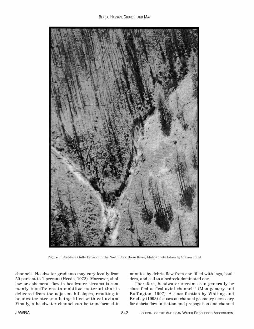
Some headwater channels are susceptible toepisodic erosion by floodwater, especially followingfire (Meyer et al., 2001; Cannon, 2001; Cannon et al.,2001) (Figure 1B and Figure 3). Fires, which can
completely burn small watersheds, can create hydro-phobic (water repellent) soils (e.g., Letey, 2001), whichmay yield extraordinary surface runoff, particularlyin regions where thunderstorms rain on dry soils(Cannon et al., 2001; Istanbulluoglu et al., 2003).Intense precipitation following hot burns can lead toextensive rill erosion and extreme discharge events insmall, soil filled channels (Heede, 1988).
Sediment transport during extreme hydrologicevents may cause floods to bulk with fine sediment upto 20 percent or more by volume (a condition referredto as a “hyperconcentrated flow”) (Costa, 1988); or tomobilize a gravel-transporting “debris floods” (Hungret al., 2001), which can evacuate all, or most of thesediment that has accumulated in unchanneledswales and headwater channels and this scouring ofheadwater streams can create upslope gullies, whichfocus further runoff and scour. Large pulses of sedi-ment are delivered to downstream channels and val-ley floors (Klock and Helvey, 1976; Meyer et al., 1995;Robichard and Brown, 1999; Istanbulluoglu, 2002).The physics of debris floods is not well understood butthe process can be defined rheologically as an inter-mediate stage between debris flow and streamflow(Hungr et al., 2001).
Another mechanism responsible for gully formationin headwater streams is the upstream progression ofheadcuts (Dewey et al., 2002). A headcut is an abruptchange in elevation, or a “knickpoint,” at the leadingedge of a gully (Bennett, 1999). Headcuts drive chan-nel incision by migrating up the channel until a resis-tant structure such as large wood is encountered.Headcut progression results in a bottom-up control onchannel erosion, which is the opposite of floods andassociated hyperconcentrated flows that develop nearthe gully or channel head (a top-down control on gullyformation). Once established, gullies can becomechronic sources of fine sediment delivered by chronicfluvial transport processes over many years (Nistorand Church, 2005).
MOUNTAIN HEADWATER STREAMS: CHANNELMORPHOLOGY AND CLASSIFICATION
Headwater streams containing a mixture of boul-ders, logs and soil and stretches of bedrock, includingwaterfalls, defy reach scale characterizationsdesigned for larger channels dominated by fluvial pro-cesses (Jackson and Sturm, 2002). In addition, chan-nel morphology can change significantly within arelatively short period. Vegetation that grows ondeposits changes channel morphology by enhancingsediment storage (Abt et al., 1993) and by narrowing
JOURNAL OF THE AMERICAN WATER RESOURCES ASSOCIATION 841 JAWRA
GEOMORPHOLOGY OF STEEPLAND HEADWATERS: THE TRANSITION FROM HILLSLOPES TO CHANNELS
channels. Headwater gradients may vary locally from50 percent to 1 percent (Heede, 1972). Moreover, shal-low or ephemeral flow in headwater streams is com-monly insufficient to mobilize material that isdelivered from the adjacent hillslopes, resulting inheadwater streams being filled with colluvium.Finally, a headwater channel can be transformed in
minutes by debris flow from one filled with logs, boul-ders, and soil to a bedrock dominated one.
Therefore, headwater streams can generally beclassified as “colluvial channels” (Montgomery andBuffington, 1997). A classification by Whiting andBradley (1993) focuses on channel geometry necessaryfor debris flow initiation and propagation and channel
JAWRA 842 JOURNAL OF THE AMERICAN WATER RESOURCES ASSOCIATION
BENDA, HASSAN, CHURCH, AND MAY
Figure 3. Post-Fire Gully Erosion in the North Fork Boise River, Idaho (photo taken by Steven Toth).

properties that would affect sediment transport byfloods (flow depth, slope, roughness, etc.). Forinstance, gradient thresholds must be exceeded fordebris flow transport to occur (Benda and Cundy,1990; Fannin and Wise, 2001), and particle size alsodictates what flow magnitude is needed to fluviallytransport sediment (Heede, 1972; Hassan et al.,2005), although the application of the latter is compli-cated by the “stepped” nature of headwater streams.
Recently, Halwas and Church (2002) presented aclassification and description of channel units insmall, high gradient mountain channels in VancouverIsland, British Columbia (see also Grant et al., 1990;Hawkins et al., 1993). Falls, bedrock cascade, bouldercascades, rapids, chutes, riffles, glides, and pools weredescribed according to their bed slope and dominantbed material texture and organization. Multiple pair-wise comparisons showed that these morphologieshave mean bed gradients distinct from each other andfrom those of corresponding units in larger streams.High gradient units (e.g., bedrock, boulder cascades)were dominant in steep, largely non-alluvial channels,whereas low gradient units (e.g., riffles, rapids) werecommon in semi-alluvial segments with more gentleslopes. Interestingly, wood did not play a large role inthe morphology of these very small channels; mostly,wood spanned them above the level of hydraulicaction.
In general, the spatially and temporally diversemorphology of relatively steep headwater channelsprecludes a strict classification according to process,since fluvial processes may dominate at certain times(although be relatively minor in terms of long -termsediment export), and debris flow scoured channelsmay characterize the system during other times.Consequently, channel morphology is highly sensitiveto the time since the last scouring event, and it shouldvary with channel gradient and, hence, position in theheadwater network (Figure 4). Therefore, debris flow
prone headwater channels could be classified accord-ing to both spatial and temporal characteristics.
EFFECTS OF MOUNTAIN HEADWATERSTREAMS ON LARGER CHANNELS
AND RIVER ECOSYSTEMS
Episodic Sediment and Wood Supply
Punctuated erosion in hilly to mountainous ter-rains is common in coastal rainforests of PacificNorthwest, British Columbia, and Alaska (Dietrichand Dunne, 1978; Sidle and Swanston, 1982; Swansonet al., 1982; Roberts and Church, 1986; Gomi et al.,2004), in the Appalachian Mountains (Hack andGoodlett, 1960; Williams and Guy, 1973; Costa, 1974;Gupta and Fox, 1974; Jacobson et al., 1989; Miller,1990; Eaton et al., 2003), in the intermountain region,and in southwestern highland deserts (Wohl andPearthree, 1991; Meyer et al., 1995; Kirchner et al.,2001). Episodic erosion in headwater streams does notalways result in an episodic flux of sediment to largerrivers because sediment can be stored on fans (Mayand Gresswell, 2004) and behind large logjams thateffectively capture sediment (Lancaster et al., 2003).
Nevertheless, because headwater streams are soabundant, they provide a substantial portion of thesediment and organic material that forms riverinehabitats throughout whole drainage networks, andmost of it is delivered during brief periods. For exam-ple, in the Queen Charolotte Islands, Schwab (1998)documented six storms over 180 years (1810 to 1991)that triggered debris flows in first-order and second-order channels that mobilized 77 percent of all sedi-ment originating from all forms of mass wasting in afifth-order basin. In Idaho, cosmogenic dating ofstream sediments revealed an apparent long term
JOURNAL OF THE AMERICAN WATER RESOURCES ASSOCIATION 843 JAWRA
GEOMORPHOLOGY OF STEEPLAND HEADWATERS: THE TRANSITION FROM HILLSLOPES TO CHANNELS
Figure 4. A Classification of Debris Flows in Headwater Streams Indicating the Slope Gradient Thresholds for Erosion,Transition Between Erosion and Deposition, and Deposition. Also shown are the temporal trajectories at
different time intervals following scouring debris flow (after May and Gresswell, 2003b).

average erosion rate (103 years) 17 times higher thanerosion rates measured over 10 to 84 years, indicatingthat mountain sediment yields are highly episodicand dominated by large erosional events in headwaterbasins (Kirchner et al., 2001). Field studies by Meyeret al. (2001) also suggest that episodic erosion follow-ing fire was equivalent to several thousand years ofsediment yield at the rates measured over short termsediment trapping and gauging in an Idaho batholithwatershed. An important implication of these studiesis that conventional programs of sediment transportand yield measurements are likely to miss the mostsignificant events occurring in headwater channelsunless they are continued for a long time.
Recognition that dynamic processes, termed “dis-turbances,” can alter the physical environment andchange ecosystem structure represents a maturingtheme in the study of rivers (Pickett and White, 1985;Resh et al., 1988; Reeves et al., 1995) This frameworkcoincides with a growing interest within the past sev-eral years in applying principles of landscape ecologyto river corridors, leading to the consideration of“riverscapes” (Ward et al., 2002) and spatially dis-tributed fluvial processes and features that createhabitat heterogeneity for aquatic and riparian species(e.g., Fausch et al., 2002; Wiens, 2002). In the contextof these emerging ecological frameworks, distur-bances in forested mountain environments, such aslandslides, debris flows, floods, and gully erosion inheadwater channels, can be viewed as components inhabitat formation, creating many landforms and asso-ciated habitats (i.e., fans, terraces, floodplains withsecondary channels, large logjams, and boulderdeposits) in channels and on valley floors (Hogan etal., 1998; Benda et al., 2004) that are not formed dur-ing more quiescent times. It should be clear, then,that long term habitat creation often entails shorterterm disturbance. Shorter term negative effects ofepisodic erosion must be considered in the context oflonger term goals for land management.
Headwater Tributary Junctions
The effects of headwater streams as sedimentsources are most evident at the confluences of head-waters with larger channels where debris flow andalluvial fans form. In the context of “riverscapes,” con-fluences of headwater streams with larger channelscan be viewed as nodes of habitat heterogeneity(Benda et al., 2003a). The ecological effects of debrisflows have been documented in several studies, pro-viding perspective on both destructive and construc-tive effects. Over short periods, debris flow depositshave destructive effects, including immediate burial
of existing habitat and direct mortality of aquaticbiota (Everest and Meehan, 1981); increased fine sedi-ment deposition within gravels onsite and down-stream that can suffocate fish eggs in gravel (e.g.,Everest et al., 1987); increased bed load transport andlateral channel movement due to heightened sedi-ment supply that scours fish eggs; a loss of pools thatreduces rearing habitat (Frissell and Nawa, 1992;Hogan et al., 1998); loss of aquatic insects (Lambertiet al., 1991); and the dewatering of pools due to chan-nel aggradation (May and Lee, 2004). Over longerperiods, constructive effects of debris flows on aquaticsystems may include formation of temporary pondsthat become occupied by rearing fish and beavers(Everest and Meehan, 1981); depositional areas thatrelease nutrients from buried organics in anaerobicenvironments (Sedell and Dahm, 1984); deposition ofwoody debris that creates sediment wedges (Hogan etal., 1998); deposition of boulders that trap sedimentsand create complex habitats (Benda, 1990; Reeves etal., 1995); formation of wider valley floors that con-tain larger floodplains (Grant and Swanson, 1995);creation of gravel deposits and large pools (Benda etal., 2003a); and increased biological productivity(Roghair et al., 2002). Spates of debris flows con-tribute to watershed scale habitat diversity, includingthe structure and composition of riparian forests(Nakamura et al., 2000; Nierenberg and Hibbs, 2000).In semi-arid environments, post-fire gully erosion inheadwater streams can construct alluvial fans thatcreate wide floodplains, side channels, and terraces inlarger valleys (Benda et al., 2003b).
The more or less irregular spacing of headwaterconfluences and the effects they have on the morphol-ogy of larger channels suggest that aquatic habitatsin larger channels are not uniformly distributed. Forexample, in a fifth-order basin in the Oregon CoastRange, boulder deposits, logjams, and temporaryponds are focused at confluences with low orderstreams (Everest and Meehan, 1981; Benda, 1990).In third-order through fifth-order channels in theQueen Charlotte Islands, Hogan et al. (1998) showedthat large logjams with associated sediment wedgesoccurred irregularly, their spacing dictated by the spa-tial distribution of headwater streams. Similarly, inthird-order and fourth-order channels in managedbasins in the Olympic Peninsula, Benda et al. (2003a)showed that the highest densities of large wood, largepools, wide floodplains, and gravel substrate occurredin the immediate vicinity of low order channels at aspatial scale of approximately 200 m (based on theaverage spacing of headwater streams).
In addition to tributary junction effects, spates ofdebris flows and gully erosion can lead to widespread(kilometer scale) channel aggradation. Large influxesof sediment can construct wide floodplains and side
JAWRA 844 JOURNAL OF THE AMERICAN WATER RESOURCES ASSOCIATION
BENDA, HASSAN, CHURCH, AND MAY

channels (Nakamura, 1986; Roberts and Church,1986; Wohl and Pearthee, 1991; Miller and Benda,2000; Benda et al., 2003b) and can set the stage forsubsequent terrace development. Fluctuations in bedload supply may also be manifest as coherent wavesor pulses that migrate downstream (e.g., Madej andOzaki, 1996; Miller and Benda, 2000). However, sedi-ment pulses may also disperse downstream (Lisle etal., 1997, 2001; Sutherland et al., 2002). Channelaggradation can also occur preferentially upstreamfrom large wood jams (Montgomery et al., 2003) andculluvial and alluvial fans (Benda et al., 2003a,b).
Long Term Perspectives of Headwater Dynamics
Sediment supply from headwater streams impactsthe form and function of larger, fish bearing channels(Everest and Meehan, 1981; Swanson et al., 1987;Benda, 1990; Rice et al., 2001; Gomi et al., 2002).Given the relatively short time horizons of many nat-ural resource studies, a common perspective is thatepisodic erosion and the punctuated supply of sedi-ment and wood during storms or following fires andtimber harvest is inherently destructive. However, thelonger term consequences of erosion, including thematerial transfer from headwaters to larger channels,cannot be evaluated over short time horizons (Dunne,2001).
Most of the field studies reviewed in this paper rep-resent snapshots in time. For a longer term perspec-tive, the role of headwaters on larger, fish bearingstreams can be examined using simulation models.Benda and Dunne (1997b) used numerical models toillustrate how, over decades to centuries, a probabilis-tic sequence of rainstorms coupled with a sequence offires generates a stochastic sequence of erosion andsediment transport events in headwater streams in a200 km2 basin in the Oregon Coast Range. The modelpredicted that the probability distribution of sedimentexport from headwaters would be right-skewed andcharacterized by frequent small sediment fluxes punc-tuated by infrequent large fluxes (triggered by firesand storms). Other predictions suggest that followingspates of storms and fires, sedimentation would beconcentrated in certain parts of the network, particu-larly near tributary junctions, and that those depositswould interfere with transport of sediment and woodfrom upstream.
Other models are being used to understand thelong term effects of events such as fires, landslides,debris flows, wood recruitment, and gully erosion onthe behavior of watersheds. Lancaster et al. (2000,2003) constructed models to show how debris flowsexported sediment and wood. Because sediment wascaptured by logjams, there was less sediment delivery
downstream, at least in the short term. Stochasticsimulation is being utilized to create visual graphicsof watershed dynamics over decades to centuries asan educational tool (USFS, 2002). Simulation model-ing is also being extended to more arid environmentswhere post-fire gully erosion is an important process(Gabet and Dunne, 2003; Istanbulluoglu et al., 2003).Theoretical models of wood recruitment over cen-turies have also been developed (Benda and Sias,2003). For example, in the Oregon Coast Range,debris flows in headwater streams are predicted tocontribute approximately 10 percent of the century-scale wood budget in larger channels. However, theselong term predictions have not been tested, and shortterm studies suggest that wood recruitment fromdebris flows can be a much larger component of thewood budget (May and Gresswell, 2003a; Reeves etal., 2003).
Influences of Land Management on MountainHeadwater Streams
Timber harvest, road networks, and severe firesinfluence the frequency, magnitude, and compositionof mass wasting in headwater systems. Landslide fre-quency typically increases after construction of forestroads and timber harvest (summary of early work inSidle et al., 1985; Jakob, 2000; Guthrie, 2002; Brardi-noni et al., 2003). An increase in landslide frequencyoften leads to an increase in debris flow frequency(Swanson and Dyrness, 1975; Swanson et al., 1977).Harvesting of large, old trees adjacent to headwaterstreams (and maintaining the managed forest inyounger, smaller trees) can reduce the supply of largeinstream wood in headwater systems. In the glaciatedlandscapes of British Columbia and Alaska, reroutingof the drainage system as the result of forestry activi-ties (principally road building) is responsible for trig-gering landslides and may also contribute to gullying.
Increasing the frequency of debris flows in man-aged forests can alter the morphology of larger riversystems. May (2002) documented a higher proportionof wood delivered by debris flows (relative to othersources of wood in the mainstem channel) for catch-ments that had been clear-cut. Montgomery et al.(2003) found that debris flow deposits assumed agreater relative importance in logjam formation inmanaged forests due to the inability of small, locallyrecruited wood from young riparian forests to providestable foundations for logjam development. Debrisflows in managed forests on the Olympic Peninsulaled to increases in large wood, gravel deposits, andlarge pools in proximity to low order confluences(Benda et al., 2003a). These studies imply increaseddelivery by debris flows of residual large wood in the
JOURNAL OF THE AMERICAN WATER RESOURCES ASSOCIATION 845 JAWRA
GEOMORPHOLOGY OF STEEPLAND HEADWATERS: THE TRANSITION FROM HILLSLOPES TO CHANNELS
decades following forest harvest, but the effect iswidely expected to give way to smaller flows carryingsmaller wood later.
If forest management activities are increasing theoccurrence of debris flows, then headwater streamsmay be transformed to a bedrock state more frequent-ly. The reduction of wood recruitment to headwaterstreams due to harvesting of large trees should leadto a reduction in sediment storage. Hence headwaterstreams may become more of a chronic source of sedi-ment to downstream, fish bearing systems becausebedrock streams have a high transport efficiency andthe lack of large wood reduces their storage capacity(May and Gresswell, 2003b). The effect of more punc-tuated versus less punctuated delivery of sedimentand wood from headwater to larger channels in man-aged versus unmanaged watersheds is not well under-stood. A reduction in large wood in headwatersystems will also reduce the amount of large woodthat can be delivered to larger streams by debrisflows, thereby negatively impacting fish habitats(Reeves et al., 1995), though possibly not for decades.
Land management influences on headwaterstreams go beyond mass wasting. Because headwaterwatersheds are small, it is feasible to log all or a sig-nificant proportion of low order catchments at onepass. Given that headwater catchments in someregions are rain-on-snow or snow dominated water-sheds, there is significant potential to increase peakflows (Berris and Harr, 1987; Jones and Grant, 1996;Jones, 2000). Moreover, roads can alter runoff pat-terns and supply more flow to headwater streams(Wemple and Jones, 2003). Increases in flood magni-tude have the potential to further increase erosionand sediment transport.
It is imperative that forest managers recognize therole played by headwater systems in the supply ofwater, sediment, and nutrients downstream, under-stand the intensity of impacts from forestry practices,and adopt practices to ensure the integrity of headwa-ter systems. Management practices need to ensurethat when disturbances do occur, the essential pro-cesses (e.g., coarse sediment and large wood inputs,nutrient and fine organic matter transfers) and link-ages (e.g., floodplain connections) that promote chan-nel reorganization and habitat recovery are notdisrupted (Reeves et al., 1995; Ebersole et al., 1997).
CONCLUSIONS
Small headwater channels have received consider-ably less study than larger streams. Reasons includelack of fish, difficult access, and generally harsh working conditions. Based on their sheer numbers in
a watershed, headwater channels have important consequences for the ecology of larger streams andrivers (Gomi et al., 2002). In addition, the protectionof headwaters has important ramifications for the for-est industry and the regulatory agencies.
A rapidly growing body of literature analyzes thehydrology, geomorphology, and ecology of headwatersystems. In many important respects, headwaterstreams are different from their larger counterpartslocated lower in river networks. Headwater streamscan be highly retentive of both sediment and wood,and in steeplands the episodic release of material mayoccur infrequently during debris flows, flash floods,and gully erosion. Because of high sediment and woodstorage, the morphology of steep headwater channelsis an amalgam of logs, soil, boulders, bedrock, andwaterfalls, and the morphology varies temporally dueto debris flows and flash floods. Therefore, headwaterstreams defy simple classification of their morphology.Although the episodic and catastrophic nature of sedi-ment and wood transport in headwater channels oftenappears as an environmental threat to downstreamresources, the supply of sediment and wood by masswasting processes is an important ecological processin both unmanaged and managed forests.
Because of their episodic dynamics, the behavior ofheadwater streams may best be understood over largespatial and temporal scales. For example, it is difficultto evaluate effects of a debris flow or post-fire gullyerosion in a single headwater channel over only a fewyears. Because of the century long time scalesinvolved in the disturbance of headwater streams,event histories are best understood over decades tocenturies at the scale of the river basin (i.e., incorpo-rating hundreds to thousands of headwater channels).Only then can the inherently stochastic nature ofsediment and wood supply from hillslopes and head-water channels be put into the context of the geomor-phological and ecological behavior of entire mountaindrainage basins. Only with that understanding canviable, long term management strategies be devel-oped for headwater landscapes.
LITERATURE CITED
Abt, S.R, W.P. Clary, and C.I. Thornton, 1993. Sediment Entrap-ment in Vegetated Streambeds. In: Preserving Our Environ-ment – The Race Is On. Proceedings, International ErosionControl Assoc., Conference XXIV. Indianapolis, Indiana, pp. 75-91.
Benda, L., 1990. The Influence of Debris Flows on Channels andValley Floors of the Oregon Coast Range, U.S.A. Earth SurfaceProcesses and Landforms 15:457-466.
Benda, L.E., K. Andras, D. Miller, and P. Bigelow, 2004. ConfluenceEffects in Rivers: Interactions of Basin Scale, Network Geome-try, and Disturbance Regimes. Water Resources Research, Vol.40, W05402, doi:10.1029/2003WR002583.
JAWRA 846 JOURNAL OF THE AMERICAN WATER RESOURCES ASSOCIATION
BENDA, HASSAN, CHURCH, AND MAY

Benda, L.E., P. Bigelow, and T.M. Worsley, 2002. Recruitment ofWood to Streams in Old-Growth and Second-Growth RedwoodForests, Northern California, U.S.A. Canadian Journal of Fish-eries and Aquatic Sciences 32:1460-1477.
Benda, L. and T. Cundy, 1990. Predicting Deposition of DebrisFlows in Mountain Channels. Canadian Geotechnical Journal27:409-417.
Benda, L. and T. Dunne, 1987. Sediment Routing by Debris Flows.International Association for Hydrological Sciences Publication165:213-223.
Benda, L. and T. Dunne, 1997a. Stochastic Forcing of SedimentSupply to Channel Networks From LandSliding and DebrisFlow. Water Resources Research 33(12):2849-2863.
Benda, L. and T. Dunne, 1997b. Stochastic Forcing of SedimentRouting and Storage in Channel Networks. Water ResourcesResearch 33(12):2865-2880.
Benda, L., C. Miller, P. Bigelow, and K. Andras, 2003b. Effects ofPost-Fire Erosion on Channel Environments, Idaho. Journal ofForest Ecology and Management, Special Edition: Fires andAquatic Ecosystems 178(1-2):105-119.
Benda, L. and J. Sias, 2003. A Quantitative Framework for Evalu-ating the Wood Budget. Journal of Forest Ecology and Manage-ment 172:1-16.
Benda, L., C. Veldhuisen, and B. Black, 2003a. Tributary Conflu-ences, Debris Flows, and Channel Morphology, Olympic Penin-sula, Washington. Geological Society of America Bulletin115:1110-1121.
Bennett, S.J., 1999. Effect of Slope on the Growth and Migration ofHeadcuts in Rills. Geomorphology 30:273-290.
Berris, S.N. and R.D. Harr, 1987. Comparative Snow Accumulationand Melt During Rainfall in Forested and Clear-Cut Plots in theWestern Cascades of Oregon. Water Resources Research23(1):135-142.
Bovis, M.J., T.H. Millard, and M.E. Oden, 1998. Gully Processes inCoastal British Columbia: The Role of Woody Webris. In: Carna-tion Creek and Queen Charlotte Islands Fish/Forestry Work-shop: Applying 20 Years of Coastal Research to ManagementSolutions, D.L. Hogan, P.J. Tschaplinski, and S.B.C. Chatwin(Editors). British Columbia Ministry of Forests ResearchBranch, Victoria, B.C., Land Management Handbook No. 41, pp.49-76.
Brardinoni, F., M.A. Hassan, and H.O. Slaymaker, 2003. ComplexMass Wasting Response of Drainage Basins to Forest Manage-ment in Coastal British Columbia. Geomorphology 49:109-124.
Burt, T.P., 1992. The Hydrology of Headwater Catchments. In: TheRivers Handbook, P. Calow and G.E. Petts (Editors). Blackwell,London, United Kingdom, pp. 3-28.
Campbell, D. and M. Church, 2003. Reconnaissance Sediment Bud-gets for Lynn Valley, British Columbia: Holocene and Contempo-rary Time Scales. Canadian Journal of Earth Sciences 40:701-713.
Cannon, S.H., 2001. Debris-Flow Generation From RecentlyBurned Watersheds. Environmental and Engineering Geo-sciences 7(4):321-341.
Cannon, S.H., E.R. Bigio and E. Mine, 2001. A Process for Fire-Related Debris Flow Initiation, Cerro Grande Fire, New Mexico.Hydrological Processes 15:3011-3023.
Casadei, M., W.E. Dietrich, and N.L. Miller, 2003. Testing a Modelfor Predicting the Timing and Location of Shallow LandslideInitiation in Soil-Mantled Landscapes. Earth Surface Processesand Landforms 28:925-950.
Chin, A., 1989. Step Pools in Stream Channels. Progress in Physi-cal Geography 13:391-407.
Chin, A., 1999. On the Stability of Step-Pool Mountain Streams.Geophysical Research Letters 26:231-234.
Church, M., 2002. Geomorphic Thresholds in Riverine Landscapes.Freshwater Biology 47:541-557.
Costa, J.E., 1974. Response and Recovery of a Piedmont WatershedFrom Tropical Storm Anges, June 1972. Water ResourcesResearch 10:106-112.
Costa, J.E., 1984. Physical Geomorphology of Debris Flows. In:Developments and Applications of Geomorphology, J.E. Costa,and P.J. Fleisher (Editors) Springer-Verlag, Berlin, Germany, pp.268-312.
Costa, J.E., 1988. Rheologic, Geomorphic, and Sedimentlogic Differ-entiation of Water Flood, Hyperconcentrated Flows, and DebrisFlows. In: Flood Geomorphology, V.R. Baker, R.C. Kochel, andP.C. Patton (Editors). Wiley, New York, New York, pp. 113-122.
Dewey, N.J., T.E. Lisle, and L.M. Reid, 2002. Gully Development inTributaries to Casper Creek, Northern California Coast Range.EOS Transactions American Geophysical Union 83(47), FallMeeting Supplement, Abstract H11C-0862, p. F534.
Dieterich, M. and N.H. Anderson, 1998. Dynamics of AbioticParameters, Solute Removal and Sediment Retention in Sum-mer-Dry Headwater Streams of Western Oregon. Hydrobiologia379:1-15.
Dietrich, W.E. and T. Dunne, 1978. Sediment Budget for a SmallCatchment in Mountainous Terrain: Zietschrift fur Geomor-phologie, Suppl. 29:191-206.
Dietrich, W.E. and T. Dunne, 1993. The Channel Head. In: ChannelNetwork Hydrology, K. Beven, and M.J. Kirkby (Editors). Wiley,Chichester, United Kingdom, pp. 175-219.
Dietrich, W.E., R. Reiss, M. Hsu, and D.R. Montgomery, 1995. AProcess-Based Model for Colluvial Soil Depth and ShallowLandsliding Using Digital Elevation Data. Hydrological Process-es 9:383-400.
Dietrich, W.E., S.L. Renau, and C.J. Wilson, 1987. Overview: “Zero-Order Basins” and Problems of Drainage Density, SedimentTransport and Hillslope Morphology. In: Erosion and Sedimen-tation in the Pacific Rim. International Association of Hydrologi-cal Sciences Publication 165:27-37.
Duncan, S.H., R.E. Bilby, J.V. Ward, and J.T. Heffner, 1987. Trans-port of Road-Surface Sediment Through Ephemeral StreamChannels. Water Resources Bulletin 23(1):114-119.
Dunne, T., 1991. Stochastic Aspects of the Relations Between Cli-mate, Hydrology and Landform Evolution. Transactions,Japanese Geomorphological Union 12:1-24.
Dunne, T., 2001. Problems in Measuring and Modeling theInfluence of Forest Management on Hydrologic and GeomorphicProcesses. In: Land Use and Watersheds: Human Influence onHydrology and Geomorpholgy in Urban and Forest Areas, M.S.Wigmosta and S.J. Burges (Editors). Water Science and Applica-tion 2, American Geophysical Union, Washington, D.C., pp. 77-84
Eaton, L.S., B.A. Morgan, R.C. Kochel, and A.D. Howard, 2003.Role of Debris Flows in Long-Term Landscape Denudation inthe Central Appalachians of Virginia. Geology 31(4):339-342.
Ebersole, J.L., W.J. Liss, and C.A. Frissell, 1997. Restoration ofStream Habitats in the Western United States: Restoration asReexpression of Habitat Capacity. Environmental Management21(1):1-14.
Everest, F.E., R.L. Beschta, K.V. Scrivener, J.R. Sedell, and C.J.Cederholm, 1987. Fine Sediment and Salmon Production: AParadox. In: Streamside Management, Forestry and FisheryInteractions. University of Washington, Institute of ForestResources, Contribution No. 57, Seattle, Washington, Chapter 4,pp. 98-142.
Everest, F.H. and W.R. Meehan, 1981. Forest Management andAnadromous Fish Habitat Productivity. In: Transactions of the46th North American Wildlife and Natural Resources Confer-ence, Wildlife Management Institute, Washington, DC, pp. 521-530.
JOURNAL OF THE AMERICAN WATER RESOURCES ASSOCIATION 847 JAWRA
GEOMORPHOLOGY OF STEEPLAND HEADWATERS: THE TRANSITION FROM HILLSLOPES TO CHANNELS

Fannin, R.J. and T. Rollerson, 1993. Debris Flows: Some PhysicalCharacteristics and Behaviour. Canadian Geotechnical Journal30(1):71-82.
Fannin, R.J. and M.P.W. Wise, 2001. An Empirical-Statistical Modelfor Debris Flow Travel Distance. Canadian Geotechnical Jour-nal 38:982-994.
Fausch, K.D, C.E. Torgersen, C.V. Baxter, and H. Li, 2002. Land-scapes to Riverscapes: Bridging the Gap Between Research andConservation of Stream Fishes. BioScience 52:483-498.
Fredriksen, R.L., 1970. Erosion and Sedimentation Following RoadConstruction and Timber Harvest on Unstable Soils in ThreeSmall Western Oregon Watersheds. USDA Forest ServiceResearch Paper PNW-104, Pacific Northwest and Range Experi-ment Station, Portland, Oregon, 15 pp.
Frissell, C.A. and R.K. Nawa, 1992. Incidence and Causes of Physi-cal Failure of Artificial Habitat Structures of Western Oregonand Washington. North American Journal Fish Management12:182-194.
Gabet, E.J. and T. Dunne, 2003. A Stochastic Sediment DeliveryModel for a Steep Mediterranean Landscape. Water ResourcesResearch 39(9):1237-1248.
Gomi, T. and R. C. Sidle, 2003. Bed Load Transport in ManagedSteep-Gradient Headwater Streams of Southeastern Alaska.Water Resources Research 39(12):1336, doi:10.1029/2003WR002440.
Gomi, T., R.C. Sidle, M.D. Bryant, and R.D. Woodsmith, 2001. TheCharacteristics of Woody Debris and Sediment Distribution inHeadwater Streams, Southeastern Alaska. Canadian Journal ofForest Research 31:1386-1399.
Gomi, T., R.C. Sidle, and J.S. Richardson, 2002. Understanding Pro-cesses and Downstream Linkages of Headwater Systems. Bio-Science 52:905-916.
Gomi, T., R.C. Sidle, and D.N. Swanston, 2004. HydrogeomorphicLinkages of Sediment Transport in Headwater Streams, Maybe-so Experimental Forest, Southeast Alaska. Hydrological Pro-cesses 18:667-683.
Grant, G.E. and F.J. Swanson, 1995 Morphology and Processes ofValley Floors in Mountain Sstreams, Western Cascades, Oregon.In: Natural and Anthropogenic Influences in Fluvial Geomor-phology, J.E. Costa, A.J. Miller, K.W. Potter, and P.R. Wilcock(Editors).Geophysical Monograph 89:83- 101.
Grant, G.E., F.J. Swanson, and M.G. Wolman, 1990. Pattern andOrigin of Stepped-Bed Morphology in High Gradient Streams,Western Cascades, Oregon. Geological Society of America Bul-letin 102:340-352.
Grant, G.E. and A.L. Wolff, 1991. Long-Term Patterns of SedimentTransport After Timber Harvest, Western Cascade Mountains,Oregon, USA. In: Proceedings of the Vienna Symposium, Inter-national Association of Hydrological Sciences, Wallingford, Unit-ed Kingdom, IAHS 203:31-40.
Gupta, A. and H. Fox, 1974. Effects of High-Magnitude Floods onChannel Form: A Case Study in the Maryland Piedmont. WaterResources Research 10:499-509.
Guthrie, R.H., 2002. The Effects of Logging on Frequency and Dis-tribution of Landslides in Three Watersheds on VancouverIsland, British Columbia. Geomorphology 43:273-292.
Hack, J.T., 1965. Geomorphology of the Shenandoah Valley Virginiaand West Virginia and Origin of the Residual Ore Deposits. U.S.Geological Survey Professional Paper 504B. Washington, D.C.,pp. B1-B40.
Hack, J.T. and J.C. Goodlett, 1960. Geomorphology and Forest Ecol-ogy of a Mountain Region in the Central Appalachians. U.S.Geological Survey Professional Paper 347, Reston, Virginia, 66pp.
Halwas, K.L. and M. Church, 2002. Channel Units in Small, HighGradient Streams on Vancouver Island, British Columbia. Geo-morphology 43:243-256.
Hassan, M.A., M. Church, T.E. Lisle, F. Brardinoni, L. Benda, andG.E. Grant, 2005. Sediment Transport and Channel Mmorpholo-gy of Small, Forested Streams. Journal of the American WaterResources Association (JAWRA) 41(4):853-876.
Hawkins, C.P., J.L. Kershner, P.A. Bisson, M. Bryant, L. Decker,S.V. Gregory, D.A. McCullough, K. Overton, G. Reeves, R. Steed-man, and M. Young, 1993. A Hierarchical Approach to Classify-ing Stream Habitat Features. Fisheries 18(6):3-12.
Heede, B.H., 1972. Influence of a Forest on the Hydraulic Geometryof Two Mountain Streams. Water Resources Bulletin 8:523-530.
Heede, B.H., 1985. Channel Adjustments to the Removal of LogSteps: An Experiment in a Mountain Stream. EnvironmentalManagement 9:427-432.
Heede, B.H., 1988. Sediment Delivery Linkages in a ChaparrelWatershed Following Wildfire. Environmental Management12(3):349-358.
Heimsath, A.M., W.E. Dietrich, K. Nishizumi, and R.C. Finkel,2001. Stochastic Processes of Soil Production and Transport:Erosion Rates, Topographic Variation and Cosmogenic Nuclidesin the Oregon Coast Range. Earth Surface Processes and Land-forms 26:531-552.
Hogan, D.L., S.A. Bird, and M.A. Hassan, 1998. Spatial and Tempo-ral Evolution of Small Coastal Gravel-Bed Streams: The Influ-ence of Forest Management on Channel Morphology and FishHabitats. In: Gravel-Bed Rivers in the Environment, Gravel BedRivers IV, P.C. Klingeman, R.L. Beschta, P.D. Komar, and J.B.Bradley (Editors). Water Resources Publications, HighlandRanch, Colorado, pp. 365-392.
Hungr, O., 2005. Classification and Terminology. In: Debris-FlowHazard and Related Phenomena, M. Jakob and O. Hungr (Edi-tors). Springer-Praxis, Berlin, Germany, pp. 9-24.
Hungr, O., S.G. Evans, M.J. Bovis, and J.N. Hutchinson, 2001. AReview of The Classification of Landslides of the Flow Type.Environment and Engineering Geosciences 7:221-238.
Hungr, O., S. McDougall, and M. Bovis, 2005. Entrainment of Mate-rial by Debris Flows. In: Debris-Flow Hazard and Related Phe-nomena, M. Jakob and O. Hung (Editors). Springer-Praxis,Berlin, Germany, pp. 135-158.
Hungr, O., G.C. Morgan, and R. Kellerhals, 1984. QuantitativeAnalysis of Debris Torrent Hazards for Design of Remedial Mea-sures. Canadian Geotechnical Journal 21:663-677.
Istanbulluoglu, E., 2002. Quantification of Stream Sediment InputsFrom Steep Forested Mountains. Ph.D. Thesis, Civil Engineer-ing, Utah State University, Logan, Utah, 210 pp.
Istanbulluoglu, E., D.G. Tarboton, R.T. Pack, and C. Luce, 2003. ASediment Transport Model for Incising Gullies on Steep Topog-raphy. Water Resources Research 39(4):1103, doi:10.1029/2002WR001467.
Jackson, C.R. and C.A. Sturm, 2002. Woody Debris and ChannelMorphology in First- and Second-Order Forested Channels inWashington ’s Coast Ranges. Water Resources Research38(9):1177, doi:10.1029/2001WR001138.
Jacobson, R.B., A.J. Miller, and J.A. Smith, 1989. The Role of Catas-trophic Geomorphic Events in Central Appalachian LandscapeEvolution. Geomorphology 2:257-284.
Jakob, M., 2000. The Impacts of Logging on Landslide Activity atClayoquot Sound, British Columbia. Catena 38:279-300.
Jones, J.A., 2000. Hydrologic Processes and Peak DischargeResponse to Forest Removal, Regrowth, and Roads in 10 SmallExperimental Basins, Western Cascades, Oregon. WaterResources Research 36: 2621-2642.
Jones, J.A. and G.E. Grant, 1996. Peak Flow Responses to Clear-Cutting and Roads in Small and Large Basins, Western Cas-cades, Oregon. Water Resources Research 32:959-974.
JAWRA 848 JOURNAL OF THE AMERICAN WATER RESOURCES ASSOCIATION
BENDA, HASSAN, CHURCH, AND MAY

Kelsey, H.M., 1980. A Sediment Budget and an Analysis of Geomor-phic Process in the Van Duzen River Basin, North Coastal Cali-fornia, 1941-1975. Geological Society of American Bulletin 91(4),Part II: 1119-1216.
Kirchner, J.W., R.C. Finkel, C.S. Riebe, D.E. Granger, J.L. Clayton,J.G. King, and W.F. Megahan, 2001. Mountain Erosion Over 10yr, 10 k. y., and 10 m. y. Time Scales. Geology 29(7):591-594.
Klock, G.O. and J.D. Helvey, 1976. Debris Flows Following Wildfirein North Central Washington. In: Proceedings of the Third Fed-eral Interagency Sedimentation Conference, Denver, Colorado,Water Resources Council, Denver, Colorado, pp.91-98.
Kostaschuk, R.A., G.M. Macdonald, and P.E. Putnam. 1986. Deposi-tional Process and Alluvial Fan-Drainage Basin MorphometricRelationships Near Banff, Alberta, Canada. Earth Surface Pro-cesses and Landforms 11:471-484.
Lamberti, G.A., S.V. Gregory, L.R. Ashkenas, R,C, Wildman, andK.M.S. Moore, 1991. Stream Ecosystem Recovery Following aCatastrophic Debris Flow. Canadian Journal of Fisheries andAquatic Sciences 48:196-208.
Lancaster, S.T, S.K. Hayes, and G. Grant, 2000. Modeling Sedimentand Wood Storage and Dynamics in Small Mountainous Water-sheds. In: Geomorphic Processes and Riverine Habitat. Ameri-can Geophysical Union, Washington, D.C., Vol. 4:85-102.
Lancaster, S.T., S.K. Hayes, and G. Grant, 2003. Effects of Wood onDebris Flow Runout in Small Mountain Watersheds. WaterResources Research 39(6):1168, doi:10.1029/2001WR001227.
Letey, J., 2001. Causes and Consequences of Fire-Induced SoilWater Repellency. Hydrological Processes 15:2867-2875.
Lienkaemper, G.W. and F.J. Swanson, 1987. Dynamics of LargeWoody Debris in Streams in Old Growth Douglas-Fir Forests.Canadian Journal of Forest Research 17:150-156.
Lisle, T.F., Y. Cui, G. Parker, J.E. Pizzuto, and A.M. Dodd, 2001. TheDominance of Dispersion in the Evolution of Bed MaterialWaves in Gravel Bed Rivers. Earth Surface Processes and Land-forms 26: 1409-1420.
Lisle, T.E., J.E. Pizzuto, H. Ikeda, F. Iseya, and Y. Kodama, 1997.Evolution of a Sediment Wave in an Experimental Channel.Water Resources Research 33:1971-1981.
Madej, M.A. and V. Ozaki, 1996. Channel Response to SedimentWave Propagation and Movement, Redwood Creek, California,USA. Earth Surface Processes Landforms 21:911-927.
Martin, D. and L. Benda, 2001. Patterns of Instream Wood Recruit-ment and Transport at the Watershed Scale. Transactions of theAmerican Fisheries Society 130:940-958.
May, C.L., 2002. Debris Flows Through Different Forest Age Class-es in the Central Oregon Coast Range. Journal of the AmericanWater Resources Association (JAWRA) 38(4):1097-1113.
May, C.L. and R.E. Gresswell, 2003a. Large Wood Recruitment andRedistribution in Headwater Streams of the Oregon CoastRange, U.S.A. Canadian Journal of Forest Research 33:1352-1362.
May, C.L. and R.E. Gresswell, 2003b. Processes and Rates of Sedi-ment and Wood Accumulation in Headwater Streams of the Oregon Coast Range, U.S.A. Earth Surface Processes and Land-forms 28:409-424.
May, C.L. and R.E. Gresswell, 2004. Spatial and Temporal Patternsof Debris-Flow Deposition in the Oregon Coast Range, USA.Geomorphology 57:135-149.
May, C.L. and D.C. Lee, 2004. The Relationships Among In-Chan-nel Sediment Storage, Pool Depth, and Summer Survival ofJuvenile Salmonids in Oregon Coast Range Streams. NorthAmerican Journal of Fisheries Management 24:761-774.
McDade, M.H., F.J. Swanson, W.A. McKee, J.F. Franklin, and J. VanSickle, 1990. Source Distances for Coarse Wood Entering SmallStreams in Western Oregon and Washington. Canadian Journalof Forest Resources 20:326-330.
Megahan, W.F., 1975. Sedimentation in Relation to Logging Activi-ties in the Mountains of Central Idaho. In: Proceedings, Sedi-ment Yield Workshop, USDA Sediment Lab., Oxford,Mississippi. U.S. Agric. Res. Serv. Rep., ARS-S-40, Oxford, Mis-sissippi, 285 pp.
Meyer, G.A., J.L. Pierce, S.H. Wood, and A.J.T. Jull, 2001. Fire,Storms, and Erosional Events in the Idaho Batholith. Hydrologi-cal Processes 15:3025-3038.
Meyer, G.A, S.G. Wells, and J.T. Jull, 1995. Fire and AlluvialChronology in Yellowstone National Park: Climatic and IntrinsicControls on Holocene Geomorphic Processes. GSA Bulletin107(10):1211-1230.
Meyer, J.L. and J.B. Wallace, 2001. Lost Linkages and Lotic Ecolo-gy: Rediscovering Small Streams. In: Ecology: Achievement andChallenge, M. Pages, N. Huntly and S. Levin (Editors). Black-well Science, Oxford, United Kingdom, pp. 295-317.
Millard, T., 2001. Transport of Logging Slash and Sediment in S5and S6 Streams Near Boston Bar, Chilliwack Forest District.Nanaimo, B.C. Forest Research Publication, Technical ReportNo. TR-012, British Columbia Ministry of Forests, Victoria,British Columbia, Canada, 15 pp.
Miller, A.J., 1990. Flood Hydrology and Geomorphic Effectivenessin the Central Appalachians. Earth Surface Processes andLandforms 15:119-134.
Miller, D. and L. Benda, 2000. Effects of Mass Wasting on ChannelMorphology and Sediment Transport: South Fork Gate Creek,Oregon. GSA Bulletin 112(12):1814-1824.
Montgomery D.R., T.B. Abbe, J.M. Buffington, N.P. Peterson, K.M.Schmidt, and J.D. Stock, 1996. Distribution of Bedrock andAlluvial Channels in Forested Mountain Drainage Basins.Nature 381:587-589.
Montgomery, D.R. and J.M. Buffington, 1997. Channel Reach Mor-phology in Mountain Drainage Basins. GSA Bulletin 109:596-611.
Montgomery, D.R. and W.E. Dietrich, 1994. A Physically BasedModel for the Topographic Control on Shallow Landsliding.Water Resources Research 30:1153-1171.
Montgomery, D.R. and E. Foufoula-Georgiou, 1993. Channel Net-work Source Representation Using Digital Elevation Models.Water Resources Research 29:3925-3934.
Montgomery, D.R., T.M. Massong, and S.C.S. Hawley, 2003. Influ-ence of Debris Flows and Logjams on the Location of Pools andAlluvial Channel Reaches, Oregon Coast Range. Geological Soci-ety of America Bulletin 115(1):78-88.
Morisawa, M.E., 1957. Accuracy of Determination of StreamLengths From Topographic Maps. American Geophysical UnionTransactions 38:86-88.
Muchow, C. and J.S. Richardson, 2000. Unexplored Diversity:Macroinvertebrates in Coastal B.C. Zero-Order HeadwaterStreams. In: Proceedings, Biology and Management of Speciesand Habitats At Risk, L.M. Darling (Editor). British ColumbiaMinistry of Environment, Lands and Parks, Victoria, BritishColumbia, Canada, pp. 503-506.
Nakamura, F., 1986. Chronological Study on the Torrential Chan-nel Bed by the Age Distribution of Deposits. Research Bulletinof the College Experiment Forests, Faculty of Agriculture,Hokkaido University 43:1-26.
Nakamura, F. and F.J. Swanson, 1993. Effects of Coarse WoodyDebris on Morphology and Sediment Storage of a MountainStream System in Western Oregon. Earth Surface Processes andLandforms 18:43-61.
Nakamura, F., F.J. Swanson, and S.M. Wondzell, 2000. DisturbanceRegimes of Stream and Riparian Systems – A Disturbance Cas-cade Perspective. Hydrological Processes 14:2849-2860.
Nierenberg, T.R. and D.E. Hibbs, 2000. A Characterization ofUnmanaged Riparian Areas in the Central Coast Range of
JOURNAL OF THE AMERICAN WATER RESOURCES ASSOCIATION 849 JAWRA
GEOMORPHOLOGY OF STEEPLAND HEADWATERS: THE TRANSITION FROM HILLSLOPES TO CHANNELS

Western Oregon. Journal of Forest Ecology and Management129:195-206.
Nistor, C. and M. Church, 2005. Fluvial Suspended SedimentTransport Regime in a Steepland Gully: Vancouver Island,British Columbia. Hydrological Processes 19:861-885.
O’Connor, M.D, 1993. Bedload Transport Processes in Steep Tribu-tary Streams, Olympic Peninsula, Washington, U.S.A. Advancesin Hydro-Science and Engineering 1:243-251.
Pack, R.T., D.G. Tarboton, and C.N. Goodwin, 1998. The SINMAPApproach to Terrain Stability Mapping. In: Proceedings, Inter-national Congress of the International Association for Engineer-ing Geology and the Environment 8, D.P. Moore and O. Hungr(Editors). A. A. Balkema, Rotterdam, Netherlands, Vol. 8, pp.1157-1165.
Pickett, S.T.A. and P.S. White, 1985. The Ecology of Natural Distur-bance and Patch Dynamics. Academic Press, New York, NewYork.
Pierson, T.C. and J.E. Costa, 1987. A Rheologic Classification ofSubaerial Sediment-Water Flows. Geological Society of America,Reviews of Engineering Geology 7:1-12.
Reeves, G., L. Benda, K. Burnett, P. Bisson, and J. Sedell, 1995. A Disturbance-Based Ecosystem Approach to Maintaining andRestoring Freshwater Habitats of Evolutionarily SignificantUnits of Anadromous Salmonids in the Pacific Northwest.American Fisheries Society Symposium 17:334-349.
Reeves, G.H., K.M. Burnett, and E.V. McGarry, 2003. Sources ofLarge Wood in the Main Stem of a Fourth-Order Watershed inCoastal Oregon. Canadian Journal of Forest Research33(8):1352-1362.
Reid, L.M. and T. Dunne, 1996. Rapid Construction of SedimentBudgets for Drainage Basins. Catena-Verlag, Cremlingen, Ger-many.
Reneau, S.L. and W.E. Dietrich, 1987. The Importance of Hollows inDebris-Flow Studies; Example From Marin County, California.In: Debris-Flows/Avalanches: Process, Recognition, and Mitiga-tion, J.E. Costa and G.F. Wieczorek (Editors). Reviews in Engi-neering Geology, Geological Society of America, Boulder,Colorado, Vol. 7, pp. 165-180.
Reneau, S.L. and W.E. Dietrich, 1991. Erosion Rates in the South-ern Oregon Coast Range: Evidence for an Equilibrium BetweenHillslope Erosion and Sediment Yield. Earth Surface Processesand Landforms 16:307-322.
Resh, V.H., A.V. Brown, A.P. Covich, M.E. Gurtz, H.W. Li, G.W.Minshall, S.R. Reice, A.L. Sheldon, J.B. Wallace, and R. Wiss-mar, 1988. The Role of Disturbance in Stream Ecology. Journalof the North American Benthological Society 7:433-455.
Rice, S.P., M.T. Greenwood, and C.B. Joyce, 2001. Tributaries, Sedi-ment Sources, and the Longitudinal Organization of Macroin-vertebrate Fauna Along River Systems. Canadian Journal ofFisheries and Aquatic Sciences 58:828-840.
Roberts, R.G and M. Church, 1986. The Sediment Budget inSeverely Disturbed Watersheds, Queen Charlotte Ranges,British Columbia. Canadian Journal of Forest Research16:1092-1106.
Robichard, P.R. and R.E. Brown, 1999. What Happened After theSmoke Cleared: Onsite Erosion Rates After a Wildfire in East-ern Oregon. In: Proceedings, Wildland Hydrology, D.S. Olsenand J.P. Potyondy (Editors). American Water Resources Associa-tion, TPS-99-3, pp. 419-426.
Roghair, C.N., C.A. Dolloff, and M.K. Underwood, 2002. Response ofa Brook Trout Population and Instream Habitat to a Catas-trophic Flood and Debris Flow. Transactions of the AmericanFisheries Society 131:718-730.
Schumm, S.A., 1956. Evolution of Drainage Systems and Slopes inBadlands at Perth Amboy, New Jersey. Bulletin of the GeologicalSociety of America 67:597-646.
Schwab, J.W., 1998. Landslides on the Queen Charlotte Islands:Processes, Rates, and Climatic Events. In: Carnation Creek andQueen Charlotte Islands Fish/Forestry Workshop: Applying 20Years of Coastal Research to Management Solutions. D.L.Hogan, P.J. Tschaplinski, and S. Chatwin (Editors). BritishColumbia Ministry of Forests Research Branch, Victoria, B.C.,Land Management Handbook No. 41, pp. 41-48.
Sedell, J.R. and C.N. Dahm, 1984. Catastrophic Disturbances toStream Ecosystems: Volcanism and Clear-Cut Logging. In: Cur-rent Perspectives in Microbial Ecology, M.J. Klug and C.A.Reddy (Editors). Michigan State University, East Lansing, andAmerican Society of Microbiology, Washington, D.C., pp.531-539.
Shreve, R.W., 1969. Stream Lengths and Basin Areas in Topologi-cally Random Channel Networks. Journal of Geology 77:397-414.
Sidle, R.C., 1987. A Dynamic Model of Slope Stability in Zero-OrderBasins. International Association of Hydrological Sciences, Pub-lication 165:101-110.
Sidle, R.C., A.J. Pearce and C.L. O'Loughlin, 1985. Hillslope Stabili-ty and Land Use. American Geophysical Union, Washington,D.C.
Sidle, R.C. and D.N. Swanston, 1982. Analysis of a Small DebrisSlide in Coastal Alaska. Canadian Geotechnical Journal19(2):167-174.
Sidle, R.C., Y. Tsuboyama, S. Noguchi, I. Hosoda, M. Fujeida, and T. Shimizu, 2000. Streamflow Generation in Steep Headwaters:A Linked Hydro-Geomorphic Paradigm. Hydrological Processes14:369-385.
Stock, J. and W.E. Dietrich, 2003. Valley Incision by Debris Flows:Evidence of a Topographic Signature. Water ResourcesResearch 39(4):1089, doi:10.1029/2001WR001057.
Strahler, A.N., 1952. Hypsometric (Area-Altitude) Analysis of Ero-sional Topography. Bulletin of the Geological Society of America63:1117-1142.
Strahler, A.N., 1957. Quantitative Analysis of Watershed Geomor-phology. Transaction of the American Geophysical Union 38:913-920.
Sutherland, D.G., M.H. Ball, S.J. Hilton, and T.E. Lisle, 2002. Evo-lution of a Landslide-Induced Sediment Wave in the NavarroRiver, California. Geological Society of America Bulletin114(8):1036-1048.
Swanson, F., L. Benda, S. Duncan, G. Grant, W.F. Megahan, and R. Ziemer, 1987. Mass Erosion and Other Sediment Sources. In:Streamside Management: Forestry and Fishery Interactions.University of Washington, Institute of Forest Resources, Contri-bution No. 57, Seattle, Washington, pp. 9-38.
Swanson, F.J. and C.T. Dyrness, 1975. Impact of Clearcutting andRoad Construction on Soil Erosion by Landslides in the WesternCascade Range, Oregon. Geology 3(7):393-396.
Swanson, F.J., R.L. Fredrickson, and F.M. McCorison, 1982. Materi-al Transfer in a Western Oregon Forested Watershed. In: Analy-sis of Coniferous Forest Ecosystems in the Western UnitedStates, R.L. Edmonds (Editor). Hutchinson Ross Publishing Co.,Stroudsburg, Pennsylvania, pp.233-266.
Swanson, F.J., M.M. Swanson, and C. Woods, 1977. Inventory ofMass Erosion in the Mapleton Ranger District. USFS, SiuslawNational Forest, Final Report. Corvallis, Oregon.
Tsukamoto, Y., 1973. Study on the Growth of Stream Channel (I):Relationship Between Stream Channel Growth and LandslidesOccurring During Heavy Storms. Journal of the Japanese Ero-sion Control Society 25:4-13 (in Japanese).
USFS (U.S. Forest Service), 2002. Landscape Dynamics and ForestManagement: Educational CD-ROM. General Technical Report,RMRS-GTR-101CD, USDA, Rocky Mountain ResearchStation/Earth Systems Institute. Arcata, California.
JAWRA 850 JOURNAL OF THE AMERICAN WATER RESOURCES ASSOCIATION
BENDA, HASSAN, CHURCH, AND MAY
VanDine, D.F. 1985. Debris Flows and Debris Torrents in theSouthern Canadian Cordillera. Canadian Geotechnical Journal22:44-68.
Ward, J.V., K. Tockner, D.B. Arscott, and C. Claret, 2002. RiverineLandscape Diversity. Freshwater Biology 47:517-539.
Wemple, B.C. and J.A. Jones, 2003. Runoff Production on ForestRoads in a Steep, Mountain Catchment. Water ResourcesResearch 39(8):1220, doi:10.1029/2002WR001744.
Wiens, J.A., 2002. Riverine Landscapes: Taking Landscape EcologyInto the Water. Freshwater Biology 47:501-515.
Whiting, P.J. and J.B. Bradley, 1993. A Process Based ClassificationSystem for Headwater Streams, Earth Surface Processes andLandforms 18:603-612.
Williams, G.P. and H.P. Guy, 1973. Erosional and DepositionalAspects of Hurricane Camille, in Virginia, 1969. U.S. GeologicalSurvey Professional Paper 804, Washington, D.C.
Wohl, E.E. and P.P. Pearthree, 1991, Debris Flows as GeomorphicAgents in the Huachuca Mountains of Southeastern Arizona.Geomorphology 4:273-292.
Woods, R., M. Sivapalan, and M. Duncan, 1995. Investigating theRepresentative Elementary Area Concept: An Approach Basedon Field Data. Hydrological Processes 9:291-312.
Wu, W. and R.C. Sidle, 1995. A Distributed Slope Stability Modelfor Steep Forested Basins. Water Resources Research 31:2097-2110.
Ziemer, R.R., 1981. Roots and the Stability of Forested Slopes. In:Proceedings of the International Symposium on Erosion andSediment Transport in Pacific Rim Steeplands, Christchurch,New Zealand, T.R.H. Davies and A.J. Pearce (Editors). Int. Assn.Hydrol. Sci. Pub. No. 132:343-361.
Zimmerman, A. and M. Church, 2001. Channel Morphology, Gradi-ent Profiles and Bed Stress During Flood in a Step-Pool Chan-nel. Geomorphology 40:311-327.
JOURNAL OF THE AMERICAN WATER RESOURCES ASSOCIATION 851 JAWRA
GEOMORPHOLOGY OF STEEPLAND HEADWATERS: THE TRANSITION FROM HILLSLOPES TO CHANNELS