Geomorphological Valuation of Sitla Rao Watershed … · Geomorphological Valuation of Sitla Rao...
16
International Journal of Advancements in Research & Technology, Volume 2, Issue3, March-2013 1 ISSN 2278-7763 Copyright © 2013 SciResPub. Geomorphological Valuation of Sitla Rao Watershed Using ASTER- DEM, Dehradun, Uttrakhand, India. Ziaur Rehman Ansari 1 , Liaqat.A.K.Rao 1 and Sameer Saran 2 1 Geology Department, Aligarh Muslim University, Aligarh-202002,INDIA, 2 Geoinformatics Division, Indian Institute Remote Sensing (NRSC), 4. Kalidas Road, Dehradun, Uttrakhand-248001, INDIA. Email: [email protected] Abstract In the present study geomorphological units of a part of Himalayan watershed has been delineated with the help of ASTER imagery. DEMs used in the present study are generated from toposheet contour interval, SRTM and ASTER. The morphological aspects of these features obtained from DEMs generated from different sources are compared. Geomorphological studies reveal different landform in the area of Sitla Rao watershed which lies in the foothill of Himalaya. Landforms identified in the study area are Doon Fan Gravel Terrace, Doon Fan Gravel Dissected Hill, Sub Recent Fan Terrace, Moderately Dissected Structural Hill, Piedmont Dissected Slope, River Terrace, Channel Bar and River channel. The spatial and statistical distributions of topographic attributes of these units were computed and compared using SAGA 2. 3 software as a digital terrain analysis tool for studying topographic attributes extraction and analysis methods, based on grid DEMs. The study reveals that the DEM resolution has a great influence on terrain or topographic attributes and the statistical value become larger when DEM resolution changes from coarser to finer. Keywords: Digital elevation model (DEM), SAGA 2.3, ASTER, Sitla Rao, Geomorphological units 1. Introduction he Doon valley is a topographic depression of irregular parallelogram shape with longer axis running parallel to Lesser Himalyan range (Chandel and Singh, 2001). The location of the valley makes it interesting, with Lesser Himalaya in the north, Siwalik in the South and traversing Ganga and Yamuna in SE and NW direction. Goemorphologically landforms in the area are developed by the combine action of erosion, deposition and tectonic activity. Remote sensing method play an important role in the realization of the map, allowing the pattern that mark the landscape unit to be delineated. Digital elevation models (DEMs) are widely used and play an increasing important role in geomorphology, hydrology, soil erosion and many related geoanalysis field T
-
Upload
nguyenxuyen -
Category
Documents
-
view
220 -
download
1
Transcript of Geomorphological Valuation of Sitla Rao Watershed … · Geomorphological Valuation of Sitla Rao...

International Journal of Advancements in Research & Technology, Volume 2, Issue3, March-2013 1 ISSN 2278-7763
Copyright © 2013 SciResPub.
Geomorphological Valuation of Sitla Rao Watershed
Using ASTER- DEM, Dehradun, Uttrakhand, India. Ziaur Rehman Ansari1, Liaqat.A.K.Rao1 and Sameer Saran2
1Geology Department, Aligarh Muslim University, Aligarh-202002,INDIA,2Geoinformatics Division, Indian Institute
Remote Sensing (NRSC), 4. Kalidas Road, Dehradun, Uttrakhand-248001, INDIA.
Email: [email protected]
Abstract In the present study geomorphological units of a part of Himalayan watershed has been delineated
with the help of ASTER imagery. DEMs used in the present study are generated from toposheet
contour interval, SRTM and ASTER. The morphological aspects of these features obtained from DEMs
generated from different sources are compared. Geomorphological studies reveal different landform
in the area of Sitla Rao watershed which lies in the foothill of Himalaya. Landforms identified in the
study area are Doon Fan Gravel Terrace, Doon Fan Gravel Dissected Hill, Sub Recent Fan Terrace,
Moderately Dissected Structural Hill, Piedmont Dissected Slope, River Terrace, Channel Bar and River
channel. The spatial and statistical distributions of topographic attributes of these units were
computed and compared using SAGA 2. 3 software as a digital terrain analysis tool for studying
topographic attributes extraction and analysis methods, based on grid DEMs. The study reveals that
the DEM resolution has a great influence on terrain or topographic attributes and the statistical value
become larger when DEM resolution changes from coarser to finer.
Keywords: Digital elevation model (DEM), SAGA 2.3, ASTER, Sitla Rao, Geomorphological units
1. Introduction
he Doon valley is a topographic
depression of irregular parallelogram
shape with longer axis running parallel to
Lesser Himalyan range (Chandel and Singh,
2001). The location of the valley makes it
interesting, with Lesser Himalaya in the north,
Siwalik in the South and traversing Ganga and
Yamuna in SE and NW direction.
Goemorphologically landforms in the area are
developed by the combine action of erosion,
deposition and tectonic activity. Remote
sensing method play an important role in the
realization of the map, allowing the pattern
that mark the landscape unit to be delineated.
Digital elevation models (DEMs) are widely
used and play an increasing important role in
geomorphology, hydrology, soil erosion and
many related geoanalysis field
T

International Journal of Advancements in Research & Technology, Volume 2, Issue3, March-2013 2 ISSN 2278-7763
Copyright © 2013 SciResPub.
(Moore et al., 1991; Goodchild et al., 1993;
Wise, 2000). A good deal of work has been
done to analyze effect on the application
results of using DEMs with different
resolution (Hutchinson and Dowling, 1991;
Jenson, 1991; Zhang and Montgomery, 1994;
Band and Moore, 1995; Braun et al., 1997;
Walker and Willgoose, 1999; Wilson and
Gallant, 2000; Wise, 2000; Tang et al., 2003;
Saran et al., 2009; Suganthi and Srinivasan,
2010). Topographical attributes derived from
DEMs analysis can be divided into primary
and secondary attributes (Moore et al., 1991).
In general, topographical information in DEMs
can be represented and stored as three
different forms: (i) a grid, (ii) a triangulated
irregular network (TIN) or (iii) contour-line
models (Weibel and Heller, 1991; Tarboton,
1997; Richard, 2004).
The present geomorphological studies carried
out, mainly aimed to identify and delineate
various geomorphic units using different
photographic element (Table-1) in the area
near Sitla Rao watershed highlighting the
diverse topographic and material characteristic
using high resolution ASTER image of the
study area and to evaluate the dependence of
terrain characteristic of DEM of the identified
units depending upon the resolution of
different DEM.
2. Study Area
The study area, Sitla Rao (Fig.1) is situated in
the western part of the Dehradun district,
Uttrakhand, in the Lesser Himalayas. The
geographical dimension extends from
30°24'00" to 30°30'00" N latitude and 77°45'33"
to 77°57'00" E longitude and is included in the
SOI toposheet no.53 F/15. The district is
bounded on the north-west by the district of
Uttarkashi, in the east by the district of Tehri
Garhwal and Pauri Garhwal, in the south by
the district of Saharanpur (U.P) and at the
southern tip touches the boundary of district
Haridwar, its western boundary joins the
Sirmur (Nahan) district of Himachal Pradesh.
3. Climate
The climate of the district is generally
temperate and varies greatly from tropical to
severe cold depending upon the altitude of the
area and temperature variations due to
difference in elevation is considerable. Three
seasons experienced in the area include, cold
winter season (Oct-Feb), hot or summer season
(March-June) and wet monsoon season (July-
Fig.1: Location Map of the Study area

International Journal of Advancements in Research & Technology, Volume 2, Issue3, March-2013 3 ISSN 2278-7763
Copyright © 2013 SciResPub.
Sep). The area receives an average annual
rainfall of 2073.3 mm. The relative humidity is
high in monsoon season exceeding 70% on an
average. Most of the annual rainfall in the
district is received during the month from June
to September, July and August being the most
showery.
4. Geology and Geomorphology
Dehradun is situated in synclinal
intermonatevalley within the Siwalik
Formation and is separated from the Lesser
Himalayan Formations in the north by Main
Boundary Fault. Siwalik Group of rocks is
thrusted over Indogangetic Plain sediments
along the Himalayan Frontal Fault, forming
Dehradun Valley as a piggyback basin (Ori
abd Friend, 1984; Gupta, 1993). Geologically
Dehradun can be divided into three major
units; Lesser Himalayan Formation, Siwalik
Formation and the Alluvium covered valley
depression. Proterozoic to Lower Cambrian
rock of Lesser Himalaya is separated from the
Cenozoic Siwalik groupand the Pleistocene
aged Dun gravels by the Main Boundary
Thrust.
S.No
Geomorphic Unit
Geological Unit
Characteristics of Geomorphological Units
Tone Topographic Expression
Elevation (m)
Drainage Texture
1 Doon Fan Gravel Terrace
Doon Gravel
Light to medium
Undulating with moderate slope 480-960
Coarse to medium
2 Doon Fan
Gravel Dissected Hill
Doon Gravel
Light to medium
Rugged 480-1200
Medium to fine
3
Sub Recent Fan Tterrace
Doon Gravel
Light to medium
Very gently
sloping 420-520
Coarse to
very coarse
4 Moderately Dissected
Structural Hill
Middle Siwalik Dark
Moderately to steep sloping and
high relief 800-2400
Fine Upper
Siwalik Light to medium
Lesser Himalaya Dark
5 Piedmont Dissected Slope
Doon Gravel
Light to medium
Upland with grooves/
Undulating terrain 410-430
****
6 River Terrace Doon Gravel Light to medium
Gentle nearly flat surface 420-640 Very coarse
7 Channel Bar River Alluvium Dark Lenticular/
elongated
****
****
Fig.2: Geomorphological Map of the Study area
Table-1: Characteristic of Geomorphic Units

International Journal of Advancements in Research & Technology, Volume 2, Issue3, March-2013 4 ISSN 2278-7763
Copyright © 2013 SciResPub.
Doon valley is bounded by two perennial
rivers Yamuna and Ganga that drains the
entire area with its tributaries, NW flowing
Asan and SE flowing Suswa-Song respectively.
It is the largest “Doon” in the Sub-Himalayan
region and a longitudinal, synclinal basin with
fluvialte sediments deposited in front of the
abrupt rising of Lesser Himalaya (Mussoorie
Range) in the north. The structural hills of
Middle Siwalik rocks rise abruptly over the
upper piedmont because of a Foothill Fault.
These structural hills are controlled
morphologically by lithology whereas the
southern part consisting of alternating
sandstone and shale overlain by massive
sandstone, which grassy slope facing south
and open mixed forest in northern aspects
(Rao, 2002). The major part of the valley area is
occupied by three fans i.e., Donga, Dehradun
and Bhogpur fan (Singh, et al., 2001) deposited
by the rivers, flowing from Lesser Himalaya
5. Material and Method
The detailed procedure of grid DEM
generation was carried out is as follows: a)
Topographic basemap on 1:50,000 scale and
was scanned image registration was carried
out using UTM projection plane (Zone 43N),
with the help of Georeferencing Tool 1.0.0.0
and Geographic Translator 2.3., and vectorized
using ArcGIS 3.2 to generate contour layer and
spot elevation layer respectively to obtain
spatial topological relation; b) The altitude
values to the contour lines and spot elevation
layer were assigned; c) contour polyline
converted to TIN data; d) TIN data was
modified using spot elevation data; e) By
interpolation method resample from TIN data
converted to Raster data to generate 20m×20m
resolution DEM (the original DEM).
FCC of ASTER image was prepared using
band 123 of VNIR in Multispec W32 software
and landforms were identified after a complete
literature review of the study area.
Geomorphological map was prepared and
digitized after georefrencing and subsequently
the saved GeoTIFF file was imported to
Arcview to create shape files for each unit
which was then used to clip the required area
for elevation, slope and aspect maps from the
SRTM DEM, ASTER DEM and the
Topographic DEM.
ASTER on board of Terra spacecraft is multi
spectral optical sensor, set in motion on
December 1999, works in 14 spectral bands
ranging from visible to thermal infrared band.
These spectral bands have been divided into
three radiometers namely VNIR (Visible Near
Infrared Radiometer), SWIR (Short Wave
Infrared Radiometer) and TIR (Thermal
Infrared Radiometer) (Ersdac, 2003). Out of
these three VNIR has a high performance, high
resolution optical instrument with spatial
resolution of 15 m. with two near infrared
bands, having similar wavelengths namely 3n
(nadir looking) and 3b (backward looking).
The 3b band is used to achieve the backward
looking and the setting angle between the

International Journal of Advancements in Research & Technology, Volume 2, Issue3, March-2013 5 ISSN 2278-7763
Copyright © 2013 SciResPub.
backward looking and the nadir looking has
been designed to be 27.60° (Ersdac, 2002).
The successfully collected Synthetic Aperture
Radar (SRTM) data over 80 percent of the
landmass of the Earth between 600 N and 560 S
latitudes during an 11-day Space Shuttle
mission in February, 2000. The SRTM data was
processed using SAR interferometry (IFSAR)
to obtain a nearly global DEM (Rabus et al.
2003) and is freely available http://
srtm.csi.cgiar.org for modeling and
environmental applications.
6. Result and Discussion
Geomorphically Doon valley is divided into
two slope regimes by axial drainage of NW
flowing Asan and SE flowing Suswa-Song
river joining the Yamuna and Ganga rivers
respectively. In the northern slope of the Doon,
the Siwalik Group occurs as uplifted and
dissected hills and further south as pediments
with a thick cover of gravel. Southern slope of
the valley is covered by piedmont fan gravels
derived from uplifted topography of the
frontal Siwalik range in the south.
The geomorphological units namely Doon Fan
Gravel Terrace, Doon Fan Gravel Dissected
Hill, Sub Recent Fan Terrace, Moderately
Dissected Structural Hill, Piedmont Dissected
Slope, River Terrace, Channel Bar and River
channel have been identified and delineated
(Fig.2) are discussed below and is given in
Table-1.
6.1 Doon Fan Gravel Terrace
Doon Fan Gravels forming terraces, consisting
of gravels, pebbles, boulders, sand, clay and
rock fragments. These terraces also known as
fan cut terraces formed by the erosional work
of the streams flowing down from the Lesser
Himalaya and are extensively used for
agricultural purposes. At places, these fans
show differential upliftment and subsequent
faulting in recent and sub-recent times.
6.2 Doon Fan Gravel Dissected Hill
Doon Fan Gravel Dissected Hill is represented
in the study area as an elongated feature
tapering towards south with variable slope
and is found to be very gentle towards south.
Quartzite, sandstone and clay constitute the
composition of the fan material and cover a
large area extending from apex of the fan in
the north up to the Sub Recent alluvial
deposits of Asan River. They are highly
dissected by streams and gullies running
down from the Lesser Himalaya and have
thick vegetation.
6.3 Sub Recent Fan Terrace
Sub Recent Fan Terraces are conspicuous on
either side of the Asan River. They maintain a
bit higher elevation from valley floor of recent
alluvium. This unit is sub-recent in age and
comprises boulders, gravels, pebbles, sand and
clay, deposited on the lower part of the
piedmont dissected slope as well as on the
lower part of Doon Fan Gravel Terrace.

International Journal of Advancements in Research & Technology, Volume 2, Issue3, March-2013 6 ISSN 2278-7763
Copyright © 2013 SciResPub.
Table: 2: Minimum maximum, mean elevation (meter) and relief (meter) statistics of various geomorphological units obtained from ASTER-DEM, SRTM-DEM and Topographic-DEM
Geomorphological Units
Minimum elevation in meter Maximum elevation in meter Mean elevation in meter Relief in meter ASTER-
DEM SRTM-DEM
Topographic -DEM
ASTER-DEM
SRTM-DEM
Topographic -DEM
ASTER-DEM
SRTM-DEM
Topographic -DEM
ASTER-DEM
SRTM-DEM
Topographic –DEM
Dun Fan Gravel Dissected Hill 457.99 512.15 479.75 973.23 941.68 923.06 611.18 636.90 599.3 515.23 429.52 443.3
Dun Fan Gravel Terrace 427.18 488.24 477.16 1220.16 1040.85 1045.58 658.37 666.95 634.14 792.98 552.60 568.42
Moderately Dissected
Structural Hill 719.07 838.57 676.92 2481.86 2108.66 2095.77 1468.88 1477.70 1234.39 1762.00 1270.08 1418.85
Piedmont Dissected Slope 408.07 438.23 425.59 431.35 448.00 441.66 418.20 444.00 432.95 23.28 9.77 16.07
River Terrace 403.45 460.70 439.91 650.69 612.40 708.26 459.07 500.68 485.64 247.24 151.70 268.34 Subrecent Fan
Terrace 414.25 458.69 446.34 522.40 517.89 502.49 456.11 482.59 471.72 108.15 59.20 56.15

International Journal of Advancements in Research & Technology, Volume 2, Issue3, March-2013 7 ISSN 2278-7763
Copyright © 2013 SciResPub.
6.4 Moderately Dissected Structural
Hill
Moderately Dissected Structural Hills are
confined to the Middle Siwalik in the study
area. These hills are characterized by fold and
fault with gentle to steep dip towards NW
having moderate to high relief and posse’s
distinct water divide. Presence of compact,
massive, medium to coarse grained friable
sandstone favors moderate dissection in this
zone. This unit is characterized by high
drainage density with sub-dendritic to
dendritic and at places trellis pattern.
6.5 Piedmont Dissected Slope
The Piedmont zone extends from the Siwalik
water divide in the south to synclinal axis of
the Doon valley in north. It consists of
assemblages of boulder, gravel, clay and
pebbles, derived from the Upper Siwalik
Formations. In the southern part it shows a
steeper gradient and parallel to sub parallel
drainage pattern.
6.6 River Terrace
River Terraces are the relicts of former flood
plain levels that have undergone cyclic uplift
and subsequent erosion under the influence of
different physical and climatic conditions. The
river terraces are formed by down cutting of
fan material (Piedmont) and shifting of river
courses constitute older alluvial formation
consisting of river borne detritus deposits of
varying dimensions. The sediment matrix of
terrace consists of clay, silt, sand, gravel,
pebbles and boulders.
6.7 Channel Bar
Channel bar, the youngest and the lowest
geomorphic units identified in the floor of the
river bed. These low relief geomorphic
features are mostly observed in Sitla Rao river.
Channel bars develop in the river flowing
through unconsolidated materials like
boulder, pebble, sand, silt and clay and
develop channel bars. Channel bars are found
in the Asan, Sitla Rao, Mauti Nadi, Gauna
Nadi, Koti Nadi and Chor Khala.
6.8 River
In the study area Asan river bifurcates into
many tributaries and streams, narrow/less
wide in the upper reaches of the valley and
show valley widening as they enter into the
upper level of the gravel terrace. This unit
represents the lowermost relief and consists of
soft saturated sediments. The bed consists of
reworked Doon fan gravel, older Doon gravel
mixed with boulders and pebbles, derived
from the Lesser Himalayan rocks.
7. DEM Analysis
The elevations (minimum, maximum and
mean) relief, mean slope and mean aspect
statistics of various geomorphological units
have been generated from ASTER-DEM,
SRTM-DEM and Topographic-DEM (Fig.3)
and given in Table-2, and shown in Fig.2.a, b, c
and d. The ASTER-DEM has been shown as

International Journal of Advancements in Research & Technology, Volume 2, Issue3, March-2013 8 ISSN 2278-7763
Copyright © 2013 SciResPub.
DEM-1, SRTM-DEM as DEM-2 and
Topographic DEM as DEM-3 respectively.
7.1 Comparison of minimum, maximum and mean elevation and relief in meter of the geomorphological units
The elevation statistics (Table-2) generated
from DEM-1, DEM-2 and DEM-3 depict that
the minimum elevations (Fig. 2.a) encountered
in the Doon Fan Gravel Dissected Hill are
457.99, 512.15 and 479.75 meter respectively.
Further analysis shows that for Doon Fan
Gravel Terrace the minimum elevations
obtained from DEM-1, DEM-2 and DEM-3 are
427.18, 488.24 and 477.16 meter respectively.
The minimum elevations obtained from DEM-
1, DEM-2 and DEM-3 for Moderately
Dissected Structural Hill are 719.07, 838.57and
676.92 meter respectively and for Piedmont
Dissected Slope the minimum elevations are
408.07, 438.23 and 425.59 meter as obtained
from DEM-1, DEM-2 and DEM-3 respectively.
The DEM-1, DEM-2 and DEM-3 based
minimum elevations for River Terrace is
403.45, 460.70 and 439.91 meter respectively.
The Sub Recent Fan Terrace showing
minimum elevations are 414.25, 458.69 and
446.34 meter as obtained from DEM-1, DEM-2
and DEM-3 respectively.
Table-2, Fig.2.b shows that the maximum
elevations of the Doon Fan Gravel Dissected
Hill obtained from DEM-1, DEM-2 and DEM-3
are 973.23, 941.68 and 923.06 meter
respectively. The maximum elevations
incurred from DEM-1, DEM-2 and DEM-3 for
Dun Fan Gravel Terrace are 1220.16, 1040.85
and 1045.58 meter respectively, while the
maximum elevations from DEM-1, DEM-2 and
DEM-3 for Moderately Dissected Structural
Hill are 2481.86, 2108.66 and 2095.77 meter
respectively. For Piedmont Dissected Slope the
maximum elevations from DEM-1, DEM-2 and
DEM-3 are 431.35, 448.00and 441.66 meter
respectively. The maximum elevations from
DEM-1, DEM-2 and DEM-3 for the River
Terrace are 650.69, 612.40 and 708.26 meter
respectively. Similarly for the Sub Recent Fan
Fig. 2 a: Minimum elevation (meter) of various geomorphological units obtained from ASTER-DEM SRTM-DEM and Topographic-
DEM.
Fig.2 b: Maximum elevation (meter) of various geomorphological units obtained from ASTER-DEM SRTM-DEM and Topographic-
DEM.

International Journal of Advancements in Research & Technology, Volume 2, Issue3, March-2013 9 ISSN 2278-7763
Copyright © 2013 SciResPub.
Terrace the maximum elevations obtained
respectively from DEM-1, DEM-2 and DEM-3
are 522.40, 517.89 and 502.49 meter.
The mean elevations of the Dun Fan Gravel
Dissected Hill encountered from DEM-1,
DEM-2 and DEM-3 are 611.18, 636.90 and 599.3
meter respectively (Table-2, Fig.2.c). The mean
elevations obtained from DEM-1, DEM-2 and
DEM-3 for Dun Fan Gravel Terrace is 658.37,
666.95 and 634.14 meter respectively. For
Moderately Dissected Structural Hill the mean
elevations obtained from DEM-1, DEM-2 and
DEM-3 are 1468.88, 1477.70 and 1234.39 meter
respectively. For Piedmont Dissected Slope the
mean elevations obtained from DEM-1, DEM-2
and DEM-3 are 418.20, 444.00 and 432.95 meter
respectively. For the River Terrace the mean
elevations obtained from DEM-1, DEM-2 and
DEM-3 are 459.07, 500.68 and 485.64 meter
respectively. Similarly for the Sub Recent Fan
Terrace the mean elevations obtained from
DEM-1, DEM-2 and DEM-3 are 456.11, 482.59
and 471.72 meter respectively (Table-2,
Fig.2.c).
The relief (Table-2, Fig.2.d) of the Doon Fan
Gravel Dissected Hill obtained from DEM-1,
DEM-2 and DEM-3 are 515.23, 515.23 and 443.3
meter respectively. The relief obtained from
DEM-1, DEM-2 and DEM-3 for Doon Fan
Gravel Terrace are 792.98, 552.60 and 568.42
meter respectively while Moderately Dissected
Structural Hill shows the relief, obtained from
DEM-1, DEM-2 and DEM-3 are 1762.00,
1270.08 and 1418.85 meter respectively. Relief
obtained for Piedmont Dissected Slope from
DEM-1, DEM-2 and DEM-3 is 23.28, 9.77 and
16.07 meter respectively. For the River Terrace
the relief obtained from DEM-1, DEM-2 and
DEM-3 are 247.24, 151.70 and 268.34 meter
respectively. Similarly for the Sub Recent Fan
Terrace the relief obtained from DEM-1, DEM-
2 and DEM-3 are 108.15, 59.20 and 56.15 meter
respectively.
Fig. 2 c: Mean elevation (meter) of various geomorphological units obtained from ASTER-DEM SRTM-DEM and
Topographic-DEM.
Fig. 2 d: Relief (meter) of various geomorphological units obtained from ASTER-DEM SRTM-DEM and
Topographic-DEM.

International Journal of Advancements in Research & Technology, Volume 2, Issue3, March-2013 10 ISSN 2278-7763
Copyright © 2013 SciResPub.
Toposheet elevation map with geomorphic units
Fig.3: Elevation maps of various geomorphological units generated from ASTER-DEM, SRTM DEM and Topographic –DEM
STRM elevation map with geomorphic units ASTER elevation map with geomorphic units
International Journal of Advancements in Research & Technology, Volume 2, Issue3, March-2013 11 ISSN 2278-7763
Copyright © 2013 SciResPub.
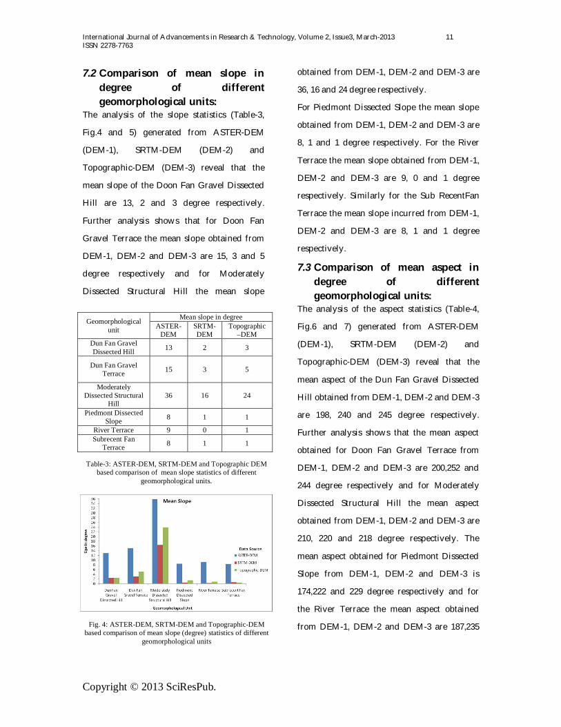
7.2 Comparison of mean slope in degree of different geomorphological units:
The analysis of the slope statistics (Table-3,
Fig.4 and 5) generated from ASTER-DEM
(DEM-1), SRTM-DEM (DEM-2) and
Topographic-DEM (DEM-3) reveal that the
mean slope of the Doon Fan Gravel Dissected
Hill are 13, 2 and 3 degree respectively.
Further analysis shows that for Doon Fan
Gravel Terrace the mean slope obtained from
DEM-1, DEM-2 and DEM-3 are 15, 3 and 5
degree respectively and for Moderately
Dissected Structural Hill the mean slope
obtained from DEM-1, DEM-2 and DEM-3 are
36, 16 and 24 degree respectively.
For Piedmont Dissected Slope the mean slope
obtained from DEM-1, DEM-2 and DEM-3 are
8, 1 and 1 degree respectively. For the River
Terrace the mean slope obtained from DEM-1,
DEM-2 and DEM-3 are 9, 0 and 1 degree
respectively. Similarly for the Sub RecentFan
Terrace the mean slope incurred from DEM-1,
DEM-2 and DEM-3 are 8, 1 and 1 degree
respectively.
7.3 Comparison of mean aspect in degree of different geomorphological units:
The analysis of the aspect statistics (Table-4,
Fig.6 and 7) generated from ASTER-DEM
(DEM-1), SRTM-DEM (DEM-2) and
Topographic-DEM (DEM-3) reveal that the
mean aspect of the Dun Fan Gravel Dissected
Hill obtained from DEM-1, DEM-2 and DEM-3
are 198, 240 and 245 degree respectively.
Further analysis shows that the mean aspect
obtained for Doon Fan Gravel Terrace from
DEM-1, DEM-2 and DEM-3 are 200,252 and
244 degree respectively and for Moderately
Dissected Structural Hill the mean aspect
obtained from DEM-1, DEM-2 and DEM-3 are
210, 220 and 218 degree respectively. The
mean aspect obtained for Piedmont Dissected
Slope from DEM-1, DEM-2 and DEM-3 is
174,222 and 229 degree respectively and for
the River Terrace the mean aspect obtained
from DEM-1, DEM-2 and DEM-3 are 187,235
Geomorphological unit
Mean slope in degree ASTER-
DEM SRTM-DEM
Topographic –DEM
Dun Fan Gravel Dissected Hill 13 2 3
Dun Fan Gravel Terrace 15 3 5
Moderately Dissected Structural
Hill 36 16 24
Piedmont Dissected Slope 8 1 1
River Terrace 9 0 1 Subrecent Fan
Terrace 8 1 1
Table-3: ASTER-DEM, SRTM-DEM and Topographic DEM based comparison of mean slope statistics of different
geomorphological units.
Fig. 4: ASTER-DEM, SRTM-DEM and Topographic-DEM based comparison of mean slope (degree) statistics of different
geomorphological units

International Journal of Advancements in Research & Technology, Volume 2, Issue3, March-2013 12 ISSN 2278-7763
Copyright © 2013 SciResPub.
Fig-5: Mean slope maps of various geomorphological units generated from ASTER-DEM, SRTM DEM and Topographic –DEM
SRTM slope map with geomorphic units ASTER slope map with geomorphic units
Toposheet slope map with geomorphic units

International Journal of Advancements in Research & Technology, Volume 2, Issue3, March-2013 13 ISSN 2278-7763
Copyright © 2013 SciResPub.
and 236 degree respectively. Similarly for the
Sub Recent Fan Terrace the mean aspect
obtained from DEM-1, DEM-2 and DEM-3 are
189,266 and 262 degree respectively.
8. Conclusion
The digital elevation model (DEM), an
important source of information, is usually
used to express a topographic surface in three
dimensions and to imitate essential natural
geography. The present study analyzed digital
elevation data sources and their structure, the
comparison of the statistics of numerous
terrain attributes extracted from the different
DEMs. The results show that DEM is a very
effective tool for terrain analysis: many terrain
attributes (such as elevation slope, aspect,
relief etc) can be derived and can be displayed
with both image and attribute databases with
the help of GIS.
The elevation statistics (minimum, maximum
and mean), relief statistics, slope statistics and
aspect statistics of various geomorphological
units have been generated from ASTER-DEM
(DEM-1), SRTM-DEM (DEM-2), and
Topographic DEM (DEM-3) and the analysis
of the minimum elevation of different
geomorphological units in the study area
shows that the DEM-1 has comparatively
lesser elevation as compared to the DEM-2 and
DEM-3 in all of the geomorphological units.
However the difference in the relief and mean
elevation among the various DEMs is more
pronounced in the highland areas, such as
moderately dissected hill which is in the
Lesser Himalayan region, as compared to the
lowland areas of Doon Valley. An analysis of
the minimum elevation of all the
geomorphological units DEM-1 shows
comparatively lesser elevation as compared to
the DEM-2 and DEM-3. This is due to higher
accuracy obtained in mapping 15m area by
ASTER. Moreover, the relief difference among
the studied DEMs is more obvious in all the
geomorphological units since the study falls in
the hilly terrain of Himalayan foothill. The
analysis of the slope statistics reveal that the
mean slope of the DEM-1 is showing the high
value of the mean slope in all
geomorphological units as compared to the
Geomorphological unit
Mean aspect in degree
ASTER-DEM
SRTM-DEM
Toposheet- DEM
Dun Fan Gravel Dissected Hill 198 240 245
Dun Fan Gravel Terrace 200 252 244
Moderately Dissected Structural Hill 210 220 218
Piedmont Dissected Slope 174 222 229
River Terrace 187 235 236
Subrecent Fan Terrace 189 266 262
Fig. 6: ASTER-DEM, SRTM-DEM and Topographic DEM based comparison of mean aspect (degree) statistics of different
geomorphological units
Table-4: ASTER-DEM, SRTM-DEM and Topographic DEM based comparison of mean aspect statistics of different
geomorphological units.

International Journal of Advancements in Research & Technology, Volume 2, Issue3, March-2013 14 ISSN 2278-7763
Copyright © 2013 SciResPub.
Fig-7: Mean aspect maps of various geomorphological units generated from ASTER-DEM, SRTM DEM and Topographic –DEM
Toposheet aspect map with geomorphic units
SRTM aspect map with geomorphic units ASTER aspect map with geomorphic units

International Journal of Advancements in Research & Technology, Volume 2, Issue3, March-2013 15 ISSN 2278-7763
Copyright © 2013 SciResPub.
DEM-2 and DEM-3. The analysis of the aspect
statistics reveal that the mean aspect show
lower value in DEM-1 in all the
geomorphological units in comparison to the
DEM-2 AND DEM-3. Furthermore, the DEM-
2- and DEM-3 show lesser difference in the
aspect direction. These terrain parameter
variations depend on ability of GIS to process
the values provided in DEM mapped on
different scale and the accuracy of mapping.
The study clearly demonstrate that the DEM
resolution has a great influence on terrain
attributes and the statistical values become
larger when DEM resolution changes from
coarse to fine.
REFERENCES [1] Band, L.E.and Moore, I.D. (1995) Scale: landscape
attributes and geographical information
systems [J]. Hydrological Processes 9:401-
422.
[2] Braun, M., Molnar, T.and Kleeberg, H.B. (1997) The
problem of scaling in grid-related
hydrological process modelling [J].
Hydrological Processes 11: 1219-1230.
[3] ERSDAC, 2002 ASTER User's Guide Part-III (Ver.
1.0), Earth Remote Sensing Data Analysis
Center, JAPAN.
[4] ERSDAC, 2003 ASTER Reference Guide Version 1.0,
Earth Remote Sensing Data Analysis
Center, JAPAN.
[5] Goodchild, M.F., Parks, B.O. and Steyaert, L.T(eds).
(1993) Geographic Information System and
Environmental Modeling [M]. Oxford
University Press: Oxford.
[6] Hutchinson, M.F. and Dowling, T.I. (1991) A
continental hydrological assessment of a
new grid-based digital elevationmodel of
Australia [J]. Hydrologic Processes 5: 45-
58.
[7] Jenson, S.K. (1991) Applications of hydrologic
information automatically extracted from
digital elevation models [J].Hydrologic
Processes 5:31-44.
[8] Moore, I.D., Grayson, R.B., Ladson, A.R. (1991)
Digital terrain modeling: a review of
hydrological, geomorphological and
biological applications [J]. Hydrological
Processes 5: 3–30.
[9] Rabus, B., Eineder, M., Roth, A. and Bamler, R.
(2003) The shuttle radar topography
mission. A new class of digital elevation
models acquired by spaceborne radar.
ISPRS J. Photogram. Remote Sensing, 57,
pp. 241-262.
[10] Richard, Kiss. (2004) Determination of drainage
network in digital elevation models,
utilities and limitations [J]. Journal of
Hungarian Geomathematics 2:16-29.
[11] Saran S., Sterk G., Peters P. and Dadhwal, V. K.
(2009) Evaluation of digital elevation
models for delineation of hydrological
response units in a Himalayan watershed.
Geocarto International 2009, 1–18, iFirst
article.
[12] Suganthi, S. and Srinivasan, K. (2010) Digital
elevation model generation and its
application in landslide studies using
Cartosat-1. International Journal of
Geomatiics and Geosciences, Vol-1, No-1.
[13] Tang, G.A., Zhao, M.D., Li, T.W., et al. (2003)
Modeling slope uncertainly derived from

International Journal of Advancements in Research & Technology, Volume 2, Issue3, March-2013 16 ISSN 2278-7763
Copyright © 2013 SciResPub.
DEMs in loess plateau [J]. ACTA
Geographic Sinica 58(6):824-830.
[14] Tarboton, D.J. (1997) A new method for the
determination of flow directions and
upslope areas in grid digital elevation
models [J]. Water Resources Research
33(2):309-319.
[15] Walker, J.P.and Willgoose, G.R. (1999) On the effect
of digital elevation model accuracy on
hydrology and geomorphology [J]. Water
Resources Research 35(7):2259-2268.
[16] Weibel, R. and Heller, M. (1991) Digital terrain
modelling [J]. Geographical Information
System 1:269-297.
[17] Wilson, J.P.and Gallant, J.G. (eds). (2000) Terrain
Analysis: Principles and Applications.
John Wiley and Sons: New York.
[18] Wise, S. 2000. Assessing the quality for
hydrological applications of digital
elevation models derived from contours
[J]. Hydrological Processes 14: 1909–1929.
[19] Zhang, W. and Montgomery, D.R. (1994) Digital
elevation model grid size, landscape
representation, and hydrologicsimulations
[J]. Water Resources Research 30(4):1019-
1028.
.