Geomorphic evolution and present-day geomorphic processes ...

1
Geomorphic aspect of hydraulic engineering
Dr. N.L. Dongre
Omkareshwar Dam on The Narbada River rift valley
____________________________________________________________________________
ABSTRACT- to explain the geomorphic aspects, examples are
given from well known Jaypee Groups Dam and hydraulic
constructions and Worlds important river project. Morpho
logy may be defined as the science of structure or form "and
fluvial may be defined as produced by the action of flowing
water." Since rivers can hardly be said to have structure,
fluvial morphology is therefore, the science of the form as
produced by the action of flowing water. It is a branch of
geomorphology, the science of the form of the earth's surface.
Geomorphology has also been called physiography. Fluvial
morphology is particularly important to the hydraulicEngine
ering because many of his greatest problems arise because of
the form of streams brought about by the Transpo rtation and
deposition of sediment by them. For the proper solution of
these problems, knowledge of the principles of fluvial Morph
ology is often necessary. Among the problems in which fluvial
morphology is a very important factor are many of those deal
ing with water resources development and include some of the
most important river problems in the world. Among these is
flood control on the Ganga, Brahmaputra, Mahanadi, Krishna,
Godavari, Periyar, Kaveri, Sutlaj, Narmada, Kosi, Tawa and
Chambal (India), lower Mississippi and lower Colorado Rivers
(USA). The Developm ent of the Hydraulic resources all over
the world are ensured and commissioned. The Yellow and
Huai River flood problems are solved by China. As streams
become highly developed, and changes in sediment Move
ment due to stream Developments slowly become
evident, the importance of the Morpho ogical aspect of river
control problems will be increasingly appreciated.
___________________________________________________________________________

2
The science of fluvial morphology has developed from two roots, which have been
largely independent of each other. The most vigorous root is in the science of geomorphology,
where the principal originators were the geologists, Powell, J. W.(1875) Gilbert, G. K.
(1887) and Davis, W. M. (1909) who worked in the latter part of the past century and early
part of the present one. The work of these men dealt chiefly with the form of the surface of the
earth and the importance of flowing water in causing the present shape, but Gilbert also made
extensive investigations into the quantitative aspects of sediment transportation. The other
root is in engineering and goes back much further to Dominique Guglielmini (1697) about,
who was probably the first writer on fluvial morphology. As early as 1750, engineers Frizi ,
Paul (1762) were arguing about the advantages and disadvantages, from the standpoint of
navigation, of dividing the Rhine into several channels and were constructing hydraulic
models to prove their contentions. Very complete histories of the developments of this science
in the field of engineering can be found in the summaries of Hooker, E.H. (1896) and Mavis,
F.T. (1935). Unfortunately for both engineering and geology, these two roots, except for the
work of Gilbert, have remained largely separate, down to the present time; but it seems
probable that in the future a closer coordination of the two fields will exist to the advantage of
both.
Tehri Dam on the Bhagirathi River, constructed by Jaypee Group is one of the typical Dams in the
world.
Nomenclature of the geomorphologists
One of the best contributions made by the geomorphologists to the science of
fluvial morphology is the nomenclature which they have introduced. Rivers have been
classified by them on two bases: 1 on the basis of the method of formation, i.e., whether the
position of the river is as a consequence of the initial slope of the land area or as a result of
other factors (Lobeck, A.L. (1939) Gilbert, G. K. (1887) the basis of the stage which has
been reached in the development of the stream. From the standpoint of the approach of this
paper, the first of these methods of classification has little usefulness; but classification on the
basis of stage of development introduces ideas of major value. A number of the morphologist's
descriptive terms for rivers, such as meandering and braided have been generally adopted.
The conception of "base level" and of a "graded river" are also very useful, as are also the
terms "agrading" for the change of the level of a river whose bed is rising and "degra ding
" for change downward.

3
The Monticello Dam in California, United States is most noted for its large circular spillway with a rate
of 48,400 cubic feet per second.
The geomorphological approach
As previously mentioned, the geomorphologist is interested in fluvial morphology
principally as a tool in explaining the origin of the present form of the surface of the earth. The
science appears to be of comparatively recent origin. Although many able men contributed to its
early development, the outstanding work is that of Davis, W. M. (1909). According to the
Davis conception, the primary action in the formation of the earth by moving water is the
geographical or geomorphic cycle which is a cycle of erosion passing through several stages.
It starts with a nearly flat land surface which is gradually warped by movements of the
earth's crust. This gives rise to increased erosive and transporting power of the water flowing
from the land, the water beginning to carve the landscape into various forms. As time goes on,
the forms of the land surface change, the various types of topography being characteristic of
the various length of time during which the water has acted. Material is constantly being
carried away from the land surface and deposited (usually in the sea); and the elevation of the
land surface is gradually lowered and flattened until, after a very long period of time, the end
of the cycle is reached when the whole surface has been reduced to a very gently sloping plain
called a peneplain, and thus comes back to the condition in which the cycle started.
The various types of topography in the cycle were designated by Davis, in terms of
the stage reached in this cycle, using a terminology commonly adapted for designation of the
age of a man. The stages began at the start of the cycle with youth, which passes into maturity
and then into old age. The topographic forms typical of the first stage are spoken of as young
or youthful, later ones as mature, and those of the last stage as old, with further subdivisions
when desirable such as, for example, early and late maturity. The same set of terms is used to
designate the stage of development of streams and certain characteristics are typical of
rivers of these various stages. Davis' designation by means of terms of age is somewhat
confusing, as a mature stream may later become a youthful one. Also, although the stage
reached by the stream usually corresponds with that of the surrounding topography,
this is not necessarily the case. An entire river need not be the same stage throughout; usually
a stream is less youthful in character near the mouth than in the vicinity of its headwaters.
4
Fluvial morphology as developed by the geomorphologists is largely a qualitative or
descriptive science and suffers somewhat from a lack of quantitative relations, but many keen
minds have contributed to it. It is not the intention in this paper to present in detail the
geomorphological approach to subject but rather to present geomorphology from an
engineering viewpoint in order that the engineer may have the advantage of the extensive work of
the geomorphologist, and that the latter may possibly gain something from the engineering
viewpoint. An engineer who wishes to become a specialist in this field of fluvial morphology
should thoroughly study numerous books and orginal sources of this part of the sciences.
(Lobeck, A.L.( 1939), Worcester, P.G.( 1939), Mackin, J. Hovver (1939), Johnson,
Douglas (1932).
The Ganga River, is the classical view point , too much emphasised on erosion and the formation of
erosional peneplains and not enough on the depositional aspects.
Characteristics of the various stages of development of rivers
In the same way that a person rapidly forms an opinion of the age of another person
from the presence or absence of certain features which are characteristic of the various ages,
a geomorphologist forms his opinion of stage of development of a river from the presence or
absence of certain conditions which are characteristic of the various river stages. According
to the classical conception, young rivers are characterized by their ability to cut their stream
beds downward with, geologically speaking, considerable rapidity; and the
characteristic features are those which result from this action. The valleys of young streams
are usually V-shaped or are deep gorges or canyons. Waterfalls or rapids often exist in
these streams are sufficient time has not passed since they were uplifted for the stream to cut
down and thus eliminate them. There are frequent changes of the grade of the stream caused by
the hardness of the strata over which the stream flows and pot holes are sometimes found.
Because the valleys are steep sided and narrow, there is very little flat land in their bottoms;
and highway and rail road construction along them is accomplished with difficulty.
Johnson, Douglas (1932) suggests that early youth ends when lakes are eliminated, and
middle youth ends when falls and rapids are eliminated.

5
The Ganga River with its meanders, oxbow lakes, natural levees, and with a flood plain several
times the meander belt’s width is still a comparatively young stream, since it is building up
the land along its course.
Baglihar Dam Hydroelectric Power Project is a run-of-the-river power project on the Chenab River in
Jammu and Kashmir. It is based on the study of gravitational force, river profile and base level. This
project is typical type of construction, built by Jaypee Group, India.

6
Late youth ends and early maturity begins in a stream when the stream ceases to cut
down rapidly but continues to widen out the bottom of the valley. This occurs in any stretch
of the river when the sediment supplied by the river upstream, the tributaries within the
stretch, and the erosion of the banks and valley sides is equal to the transportation capacity of
the river. It then ceases its rapid cutting down, but the valley widens out as the material
from the banks and valley sides continues to be carried away. Normally, the river
would continue to lower its bed as the whole drainage area is lowered; but this is a very much
slower rate than the lowering in a youthful stream. Early, maturity ends and late maturity
begins when the valley width equals the width of the belt covered by meanders of the stream.
Late maturity ends and early old age begins when the valley width reaches several times the
meander belt width.
The features usually associated with maturity in streams are flood plains and no
rapids or falls; and meanders with oxbow lakes, but no other kinds of lakes. There are no
sharp divisions between the various stages, nor is there general agreement as to when the
various stages end. For example, an old river is sometimes considered to be one in which all
of whose tributaries have reached maturity. Also some consider that when the flood plain
wide to the width occupied by the stream's meanders, so that these can move unrestrained by
the valley walls, the end of the maturity stage is reached; and when the flood plain is
wider than this, the river is old. These limits differ from those previously stated.
The foregoing classification represents the views of the classical or Davis school of
geomorphologists; but a questioning of it has recently arisen, largely among those dealing
with the Ganga River, who believes that the classical viewpoint puts too much emphasis on
erosion and the formation of erosional pen plains and not enough on the depositional aspects.
According to their view, the Ganga River with its meanders, oxbow lakes, and natural
levees, and with a flood plain several times the meander belt width is still a
comparatively young stream since it is building up the land along its course. There
seems to be some justification for this new viewpoint. Obviously when uplift occurs and
streams start to cut down, there must soon be a part of their length, even though a relatively
short one, along which at least part of the eroded material is deposited. This part of the stream
is thus building up, and this process is as characteristic of a stream in the early part of the
geographic cycle as is the cutting down of the high lands. It will thus see that the classical
classification of age of a stream may be inexactly related to chronological age and that there
is room for further work in classification to bring about a more logical system.
Base level
Another of the concepts of the geomorphologist , which is very useful to the
engineer, is that of base level. If the quantity of water in the ocean remained the same and
no moving of the earth's crust took place, the dry surface of the earth would
eventually be reduced nearly to sea level. Sea level is thus the ultimate base level towards
which all streams tend to cut their beds. There are often certain local levels which,
geologically speaking, temporarily are elevations toward which streams tend to cut their
beds. Lakes, for example, for the period of their existence, control the level of streams
entering them and thus form local or temporary base levels for such streams. Waterfalls
and rapids often form local base levels. The bed of a large stream usually forms the
temporary base level for its tributaries. There are here also borderline cases, where it is
difficult to establish the existence of a local or temporary base level, but usually they are
quite evident.

7
Three Gorges Dam on Yangtze River Gorge, China. Its flow is so speedy, that one cannot stand nearby.
Equilibrium in natural streams
The concept of equilibrium in streams as developed by the geomorphologist is also a
very useful one to engineers. This concept is not unknown to engineers, but it has been more
actively studied by geomorphologists. A variety of terminology has been used to express this
condition. A stream in equilibrium is said to be a graded stream, a poised or balanced stream,
or to be a regime stream or a stream in regime. Makin J Hoover (1948) has given the
following definition:
"A graded stream is one in which, over a period of years, slope is delicately
adjusted to provide, with available discharge and with prevailing channel characteristics, just
the velocity required for the transportation of the load supplied from the drainage basin. The
graded stream is a system in equilibrium."
When a stream is capable of carrying more sediment than is supplied to it, it carries
away material from its bed and thus tends to lower the bed. This, cutting down increases
the slope of the tributary streams which causes them, to bring down more material to
the main stream. The more streams cut down into the surrounding land, the greater becomes
the load supplied to it, since most streams eventually reach either the ocean or some other
base level as they cut down their beds, their slopes decrease; and, therefore, their ability to
carry away the sediment brought to them is diminished. With the amount of material
brought down to the stream increasing and the streams ability to carry it away
decreasing, a point is eventually reached, where the rate at which sediment is brought to the
stream becomes substantially equal to the rate at which, it is carried away by the stream and a
condition of equilibrium is reached. Under these conditions, the bed neither cuts down nor
fills up.
Ordinarily in natural streams, the flow of water is not constant but continually varies
the ratio of the high flows frequently being a hundred or more times the low flows. Although
the stream tends to pick up or deposit the bed material until its load equals its capacity
to transport the load, because of the rapid variations of flow and sediment supply,

8
a condition of equilibrium, which the load exactly equals the capacity of the stream to
transport rarely exists except momentarily. Since the tendency of streams is to wear the land
surface down to sea level and hence to lower their beds, considering a very long period,
geologically speaking, the tendency is for more sediment to be removed from a section of a
stream than is supplied to it; and, therefore, when long periods are considered, natural
streams are rarely in equilibrium. Normally, therefore, neither in very short nor very long
periods may natural streams be considered to be in equilibrium.
Over long periods, historically speaking, however, it is true that the beds of a large number of
streams, for most practical engineering purposes, a substantially in equilibrium; and accurate
conclusions for many purposes may be reached by assuming equilibrium to exist. In some
streams, the bed may be slightly lowered in floods but fill back to their former level as the
flood recedes and, except during floods, be at practically the same elevation even at the end of
a long period of years as at the beginning of it. Although exact equilibrium is only momentarily
obtained and, geologically speaking, stream may be slowly degrading or agrading, for
practical purposes it may be considered to be in equilibrium. The term equilibrium in this case
may be likened to the term sea level, which for practical purposes is considered to be fixed
level, although the surface of the sea is constantly fluctuating above and below
this level due to waves and tides; and, over very long periods of time, the sea level may rise
or fall scores of feet due to more or less water being stored on the land surface in the
form of glaciers.
Sardar Sarower Dam on the Narbada River, constructed by Jaypee Group. River gradation and River
profile also considered during the construction.
For engineering purposes a section of a stream may, therefore, be said to be in equilibrium
if, although it may continually fluctuate between aggradation and degradation, over a long
period of years, in terms of human history, the net amount of change is not sufficiently
large to be detected by quantitative measurements. It is believed that most alluvial
streams, were not affected by the works of men, may thus be said to be in this equilibrium
or graded condition.
If equilibrium exists in a reach of a river, a change of only one condition at a single
point which would upset the equilibrium at this point would, if no other factors changed,
eventually upset the conditions of equilibrium throughout the entire reach and bring about

9
a new condition of equilibrium in this reach. Except in short reaches, however, other
changes probably occur before the readjustment to any one change is completed; and in most
streams on which man has built hydraulic works, several changes are going on at the same
time. Not infrequently, however, one change is so large, compared with the others that it
overshadows the minor ones and appears as a single change.
A run-of-the river project built on the Sutlej in distt. Kinnaur, Himachal Pradesh, Karcham-Wangtoo is
india’s largest private hydro power plant, built by Jaypee Group, India, on Build-Own-Operate basis.
The plant is situated 2000 metres above sea level. It is 88meters high concrete diversion dam with a
foundation, 53 meters below the river bed. It has a Head Race Tunnel of 10.48 meters diameter and
16.925 Kilometer long generating water velocity of 4.88 rn/sec. The dam also has the large
underground de-silting chambers to remove particles larger than 0.2mm size. It is built on the
principles of gravitational force.
Changes of the profile of natural streams
As the science of sediment transportation and deposition develops, it will
be possible to predict more and more closely the morphological changes which will take place
in a river due to any set of conditions and the rate at which they will occur. In the future the
necessity of making such predictions is likely to increase. Such quantitative
predictions can often be made by means of the knowledge of sediment transportation
now available if all of the factors are known with sufficient accuracy. Usually, however, the
data is not sufficient for quantitative estimates; and only qualitative estimates are pos-
sible.
The following very general expression will be found useful in analyzing qualitatively many
problems of stream morphology: 𝑄𝑠𝑑 ∝ 𝑄𝑊𝑠
Here 𝑄𝑠 is the quantity of sediment, 𝑑 is the particle diameter or size of the sediment, 𝑄𝑤 is the water discharge, and 𝑠 is the slope of the stream. This is an equation of equilibrium
and if any of the four variables is altered, it indicates the changes which are necessary in one
or more of the others to restore equilibrium. For example, if a stream with its sediment load is
flowing in a condition of equilibrium and its sediment load is decreased,
equilibrium can be restored if the water discharge or the slope is decreased sufficiently or if
the diameter of the sediment is increased the proper amount. This equation is not an exact
mathematical equation as it will not give the quantitative values of the variables involved
which bring about equilibrium, but it is helpful to indicate qualitatively the changes
which will take place in a stream when a change of any one of the variables occurs.
10
The sediment discharge, Qs, in this equation is the coarser part of the sediment load or
more exactly the bed material load, since this is the part of the load which largely molds
the bed formation. In most cases, the quantity of the fine load of silt and clay sizes can
change almost indefinitely without materially affecting the river profile. In the following
discussions of profile changes, changes of sediment load will be considered to mean changes
of bed material load.
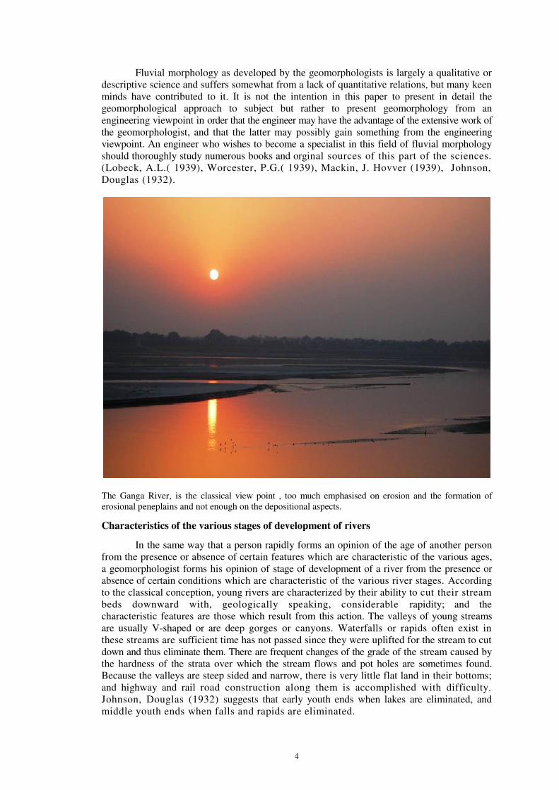
Gravity Dam: Indira Sagar on Narbada River
Classes of stream profile changes
The changes which take place in the profile of a graded stream in equilibrium, due to
a change of one or more of the factors controlling equilibrium, usually fall into one of six
classes. One of the most common classes (Class 1) is the change that takes place in a
stream with an equilibrium Grade BA as shown on Figure 1-a , which reaches a base
level at A, due to a change of conditions in the channel. Suppose the change of conditions is
an increase in the sediment load 𝑄𝑠 beginning at C without changing the size of the sediment
diameter d or the water discharge 𝑄. to re-establish equilibrium the slope 𝑆 must be increased. Ordinarily after such a change of conditions, a new equilibrium tends gradually to be established, laid as follows:
When the change of condition first occurs, the stream between C and 𝐴
cannot carry the increased load of sediment, and some of it is deposited on the
bed downstream from C causing the bed to rise or aggrade to C". At first this deposit may
not extend down to base level but may end at E. As the deposit continues, the bed
level may be increased to C ", and the rise or aggradation may extend all the way to A. If the
new condition continued a long enough time, a new equilibrium Grade C " A would eventually
be established; and no further rise or aggradation in the grade would take place.
The same changes would take place if instead of the sediment discharge𝑄𝑠 increasing
at C, the size of the sediment d was increased at C, leaving the sediment discharge 𝑄𝑠 and
water discharge 𝑄 the same. A decrease of the water discharge 𝑄 leaving 𝑄𝑠 and d the same
would produce the same result.

11
The Tawa River has increased its river bed due to the increase in sediment load, brought by tributaries.
The Lena River (Russian) is located in Siberia and is the tenth longest in the world (4,400 km), and
ninth in the catchment area. It rises to 1640meters altitude in the Baikal Mountains, South Central
Siberian Plateau, 20 kilometers west of Lake Baikal and flows northeast, receiving caudal Kirenga and
Vitim. From Yakutsk it enters the lowlands, receiving caudal Olyokma and goes north to the mouth of
its tributary Aldan. It empties into the Laptev Sea, part of the Arctic Ocean, with a delta of 10,800
square kilometers in area.
12
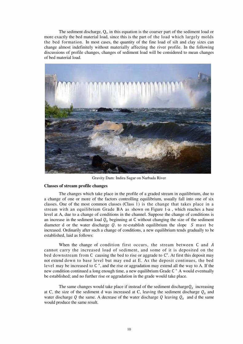
The Serendah River, Malayasia, where the river bed rose due to addition of Sediment from the
Hydraulic mining of tin
The Arpa River Koni-Bilaspur (C.G.) India, has a rising river bed

13
The Arkansas River has river bed rise, due to increase in the sediment load.
14
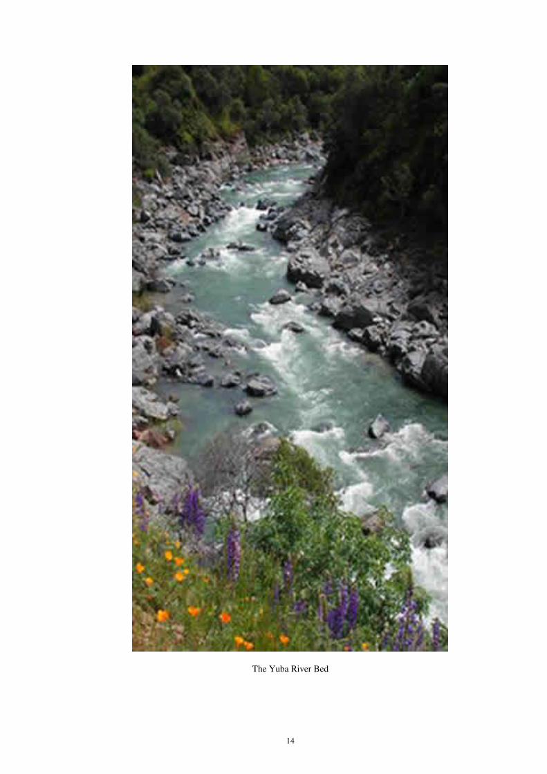
The Yuba River Bed

15
The foregoing changes also would cause a change of grade above the point C. The
raising of the bed to C' would cause a decrease in the slope S upstream from the point C: The
stream could not transport the sediment brought dawn on this flattened slope; and some of it
would be deposited upstream from C, aggrading the stream bed upstream from C. As the
stream bed below C aggraded, that above would also rise, approaching a final
equilibrium Grade C"' B"' parallel to the original equilibrium Grade CB. The height of
C"'B"' above CB would depend on the magnitude of the change of conditions which brought it
about. The raising of the grade of the main stream in this way would also usually cause a rise in
the grade of the tributaries entering the raised section, extending up the tributary a greater or
less distance depending on the conditions in its bed.
Sedimentation in the Feather River
Examples of class 1
One of the common causes of a change in stream profile as in Class 1 is the
decreasing of 𝑄 by taking the water out of the stream for irrigation, desilting the water, and
returning the sediment to the river again, thus decreasing 𝑄 without changing 𝑄𝑠or d.
The Tawa River in India and in the Arkansas River in the United States, the Arpa river of
Chhatisgarh in India, this has resulted in a rise in level of the river bed which causes many
difficulties. A rise of the Yuba river bed (Figure. 3) in northern California, U.S.A., of about 8
meter started about 1850 due to the increase in the sediment load 𝑄𝑠 resulting from the
discharge into the streams of large quantities of gravel wasted in the hydraulic mining of gold,
( Gilbert, G.K. (1917)
16
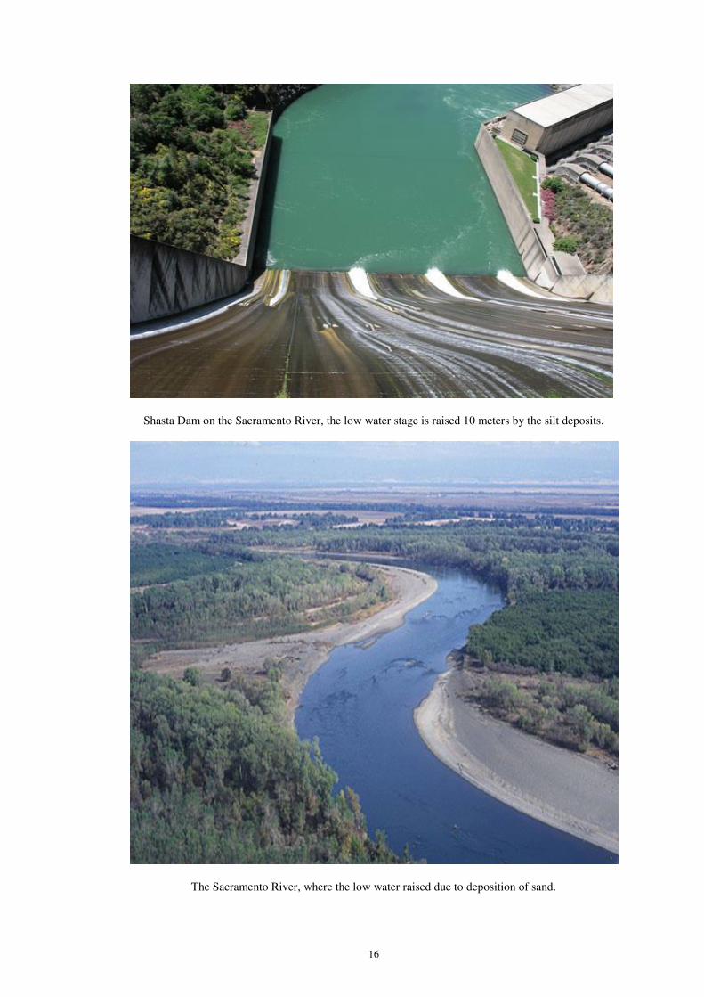
Shasta Dam on the Sacramento River, the low water stage is raised 10 meters by the silt deposits.
The Sacramento River, where the low water raised due to deposition of sand.

17
The Narmada Rift Valley, large quantities of sand has been roved due to its flow.
Figure: 1 a Class 1
After hydraulic mining activity was greatly reduced, the height of this deposit gradually
decreased, tending to restore the former levels. A similar case is the Serendah River it
Malaya, where the river bed rose 10 meter in the years 1990-2000 due to the addition of
sediment from the hydraulic mining of tin.. A very striking example is the Mukwa River in
Formosa, the bed of which raised about 15 meter in 3 years due to the addition of sediment to
the river from landslides. A two-story hydroelectric powerhouse along the side of the river
was completely buried.
A rise of the stream bed may also occur due to the increase in sediment load
brought into the stream by a tributary. The slope of the Tawa River for some distance
upstream for the mouth of the Denwa River is flatter; and below the mouth, it is steeper than
the slope of the remainder of the river in this vicinity, which is said to be due to the large
quantity of coarse sediment brought in by the Denwa River(Dongre,N.L.1999) The deposits
brought in by a tributary may cause the stream bed downstream from the mouth of the
tributary to build up so rapidly that the deposit upstream may not be rapid enough to keep the
bed level upstream higher than that downstream. The deposits downstream then form a sort of
dam which causes at lake to form upstream from the tributary mouth. An example of
this condition is found at Tawa Dam which has been formed in the Upper Tawa River by

18
the great load of sand brought into it by the Denwa and Sonbhadra (rivers of India).
Matthes reports that the sediment brought down the Yuba River previously mentioned
temporarily formed a dam in the Feather River, into which the Yuba discharged, which
caused a lake 25 kilometer or more long; and later the sediment coming down the
Feather River formed another temporary dam in the Sacramento River, into which the
Feather River discharged, which also produced a lake. Farther down the Sacramento
River at the city of Sacramento, California, U.S.A., the low water stage was raised 4-5
meter by the deposits. This maximum stage was reached in 1890. The discharge of
gravel into the streams was prohibited by law and the deposits decreased, restoring
the original stage at Sacramento by 1920.
Examples of class 2
Class 2 is similar to Class 1 but results in a lowering or degrading of the
profile of the stream due to a decrease in the sediment load or its particle size or an
increase in the water discharge. A reduction of the sediment load 𝑄𝑒 of the stream at point C
(Figure 1-b) is brought into balance by a reduction of slope S from point C to the base level
at A and upstream from C the bottom is lowered but retains the same slope as before.
In this case, tributaries entering the stream usually have their beds lowered also.
A very common cause of such a lowering is the abstraction of part or the
entire sediment load from a stream by the deposit of it in the quiet water upstream from a
dam. Downstream from the dam the river bed is often considerably degraded because of
the sediment carried away from the bed by the clarified water. This action caused the
failure of dam . Many other changes of Class 2 have been observed on the Indus River.
( Foy, T.A.W. (1947), Molhotra , S.L. (1951), Joglekar , D.V. (1951). A stream profile
change of Class 2 necessitated the complete reconstruction of Fort Sumner Dam on the
Pecos River in New Mexico. Stream profile changes of Class 2 have affected in some
cases beneficially and other cases detrimentally a large number of water power plants.
Knowledge of the magnitude of this action is an important factor in the design of the
spillways of many dams, since failure to correctly estimate the lowering may in some
cases cause failure of the spillway or even of the dam itself. A number of cases of de -
gradation below dams have been described in technical literature. Lane, E.W. (1934),
Hathaway, G.A. (1948).
Figure: 1 b Class 2
The increase of the flow 𝑄𝑊 has the same effect as a lowering of the quantity of
sediment 𝑄𝑆. A very striking case of stream bed lowering due to an increase in the
flow has occurred in the Narmada River. The added flow is due to the waste water of an
irrigation project constructed in the valley of this stream. Here the stream bed has

19
degraded until it has uncovered rock ledges which were below bed level and produced
waterfalls and rapids where the water flows over these ledges. This degradation
removed about 80 hectare meter of sediment in a year from the stream bed and banks
and which is depositing in and rapidly filling a reservoir a short distance
downstream.
An interesting example of stream bed lowering due to a reduction of the quantity
of sediment Qs has occurred in the Narmada Rift valley in India. Large quantities of
sand have been removed from the stream for building construction; and downstream
from the point of removal, the bed degradation has extended to the mouth, a distance
of about 12 kilometer. The construction of a number of check dams was necessitated to
hold up the bed level and prevent the undermining of walls, bridges, and sewers along
the valley. A similar degrading has resulted on the Son River. A canal for hydroelectric
power was constructed from one branch of the stream to a power plant on another
branch. The increased flow of the branch below the power plant caused a lowering of the
grade of the river above the plant and extended downstream 2-3 kilometer to the junction of
two streams below which the discharge is unchanged. The effect was beneficial to the
power development as it increased the fall available for producing power by about 2
meter, but it caused damage to the foundations of bridge this portion of the stream.
Usually the changes involved go on quite slowly but under certain conditions
changes of surprising magnitude and rapidity can take place. Tod Eliasson report that in
a 50-kilometers stretch in the Yellow River (Figure. 4) bed was deepened an average of 3
meter. At Lungmen the bed was lowered approximately 10 meter over a width of 1,000 meter,
the depth tapering off upstream and downstream removing an estimated quantity of
1,000,000 cubic meters in not more than 12 hours. The cause of this phenomenon is
not indicated but it was probably due to an increase in discharge, perhaps of less
heavily sediment laden water.
Examples of class 3
Class 3 changes of stream bed profile are those which occur when the grade of the
stream is suddenly raised at one point. The most common of such a rise is the construction of
a dam; but such changes also occur natural causes, such as the damming of rivers by
landslides, mud flows lava flows, or the advance of a glacier. This class is
represented by Figure 1-c which shows the changes which occur in the bed of a stream
in equilibrium when the grade at one point is suddenly raised.
Figure: 1 C Class 3
If the stream grade is raised suddenly enough, a lake is formed upstream from the
point of rise; and this lake is then gradually filled with sediment brought down by the
stream. The conditions during the filling period are represented by the profile ending at C'
on Figure 1-c. The unusual shape of the stream profile is due to the coarse sediment being
20
deposited at the upper end of the reservoir and the fine material being carried farther
into the or flowing down the lake bottom as a density current. The reservoir is filled when
the stream bottom is raised to point C′′and part of the sediment passes over the
obstruction. The grade continues to rise upstream from the dam and approaches a final
equilibrium grade which is parallel to that before the grade was raised. This was probably
first pointed out by Harris, E.C. (1901) a half century ago. The changes discussed
under Class 1, where lakes where formed upstream from the tributaries, are also
occurrences of Class 3.
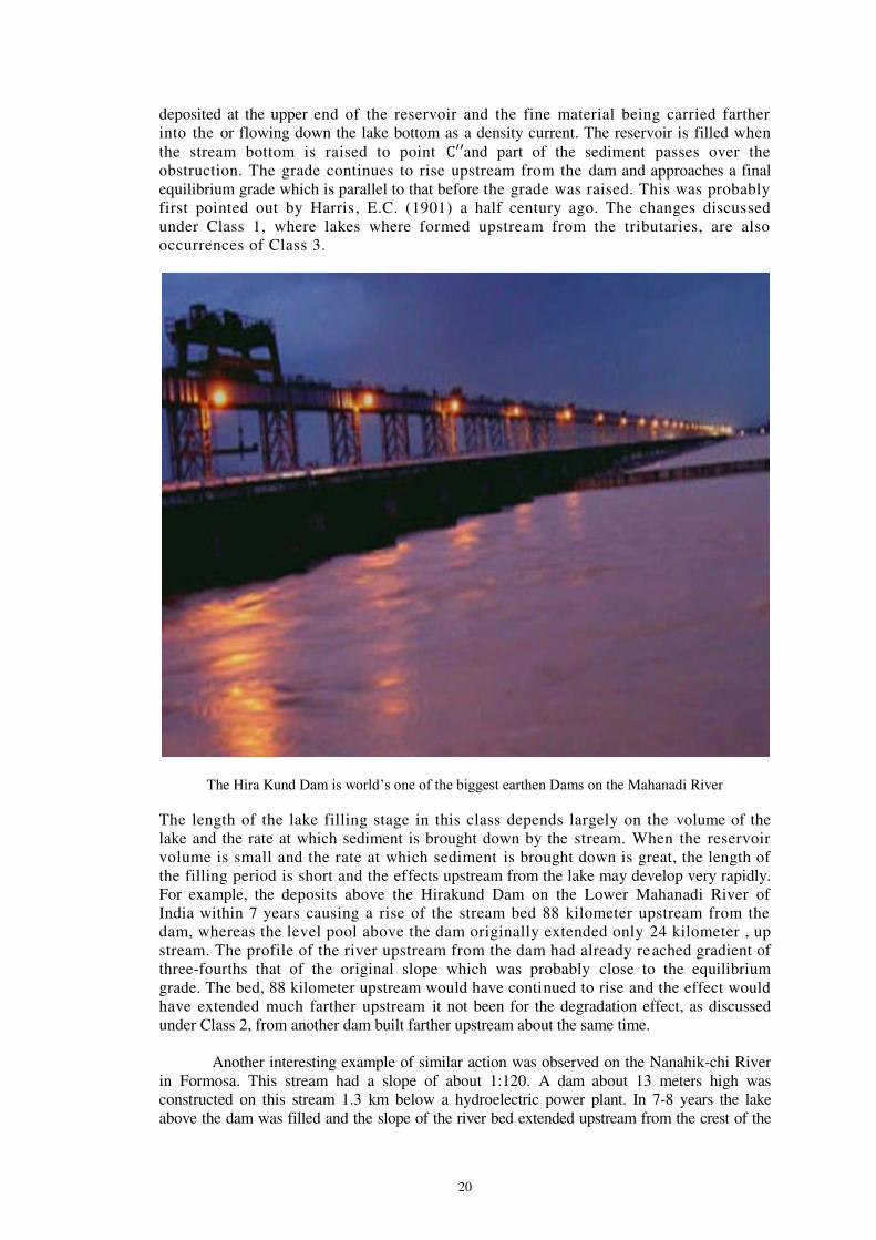
The Hira Kund Dam is world’s one of the biggest earthen Dams on the Mahanadi River
The length of the lake filling stage in this class depends largely on the volume of the
lake and the rate at which sediment is brought down by the stream. When the reservoir
volume is small and the rate at which sediment is brought down is great, the length of
the filling period is short and the effects upstream from the lake may develop very rapidly.
For example, the deposits above the Hirakund Dam on the Lower Mahanadi River of
India within 7 years causing a rise of the stream bed 88 kilometer upstream from the
dam, whereas the level pool above the dam originally extended only 24 kilometer , up
stream. The profile of the river upstream from the dam had already reached gradient of
three-fourths that of the original slope which was probably close to the equilibrium
grade. The bed, 88 kilometer upstream would have continued to rise and the effect would
have extended much farther upstream it not been for the degradation effect, as discussed
under Class 2, from another dam built farther upstream about the same time.
Another interesting example of similar action was observed on the Nanahik-chi River
in Formosa. This stream had a slope of about 1:120. A dam about 13 meters high was
constructed on this stream 1.3 km below a hydroelectric power plant. In 7-8 years the lake
above the dam was filled and the slope of the river bed extended upstream from the crest of the

21
dam on a slope of 1:250, or about half that of the original river bed. This raised the river level so
much at the hydroelectric plant that it was threatened with flooding, end it was necessary
to blast off the top of the dam downstream to prevent it.
Extensive changes of level above dams have been investigated in India in connection
with the great irrigation works in the Indus River basin.( Foy, T.A.W, (1947), Malhotra, S.L.
(1951), Joglekar, D.V. (1951).
The Whitewater River has built a grade adjusted to the level.
Examples of class 4
Class 4 profile changes (Figure 1-d) result-from the lowering of the temporary base
level of the stream and causes effects somewhat similar to those upstream from point C in
Class 2. This case often occurs when a reservoir, which is usually held at a constant level, is
drawn down.
Figure: 1 d Class 4
22
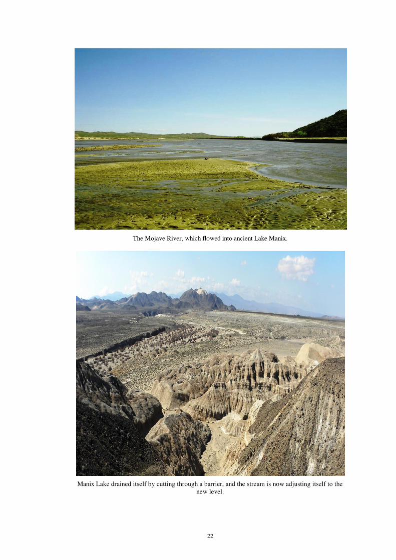
The Mojave River, which flowed into ancient Lake Manix.
Manix Lake drained itself by cutting through a barrier, and the stream is now adjusting itself to the
new level.

23
Here the Mississippi River has shifted from the west to the east side of the valley; and streams entering
this river from the east, which were adjusted to the former position, have cut down their beds to the
altered position of the base level.

24
The Salton Sea in California, U.S.A., was at one time filled to an elevation of 15 meter above
sea level and the Whitewater River built a grade adjusted to this level. The sea has been cut
off from the ocean and lowered by evaporation to 80 meter below sea level, and the
Whitewater River is slowly adjusting itself to this new base level. The flow in the river is
ordinarily very small so that the adjustment is slow; but in the rare large floods, scours
proceeds rapidly upstream in a series of cataracts. Another example is the Mojave River which
flowed into ancient Lake Manix. This lake drained itself by cutting through a barrier, and the
stream is now adjusting itself to the new level. Over a long period of time such changes have
taken place in many large rivers.
Examples of classes 5 and 6
Classes 5 and 6 (Figures 1-e and 1-i) result from the base level moving up or down
the stream without a change of elevation. Illustrating Class 5 is the following set of
circumstances: A railroad runs up the valley of the Brahmaputra River in India and small
tributaries of the river pass under the railroad in culverts. When the railroad was built at the
point where one of these tributaries entered the river, the river flowed along the side of the
valley near the railroad and the culvert was set to conform to the grade established by this
situation. The Brahmaputra River shifted to the other side of the valley and the distance from
the culvert to base level in the river increased. This caused a rising of the grade off the tributary
to such an extent that it was necessary to raise the grade of the railroad where it crossed the
tributary. An illustration of Class 6 has occurred in the lower Mississippi Valley.
Figure: 1-e Class 5
Figure: 1-f Class 6

25
Lobeck, A.L. (1939) Here the Mississippi River has shifted from the west to the east side of
the valley; and streams entering this river from the east, which were adjusted to the former
position, have cut down their beds to the altered posi tion of the base level.
The foregoing discussion of the six classes has assumed that the stream on which the
changes occurred was in equilibrium before the change occurred in applying the reasoning
developed to the case of any particular river, it is necessary to know whether or not that
stream is in equilibrium. For examples a change in the conditions on a stream in
equilibrium which would produce an aggrading profile, might produce in a degrading
stream only a slowing down of the rate of degrading. Similarly a change of conditions that
would produce degradation in a stream in equilibrium might, in a stream which was aggrading,
produce only a slowing down of the aggradation, unless the degrading of effect of the change
was greater than the present aggradation.
In the foregoing analysis, only the vertical movements of the streams have been
discussed, but horizontal changes accompany the vertical ones. These changes are also
important, but comparatively little study has been given to this phase of the subject. A
good start has been made by Leopold and Maddock, who have investigated the shape of
the cross-section of stream under various conditions. The writer is engaged in a
quantitative study of the form of the plan of streams, such as meandering and braided, but
much further study in this field is needed.
Tawa Dam on the Tawa River.

26
Figure.2: The Tawa River, Increase in coarseness of bed material.
Observations made at the Tawa dam indicate that, when the clarified water is released
from the dams, the flow will carry away from the bed more fine particles than coarse
particles. As a result, the average particle size of the bed material will gradually become
larger.
Figure. 2 shows the increase in size of the bed material a short distance below the
Dam on the lower Tawa River. Since a specified flow cannot carry so large a volume
of coarse as of fine material, this increase in bed coarseness will cause a slow decrease in
scour volume. Thus, the rate of degradation will be reduced gradually, and the rate of
lowering of the bed will become negligible. The rate at which the fine sand is removed and
the length of time before the degradation rate becomes negligible depend on the depth to
which the river bed is scoured during high flows, since the volume of fine material that can
be removed by the river depends on the volume of this material that comes in contact
with the flowing water. If the depth of scour is small, little fine material can be carried
away before the bed becomes covered with coarse material; however, if the depth of scour
is great, much fine material will be carried away before the average size becomes large. The

27
removal of the small quantity with small depth of scour will lower the bed much less than
the removal of the large amount if the depth of scour is great. It was necessary,
therefore, to know the scour depth.
Laguna Dam, near Yuma on the Colorado River
The maximum increase in depth at the section is usually twice the rise in the
water surface. These measurements were made from a cableway at a narrow section of
the river, where one or both banks are of scour-resistant material, and where the bed
material is fine sand. Backwater curve studies made to determine levee grades below Yuma
indicate that this degradation effect continues along a narrow reach of the river extending
approximately 20 kilometer below Yuma.
28
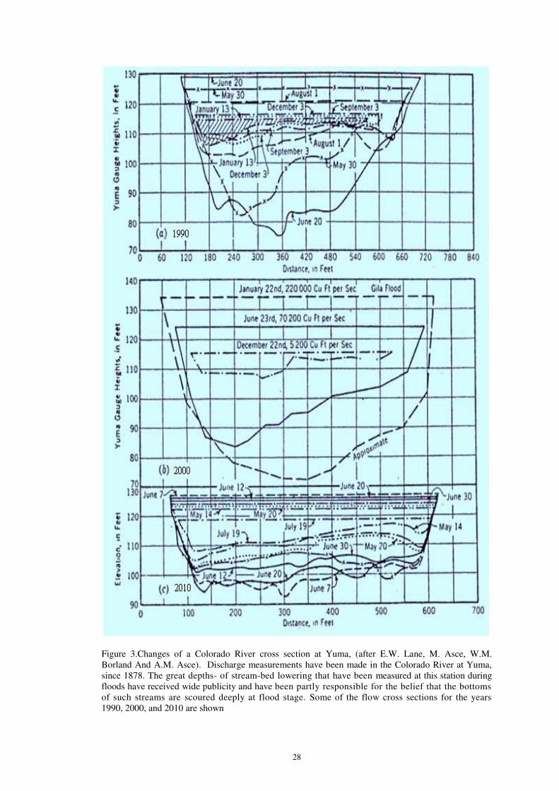
Figure 3.Changes of a Colorado River cross section at Yuma, (after E.W. Lane, M. Asce, W.M.
Borland And A.M. Asce). Discharge measurements have been made in the Colorado River at Yuma,
since 1878. The great depths- of stream-bed lowering that have been measured at this station during
floods have received wide publicity and have been partly responsible for the belief that the bottoms
of such streams are scoured deeply at flood stage. Some of the flow cross sections for the years
1990, 2000, and 2010 are shown

29
The Yellow River is the second longest river in China
30
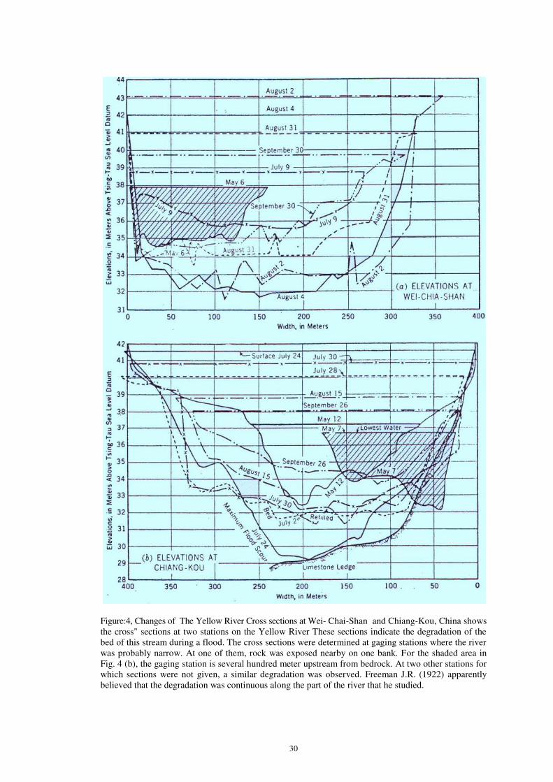
Figure:4, Changes of The Yellow River Cross sections at Wei- Chai-Shan and Chiang-Kou, China shows
the cross" sections at two stations on the Yellow River These sections indicate the degradation of the
bed of this stream during a flood. The cross sections were determined at gaging stations where the river
was probably narrow. At one of them, rock was exposed nearby on one bank. For the shaded area in
Fig. 4 (b), the gaging station is several hundred meter upstream from bedrock. At two other stations for
which sections were not given, a similar degradation was observed. Freeman J.R. (1922) apparently
believed that the degradation was continuous along the part of the river that he studied.
31
Conclusions
Fluvial morphology is the science of the forms of the earth's surface produced by
flowing water. This science is of major importance to the hydraulic engineer, since many of
his greatest problems arise because of such forms, Fluvial morphology has been studied most
extensively as a part of geomorphology, which is a subdivision of the science of geology. The
hydraulic engineer can learn much from the writings of the geomorphologists. Engineers have
also contributed to progress in this field.
The concepts of 1) the stages of development of a river proposed by W. M Davis, 2)
of base level, to which streams tend to cut down and 3) of equilibrium in stream
channels, will be of considerable assistance to hydraulic engineers in their analysis of plans
for stream control.
Many problems arise because of the changes which take place in the profile of
streams as the result of the works of man, or sometimes by natural causes. Because of the
progressive nature of these changes, and the large number of hydraulic works that have been
recently constructed, these problems are likely to be more frequent and important in the future
than they have been in the past. In this paper, an attempt has been made to classify these
changes and to give illustrations of cases, where they have occurred. It is believed that a
study of this classification and the examples, will aid the hydraulic engineer in
working out rational answers to some of his projects.
References Atwood, W.W. (1940). The Physiographic Provinces of North America. Ginn and Company, New
York, NY.
Andrews, E.D. (1983). "Entrainment of gravel from naturally sorted riverbed material." Geological
Society of America Bulletin, 94, 1225-1231.
Annandale, G.W. (1999). "Risk analysis of river bridge failure." In Stream Stability and Scour at
Highway Bridges. E.V. Richardson and P.F. Lagasse, Eds. ASCE, Reston, VA, 1003-1012.
ASCE Task Committee on Hydraulics, Bank Mechanics, and Modeling of River Width Adjustment
(1998). "River width adjustment I: Processes and mechanisms." Journal of Hydraulic
Engineering, 124(9), 881-902.
Bates, Robert EE.; (1939); Geomorphic History of the Kickapoo Region, Wisconsin; Bull.l. Geol. Soc.
A.m. Vol. 50; 819-880.
Bagnold, R.A. (1966). "An approach to the sediment transport problem from general physics." U.S.
Geological Survey Professional Paper 422-I.
Brookes, A. (1989). Channelized Rivers: Perspectives for Environmental Management. Wiley & Sons,
New York, NY.
Brice, J.C. and Blodgett, J.C. (1978). Countermeasures for Hydraulic Problems at Bridges. Volume I.
Analysis and Assessment. U.S. Department of Transportation, FHWA, Report No. FHWA-
RD-78-162, Washington, DC.
Chang, H.H. (1988). Fluvial Processes in River Engineering. Krieger Publishing Company, Melbourne,
FL, 432 pp.
Corey, H. T.; (1913) ; Irrigation and River Control in the Colorado River Delta; Trans. AASCE; Vol.
76; pp. 1204-1571.
Central Board of Irrigation of India; (1939-1940) Annual Report (Technical).
Carson, M.A. and Griffiths, G.A. (1987). "Bedload transport in gravel channels." Journal of Hydrology,
26, 1-151.
Castro, J.M. and Jackson, P.L., (2001). "Bankfull discharge recurrence intervals and regional hydraulic
geometry relationships." Journal of the American Water Resources Association, 37(5), 1249-
1262.
Davis, W. M; (1909); Geographical Essays; Ginn and Company. Republished 1999; Dover Publica
tions. New York, N.Y.
Dowd, M. J.; (1939); Silt Problems of Imperial Irrigation District as Affected by Comppletion of
Boulder Dam; Civil Engineering; -6611.
Dobby, E.H.G.;(1950) Southeast Asia; pp. 59-60.
Dongre, N. L. (1999). Pachmarhi. A Geomrphological study

32
Dietz, R.S. (1952). "Geomorphic evolution of the continental terrace (continental shelf and slope)."
American Association of Petroleum Geologists Bulletin, 36, 1802-1819.
Doll, B.A., Wise-Frederick, D.E., Buckner, C.M., Wilkerson, D., Harman, W.A., Smith, R.E., and
Spooner, J. (2002). "Hydraulic geometry relationships for urban streams throughout the
Piedmont of North Carolina." Journal of the American Water Resources Association, 38(3),
641-652.
Dohrenwend, J.C. (1987). "Basin and Range." In Geomorphic Systems of North America, Chapter 9.
Geological Society of America, Boulder, CO.
Freeman, J.R. , (1922) Flood Problem in China Transaction. ASCE, Vol.45
Fenneman, N.M. and Johnson, D.W. (1946). Physical Division of the United States. U.S. Geological
Survey, scale 1:7,000,000. Available at http://tapestry.usgs.gov/physiogr/physio.html.
Fisk, N., (1994). Geological Investigation of the Alluvial Valley of the Mississippi River- Mississippi
River Commission, Vicksburg, Miss,.
Foy, T.A.W.; (1947) Regime Level Changes on the Indus System, Punjab Irrigation Branch Paper No.
16.
Frizi, Paul; (1762); Treatise on Rivers and Torrents with Methods of Regulating their Coaurses and
Channels (in Italian); Translated by Gen. Garstin; London; 181 B.
Gilbert, G. K. (1887); Report on the Geology of the Henry Mountains--U.S. Geographical and
Geological Survey of the Rocky Mountain Region.
Guglielmini, Dominique; (1997); Della natura di fluni trattato fisico matematico,
Gilbert, G. K.; (1917); Hydraulic-Mining Debris in the Sierra Nevada; U.S. Geoiogical Survey;
Professional Paper No. 105
Geological Survey (2003). A Tapestry of Time and Terrain: The Union of Two Maps Geology and
Topography. http://tapestry.usgs.gov/physiogr/physio.html.
Graf, W.L. (1987). Geomorphic Systems of North America. Geological Society of America, Boulder,
CO.
Hooker, E. H.; (1996); The Suspension of Solids in Flowing Water;Trans. ASCE; Vol. 36a; 1896; pp.
239-340.
Hathaway, G. A.; (1948) Observations on Channel Changes, Degradation, and Scour Below Dams;
Report of the Second Meeting of the International Association of Hydraulic Research; ; pp.
297-307.
Harris, E. G.; (1901) Effect of Dams and Like Obstructions in Silt Bearing Streams; Engineering
News; Vol. 46; August 15,; pp. 110-111.
Harvey, M.D. and Watson, C.C. (1986). "Fluvial processes and morphological thresholds in incised
channel restoration." Water Resources Bulletin, 22(3), 359-368.
Hack, J.T. (1965). Geomorphology of the Shenandoah Valley, Virginia and West Virginia, and Origin
of the Residual Ore Deposits. U.S. Geological Survey Professional Paper 484.
Hack, J.T. (1957). Studies of Longitudinal Stream Profiles in Virginia and Maryland. U.S. Geological
Survey Professional Paper 294-B, 45-97.
Joglekar, D. V, and Wadekar, G. T.; The Effect of Weirs and Dams on the Regime of Rivers; Internatio
nal Association of Hydraulic Research; Bombay; 1991.
Jefferson, M. SE.; (1902); Limiting Width of Meander Belts; Nat.Geo. Mag. Vol. 13, pp. 3738-384.
Kesseli J.E. ; (1941) The Concept of the Graded River; Journal of Geology; Vol.49; pp561-588
Lobeck, A. K.; (1939); Geomorphology; McGraw-Hill Book Company.
Lane, E. W.; (1934); Ret regression of Levels in Riverbeds Below Dams; Engineering News Record;
Vol. 112; June 28; p. 836.
Leopold, L. B., & Maddock, Thomas, Jr., (1993). The Hydraulic Geometry of Stream Channels and
Some Physiographic Implications. U. S. Geological Survey Professional Paper No. 252
Lawler, D.M., Thorne, C.R., and Hooke, J.M. (1997). "Bank erosion and instability." In Applied
Fluvial Geomorphology for River Engineering and Management. C.R. Thorne, R.D. Hey, and
M.D. Newson, Eds. Wiley & Sons, New York, NY.
Lewin, J., Macklin, M.G., and Newson, M.D. (1988). "Regime theory and environmental change-
irreconcilable concepts?" In White, W.R. (Ed.), International Conference on River Regime.
Wiley & Sons, Chichester, England, 431-445.
Leopold, L.B. and Maddock, T. (1953). The Hydraulic Geometry of Stream Channels and Some
Physiographic Implications. U.S. Geological Survey Professional Paper 252.
Matthes, G. H.r; 1974; Basic Aspects of Stream-Meanders; Trans. American Geophysicabl Union; Part
III; p. 632.
Mackin, J. Hoover; (1948); Concept of the Graded River; Bulletin of the Geological Society of
America; Vol. 59; May 1948; pp. 463-512.

33
Malhotra, S. L.; (1951).Effect of Barrages and Weirs on the Regime of Rivers; International
Association for Hydraulic Research; Bombay;
Mills, H.H., Brakenridge, G.R., Jacobson, R.B., Newell, W.L., Pavich, M.J., and Pomeroy, J.S. (1987).
"Appalachian mountains and plateaus." In Geomorphic Systems of North America, Chapter 2.
Geological Society of America, Boulder, CO.
Maryland Department of Natural Resources (2002). Maryland's Nonpoint Source Program Manage me
nt Plan. Department of Natural Resources, Annapolis, MD (available online at www. dnr.
state. md.us / bay/ czm /nps/plans/summary.html).
Madole, R.F., Bradley, W.C., Loewenherz, D.S., Ritter, D.F., Rutter, N.W., and Thorn, C.E. (1987).
"Rocky Mountains." In Geomorphic Systems of North America, Chapter 7. Geological
Society of America, Boulder, CO.
Muhs, D.R., Thorson, R.M., Clague, J.J., Mathews, W.H., McDowell, P.F., Kelsey, H.M. (1987).
"Pacific Coast and Mountain System." In Geomorphic Systems of North America, Chapter 13.
Geological Society of America, Boulder, CO.
Mavis, F. T.; (1935); An Investigation of the Transportation of Bed Load by Flowing Water:; Thesis at
the University of Illinois.
McCandless, T.L. and Everett, R.A. (2002). "Bankfull Discharge and Channel Characteristics of
Streams in the Piedmont Hydrologic Region." U.S. Fish and Wildlife Service, Report CBFO-
SO2-01.
Niezgoda, S.L. and Johnson, P.A. (2005). "Improving the urban stream restoration effort: identifying
critical form and processes relationships." Environmental Management, 35(5), 579-592.
Osman, A.M. and Thorne, C.R. (1988). "River bank stability analysis I: Theory." Journal of Hydraulic
Engineering, 114(2), 134-150.
Osterkamp, W.R., Fenton, M.M., Gustavson, T.C., Hadley, R.F., Holliday, V.T., Morrison, R.B., Toy,
T.J. (1987). "Great Plains." In Geomorphic Systems of North America, Chapter 6. Geological
Society of America, Boulder, CO.
Osterkamp, W.R. and Hedman, E.R. (1982). "Perennial-streamflow characteristics related to channel
geometry and sediment in Missouri River Basin." U.S. Geological Survey Professional Paper
1242.
Powell, J. W: (1875); Exploration of the Colorado River of the West.
Penk, Walter, (1924). Morphological Analysis of Land Forms. Translated 1953. MacMillan and Co.,
Ltd., London.
Prestegaard, K.L. (2000). Preliminary Assessment of Morphological and Hydrological Characteristics
of Piedmont and Coastal Plain Streams in Maryland. Report to Maryland Department of the
Environment, Baltimore, MD.
Parker, G., Klingeman, P.C., and McClean, D.G. (1982). "Bedload and size distribution in paved
gravel-bed streams." Journal of Hydraulic Engineering, ASCE, 108(HY4), 544-571.
Russell, R. J.;, (1940) Quarternary History of Louisiana; Bulletin of the Geological Society of P-
America; Vol. 51; August 1,; pp. 1999- 1234.
Rosgen, D.L. (1996). Applied River Morphology. Wildland Hydrology, Pagosa Springs, CO.
Sondereregger, A. L.; (1935); Modifying the Physiolographical Balance by Conservation Measures;
Trans. ASCE 1975; Vol. 100; pp. 284-346.
Shulits, S.; (1934); Experience with Bed Degradation Below Dams on European Rivers; Engineering
News Record; Vol. 112; June 28; p. 838.
Schoklitsch, A.; (1937); Hydraulic Structures; American Society of Mechanical Engineers.
Stabler, Herman; (1925) ; Does Desilting Affect Cutting Power of Streams; Eng. News Rec. Vol. 95;
December 10; p. 969.
Sonderegger, A. L., (1999-2000). Physiography of Watersheds and Channels and Analysis of Stream
Action of Southern California Rivers Transactions, ASCE. Volume 83, pp. 1111-1148.
Schumm, S.A. (1977). Applied Fluvial Geomorphology. Elsevier Publishing, Amsterdam, Netherlands.
Shields, Jr., F.D. (1996). Hydraulic and Hydrologic Stability in River Channel Restoration: Guiding
Principles for Sustainable Projects. A. Brookes and F.D. Shields, Jr., Eds. Wiley & Sons, New
York, NY.
Simon, A., Curini, A., Darby, S., and Langendoen, E.J. (1999). "Streambank mechanics and the role of
bank and near-bank processes in incised channels In Incised River Channels (Darby, S., and
Simon, A., Eds.), Wiley & Sons, New York, NY, Chapter 6.
Sweet, W.V. and Geratz, J.W. (2003). "Bankfull hydraulic geometry relationships and recurrence
intervals for North Carolina's Coastal Plain." Journal of the American Water Resources
Association, 39(4), 861-871.
Simon, A. and Rinaldi, M. (2000). "Channel instability in the loess area of the midwestern United

34
States." Journal of the American Water Resources Association, 36(1), 133-150.
Todd, O. J. andd Eliassen, S.; (1940); The Yellow River Problem; Trans. ASCE; Vol. 10u-5; pp. 346-
453.
Thorne, C.R. and Osman, A.M. (1988). "Riverbank stability analysis II: Applications." Journal of
Hydraulic Engineering, 114(2), 151-172.
Thornbury, W. D. (1965). Regional Geomorphology of the United States. Wiley & Sons, New York,
NY.
U.S. Geological Survey (2004). "Regionalization of channel geomorphology characteristics for streams
in New York State." U.S. Geological Survey, Troy, NY.
Von Englen, (1942). Geomorphology. The MacMillan Co,, New York.
Vermont Water Quality Division (2001). Provisional Hydraulic Geometry Curves. Vermont Depart
ment of Environmental Conservation, Waterbury, VT, www. vtwater quality. org/ rivers/
docs/rv_ hydraulicgeocurves.pdf.
Worcester, P. G.; (1939); A Textbook of Geomorphology; D. Van Nostrand Company.Johnson,
Douglas; (1999); Streams and Their Significance; Journal of Geology; Vol. 40; August,
September 1932; pp. 481-497.
Wilcock, P.R. (1997). "Entrainment, displacement and transport of tracer gravels." Earth Surface
Processes and Landforms, 22(12), 1125-1138.
Wilcock, P.R. and Crowe, J.C. (2003). "Surface-based transport model for mixed-size sediment."
Journal of Hydraulic Engineering, 129(2), 120-128.
Walker, H.J. and Coleman, J.M. (1987). Coastal Plain, Geomorphic Systems of North America,
Chapter 3. Geological Society of America, Boulder, CO.
Wilcock, P.R. and Kenworthy, S.T. (2002). "A two-fraction model for the transport of sand/gravel
mixtures." Water Resources Research, 38(10), 121-133.
___________________________________________________________________________