Geometry and Kinematics - IGME
632
04/09/2015 Quaternary Active Faults Database of Iberia v.3 (4/09/2015) Refer to the Access file for a complete description of the record ID: AT002 Fault Name: Portimao-Guadalquivir Bank Segment Name: Location X: -8.006 Location Y: 36.142 Name of Compiler(s): Álvarez-Gómez, J.A. and García-Mayordomo, J. Filiation: UCM; IGME Email: [email protected] Last Update: 16/04/2015 Average Strike(º): 266 ± 5 LD Lima et al. (2010) Dip (º): 55 + 15 / - 20 LD Lima et al. (2010) Rake (º): 90 ± 20 LD Lima et al. (2010) Sense of Movement: R LD Lima et al. (2010) Length (km): 100.0 ± 5 LD Lima et al. (2010) Min Depth (km): 0 + 0.5 LD Lima et al. (2010) Max Depth (km): 40.0 ± 10 LD Lima et al. (2010) Width (km): 48.8 AR Area (km²): 5469.07 AR Age of the youngest deposits affected by the fault: Quaternary s.l. Pliocene- Quaternary EJ Based on Zitellini et al. (2004). Vertical Slip Rate (m/ka or mm/yr) : 0.100 EJ Based on Zitellini et al. (2004). Assuming a displacement of 1000 m (1 s TWT) since Middle Miocene times (Tortonian, 10 ma (Medialdea et al., 2004). Horizontal Slip Rate (m/ka or mm/yr) : Unknown Net Slip Rate (m/ka or mm/yr) : 0.122 AR From rake, dip and VSR MaxImum Slip Per Event (m): Unknown Number of Seismic Events: Unknown Evidence of Aseismic Creep: Unknown Identification Geometry and Kinematics Variability Source Comment Quaternary Activity Variability Source Comment Seismic Potential Prominent morphologic submarine topography with spatially associated seismicity, offset of recent reflectors. Zitellini et al. (2004, 2009) Geological Set: Atlantic Ocean (Offshore Southwest Iberia) Identification Method: Geophysical methods Comment Quaternary activity evidence B *Strength Class: Slip Rate *Accuracy Class: C Paleoearthquakes Orden Visual: 282 Página 1 de 632
Transcript of Geometry and Kinematics - IGME

04/09/2015Quaternary Active Faults Database of Iberia v.3 (4/09/2015)
Refer to the Access file for a complete description of the record
ID: AT002 Fault Name: Portimao-Guadalquivir Bank
Segment Name:
Location X: -8.006
Location Y: 36.142
Name of Compiler(s): Álvarez-Gómez, J.A. and García-Mayordomo, J.
Filiation: UCM; IGME
Email: [email protected]
Last Update: 16/04/2015
Average Strike(º): 266 ± 5 LD Lima et al. (2010)
Dip (º): 55 + 15 / - 20 LD Lima et al. (2010)
Rake (º): 90 ± 20 LD Lima et al. (2010)
Sense of Movement: R LD Lima et al. (2010)
Length (km): 100.0 ± 5 LD Lima et al. (2010)
Min Depth (km): 0 + 0.5 LD Lima et al. (2010)
Max Depth (km): 40.0 ± 10 LD Lima et al. (2010)
Width (km): 48.8 AR
Area (km²): 5469.07 AR
Age of the youngestdeposits affected bythe fault:
Quaternary s.l. Pliocene-Quaternary
EJ Based on Zitellini et al. (2004).
Vertical Slip Rate(m/ka or mm/yr) :
0.100 EJ Based on Zitellini et al. (2004). Assuming a displacement of 1000 m (1 s TWT) since Middle Miocene times (Tortonian, 10 ma (Medialdea et al., 2004).
Horizontal Slip Rate(m/ka or mm/yr) :
Unknown
Net Slip Rate(m/ka or mm/yr) :
0.122 AR From rake, dip and VSR
MaxImum Slip Per Event (m):
Unknown
Number of SeismicEvents:
Unknown
Evidence of AseismicCreep:
Unknown
Identification
Geometry and KinematicsVariability Source Comment
Quaternary Activity
Variability Source
Comment
Seismic Potential
Prominent morphologic submarine topography with spatially associated seismicity, offset of recent reflectors.
Zitellini et al. (2004, 2009)
Geological Set: Atlantic Ocean (Offshore Southwest Iberia)
Identification Method: Geophysical methods
Comment
Quaternary activity evidence
B*Strength Class:
Slip Rate *Accuracy Class: C
Paleoearthquakes
Orden Visual: 282
Página 1 de 632
04/09/2015Quaternary Active Faults Database of Iberia v.3 (4/09/2015)
Refer to the Access file for a complete description of the record
Maximun Magnitude(Mw):
7.35 ± 0.37 ER Magnitude from length using Stirling et al. (2002) equation derived from the instrumental dataset. Estimation following Scholz (2002) relations results in Mw 8.10.
RecurrenceInterval (years) :
5938 5938-79178 AR Preferred estimation considers Mw 7.35 and SR=0.122. Upper bound results from Mw 8.1.
Date of Last MaximumEarthquake (years) :
Unknown
Extended Information: EXTENDED_INFORMATION\AT001-AT003.rar
Lima, J. M. Miranda , M. A. Baptista, J. Catalao, M. Gonzalez, L. Otero, M. Olabarrieta, J. A. Alvarez-Gomez, and E. Carreño (2010): Impact of a 1755-like tsunami in Huelva, Spain. Natural Hazards and Earth System Science, 10: 1-10.
Medialdea, T., Vegas, R., Somoza, L., Vázquez, J. T., Maldonado, A., Dıaz-del-Rıo, V., ... & Fernández-Puga, M. C. (2004). Structure and evolution of the “Olistostrome” complex of the Gibraltar Arc in the Gulf of Cádiz (eastern Central Atlantic): evidence from two long seismic cross-sections. Marine Geology,209(1), 173-198.
Stirling, M., Rhoades, D. and Berryman K. (2002): Comparison of Earthquake Scaling Relations Derived from Data of the Instrumental and Preinstrumental Era. Bulletin of the Seismological Society of America, 92 (2): 812–830.
Zitellini, N., Rovere, M., Terrinha, P., Chierici, F., Matias, L., & Team, B. (2004). Neogene through Quaternary tectonic reactivation of SW Iberian passive margin.Pure and Applied Geophysics, 161(3), 565-587.
Zitellini, N., Gràcia, E., Matias, L., Terrinha, P., Abreu, M. A., DeAlteriis, G., … & Diez, S. (2009). The quest for the Africa–Eurasia plate boundary west of the Strait of Gibraltar. Earth and Planetary Science Letters, 280(1), 13-50.
Source Comment
Associated Seismicity
Extended Data and References
References
Variability
*Reliability rating: C
*Reliability rating: C
Página 2 de 632

04/09/2015Quaternary Active Faults Database of Iberia v.3 (4/09/2015)
Refer to the Access file for a complete description of the record
ID: AT004 Fault Name: Marques de Pompal
Segment Name:
Location X: -10.203
Location Y: 36.653
Name of Compiler(s): Gràcia, E., Bartolomé, R., Martínez, S. and Lo Iacono, C.
Filiation: Unitat de Tecnologia Marina - CSIC
Email: [email protected]
Last Update: 30/12/2010
Average Strike(º): 021 ± 5 LD Measured on multibeam bathymetric data (Vizcaino, 2009; Gràcia et al., 2010).
Dip (º): 24 ± 5 LD Depth conversion of a MCS profile (Zitellini et al., 2001; 2004)
Rake (º): 90 ± 10 EJ Assumed pure reverse
Sense of Movement: R LD Displacement of reflectors on seismic data (Vizcaino, 2009; Gràcia et al., 2010).
Length (km): 47.6 ± 5 LD Measured on multibeam bathymetric data (Vizcaino, 2009; Gràcia et al., 2010).
Min Depth (km): 0 LD Vizcaino, 2009; Gràcia et al., 2010.
Max Depth (km): 50.0 - 10 LD From 40 to 50 km suggested by Geissler et al. (2010); Stich et al. (2010)
Width (km): 122.9 AR
Area (km²): 5851.45 AR
Age of the youngestdeposits affected bythe fault:
300 - 560 yr BP
LD Age of the last mass transport deposit associated to the fault. We relate it to the 1755 Lisbon Earthquake (Vizcaino, 2009; Gràcia et al., 2010)
Vertical Slip Rate(m/ka or mm/yr) :
Unknown
Horizontal Slip Rate(m/ka or mm/yr) :
0 EJ The fault is mainly reverse. In addition, there are no evidences for calculating the horizontal component.
Net Slip Rate(m/ka or mm/yr) : Unknown
MaxImum Slip Per Event (m):
Unknown
Number of SeismicEvents:
4 LD We observe a total of 4 successive mass transport deposits associated to this fault (Vizcaino, 2009; Gràcia et al., 2010)
Evidence of AseismicCreep:
Unknown
Identification
Geometry and KinematicsVariability Source Comment
Quaternary Activity
Variability Source
Comment
Surface expression, offset Quaternary horizons, folds, landslides associated
Vizcaino, 2009; Gràcia et al., 2010
Geological Set: Atlantic Ocean (Offshore Southwest Iberia)
Identification Method: Geophysical methods
Comment
Quaternary activity evidence
A+*Strength Class:
Slip Rate *Accuracy Class: Not rated
Paleoearthquakes
Orden Visual: 283
Página 3 de 632

04/09/2015Quaternary Active Faults Database of Iberia v.3 (4/09/2015)
Refer to the Access file for a complete description of the record
Maximun Magnitude(Mw):
7.04 ± 0.37 ER Magnitude from length using Stirling et al. (2002) equation derived from the instrumental dataset. The Mw is 7.76 if it is calculated according to Wells & Coppersmith (1994). A value of Mw 8.1 has been proposed by Lima et al. (2010).
RecurrenceInterval (years) :
2000 LD Based on the average recurrence of successive mass transport deposits associated to the Marques de Pombal Fault (Vizcaino, 2009; Gràcia et al., 2010).
Date of Last MaximumEarthquake (years) :
Unknown
Extended Information: EXTENDED_INFORMATION\AT004-AT009.rar
García-Orellana, J., Gràcia, E., Vizcaino, A., Masqué, P., Olid, C., Martínez Ruiz, F., Piñero, E., Sánchez-Cabeza, J.A, Dañobeitia, J.J (2006). Identifying instrumental and historical earthquake records in the SW Iberian Margin using 210Pb turbidite chronology. Geophys. Res. Lett., 33 (24), L24601, doi: 10.1029/2006GL028417.
Gràcia, E., Dañobeitia, J.J., Vergés, J., and PARSIFAL Team (2003). Mapping active faults offshore Portugal (38ºN-36ºN): Implications for seismic hazard assessment along the southwest Iberian Margin. Geology, 31, 83-86.
Gràcia, E., Vizcaino, A., Escutia, C., Asioli, A., Rodés, A., Pallàs, R., García Orellana, J., Lebreiro, S., Goldfinger, C (2010). Holocene earthquake record offshore Portugal (SW Iberia): Testing turbidite paleoseismology in a slow-convergence margin. Quaternary Science Reviews, 29, 1156–1172.
Gràcia, E., Bartolomé, R., Lo Iacono, C., Moreno, X., Martínez-Loriente, S., Perea, H., Masana, E., Pallàs, R., Díez, S., Dañobeitia, J.J., Terrinha, P., Zitellini, N. (2010). Characterizing active faults and associated mass transport deposits in the South Iberian Margin (Alboran Sea and Gulf of Cadiz): On-fault and off-fault paleoseismic evidence. En: Contribución de la Geología al Análisis de la Peligrosidad Sísmica (J.M. Insúa y F.Martín-González, eds.), pp. 163-166. IBERFAULT, Sigüenza (Guadalajara), 27-29 Octubre 2010.
V. V. Lima, J. M. Miranda , M. A. Baptista, J. Catalao, M. Gonzalez, L. Otero, M. Olabarrieta, J. A. Alvarez-Gomez, and E. Carreño (2010): Impact of a 1755-like tsunami in Huelva, Spain. Natural Hazards and Earth System Science, 10: 1-10.
Stirling, M., Rhoades, D. and Berryman K. (2002): Comparison of Earthquake Scaling Relations Derived from Data of the Instrumental and Preinstrumental Era. Bulletin of the Seismological Society of America, 92 (2): 812–830.
Vizcaino, A., Gràcia, E., Pallàs, R., García-Orellana, J., Escutia, C., CASAS, D., WILLMOTT, V., Díez, S., AND Dañobeitia, J.J. (2006). Sedimentology, physical properties and ages of mass-transport deposits associated to the Marquês de Pombal Fault, Southwest Portuguese Margin. Norwegian Journal of Geology, 86, 173-182.
Vizcaino, A., 2009. “Processos sedimentaris d’edat Holocena al marge sud-oest de la Península Ibèrica: Aplicació a la paleosismologia marina”. Tesis Doctoral, Universitat de Barcelona, 281 pp.
Wells, D. L., and Coppersmith, K. J. (1994). New empirical relationships among magnitude, rupture length, rupture width, and surface displacement. Bulleting of the Seismological Society of America 84, 974-1002.
Geissler et al., 2010. Focal mechanisms for sub-crustal earthquakes in the Gulf of Cadiz from a dense OBS deployment. Geophys. Res. Lett., 37, L18309.
Stich, D., Mancilla, F., Morales, J., 2005. Crust-mantle coupling in the Gulf of Cadiz (SW Iberia). Geophys. Res. Lett., 32, L13306, doi:10.1029/2005GL023098.
Stich et al., 2010. Moment tensor inversion for Iberia-Maghreb earthquakes 2005-2008. Tectonophysics, 483, 390-398.
Zitellini, N., Mendes, L., Córdoba, D., Dañobeitia, J.J., Nicolich, R., Pellis, G., Ribeiro, A., Sartori, R., Torelli, L., and BIGSETS TEAM
Seismic PotentialSource Comment
Associated Seismicity
Extended Data and References
References
Variability
*Reliability rating: A
*Reliability rating: Not rated
Database of Seismicity Associated to QAFI v.3 FaultsRefer to the Access file for a complete description of the record
ID_Event Event name Date Location XY Int./Mag. Source Association Comment
AT004
1755 Lisbon earthquake
1/11/1755 Mw>8 Lisbon event either associated to Horseshoe or Marques de Pombal faults (Gràcia et al., 2003; Zitellini et al., 2004).
730
Página 4 de 632
04/09/2015Quaternary Active Faults Database of Iberia v.3 (4/09/2015)
Refer to the Access file for a complete description of the record
(2001). Source of the 1755 Lisbon Earthquake and Tsunami Investigated. EOS, Transactions of AGU, Vol 82 (26), p. 285-290-291.
Zitellini, N., Rovere, M., Terrinha, P., Chierici, F., Matias, L., and BIGSETS Team, 2004. Neogene through Quaternary tectonic reactivation of SW Iberian Passive Margin. Pure Appl. Geophys., 161, 565-587.
Página 5 de 632

04/09/2015Quaternary Active Faults Database of Iberia v.3 (4/09/2015)
Refer to the Access file for a complete description of the record
ID: AT005 Fault Name: Horseshoe
Segment Name:
Location X: -10.477
Location Y: 35.803
Name of Compiler(s): Gràcia, E., Bartolomé, R., Martínez, S. and Lo Iacono, C.
Filiation: Unitat de Tecnologia Marina - CSIC
Email: [email protected]
Last Update: 30/12/2010
Average Strike(º): 045 ± 5 LD Measured on multibeam bathymetric data (Gràcia et al., 2003, 2010).
Dip (º): 30 ± 10 LD Calculated from the SWIM-2006 MCS profiles, where we have performed pre-stack depth migration, so the profiles are in depth-section, not TWTT (Gràcia et al., 2003, 2010).
Rake (º): 90 ± 10 EJ Assumed pure reverse
Sense of Movement: R LD Displacement of reflectors on seismic data (Gràcia et al., 2003, 2010)
Length (km): 87.0 ± 5 LD Measured on multibeam bathymetric data (Gràcia et al., 2003, 2010)
Min Depth (km): 0 LD Gràcia et al., 2003, 2010.
Max Depth (km): 60.0 - 20 LD From 40 to 60 km suggested by Stich et al. (2007); Geissler et al. (2010); Stich et al. (2010)
Width (km): 120.0 AR
Area (km²): 10440.00 AR
Age of the youngestdeposits affected bythe fault:
Holocene LD The fault reaches up to the surface, as demonstrated by MCS and TOPAS profiles. The age of the seafloor sediments is of Holocene age based on sediment cores (Gràcia et al., 2003, 2010).
Vertical Slip Rate(m/ka or mm/yr) :
0.180 ± 0.01 LD Calculated from vertical displacement of seismic horizons in the depth-section profile (Gràcia et al., 2003, 2010). This is a long-range rate since the base of the Quaternary.
Horizontal Slip Rate(m/ka or mm/yr) :
0 EJ The fault is mainly reverse. In addition, there are no evidences for calculating the horizontal component.
Net Slip Rate(m/ka or mm/yr) :
0.36 ± 0.01 AR Relationship between VSR, dip and rake
MaxImum Slip Per Event (m):
Unknown
Number of SeismicEvents:
Unknown
Evidence of AseismicCreep:
Unknown
Identification
Geometry and KinematicsVariability Source Comment
Quaternary Activity
Variability Source
Comment
Surface expression, offset Quaternary horizons, folds, landslides associated
Gràcia et al., 2003, 2010.
Geological Set: Atlantic Ocean (Offshore Southwest Iberia)
Identification Method: Geophysical methods
Comment
Quaternary activity evidence
A+*Strength Class:
Slip Rate *Accuracy Class: C
Paleoearthquakes
Orden Visual: 284
Página 6 de 632

04/09/2015Quaternary Active Faults Database of Iberia v.3 (4/09/2015)
Refer to the Access file for a complete description of the record
Maximun Magnitude(Mw):
7.29 ± 0.37 ER Magnitude from length using Stirling et al. (2002) equation derived from the instrumental dataset. The Mw is 8.01 if it is calculated according to Wells & Coppersmith (1994). A value of Mw 8.3 has been proposed by Lima et al. (2010).
RecurrenceInterval (years) :
864 234-3191 AR Considering the Maximum Earthquake Model (Wesnousky, 1986): slip rate represents the rate at which maximum earthquakes are released by the fault. RI = Mo f(Mw±d) / Mo f(SR±d). The occurrence of smaller, damaging earthquakes may be much shorter.
Date of Last MaximumEarthquake (years) :
Unknown
Extended Information: EXTENDED_INFORMATION\AT004-AT009.rar
Gràcia, E., Dañobeitia, J.J., Vergés, J., and PARSIFAL Team (2003). Mapping active faults offshore Portugal (38ºN-36ºN): Implications for seismic hazard assessment along the southwest Iberian Margin. Geology, 31, 83-86.
Gràcia, E., Vizcaino, A., Escutia, C., Asioli, A., Rodés, A., Pallàs, R., García Orellana, J., Lebreiro, S., Goldfinger, C (2010). Holocene earthquake record offshore Portugal (SW Iberia): Testing turbidite paleoseismology in a slow-convergence margin. Quaternary Science Reviews, 29, 1156–1172.
Gràcia, E., Bartolomé, R., Lo Iacono, C., Moreno, X., Martínez-Loriente, S., Perea, H., Masana, E., Pallàs, R., Díez, S., Dañobeitia, J.J., Terrinha, P., Zitellini, N. (2010). Characterizing active faults and associated mass transport deposits in the South Iberian Margin (Alboran Sea and Gulf of Cadiz): On-fault and off-fault paleoseismic evidence. En: Contribución de la Geología al Análisis de la Peligrosidad Sísmica (J.M. Insúa y F.Martín-González, eds.), pp. 163-166. IBERFAULT, Sigüenza (Guadalajara), 27-29 Octubre 2010.
V. V. Lima, J. M. Miranda , M. A. Baptista, J. Catalao, M. Gonzalez, L. Otero, M. Olabarrieta, J. A. Alvarez-Gomez, and E. Carreño (2010): Impact of a 1755-like tsunami in Huelva, Spain. Natural Hazards and Earth System Science, 10: 1-10.
Wells, D. L., and Coppersmith, K. J. (1994). New empirical relationships among magnitude, rupture length, rupture width, and surface displacement. Bulleting of the Seismological Society of America 84, 974-1002.
Geissler et al., 2010. Focal mechanisms for sub-crustal earthquakes in the Gulf of Cadiz from a dense OBS deployment. Geophys. Res. Lett., 37, L18309.
Stich, D., Mancilla, F., Morales, J., 2005. Crust-mantle coupling in the Gulf of Cadiz (SW Iberia). Geophys. Res. Lett., 32, L13306, doi:10.1029/2005GL023098.
Seismic PotentialSource Comment
Associated Seismicity
Extended Data and References
References
Variability
*Reliability rating: A
*Reliability rating: C
Database of Seismicity Associated to QAFI v.3 FaultsRefer to the Access file for a complete description of the record
ID_Event Event name Date Location XY Int./Mag. Source Association Comment
AT005
2007 Horseshoe event
12/02/2007 Mw=6.0 Stich et al., 2007
Stich et al., 2007728
AT005
1755 Lisbon earthquake
1/11/1755 Mw>8 Lisbon event either associated to Horseshoe or Marques de Pombal faults (Gràcia et al., 2003; Zitellini et al., 2004).
729
AT005
1969 Horseshoe earthquake
Mw=8.0 Gràcia et al. (2010)731
Página 7 de 632

04/09/2015Quaternary Active Faults Database of Iberia v.3 (4/09/2015)
Refer to the Access file for a complete description of the record
Stich et al., 2007. Source analysis of the February 12th 2007, Mw 6.0 Horseshoe earthquake: Implications for the 1755 Lisbon earthquake. Geophys. Res. Lett., Vol 34, L12308.
Stich et al., 2010. Moment tensor inversion for Iberia-Maghreb earthquakes 2005-2008. Tectonophysics, 483, 390-398.
Stirling, M., Rhoades, D. and Berryman K. (2002): Comparison of Earthquake Scaling Relations Derived from Data of the Instrumental and Preinstrumental Era. Bulletin of the Seismological Society of America, 92 (2): 812–830.
Wesnousky, S.G. (1986). Earthquakes, Quaternary faults, and seismic hazard in California. Journal of Geophysical Research. 91(B12), 12587-12631.
Zitellini, N., Rovere, M., Terrinha, P., Chierici, F., Matias, L. & BIGSETS TEAM (2004). Neogene through Quaternary tectonic reactivation of SW Iberian passive margin. Pure Appl. Geophys., 161, 565-587.
Página 8 de 632

04/09/2015Quaternary Active Faults Database of Iberia v.3 (4/09/2015)
Refer to the Access file for a complete description of the record
ID: AT006 Fault Name: Coral Patch Ridge (1/2)
Segment Name: Western
Location X: -11.318
Location Y: 35.398
Name of Compiler(s): Gràcia, E., Martínez, S. and Bartolomé, R.
Filiation: Unitat de Tecnologia Marina - CSIC
Email: [email protected]
Last Update: 30/12/2010
Average Strike(º): 085 ± 5 LD Measured on multibeam bathymetric data (Martínez-Loriente, 2008; Martínez-Loriente et al. 2009)
Dip (º): 90 LD Martínez-Loriente, 2008; Martínez-Loriente et al. 2009.
Rake (º): 90 EJ Assumed pure reverse
Sense of Movement: R LD Martínez-Loriente, 2008; Martínez-Loriente et al. 2009.
Length (km): 53.0 ± 5 LD Measured on multibeam bathymetric data (Martínez-Loriente, 2008; Martínez-Loriente et al. 2009).
Min Depth (km): Unknown
Max Depth (km): Unknown
Width (km): Unknown
Area (km²): Unknown
Age of the youngestdeposits affected bythe fault:
Holocene LD The fault reaches up to the surface, as demostrated by MCS and TOPAS profiles. Martínez-Loriente et al. (2009).
Vertical Slip Rate(m/ka or mm/yr) :
Unknown
Horizontal Slip Rate(m/ka or mm/yr) :
Unknown
Net Slip Rate(m/ka or mm/yr) : Unknown
MaxImum Slip Per Event (m):
Unknown
Number of SeismicEvents:
Unknown
Evidence of AseismicCreep:
Unknown
Identification
Geometry and KinematicsVariability Source Comment
Quaternary Activity
Variability Source
Comment
Seismic Potential
Surface expression, offset Quaternary horizons Martínez-Loriente, 2008; Martínez-Loriente et al., 2009.
Geological Set: Atlantic Ocean (Offshore Southwest Iberia)
Identification Method: Geophysical methods
Comment
Quaternary activity evidence
A+*Strength Class:
Slip Rate *Accuracy Class: Not rated
Paleoearthquakes
Orden Visual: 285
Página 9 de 632
04/09/2015Quaternary Active Faults Database of Iberia v.3 (4/09/2015)
Refer to the Access file for a complete description of the record
Maximun Magnitude(Mw):
7.09 ± 0.37 ER Magnitude from length using Stirling et al. (2002) equation derived from the instrumental dataset. The Mw is 7.08 if it is calculated according to Wells & Coppersmith (1994).
RecurrenceInterval (years) :
Not enough data for an estimation
Date of Last MaximumEarthquake (years) :
Unknown
Extended Information: EXTENDED_INFORMATION\AT004-AT009.rar
Gràcia, E., Bartolomé, R., Lo Iacono, C., Moreno, X., Martínez-Loriente, S., Perea, H., Masana, E., Pallàs, R., Díez, S., Dañobeitia, J.J., Terrinha, P., Zitellini, N. (2010). Characterizing active faults and associated mass transport deposits in the South Iberian Margin (Alboran Sea and Gulf of Cadiz): On-fault and off-fault paleoseismic evidence. En: Contribución de la Geología al Análisis de la Peligrosidad Sísmica (J.M. Insúa y F.Martín-González, eds.), pp. 163-166. IBERFAULT, Sigüenza (Guadalajara), 27-29 Octubre 2010.
Martínez-Loriente, S., 2008. “Estratigrafia i estructura de la part externa del Golf de Cadis basades en dades de sísmica de reflexió multicanal migrades en profunditat pre-stack”. DEA Universitat de Barcelona.
Martínez-Loriente, S., Gràcia, E., Bartolomé, R., Sallarès, V., Terrinha, P. (2009). Active tectonics at the external part of the Gulf of Cadiz based on depth and time migrated MCS profiles. 6º Simposio sobre el Margen Ibérico Atlántico (MIA-09), Oviedo (Spain), 1-5 December 2009.
Martínez-Loriente, S., Sallarès, V., Bartolomé, R., Gràcia, E., NEAREST-SEIS CRUISE PARTY, 2009. Wide-angle reflection and refraction seismic profile from the outer part of the Gulf of Cadiz: NEAREST-SEIS cruise. Instrumentation Viewpoint, 8, 49, ISSN:1697-2562.
Stirling, M., Rhoades, D. and Berryman K. (2002): Comparison of Earthquake Scaling Relations Derived from Data of the Instrumental and Preinstrumental Era. Bulletin of the Seismological Society of America, 92 (2): 812–830.
Wells, D. L., and Coppersmith, K. J. (1994). New empirical relationships among magnitude, rupture length, rupture width, and surface displacement. Bulleting of the Seismological Society of America 84, 974-1002.
Source Comment
Associated Seismicity
Extended Data and References
References
Variability
*Reliability rating: A
*Reliability rating: Not rated
Página 10 de 632
04/09/2015Quaternary Active Faults Database of Iberia v.3 (4/09/2015)
Refer to the Access file for a complete description of the record
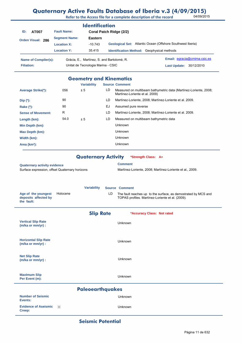
ID: AT007 Fault Name: Coral Patch Ridge (2/2)
Segment Name: Eastern
Location X: -10.743
Location Y: 35.415
Name of Compiler(s): Gràcia, E., Martínez, S. and Bartolomé, R.
Filiation: Unitat de Tecnologia Marina - CSIC
Email: [email protected]
Last Update: 30/12/2010
Average Strike(º): 056 ± 5 LD Measured on multibeam bathymetric data (Martínez-Loriente, 2008; Martínez-Loriente et al. 2009)
Dip (º): 90 LD Martínez-Loriente, 2008; Martínez-Loriente et al. 2009.
Rake (º): 90 EJ Assumed pure reverse
Sense of Movement: R LD Martínez-Loriente, 2008; Martínez-Loriente et al. 2009.
Length (km): 54.0 ± 5 LD Measured on multibeam bathymetric data
Min Depth (km): Unknown
Max Depth (km): Unknown
Width (km): Unknown
Area (km²): Unknown
Age of the youngestdeposits affected bythe fault:
Holocene LD The fault reaches up to the surface, as demostrated by MCS and TOPAS profiles. Martínez-Loriente et al. (2009).
Vertical Slip Rate(m/ka or mm/yr) :
Unknown
Horizontal Slip Rate(m/ka or mm/yr) :
Unknown
Net Slip Rate(m/ka or mm/yr) : Unknown
MaxImum Slip Per Event (m):
Unknown
Number of SeismicEvents:
Unknown
Evidence of AseismicCreep:
Unknown
Identification
Geometry and KinematicsVariability Source Comment
Quaternary Activity
Variability Source
Comment
Seismic Potential
Surface expression, offset Quaternary horizons Martínez-Loriente, 2008; Martínez-Loriente et al., 2009.
Geological Set: Atlantic Ocean (Offshore Southwest Iberia)
Identification Method: Geophysical methods
Comment
Quaternary activity evidence
A+*Strength Class:
Slip Rate *Accuracy Class: Not rated
Paleoearthquakes
Orden Visual: 286
Página 11 de 632

04/09/2015Quaternary Active Faults Database of Iberia v.3 (4/09/2015)
Refer to the Access file for a complete description of the record
Maximun Magnitude(Mw):
7.10 ± 0.37 ER Magnitude from length using Stirling et al. (2002) equation derived from the instrumental dataset. The Mw is 7.09 if it is calculated according to Wells & Coppersmith (1994).
RecurrenceInterval (years) :
Not enough data for an estimation
Date of Last MaximumEarthquake (years) :
Unknown
Extended Information: EXTENDED_INFORMATION\AT004-AT009.rar
Gràcia, E., Bartolomé, R., Lo Iacono, C., Moreno, X., Martínez-Loriente, S., Perea, H., Masana, E., Pallàs, R., Díez, S., Dañobeitia, J.J., Terrinha, P., Zitellini, N. (2010). Characterizing active faults and associated mass transport deposits in the South Iberian Margin (Alboran Sea and Gulf of Cadiz): On-fault and off-fault paleoseismic evidence. En: Contribución de la Geología al Análisis de la Peligrosidad Sísmica (J.M. Insúa y F.Martín-González, eds.), pp. 163-166. IBERFAULT, Sigüenza (Guadalajara), 27-29 Octubre 2010.
Martínez-Loriente, S., 2008. “Estratigrafia i estructura de la part externa del Golf de Cadis basades en dades de sísmica de reflexió multicanal migrades en profunditat pre-stack”. DEA Universitat de Barcelona.
Martínez-Loriente, S., Gràcia, E., Bartolomé, R., Sallarès, V., Terrinha, P. (2009). Active tectonics at the external part of the Gulf of Cadiz based on depth and time migrated MCS profiles. 6º Simposio sobre el Margen Ibérico Atlántico (MIA-09), Oviedo (Spain), 1-5 December 2009.
Martínez-Loriente, S., Sallarès, V., Bartolomé, R., Gràcia, E., NEAREST-SEIS CRUISE PARTY, 2009. Wide-angle reflection and refraction seismic profile from the outer part of the Gulf of Cadiz: NEAREST-SEIS cruise. Instrumentation Viewpoint, 8, 49, ISSN:1697-2562.
Stirling, M., Rhoades, D. and Berryman K. (2002): Comparison of Earthquake Scaling Relations Derived from Data of the Instrumental and Preinstrumental Era. Bulletin of the Seismological Society of America, 92 (2): 812–830.
Wells, D. L., and Coppersmith, K. J. (1994). New empirical relationships among magnitude, rupture length, rupture width, and surface displacement. Bulleting of the Seismological Society of America 84, 974-1002.
Source Comment
Associated Seismicity
Extended Data and References
References
Variability
*Reliability rating: A
*Reliability rating: Not rated
Página 12 de 632

04/09/2015Quaternary Active Faults Database of Iberia v.3 (4/09/2015)
Refer to the Access file for a complete description of the record
ID: AT008 Fault Name: Lineament N
Segment Name:
Location X: -9.456
Location Y: 35.962
Name of Compiler(s): Gràcia, E., Bartolomé, R. and Martínez, S.
Filiation: Unitat de Tecnologia Marina - CSIC
Email: [email protected]
Last Update: 30/12/2010
Average Strike(º): 100 ± 2 LD Measured on multibeam bathymetric data (Zitellini et al., 2009).
Dip (º): 90 ± 10 LD Calculated from the SWIM-2006 MCS profiles, where we have performed pre-stack depth migration, so the profiles are in depth-section, not TWTT (Zitellini et al., 2009).
Rake (º): 180 ± 10 EJ Assumed pure dextral strike-slip
Sense of Movement: D LD Zitellini et al., 2009.
Length (km): 130.0 ± 5 LD Measured on multibeam bathymetric data (Zitellini et al., 2009).
Min Depth (km): Unknown
Max Depth (km): Unknown
Width (km): Unknown
Area (km²): Unknown
Age of the youngestdeposits affected bythe fault:
Holocene LD Zitellini et al., 2009.
Vertical Slip Rate(m/ka or mm/yr) :
Unknown
Horizontal Slip Rate(m/ka or mm/yr) :
Unknown
Net Slip Rate(m/ka or mm/yr) : Unknown
MaxImum Slip Per Event (m):
Unknown
Number of SeismicEvents:
Unknown
Evidence of AseismicCreep:
Unknown
Identification
Geometry and KinematicsVariability Source Comment
Quaternary Activity
Variability Source
Comment
Seismic Potential
Surface expression, flower structures, offset quaternary horizons Zitellini et al., 2009.
Geological Set: Atlantic Ocean (Offshore Southwest Iberia)
Identification Method: Geophysical methods
Comment
Quaternary activity evidence
A+*Strength Class:
Slip Rate *Accuracy Class: Not rated
Paleoearthquakes
Orden Visual: 287
Página 13 de 632

04/09/2015Quaternary Active Faults Database of Iberia v.3 (4/09/2015)
Refer to the Access file for a complete description of the record
Maximun Magnitude(Mw):
7.46 ± 0.37 ER Magnitude from length using Stirling et al. (2002) equation derived from the instrumental dataset. The Mw is 7.53 if it is calculated according to Wells & Coppersmith (1994).
RecurrenceInterval (years) :
Not enough data for an estimation
Date of Last MaximumEarthquake (years) :
Unknown
Extended Information: EXTENDED_INFORMATION\AT004-AT009.rar
Gràcia, E., Bartolomé, R., Lo Iacono, C., Moreno, X., Martínez-Loriente, S., Perea, H., Masana, E., Pallàs, R., Díez, S., Dañobeitia, J.J., Terrinha, P., Zitellini, N. (2010). Characterizing active faults and associated mass transport deposits in the South Iberian Margin (Alboran Sea and Gulf of Cadiz): On-fault and off-fault paleoseismic evidence. En: Contribución de la Geología al Análisis de la Peligrosidad Sísmica (J.M. Insúa y F.Martín-González, eds.), pp. 163-166. IBERFAULT, Sigüenza (Guadalajara), 27-29 Octubre 2010.
Bartolomé, R., Gràcia, E., Stich, D., MARTÍNEZ–LORIENTE, S., Klaeschen, D., Masana, E., Díez, S., Lo Iacono, C., Moreno, X., Zitellini, N., Mànuel, A., Dañobeitia, J.J. (2009). Seismic evidence of active strike-slip faulting in the external Gulf of Cadiz (SW Iberian Margin). EOS Trans AGU, Fall meeting Suppl., San Francisco (USA), 14-18 Dec. 2009.
Martínez-Loriente, S., 2008. “Estratigrafia i estructura de la part externa del Golf de Cadis basades en dades de sísmica de reflexió multicanal migrades en profunditat pre-stack”. DEA Universitat de Barcelona.
Martínez-Loriente, S., Gràcia, E., Bartolomé, R., Sallarès, V., Terrinha, P. (2009). Active tectonics at the external part of the Gulf of Cadiz based on depth and time migrated MCS profiles. 6º Simposio sobre el Margen Ibérico Atlántico (MIA-09), Oviedo (Spain), 1-5 December 2009.
Stirling, M., Rhoades, D. and Berryman K. (2002): Comparison of Earthquake Scaling Relations Derived from Data of the Instrumental and Preinstrumental Era. Bulletin of the Seismological Society of America, 92 (2): 812–830.
Wells, D. L., and Coppersmith, K. J. (1994). New empirical relationships among magnitude, rupture length, rupture width, and surface displacement. Bulleting of the Seismological Society of America 84, 974-1002.
Zitellini, N., Gràcia, E., MATIAS, L., Terrinha, P., ABREU, M.A., DE ALTERIIS, G., HENRIET, J.P., Dañobeitia, J.J., MASSON, D.G., MULDER, T., RAMELLA, R., SOMOZA, L., Díez, S. (2009). The Quest for the Africa-Eurasia plate boundary west of the Strait of Gibraltar. Earth Planet Sci. Lett., 280, 13-50.
Source Comment
Associated Seismicity
Extended Data and References
References
Variability
*Reliability rating: A
*Reliability rating: Not rated
Página 14 de 632

04/09/2015Quaternary Active Faults Database of Iberia v.3 (4/09/2015)
Refer to the Access file for a complete description of the record
ID: AT009 Fault Name: Lineament S
Segment Name:
Location X: -10.858
Location Y: 35.866
Name of Compiler(s): Gràcia, E., Bartolomé, R.and Martínez, S.
Filiation: Unitat de Tecnologia Marina - CSIC
Email: [email protected]
Last Update: 30/12/2010
Average Strike(º): 105 ± 2 LD Measured on multibeam bathymetric data (Zitellini et al., 2009).
Dip (º): 90 ± 10 LD Calculated from the SWIM-2006 MCS profiles, where we have performed pre-stack depth migration, so the profiles are in depth-section, not TWTT (Zitellini et al., 2009).
Rake (º): 180 ± 10 EJ Assumed pure dextral strike-slip
Sense of Movement: D LD Evidenced by earthquake focal mechanisms (Stich et al., 2010)
Length (km): 170.0 ± 5 LD Measured on multibeam bathymetric data (Zitellini et al., 2009).
Min Depth (km): 0 LD Zitellini et al., 2009.
Max Depth (km): 55.0 LD Lower depth of the instrumental seismicity according to recent earthquake focal mechanisms along this fault (Geissler et al., 2010; Stich et al., 2010)
Width (km): 55.0 AR
Area (km²): 9350.00 AR
Age of the youngestdeposits affected bythe fault:
Holocene LD The fault reaches up to the surface, as demonstrated by MCS and TOPAS profiles (Zitellini et al., 2009).
Vertical Slip Rate(m/ka or mm/yr) :
Unknown
Horizontal Slip Rate(m/ka or mm/yr) :
Unknown
Net Slip Rate(m/ka or mm/yr) : Unknown
MaxImum Slip Per Event (m):
Unknown
Number of SeismicEvents:
Unknown
Evidence of AseismicCreep:
Unknown
Identification
Geometry and KinematicsVariability Source Comment
Quaternary Activity
Variability Source
Comment
Surface expression, flower structures, offset quaternary horizons Zitellini et al., 2009.
Geological Set: Atlantic Ocean (Offshore Southwest Iberia)
Identification Method: Geophysical methods
Comment
Quaternary activity evidence
A+*Strength Class:
Slip Rate *Accuracy Class: Not rated
Paleoearthquakes
Orden Visual: 288
Página 15 de 632

04/09/2015Quaternary Active Faults Database of Iberia v.3 (4/09/2015)
Refer to the Access file for a complete description of the record
Maximun Magnitude(Mw):
7.57 ± 0.37 ER Magnitude from length using Stirling et al. (2002) equation derived from the instrumental dataset. The Mw is 7.96 if it is calculated according to Wells & Coppersmith (1994).
RecurrenceInterval (years) :
Not enough data for an estimation
Date of Last MaximumEarthquake (years) :
Unknown
Extended Information: EXTENDED_INFORMATION\AT004-AT009.rar
Bartolomé, R., Gràcia, E., Stich, D., Martínez-Loriente, S., Klaeschen, D., Masana, E., Díez, S., Lo Iacono, C., Moreno, X., Zitellini, N., Mànuel, A., Dañobeitia, J.J. (2009). Seismic evidence of active strike-slip faulting in the external Gulf of Cadiz (SW Iberian Margin). EOS Trans AGU, Fall meeting Suppl., San Francisco (USA), 14-18 Dec. 2009.
Geissler et al., 2010. Focal mechanisms from sub-crustal earthquakes in the Gulf of Cadiz from a dense OBS deployment. Geohys. Res. Lett., 37, L18309.
Gràcia, E., Bartolomé, R., Lo Iacono, C., Moreno, X., Martínez-Loriente, S., Perea, H., Masana, E., Pallàs, R., Díez, S., Dañobeitia, J.J., Terrinha, P., Zitellini, N. (2010). Characterizing active faults and associated mass transport deposits in the South Iberian Margin (Alboran Sea and Gulf of Cadiz): On-fault and off-fault paleoseismic evidence. En: Contribución de la Geología al Análisis de la Peligrosidad Sísmica (J.M. Insúa y F.Martín-González, eds.), pp. 163-166. IBERFAULT, Sigüenza (Guadalajara), 27-29 Octubre 2010.
Martínez-Loriente, S., 2008. “Estratigrafia i estructura de la part externa del Golf de Cadis basades en dades de sísmica de reflexió multicanal migrades en profunditat pre-stack”. DEA Universitat de Barcelona.
Martínez-Loriente, S., Gràcia, E., Bartolomé, R., Sallarès, V., Terrinha, P. (2009). Active tectonics at the external part of the Gulf of Cadiz based on depth and time migrated MCS profiles. 6º Simposio sobre el Margen Ibérico Atlántico (MIA-09), Oviedo (Spain), 1-5 December 2009.
Stich et al., 2010. Moment tension inversion for Iberia-Maghreb earthquakes 2005-2008. Tectonophysics, 483, 390-398.
Stirling, M., Rhoades, D. and Berryman K. (2002): Comparison of Earthquake Scaling Relations Derived from Data of the Instrumental and Preinstrumental Era. Bulletin of the Seismological Society of America, 92 (2): 812–830.
Wells, D. L., and Coppersmith, K. J. (1994). New empirical relationships among magnitude, rupture length, rupture width, and surface displacement. Bulleting of the Seismological Society of America 84, 974-1002.
Zitellini, N., Gràcia, E., MATIAS, L., Terrinha, P., ABREU, M.A., DE ALTERIIS, G., HENRIET, J.P., Dañobeitia, J.J., MASSON, D.G., MULDER, T., RAMELLA, R., SOMOZA, L., Díez, S. (2009). The Quest for the Africa-Eurasia plate boundary west of the Strait of Gibraltar. Earth Planet Sci. Lett., 280, 13-50.
Seismic PotentialSource Comment
Associated Seismicity
Extended Data and References
References
Variability
*Reliability rating: A
*Reliability rating: Not rated
Página 16 de 632
04/09/2015Quaternary Active Faults Database of Iberia v.3 (4/09/2015)
Refer to the Access file for a complete description of the record
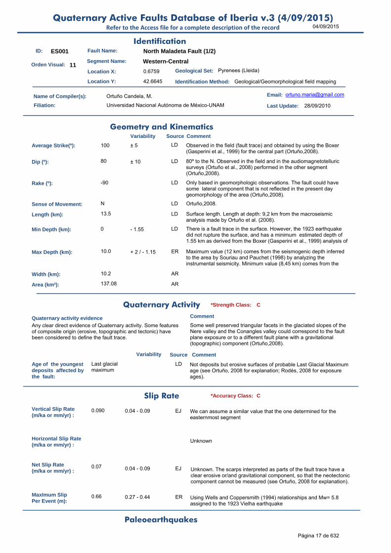
ID: ES001 Fault Name: North Maladeta Fault (1/2)
Segment Name: Western-Central
Location X: 0.6759
Location Y: 42.6645
Name of Compiler(s): Ortuño Candela, M.
Filiation: Universidad Nacional Autónoma de México-UNAM
Email: [email protected]
Last Update: 28/09/2010
Average Strike(º): 100 ± 5 LD Observed in the field (fault trace) and obtained by using the Boxer (Gasperini et al., 1999) for the central part (Ortuño,2008).
Dip (º): 80 ± 10 LD 80º to the N. Observed in the field and in the audiomagnetotelluric surveys (Ortuño et al., 2008) performed in the other segment (Ortuño,2008).
Rake (º): -90 LD Only based in geomorphologic observations. The fault could have some lateral component that is not reflected in the present day geomorphology of the area (Ortuño,2008).
Sense of Movement: N LD Ortuño,2008.
Length (km): 13.5 LD Surface length. Length at depth: 9,2 km from the macroseismic analysis made by Ortuño et al. (2008).
Min Depth (km): 0 - 1.55 LD There is a fault trace in the surface. However, the 1923 earthquake did not rupture the surface, and has a minimum estimated depth of 1.55 km as derived from the Boxer (Gasperini et al., 1999) analysis of
Max Depth (km): 10.0 + 2 / - 1.15 ER Maximum value (12 km) comes from the seismogenic depth inferred to the area by Souriau and Pauchet (1998) by analyzing the instrumental seismicity. Minimum value (8,45 km) comes from the
Width (km): 10.2 AR
Area (km²): 137.08 AR
Age of the youngestdeposits affected bythe fault:
Last glacial maximum
LD Not deposits but erosive surfaces of probable Last Glacial Maximum age (see Ortuño, 2008 for explanation; Rodés, 2008 for exposure ages).
Vertical Slip Rate(m/ka or mm/yr) :
0.090 0.04 - 0.09 EJ We can assume a similar value that the one determined for the easternmost segment
Horizontal Slip Rate(m/ka or mm/yr) :
Unknown
Net Slip Rate(m/ka or mm/yr) :
0.07 0.04 - 0.09 EJ Unknown. The scarps interpreted as parts of the fault trace have a clear erosive or/and gravitational component, so that the neotectonic component cannot be measured (see Ortuño, 2008 for explanation).
MaxImum Slip Per Event (m):
0.66 0.27 - 0.44 ER Using Wells and Coppersmith (1994) relationships and Mw= 5.8 assigned to the 1923 Vielha earthquake
Identification
Geometry and KinematicsVariability Source Comment
Quaternary Activity
Variability Source
Comment
Any clear direct evidence of Quaternary activity. Some features of composite origin (erosive, topographic and tectonic) have been considered to define the fault trace.
Some well preserved triangular facets in the glaciated slopes of the Nere valley and the Conangles valley could correspond to the fault plane exposure or to a different fault plane with a gravitational (topographic) component (Ortuño,2008).
Geological Set: Pyrenees (Lleida)
Identification Method: Geological/Geomorphological field mapping
Comment
Quaternary activity evidence
C*Strength Class:
Slip Rate *Accuracy Class: C
Paleoearthquakes
Orden Visual: 11
Página 17 de 632

04/09/2015Quaternary Active Faults Database of Iberia v.3 (4/09/2015)
Refer to the Access file for a complete description of the record
Number of SeismicEvents:
1 19th November 1923
Evidence of AseismicCreep:
OD No
Maximun Magnitude(Mw):
6.52 ± 0.37 ER Magnitude from length using Stirling et al. (2002) equation derived from the instrumental dataset.
RecurrenceInterval (years) :
23798 5157-149476 AR Considering the Maximum Earthquake Model (Wesnousky, 1986). It can also be 30,8 - 69,4 ka using the Brune (1968) relationships, Stirling et al. (2002) SRL derived magnitudes and the SR inferred for the other segment (Ortuño, 2008).
Date of Last MaximumEarthquake (years) :
1923 LD Historic earthquake, see Susagna et al. (1994) and Ortuño et al. (2008).
Extended Information: EXTENDED_INFORMATION\ES001-ES002.rar
Brune, J.N., 1968. Seismic moment, seismicity, and rate of slip along major fault zones. Journal of Geophysical Research 73, 777-784.
Ortuño, M. (2008). Deformación activa en el Pirineo Central: la falla Norte de la Maladeta y otras fallas activas. Tesis doctoral, Univ. De Barcelona, 346 pp.
Ortuño, M., Queralt, P., Martí, A., Ledo, J., Masana, E., Perea, H. & Santanach, P. (2008). The North Maladeta fault (Spanish Central Pyrenees) as the Vielha 1923 earthquakeseismic source: recent activity revealed by geomorphological and geophysical research. Tectonophysics (453), 246-262.
Ortuño and Perea, (2010). El terremoto de Vielha de 1923 (Pirineos Centrales): fuente sismogenética, variación del esfuerzo de Coulomb y distribución de la sismicidad posterior .In: Contribución de la Geología al Análisis de la Peligrosidad Sísmica (J.M. Insua y F. Martín‐González, eds.), pp.15‐18. Sigüenza (Guadalajara, Spain).
Rodés, A. (2008). La última deglaciación en los Pirineos: datación de superficies de exposición mediante 10Be, y modelado numérico de paleoglaciares. Tesis doctoral, Universitat de Barcelona. 238 pp.
Stirling, M., Rhoades, D. and Berryman K. (2002): Comparison of Earthquake Scaling Relations Derived from Data of the Instrumental and Preinstrumental Era. Bulletin of the Seismological Society of America, 92 (2): 812–830.
Susagna, T., Roca, A., Goula, X. & Batlló, J. (1994). Analysis of Macroseismic and Instrumental Data for the Study of the 19 November 1923 Earthquake in the Aran Valley (Central Pyrenees). Natural Hazards, 10, 7-17.
Wells, D.L. y Coppersmith, K.J., 1994; Empirical relationships among magnitude, rupture length, rupture area, and surface displacement. Bull. Seismol. Soc. Am., 82, 974-1002.
Wesnousky, S.G. (1986). Earthquakes, Quaternary faults, and seismic hazard in California. Journal of Geophysical Research. 91(B12), 12587-12631.
Seismic PotentialSource Comment
Associated Seismicity
Extended Data and References
References
Variability
*Reliability rating: D
*Reliability rating: D
Database of Seismicity Associated to QAFI v.3 FaultsRefer to the Access file for a complete description of the record
ID_Event Event name Date Location XY Int./Mag. Source Association Comment
ES001
Vielha earthquake 19th of November
1923
(0.7, 42.67) Imax = VIII; ML = 5.6
Susagna et al. (1994)
isoseist analysis and spacial correlation
5 km hipocenter, Susagna et al. (1994), Ortuño et al (2008) for seismogenesis. The epicentre obtained using the Gasperini et al. (1999) method slightly differs from this: (42.7 N, 0.778 E); having an associated Mw (from source dimensions) = 5,77
595
Página 18 de 632

04/09/2015Quaternary Active Faults Database of Iberia v.3 (4/09/2015)
Refer to the Access file for a complete description of the record
ID: ES002 Fault Name: North Maladeta fault (2/2)
Segment Name: Eastern
Location X: 0.836
Location Y: 42.668
Name of Compiler(s): Ortuño Candela, M.
Filiation: Universidad Nacional Autónoma de México-UNAM
Email: [email protected]
Last Update: 28/09/2010
Average Strike(º): 100 ± 5 LD Observed in the field (fault trace) (Ortuño,2008).
Dip (º): 80 ± 5 LD 80º to the N. Observed in the field and in the audiomagnetotelluric surveys (Ortuño et al., 2008)
Rake (º): -90 ± 5 LD Only based in geomorphologic observations. The fault could have some lateral component that is not reflected in the present day geomorphology of the area (Ortuño,2008).
Sense of Movement: N LD Ortuño,2008.
Length (km): 14.3 ± 0.010 LD Ortuño,2008.
Min Depth (km): 0 EJ Inferred from the surface displacement
Max Depth (km): 12.0 LD Maximum value (12 km) comes from the seismogenic depth inferred to the area by Souriau and Pauchet (1998) by analyzing the instrumental seismicity (Ortuño,2008).
Width (km): 12.2 AR
Area (km²): 149.43 AR
Age of the youngestdeposits affected bythe fault:
Late Neogene LD The Prüedo lacustrine deposits (Late Miocene, most probably vallesian age: 11.1 - 8. 7 Ma) were formed in a tectonic basin generated by the activity of this fault (Ortuño,2008).
Vertical Slip Rate(m/ka or mm/yr) :
0.090 0.04 - 0.09 LD Triangular facets, erosion surfaces displaced and dated by lacustrine deposits on top (489 m/11.1 - 8,7 Ma)((Ortuño,2008)). The maximum value is preferred because it is more conservative.
Horizontal Slip Rate(m/ka or mm/yr) :
Unknown
Net Slip Rate(m/ka or mm/yr) :
0.07 0.04 - 0.09 EJ Unknown, the fault could have some lateral component that is not reflected in the present day geomorphology of the area. No free surface have been observed.
MaxImum Slip Per Event (m):
0.463 +0.145/-0.111 ER Using Wells and Coppersmith (1994) and a Mw = 6.2, estimated for the Ribagorça (1373) earthquake, possibly generated by this fault segment (among other possible sources).
Number of SeismicEvents:
1 LD The Ribagorça (1373) earthquake, possibly generated by this fault segment (among other possible sources) (Ortuño,2008).
Identification
Geometry and KinematicsVariability Source Comment
Quaternary Activity
Variability Source
Comment
Any clear direct evidence of Quaternary activity. Some features of composite origin (erosive, topographic and tectonic) have been considered to define the fault trace.
Ortuño (2008).
Geological Set: Pyrenees (Lleida)
Identification Method: Geological/Geomorphological field mapping
Comment
Quaternary activity evidence
C*Strength Class:
Slip Rate *Accuracy Class: C
Paleoearthquakes
Orden Visual: 12
Página 19 de 632

04/09/2015Quaternary Active Faults Database of Iberia v.3 (4/09/2015)
Refer to the Access file for a complete description of the record
Evidence of AseismicCreep:
Unknown
Maximun Magnitude(Mw):
6.55 ± 0.37 ER Magnitude from length using Stirling et al. (2002) equation derived from the instrumental dataset. The Mw is 6.30 using Wells and Coppersmith (1994) and a surface length of 12.263 km
RecurrenceInterval (years) :
Unknown, although a rough estimate using the Brune (1968) relationships and indirect data leads to values between (35,2 - 79,2) ka, using Stirling et al. (2002) SRL derived magnitudes and the slip rate inferred for the other segment (Ortuño, 2008).
Date of Last MaximumEarthquake (years) :
1373 Historic earthquake (Olivera et al., 2006) that might be produced by this fault (Ortuño, 2008)
Extended Information: EXTENDED_INFORMATION\ES001-ES002.rar
Brune, J.N., 1968. Seismic moment, seismicity, and rate of slip along major fault zones. Journal of Geophysical Research 73, 777-784.
Olivera, C., Redondo, E., Lambert, J., Riera Melis, A. y Roca, A., 2006. Els terratrèmols dels segles XIV i XV a Catalunya. Institut Cartogràfic de Catalunya, Monografies nº30,407 pp.
Ortuño, M. (2008). Deformación activa en el Pirineo Central: la falla Norte de la Maladeta y otras fallas activas. Tesis doctoral, Univ. De Barcelona, 346 pp.
Ortuño, M., Queralt, P., Martí, A., Ledo, J., Masana, E., Perea, H. & Santanach, P. (2008). The North Maladeta fault (Spanish Central Pyrenees) as the Vielha 1923 earthquakeseismic source: recent activity revealed by geomorphological and geophysical research. Tectonophysics (453), 246-262.
Stirling, M., Rhoades, D. and Berryman K. (2002): Comparison of Earthquake Scaling Relations Derived from Data of the Instrumental and Preinstrumental Era. Bulletin of the Seismological Society of America, 92 (2): 812–830.
Wells, D.L. y Coppersmith, K.J., 1994; Empirical relationships among magnitude, rupture length, rupture area, and surface displacement. Bull. Seismol. Soc. Am., 82, 974-1002.
Seismic PotentialSource Comment
Associated Seismicity
Extended Data and References
References
Variability
*Reliability rating: D
*Reliability rating: D
Database of Seismicity Associated to QAFI v.3 FaultsRefer to the Access file for a complete description of the record
ID_Event Event name Date Location XY Int./Mag. Source Association Comment
ES002
The Ribagorça earthquake
3th March 1373
(0.683 , 42,633)
Imax = VIII - IX; M = 6.2
Olivera et al. (2006)
epicentral area and spacial correlation
This segment of the North Maladeta fault is among the possible seismic sources of this event. Other possible sources are the Coronas fault and faults in the Rius-Cabanes fault system (see Ortuño, 2008 for further information)
596
Página 20 de 632

04/09/2015Quaternary Active Faults Database of Iberia v.3 (4/09/2015)
Refer to the Access file for a complete description of the record
ID: ES003 Fault Name: Coronas
Segment Name:
Location X: 0.60394462
Location Y: 42.66733179
Name of Compiler(s): Ortuño Candela, M.
Filiation: Universidad Nacional Autónoma de México-UNAM
Email: [email protected]
Last Update: 28/09/2010
Average Strike(º): 140 ± 5 LD Ortuño, 2008
Dip (º): 80 ± 10 LD 80º to the N. Geologic data (Ortuño,2008).
Rake (º): -80 ± 5 LD A left-lateral minor component is inferred from the analysis of the geodynamical features observed in other associated secondary faults (Ortuño, 2008).
Sense of Movement: N LD Ortuño,2008.
Length (km): 10.2 LD Ortuño,2008.
Min Depth (km): 0 LD Inferred from the displacement of the surface (Ortuño,2008).
Max Depth (km): 12.0 LD Maximum value (12 km) comes from the seismogenic depth inferred to the area by Souriau and Pauchet (1998) by analyzing the instrumental seismicity (Ortuño,2008).
Width (km): 12.2 AR
Area (km²): 124.65 AR
Age of the youngestdeposits affected bythe fault:
20 ky ± 3 ky EJ Last Glacial Maximum (see Ortuño,2008).
Vertical Slip Rate(m/ka or mm/yr) :
0.090 0.04 to 0.09 LD Estimation from proximity and similarities to North Maladeta Fault. 1.2 m/ka is a overestimation considering the maximum offset (150m) accumulated since 125 ka ago, although it could be longer ago. Part of this slip is expected to be gravitational.
Horizontal Slip Rate(m/ka or mm/yr) :
0.016 0.007 to 0.016 AR Relationship between NSR and rake
Net Slip Rate(m/ka or mm/yr) :
0.093 0.041 to 0.093 AR Relationship between VSR, dip and rake
MaxImum Slip Per Event (m):
Unknown
Number of SeismicEvents:
Unknown
Identification
Geometry and KinematicsVariability Source Comment
Quaternary Activity
Variability Source
Comment
Offset of glacial erosion surfaces at the Ballibierna valley (Huesca)
This fault has probably displaced the northern slope of the Ballibierna valley (Huesca) by some meters. The present day offset (almost 200 m at some parts) seem to have a gravitational component. See Ortuño (2008) for further information.
Geological Set: Pyrenees (Huesca-Lleida)
Identification Method: Geological/Geomorphological field mapping
Comment
Quaternary activity evidence
C*Strength Class:
Slip Rate *Accuracy Class: C
Paleoearthquakes
Orden Visual: 13
Página 21 de 632

04/09/2015Quaternary Active Faults Database of Iberia v.3 (4/09/2015)
Refer to the Access file for a complete description of the record
Evidence of AseismicCreep:
LD There are several evidences of aseismic creep. This creep, however, is not tectonic by due to a topographic instability. The Aneto massif seems to be collapsing towards the north along part of a tectonic fault. See Ortuño (2008) for further information.
Maximun Magnitude(Mw):
6.41 ± 0.37 ER Magnitude from length using Stirling et al. (2002) equation derived from the instrumental dataset. The Mw is 6.3 using Wells and Coppersmith (1994) and a surface length of 10.23 km
RecurrenceInterval (years) :
13212 107562-3681 AR Considering the Maximum Earthquake Model (Wesnousky, 1986): slip rate represents the rate at which maximum earthquakes are released by the fault. RI = Mo f(Mw±d) / Mo f(SR±d). The occurrence of smaller, damaging earthquakes may be much shorter.
Date of Last MaximumEarthquake (years) :
1373 LD Historic earthquake (Olivera et al., 2006) that might be produced by this fault (Ortuño, 2008)
Extended Information: EXTENDED_INFORMATION\ES003.rar
Olivera, C., Redondo, E., Lambert, J., Riera Melis, A. y Roca, A., 2006. Els terratrèmols dels segles XIV i XV a Catalunya. Institut Cartogràfic de Catalunya, Monografies nº30, 407 pp.
Ortuño, M. (2008). Deformación activa en el Pirineo Central: la falla Norte de la Maladeta y otras fallas activas. Tesis doctoral, Univ. de Barcelona, 346 pp.
Stirling, M., Rhoades, D. and Berryman K. (2002): Comparison of Earthquake Scaling Relations Derived from Data of the Instrumental and Preinstrumental Era. Bulletin of the Seismological Society of America, 92 (2): 812–830.
Wells, D.L. y Coppersmith, K.J., 1994; Empirical relationships among magnitude, rupture length, rupture area, and surface displacement. Bull. Seismol. Soc. Am., 82, 974-1002.
Wesnousky, S.G. (1986). Earthquakes, Quaternary faults, and seismic hazard in California. Journal of Geophysical Research. 91(B12), 12587-12631.
Seismic PotentialSource Comment
Associated Seismicity
Extended Data and References
References
Variability
*Reliability rating: D
*Reliability rating: D
Database of Seismicity Associated to QAFI v.3 FaultsRefer to the Access file for a complete description of the record
ID_Event Event name Date Location XY Int./Mag. Source Association Comment
ES003
The Ribagorça earthquake
3th March 1373
(0.683 , 42,633)
Imax = VIII - IX; M = 6.2
Olivera et al. (2006)
epicentral area and spacial correlation
This fault is among the possible seismic sources of this event. Other possible sources are the North Maladeta fault and faults in the Rius-Cabanes fault system (see Ortuño, 2008 for further information).
597
Página 22 de 632
04/09/2015Quaternary Active Faults Database of Iberia v.3 (4/09/2015)
Refer to the Access file for a complete description of the record
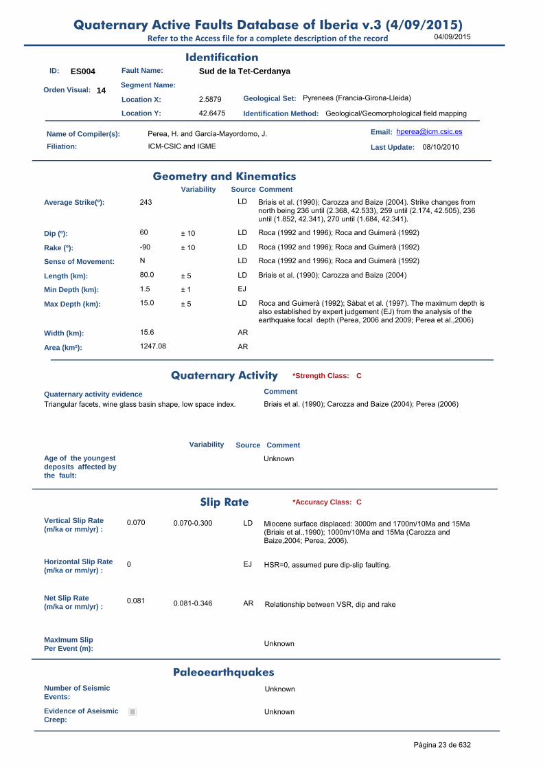
ID: ES004 Fault Name: Sud de la Tet-Cerdanya
Segment Name:
Location X: 2.5879
Location Y: 42.6475
Name of Compiler(s): Perea, H. and García-Mayordomo, J.
Filiation: ICM-CSIC and IGME
Email: [email protected]
Last Update: 08/10/2010
Average Strike(º): 243 LD Briais et al. (1990); Carozza and Baize (2004). Strike changes from north being 236 until (2.368, 42.533), 259 until (2.174, 42.505), 236 until (1.852, 42.341), 270 until (1.684, 42.341).
Dip (º): 60 ± 10 LD Roca (1992 and 1996); Roca and Guimerà (1992)
Rake (º): -90 ± 10 LD Roca (1992 and 1996); Roca and Guimerà (1992)
Sense of Movement: N LD Roca (1992 and 1996); Roca and Guimerà (1992)
Length (km): 80.0 ± 5 LD Briais et al. (1990); Carozza and Baize (2004)
Min Depth (km): 1.5 ± 1 EJ
Max Depth (km): 15.0 ± 5 LD Roca and Guimerà (1992); Sàbat et al. (1997). The maximum depth is also established by expert judgement (EJ) from the analysis of the earthquake focal depth (Perea, 2006 and 2009; Perea et al.,2006)
Width (km): 15.6 AR
Area (km²): 1247.08 AR
Age of the youngestdeposits affected bythe fault:
Unknown
Vertical Slip Rate(m/ka or mm/yr) :
0.070 0.070-0.300 LD Miocene surface displaced: 3000m and 1700m/10Ma and 15Ma (Briais et al.,1990); 1000m/10Ma and 15Ma (Carozza and Baize,2004; Perea, 2006).
Horizontal Slip Rate(m/ka or mm/yr) :
0 EJ HSR=0, assumed pure dip-slip faulting.
Net Slip Rate(m/ka or mm/yr) :
0.081 0.081-0.346 AR Relationship between VSR, dip and rake
MaxImum Slip Per Event (m):
Unknown
Number of SeismicEvents:
Unknown
Evidence of AseismicCreep:
Unknown
Identification
Geometry and KinematicsVariability Source Comment
Quaternary Activity
Variability Source
Comment
Triangular facets, wine glass basin shape, low space index. Briais et al. (1990); Carozza and Baize (2004); Perea (2006)
Geological Set: Pyrenees (Francia-Girona-Lleida)
Identification Method: Geological/Geomorphological field mapping
Comment
Quaternary activity evidence
C*Strength Class:
Slip Rate *Accuracy Class: C
Paleoearthquakes
Orden Visual: 14
Página 23 de 632

04/09/2015Quaternary Active Faults Database of Iberia v.3 (4/09/2015)
Refer to the Access file for a complete description of the record
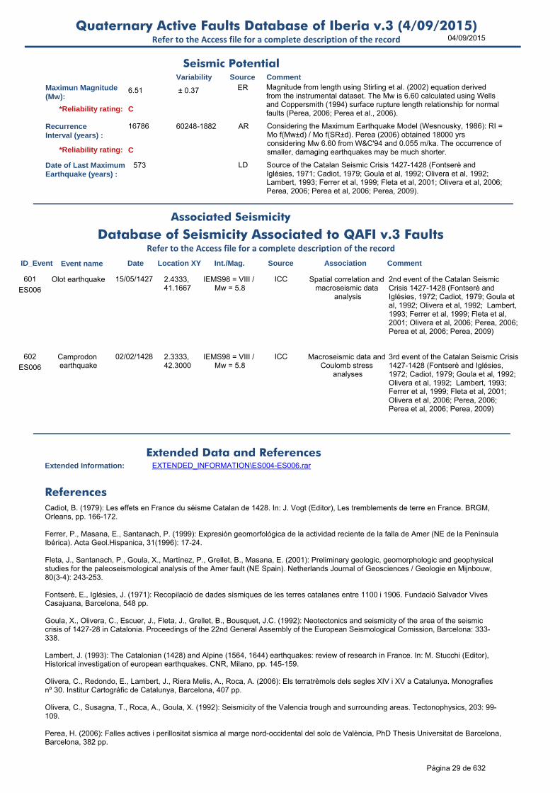
Maximun Magnitude(Mw):
7.26 ± 0.37 ER Magnitude from length using Stirling et al. (2002) equation derived from the instrumental dataset. The Mw is 7.40 calculated using Wells and Coppersmith (1994) surface rupture length relationship for normal faults (Perea, 2006; Perea et al., 2006).
RecurrenceInterval (years) :
28538 102431-1861 AR Considering the Maximum Earthquake Model (Wesnousky, 1986): RI = Mo f(Mw±d) / Mo f(SR±d). Perea (2006) obtained 54000 yrs considering Mw 7.40 from W&C'94 and 0.07 m/ka. The occurrence of smaller, damaging earthquakes may be much shorter.
Date of Last MaximumEarthquake (years) :
Unknown
Extended Information: EXTENDED_INFORMATION\ES004-ES006.rar
Briais, A., Armijo, R., Winter, T., Tapponnier, P., Herbecq, A. (1990): Morphological evidence for Quaternary normal faulting and seismic hazard in the Eastern Pyrenees. Annales Tectonicae, 4(1), 19-42.
Carozza, J.-M., Baize, S. (2004): L'escarpement de la Têt est-il le résultat de la tectonique active Plio-Pléistocène? C.R.Geoscience, 336, 217-226.
Perea, H. (2006): Falles actives i perillositat sísmica al marge nord-occidental del solc de València, PhD Thesis Universitat de Barcelona, Barcelona, 382 pp.
Perea, H. (2009): The Catalan seismic crisis (1427 and 1428; NE Iberian Peninsula): Geological sources and earthquake triggering. Journal of Geodynamics, 47, 259-270.
Perea, H., Masana, E., Santanach, P. (2006): A pragmatic approach to seismic parameters in a region with low seismicity: The case of eastern Iberia. Natural Hazards, 39(3): 451-477.
Roca, E. (1992): L'estructura de la Conca Catalano-Balear: paper de la compressió i de la distensió en la seva gènesi. PhD thesis, Universitat de Barcelona, pp. 330.
Roca, E. (1996): La evolución geodinámica de la Cuenca Catalano-Balear y áreas adyacentes desde el Mesozoico hasta la actualidad. Acta Geol. Hispanica 29(1994), 3-26.
Roca, E., Guimerà, J. (1992): The Neogene structure of the eastern Iberian margin: structural constrains on the crustal evolution of the València trough (western Mediterranean). Tectonophysics 203, 203-218.
Sàbat, F., Roca, E., Muñoz, J.A., Vergés, J., Sans, M., Masana, E., Santanach, P. Estévez, A., Santisteban, C. (1997): Role of extension and compression in the evolution of the eastern margin of Iberia: the ESCI-València Trough seismic profile. Rev. Soc. Geol. España 8 (1995), 431-448.
Simón, J.L. (1984): Compresión y distensión alpinas en la Cadena Ibérica oriental. Instituto de Estudios Turolenses-CSIC, pp. 172.
Stirling, M., Rhoades, D. and Berryman K. (2002): Comparison of Earthquake Scaling Relations Derived from Data of the Instrumental and Preinstrumental Era. Bulletin of the Seismological Society of America, 92 (2): 812–830.
Wells, D.L., Coppersmith, K.J. (1994): New empirical relationships among magnitude, rupture length, rupture width, rupture area, and surface displacement. Bulletin of the Seismological Society of America 84 (4), 974–1002.
Wesnousky, S. G. (1986): Earthquakes, quaternary faults and seismic hazard in California. J. Geophys. Res. 91(B12), 12587–12631.
Seismic PotentialSource Comment
Associated Seismicity
Extended Data and References
References
Variability
*Reliability rating: D
*Reliability rating: D
Página 24 de 632

04/09/2015Quaternary Active Faults Database of Iberia v.3 (4/09/2015)
Refer to the Access file for a complete description of the record
ID: ES005 Fault Name: Amer (complete)
Segment Name:
Location X: 2.608
Location Y: 41.991
Name of Compiler(s): Perea, H.
Filiation: ICM-CSIC
Email: [email protected]
Last Update: 08/10/2010
Average Strike(º): 321 LD Saula et al. (1996); Ferrer et al. (1999). The strike of the fault is given following the direction that connects its tips. Note that the fault changes its direction at its middle point.
Dip (º): 60 ± 10 LD Saula et al. (1996)
Rake (º): -90 ± 10 LD Saula et al. (1996)
Sense of Movement: N LD Saula et al. (1996)
Length (km): 35.4 ± 0.5 LD Ferrer et al. (1999); Perea (2006); Perea et al. (2006)
Min Depth (km): 1.5 ± 1 EJ
Max Depth (km): 15.0 ± 5 LD The maximum depth is also established by expert judgement (EJ) from the analysis of the earthquake focal depth (Perea, 2006 and 2009; Perea et al.,2006)
Width (km): 15.6 AR
Area (km²): 551.83 AR
Age of the youngestdeposits affected bythe fault:
Unknown
Vertical Slip Rate(m/ka or mm/yr) :
0.055 0.045-0.138 LD Triangular facets and alluvial fan surface: 275m/5Ma and 2Ma (Ferrer et al., 1999; Perea, 2006; Perea et al., 2006)
Horizontal Slip Rate(m/ka or mm/yr) :
0 EJ HSR=0, assumed pure dip-slip faulting.
Net Slip Rate(m/ka or mm/yr) :
0.064 0.052-0.159 AR Relationship between VSR, dip and rake
MaxImum Slip Per Event (m):
Unknown
Number of SeismicEvents:
2 in last 573 yr
2-3 LD Fault responsible of at least 2, but probable, of the 3 earthquakes of the Catalan Seismic Crisis between 1427-1428 (Goula et al., 1992; Ferrer et al, 1999; Fleta et al., 2001; Perea, 2006; Perea et al., 2006; Perea, 2009)
Identification
Geometry and KinematicsVariability Source Comment
Quaternary Activity
Variability Source
Comment
Triangular facets, wine glass basin shape, low space index Ferrer et al. (1999); Perea (2006); Perea et al. (2010)
Geological Set: Pyrenees (Girona)
Identification Method: Geological/Geomorphological field mapping
Comment
Quaternary activity evidence
C+*Strength Class:
Slip Rate *Accuracy Class: C
Paleoearthquakes
Orden Visual: 15
Página 25 de 632

04/09/2015Quaternary Active Faults Database of Iberia v.3 (4/09/2015)
Refer to the Access file for a complete description of the record
Evidence of AseismicCreep:
Unknown
Maximun Magnitude(Mw):
6.92 ± 0.37 ER Magnitude from length using Stirling et al. (2002) equation derived from the instrumental dataset. The Mw is 6.90 calculated using Wells and Coppersmith (1994) surface rupture length relationship for normal faults (Perea, 2006; Perea et al., 2006).
RecurrenceInterval (years) :
25540 112823-2864 AR Considering the Maximum Earthquake Model (Wesnousky, 1986): RI = Mo f(Mw±d) / Mo f(SR±d). Perea (2006) obtained 27000 yrs considering Mw 6.90 from W&C'94 and 0.055 m/ka. The occurrence of smaller, damaging earthquakes may be much shorter.
Date of Last MaximumEarthquake (years) :
573 LD Source of the Catalan Seismic Crisis 1427-1428 (Fontserè and Iglésies, 1971; Cadiot, 1979; Goula et al, 1992; Olivera et al, 1992; Lambert, 1993; Ferrer et al, 1999; Fleta et al, 2001; Olivera et al, 2006; Perea, 2006; Perea et al, 2006; Perea, 2009)
Extended Information: EXTENDED_INFORMATION\ES004-ES006.rar
Cadiot, B. (1979): Les effets en France du séisme Catalan de 1428. In: J. Vogt (Editor), Les tremblements de terre en France. BRGM, Orleans, pp. 166-172.
Ferrer, P., Masana, E., Santanach, P. (1999): Expresión geomorfológica de la actividad reciente de la falla de Amer (NE de la Península Ibérica). Acta Geol.Hispanica, 31(1996): 17-24.
Fleta, J., Santanach, P., Goula, X., Martínez, P., Grellet, B., Masana, E. (2001): Preliminary geologic, geomorphologic and geophysical studies for the paleoseismological analysis of the Amer fault (NE Spain). Netherlands Journal of Geosciences / Geologie en Mijnbouw, 80(3-4): 243-253.
Fontserè, E., Iglésies, J. (1971): Recopilació de dades sísmiques de les terres catalanes entre 1100 i 1906. Fundació Salvador Vives Casajuana, Barcelona, 548 pp.
Goula, X., Olivera, C., Escuer, J., Fleta, J., Grellet, B., Bousquet, J.C. (1992): Neotectonics and seismicity of the area of the seismic crisis of 1427-28 in Catalonia. Proceedings of the 22nd General Assembly of the European Seismological Comission, Barcelona: 333-338.
Seismic PotentialSource Comment
Associated Seismicity
Extended Data and References
References
Variability
*Reliability rating: C
*Reliability rating: C
Database of Seismicity Associated to QAFI v.3 FaultsRefer to the Access file for a complete description of the record
ID_Event Event name Date Location XY Int./Mag. Source Association Comment
ES005
Amer earthquake 19/03/1427 2.5833, 41.9833
IEMS98 = VIII / Mw = 5.9
ICC Spatial correlation and macroseismic data
analysis
1st event of the Catalan Seismic Crisis 1427-1428 (Fontserè and Iglésies, 1972; Cadiot, 1979; Goula et al, 1992; Olivera et al, 1992; Lambert, 1993; Ferrer et al, 1999; Fleta et al, 2001; Olivera et al, 2006; Perea, 2006; Perea et al, 2006; Perea, 2009)
598
ES005
Olot earthquake 15/05/1427 2.4333, 41.1667
IEMS98 = VIII / Mw = 5.8
ICC Spatial correlation and macroseismic data
analysis
2nd event of the Catalan Seismic Crisis 1427-1428 (Fontserè and Iglésies, 1972; Cadiot, 1979; Goula et al, 1992; Olivera et al, 1992; Lambert, 1993; Ferrer et al, 1999; Fleta et al, 2001; Olivera et al, 2006; Perea, 2006; Perea et al, 2006; Perea, 2009)
599
ES005
Camprodon earthquake
02/02/1428 2.3333, 42.3000
IEMS98 = VIII / Mw = 5.8
ICC Macroseismic data and Coulomb stress
analyses
3rd event of the Catalan Seismic Crisis 1427-1428 (Fontserè and Iglésies, 1972; Cadiot, 1979; Goula et al, 1992; Olivera et al, 1992; Lambert, 1993; Ferrer et al, 1999; Fleta et al, 2001; Olivera et al, 2006; Perea, 2006; Perea et al, 2006; Perea, 2009)
600
Página 26 de 632

04/09/2015Quaternary Active Faults Database of Iberia v.3 (4/09/2015)
Refer to the Access file for a complete description of the record
Lambert, J. (1993): The Catalonian (1428) and Alpine (1564, 1644) earthquakes: review of research in France. In: M. Stucchi (Editor), Historical investigation of european earthquakes. CNR, Milano, pp. 145-159.
Olivera, C., Redondo, E., Lambert, J., Riera Melis, A., Roca, A. (2006): Els terratrèmols dels segles XIV i XV a Catalunya. Monografies nº 30. Institur Cartogràfic de Catalunya, Barcelona, 407 pp.
Olivera, C., Susagna, T., Roca, A., Goula, X. (1992): Seismicity of the Valencia trough and surrounding areas. Tectonophysics, 203: 99-109.
Perea, H. (2006): Falles actives i perillositat sísmica al marge nord-occidental del solc de València, PhD Thesis Universitat de Barcelona, Barcelona, 382 pp.
Perea, H. (2009): The Catalan seismic crisis (1427 and 1428; NE Iberian Peninsula): Geological sources and earthquake triggering. Journal of Geodynamics, 47, 259-270.
Perea, H., Masana, E., Santanach, P. (2006): A pragmatic approach to seismic parameters in a region with low seismicity: The case of eastern Iberia. Natural Hazards, 39(3): 451-477.
Perea, H., Masana, E. and Santanach, P. (2010): Geomorphological features of mountain fronts controlled by low slip extensional faults: the northweastern margin of the València trough. In: Contribución de la geología al análisis de la peligrosidad sísmica (Insua, J.M. and Martín-González, F., eds.). 19-22.
Saula, E., Picart, J., Mató, E., Llenas, M., Losantos, M., Berástegui, X., Agustí, J. (1996): Evolución geodinámica de la fosa del Empordà y las Sierras Transversales. Acta Geológica Hispánica 29 (2–4 (1994)), 55–75.
Stirling, M., Rhoades, D. and Berryman K. (2002): Comparison of Earthquake Scaling Relations Derived from Data of the Instrumental and Preinstrumental Era. Bulletin of the Seismological Society of America, 92 (2): 812–830.
Wells, D.L., Coppersmith, K.J. (1994): New empirical relationships among magnitude, rupture length, rupture width, rupture area, and surface displacement. Bulletin of the Seismological Society of America 84 (4), 974–1002.
Wesnousky, S. G. (1986): Earthquakes, quaternary faults and seismic hazard in California. J. Geophys. Res. 91(B12), 12587–12631.
Página 27 de 632

04/09/2015Quaternary Active Faults Database of Iberia v.3 (4/09/2015)
Refer to the Access file for a complete description of the record
ID: ES006 Fault Name: Amer (1/2)
Segment Name: Amer norte
Location X: 2.467
Location Y: 42.088
Name of Compiler(s): Perea, H.
Filiation: ICM-CSIC
Email: [email protected]
Last Update: 08/10/2010
Average Strike(º): 335 LD Saula et al. (1996); Ferrer et al. (1999). Note that the fault changes its strike at (2.4337,42.1177) from 321 (to the south) to 357 (to the north).
Dip (º): 60 ± 10 LD Saula et al. (1996)
Rake (º): -90 ± 10 LD Saula et al. (1996)
Sense of Movement: N LD Saula et al. (1996)
Length (km): 13.2 ± 0.5 LD Ferrer et al. (1999); Perea (2006); Perea et al. (2006)
Min Depth (km): 1.5 ± 1 EJ
Max Depth (km): 15.0 ± 5 LD The maximum depth is also established by expert judgement (EJ) from the analysis of the earthquake focal depth (Perea, 2006 and 2009; Perea et al.,2006)
Width (km): 15.6 AR
Area (km²): 205.86 AR
Age of the youngestdeposits affected bythe fault:
Unknown
Vertical Slip Rate(m/ka or mm/yr) :
0.055 0.055-0.138 LD Triangular facets and alluvial fan surface: 275m/5Ma and 2Ma (Ferrer et al., 1999; Perea, 2006; Perea et al., 2006)
Horizontal Slip Rate(m/ka or mm/yr) :
0 EJ HSR=0, assumed pure dip-slip faulting.
Net Slip Rate(m/ka or mm/yr) :
0.064 0.064-0.159 AR Relationship between VSR, dip and rake
MaxImum Slip Per Event (m):
Unknown
Number of SeismicEvents:
1 in last 573 yr
1-2 LD Fault responsible of at least 1, an probable 2, of the 3 earthquakes of the Catalan Seismic Crisis between 1427-1428 (Goula et al., 1992; Ferrer et al, 1999; Fleta et al., 2001; Perea, 2006; Perea et al., 2006; Perea, 2009)
Evidence of AseismicCreep:
Unknown
Identification
Geometry and KinematicsVariability Source Comment
Quaternary Activity
Variability Source
Comment
Triangular facets, wine glass basin shape, low space index Ferrer et al. (1999); Perea (2006); Perea et al. (2010)
Geological Set: Pyrenees (Girona)
Identification Method: Geological/Geomorphological field mapping
Comment
Quaternary activity evidence
C+*Strength Class:
Slip Rate *Accuracy Class: C
Paleoearthquakes
Orden Visual: 16
Página 28 de 632
04/09/2015Quaternary Active Faults Database of Iberia v.3 (4/09/2015)
Refer to the Access file for a complete description of the record
Maximun Magnitude(Mw):
6.51 ± 0.37 ER Magnitude from length using Stirling et al. (2002) equation derived from the instrumental dataset. The Mw is 6.60 calculated using Wells and Coppersmith (1994) surface rupture length relationship for normal faults (Perea, 2006; Perea et al., 2006).
RecurrenceInterval (years) :
16786 60248-1882 AR Considering the Maximum Earthquake Model (Wesnousky, 1986): RI = Mo f(Mw±d) / Mo f(SR±d). Perea (2006) obtained 18000 yrs considering Mw 6.60 from W&C'94 and 0.055 m/ka. The occurrence of smaller, damaging earthquakes may be much shorter.
Date of Last MaximumEarthquake (years) :
573 LD Source of the Catalan Seismic Crisis 1427-1428 (Fontserè and Iglésies, 1971; Cadiot, 1979; Goula et al, 1992; Olivera et al, 1992; Lambert, 1993; Ferrer et al, 1999; Fleta et al, 2001; Olivera et al, 2006; Perea, 2006; Perea et al, 2006; Perea, 2009).
Extended Information: EXTENDED_INFORMATION\ES004-ES006.rar
Cadiot, B. (1979): Les effets en France du séisme Catalan de 1428. In: J. Vogt (Editor), Les tremblements de terre en France. BRGM, Orleans, pp. 166-172.
Ferrer, P., Masana, E., Santanach, P. (1999): Expresión geomorfológica de la actividad reciente de la falla de Amer (NE de la Península Ibérica). Acta Geol.Hispanica, 31(1996): 17-24.
Fleta, J., Santanach, P., Goula, X., Martínez, P., Grellet, B., Masana, E. (2001): Preliminary geologic, geomorphologic and geophysical studies for the paleoseismological analysis of the Amer fault (NE Spain). Netherlands Journal of Geosciences / Geologie en Mijnbouw, 80(3-4): 243-253.
Fontserè, E., Iglésies, J. (1971): Recopilació de dades sísmiques de les terres catalanes entre 1100 i 1906. Fundació Salvador Vives Casajuana, Barcelona, 548 pp.
Goula, X., Olivera, C., Escuer, J., Fleta, J., Grellet, B., Bousquet, J.C. (1992): Neotectonics and seismicity of the area of the seismic crisis of 1427-28 in Catalonia. Proceedings of the 22nd General Assembly of the European Seismological Comission, Barcelona: 333-338.
Lambert, J. (1993): The Catalonian (1428) and Alpine (1564, 1644) earthquakes: review of research in France. In: M. Stucchi (Editor), Historical investigation of european earthquakes. CNR, Milano, pp. 145-159.
Olivera, C., Redondo, E., Lambert, J., Riera Melis, A., Roca, A. (2006): Els terratrèmols dels segles XIV i XV a Catalunya. Monografies nº 30. Institur Cartogràfic de Catalunya, Barcelona, 407 pp.
Olivera, C., Susagna, T., Roca, A., Goula, X. (1992): Seismicity of the Valencia trough and surrounding areas. Tectonophysics, 203: 99-109.
Perea, H. (2006): Falles actives i perillositat sísmica al marge nord-occidental del solc de València, PhD Thesis Universitat de Barcelona, Barcelona, 382 pp.
Seismic PotentialSource Comment
Associated Seismicity
Extended Data and References
References
Variability
*Reliability rating: C
*Reliability rating: C
Database of Seismicity Associated to QAFI v.3 FaultsRefer to the Access file for a complete description of the record
ID_Event Event name Date Location XY Int./Mag. Source Association Comment
ES006
Olot earthquake 15/05/1427 2.4333, 41.1667
IEMS98 = VIII / Mw = 5.8
ICC Spatial correlation and macroseismic data
analysis
2nd event of the Catalan Seismic Crisis 1427-1428 (Fontserè and Iglésies, 1972; Cadiot, 1979; Goula et al, 1992; Olivera et al, 1992; Lambert, 1993; Ferrer et al, 1999; Fleta et al, 2001; Olivera et al, 2006; Perea, 2006; Perea et al, 2006; Perea, 2009)
601
ES006
Camprodon earthquake
02/02/1428 2.3333, 42.3000
IEMS98 = VIII / Mw = 5.8
ICC Macroseismic data and Coulomb stress
analyses
3rd event of the Catalan Seismic Crisis 1427-1428 (Fontserè and Iglésies, 1972; Cadiot, 1979; Goula et al, 1992; Olivera et al, 1992; Lambert, 1993; Ferrer et al, 1999; Fleta et al, 2001; Olivera et al, 2006; Perea, 2006; Perea et al, 2006; Perea, 2009)
602
Página 29 de 632

04/09/2015Quaternary Active Faults Database of Iberia v.3 (4/09/2015)
Refer to the Access file for a complete description of the record
Perea, H. (2009): The Catalan seismic crisis (1427 and 1428; NE Iberian Peninsula): Geological sources and earthquake triggering. Journal of Geodynamics, 47, 259-270.
Perea, H., Masana, E., Santanach, P. (2006): A pragmatic approach to seismic parameters in a region with low seismicity: The case of eastern Iberia. Natural Hazards, 39(3): 451-477.
Perea, H., Masana, E. and Santanach, P. (2010): Geomorphological features of mountain fronts controlled by low slip extensional faults: the northweastern margin of the València trough. In: Contribución de la geología al análisis de la peligrosidad sísmica (Insua, J.M. and Martín-González, F., eds.). 19-22.
Saula, E., Picart, J., Mató, E., Llenas, M., Losantos, M., Berástegui, X., Agustí, J. (1996): Evolución geodinámica de la fosa del Empordà y las Sierras Transversales. Acta Geológica Hispánica 29 (2–4 (1994)), 55–75.
Stirling, M., Rhoades, D. and Berryman K. (2002): Comparison of Earthquake Scaling Relations Derived from Data of the Instrumental and Preinstrumental Era. Bulletin of the Seismological Society of America, 92 (2): 812–830.
Wells, D.L., Coppersmith, K.J. (1994): New empirical relationships among magnitude, rupture length, rupture width, rupture area, and surface displacement. Bulletin of the Seismological Society of America 84 (4), 974–1002.
Wesnousky, S. G. (1986): Earthquakes, quaternary faults and seismic hazard in California. J. Geophys. Res. 91(B12), 12587–12631.
Página 30 de 632

04/09/2015Quaternary Active Faults Database of Iberia v.3 (4/09/2015)
Refer to the Access file for a complete description of the record
ID: ES007 Fault Name: Amer (2/2)
Segment Name: Amer sur
Location X: 2.624
Location Y: 41.968
Name of Compiler(s): Perea, H., Bach, J. and Linares, R.
Filiation: IDL-U. de Lisboa and Grupo Geodinámica Externa-UAB
Email: [email protected]
Last Update: 08/10/2010
Average Strike(º): 315 LD Saula et al. (1996); Ferrer et al. (1999). Note that the fault changes its strike at (2.5268,42.0499) from 318 (to the south) to 310 (to the north).
Dip (º): 60 ± 10 LD Saula et al. (1996)
Rake (º): -90 ± 10 LD Saula et al. (1996)
Sense of Movement: N LD Saula et al. (1996)
Length (km): 16.1 ± 0.5 LD Ferrer et al. (1999); Perea (2006); Perea et al. (2006)
Min Depth (km): 1.5 ± 1 EJ
Max Depth (km): 15.0 ± 5 LD The maximum depth is also established by expert judgement (EJ) from the analysis of the earthquake focal depth (Perea, 2006 and 2009; Perea et al.,2006)
Width (km): 15.6 AR
Area (km²): 250.97 AR
Age of the youngestdeposits affected bythe fault:
Unknown
Vertical Slip Rate(m/ka or mm/yr) :
0.045 0.045-0.113 LD Triangular facets and alluvial fan surface: 225m/5Ma and 2Ma (Ferrer et al., 1999; Perea, 2006; Perea et al., 2006)
Horizontal Slip Rate(m/ka or mm/yr) :
0 EJ HSR=0, assumed pure dip-slip faulting.
Net Slip Rate(m/ka or mm/yr) :
0.052 0.052-0.130 AR Relationship between VSR, dip and rake
MaxImum Slip Per Event (m):
Unknown
Number of SeismicEvents:
1 in last 573 yr
LD Fault responsible of ´May 15ty earthquake of the Catalan Seismic Crisis between 1427-1428 (Goula et al., 1992; Ferrer et al, 1999; Fleta et al., 2001; Perea, 2006; Perea et al., 2006; Perea, 2009)
Evidence of AseismicCreep:
Unknown
Identification
Geometry and KinematicsVariability Source Comment
Quaternary Activity
Variability Source
Comment
Triangular facets, wine glass basin shape, low space index Ferrer et al. (1999); Perea (2006); Perea et al. (2010)
Geological Set: Pyrenees (Girona)
Identification Method: Geological/Geomorphological field mapping
Comment
Quaternary activity evidence
C+*Strength Class:
Slip Rate *Accuracy Class: C
Paleoearthquakes
Orden Visual: 17
Página 31 de 632

04/09/2015Quaternary Active Faults Database of Iberia v.3 (4/09/2015)
Refer to the Access file for a complete description of the record
Maximun Magnitude(Mw):
6.60 ± 0.37 ER Magnitude from length using Stirling et al. (2002) equation derived from the instrumental dataset. The Mw is 6.50 calculated using Wells and Coppersmith (1994) surface rupture length relationship for normal faults (Perea, 2006; Perea et al., 2006).
RecurrenceInterval (years) :
22490 80720-2506 AR Considering the Maximum Earthquake Model (Wesnousky, 1986): RI = Mo f(Mw±d) / Mo f(SR±d). Perea (2006) obtained 18000 yrs considering Mw 6.50 from W&C'94 and 0.045 m/ka. The occurrence of smaller, damaging earthquakes may be much shorter.
Date of Last MaximumEarthquake (years) :
573 LD Source of the Catalan Seismic Crisis 1427-1428 (Fontserè and Iglésies, 1971; Cadiot, 1979; Goula et al, 1992; Olivera et al, 1992; Lambert, 1993; Ferrer et al, 1999; Fleta et al, 2001; Olivera et al, 2006; Perea, 2006; Perea et al, 2006; Perea, 2009).
Extended Information:
Cadiot, B. (1979): Les effects en France du séisme Catalan de 1428. In: J. Vogt (Editor), Les tremblements de terre en France. BRGM, Orleans, pp. 166-172.
Ferrer, P., Masana, E., Santanach, P. (1999): Expresión geomorfológica de la actividad reciente de la falla de Amer (NE de la Península Ibérica). Acta Geol.Hispanica, 31(1996): 17-24.
Fleta, J., Santanach, P., Goula, X., Martínez, P., Grellet, B., Masana, E. (2001): Preliminary geologic, geomorphologic and geophysical studies for the paleoseismological analysis of the Amer fault (NE Spain). Netherlands Journal of Geosciences / Geologie en Mijnbouw, 80(3-4): 243-253.
Fontserè, E., Iglésies, J. (1971): Recopilació de dades sísmiques de les terres catalanes entre 1100 i 1906. Fundació Salvador Vives Casajuana, Barcelona, 548 pp.
Goula, X., Olivera, C., Escuer, J., Fleta, J., Grellet, B., Bousquet, J.C. (1992): Neotectonics and seismicity of the area of the seismic crisis of 1427-28 in Catalonia. Proceedings of the 22nd General Assembly of the European Seismological Comission, Barcelona: 333-338.Lambert, J. (1993): The Catalonian (1428) and Alpine (1564, 1644) earthquakes: review of research in France. In: M. Stucchi (Editor), Historical investigation of european earthquakes. CNR, Milano, pp. 145-159.
Olivera, C., Redondo, E., Lambert, J., Riera Melis, A., Roca, A. (2006): Els terratrèmols dels segles XIV i XV a Catalunya. Monografies nº 30. Institur Cartogràfic de Catalunya, Barcelona, 407 pp.
Olivera, C., Susagna, T., Roca, A., Goula, X. (1992): Seismicity of the Valencia trough and surrounding areas. Tectonophysics, 203: 99-109.
Perea, H. (2006): Falles actives i perillositat sísmica al marge nord-occidental del solc de València, PhD Thesis Universitat de Barcelona, Barcelona, 382 pp.
Perea, H. (2009): The Catalan seismic crisis (1427 and 1428; NE Iberian Peninsula): Geological sources and earthquake triggering. Journal of Geodynamics, 47, 259-270.
Perea, H., Masana, E., Santanach, P. (2006): A pragmatic approach to seismic parameters in a region with low seismicity: The case of eastern Iberia. Natural Hazards, 39(3): 451-477.
Perea, H., Masana, E. and Santanach, P. (2010): Geomorphological features of mountain fronts controlled by low slip extensional faults: the northweastern margin of the València trough. In: Contribución de la geología al análisis de la peligrosidad sísmica (Insua, J.M. and Martín-González, F., eds.). 19-22.
Saula, E., Picart, J., Mató, E., Llenas, M., Losantos, M., Berástegui, X., Agustí, J. (1996): Evolución geodinámica de la fosa del Empordà
Seismic PotentialSource Comment
Associated Seismicity
Extended Data and References
References
Variability
*Reliability rating: C
*Reliability rating: C
Database of Seismicity Associated to QAFI v.3 FaultsRefer to the Access file for a complete description of the record
ID_Event Event name Date Location XY Int./Mag. Source Association Comment
ES007
Amer earthquake 19/03/1427 2.5833, 41.9833
IEMS98 = VIII / Mw = 5.9
ICC Spatial correlation and macroseismic data
analysis
1st event of the Catalan Seismic Crisis 1427-1428 (Fontserè and Iglésies, 1972; Cadiot, 1979; Goula et al, 1992; Olivera et al, 1992; Lambert, 1993; Ferrer et al, 1999; Fleta et al, 2001; Olivera et al, 2006; Perea, 2006; Perea et al, 2006; Perea, 2009)
603
Página 32 de 632

04/09/2015Quaternary Active Faults Database of Iberia v.3 (4/09/2015)
Refer to the Access file for a complete description of the record
y las Sierras Transversales. Acta Geológica Hispánica 29 (2–4 (1994)), 55–75.
Stirling, M., Rhoades, D. and Berryman K. (2002): Comparison of Earthquake Scaling Relations Derived from Data of the Instrumental and Preinstrumental Era. Bulletin of the Seismological Society of America, 92 (2): 812–830.
Wells, D.L., Coppersmith, K.J. (1994): New empirical relationships among magnitude, rupture length, rupture width, rupture area, and surface displacement. Bulletin of the Seismological Society of America 84 (4), 974–1002.
Wesnousky, S. G. (1986): Earthquakes, quaternary faults and seismic hazard in California. J. Geophys. Res. 91(B12), 12587–12631.
Página 33 de 632

04/09/2015Quaternary Active Faults Database of Iberia v.3 (4/09/2015)
Refer to the Access file for a complete description of the record
ID: ES008 Fault Name: El Camp (complete)
Segment Name:
Location X: 0.8764
Location Y: 40.9735
Name of Compiler(s): Perea, H.
Filiation: ICM-CSIC
Email: [email protected]
Last Update: 08/10/2010
Average Strike(º): 035 LD Masana (1994, 1995 and 1996); Perea (2006); Perea et al. (2006). Note that the fault changes its strike at (1.1032, 41.1798) from 060 (to the south) to 030 (to the north) and at (0.9748, 41.1258) from 025 (to the south) to 060 (to the north).
Dip (º): 60 ± 10 LD Roca (1992 and 1996); Roca and Guimerà (1992)
Rake (º): -90 ± 10 LD Roca (1992 and 1996); Roca and Guimerà (1992)
Sense of Movement: N LD Roca (1992 and 1996); Roca and Guimerà (1992)
Length (km): 41.1 ± 0.5 LD Masana (1994, 1995 and 1996); Perea (2006); Perea et al. (2006)
Min Depth (km): 1.5 ± 1 EJ
Max Depth (km): 15.0 ± 5 LD Roca and Guimerà (1992); Sàbat et al. (1997). The maximum depth is also established by expert judgement (EJ) from the analysis of the earthquake focal depth (Perea, 2006 and 2009; Perea et al.,2006)
Width (km): 15.6 AR
Area (km²): 640.69 AR
Age of the youngestdeposits affected bythe fault:
<125ka LD Masana et al. (2001a) See El Camp 3/3: L'Hospitalet segment.
Vertical Slip Rate(m/ka or mm/yr) :
0.020 0.020-0.080 LD Masana et al. (2001a and 2001b); Santanach et al. (2001 and 2010). See El Camp 3/3: L'Hospitalet segment.
Horizontal Slip Rate(m/ka or mm/yr) :
0 EJ HSR=0, assumed pure dip-slip faulting.
Net Slip Rate(m/ka or mm/yr) :
0.023 0.023-0.092 AR Relationship between VSR, dip and rake
MaxImum Slip Per Event (m):
Unknown
Number of SeismicEvents:
5-6 in 300ka
5-6 LD Masana et al. (2001a and 2001b); Santanach et al. (2001 and 2010); Perea et al (2003 and 2006).
Evidence of AseismicCreep:
Unknown
Identification
Geometry and KinematicsVariability Source Comment
Quaternary Activity
Variability Source
Comment
Triangular facets, low sinuosity, wine glass basin shape, low space index, low valley-floor-to-height ratio.
Masana (1994, 1995 and 1996); Perea (2006); Perea et al. (2006); Perea et al. (2010)
Geological Set: Catalan Coastal Ranges (Tarragona)
Identification Method: Geological/Geomorphological field mapping
Comment
Quaternary activity evidence
B*Strength Class:
Slip Rate *Accuracy Class: C
Paleoearthquakes
Orden Visual: 38
Página 34 de 632

04/09/2015Quaternary Active Faults Database of Iberia v.3 (4/09/2015)
Refer to the Access file for a complete description of the record
Maximun Magnitude(Mw):
6.98 ± 0.37 ER Magnitude from length using Stirling et al. (2002) equation derived from the instrumental dataset. The Mw is 6.50 calculated using Wells and Coppersmith (1994) surface rupture length relationship for normal faults (Perea, 2006; Perea et al., 2006).
RecurrenceInterval (years) :
75723 271786-5274 AR Considering the Maximum Earthquake Model (Wesnousky, 1986): RI = Mo f(Mw±d) / Mo f(SR±d). Perea (2006) obtained 32000 yrs considering Mw 6.50 from W&C'94 and 0.02 m/ka. The occurrence of smaller, damaging earthquakes may be much shorter.
Date of Last MaximumEarthquake (years) :
3000 805 AD-30000
LD Masana et al. (2001a and 2001b); Santanach et al. (2001 and 2010); Perea et al (2003 and 2006).
Extended Information:
Masana, E. (1994): Neotectonic features in the Catalan Coastal Ranges, Northeastern Spain. Acta Geol. Hispanica 29 (2-4), 107-121.
Masana, E. (1995): L'activitat neotectònica a les Cadenes Costaneres Catalanes. PhD thesis, Universitat de Barcelona, pp. 444.
Masana, E. (1996): Evidence for past earthquakes in an area of low historical seismicity: the Catalan coastal ranges, NE Spain. Anali di Geofisica XXXIX, 689-704.
Masana, E., Villamarín, J.A., Sánchez Cabañero, J., Plaza, J., Santanach, P. (2001a): Seismogenic faulting in an area of low seismic activity: Paleoseismicity of the El Camp fault (Northeast Spain). Geol. Mijnbouw/Netherlands J. Geosciences 80 (3-4), 29-41.
Masana, E., Villamarín, J.A., Santanach, P. (2001b): Paleoseismic results from multiple trenching analysis along a silent fault: The El Camp fault (Tarragona, northeastern Iberian Peninsula). Acta Geol. Hispanica 36 (3-4), 329-354.
Perea, H. (2006): Falles actives i perillositat sísmica al marge nord-occidental del solc de València, PhD Thesis Universitat de Barcelona, Barcelona, 382 pp.
Perea, H. (2009): The Catalan seismic crisis (1427 and 1428; NE Iberian Peninsula): Geological sources and earthquake triggering. Journal of Geodynamics, 47, 259-270.
Perea, H., Figueiredo, P.M., Carner, J., Gambini, S., Boydell, K. (2003): Paleoseismological data from a new trench across the El Camp Fault (Catalan Coastal Ranges, NE Iberian Peninsula). Annals of Geophysics 46, 763-774.
Perea, H., Masana, E., Santanach, P. (2006): A pragmatic approach to seismic parameters in a region with low seismicity: The case of eastern Iberia. Natural Hazards, 39(3): 451-477.
Perea, H., Masana, E. and Santanach, P. (2010): Geomorphological features of mountain fronts controlled by low slip extensional faults: the northweastern margin of the València trough. In: Contribución de la geología al análisis de la peligrosidad sísmica (Insua, J.M. and Martín-González, F., eds.). 19-22.
Roca, E. (1992): L'estructura de la Conca Catalano-Balear: paper de la compressió i de la distensió en la seva gènesi. PhD thesis, Universitat de Barcelona, pp. 330.
Roca, E. (1996): La evolución geodinámica de la Cuenca Catalano-Balear y áreas adyacentes desde el Mesozoico hasta la actualidad. Acta Geol. Hispanica 29(1994), 3-26.
Roca, E., Guimerà, J. (1992): The Neogene structure of the eastern Iberian margin: structural constrains on the crustal evolution of the València trough (western Mediterranean). Tectonophysics 203, 203-218.
Sàbat, F., Roca, E., Muñoz, J.A., Vergés, J., Sans, M., Masana, E., Santanach, P. Estévez, A., Santisteban, C. (1997): Role of extension and compression in the evolution of the eastern margin of Iberia: the ESCI-València Trough seismic profile. Rev. Soc. Geol. España 8 (1995), 431-448.
Santanach, P., Masana, E., Villamarín, J.A. (2001): Proyecto Datación. CSN-Consejo de Seguridad Nuclear, Madrid, pp. 159.
Santanach, P., Masana, E. and Perea, H. (2010): The El Camp fault revisited: A 300 ka long paleoseismic history of a low-slip normal fault in northeastern Iberia. In: Contribución de la geología al análisis de la peligrosidad sísmica (Insua, J.M. and Martín-González, F., eds.). 23-26.
Stirling, M., Rhoades, D. and Berryman K. (2002): Comparison of Earthquake Scaling Relations Derived from Data of the Instrumental and Preinstrumental Era. Bulletin of the Seismological Society of America, 92 (2): 812–830.
Wells, D.L., Coppersmith, K.J. (1994): New empirical relationships among magnitude, rupture length, rupture width, rupture area, and surface displacement. Bulletin of the Seismological Society of America 84 (4), 974–1002.
Seismic PotentialSource Comment
Associated Seismicity
Extended Data and References
References
Variability
*Reliability rating: C
*Reliability rating: C
Página 35 de 632

04/09/2015Quaternary Active Faults Database of Iberia v.3 (4/09/2015)
Refer to the Access file for a complete description of the record
Wesnousky, S. G. (1986): Earthquakes, quaternary faults and seismic hazard in California. J. Geophys. Res. 91(B12), 12587–12631.
Página 36 de 632
04/09/2015Quaternary Active Faults Database of Iberia v.3 (4/09/2015)
Refer to the Access file for a complete description of the record
ID: ES009 Fault Name: El Camp (1/3)
Segment Name: La Selva
Location X: 1.0889
Location Y: 41.1738
Name of Compiler(s): Perea, H.
Filiation: ICM-CSIC
Email: [email protected]
Last Update: 08/10/2010
Average Strike(º): 030 LD Masana (1994, 1995 and 1996); Perea (2006); Perea et al. (2006)
Dip (º): 60 ± 10 LD Roca (1992 and 1996); Roca and Guimerà (1992)
Rake (º): -90 ± 10 LD Roca (1992 and 1996); Roca and Guimerà (1992)
Sense of Movement: N LD Roca (1992 and 1996); Roca and Guimerà (1992)
Length (km): 16.9 ± 0.5 LD Masana (1994, 1995 and 1996); Perea (2006); Perea et al. (2006)
Min Depth (km): 1.5 ± 1 EJ
Max Depth (km): 15.0 ± 5 LD Roca and Guimerà (1992); Sàbat et al. (1997). The maximum depth is also established by expert judgement (EJ) from the analysis of the earthquake focal depth (Perea, 2006 and 2009; Perea et al.,2006)
Width (km): 15.6 AR
Area (km²): 262.70 AR
Age of the youngestdeposits affected bythe fault:
Unknown
Vertical Slip Rate(m/ka or mm/yr) :
0.030 0.018-0.045 LD Triangular facets and alluvial fan surface: 90m/5Ma and 2Ma (Masana, 1994, 1995 and 1996; Perea, 2006; Perea et al., 2006).
Horizontal Slip Rate(m/ka or mm/yr) :
0 EJ HSR=0, assumed pure dip-slip faulting.
Net Slip Rate(m/ka or mm/yr) :
0.035 0.021-0.052 AR Relationship between VSR, dip and rake
MaxImum Slip Per Event (m):
Unknown
Number of SeismicEvents:
Unknown
Evidence of AseismicCreep:
Unknown
Identification
Geometry and KinematicsVariability Source Comment
Quaternary Activity
Variability Source
Comment
Seismic Potential
Triangular facets, low sinuosity, wine glass basin shape, low space index, low valley-floor-to-height ratio.
Masana (1994, 1995 and 1996); Perea (2006); Perea et al. (2006)); Perea et al. (2010)
Geological Set: Catalan Coastal Ranges (Tarragona)
Identification Method: Geological/Geomorphological field mapping
Comment
Quaternary activity evidence
B*Strength Class:
Slip Rate *Accuracy Class: C
Paleoearthquakes
Orden Visual: 39
Página 37 de 632

04/09/2015Quaternary Active Faults Database of Iberia v.3 (4/09/2015)
Refer to the Access file for a complete description of the record
Maximun Magnitude(Mw):
6.62 ± 0.37 ER Magnitude from length using Stirling et al. (2002) equation derived from the instrumental dataset. The Mw is 6.40 calculated using Wells and Coppersmith (1994) surface rupture length relationship for normal faults (Perea, 2006; Perea et al., 2006).
RecurrenceInterval (years) :
34205 204615-6414 AR Considering the Maximum Earthquake Model (Wesnousky, 1986): RI = Mo f(Mw±d) / Mo f(SR±d). Perea (2006) obtained 23000 yrs considering Mw 6.40 from W&C'94 and 0.03 m/ka. The occurrence of smaller, damaging earthquakes may be much shorter.
Date of Last MaximumEarthquake (years) :
Unknown
Extended Information:
Masana, E. (1994): Neotectonic features in the Catalan Coastal Ranges, Northeastern Spain. Acta Geol. Hispanica 29 (2-4), 107-121.
Masana, E. (1995): L'activitat neotectònica a les Cadenes Costaneres Catalanes. PhD thesis, Universitat de Barcelona, pp. 444.
Masana, E. (1996): Evidence for past earthquakes in an area of low historical seismicity: the Catalan coastal ranges, NE Spain. Anali di Geofisica XXXIX, 689-704.
Perea, H. (2006): Falles actives i perillositat sísmica al marge nord-occidental del solc de València, PhD Thesis Universitat de Barcelona, Barcelona, 382 pp.
Perea, H. (2009): The Catalan seismic crisis (1427 and 1428; NE Iberian Peninsula): Geological sources and earthquake triggering. Journal of Geodynamics, 47, 259-270.
Perea, H., Masana, E., Santanach, P. (2006): A pragmatic approach to seismic parameters in a region with low seismicity: The case of eastern Iberia. Natural Hazards, 39(3): 451-477.
Perea, H., Masana, E. and Santanach, P. (2010): Geomorphological features of mountain fronts controlled by low slip extensional faults: the northweastern margin of the València trough. In: Contribución de la geología al análisis de la peligrosidad sísmica (Insua, J.M. and Martín-González, F., eds.). 19-22.
Roca, E. (1992): L'estructura de la Conca Catalano-Balear: paper de la compressió i de la distensió en la seva gènesi. PhD thesis, Universitat de Barcelona, pp. 330.
Roca, E. (1996): La evolución geodinámica de la Cuenca Catalano-Balear y áreas adyacentes desde el Mesozoico hasta la actualidad. Acta Geol. Hispanica 29(1994), 3-26.
Roca, E., Guimerà, J. (1992): The Neogene structure of the eastern Iberian margin: structural constrains on the crustal evolution of the València trough (western Mediterranean). Tectonophysics 203, 203-218.
Sàbat, F., Roca, E., Muñoz, J.A., Vergés, J., Sans, M., Masana, E., Santanach, P. Estévez, A., Santisteban, C. (1997): Role of extension and compression in the evolution of the eastern margin of Iberia: the ESCI-València Trough seismic profile. Rev. Soc. Geol. España 8 (1995), 431-448.
Stirling, M., Rhoades, D. and Berryman K. (2002): Comparison of Earthquake Scaling Relations Derived from Data of the Instrumental and Preinstrumental Era. Bulletin of the Seismological Society of America, 92 (2): 812–830.
Wells, D.L., Coppersmith, K.J. (1994): New empirical relationships among magnitude, rupture length, rupture width, rupture area, and surface displacement. Bulletin of the Seismological Society of America 84 (4), 974–1002.
Wesnousky, S. G. (1986): Earthquakes, quaternary faults and seismic hazard in California. J. Geophys. Res. 91(B12), 12587–12631.
Source Comment
Associated Seismicity
Extended Data and References
References
Variability
*Reliability rating: C
*Reliability rating: C
Página 38 de 632

04/09/2015Quaternary Active Faults Database of Iberia v.3 (4/09/2015)
Refer to the Access file for a complete description of the record
ID: ES010 Fault Name: El Camp (2/3)
Segment Name: Vilavella
Location X: 0.937
Location Y: 41.0925
Name of Compiler(s): Perea, H.
Filiation: ICM-CSIC
Email: [email protected]
Last Update: 08/10/2010
Average Strike(º): 034 LD Masana (1994, 1995 and 1996); Perea (2006); Perea et al. (2006)
Dip (º): 60 ± 10 LD Roca (1992 and 1996); Roca and Guimerà (1992)
Rake (º): -90 ± 10 LD Roca (1992 and 1996); Roca and Guimerà (1992)
Sense of Movement: N LD Roca (1992 and 1996); Roca and Guimerà (1992)
Length (km): 13.3 ± 0.5 LD Masana (1994, 1995 and 1996); Perea (2006); Perea et al. (2006)
Min Depth (km): 1.5 ± 1 EJ
Max Depth (km): 15.0 ± 5 LD Roca and Guimerà (1992); Sàbat et al. (1997). The maximum depth is also established by expert judgement (EJ) from the analysis of the earthquake focal depth (Perea, 2006 and 2009; Perea et al.,2006)
Width (km): 15.6 AR
Area (km²): 207.25 AR
Age of the youngestdeposits affected bythe fault:
Unknown
Vertical Slip Rate(m/ka or mm/yr) :
0.030 0.024-0.060 LD Triangular facets and alluvial fan surface: 120m/5Ma and 2Ma (Masana, 1994, 1995 and 1996; Perea, 2006; Perea et al., 2006).
Horizontal Slip Rate(m/ka or mm/yr) :
0 EJ HSR=0, assumed pure dip-slip faulting.
Net Slip Rate(m/ka or mm/yr) :
0.035 0.028-0.069 AR Relationship between VSR, dip and rake
MaxImum Slip Per Event (m):
Unknown
Number of SeismicEvents:
Unknown
Evidence of AseismicCreep:
Unknown
Identification
Geometry and KinematicsVariability Source Comment
Quaternary Activity
Variability Source
Comment
Seismic Potential
Triangular facets, low sinuosity, wine glass basin shape, low space index, low valley-floor-to-height ratio.
Masana (1994, 1995 and 1996); Perea (2006); Perea et al. (2006)); Perea et al. (2010)
Geological Set: Catalan Coastal Ranges (Tarragona)
Identification Method: Geological/Geomorphological field mapping
Comment
Quaternary activity evidence
B*Strength Class:
Slip Rate *Accuracy Class: C
Paleoearthquakes
Orden Visual: 40
Página 39 de 632

04/09/2015Quaternary Active Faults Database of Iberia v.3 (4/09/2015)
Refer to the Access file for a complete description of the record
Maximun Magnitude(Mw):
6.52 ± 0.37 ER Magnitude from length using Stirling et al. (2002) equation derived from the instrumental dataset. The Mw is 6.20 calculated using Wells and Coppersmith (1994) surface rupture length relationship for normal faults (Perea, 2006; Perea et al., 2006).
RecurrenceInterval (years) :
30818 138266-4355 AR Considering the Maximum Earthquake Model (Wesnousky, 1986): RI = Mo f(Mw±d) / Mo f(SR±d). Perea (2006) obtained 17000 yrs considering Mw 6.20 from W&C'94 and 0.03 m/ka. The occurrence of smaller, damaging earthquakes may be much shorter.
Date of Last MaximumEarthquake (years) :
Unknown
Extended Information:
Masana, E. (1994): Neotectonic features in the Catalan Coastal Ranges, Northeastern Spain. Acta Geol. Hispanica 29 (2-4), 107-121.
Masana, E. (1995): L'activitat neotectònica a les Cadenes Costaneres Catalanes. PhD thesis, Universitat de Barcelona, pp. 444.
Masana, E. (1996): Evidence for past earthquakes in an area of low historical seismicity: the Catalan coastal ranges, NE Spain. Anali di Geofisica XXXIX, 689-704.
Perea, H. (2006): Falles actives i perillositat sísmica al marge nord-occidental del solc de València, PhD Thesis Universitat de Barcelona, Barcelona, 382 pp.
Perea, H. (2009): The Catalan seismic crisis (1427 and 1428; NE Iberian Peninsula): Geological sources and earthquake triggering. Journal of Geodynamics, 47, 259-270.
Perea, H., Masana, E., Santanach, P. (2006): A pragmatic approach to seismic parameters in a region with low seismicity: The case of eastern Iberia. Natural Hazards, 39(3): 451-477.
Perea, H., Masana, E. and Santanach, P. (2010): Geomorphological features of mountain fronts controlled by low slip extensional faults: the northweastern margin of the València trough. In: Contribución de la geología al análisis de la peligrosidad sísmica (Insua, J.M. and Martín-González, F., eds.). 19-22.
Roca, E. (1992): L'estructura de la Conca Catalano-Balear: paper de la compressió i de la distensió en la seva gènesi. PhD thesis, Universitat de Barcelona, pp. 330.
Roca, E. (1996): La evolución geodinámica de la Cuenca Catalano-Balear y áreas adyacentes desde el Mesozoico hasta la actualidad. Acta Geol. Hispanica 29(1994), 3-26.
Roca, E., Guimerà, J. (1992): The Neogene structure of the eastern Iberian margin: structural constrains on the crustal evolution of the València trough (western Mediterranean). Tectonophysics 203, 203-218.
Sàbat, F., Roca, E., Muñoz, J.A., Vergés, J., Sans, M., Masana, E., Santanach, P. Estévez, A., Santisteban, C. (1997): Role of extension and compression in the evolution of the eastern margin of Iberia: the ESCI-València Trough seismic profile. Rev. Soc. Geol. España 8 (1995), 431-448.
Stirling, M., Rhoades, D. and Berryman K. (2002): Comparison of Earthquake Scaling Relations Derived from Data of the Instrumental and Preinstrumental Era. Bulletin of the Seismological Society of America, 92 (2): 812–830.
Wells, D.L., Coppersmith, K.J. (1994): New empirical relationships among magnitude, rupture length, rupture width, rupture area, and surface displacement. Bulletin of the Seismological Society of America 84 (4), 974–1002.
Wesnousky, S. G. (1986): Earthquakes, quaternary faults and seismic hazard in California. J. Geophys. Res. 91(B12), 12587–12631.
Source Comment
Associated Seismicity
Extended Data and References
References
Variability
*Reliability rating: C
*Reliability rating: C
Página 40 de 632

04/09/2015Quaternary Active Faults Database of Iberia v.3 (4/09/2015)
Refer to the Access file for a complete description of the record
ID: ES011 Fault Name: El Camp (3/3)
Segment Name: L'Hospitalet
Location X: 0.8764
Location Y: 40.9735
Name of Compiler(s): Perea, H.
Filiation: ICM-CSIC
Email: [email protected]
Last Update: 08/10/2010
Average Strike(º): 025 LD Masana (1994, 1995 and 1996); Santanach et al. (2001); Perea (2006); Perea et al. (2006)
Dip (º): 60 ± 10 LD Roca (1992 and 1996); Roca and Guimerà (1992)
Rake (º): -90 ± 10 LD Roca (1992 and 1996); Roca and Guimerà (1992)
Sense of Movement: N LD Roca (1992 and 1996); Roca and Guimerà (1992)
Length (km): 18.2 ± 0.5 LD Masana (1994, 1995 and 1996); Perea (2006); Perea et al. (2006). The faults enters into the sea and its length could be around 24 km (Santanach et al., 2001).
Min Depth (km): 1.5 ± 1 EJ
Max Depth (km): 15.0 ± 5 LD Roca and Guimerà (1992); Sàbat et al. (1997). The maximum depth is also established by expert judgement (EJ) from the analysis of the earthquake focal depth (Perea, 2006 and 2009; Perea et al.,2006)
Width (km): 15.6 AR
Area (km²): 282.99 AR
Age of the youngestdeposits affected bythe fault:
<125ka LD Masana et al. (2001a)
Vertical Slip Rate(m/ka or mm/yr) :
0.020 0.020-0.080 LD Masana et al. (2001a and 2001b); Santanach et al. (2001 and 2010).
Horizontal Slip Rate(m/ka or mm/yr) :
0 EJ HSR=0, assumed pure dip-slip faulting.
Net Slip Rate(m/ka or mm/yr) :
0.023 0.023-0.092 AR Relationship between VSR, dip and rake
MaxImum Slip Per Event (m):
Unknown
Number of SeismicEvents:
5-6 in 300 ka
5-6 LD Masana et al. (2001a and 2001b); Santanach et al. (2001 and 2010).
Evidence of AseismicCreep:
Unknown
Identification
Geometry and KinematicsVariability Source Comment
Quaternary Activity
Variability Source
Comment
Triangular facets, low sinuosity, wine glass basin shape, low space index, low valley-floor-to-height ratio, fault escarpment.
Masana (1994, 1995 and 1996); Perea (2006); Perea et al. (2006)); Perea et al. (2010)
Geological Set: Catalan Coastal Ranges (Tarragona)
Identification Method: Geological/Geomorphological field mapping
Comment
Quaternary activity evidence
A+*Strength Class:
Slip Rate *Accuracy Class: A
Paleoearthquakes
Orden Visual: 41
Página 41 de 632

04/09/2015Quaternary Active Faults Database of Iberia v.3 (4/09/2015)
Refer to the Access file for a complete description of the record
Maximun Magnitude(Mw):
6.65 ± 0.37 ER Mw using Stirling et al. (2002) equation. Mw 6.50 calculated using Wells and Coppersmith (1994) surface rupture length relationship for normal faults (Masana et al., 2001a and 2001b; Santanach et al. 2001 and 2010; Perea, 2006, Perea et al 2003 and 2006)
RecurrenceInterval (years) :
30000 25000-50000 LD Paleoseismic data from Masana et al. (2001a and 2001b); Santanach et al. (2001 and 2010); Perea et al (2003 and 2006). Considering the Maximum Earthquake Model (Wesnousky, 1986) and an average slip rate of 0.05 m/ka results 24702 yrs.
Date of Last MaximumEarthquake (years) :
3000 805 AD-30000
LD Masana et al. (2001a and 2001b); Santanach et al. (2001 and 2010); Perea et al (2003 and 2006).
Extended Information:
Masana, E. (1994): Neotectonic features in the Catalan Coastal Ranges, Northeastern Spain. Acta Geol. Hispanica 29 (2-4), 107-121.
Masana, E. (1995): L'activitat neotectònica a les Cadenes Costaneres Catalanes. PhD thesis, Universitat de Barcelona, pp. 444.
Masana, E. (1996): Evidence for past earthquakes in an area of low historical seismicity: the Catalan coastal ranges, NE Spain. Anali di Geofisica XXXIX, 689-704.
Masana, E., Villamarín, J.A., Sánchez Cabañero, J., Plaza, J., Santanach, P. (2001a): Seismogenic faulting in an area of low seismic activity: Paleoseismicity of the El Camp fault (Northeast Spain). Geol. Mijnbouw/Netherlands J. Geosciences 80 (3-4), 29-41.
Masana, E., Villamarín, J.A., Santanach, P. (2001b): Paleoseismic results from multiple trenching analysis along a silent fault: The El Camp fault (Tarragona, northeastern Iberian Peninsula). Acta Geol. Hispanica 36 (3-4), 329-354.
Perea, H. (2006): Falles actives i perillositat sísmica al marge nord-occidental del solc de València, PhD Thesis Universitat de Barcelona, Barcelona, 382 pp.
Perea, H. (2009): The Catalan seismic crisis (1427 and 1428; NE Iberian Peninsula): Geological sources and earthquake triggering. Journal of Geodynamics, 47, 259-270.
Perea, H., Figueiredo, P.M., Carner, J., Gambini, S., Boydell, K. (2003): Paleoseismological data from a new trench across the El Camp Fault (Catalan Coastal Ranges, NE Iberian Peninsula). Annals of Geophysics 46, 763-774.
Perea, H., Masana, E., Santanach, P. (2006): A pragmatic approach to seismic parameters in a region with low seismicity: The case of eastern Iberia. Natural Hazards, 39(3): 451-477.
Perea, H., Masana, E. and Santanach, P. (2010): Geomorphological features of mountain fronts controlled by low slip extensional faults: the northweastern margin of the València trough. In: Contribución de la geología al análisis de la peligrosidad sísmica (Insua, J.M. and Martín-González, F., eds.). 19-22.
Roca, E. (1992): L'estructura de la Conca Catalano-Balear: paper de la compressió i de la distensió en la seva gènesi. PhD thesis, Universitat de Barcelona, pp. 330.
Roca, E. (1996): La evolución geodinámica de la Cuenca Catalano-Balear y áreas adyacentes desde el Mesozoico hasta la actualidad. Acta Geol. Hispanica 29(1994), 3-26.
Roca, E., Guimerà, J. (1992): The Neogene structure of the eastern Iberian margin: structural constrains on the crustal evolution of the València trough (western Mediterranean). Tectonophysics 203, 203-218.
Sàbat, F., Roca, E., Muñoz, J.A., Vergés, J., Sans, M., Masana, E., Santanach, P. Estévez, A., Santisteban, C. (1997): Role of extension and compression in the evolution of the eastern margin of Iberia: the ESCI-València Trough seismic profile. Rev. Soc. Geol. España 8 (1995), 431-448.
Santanach, P., Masana, E., Villamarín, J.A. (2001): Proyecto Datación. CSN-Consejo de Seguridad Nuclear, Madrid, pp. 159.
Santanach, P., Masana, E. and Perea, H. (2010): The El Camp fault revisited: A 300 ka long paleoseismic history of a low-slip normal fault in northeastern Iberia. In: Contribución de la geología al análisis de la peligrosidad sísmica (Insua, J.M. and Martín-González, F., eds.). 23-26.
Stirling, M., Rhoades, D. and Berryman K. (2002): Comparison of Earthquake Scaling Relations Derived from Data of the Instrumental and Preinstrumental Era. Bulletin of the Seismological Society of America, 92 (2): 812–830.
Wells, D.L., Coppersmith, K.J. (1994): New empirical relationships among magnitude, rupture length, rupture width, rupture area, and surface displacement. Bulletin of the Seismological Society of America 84 (4), 974–1002.
Seismic PotentialSource Comment
Associated Seismicity
Extended Data and References
References
Variability
*Reliability rating: A
*Reliability rating: A
Página 42 de 632
04/09/2015Quaternary Active Faults Database of Iberia v.3 (4/09/2015)
Refer to the Access file for a complete description of the record
Wesnousky, S. G. (1986): Earthquakes, quaternary faults and seismic hazard in California. J. Geophys. Res. 91(B12), 12587–12631.
Página 43 de 632

04/09/2015Quaternary Active Faults Database of Iberia v.3 (4/09/2015)
Refer to the Access file for a complete description of the record
ID: ES012 Fault Name: Montseny
Segment Name:
Location X: 2.2953
Location Y: 41.69
Name of Compiler(s): Perea, H.
Filiation: ICM-CSIC
Email: [email protected]
Last Update: 08/10/2010
Average Strike(º): 061 LD Masana (1994, 1995 and 1996); Perea (2006); Perea et al. (2006)
Dip (º): 60 ± 10 LD Roca (1992 and 1996); Roca and Guimerà (1992)
Rake (º): -90 ± 10 LD Roca (1992 and 1996); Roca and Guimerà (1992)
Sense of Movement: N LD Roca (1992 and 1996); Roca and Guimerà (1992)
Length (km): 23.1 ± 0.5 LD Masana (1994, 1995 and 1996); Perea (2006); Perea et al. (2006)
Min Depth (km): 1.5 ± 1 EJ
Max Depth (km): 15.0 ± 5 LD Roca and Guimerà (1992); Sàbat et al. (1997). The maximum depth is also established by expert judgement (EJ) from the analysis of the earthquake focal depth (Perea, 2006 and 2009; Perea et al.,2006)
Width (km): 15.6 AR
Area (km²): 360.09 AR
Age of the youngestdeposits affected bythe fault:
Quaternary Pliocene-Quaternary
EJ Unknown
Vertical Slip Rate(m/ka or mm/yr) :
0.045 0.045-0.112 LD Triangular facets and alluvial fan surface: 224m/5Ma and 2Ma (Masana, 1994, 1995 and 1996; Perea, 2006; Perea et al., 2006).
Horizontal Slip Rate(m/ka or mm/yr) :
0 EJ HSR=0, assumed pure dip-slip faulting.
Net Slip Rate(m/ka or mm/yr) :
0.052 0.052-0.129 AR Relationship between VSR, dip and rake
MaxImum Slip Per Event (m):
Unknown
Number of SeismicEvents:
Unknown
Evidence of AseismicCreep:
Unknown
Identification
Geometry and KinematicsVariability Source Comment
Quaternary Activity
Variability Source
Comment
Seismic Potential
Triangular facets, low sinuosity, wine glass basin shape, low space index, low valley-floor-to-height ratio.
Masana (1994, 1995 and 1996); Perea (2006); Perea et al. (2006)); Perea et al. (2010)
Geological Set: Catalan Coastal Ranges (Barcelona)
Identification Method: Geological/Geomorphological field mapping
Comment
Quaternary activity evidence
B*Strength Class:
Slip Rate *Accuracy Class: C
Paleoearthquakes
Orden Visual: 42
Página 44 de 632
04/09/2015Quaternary Active Faults Database of Iberia v.3 (4/09/2015)
Refer to the Access file for a complete description of the record
Maximun Magnitude(Mw):
6.75 ± 0.37 ER Magnitude from length using Stirling et al. (2002) equation derived from the instrumental dataset. The Mw is 6.70 calculated using Wells and Coppersmith (1994) surface rupture length relationship for normal faults (Perea, 2006; Perea et al., 2006).
RecurrenceInterval (years) :
26219 94105-2945 AR Considering the Maximum Earthquake Model (Wesnousky, 1986): RI = Mo f(Mw±d) / Mo f(SR±d). Perea (2006) obtained 26000 yrs considering Mw 6.70 from W&C'94 and 0.045 m/ka. The occurrence of smaller, damaging earthquakes may be much shorter.
Date of Last MaximumEarthquake (years) :
Unknown
Extended Information:
Fontboté, J.M. (1954): Las relaciones tectónicas de la depresión del Vallès-Penedès con la Cordillera Prelitoral y con la depresión del Ebro.Tomo homenaje al profesor E. Hernández Pacheco. Rev. Soc. Esp. Hist. Nat., 281-310.
Fontserè, E. (1927): El temblor de tierra del 12 de Marzo del 1927. Revista Ibérica, 23-IV-1327, -675.
Gasperini, P., Bernardini, F., Valensise, G., Boschi, E. (1999): Defining seismogenic sources from historical earthquake felt report. Bulletin of the Seismological Society of America, 89(1), 94-110.
Masana, E. (1994): Neotectonic features in the Catalan Coastal Ranges, Northeastern Spain. Acta Geol. Hispanica 29 (2-4), 107-121.
Masana, E. (1995): L'activitat neotectònica a les Cadenes Costaneres Catalanes. PhD thesis, Universitat de Barcelona, pp. 444.
Masana, E. (1996): Evidence for past earthquakes in an area of low historical seismicity: the Catalan coastal ranges, NE Spain. Anali di Geofisica XXXIX, 689-704.
Perea, H. (2006): Falles actives i perillositat sísmica al marge nord-occidental del solc de València, PhD Thesis Universitat de Barcelona, Barcelona, 382 pp.
Perea, H. (2009): The Catalan seismic crisis (1427 and 1428; NE Iberian Peninsula): Geological sources and earthquake triggering. Journal of Geodynamics, 47, 259-270.
Perea, H., Masana, E., Santanach, P. (2006): A pragmatic approach to seismic parameters in a region with low seismicity: The case of eastern Iberia. Natural Hazards, 39(3): 451-477.
Perea, H., Masana, E. and Santanach, P. (2010): Geomorphological features of mountain fronts controlled by low slip extensional faults: the northweastern margin of the València trough. In: Contribución de la geología al análisis de la peligrosidad sísmica (Insua, J.M. and Martín-González, F., eds.). 19-22.
Roca, E. (1992): L'estructura de la Conca Catalano-Balear: paper de la compressió i de la distensió en la seva gènesi. PhD thesis, Universitat de Barcelona, pp. 330.
Roca, E. (1996): La evolución geodinámica de la Cuenca Catalano-Balear y áreas adyacentes desde el Mesozoico hasta la actualidad. Acta Geol. Hispanica 29(1994), 3-26.
Roca, E., Guimerà, J. (1992): The Neogene structure of the eastern Iberian margin: structural constrains on the crustal evolution of the València trough (western Mediterranean). Tectonophysics 203, 203-218.
Sàbat, F., Roca, E., Muñoz, J.A., Vergés, J., Sans, M., Masana, E., Santanach, P. Estévez, A., Santisteban, C. (1997): Role of extension and compression in the evolution of the eastern margin of Iberia: the ESCI-València Trough seismic profile. Rev. Soc. Geol. España 8 (1995), 431-448.
Stirling, M., Rhoades, D. and Berryman K. (2002): Comparison of Earthquake Scaling Relations Derived from Data of the Instrumental
Source Comment
Associated Seismicity
Extended Data and References
References
Variability
*Reliability rating: C
*Reliability rating: C
Database of Seismicity Associated to QAFI v.3 FaultsRefer to the Access file for a complete description of the record
ID_Event Event name Date Location XY Int./Mag. Source Association Comment
ES012
Sant Celoni earthquake
12/03/1927 2.4840, 41.7398
IMSK = VII / Mw = 5.0
ICC Spatial correlation and macroseismic data
analysis
Mw estimated from Boxer (Gasperini, 1999). Intensity coming from Fontserè (1927) and Susagna and Goula (1999). Fontboté (1954) associate this earthquake to the fault.
604
Página 45 de 632

04/09/2015Quaternary Active Faults Database of Iberia v.3 (4/09/2015)
Refer to the Access file for a complete description of the record
and Preinstrumental Era. Bulletin of the Seismological Society of America, 92 (2): 812–830.
Susagna, T., Goula, X. (1999): Atlas sísmic de Catalunya. Volum 1: Catàleg de sismicitat. Institut Cartogràfic de Catalunya, p. 436.Wells, D.L., Coppersmith, K.J. (1994): New empirical relationships among magnitude, rupture length, rupture width, rupture area, and surface displacement. Bulletin of the Seismological Society of America 84 (4), 974–1002.
Wesnousky, S. G. (1986): Earthquakes, quaternary faults and seismic hazard in California. J. Geophys. Res. 91(B12), 12587–12631.
Página 46 de 632
04/09/2015Quaternary Active Faults Database of Iberia v.3 (4/09/2015)
Refer to the Access file for a complete description of the record
ID: ES013 Fault Name: Pla de Barcelona
Segment Name:
Location X: 1.9574
Location Y: 41.2654
Name of Compiler(s): Perea, H.
Filiation: ICM-CSIC
Email: [email protected]
Last Update: 08/10/2010
Average Strike(º): 040 LD Perea (2006); Perea et al. (2006)
Dip (º): 60 ± 10 LD Roca (1992 and 1996); Roca and Guimerà (1992)
Rake (º): -90 ± 10 LD Roca (1992 and 1996); Roca and Guimerà (1992)
Sense of Movement: N LD Roca (1992 and 1996); Roca and Guimerà (1992)
Length (km): 32.1 ± 0.5 LD Perea (2006); Perea et al. (2006)
Min Depth (km): 1.5 ± 1 EJ
Max Depth (km): 15.0 ± 5 LD Roca and Guimerà (1992); Sàbat et al. (1997). The maximum depth is also established by expert judgement (EJ) from the analysis of the earthquake focal depth (Perea, 2006 and 2009; Perea et al.,2006)
Width (km): 15.6 AR
Area (km²): 500.87 AR
Age of the youngestdeposits affected bythe fault:
Quaternary Pliocene-Quaternary
EJ Unknown
Vertical Slip Rate(m/ka or mm/yr) :
0.020 0.015-0.038 LD Triangular facets and alluvial fan surface: 75m/5Ma and 2Ma (Perea, 2006; Perea et al., 2006).
Horizontal Slip Rate(m/ka or mm/yr) :
0 EJ HSR=0, assumed pure dip-slip faulting.
Net Slip Rate(m/ka or mm/yr) :
0.023 0.017-0.044 AR Relationship between VSR, dip and rake
MaxImum Slip Per Event (m):
Unknown
Number of SeismicEvents:
Unknown
Evidence of AseismicCreep:
Unknown
Identification
Geometry and KinematicsVariability Source Comment
Quaternary Activity
Variability Source
Comment
Seismic Potential
Triangular facets, low sinuosity, wine glass basin shape, low space index, low valley-floor-to-height ratio.
Perea (2006); Perea et al. (2006)); Perea et al. (2010)
Geological Set: Catalan Coastal Ranges (Barcelona-Girona)
Identification Method: Geological/Geomorphological field mapping
Comment
Quaternary activity evidence
B*Strength Class:
Slip Rate *Accuracy Class: C
Paleoearthquakes
Orden Visual: 43
Página 47 de 632

04/09/2015Quaternary Active Faults Database of Iberia v.3 (4/09/2015)
Refer to the Access file for a complete description of the record
Maximun Magnitude(Mw):
6.88 ± 0.37 ER Magnitude from length using Stirling et al. (2002) equation derived from the instrumental dataset. The Mw is 6.70 calculated using Wells and Coppersmith (1994) surface rupture length relationship for normal faults (Perea, 2006; Perea et al., 2006).
RecurrenceInterval (years) :
52216 330731-9919 AR Considering the Maximum Earthquake Model (Wesnousky, 1986): RI = Mo f(Mw±d) / Mo f(SR±d). Perea (2006) obtained 54000 yrs considering Mw 6.70 from W&C'94 and 0.02 m/ka. The occurrence of smaller, damaging earthquakes may be much shorter.
Date of Last MaximumEarthquake (years) :
Unknown
Extended Information:
Perea, H. (2006): Falles actives i perillositat sísmica al marge nord-occidental del solc de València, PhD Thesis Universitat de Barcelona, Barcelona, 382 pp.
Perea, H. (2009): The Catalan seismic crisis (1427 and 1428; NE Iberian Peninsula): Geological sources and earthquake triggering. Journal of Geodynamics, 47, 259-270.
Perea, H., Masana, E., Santanach, P. (2006): A pragmatic approach to seismic parameters in a region with low seismicity: The case of eastern Iberia. Natural Hazards, 39(3): 451-477.
Perea, H., Masana, E. and Santanach, P. (2010): Geomorphological features of mountain fronts controlled by low slip extensional faults: the northweastern margin of the València trough. In: Contribución de la geología al análisis de la peligrosidad sísmica (Insua, J.M. and Martín-González, F., eds.). 19-22.
Roca, E. (1992): L'estructura de la Conca Catalano-Balear: paper de la compressió i de la distensió en la seva gènesi. PhD thesis, Universitat de Barcelona, pp. 330.
Roca, E. (1996): La evolución geodinámica de la Cuenca Catalano-Balear y áreas adyacentes desde el Mesozoico hasta la actualidad. Acta Geol. Hispanica 29(1994), 3-26.
Roca, E., Guimerà, J. (1992): The Neogene structure of the eastern Iberian margin: structural constrains on the crustal evolution of the València trough (western Mediterranean). Tectonophysics 203, 203-218.
Sàbat, F., Roca, E., Muñoz, J.A., Vergés, J., Sans, M., Masana, E., Santanach, P. Estévez, A., Santisteban, C. (1997): Role of extension and compression in the evolution of the eastern margin of Iberia: the ESCI-València Trough seismic profile. Rev. Soc. Geol. España 8 (1995), 431-448.
Stirling, M., Rhoades, D. and Berryman K. (2002): Comparison of Earthquake Scaling Relations Derived from Data of the Instrumental and Preinstrumental Era. Bulletin of the Seismological Society of America, 92 (2): 812–830.
Wells, D.L., Coppersmith, K.J. (1994): New empirical relationships among magnitude, rupture length, rupture width, rupture area, and surface displacement. Bulletin of the Seismological Society of America 84 (4), 974–1002.
Wesnousky, S. G. (1986): Earthquakes, quaternary faults and seismic hazard in California. J. Geophys. Res. 91(B12), 12587–12631.
Source Comment
Associated Seismicity
Extended Data and References
References
Variability
*Reliability rating: C
*Reliability rating: C
Página 48 de 632

04/09/2015Quaternary Active Faults Database of Iberia v.3 (4/09/2015)
Refer to the Access file for a complete description of the record
ID: ES014 Fault Name: Pla de Burgar
Segment Name:
Location X: 0.6382
Location Y: 40.9342
Name of Compiler(s): Perea, H.
Filiation: ICM-CSIC
Email: [email protected]
Last Update: 08/10/2010
Average Strike(º): 350 LD Masana (1994, 1995 and 1996); Perea (2006); Perea et al. (2006). Note that the fault changes its strike at (0.5992, 41.0500) from 356 (to the south) to 026 (to the north) and at (0.6038, 41.0001) from 334 (to the south) to 356 (to the north).
Dip (º): 60 ± 10 LD Roca (1992 and 1996); Roca and Guimerà (1992)
Rake (º): -90 ± 10 LD Roca (1992 and 1996); Roca and Guimerà (1992)
Sense of Movement: N LD Roca (1992 and 1996); Roca and Guimerà (1992)
Length (km): 17.0 ± 0.5 LD Masana (1994, 1995 and 1996); Perea (2006); Perea et al. (2006)
Min Depth (km): 1.5 ± 1 EJ
Max Depth (km): 15.0 ± 5 LD Roca and Guimerà (1992); Sàbat et al. (1997). The maximum depth is also established by expert judgement (EJ) from the analysis of the earthquake focal depth (Perea, 2006 and 2009; Perea et al.,2006)
Width (km): 15.6 AR
Area (km²): 264.43 AR
Age of the youngestdeposits affected bythe fault:
Quaternary Pliocene-Quaternary
EJ Unknown
Vertical Slip Rate(m/ka or mm/yr) :
0.025 0.018-0.045 LD Triangular facets and alluvial fan surface: 90m/5Ma and 2Ma (Masana, 1994, 1995 and 1996; Perea, 2006; Perea et al., 2006).
Horizontal Slip Rate(m/ka or mm/yr) :
0 EJ HSR=0, assumed pure dip-slip faulting.
Net Slip Rate(m/ka or mm/yr) :
0.029 0.021-0.052 AR Relationship between VSR, dip and rake
MaxImum Slip Per Event (m):
Unknown
Number of SeismicEvents:
Unknown
Evidence of AseismicCreep:
Unknown
Identification
Geometry and KinematicsVariability Source Comment
Quaternary Activity
Variability Source
Comment
Triangular facets, low sinuosity, wine glass basin shape, low space index, low valley-floor-to-height ratio.
Masana (1994, 1995 and 1996); Perea (2006); Perea et al. (2006); Perea et al. (2010)
Geological Set: Catalan Coastal Ranges (Tarragona)
Identification Method: Geological/Geomorphological field mapping
Comment
Quaternary activity evidence
B*Strength Class:
Slip Rate *Accuracy Class: C
Paleoearthquakes
Orden Visual: 44
Página 49 de 632

04/09/2015Quaternary Active Faults Database of Iberia v.3 (4/09/2015)
Refer to the Access file for a complete description of the record
Maximun Magnitude(Mw):
6.62 ± 0.37 ER Magnitude from length using Stirling et al. (2002) equation derived from the instrumental dataset. A Mw 6.40 results from using Wells and Coppersmith (1994) surface rupture length relationship for normal faults (Perea, 2006; Perea et al., 2006).
RecurrenceInterval (years) :
41358 204993-6426 AR Considering the Maximum Earthquake Model (Wesnousky, 1986): RI = Mo f(Mw±d) / Mo f(SR±d). Perea (2006) obtained 27000 yrs considering Mw 6.40 from W&C'94 and 0.025 m/ka. The occurrence of smaller, damaging earthquakes may be much shorter.
Date of Last MaximumEarthquake (years) :
Unknown
Extended Information:
Masana, E. (1994): Neotectonic features in the Catalan Coastal Ranges, Northeastern Spain. Acta Geol. Hispanica 29 (2-4), 107-121.
Masana, E. (1995): L'activitat neotectònica a les Cadenes Costaneres Catalanes. PhD thesis, Universitat de Barcelona, pp. 444.
Masana, E. (1996): Evidence for past earthquakes in an area of low historical seismicity: the Catalan coastal ranges, NE Spain. Anali di Geofisica XXXIX, 689-704.
Perea, H. (2006): Falles actives i perillositat sísmica al marge nord-occidental del solc de València, PhD Thesis Universitat de Barcelona, Barcelona, 382 pp.
Perea, H. (2009): The Catalan seismic crisis (1427 and 1428; NE Iberian Peninsula): Geological sources and earthquake triggering. Journal of Geodynamics, 47, 259-270.
Perea, H., Masana, E., Santanach, P. (2006): A pragmatic approach to seismic parameters in a region with low seismicity: The case of eastern Iberia. Natural Hazards, 39(3): 451-477.
Perea, H., Masana, E. and Santanach, P. (2010): Geomorphological features of mountain fronts controlled by low slip extensional faults: the northweastern margin of the València trough. In: Contribución de la geología al análisis de la peligrosidad sísmica (Insua, J.M. and Martín-González, F., eds.). 19-22.
Roca, E. (1992): L'estructura de la Conca Catalano-Balear: paper de la compressió i de la distensió en la seva gènesi. PhD thesis, Universitat de Barcelona, pp. 330.
Roca, E. (1996): La evolución geodinámica de la Cuenca Catalano-Balear y áreas adyacentes desde el Mesozoico hasta la actualidad. Acta Geol. Hispanica 29(1994), 3-26.
Roca, E., Guimerà, J. (1992): The Neogene structure of the eastern Iberian margin: structural constrains on the crustal evolution of the València trough (western Mediterranean). Tectonophysics 203, 203-218.
Sàbat, F., Roca, E., Muñoz, J.A., Vergés, J., Sans, M., Masana, E., Santanach, P. Estévez, A., Santisteban, C. (1997): Role of extension and compression in the evolution of the eastern margin of Iberia: the ESCI-València Trough seismic profile. Rev. Soc. Geol. España 8 (1995), 431-448.
Stirling, M., Rhoades, D. and Berryman K. (2002): Comparison of Earthquake Scaling Relations Derived from Data of the Instrumental and Preinstrumental Era. Bulletin of the Seismological Society of America, 92 (2): 812–830.
Wells, D.L., Coppersmith, K.J. (1994): New empirical relationships among magnitude, rupture length, rupture width, rupture area, and surface displacement. Bulletin of the Seismological Society of America 84 (4), 974–1002.
Wesnousky, S. G. (1986): Earthquakes, quaternary faults and seismic hazard in California. J. Geophys. Res. 91(B12), 12587–12631.
Seismic PotentialSource Comment
Associated Seismicity
Extended Data and References
References
Variability
*Reliability rating: C
*Reliability rating: C
Página 50 de 632
04/09/2015Quaternary Active Faults Database of Iberia v.3 (4/09/2015)
Refer to the Access file for a complete description of the record
ID: ES015 Fault Name: Baix Ebre (complete)
Segment Name:
Location X: 0.01646
Location Y: 40.3868
Name of Compiler(s): Perea, H.
Filiation: ICM-CSIC
Email: [email protected]
Last Update: 08/10/2010
Average Strike(º): 032 LD Masana (1994, 1995, 1996); Perea (2006); Perea et al. (2006). Strike changes from north being 014 until (0.400, 40.754), 036 until (0.326, 40.684), 061 until (0.241, 40.648), 023 until (0.156, 40.495), 052 until (0.088, 40.455), 033 until (0.040, 40.398).
Dip (º): 60 ± 10 LD Roca (1992 and 1996); Roca and Guimerà (1992)
Rake (º): -90 ± 10 LD Roca (1992 and 1996); Roca and Guimerà (1992)
Sense of Movement: N LD Roca (1992 and 1996); Roca and Guimerà (1992)
Length (km): 80.0 ± 0.5 LD Masana (1994, 1995 and 1996); Perea (2006); Perea et al. (2006)
Min Depth (km): 1.5 ± 1 EJ
Max Depth (km): 15.0 ± 5 LD Roca and Guimerà (1992); Sàbat et al. (1997). The maximum depth is also established by expert judgement (EJ) from the analysis of the earthquake focal depth (Perea, 2006 and 2009; Perea et al.,2006)
Width (km): 15.6 AR
Area (km²): 1247.08 AR
Age of the youngestdeposits affected bythe fault:
Quaternary Pliocene-Quaternary
EJ Unknown
Vertical Slip Rate(m/ka or mm/yr) :
0.045 0.044-0.110 LD Triangular facets and alluvial fan surface: 220m/5Ma and 2Ma (Masana, 1994, 1995 and 1996; Perea, 2006; Perea et al., 2006).
Horizontal Slip Rate(m/ka or mm/yr) :
0 EJ HSR=0, assumed pure dip-slip faulting.
Net Slip Rate(m/ka or mm/yr) :
0.052 0.051-0.127 AR Relationship between VSR, dip and rake
MaxImum Slip Per Event (m):
Unknown
Number of SeismicEvents:
Unknown
Evidence of AseismicCreep:
Unknown
Identification
Geometry and KinematicsVariability Source Comment
Quaternary Activity
Variability Source
Comment
Triangular facets, low sinuosity, wine glass basin shape, low space index, low valley-floor-to-height ratio.
Masana (1994, 1995 and 1996); Perea (2006); Perea et al. (2006); Perea et al. (2010)
Geological Set: Catalan Coastal Ranges (Castellón-Tarragona)
Identification Method: Geological/Geomorphological field mapping
Comment
Quaternary activity evidence
B*Strength Class:
Slip Rate *Accuracy Class: C
Paleoearthquakes
Orden Visual: 45
Página 51 de 632

04/09/2015Quaternary Active Faults Database of Iberia v.3 (4/09/2015)
Refer to the Access file for a complete description of the record
Maximun Magnitude(Mw):
7.26 ± 0.37 ER Magnitude from length using Stirling et al. (2002) equation derived from the instrumental dataset. The Mw is 7.40 calculated using Wells and Coppersmith (1994) surface rupture length relationship for normal faults (Perea, 2006; Perea et al., 2006).
RecurrenceInterval (years) :
44454 162864-5071 AR Considering the Maximum Earthquake Model (Wesnousky, 1986): RI = Mo f(Mw±d) / Mo f(SR±d). Perea (2006) obtained 76000 yrs considering Mw 7.40 from W&C'94 and 0.045 m/ka. The occurrence of smaller, damaging earthquakes may be much shorter.
Date of Last MaximumEarthquake (years) :
Unknown
Extended Information:
Masana, E. (1994): Neotectonic features in the Catalan Coastal Ranges, Northeastern Spain. Acta Geol. Hispanica 29 (2-4), 107-121.
Masana, E. (1995): L'activitat neotectònica a les Cadenes Costaneres Catalanes. PhD thesis, Universitat de Barcelona, pp. 444.
Masana, E. (1996): Evidence for past earthquakes in an area of low historical seismicity: the Catalan coastal ranges, NE Spain. Anali di Geofisica XXXIX, 689-704.
Perea, H. (2006): Falles actives i perillositat sísmica al marge nord-occidental del solc de València, PhD Thesis Universitat de Barcelona, Barcelona, 382 pp.
Perea, H. (2009): The Catalan seismic crisis (1427 and 1428; NE Iberian Peninsula): Geological sources and earthquake triggering. Journal of Geodynamics, 47, 259-270.
Perea, H., Masana, E., Santanach, P. (2006): A pragmatic approach to seismic parameters in a region with low seismicity: The case of eastern Iberia. Natural Hazards, 39(3): 451-477.
Perea, H., Masana, E. and Santanach, P. (2010): Geomorphological features of mountain fronts controlled by low slip extensional faults: the northweastern margin of the València trough. In: Contribución de la geología al análisis de la peligrosidad sísmica (Insua, J.M. and Martín-González, F., eds.). 19-22.
Roca, E. (1992): L'estructura de la Conca Catalano-Balear: paper de la compressió i de la distensió en la seva gènesi. PhD thesis, Universitat de Barcelona, pp. 330.
Roca, E. (1996): La evolución geodinámica de la Cuenca Catalano-Balear y áreas adyacentes desde el Mesozoico hasta la actualidad. Acta Geol. Hispanica 29(1994), 3-26.
Roca, E., Guimerà, J. (1992): The Neogene structure of the eastern Iberian margin: structural constrains on the crustal evolution of the València trough (western Mediterranean). Tectonophysics 203, 203-218.
Sàbat, F., Roca, E., Muñoz, J.A., Vergés, J., Sans, M., Masana, E., Santanach, P. Estévez, A., Santisteban, C. (1997): Role of extension and compression in the evolution of the eastern margin of Iberia: the ESCI-València Trough seismic profile. Rev. Soc. Geol. España 8 (1995), 431-448.
Stirling, M., Rhoades, D. and Berryman K. (2002): Comparison of Earthquake Scaling Relations Derived from Data of the Instrumental and Preinstrumental Era. Bulletin of the Seismological Society of America, 92 (2): 812–830.
Wells, D.L., Coppersmith, K.J. (1994): New empirical relationships among magnitude, rupture length, rupture width, rupture area, and surface displacement. Bulletin of the Seismological Society of America 84 (4), 974–1002.
Wesnousky, S. G. (1986): Earthquakes, quaternary faults and seismic hazard in California. J. Geophys. Res. 91(B12), 12587–12631.
Seismic PotentialSource Comment
Associated Seismicity
Extended Data and References
References
Variability
*Reliability rating: C
*Reliability rating: C
Página 52 de 632

04/09/2015Quaternary Active Faults Database of Iberia v.3 (4/09/2015)
Refer to the Access file for a complete description of the record
ID: ES016 Fault Name: Baix Ebre (1/5)
Segment Name: La Caramella
Location X: 0.3968
Location Y: 40.7516
Name of Compiler(s): Perea, H.
Filiation: ICM-CSIC
Email: [email protected]
Last Update: 08/10/2010
Average Strike(º): 014 LD Masana (1994, 1995 and 1996); Perea (2006); Perea et al. (2006).
Dip (º): 60 ± 10 LD Roca (1992 and 1996); Roca and Guimerà (1992)
Rake (º): -90 ± 10 LD Roca (1992 and 1996); Roca and Guimerà (1992)
Sense of Movement: N LD Roca (1992 and 1996); Roca and Guimerà (1992)
Length (km): 22.0 ± 0.5 LD Masana (1994, 1995 and 1996); Perea (2006); Perea et al. (2006)
Min Depth (km): 1.5 ± 1 EJ
Max Depth (km): 15.0 ± 5 LD Roca and Guimerà (1992); Sàbat et al. (1997). The maximum depth is also established by expert judgement (EJ) from the analysis of the earthquake focal depth (Perea, 2006 and 2009; Perea et al.,2006)
Width (km): 15.6 AR
Area (km²): 341.39 AR
Age of the youngestdeposits affected bythe fault:
Quaternary Pliocene-Quaternary
EJ Unknown
Vertical Slip Rate(m/ka or mm/yr) :
0.040 0.032-0.080 LD Triangular facets and alluvial fan surface: 160m/5Ma and 2Ma (Masana, 1994, 1995 and 1996; Perea, 2006; Perea et al., 2006).
Horizontal Slip Rate(m/ka or mm/yr) :
0 EJ HSR=0, assumed pure dip-slip faulting.
Net Slip Rate(m/ka or mm/yr) :
0.046 0.037-0.092 AR Relationship between VSR, dip and rake
MaxImum Slip Per Event (m):
Unknown
Number of SeismicEvents:
Unknown
Evidence of AseismicCreep:
Unknown
Identification
Geometry and KinematicsVariability Source Comment
Quaternary Activity
Variability Source
Comment
Seismic Potential
Triangular facets, low sinuosity, wine glass basin shape, low space index, low valley-floor-to-height ratio.
Masana (1994, 1995 and 1996); Perea (2006); Perea et al. (2006); Perea et al. (2010)
Geological Set: Catalan Coastal Ranges (Tarragona)
Identification Method: Geological/Geomorphological field mapping
Comment
Quaternary activity evidence
B*Strength Class:
Slip Rate *Accuracy Class: C
Paleoearthquakes
Orden Visual: 46
Página 53 de 632

04/09/2015Quaternary Active Faults Database of Iberia v.3 (4/09/2015)
Refer to the Access file for a complete description of the record
Maximun Magnitude(Mw):
6.73 ± 0.37 ER Magnitude from length using Stirling et al. (2002) equation derived from the instrumental dataset. The Mw is 6.60 calculated using Wells and Coppersmith (1994) surface rupture length relationship for normal faults (Perea, 2006; Perea et al., 2006).
RecurrenceInterval (years) :
29162 130130-4062 AR Considering the Maximum Earthquake Model (Wesnousky, 1986): RI = Mo f(Mw±d) / Mo f(SR±d). Perea (2006) obtained 22000 yrs considering Mw 6.60 from W&C'94 and 0.040 m/ka. The occurrence of smaller, damaging earthquakes may be much shorter.
Date of Last MaximumEarthquake (years) :
Unknown
Extended Information:
Masana, E. (1994): Neotectonic features in the Catalan Coastal Ranges, Northeastern Spain. Acta Geol. Hispanica 29 (2-4), 107-121.
Masana, E. (1995): L'activitat neotectònica a les Cadenes Costaneres Catalanes. PhD thesis, Universitat de Barcelona, pp. 444.
Masana, E. (1996): Evidence for past earthquakes in an area of low historical seismicity: the Catalan coastal ranges, NE Spain. Anali di Geofisica XXXIX, 689-704.
Perea, H. (2006): Falles actives i perillositat sísmica al marge nord-occidental del solc de València, PhD Thesis Universitat de Barcelona, Barcelona, 382 pp.
Perea, H. (2009): The Catalan seismic crisis (1427 and 1428; NE Iberian Peninsula): Geological sources and earthquake triggering. Journal of Geodynamics, 47, 259-270.
Perea, H., Masana, E., Santanach, P. (2006): A pragmatic approach to seismic parameters in a region with low seismicity: The case of eastern Iberia. Natural Hazards, 39(3): 451-477.
Perea, H., Masana, E. and Santanach, P. (2010): Geomorphological features of mountain fronts controlled by low slip extensional faults: the northweastern margin of the València trough. In: Contribución de la geología al análisis de la peligrosidad sísmica (Insua, J.M. and Martín-González, F., eds.). 19-22.
Roca, E. (1992): L'estructura de la Conca Catalano-Balear: paper de la compressió i de la distensió en la seva gènesi. PhD thesis, Universitat de Barcelona, pp. 330.
Roca, E. (1996): La evolución geodinámica de la Cuenca Catalano-Balear y áreas adyacentes desde el Mesozoico hasta la actualidad. Acta Geol. Hispanica 29(1994), 3-26.
Roca, E., Guimerà, J. (1992): The Neogene structure of the eastern Iberian margin: structural constrains on the crustal evolution of the València trough (western Mediterranean). Tectonophysics 203, 203-218.
Sàbat, F., Roca, E., Muñoz, J.A., Vergés, J., Sans, M., Masana, E., Santanach, P. Estévez, A., Santisteban, C. (1997): Role of extension and compression in the evolution of the eastern margin of Iberia: the ESCI-València Trough seismic profile. Rev. Soc. Geol. España 8 (1995), 431-448.
Stirling, M., Rhoades, D. and Berryman K. (2002): Comparison of Earthquake Scaling Relations Derived from Data of the Instrumental and Preinstrumental Era. Bulletin of the Seismological Society of America, 92 (2): 812–830.
Wells, D.L., Coppersmith, K.J. (1994): New empirical relationships among magnitude, rupture length, rupture width, rupture area, and surface displacement. Bulletin of the Seismological Society of America 84 (4), 974–1002.
Wesnousky, S. G. (1986): Earthquakes, quaternary faults and seismic hazard in California. J. Geophys. Res. 91(B12), 12587–12631.
Source Comment
Associated Seismicity
Extended Data and References
References
Variability
*Reliability rating: C
*Reliability rating: C
Página 54 de 632
04/09/2015Quaternary Active Faults Database of Iberia v.3 (4/09/2015)
Refer to the Access file for a complete description of the record
ID: ES017 Fault Name: Baix Ebre (2/5)
Segment Name: La Sénia norte
Location X: 0.3251
Location Y: 40.6838
Name of Compiler(s): Perea, H.
Filiation: ICM-CSIC
Email: [email protected]
Last Update: 08/10/2010
Average Strike(º): 035 LD Masana (1994, 1995 and 1996); Perea (2006); Perea et al. (2006).
Dip (º): 60 ± 10 LD Roca (1992 and 1996); Roca and Guimerà (1992)
Rake (º): -90 ± 10 LD Roca (1992 and 1996); Roca and Guimerà (1992)
Sense of Movement: N LD Roca (1992 and 1996); Roca and Guimerà (1992)
Length (km): 10.9 ± 0.5 LD Masana (1994, 1995 and 1996); Perea (2006); Perea et al. (2006)
Min Depth (km): 1.5 ± 1 EJ
Max Depth (km): 15.0 ± 5 LD Roca and Guimerà (1992); Sàbat et al. (1997). The maximum depth is also established by expert judgement (EJ) from the analysis of the earthquake focal depth (Perea, 2006 and 2009; Perea et al.,2006)
Width (km): 15.6 AR
Area (km²): 169.91 AR
Age of the youngestdeposits affected bythe fault:
Quaternary Pliocene-Quaternary
EJ Unknown
Vertical Slip Rate(m/ka or mm/yr) :
0.030 0.020-0.050 LD Triangular facets and alluvial fan surface: 100m/5Ma and 2Ma (Masana, 1994, 1995 and 1996; Perea, 2006; Perea et al., 2006).
Horizontal Slip Rate(m/ka or mm/yr) :
0 EJ HSR=0, assumed pure dip-slip faulting.
Net Slip Rate(m/ka or mm/yr) :
0.035 0.023-0.058 AR Relationship between VSR, dip and rake
MaxImum Slip Per Event (m):
Unknown
Number of SeismicEvents:
Unknown
Evidence of AseismicCreep:
Unknown
Identification
Geometry and KinematicsVariability Source Comment
Quaternary Activity
Variability Source
Comment
Seismic Potential
Triangular facets, low sinuosity, wine glass basin shape, low space index, low valley-floor-to-height ratio.
Masana (1994, 1995 and 1996); Perea (2006); Perea et al. (2006); Perea et al. (2010)
Geological Set: Catalan Coastal Ranges (Tarragona)
Identification Method: Geological/Geomorphological field mapping
Comment
Quaternary activity evidence
B*Strength Class:
Slip Rate *Accuracy Class: C
Paleoearthquakes
Orden Visual: 47
Página 55 de 632
04/09/2015Quaternary Active Faults Database of Iberia v.3 (4/09/2015)
Refer to the Access file for a complete description of the record
Maximun Magnitude(Mw):
6.44 ± 0.37 ER Magnitude from length using Stirling et al. (2002) equation derived from the instrumental dataset. The Mw is 6.20 calculated using Wells and Coppersmith (1994) surface rupture length relationship for normal faults (Perea, 2006; Perea et al., 2006).
RecurrenceInterval (years) :
28309 154620-4760 AR Considering the Maximum Earthquake Model (Wesnousky, 1986): RI = Mo f(Mw±d) / Mo f(SR±d). Perea (2006) obtained 15000 yrs considering Mw 6.20 from W&C'94 and 0.030 m/ka. The occurrence of smaller, damaging earthquakes may be much shorter.
Date of Last MaximumEarthquake (years) :
Unknown
Extended Information:
Masana, E. (1994): Neotectonic features in the Catalan Coastal Ranges, Northeastern Spain. Acta Geol. Hispanica 29 (2-4), 107-121.
Masana, E. (1995): L'activitat neotectònica a les Cadenes Costaneres Catalanes. PhD thesis, Universitat de Barcelona, pp. 444.
Masana, E. (1996): Evidence for past earthquakes in an area of low historical seismicity: the Catalan coastal ranges, NE Spain. Anali di Geofisica XXXIX, 689-704.
Perea, H. (2006): Falles actives i perillositat sísmica al marge nord-occidental del solc de València, PhD Thesis Universitat de Barcelona, Barcelona, 382 pp.
Perea, H. (2009): The Catalan seismic crisis (1427 and 1428; NE Iberian Peninsula): Geological sources and earthquake triggering. Journal of Geodynamics, 47, 259-270.
Perea, H., Masana, E., Santanach, P. (2006): A pragmatic approach to seismic parameters in a region with low seismicity: The case of eastern Iberia. Natural Hazards, 39(3): 451-477.
Perea, H., Masana, E. and Santanach, P. (2010): Geomorphological features of mountain fronts controlled by low slip extensional faults: the northweastern margin of the València trough. In: Contribución de la geología al análisis de la peligrosidad sísmica (Insua, J.M. and Martín-González, F., eds.). 19-22.
Roca, E. (1992): L'estructura de la Conca Catalano-Balear: paper de la compressió i de la distensió en la seva gènesi. PhD thesis, Universitat de Barcelona, pp. 330.
Roca, E. (1996): La evolución geodinámica de la Cuenca Catalano-Balear y áreas adyacentes desde el Mesozoico hasta la actualidad. Acta Geol. Hispanica 29(1994), 3-26.
Roca, E., Guimerà, J. (1992): The Neogene structure of the eastern Iberian margin: structural constrains on the crustal evolution of the València trough (western Mediterranean). Tectonophysics 203, 203-218.
Sàbat, F., Roca, E., Muñoz, J.A., Vergés, J., Sans, M., Masana, E., Santanach, P. Estévez, A., Santisteban, C. (1997): Role of extension and compression in the evolution of the eastern margin of Iberia: the ESCI-València Trough seismic profile. Rev. Soc. Geol. España 8 (1995), 431-448.
Stirling, M., Rhoades, D. and Berryman K. (2002): Comparison of Earthquake Scaling Relations Derived from Data of the Instrumental and Preinstrumental Era. Bulletin of the Seismological Society of America, 92 (2): 812–830.
Wells, D.L., Coppersmith, K.J. (1994): New empirical relationships among magnitude, rupture length, rupture width, rupture area, and surface displacement. Bulletin of the Seismological Society of America 84 (4), 974–1002.
Wesnousky, S. G. (1986): Earthquakes, quaternary faults and seismic hazard in California. J. Geophys. Res. 91(B12), 12587–12631.
Source Comment
Associated Seismicity
Extended Data and References
References
Variability
*Reliability rating: C
*Reliability rating: C
Página 56 de 632

04/09/2015Quaternary Active Faults Database of Iberia v.3 (4/09/2015)
Refer to the Access file for a complete description of the record
ID: ES018 Fault Name: Baix Ebre (3/5)
Segment Name: La Sénia sur
Location X: 0.235
Location Y: 40.6475
Name of Compiler(s): Perea, H.
Filiation: ICM-CSIC
Email: [email protected]
Last Update: 08/10/2010
Average Strike(º): 060 LD Masana (1994, 1995 and 1996); Perea (2006); Perea et al. (2006).
Dip (º): 60 ± 10 LD Roca (1992 and 1996); Roca and Guimerà (1992)
Rake (º): -90 ± 10 LD Roca (1992 and 1996); Roca and Guimerà (1992)
Sense of Movement: N LD Roca (1992 and 1996); Roca and Guimerà (1992)
Length (km): 10.9 ± 0.5 LD Masana (1994, 1995 and 1996); Perea (2006); Perea et al. (2006)
Min Depth (km): 1.5 ± 1 EJ
Max Depth (km): 15.0 ± 5 LD Roca and Guimerà (1992); Sàbat et al. (1997). The maximum depth is also established by expert judgement (EJ) from the analysis of the earthquake focal depth (Perea, 2006 and 2009; Perea et al.,2006)
Width (km): 15.6 AR
Area (km²): 169.91 AR
Age of the youngestdeposits affected bythe fault:
Quaternary Pliocene-Quaternary
EJ Unknown
Vertical Slip Rate(m/ka or mm/yr) :
0.030 0.028-0.070 LD Triangular facets and alluvial fan surface: 140m/5Ma and 2Ma (Masana, 1994, 1995 and 1996; Perea, 2006; Perea et al., 2006).
Horizontal Slip Rate(m/ka or mm/yr) :
0 EJ HSR=0, assumed pure dip-slip faulting.
Net Slip Rate(m/ka or mm/yr) :
0.035 0.032-0.081 AR Relationship between VSR, dip and rake
MaxImum Slip Per Event (m):
Unknown
Number of SeismicEvents:
Unknown
Evidence of AseismicCreep:
Unknown
Identification
Geometry and KinematicsVariability Source Comment
Quaternary Activity
Variability Source
Comment
Seismic Potential
Triangular facets, low sinuosity, wine glass basin shape, low space index, low valley-floor-to-height ratio.
Masana (1994, 1995 and 1996); Perea (2006); Perea et al. (2006); Perea et al. (2010)
Geological Set: Catalan Coastal Ranges (Tarragona)
Identification Method: Geological/Geomorphological field mapping
Comment
Quaternary activity evidence
B*Strength Class:
Slip Rate *Accuracy Class: C
Paleoearthquakes
Orden Visual: 48
Página 57 de 632

04/09/2015Quaternary Active Faults Database of Iberia v.3 (4/09/2015)
Refer to the Access file for a complete description of the record
Maximun Magnitude(Mw):
6.44 ± 0.37 ER Magnitude from length using Stirling et al. (2002) equation derived from the instrumental dataset. The Mw is 6.20 calculated using Wells and Coppersmith (1994) surface rupture length relationship for normal faults (Perea, 2006; Perea et al., 2006).
RecurrenceInterval (years) :
28309 111133-3408 AR Considering the Maximum Earthquake Model (Wesnousky, 1986): RI = Mo f(Mw±d) / Mo f(SR±d). Perea (2006) obtained 15000 yrs considering Mw 6.20 from W&C'94 and 0.030 m/ka. The occurrence of smaller, damaging earthquakes may be much shorter.
Date of Last MaximumEarthquake (years) :
Unknown
Extended Information:
Masana, E. (1994): Neotectonic features in the Catalan Coastal Ranges, Northeastern Spain. Acta Geol. Hispanica 29 (2-4), 107-121.
Masana, E. (1995): L'activitat neotectònica a les Cadenes Costaneres Catalanes. PhD thesis, Universitat de Barcelona, pp. 444.
Masana, E. (1996): Evidence for past earthquakes in an area of low historical seismicity: the Catalan coastal ranges, NE Spain. Anali di Geofisica XXXIX, 689-704.
Perea, H. (2006): Falles actives i perillositat sísmica al marge nord-occidental del solc de València, PhD Thesis Universitat de Barcelona, Barcelona, 382 pp.
Perea, H. (2009): The Catalan seismic crisis (1427 and 1428; NE Iberian Peninsula): Geological sources and earthquake triggering. Journal of Geodynamics, 47, 259-270.
Perea, H., Masana, E., Santanach, P. (2006): A pragmatic approach to seismic parameters in a region with low seismicity: The case of eastern Iberia. Natural Hazards, 39(3): 451-477.
Perea, H., Masana, E. and Santanach, P. (2010): Geomorphological features of mountain fronts controlled by low slip extensional faults: the northweastern margin of the València trough. In: Contribución de la geología al análisis de la peligrosidad sísmica (Insua, J.M. and Martín-González, F., eds.). 19-22.
Roca, E. (1992): L'estructura de la Conca Catalano-Balear: paper de la compressió i de la distensió en la seva gènesi. PhD thesis, Universitat de Barcelona, pp. 330.
Roca, E. (1996): La evolución geodinámica de la Cuenca Catalano-Balear y áreas adyacentes desde el Mesozoico hasta la actualidad. Acta Geol. Hispanica 29(1994), 3-26.
Roca, E., Guimerà, J. (1992): The Neogene structure of the eastern Iberian margin: structural constrains on the crustal evolution of the València trough (western Mediterranean). Tectonophysics 203, 203-218.
Sàbat, F., Roca, E., Muñoz, J.A., Vergés, J., Sans, M., Masana, E., Santanach, P. Estévez, A., Santisteban, C. (1997): Role of extension and compression in the evolution of the eastern margin of Iberia: the ESCI-València Trough seismic profile. Rev. Soc. Geol. España 8 (1995), 431-448.
Stirling, M., Rhoades, D. and Berryman K. (2002): Comparison of Earthquake Scaling Relations Derived from Data of the Instrumental and Preinstrumental Era. Bulletin of the Seismological Society of America, 92 (2): 812–830.
Wells, D.L., Coppersmith, K.J. (1994): New empirical relationships among magnitude, rupture length, rupture width, rupture area, and surface displacement. Bulletin of the Seismological Society of America 84 (4), 974–1002.
Wesnousky, S. G. (1986): Earthquakes, quaternary faults and seismic hazard in California. J. Geophys. Res. 91(B12), 12587–12631.
Source Comment
Associated Seismicity
Extended Data and References
References
Variability
*Reliability rating: C
*Reliability rating: C
Página 58 de 632

04/09/2015Quaternary Active Faults Database of Iberia v.3 (4/09/2015)
Refer to the Access file for a complete description of the record
ID: ES019 Fault Name: Baix Ebre (4/5)
Segment Name: Tirig norte
Location X: 0.07733
Location Y: 40.452487
Name of Compiler(s): Perea, H.
Filiation: ICM-CSIC
Email: [email protected]
Last Update: 08/10/2010
Average Strike(º): 042 LD Perea (2006); Perea et al. (2006).
Dip (º): 60 ± 10 LD Roca (1992 and 1996); Roca and Guimerà (1992)
Rake (º): -90 ± 10 LD Roca (1992 and 1996); Roca and Guimerà (1992)
Sense of Movement: N LD Roca (1992 and 1996); Roca and Guimerà (1992)
Length (km): 14.2 ± 0.5 LD Perea (2006); Perea et al. (2006)
Min Depth (km): 1.5 ± 1 EJ
Max Depth (km): 15.0 ± 5 LD Roca and Guimerà (1992); Sàbat et al. (1997). The maximum depth is also established by expert judgement (EJ) from the analysis of the earthquake focal depth (Perea, 2006 and 2009; Perea et al.,2006)
Width (km): 15.6 AR
Area (km²): 221.18 AR
Age of the youngestdeposits affected bythe fault:
Quaternary Pliocene-Quaternary
EJ Unknown
Vertical Slip Rate(m/ka or mm/yr) :
0.030 0.027-0.068 LD Triangular facets and alluvial fan surface: 135m/5Ma and 2Ma (Perea, 2006; Perea et al., 2006).
Horizontal Slip Rate(m/ka or mm/yr) :
0 EJ HSR=0, assumed pure dip-slip faulting.
Net Slip Rate(m/ka or mm/yr) :
0.035 0.031-0.079 AR Relationship between VSR, dip and rake
MaxImum Slip Per Event (m):
Unknown
Number of SeismicEvents:
Unknown
Evidence of AseismicCreep:
Unknown
Identification
Geometry and KinematicsVariability Source Comment
Quaternary Activity
Variability Source
Comment
Seismic Potential
Triangular facets, low sinuosity, wine glass basin shape, low space index, low valley-floor-to-height ratio.
Perea (2006); Perea et al. (2006); Perea et al. (2010)
Geological Set: Catalan Coastal Ranges (Castellón)
Identification Method: Geological/Geomorphological field mapping
Comment
Quaternary activity evidence
B*Strength Class:
Slip Rate *Accuracy Class: C
Paleoearthquakes
Orden Visual: 49
Página 59 de 632

04/09/2015Quaternary Active Faults Database of Iberia v.3 (4/09/2015)
Refer to the Access file for a complete description of the record
Maximun Magnitude(Mw):
6.54 ± 0.37 ER Magnitude from length using Stirling et al. (2002) equation derived from the instrumental dataset. The Mw is 6.30 calculated using Wells and Coppersmith (1994) surface rupture length relationship for normal faults (Perea, 2006; Perea et al., 2006).
RecurrenceInterval (years) :
31701 128464-3913 AR Considering the Maximum Earthquake Model (Wesnousky, 1986): RI = Mo f(Mw±d) / Mo f(SR±d). Perea (2006) obtained 20000 yrs considering Mw 6.30 from W&C'94 and 0.030 m/ka. The occurrence of smaller, damaging earthquakes may be much shorter.
Date of Last MaximumEarthquake (years) :
Unknown
Extended Information:
Perea, H. (2006): Falles actives i perillositat sísmica al marge nord-occidental del solc de València, PhD Thesis Universitat de Barcelona, Barcelona, 382 pp.
Perea, H. (2009): The Catalan seismic crisis (1427 and 1428; NE Iberian Peninsula): Geological sources and earthquake triggering. Journal of Geodynamics, 47, 259-270.
Perea, H., Masana, E., Santanach, P. (2006): A pragmatic approach to seismic parameters in a region with low seismicity: The case of eastern Iberia. Natural Hazards, 39(3): 451-477.
Perea, H., Masana, E. and Santanach, P. (2010): Geomorphological features of mountain fronts controlled by low slip extensional faults: the northweastern margin of the València trough. In: Contribución de la geología al análisis de la peligrosidad sísmica (Insua, J.M. and Martín-González, F., eds.). 19-22.
Roca, E. (1992): L'estructura de la Conca Catalano-Balear: paper de la compressió i de la distensió en la seva gènesi. PhD thesis, Universitat de Barcelona, pp. 330.
Roca, E. (1996): La evolución geodinámica de la Cuenca Catalano-Balear y áreas adyacentes desde el Mesozoico hasta la actualidad. Acta Geol. Hispanica 29(1994), 3-26.
Roca, E., Guimerà, J. (1992): The Neogene structure of the eastern Iberian margin: structural constrains on the crustal evolution of the València trough (western Mediterranean). Tectonophysics 203, 203-218.
Sàbat, F., Roca, E., Muñoz, J.A., Vergés, J., Sans, M., Masana, E., Santanach, P. Estévez, A., Santisteban, C. (1997): Role of extension and compression in the evolution of the eastern margin of Iberia: the ESCI-València Trough seismic profile. Rev. Soc. Geol. España 8 (1995), 431-448.
Stirling, M., Rhoades, D. and Berryman K. (2002): Comparison of Earthquake Scaling Relations Derived from Data of the Instrumental and Preinstrumental Era. Bulletin of the Seismological Society of America, 92 (2): 812–830.
Wells, D.L., Coppersmith, K.J. (1994): New empirical relationships among magnitude, rupture length, rupture width, rupture area, and surface displacement. Bulletin of the Seismological Society of America 84 (4), 974–1002.
Wesnousky, S. G. (1986): Earthquakes, quaternary faults and seismic hazard in California. J. Geophys. Res. 91(B12), 12587–12631.
Source Comment
Associated Seismicity
Extended Data and References
References
Variability
*Reliability rating: C
*Reliability rating: C
Página 60 de 632

04/09/2015Quaternary Active Faults Database of Iberia v.3 (4/09/2015)
Refer to the Access file for a complete description of the record
ID: ES020 Fault Name: Baix Ebre (5/5)
Segment Name: Tirig sur
Location X: 0.0165
Location Y: 40.3868
Name of Compiler(s): Perea, H.
Filiation: ICM-CSIC
Email: [email protected]
Last Update: 08/10/2010
Average Strike(º): 032 LD Perea (2006); Perea et al. (2006).
Dip (º): 60 ± 10 LD Roca (1992 and 1996); Roca and Guimerà (1992)
Rake (º): -90 ± 10 LD Roca (1992 and 1996); Roca and Guimerà (1992)
Sense of Movement: N LD Roca (1992 and 1996); Roca and Guimerà (1992)
Length (km): 8.6 ± 0.5 LD Perea (2006); Perea et al. (2006)
Min Depth (km): 1.5 ± 1 EJ
Max Depth (km): 15.0 ± 5 LD Roca and Guimerà (1992); Sàbat et al. (1997). The maximum depth is also established by expert judgement (EJ) from the analysis of the earthquake focal depth (Perea, 2006 and 2009; Perea et al.,2006)
Width (km): 15.6 AR
Area (km²): 134.06 AR
Age of the youngestdeposits affected bythe fault:
Quaternary Pliocene-Quaternary
EJ Unknown
Vertical Slip Rate(m/ka or mm/yr) :
0.045 0.044-0.110 LD Triangular facets and alluvial fan surface: 220m/5Ma and 2Ma (Perea, 2006; Perea et al., 2006).
Horizontal Slip Rate(m/ka or mm/yr) :
0 EJ HSR=0, assumed pure dip-slip faulting.
Net Slip Rate(m/ka or mm/yr) :
0.052 0.051-0.127 AR Relationship between VSR, dip and rake
MaxImum Slip Per Event (m):
Unknown
Number of SeismicEvents:
Unknown
Evidence of AseismicCreep:
Unknown
Identification
Geometry and KinematicsVariability Source Comment
Quaternary Activity
Variability Source
Comment
Seismic Potential
Triangular facets, low sinuosity, wine glass basin shape, low space index, low valley-floor-to-height ratio.
Perea (2006); Perea et al. (2006); Perea et al. (2010)
Geological Set: Catalan Coastal Ranges (Castellón)
Identification Method: Geological/Geomorphological field mapping
Comment
Quaternary activity evidence
B*Strength Class:
Slip Rate *Accuracy Class: C
Paleoearthquakes
Orden Visual: 50
Página 61 de 632

04/09/2015Quaternary Active Faults Database of Iberia v.3 (4/09/2015)
Refer to the Access file for a complete description of the record
Maximun Magnitude(Mw):
6.34 ± 0.37 ER Magnitude from length using Stirling et al. (2002) equation derived from the instrumental dataset. The Mw is 6.20 calculated using Wells and Coppersmith (1994) surface rupture length relationship for normal faults (Perea, 2006; Perea et al., 2006).
RecurrenceInterval (years) :
17228 63048-1965 AR Considering the Maximum Earthquake Model (Wesnousky, 1986): RI = Mo f(Mw±d) / Mo f(SR±d). Perea (2006) obtained 8000 yrs considering Mw 6.20 from W&C'94 and 0.045 m/ka. The occurrence of smaller, damaging earthquakes may be much shorter.
Date of Last MaximumEarthquake (years) :
Unknown
Extended Information:
Perea, H. (2006): Falles actives i perillositat sísmica al marge nord-occidental del solc de València, PhD Thesis Universitat de Barcelona, Barcelona, 382 pp.
Perea, H. (2009): The Catalan seismic crisis (1427 and 1428; NE Iberian Peninsula): Geological sources and earthquake triggering. Journal of Geodynamics, 47, 259-270.
Perea, H., Masana, E., Santanach, P. (2006): A pragmatic approach to seismic parameters in a region with low seismicity: The case of eastern Iberia. Natural Hazards, 39(3): 451-477.
Perea, H., Masana, E. and Santanach, P. (2010): Geomorphological features of mountain fronts controlled by low slip extensional faults: the northweastern margin of the València trough. In: Contribución de la geología al análisis de la peligrosidad sísmica (Insua, J.M. and Martín-González, F., eds.). 19-22.
Roca, E. (1992): L'estructura de la Conca Catalano-Balear: paper de la compressió i de la distensió en la seva gènesi. PhD thesis, Universitat de Barcelona, pp. 330.
Roca, E. (1996): La evolución geodinámica de la Cuenca Catalano-Balear y áreas adyacentes desde el Mesozoico hasta la actualidad. Acta Geol. Hispanica 29(1994), 3-26.
Roca, E., Guimerà, J. (1992): The Neogene structure of the eastern Iberian margin: structural constrains on the crustal evolution of the València trough (western Mediterranean). Tectonophysics 203, 203-218.
Sàbat, F., Roca, E., Muñoz, J.A., Vergés, J., Sans, M., Masana, E., Santanach, P. Estévez, A., Santisteban, C. (1997): Role of extension and compression in the evolution of the eastern margin of Iberia: the ESCI-València Trough seismic profile. Rev. Soc. Geol. España 8 (1995), 431-448.
Stirling, M., Rhoades, D. and Berryman K. (2002): Comparison of Earthquake Scaling Relations Derived from Data of the Instrumental and Preinstrumental Era. Bulletin of the Seismological Society of America, 92 (2): 812–830.
Wells, D.L., Coppersmith, K.J. (1994): New empirical relationships among magnitude, rupture length, rupture width, rupture area, and surface displacement. Bulletin of the Seismological Society of America 84 (4), 974–1002.
Wesnousky, S. G. (1986): Earthquakes, quaternary faults and seismic hazard in California. J. Geophys. Res. 91(B12), 12587–12631.
Source Comment
Associated Seismicity
Extended Data and References
References
Variability
*Reliability rating: C
*Reliability rating: C
Página 62 de 632

04/09/2015Quaternary Active Faults Database of Iberia v.3 (4/09/2015)
Refer to the Access file for a complete description of the record
ID: ES021 Fault Name: Montsiá
Segment Name:
Location X: 0.5298
Location Y: 40.5641
Name of Compiler(s): Perea, H.
Filiation: ICM-CSIC
Email: [email protected]
Last Update: 08/10/2010
Average Strike(º): 023 LD Perea (2006); Perea et al. (2006).
Dip (º): 60 ± 10 LD Roca (1992 and 1996); Roca and Guimerà (1992)
Rake (º): -90 ± 10 LD Roca (1992 and 1996); Roca and Guimerà (1992)
Sense of Movement: N LD Roca (1992 and 1996); Roca and Guimerà (1992)
Length (km): 11.0 ± 0.5 LD Perea (2006); Perea et al. (2006)
Min Depth (km): 1.5 ± 1 EJ
Max Depth (km): 15.0 ± 5 LD Roca and Guimerà (1992); Sàbat et al. (1997). The maximum depth is also established by expert judgement (EJ) from the analysis of the earthquake focal depth (Perea, 2006 and 2009; Perea et al.,2006)
Width (km): 15.6 AR
Area (km²): 171.47 AR
Age of the youngestdeposits affected bythe fault:
Quaternary Pliocene-Quaternary
EJ Unknown
Vertical Slip Rate(m/ka or mm/yr) :
0.035 0.031-0.078 LD Triangular facets and alluvial fan surface: 155m/5Ma and 2Ma (Perea, 2006; Perea et al., 2006).
Horizontal Slip Rate(m/ka or mm/yr) :
0 EJ HSR=0, assumed pure dip-slip faulting.
Net Slip Rate(m/ka or mm/yr) :
0.04 0.036-0.090 AR Relationship between VSR, dip and rake
MaxImum Slip Per Event (m):
Unknown
Number of SeismicEvents:
Unknown
Evidence of AseismicCreep:
Unknown
Identification
Geometry and KinematicsVariability Source Comment
Quaternary Activity
Variability Source
Comment
Seismic Potential
Triangular facets, low sinuosity, wine glass basin shape, low space index, low valley-floor-to-height ratio.
Perea (2006); Perea et al. (2006); Perea et al. (2010)
Geological Set: Catalan Coastal Ranges (Tarragona)
Identification Method: Geological/Geomorphological field mapping
Comment
Quaternary activity evidence
B*Strength Class:
Slip Rate *Accuracy Class: C
Paleoearthquakes
Orden Visual: 51
Página 63 de 632
04/09/2015Quaternary Active Faults Database of Iberia v.3 (4/09/2015)
Refer to the Access file for a complete description of the record
Maximun Magnitude(Mw):
6.44 ± 0.37 ER Magnitude from length using Stirling et al. (2002) equation derived from the instrumental dataset. The Mw is 6.20 calculated using Wells and Coppersmith (1994) surface rupture length relationship for normal faults (Perea, 2006; Perea et al., 2006).
RecurrenceInterval (years) :
24867 99168-3079 AR Considering the Maximum Earthquake Model (Wesnousky, 1986): RI = Mo f(Mw±d) / Mo f(SR±d). Perea (2006) obtained 13000 yrs considering Mw 6.20 from W&C'94 and 0.035 m/ka. The occurrence of smaller, damaging earthquakes may be much shorter.
Date of Last MaximumEarthquake (years) :
Unknown
Extended Information:
Perea, H. (2006): Falles actives i perillositat sísmica al marge nord-occidental del solc de València, PhD Thesis Universitat de Barcelona, Barcelona, 382 pp.
Perea, H. (2009): The Catalan seismic crisis (1427 and 1428; NE Iberian Peninsula): Geological sources and earthquake triggering. Journal of Geodynamics, 47, 259-270.
Perea, H., Masana, E., Santanach, P. (2006): A pragmatic approach to seismic parameters in a region with low seismicity: The case of eastern Iberia. Natural Hazards, 39(3): 451-477.
Perea, H., Masana, E. and Santanach, P. (2010): Geomorphological features of mountain fronts controlled by low slip extensional faults: the northweastern margin of the València trough. In: Contribución de la geología al análisis de la peligrosidad sísmica (Insua, J.M. and Martín-González, F., eds.). 19-22.
Roca, E. (1992): L'estructura de la Conca Catalano-Balear: paper de la compressió i de la distensió en la seva gènesi. PhD thesis, Universitat de Barcelona, pp. 330.
Roca, E. (1996): La evolución geodinámica de la Cuenca Catalano-Balear y áreas adyacentes desde el Mesozoico hasta la actualidad. Acta Geol. Hispanica 29(1994), 3-26.
Roca, E., Guimerà, J. (1992): The Neogene structure of the eastern Iberian margin: structural constrains on the crustal evolution of the València trough (western Mediterranean). Tectonophysics 203, 203-218.
Sàbat, F., Roca, E., Muñoz, J.A., Vergés, J., Sans, M., Masana, E., Santanach, P. Estévez, A., Santisteban, C. (1997): Role of extension and compression in the evolution of the eastern margin of Iberia: the ESCI-València Trough seismic profile. Rev. Soc. Geol. España 8 (1995), 431-448.
Stirling, M., Rhoades, D. and Berryman K. (2002): Comparison of Earthquake Scaling Relations Derived from Data of the Instrumental and Preinstrumental Era. Bulletin of the Seismological Society of America, 92 (2): 812–830.
Wells, D.L., Coppersmith, K.J. (1994): New empirical relationships among magnitude, rupture length, rupture width, rupture area, and surface displacement. Bulletin of the Seismological Society of America 84 (4), 974–1002.
Wesnousky, S. G. (1986): Earthquakes, quaternary faults and seismic hazard in California. J. Geophys. Res. 91(B12), 12587–12631.
Source Comment
Associated Seismicity
Extended Data and References
References
Variability
*Reliability rating: C
*Reliability rating: C
Página 64 de 632
04/09/2015Quaternary Active Faults Database of Iberia v.3 (4/09/2015)
Refer to the Access file for a complete description of the record
ID: ES022 Fault Name: Salsadella (complete)
Segment Name:
Location X: 0.2058
Location Y: 40.4672
Name of Compiler(s): Perea, H.
Filiation: ICM-CSIC
Email: [email protected]
Last Update: 08/10/2010
Average Strike(º): 203 LD Perea (2006); Perea et al. (2006). Strike changes from north being 198 until (0.186, 40.419), 133 until (0.192, 40.414), 121 until (0.132, 40.340), 157 until (0.136, 40.334), 205 until (0.096, 40.270).
Dip (º): 60 ± 10 LD Roca (1992 and 1996); Roca and Guimerà (1992); Simón (1984)
Rake (º): -90 ± 10 LD Roca (1992 and 1996); Roca and Guimerà (1992)); Simón (1984)
Sense of Movement: N LD Roca (1992 and 1996); Roca and Guimerà (1992)); Simón (1984)
Length (km): 23.5 ± 0.5 LD Perea (2006); Perea et al. (2006)
Min Depth (km): 1.5 ± 1 EJ
Max Depth (km): 15.0 ± 5 LD Roca and Guimerà (1992); Sàbat et al. (1997). The maximum depth is also established by expert judgement (EJ) from the analysis of the earthquake focal depth (Perea, 2006 and 2009; Perea et al.,2006)
Width (km): 15.6 AR
Area (km²): 366.33 AR
Age of the youngestdeposits affected bythe fault:
Quaternary Pliocene-Quaternary
EJ Unknown
Vertical Slip Rate(m/ka or mm/yr) :
0.020 0.017-0.043 LD Triangular facets and alluvial fan surface: 85m/5Ma and 2Ma (Perea, 2006; Perea et al., 2006).
Horizontal Slip Rate(m/ka or mm/yr) :
0 EJ HSR=0, assumed pure dip-slip faulting.
Net Slip Rate(m/ka or mm/yr) :
0.023 0.020-0.050 AR Relationship between VSR, dip and rake
MaxImum Slip Per Event (m):
Unknown
Number of SeismicEvents:
Unknown
Evidence of AseismicCreep:
Unknown
Identification
Geometry and KinematicsVariability Source Comment
Quaternary Activity
Variability Source
Comment
Triangular facets, low sinuosity, wine glass basin shape, low space index, low valley-floor-to-height ratio.
Perea (2006); Perea et al. (2006); Perea et al. (2010)
Geological Set: Catalan Coastal Ranges (Castellón)
Identification Method: Geological/Geomorphological field mapping
Comment
Quaternary activity evidence
B*Strength Class:
Slip Rate *Accuracy Class: C
Paleoearthquakes
Orden Visual: 52
Página 65 de 632

04/09/2015Quaternary Active Faults Database of Iberia v.3 (4/09/2015)
Refer to the Access file for a complete description of the record
Maximun Magnitude(Mw):
6.75 ± 0.37 ER Magnitude from length using Stirling et al. (2002) equation derived from the instrumental dataset. The Mw is 6.70 calculated using Wells and Coppersmith (1994) surface rupture length relationship for normal faults (Perea, 2006; Perea et al., 2006).
RecurrenceInterval (years) :
59710 246461-7653 AR Considering the Maximum Earthquake Model (Wesnousky, 1986): RI = Mo f(Mw±d) / Mo f(SR±d). Perea (2006) obtained 58000 yrs considering Mw 6.70 from W&C'94 and 0.020 m/ka. The occurrence of smaller, damaging earthquakes may be much shorter.
Date of Last MaximumEarthquake (years) :
Unknown
Extended Information:
Perea, H. (2006): Falles actives i perillositat sísmica al marge nord-occidental del solc de València, PhD Thesis Universitat de Barcelona, Barcelona, 382 pp.
Perea, H. (2009): The Catalan seismic crisis (1427 and 1428; NE Iberian Peninsula): Geological sources and earthquake triggering. Journal of Geodynamics, 47, 259-270.
Perea, H., Masana, E., Santanach, P. (2006): A pragmatic approach to seismic parameters in a region with low seismicity: The case of eastern Iberia. Natural Hazards, 39(3): 451-477.
Perea, H., Masana, E. and Santanach, P. (2010): Geomorphological features of mountain fronts controlled by low slip extensional faults: the northweastern margin of the València trough. In: Contribución de la geología al análisis de la peligrosidad sísmica (Insua, J.M. and Martín-González, F., eds.). 19-22.
Roca, E. (1992): L'estructura de la Conca Catalano-Balear: paper de la compressió i de la distensió en la seva gènesi. PhD thesis, Universitat de Barcelona, pp. 330.
Roca, E. (1996): La evolución geodinámica de la Cuenca Catalano-Balear y áreas adyacentes desde el Mesozoico hasta la actualidad. Acta Geol. Hispanica 29(1994), 3-26.
Roca, E., Guimerà, J. (1992): The Neogene structure of the eastern Iberian margin: structural constrains on the crustal evolution of the València trough (western Mediterranean). Tectonophysics 203, 203-218.
Sàbat, F., Roca, E., Muñoz, J.A., Vergés, J., Sans, M., Masana, E., Santanach, P. Estévez, A., Santisteban, C. (1997): Role of extension and compression in the evolution of the eastern margin of Iberia: the ESCI-València Trough seismic profile. Rev. Soc. Geol. España 8 (1995), 431-448.
Simón, J.L. (1984): Compresión y distensión alpinas en la Cadena Ibérica oriental. Instituto de Estudios Turolenses-CSIC, pp. 172.
Stirling, M., Rhoades, D. and Berryman K. (2002): Comparison of Earthquake Scaling Relations Derived from Data of the Instrumental and Preinstrumental Era. Bulletin of the Seismological Society of America, 92 (2): 812–830.
Wells, D.L., Coppersmith, K.J. (1994): New empirical relationships among magnitude, rupture length, rupture width, rupture area, and surface displacement. Bulletin of the Seismological Society of America 84 (4), 974–1002.
Wesnousky, S. G. (1986): Earthquakes, quaternary faults and seismic hazard in California. J. Geophys. Res. 91(B12), 12587–12631.
Seismic PotentialSource Comment
Associated Seismicity
Extended Data and References
References
Variability
*Reliability rating: C
*Reliability rating: C
Página 66 de 632

04/09/2015Quaternary Active Faults Database of Iberia v.3 (4/09/2015)
Refer to the Access file for a complete description of the record
ID: ES023 Fault Name: Salsadella (1/3)
Segment Name: Salsadella norte
Location X: 0.2058
Location Y: 0.4672
Name of Compiler(s): Perea, H.
Filiation: ICM-CSIC
Email: [email protected]
Last Update: 08/10/2010
Average Strike(º): 198 LD Perea (2006); Perea et al. (2006).
Dip (º): 60 ± 10 LD Roca (1992 and 1996); Roca and Guimerà (1992)); Simón (1984)
Rake (º): -90 ± 10 LD Roca (1992 and 1996); Roca and Guimerà (1992)); Simón (1984)
Sense of Movement: N LD Roca (1992 and 1996); Roca and Guimerà (1992)); Simón (1984)
Length (km): 5.8 ± 0.5 LD Perea (2006); Perea et al. (2006)
Min Depth (km): 1.5 ± 1 EJ
Max Depth (km): 15.0 ± 5 LD Roca and Guimerà (1992); Sàbat et al. (1997). The maximum depth is also established by expert judgement (EJ) from the analysis of the earthquake focal depth (Perea, 2006 and 2009; Perea et al.,2006)
Width (km): 15.6 AR
Area (km²): 90.41 AR
Age of the youngestdeposits affected bythe fault:
Quaternary Pliocene-Quaternary
EJ Unknown
Vertical Slip Rate(m/ka or mm/yr) :
0.020 0.017-0.043 LD Triangular facets and alluvial fan surface: 85m/5Ma and 2Ma (Perea, 2006; Perea et al., 2006).
Horizontal Slip Rate(m/ka or mm/yr) :
0 EJ HSR=0, assumed pure dip-slip faulting.
Net Slip Rate(m/ka or mm/yr) :
0.023 0.020-0.050 AR Relationship between VSR, dip and rake
MaxImum Slip Per Event (m):
Unknown
Number of SeismicEvents:
Unknown
Evidence of AseismicCreep:
Unknown
Identification
Geometry and KinematicsVariability Source Comment
Quaternary Activity
Variability Source
Comment
Seismic Potential
Triangular facets, low sinuosity, wine glass basin shape, low space index, low valley-floor-to-height ratio.
Perea (2006); Perea et al. (2006); Perea et al. (2010)
Geological Set: Catalan Coastal Ranges (Castellón)
Identification Method: Geological/Geomorphological field mapping
Comment
Quaternary activity evidence
B*Strength Class:
Slip Rate *Accuracy Class: C
Paleoearthquakes
Orden Visual: 53
Página 67 de 632

04/09/2015Quaternary Active Faults Database of Iberia v.3 (4/09/2015)
Refer to the Access file for a complete description of the record
Maximun Magnitude(Mw):
6.18 ± 0.37 ER Magnitude from length using Stirling et al. (2002) equation derived from the instrumental dataset. The Mw is 5.90 calculated using Wells and Coppersmith (1994) surface rupture length relationship for normal faults (Perea, 2006; Perea et al., 2006).
RecurrenceInterval (years) :
32947 135993-4223 AR Considering the Maximum Earthquake Model (Wesnousky, 1986): RI = Mo f(Mw±d) / Mo f(SR±d). Perea (2006) obtained 15000 yrs considering Mw 5.90 from W&C'94 and 0.020 m/ka. The occurrence of smaller, damaging earthquakes may be much shorter.
Date of Last MaximumEarthquake (years) :
Unknown
Extended Information:
Perea, H. (2006): Falles actives i perillositat sísmica al marge nord-occidental del solc de València, PhD Thesis Universitat de Barcelona, Barcelona, 382 pp.
Perea, H. (2009): The Catalan seismic crisis (1427 and 1428; NE Iberian Peninsula): Geological sources and earthquake triggering. Journal of Geodynamics, 47, 259-270.
Perea, H., Masana, E., Santanach, P. (2006): A pragmatic approach to seismic parameters in a region with low seismicity: The case of eastern Iberia. Natural Hazards, 39(3): 451-477.
Perea, H., Masana, E. and Santanach, P. (2010): Geomorphological features of mountain fronts controlled by low slip extensional faults: the northweastern margin of the València trough. In: Contribución de la geología al análisis de la peligrosidad sísmica (Insua, J.M. and Martín-González, F., eds.). 19-22.
Roca, E. (1992): L'estructura de la Conca Catalano-Balear: paper de la compressió i de la distensió en la seva gènesi. PhD thesis, Universitat de Barcelona, pp. 330.
Roca, E. (1996): La evolución geodinámica de la Cuenca Catalano-Balear y áreas adyacentes desde el Mesozoico hasta la actualidad. Acta Geol. Hispanica 29(1994), 3-26.
Roca, E., Guimerà, J. (1992): The Neogene structure of the eastern Iberian margin: structural constrains on the crustal evolution of the València trough (western Mediterranean). Tectonophysics 203, 203-218.
Sàbat, F., Roca, E., Muñoz, J.A., Vergés, J., Sans, M., Masana, E., Santanach, P. Estévez, A., Santisteban, C. (1997): Role of extension and compression in the evolution of the eastern margin of Iberia: the ESCI-València Trough seismic profile. Rev. Soc. Geol. España 8 (1995), 431-448.
Simón, J.L. (1984): Compresión y distensión alpinas en la Cadena Ibérica oriental. Instituto de Estudios Turolenses-CSIC, pp. 172.
Stirling, M., Rhoades, D. and Berryman K. (2002): Comparison of Earthquake Scaling Relations Derived from Data of the Instrumental and Preinstrumental Era. Bulletin of the Seismological Society of America, 92 (2): 812–830.
Wells, D.L., Coppersmith, K.J. (1994): New empirical relationships among magnitude, rupture length, rupture width, rupture area, and surface displacement. Bulletin of the Seismological Society of America 84 (4), 974–1002.
Wesnousky, S. G. (1986): Earthquakes, quaternary faults and seismic hazard in California. J. Geophys. Res. 91(B12), 12587–12631.
Source Comment
Associated Seismicity
Extended Data and References
References
Variability
*Reliability rating: C
*Reliability rating: C
Página 68 de 632

04/09/2015Quaternary Active Faults Database of Iberia v.3 (4/09/2015)
Refer to the Access file for a complete description of the record
ID: ES024 Fault Name: Salsadella (2/3)
Segment Name: Salsadella central
Location X: 0.1891
Location Y: 40.4123
Name of Compiler(s): Perea, H.
Filiation: ICM-CSIC
Email: [email protected]
Last Update: 08/10/2010
Average Strike(º): 212 LD Perea (2006); Perea et al. (2006).
Dip (º): 60 ± 10 LD Roca (1992 and 1996); Roca and Guimerà (1992)); Simón (1984)
Rake (º): -90 ± 10 LD Roca (1992 and 1996); Roca and Guimerà (1992)); Simón (1984)
Sense of Movement: N LD Roca (1992 and 1996); Roca and Guimerà (1992)); Simón (1984)
Length (km): 9.5 ± 0.5 LD Perea (2006); Perea et al. (2006)
Min Depth (km): 1.5 ± 1 EJ
Max Depth (km): 15.0 ± 5 LD Roca and Guimerà (1992); Sàbat et al. (1997). The maximum depth is also established by expert judgement (EJ) from the analysis of the earthquake focal depth (Perea, 2006 and 2009; Perea et al.,2006)
Width (km): 15.6 AR
Area (km²): 148.09 AR
Age of the youngestdeposits affected bythe fault:
Quaternary Pliocene-Quaternary
EJ Unknown
Vertical Slip Rate(m/ka or mm/yr) :
0.020 0.014-0.035 LD Triangular facets and alluvial fan surface:70m/5Ma and 2Ma (Perea, 2006; Perea et al., 2006).
Horizontal Slip Rate(m/ka or mm/yr) :
0 EJ HSR=0, assumed pure dip-slip faulting.
Net Slip Rate(m/ka or mm/yr) :
0.023 0.016-0.040 AR Relationship between VSR, dip and rake
MaxImum Slip Per Event (m):
Unknown
Number of SeismicEvents:
Unknown
Evidence of AseismicCreep:
Unknown
Identification
Geometry and KinematicsVariability Source Comment
Quaternary Activity
Variability Source
Comment
Seismic Potential
Triangular facets, low sinuosity, wine glass basin shape, low space index, low valley-floor-to-height ratio.
Perea (2006); Perea et al. (2006); Perea et al. (2010)
Geological Set: Catalan Coastal Ranges (Castellón)
Identification Method: Geological/Geomorphological field mapping
Comment
Quaternary activity evidence
B*Strength Class:
Slip Rate *Accuracy Class: C
Paleoearthquakes
Orden Visual: 54
Página 69 de 632

04/09/2015Quaternary Active Faults Database of Iberia v.3 (4/09/2015)
Refer to the Access file for a complete description of the record
Maximun Magnitude(Mw):
6.38 ± 0.37 ER Magnitude from length using Stirling et al. (2002) equation derived from the instrumental dataset. The Mw is 6.20 calculated using Wells and Coppersmith (1994) surface rupture length relationship for normal faults (Perea, 2006; Perea et al., 2006).
RecurrenceInterval (years) :
40633 209647-6510 AR Considering the Maximum Earthquake Model (Wesnousky, 1986): RI = Mo f(Mw±d) / Mo f(SR±d). Perea (2006) obtained 26000 yrs considering Mw6.20 from W&C'94 and 0.020 m/ka. The occurrence of smaller, damaging earthquakes may be much shorter.
Date of Last MaximumEarthquake (years) :
Unknown
Extended Information:
Perea, H. (2006): Falles actives i perillositat sísmica al marge nord-occidental del solc de València, PhD Thesis Universitat de Barcelona, Barcelona, 382 pp.
Perea, H. (2009): The Catalan seismic crisis (1427 and 1428; NE Iberian Peninsula): Geological sources and earthquake triggering. Journal of Geodynamics, 47, 259-270.
Perea, H., Masana, E., Santanach, P. (2006): A pragmatic approach to seismic parameters in a region with low seismicity: The case of eastern Iberia. Natural Hazards, 39(3): 451-477.
Perea, H., Masana, E. and Santanach, P. (2010): Geomorphological features of mountain fronts controlled by low slip extensional faults: the northweastern margin of the València trough. In: Contribución de la geología al análisis de la peligrosidad sísmica (Insua, J.M. and Martín-González, F., eds.). 19-22.
Roca, E. (1992): L'estructura de la Conca Catalano-Balear: paper de la compressió i de la distensió en la seva gènesi. PhD thesis, Universitat de Barcelona, pp. 330.
Roca, E. (1996): La evolución geodinámica de la Cuenca Catalano-Balear y áreas adyacentes desde el Mesozoico hasta la actualidad. Acta Geol. Hispanica 29(1994), 3-26.
Roca, E., Guimerà, J. (1992): The Neogene structure of the eastern Iberian margin: structural constrains on the crustal evolution of the València trough (western Mediterranean). Tectonophysics 203, 203-218.
Sàbat, F., Roca, E., Muñoz, J.A., Vergés, J., Sans, M., Masana, E., Santanach, P. Estévez, A., Santisteban, C. (1997): Role of extension and compression in the evolution of the eastern margin of Iberia: the ESCI-València Trough seismic profile. Rev. Soc. Geol. España 8 (1995), 431-448.
Simón, J.L. (1984): Compresión y distensión alpinas en la Cadena Ibérica oriental. Instituto de Estudios Turolenses-CSIC, pp. 172.
Stirling, M., Rhoades, D. and Berryman K. (2002): Comparison of Earthquake Scaling Relations Derived from Data of the Instrumental and Preinstrumental Era. Bulletin of the Seismological Society of America, 92 (2): 812–830.
Wells, D.L., Coppersmith, K.J. (1994): New empirical relationships among magnitude, rupture length, rupture width, rupture area, and surface displacement. Bulletin of the Seismological Society of America 84 (4), 974–1002.
Wesnousky, S. G. (1986): Earthquakes, quaternary faults and seismic hazard in California. J. Geophys. Res. 91(B12), 12587–12631.
Source Comment
Associated Seismicity
Extended Data and References
References
Variability
*Reliability rating: C
*Reliability rating: C
Página 70 de 632

04/09/2015Quaternary Active Faults Database of Iberia v.3 (4/09/2015)
Refer to the Access file for a complete description of the record
ID: ES025 Fault Name: Salsadella (3/3)
Segment Name: Salsadella sur
Location X: 0.134
Location Y: 40.32677
Name of Compiler(s): Perea, H.
Filiation: ICM-CSIC
Email: [email protected]
Last Update: 08/10/2010
Average Strike(º): 205 LD Perea (2006); Perea et al. (2006).
Dip (º): 60 ± 10 LD Roca (1992 and 1996); Roca and Guimerà (1992)); Simón (1984)
Rake (º): -90 ± 10 LD Roca (1992 and 1996); Roca and Guimerà (1992)); Simón (1984)
Sense of Movement: N LD Roca (1992 and 1996); Roca and Guimerà (1992)); Simón (1984)
Length (km): 8.0 ± 0.5 LD Perea (2006); Perea et al. (2006)
Min Depth (km): 1.5 ± 1 EJ
Max Depth (km): 15.0 ± 5 LD Roca and Guimerà (1992); Sàbat et al. (1997). The maximum depth is also established by expert judgement (EJ) from the analysis of the earthquake focal depth (Perea, 2006 and 2009; Perea et al.,2006)
Width (km): 15.6 AR
Area (km²): 124.71 AR
Age of the youngestdeposits affected bythe fault:
Quaternary Pliocene-Quaternary
EJ Unknown
Vertical Slip Rate(m/ka or mm/yr) :
0.020 0.015-0.038 LD Triangular facets and alluvial fan surface: 75m/5Ma and 2Ma (Perea, 2006; Perea et al., 2006).
Horizontal Slip Rate(m/ka or mm/yr) :
0 EJ HSR=0, assumed pure dip-slip faulting.
Net Slip Rate(m/ka or mm/yr) :
0.023 0.017-0.044 AR Relationship between VSR, dip and rake
MaxImum Slip Per Event (m):
Unknown
Number of SeismicEvents:
Unknown
Evidence of AseismicCreep:
Unknown
Identification
Geometry and KinematicsVariability Source Comment
Quaternary Activity
Variability Source
Comment
Seismic Potential
Triangular facets, low sinuosity, wine glass basin shape, low space index, low valley-floor-to-height ratio.
Perea (2006); Perea et al. (2006); Perea et al. (2010)
Geological Set: Catalan Coastal Ranges (Castellón)
Identification Method: Geological/Geomorphological field mapping
Comment
Quaternary activity evidence
B*Strength Class:
Slip Rate *Accuracy Class: C
Paleoearthquakes
Orden Visual: 55
Página 71 de 632

04/09/2015Quaternary Active Faults Database of Iberia v.3 (4/09/2015)
Refer to the Access file for a complete description of the record
Maximun Magnitude(Mw):
6.31 ± 0.37 ER Magnitude from length using Stirling et al. (2002) equation derived from the instrumental dataset. The Mw is 6.10 calculated using Wells and Coppersmith (1994) surface rupture length relationship for normal faults (Perea, 2006; Perea et al., 2006).
RecurrenceInterval (years) :
48251 234307-7027 AR Considering the Maximum Earthquake Model (Wesnousky, 1986): RI = Mo f(Mw±d) / Mo f(SR±d). Perea (2006) obtained 21000 yrs considering Mw 6.10 from W&C'94 and 0.020 m/ka. The occurrence of smaller, damaging earthquakes may be much shorter.
Date of Last MaximumEarthquake (years) :
Unknown
Extended Information:
Perea, H. (2006): Falles actives i perillositat sísmica al marge nord-occidental del solc de València, PhD Thesis Universitat de Barcelona, Barcelona, 382 pp.
Perea, H. (2009): The Catalan seismic crisis (1427 and 1428; NE Iberian Peninsula): Geological sources and earthquake triggering. Journal of Geodynamics, 47, 259-270.
Perea, H., Masana, E., Santanach, P. (2006): A pragmatic approach to seismic parameters in a region with low seismicity: The case of eastern Iberia. Natural Hazards, 39(3): 451-477.
Perea, H., Masana, E. and Santanach, P. (2010): Geomorphological features of mountain fronts controlled by low slip extensional faults: the northweastern margin of the València trough. In: Contribución de la geología al análisis de la peligrosidad sísmica (Insua, J.M. and Martín-González, F., eds.). 19-22.
Roca, E. (1992): L'estructura de la Conca Catalano-Balear: paper de la compressió i de la distensió en la seva gènesi. PhD thesis, Universitat de Barcelona, pp. 330.
Roca, E. (1996): La evolución geodinámica de la Cuenca Catalano-Balear y áreas adyacentes desde el Mesozoico hasta la actualidad. Acta Geol. Hispanica 29(1994), 3-26.
Roca, E., Guimerà, J. (1992): The Neogene structure of the eastern Iberian margin: structural constrains on the crustal evolution of the València trough (western Mediterranean). Tectonophysics 203, 203-218.
Sàbat, F., Roca, E., Muñoz, J.A., Vergés, J., Sans, M., Masana, E., Santanach, P. Estévez, A., Santisteban, C. (1997): Role of extension and compression in the evolution of the eastern margin of Iberia: the ESCI-València Trough seismic profile. Rev. Soc. Geol. España 8 (1995), 431-448.
Simón, J.L. (1984): Compresión y distensión alpinas en la Cadena Ibérica oriental. Instituto de Estudios Turolenses-CSIC, pp. 172.
Stirling, M., Rhoades, D. and Berryman K. (2002): Comparison of Earthquake Scaling Relations Derived from Data of the Instrumental and Preinstrumental Era. Bulletin of the Seismological Society of America, 92 (2): 812–830.
Wells, D.L., Coppersmith, K.J. (1994): New empirical relationships among magnitude, rupture length, rupture width, rupture area, and surface displacement. Bulletin of the Seismological Society of America 84 (4), 974–1002.
Wesnousky, S. G. (1986): Earthquakes, quaternary faults and seismic hazard in California. J. Geophys. Res. 91(B12), 12587–12631.
Source Comment
Associated Seismicity
Extended Data and References
References
Variability
*Reliability rating: C
*Reliability rating: C
Página 72 de 632

04/09/2015Quaternary Active Faults Database of Iberia v.3 (4/09/2015)
Refer to the Access file for a complete description of the record
ID: ES026 Fault Name: Alcalá de Xivert (complete)
Segment Name:
Location X: 0.3545
Location Y: 40.3915
Name of Compiler(s): Perea, H.
Filiation: ICM-CSIC
Email: [email protected]
Last Update: 08/10/2010
Average Strike(º): 222 LD Perea (2006); Perea et al. (2006). Strike changes from north being 227 until (0.272, 40.333), 211 until (0.241, 40.295).
Dip (º): 60 ± 10 LD Roca (1992 and 1996); Roca and Guimerà (1992)); Simón (1984)
Rake (º): -90 ± 10 LD Roca (1992 and 1996); Roca and Guimerà (1992)); Simón (1984)
Sense of Movement: N LD Roca (1992 and 1996); Roca and Guimerà (1992)); Simón (1984)
Length (km): 14.5 ± 0.5 LD Perea (2006); Perea et al. (2006)
Min Depth (km): 1.5 ± 1 EJ
Max Depth (km): 15.0 ± 5 LD Roca and Guimerà (1992); Sàbat et al. (1997). The maximum depth is also established by expert judgement (EJ) from the analysis of the earthquake focal depth (Perea, 2006 and 2009; Perea et al.,2006)
Width (km): 15.6 AR
Area (km²): 226.03 AR
Age of the youngestdeposits affected bythe fault:
Quaternary Pliocene-Quaternary
EJ Unknown
Vertical Slip Rate(m/ka or mm/yr) :
0.030 0.027-0.068 LD Triangular facets and alluvial fan surface: 135m/5Ma and 2Ma (Perea, 2006; Perea et al., 2006).
Horizontal Slip Rate(m/ka or mm/yr) :
0 EJ HSR=0, assumed pure dip-slip faulting.
Net Slip Rate(m/ka or mm/yr) :
0.035 0.031-0.079 AR Relationship between VSR, dip and rake
MaxImum Slip Per Event (m):
Unknown
Number of SeismicEvents:
Unknown
Evidence of AseismicCreep:
Unknown
Identification
Geometry and KinematicsVariability Source Comment
Quaternary Activity
Variability Source
Comment
Triangular facets, low sinuosity, wine glass basin shape, low space index, low valley-floor-to-height ratio.
Perea (2006); Perea et al. (2006); Perea et al. (2010)
Geological Set: Catalan Coastal Ranges (Castellón)
Identification Method: Geological/Geomorphological field mapping
Comment
Quaternary activity evidence
B*Strength Class:
Slip Rate *Accuracy Class: C
Paleoearthquakes
Orden Visual: 56
Página 73 de 632

04/09/2015Quaternary Active Faults Database of Iberia v.3 (4/09/2015)
Refer to the Access file for a complete description of the record
Maximun Magnitude(Mw):
6.55 ± 0.37 ER Magnitude from length using Stirling et al. (2002) equation derived from the instrumental dataset. The Mw is 6.40 calculated using Wells and Coppersmith (1994) surface rupture length relationship for normal faults (Perea, 2006; Perea et al., 2006).
RecurrenceInterval (years) :
31959 129509-3945 AR Considering the Maximum Earthquake Model (Wesnousky, 1986): RI = Mo f(Mw±d) / Mo f(SR±d). Perea (2006) obtained 22000 yrs considering Mw 6.40 from W&C'94 and 0.030 m/ka. The occurrence of smaller, damaging earthquakes may be much shorter.
Date of Last MaximumEarthquake (years) :
Unknown
Extended Information:
Perea, H. (2006): Falles actives i perillositat sísmica al marge nord-occidental del solc de València, PhD Thesis Universitat de Barcelona, Barcelona, 382 pp.
Perea, H. (2009): The Catalan seismic crisis (1427 and 1428; NE Iberian Peninsula): Geological sources and earthquake triggering. Journal of Geodynamics, 47, 259-270.
Perea, H., Masana, E., Santanach, P. (2006): A pragmatic approach to seismic parameters in a region with low seismicity: The case of eastern Iberia. Natural Hazards, 39(3): 451-477.
Perea, H., Masana, E. and Santanach, P. (2010): Geomorphological features of mountain fronts controlled by low slip extensional faults: the northweastern margin of the València trough. In: Contribución de la geología al análisis de la peligrosidad sísmica (Insua, J.M. and Martín-González, F., eds.). 19-22.
Roca, E. (1992): L'estructura de la Conca Catalano-Balear: paper de la compressió i de la distensió en la seva gènesi. PhD thesis, Universitat de Barcelona, pp. 330.
Roca, E. (1996): La evolución geodinámica de la Cuenca Catalano-Balear y áreas adyacentes desde el Mesozoico hasta la actualidad. Acta Geol. Hispanica 29(1994), 3-26.
Roca, E., Guimerà, J. (1992): The Neogene structure of the eastern Iberian margin: structural constrains on the crustal evolution of the València trough (western Mediterranean). Tectonophysics 203, 203-218.
Sàbat, F., Roca, E., Muñoz, J.A., Vergés, J., Sans, M., Masana, E., Santanach, P. Estévez, A., Santisteban, C. (1997): Role of extension and compression in the evolution of the eastern margin of Iberia: the ESCI-València Trough seismic profile. Rev. Soc. Geol. España 8 (1995), 431-448.
Simón, J.L. (1984): Compresión y distensión alpinas en la Cadena Ibérica oriental. Instituto de Estudios Turolenses-CSIC, pp. 172.
Stirling, M., Rhoades, D. and Berryman K. (2002): Comparison of Earthquake Scaling Relations Derived from Data of the Instrumental and Preinstrumental Era. Bulletin of the Seismological Society of America, 92 (2): 812–830.
Wells, D.L., Coppersmith, K.J. (1994): New empirical relationships among magnitude, rupture length, rupture width, rupture area, and surface displacement. Bulletin of the Seismological Society of America 84 (4), 974–1002.
Wesnousky, S. G. (1986): Earthquakes, quaternary faults and seismic hazard in California. J. Geophys. Res. 91(B12), 12587–12631.
Seismic PotentialSource Comment
Associated Seismicity
Extended Data and References
References
Variability
*Reliability rating: C
*Reliability rating: C
Página 74 de 632

04/09/2015Quaternary Active Faults Database of Iberia v.3 (4/09/2015)
Refer to the Access file for a complete description of the record
ID: ES027 Fault Name: Alcalá de Xivert (1/2)
Segment Name: Alcalá de Xivert norte
Location X: 0.3545
Location Y: 40.392
Name of Compiler(s): Perea, H.
Filiation: ICM-CSIC
Email: [email protected]
Last Update: 08/10/2010
Average Strike(º): 227 LD Perea (2006); Perea et al. (2006).
Dip (º): 60 ± 10 LD Roca (1992 and 1996); Roca and Guimerà (1992)); Simón (1984)
Rake (º): -90 ± 10 LD Roca (1992 and 1996); Roca and Guimerà (1992)); Simón (1984)
Sense of Movement: N LD Roca (1992 and 1996); Roca and Guimerà (1992)); Simón (1984)
Length (km): 8.8 ± 0.5 LD Perea (2006); Perea et al. (2006)
Min Depth (km): 1.5 ± 1 EJ
Max Depth (km): 15.0 ± 5 LD Roca and Guimerà (1992); Sàbat et al. (1997). The maximum depth is also established by expert judgement (EJ) from the analysis of the earthquake focal depth (Perea, 2006 and 2009; Perea et al.,2006)
Width (km): 15.6 AR
Area (km²): 137.18 AR
Age of the youngestdeposits affected bythe fault:
Quaternary Pliocene-Quaternary
EJ Unknown
Vertical Slip Rate(m/ka or mm/yr) :
0.030 0.021-0.053 LD Triangular facets and alluvial fan surface: 105m/5Ma and 2Ma (Perea, 2006; Perea et al., 2006).
Horizontal Slip Rate(m/ka or mm/yr) :
0 EJ HSR=0, assumed pure dip-slip faulting.
Net Slip Rate(m/ka or mm/yr) :
0.035 0.024-0.061 AR Relationship between VSR, dip and rake
MaxImum Slip Per Event (m):
Unknown
Number of SeismicEvents:
Unknown
Evidence of AseismicCreep:
Unknown
Identification
Geometry and KinematicsVariability Source Comment
Quaternary Activity
Variability Source
Comment
Seismic Potential
Triangular facets, low sinuosity, wine glass basin shape, low space index, low valley-floor-to-height ratio.
Perea (2006); Perea et al. (2006); Perea et al. (2010)
Geological Set: Catalan Coastal Ranges (Castellón)
Identification Method: Geological/Geomorphological field mapping
Comment
Quaternary activity evidence
B*Strength Class:
Slip Rate *Accuracy Class: C
Paleoearthquakes
Orden Visual: 57
Página 75 de 632
04/09/2015Quaternary Active Faults Database of Iberia v.3 (4/09/2015)
Refer to the Access file for a complete description of the record
Maximun Magnitude(Mw):
6.35 ± 0.37 ER Magnitude from length using Stirling et al. (2002) equation derived from the instrumental dataset. The Mw is 6.10 calculated using Wells and Coppersmith (1994) surface rupture length relationship for normal faults (Perea, 2006; Perea et al., 2006).
RecurrenceInterval (years) :
25847 135290-4132 AR Considering the Maximum Earthquake Model (Wesnousky, 1986): RI = Mo f(Mw±d) / Mo f(SR±d). Perea (2006) obtained 13000 yrs considering Mw 6.10 from W&C'94 and 0.030 m/ka. The occurrence of smaller, damaging earthquakes may be much shorter.
Date of Last MaximumEarthquake (years) :
Unknown
Extended Information:
Perea, H. (2006): Falles actives i perillositat sísmica al marge nord-occidental del solc de València, PhD Thesis Universitat de Barcelona, Barcelona, 382 pp.
Perea, H. (2009): The Catalan seismic crisis (1427 and 1428; NE Iberian Peninsula): Geological sources and earthquake triggering. Journal of Geodynamics, 47, 259-270.
Perea, H., Masana, E., Santanach, P. (2006): A pragmatic approach to seismic parameters in a region with low seismicity: The case of eastern Iberia. Natural Hazards, 39(3): 451-477.
Perea, H., Masana, E. and Santanach, P. (2010): Geomorphological features of mountain fronts controlled by low slip extensional faults: the northweastern margin of the València trough. In: Contribución de la geología al análisis de la peligrosidad sísmica (Insua, J.M. and Martín-González, F., eds.). 19-22.
Roca, E. (1992): L'estructura de la Conca Catalano-Balear: paper de la compressió i de la distensió en la seva gènesi. PhD thesis, Universitat de Barcelona, pp. 330.
Roca, E. (1996): La evolución geodinámica de la Cuenca Catalano-Balear y áreas adyacentes desde el Mesozoico hasta la actualidad. Acta Geol. Hispanica 29(1994), 3-26.
Roca, E., Guimerà, J. (1992): The Neogene structure of the eastern Iberian margin: structural constrains on the crustal evolution of the València trough (western Mediterranean). Tectonophysics 203, 203-218.
Sàbat, F., Roca, E., Muñoz, J.A., Vergés, J., Sans, M., Masana, E., Santanach, P. Estévez, A., Santisteban, C. (1997): Role of extension and compression in the evolution of the eastern margin of Iberia: the ESCI-València Trough seismic profile. Rev. Soc. Geol. España 8 (1995), 431-448.
Simón, J.L. (1984): Compresión y distensión alpinas en la Cadena Ibérica oriental. Instituto de Estudios Turolenses-CSIC, pp. 172.
Stirling, M., Rhoades, D. and Berryman K. (2002): Comparison of Earthquake Scaling Relations Derived from Data of the Instrumental and Preinstrumental Era. Bulletin of the Seismological Society of America, 92 (2): 812–830.
Wells, D.L., Coppersmith, K.J. (1994): New empirical relationships among magnitude, rupture length, rupture width, rupture area, and surface displacement. Bulletin of the Seismological Society of America 84 (4), 974–1002.
Wesnousky, S. G. (1986): Earthquakes, quaternary faults and seismic hazard in California. J. Geophys. Res. 91(B12), 12587–12631.
Source Comment
Associated Seismicity
Extended Data and References
References
Variability
*Reliability rating: C
*Reliability rating: C
Página 76 de 632

04/09/2015Quaternary Active Faults Database of Iberia v.3 (4/09/2015)
Refer to the Access file for a complete description of the record
ID: ES028 Fault Name: Alcalá de Xivert (2/2)
Segment Name: Alcalá de Xivert sur
Location X: 0.2735
Location Y: 40.3334
Name of Compiler(s): Perea, H.
Filiation: ICM-CSIC
Email: [email protected]
Last Update: 08/10/2010
Average Strike(º): 211 LD Perea (2006); Perea et al. (2006).
Dip (º): 60 ± 10 LD Roca (1992 and 1996); Roca and Guimerà (1992)); Simón (1984)
Rake (º): -90 ± 10 LD Roca (1992 and 1996); Roca and Guimerà (1992)); Simón (1984)
Sense of Movement: N LD Roca (1992 and 1996); Roca and Guimerà (1992)); Simón (1984)
Length (km): 4.8 ± 0.5 LD Perea (2006); Perea et al. (2006)
Min Depth (km): 1.5 ± 1 EJ
Max Depth (km): 15.0 ± 5 LD Roca and Guimerà (1992); Sàbat et al. (1997). The maximum depth is also established by expert judgement (EJ) from the analysis of the earthquake focal depth (Perea, 2006 and 2009; Perea et al.,2006)
Width (km): 15.6 AR
Area (km²): 74.82 AR
Age of the youngestdeposits affected bythe fault:
Quaternary Pliocene-Quaternary
EJ Unknown
Vertical Slip Rate(m/ka or mm/yr) :
0.030 0.027-0.068 LD Triangular facets and alluvial fan surface: 135m/5Ma and 2Ma (Perea, 2006; Perea et al., 2006).
Horizontal Slip Rate(m/ka or mm/yr) :
0 EJ HSR=0, assumed pure dip-slip faulting.
Net Slip Rate(m/ka or mm/yr) :
0.035 0.031-0.079 AR Relationship between VSR, dip and rake
MaxImum Slip Per Event (m):
Unknown
Number of SeismicEvents:
Unknown
Evidence of AseismicCreep:
Unknown
Identification
Geometry and KinematicsVariability Source Comment
Quaternary Activity
Variability Source
Comment
Seismic Potential
Triangular facets, low sinuosity, wine glass basin shape, low space index, low valley-floor-to-height ratio.
Perea (2006); Perea et al. (2006); Perea et al. (2010)
Geological Set: Catalan Coastal Ranges (Castellón)
Identification Method: Geological/Geomorphological field mapping
Comment
Quaternary activity evidence
B*Strength Class:
Slip Rate *Accuracy Class: C
Paleoearthquakes
Orden Visual: 58
Página 77 de 632
04/09/2015Quaternary Active Faults Database of Iberia v.3 (4/09/2015)
Refer to the Access file for a complete description of the record
Maximun Magnitude(Mw):
6.10 ± 0.37 ER Magnitude from length using Stirling et al. (2002) equation derived from the instrumental dataset. The Mw is 5.80 calculated using Wells and Coppersmith (1994) surface rupture length relationship for normal faults (Perea, 2006; Perea et al., 2006).
RecurrenceInterval (years) :
19978 80960-2563 AR Considering the Maximum Earthquake Model (Wesnousky, 1986): RI = Mo f(Mw±d) / Mo f(SR±d). Perea (2006) obtained 8000 yrs considering Mw 6.10 from W&C'94 and 0.030 m/ka. The occurrence of smaller, damaging earthquakes may be much shorter.
Date of Last MaximumEarthquake (years) :
Unknown
Extended Information:
Perea, H. (2006): Falles actives i perillositat sísmica al marge nord-occidental del solc de València, PhD Thesis Universitat de Barcelona, Barcelona, 382 pp.
Perea, H. (2009): The Catalan seismic crisis (1427 and 1428; NE Iberian Peninsula): Geological sources and earthquake triggering. Journal of Geodynamics, 47, 259-270.
Perea, H., Masana, E., Santanach, P. (2006): A pragmatic approach to seismic parameters in a region with low seismicity: The case of eastern Iberia. Natural Hazards, 39(3): 451-477.
Perea, H., Masana, E. and Santanach, P. (2010): Geomorphological features of mountain fronts controlled by low slip extensional faults: the northweastern margin of the València trough. In: Contribución de la geología al análisis de la peligrosidad sísmica (Insua, J.M. and Martín-González, F., eds.). 19-22.
Roca, E. (1992): L'estructura de la Conca Catalano-Balear: paper de la compressió i de la distensió en la seva gènesi. PhD thesis, Universitat de Barcelona, pp. 330.
Roca, E. (1996): La evolución geodinámica de la Cuenca Catalano-Balear y áreas adyacentes desde el Mesozoico hasta la actualidad. Acta Geol. Hispanica 29(1994), 3-26.
Roca, E., Guimerà, J. (1992): The Neogene structure of the eastern Iberian margin: structural constrains on the crustal evolution of the València trough (western Mediterranean). Tectonophysics 203, 203-218.
Sàbat, F., Roca, E., Muñoz, J.A., Vergés, J., Sans, M., Masana, E., Santanach, P. Estévez, A., Santisteban, C. (1997): Role of extension and compression in the evolution of the eastern margin of Iberia: the ESCI-València Trough seismic profile. Rev. Soc. Geol. España 8 (1995), 431-448.
Simón, J.L. (1984): Compresión y distensión alpinas en la Cadena Ibérica oriental. Instituto de Estudios Turolenses-CSIC, pp. 172.
Stirling, M., Rhoades, D. and Berryman K. (2002): Comparison of Earthquake Scaling Relations Derived from Data of the Instrumental and Preinstrumental Era. Bulletin of the Seismological Society of America, 92 (2): 812–830.
Wells, D.L., Coppersmith, K.J. (1994): New empirical relationships among magnitude, rupture length, rupture width, rupture area, and surface displacement. Bulletin of the Seismological Society of America 84 (4), 974–1002.
Wesnousky, S. G. (1986): Earthquakes, quaternary faults and seismic hazard in California. J. Geophys. Res. 91(B12), 12587–12631.
Source Comment
Associated Seismicity
Extended Data and References
References
Variability
*Reliability rating: C
*Reliability rating: C
Página 78 de 632
04/09/2015Quaternary Active Faults Database of Iberia v.3 (4/09/2015)
Refer to the Access file for a complete description of the record
ID: ES029 Fault Name: Serra d'Irta
Segment Name:
Location X: 0.2806
Location Y: 40.3101
Name of Compiler(s): Perea, H.
Filiation: ICM-CSIC
Email: [email protected]
Last Update: 08/10/2010
Average Strike(º): 200 LD Perea (2006); Perea et al. (2006).
Dip (º): 60 ± 10 LD Roca (1992 and 1996); Roca and Guimerà (1992)); Simón (1984)
Rake (º): -90 ± 10 LD Roca (1992 and 1996); Roca and Guimerà (1992)); Simón (1984)
Sense of Movement: N LD Roca (1992 and 1996); Roca and Guimerà (1992)); Simón (1984)
Length (km): 5.9 ± 0.5 LD Perea (2006); Perea et al. (2006)
Min Depth (km): 1.5 ± 1 EJ
Max Depth (km): 15.0 ± 5 LD Roca and Guimerà (1992); Sàbat et al. (1997). The maximum depth is also established by expert judgement (EJ) from the analysis of the earthquake focal depth (Perea, 2006 and 2009; Perea et al.,2006)
Width (km): 15.6 AR
Area (km²): 91.97 AR
Age of the youngestdeposits affected bythe fault:
Quaternary Pliocene-Quaternary
EJ Unknown
Vertical Slip Rate(m/ka or mm/yr) :
0.030 0.022-0.055 LD Triangular facets and alluvial fan surface: 110m/5Ma and 2Ma (Perea, 2006; Perea et al., 2006).
Horizontal Slip Rate(m/ka or mm/yr) :
0 EJ HSR=0, assumed pure dip-slip faulting.
Net Slip Rate(m/ka or mm/yr) :
0.035 0.025-0.064 AR Relationship between VSR, dip and rake
MaxImum Slip Per Event (m):
Unknown
Number of SeismicEvents:
Unknown
Evidence of AseismicCreep:
Unknown
Identification
Geometry and KinematicsVariability Source Comment
Quaternary Activity
Variability Source
Comment
Seismic Potential
Triangular facets, low sinuosity, wine glass basin shape, low space index, low valley-floor-to-height ratio.
Perea (2006); Perea et al. (2006); Perea et al. (2010)
Geological Set: Catalan Coastal Ranges (Castellón)
Identification Method: Geological/Geomorphological field mapping
Comment
Quaternary activity evidence
B*Strength Class:
Slip Rate *Accuracy Class: C
Paleoearthquakes
Orden Visual: 59
Página 79 de 632

04/09/2015Quaternary Active Faults Database of Iberia v.3 (4/09/2015)
Refer to the Access file for a complete description of the record
Maximun Magnitude(Mw):
6.18 ± 0.37 ER Magnitude from length using Stirling et al. (2002) equation derived from the instrumental dataset. The Mw is 5.90 calculated using Wells and Coppersmith (1994) surface rupture length relationship for normal faults (Perea, 2006; Perea et al., 2006).
RecurrenceInterval (years) :
21809 109586-3323 AR Considering the Maximum Earthquake Model (Wesnousky, 1986): RI = Mo f(Mw±d) / Mo f(SR±d). Perea (2006) obtained 10000 yrs considering Mw 5.90 from W&C'94 and 0.030 m/ka. The occurrence of smaller, damaging earthquakes may be much shorter.
Date of Last MaximumEarthquake (years) :
Unknown
Extended Information:
Perea, H. (2006): Falles actives i perillositat sísmica al marge nord-occidental del solc de València, PhD Thesis Universitat de Barcelona, Barcelona, 382 pp.
Perea, H. (2009): The Catalan seismic crisis (1427 and 1428; NE Iberian Peninsula): Geological sources and earthquake triggering. Journal of Geodynamics, 47, 259-270.
Perea, H., Masana, E., Santanach, P. (2006): A pragmatic approach to seismic parameters in a region with low seismicity: The case of eastern Iberia. Natural Hazards, 39(3): 451-477.
Perea, H., Masana, E. and Santanach, P. (2010): Geomorphological features of mountain fronts controlled by low slip extensional faults: the northweastern margin of the València trough. In: Contribución de la geología al análisis de la peligrosidad sísmica (Insua, J.M. and Martín-González, F., eds.). 19-22.
Roca, E. (1992): L'estructura de la Conca Catalano-Balear: paper de la compressió i de la distensió en la seva gènesi. PhD thesis, Universitat de Barcelona, pp. 330.
Roca, E. (1996): La evolución geodinámica de la Cuenca Catalano-Balear y áreas adyacentes desde el Mesozoico hasta la actualidad. Acta Geol. Hispanica 29(1994), 3-26.
Roca, E., Guimerà, J. (1992): The Neogene structure of the eastern Iberian margin: structural constrains on the crustal evolution of the València trough (western Mediterranean). Tectonophysics 203, 203-218.
Sàbat, F., Roca, E., Muñoz, J.A., Vergés, J., Sans, M., Masana, E., Santanach, P. Estévez, A., Santisteban, C. (1997): Role of extension and compression in the evolution of the eastern margin of Iberia: the ESCI-València Trough seismic profile. Rev. Soc. Geol. España 8 (1995), 431-448.
Simón, J.L. (1984): Compresión y distensión alpinas en la Cadena Ibérica oriental. Instituto de Estudios Turolenses-CSIC, pp. 172.
Stirling, M., Rhoades, D. and Berryman K. (2002): Comparison of Earthquake Scaling Relations Derived from Data of the Instrumental and Preinstrumental Era. Bulletin of the Seismological Society of America, 92 (2): 812–830.
Wells, D.L., Coppersmith, K.J. (1994): New empirical relationships among magnitude, rupture length, rupture width, rupture area, and surface displacement. Bulletin of the Seismological Society of America 84 (4), 974–1002.
Wesnousky, S. G. (1986): Earthquakes, quaternary faults and seismic hazard in California. J. Geophys. Res. 91(B12), 12587–12631.
Source Comment
Associated Seismicity
Extended Data and References
References
Variability
*Reliability rating: C
*Reliability rating: C
Página 80 de 632

04/09/2015Quaternary Active Faults Database of Iberia v.3 (4/09/2015)
Refer to the Access file for a complete description of the record
ID: ES030 Fault Name: Vall d'Angel
Segment Name:
Location X: 0.19927
Location Y: 40.3351
Name of Compiler(s): Perea, H.
Filiation: ICM-CSIC
Email: [email protected]
Last Update: 08/10/2010
Average Strike(º): 217 LD Perea (2006); Perea et al. (2006).
Dip (º): 60 ± 10 LD Roca (1992 and 1996); Roca and Guimerà (1992)); Simón (1984)
Rake (º): -90 ± 10 LD Roca (1992 and 1996); Roca and Guimerà (1992)); Simón (1984)
Sense of Movement: N LD Roca (1992 and 1996); Roca and Guimerà (1992)); Simón (1984)
Length (km): 5.6 ± 0.5 LD Perea (2006); Perea et al. (2006)
Min Depth (km): 1.5 ± 1 EJ
Max Depth (km): 15.0 ± 5 LD Roca and Guimerà (1992); Sàbat et al. (1997). The maximum depth is also established by expert judgement (EJ) from the analysis of the earthquake focal depth (Perea, 2006 and 2009; Perea et al.,2006)
Width (km): 15.6 AR
Area (km²): 87.84 AR
Age of the youngestdeposits affected bythe fault:
Quaternary Pliocene-Quaternary
EJ Unknown
Vertical Slip Rate(m/ka or mm/yr) :
0.025 0.020-0.050 LD Triangular facets and alluvial fan surface: 100m/5Ma and 2Ma (Perea, 2006; Perea et al., 2006).
Horizontal Slip Rate(m/ka or mm/yr) :
0 EJ HSR=0, assumed pure dip-slip faulting.
Net Slip Rate(m/ka or mm/yr) :
0.029 0.023-0.058 AR Relationship between VSR, dip and rake
MaxImum Slip Per Event (m):
Unknown
Number of SeismicEvents:
Unknown
Evidence of AseismicCreep:
Unknown
Identification
Geometry and KinematicsVariability Source Comment
Quaternary Activity
Variability Source
Comment
Seismic Potential
Triangular facets, low sinuosity, wine glass basin shape, low space index, low valley-floor-to-height ratio.
Perea (2006); Perea et al. (2006); Perea et al. (2010)
Geological Set: Catalan Coastal Ranges (Castellón)
Identification Method: Geological/Geomorphological field mapping
Comment
Quaternary activity evidence
B*Strength Class:
Slip Rate *Accuracy Class: C
Paleoearthquakes
Orden Visual: 60
Página 81 de 632

04/09/2015Quaternary Active Faults Database of Iberia v.3 (4/09/2015)
Refer to the Access file for a complete description of the record
Maximun Magnitude(Mw):
6.16 ± 0.37 ER Magnitude from length using Stirling et al. (2002) equation derived from the instrumental dataset. The Mw is 6.10 calculated using Wells and Coppersmith (1994) surface rupture length relationship for normal faults (Perea, 2006; Perea et al., 2006).
RecurrenceInterval (years) :
25583 115778-3564 AR Considering the Maximum Earthquake Model (Wesnousky, 1986): RI = Mo f(Mw±d) / Mo f(SR±d). Perea (2006) obtained 16000 yrs considering Mw 6.10 from W&C'94 and 0.025 m/ka. The occurrence of smaller, damaging earthquakes may be much shorter.
Date of Last MaximumEarthquake (years) :
Unknown
Extended Information:
Perea, H. (2006): Falles actives i perillositat sísmica al marge nord-occidental del solc de València, PhD Thesis Universitat de Barcelona, Barcelona, 382 pp.
Perea, H. (2009): The Catalan seismic crisis (1427 and 1428; NE Iberian Peninsula): Geological sources and earthquake triggering. Journal of Geodynamics, 47, 259-270.
Perea, H., Masana, E., Santanach, P. (2006): A pragmatic approach to seismic parameters in a region with low seismicity: The case of eastern Iberia. Natural Hazards, 39(3): 451-477.
Perea, H., Masana, E. and Santanach, P. (2010): Geomorphological features of mountain fronts controlled by low slip extensional faults: the northweastern margin of the València trough. In: Contribución de la geología al análisis de la peligrosidad sísmica (Insua, J.M. and Martín-González, F., eds.). 19-22.
Roca, E. (1992): L'estructura de la Conca Catalano-Balear: paper de la compressió i de la distensió en la seva gènesi. PhD thesis, Universitat de Barcelona, pp. 330.
Roca, E. (1996): La evolución geodinámica de la Cuenca Catalano-Balear y áreas adyacentes desde el Mesozoico hasta la actualidad. Acta Geol. Hispanica 29(1994), 3-26.
Roca, E., Guimerà, J. (1992): The Neogene structure of the eastern Iberian margin: structural constrains on the crustal evolution of the València trough (western Mediterranean). Tectonophysics 203, 203-218.
Sàbat, F., Roca, E., Muñoz, J.A., Vergés, J., Sans, M., Masana, E., Santanach, P. Estévez, A., Santisteban, C. (1997): Role of extension and compression in the evolution of the eastern margin of Iberia: the ESCI-València Trough seismic profile. Rev. Soc. Geol. España 8 (1995), 431-448.
Simón, J.L. (1984): Compresión y distensión alpinas en la Cadena Ibérica oriental. Instituto de Estudios Turolenses-CSIC, pp. 172.
Stirling, M., Rhoades, D. and Berryman K. (2002): Comparison of Earthquake Scaling Relations Derived from Data of the Instrumental and Preinstrumental Era. Bulletin of the Seismological Society of America, 92 (2): 812–830.
Wells, D.L., Coppersmith, K.J. (1994): New empirical relationships among magnitude, rupture length, rupture width, rupture area, and surface displacement. Bulletin of the Seismological Society of America 84 (4), 974–1002.
Wesnousky, S. G. (1986): Earthquakes, quaternary faults and seismic hazard in California. J. Geophys. Res. 91(B12), 12587–12631.
Source Comment
Associated Seismicity
Extended Data and References
References
Variability
*Reliability rating: C
*Reliability rating: C
Página 82 de 632

04/09/2015Quaternary Active Faults Database of Iberia v.3 (4/09/2015)
Refer to the Access file for a complete description of the record
ID: ES031 Fault Name: Catí (complete)
Segment Name:
Location X: -0.0749
Location Y: 40.3593
Name of Compiler(s): Perea, H.
Filiation: ICM-CSIC
Email: [email protected]
Last Update: 08/10/2010
Average Strike(º): 025 LD Perea (2006); Perea et al. (2006). Strike changes from north being 021 until (0.000, 40.466), 028 until (-0.074, 40.361).
Dip (º): 60 ± 10 LD Roca (1992 and 1996); Roca and Guimerà (1992)); Simón (1984)
Rake (º): -90 ± 10 LD Roca (1992 and 1996); Roca and Guimerà (1992)); Simón (1984)
Sense of Movement: N LD Roca (1992 and 1996); Roca and Guimerà (1992)); Simón (1984)
Length (km): 19.0 ± 0.5 LD Perea (2006); Perea et al. (2006)
Min Depth (km): 1.5 ± 1 EJ
Max Depth (km): 15.0 ± 5 LD Roca and Guimerà (1992); Sàbat et al. (1997). The maximum depth is also established by expert judgement (EJ) from the analysis of the earthquake focal depth (Perea, 2006 and 2009; Perea et al.,2006)
Width (km): 15.6 AR
Area (km²): 296.18 AR
Age of the youngestdeposits affected bythe fault:
Quaternary Pliocene-Quaternary
EJ Unknown
Vertical Slip Rate(m/ka or mm/yr) :
0.045 0.045-0.113 LD Triangular facets and alluvial fan surface: 225m/5Ma and 2Ma (Perea, 2006; Perea et al., 2006).
Horizontal Slip Rate(m/ka or mm/yr) :
0 EJ HSR=0, assumed pure dip-slip faulting.
Net Slip Rate(m/ka or mm/yr) :
0.052 0.052-0.130 AR Relationship between VSR, dip and rake
MaxImum Slip Per Event (m):
Unknown
Number of SeismicEvents:
Unknown
Evidence of AseismicCreep:
Unknown
Identification
Geometry and KinematicsVariability Source Comment
Quaternary Activity
Variability Source
Comment
Triangular facets, low sinuosity, wine glass basin shape, low space index, low valley-floor-to-height ratio.
Perea (2006); Perea et al. (2006); Perea et al. (2010)
Geological Set: Catalan Coastal Ranges (Castellón)
Identification Method: Geological/Geomorphological field mapping
Comment
Quaternary activity evidence
B*Strength Class:
Slip Rate *Accuracy Class: C
Paleoearthquakes
Orden Visual: 61
Página 83 de 632

04/09/2015Quaternary Active Faults Database of Iberia v.3 (4/09/2015)
Refer to the Access file for a complete description of the record
Maximun Magnitude(Mw):
6.66 ± 0.37 ER Magnitude from length using Stirling et al. (2002) equation derived from the instrumental dataset. The Mw is 6.50 calculated using Wells and Coppersmith (1994) surface rupture length relationship for normal faults (Perea, 2006; Perea et al., 2006).
RecurrenceInterval (years) :
24129 86605-2689 AR Considering the Maximum Earthquake Model (Wesnousky, 1986): RI = Mo f(Mw±d) / Mo f(SR±d). Perea (2006) obtained 15000 yrs considering Mw 6.50 from W&C'94 and 0.045 m/ka. The occurrence of smaller, damaging earthquakes may be much shorter.
Date of Last MaximumEarthquake (years) :
Unknown
Extended Information:
Perea, H. (2006): Falles actives i perillositat sísmica al marge nord-occidental del solc de València, PhD Thesis Universitat de Barcelona, Barcelona, 382 pp.
Perea, H. (2009): The Catalan seismic crisis (1427 and 1428; NE Iberian Peninsula): Geological sources and earthquake triggering. Journal of Geodynamics, 47, 259-270.
Perea, H., Masana, E., Santanach, P. (2006): A pragmatic approach to seismic parameters in a region with low seismicity: The case of eastern Iberia. Natural Hazards, 39(3): 451-477.
Perea, H., Masana, E. and Santanach, P. (2010): Geomorphological features of mountain fronts controlled by low slip extensional faults: the northweastern margin of the València trough. In: Contribución de la geología al análisis de la peligrosidad sísmica (Insua, J.M. and Martín-González, F., eds.). 19-22.
Roca, E. (1992): L'estructura de la Conca Catalano-Balear: paper de la compressió i de la distensió en la seva gènesi. PhD thesis, Universitat de Barcelona, pp. 330.
Roca, E. (1996): La evolución geodinámica de la Cuenca Catalano-Balear y áreas adyacentes desde el Mesozoico hasta la actualidad. Acta Geol. Hispanica 29(1994), 3-26.
Roca, E., Guimerà, J. (1992): The Neogene structure of the eastern Iberian margin: structural constrains on the crustal evolution of the València trough (western Mediterranean). Tectonophysics 203, 203-218.
Sàbat, F., Roca, E., Muñoz, J.A., Vergés, J., Sans, M., Masana, E., Santanach, P. Estévez, A., Santisteban, C. (1997): Role of extension and compression in the evolution of the eastern margin of Iberia: the ESCI-València Trough seismic profile. Rev. Soc. Geol. España 8 (1995), 431-448.
Simón, J.L. (1984): Compresión y distensión alpinas en la Cadena Ibérica oriental. Instituto de Estudios Turolenses-CSIC, pp. 172.
Stirling, M., Rhoades, D. and Berryman K. (2002): Comparison of Earthquake Scaling Relations Derived from Data of the Instrumental and Preinstrumental Era. Bulletin of the Seismological Society of America, 92 (2): 812–830.
Wells, D.L., Coppersmith, K.J. (1994): New empirical relationships among magnitude, rupture length, rupture width, rupture area, and surface displacement. Bulletin of the Seismological Society of America 84 (4), 974–1002.
Wesnousky, S. G. (1986): Earthquakes, quaternary faults and seismic hazard in California. J. Geophys. Res. 91(B12), 12587–12631.
Seismic PotentialSource Comment
Associated Seismicity
Extended Data and References
References
Variability
*Reliability rating: C
*Reliability rating: C
Página 84 de 632

04/09/2015Quaternary Active Faults Database of Iberia v.3 (4/09/2015)
Refer to the Access file for a complete description of the record
ID: ES032 Fault Name: Catí (1/2)
Segment Name: Segmento de Catí norte
Location X: 0.0025
Location Y: 40.4619
Name of Compiler(s): Perea, H.
Filiation: ICM-CSIC
Email: [email protected]
Last Update: 08/10/2010
Average Strike(º): 017 LD Perea (2006); Perea et al. (2006).
Dip (º): 60 ± 10 LD Roca (1992 and 1996); Roca and Guimerà (1992)); Simón (1984)
Rake (º): -90 ± 10 LD Roca (1992 and 1996); Roca and Guimerà (1992)); Simón (1984)
Sense of Movement: N LD Roca (1992 and 1996); Roca and Guimerà (1992)); Simón (1984)
Length (km): 6.0 ± 0.5 LD Perea (2006); Perea et al. (2006)
Min Depth (km): 1.5 ± 1 EJ
Max Depth (km): 15.0 ± 5 LD Roca and Guimerà (1992); Sàbat et al. (1997). The maximum depth is also established by expert judgement (EJ) from the analysis of the earthquake focal depth (Perea, 2006 and 2009; Perea et al.,2006)
Width (km): 15.6 AR
Area (km²): 93.53 AR
Age of the youngestdeposits affected bythe fault:
Quaternary Pliocene-Quaternary
EJ Unknown
Vertical Slip Rate(m/ka or mm/yr) :
0.045 0.030-0.075 LD Triangular facets and alluvial fan surface: 150m/5Ma and 2Ma (Perea, 2006; Perea et al., 2006).
Horizontal Slip Rate(m/ka or mm/yr) :
0 EJ HSR=0, assumed pure dip-slip faulting.
Net Slip Rate(m/ka or mm/yr) :
0.052 0.035-0.087 AR Relationship between VSR, dip and rake
MaxImum Slip Per Event (m):
Unknown
Number of SeismicEvents:
Unknown
Evidence of AseismicCreep:
Unknown
Identification
Geometry and KinematicsVariability Source Comment
Quaternary Activity
Variability Source
Comment
Seismic Potential
Triangular facets, low sinuosity, wine glass basin shape, low space index, low valley-floor-to-height ratio.
Perea (2006); Perea et al. (2006); Perea et al. (2010)
Geological Set: Catalan Coastal Ranges (Castellón)
Identification Method: Geological/Geomorphological field mapping
Comment
Quaternary activity evidence
B*Strength Class:
Slip Rate *Accuracy Class: C
Paleoearthquakes
Orden Visual: 62
Página 85 de 632

04/09/2015Quaternary Active Faults Database of Iberia v.3 (4/09/2015)
Refer to the Access file for a complete description of the record
Maximun Magnitude(Mw):
6.19 ± 0.37 ER Magnitude from length using Stirling et al. (2002) equation derived from the instrumental dataset. The Mw is 5.90 calculated using Wells and Coppersmith (1994) surface rupture length relationship for normal faults (Perea, 2006; Perea et al., 2006).
RecurrenceInterval (years) :
14474 77186-2410 AR Considering the Maximum Earthquake Model (Wesnousky, 1986): RI = Mo f(Mw±d) / Mo f(SR±d). Perea (2006) obtained 6000 yrs considering Mw 5.90 from W&C'94 and 0.045 m/ka. The occurrence of smaller, damaging earthquakes may be much shorter.
Date of Last MaximumEarthquake (years) :
Unknown
Extended Information:
Perea, H. (2006): Falles actives i perillositat sísmica al marge nord-occidental del solc de València, PhD Thesis Universitat de Barcelona, Barcelona, 382 pp.
Perea, H. (2009): The Catalan seismic crisis (1427 and 1428; NE Iberian Peninsula): Geological sources and earthquake triggering. Journal of Geodynamics, 47, 259-270.
Perea, H., Masana, E., Santanach, P. (2006): A pragmatic approach to seismic parameters in a region with low seismicity: The case of eastern Iberia. Natural Hazards, 39(3): 451-477.
Perea, H., Masana, E. and Santanach, P. (2010): Geomorphological features of mountain fronts controlled by low slip extensional faults: the northweastern margin of the València trough. In: Contribución de la geología al análisis de la peligrosidad sísmica (Insua, J.M. and Martín-González, F., eds.). 19-22.
Roca, E. (1992): L'estructura de la Conca Catalano-Balear: paper de la compressió i de la distensió en la seva gènesi. PhD thesis, Universitat de Barcelona, pp. 330.
Roca, E. (1996): La evolución geodinámica de la Cuenca Catalano-Balear y áreas adyacentes desde el Mesozoico hasta la actualidad. Acta Geol. Hispanica 29(1994), 3-26.
Roca, E., Guimerà, J. (1992): The Neogene structure of the eastern Iberian margin: structural constrains on the crustal evolution of the València trough (western Mediterranean). Tectonophysics 203, 203-218.
Sàbat, F., Roca, E., Muñoz, J.A., Vergés, J., Sans, M., Masana, E., Santanach, P. Estévez, A., Santisteban, C. (1997): Role of extension and compression in the evolution of the eastern margin of Iberia: the ESCI-València Trough seismic profile. Rev. Soc. Geol. España 8 (1995), 431-448.
Simón, J.L. (1984): Compresión y distensión alpinas en la Cadena Ibérica oriental. Instituto de Estudios Turolenses-CSIC, pp. 172.
Stirling, M., Rhoades, D. and Berryman K. (2002): Comparison of Earthquake Scaling Relations Derived from Data of the Instrumental and Preinstrumental Era. Bulletin of the Seismological Society of America, 92 (2): 812–830.
Wells, D.L., Coppersmith, K.J. (1994): New empirical relationships among magnitude, rupture length, rupture width, rupture area, and surface displacement. Bulletin of the Seismological Society of America 84 (4), 974–1002.
Wesnousky, S. G. (1986): Earthquakes, quaternary faults and seismic hazard in California. J. Geophys. Res. 91(B12), 12587–12631.
Source Comment
Associated Seismicity
Extended Data and References
References
Variability
*Reliability rating: C
*Reliability rating: C
Página 86 de 632

04/09/2015Quaternary Active Faults Database of Iberia v.3 (4/09/2015)
Refer to the Access file for a complete description of the record
ID: ES033 Fault Name: Catí (2/2)
Segment Name: Segmento de Catí sur
Location X: -0.0749
Location Y: 40.3593
Name of Compiler(s): Perea, H.
Filiation: ICM-CSIC
Email: [email protected]
Last Update: 08/10/2010
Average Strike(º): 028 LD Perea (2006); Perea et al. (2006).
Dip (º): 60 ± 10 LD Roca (1992 and 1996); Roca and Guimerà (1992)); Simón (1984)
Rake (º): -90 ± 10 LD Roca (1992 and 1996); Roca and Guimerà (1992)); Simón (1984)
Sense of Movement: N LD Roca (1992 and 1996); Roca and Guimerà (1992)); Simón (1984)
Length (km): 12.5 ± 0.5 LD Perea (2006); Perea et al. (2006)
Min Depth (km): 1.5 ± 1 EJ
Max Depth (km): 15.0 ± 5 LD Roca and Guimerà (1992); Sàbat et al. (1997). The maximum depth is also established by expert judgement (EJ) from the analysis of the earthquake focal depth (Perea, 2006 and 2009; Perea et al.,2006)
Width (km): 15.6 AR
Area (km²): 194.86 AR
Age of the youngestdeposits affected bythe fault:
Quaternary Pliocene-Quaternary
EJ Unknown
Vertical Slip Rate(m/ka or mm/yr) :
0.045 0.045-0.113 LD Triangular facets and alluvial fan surface: 225m/5Ma and 2Ma (Perea, 2006; Perea et al., 2006).
Horizontal Slip Rate(m/ka or mm/yr) :
0 EJ HSR=0, assumed pure dip-slip faulting.
Net Slip Rate(m/ka or mm/yr) :
0.052 0.052-0.130 AR Relationship between VSR, dip and rake
MaxImum Slip Per Event (m):
Unknown
Number of SeismicEvents:
Unknown
Evidence of AseismicCreep:
Unknown
Identification
Geometry and KinematicsVariability Source Comment
Quaternary Activity
Variability Source
Comment
Seismic Potential
Triangular facets, low sinuosity, wine glass basin shape, low space index, low valley-floor-to-height ratio.
Perea (2006); Perea et al. (2006); Perea et al. (2010)
Geological Set: Catalan Coastal Ranges (Castellón)
Identification Method: Geological/Geomorphological field mapping
Comment
Quaternary activity evidence
B*Strength Class:
Slip Rate *Accuracy Class: C
Paleoearthquakes
Orden Visual: 63
Página 87 de 632

04/09/2015Quaternary Active Faults Database of Iberia v.3 (4/09/2015)
Refer to the Access file for a complete description of the record
Maximun Magnitude(Mw):
6.49 ± 0.37 ER Magnitude from length using Stirling et al. (2002) equation derived from the instrumental dataset. The Mw is 6.30 calculated using Wells and Coppersmith (1994) surface rupture length relationship for normal faults (Perea, 2006; Perea et al., 2006).
RecurrenceInterval (years) :
20195 72485-2251 AR Considering the Maximum Earthquake Model (Wesnousky, 1986): RI = Mo f(Mw±d) / Mo f(SR±d). Perea (2006) obtained 12000 yrs considering Mw 6.30 from W&C'94 and 0.045 m/ka. The occurrence of smaller, damaging earthquakes may be much shorter.
Date of Last MaximumEarthquake (years) :
Unknown
Extended Information:
Perea, H. (2006): Falles actives i perillositat sísmica al marge nord-occidental del solc de València, PhD Thesis Universitat de Barcelona, Barcelona, 382 pp.
Perea, H. (2009): The Catalan seismic crisis (1427 and 1428; NE Iberian Peninsula): Geological sources and earthquake triggering. Journal of Geodynamics, 47, 259-270.
Perea, H., Masana, E., Santanach, P. (2006): A pragmatic approach to seismic parameters in a region with low seismicity: The case of eastern Iberia. Natural Hazards, 39(3): 451-477.
Perea, H., Masana, E. and Santanach, P. (2010): Geomorphological features of mountain fronts controlled by low slip extensional faults: the northweastern margin of the València trough. In: Contribución de la geología al análisis de la peligrosidad sísmica (Insua, J.M. and Martín-González, F., eds.). 19-22.
Roca, E. (1992): L'estructura de la Conca Catalano-Balear: paper de la compressió i de la distensió en la seva gènesi. PhD thesis, Universitat de Barcelona, pp. 330.
Roca, E. (1996): La evolución geodinámica de la Cuenca Catalano-Balear y áreas adyacentes desde el Mesozoico hasta la actualidad. Acta Geol. Hispanica 29(1994), 3-26.
Roca, E., Guimerà, J. (1992): The Neogene structure of the eastern Iberian margin: structural constrains on the crustal evolution of the València trough (western Mediterranean). Tectonophysics 203, 203-218.
Sàbat, F., Roca, E., Muñoz, J.A., Vergés, J., Sans, M., Masana, E., Santanach, P. Estévez, A., Santisteban, C. (1997): Role of extension and compression in the evolution of the eastern margin of Iberia: the ESCI-València Trough seismic profile. Rev. Soc. Geol. España 8 (1995), 431-448.
Simón, J.L. (1984): Compresión y distensión alpinas en la Cadena Ibérica oriental. Instituto de Estudios Turolenses-CSIC, pp. 172.
Stirling, M., Rhoades, D. and Berryman K. (2002): Comparison of Earthquake Scaling Relations Derived from Data of the Instrumental and Preinstrumental Era. Bulletin of the Seismological Society of America, 92 (2): 812–830.
Wells, D.L., Coppersmith, K.J. (1994): New empirical relationships among magnitude, rupture length, rupture width, rupture area, and surface displacement. Bulletin of the Seismological Society of America 84 (4), 974–1002.
Wesnousky, S. G. (1986): Earthquakes, quaternary faults and seismic hazard in California. J. Geophys. Res. 91(B12), 12587–12631.
Source Comment
Associated Seismicity
Extended Data and References
References
Variability
*Reliability rating: C
*Reliability rating: C
Página 88 de 632
04/09/2015Quaternary Active Faults Database of Iberia v.3 (4/09/2015)
Refer to the Access file for a complete description of the record
ID: ES034 Fault Name: Albocásser (complete)
Segment Name:
Location X: -0.0997
Location Y: 40.2685
Name of Compiler(s): Perea, H.
Filiation: ICM-CSIC
Email: [email protected]
Last Update: 08/10/2010
Average Strike(º): 027 LD Perea (2006); Perea et al. (2006). Strike changes from north being 013 until (0.000, 40.392), 024 until (-0.040, 40.325), 039 until (-0.096, 40.270).
Dip (º): 60 ± 10 LD Roca (1992 and 1996); Roca and Guimerà (1992)); Simón (1984)
Rake (º): -90 ± 10 LD Roca (1992 and 1996); Roca and Guimerà (1992)); Simón (1984)
Sense of Movement: N LD Roca (1992 and 1996); Roca and Guimerà (1992)); Simón (1984)
Length (km): 20.4 ± 0.5 LD Perea (2006); Perea et al. (2006)
Min Depth (km): 1.5 ± 1 EJ
Max Depth (km): 15.0 ± 5 LD Roca and Guimerà (1992); Sàbat et al. (1997). The maximum depth is also established by expert judgement (EJ) from the analysis of the earthquake focal depth (Perea, 2006 and 2009; Perea et al.,2006)
Width (km): 15.6 AR
Area (km²): 318.00 AR
Age of the youngestdeposits affected bythe fault:
Quaternary Pliocene-Quaternary
EJ Unknown
Vertical Slip Rate(m/ka or mm/yr) :
0.050 0.048-0.120 LD Triangular facets and alluvial fan surface: 240m/5Ma and 2Ma (Perea, 2006; Perea et al., 2006).
Horizontal Slip Rate(m/ka or mm/yr) :
0 EJ HSR=0, assumed pure dip-slip faulting.
Net Slip Rate(m/ka or mm/yr) :
0.058 0.055-0.139 AR Relationship between VSR, dip and rake
MaxImum Slip Per Event (m):
Unknown
Number of SeismicEvents:
Unknown
Evidence of AseismicCreep:
Unknown
Identification
Geometry and KinematicsVariability Source Comment
Quaternary Activity
Variability Source
Comment
Triangular facets, low sinuosity, wine glass basin shape, low space index, low valley-floor-to-height ratio.
Perea (2006); Perea et al. (2006); Perea et al. (2010)
Geological Set: Catalan Coastal Ranges (Castellón)
Identification Method: Geological/Geomorphological field mapping
Comment
Quaternary activity evidence
B*Strength Class:
Slip Rate *Accuracy Class: C
Paleoearthquakes
Orden Visual: 64
Página 89 de 632

04/09/2015Quaternary Active Faults Database of Iberia v.3 (4/09/2015)
Refer to the Access file for a complete description of the record
Maximun Magnitude(Mw):
6.69 ± 0.37 ER Magnitude from length using Stirling et al. (2002) equation derived from the instrumental dataset. The Mw is 6.60 calculated using Wells and Coppersmith (1994) surface rupture length relationship for normal faults (Perea, 2006; Perea et al., 2006).
RecurrenceInterval (years) :
22297 84394-2592 AR Considering the Maximum Earthquake Model (Wesnousky, 1986): RI = Mo f(Mw±d) / Mo f(SR±d). Perea (2006) obtained 19000 yrs considering Mw 6.60 from W&C'94 and 0.050 m/ka. The occurrence of smaller, damaging earthquakes may be much shorter.
Date of Last MaximumEarthquake (years) :
Unknown
Extended Information:
Perea, H. (2006): Falles actives i perillositat sísmica al marge nord-occidental del solc de València, PhD Thesis Universitat de Barcelona, Barcelona, 382 pp.
Perea, H. (2009): The Catalan seismic crisis (1427 and 1428; NE Iberian Peninsula): Geological sources and earthquake triggering. Journal of Geodynamics, 47, 259-270.
Perea, H., Masana, E., Santanach, P. (2006): A pragmatic approach to seismic parameters in a region with low seismicity: The case of eastern Iberia. Natural Hazards, 39(3): 451-477.
Perea, H., Masana, E. and Santanach, P. (2010): Geomorphological features of mountain fronts controlled by low slip extensional faults: the northweastern margin of the València trough. In: Contribución de la geología al análisis de la peligrosidad sísmica (Insua, J.M. and Martín-González, F., eds.). 19-22.
Roca, E. (1992): L'estructura de la Conca Catalano-Balear: paper de la compressió i de la distensió en la seva gènesi. PhD thesis, Universitat de Barcelona, pp. 330.
Roca, E. (1996): La evolución geodinámica de la Cuenca Catalano-Balear y áreas adyacentes desde el Mesozoico hasta la actualidad. Acta Geol. Hispanica 29(1994), 3-26.
Roca, E., Guimerà, J. (1992): The Neogene structure of the eastern Iberian margin: structural constrains on the crustal evolution of the València trough (western Mediterranean). Tectonophysics 203, 203-218.
Sàbat, F., Roca, E., Muñoz, J.A., Vergés, J., Sans, M., Masana, E., Santanach, P. Estévez, A., Santisteban, C. (1997): Role of extension and compression in the evolution of the eastern margin of Iberia: the ESCI-València Trough seismic profile. Rev. Soc. Geol. España 8 (1995), 431-448.
Simón, J.L. (1984): Compresión y distensión alpinas en la Cadena Ibérica oriental. Instituto de Estudios Turolenses-CSIC, pp. 172.
Stirling, M., Rhoades, D. and Berryman K. (2002): Comparison of Earthquake Scaling Relations Derived from Data of the Instrumental and Preinstrumental Era. Bulletin of the Seismological Society of America, 92 (2): 812–830.
Wells, D.L., Coppersmith, K.J. (1994): New empirical relationships among magnitude, rupture length, rupture width, rupture area, and surface displacement. Bulletin of the Seismological Society of America 84 (4), 974–1002.
Wesnousky, S. G. (1986): Earthquakes, quaternary faults and seismic hazard in California. J. Geophys. Res. 91(B12), 12587–12631.
Seismic PotentialSource Comment
Associated Seismicity
Extended Data and References
References
Variability
*Reliability rating: C
*Reliability rating: C
Página 90 de 632

04/09/2015Quaternary Active Faults Database of Iberia v.3 (4/09/2015)
Refer to the Access file for a complete description of the record
ID: ES035 Fault Name: Albocásser (1/3)
Segment Name: Segmento Albocásser norte
Location X: -0.00136
Location Y: 40.3881
Name of Compiler(s): Perea, H.
Filiation: ICM-CSIC
Email: [email protected]
Last Update: 08/10/2010
Average Strike(º): 013 LD Perea (2006); Perea et al. (2006).
Dip (º): 60 ± 10 LD Roca (1992 and 1996); Roca and Guimerà (1992)); Simón (1984)
Rake (º): -90 ± 10 LD Roca (1992 and 1996); Roca and Guimerà (1992)); Simón (1984)
Sense of Movement: N LD Roca (1992 and 1996); Roca and Guimerà (1992)); Simón (1984)
Length (km): 6.8 ± 0.5 LD Perea (2006); Perea et al. (2006)
Min Depth (km): 1.5 ± 1 EJ
Max Depth (km): 15.0 ± 5 LD Roca and Guimerà (1992); Sàbat et al. (1997). The maximum depth is also established by expert judgement (EJ) from the analysis of the earthquake focal depth (Perea, 2006 and 2009; Perea et al.,2006)
Width (km): 15.6 AR
Area (km²): 106.42 AR
Age of the youngestdeposits affected bythe fault:
Quaternary Pliocene-Quaternary
EJ Unknown
Vertical Slip Rate(m/ka or mm/yr) :
0.040 0.026-0.065 LD Triangular facets and alluvial fan surface: 130m/5Ma and 2Ma (Perea, 2006; Perea et al., 2006).
Horizontal Slip Rate(m/ka or mm/yr) :
0 EJ HSR=0, assumed pure dip-slip faulting.
Net Slip Rate(m/ka or mm/yr) :
0.046 0.030-0.075 AR Relationship between VSR, dip and rake
MaxImum Slip Per Event (m):
Unknown
Number of SeismicEvents:
Unknown
Evidence of AseismicCreep:
Unknown
Identification
Geometry and KinematicsVariability Source Comment
Quaternary Activity
Variability Source
Comment
Seismic Potential
Triangular facets, low sinuosity, wine glass basin shape, low space index, low valley-floor-to-height ratio.
Perea (2006); Perea et al. (2006); Perea et al. (2010)
Geological Set: Catalan Coastal Ranges (Castellón)
Identification Method: Geological/Geomorphological field mapping
Comment
Quaternary activity evidence
B*Strength Class:
Slip Rate *Accuracy Class: C
Paleoearthquakes
Orden Visual: 65
Página 91 de 632

04/09/2015Quaternary Active Faults Database of Iberia v.3 (4/09/2015)
Refer to the Access file for a complete description of the record
Maximun Magnitude(Mw):
6.24 ± 0.37 ER Magnitude from length using Stirling et al. (2002) equation derived from the instrumental dataset. The Mw is 5.80 calculated using Wells and Coppersmith (1994) surface rupture length relationship for normal faults (Perea, 2006; Perea et al., 2006).
RecurrenceInterval (years) :
17556 96618-3000 AR Considering the Maximum Earthquake Model (Wesnousky, 1986): RI = Mo f(Mw±d) / Mo f(SR±d). Perea (2006) obtained 6000 yrs considering Mw 5.80 from W&C'94 and 0.040 m/ka. The occurrence of smaller, damaging earthquakes may be much shorter.
Date of Last MaximumEarthquake (years) :
Unknown
Extended Information:
Perea, H. (2006): Falles actives i perillositat sísmica al marge nord-occidental del solc de València, PhD Thesis Universitat de Barcelona, Barcelona, 382 pp.
Perea, H. (2009): The Catalan seismic crisis (1427 and 1428; NE Iberian Peninsula): Geological sources and earthquake triggering. Journal of Geodynamics, 47, 259-270.
Perea, H., Masana, E., Santanach, P. (2006): A pragmatic approach to seismic parameters in a region with low seismicity: The case of eastern Iberia. Natural Hazards, 39(3): 451-477.
Perea, H., Masana, E. and Santanach, P. (2010): Geomorphological features of mountain fronts controlled by low slip extensional faults: the northweastern margin of the València trough. In: Contribución de la geología al análisis de la peligrosidad sísmica (Insua, J.M. and Martín-González, F., eds.). 19-22.
Roca, E. (1992): L'estructura de la Conca Catalano-Balear: paper de la compressió i de la distensió en la seva gènesi. PhD thesis, Universitat de Barcelona, pp. 330.
Roca, E. (1996): La evolución geodinámica de la Cuenca Catalano-Balear y áreas adyacentes desde el Mesozoico hasta la actualidad. Acta Geol. Hispanica 29(1994), 3-26.
Roca, E., Guimerà, J. (1992): The Neogene structure of the eastern Iberian margin: structural constrains on the crustal evolution of the València trough (western Mediterranean). Tectonophysics 203, 203-218.
Sàbat, F., Roca, E., Muñoz, J.A., Vergés, J., Sans, M., Masana, E., Santanach, P. Estévez, A., Santisteban, C. (1997): Role of extension and compression in the evolution of the eastern margin of Iberia: the ESCI-València Trough seismic profile. Rev. Soc. Geol. España 8 (1995), 431-448.
Simón, J.L. (1984): Compresión y distensión alpinas en la Cadena Ibérica oriental. Instituto de Estudios Turolenses-CSIC, pp. 172.
Stirling, M., Rhoades, D. and Berryman K. (2002): Comparison of Earthquake Scaling Relations Derived from Data of the Instrumental and Preinstrumental Era. Bulletin of the Seismological Society of America, 92 (2): 812–830.
Wells, D.L., Coppersmith, K.J. (1994): New empirical relationships among magnitude, rupture length, rupture width, rupture area, and surface displacement. Bulletin of the Seismological Society of America 84 (4), 974–1002.
Wesnousky, S. G. (1986): Earthquakes, quaternary faults and seismic hazard in California. J. Geophys. Res. 91(B12), 12587–12631.
Source Comment
Associated Seismicity
Extended Data and References
References
Variability
*Reliability rating: C
*Reliability rating: C
Página 92 de 632

04/09/2015Quaternary Active Faults Database of Iberia v.3 (4/09/2015)
Refer to the Access file for a complete description of the record
ID: ES036 Fault Name: Albocásser (2/3)
Segment Name: Segmento Albocásser central
Location X: -0.09978
Location Y: 40.2685
Name of Compiler(s): Perea, H.
Filiation: ICM-CSIC
Email: [email protected]
Last Update: 08/10/2010
Average Strike(º): 027 LD Perea (2006); Perea et al. (2006).
Dip (º): 60 ± 10 LD Roca (1992 and 1996); Roca and Guimerà (1992)); Simón (1984)
Rake (º): -90 ± 10 LD Roca (1992 and 1996); Roca and Guimerà (1992)); Simón (1984)
Sense of Movement: N LD Roca (1992 and 1996); Roca and Guimerà (1992)); Simón (1984)
Length (km): 6.5 ± 0.5 LD Perea (2006); Perea et al. (2006)
Min Depth (km): 1.5 ± 1 EJ
Max Depth (km): 15.0 ± 5 LD Roca and Guimerà (1992); Sàbat et al. (1997). The maximum depth is also established by expert judgement (EJ) from the analysis of the earthquake focal depth (Perea, 2006 and 2009; Perea et al.,2006)
Width (km): 15.6 AR
Area (km²): 100.61 AR
Age of the youngestdeposits affected bythe fault:
Quaternary Pliocene-Quaternary
EJ Unknown
Vertical Slip Rate(m/ka or mm/yr) :
0.040 0.034-0.085 LD Triangular facets and alluvial fan surface: 170m/5Ma and 2Ma (Perea, 2006; Perea et al., 2006).
Horizontal Slip Rate(m/ka or mm/yr) :
0 EJ HSR=0, assumed pure dip-slip faulting.
Net Slip Rate(m/ka or mm/yr) :
0.046 0.039-0.098 AR Relationship between VSR, dip and rake
MaxImum Slip Per Event (m):
Unknown
Number of SeismicEvents:
Unknown
Evidence of AseismicCreep:
Unknown
Identification
Geometry and KinematicsVariability Source Comment
Quaternary Activity
Variability Source
Comment
Seismic Potential
Triangular facets, low sinuosity, wine glass basin shape, low space index, low valley-floor-to-height ratio.
Perea (2006); Perea et al. (2006); Perea et al. (2010)
Geological Set: Catalan Coastal Ranges (Castellón)
Identification Method: Geological/Geomorphological field mapping
Comment
Quaternary activity evidence
B*Strength Class:
Slip Rate *Accuracy Class: C
Paleoearthquakes
Orden Visual: 66
Página 93 de 632

04/09/2015Quaternary Active Faults Database of Iberia v.3 (4/09/2015)
Refer to the Access file for a complete description of the record
Maximun Magnitude(Mw):
6.22 ± 0.37 ER Magnitude from length using Stirling et al. (2002) equation derived from the instrumental dataset. The Mw is 5.90 calculated using Wells and Coppersmith (1994) surface rupture length relationship for normal faults (Perea, 2006; Perea et al., 2006).
RecurrenceInterval (years) :
17413 73718-2277 AR Considering the Maximum Earthquake Model (Wesnousky, 1986): RI = Mo f(Mw±d) / Mo f(SR±d). Perea (2006) obtained 7000 yrs considering Mw 5.90 from W&C'94 and 0.040 m/ka. The occurrence of smaller, damaging earthquakes may be much shorter.
Date of Last MaximumEarthquake (years) :
Unknown
Extended Information:
Perea, H. (2006): Falles actives i perillositat sísmica al marge nord-occidental del solc de València, PhD Thesis Universitat de Barcelona, Barcelona, 382 pp.
Perea, H. (2009): The Catalan seismic crisis (1427 and 1428; NE Iberian Peninsula): Geological sources and earthquake triggering. Journal of Geodynamics, 47, 259-270.
Perea, H., Masana, E., Santanach, P. (2006): A pragmatic approach to seismic parameters in a region with low seismicity: The case of eastern Iberia. Natural Hazards, 39(3): 451-477.
Perea, H., Masana, E. and Santanach, P. (2010): Geomorphological features of mountain fronts controlled by low slip extensional faults: the northweastern margin of the València trough. In: Contribución de la geología al análisis de la peligrosidad sísmica (Insua, J.M. and Martín-González, F., eds.). 19-22.
Roca, E. (1992): L'estructura de la Conca Catalano-Balear: paper de la compressió i de la distensió en la seva gènesi. PhD thesis, Universitat de Barcelona, pp. 330.
Roca, E. (1996): La evolución geodinámica de la Cuenca Catalano-Balear y áreas adyacentes desde el Mesozoico hasta la actualidad. Acta Geol. Hispanica 29(1994), 3-26.
Roca, E., Guimerà, J. (1992): The Neogene structure of the eastern Iberian margin: structural constrains on the crustal evolution of the València trough (western Mediterranean). Tectonophysics 203, 203-218.
Sàbat, F., Roca, E., Muñoz, J.A., Vergés, J., Sans, M., Masana, E., Santanach, P. Estévez, A., Santisteban, C. (1997): Role of extension and compression in the evolution of the eastern margin of Iberia: the ESCI-València Trough seismic profile. Rev. Soc. Geol. España 8 (1995), 431-448.
Simón, J.L. (1984): Compresión y distensión alpinas en la Cadena Ibérica oriental. Instituto de Estudios Turolenses-CSIC, pp. 172.
Stirling, M., Rhoades, D. and Berryman K. (2002): Comparison of Earthquake Scaling Relations Derived from Data of the Instrumental and Preinstrumental Era. Bulletin of the Seismological Society of America, 92 (2): 812–830.
Wells, D.L., Coppersmith, K.J. (1994): New empirical relationships among magnitude, rupture length, rupture width, rupture area, and surface displacement. Bulletin of the Seismological Society of America 84 (4), 974–1002.
Wesnousky, S. G. (1986): Earthquakes, quaternary faults and seismic hazard in California. J. Geophys. Res. 91(B12), 12587–12631.
Source Comment
Associated Seismicity
Extended Data and References
References
Variability
*Reliability rating: C
*Reliability rating: C
Página 94 de 632
04/09/2015Quaternary Active Faults Database of Iberia v.3 (4/09/2015)
Refer to the Access file for a complete description of the record
ID: ES037 Fault Name: Albocásser (3/3)
Segment Name: Segmento Albocásser sur
Location X: -0.0997
Location Y: 40.2685
Name of Compiler(s): Perea, H.
Filiation: ICM-CSIC
Email: [email protected]
Last Update: 08/10/2010
Average Strike(º): 034 LD Perea (2006); Perea et al. (2006).
Dip (º): 60 ± 10 LD Roca (1992 and 1996); Roca and Guimerà (1992)); Simón (1984)
Rake (º): -90 ± 10 LD Roca (1992 and 1996); Roca and Guimerà (1992)); Simón (1984)
Sense of Movement: N LD Roca (1992 and 1996); Roca and Guimerà (1992)); Simón (1984)
Length (km): 8.5 ± 0.5 LD Perea (2006); Perea et al. (2006)
Min Depth (km): 1.5 ± 1 EJ
Max Depth (km): 15.0 ± 5 LD Roca and Guimerà (1992); Sàbat et al. (1997). The maximum depth is also established by expert judgement (EJ) from the analysis of the earthquake focal depth (Perea, 2006 and 2009; Perea et al.,2006)
Width (km): 15.6 AR
Area (km²): 132.50 AR
Age of the youngestdeposits affected bythe fault:
Quaternary Pliocene-Quaternary
EJ Unknown
Vertical Slip Rate(m/ka or mm/yr) :
0.050 0.048-0.120 LD Triangular facets and alluvial fan surface: 240m/5Ma and 2Ma (Perea, 2006; Perea et al., 2006).
Horizontal Slip Rate(m/ka or mm/yr) :
0 EJ HSR=0, assumed pure dip-slip faulting.
Net Slip Rate(m/ka or mm/yr) :
0.058 0.055-0.139 AR Relationship between VSR, dip and rake
MaxImum Slip Per Event (m):
Unknown
Number of SeismicEvents:
Unknown
Evidence of AseismicCreep:
Unknown
Identification
Geometry and KinematicsVariability Source Comment
Quaternary Activity
Variability Source
Comment
Seismic Potential
Triangular facets, low sinuosity, wine glass basin shape, low space index, low valley-floor-to-height ratio.
Perea (2006); Perea et al. (2006); Perea et al. (2010)
Geological Set: Catalan Coastal Ranges (Castellón)
Identification Method: Geological/Geomorphological field mapping
Comment
Quaternary activity evidence
B*Strength Class:
Slip Rate *Accuracy Class: C
Paleoearthquakes
Orden Visual: 67
Página 95 de 632

04/09/2015Quaternary Active Faults Database of Iberia v.3 (4/09/2015)
Refer to the Access file for a complete description of the record
Maximun Magnitude(Mw):
6.33 ± 0.37 ER Magnitude from length using Stirling et al. (2002) equation derived from the instrumental dataset. The Mw is 6.10 calculated using Wells and Coppersmith (1994) surface rupture length relationship for normal faults (Perea, 2006; Perea et al., 2006).
RecurrenceInterval (years) :
15369 58173-1787 AR Considering the Maximum Earthquake Model (Wesnousky, 1986): RI = Mo f(Mw±d) / Mo f(SR±d). Perea (2006) obtained 7000 yrs considering Mw 6.10 from W&C'94 and 0.050 m/ka. The occurrence of smaller, damaging earthquakes may be much shorter.
Date of Last MaximumEarthquake (years) :
Unknown
Extended Information:
Perea, H. (2006): Falles actives i perillositat sísmica al marge nord-occidental del solc de València, PhD Thesis Universitat de Barcelona, Barcelona, 382 pp.
Perea, H. (2009): The Catalan seismic crisis (1427 and 1428; NE Iberian Peninsula): Geological sources and earthquake triggering. Journal of Geodynamics, 47, 259-270.
Perea, H., Masana, E., Santanach, P. (2006): A pragmatic approach to seismic parameters in a region with low seismicity: The case of eastern Iberia. Natural Hazards, 39(3): 451-477.
Perea, H., Masana, E. and Santanach, P. (2010): Geomorphological features of mountain fronts controlled by low slip extensional faults: the northweastern margin of the València trough. In: Contribución de la geología al análisis de la peligrosidad sísmica (Insua, J.M. and Martín-González, F., eds.). 19-22.
Roca, E. (1992): L'estructura de la Conca Catalano-Balear: paper de la compressió i de la distensió en la seva gènesi. PhD thesis, Universitat de Barcelona, pp. 330.
Roca, E. (1996): La evolución geodinámica de la Cuenca Catalano-Balear y áreas adyacentes desde el Mesozoico hasta la actualidad. Acta Geol. Hispanica 29(1994), 3-26.
Roca, E., Guimerà, J. (1992): The Neogene structure of the eastern Iberian margin: structural constrains on the crustal evolution of the València trough (western Mediterranean). Tectonophysics 203, 203-218.
Sàbat, F., Roca, E., Muñoz, J.A., Vergés, J., Sans, M., Masana, E., Santanach, P. Estévez, A., Santisteban, C. (1997): Role of extension and compression in the evolution of the eastern margin of Iberia: the ESCI-València Trough seismic profile. Rev. Soc. Geol. España 8 (1995), 431-448.
Simón, J.L. (1984): Compresión y distensión alpinas en la Cadena Ibérica oriental. Instituto de Estudios Turolenses-CSIC, pp. 172.
Stirling, M., Rhoades, D. and Berryman K. (2002): Comparison of Earthquake Scaling Relations Derived from Data of the Instrumental and Preinstrumental Era. Bulletin of the Seismological Society of America, 92 (2): 812–830.
Wells, D.L., Coppersmith, K.J. (1994): New empirical relationships among magnitude, rupture length, rupture width, rupture area, and surface displacement. Bulletin of the Seismological Society of America 84 (4), 974–1002.
Wesnousky, S. G. (1986): Earthquakes, quaternary faults and seismic hazard in California. J. Geophys. Res. 91(B12), 12587–12631.
Source Comment
Associated Seismicity
Extended Data and References
References
Variability
*Reliability rating: C
*Reliability rating: C
Página 96 de 632
04/09/2015Quaternary Active Faults Database of Iberia v.3 (4/09/2015)
Refer to the Access file for a complete description of the record
ID: ES038 Fault Name: Atzeneta oriental (complete)
Segment Name:
Location X: -0.0565
Location Y: 40.3367
Name of Compiler(s): Perea, H.
Filiation: ICM-CSIC
Email: [email protected]
Last Update: 08/10/2010
Average Strike(º): 212 LD Perea (2006); Perea et al. (2006). Strike changes from north being 218 until (-0.099, 40.297), 208 until (-0.130, 40.253), 190 until (-0.132, 40.242), 216 until (-0.172, 40.201).
Dip (º): 60 ± 10 LD Roca (1992 and 1996); Roca and Guimerà (1992)); Simón (1984)
Rake (º): -90 ± 10 LD Roca (1992 and 1996); Roca and Guimerà (1992)); Simón (1984)
Sense of Movement: N LD Roca (1992 and 1996); Roca and Guimerà (1992)); Simón (1984)
Length (km): 18.0 ± 0.5 LD Perea (2006); Perea et al. (2006)
Min Depth (km): 1.5 ± 1 EJ
Max Depth (km): 15.0 ± 5 LD Roca and Guimerà (1992); Sàbat et al. (1997). The maximum depth is also established by expert judgement (EJ) from the analysis of the earthquake focal depth (Perea, 2006 and 2009; Perea et al.,2006)
Width (km): 15.6 AR
Area (km²): 280.59 AR
Age of the youngestdeposits affected bythe fault:
Quaternary Pliocene-Quaternary
EJ Unknown
Vertical Slip Rate(m/ka or mm/yr) :
0.035 0.034-0.085 LD Triangular facets and alluvial fan surface: 170m/5Ma and 2Ma (Perea, 2006; Perea et al., 2006).
Horizontal Slip Rate(m/ka or mm/yr) :
0 EJ HSR=0, assumed pure dip-slip faulting.
Net Slip Rate(m/ka or mm/yr) :
0.04 0.039-0.098 AR Relationship between VSR, dip and rake
MaxImum Slip Per Event (m):
Unknown
Number of SeismicEvents:
Unknown
Evidence of AseismicCreep:
Unknown
Identification
Geometry and KinematicsVariability Source Comment
Quaternary Activity
Variability Source
Comment
Triangular facets, low sinuosity, wine glass basin shape, low space index, low valley-floor-to-height ratio.
Perea (2006); Perea et al. (2006); Perea et al. (2010)
Geological Set: Catalan Coastal Ranges (Castellón)
Identification Method: Geological/Geomorphological field mapping
Comment
Quaternary activity evidence
B*Strength Class:
Slip Rate *Accuracy Class: C
Paleoearthquakes
Orden Visual: 68
Página 97 de 632
04/09/2015Quaternary Active Faults Database of Iberia v.3 (4/09/2015)
Refer to the Access file for a complete description of the record
Maximun Magnitude(Mw):
6.64 ± 0.37 ER Magnitude from length using Stirling et al. (2002) equation derived from the instrumental dataset. The Mw is 6.50 calculated using Wells and Coppersmith (1994) surface rupture length relationship for normal faults (Perea, 2006; Perea et al., 2006).
RecurrenceInterval (years) :
30656 112851-3486 AR Considering the Maximum Earthquake Model (Wesnousky, 1986): RI = Mo f(Mw±d) / Mo f(SR±d). Perea (2006) obtained 22000 yrs considering Mw 6.50 from W&C'94 and 0.035 m/ka. The occurrence of smaller, damaging earthquakes may be much shorter.
Date of Last MaximumEarthquake (years) :
Unknown
Extended Information:
Perea, H. (2006): Falles actives i perillositat sísmica al marge nord-occidental del solc de València, PhD Thesis Universitat de Barcelona, Barcelona, 382 pp.
Perea, H. (2009): The Catalan seismic crisis (1427 and 1428; NE Iberian Peninsula): Geological sources and earthquake triggering. Journal of Geodynamics, 47, 259-270.
Perea, H., Masana, E., Santanach, P. (2006): A pragmatic approach to seismic parameters in a region with low seismicity: The case of eastern Iberia. Natural Hazards, 39(3): 451-477.
Perea, H., Masana, E. and Santanach, P. (2010): Geomorphological features of mountain fronts controlled by low slip extensional faults: the northweastern margin of the València trough. In: Contribución de la geología al análisis de la peligrosidad sísmica (Insua, J.M. and Martín-González, F., eds.). 19-22.
Roca, E. (1992): L'estructura de la Conca Catalano-Balear: paper de la compressió i de la distensió en la seva gènesi. PhD thesis, Universitat de Barcelona, pp. 330.
Roca, E. (1996): La evolución geodinámica de la Cuenca Catalano-Balear y áreas adyacentes desde el Mesozoico hasta la actualidad. Acta Geol. Hispanica 29(1994), 3-26.
Roca, E., Guimerà, J. (1992): The Neogene structure of the eastern Iberian margin: structural constrains on the crustal evolution of the València trough (western Mediterranean). Tectonophysics 203, 203-218.
Sàbat, F., Roca, E., Muñoz, J.A., Vergés, J., Sans, M., Masana, E., Santanach, P. Estévez, A., Santisteban, C. (1997): Role of extension and compression in the evolution of the eastern margin of Iberia: the ESCI-València Trough seismic profile. Rev. Soc. Geol. España 8 (1995), 431-448.
Simón, J.L. (1984): Compresión y distensión alpinas en la Cadena Ibérica oriental. Instituto de Estudios Turolenses-CSIC, pp. 172.
Stirling, M., Rhoades, D. and Berryman K. (2002): Comparison of Earthquake Scaling Relations Derived from Data of the Instrumental and Preinstrumental Era. Bulletin of the Seismological Society of America, 92 (2): 812–830.
Wells, D.L., Coppersmith, K.J. (1994): New empirical relationships among magnitude, rupture length, rupture width, rupture area, and surface displacement. Bulletin of the Seismological Society of America 84 (4), 974–1002.
Wesnousky, S. G. (1986): Earthquakes, quaternary faults and seismic hazard in California. J. Geophys. Res. 91(B12), 12587–12631.
Seismic PotentialSource Comment
Associated Seismicity
Extended Data and References
References
Variability
*Reliability rating: C
*Reliability rating: C
Página 98 de 632

04/09/2015Quaternary Active Faults Database of Iberia v.3 (4/09/2015)
Refer to the Access file for a complete description of the record
ID: ES039 Fault Name: Atzeneta oriental (1/2)
Segment Name: Atzeneta oriental norte
Location X: -0.0565
Location Y: 40.3367
Name of Compiler(s): Perea, H.
Filiation: ICM-CSIC
Email: [email protected]
Last Update: 08/10/2010
Average Strike(º): 214 LD Perea (2006); Perea et al. (2006). Strike changes from north being 218 until (-0.099, 40.297), 208 until (-0.130, 40.253).
Dip (º): 60 ± 10 LD Roca (1992 and 1996); Roca and Guimerà (1992)); Simón (1984)
Rake (º): -90 ± 10 LD Roca (1992 and 1996); Roca and Guimerà (1992)); Simón (1984)
Sense of Movement: N LD Roca (1992 and 1996); Roca and Guimerà (1992)); Simón (1984)
Length (km): 11.2 ± 0.5 LD Perea (2006); Perea et al. (2006)
Min Depth (km): 1.5 ± 1 EJ
Max Depth (km): 15.0 ± 5 LD Roca and Guimerà (1992); Sàbat et al. (1997). The maximum depth is also established by expert judgement (EJ) from the analysis of the earthquake focal depth (Perea, 2006 and 2009; Perea et al.,2006)
Width (km): 15.6 AR
Area (km²): 174.59 AR
Age of the youngestdeposits affected bythe fault:
Quaternary Pliocene-Quaternary
EJ Unknown
Vertical Slip Rate(m/ka or mm/yr) :
0.035 0.035-0.088 LD Triangular facets and alluvial fan surface: 175m/5Ma and 2Ma (Perea, 2006; Perea et al., 2006).
Horizontal Slip Rate(m/ka or mm/yr) :
0 EJ HSR=0, assumed pure dip-slip faulting.
Net Slip Rate(m/ka or mm/yr) :
0.04 0.040-0.102 AR Relationship between VSR, dip and rake
MaxImum Slip Per Event (m):
Unknown
Number of SeismicEvents:
Unknown
Evidence of AseismicCreep:
Unknown
Identification
Geometry and KinematicsVariability Source Comment
Quaternary Activity
Variability Source
Comment
Triangular facets, low sinuosity, wine glass basin shape, low space index, low valley-floor-to-height ratio.
Perea (2006); Perea et al. (2006); Perea et al. (2010)
Geological Set: Catalan Coastal Ranges (Castellón)
Identification Method: Geological/Geomorphological field mapping
Comment
Quaternary activity evidence
B*Strength Class:
Slip Rate *Accuracy Class: C
Paleoearthquakes
Orden Visual: 69
Página 99 de 632

04/09/2015Quaternary Active Faults Database of Iberia v.3 (4/09/2015)
Refer to the Access file for a complete description of the record
Maximun Magnitude(Mw):
6.45 ± 0.37 ER Magnitude from length using Stirling et al. (2002) equation derived from the instrumental dataset. The Mw is 6.20 calculated using Wells and Coppersmith (1994) surface rupture length relationship for normal faults (Perea, 2006; Perea et al., 2006).
RecurrenceInterval (years) :
25057 89936-2738 AR Considering the Maximum Earthquake Model (Wesnousky, 1986): RI = Mo f(Mw±d) / Mo f(SR±d). Perea (2006) obtained 12000 yrs considering Mw 6.20 from W&C'94 and 0.035 m/ka. The occurrence of smaller, damaging earthquakes may be much shorter.
Date of Last MaximumEarthquake (years) :
Unknown
Extended Information:
Perea, H. (2006): Falles actives i perillositat sísmica al marge nord-occidental del solc de València, PhD Thesis Universitat de Barcelona, Barcelona, 382 pp.
Perea, H. (2009): The Catalan seismic crisis (1427 and 1428; NE Iberian Peninsula): Geological sources and earthquake triggering. Journal of Geodynamics, 47, 259-270.
Perea, H., Masana, E., Santanach, P. (2006): A pragmatic approach to seismic parameters in a region with low seismicity: The case of eastern Iberia. Natural Hazards, 39(3): 451-477.
Perea, H., Masana, E. and Santanach, P. (2010): Geomorphological features of mountain fronts controlled by low slip extensional faults: the northweastern margin of the València trough. In: Contribución de la geología al análisis de la peligrosidad sísmica (Insua, J.M. and Martín-González, F., eds.). 19-22.
Roca, E. (1992): L'estructura de la Conca Catalano-Balear: paper de la compressió i de la distensió en la seva gènesi. PhD thesis, Universitat de Barcelona, pp. 330.
Roca, E. (1996): La evolución geodinámica de la Cuenca Catalano-Balear y áreas adyacentes desde el Mesozoico hasta la actualidad. Acta Geol. Hispanica 29(1994), 3-26.
Roca, E., Guimerà, J. (1992): The Neogene structure of the eastern Iberian margin: structural constrains on the crustal evolution of the València trough (western Mediterranean). Tectonophysics 203, 203-218.
Sàbat, F., Roca, E., Muñoz, J.A., Vergés, J., Sans, M., Masana, E., Santanach, P. Estévez, A., Santisteban, C. (1997): Role of extension and compression in the evolution of the eastern margin of Iberia: the ESCI-València Trough seismic profile. Rev. Soc. Geol. España 8 (1995), 431-448.
Simón, J.L. (1984): Compresión y distensión alpinas en la Cadena Ibérica oriental. Instituto de Estudios Turolenses-CSIC, pp. 172.
Stirling, M., Rhoades, D. and Berryman K. (2002): Comparison of Earthquake Scaling Relations Derived from Data of the Instrumental and Preinstrumental Era. Bulletin of the Seismological Society of America, 92 (2): 812–830.
Wells, D.L., Coppersmith, K.J. (1994): New empirical relationships among magnitude, rupture length, rupture width, rupture area, and surface displacement. Bulletin of the Seismological Society of America 84 (4), 974–1002.
Wesnousky, S. G. (1986): Earthquakes, quaternary faults and seismic hazard in California. J. Geophys. Res. 91(B12), 12587–12631.
Seismic PotentialSource Comment
Associated Seismicity
Extended Data and References
References
Variability
*Reliability rating: C
*Reliability rating: C
Página 100 de 632

04/09/2015Quaternary Active Faults Database of Iberia v.3 (4/09/2015)
Refer to the Access file for a complete description of the record
ID: ES040 Fault Name: Atzeneta oriental (2/2)
Segment Name: Atzeneta oriental sur
Location X: -0.12796
Location Y: 40.2501
Name of Compiler(s): Perea, H.
Filiation: ICM-CSIC
Email: [email protected]
Last Update: 08/10/2010
Average Strike(º): 216 LD Perea (2006); Perea et al. (2006).
Dip (º): 60 ± 10 LD Roca (1992 and 1996); Roca and Guimerà (1992)); Simón (1984)
Rake (º): -90 ± 10 LD Roca (1992 and 1996); Roca and Guimerà (1992)); Simón (1984)
Sense of Movement: N LD Roca (1992 and 1996); Roca and Guimerà (1992)); Simón (1984)
Length (km): 6.5 ± 0.5 LD Perea (2006); Perea et al. (2006)
Min Depth (km): 1.5 ± 1 EJ
Max Depth (km): 15.0 ± 5 LD Roca and Guimerà (1992); Sàbat et al. (1997). The maximum depth is also established by expert judgement (EJ) from the analysis of the earthquake focal depth (Perea, 2006 and 2009; Perea et al.,2006)
Width (km): 15.6 AR
Area (km²): 101.32 AR
Age of the youngestdeposits affected bythe fault:
Quaternary Pliocene-Quaternary
EJ Unknown
Vertical Slip Rate(m/ka or mm/yr) :
0.035 0.033-0.083 LD Triangular facets and alluvial fan surface: 165m/5Ma and 2Ma (Perea, 2006; Perea et al., 2006).
Horizontal Slip Rate(m/ka or mm/yr) :
0 EJ HSR=0, assumed pure dip-slip faulting.
Net Slip Rate(m/ka or mm/yr) :
0.04 0.038-0.096 AR Relationship between VSR, dip and rake
MaxImum Slip Per Event (m):
Unknown
Number of SeismicEvents:
Unknown
Evidence of AseismicCreep:
Unknown
Identification
Geometry and KinematicsVariability Source Comment
Quaternary Activity
Variability Source
Comment
Seismic Potential
Triangular facets, low sinuosity, wine glass basin shape, low space index, low valley-floor-to-height ratio.
Perea (2006); Perea et al. (2006); Perea et al. (2010)
Geological Set: Catalan Coastal Ranges (Castellón)
Identification Method: Geological/Geomorphological field mapping
Comment
Quaternary activity evidence
B*Strength Class:
Slip Rate *Accuracy Class: C
Paleoearthquakes
Orden Visual: 70
Página 101 de 632

04/09/2015Quaternary Active Faults Database of Iberia v.3 (4/09/2015)
Refer to the Access file for a complete description of the record
Maximun Magnitude(Mw):
6.22 ± 0.37 ER Magnitude from length using Stirling et al. (2002) equation derived from the instrumental dataset. The Mw is 5.90 calculated using Wells and Coppersmith (1994) surface rupture length relationship for normal faults (Perea, 2006; Perea et al., 2006).
RecurrenceInterval (years) :
19885 75128-2308 AR Considering the Maximum Earthquake Model (Wesnousky, 1986): RI = Mo f(Mw±d) / Mo f(SR±d). Perea (2006) obtained 8000 yrs considering Mw 5.90 from W&C'94 and 0.035 m/ka. The occurrence of smaller, damaging earthquakes may be much shorter.
Date of Last MaximumEarthquake (years) :
Unknown
Extended Information:
Perea, H. (2006): Falles actives i perillositat sísmica al marge nord-occidental del solc de València, PhD Thesis Universitat de Barcelona, Barcelona, 382 pp.
Perea, H. (2009): The Catalan seismic crisis (1427 and 1428; NE Iberian Peninsula): Geological sources and earthquake triggering. Journal of Geodynamics, 47, 259-270.
Perea, H., Masana, E., Santanach, P. (2006): A pragmatic approach to seismic parameters in a region with low seismicity: The case of eastern Iberia. Natural Hazards, 39(3): 451-477.
Perea, H., Masana, E. and Santanach, P. (2010): Geomorphological features of mountain fronts controlled by low slip extensional faults: the northweastern margin of the València trough. In: Contribución de la geología al análisis de la peligrosidad sísmica (Insua, J.M. and Martín-González, F., eds.). 19-22.
Roca, E. (1992): L'estructura de la Conca Catalano-Balear: paper de la compressió i de la distensió en la seva gènesi. PhD thesis, Universitat de Barcelona, pp. 330.
Roca, E. (1996): La evolución geodinámica de la Cuenca Catalano-Balear y áreas adyacentes desde el Mesozoico hasta la actualidad. Acta Geol. Hispanica 29(1994), 3-26.
Roca, E., Guimerà, J. (1992): The Neogene structure of the eastern Iberian margin: structural constrains on the crustal evolution of the València trough (western Mediterranean). Tectonophysics 203, 203-218.
Sàbat, F., Roca, E., Muñoz, J.A., Vergés, J., Sans, M., Masana, E., Santanach, P. Estévez, A., Santisteban, C. (1997): Role of extension and compression in the evolution of the eastern margin of Iberia: the ESCI-València Trough seismic profile. Rev. Soc. Geol. España 8 (1995), 431-448.
Simón, J.L. (1984): Compresión y distensión alpinas en la Cadena Ibérica oriental. Instituto de Estudios Turolenses-CSIC, pp. 172.
Stirling, M., Rhoades, D. and Berryman K. (2002): Comparison of Earthquake Scaling Relations Derived from Data of the Instrumental and Preinstrumental Era. Bulletin of the Seismological Society of America, 92 (2): 812–830.
Wells, D.L., Coppersmith, K.J. (1994): New empirical relationships among magnitude, rupture length, rupture width, rupture area, and surface displacement. Bulletin of the Seismological Society of America 84 (4), 974–1002.
Wesnousky, S. G. (1986): Earthquakes, quaternary faults and seismic hazard in California. J. Geophys. Res. 91(B12), 12587–12631.
Source Comment
Associated Seismicity
Extended Data and References
References
Variability
*Reliability rating: C
*Reliability rating: C
Página 102 de 632

04/09/2015Quaternary Active Faults Database of Iberia v.3 (4/09/2015)
Refer to the Access file for a complete description of the record
ID: ES041 Fault Name: Atzeneta occidental
Segment Name:
Location X: -0.1475
Location Y: 40.273
Name of Compiler(s): Perea, H.
Filiation: ICM-CSIC
Email: [email protected]
Last Update: 08/10/2010
Average Strike(º): 047 LD Perea (2006); Perea et al. (2006). Strike changes from north being 040 until (-0.104, 40.299), 053 until (-0.146, 40.274).
Dip (º): 60 ± 10 LD Roca (1992 and 1996); Roca and Guimerà (1992)); Simón (1984)
Rake (º): -90 ± 10 LD Roca (1992 and 1996); Roca and Guimerà (1992)); Simón (1984)
Sense of Movement: N LD Roca (1992 and 1996); Roca and Guimerà (1992)); Simón (1984)
Length (km): 9.5 ± 0.5 LD Perea (2006); Perea et al. (2006)
Min Depth (km): 1.5 ± 1 EJ
Max Depth (km): 15.0 ± 5 LD Roca and Guimerà (1992); Sàbat et al. (1997). The maximum depth is also established by expert judgement (EJ) from the analysis of the earthquake focal depth (Perea, 2006 and 2009; Perea et al.,2006)
Width (km): 15.6 AR
Area (km²): 148.09 AR
Age of the youngestdeposits affected bythe fault:
Quaternary Pliocene-Quaternary
EJ Unknown
Vertical Slip Rate(m/ka or mm/yr) :
0.030 0.026-0.065 LD Triangular facets and alluvial fan surface: 130m/5Ma and 2Ma (Perea, 2006; Perea et al., 2006).
Horizontal Slip Rate(m/ka or mm/yr) :
0 EJ HSR=0, assumed pure dip-slip faulting.
Net Slip Rate(m/ka or mm/yr) :
0.035 0.030-0.075 AR Relationship between VSR, dip and rake
MaxImum Slip Per Event (m):
Unknown
Number of SeismicEvents:
Unknown
Evidence of AseismicCreep:
Unknown
Identification
Geometry and KinematicsVariability Source Comment
Quaternary Activity
Variability Source
Comment
Triangular facets, low sinuosity, wine glass basin shape, low space index, low valley-floor-to-height ratio.
Perea (2006); Perea et al. (2006); Perea et al. (2010)
Geological Set: Catalan Coastal Ranges (Castellón)
Identification Method: Geological/Geomorphological field mapping
Comment
Quaternary activity evidence
B*Strength Class:
Slip Rate *Accuracy Class: C
Paleoearthquakes
Orden Visual: 71
Página 103 de 632

04/09/2015Quaternary Active Faults Database of Iberia v.3 (4/09/2015)
Refer to the Access file for a complete description of the record
Maximun Magnitude(Mw):
6.38 ± 0.37 ER Magnitude from length using Stirling et al. (2002) equation derived from the instrumental dataset. The Mw is 6.20 calculated using Wells and Coppersmith (1994) surface rupture length relationship for normal faults (Perea, 2006; Perea et al., 2006).
RecurrenceInterval (years) :
26702 111812-3472 AR Considering the Maximum Earthquake Model (Wesnousky, 1986): RI = Mo f(Mw±d) / Mo f(SR±d). Perea (2006) obtained 17000 yrs considering Mw 6.20 from W&C'94 and 0.030 m/ka. The occurrence of smaller, damaging earthquakes may be much shorter.
Date of Last MaximumEarthquake (years) :
Unknown
Extended Information:
Perea, H. (2006): Falles actives i perillositat sísmica al marge nord-occidental del solc de València, PhD Thesis Universitat de Barcelona, Barcelona, 382 pp.
Perea, H. (2009): The Catalan seismic crisis (1427 and 1428; NE Iberian Peninsula): Geological sources and earthquake triggering. Journal of Geodynamics, 47, 259-270.
Perea, H., Masana, E., Santanach, P. (2006): A pragmatic approach to seismic parameters in a region with low seismicity: The case of eastern Iberia. Natural Hazards, 39(3): 451-477.
Perea, H., Masana, E. and Santanach, P. (2010): Geomorphological features of mountain fronts controlled by low slip extensional faults: the northweastern margin of the València trough. In: Contribución de la geología al análisis de la peligrosidad sísmica (Insua, J.M. and Martín-González, F., eds.). 19-22.
Roca, E. (1992): L'estructura de la Conca Catalano-Balear: paper de la compressió i de la distensió en la seva gènesi. PhD thesis, Universitat de Barcelona, pp. 330.
Roca, E. (1996): La evolución geodinámica de la Cuenca Catalano-Balear y áreas adyacentes desde el Mesozoico hasta la actualidad. Acta Geol. Hispanica 29(1994), 3-26.
Roca, E., Guimerà, J. (1992): The Neogene structure of the eastern Iberian margin: structural constrains on the crustal evolution of the València trough (western Mediterranean). Tectonophysics 203, 203-218.
Sàbat, F., Roca, E., Muñoz, J.A., Vergés, J., Sans, M., Masana, E., Santanach, P. Estévez, A., Santisteban, C. (1997): Role of extension and compression in the evolution of the eastern margin of Iberia: the ESCI-València Trough seismic profile. Rev. Soc. Geol. España 8 (1995), 431-448.
Simón, J.L. (1984): Compresión y distensión alpinas en la Cadena Ibérica oriental. Instituto de Estudios Turolenses-CSIC, pp. 172.
Stirling, M., Rhoades, D. and Berryman K. (2002): Comparison of Earthquake Scaling Relations Derived from Data of the Instrumental and Preinstrumental Era. Bulletin of the Seismological Society of America, 92 (2): 812–830.
Wells, D.L., Coppersmith, K.J. (1994): New empirical relationships among magnitude, rupture length, rupture width, rupture area, and surface displacement. Bulletin of the Seismological Society of America 84 (4), 974–1002.
Wesnousky, S. G. (1986): Earthquakes, quaternary faults and seismic hazard in California. J. Geophys. Res. 91(B12), 12587–12631.
Seismic PotentialSource Comment
Associated Seismicity
Extended Data and References
References
Variability
*Reliability rating: C
*Reliability rating: C
Página 104 de 632
04/09/2015Quaternary Active Faults Database of Iberia v.3 (4/09/2015)
Refer to the Access file for a complete description of the record
ID: ES042 Fault Name: Els Ivarsos (complete)
Segment Name:
Location X: -0.02630762
Location Y: 40.31302949
Name of Compiler(s): Perea, H.; García-Mayordomo, J. and Martín-Banda, R.
Filiation: Instituto de Ciencias del Mar-CSIC
Email: [email protected]
Last Update: 25/07/2014
Average Strike(º): 190 LD Perea (2006); Perea et al. (2006). Strike changes from north being 210 until (-0.073, 40.234), 166 until (-0.060, 40.194), 185 until (-0.063, 40.169).
Dip (º): 60 ± 10 LD Roca (1992 and 1996); Roca and Guimerà (1992)); Simón (1984)
Rake (º): -90 ± 10 LD Roca (1992 and 1996); Roca and Guimerà (1992)); Simón (1984)
Sense of Movement: N LD Roca (1992 and 1996); Roca and Guimerà (1992)); Simón (1984)
Length (km): 24.2 ± 0.5 LD Perea (2006) and Perea et al. (2006); Simon et al. (2012) considers an additional southwestern segment (Els Ivarsos 3/3).
Min Depth (km): 1.5 ± 1 EJ
Max Depth (km): 15.0 ± 5 LD Roca and Guimerà (1992); Sàbat et al. (1997). The maximum depth is also established by expert judgement (EJ) from the analysis of the earthquake focal depth (Perea, 2006 and 2009; Perea et al.,2006)
Width (km): 15.6 AR
Area (km²): 236.94 AR
Age of the youngestdeposits affected bythe fault:
Quaternary Pliocene-Quaternary
EJ Unknown
Vertical Slip Rate(m/ka or mm/yr) :
0.055 0.054-0.135 LD Triangular facets and alluvial fan surface: 270m/5Ma and 2Ma (Perea, 2006; Perea et al., 2006).
Horizontal Slip Rate(m/ka or mm/yr) :
0 EJ HSR=0, assumed pure dip-slip faulting.
Net Slip Rate(m/ka or mm/yr) :
0.064 0.062-0.156 AR Relationship between VSR, dip and rake
MaxImum Slip Per Event (m):
Unknown
Number of SeismicEvents:
Unknown
Evidence of AseismicCreep:
Unknown
Identification
Geometry and KinematicsVariability Source Comment
Quaternary Activity
Variability Source
Comment
Triangular facets, low sinuosity, wine glass basin shape, low space index, low valley-floor-to-height ratio.
Perea (2006); Perea et al. (2006); Perea et al. (2010)
Geological Set: Catalan Coastal Ranges (Castellón)
Identification Method: Geological/Geomorphological field mapping
Comment
Quaternary activity evidence
B*Strength Class:
Slip Rate *Accuracy Class: C
Paleoearthquakes
Orden Visual: 72
Página 105 de 632

04/09/2015Quaternary Active Faults Database of Iberia v.3 (4/09/2015)
Refer to the Access file for a complete description of the record
Maximun Magnitude(Mw):
6.76 ± 0.37 ER Magnitude from length using Stirling et al. (2002) equation derived from the instrumental dataset. The Mw is 6.70 calculated using Wells and Coppersmith (1994) surface rupture length relationship for normal faults, according to the length of 3 segments.
RecurrenceInterval (years) :
34594 128170-3954 AR Considering the Maximum Earthquake Model (Wesnousky, 1986): RI = Mo f(Mw±d) / Mo f(SR±d). Perea (2006) obtained 11000 yrs considering Mw 6.70 from W&C'94 and 0.055 m/ka. The occurrence of smaller, damaging earthquakes may be much shorter.
Date of Last MaximumEarthquake (years) :
Unknown
Extended Information:
Perea, H. (2006): Falles actives i perillositat sísmica al marge nord-occidental del solc de València, PhD Thesis Universitat de Barcelona, Barcelona, 382 pp.
Perea, H. (2009): The Catalan seismic crisis (1427 and 1428; NE Iberian Peninsula): Geological sources and earthquake triggering. Journal of Geodynamics, 47, 259-270.
Perea, H., Masana, E., Santanach, P. (2006): A pragmatic approach to seismic parameters in a region with low seismicity: The case of eastern Iberia. Natural Hazards, 39(3): 451-477.
Perea, H., Masana, E. and Santanach, P. (2010): Geomorphological features of mountain fronts controlled by low slip extensional faults: the northweastern margin of the València trough. In: Contribución de la geología al análisis de la peligrosidad sísmica (Insua, J.M. and Martín-González, F., eds.). 19-22.
Roca, E. (1992): L'estructura de la Conca Catalano-Balear: paper de la compressió i de la distensió en la seva gènesi. PhD thesis, Universitat de Barcelona, pp. 330.
Roca, E. (1996): La evolución geodinámica de la Cuenca Catalano-Balear y áreas adyacentes desde el Mesozoico hasta la actualidad. Acta Geol. Hispanica 29(1994), 3-26.
Roca, E., Guimerà, J. (1992): The Neogene structure of the eastern Iberian margin: structural constrains on the crustal evolution of the València trough (western Mediterranean). Tectonophysics 203, 203-218.
Sàbat, F., Roca, E., Muñoz, J.A., Vergés, J., Sans, M., Masana, E., Santanach, P. Estévez, A., Santisteban, C. (1997): Role of extension and compression in the evolution of the eastern margin of Iberia: the ESCI-València Trough seismic profile. Rev. Soc. Geol. España 8 (1995), 431-448.
Simón, J.L. (1984): Compresión y distensión alpinas en la Cadena Ibérica oriental. Instituto de Estudios Turolenses-CSIC, pp. 172.
Simón, J.L., Arlegui, L.E., Lafuente, P., Liesa, C.L. (2012): Active extensional faults in the central-eastern Iberian Chain, Spain. Journal of Iberian Geology, 38 (1), 127-144.
Stirling, M., Rhoades, D. and Berryman K. (2002): Comparison of Earthquake Scaling Relations Derived from Data of the Instrumental and Preinstrumental Era. Bulletin of the Seismological Society of America, 92 (2): 812–830.
Wells, D.L., Coppersmith, K.J. (1994): New empirical relationships among magnitude, rupture length, rupture width, rupture area, and surface displacement. Bulletin of the Seismological Society of America 84 (4), 974–1002.Wesnousky, S. G. (1986): Earthquakes, quaternary faults and seismic hazard in California. J. Geophys. Res. 91(B12), 12587–12631.
Seismic PotentialSource Comment
Associated Seismicity
Extended Data and References
References
Variability
*Reliability rating: C
*Reliability rating: C
Página 106 de 632
04/09/2015Quaternary Active Faults Database of Iberia v.3 (4/09/2015)
Refer to the Access file for a complete description of the record
ID: ES043 Fault Name: Els Ivarsos (1/3)
Segment Name: Els Ivarsos norte
Location X: -0.0263
Location Y: 40.313
Name of Compiler(s): Perea, H.
Filiation: ICM-CSIC
Email: [email protected]
Last Update: 08/10/2010
Average Strike(º): 210 LD Perea (2006); Perea et al. (2006).
Dip (º): 60 ± 10 LD Roca (1992 and 1996); Roca and Guimerà (1992)); Simón (1984)
Rake (º): -90 ± 10 LD Roca (1992 and 1996); Roca and Guimerà (1992)); Simón (1984)
Sense of Movement: N LD Roca (1992 and 1996); Roca and Guimerà (1992)); Simón (1984)
Length (km): 8.2 ± 0.5 LD Perea (2006); Perea et al. (2006)
Min Depth (km): 1.5 ± 1 EJ
Max Depth (km): 15.0 ± 5 LD Roca and Guimerà (1992); Sàbat et al. (1997). The maximum depth is also established by expert judgement (EJ) from the analysis of the earthquake focal depth (Perea, 2006 and 2009; Perea et al.,2006)
Width (km): 15.6 AR
Area (km²): 127.83 AR
Age of the youngestdeposits affected bythe fault:
Quaternary Pliocene-Quaternary
EJ Unknown
Vertical Slip Rate(m/ka or mm/yr) :
0.055 0.054-0.135 LD Triangular facets and alluvial fan surface: 270m/5Ma and 2Ma (Perea, 2006; Perea et al., 2006).
Horizontal Slip Rate(m/ka or mm/yr) :
0 EJ HSR=0, assumed pure dip-slip faulting.
Net Slip Rate(m/ka or mm/yr) :
0.064 0.062-0.156 AR Relationship between VSR, dip and rake
MaxImum Slip Per Event (m):
Unknown
Number of SeismicEvents:
Unknown
Evidence of AseismicCreep:
Unknown
Identification
Geometry and KinematicsVariability Source Comment
Quaternary Activity
Variability Source
Comment
Seismic Potential
Triangular facets, low sinuosity, wine glass basin shape, low space index, low valley-floor-to-height ratio.
Perea (2006); Perea et al. (2006); Perea et al. (2010)
Geological Set: Catalan Coastal Ranges (Castellón)
Identification Method: Geological/Geomorphological field mapping
Comment
Quaternary activity evidence
B*Strength Class:
Slip Rate *Accuracy Class: C
Paleoearthquakes
Orden Visual: 73
Página 107 de 632

04/09/2015Quaternary Active Faults Database of Iberia v.3 (4/09/2015)
Refer to the Access file for a complete description of the record
Maximun Magnitude(Mw):
6.32 ± 0.37 ER Magnitude from length using Stirling et al. (2002) equation derived from the instrumental dataset. The Mw is 6.10 calculated using Wells and Coppersmith (1994) surface rupture length relationship for normal faults (Perea, 2006; Perea et al., 2006).
RecurrenceInterval (years) :
137171 50821-1568 AR Considering the Maximum Earthquake Model (Wesnousky, 1986): RI = Mo f(Mw±d) / Mo f(SR±d). Perea (2006) obtained 7000 yrs considering Mw 6.10 from W&C'94 and 0.055 m/ka. The occurrence of smaller, damaging earthquakes may be much shorter.
Date of Last MaximumEarthquake (years) :
Unknown
Extended Information:
Perea, H. (2006): Falles actives i perillositat sísmica al marge nord-occidental del solc de València, PhD Thesis Universitat de Barcelona, Barcelona, 382 pp.
Perea, H. (2009): The Catalan seismic crisis (1427 and 1428; NE Iberian Peninsula): Geological sources and earthquake triggering. Journal of Geodynamics, 47, 259-270.
Perea, H., Masana, E., Santanach, P. (2006): A pragmatic approach to seismic parameters in a region with low seismicity: The case of eastern Iberia. Natural Hazards, 39(3): 451-477.
Perea, H., Masana, E. and Santanach, P. (2010): Geomorphological features of mountain fronts controlled by low slip extensional faults: the northweastern margin of the València trough. In: Contribución de la geología al análisis de la peligrosidad sísmica (Insua, J.M. and Martín-González, F., eds.). 19-22.
Roca, E. (1992): L'estructura de la Conca Catalano-Balear: paper de la compressió i de la distensió en la seva gènesi. PhD thesis, Universitat de Barcelona, pp. 330.
Roca, E. (1996): La evolución geodinámica de la Cuenca Catalano-Balear y áreas adyacentes desde el Mesozoico hasta la actualidad. Acta Geol. Hispanica 29(1994), 3-26.
Roca, E., Guimerà, J. (1992): The Neogene structure of the eastern Iberian margin: structural constrains on the crustal evolution of the València trough (western Mediterranean). Tectonophysics 203, 203-218.
Sàbat, F., Roca, E., Muñoz, J.A., Vergés, J., Sans, M., Masana, E., Santanach, P. Estévez, A., Santisteban, C. (1997): Role of extension and compression in the evolution of the eastern margin of Iberia: the ESCI-València Trough seismic profile. Rev. Soc. Geol. España 8 (1995), 431-448.
Simón, J.L. (1984): Compresión y distensión alpinas en la Cadena Ibérica oriental. Instituto de Estudios Turolenses-CSIC, pp. 172.
Stirling, M., Rhoades, D. and Berryman K. (2002): Comparison of Earthquake Scaling Relations Derived from Data of the Instrumental and Preinstrumental Era. Bulletin of the Seismological Society of America, 92 (2): 812–830.
Wells, D.L., Coppersmith, K.J. (1994): New empirical relationships among magnitude, rupture length, rupture width, rupture area, and surface displacement. Bulletin of the Seismological Society of America 84 (4), 974–1002.
Wesnousky, S. G. (1986): Earthquakes, quaternary faults and seismic hazard in California. J. Geophys. Res. 91(B12), 12587–12631.
Source Comment
Associated Seismicity
Extended Data and References
References
Variability
*Reliability rating: C
*Reliability rating: C
Página 108 de 632

04/09/2015Quaternary Active Faults Database of Iberia v.3 (4/09/2015)
Refer to the Access file for a complete description of the record
ID: ES044 Fault Name: Els Ivarsos (2/3)
Segment Name: Els Ivarsos central
Location X: -0.06979341
Location Y: 40.23540124
Name of Compiler(s): Perea, H.
Filiation: ICM-CSIC
Email: [email protected]
Last Update: 08/10/2010
Average Strike(º): 174 LD Perea (2006); Perea et al. (2006). Strike changes from north being 166 until (-0.060, 40.194), 185 until (-0.063, 40.169).
Dip (º): 60 ± 10 LD Roca (1992 and 1996); Roca and Guimerà (1992)); Simón (1984)
Rake (º): -90 ± 10 LD Roca (1992 and 1996); Roca and Guimerà (1992)); Simón (1984)
Sense of Movement: N LD Roca (1992 and 1996); Roca and Guimerà (1992)); Simón (1984)
Length (km): 6.8 ± 0.5 LD Perea (2006) and Perea et al. (2006).
Min Depth (km): 1.5 ± 1 EJ
Max Depth (km): 15.0 ± 5 LD Roca and Guimerà (1992); Sàbat et al. (1997). The maximum depth is also established by expert judgement (EJ) from the analysis of the earthquake focal depth (Perea, 2006 and 2009; Perea et al.,2006)
Width (km): 15.6 AR
Area (km²): 106.00 AR
Age of the youngestdeposits affected bythe fault:
Quaternary Pliocene-Quaternary
EJ
Vertical Slip Rate(m/ka or mm/yr) :
0.020 0.017-0.043 LD Triangular facets and alluvial fan surface: 85m/5Ma and 2Ma (Perea, 2006; Perea et al., 2006).
Horizontal Slip Rate(m/ka or mm/yr) :
0 EJ HSR=0, assumed pure dip-slip faulting.
Net Slip Rate(m/ka or mm/yr) :
0.023 0.020-0.050 AR Relationship between VSR, dip and rake
MaxImum Slip Per Event (m):
Unknown
Number of SeismicEvents:
Unknown
Evidence of AseismicCreep:
Unknown
Identification
Geometry and KinematicsVariability Source Comment
Quaternary Activity
Variability Source
Comment
Triangular facets, low sinuosity, wine glass basin shape, low space index, low valley-floor-to-height ratio.
Perea (2006); Perea et al. (2006); Perea et al. (2010)
Geological Set: Catalan Coastal Ranges (Castellón)
Identification Method: Geological/Geomorphological field mapping
Comment
Quaternary activity evidence
B*Strength Class:
Slip Rate *Accuracy Class: C
Paleoearthquakes
Orden Visual: 74
Página 109 de 632
04/09/2015Quaternary Active Faults Database of Iberia v.3 (4/09/2015)
Refer to the Access file for a complete description of the record
Maximun Magnitude(Mw):
6.24 ± 0.37 ER Magnitude from length using Stirling et al. (2002) equation derived from the instrumental dataset. Mw is 6 using Wells and Coppersmith (1994) surface rupture length relationship for normal faults and length and area of Perea (2006) and Perea et al (2006).
RecurrenceInterval (years) :
35251 145502-4518 AR Considering the Maximum Earthquake Model (Wesnousky, 1986): RI = Mo f(Mw±d) / Mo f(SR±d). Perea (2006) obtained 18000 yrs considering Mw 6.0 from W&C'94 and 0.02 m/ka. The occurrence of smaller, damaging earthquakes may be much shorter.
Date of Last MaximumEarthquake (years) :
Unknown
Extended Information:
Perea, H. (2006): Falles actives i perillositat sísmica al marge nord-occidental del solc de València, PhD Thesis Universitat de Barcelona, Barcelona, 382 pp.
Perea, H. (2009): The Catalan seismic crisis (1427 and 1428; NE Iberian Peninsula): Geological sources and earthquake triggering. Journal of Geodynamics, 47, 259-270.
Perea, H., Masana, E., Santanach, P. (2006): A pragmatic approach to seismic parameters in a region with low seismicity: The case of eastern Iberia. Natural Hazards, 39(3): 451-477.
Perea, H., Masana, E. and Santanach, P. (2010): Geomorphological features of mountain fronts controlled by low slip extensional faults: the northweastern margin of the València trough. In: Contribución de la geología al análisis de la peligrosidad sísmica (Insua, J.M. and Martín-González, F., eds.). 19-22.
Roca, E. (1992): L'estructura de la Conca Catalano-Balear: paper de la compressió i de la distensió en la seva gènesi. PhD thesis, Universitat de Barcelona, pp. 330.
Roca, E. (1996): La evolución geodinámica de la Cuenca Catalano-Balear y áreas adyacentes desde el Mesozoico hasta la actualidad. Acta Geol. Hispanica 29(1994), 3-26.
Roca, E., Guimerà, J. (1992): The Neogene structure of the eastern Iberian margin: structural constrains on the crustal evolution of the València trough (western Mediterranean). Tectonophysics 203, 203-218.
Sàbat, F., Roca, E., Muñoz, J.A., Vergés, J., Sans, M., Masana, E., Santanach, P. Estévez, A., Santisteban, C. (1997): Role of extension and compression in the evolution of the eastern margin of Iberia: the ESCI-València Trough seismic profile. Rev. Soc. Geol. España 8 (1995), 431-448.
Simón, J.L. (1984): Compresión y distensión alpinas en la Cadena Ibérica oriental. Instituto de Estudios Turolenses-CSIC, pp. 172.
Simón, J.L., Arlegui, L.E., Lafuente, P., Liesa, C.L. (2012): Active extensional faults in the central-eastern Iberian Chain, Spain. Journal of Iberian Geology, 38 (1), 127-144.
Stirling, M., Rhoades, D. and Berryman K. (2002): Comparison of Earthquake Scaling Relations Derived from Data of the Instrumental and Preinstrumental Era. Bulletin of the Seismological Society of America, 92 (2): 812–830.
Wells, D.L., Coppersmith, K.J. (1994): New empirical relationships among magnitude, rupture length, rupture width, rupture area, and surface displacement. Bulletin of the Seismological Society of America 84 (4), 974–1002.
Wesnousky, S. G. (1986): Earthquakes, quaternary faults and seismic hazard in California. J. Geophys. Res. 91(B12), 12587–12631.
Seismic PotentialSource Comment
Associated Seismicity
Extended Data and References
References
Variability
*Reliability rating: C
*Reliability rating: C
Página 110 de 632
04/09/2015Quaternary Active Faults Database of Iberia v.3 (4/09/2015)
Refer to the Access file for a complete description of the record
ID: ES045 Fault Name: Vall d'Uixó
Segment Name:
Location X: -0.316
Location Y: 39.7852
Name of Compiler(s): Perea, H.
Filiation: ICM-CSIC
Email: [email protected]
Last Update: 08/10/2010
Average Strike(º): 060 LD Perea (2006); Perea et al. (2006).
Dip (º): 60 ± 10 LD Roca (1992 and 1996); Roca and Guimerà (1992)); Simón (1984)
Rake (º): -90 ± 10 LD Roca (1992 and 1996); Roca and Guimerà (1992)); Simón (1984)
Sense of Movement: N LD Roca (1992 and 1996); Roca and Guimerà (1992)); Simón (1984)
Length (km): 7.3 ± 0.5 LD Perea (2006); Perea et al. (2006)
Min Depth (km): 1.5 ± 1 EJ
Max Depth (km): 15.0 ± 5 LD Roca and Guimerà (1992); Sàbat et al. (1997). The maximum depth is also established by expert judgement (EJ) from the analysis of the earthquake focal depth (Perea, 2006 and 2009; Perea et al.,2006)
Width (km): 15.6 AR
Area (km²): 113.16 AR
Age of the youngestdeposits affected bythe fault:
Quaternary Pliocene-Quaternary
EJ
Vertical Slip Rate(m/ka or mm/yr) :
0.020 0.013-0.033 LD Triangular facets and alluvial fan surface: 65m/5Ma and 2Ma (Perea, 2006; Perea et al., 2006).
Horizontal Slip Rate(m/ka or mm/yr) :
0 EJ HSR=0, assumed pure dip-slip faulting.
Net Slip Rate(m/ka or mm/yr) :
0.023 0.015-0.038 AR Relationship between VSR, dip and rake
MaxImum Slip Per Event (m):
Unknown
Number of SeismicEvents:
Unknown
Evidence of AseismicCreep:
Unknown
Identification
Geometry and KinematicsVariability Source Comment
Quaternary Activity
Variability Source
Comment
Seismic Potential
Triangular facets, low sinuosity, wine glass basin shape, low space index, low valley-floor-to-height ratio.
Perea (2006); Perea et al. (2006); Perea et al. (2010)
Geological Set: Catalan Coastal Ranges (Castellón-Valencia)
Identification Method: Geological/Geomorphological field mapping
Comment
Quaternary activity evidence
B*Strength Class:
Slip Rate *Accuracy Class: C
Paleoearthquakes
Orden Visual: 76
Página 111 de 632

04/09/2015Quaternary Active Faults Database of Iberia v.3 (4/09/2015)
Refer to the Access file for a complete description of the record
Maximun Magnitude(Mw):
6.27 ± 0.37 ER Magnitude from length using Stirling et al. (2002) equation derived from the instrumental dataset. The Mw is 5.90 calculated using Wells and Coppersmith (1994) surface rupture length relationship for normal faults (Perea, 2006; Perea et al., 2006).
RecurrenceInterval (years) :
36534 201062-6161 AR Considering the Maximum Earthquake Model (Wesnousky, 1986): RI = Mo f(Mw±d) / Mo f(SR±d). Perea (2006) obtained 13000 yrs considering Mw 5.90 from W&C'94 and 0.02 m/ka. The occurrence of smaller, damaging earthquakes may be much shorter.
Date of Last MaximumEarthquake (years) :
Unknown
Extended Information:
Perea, H. (2006): Falles actives i perillositat sísmica al marge nord-occidental del solc de València, PhD Thesis Universitat de Barcelona, Barcelona, 382 pp.
Perea, H. (2009): The Catalan seismic crisis (1427 and 1428; NE Iberian Peninsula): Geological sources and earthquake triggering. Journal of Geodynamics, 47, 259-270.
Perea, H., Masana, E., Santanach, P. (2006): A pragmatic approach to seismic parameters in a region with low seismicity: The case of eastern Iberia. Natural Hazards, 39(3): 451-477.
Perea, H., Masana, E. and Santanach, P. (2010): Geomorphological features of mountain fronts controlled by low slip extensional faults: the northweastern margin of the València trough. In: Contribución de la geología al análisis de la peligrosidad sísmica (Insua, J.M. and Martín-González, F., eds.). 19-22.
Roca, E. (1992): L'estructura de la Conca Catalano-Balear: paper de la compressió i de la distensió en la seva gènesi. PhD thesis, Universitat de Barcelona, pp. 330.
Roca, E. (1996): La evolución geodinámica de la Cuenca Catalano-Balear y áreas adyacentes desde el Mesozoico hasta la actualidad. Acta Geol. Hispanica 29(1994), 3-26.
Roca, E., Guimerà, J. (1992): The Neogene structure of the eastern Iberian margin: structural constrains on the crustal evolution of the València trough (western Mediterranean). Tectonophysics 203, 203-218.
Sàbat, F., Roca, E., Muñoz, J.A., Vergés, J., Sans, M., Masana, E., Santanach, P. Estévez, A., Santisteban, C. (1997): Role of extension and compression in the evolution of the eastern margin of Iberia: the ESCI-València Trough seismic profile. Rev. Soc. Geol. España 8 (1995), 431-448.
Simón, J.L. (1984): Compresión y distensión alpinas en la Cadena Ibérica oriental. Instituto de Estudios Turolenses-CSIC, pp. 172.
Stirling, M., Rhoades, D. and Berryman K. (2002): Comparison of Earthquake Scaling Relations Derived from Data of the Instrumental and Preinstrumental Era. Bulletin of the Seismological Society of America, 92 (2): 812–830.
Wells, D.L., Coppersmith, K.J. (1994): New empirical relationships among magnitude, rupture length, rupture width, rupture area, and surface displacement. Bulletin of the Seismological Society of America 84 (4), 974–1002.
Wesnousky, S. G. (1986): Earthquakes, quaternary faults and seismic hazard in California. J. Geophys. Res. 91(B12), 12587–12631.
Source Comment
Associated Seismicity
Extended Data and References
References
Variability
*Reliability rating: C
*Reliability rating: C
Página 112 de 632

04/09/2015Quaternary Active Faults Database of Iberia v.3 (4/09/2015)
Refer to the Access file for a complete description of the record
ID: ES201 Fault Name: Ventaniella
Segment Name: Suroriental
Location X: -4.744
Location Y: 42.894
Name of Compiler(s): Martín Banda, R. and García Mayordomo, J.
Filiation: Universidad Complutense de Madrid and IGME
Email: [email protected]; Julian.
Last Update: 26/08/2014
Average Strike(º): 117 ± 3 LD Compiler's measurement based Nozal and Gracia (1990), IGME y ENRESA (1998), Tavani et al. (2011). According to Tavani et al (2011) Ubierna and Ventaniella faults form part of the same shear zone, about 15 km wide, and called it the Ubierna Fault System.
Dip (º): 85 80-90 LD Sub-vertical. Nozal and Gracia (1990), IGME y ENRESA (1998), Tavani et al. (2011).
Rake (º): 180 to 135 LD Tavani et al. (2011). Slightly transpressive.
Sense of Movement: D to DR LD Tavani et al. (2011). Slightly transpressive.
Length (km): 39.0 25-40 EJ Compiler's measurement based on Mapa Neotectónico de España, for the Quaternary trace of the Ventaniella fault (IGME y ENRESA, 1998) . Fault may extend further to the SE according to Tavani et al. (2011).
Min Depth (km): 0 0-1 LD Nozal y Gracia (1990), IGME y ENRESA (1998), Tavani et al. (2011).
Max Depth (km): 16.0 to 14 LD Tavani et al. (2011) based on seismicity depth distribution.
Width (km): 16.1 AR
Area (km²): 626.38 AR
Age of the youngestdeposits affected bythe fault:
Lower Pleistocene
LD According to Nozal and Gracia (1990) the fault is sealed by younger fans, Middle to Upper Pleistocene in age. There are no radiometric dating for the Quaternary formations in the area.
Vertical Slip Rate(m/ka or mm/yr) :
0.000 EJ VSR=0, assumed pure strike-slip faulting.
Horizontal Slip Rate(m/ka or mm/yr) :
0.05 0.1- 0.01 EJ 0.1 and 0.01 are extreme values assumed by Villamor et al. (2012) for a seismic hazard calculation (Villamor, 2002).
Net Slip Rate(m/ka or mm/yr) :
0.05 0.1- 0.01 EJ 0.1 and 0.01 are extreme values assumed by Villamor et al. (2012) for a seismic hazard calculation (Villamor, 2002).
MaxImum Slip Per Event (m):
Unknown
Number of SeismicEvents:
Unknown
Identification
Geometry and KinematicsVariability Source Comment
Quaternary Activity
Variability Source
Comment
1) Morphologic lineament 2) It offsets early Pleistocene alluvial fan deposits 3) Possible association to seismic epicentres.
Nozal and Gracia (1990), IGME y ENRESA (1998), Tavani et al. (2011).
Geological Set: Basque-Cantabrian Basin and Duero Basin (Palencia a
Identification Method: Geological/Geomorphological field mapping
Comment
Quaternary activity evidence
C*Strength Class:
Slip Rate *Accuracy Class: C
Paleoearthquakes
Orden Visual: 1
Página 113 de 632
04/09/2015Quaternary Active Faults Database of Iberia v.3 (4/09/2015)
Refer to the Access file for a complete description of the record
Evidence of AseismicCreep:
Unknown
Maximun Magnitude(Mw):
6.96 ± 0.37 ER Magnitude from length using Stirling et al. (2002) equation derived from the instrumental dataset. Considering uncertainty in length (25-40 km) results: 6.78-6.97.
RecurrenceInterval (years) :
33420 599766-4656 AR Considering the MEM (Wesnousky, 1986): RI = Mo f(Mw±d) / Mo f(SR±d). The occurrence of smaller, damaging earthquakes may be much shorter. Villamor et al. (2012) estimated for Ventaniella segments 5 and 6: 50-10 kyr.
Date of Last MaximumEarthquake (years) :
Unknown
Extended Information: EXTENDED INFORMATION\
IGME and ENRESA (1998a): Neotectonic Map of Spain, scale 1:1.000.000.
IGME and ENRESA (1998b): Memory of the Neotectonic and Seismotectonic Map of Spain, scale 1:1.000.000. Vol.1
Nozal, F., and Gracia , F.J. (1990): El piedemonte de la Sierra del Brezo (Montes Palentinos). Primera Reunión Nacional de Geomorfología, Teruel: 763-772.
Stirling, M., Rhoades, D. and Berryman K. (2002): Comparison of Earthquake Scaling Relations Derived from Data of the Instrumental and Preinstrumental Era. Bulletin of the Seismological Society of America, 92 (2): 812–830.
Tavani, S., Quintà, A., and Granado, P. (2011): Cenozoic right-lateral wrench tectonics in the Western Pyrenees (Spain): The Ubierna Fault System. Tectonophysics, 509, 238–253.
Villamor, P. (2002) "Cinemática terciaria y cuaternaria de la falla de Alentejo Plasencia y su influencia en la peligrosidad sísmica del interior de la Peninsula Ibérica" PhD Thesis. UCM. 343p
Villamor, P., Capote, R., Stirling, M.W., Tsige, M., Berryman, K.R., Martínez-Díaz, J.J., and Martín-González, F (2012): Contribution of active faults in the intraplate area of Iberia to seismic hazard: The Alentejo-Plasencia Fault. Journal of Iberian Geology, 38 (1), 85-111.
Seismic PotentialSource Comment
Associated Seismicity
Extended Data and References
References
Variability
*Reliability rating: D
*Reliability rating: D
Página 114 de 632

04/09/2015Quaternary Active Faults Database of Iberia v.3 (4/09/2015)
Refer to the Access file for a complete description of the record
ID: ES204 Fault Name: Plasencia (1/4)
Segment Name: Cañaveral
Location X: -6.45666666666667
Location Y: 39.7366666666667
Name of Compiler(s): Martín-Banda, R. and García-Mayordomo, J.
Filiation: Universidad Complutense de Madrid and IGME
Email: [email protected]
Last Update: 22/08/2013
Average Strike(º): 050 LD Villamor et al. (2012)
Dip (º): 90 LD Villamor et al. (2012)
Rake (º): 2 LD Villamor et al. (2012)
Sense of Movement: S LD Villamor et al. (2012)
Length (km): 43.2 ± 0.5 LD Villamor et al. (2012)
Min Depth (km): 0 LD Villamor et al. (2012)
Max Depth (km): 20.0 EJ
Width (km): 20.0 AR
Area (km²): 863.00 AR
Age of the youngestdeposits affected bythe fault:
Middle Pleistocene
LD Villamor et al. (2012)
Vertical Slip Rate(m/ka or mm/yr) :
0.002 ± 0.001 AR Relationship between NSR, dip and rake
Horizontal Slip Rate(m/ka or mm/yr) :
0.07 ± 0.02 AR Relationship between NSR and rake
Net Slip Rate(m/ka or mm/yr) :
0.07 ± 0.02 LD Associated with pull-apart formation (16 Ma) (Villamor et al., 2012)
MaxImum Slip Per Event (m):
Unknown
Number of SeismicEvents:
Unknown
Evidence of AseismicCreep:
Unknown
Identification
Geometry and KinematicsVariability Source Comment
Quaternary Activity
Variability Source
Comment
Seismic Potential
Pull-apart basin of Plasencia. In Moro pull-apart basin, two fault scarps resemble recent and a shutter ridge. A Middle Pleistocene fluvial terrace is faulted.
Villamor (2002), p. 114 y 116; Villamor et al. (2012)
Geological Set: Iberian Massif - Central Iberian Zone (Cáceres)
Identification Method: Geological/Geomorphological field mapping
Comment
Quaternary activity evidence
A*Strength Class:
Slip Rate *Accuracy Class: C
Paleoearthquakes
Orden Visual: 4
Página 115 de 632

04/09/2015Quaternary Active Faults Database of Iberia v.3 (4/09/2015)
Refer to the Access file for a complete description of the record
Maximun Magnitude(Mw):
7.00 ± 0.37 ER Mw from length using Stirling et al. (2002) equation derived from the instrumental dataset. Mw from rupture length (Wells and Coppersmith, 1994) is 6.95 and from Anderson et al. (1996) assuming a SR 0.05 m/ka is 7.32 (Villamor et al., 2012).
RecurrenceInterval (years) :
19798 99482-4290 AR Considering the Maximum Earthquake Model (Wesnousky, 1986): RI = Mo f(Mw±d) / Mo f(SR±d). Villamor et al. (2012) obtained 25635 yrs considering Mw 6.95 from W&C'94 and 0.05 m/ka. The occurrence of smaller, damaging earthquakes may be much shorter.
Date of Last MaximumEarthquake (years) :
Unknown
Extended Information:
Anderson, J.G., Wesnousky, S.G., Stirling, M.W. (1996): Earthquake size as a function of fault slip rate. Bull. Seis. Soc. America 86, 683-690.
Stirling, M., Rhoades, D. and Berryman K. (2002): Comparison of Earthquake Scaling Relations Derived from Data of the Instrumental and Preinstrumental Era. Bulletin of the Seismological Society of America, 92 (2): 812–830.
Villamor, P. (2002) "Cinemática terciaria y cuaternaria de la falla de Alentejo Plasencia y su influencia en la peligrosidad sísmica del interior de la Peninsula Ibérica" PhD Thesis. UCM. 343p
Villamor, P., Capote, R., Stirling, M.W., Tsige, M., Berryman, K.R., Martínez-Díaz, J.J., and Martín-González, F (2012): Contribution of active faults in the intraplate area of Iberia to seismic hazard: The Alentejo-Plasencia Fault. Journal of Iberian Geology, 38 (1), 85-111.
Wells, D.L.; Coppersmith, K.J. (1994): New empirical relationships among magnitude, rupture length, rupture area, and surface displacement. Bull. Seis. Soc. of America 84, 974-1002.
Source Comment
Associated Seismicity
Extended Data and References
References
Variability
*Reliability rating: B
*Reliability rating: C
Página 116 de 632

04/09/2015Quaternary Active Faults Database of Iberia v.3 (4/09/2015)
Refer to the Access file for a complete description of the record
ID: ES205 Fault Name: Plasencia (2/4)
Segment Name: Brozas
Location X: -6.65333333333333
Location Y: 39.5483333333333
Name of Compiler(s): Martín-Banda, R. and García-Mayordomo, J.
Filiation: Universidad Complutense de Madrid and IGME
Email: [email protected]
Last Update: 22/08/2013
Average Strike(º): 050 LD Villamor et al. (2012)
Dip (º): 90 LD Villamor et al. (2012)
Rake (º): 2 LD Villamor et al. (2012)
Sense of Movement: S LD Villamor et al. (2012)
Length (km): 26.8 ± 0.5 LD Villamor et al. (2012)
Min Depth (km): 0 LD Villamor et al. (2012)
Max Depth (km): 20.0 EJ
Width (km): 20.0 AR
Area (km²): 536.00 AR
Age of the youngestdeposits affected bythe fault:
Middle Pleistocene
LD Villamor (2002), p.166; Villamor et al. (2012)
Vertical Slip Rate(m/ka or mm/yr) :
0.003 ± 0.001 AR Relationship between NSR, dip and rake
Horizontal Slip Rate(m/ka or mm/yr) :
0.09 ± 0.03 AR Relationship between NSR and rake
Net Slip Rate(m/ka or mm/yr) :
0.09 ± 0.03 LD Associated with pull-apart formation (16 Ma) (Villamor et al., 2012)
MaxImum Slip Per Event (m):
Unknown
Number of SeismicEvents:
Unknown
Evidence of AseismicCreep:
Unknown
Identification
Geometry and KinematicsVariability Source Comment
Quaternary Activity
Variability Source
Comment
Seismic Potential
Deformation of at least 1 m vertical thrown in a Middle Pleistocene terrace in Cañaveral pull-apart basin. Fault scarp.
Villamor (2002), p. 166; Villamor et al. (2012)
Geological Set: Iberian Massif - Central Iberian Zone (Cáceres)
Identification Method: Geological/Geomorphological field mapping
Comment
Quaternary activity evidence
A*Strength Class:
Slip Rate *Accuracy Class: C
Paleoearthquakes
Orden Visual: 5
Página 117 de 632

04/09/2015Quaternary Active Faults Database of Iberia v.3 (4/09/2015)
Refer to the Access file for a complete description of the record
Maximun Magnitude(Mw):
6.81 ± 0.37 ER Mw from length using Stirling et al. (2002) equation derived from the instrumental dataset. Mw from rupture length (Wells and Coppersmith, 1994) is 6.74 and from Anderson et al. (1996) assuming a SR 0.05 m/ka is 7.08 (Villamor et al. (2012)
RecurrenceInterval (years) :
12577 67710-2628 AR Considering the Maximum Earthquake Model (Wesnousky, 1986): RI = Mo f(Mw±d) / Mo f(SR±d). Villamor et al. (2012) obtained 20494 yrs considering Mw 6.74 from W&C'94 and 0.05 m/ka. The occurrence of smaller, damaging earthquakes may be much shorter.
Date of Last MaximumEarthquake (years) :
Unknown
Extended Information:
Anderson, J.G., Wesnousky, S.G., Stirling, M.W. (1996): Earthquake size as a function of fault slip rate. Bull. Seis. Soc. America 86, 683-690.
Stirling, M., Rhoades, D. and Berryman K. (2002): Comparison of Earthquake Scaling Relations Derived from Data of the Instrumental and Preinstrumental Era. Bulletin of the Seismological Society of America, 92 (2): 812–830.
Villamor, P. (2002) "Cinemática terciaria y cuaternaria de la falla de Alentejo Plasencia y su influencia en la peligrosidad sísmica del interior de la Peninsula Ibérica" PhD Thesis. UCM. 343p
Villamor, P., Capote, R., Stirling, M.W., Tsige, M., Berryman, K.R., Martínez-Díaz, J.J., and Martín-González, F (2012): Contribution of active faults in the intraplate area of Iberia to seismic hazard: The Alentejo-Plasencia Fault. Journal of Iberian Geology, 38 (1), 85-111.
Wells, D.L.; Coppersmith, K.J. (1994): New empirical relationships among magnitude, rupture length, rupture area, and surface displacement. Bull. Seis. Soc. of America 84, 974-1002.
Source Comment
Associated Seismicity
Extended Data and References
References
Variability
*Reliability rating: B
*Reliability rating: C
Página 118 de 632

04/09/2015Quaternary Active Faults Database of Iberia v.3 (4/09/2015)
Refer to the Access file for a complete description of the record
ID: ES206 Fault Name: Plasencia (3/4)
Segment Name: Aliseda
Location X: -6.86666666666667
Location Y: 39.29
Name of Compiler(s): Martín-Banda, R. and García-Mayordomo, J.
Filiation: Universidad Complutense de Madrid and IGME
Email: [email protected]
Last Update: 22/08/2013
Average Strike(º): 030 LD Villamor et al. (2012)
Dip (º): 90 LD Villamor et al. (2012)
Rake (º): 2 LD Villamor et al. (2012)
Sense of Movement: S LD Villamor et al. (2012)
Length (km): 34.1 ± 0.5 LD Villamor et al. (2012)
Min Depth (km): 0 LD Villamor et al. (2012)
Max Depth (km): 20.0 EJ
Width (km): 20.0 AR
Area (km²): 682.60 AR
Age of the youngestdeposits affected bythe fault:
Plio-Quaternary
LD Villamor et al. (2012).
Vertical Slip Rate(m/ka or mm/yr) :
0.003 ± 0.001 AR Relationship between NSR, dip and rake
Horizontal Slip Rate(m/ka or mm/yr) :
0.1 ± 0.03 AR Relationship between NSR and rake
Net Slip Rate(m/ka or mm/yr) :
0.1 ± 0.03 LD Total Slip Rate for 16 Ma. SR 0.04 +/- 0.01 for 35 Ma (Villamor et al., 2012).
MaxImum Slip Per Event (m):
Unknown
Number of SeismicEvents:
Unknown
Evidence of AseismicCreep:
Unknown
Identification
Geometry and KinematicsVariability Source Comment
Quaternary Activity
Variability Source
Comment
Seismic Potential
Fault scarp. Neogene series sediments are also found at Ribera de Araya pull-apart basins but the detailed relationships with faulting are not exposed.
Villamor et al. (2012).
Geological Set: Iberian Massif - Central Iberian Zone (Cáceres-Badajoz
Identification Method: Geological/Geomorphological field mapping
Comment
Quaternary activity evidence
B*Strength Class:
Slip Rate *Accuracy Class: C
Paleoearthquakes
Orden Visual: 6
Página 119 de 632

04/09/2015Quaternary Active Faults Database of Iberia v.3 (4/09/2015)
Refer to the Access file for a complete description of the record
Maximun Magnitude(Mw):
6.91 ± 0.37 ER Mw from length using Stirling et al. (2002) equation derived from the instrumental dataset. Mw from rupture length (Wells and Coppersmith, 1994) is 6.85 and from Anderson et al. (1996) assuming a SR 0.05 m/ka is 7.20 (Villamor et al., 2012).
RecurrenceInterval (years) :
30816 158007-6604 AR Considering the Maximum Earthquake Model (Wesnousky, 1986): RI = Mo f(Mw±d) / Mo f(SR±d). Villamor et al. (2012) obtained 22960 yrs considering Mw 6.85 from W&C'94 and 0.05 m/ka. The occurrence of smaller, damaging earthquakes may be much shorter.
Date of Last MaximumEarthquake (years) :
Unknown
Extended Information:
Anderson, J.G., Wesnousky, S.G., Stirling, M.W. (1996): Earthquake size as a function of fault slip rate. Bull. Seis. Soc. America 86, 683-690.
Stirling, M., Rhoades, D. and Berryman K. (2002): Comparison of Earthquake Scaling Relations Derived from Data of the Instrumental and Preinstrumental Era. Bulletin of the Seismological Society of America, 92 (2): 812–830.
Villamor, P. (2002) "Cinemática terciaria y cuaternaria de la falla de Alentejo Plasencia y su influencia en la peligrosidad sísmica del interior de la Peninsula Ibérica" PhD Thesis. UCM. 343p
Villamor, P., Capote, R., Stirling, M.W., Tsige, M., Berryman, K.R., Martínez-Díaz, J.J., and Martín-González, F (2012): Contribution of active faults in the intraplate area of Iberia to seismic hazard: The Alentejo-Plasencia Fault. Journal of Iberian Geology, 38 (1), 85-111.
Wells, D.L.; Coppersmith, K.J. (1994): New empirical relationships among magnitude, rupture length, rupture area, and surface displacement. Bull. Seis. Soc. of America 84, 974-1002.
Source Comment
Associated Seismicity
Extended Data and References
References
Variability
*Reliability rating: C
*Reliability rating: C
Página 120 de 632

04/09/2015Quaternary Active Faults Database of Iberia v.3 (4/09/2015)
Refer to the Access file for a complete description of the record
ID: ES207 Fault Name: Plasencia (4/4)
Segment Name: Alburquerque
Location X: -6.9864
Location Y: 39.1122
Name of Compiler(s): Martín-Banda, R. and García-Mayordomo, J.
Filiation: Universidad Complutense de Madrid and IGME
Email: [email protected]
Last Update: 22/08/2013
Average Strike(º): 035 LD Villamor et al. (2012)
Dip (º): 90 LD Villamor et al. (2012)
Rake (º): 2 LD Villamor et al. (2012)
Sense of Movement: S LD Villamor et al. (2012)
Length (km): 20.9 ± 0.5 LD Villamor et al. (2012)
Min Depth (km): 0 LD Villamor et al. (2012)
Max Depth (km): 20.0 EJ
Width (km): 20.0 AR
Area (km²): 417.40 AR
Age of the youngestdeposits affected bythe fault:
Lower Pleistocene
LD Villamor (2002), p.167
Vertical Slip Rate(m/ka or mm/yr) :
0.001 ± 0.001 AR Relationship between NSR, dip and rake
Horizontal Slip Rate(m/ka or mm/yr) :
0.03 ± 0.02 AR Relationship between NSR and rake
Net Slip Rate(m/ka or mm/yr) :
0.03 ± 0.02 LD Associated with Raña surface (for 2 Ma) and 0.012 +/- 0.008 for > 5 Ma (Villamor et al., 2012).
MaxImum Slip Per Event (m):
Unknown
Number of SeismicEvents:
Unknown
Evidence of AseismicCreep:
Unknown
Identification
Geometry and KinematicsVariability Source Comment
Quaternary Activity
Variability Source
Comment
Seismic Potential
Syncline deformation in a Lower Pleistocene terrace at Ribera de Albarragena
Villamor (2002), p. 167
Geological Set: Iberian Massif - Central System Zone (Badajoz)
Identification Method: Geological/Geomorphological field mapping
Comment
Quaternary activity evidence
A*Strength Class:
Slip Rate *Accuracy Class: C
Paleoearthquakes
Orden Visual: 7
Página 121 de 632
04/09/2015Quaternary Active Faults Database of Iberia v.3 (4/09/2015)
Refer to the Access file for a complete description of the record
Maximun Magnitude(Mw):
6.70 ± 0.37 ER Mw from length using Stirling et al. (2002) equation derived from the instrumental dataset. Mw from rupture length (Wells and Coppersmith, 1994) is 6.64 and from Anderson et al. (1996) assuming a SR 0.05 m/ka is 6.95 (Villamor et al., 2012).
RecurrenceInterval (years) :
33925 365297-5671 AR Considering the Maximum Earthquake Model (Wesnousky, 1986): RI = Mo f(Mw±d) / Mo f(SR±d). Villamor et al. (2012) obtained 18221 yrs considering Mw 6.64 from W&C'94 and 0.05 m/ka. The occurrence of smaller, damaging earthquakes may be much shorter.
Date of Last MaximumEarthquake (years) :
Unknown
Extended Information:
Anderson, J.G., Wesnousky, S.G., Stirling, M.W. (1996): Earthquake size as a function of fault slip rate. Bull. Seis. Soc. America 86, 683-690.
Stirling, M., Rhoades, D. and Berryman K. (2002): Comparison of Earthquake Scaling Relations Derived from Data of the Instrumental and Preinstrumental Era. Bulletin of the Seismological Society of America, 92 (2): 812–830.
Villamor, P. (2002) "Cinemática terciaria y cuaternaria de la falla de Alentejo Plasencia y su influencia en la peligrosidad sísmica del interior de la Peninsula Ibérica" PhD Thesis. UCM. 343p
Villamor, P., Capote, R., Stirling, M.W., Tsige, M., Berryman, K.R., Martínez-Díaz, J.J., and Martín-González, F (2012): Contribution of active faults in the intraplate area of Iberia to seismic hazard: The Alentejo-Plasencia Fault. Journal of Iberian Geology, 38 (1), 85-111.
Wells, D.L.; Coppersmith, K.J. (1994): New empirical relationships among magnitude, rupture length, rupture area, and surface displacement. Bull. Seis. Soc. of America 84, 974-1002.
Source Comment
Associated Seismicity
Extended Data and References
References
Variability
*Reliability rating: B
*Reliability rating: C
Página 122 de 632

04/09/2015Quaternary Active Faults Database of Iberia v.3 (4/09/2015)
Refer to the Access file for a complete description of the record
ID: ES208 Fault Name: Plasencia (complete)
Segment Name: Alburquerque-Aliseda-Brozas-Cañaveral
Location X: -6.9864
Location Y: 39.1122
Name of Compiler(s): Martín-Banda, R. and García-Mayordomo, J.
Filiation: Universidad Complutense de Madrid and IGME
Email: [email protected]
Last Update: 22/08/2013
Average Strike(º): 039 LD Villamor et al. (2012)
Dip (º): 90 LD Villamor et al. (2012)
Rake (º): 0 LD Villamor et al. (2012)
Sense of Movement: S LD Villamor et al. (2012)
Length (km): 125.0 OD Sum of the lengths of the four segments
Min Depth (km): 0 LD Villamor et al. (2012)
Max Depth (km): 20.0 EJ
Width (km): 20.0 AR
Area (km²): 2500.00 AR
Age of the youngestdeposits affected bythe fault:
Middle Pleistocene
LD Villamor (2002). See segments for more information.
Vertical Slip Rate(m/ka or mm/yr) :
0.000 AR Relationship between NSR, dip and rake
Horizontal Slip Rate(m/ka or mm/yr) :
0.05 0.01-0.10 AR Relationship between NSR and rake
Net Slip Rate(m/ka or mm/yr) :
0.05 0.01-0.10 LD Villamor et al. (2012)
MaxImum Slip Per Event (m):
Unknown
Number of SeismicEvents:
Unknown
Evidence of AseismicCreep:
Unknown
Identification
Geometry and KinematicsVariability Source Comment
Quaternary Activity
Variability Source
Comment
Seismic Potential
At least 1 m vertical thrown in a Middle Pleistocene terrace (see Brozas). Syncline deformation in a Lower Pleistocene terrace at Ribera de Albarragena (see Alburquerque). Drainage-relief relations and scarps in Moro basin (see Cañaverales).
Villamor (2002)
Geological Set: Iberian Massif - Central Iberian Zone (Cáceres-Badajoz
Identification Method: Geological/Geomorphological field mapping
Comment
Quaternary activity evidence
B*Strength Class:
Slip Rate *Accuracy Class: C
Paleoearthquakes
Orden Visual: 8
Página 123 de 632

04/09/2015Quaternary Active Faults Database of Iberia v.3 (4/09/2015)
Refer to the Access file for a complete description of the record
Maximun Magnitude(Mw):
7.44 ± 0.37 ER Magnitude from length using Stirling et al. (2002) equation derived from the instrumental dataset.
RecurrenceInterval (years) :
43558 781692-6068 AR Considering the Maximum Earthquake Model (Wesnousky, 1986): RI = Mo f(Mw±d) / Mo f(SR±d). Villamor et al. (2012) obtained 81079 yrs. The occurrence of smaller, damaging earthquakes may be much shorter.
Date of Last MaximumEarthquake (years) :
Unknown
Extended Information:
Stirling, M., Rhoades, D. and Berryman K. (2002): Comparison of Earthquake Scaling Relations Derived from Data of the Instrumental and Preinstrumental Era. Bulletin of the Seismological Society of America, 92 (2): 812–830.
Villamor, P. (2002) "Cinemática terciaria y cuaternaria de la falla de Alentejo Plasencia y su influencia en la peligrosidad sísmica del interior de la Peninsula Ibérica" PhD Thesis. UCM. 343p
Villamor, P., Capote, R., Stirling, M.W., Tsige, M., Berryman, K.R., Martínez-Díaz, J.J., and Martín-González, F (2012): Contribution of active faults in the intraplate area of Iberia to seismic hazard: The Alentejo-Plasencia Fault. Journal of Iberian Geology, 38 (1), 85-111.
Wells, D.L.; Coppersmith, K.J. (1994): New empirical relationships among magnitude, rupture length, rupture area, and surface displacement. Bull. Seis. Soc. of America 84, 974-1002.
Source Comment
Associated Seismicity
Extended Data and References
References
Variability
*Reliability rating: C
*Reliability rating: C
Página 124 de 632

04/09/2015Quaternary Active Faults Database of Iberia v.3 (4/09/2015)
Refer to the Access file for a complete description of the record
ID: ES214 Fault Name: Vilachá-Baralla
Segment Name:
Location X: -7.1022
Location Y: 43.1022
Name of Compiler(s): Martín-González, F.
Filiation: ESCET. Universidad Rey Juan Carlos
Email: [email protected]
Last Update: 06/10/2014
Average Strike(º): 210 LD Martín-González et al. (2012)
Dip (º): 70 LD Martín-González et al. (2012)
Rake (º): 175 LD Martín-González et al. (2012)
Sense of Movement: S LD Martín-González et al. (2012)
Length (km): 36.0 LD Martín-González et al. (2012)
Min Depth (km): 0 LD Martín-González et al. (2012)
Max Depth (km): 20.0 EJ
Width (km): 21.3 AR
Area (km²): 766.21 AR
Age of the youngestdeposits affected bythe fault:
Pleistocene Pliocene-Pleistocene
LD Martín-González et al. (2012)
Vertical Slip Rate(m/ka or mm/yr) :
Unknown
Horizontal Slip Rate(m/ka or mm/yr) :
Unknown
Net Slip Rate(m/ka or mm/yr) : Unknown
MaxImum Slip Per Event (m):
Unknown
Number of SeismicEvents:
Unknown
Evidence of AseismicCreep:
Unknown
Identification
Geometry and KinematicsVariability Source Comment
Quaternary Activity
Variability Source
Comment
Seismic Potential
Drainage affections in Sarria depression, displacement of the latest alluvial fans “Raña” Pliocene-Pleistocene in age (not dated)
Martín-González et al. (2012)
Geological Set: Iberian Massif - Asturoccidental-Leonesa Zone (Lugo-A
Identification Method: Geological/Geomorphological field mapping
Comment
Quaternary activity evidence
C*Strength Class:
Slip Rate *Accuracy Class: Not rated
Paleoearthquakes
Orden Visual: 9
Página 125 de 632

04/09/2015Quaternary Active Faults Database of Iberia v.3 (4/09/2015)
Refer to the Access file for a complete description of the record
Maximun Magnitude(Mw):
6.93 ± 0.37 ER Magnitude from length using Stirling et al. (2002) equation derived from the instrumental dataset. It is 6.90 using the magnitude-rupture length scaling relation from Wells and Coppersmith (1994).
RecurrenceInterval (years) :
Not enough data for an estimation
Date of Last MaximumEarthquake (years) :
Unknown
Extended Information: EXTENDED_INFORMATION\ES214-ES215.rar
Martín-González, F., 2005. Tectónica Alpina, Neotectónica y Sismotectónica en la terminación occidental de los relieves cantábricos (Noroeste del Macizo Ibérico): Marco tectónico de las crisis sísmicas de Lugo. Tesis Doctoral, Univ. Complutense, 313 p.
Martínez-Díaz, J.J., Capote R., Tsige M., Villamor P., Martín-González F., Insua-Arévalo, J .M., 2006. Seismic triggering in a stable continental area: The Lugo1995-1997 seismic sequences (NW Spain). Journal of Geodynamics 41, 440-449.
Martín-González, F., 2009. Cenozoic tectonic activity in a Variscan basement: Evidence from geomorphological markers and structural mapping (NW Iberian Massif). Geomorphology 107, 210-225. doi: 10.1016/j.geomorph.2008.12.008
Martín-González, F., Antón, L., Insua, J.M., De Vicente, G., Martínez- Díaz, J.J., Muñoz-Martín, A., Heredia, N., Olaiz, A. 2012. Seismicityand potentially active faults in the Northwest and Central-West Iberian Peninsula. Journal of Iberian Geology 38, 53–69. DOI: 10.5209/ rev_JIGE.2012.v38.n1.39205.
Stirling, M., Rhoades, D. and Berryman K. (2002): Comparison of Earthquake Scaling Relations Derived from Data of the Instrumental and Preinstrumental Era. Bulletin of the Seismological Society of America, 92 (2): 812–830.
Source Comment
Associated Seismicity
Extended Data and References
References
Variability
*Reliability rating: D
*Reliability rating: Not Rated
Database of Seismicity Associated to QAFI v.3 FaultsRefer to the Access file for a complete description of the record
ID_Event Event name Date Location XY Int./Mag. Source Association Comment
ES214
Sarria-Triacastela-Becerreá
29 nov and 24
december 1995
4.6 IGN607
ES214
Sarria-Triacastela-Becerreá
May 1997 5.1 IGN608
Página 126 de 632

04/09/2015Quaternary Active Faults Database of Iberia v.3 (4/09/2015)
Refer to the Access file for a complete description of the record
ID: ES401 Fault Name: Bañón
Segment Name:
Location X: -1.22021
Location Y: 40.85395
Name of Compiler(s): González, Álvaro
Filiation: Universidad de Zaragoza
Email: [email protected]
Last Update: 16/12/2010
Average Strike(º): 205 OD Compiler's measurement, based on the cartographies by Olivé & Gutiérrez (1983) and Portero et al. (1983).
Dip (º): 60 45-90 EJ Typical dip of normal faults.
Rake (º): -90 EJ No evidence of strike-slip displacement suggests purely dip-slip, normal displacement.
Sense of Movement: N LD Gracia (1990); Gracia and Gutiérrez (1996); Rubio and Simón (2007); Gutiérrez et al. (2008).
Length (km): 3.7 OD Compiler's measurement of end-to-end distance, based on the cartographies by Olivé & Gutiérrez (1983) and Portero et al. (1983).
Min Depth (km): 0 LD The fault crops out at the surface (e.g. Gracia and Gutiérrez, 1996; Rubio and Simón, 2007; Gutiérrez et al., 2008).
Max Depth (km): 15.0 EJ Depths assigned to the seismicity in the region typically range between 5 and 15 km, and are always less than 25 km (IGN, 2010). That's consistent to the brittle layer above a basal detachment level ,
Width (km): 17.3 AR
Area (km²): 64.09 AR
Age of the youngestdeposits affected bythe fault:
Pleistocene Pleistocene-Holocene
LD Gracia and Gutiérrez (1996) show that the fault offsets Pleistocene alluvial deposits, and probably Holocene soil.
Vertical Slip Rate(m/ka or mm/yr) :
0.040 0.01-0.05 EJ There are no published estimates of slip rate for this fault. If the 50-cm-high scarp is Holocene in age (12000 yr old at most), the slip rate is ca. 0.04 m/ky. This is slightly smaller than the slip rate of the adjacent Calamocha Fault (0.05 m/ky).
Horizontal Slip Rate(m/ka or mm/yr) :
0 EJ No evidences for horizontal slip during the Quaternary have been reported.
Net Slip Rate(m/ka or mm/yr) :
0.05 0.01-0.07 EJ Compiler's crude estimate, taking into account the assumed range of vertical slip rate and the assumed range of fault dips.
MaxImum Slip Per Event (m):
Unknown
Number of SeismicEvents:
Unknown
Identification
Geometry and KinematicsVariability Source Comment
Quaternary Activity
Variability Source
Comment
Faulted Quaternary alluvial deposits. Continuous fault scarp, about 50 cm high.
As reviewed by Gutiérrez et al. (2008). Previous works by Moissenet (1980); Olivé & Gutiérrez (1983); Portero et al. (1983); Gracia (1990) and Gracia and Gutiérrez (1996). The scarp height is mentioned by Gracia and Gutiérrez (1996).
Geological Set: Iberian Range (Teruel)
Identification Method: Geological/Geomorphological field mapping
Comment
Quaternary activity evidence
A+*Strength Class:
Slip Rate *Accuracy Class: C
Paleoearthquakes
Orden Visual: 91
Página 127 de 632

04/09/2015Quaternary Active Faults Database of Iberia v.3 (4/09/2015)
Refer to the Access file for a complete description of the record
Evidence of AseismicCreep:
Unknown
Maximun Magnitude(Mw):
5.99 ± 0.37 ER Magnitude from length using Stirling et al. (2002) equation derived from the instrumental dataset. Using equation derived from the preinstrumental dataset, Mw is higher (6.3, 6.2-6.5).
RecurrenceInterval (years) :
11267 2242-202198 AR Considering the Maximum Earthquake Model (Wesnousky, 1986): slip rate represents the rate at which maximum earthquakes are released by the fault. RI = Mo f(Mw±d) / Mo f(SR±d). The occurrence of smaller, damaging earthquakes may be much shorter.
Date of Last MaximumEarthquake (years) :
Unknown
Extended Information:
Gracia, J. (1990): Geomorfología de la región de Gallocanta (Cordillera Ibérica Central). PhD Thesis. Universidad de Zaragoza (Spain). 660 p.
Gracia, F.J. & Gutiérrez, F. (1996): Neotectónica y sismicidad del valle del Jiloca y sus alrededores. Xiloca, 17: 165–206.
Gracia, F.J.; Gutiérrez, F. & Gutiérrez, M. (2003): The Jiloca karst polje-tectonic graben (Iberian Range, NE Spain). Geomorphology, 52: 215-231.
Gutiérrez, F.; Gutiérrez, M.; Gracia, F.J.; McCalpin, J.P.; Lucha, P. & Guerrero, J. (2008): Plio-Quaternary extensional seismotectonics and drainage network development in the central sector of the Iberian Chain (NE Spain). Geomorphology, 102: 21-42.
IGN (2010). Http://www.ign.es/ign/es/IGN/SisCatalogo.jsp
Moissenet, É. (1980): Relief et déformations récentes: trois transversales dans les fossés internes des chaînes ibériques orientales. Revue Géographique des Pyrénées et du Sud-Ouest, 51: 315–344.
Olivé, A. & Gutiérrez, M. (1983): Geomorfología. In: Mapa geológico de España E. 1:50.000, Monreal del Campo (516). Instituto Geológico y Minero de España, Madrid. pp 40-44 + map.
Portero, J.M.; Olivé, A. & Gutiérrez, M. (1983): Geomorfología. In: Mapa geológico de España E. 1:50.000, Calamocha (491). Instituto Geológico y Minero de España, Madrid. pp 48-64 + map.
Roca, E., Guimerà, J. (1992): The Neogene structure of the eastern Iberian margin: structural constraints on the crustal evolution of the Valencia trough (western Mediterranean). Tectonophys, 203: 203-218.
Rubio, J.C. & Simón, J.L. (2007): Tectonic subsidence v. erosional lowering in a controversial intramontane depression: the Jiloca basin (Iberian Chain, Spain). Geological Magazine, 144: 127-141.
Stirling, M.; Rhoades, D. & Berryman, K. (2002): Comparison of earthquake scaling relations derived from data of the instrumental and preinstrumental era. Bulletin of the Seismological Society of America, 92: 812-830.
Wesnousky, S.G. (1986). Earthquakes, Quaternary faults, and seismic hazard in California. Journal of Geophysical Research. 91(B12), 12587-12631.
Seismic PotentialSource Comment
Associated Seismicity
Extended Data and References
References
Variability
*Reliability rating: A
*Reliability rating: C
Página 128 de 632

04/09/2015Quaternary Active Faults Database of Iberia v.3 (4/09/2015)
Refer to the Access file for a complete description of the record
ID: ES402 Fault Name: Calamocha
Segment Name:
Location X: -1.31223
Location Y: 40.96894
Name of Compiler(s): González, Álvaro
Filiation: Universidad de Zaragoza
Email: [email protected]
Last Update: 16/12/2010
Average Strike(º): 149 OD Compiler's measurement, based on the cartographies by Portero et al. (1983); Gracia & Gutiérrez (1996); Gracia et al. (2003) and Rubio & Simón (2007).
Dip (º): 60 45-90 EJ Typical dip of normal faults.
Rake (º): -90 EJ No evidence of strike-slip displacement suggests purely dip-slip, normal displacement.
Sense of Movement: N LD As reviewed by Gutiérrez et al. (2008).
Length (km): 15.0 OD Compiler's measurement of end-to-end distance, based on the cartographies by Portero et al. (1983); Gracia & Gutiérrez (1996); Gracia et al. (2003) and Rubio & Simón (2007).
Min Depth (km): 0 LD The fault crops out at the surface (e.g. Rubio and Simón, 2007; Gutiérrez et al., 2008).
Max Depth (km): 15.0 EJ Depths assigned to the seismicity in the region typically range between 5 and 15 km, and are always less than 25 km (IGN, 2010). That's consistent to the brittle layer above a basal detachment level ,
Width (km): 17.3 AR
Area (km²): 259.81 AR
Age of the youngestdeposits affected bythe fault:
Quaternary LD As reviewed by Gutiérrez et al. (2008).
Vertical Slip Rate(m/ka or mm/yr) :
0.050 LD Minimum vertical offset since Early Pliocene: 250 m (Olivé et al., 1983) or 160-180 m (Rubio and Simón, 2007). The 250 m and a maximum age of 5.3 Ma (base of the Pliocene) yield a minimum vertical slip rate of 0.05 m/ky (Gutiérrez et al., 2008).
Horizontal Slip Rate(m/ka or mm/yr) :
0 EJ No evidences for horizontal slip during the Quaternary have been reported.
Net Slip Rate(m/ka or mm/yr) :
0.06 0.05-0.07 EJ Compiler's calculation, taking into account the minimum vertical slip rate of 0.05 m/ky and the assumed range of fault dips.
MaxImum Slip Per Event (m):
Unknown
Number of SeismicEvents:
Unknown
Identification
Geometry and KinematicsVariability Source Comment
Quaternary Activity
Variability Source
Comment
Early Pliocene limestone sediments displaced vertically more than 250 m. Faulted Quaternary alluvial deposits. Thick Plio-Quaternary sequence beneath the valley bottom. Triangular facets.
As reviewed by Gutiérrez et al. (2008). Previous works include those of Moissenet (1980); Portero et al. (1983); Simón (1983); Colomer (1987); Gracia (1990); Gracia & Gutiérrez (1996); Arlegui et al. (2005) and Rubio and Simón (2007).
Geological Set: Iberian Range (Teruel)
Identification Method: Geological/Geomorphological field mapping
Comment
Quaternary activity evidence
A+*Strength Class:
Slip Rate *Accuracy Class: B
Paleoearthquakes
Orden Visual: 92
Página 129 de 632

04/09/2015Quaternary Active Faults Database of Iberia v.3 (4/09/2015)
Refer to the Access file for a complete description of the record
Evidence of AseismicCreep:
Unknown
Maximun Magnitude(Mw):
6.57 ± 0.37 ER Magnitude from length using Stirling et al. (2002) equation derived from the instrumental dataset. Using equation derived from the preinstrumental earthquakes, Mw is higher (6.8, 6.6-7.0).
RecurrenceInterval (years) :
17022 4065-73313 AR Considering the Maximum Earthquake Model (Wesnousky, 1986): slip rate represents the rate at which maximum earthquakes are released by the fault. RI = Mo f(Mw±d) / Mo f(SR±d). The occurrence of smaller, damaging earthquakes may be much shorter.
Date of Last MaximumEarthquake (years) :
Unknown.
Extended Information:
Arlegui, L.E.; Simón, J.L.; Lisle, R.J. & Orife, T. (2005) Late Pliocene–Pleistocene stress field in the Teruel and Jiloca grabens (eastern Spain): contribution of a new method of stress inversion. Journal of Structural Geology, 27: 693-705.
Colomer, M. (1987): Estudi geològic de la vora sud-oest de la Fossa de Calataiud-Daroca entre Villafeliche i Calamocha. MSc Thesis, Universitat de Barcelona (Spain). 99 p.
Gracia, J. (1990): Geomorfología de la región de Gallocanta (Cordillera Ibérica Central). PhD Thesis. Universidad de Zaragoza (Spain). 660 p.
Gracia, F.J. & Gutiérrez, F. (1996) Neotectónica y sismicidad del valle del Jiloca y sus alrededores. Xiloca, 17: 165-206.
Gracia, F.J.; Gutiérrez, F. & Gutiérrez, M. (2003): The Jiloca karst polje-tectonic graben (Iberian Range, NE Spain). Geomorphology, 52: 215-231.
Gutiérrez, F.; Gutiérrez, M.; Gracia, F.J.; McCalpin, J.P.; Lucha, P. & Guerrero, J. (2008): Plio-Quaternary extensional seismotectonics and drainage network development in the central sector of the Iberian Chain (NE Spain). Geomorphology, 102: 21-42.
IGN (2010). Http://www.ign.es/ign/es/IGN/SisCatalogo.jsp
Olivé, A.; Hernández, A.; Portero, J.M.; Moissenet, É.; Gutiérrez, M.; Aguilar, M.J. & Leal, M.C. (1983) Memoria. In: Mapa geológico de España E. 1:50.000, Calamocha (491). Instituto Geológico y Minero de España, Madrid.
Moissenet, É. (1980): Relief et déformations récentes: trois transversales dans les fossés internes des chaînes ibériques orientales. Revue Géographique des Pyrénées et du Sud-Ouest, 51: 315–344.
Portero, J.M.; Olivé, A. & Gutiérrez, M. (1983): Geomorfología. In: Mapa geológico de España E. 1:50.000, Calamocha (491). Instituto Geológico y Minero de España, Madrid. p. 48-64 + map.
Roca, E., Guimerà, J. (1992): The Neogene structure of the eastern Iberian margin: structural constraints on the crustal evolution of the Valencia trough (western Mediterranean). Tectonophys, 203: 203-218.v
Rubio, J.C. & Simón, J.L. (2007): Tectonic subsidence v. erosional lowering in a controversial intramontane depression: the Jiloca basin (Iberian Chain, Spain). Geological Magazine, 144: 127-141.
Simón, J.L. (1983): Tectónica y neotectónica del sistema de fosas de Teruel. Teruel 69: 21-97.
Stirling, M.; Rhoades, D. & Berryman, K. (2002): Comparison of earthquake scaling relations derived from data of the instrumental and preinstrumental era. Bulletin of the Seismological Society of America, 92: 812-830.
Wesnousky, S.G. (1986). Earthquakes, Quaternary faults, and seismic hazard in California. Journal of Geophysical Research. 91(B12), 12587-12631.
Seismic PotentialSource Comment
Associated Seismicity
Extended Data and References
References
Variability
*Reliability rating: A
*Reliability rating: B
Página 130 de 632

04/09/2015Quaternary Active Faults Database of Iberia v.3 (4/09/2015)
Refer to the Access file for a complete description of the record
ID: ES403 Fault Name: Daroca
Segment Name:
Location X: -1.48991
Location Y: 41.16414
Name of Compiler(s): González, Álvaro
Filiation: Universidad de Zaragoza
Email: [email protected]
Last Update: 16/12/2010
Average Strike(º): 142 OD Compiler's measurement, based on the cartographies by Olivé & Gutiérrez (1983) and Gracia (1992).
Dip (º): 60 45-90 EJ Typical dip of normal faults.
Rake (º): -90 EJ No evidence of strike-slip displacement suggests purely dip-slip, normal displacement.
Sense of Movement: N LD e.g. Gracia (1992), Gutiérrez et al. (2008).
Length (km): 24.8 OD Compiler's measurement of end-to-end distance, based on the cartographies by Olivé & Gutiérrez (1983) and Gracia (1992).
Min Depth (km): 0 LD The fault crops out at the surface (e.g. Gracia, 1992).
Max Depth (km): 15.0 EJ Depths assigned to the seismicity in the region typically range between 5 and 15 km, and are always less than 25 km (IGN, 2010). That's consistent to the brittle layer above a basal detachment level ,
Width (km): 17.3 AR
Area (km²): 429.55 AR
Age of the youngestdeposits affected bythe fault:
112855 yr BP ± 9145 yr LD OSL age (+/- 1-sigma range) of the youngest dated colluvial deposits offset by the fault (Gutiérrez et al., 2008, Fig. 14).
Vertical Slip Rate(m/ka or mm/yr) :
0.020 LD Minimum vertical slip rate (Gutiérrez et al., 2008), based on the displacement of Upper-Pliocene to Quaternary markers (Gracia, 1992).
Horizontal Slip Rate(m/ka or mm/yr) :
0 EJ No evidences for horizontal slip during the Quaternary have been reported.
Net Slip Rate(m/ka or mm/yr) :
0.02 0.02-0.03 EJ Compiler's calculation, taking into account the minimum vertical slip rate of 0.02 m/ky and the assumed range of fault dips.
MaxImum Slip Per Event (m):
Unknown
Number of SeismicEvents:
Unknown
Evidence of AseismicCreep:
Unknown
Identification
Geometry and KinematicsVariability Source Comment
Quaternary Activity
Variability Source
Comment
Fault scarp with triangular facets. >100 m thick Upper Pliocene-Pleistocene sequence deposited in the hangingwall basin. Faulted Upper Pleistocene mantled pediment deposits. Anomalously large alluvial fans.
As reviewed by Gutiérrez et al. (2008), based on previous work by Julivert (1954); Colomer (1987); Colomer and Santanach (1998) and Gracia (1990, 1992). The fault is part of the "Jiloca seismotectonic line" depicted by Rey Pastor and Bonelli Rubio (1957).
Geological Set: Iberian Range (Zaragoza-Teruel)
Identification Method: Geological/Geomorphological field mapping
Comment
Quaternary activity evidence
A+*Strength Class:
Slip Rate *Accuracy Class: B
Paleoearthquakes
Orden Visual: 93
Página 131 de 632

04/09/2015Quaternary Active Faults Database of Iberia v.3 (4/09/2015)
Refer to the Access file for a complete description of the record
Maximun Magnitude(Mw):
6.77 ± 0.37 ER Magnitude from length using Stirling et al. (2002) equation derived from the instrumental dataset. Using equation derived from the preinstrumental earthquakes, Mw is higher (7.0, 6.8-7.2).
RecurrenceInterval (years) :
63231 226949-11745 AR Considering the Maximum Earthquake Model (Wesnousky, 1986): slip rate represents the rate at which maximum earthquakes are released by the fault. RI = Mo f(Mw±d) / Mo f(SR±d). The occurrence of smaller, damaging earthquakes may be much shorter.
Date of Last MaximumEarthquake (years) :
Unknown.
Extended Information:
Colomer, M. (1987): Estudi geològic de la vora sud-oest de la Fossa de Calataiud-Daroca entre Villafeliche i Calamocha. MSc Thesis, Universitat de Barcelona (Spain). 99 p.
Colomer, M. & Santanach, P. (1988) Estructura y evolución del borde sur-occidental de la Fosa de Calatayud-Daroca. Geogaceta, 4: 29-31.
Gracia, J. (1990): Geomorfología de la región de Gallocanta (Cordillera Ibérica Central). PhD Thesis. Universidad de Zaragoza (Spain). 660 p.
Gracia, J. (1992): Tectónica pliocena de la Fosa de Daroca (prov. de Zaragoza). Geogaceta, 11: 127-129.
Gutiérrez, F.; Gutiérrez, M.; Gracia, F.J.; McCalpin, J.P.; Lucha, P. & Guerrero, J. (2008): Plio-Quaternary extensional seismotectonics and drainage network development in the central sector of the Iberian Chain (NE Spain). Geomorphology, 102: 21-42.
Gutiérrez, F.; Masana, E.; González, Á.; Lucha, P.; Guerrero, J. & McCalpin, J.P. (2009): Late Quaternary paleoseismic evidence on the Munébrega half-graben fault (Iberian Range, Spain). International Journal of Earth Sciences, 98: 1691-1703.
IGN (2010). Http://www.ign.es/ign/es/IGN/SisCatalogo.jsp
Olivé, A. & Gutiérrez, M. (1983): Geomorfología. In: Mapa geológico de España E. 1:50.000, Daroca (465). Instituto Geológico y Minero de España, Madrid. p. 54-58 + map.
Julivert, M. (1954) Observaciones sobre la tectónica de la Depresión de Calatayud. Arrahona (Museo de Sabadell), 3-18.
Mezcua, J. & Martínez Solares, J.M. (1983): Sismicidad del área Iberomogrebi. Instituto Geográfico Nacional (Madrid). Publicación 203. 301 p.
Mezcua, J.; Rueda, J. & García Blanco, M. (2004): Reevaluation of historic earthquakes in Spain. Seismological Research Letters, 75 (1): 75-81.
Rey Pastor, A. & Bonelli Rubio, J. (1957): El sismo de Daroca-Used de 28 de septiembre de 1953 y su relación con la línea sismotectónica del Jiloca. Instituto Geográfico y Catastral, Madrid, 16 p + map.
Seismic PotentialSource Comment
Associated Seismicity
Extended Data and References
References
Variability
*Reliability rating: A
*Reliability rating: B
Database of Seismicity Associated to QAFI v.3 FaultsRefer to the Access file for a complete description of the record
ID_Event Event name Date Location XY Int./Mag. Source Association Comment
ES403
Daroca-Used Earthquake or
Used Earthquake
September 28th, 1953
-1.57, 41.25 Magnitudes : MD=4.7;
Mw=5.0. Max. intensity VII
IGN catalog & Mezcua et al. (2004).
Spatial correlation with epicentre and isoseists.
Association noted by Rey Pastor & Bonelli Rubio (1957). See also Gracia (1992) and Gutiérrez et al. (2009). MD by Mezcua & Martínez Solares (1983). Mw by Mezcua et al. (2004). Focal depth might be about 15 km (Samardjieva et al., 1999).
609
ES403
Daroca earthquake September 11th, 1917
-1.4, 41.1 Maximum intensity IV
Instituto Geográfico
Nacional
Spatial correlation. The macroseismic epicentre is located on the fault trace.
612
Página 132 de 632

04/09/2015Quaternary Active Faults Database of Iberia v.3 (4/09/2015)
Refer to the Access file for a complete description of the record
Roca, E., Guimerà, J. (1992): The Neogene structure of the eastern Iberian margin: structural constraints on the crustal evolution of the Valencia trough (western Mediterranean). Tectonophys, 203: 203-218.
Samardjieva, E.; Payo, G. & Badal, J. (1999): Magnitude formulae and intensity-magnitude relations for early instrumental earthquakes in the Iberian Region. Natural Hazards, 19 (2-3): 189-204.
Stirling, M.; Rhoades, D. & Berryman, K. (2002): Comparison of earthquake scaling relations derived from data of the instrumental and preinstrumental era. Bulletin of the Seismological Society of America, 92: 812-830.
Wesnousky, S.G. (1986). Earthquakes, Quaternary faults, and seismic hazard in California. Journal of Geophysical Research. 91(B12), 12587-12631.
Página 133 de 632

04/09/2015Quaternary Active Faults Database of Iberia v.3 (4/09/2015)
Refer to the Access file for a complete description of the record
ID: ES404 Fault Name: El Pobo Range
Segment Name:
Location X: -0.95298
Location Y: 40.63159
Name of Compiler(s): González, Álvaro
Filiation: Universidad de Zaragoza
Email: [email protected]
Last Update: 18/09/2014
Average Strike(º): 171 OD Compiler's measurement, based on the cartographies by Moissenet (1983) and Olivé et al. (1983).
Dip (º): 60 45-90 EJ Typical dip of normal faults.
Rake (º): -90 EJ No evidence of strike-slip displacement suggests purely dip-slip, normal displacement.
Sense of Movement: N LD e.g. Moissenet (1983); Gutiérrez et al. (2008) and Lafuente et al. (2008).
Length (km): 13.7 10.4 - 13.7 OD Compiler's measurement, based on maps by Moissenet (1983) and Olivé et al. (1983). Fault trace assumed continuous (e.g. Gutiérrez Elorza, 1983); Quaternary mantled pediments with synsedimentary deformations (Moissenet, 1983) obscure part of it.
Min Depth (km): 0 LD The fault crops out at the surface (e.g. Moissenet, 1983).
Max Depth (km): 15.0 EJ Depths assigned to the seismicity in the region typically range between 5 and 15 km, and are always less than 25 km (IGN, 2010). That's consistent to the brittle layer above a basal detachment level ,
Width (km): 17.3 AR
Area (km²): 237.29 AR
Age of the youngestdeposits affected bythe fault:
Plio-Quaternary
LD As reviewed by Gutiérrez et al. (2008).
Vertical Slip Rate(m/ka or mm/yr) :
0.120 LD Minimum vertical slip rate (Gutiérrez et al., 2008), based on 500 m of vertical Plio-Quaternary offset, and a maximum time interval of 4.2 million years for the deformation (base of the MN15 biozone).
Horizontal Slip Rate(m/ka or mm/yr) :
0 EJ No evidences for horizontal slip during the Quaternary have been reported.
Net Slip Rate(m/ka or mm/yr) :
0.14 0.12-0.17 EJ Compiler's calculation, taking into account the minimum vertical slip rate of 0.12 m/ky and the assumed range of fault dips.
MaxImum Slip Per Event (m):
Unknown
Number of SeismicEvents:
Unknown
Identification
Geometry and KinematicsVariability Source Comment
Quaternary Activity
Variability Source
Comment
Linear mountain front. Tectonically-controlled deposition of Upper Pliocene limestones and alluvial fan units. Eastward tilting of Lower Pliocene limestones and the Plio-Quaternary Perales mantled pediment.
As reviewed by Gutiérrez et al. (2008). Previous works include those of Moissenet (1980, 1982, 1983); Peña et al. (1981); Olivé et al. (1983); Simón (1983) and Gutiérrez (1998).
Geological Set: Iberian Range (Teruel)
Identification Method: Geological/Geomorphological field mapping
Comment
Quaternary activity evidence
A+*Strength Class:
Slip Rate *Accuracy Class: C
Paleoearthquakes
Orden Visual: 94
Página 134 de 632

04/09/2015Quaternary Active Faults Database of Iberia v.3 (4/09/2015)
Refer to the Access file for a complete description of the record
Evidence of AseismicCreep:
Unknown
Maximun Magnitude(Mw):
6.53 ± 0.37 ER Mw from continuous trace length (13.7 km) using Stirling et al. (2002) equation derived from the instrumental dataset. Considering dashed trace (10.4 km) Mw is 6.42. Using equation derived from the preinstrumental dataset Mw is higher (6.8, 6.6-7.0).
RecurrenceInterval (years) :
7019 29393-1611 AR Considering the Maximum Earthquake Model (Wesnousky, 1986): slip rate represents the rate at which maximum earthquakes are released by the fault. RI = Mo f(Mw±d) / Mo f(SR±d). The occurrence of smaller, damaging earthquakes may be much shorter.
Date of Last MaximumEarthquake (years) :
Unknown.
Extended Information:
Gutiérrez, F. (1998): Fenómenos de subsidencia por disolución de formaciones evaporíticas en las fosas neógenas de Teruel y Calatayud. PhD Thesis, Universidad de Zaragoza (Spain). 569 p.
Gutiérrez, F.; Gutiérrez, M.; Gracia, F.J.; McCalpin, J.P.; Lucha, P. & Guerrero, J. (2008): Plio-Quaternary extensional seismotectonics and drainage network development in the central sector of the Iberian Chain (NE Spain). Geomorphology, 102: 21-42.
Gutiérrez Elorza, M. (1983) Geomorfología. In: Mapa geológico de España, E. 1:50.000, Alfambra (542). Instituto Geológico y Minero de España, Madrid.
IGN (2010). Http://www.ign.es/ign/es/IGN/SisCatalogo.jsp
Lafuente, P.; Rodríguez-Pascua, M.A.; Simón, J.L.; Arlegui, L.E. & Liesa, C.L. (2008): Sismitas en los depósitos pliocenos y pleistocenos de la Fosa de Teruel. Revista de la Sociedad Geológica de España, 21: 133-149.
Moissenet, É. (1980): Relief et déformations récentes: trois transversales dans les fossés internes des chaînes ibériques orientales. Revue Géographique des Pyrénées et du Sud-Ouest, 51: 315–344.
Moissenet, É. (1982): Le Villafranchien de la région de Teruel (Espagne), stratigraphie-déformations-milieux. In: Actes du Colloque "Le Villafranchien méditerranéen", p. 229–253. Lille (France).
Moissenet, É. (1983): Aspectos de la neotectónica en la Fosa de Teruel. In: Geología de España, vol. II. Instituto Geológico y Minero de España, Madrid. p. 423–446.
Olivé, A.; Godoy, A. & Moissenet, E. (1983): Cartografía. In: Mapa geológico de España, E. 1:50.000, Alfambra (542). Instituto Geológico y Minero de España, Madrid.
Peña, J.L.; Sánchez, M. & Simón, J.L. (1981) Algunos aspectos de la tectónica cuaternaria en el margen oriental de la fosa de Alfambra-Teruel. Teruel, 66: 31-48.
Roca, E., Guimerà, J. (1992): The Neogene structure of the eastern Iberian margin: structural constraints on the crustal evolution of the Valencia trough (western Mediterranean). Tectonophys, 203: 203-218.
Simón, J.L. (1983): Tectónica y neotectónica del sistema de fosas de Teruel. Teruel, 69: 21-97.
Stirling, M.; Rhoades, D. & Berryman, K. (2002): Comparison of earthquake scaling relations derived from data of the instrumental and preinstrumental era. Bulletin of the Seismological Society of America, 92: 812-830.
Seismic PotentialSource Comment
Associated Seismicity
Extended Data and References
References
Variability
*Reliability rating: A
*Reliability rating: C
Database of Seismicity Associated to QAFI v.3 FaultsRefer to the Access file for a complete description of the record
ID_Event Event name Date Location XY Int./Mag. Source Association Comment
ES404
Alfambra earthquake
June 16th, 1927
-1.0333, 40.5333
Maximum intensity V
Instituto Geográfico
Nacional
Spatial correlation The epicentre is located on the hanging wall of the fault.
611
Página 135 de 632

04/09/2015Quaternary Active Faults Database of Iberia v.3 (4/09/2015)
Refer to the Access file for a complete description of the record
Página 136 de 632
04/09/2015Quaternary Active Faults Database of Iberia v.3 (4/09/2015)
Refer to the Access file for a complete description of the record
ID: ES405 Fault Name: Munébrega E
Segment Name:
Location X: -1.66583
Location Y: 41.24296
Name of Compiler(s): González, Álvaro
Filiation: Universidad de Zaragoza
Email: [email protected]
Last Update: 16/12/2010
Average Strike(º): 322 OD Compiler's measurement, based on the cartography by Gutiérrez et al. (2009).
Dip (º): 60 45-90 EJ Typical dip of normal faults.
Rake (º): -90 EJ No evidence of strike-slip displacement suggests purely dip-slip, normal displacement.
Sense of Movement: N LD Gutiérrez et al. (2008, 2009).
Length (km): 9.1 OD Compiler's measurement of end-to-end distance, based on the cartography by Gutiérrez et al. (2009).
Min Depth (km): 0 LD The fault crops out at the surface (e.g. Gutiérrez et al., 2009).
Max Depth (km): 15.0 EJ Depths assigned to the seismicity in the region typically range between 5 and 15 km, and are always less than 25 km (IGN, 2010). That's consistent to the brittle layer above a basal detachment level ,
Width (km): 17.3 AR
Area (km²): 157.62 AR
Age of the youngestdeposits affected bythe fault:
Miocene LD The geomorphic expression of the fault and the associated Plio-Quaternary alluvial fan (interpreted as tectonically-induced) suggest recent activity, but the youngest sediments faulted in exposures are Miocene in age (Gutiérrez et al., 2009).
Vertical Slip Rate(m/ka or mm/yr) :
0.050 0.01-0.1 EJ Unknown. The weaker geomorphic expression than the Munébrega E Fault suggests that the slip rate may be smaller than in the nearby Munébrega W Fault (Gutiérrez et al., 2009).
Horizontal Slip Rate(m/ka or mm/yr) :
0 EJ No evidences for horizontal slip during the Quaternary have been reported.
Net Slip Rate(m/ka or mm/yr) :
0.05 0.01-0.1 EJ Unknown. The weaker geomorphic expression than the Munébrega E Fault suggests that the slip rate may be smaller than in the nearby Munébrega W Fault (Gutiérrez et al., 2009).
MaxImum Slip Per Event (m):
Unknown
Number of SeismicEvents:
Unknown
Identification
Geometry and KinematicsVariability Source Comment
Quaternary Activity
Variability Source
Comment
Topographic lineament, reflected by a conspicuous break in slope. Exposures show faulted Miocene sediments. Plio-Quaternary alluvial fan (Valgalindo Fan) inset into the basin fill. Stream deflections controlled by the fault.
Detailed by Gutiérrez et al. (2009). The fault was previously studied by Hoyos et al. (1977); Gracia & Gutiérrez (1996); Gutiérrez (1996, 1998) and Gutiérrez et al. (2008).
Geological Set: Iberian Range (Zaragoza)
Identification Method: Geological/Geomorphological field mapping
Comment
Quaternary activity evidence
C*Strength Class:
Slip Rate *Accuracy Class: C
Paleoearthquakes
Orden Visual: 95
Página 137 de 632

04/09/2015Quaternary Active Faults Database of Iberia v.3 (4/09/2015)
Refer to the Access file for a complete description of the record
Evidence of AseismicCreep:
Unknown
Maximun Magnitude(Mw):
6.36 ± 0.37 ER Magnitude from length using Stirling et al. (2002) equation derived from the instrumental dataset. Using equation derived from the preinstrumental earthquakes, Mw is higher (6.6, 6.5-6.8).
RecurrenceInterval (years) :
16517 296416-2301 AR Considering the Maximum Earthquake Model (Wesnousky, 1986): slip rate represents the rate at which maximum earthquakes are released by the fault. RI = Mo f(Mw±d) / Mo f(SR±d). The occurrence of smaller, damaging earthquakes may be much shorter.
Date of Last MaximumEarthquake (years) :
>7921 yr BP +/-587 LD In the exposure of a road cutting, the fault is covered by an undeformed mantled pediment; a sample taken from the base of the pediment deposits had an OSL age of 7921+/-587 yr BP (Gutiérrez et al., 2009).
Extended Information:
Gracia, F.J. & Gutiérrez, F. (1996) Neotectónica y sismicidad del valle del Jiloca y sus alrededores. Xiloca, 17: 165-206.
Gutiérrez, F. (1996): Gypsum karstification induced subsidence: effects on alluvial systems and derived geohazards (Calatayud Graben, Iberian Range, Spain). Geomorphology 16: 277–293.
Gutiérrez, F. (1998): Fenómenos de subsidencia por disolución de formaciones evaporíticas en las fosas neógenas de Teruel y Calatayud. PhD Thesis, Universidad de Zaragoza (Spain). 569 p.
Gutiérrez, F.; Gutiérrez, M.; Gracia, F.J.; McCalpin, J.P.; Lucha, P. & Guerrero, J. (2008): Plio-Quaternary extensional seismotectonics and drainage network development in the central sector of the Iberian Chain (NE Spain). Geomorphology, 102: 21-42.
Gutiérrez, F.; Masana, E.; González, Á.; Lucha, P.; Guerrero, J. & McCalpin, J.P. (2009): Late Quaternary paleoseismic evidence on the Munébrega half-graben fault (Iberian Range, Spain). International Journal of Earth Sciences, 98: 1691-1703.
Hoyos, M., Zazo, C., Goy, J.L. & Aguirre, E. (1977): Estudio geomorfológico en los alrededores de Calatayud. Actas de la III Reunión Nacional (El Cuaternario en medios semiáridos), p. 149–160.
IGN (2010). Http://www.ign.es/ign/es/IGN/SisCatalogo.jsp
Roca, E., Guimerà, J. (1992): The Neogene structure of the eastern Iberian margin: structural constraints on the crustal evolution of the Valencia trough (western Mediterranean). Tectonophys, 203: 203-218.
Stirling, M.; Rhoades, D. & Berryman, K. (2002): Comparison of earthquake scaling relations derived from data of the instrumental and preinstrumental era. Bulletin of the Seismological Society of America, 92: 812-830.
Seismic PotentialSource Comment
Associated Seismicity
Extended Data and References
References
Variability
*Reliability rating: D
*Reliability rating: D
Página 138 de 632

04/09/2015Quaternary Active Faults Database of Iberia v.3 (4/09/2015)
Refer to the Access file for a complete description of the record
ID: ES406 Fault Name: Munébrega W
Segment Name:
Location X: -1.76223
Location Y: 41.31183
Name of Compiler(s): González, Álvaro
Filiation: Universidad de Zaragoza
Email: [email protected]
Last Update: 16/12/2010
Average Strike(º): 144 ± 20 OD Compiler's measurement, based on the cartography by Gutiérrez et al. (2009). The range accounts for the sinuosity of the fault trace.
Dip (º): 60 45-90 EJ Typical dip of normal faults.
Rake (º): -90 EJ No evidence of strike-slip displacement suggests purely dip-slip, normal displacement.
Sense of Movement: N LD del Olmo et al. (1983); Gutiérrez (1996, 1998); Gutiérrez et al. (2008); Gutiérrez et al. (2009).
Length (km): 18.2 18.2-20 LD The compiler's measurement of end-to-end distance is ca. 18.2 km. The total fault length (Gutiérrez et al., 2009) is 20 km. The difference is due to the sinuosity of the fault trace.
Min Depth (km): 0 LD The fault crops out at the surface (e.g. Gutiérrez et al., 2009).
Max Depth (km): 15.0 EJ Depths assigned to the seismicity in the region typically range between 5 and 15 km, and are always less than 25 km (IGN, 2010). That's consistent to the brittle layer above a basal detachment level ,
Width (km): 17.3 AR
Area (km²): 315.23 AR
Age of the youngestdeposits affected bythe fault:
32567 yr BP ± 2467 yr LD OSL age (+/- 1-sigma range) of the youngest dated alluvial deposits clearly affected by the fault in a trench exposure (Gutiérrez et al., 2009).
Vertical Slip Rate(m/ka or mm/yr) :
0.100 +/-0.01 LD Calculated by Gutiérrez et al. (2009), from 7.4 m of vertical displacement (measured in a trench) of a stratigraphic marker dated by OSL at 71,809 +/- 5,555 yr BP (1-sigma range).
Horizontal Slip Rate(m/ka or mm/yr) :
0 EJ No evidences for horizontal slip during the Quaternary have been reported.
Net Slip Rate(m/ka or mm/yr) :
0.12 0.09-0.16 EJ Compiler's calculation, taking into account the vertical slip rate of 0.10 +/-0.01 m/ky and the assumed range of fault dips.
MaxImum Slip Per Event (m):
2.5 LD Inferred from a total of 7.4 m of displacement produced by three surface-rupturing earthquakes interpreted from a trench exposure, occurred after 71,809 ± 5,555 OSL yr BP (1-sigma range, Gutiérrez et al., 2009).
Identification
Geometry and KinematicsVariability Source Comment
Quaternary Activity
Variability Source
Comment
Fault scarp offsetting Pleistocene sediments at least 7.4 m vertically. Linear range front with triangular and trapezoidal fault facets. Originates a half-graben partially filled with Plio-Quaternary sediments.
Detailed by Gutiérrez et al. (2009). The fault had been previously studied by del Olmo et al. (1983); Gracia & Gutiérrez (1996); Gutiérrez (1996, 1998) and Gutiérrez et al. (2008).
Geological Set: Iberian Range (Zaragoza)
Identification Method: Geological/Geomorphological field mapping
Comment
Quaternary activity evidence
A+*Strength Class:
Slip Rate *Accuracy Class: A
Paleoearthquakes
Orden Visual: 96
Página 139 de 632

04/09/2015Quaternary Active Faults Database of Iberia v.3 (4/09/2015)
Refer to the Access file for a complete description of the record
Number of SeismicEvents:
3 LD Three surface-rupturing earthquakes have been interpreted from a trench exposure, occurred after 71,809 ± 5,555 OSL yr BP (1-sigma range, Gutiérrez et al., 2009).
Evidence of AseismicCreep:
Unknown
Maximun Magnitude(Mw):
6.65 ± 0.37 ER Magnitude from compiler's length (18.2 km) using Stirling et al. (2002) equation derived from the instrumental dataset. Considering total length (20 km), Mw is 6.69. Using equation derived from the preinstrumental earthquakes, Mw is higher (6.9, 6.7-7.1).
RecurrenceInterval (years) :
24000 ± 2000 LD Based on the identification of three surface-rupturing events occurred after 71,809 ± 5,555 OSL yr BP (Gutiérrez et al., 2009). The range reported here takes into account this 1-sigma range of age uncertainty.From Wesnousky'86 approach results 9240 yrs.
Date of Last MaximumEarthquake (years) :
35000-18000 yr BP
LD The last surface-rupturing event (Gutiérrez et al. 2009) is younger than 32,567 ± 2,467 OSL yr BP (1-sigma range); and it is and probably older than 19,021 +/- 1,191 OSL yrs BP (1-sigma range), since sediments of this age may be undeformed.
Extended Information:
del Olmo, P.; Aragonés, E. & Gutiérrez, M. (1983): Geomorfología. In: Mapa Geológico de España E. 1:50.000, Ateca (437). Instituto Geológico y Minero de España, Madrid. p. 45-48 + map.
Gracia, F.J. & Gutiérrez, F. (1996) Neotectónica y sismicidad del valle del Jiloca y sus alrededores. Xiloca, 17: 165-206.
Gutiérrez, F. (1996): Gypsum karstification induced subsidence: effects on alluvial systems and derived geohazards (Calatayud Graben, Iberian Range, Spain). Geomorphology, 16: 277–293.
Gutiérrez, F. (1998): Fenómenos de subsidencia por disolución de formaciones evaporíticas en las fosas neógenas de Teruel y Calatayud. PhD Thesis, Universidad de Zaragoza (Spain). 569 p.
Gutiérrez, F.; Gutiérrez, M.; Gracia, F.J.; McCalpin, J.P.; Lucha, P. & Guerrero, J. (2008): Plio-Quaternary extensional seismotectonics and drainage network development in the central sector of the Iberian Chain (NE Spain). Geomorphology, 102: 21-42.
Gutiérrez, F.; Masana, E.; González, Á.; Lucha, P.; Guerrero, J. & McCalpin, J.P. (2009): Late Quaternary paleoseismic evidence on the Munébrega half-graben fault (Iberian Range, Spain). International Journal of Earth Sciences, 98: 1691-1703.
IGN (2010). Http://www.ign.es/ign/es/IGN/SisCatalogo.jsp
Roca, E., Guimerà, J. (1992): The Neogene structure of the eastern Iberian margin: structural constraints on the crustal evolution of the Valencia trough (western Mediterranean). Tectonophys, 203: 203-218.
Stirling, M.; Rhoades, D. & Berryman, K. (2002): Comparison of earthquake scaling relations derived from data of the instrumental and preinstrumental era. Bulletin of the Seismological Society of America, 92: 812-830.
Seismic PotentialSource Comment
Associated Seismicity
Extended Data and References
References
Variability
*Reliability rating: A
*Reliability rating: A
Página 140 de 632

04/09/2015Quaternary Active Faults Database of Iberia v.3 (4/09/2015)
Refer to the Access file for a complete description of the record
ID: ES407 Fault Name: Palomera Range
Segment Name:
Location X: -1.29284
Location Y: 40.71164
Name of Compiler(s): González, Álvaro
Filiation: Universidad de Zaragoza
Email: [email protected]
Last Update: 16/12/2010
Average Strike(º): 150 OD Compiler's measurement, based on the cartographies by Olivé & Gutiérrez (1983) and Gracia et al. (2003).
Dip (º): 60 45-90 EJ Typical dip of normal faults.
Rake (º): -90 EJ No evidence of strike-slip displacement suggests purely dip-slip, normal displacement.
Sense of Movement: N LD e.g. Olivé & Gutiérrez (1983); Gracia et al. (2003); Rubio and Simón (2007) and Gutiérrez et al. (2008).
Length (km): 15.8 OD Compiler's measurement of end-to-end distance, based on the cartographies by Olivé & Gutiérrez (1983) and Gracia et al. (2003).
Min Depth (km): 0 LD The fault crops out at the surface (e.g. Rubio & Simón, 2007; Gutiérrez et al., 2008).
Max Depth (km): 15.0 EJ Depths assigned to the seismicity in the region typically range between 5 and 15 km, and are always less than 25 km (IGN, 2010). That's consistent to the brittle layer above a basal detachment level ,
Width (km): 17.3 AR
Area (km²): 273.66 AR
Age of the youngestdeposits affected bythe fault:
Quaternary Upper Pliocene-Quaternary
LD e.g. Gutiérrez et al. (2008).
Vertical Slip Rate(m/ka or mm/yr) :
0.040 0.02-0.2 EJ Compiler's estimate, based on a variety of estimates of vertical throw (Cortés and Casas, 2000; Gracia et al., 2003, 2008; Rubio and Simón, 2007; Gutiérrez et al., 2008). See "Extended Data" section for details.
Horizontal Slip Rate(m/ka or mm/yr) :
0 EJ No evidences for horizontal slip during the Quaternary have been reported.
Net Slip Rate(m/ka or mm/yr) :
0.04 0.02-0.2 EJ Compiler's estimate, based on a variety of estimates of vertical throw (Cortés and Casas, 2000; Gracia et al., 2003, 2008; Rubio and Simón, 2007; Gutiérrez et al., 2008), and the assumed range of fault dips. See "Extended Data" section for details.
MaxImum Slip Per Event (m):
Unknown
Number of SeismicEvents:
Unknown
Identification
Geometry and KinematicsVariability Source Comment
Quaternary Activity
Variability Source
Comment
Linear mountain front. Faulted Upper Pliocene–Quaternary alluvial deposits with angular unconformities and cumulative wedge outs. Anomalously steep fans. Triangular and trapezoidal fault facets. Hanging canyons.
As reviewed by Gutiérrez et al. (2008). Other works: Moissenet (1980); Olivé & Gutiérrez (1983); Simón (1983); Cortés (1999); Cortés and Casas (2000); Casas-Sainz and Cortés-Gracia (2002); Gracia et al. (2003, 2008) and Rubio and Simón (2007).
Geological Set: Iberian Range (Teruel)
Identification Method: Geological/Geomorphological field mapping
Comment
Quaternary activity evidence
A+*Strength Class:
Slip Rate *Accuracy Class: C
Paleoearthquakes
Orden Visual: 97
Página 141 de 632
04/09/2015Quaternary Active Faults Database of Iberia v.3 (4/09/2015)
Refer to the Access file for a complete description of the record
Evidence of AseismicCreep:
Unknown
Maximun Magnitude(Mw):
6.59 ± 0.37 ER Magnitude from length using Stirling et al. (2002) equation derived from the instrumental dataset. Using equation derived from the preinstrumental earthquakes, Mw is higher (6.8, 6.6-7.0).
RecurrenceInterval (years) :
26103 187380-1455 AR Considering the Maximum Earthquake Model (Wesnousky, 1986): slip rate represents the rate at which maximum earthquakes are released by the fault. RI = Mo f(Mw±d) / Mo f(SR±d). The occurrence of smaller, damaging earthquakes may be much shorter.
Date of Last MaximumEarthquake (years) :
Unknown.
Extended Information: EXTENDED_INFORMATION\ES407.rar
Casas-Sainz, A. & Cortés-Gracia, A. (2002): Cenozoic landscape development within the Central Iberian Chain, Spain. Geomorphology, 44: 19-46.
Cortés, A.L. (1999): Evolución tectónica reciente de la Cordillera Ibérica, Cuenca del Ebro y Pirineo centro-occidental. PhD Thesis, Universidad de Zaragoza (Spain). 406 p.
Cortés, A.L. & Casas, A.M. (2000): ¿Tiene el sistema de fosas de Teruel origen extensional? Revista de la Sociedad Geológica de España, 13: 445-470.
Gracia, F.J.; Gutiérrez, F. & Gutiérrez, M. (2003): The Jiloca karst polje-tectonic graben (Iberian Range, NE Spain). Geomorphology, 52: 215-231.
Gracia, F.J.; Gutiérrez, F.; Gutiérrez, M.; Rubio, J.C. & Simón, J.L. (2008): Discussion of 'Tectonic subsidence v. erosional lowering in a controversial intramontane depression: the Jiloca basin (Iberian Chain, Spain)'. Geological Magazine, 145: 591-597.
Gutiérrez, F.; Gutiérrez, M.; Gracia, F.J.; McCalpin, J.P.; Lucha, P. & Guerrero, J. (2008): Plio-Quaternary extensional seismotectonics and drainage network development in the central sector of the Iberian Chain (NE Spain). Geomorphology, 102: 21-42.
IGN (2010). Http://www.ign.es/ign/es/IGN/SisCatalogo.jsp
Moissenet, É. (1980): Relief et déformations récentes: trois transversales dans les fossés internes des chaînes ibériques orientales. Revue Géographique des Pyrénées et du Sud-Ouest, 51: 315–344.
Olivé, A. & Gutiérrez, M. (1983) Geomorfología. In: Mapa geológico de España, E 1:50000, Monreal del Campo (516). Instituto Geológico y Minero de España, Madrid. p. 40-44 + map.
Roca, E., Guimerà, J. (1992): The Neogene structure of the eastern Iberian margin: structural constraints on the crustal evolution of the Valencia trough (western Mediterranean). Tectonophys, 203: 203-218.
Rubio, J.C. & Simón, J.L. (2007): Tectonic subsidence v. erosional lowering in a controversial intramontane depression: the Jiloca basin (Iberian Chain, Spain). Geological Magazine, 144: 127-141.
Simón, J.L. (1983): Tectónica y neotectónica del sistema de fosas de Teruel. Teruel, 69: 21-97.
Stirling, M.; Rhoades, D. & Berryman, K. (2002): Comparison of earthquake scaling relations derived from data of the instrumental and preinstrumental era. Bulletin of the Seismological Society of America, 92: 812-830.
Seismic PotentialSource Comment
Associated Seismicity
Extended Data and References
References
Variability
*Reliability rating: A
*Reliability rating: C
Database of Seismicity Associated to QAFI v.3 FaultsRefer to the Access file for a complete description of the record
ID_Event Event name Date Location XY Int./Mag. Source Association Comment
ES407
Bueña earthquake September 14th, 1972
-1.2683, 40.6967
Magnitude 3.8 Instituto Geográfico
Nacional
Spatial correlation. The epicentre is on the fault trace, as noted by Gracia et al. (2003).
613
Página 142 de 632

04/09/2015Quaternary Active Faults Database of Iberia v.3 (4/09/2015)
Refer to the Access file for a complete description of the record
Página 143 de 632

04/09/2015Quaternary Active Faults Database of Iberia v.3 (4/09/2015)
Refer to the Access file for a complete description of the record
ID: ES408 Fault Name: Rubielos de la Cérida
Segment Name:
Location X: -1.24568
Location Y: 40.82008
Name of Compiler(s): González, Álvaro
Filiation: Universidad de Zaragoza
Email: [email protected]
Last Update: 16/12/2010
Average Strike(º): 173 ± 20 OD Compiler's measurement, based on the cartography by Gutiérrez et al. (2008). The range accounts for the different orientations of the fault traces within the system.
Dip (º): 75 60-90 EJ To the compiler, the narrowness of the graben suggests that the faults may merge into a subvertical fault at depth, with overall down-to-the-W displacement. In an outcrop, one of the main fault strands dips 75-80 degrees to the W (Gutiérrez et al., 2008).
Rake (º): -90 EJ No evidence of strike-slip displacement suggests purely dip-slip, normal displacement.
Sense of Movement: N LD e.g. Gutiérrez et al. (2008).
Length (km): 9.7 OD Compiler's measurement of end-to-end distance of the whole graben, based on the cartography by Gutiérrez et al. (2008). Individual fault strands are up to ca. 3.2 km long.
Min Depth (km): 0 LD Several fault strands crop out at the surface (e.g. Gutiérrez et al., 2008).
Max Depth (km): 15.0 EJ Depths assigned to the seismicity in the region typically range between 5 and 15 km, and are always less than 25 km (IGN, 2010). That's consistent to the brittle layer above a basal detachment level ,
Width (km): 15.5 AR
Area (km²): 150.63 ER
Age of the youngestdeposits affected bythe fault:
43070 yr BP ± 1200 yr LD 14C age (+/- 1-sigma range) of the youngest colluvial deposits affected by a fault strand in an artificial outcrop (Gutiérrez et al., 2008, Fig. 13).
Vertical Slip Rate(m/ka or mm/yr) :
0.050 LD Gutiérrez et al. (2008) estimated a vertical slip rate of ca. 0.05 m/ky for a fault strand (assuming that it equals the sedimentation rate on the hanging wall) from 2.1 m of sediment thickness accumulated since 43,070 +/-1200 14C yr BP (1-sigma range).
Horizontal Slip Rate(m/ka or mm/yr) :
0 EJ No evidences for horizontal slip during the Quaternary have been reported.
Net Slip Rate(m/ka or mm/yr) :
0.05 0.05-0.06 EJ Compiler's calculation, taking into account the vertical slip rate of ca. 0.05 m/yr (Gutiérrez et al., 2008) and the assumed range of fault dips.
MaxImum Slip Per Event (m):
Unknown
Identification
Geometry and KinematicsVariability Source Comment
Quaternary Activity
Variability Source
Comment
Narrow graben formed by a set of subparallel valleys bounded by fault scarps, which offset Upper Pleistocene and maybe even Holocene colluvial deposits.
As described by Gutiérrez et al. (2008). The fault system was previously studied by Capote et al. (1981) and Gutiérrez et al. (1983a,b).
Geological Set: Iberian Range (Teruel)
Identification Method: Geological/Geomorphological field mapping
Comment
Quaternary activity evidence
A+*Strength Class:
Slip Rate *Accuracy Class: A
Paleoearthquakes
Orden Visual: 98
Página 144 de 632

04/09/2015Quaternary Active Faults Database of Iberia v.3 (4/09/2015)
Refer to the Access file for a complete description of the record
Number of SeismicEvents:
Unknown
Evidence of AseismicCreep:
Unknown
Maximun Magnitude(Mw):
6.39 ± 0.37 ER Magnitude from length using Stirling et al. (2002) equation derived from the instrumental dataset. Using equation derived from the preinstrumental earthquakes, Mw is higher (6.7, 6.5-6.9).
RecurrenceInterval (years) :
18930 67943-4395 AR Considering the Maximum Earthquake Model (Wesnousky, 1986): slip rate represents the rate at which maximum earthquakes are released by the fault. RI = Mo f(Mw±d) / Mo f(SR±d). The occurrence of smaller, damaging earthquakes may be much shorter.
Date of Last MaximumEarthquake (years) :
Unknown.
Extended Information:
Capote, R.; Gutiérrez, M.; Hernández, A. & Olivé, A. (1981): Movimientos recientes en la Fosa del Jiloca (Cordillera Ibérica). In: Actas de la V Reunión del Grupo Español de Trabajo del Cuaternario, Sevilla (Spain), p. 245–257.
Gutiérrez, M., Peña, J.L., Rodríguez, J. & Simón, J.L. (1983a): Criterios geomorfológicos aplicados al estudio de la neotectónica en áreas continentales (ejemplos en la Cadena Ibérica, Depresión del Ebro y Pirineos). In: Actas de las primeras jornadas sobre neotectónica y su aplicación al análisis de riesgos de emplazamientos energéticos e industriales. Junta de Energía Nuclear, Madrid, p. 158–213.
Gutiérrez, M., Peña, J.L. & Simón, J.L. (1983b): Los valles tectónicos recientes de Rubielos de la Cérida (Teruel). In: Actas de la VI Reunión Nacional Grupo Español de Trabajo del Cuaternario, Vigo-Santiago de Compostela (Spain), p. 449–459.
Gutiérrez, F.; Gutiérrez, M.; Gracia, F.J.; McCalpin, J.P.; Lucha, P. & Guerrero, J. (2008): Plio-Quaternary extensional seismotectonics and drainage network development in the central sector of the Iberian Chain (NE Spain). Geomorphology, 102: 21-42.
IGN (2010). Http://www.ign.es/ign/es/IGN/SisCatalogo.jsp
Roca, E., Guimerà, J. (1992): The Neogene structure of the eastern Iberian margin: structural constraints on the crustal evolution of the Valencia trough (western Mediterranean). Tectonophys, 203: 203-218.
Stirling, M.; Rhoades, D. & Berryman, K. (2002): Comparison of earthquake scaling relations derived from data of the instrumental and preinstrumental era. Bulletin of the Seismological Society of America, 92: 812-830.
Wesnousky, S.G. (1986). Earthquakes, Quaternary faults, and seismic hazard in California. Journal of Geophysical Research. 91(B12), 12587-12631.
Seismic PotentialSource Comment
Associated Seismicity
Extended Data and References
References
Variability
*Reliability rating: A
*Reliability rating: A
Página 145 de 632
04/09/2015Quaternary Active Faults Database of Iberia v.3 (4/09/2015)
Refer to the Access file for a complete description of the record
ID: ES409 Fault Name: Valdecebro
Segment Name:
Location X: -1.04373257
Location Y: 40.3763227
Name of Compiler(s): González, Álvaro
Filiation: Universidad de Zaragoza
Email: [email protected]
Last Update: 18/09/2014
Average Strike(º): 098 078-107 OD Compiler's measurement of the strands along the main trace, based on the cartographies by Godoy et al. (1983) and Moissenet (1983). Other nearby faults with smaller displacements and diverse strikes were mapped by Peña et al. (1981) and Moissenet (1983).
Dip (º): 60 45-90 EJ Typical dip of normal faults.
Rake (º): -90 EJ No evidence of strike-slip displacement suggests purely dip-slip, normal displacement.
Sense of Movement: N LD Moissenet (1980, 1983); Peña et al. (1981); Gutiérrez (1998); Gutiérrez et al. (2008).
Length (km): 4.1 OD Compiler's measurement of end-to-end distance of the main trace, based on the cartographies by Godoy et al. (1983) and Moissenet (1983). To the SE, other fault traces with smaller displacements were mapped by Peña et al. (1981) and Moissenet (1983).
Min Depth (km): 0 LD The fault crops out at the surface (Moissenet, 1980, 1983; Peña et al., 1981; Gutiérrez, 1998; Gutiérrez et al., 2008).
Max Depth (km): 15.0 EJ Depths assigned to the seismicity in the region typically range between 5 and 15 km, and are always less than 25 km (IGN, 2010). That's consistent to the brittle layer above a basal detachment level ,
Width (km): 17.3 AR
Area (km²): 71.01 AR
Age of the youngestdeposits affected bythe fault:
Pleistocene LD Moissenet (1983); Gutiérrez et al. (2008).
Vertical Slip Rate(m/ka or mm/yr) :
0.040 LD Minimum vertical slip rate (Gutiérrez, 1998; Gutiérrez et al., 2008), from a vertical offset of 150 m since the Early Pliocene.
Horizontal Slip Rate(m/ka or mm/yr) :
0 EJ No evidences for horizontal slip during the Quaternary have been reported.
Net Slip Rate(m/ka or mm/yr) :
0.05 0.04-0.06 EJ Compiler's calculation, taking into account the minimum vertical slip rate of 0.04 m/ky and the assumed range of fault dips.
MaxImum Slip Per Event (m):
Unknown
Identification
Geometry and KinematicsVariability Source Comment
Quaternary Activity
Variability Source
Comment
Linear mountain front. Uplifted Lower Pliocene planation surface and faulted Pleistocene pediment deposits.
As reviewed by Gutiérrez et al. (2008). Previous work by Moissenet (1980, 1983); Peña et al. (1981); Godoy et al. (1983); Gutiérrez (1998) and Arlegui et al. (2005).
Geological Set: Iberian Range (Teruel)
Identification Method: Geological/Geomorphological field mapping
Comment
Quaternary activity evidence
C*Strength Class:
Slip Rate *Accuracy Class: C
Paleoearthquakes
Orden Visual: 99
Página 146 de 632

04/09/2015Quaternary Active Faults Database of Iberia v.3 (4/09/2015)
Refer to the Access file for a complete description of the record
Number of SeismicEvents:
Unknown
Evidence of AseismicCreep:
Unknown
Maximun Magnitude(Mw):
6.03 ± 0.37 ER Magnitude from length using Stirling et al. (2002) equation derived from the instrumental dataset. Using equation derived from the preinstrumental earthquakes, Mw is higher (6.4, 6.2-6.6).
RecurrenceInterval (years) :
11771 52810-2733 AR Considering the Maximum Earthquake Model (Wesnousky, 1986): slip rate represents the rate at which maximum earthquakes are released by the fault. RI = Mo f(Mw±d) / Mo f(SR±d). The occurrence of smaller, damaging earthquakes may be much shorter.
Date of Last MaximumEarthquake (years) :
Unknown.
Extended Information:
Arlegui, L.E.; Simón, J.L.; Lisle, R.J. & Orife, T. (2005) Late Pliocene–Pleistocene stress field in the Teruel and Jiloca grabens (eastern Spain): contribution of a new method of stress inversion. Journal of Structural Geology, 27: 693-705.
Godoy, A.; Olivé, A. & Moissenet, E. (1983) Cartografía. In: Mapa geológico de España, E: 1:50000, Teruel (567). Instituto Geológico y Minero de España, Madrid.
Gutiérrez, F. (1998) Fenómenos de subsidencia por disolución de formaciones evaporíticas en las fosas neógenas de Teruel y Calatayud. PhD Thesis, Universidad de Zaragoza (Spain). 569 p.
Gutiérrez, F.; Gutiérrez, M.; Gracia, F.J.; McCalpin, J.P.; Lucha, P. & Guerrero, J. (2008) Plio-Quaternary extensional seismotectonics and drainage network development in the central sector of the Iberian Chain (NE Spain). Geomorphology, 102, 21-42.
IGN (2010). Http://www.ign.es/ign/es/IGN/SisCatalogo.jsp
Moissenet, É. (1980): Relief et déformations récentes: trois transversales dans les fossés internes des chaînes ibériques orientales. Revue Géographique des Pyrénées et du Sud-Ouest, 51: 315–344.
Moissenet, É. (1983): Aspectos de la neotectónica en la Fosa de Teruel. In: Geología de España, vol. II. Instituto Geológico y Minero de España, Madrid. p. 423–446.
Peña, J.L.; Sánchez, M. & Simón, J.L. (1981) Algunos aspectos de la tectónica cuaternaria en el margen oriental de la fosa de Alfambra-Teruel. Teruel, 66: 31-48.
Roca, E., Guimerà, J. (1992): The Neogene structure of the eastern Iberian margin: structural constraints on the crustal evolution of the Valencia trough (western Mediterranean). Tectonophys, 203: 203-218.
Stirling, M.; Rhoades, D. & Berryman, K. (2002): Comparison of earthquake scaling relations derived from data of the instrumental and preinstrumental era. Bulletin of the Seismological Society of America, 92: 812-830.
Seismic PotentialSource Comment
Associated Seismicity
Extended Data and References
References
Variability
*Reliability rating: D
*Reliability rating: D
Página 147 de 632

04/09/2015Quaternary Active Faults Database of Iberia v.3 (4/09/2015)
Refer to the Access file for a complete description of the record
ID: ES410 Fault Name: Villar del Salz
Segment Name:
Location X: -1.38137
Location Y: 40.67388
Name of Compiler(s): González, Álvaro
Filiation: Universidad de Zaragoza
Email: [email protected]
Last Update: 16/12/2010
Average Strike(º): 275 OD Compiler's measurement, based on the geomorphological cartographies by Simón-Gómez (1989) and Gracia et al. (2003), and the geological cartography by Olivé et al. (1983).
Dip (º): 60 45-90 EJ Typical dip of normal faults.
Rake (º): -90 EJ No evidence of strike-slip displacement suggests purely dip-slip, normal displacement.
Sense of Movement: N LD e.g. Simón-Gómez (1989); Gracia et al. (2003); Rubio and Simón (2007) and Gutiérrez et al. (2008).
Length (km): 5.8 OD Compiler's measurement of end-to-end distance, based on the geomorphological cartographies by Simón-Gómez (1989) and Gracia et al. (2003), and the geological cartography by Olivé et al. (1983).
Min Depth (km): 0 LD The fault crops out at the surface (e.g. Simón-Gómez, 1989; Gracia et al., 2003; Rubio and Simón, 2007; Gutiérrez et al., 2008).
Max Depth (km): 15.0 EJ Depths assigned to the seismicity in the region typically range between 5 and 15 km, and are always less than 25 km (IGN, 2010). That's consistent to the brittle layer above a basal detachment level ,
Width (km): 17.3 AR
Area (km²): 100.46 ER
Age of the youngestdeposits affected bythe fault:
Pleistocene LD As reviewed by Gutiérrez et al. (2008), based on Gracia et al. (1987, 2003) and Gracia (1990).
Vertical Slip Rate(m/ka or mm/yr) :
0.030 0.01-0.05 EJ Unknown. The assumed range expresses the slip rates of other faults in the region with comparable geomorphic expression.
Horizontal Slip Rate(m/ka or mm/yr) :
0 EJ No evidences for horizontal slip during the Quaternary have been reported.
Net Slip Rate(m/ka or mm/yr) :
0.03 0.01-0.06 EJ Unknown. The assumed range expresses the slip rates of other faults in the region with comparable geomorphic expression.
MaxImum Slip Per Event (m):
Unknown
Identification
Geometry and KinematicsVariability Source Comment
Quaternary Activity
Variability Source
Comment
Linear fault scarp. Quaternary alluvial fans with 1) normal faults with metre-scale throws, 2) extensional gashes and 3) anomalous dips in the proximity of the fault scarp.
Simón-Gómez (1989); Gracia (1990); Gracia et al. (2003) and Gutiérrez et al. (2008). Also mapped, e.g., by Rubio and Simón (2007).
Geological Set: Iberian Range (Teruel)
Identification Method: Geological/Geomorphological field mapping
Comment
Quaternary activity evidence
A+*Strength Class:
Slip Rate *Accuracy Class: C
Paleoearthquakes
Orden Visual: 100
Página 148 de 632
04/09/2015Quaternary Active Faults Database of Iberia v.3 (4/09/2015)
Refer to the Access file for a complete description of the record
Number of SeismicEvents:
Unknown
Evidence of AseismicCreep:
Unknown
Maximun Magnitude(Mw):
6.18 ± 0.37 ER Magnitude from length using Stirling et al. (2002) equation derived from the instrumental dataset. Using equation derived from the preinstrumental earthquakes, Mw is higher (6.5, 6.3-6.7).
RecurrenceInterval (years) :
22733 244777-3167 AR Considering the Maximum Earthquake Model (Wesnousky, 1986): slip rate represents the rate at which maximum earthquakes are released by the fault. RI = Mo f(Mw±d) / Mo f(SR±d). The occurrence of smaller, damaging earthquakes may be much shorter.
Date of Last MaximumEarthquake (years) :
Unknown.
Extended Information:
Gracia, J. (1990): Geomorfología de la región de Gallocanta (Cordillera Ibérica Central). PhD Thesis. Universidad de Zaragoza (Spain). 660 p.
Gracia, F.J.; Gutiérrez, F. & Gutiérrez, M. (2003): The Jiloca karst polje-tectonic graben (Iberian Range, NE Spain). Geomorphology, 52: 215-231.
Gracia, F.J.; Gutiérrez, M. & Sancho, C. (1987): Las costras calcáreas pliocuaternarias de Villafranca (Fosa de Calamocha-Teruel). Actas VII Reun. sobre Cuaternario. AEQUA. Santander, p. 279–282.
Gutiérrez, F.; Gutiérrez, M.; Gracia, F.J.; McCalpin, J.P.; Lucha, P. & Guerrero, J. (2008) Plio-Quaternary extensional seismotectonics and drainage network development in the central sector of the Iberian Chain (NE Spain). Geomorphology, 102, 21-42.
IGN (2010). Http://www.ign.es/ign/es/IGN/SisCatalogo.jsp
Olivé, A.; Hernández, A.; Pardo, G., Villena, J. & Moissenet, É. (1983) Cartografía. In: Mapa geológico de España, E 1:50000, Monreal del Campo (516). Instituto Geológico y Minero de España, Madrid. p. 40-44 + map.
Roca, E., Guimerà, J. (1992): The Neogene structure of the eastern Iberian margin: structural constraints on the crustal evolution of the Valencia trough (western Mediterranean). Tectonophys, 203: 203-218.
Rubio, J.C. & Simón, J.L. (2007): Tectonic subsidence v. erosional lowering in a controversial intramontane depression: the Jiloca basin (Iberian Chain, Spain). Geological Magazine, 144: 127-141.
Simón-Gómez, J.L. (1989): Late Cenozoic stress field and fracturing in the Iberian Chain and Ebro Basin (Spain). Journal of Structural Geology, 11: 285-294.
Stirling, M.; Rhoades, D. & Berryman, K. (2002): Comparison of earthquake scaling relations derived from data of the instrumental and preinstrumental era. Bulletin of the Seismological Society of America, 92: 812-830.
Seismic PotentialSource Comment
Associated Seismicity
Extended Data and References
References
Variability
*Reliability rating: A
*Reliability rating: C
Página 149 de 632

04/09/2015Quaternary Active Faults Database of Iberia v.3 (4/09/2015)
Refer to the Access file for a complete description of the record
ID: ES411 Fault Name: Aldehuela
Segment Name:
Location X: -1.03973
Location Y: 40.25396
Name of Compiler(s): González, Álvaro
Filiation: Universidad de Zaragoza
Email: [email protected]
Last Update: 16/12/2010
Average Strike(º): 194 ± 10 OD Compiler's measurement, based on the cartographies by Moissenet (1980) and Godoy et al. (1983). The range accounts for the sinuosity of the fault trace.
Dip (º): 60 45-90 EJ Typical dip of normal faults.
Rake (º): -90 EJ No evidence of strike-slip displacement suggests purely dip-slip, normal displacement.
Sense of Movement: N LD e.g. Moissenet (1980) and Gutiérrez et al. (2008).
Length (km): 3.7 OD Compiler's measurement of end-to-end distance, based on the cartographies by Moissenet (1980) and Godoy et al. (1983).
Min Depth (km): 0 LD The fault crops out at the surface (e.g. Godoy et al., 1983; Moissenet, 1983).
Max Depth (km): 15.0 EJ Depths assigned to the seismicity in the region typically range between 5 and 15 km, and are always less than 25 km (IGN, 2010). That's consistent to the brittle layer above a basal detachment level ,
Width (km): 17.3 AR
Area (km²): 64.09 AR
Age of the youngestdeposits affected bythe fault:
Plio-Quaternary
LD Gutiérrez et al. (2008) and references therein. The vertical Plio-Quaternary offset exceeds several tens of meters (Moissenet, 1983; Gutiérrez et al., 2008).
Vertical Slip Rate(m/ka or mm/yr) :
0.010 EJ Compiler's estimate, based on ca. 30 m of vertical throw of deposits from the terminal Pliocene (Moissenet, 1983, Fig. IV.1.16), which may be Quaternary, according to the new convention. Their assumed age is 2.6 million years (base of the Quaternary).
Horizontal Slip Rate(m/ka or mm/yr) :
0 EJ No evidences for horizontal slip during the Quaternary have been reported.
Net Slip Rate(m/ka or mm/yr) :
0.01 0.01-0.02 EJ Compiler's estimate, taking into account the vertical slip rate of ca. 0.01 m/ky and the assumed range of fault dips.
MaxImum Slip Per Event (m):
Unknown
Number of SeismicEvents:
Unknown
Identification
Geometry and KinematicsVariability Source Comment
Quaternary Activity
Variability Source
Comment
Faulted alluvial fan deposits with cumulative wedge outs and angular unconformities.
As reviewed by Gutiérrez et al. (2008). Previous work by Adrover et al. (1978); Moissenet (1980, 1982, 1983, 1989); Simón (1983) and Arlegui et al. (2005).
Geological Set: Iberian Range (Teruel)
Identification Method: Geological/Geomorphological field mapping
Comment
Quaternary activity evidence
A+*Strength Class:
Slip Rate *Accuracy Class: C
Paleoearthquakes
Orden Visual: 101
Página 150 de 632

04/09/2015Quaternary Active Faults Database of Iberia v.3 (4/09/2015)
Refer to the Access file for a complete description of the record
Evidence of AseismicCreep:
Unknown
Maximun Magnitude(Mw):
5.99 ± 0.37 ER Magnitude from length using Stirling et al. (2002) equation derived from the instrumental dataset. Using equation derived from the preinstrumental earthquakes, Mw is higher (6.3, 6.2-6.5).
RecurrenceInterval (years) :
56335 202198-7848 AR Considering the Maximum Earthquake Model (Wesnousky, 1986): slip rate represents the rate at which maximum earthquakes are released by the fault. RI = Mo f(Mw±d) / Mo f(SR±d). The occurrence of smaller, damaging earthquakes may be much shorter.
Date of Last MaximumEarthquake (years) :
Unknown.
Extended Information:
Arlegui, L.E.; Simón, J.L.; Lisle, R.J. & Orife, T. (2005) Late Pliocene–Pleistocene stress field in the Teruel and Jiloca grabens (eastern Spain): contribution of a new method of stress inversion. Journal of Structural Geology, 27: 693-705.
Adrover, R.; Mein, P. & Moissenet, É. (1978): Nuevos datos sobre la edad de las formaciones continentales neógenas de los alrededores de Teruel. Estudios Geológicos, 34: 205-214.
Godoy, A.; Ramírez, J.I.; Moissenet, É. & Olivé, A. (1983): Cartografía. In: Mapa geológico de España, E: 1:50000, La Puebla de Valverde (590). Instituto Geológico y Minero de España, Madrid.
IGN (2010). Http://www.ign.es/ign/es/IGN/SisCatalogo.jsp
Moissenet, É. (1980): Relief et déformations récentes: trois transversales dans les fossés internes des chaînes ibériques orientales. Revue Géographique des Pyrénées et du Sud-Ouest, 51: 315–344.
Moissenet, É. (1982): Le Villafranchien de la région de Teruel (Espagne), stratigraphie-déformations-milieux. In: Actes du Colloque "Le Villafranchien méditerranéen", p. 229–253. Lille (France).
Moissenet, É. (1983): Aspectos de la neotectónica en la Fosa de Teruel. In: Geología de España, vol. II. Instituto Geológico y Minero de España, Madrid. p. 423–446.
Moissenet, É. (1989): L'age et les deformations des terrases alluviales du Fosse de Teruel. II Reunión del Cuaternario Ibérico. Madrid, p. 267–279.
Roca, E., Guimerà, J. (1992): The Neogene structure of the eastern Iberian margin: structural constraints on the crustal evolution of the Valencia trough (western Mediterranean). Tectonophys, 203: 203-218.
Simón, J.L. (1983): Tectónica y neotectónica del sistema de fosas de Teruel. Teruel 69: 21-97.
Stirling, M.; Rhoades, D. & Berryman, K. (2002): Comparison of earthquake scaling relations derived from data of the instrumental and preinstrumental era. Bulletin of the Seismological Society of America, 92: 812-830.
Seismic PotentialSource Comment
Associated Seismicity
Extended Data and References
References
Variability
*Reliability rating: A
*Reliability rating: C
Página 151 de 632

04/09/2015Quaternary Active Faults Database of Iberia v.3 (4/09/2015)
Refer to the Access file for a complete description of the record
ID: ES412 Fault Name: Concud
Segment Name:
Location X: -1.208
Location Y: 40.441
Name of Compiler(s): Lafuente, P., Simón, J.L., Arlegui, L.E. and Liesa, C.L.
Filiation: Zaragoza University
Email: [email protected]
Last Update: 03/10/2014
Average Strike(º): 130 113-170 OD Field and cartography measurements.
Dip (º): 68 ± 3 OD Field measurements.
Rake (º): -75 ± 17 OD Field measurements.
Sense of Movement: N OD
Length (km): 14.5 ± 1 km LD From cartography (Lafuente et al., 2010)
Min Depth (km): 0 EJ
Max Depth (km): 15.0 EJ Depths assigned to the seismicity in the region typically range between 5 and 15 km, and are always less than 25 km (IGN, 2010). That's consistent to the brittle layer above a basal detachment level ,
Width (km): 16.2 AR
Area (km²): 234.58 AR
Age of the youngestdeposits affected bythe fault:
15.6 ky ± 1 ky LD River terrace affected by a minor branch fault of the Concud fault (Lafuente et al., 2010). Discussion by Gutiérrez et al. (2011) attributes the most likely cause of deformation to a landslide or collapse structure.
Vertical Slip Rate(m/ka or mm/yr) :
0.216 0.066-0.310 LD Values for the whole activity period: 240m/3.6 Ma, for Pleistocene: 36m/116-169 ky, best estimate: 36m/169 ky (Simón et al., 2005; Lafuente et al., 2010). Gutiérrez et al. (2011) discuss these displacement and age values; SR might be higher.
Horizontal Slip Rate(m/ka or mm/yr) :
0.058 0.018-0.084 AR Relationship between NSR and rake
Net Slip Rate(m/ka or mm/yr) :
0.225 0.069-0.323 AR From vertical slip rate, considering fault dip and rake.
MaxImum Slip Per Event (m):
1.9 LD Lafuente et al. (2011). Gutiérrez et al. (2011) consider this value an overestimation when considering the length of the fault and because the measurement was taken close to the tip of the fault.
Number of SeismicEvents:
6-7 in 81 ka > 4 in 72 ka OD Los Baños trench (Lafuente et al., 2010). For the same site Gutiérrez et al. (2008) interpreted a minimum of 4 events in the las 72 ka (cf. Gutiérrez et al., 2011)
Evidence of AseismicCreep:
OD No evidences.
Identification
Geometry and KinematicsVariability Source Comment
Quaternary Activity
Variability Source
Comment
Fault-generated mountain front, triangular facets, deformed fluvial terraces, drainage pattern partially controlled by fault, non-incised alluvial fans, geomorphic indices
Values of geomorphic indices, together with qualitative features of the escarpment and piedmont landscape, indicate at least a moderate activity of the fault ( Lafuente et al., 2008).
Geological Set: Iberian Range (Teruel)
Identification Method: Geological/Geomorphological field mapping
Comment
Quaternary activity evidence
A+*Strength Class:
Slip Rate *Accuracy Class: A
Paleoearthquakes
Orden Visual: 102
Página 152 de 632

04/09/2015Quaternary Active Faults Database of Iberia v.3 (4/09/2015)
Refer to the Access file for a complete description of the record
Maximun Magnitude(Mw):
6.55 ± 0.37 ER Magnitude from length using Stirling et al. (2002) equation derived from the instrumental dataset. Using equation derived from the preinstrumental earthquakes, Mw is higher (6.8, 6.6-7.0).
RecurrenceInterval (years) :
7300 6700-7900 LD Los Baños trench (Lafuente et al., 2010). For the same site Gutiérrez et al. (2011) estimates for the same time period a RI of 9900 yrs considering just 4 events (cf. Gutiérrez et al., 2011). From Wesnousky'86 approach results 4790 yrs.
Date of Last MaximumEarthquake (years) :
15300 15000-15600 LD Based on the age of a faulted terrace exposed at N420-A226 road cut and attributed by Lafuente et al. (2010) to the Concud Fault. Gutiérrez et al. (2011) points out a non-tectonic origin, that would imply a date of the last event older than 15 ka.
Extended Information: EXTENDED_INFORMATION\ES412.rar
Gutiérrez F., Gutiérrez M., Gracia F.J., McCalpin J.P., Lucha P., Guerrero J. (2008) Plio-Quaternary extensional seismotectonics and drainage network development in the central sector of the IberianChain (NE Spain). Geomorphology 102:21–42
Gutiérrez, F., Lucha, P., Guerrero, J., Gutiérrez, M. and Carbonel, D. (2011) Discussion on the article "Paleoseismological analysis of an intraplate extensional structure: the Concud fault" (Iberian Chain, Eastern Spain)" by P. Lafuente, L.E. Arlegui, C.L. Liesa, and J.L. Simón (Int J Earth Sci), Internationa Journal of Earth Sciences, DOI 10.1007/s00531-011-0660-4
IGN (2010). Http://www.ign.es/ign/es/IGN/SisCatalogo.jsp
Lafuente, P., Lamelas, T., Soriano, M.A. (2008). Caracterización morfotectónica de la actividad de la falla de Concud (Cordillera Ibérica, Teruel). Geo-Temas, 10: 1027-1030.
Lafuente, P., Arlegui, L.E., Liesa, C.L., Simón, J.L. (2010): Paleoseismological analysis of an intraplate extensional structure: the Concud fault (Iberian Chain, eastern Spain). International Journal of Earth Sciences. DOI 10.1007/s00531-010-0542-1
Lafuente, P., Arlegui, L.E., Liesa, C.L., Simón, J.L. (2010): Nuevo estudio paleosismológico en el sector central de la falla de Concud (Fosa del Jiloca, Teruel): resultados preliminares. Resúmenes de la 1ª Reunión Ibérica sobre Fallas Activas y Paleosismología, Sigüenza, España, 2010: 67-70.
Roca, E., Guimerà, J. (1992): The Neogene structure of the eastern Iberian margin: structural constraints on the crustal evolution of the Valencia trough (western Mediterranean). Tectonophys, 203: 203-218.
Simón, J.L., Lafuente, P., Arlegui, L.E., Liesa, C.L., Soriano, M.A. (2005): Caracterización paleosísmica preliminar de la falla de Concud (fosa del Jiloca, Teruel). Geogaceta, 38: 63-66.
Stirling, M., Rhoades, D., Berryman, K. (2002): Comparison of Earthquake Scaling Relations Derived from Data of the Instrumental and Preinstrumental Era. Bulletin of the Seismological Society of America, 92 (2): 812-830.
Seismic PotentialSource Comment
Associated Seismicity
Extended Data and References
References
Variability
*Reliability rating: A
*Reliability rating: A
Página 153 de 632
04/09/2015Quaternary Active Faults Database of Iberia v.3 (4/09/2015)
Refer to the Access file for a complete description of the record
ID: ES413 Fault Name: Vicort
Segment Name:
Location X: -1.384969
Location Y: 41.313128
Name of Compiler(s): Gutiérrez, F.
Filiation: University of Zaragoza
Email: [email protected]
Last Update: 12/10/2010
Average Strike(º): 315 ± 10 OD Based on detailed morpho-structural map produced by the compiler at 1:10,000 scale
Dip (º): 70 ± 15 OD Estimated from fault contact observed at the margin of transverse drainage
Rake (º): -90 EJ
Sense of Movement: N OD
Length (km): 15.5 OD Measured on detailed morphostructural map
Min Depth (km): 0 EJ
Max Depth (km): 15.0 EJ Depths assigned to the seismicity in the region typically range between 5 and 15 km, and are always less than 25 km (IGN, 2010). That's consistent to the brittle layer above a basal detachment level ,
Width (km): 16.0 AR
Area (km²): 247.42 AR
Age of the youngestdeposits affected bythe fault:
Quaternary OD Presumably, late Pleistocene
Vertical Slip Rate(m/ka or mm/yr) :
0.105 0.01-0.2 EJ
Horizontal Slip Rate(m/ka or mm/yr) :
0 EJ HSR=0, assumed pure dip-slip faulting.
Net Slip Rate(m/ka or mm/yr) :
0.112 0.01-0.21 AR From VSR, dip and rake.
MaxImum Slip Per Event (m):
Unknown
Number of SeismicEvents:
Unknown
Evidence of AseismicCreep:
Unknown
Identification
Geometry and KinematicsVariability Source Comment
Quaternary Activity
Variability Source
Comment
Controls prominent mountain front with conspicuous triangular facets up to 230 m high. In the hanging-wall, antithetic secondary fault expressed as upslope-facing scarp on alluvial fan surfaces. GPR profile shows faulted young (Holocene?)
Master fault at the SW margin of the Río Grío Graben. Juxtaposes Plio-Quaternary alluvial fan deposits, more than 90 m thick, against Paleozoic rocks.
Geological Set: Iberian Range (Zaragoza)
Identification Method: Geological/Geomorphological field mapping
Comment
Quaternary activity evidence
A+*Strength Class:
Slip Rate *Accuracy Class: C
Paleoearthquakes
Orden Visual: 103
Página 154 de 632

04/09/2015Quaternary Active Faults Database of Iberia v.3 (4/09/2015)
Refer to the Access file for a complete description of the record
Maximun Magnitude(Mw):
6.58 ± 0.37 ER Magnitude from length using Stirling et al. (2002) equation derived from the instrumental dataset. Using equation derived from the preinstrumental earthquakes, Mw is higher (6.8, 6.6-7.0).
RecurrenceInterval (years) :
10033 403336-1491 AR Considering the Maximum Earthquake Model (Wesnousky, 1986): slip rate represents the rate at which maximum earthquakes are released by the fault. RI = Mo f(Mw±d) / Mo f(SR±d). The occurrence of smaller, damaging earthquakes may be much shorter.
Date of Last MaximumEarthquake (years) :
Unknown
Extended Information:
Gutiérrez, F.; Lucha, P. and Jordá, L. (2009). The Río Grío depression (Iberian Range, NE Spain). Neotectonic graben vs. fluvial valley. En: Pérez-López, R.; Grützner, C.; Lario, J.; Reicherter, K. y Silva, P. (Eds.). Archeoseismology and Palaeoseismology in the Alpine-Himalayan collisional zone. 1st INQUA-IGCP-567 International Workshop on Earthquake Archaeology and Palaeoseismology, Baelo Claudia, Spain, 43-46.
IGN (2010). Http://www.ign.es/ign/es/IGN/SisCatalogo.jsp
Roca, E., Guimerà, J. (1992): The Neogene structure of the eastern Iberian margin: structural constraints on the crustal evolution of the Valencia trough (western Mediterranean). Tectonophys, 203: 203-218.
Stirling, M.; Rhoades, D. & Berryman, K. (2002) Comparison of earthquake scaling relations derived from data of the instrumental and preinstrumental era. Bulletin of the Seismological Society of America, 92, 812-830.
Wesnousky, S.G. (1986). Earthquakes, Quaternary faults, and seismic hazard in California. Journal of Geophysical Research. 91(B12), 12587-12631.
Seismic PotentialSource Comment
Associated Seismicity
Extended Data and References
References
Variability
*Reliability rating: A
*Reliability rating: C
Página 155 de 632
04/09/2015Quaternary Active Faults Database of Iberia v.3 (4/09/2015)
Refer to the Access file for a complete description of the record
ID: ES414 Fault Name: Modorra
Segment Name:
Location X: -1.323619
Location Y: 41.253197
Name of Compiler(s): Gutiérrez, F.
Filiation: University of Zaragoza
Email: [email protected]
Last Update: 12/10/2010
Average Strike(º): 316 ± 10 OD Based on detailed morpho-structural map produced by the compiler at 1:10,000 scale
Dip (º): 70 ± 15 OD Preferred based on dip of faults measured in the area
Rake (º): -90 EJ
Sense of Movement: N
Length (km): 5.9 OD Measured on detailed morpho-structural map
Min Depth (km): 0 EJ
Max Depth (km): 15.0 EJ Depths assigned to the seismicity in the region typically range between 5 and 15 km, and are always less than 25 km (IGN, 2010). That's consistent to the brittle layer above a basal detachment level ,
Width (km): 16.0 AR
Area (km²): 94.18 AR
Age of the youngestdeposits affected bythe fault:
Quaternary OD Presumably, late Pleistocene
Vertical Slip Rate(m/ka or mm/yr) :
0.105 0.01-0.2 EJ
Horizontal Slip Rate(m/ka or mm/yr) :
0 EJ HSR=0, assumed pure dip-slip faulting.
Net Slip Rate(m/ka or mm/yr) :
0.112 0.01-0.21 AR From VSR, dip and rake.
MaxImum Slip Per Event (m):
Unknown
Number of SeismicEvents:
Unknown
Evidence of AseismicCreep:
Unknown
Identification
Geometry and KinematicsVariability Source Comment
Quaternary Activity
Variability Source
Comment
Controls prominent mountain front with conspicuous triangular facets up to 140 m high. Separated from the Vicort Fault by a transverse graben (gap) controlled by cross faults. Different seismogenic segments?
Juxtaposes Plio-Quaternary alluvial fan deposits against Paleozoic rocks. In the hanging-wall, sympathetic fault expressed as downslope-facing scarp on alluvial fan surfaces.
Geological Set: Iberian Range (Zaragoza)
Identification Method: Geological/Geomorphological field mapping
Comment
Quaternary activity evidence
A+*Strength Class:
Slip Rate *Accuracy Class: C
Paleoearthquakes
Orden Visual: 104
Página 156 de 632
04/09/2015Quaternary Active Faults Database of Iberia v.3 (4/09/2015)
Refer to the Access file for a complete description of the record
Maximun Magnitude(Mw):
6.18 ± 0.37 ER Magnitude from length using Stirling et al. (2002) equation derived from the instrumental dataset. Using equation derived from the preinstrumental earthquakes, Mw is higher (6.5, 6.3-6.7).
RecurrenceInterval (years) :
6655 267537-989 AR Considering the Maximum Earthquake Model (Wesnousky, 1986): slip rate represents the rate at which maximum earthquakes are released by the fault. RI = Mo f(Mw±d) / Mo f(SR±d). The occurrence of smaller, damaging earthquakes may be much shorter.
Date of Last MaximumEarthquake (years) :
Unknown
Extended Information:
Gutiérrez, F.; Lucha, P. and Jordá, L. (2009). The Río Grío depression (Iberian Range, NE Spain). Neotectonic graben vs. fluvial valley. En: Pérez-López, R.; Grützner, C.; Lario, J.; Reicherter, K. y Silva, P. (Eds.). Archeoseismology and Palaeoseismology in the Alpine-Himalayan collisional zone. 1st INQUA-IGCP-567 International Workshop on Earthquake Archaeology and Palaeoseismology, Baelo Claudia, Spain, 43-46.
IGN (2010). Http://www.ign.es/ign/es/IGN/SisCatalogo.jsp
Roca, E., Guimerà, J. (1992): The Neogene structure of the eastern Iberian margin: structural constraints on the crustal evolution of the Valencia trough (western Mediterranean). Tectonophys, 203: 203-218.
Stirling, M.; Rhoades, D. & Berryman, K. (2002) Comparison of earthquake scaling relations derived from data of the instrumental and preinstrumental era. Bulletin of the Seismological Society of America, 92, 812-830.
Wesnousky, S.G. (1986). Earthquakes, Quaternary faults, and seismic hazard in California. Journal of Geophysical Research. 91(B12), 12587-12631.
Seismic PotentialSource Comment
Associated Seismicity
Extended Data and References
References
Variability
*Reliability rating: A
*Reliability rating: C
Página 157 de 632

04/09/2015Quaternary Active Faults Database of Iberia v.3 (4/09/2015)
Refer to the Access file for a complete description of the record
ID: ES415 Fault Name: Río Grío Graben (1/3)
Segment Name: Fault F3
Location X: -1.4376
Location Y: 41.407
Name of Compiler(s): Gutiérrez, F.
Filiation: University of Zaragoza
Email: [email protected]
Last Update: 12/10/2010
Average Strike(º): 327 ± 10 OD Based on detailed morpho-structural map produced by the compiler at 1:10,000 scale.
Dip (º): 70 ± 15 OD Preferred based on dip of faults measured in the area
Rake (º): -90 EJ
Sense of Movement: N OD
Length (km): 6.5 OD Measured on detailed morpho-structural map
Min Depth (km): 0 EJ
Max Depth (km): 15.0 EJ Depths assigned to the seismicity in the region typically range between 5 and 15 km, and are always less than 25 km (IGN, 2010). That's consistent to the brittle layer above a basal detachment level ,
Width (km): 16.0 AR
Area (km²): 103.76 AR
Age of the youngestdeposits affected bythe fault:
Quaternary OD Presumably, late Pleistocene
Vertical Slip Rate(m/ka or mm/yr) :
0.105 0.01-0.2 EJ
Horizontal Slip Rate(m/ka or mm/yr) :
0 EJ HSR=0, assumed pure dip-slip faulting.
Net Slip Rate(m/ka or mm/yr) :
0.112 0.01-0.21 AR From VSR, dip and rake.
MaxImum Slip Per Event (m):
Unknown
Number of SeismicEvents:
Unknown
Evidence of AseismicCreep:
Unknown
Identification
Geometry and KinematicsVariability Source Comment
Quaternary Activity
Variability Source
Comment
Linear front with triangular fault facets up to 60 m high. Offsets alluvial fan deposits developed in the graben depression controlled by faults F3 and F4 at their distal edge.
Geological Set: Iberian Range (Zaragoza)
Identification Method: Geological/Geomorphological field mapping
Comment
Quaternary activity evidence
C*Strength Class:
Slip Rate *Accuracy Class: C
Paleoearthquakes
Orden Visual: 105
Página 158 de 632

04/09/2015Quaternary Active Faults Database of Iberia v.3 (4/09/2015)
Refer to the Access file for a complete description of the record
Maximun Magnitude(Mw):
6.22 ± 0.37 ER Magnitude from length using Stirling et al. (2002) equation derived from the instrumental dataset. Using equation derived from the preinstrumental earthquakes, Mw is higher (6.53, 6.37-6.69).
RecurrenceInterval (years) :
6935 278773-1030 AR Considering the Maximum Earthquake Model (Wesnousky, 1986): slip rate represents the rate at which maximum earthquakes are released by the fault. RI = Mo f(Mw±d) / Mo f(SR±d). The occurrence of smaller, damaging earthquakes may be much shorter.
Date of Last MaximumEarthquake (years) :
Unknown
Extended Information: EXTENDED_INFORMATION\ES415-ES417.rar
Gutiérrez, F.; Lucha, P.; Jordá, L. (2013). The Río Grío depression (Iberian Chain, NE Spain). Neotectonic graben vs. Fluvial valley. Cuaternario y Geomorfología, 27, 63-71.
Gutiérrez, F.; Lucha, P. and Jordá, L. (2009). The Río Grío depression (Iberian Range, NE Spain). Neotectonic graben vs. Fluvial valley. En: Pérez-López, R.; Grützner, C.; Lario, J.; Reicherter, K. y Silva, P. (Eds.). Archeoseismology and Palaeoseismology in the Alpine-Himalayan collisional zone. 1st INQUA-IGCP-567 International Workshop on Earthquake Archaeology and Palaeoseismology, Baelo Claudia, Spain, 43-46.
IGN (2010). Http://www.ign.es/ign/es/IGN/SisCatalogo.jsp
Roca, E., Guimerà, J. (1992): The Neogene structure of the eastern Iberian margin: structural constraints on the crustal evolution of the Valencia trough (western Mediterranean). Tectonophys, 203: 203-218.
Stirling, M.; Rhoades, D. & Berryman, K. (2002) Comparison of earthquake scaling relations derived from data of the instrumental and preinstrumental era. Bulletin of the Seismological Society of America, 92, 812-830.
Wesnousky, S.G. (1986). Earthquakes, Quaternary faults, and seismic hazard in California. Journal of Geophysical Research. 91(B12), 12587-12631.
Seismic PotentialSource Comment
Associated Seismicity
Extended Data and References
References
Variability
*Reliability rating: D
*Reliability rating: D
Página 159 de 632
04/09/2015Quaternary Active Faults Database of Iberia v.3 (4/09/2015)
Refer to the Access file for a complete description of the record
ID: ES416 Fault Name: Río Grío Graben (2/3)
Segment Name: Fault F4
Location X: -1.443758
Location Y: 41.395939
Name of Compiler(s): Gutiérrez, F.
Filiation: University of Zaragoza
Email: [email protected]
Last Update: 12/10/2010
Average Strike(º): 326 ± 10 OD Based on detailed morpho-structural map produced by the compiler at 1:10,000 scale
Dip (º): 70 ± 15 OD Preferred based on dip of faults measured in the area
Rake (º): -90 EJ
Sense of Movement: N OD
Length (km): 5.8 OD Measured on detailed morpho-structural map
Min Depth (km): 0 EJ
Max Depth (km): 15.0 EJ Depths assigned to the seismicity in the region typically range between 5 and 15 km, and are always less than 25 km (IGN, 2010). That's consistent to the brittle layer above a basal detachment level ,
Width (km): 16.0 AR
Area (km²): 92.58 AR
Age of the youngestdeposits affected bythe fault:
Quaternary OD Presumably, late Pleistocene
Vertical Slip Rate(m/ka or mm/yr) :
0.105 0.01-0.2 EJ
Horizontal Slip Rate(m/ka or mm/yr) :
0 EJ HSR=0, assumed pure dip-slip faulting.
Net Slip Rate(m/ka or mm/yr) :
0.112 0.01-0.21 AR From VSR, dip and rake.
MaxImum Slip Per Event (m):
Unknown
Number of SeismicEvents:
Unknown
Evidence of AseismicCreep:
Unknown
Identification
Geometry and KinematicsVariability Source Comment
Quaternary Activity
Variability Source
Comment
Triangular fault facets up to 60 m high. Small right-stepping step-over NE of Monte Blanco Peak.
Juxtaposes Plio-Quaternary alluvial fan deposits against Paleozoic rocks.
Geological Set: Iberian Range (Zaragoza)
Identification Method: Geological/Geomorphological field mapping
Comment
Quaternary activity evidence
C*Strength Class:
Slip Rate *Accuracy Class: C
Paleoearthquakes
Orden Visual: 106
Página 160 de 632

04/09/2015Quaternary Active Faults Database of Iberia v.3 (4/09/2015)
Refer to the Access file for a complete description of the record
Maximun Magnitude(Mw):
6.18 ± 0.37 ER Magnitude from length using Stirling et al. (2002) equation derived from the instrumental dataset. Using equation derived from the preinstrumental earthquakes, Mw is higher (6.49, 6.33-6.64).
RecurrenceInterval (years) :
10572 982-265611 AR Considering the Maximum Earthquake Model (Wesnousky, 1986): slip rate represents the rate at which maximum earthquakes are released by the fault. RI = Mo f(Mw±d) / Mo f(SR±d). The occurrence of smaller, damaging earthquakes may be much shorter.
Date of Last MaximumEarthquake (years) :
Unknown
Extended Information: EXTENDED_INFORMATION\ES415-ES417.rar
Gutiérrez, F.; Lucha, P.; Jordá, L. (2013). The Río Grío depression (Iberian Chain, NE Spain). Neotectonic graben vs. Fluvial valley. Cuaternario y Geomorfología, 27, 63-71.
Gutiérrez, F.; Lucha, P. and Jordá, L. (2009). The Río Grío depression (Iberian Range, NE Spain). Neotectonic graben vs. Fluvial valley. En: Pérez-López, R.; Grützner, C.; Lario, J.; Reicherter, K. y Silva, P. (Eds.). Archeoseismology and Palaeoseismology in the Alpine-Himalayan collisional zone. 1st INQUA-IGCP-567 International Workshop on Earthquake Archaeology and Palaeoseismology, Baelo Claudia, Spain, 43-46.
IGN (2010). Http://www.ign.es/ign/es/IGN/SisCatalogo.jsp
Roca, E., Guimerà, J. (1992): The Neogene structure of the eastern Iberian margin: structural constraints on the crustal evolution of the Valencia trough (western Mediterranean). Tectonophys, 203: 203-218.
Stirling, M.; Rhoades, D. & Berryman, K. (2002) Comparison of earthquake scaling relations derived from data of the instrumental and preinstrumental era. Bulletin of the Seismological Society of America, 92, 812-830.
Wesnousky, S.G. (1986). Earthquakes, Quaternary faults, and seismic hazard in California. Journal of Geophysical Research. 91(B12), 12587-12631.
Seismic PotentialSource Comment
Associated Seismicity
Extended Data and References
References
Variability
*Reliability rating: D
*Reliability rating: D
Página 161 de 632

04/09/2015Quaternary Active Faults Database of Iberia v.3 (4/09/2015)
Refer to the Access file for a complete description of the record
ID: ES417 Fault Name: Río Grío Graben (3/3)
Segment Name: Fault F5
Location X: -1.455
Location Y: 41.3985
Name of Compiler(s): Gutiérrez, F.
Filiation: University of Zaragoza
Email: [email protected]
Last Update: 12/10/2010
Average Strike(º): 328 ± 10 OD Based on detailed morpho-structural map produced by the compiler at 1:10,000 scale
Dip (º): 70 ± 15 OD Preferred based on dip of faults measured in the area
Rake (º): -90 EJ
Sense of Movement: N OD
Length (km): 5.0 OD Measured on detailed morpho-structural map
Min Depth (km): 0 EJ
Max Depth (km): 15.0 EJ Depths assigned to the seismicity in the region typically range between 5 and 15 km, and are always less than 25 km (IGN, 2010). That's consistent to the brittle layer above a basal detachment level ,
Width (km): 16.0 AR
Area (km²): 79.81 AR
Age of the youngestdeposits affected bythe fault:
Quaternary EJ No recent stratigraphic markers associated to the inferred Quaternary fault
Vertical Slip Rate(m/ka or mm/yr) :
0.105 0.01-0.2 EJ
Horizontal Slip Rate(m/ka or mm/yr) :
0 EJ HSR=0, assumed pure dip-slip faulting.
Net Slip Rate(m/ka or mm/yr) :
0.112 0.01-0.21 AR From VSR, dip and rake.
MaxImum Slip Per Event (m):
Unknown
Number of SeismicEvents:
Unknown
Evidence of AseismicCreep:
Unknown
Identification
Geometry and KinematicsVariability Source Comment
Quaternary Activity
Variability Source
Comment
Mapped as active fault based on its prominent geomorphic expression; linear mountain front with truncated divides and triangular facets.
Very limited Quaternary deposits along the fault trace zone
Geological Set: Iberian Range (Zaragoza)
Identification Method: Geological/Geomorphological field mapping
Comment
Quaternary activity evidence
C*Strength Class:
Slip Rate *Accuracy Class: C
Paleoearthquakes
Orden Visual: 107
Página 162 de 632

04/09/2015Quaternary Active Faults Database of Iberia v.3 (4/09/2015)
Refer to the Access file for a complete description of the record
Maximun Magnitude(Mw):
6.11 ± 0.37 ER Magnitude from length using Stirling et al. (2002) equation derived from the instrumental dataset. Using equation derived from the preinstrumental earthquakes, Mw is higher (6.44, 6.29-6.59).
RecurrenceInterval (years) :
6203 249375-922 AR Considering the Maximum Earthquake Model (Wesnousky, 1986): slip rate represents the rate at which maximum earthquakes are released by the fault. RI = Mo f(Mw±d) / Mo f(SR±d). The occurrence of smaller, damaging earthquakes may be much shorter.
Date of Last MaximumEarthquake (years) :
Unknown
Extended Information: EXTENDED_INFORMATION\ES415-ES417.rar
Gutiérrez, F.; Lucha, P.; Jordá, L. (2013). The Río Grío depression (Iberian Chain, NE Spain). Neotectonic graben vs. Fluvial valley. Cuaternario y Geomorfología, 27, 63-71.
Gutiérrez, F.; Lucha, P. and Jordá, L. (2009). The Río Grío depression (Iberian Range, NE Spain). Neotectonic graben vs. Fluvial valley. En: Pérez-López, R.; Grützner, C.; Lario, J.; Reicherter, K. y Silva, P. (Eds.). Archeoseismology and Palaeoseismology in the Alpine-Himalayan collisional zone. 1st INQUA-IGCP-567 International Workshop on Earthquake Archaeology and Palaeoseismology, Baelo Claudia, Spain, 43-46.
IGN (2010). Http://www.ign.es/ign/es/IGN/SisCatalogo.jsp
Roca, E., Guimerà, J. (1992): The Neogene structure of the eastern Iberian margin: structural constraints on the crustal evolution of the Valencia trough (western Mediterranean). Tectonophys, 203: 203-218.
Stirling, M.; Rhoades, D. & Berryman, K. (2002) Comparison of earthquake scaling relations derived from data of the instrumental and preinstrumental era. Bulletin of the Seismological Society of America, 92, 812-830.
Seismic PotentialSource Comment
Associated Seismicity
Extended Data and References
References
Variability
*Reliability rating: D
*Reliability rating: D
Página 163 de 632

04/09/2015Quaternary Active Faults Database of Iberia v.3 (4/09/2015)
Refer to the Access file for a complete description of the record
ID: ES599 Fault Name: Crevillente (Sector Alicante) (2/3)
Segment Name: Río Vinalopó - Torrellano
Location X: -0.597
Location Y: 38.315
Name of Compiler(s): Martin-Rojas, I., Alfaro, P., Estévez, A., García-Mayordomo, J.
Filiation: Universidad de Alicante, IGME
Email: [email protected]
Last Update: 14/05/2015
Average Strike(º): 270 + 3 / - 2 LD Martín-Rojas et al. (2014ab, 2015)
Dip (º): 65 40-90 EJ Dip varies along strike, probably lower than Crevillente (Sector Alicante) 1/3. Martín-Rojas et al. (2014ab, 2015)
Rake (º): 80 80-90 EJ Reverse kinematics with a minor sinistral component. Martín-Rojas et al. (2014ab, 2015)
Sense of Movement: R SR-ANT LD Anticline-sincline par (Martín-Rojas et al., 2014ab, 2015).
Length (km): 16.5 LD Martín-Rojas et al., 2014ab, 2015
Min Depth (km): 0.5 0.5-1 EJ Blind fault. Martín-Rojas et al. (2014ab, 2015)
Max Depth (km): 15.0 LD Fragile section of the fault, the fault depht is mantelic. Table 4.21 in García-Mayordomo (2005). See explanation in p. 306.
Width (km): 16.0 AR
Area (km²): 263.98 AR
Age of the youngestdeposits affected bythe fault:
Lower Pleistocene
Pleistocene LD Indirect evidence from alluvial fan relationships by Goy and Zazo (1989)
Vertical Slip Rate(m/ka or mm/yr) :
0.050 0.03-0.07 EJ Unknown. Assumed to be similar to Crevillente (Sector Alicante) 1/3, Abanilla-Río Vinalopó segment.
Horizontal Slip Rate(m/ka or mm/yr) :
0.01 0.006-0.014 AR From NSR and rake. Alfaro et al. (2014ab) and Sánchez-Alzola et al. (2014) indicate 0.44-0.75 mm/yr from GPS data. Considering that the main fault kinematics is reverse, this value may be an overestimation.
Net Slip Rate(m/ka or mm/yr) :
0.056 0.034-0.078 AR From assumed values for VSR, dip and rake.
MaxImum Slip Per Event (m):
Unknown
Number of SeismicEvents:
Unknown
Evidence of AseismicCreep:
Unknown
Identification
Geometry and KinematicsVariability Source Comment
Quaternary Activity
Variability Source
Comment
Apparent linear topography. Mountain front uplift linked to Lower Pleistocene alluvial fan development. Probable relationship with seismites in Early-Middle Pleistocene deposits.
Goy y Zazo (1989) in García-Mayordomo (2005) p.146; Alfaro et al. (1999); Martin-Rojas et al. (2014ab).
Geological Set: Betic Range (Alicante)
Identification Method: Geological/Geomorphological field mapping and modelling
Comment
Quaternary activity evidence
C*Strength Class:
Slip Rate *Accuracy Class: C
Paleoearthquakes
Orden Visual: 119
Página 164 de 632

04/09/2015Quaternary Active Faults Database of Iberia v.3 (4/09/2015)
Refer to the Access file for a complete description of the record
Maximun Magnitude(Mw):
6.61 ± 0.37 ER Magnitude from length using Stirling et al. (2002) equation derived from the instrumental dataset and considering 40 km length.
RecurrenceInterval (years) :
20561 121547-4113 AR Considering the Maximum Earthquake Model (Wesnousky, 1986): slip rate represents the rate at which maximum earthquakes are released by the fault. RI = Mo f(Mw±d) / Mo f(SR±d). The occurrence of smaller, damaging earthquakes may be much shorter.
Date of Last MaximumEarthquake (years) :
Unknown
Extended Information: EXTENDED INFORMATION\
Alfaro, P., Martín-Rojas, I., Estévez, A., García-Tortosa, F.J., Sánchez-Alzola, A., Borque, M.J., Rodríguez-Caderot, G., de Lacy. C., García-Armenteros, J.A., Avilés, M., Herrera-Olmo, A., Molina, S., Rosa-Cintas, S., and Gil, A.J. (2014). Red GPS de la Cuenca del Bajo Segura (Cordillera Bética Oriental). Implicaciones sobre las tasas de desplazamiento de las fallas del Bajo Segura y de Crevillente. Resúmenes de la 2ª Reunión Ibérica sobre Falls Activas y Paleosismología, Lorca, España, 205-208.
Bisbal Cervelló, L. (1984). Estudio de la distribución de intensidades sísmicas en el ámbito valenciano. Su incidencia en las obras públicas. Tesis Doctoral, Universidad de Valencia.
Garcia-Mayordomo, J. (2005). Caracterización y Análisis de la Peligrosidad Sísmica en el Sureste de España. Tesis Doctoral, Universidad Complutense de Madrid, 373 pp.
I.T.G.E. (1993). Mapa neotectónico, sismotectónico y de actividad de fallas de la Región de Murcia (escalas 1:200.000 y 1:100.000). Conserjería de Política Territorial y Obras Públicas de la Región de Murcia, 6 mapas, 99 pp. Record 65 of the data-file.
Martín-Rojas, I., Alfaro, P., and Estévez, A. (2014a). Caracterización estructural y actividad tectónica reciente de la Falla de Crevillente. Resúmenes de la 2ª Reunión Ibérica sobre Fallas Activas y Paleosismología, Lorca, España, 39-42.
Martín-Rojas, I., Alfaro, P., and Estévez, A. (2014b). Evolución tectónica del borde norte de la cuenca del Bajo Segura. Implicaciones en la evolución de la falla de Crevillente (sector Abanilla-Alicante). Cuaternario y Geomorfología: 28 (3-4), 85-94.
Martín-Rojas, I., Alfaro, P. and Estévez, A. (2015) 3D geometry of growth strata in a fault‑propagation fold: insights into space–time evolution of the Crevillente Fault (Abanilla‑Alicante sector), Betic Cordillera, Spain. Int J Earth Sci (Geol Rundsch) DOI 10.1007/s00531-015-1143-9
Rey, J., Fumanal, M.P., Ferrer, C., Viñals, M.J. y Yébenes, A. (1993). Correlación de las unidades morfológicas cuaternarias (dominio continental y plataforma submarina) del sector Altea-Villa Joiosa, País Valenciano, España. Cuadernos de Geografía de la Universidad de Valencia, 54, 249-267.
Sánchez-Alzola, A.,Borque, M.J., Martín-Rojas, I., García- Tortosa, F.J., Alfaro, P., Estévez, A., Molina, S., Rodríguez-Caderot, G., de Lacy, C., García-Armenteros, J.A., Avilés, M., Herrera-Olmo, A., Rosa, S. & Gil, A.J. (2014). Tasas de deformación GPS en la cuenca del Bajo Segura (Cordillera Bética oriental). Geogaceta, 54, 3-6.
Silva, P.G., Goy, J.L., Zazo, C. y Bardají T. (2003). Fault-generated mountain fronts in southeast Spain: geomorphologic assessment of tectonic and seismic activity. Geomorphology, 50, 203-225.
Stirling, M., Rhoades, D. and Berryman K. (2002): Comparison of Earthquake Scaling Relations Derived from Data of the Instrumental and Preinstrumental Era. Bulletin of the Seismological Society of America, 92 (2): 812–830.
Wesnousky, S.G. (1986). Earthquakes, Quaternary faults, and seismic hazard in California. Journal of Geophysical Research. 91(B12), 12587-12631.
Seismic PotentialSource Comment
Associated Seismicity
Extended Data and References
References
Variability
*Reliability rating: D
*Reliability rating: D
Página 165 de 632

04/09/2015Quaternary Active Faults Database of Iberia v.3 (4/09/2015)
Refer to the Access file for a complete description of the record
ID: ES600 Fault Name: Crevillente (Sector Alicante) (3/3)
Segment Name: Torrellano - Mar Mediterráneo
Location X: -0.155
Location Y: 38.471
Name of Compiler(s): Martin-Rojas, I., Alfaro, P., Estévez, A., García-Mayordomo, J.
Filiation: Universidad de Alicante, IGME
Email: [email protected]
Last Update: 14/05/2015
Average Strike(º): 251 + 3 / - 2 LD Martín-Rojas et al. (2014ab, 2015)
Dip (º): 65 40-90 EJ Dip varies along strike, probably lower than Crevillente (Sector Alicante) 1/3. Martín-Rojas et al. (2014ab, 2015)
Rake (º): 80 90-75 EJ Reverse kinematics with a minor sinistral component. Martín-Rojas et al. (2014ab, 2015)
Sense of Movement: R SR-ANT LD Anticline-sincline par, clearly reverse onshore (Martín-Rojas et al., 2014ab, 2015). Contrastingly, in offshore studies it is classified as a normal fault (ITGE, 1994) (cf. García-Mayordomo, 2005, p.153, for discussion).
Length (km): 40.0 14-60 EJ 14 km is the length of the inferred trace onshore (Martín-Rojas et al, 2014ab, 2015). Considering its offshore extension length reaches at least 40 km and it could be much longer (García Mayordomo, 2005).
Min Depth (km): 0.5 0-1 km EJ Blind fault. Martín-Rojas et al. (2014ab, 2015)
Max Depth (km): 15.0 LD Fragile section of the fault, the fault depht is mantelic. Table 4.21 in García-Mayordomo (2005). See explanation in p. 306.
Width (km): 16.0 AR
Area (km²): 639.96 AR
Age of the youngestdeposits affected bythe fault:
Pleistocene PlioQuaternary - Pleistocene
LD According to ITGE (1994) the offshore fault is sealed by Plio-Quaternary deposits (G.-Mayordomo (2005), p.153). Martin-Rojas et al. (2014b) describes Thyrrenian terraces affected by the fault based on Goy et al. (1993). Well located deep seismicity.
Vertical Slip Rate(m/ka or mm/yr) :
0.050 0.03-0.07 EJ Unknown. Assumed to be similar to Crevillente (Sector Alicante) 1/3, Abanilla-Río Vinalopó segment.
Horizontal Slip Rate(m/ka or mm/yr) :
0.01 0.006-0.014 AR From NSR and rake. Alfaro et al. (2014ab) and Sánchez-Alzola et al. (2014) indicate 0.44-0.75 mm/yr from GPS data. Considering that the main fault kinematics is reverse, this value may be an overestimation.
Net Slip Rate(m/ka or mm/yr) :
0.056 0.034-0.078 AR From assumed values for VSR, dip and rake.
MaxImum Slip Per Event (m):
Unknown
Identification
Geometry and KinematicsVariability Source Comment
Quaternary Activity
Variability Source
Comment
Uplifted and tilted Thyrrenian marine terraces. Likely association to seismites. Very likely association to seismicity (see associated seismicity)
García-Mayordomo (2005), p.153. Alfaro et al. (1999). Goy et al. (1993), Martin-Rojas et al. (2014ab, 2015).
Geological Set: Betic Range (Alicante and offshore)
Identification Method: Trace inferred from Geological/Geomorphological mapping, modelling and by spatial association to seismic hypocentres (offshore extension).
Comment
Quaternary activity evidence
C*Strength Class:
Slip Rate *Accuracy Class: C
Paleoearthquakes
Orden Visual: 120
Página 166 de 632

04/09/2015Quaternary Active Faults Database of Iberia v.3 (4/09/2015)
Refer to the Access file for a complete description of the record
Number of SeismicEvents:
Unknown
Evidence of AseismicCreep:
Unknown
Maximun Magnitude(Mw):
6.97 ± 0.37 ER Magnitude from length using Stirling et al. (2002) equation derived from the instrumental dataset and considering 40 km length.
RecurrenceInterval (years) :
29955 177085-5992 AR Considering the Maximum Earthquake Model (Wesnousky, 1986): slip rate represents the rate at which maximum earthquakes are released by the fault. RI = Mo f(Mw±d) / Mo f(SR±d). The occurrence of smaller, damaging earthquakes may be much shorter.
Date of Last MaximumEarthquake (years) :
Unknown
Extended Information: EXTENDED_INFORMATION\ES600-ES625.rar
Alfaro, P., Estévez, A., Moretti, M. y Soria, J.M. (1999). Structures sédimentaires de déformation interprétés comme séismites dans le Quaternaire du bassin du Bas Segura (Cordillère bétique orientale). C.R. Acad. Sci. Paris, 328, 17-22.
Alfaro, P., Martín-Rojas, I., Estévez, A., García-Tortosa, F.J., Sánchez-Alzola, A., Borque, M.J., Rodríguez-Caderot, G., de Lacy. C., García-Armenteros, J.A., Avilés, M., Herrera-Olmo, A., Molina, S., Rosa-Cintas, S., and Gil, A.J. (2014). Red GPS de la Cuenca del Bajo Segura (Cordillera Bética Oriental). Implicaciones sobre las tasas de desplazamiento de las fallas del Bajo Segura y de Crevillente. Resúmenes de la 2ª Reunión Ibérica sobre Falls Activas y Paleosismología, Lorca, España, 205-208.
Garcia-Mayordomo, J. (2005). Caracterización y Análisis de la Peligrosidad Sísmica en el Sureste de España. Tesis Doctoral, Universidad Complutense de Madrid, 373 pp.
Goy, J.L., Zazo C., Bardaji T., Somoza L., Causse C., Hillaire-Marcel, C. (1993). Elements d'une chronostratigraphie du Tyrrhenien des regions d'Alicante-Murcia, Sud-Est de l'Espagne. Geodinamica Acta 6 (2): 103-119.
I.T.G.E. (1994). Mapa Geológico de la Plataforma Continental Española y Zonas Adyacentes a escala 1:200.000. Hoja nº 72-73, Elche-Alicante.
Martín-Rojas, I., Alfaro, P., and Estévez, A. (2014a). Caracterización estructural y actividad tectónica reciente de la Falla de Crevillente. Resúmenes de la 2ª Reunión Ibérica sobre Fallas Activas y Paleosismología, Lorca, España, 39-42.
Martín-Rojas, I., Alfaro, P., and Estévez, A. (2014b). Evolución tectónica del borde norte de la cuenca del Bajo Segura. Implicaciones en la evolución de la falla de Crevillente (sector Abanilla-Alicante). Cuaternario y Geomorfología: 28 (3-4), 85-94.
Martín-Rojas, I., Alfaro, P. and Estévez, A. (2015) 3D geometry of growth strata in a fault‑propagation fold: insights into space–time evolution of the Crevillente Fault (Abanilla‑Alicante sector), Betic Cordillera, Spain. Int J Earth Sci (Geol Rundsch) DOI 10.1007/s00531-015-1143-9
Rey, J., Fumanal, M.P., Ferrer, C., Viñals, M.J. y Yébenes, A. (1993). Correlación de las unidades morfológicas cuaternarias (dominio continental y plataforma submarina) del sector Altea-Villa Joiosa, País Valenciano, España. Cuadernos de Geografía de la Universidad de Valencia, 54, 249-267.
Sánchez-Alzola, A.,Borque, M.J., Martín-Rojas, I., García- Tortosa, F.J., Alfaro, P., Estévez, A., Molina, S., Rodríguez-Caderot, G., de Lacy, C., García-Armenteros, J.A., Avilés, M., Herrera-Olmo, A., Rosa, S. & Gil, A.J. (2014). Tasas de deformación GPS en la cuenca del Bajo Segura (Cordillera Bética oriental). Geogaceta, 54, 3-6.
Seismic PotentialSource Comment
Associated Seismicity
Extended Data and References
References
Variability
*Reliability rating: D
*Reliability rating: D
Database of Seismicity Associated to QAFI v.3 FaultsRefer to the Access file for a complete description of the record
ID_Event Event name Date Location XY Int./Mag. Source Association Comment
ES600
Seismic cluster in Alicante onshore-
offshore area
1981 onwards
mbLg=1.7-4.9 IGN catalogue from 1985
to 2002
Relationship of focal depht and tectonic
structure
Along and close to inferred fault-trace a number of events located at dephts 12-27km (ERZ<=2 km) are associated to current fault activity as it is the only tectonic structure that could reach that depth in the area (G-M, 2005, p. 272-273, fig.4.17).
678
Página 167 de 632
04/09/2015Quaternary Active Faults Database of Iberia v.3 (4/09/2015)
Refer to the Access file for a complete description of the record
Stirling, M., Rhoades, D. and Berryman K. (2002): Comparison of Earthquake Scaling Relations Derived from Data of the Instrumental and Preinstrumental Era. Bulletin of the Seismological Society of America, 92 (2): 812–830.
Yébenes, A., Alfaro, P., Delgado, J., Estévez, A. y Soria, J.M. (2002). Sea cliffs resulting from late Miocene extensional tectonics: the Serra Gelada case study (Betic Cordillera, Spain). Geomorphology, 42, 197-211.
Wesnousky, S.G. (1986). Earthquakes, Quaternary faults, and seismic hazard in California. Journal of Geophysical Research. 91(B12), 12587-12631.
Página 168 de 632

04/09/2015Quaternary Active Faults Database of Iberia v.3 (4/09/2015)
Refer to the Access file for a complete description of the record
ID: ES601 Fault Name: Crevillente (Sector Murcia) (1/3)
Segment Name: La Cañada - Campo Coy
Location X: -1.93566944
Location Y: 37.9245639
Name of Compiler(s): García-Mayordomo, J., Martínez-Díaz, J.J. and Martín Banda, R.
Filiation: IGME and UCM
Email: [email protected]
Last Update: 14/10/2013
Average Strike(º): 252 + 7 / - 5 OD Based on cartographic trace of the fault provided by J.J. Martínez-Díaz (Pers. Com.)
Dip (º): 90 LD To apply right hand rule dip is considered towards N
Rake (º): 30 EJ Sinistral-reverse kinematics assumed.
Sense of Movement: SR S to R LD At Present it is sinistral reverse, although in earlier times it was very different. Estévez et al., (1976); Sanz de Galdeano (1983); García-Mayordomo (2005); Sanz de Galdeano and Buforn (2005); Canora Catalán (2005)
Length (km): 30.0 Segment length coincides with fault trace length. Table 3.12 in García-Mayordomo (2005)
Min Depth (km): 0 LD Outcrops at the surface
Max Depth (km): 15.0 LD Table 4.21 in García-Mayordomo (2005)
Width (km): 15.0 AR
Area (km²): 449.91 AR
Age of the youngestdeposits affected bythe fault:
Middle-Lower Pleistocene
LD García-Mayordomo (2005)
Vertical Slip Rate(m/ka or mm/yr) :
0.058 >0.058 AR Relationship between NSR, dip and 30º rake
Horizontal Slip Rate(m/ka or mm/yr) :
0.1 >0.1m/ka EJ Minimum value estimated by comparison to other active faults in the area (Table 3.30 y Fig. 3.29 in García-Mayordomo, 2005)
Net Slip Rate(m/ka or mm/yr) :
0.115 >0.115 AR Relationship between HSR and 30º rake
MaxImum Slip Per Event (m):
Unknown
Number of SeismicEvents:
Unknown
Evidence of AseismicCreep:
Unknown
Identification
Geometry and KinematicsVariability Source Comment
Quaternary Activity
Variability Source
Comment
Deformed Lower-Middle Pleistocene deposits. Geomorphic anomalies (see ITGE, 1993).
ITGE (1993)
Geological Set: Betic Range (Murcia)
Identification Method: Geological/Geomorphological field mapping
Comment
Quaternary activity evidence
B*Strength Class:
Slip Rate *Accuracy Class: C
Paleoearthquakes
Orden Visual: 115
Página 169 de 632

04/09/2015Quaternary Active Faults Database of Iberia v.3 (4/09/2015)
Refer to the Access file for a complete description of the record
Maximun Magnitude(Mw):
6.85 ± 0.37 ER Mw from length using Stirling et al. (2002) equation derived from the instrumental dataset.
RecurrenceInterval (years) :
13771 AR Considering the Maximum Earthquake Model (Wesnousky, 1986): slip rate represents the rate at which maximum earthquakes are released by the fault. RI = Mo f(Mw±d) / Mo f(SR±d). The occurrence of smaller, damaging earthquakes may be much shorter.
Date of Last MaximumEarthquake (years) :
Unknown
Extended Information: EXTENDED_INFORMATION\ES600-ES625.rar
Buforn, E. y Sanz de Galdeano, C. (2001). Focal mechanism of Mula (Murcia, Spain) earthquake of February 2, (1999). Journal of Seismology, 5, 277-280.
Canora Catalán, C. (2005). Evolución Neotéctónica de la Zona de Falla de Crevillente (Sector Occidental). Implicaciones Sismotectónicas. Tesina. Universidad Complutense de Madrid. 132 pp.
Estévez, A., López Garrido, A.C. y Sanz de Galdeano, C. (1976). Estudio de las deformaciones recientes en el sector del Negretín (Depresión de Guadix-Baza). En: Reunión sobre la Geodinámica de la Cordillera Bética y Mar de Alborán, Granada,12-14 de Mayo de 1976, Universidad de Granada, España, pp. 165-192.
Garcia-Mayordomo, J. (2005). Caracterización y Análisis de la Peligrosidad Sísmica en el Sureste de España. Tesis Doctoral, Universidad Complutense de Madrid, 373 pp.
I.T.G.E. (1993). Mapa neotectónico, sismotectónico y de actividad de fallas de la Región de Murcia (escalas 1:200.000 y 1:100.000). Conserjería de Política Territorial y Obras Públicas de la Región de Murcia, 6 mapas, 99 pp.
Martínez-Díaz, J.J., Rigo, A., Louis, L., Capote, R., Hernández-Enrile, J.L., Carreño, E. y Tsige, M. (2002). Caracterización geológica y sismotectónica del terremoto de Mula (febrero de 1999, Mb: 4.8) mediante la utilización de datos geológicos, sismológicos y de interferometría de RADAR (INSAR). Boletín Geológico y Minero, 113(1), 23-33.
Mezcua, J. y Lopez Arroyo, A. (1975). Ca racterísticas espacio-temporal de la serie de réplicas en Orce-Galera. En: Comunicaciones de la 1ª Asamblea Nacional de Geodesia y Geofísica, Madrid, 16-19 de Diciembre de 1974.
Sanz de Galdeano, C. (1983). Los accidentes y fracturas principales de las Cordilleras Béticas. Estudios Geológicos, 39, 157-165.
Sanz de Galdeano, C. y Buforn, E. (2005). From strike-slip to reverse reactivation: The Crevillente Fault system and seismicity in the Bullas-Mula area (Betic Cordillera, SE Spain). Geologica Acta, 3, 241-250.
Stirling, M., Rhoades, D. and Berryman K. (2002): Comparison of Earthquake Scaling Relations Derived from Data of the Instrumental and Preinstrumental Era. Bulletin of the Seismological Society of America, 92 (2): 812–830.
Wells, D.L. y Coppersmith, K.J. (1994). New empirical relationships among magnitude, rupture length, rupture width, rupture area, and surface displacement. Bulletin of the Seismological Society of America, 84(4), 974-1002.
Seismic PotentialSource Comment
Associated Seismicity
Extended Data and References
References
Variability
*Reliability rating: C
*Reliability rating: C
Página 170 de 632

04/09/2015Quaternary Active Faults Database of Iberia v.3 (4/09/2015)
Refer to the Access file for a complete description of the record
ID: ES602 Fault Name: Crevillente (Sector Murcia) (2/3)
Segment Name: Campo Coy - Sierra Ricote
Location X: -1.48260999
Location Y: 38.10853771
Name of Compiler(s): García-Mayordomo, J., Martínez-Díaz, J.J. and Martín Banda, R.
Filiation: IGME and UCM
Email: [email protected]
Last Update: 14/10/2013
Average Strike(º): 243 + 3 / - 2 OD Based on cartographic trace of the fault provided by J.J. Martínez-Díaz (Pers. Com.)
Dip (º): 90 LD To apply right hand rule criteria dip is considered towards N
Rake (º): 30 EJ Sinistral-reverse kinematics assumed.
Sense of Movement: SR S to R LD Quaternary period, in earlier times it was very different. Estévez et al., (1976); Sanz de Galdeano (1983); García-Mayordomo (2005); Sanz de Galdeano and Buforn (2005); Canora Catalán (2005)
Length (km): 43.7 LD Segment length coincides with fault trace length. Table 3.12 in García-Mayordomo (2005)
Min Depth (km): 0 LD Outcrops at the surface
Max Depth (km): 15.0 LD Table 4.21 in García-Mayordomo (2005)
Width (km): 15.0 AR
Area (km²): 655.22 AR
Age of the youngestdeposits affected bythe fault:
Middle-Lower Pleistocene
LD García-Mayordomo (2005)
Vertical Slip Rate(m/ka or mm/yr) :
0.058 >0.058 AR Relationship between NSR, dip and 30º rake
Horizontal Slip Rate(m/ka or mm/yr) :
0.1 >0.1m/ka EJ Minimum value estimated by comparison to other active faults in the area (Table 3.30 y Fig. 3.29 in García-Mayordomo, 2005)
Net Slip Rate(m/ka or mm/yr) :
0.115 >0.115 AR Relationship between HSR and 30º rake
MaxImum Slip Per Event (m):
Unknown
Number of SeismicEvents:
Unknown
Evidence of AseismicCreep:
Unknown
Identification
Geometry and KinematicsVariability Source Comment
Quaternary Activity
Variability Source
Comment
Deformed Lower-Middle Pleistocene deposits. Geomorphic anomalies (see IGTE, 1993).
ITGE (1993)
Geological Set: Betic Range (Murcia)
Identification Method: Geological/Geomorphological field mapping
Comment
Quaternary activity evidence
B*Strength Class:
Slip Rate *Accuracy Class: C
Paleoearthquakes
Orden Visual: 116
Página 171 de 632
04/09/2015Quaternary Active Faults Database of Iberia v.3 (4/09/2015)
Refer to the Access file for a complete description of the record
Maximun Magnitude(Mw):
7.01 ± 0.37 ER Mw from length using Stirling et al. (2002) equation derived from the instrumental dataset.
RecurrenceInterval (years) :
16161 AR Considering the Maximum Earthquake Model (Wesnousky, 1986): slip rate represents the rate at which maximum earthquakes are released by the fault. RI = Mo f(Mw±d) / Mo f(SR±d). The occurrence of smaller, damaging earthquakes may be much shorter.
Date of Last MaximumEarthquake (years) :
Unknown
Extended Information: EXTENDED_INFORMATION\ES600-ES625.rar
Buforn, E. y Sanz de Galdeano, C. (2001). Focal mechanism of Mula (Murcia, Spain) earthquake of February 2, (1999). Journal of Seismology, 5, 277-280.
Canora Catalán, C. (2005). Evolución Neotéctónica de la Zona de Falla de Crevillente (Sector Occidental). Implicaciones Sismotectónicas. Tesina. Universidad Complutense de Madrid. 132 pp.
Estévez, A., López Garrido, A.C. y Sanz de Galdeano, C. (1976). Estudio de las deformaciones recientes en el sector del Negretín (Depresión de Guadix-Baza). En: Reunión sobre la Geodinámica de la Cordillera Bética y Mar de Alborán, Granada,12-14 de Mayo de 1976, Universidad de Granada, España, pp. 165-192.
Garcia-Mayordomo, J. (2005). Caracterización y Análisis de la Peligrosidad Sísmica en el Sureste de España. Tesis Doctoral, Universidad Complutense de Madrid, 373 pp.
I.T.G.E. (1993). Mapa neotectónico, sismotectónico y de actividad de fallas de la Región de Murcia (escalas 1:200.000 y 1:100.000). Conserjería de Política Territorial y Obras Públicas de la Región de Murcia, 6 mapas, 99 pp.
Martínez-Díaz, J.J., Rigo, A., Louis, L., Capote, R., Hernández-Enrile, J.L., Carreño, E. y Tsige, M. (2002). Caracterización geológica y sismotectónica del terremoto de Mula (febrero de 1999, Mb: 4.8) mediante la utilización de datos geológicos, sismológicos y de interferometría de RADAR (INSAR). Boletín Geológico y Minero, 113(1), 23-33.
Mezcua, J. y Lopez Arroyo, A. (1975). Ca racterísticas espacio-temporal de la serie de réplicas en Orce-Galera. En: Comunicaciones de la 1ª Asamblea Nacional de Geodesia y Geofísica, Madrid, 16-19 de Diciembre de 1974.
Sanz de Galdeano, C. (1983). Los accidentes y fracturas principales de las Cordilleras Béticas. Estudios Geológicos, 39, 157-165.
Sanz de Galdeano, C. y Buforn, E. (2005). From strike-slip to reverse reactivation: The Crevillente Fault system and seismicity in the Bullas-Mula area (Betic Cordillera, SE Spain). Geologica Acta, 3, 241-250.
Stirling, M., Rhoades, D. and Berryman K. (2002): Comparison of Earthquake Scaling Relations Derived from Data of the Instrumental and Preinstrumental Era. Bulletin of the Seismological Society of America, 92 (2): 812–830.
Wells, D.L. y Coppersmith, K.J. (1994). New empirical relationships among magnitude, rupture length, rupture width, rupture area, and surface displacement. Bulletin of the Seismological Society of America, 84(4), 974-1002.
Seismic PotentialSource Comment
Associated Seismicity
Extended Data and References
References
Variability
*Reliability rating: C
*Reliability rating: C
Página 172 de 632

04/09/2015Quaternary Active Faults Database of Iberia v.3 (4/09/2015)
Refer to the Access file for a complete description of the record
ID: ES603 Fault Name: Crevillente (Sector Murcia) (3/3)
Segment Name: Sierra Ricote - Río Segura
Location X: -1.27188012
Location Y: 38.16322157
Name of Compiler(s): García-Mayordomo, J., Martínez-Díaz, J.J. and Martín Banda, R.
Filiation: IGME and UCM
Email: [email protected]
Last Update: 14/10/2013
Average Strike(º): 253 + 3 / - 2 OD Based on cartographic trace of the fault provided by J.J. Martínez-Díaz (Pers. Com.)
Dip (º): 90 LD To apply right hand rule criteria dip is considered towards N
Rake (º): 30 EJ Sinistral-reverse kinematics assumed.
Sense of Movement: SR S to R LD Quaternary period, in earlier times it was very different. Estévez et al., (1976); Sanz de Galdeano (1983); García-Mayordomo (2005); Sanz de Galdeano and Buforn (2005); Canora Catalán (2005)
Length (km): 17.8 LD Segment length coincides with fault trace length. Table 3.12 in García-Mayordomo (2005)
Min Depth (km): 0 LD Outcrops at the surface
Max Depth (km): 15.0 LD Table 4.21 in García-Mayordomo (2005)
Width (km): 15.0 AR
Area (km²): 266.91 AR
Age of the youngestdeposits affected bythe fault:
Middle-Lower Pleistocene
LD García-Mayordomo (2005)
Vertical Slip Rate(m/ka or mm/yr) :
0.058 >0.058 AR Relationship between NSR, dip and 30º rake
Horizontal Slip Rate(m/ka or mm/yr) :
0.1 >0.1m/ka EJ Minimum value estimated by comparison to other active faults in the area (Table 3.30 y Fig. 3.29 in García-Mayordomo, 2005)
Net Slip Rate(m/ka or mm/yr) :
0.115 >0.115 AR Relationship between HSR and 30º rake
MaxImum Slip Per Event (m):
Unknown
Number of SeismicEvents:
Unknown
Evidence of AseismicCreep:
Unknown
Identification
Geometry and KinematicsVariability Source Comment
Quaternary Activity
Variability Source
Comment
Deformed Lower-Middle Pleistocene deposits. Geomorphic anomalies (see IGTE, 1993).
ITGE (1993)
Geological Set: Betic Range (Murcia)
Identification Method: Geological/Geomorphological field mapping
Comment
Quaternary activity evidence
B*Strength Class:
Slip Rate *Accuracy Class: C
Paleoearthquakes
Orden Visual: 117
Página 173 de 632

04/09/2015Quaternary Active Faults Database of Iberia v.3 (4/09/2015)
Refer to the Access file for a complete description of the record
Maximun Magnitude(Mw):
6.64 ± 0.37 ER Mw from length using Stirling et al. (2002) equation derived from the instrumental dataset.
RecurrenceInterval (years) :
11032 Unstated AR Considering the Maximum Earthquake Model (Wesnousky, 1986): slip rate represents the rate at which maximum earthquakes are released by the fault. RI = Mo f(Mw±d) / Mo f(SR±d). The occurrence of smaller, damaging earthquakes may be much shorter.
Date of Last MaximumEarthquake (years) :
Unknown
Extended Information: EXTENDED_INFORMATION\ES600-ES625.rar
Buforn, E. y Sanz de Galdeano, C. (2001). Focal mechanism of Mula (Murcia, Spain) earthquake of February 2, (1999). Journal of Seismology, 5, 277-280.
Canora Catalán, C. (2005). Evolución Neotéctónica de la Zona de Falla de Crevillente (Sector Occidental). Implicaciones Sismotectónicas. Tesina. Universidad Complutense de Madrid. 132 pp.
Garcia-Mayordomo, J. (2005). Caracterización y Análisis de la Peligrosidad Sísmica en el Sureste de España. Tesis Doctoral, Universidad Complutense de Madrid, 373 pp.
I.T.G.E. (1993). Mapa neotectónico, sismotectónico y de actividad de fallas de la Región de Murcia (escalas 1:200.000 y 1:100.000). Conserjería de Política Territorial y Obras Públicas de la Región de Murcia, 6 mapas, 99 pp.
Sanz de Galdeano, C. y Buforn, E. (2005). From strike-slip to reverse reactivation: The Crevillente Fault system and seismicity in the Bullas-Mula area (Betic Cordillera, SE Spain). Geologica Acta, 3, 241-250.
Stirling, M., Rhoades, D. and Berryman K. (2002): Comparison of Earthquake Scaling Relations Derived from Data of the Instrumental and Preinstrumental Era. Bulletin of the Seismological Society of America, 92 (2): 812–830.
Seismic PotentialSource Comment
Associated Seismicity
Extended Data and References
References
Variability
*Reliability rating: C
*Reliability rating: C
Database of Seismicity Associated to QAFI v.3 FaultsRefer to the Access file for a complete description of the record
ID_Event Event name Date Location XY Int./Mag. Source Association Comment
ES603
Agrupación - Serie Sísmica de Mula
1999 MSK: VI; M: 4.8 IGN Spatial correlation, focal mechanism
García-Mayordomo, J. (2005) fig. 3.15 and p.129; Martínez-Díaz et al. 2002; Buforn y Sanz de Galdeano, 2001.
641
Página 174 de 632

04/09/2015Quaternary Active Faults Database of Iberia v.3 (4/09/2015)
Refer to the Access file for a complete description of the record
ID: ES604 Fault Name: Crevillente (Sector Alicante) (1/3)
Segment Name: Abanilla - Río Vinalopó
Location X: -0.752
Location Y: 38.324
Name of Compiler(s): Martin-Rojas, I., Alfaro, P., Estévez, A., García-Mayordomo, J.
Filiation: Universidad de Alicante, IGME
Email: [email protected]
Last Update: 04/05/2015
Average Strike(º): 250 + 3 / - 2 LD Martín-Rojas et al. (2014ab, 2015)
Dip (º): 65 40-90 LD Dip varies along strike. Martín-Rojas et al. (2014ab, 2015)
Rake (º): 80 LD Reverse kinematics with a minor sinistral component. Martín-Rojas et al. (2014ab, 2015)
Sense of Movement: R SR - ANT LD Anticline-syncline par. Martín-Rojas et al. (2014ab, 2015)
Length (km): 30.0 LD Martín-Rojas et al. (2014ab, 2015)
Min Depth (km): 0 LD Outcrops at the surface, though it is blind in its eastern end. Martín-Rojas et al. (2014ab, 2015)
Max Depth (km): 15.0 LD Table 4.21 in García-Mayordomo (2005)
Width (km): 16.6 AR
Area (km²): 496.52 AR
Age of the youngestdeposits affected bythe fault:
Upper Pleistocene
LD ITGE (1993), Goy y Zazo (1989) in García-Mayordomo (2005) p.146. Martín-Rojas et al (2014ab,2015) argue that during the Quaternary activity migrates southwards to the Bajo Segura Fault Zone.
Vertical Slip Rate(m/ka or mm/yr) :
0.050 0.03-0.07 LD Silva et al. (2003) mountain front classification in García-Mayordomo (2005)
Horizontal Slip Rate(m/ka or mm/yr) :
0.01 0.006-0.014 AR From NSR and rake. Alfaro et al. (2014ab) and Sánchez-Alzola et al. (2014) indicate 0.44-0.75 mm/yr from GPS data. Considering that the main fault kinematics is reverse, this value may be an overestimation.
Net Slip Rate(m/ka or mm/yr) :
0.056 0.034-0.078 AR From dip, rake and VSR.
MaxImum Slip Per Event (m):
Unknown
Number of SeismicEvents:
Unknown
Evidence of AseismicCreep:
Unknown
Identification
Geometry and KinematicsVariability Source Comment
Quaternary Activity
Variability Source
Comment
Affects Upper and Middle Pleistocene alluvial fans. Folded travertine in Abanilla village and folded alluvial fan deposits in Rambla de la Lima (N of La Murada village).
ITGE (1993, record 65), Goy y Zazo (1989) in García-Mayordomo (2005) p.146, and Martin-Rojas et al. (2014ab).
Geological Set: Betic Range (Alicante-Murcia)
Identification Method: Geological/Geomorphological field mapping and modelling
Comment
Quaternary activity evidence
B*Strength Class:
Slip Rate *Accuracy Class: C
Paleoearthquakes
Orden Visual: 118
Página 175 de 632

04/09/2015Quaternary Active Faults Database of Iberia v.3 (4/09/2015)
Refer to the Access file for a complete description of the record
Maximun Magnitude(Mw):
6.85 ± 0.37 ER Mw from length using Stirling et al. (2002) equation derived from the instrumental dataset. Mw is 6.79 (6.67-6.79) according to García Mayordomo (2005) based on: SRL(30km) vs Mw and RA vs. Mw from Wells and Coppersmith (1994) and sample "All".
RecurrenceInterval (years) :
25625 151488-5126 AR Considering the MEM (Wesnousky, 1986): RI = Mo f(Mw±d) / Mo f(SR±d). The occurrence of smaller, damaging earthquakes may be much shorter. García-Mayordomo (2005) estimated previously 45-20 ky.
Date of Last MaximumEarthquake (years) :
Unknown
Extended Information: EXTENDED_INFORMATION\ES600-ES625.rar
Alfaro, P., Martín-Rojas, I., Estévez, A., García-Tortosa, F.J., Sánchez-Alzola, A., Borque, M.J., Rodríguez-Caderot, G., de Lacy. C., García-Armenteros, J.A., Avilés, M., Herrera-Olmo, A., Molina, S., Rosa-Cintas, S., and Gil, A.J. (2014). Red GPS de la Cuenca del Bajo Segura (Cordillera Bética Oriental). Implicaciones sobre las tasas de desplazamiento de las fallas del Bajo Segura y de Crevillente. Resúmenes de la 2ª Reunión Ibérica sobre Falls Activas y Paleosismología, Lorca, España, 205-208.
Bisbal Cervelló, L. (1984). Estudio de la distribución de intensidades sísmicas en el ámbito valenciano. Su incidencia en las obras públicas. Tesis Doctoral, Universidad de Valencia.
Garcia-Mayordomo, J. (2005). Caracterización y Análisis de la Peligrosidad Sísmica en el Sureste de España. Tesis Doctoral, Universidad Complutense de Madrid, 373 pp.
I.T.G.E. (1993). Mapa neotectónico, sismotectónico y de actividad de fallas de la Región de Murcia (escalas 1:200.000 y 1:100.000). Conserjería de Política Territorial y Obras Públicas de la Región de Murcia, 6 mapas, 99 pp. Record 65 of the data-file.
Martín-Rojas, I., Alfaro, P., and Estévez, A. (2014a). Caracterización estructural y actividad tectónica reciente de la Falla de Crevillente. Resúmenes de la 2ª Reunión Ibérica sobre Fallas Activas y Paleosismología, Lorca, España, 39-42.
Martín-Rojas, I., Alfaro, P., and Estévez, A. (2014b). Evolución tectónica del borde norte de la cuenca del Bajo Segura. Implicaciones en la evolución de la falla de Crevillente (sector Abanilla-Alicante). Cuaternario y Geomorfología: 28 (3-4), 85-94.
Martín-Rojas, I., Alfaro, P. and Estévez, A. (2015) 3D geometry of growth strata in a fault‑propagation fold: insights into space–time evolution of the Crevillente Fault (Abanilla‑Alicante sector), Betic Cordillera, Spain. Int J Earth Sci (Geol Rundsch) DOI 10.1007/s00531-015-1143-9
Rey, J., Fumanal, M.P., Ferrer, C., Viñals, M.J. y Yébenes, A. (1993). Correlación de las unidades morfológicas cuaternarias (dominio continental y plataforma submarina) del sector Altea-Villa Joiosa, País Valenciano, España. Cuadernos de Geografía de la Universidad de Valencia, 54, 249-267.
Sánchez-Alzola, A.,Borque, M.J., Martín-Rojas, I., García- Tortosa, F.J., Alfaro, P., Estévez, A., Molina, S., Rodríguez-Caderot, G., de Lacy, C., García-Armenteros, J.A., Avilés, M., Herrera-Olmo, A., Rosa, S. & Gil, A.J. (2014). Tasas de deformación GPS en la cuenca del Bajo Segura (Cordillera Bética oriental). Geogaceta, 54, 3-6.
Seismic PotentialSource Comment
Associated Seismicity
Extended Data and References
References
Variability
*Reliability rating: C
*Reliability rating: C
Database of Seismicity Associated to QAFI v.3 FaultsRefer to the Access file for a complete description of the record
ID_Event Event name Date Location XY Int./Mag. Source Association Comment
ES604
Fortuna 1958 22/12/1958 -1.11667, 38.18333
MSK: VI; M: 4.0 IGN Catalogue before 2002
Spatial correlation (Weak)
García-Mayordomo, J. (2005) p.144 and fig. 317. Additionally, relatively deep earthquakes (h>16km) seem to be related to the current activity of this deep tectonic fault (p. 273).
624
ES604
Elche 1787 MSK: VI IGN Catalogue
Spatial correlation Bisbal Cervelló (1984) in García-Mayordomo, J. (2005)
625
Página 176 de 632

04/09/2015Quaternary Active Faults Database of Iberia v.3 (4/09/2015)
Refer to the Access file for a complete description of the record
Silva, P.G., Goy, J.L., Zazo, C. y Bardají T. (2003). Fault-generated mountain fronts in southeast Spain: geomorphologic assessment of tectonic and seismic activity. Geomorphology, 50, 203-225.
Stirling, M., Rhoades, D. and Berryman K. (2002): Comparison of Earthquake Scaling Relations Derived from Data of the Instrumental and Preinstrumental Era. Bulletin of the Seismological Society of America, 92 (2): 812–830.
Wesnousky, S.G. (1986). Earthquakes, Quaternary faults, and seismic hazard in California. Journal of Geophysical Research. 91(B12), 12587-12631.
Página 177 de 632
04/09/2015Quaternary Active Faults Database of Iberia v.3 (4/09/2015)
Refer to the Access file for a complete description of the record
ID: ES605 Fault Name: Jumilla (Sector Murcia) (1/3)
Segment Name: Calasparra - Jumilla
Location X: -1.71284157
Location Y: 38.26675464
Name of Compiler(s): García-Mayordomo, J. and Jiménez-Díaz, A.
Filiation: IGME and UCM
Email: [email protected]; ajime
Last Update: 10/11/2010
Average Strike(º): 053 + 15 / - 10 LD García-Mayordomo (2005), fig. 3.29.
Dip (º): 90 LD García-Mayordomo (2005) To apply right hand rule criteria dip is considered towards S
Rake (º): 30 EJ Unknown.
Sense of Movement: SR EJ García-Mayordomo (2005)
Length (km): 35.0 5-10 to 35 km LD 35 km is the total length of the segment. Note that 5-10 km is the length of single faults included in the shear zone of the segment (García-Mayordomo, 2005 -Table 3.12; Van Balen et al., 2013).
Min Depth (km): 0 LD García-Mayordomo (2005)
Max Depth (km): 11.0 LD García-Mayordomo (2005)
Width (km): 11.0 AR
Area (km²): 385.00 AR
Age of the youngestdeposits affected bythe fault:
Quaternary LD ITGE (1993) in García-Mayordomo (2005)
Vertical Slip Rate(m/ka or mm/yr) :
0.010 <0.01 EJ By comparison with other active faults in the area (Table 3.30 y Fig. 3.29 in García-Mayordomo, 2005)
Horizontal Slip Rate(m/ka or mm/yr) :
0.017 <0.017 AR From NRS and 30º rake
Net Slip Rate(m/ka or mm/yr) :
0.02 <0.02 AR From VRS, dip and 30º rake
MaxImum Slip Per Event (m):
Unknown
Number of SeismicEvents:
Unknown
Evidence of AseismicCreep:
Unknown
Identification
Geometry and KinematicsVariability Source Comment
Quaternary Activity
Variability Source
Comment
Deformed Lower-Middle Pleistocene alluvial fans ITGE (1993) in García-Mayordomo (2005)
Geological Set: Betic Range (Murcia)
Identification Method: Geological/Geomorphological field mapping
Comment
Quaternary activity evidence
C*Strength Class:
Slip Rate *Accuracy Class: C
Paleoearthquakes
Orden Visual: 121
Página 178 de 632
04/09/2015Quaternary Active Faults Database of Iberia v.3 (4/09/2015)
Refer to the Access file for a complete description of the record
Maximun Magnitude(Mw):
6.40 ± 0.37 ER Mw from maximum single fault length using Stirling et al. (2002) equation derived from the instrumental dataset. Mw is 6.01 (5.89-6.24) according to García Mayordomo (2005) based on: SRL(5-10 km) vs Mw from Wells and Coppersmith (1994) and sample "All".
RecurrenceInterval (years) :
115262 AR Considering the Maximum Earthquake Model (Wesnousky, 1986): slip rate represents the rate at which maximum earthquakes are released by the fault. RI = Mo f(Mw±d) / Mo f(SR±d). The occurrence of smaller, damaging earthquakes may be much shorter.
Date of Last MaximumEarthquake (years) :
Unknown
Extended Information: EXTENDED_INFORMATION\ES600-ES625.rar
Garcia-Mayordomo, J. (2005). Caracterización y Análisis de la Peligrosidad Sísmica en el Sureste de España. Tesis Doctoral, Universidad Complutense de Madrid, 373 pp.
I.G.M.E. (1978b). Mapa geológico de España a escala 1/50.000. Serie MAGNA Hoja nº 819 Caudete.
I.T.G.E. (1993). Mapa neotectónico, sismotectónico y de actividad de fallas de la Región de Murcia (escalas 1:200.000 y 1:100.000). Conserjería de Política Territorial y Obras Públicas de la Región de Murcia, 6 mapas, 99 pp.
Stirling, M., Rhoades, D. and Berryman K. (2002): Comparison of Earthquake Scaling Relations Derived from Data of the Instrumental and Preinstrumental Era. Bulletin of the Seismological Society of America, 92 (2): 812–830.
Van Balen, R.T. , Forzoni, A.,Van Dam, J., available online. Active faulting and folding along Jumilla Fault Zone, northeastern Betics, Spain. Geomorphology, doi: 10.1016/j.geomorph.2013.12.001
Wells, D.L. y Coppersmith, K.J. (1994). New empirical relationships among magnitude, rupture length, rupture width, rupture area, and surface displacement. Bulletin of the Seismological Society of America, 84(4), 974-1002.
Seismic PotentialSource Comment
Associated Seismicity
Extended Data and References
References
Variability
*Reliability rating: D
*Reliability rating: D
Página 179 de 632
04/09/2015Quaternary Active Faults Database of Iberia v.3 (4/09/2015)
Refer to the Access file for a complete description of the record
ID: ES606 Fault Name: Jumilla (Sector Murcia) (2/3)
Segment Name: Jumilla - Yecla
Location X: -1.38632185
Location Y: 38.49489016
Name of Compiler(s): Van Balen, R.T., García-Mayordomo, J., Jiménez-Díaz, A. and Martín-Banda R.
Filiation: Vrije Universiteit Amsterdam, IGME and UCM
Email: R.T.van. [email protected]
Last Update: 08/10/2014
Average Strike(º): 057 + 15 / - 10 LD García-Mayordomo (2005), fig. 3.29. Van Balen et al. (2013)
Dip (º): 90 LD García-Mayordomo, J. (2005). To apply right hand rule criteria dip is considered towards S
Rake (º): 35 EJ Unknown.
Sense of Movement: SR LD García-Mayordomo (2005) and Van Balen et al. (2013).
Length (km): 30.0 10 to 30 LD 30 km is the total length of the segment. Note that 10 km is the length of single faults included in the shear zone of the segment. García-Mayordomo (2005) Table 3.12
Min Depth (km): 0 LD García-Mayordomo (2005) and Van Balen et al. (2013).
Max Depth (km): 11.0 LD García-Mayordomo (2005)
Width (km): 11.0 AR
Area (km²): 330.00 AR
Age of the youngestdeposits affected bythe fault:
< 500 ka LD Age evidenced by numerical forward modelling of scarp degradation using a diffusion approach (Van Balen et al., 2013).
Vertical Slip Rate(m/ka or mm/yr) :
0.010 <0.01 EJ By comparison with other active faults in the area (Table 3.30 y Fig. 3.29 in García-Mayordomo, 2005)
Horizontal Slip Rate(m/ka or mm/yr) :
0.014 <0.014 AR From NSR and rake
Net Slip Rate(m/ka or mm/yr) :
0.017 <0.017 AR From VSR, dip and rake
MaxImum Slip Per Event (m):
Unknown
Number of SeismicEvents:
Unknown
Evidence of AseismicCreep:
Unknown
Identification
Geometry and KinematicsVariability Source Comment
Quaternary Activity
Variability Source
Comment
Fault scarps, drainage network, pop-up hills, lineaments Van Balen et al. (2013)
Geological Set: Betic Range (Murcia)
Identification Method: Geological/Geomorphological field mapping
Comment
Quaternary activity evidence
B*Strength Class:
Slip Rate *Accuracy Class: C
Paleoearthquakes
Orden Visual: 122
Página 180 de 632
04/09/2015Quaternary Active Faults Database of Iberia v.3 (4/09/2015)
Refer to the Access file for a complete description of the record
Maximun Magnitude(Mw):
6.40 ± 0.37 ER Mw from maximum single fault length using Stirling et al. (2002) equation derived from the instrumental dataset. Mw is 6.22 (5.94-6.5) according to García Mayordomo (2005) based on: SRL(10 km) vs Mw from Wells and Coppersmith (1994) and sample "All".
RecurrenceInterval (years) :
127003 AR Considering the Maximum Earthquake Model (Wesnousky, 1986): slip rate represents the rate at which maximum earthquakes are released by the fault. RI = Mo f(Mw±d) / Mo f(SR±d). The occurrence of smaller, damaging earthquakes may be much shorter.
Date of Last MaximumEarthquake (years) :
Unknown
Extended Information: EXTENDED_INFORMATION\ES600-ES625.rar
Garcia-Mayordomo, J. (2005). Caracterización y Análisis de la Peligrosidad Sísmica en el Sureste de España. Tesis Doctoral, Universidad Complutense de Madrid, 373 pp.
I.G.M.E. (1978b). Mapa geológico de España a escala 1/50.000. Serie MAGNA Hoja nº 819 Caudete.
I.T.G.E. (1993). Mapa neotectónico, sismotectónico y de actividad de fallas de la Región de Murcia (escalas 1:200.000 y 1:100.000). Conserjería de Política Territorial y Obras Públicas de la Región de Murcia, 6 mapas, 99 pp.
Stirling, M., Rhoades, D. and Berryman K. (2002): Comparison of Earthquake Scaling Relations Derived from Data of the Instrumental and Preinstrumental Era. Bulletin of the Seismological Society of America, 92 (2): 812–830.
Van Balen, R.T. , Forzoni, A.,Van Dam, J., available online. Active faulting and folding along Jumilla Fault Zone, northeastern Betics, Spain. Geomorphology, doi: 10.1016/j.geomorph.2013.12.001
Van Dam, J., Furió, M., Van Balen, R., accepted. Re-interpreting the biochronology of the La Celia and Los Gargantones mammal sites (late Miocene, Murcia, Spain). Geobios, doi: 10.1016/j.geobios.2014.03.002
Wells, D.L. y Coppersmith, K.J. (1994). New empirical relationships among magnitude, rupture length, rupture width, rupture area, and surface displacement. Bulletin of the Seismological Society of America, 84(4), 974-1002.
Seismic PotentialSource Comment
Associated Seismicity
Extended Data and References
References
Variability
*Reliability rating: C
*Reliability rating: C
Database of Seismicity Associated to QAFI v.3 FaultsRefer to the Access file for a complete description of the record
ID_Event Event name Date Location XY Int./Mag. Source Association Comment
ES606
Agrupación de Yecla
1985-2002 IGN Catalogue
Spatial correlation García-Mayordomo, J. (2005)626
Página 181 de 632
04/09/2015Quaternary Active Faults Database of Iberia v.3 (4/09/2015)
Refer to the Access file for a complete description of the record
ID: ES607 Fault Name: Jumilla (Sector Murcia) (3/3)
Segment Name: Yecla - Caudete
Location X: -1.1011304
Location Y: 38.63166946
Name of Compiler(s): García-Mayordomo, J. and Jiménez-Díaz, A.
Filiation: IGME and UCM
Email: [email protected]; ajime
Last Update: 10/11/2010
Average Strike(º): 051 + 3 / - 2 LD García-Mayordomo (2005), fig. 3.29.
Dip (º): 90 LD García-Mayordomo, J. (2005) To apply right hand rule criteria dip is considered towards S
Rake (º): 30 EJ Unknown.
Sense of Movement: SR EJ García-Mayordomo (2005)
Length (km): 15.0 10 to 15 LD 15 km is the total length of the segment. Note that 10 km is the length of single faults included in the shear zone of the segment. García-Mayordomo (2005) Table 3.12
Min Depth (km): 0 LD García-Mayordomo (2005)
Max Depth (km): 11.0 LD García-Mayordomo (2005)
Width (km): 11.0 AR
Area (km²): 165.00 AR
Age of the youngestdeposits affected bythe fault:
Middle-Upper Pleistocene
LD ITGE (1993) in García-Mayordomo (2005)
Vertical Slip Rate(m/ka or mm/yr) :
0.050 <0.05 EJ By comparison with other active faults in the area (Table 3.30 y Fig. 3.29 in García-Mayordomo, 2005)
Horizontal Slip Rate(m/ka or mm/yr) :
0.05 <0.05 AR From NSR and rake
Net Slip Rate(m/ka or mm/yr) :
0.1 <0.1 AR From VSR, dip and rake
MaxImum Slip Per Event (m):
Unknown
Number of SeismicEvents:
Unknown
Evidence of AseismicCreep:
Unknown
Identification
Geometry and KinematicsVariability Source Comment
Quaternary Activity
Variability Source
Comment
Deformed Middle-Upper Pleistocene alluvial fans ITGE (1993) in García-Mayordomo (2005)
Geological Set: Betic Range (Murcia-Albacete)
Identification Method: Geological/Geomorphological field mapping
Comment
Quaternary activity evidence
C*Strength Class:
Slip Rate *Accuracy Class: C
Paleoearthquakes
Orden Visual: 123
Página 182 de 632
04/09/2015Quaternary Active Faults Database of Iberia v.3 (4/09/2015)
Refer to the Access file for a complete description of the record
Maximun Magnitude(Mw):
6.40 ± 0.37 ER Mw from maximum single fault length using Stirling et al. (2002) equation derived from the instrumental dataset. Mw is 6.24 (5.96-6.52) according to García Mayordomo (2005) based on: SRL(10 km) vs Mw from Wells and Coppersmith (1994) and sample "All".
RecurrenceInterval (years) :
16081 4480-115440 AR Considering the Maximum Earthquake Model (Wesnousky, 1986). According to relative age of the deformed deposits IR should be >>10 ka (García-Mayordomo, 2005). The occurrence of smaller, damaging earthquakes may be much shorter.
Date of Last MaximumEarthquake (years) :
Unknown
Extended Information: EXTENDED_INFORMATION\ES600-ES625.rar
Garcia-Mayordomo, J. (2005). Caracterización y Análisis de la Peligrosidad Sísmica en el Sureste de España. Tesis Doctoral, Universidad Complutense de Madrid, 373 pp.
I.G.M.E. (1978b). Mapa geológico de España a escala 1/50.000. Serie MAGNA Hoja nº 819 Caudete.
I.T.G.E. (1993). Mapa neotectónico, sismotectónico y de actividad de fallas de la Región de Murcia (escalas 1:200.000 y 1:100.000). Conserjería de Política Territorial y Obras Públicas de la Región de Murcia, 6 mapas, 99 pp.
Stirling, M., Rhoades, D. and Berryman K. (2002): Comparison of Earthquake Scaling Relations Derived from Data of the Instrumental and Preinstrumental Era. Bulletin of the Seismological Society of America, 92 (2): 812–830.
Wells, D.L. y Coppersmith, K.J. (1994). New empirical relationships among magnitude, rupture length, rupture width, rupture area, and surface displacement. Bulletin of the Seismological Society of America, 84(4), 974-1002.
Wesnousky, S.G. (1986). Earthquakes, Quaternary faults, and seismic hazard in California. Journal of Geophysical Research. 91(B12), 12587-12631.
Seismic PotentialSource Comment
Associated Seismicity
Extended Data and References
References
Variability
*Reliability rating: D
*Reliability rating: D
Database of Seismicity Associated to QAFI v.3 FaultsRefer to the Access file for a complete description of the record
ID_Event Event name Date Location XY Int./Mag. Source Association Comment
ES607
Yecla 1931 MSK: VI; M:4 IGN Catalogue
Spatial correlation (weak)
García-Mayordomo, J. (2005)627
Página 183 de 632
04/09/2015Quaternary Active Faults Database of Iberia v.3 (4/09/2015)
Refer to the Access file for a complete description of the record
ID: ES608 Fault Name: Jumilla (Sector Valencia) (2/2)
Segment Name: Xátiva - Tavernes
Location X: -0.561
Location Y: 38.942
Name of Compiler(s): García-Mayordomo, J. and Jiménez-Díaz, A.
Filiation: IGME and UCM
Email: [email protected]; ajime
Last Update: 10/11/2010
Average Strike(º): 065 + 3 / - 2 LD García-Mayordomo (2005), fig. 3.29.
Dip (º): 90 LD García-Mayordomo (2005) To apply right hand rule criteria dip is considered towards S
Rake (º): 30 EJ Unknown.
Sense of Movement: SR EJ García-Mayordomo (2005)
Length (km): 34.8 5-10 to 30 LD 30 km is the total length of the segment. Note that 5-10 km is the length of single faults included in the shear zone of the segment. García-Mayordomo (2005) Table 3.12. Fault may extend offshore (Díaz del Río et al., 1986).
Min Depth (km): 0 LD García-Mayordomo (2005)
Max Depth (km): 15.0 LD Table 4.21 in García-Mayordomo (2005)
Width (km): 15.0 AR
Area (km²): 521.25 AR
Age of the youngestdeposits affected bythe fault:
Middle-Upper Pleistocene
LD Goy et al. (1987) in García-Mayordomo (2005)
Vertical Slip Rate(m/ka or mm/yr) :
0.050 <0.05 EJ By comparison with other active faults in the area (Table 3.12 y Fig. 3.9 in García-Mayordomo, 2005)
Horizontal Slip Rate(m/ka or mm/yr) :
0.05 <0.05 AR From NSR and rake
Net Slip Rate(m/ka or mm/yr) :
0.1 <0.1 AR From VSR, dip and rake
MaxImum Slip Per Event (m):
Unknown
Number of SeismicEvents:
Unknown
Evidence of AseismicCreep:
Unknown
Identification
Geometry and KinematicsVariability Source Comment
Quaternary Activity
Variability Source
Comment
Deformed Middle-Upper Pleistocene alluvial fans Goy et al. (1987) in García-Mayordomo (2005)
Geological Set: Betic Range (Valencia)
Identification Method: Geological/Geomorphological field mapping
Comment
Quaternary activity evidence
C*Strength Class:
Slip Rate *Accuracy Class: C
Paleoearthquakes
Orden Visual: 125
Página 184 de 632

04/09/2015Quaternary Active Faults Database of Iberia v.3 (4/09/2015)
Refer to the Access file for a complete description of the record
Maximun Magnitude(Mw):
6.40 ± 0.37 ER Mw from maximum single fault length using Stirling et al. (2002) equation derived from the instrumental dataset. Mw is 6.00 (5.89-6.24) according to García Mayordomo (2005) based on: SRL(10 km) vs Mw from Wells and Coppersmith (1994) and sample "All".
RecurrenceInterval (years) :
16888 60615-4705 AR Considering the Maximum Earthquake Model (Wesnousky, 1986): slip rate represents the rate at which maximum earthquakes are released by the fault. RI = Mo f(Mw±d) / Mo f(SR±d). The occurrence of smaller, damaging earthquakes may be much shorter.
Date of Last MaximumEarthquake (years) :
1748 AD LD This fault could have caused the historical Estubeny 1748 AD of IX (ESI-07 scale) intensity (Giner-Robles et al., 2014). This event could be its last maximum earthquake.
Extended Information: EXTENDED_INFORMATION\ES600-ES625.rar
Díaz del Río, V., Rey, J. y Vegas, R. (1986). The Gulf of Valencia continental shelf. Marine Geology, 73, 169-179.
Garcia-Mayordomo, J. (2005). Caracterización y Análisis de la Peligrosidad Sísmica en el Sureste de España. Tesis Doctoral, Universidad Complutense de Madrid, 373 pp.
Giner-Robles, J.L., Silva, P.G., Rodríguez-Pascua, M.A., Pérez-López, R., Alberola Romá, A. (2014). Efectos geológicos y arqueológicos producidos por el terremoto de Estubeny de 1748 AD (SE de España). Resúmenes de la 2ª Reunión Ibérica sobre Falals Activas y Paleosismología, Lorca, España, 155-158.
Goy, J.L., Rey, J., Díaz del Río, V. y Zazo, C. (1987). Relación entre las unidades morfológicas cuaternarias del litoral y de la Plataforma intermedia-media de Valencia (España): implicaciones paleogeográficas. En: 3ª Reunión de Geología Ambiental y Ordenación del Territorio, Valencia, febrero de 1987, Universitat de Valencia, t.2, pp. 1351-1369.
Herraiz, M., De Vicente, G., Lindo-Ñaupari, R., Giner, J., Simón, J.L., González-Casado, J.M., Vadil lo, O., Rodríguez-Pascua, M.A., Cicuéndez, J.I., Casas, A., Cabañas, L., Rincón, P., Cortés, A.L., Ramírez, M. y Lucini, M. (2000). The recent (upper Miocene to Quaternary) and present tectonic stress distributions in the Iberian Peninsula. Tectonics, 19(4), 762-786.
Rodríguez-Estrella, T. (1977). Síntesis geológica del Prebético de la provincia de Alicante. II) Tectónica. Boletín geológico y Minero, LXXXVIII-IV, 273-299.
Stirling, M., Rhoades, D. and Berryman K. (2002): Comparison of Earthquake Scaling Relations Derived from Data of the Instrumental and Preinstrumental Era. Bulletin of the Seismological Society of America, 92 (2): 812–830.
Seismic PotentialSource Comment
Associated Seismicity
Extended Data and References
References
Variability
*Reliability rating: D
*Reliability rating: D
Database of Seismicity Associated to QAFI v.3 FaultsRefer to the Access file for a complete description of the record
ID_Event Event name Date Location XY Int./Mag. Source Association Comment
ES608
Xátiva 1519 Io(MSK) = VIII IGN catalogue
Spatial nearness García-Mayordomo (2005) Fig.3.19676
ES608
Tavernes 1396 Io(MSK) = IX IGN catalogue
Spatial neareness García-Mayordomo (2005) Fig.3.19677
ES608
Estubeny 1748 AD 23th March 1748
Io (MSK) = I X; IX (ESI-07
scale)
IGN, Giner-Robles et al. (2014)
Spatial nearness, aftershocks distribution
Giner-Robles et al. (2014). Also called Enguera 1748 earthquake (García-Mayordomo, 2005: Fig.3.19)
726
Página 185 de 632

04/09/2015Quaternary Active Faults Database of Iberia v.3 (4/09/2015)
Refer to the Access file for a complete description of the record
Wells, D.L. y Coppersmith, K.J. (1994). New empirical relationships among magnitude, rupture length, rupture width, rupture area, and surface displacement. Bulletin of the Seismological Society of America, 84(4), 974-1002.
Wesnousky, S.G. (1986). Earthquakes, Quaternary faults, and seismic hazard in California. Journal of Geophysical Research. 91(B12), 12587-12631.
Página 186 de 632

04/09/2015Quaternary Active Faults Database of Iberia v.3 (4/09/2015)
Refer to the Access file for a complete description of the record
ID: ES609 Fault Name: Palomares (1/2)
Segment Name: Carboneras - Sierra de Almenara
Location X: -1.855
Location Y: 37.04
Name of Compiler(s): García-Mayordomo, J. and Jiménez-Díaz, A.
Filiation: IGME and UCM
Email: [email protected]; ajime
Last Update: 10/11/2010
Average Strike(º): 014 + 3 / - 2 LD From García-Mayordomo (2005). To apply right hand rule criteria dip is considered towards E.
Dip (º): 90 LD García-Mayordomo (2005), table 4.21.
Rake (º): -75 EJ
Sense of Movement: N N to NS LD Bousquet, 1979; Ott d’Estevou et al., 1990; Aellen de La Chapelle, 1990; Huibregtse et al., 1998; Jonk y Biermann, 2002.
Length (km): 45.0 10 to 45-60 LD 45 km (onshore) to 60 km (onshore and offshore) is the total length of the segment. Note that 10 km is the max length of single faults included in the shear zone of the segment (10-15 width). García-Mayordomo (2005), p.185 and Table 3.12.
Min Depth (km): 0 LD Outcrops at the surface. García-Mayordomo (2005)
Max Depth (km): 8.0 LD Given value is the depth of the fragile crust. The fault depth is mantelic. García-Mayordomo (2005), table 4.21.
Width (km): 8.0 AR
Area (km²): 360.00 AR
Age of the youngestdeposits affected bythe fault:
100 ka Upper Pleistocene
LD T-III (100 ka) Thyrrenian marine terraces (Goy and Zazo, 1986) in García-Mayordomo (2005)
Vertical Slip Rate(m/ka or mm/yr) :
0.040 0.01-0.08 LD See discussion in García-Mayordomo (2005), p.182-184.
Horizontal Slip Rate(m/ka or mm/yr) :
0.011 0.003-0.021 AR From NSR and -75º rake
Net Slip Rate(m/ka or mm/yr) :
0.041 0.010-0.083 AR From VSR, Dip and -75º rake
MaxImum Slip Per Event (m):
Unknown
Number of SeismicEvents:
Unknown
Identification
Geometry and KinematicsVariability Source Comment
Quaternary Activity
Variability Source
Comment
Deformation in continental and marine deposits (see references in comments, and García-Mayordomo (2005), p. 182 for a summary)
Goy and Zazo (1986); Silva et al. (1997); Wenzens and Wenzens (1997); Stokes and Mather (2000); Booth-Rea et al. (2003); García-Mayordomo (2005)
Geological Set: Betic Range (Almería)
Identification Method: Geological/Geomorphological field mapping
Comment
Quaternary activity evidence
A+*Strength Class:
Slip Rate *Accuracy Class: B
Paleoearthquakes
Orden Visual: 190
Página 187 de 632

04/09/2015Quaternary Active Faults Database of Iberia v.3 (4/09/2015)
Refer to the Access file for a complete description of the record
Evidence of AseismicCreep:
Unknown
Maximun Magnitude(Mw):
6.40 ± 0.37 ER Mw from maximum single fault length (10 km) using Stirling et al. (2002) equation from the instrumental dataset. Mw is 6.34 (5.24-6.44) according to García Mayordomo (2005) based on: SRL(10 km) vs Mw from Wells and Coppersmith (1994) and sample "All".
RecurrenceInterval (years) :
10088 148449-1388 AR Considering the Maximum Earthquake Model (Wesnousky, 1986): RI = Mo f(Mw±d) / Mo f(SR±d), for a maximum single fault length of 10 km. García-Mayordomo (2005) estimated 20,000 yrs.The occurrence of smaller, damaging earthquakes may be much shorter.
Date of Last MaximumEarthquake (years) :
1518 AD EJ This fault could have caused the IX (MSK) intensity historical Vera earthquake.
Extended Information: EXTENDED_INFORMATION\ES600-ES625.rar
Aellen de la Chapelle, M. (1990). Le couloir de Pulpi. En: Montenat, C. (ed.), Les Bassins néogènes du domaine Bétique oriental (Espagne), Documents et Travaux de l’Institut Geologique Albert de Lapparent, 12-13, 195-196.
Booth-Rea, G., Azañón, J.M., García-Dueñas, V. y Augier, R. (2003). Uppermost Tortonian to Quaternary depocentre migration related with segmentation of the strike-slip Palomares Fault Zone. C. R. Geoscience, 335, 751-761.
Bousquet, J.C. (1979). Quaternary strike-slip faults in southeastern Spain. Tectonophysics, 52, 277-286.
Garcia-Mayordomo, J. (2005). Caracterización y Análisis de la Peligrosidad Sísmica en el Sureste de España. Tesis Doctoral, Universidad Complutense de Madrid, 373 pp.
Goy, J.L. y Zazo, C. (1986). Síntesis of the Quaternary in the Almeria litoral neotectonic activity and its morphological features, Western Betics, Spain. Tectonophysics, 130, 259-270.
Huibregtse, P., van Alebeek, H., Zaal, M. y Biermann, C. (1998). Paleostress analysis of the northern Nijar and southern Vera basins: constraints for the Neogene displacement history of major strike-slip faults in the Betic Cordilleras, SE Spain. Tectonophysics, 300, 79-101.
I.G.M.E. (1982a). Mapa geológico de la plataforma continental española y zonas adyacentes. Escala 1/200.000. Hoja nº 84-85 Almería-Garrucha; Chella-Los Genoveses.
I.T.G.E. (1990). Mapa Geológico de la Plataforma Continental Española y Zonas Adyacentes a escala 1:200.000. Hoja nº 79-79E, Murcia.Jonk, R. y Biermann, C. (2002). Deformation in Neogene sediments of the Sorbas and Vera Basins (SE Spain): constraints on simple shear deformation and rigid body rotation along major strike-slip faults. Journal of Structural Geology, 24, 963-977.
Ott d’Estevou, Ph. Y Montenat, C. (1990). Le bassin de Sorbas-Tabernas. En: Montenat, C. (ed.), Les Bassins néogènes du domaine Bétique oriental (Espagne), Documents et Travaux de l’Institut Geologique Albert de Lapparent, 12-13, 287-301.
Silva, P.G. (1994). Evolución geodinámica de la Depresión del Guadalentín desde el Mioceno Superior hasta la actualidad: Neotectónica y Geomorfología. Tesis Doctoral, Universidad Complutense de Madrid, 642 pp.
Silva, P.G., Goy, J.L., Zazo, C., Lario, J. y Bardají, T. (1997). Paleoseismic indications along ‘aseismic’ fault segments in the Guadalentín Depression (SE Spain). Journal of Geodynamics, 24, 1-4, 105-115.
Slemmons, D.B. (1982). Determination of design earthquake magnitudes for microzonation. En: Proceedings of the 3rd International Earthquake Microzonation Conference, Seatle, Washington, v.1, 119-130.
Seismic PotentialSource Comment
Associated Seismicity
Extended Data and References
References
Variability
*Reliability rating: A
*Reliability rating: B
Database of Seismicity Associated to QAFI v.3 FaultsRefer to the Access file for a complete description of the record
ID_Event Event name Date Location XY Int./Mag. Source Association Comment
ES609
Vera (Almeria) 1518 MSK: IX IGN Spatial correlation (weak)
Additionaly, earthquakes hypocenters at dephts corresponding to the lower crust (h>13 km) in the area could be related to the Palomares Fault Zone, as this is a deep tectonic structure. García-Mayordomo, J. (2005), fig. 4.23, p.294 and 297.
629
Página 188 de 632
04/09/2015Quaternary Active Faults Database of Iberia v.3 (4/09/2015)
Refer to the Access file for a complete description of the record
Stirling, M., Rhoades, D. and Berryman K. (2002): Comparison of Earthquake Scaling Relations Derived from Data of the Instrumental and Preinstrumental Era. Bulletin of the Seismological Society of America, 92 (2): 812–830.
Stokes, M. y Mather, A.E. (2003). Tectonic origin and evolution of a transverse drainage: the Río Almanzora, Betic Cordillera, Southeast Spain. Geomorphology, 50, 59-81.
Villamor, P. y Berryman, K. (1999). La tasa de deslizamiento de una falla como aproximación de primer orden en las estimaciones de peligrosidad sísmica. 1er Congreso Nacional de Ingeniería Sísmica, Murcia, I, 153-163.
Wells, D.L. y Coppersmith, K.J. (1994). New empirical relationships among magnitude, rupture length, rupture width, rupture area, and surface displacement. Bulletin of the Seismological Society of America, 84(4), 974-1002.
Wenzens, E. y Wenzens, G. (1997). The influence of tectonics, sea-level fluctuations and river capture on the Quaternary morphogenesis of the semi-arid Pulpi Basin (southeast Spain). Catena, 30, 283-293.
Wesnousky, S.G. (1986). Earthquakes, Quaternary faults, and seismic hazard in California. Journal of Geophysical Research. 91(B12), 12587-12631.
Página 189 de 632

04/09/2015Quaternary Active Faults Database of Iberia v.3 (4/09/2015)
Refer to the Access file for a complete description of the record
ID: ES610 Fault Name: Palomares (2/2)
Segment Name: Sierra de Almenara - Sierra de Hinojar
Location X: -1.73936299
Location Y: 37.44305338
Name of Compiler(s): García-Mayordomo, J., Martín-Banda, R.
Filiation: IGME and UCM
Email: [email protected]
Last Update: 17/10/2013
Average Strike(º): 037 + 15 / - 10 LD Northern termination of Palomares Fault Zone, strike varies from N-S to NE-SW and ENE-WSW. García-Mayordomo (2005), p. 169. Cartographic trace of the fault has been revised in 10/2013 (Martín-Banda, Pers. Com.).
Dip (º): 90 LD García-Mayordomo (2005) table 4.21. To apply right hand rule dip is considered towards E and S.
Rake (º): -75 EJ
Sense of Movement: N N to NS EJ García-Mayordomo (2005).
Length (km): 25.0 ± 1 EJ Observed on the Neotectonic, Seismotectonic and Activity of Faults Map of the Región de Murcia (ITGE, 1993a) after reviewing the cartographic trace in 10/2013 (Martín-Banda, Pers. Com.).
Min Depth (km): 0 LD Outcrops at the surface (García-Mayordomo, 2005).
Max Depth (km): 8.0 LD Given value is the depth of the fragile crust. The fault depth is mantelic. García-Mayordomo (2005), table 4.21.
Width (km): 8.0 AR
Area (km²): 240.00 AR
Age of the youngestdeposits affected bythe fault:
Lower-Middle Pleistocene
LD Silva (1994) in García-Mayordomo (2005) p. 169.
Vertical Slip Rate(m/ka or mm/yr) :
0.040 <0.05 m/ka LD By comparison to other active faults in the area (Tables 3.12 and 3.13 and Fig. 3.29 in García-Mayordomo, 2005)
Horizontal Slip Rate(m/ka or mm/yr) :
0.011 0.003-0.021 AR From NSR and -75º rake
Net Slip Rate(m/ka or mm/yr) :
0.041 0.010-0.083 AR From VSR, dip and -75º rake
MaxImum Slip Per Event (m):
Unknown
Number of SeismicEvents:
Unknown
Identification
Geometry and KinematicsVariability Source Comment
Quaternary Activity
Variability Source
Comment
Deformation in Lower-Middle Pleistocene alluvial fans (Silva, 1994).
Silva (1994) in García-Mayordomo (2005) p. 169.
Geological Set: Betic Range (Murcia)
Identification Method: Geological/Geomorphological field mapping
Comment
Quaternary activity evidence
C*Strength Class:
Slip Rate *Accuracy Class: C
Paleoearthquakes
Orden Visual: 191
Página 190 de 632

04/09/2015Quaternary Active Faults Database of Iberia v.3 (4/09/2015)
Refer to the Access file for a complete description of the record
Evidence of AseismicCreep:
Unknown
Maximun Magnitude(Mw):
6.78 ± 0.37 ER Mw from length using Stirling et al. (2002) equation derived from the instrumental dataset.
RecurrenceInterval (years) :
55840 821735-7685 AR Considering the Maximum Earthquake Model (Wesnousky, 1986): slip rate represents the rate at which maximum earthquakes are released by the fault. RI = Mo f(Mw±d) / Mo f(SR±d). The occurrence of smaller, damaging earthquakes may be much shorter.
Date of Last MaximumEarthquake (years) :
Unknown
Extended Information: EXTENDED_INFORMATION\ES600-ES625.rar
Garcia-Mayordomo, J. (2005). Caracterización y Análisis de la Peligrosidad Sísmica en el Sureste de España. Tesis Doctoral, Universidad Complutense de Madrid, 373 pp.
Silva, P.G. (1994). Evolución geodinámica de la Depresión del Guadalentín desde el Mioceno Superior hasta la actualidad: Neotectónica y Geomorfología. Tesis Doctoral, Universidad Complutense de Madrid, 642 pp.
Silva, P.G., Goy, J.L., Zazo, C., Lario, J. y Bardají, T. (1997). Paleoseismic indications along ‘aseismic’ fault segments in the Guadalentín Depression (SE Spain). Journal of Geodynamics, 24, 1-4, 105-115.
Stirling, M., Rhoades, D. and Berryman K. (2002): Comparison of Earthquake Scaling Relations Derived from Data of the Instrumental and Preinstrumental Era. Bulletin of the Seismological Society of America, 92 (2): 812–830.
Wells, D.L. y Coppersmith, K.J. (1994). New empirical relationships among magnitude, rupture length, rupture width, rupture area, and surface displacement. Bulletin of the Seismological Society of America, 84(4), 974-1002.
Seismic PotentialSource Comment
Associated Seismicity
Extended Data and References
References
Variability
*Reliability rating: D
*Reliability rating: D
Página 191 de 632

04/09/2015Quaternary Active Faults Database of Iberia v.3 (4/09/2015)
Refer to the Access file for a complete description of the record
ID: ES614 Fault Name: Carrascoy (2/2)
Segment Name: Northeast (El Palmar-Los Ramos)
Location X: -1.131
Location Y: 37.931
Name of Compiler(s): García-Mayordomo, J., Martín-Banda, R., Insua-Arévalo, J.M.
Filiation: IGME and UCM
Email: [email protected]
Last Update: 05/05/2015
Average Strike(º): 050 ±5 LD Silva (1994), Silva et al. (2003), Martín-Banda et al (2014a,b)
Dip (º): 85 85-90 LD Subvertical. Silva (1994), Silva et al. (2003), Martín-Banda et al (2014a,b)
Rake (º): 20 LD García-Mayordomo (2005) estimation, p. 168, based on Silva (1994), Silva et al. (2003), Sanz de Galdeano et al (1998).
Sense of Movement: SR S to SR LD Silva (1994), Martín-Banda et al (2014a,b)
Length (km): 13.0 ±2 LD Martín-Banda et al (2014a,b)
Min Depth (km): 0 LD Outcrops at the surface. Silva (1994), Silva et al. (2003), Martín-Banda et al (2014a,b)
Max Depth (km): 12.0 LD Given value is the depth of the fragile crust. The fault depth reaches de lower crust. García-Mayordomo (2005), table 4.21.
Width (km): 12.0 AR
Area (km²): 156.60 AR
Age of the youngestdeposits affected bythe fault:
Upper Pleistocene
Holocene LD Very likely Holocene, to be confirmed by absolute dating methods. Martín-Banda et al (2014b)
Vertical Slip Rate(m/ka or mm/yr) :
0.200 LD García-Mayordomo (2005), p.168, estimation based on Silva (1994), Silva et al. (2003), Sanz de Galdeano et al (1998).
Horizontal Slip Rate(m/ka or mm/yr) :
0.5 LD García-Mayordomo (2005), p.168, estimation based on Silva (1994), Silva et al. (2003), Sanz de Galdeano et al (1998).
Net Slip Rate(m/ka or mm/yr) :
0.54 LD García-Mayordomo (2005), p.168, estimation based on Silva (1994), Silva et al. (2003), Sanz de Galdeano et al (1998).
MaxImum Slip Per Event (m):
Unknown
Number of SeismicEvents:
Unknown
Evidence of AseismicCreep:
Unknown
Identification
Geometry and KinematicsVariability Source Comment
Quaternary Activity
Variability Source
Comment
Fault scarp affecting Upper Pleistocene alluvial fans, very likely Holocene.
Baena et al. (1993), Silva (1994), Silva et al. (2003), Martín-Banda et al (2014b)
Geological Set: Betic Range (Murcia)
Identification Method: Geological/Geomorphological field mapping
Comment
Quaternary activity evidence
A+*Strength Class:
Slip Rate *Accuracy Class: C
Paleoearthquakes
Orden Visual: 132
Página 192 de 632

04/09/2015Quaternary Active Faults Database of Iberia v.3 (4/09/2015)
Refer to the Access file for a complete description of the record
Maximun Magnitude(Mw):
6.51 ± 0.37 LD Magnitude from length using Stirling et al (2002) equation derived from the instrumental dataset.
RecurrenceInterval (years) :
2719 Unstated AR Considering the Maximum Earthquake Model (Wesnousky, 1986): slip rate represents the rate at which maximum earthquakes are released by the fault. RI = Mo f(Mw±d) / Mo f(SR±d). The occurrence of smaller, damaging earthquakes may be much shorter.
Date of Last MaximumEarthquake (years) :
Unknown (On going work, contact the compilers for more information)
Extended Information: EXTENDED INFORMATION\
Baena et al. (1993) in: ITGE (1993a): Mapa Neotectónico, Sismotectónico y de Actividad de Fallas de la Región de Murcia (Escalas 1:200.000 y 1:100.000) and ITGE (1993b): Fichero de Fallas del Mapa Neotectónico, Sismotectónico y de Actividad de Fallas de la Región de Murcia (Escalas 1:200.000 y 1:100.000).
Garcia-Mayordomo, J. (2005). Caracterización y Análisis de la Peligrosidad Sísmica en el Sureste de España. Tesis Doctoral, Universidad Complutense de Madrid, 373 pp.
Martín-Banda, R., J. García-Mayordomo, J.M. Insua-Arévalo, A.E. Salazar-Rincón, E. Rodríguez-Escudero, J.A. Álvarez-Gómez, J.J. Martínez-Díaz, A. Medialdea, M.J. Herrero (2014a) Potencial sismogénico del segmento SO de la Falla de Carrascoy, Cordillera Bética (SE de España). Resúmenes de la 2ª Reunión Ibérica sobre Fallas Activas y Paleosismología, Lorca, España (2014a), 31-34 pp.
Martín-Banda, J.M. Insua-Arévalo, J. García-Mayordomo, A.E. Salazar-Rincón, E. Rodríguez-Escudero, J.A. Álvarez-Gómez, J.J. Martínez-Díaz (2014b) Evidencias de deformación sinestral inversa en el segmento NE de la Falla de Carrascoy (Murcia, España). Resúmenes de la 2ª Reunión Ibérica sobre Fallas Activas y Paleosismología, Lorca, España (2014b), 27-30 pp.
Martín-Banda, R., J. García-Mayordomo, J.M. Insua-Arévalo, A.E. Salazar-Rincón, E. Rodríguez-Escudero, J.A. Álvarez-Gómez, A. Medialdea, M.J. Herrero (2015). Quaternary activity and seismogenic potential of the SW segment of the Carrascoy Fault Zone: new insights on the Eastern Betic Shear Zone (SE Spain). Tectonics (submitted).
Sanz de Galdeano, C., López-Garrido, A.C. y García-Tortosa, F.J. (1998). Nuevos datos para la estimación de los valores de levantamiento desde el Tortoniense Superior a la actualidad en la parte centro-occidental de la Sierra de Carrascoy (provincia de Murcia). Geogaceta, 23, 139- 142.
Silva, P.G. (1994). Evolución geodinámica de la Depresión del Guadalentín desde el Mioceno Superior hasta la actualidad: Neotectónica y Geomorfología. Tesis Doctoral, Universidad Complutense de Madrid, 642 pp.
Silva, P.G., Goy, J.L., Zazo, C. y Bardají T. (2003). Fault-generated mountain fronts in southeast Spain: geomorphologic assessment of tectonic and seismic activity. Geomorphology, 50, 203-225.
Stirling, M., Rhoades, D. and Berryman K. (2002): Comparison of Earthquake Scaling Relations Derived from Data of the Instrumental and Preinstrumental Era. Bulletin of the Seismological Society of America, 92 (2): 812–830.
Wesnousky, S.G. (1986). Earthquakes, Quaternary faults, and seismic hazard in California. Journal of Geophysical Research. 91(B12), 12587-12631.
Seismic PotentialSource Comment
Associated Seismicity
Extended Data and References
References
Variability
*Reliability rating: A
*Reliability rating: C
Página 193 de 632
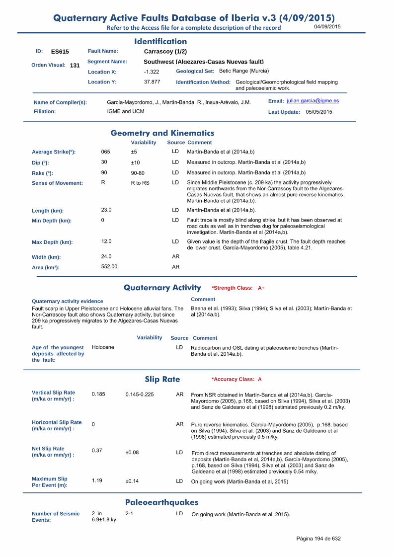
04/09/2015Quaternary Active Faults Database of Iberia v.3 (4/09/2015)
Refer to the Access file for a complete description of the record
ID: ES615 Fault Name: Carrascoy (1/2)
Segment Name: Southwest (Algezares-Casas Nuevas fault)
Location X: -1.322
Location Y: 37.877
Name of Compiler(s): García-Mayordomo, J., Martín-Banda, R., Insua-Arévalo, J.M.
Filiation: IGME and UCM
Email: [email protected]
Last Update: 05/05/2015
Average Strike(º): 065 ±5 LD Martín-Banda et al (2014a,b)
Dip (º): 30 ±10 LD Measured in outcrop. Martín-Banda et al (2014a,b)
Rake (º): 90 90-80 LD Measured in outcrop. Martín-Banda et al (2014a,b)
Sense of Movement: R R to RS LD Since Middle Pleistocene (c. 209 ka) the activity progressively migrates northwards from the Nor-Carrascoy fault to the Algezares-Casas Nuevas fault, that shows an almost pure reverse kinematics. Martín-Banda et al (2014a,b).
Length (km): 23.0 LD Martín-Banda et al (2014a,b).
Min Depth (km): 0 LD Fault trace is mostly blind along strike, but it has been observed at road cuts as well as in trenches dug for paleoseismological investigation. Martín-Banda et al (2014a,b).
Max Depth (km): 12.0 LD Given value is the depth of the fragile crust. The fault depth reaches de lower crust. García-Mayordomo (2005), table 4.21.
Width (km): 24.0 AR
Area (km²): 552.00 AR
Age of the youngestdeposits affected bythe fault:
Holocene LD Radiocarbon and OSL dating at paleoseismic trenches (Martín-Banda et al, 2014a,b).
Vertical Slip Rate(m/ka or mm/yr) :
0.185 0.145-0.225 AR From NSR obtained in Martín-Banda et al (2014a,b). García-Mayordomo (2005), p.168, based on Silva (1994), Silva et al. (2003) and Sanz de Galdeano et al (1998) estimated previously 0.2 m/ky.
Horizontal Slip Rate(m/ka or mm/yr) :
0 AR Pure reverse kinematics. García-Mayordomo (2005), p.168, based on Silva (1994), Silva et al. (2003) and Sanz de Galdeano et al (1998) estimated previously 0.5 m/ky.
Net Slip Rate(m/ka or mm/yr) :
0.37 ±0.08 LD From direct measurements at trenches and absolute dating of deposits (Martín-Banda et al, 2014a,b). García-Mayordomo (2005), p.168, based on Silva (1994), Silva et al. (2003) and Sanz de Galdeano et al (1998) estimated previously 0.54 m/ky.
MaxImum Slip Per Event (m):
1.19 ±0.14 LD On going work (Martín-Banda et al, 2015)
Number of SeismicEvents:
2 in 6.9±1.8 ky
2-1 LD On going work (Martín-Banda et al, 2015).
Identification
Geometry and KinematicsVariability Source Comment
Quaternary Activity
Variability Source
Comment
Fault scarp in Upper Pleistocene and Holocene alluvial fans. The Nor-Carrascoy fault also shows Quaternary activity, but since 209 ka progressively migrates to the Algezares-Casas Nuevas fault.
Baena et al. (1993); Silva (1994); Silva et al. (2003); Martín-Banda et al (2014a,b).
Geological Set: Betic Range (Murcia)
Identification Method: Geological/Geomorphological field mapping and paleoseismic work.
Comment
Quaternary activity evidence
A+*Strength Class:
Slip Rate *Accuracy Class: A
Paleoearthquakes
Orden Visual: 131
Página 194 de 632
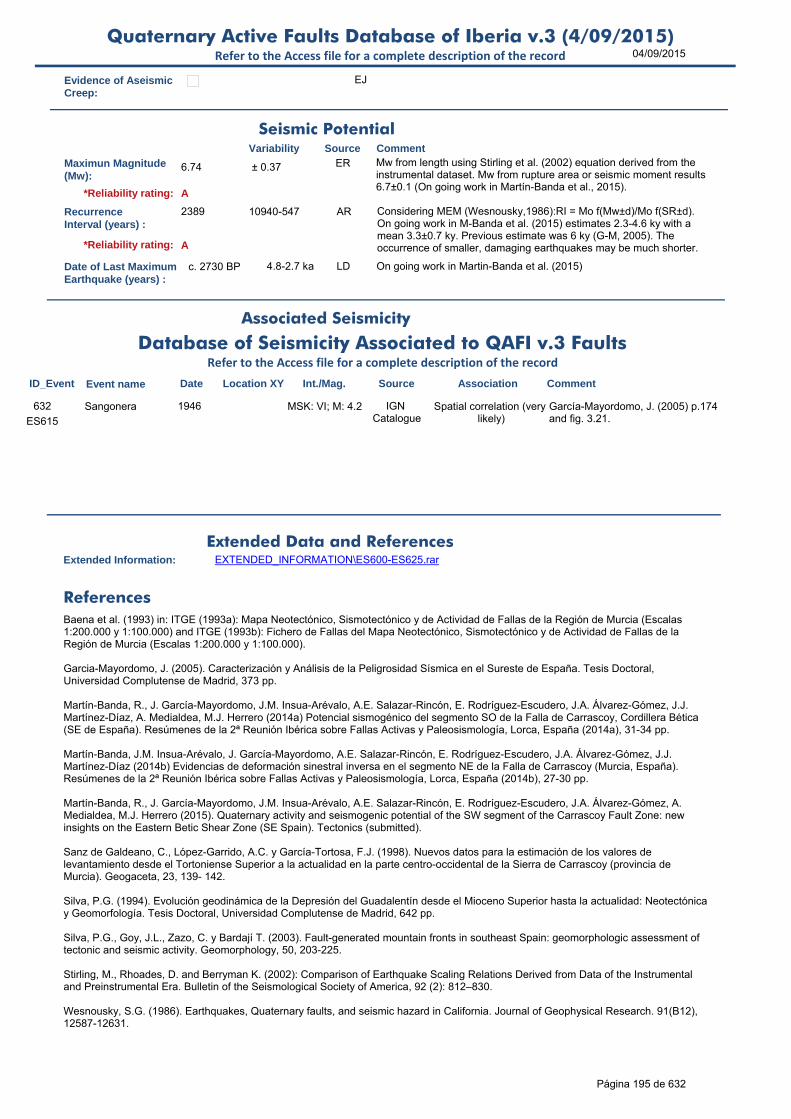
04/09/2015Quaternary Active Faults Database of Iberia v.3 (4/09/2015)
Refer to the Access file for a complete description of the record
Evidence of AseismicCreep:
EJ
Maximun Magnitude(Mw):
6.74 ± 0.37 ER Mw from length using Stirling et al. (2002) equation derived from the instrumental dataset. Mw from rupture area or seismic moment results 6.7±0.1 (On going work in Martín-Banda et al., 2015).
RecurrenceInterval (years) :
2389 10940-547 AR Considering MEM (Wesnousky,1986):RI = Mo f(Mw±d)/Mo f(SR±d). On going work in M-Banda et al. (2015) estimates 2.3-4.6 ky with a mean 3.3±0.7 ky. Previous estimate was 6 ky (G-M, 2005). The occurrence of smaller, damaging earthquakes may be much shorter.
Date of Last MaximumEarthquake (years) :
c. 2730 BP 4.8-2.7 ka LD On going work in Martin-Banda et al. (2015)
Extended Information: EXTENDED_INFORMATION\ES600-ES625.rar
Baena et al. (1993) in: ITGE (1993a): Mapa Neotectónico, Sismotectónico y de Actividad de Fallas de la Región de Murcia (Escalas 1:200.000 y 1:100.000) and ITGE (1993b): Fichero de Fallas del Mapa Neotectónico, Sismotectónico y de Actividad de Fallas de la Región de Murcia (Escalas 1:200.000 y 1:100.000).
Garcia-Mayordomo, J. (2005). Caracterización y Análisis de la Peligrosidad Sísmica en el Sureste de España. Tesis Doctoral, Universidad Complutense de Madrid, 373 pp.
Martín-Banda, R., J. García-Mayordomo, J.M. Insua-Arévalo, A.E. Salazar-Rincón, E. Rodríguez-Escudero, J.A. Álvarez-Gómez, J.J. Martínez-Díaz, A. Medialdea, M.J. Herrero (2014a) Potencial sismogénico del segmento SO de la Falla de Carrascoy, Cordillera Bética (SE de España). Resúmenes de la 2ª Reunión Ibérica sobre Fallas Activas y Paleosismología, Lorca, España (2014a), 31-34 pp.
Martín-Banda, J.M. Insua-Arévalo, J. García-Mayordomo, A.E. Salazar-Rincón, E. Rodríguez-Escudero, J.A. Álvarez-Gómez, J.J. Martínez-Díaz (2014b) Evidencias de deformación sinestral inversa en el segmento NE de la Falla de Carrascoy (Murcia, España). Resúmenes de la 2ª Reunión Ibérica sobre Fallas Activas y Paleosismología, Lorca, España (2014b), 27-30 pp.
Martín-Banda, R., J. García-Mayordomo, J.M. Insua-Arévalo, A.E. Salazar-Rincón, E. Rodríguez-Escudero, J.A. Álvarez-Gómez, A. Medialdea, M.J. Herrero (2015). Quaternary activity and seismogenic potential of the SW segment of the Carrascoy Fault Zone: new insights on the Eastern Betic Shear Zone (SE Spain). Tectonics (submitted).
Sanz de Galdeano, C., López-Garrido, A.C. y García-Tortosa, F.J. (1998). Nuevos datos para la estimación de los valores de levantamiento desde el Tortoniense Superior a la actualidad en la parte centro-occidental de la Sierra de Carrascoy (provincia de Murcia). Geogaceta, 23, 139- 142.
Silva, P.G. (1994). Evolución geodinámica de la Depresión del Guadalentín desde el Mioceno Superior hasta la actualidad: Neotectónica y Geomorfología. Tesis Doctoral, Universidad Complutense de Madrid, 642 pp.
Silva, P.G., Goy, J.L., Zazo, C. y Bardají T. (2003). Fault-generated mountain fronts in southeast Spain: geomorphologic assessment of tectonic and seismic activity. Geomorphology, 50, 203-225.
Stirling, M., Rhoades, D. and Berryman K. (2002): Comparison of Earthquake Scaling Relations Derived from Data of the Instrumental and Preinstrumental Era. Bulletin of the Seismological Society of America, 92 (2): 812–830.
Wesnousky, S.G. (1986). Earthquakes, Quaternary faults, and seismic hazard in California. Journal of Geophysical Research. 91(B12), 12587-12631.
Seismic PotentialSource Comment
Associated Seismicity
Extended Data and References
References
Variability
*Reliability rating: A
*Reliability rating: A
Database of Seismicity Associated to QAFI v.3 FaultsRefer to the Access file for a complete description of the record
ID_Event Event name Date Location XY Int./Mag. Source Association Comment
ES615
Sangonera 1946 MSK: VI; M: 4.2 IGN Catalogue
Spatial correlation (very likely)
García-Mayordomo, J. (2005) p.174 and fig. 3.21.
632
Página 195 de 632
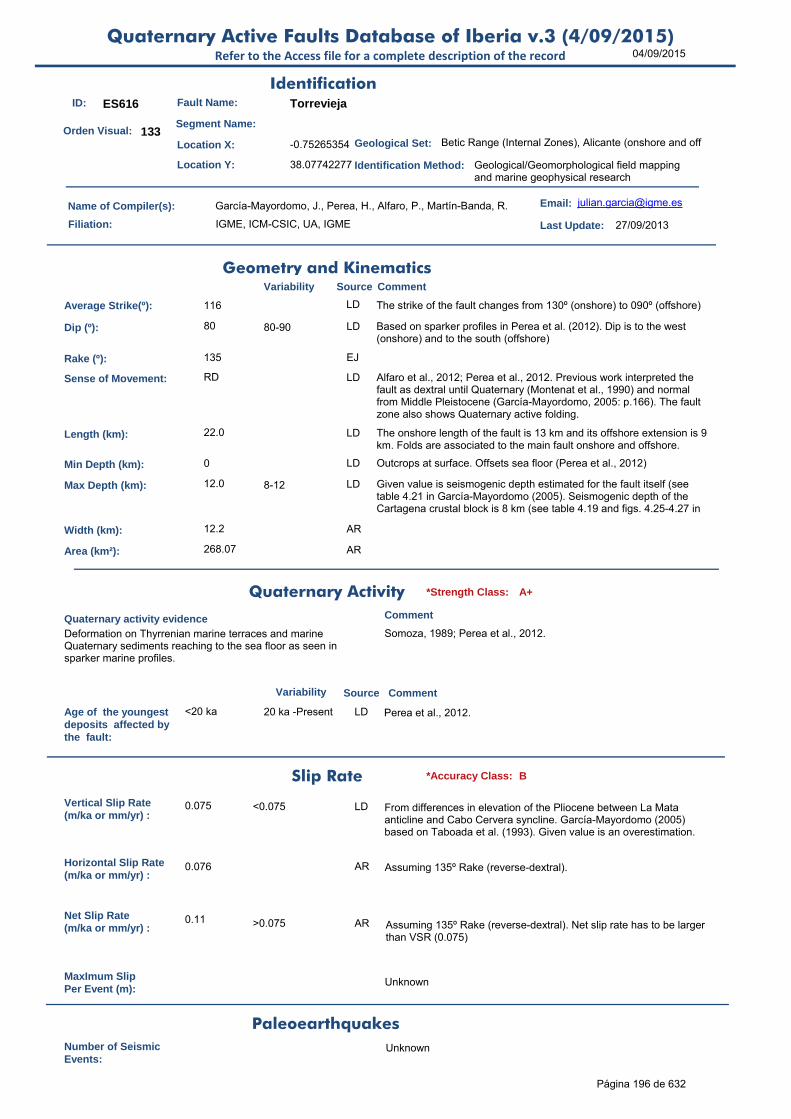
04/09/2015Quaternary Active Faults Database of Iberia v.3 (4/09/2015)
Refer to the Access file for a complete description of the record
ID: ES616 Fault Name: Torrevieja
Segment Name:
Location X: -0.75265354
Location Y: 38.07742277
Name of Compiler(s): García-Mayordomo, J., Perea, H., Alfaro, P., Martín-Banda, R.
Filiation: IGME, ICM-CSIC, UA, IGME
Email: [email protected]
Last Update: 27/09/2013
Average Strike(º): 116 LD The strike of the fault changes from 130º (onshore) to 090º (offshore)
Dip (º): 80 80-90 LD Based on sparker profiles in Perea et al. (2012). Dip is to the west (onshore) and to the south (offshore)
Rake (º): 135 EJ
Sense of Movement: RD LD Alfaro et al., 2012; Perea et al., 2012. Previous work interpreted the fault as dextral until Quaternary (Montenat et al., 1990) and normal from Middle Pleistocene (García-Mayordomo, 2005: p.166). The fault zone also shows Quaternary active folding.
Length (km): 22.0 LD The onshore length of the fault is 13 km and its offshore extension is 9 km. Folds are associated to the main fault onshore and offshore.
Min Depth (km): 0 LD Outcrops at surface. Offsets sea floor (Perea et al., 2012)
Max Depth (km): 12.0 8-12 LD Given value is seismogenic depth estimated for the fault itself (see table 4.21 in García-Mayordomo (2005). Seismogenic depth of the Cartagena crustal block is 8 km (see table 4.19 and figs. 4.25-4.27 in
Width (km): 12.2 AR
Area (km²): 268.07 AR
Age of the youngestdeposits affected bythe fault:
<20 ka 20 ka -Present LD Perea et al., 2012.
Vertical Slip Rate(m/ka or mm/yr) :
0.075 <0.075 LD From differences in elevation of the Pliocene between La Mata anticline and Cabo Cervera syncline. García-Mayordomo (2005) based on Taboada et al. (1993). Given value is an overestimation.
Horizontal Slip Rate(m/ka or mm/yr) :
0.076 AR Assuming 135º Rake (reverse-dextral).
Net Slip Rate(m/ka or mm/yr) :
0.11 >0.075 AR Assuming 135º Rake (reverse-dextral). Net slip rate has to be larger than VSR (0.075)
MaxImum Slip Per Event (m):
Unknown
Number of SeismicEvents:
Unknown
Identification
Geometry and KinematicsVariability Source Comment
Quaternary Activity
Variability Source
Comment
Deformation on Thyrrenian marine terraces and marine Quaternary sediments reaching to the sea floor as seen in sparker marine profiles.
Somoza, 1989; Perea et al., 2012.
Geological Set: Betic Range (Internal Zones), Alicante (onshore and off
Identification Method: Geological/Geomorphological field mapping and marine geophysical research
Comment
Quaternary activity evidence
A+*Strength Class:
Slip Rate *Accuracy Class: B
Paleoearthquakes
Orden Visual: 133
Página 196 de 632
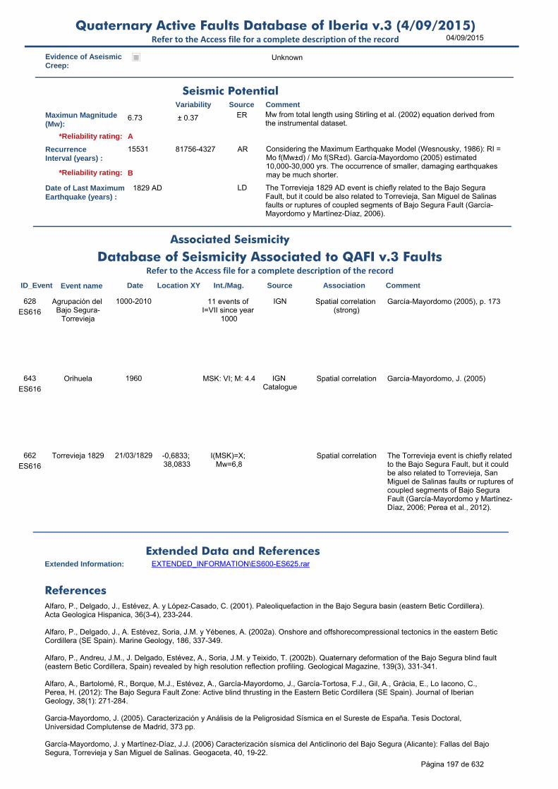
04/09/2015Quaternary Active Faults Database of Iberia v.3 (4/09/2015)
Refer to the Access file for a complete description of the record
Evidence of AseismicCreep:
Unknown
Maximun Magnitude(Mw):
6.73 ± 0.37 ER Mw from total length using Stirling et al. (2002) equation derived from the instrumental dataset.
RecurrenceInterval (years) :
15531 81756-4327 AR Considering the Maximum Earthquake Model (Wesnousky, 1986): RI = Mo f(Mw±d) / Mo f(SR±d). García-Mayordomo (2005) estimated 10,000-30,000 yrs. The occurrence of smaller, damaging earthquakes may be much shorter.
Date of Last MaximumEarthquake (years) :
1829 AD LD The Torrevieja 1829 AD event is chiefly related to the Bajo Segura Fault, but it could be also related to Torrevieja, San Miguel de Salinas faults or ruptures of coupled segments of Bajo Segura Fault (García-Mayordomo y Martínez-Díaz, 2006).
Extended Information: EXTENDED_INFORMATION\ES600-ES625.rar
Alfaro, P., Delgado, J., Estévez, A. y López-Casado, C. (2001). Paleoliquefaction in the Bajo Segura basin (eastern Betic Cordillera). Acta Geologica Hispanica, 36(3-4), 233-244.
Alfaro, P., Delgado, J., A. Estévez, Soria, J.M. y Yébenes, A. (2002a). Onshore and offshorecompressional tectonics in the eastern Betic Cordillera (SE Spain). Marine Geology, 186, 337-349.
Alfaro, P., Andreu, J.M., J. Delgado, Estévez, A., Soria, J.M. y Teixido, T. (2002b). Quaternary deformation of the Bajo Segura blind fault (eastern Betic Cordillera, Spain) revealed by high resolution reflection profiling. Geological Magazine, 139(3), 331-341.
Alfaro, A., Bartolomé, R., Borque, M.J., Estévez, A., García-Mayordomo, J., García-Tortosa, F.J., Gil, A., Gràcia, E., Lo Iacono, C., Perea, H. (2012): The Bajo Segura Fault Zone: Active blind thrusting in the Eastern Betic Cordillera (SE Spain). Journal of Iberian
Geology, 38(1): 271-284.
Garcia-Mayordomo, J. (2005). Caracterización y Análisis de la Peligrosidad Sísmica en el Sureste de España. Tesis Doctoral, Universidad Complutense de Madrid, 373 pp.
García-Mayordomo, J. y Martínez-Díaz, J.J. (2006) Caracterización sísmica del Anticlinorio del Bajo Segura (Alicante): Fallas del Bajo Segura, Torrevieja y San Miguel de Salinas. Geogaceta, 40, 19-22.
Seismic PotentialSource Comment
Associated Seismicity
Extended Data and References
References
Variability
*Reliability rating: A
*Reliability rating: B
Database of Seismicity Associated to QAFI v.3 FaultsRefer to the Access file for a complete description of the record
ID_Event Event name Date Location XY Int./Mag. Source Association Comment
ES616
Agrupación del Bajo Segura-
Torrevieja
1000-2010 11 events of I=VII since year
1000
IGN Spatial correlation (strong)
García-Mayordomo (2005), p. 173628
ES616
Orihuela 1960 MSK: VI; M: 4.4 IGN Catalogue
Spatial correlation García-Mayordomo, J. (2005)643
ES616
Torrevieja 1829 21/03/1829 -0,6833; 38,0833
I(MSK)=X; Mw=6,8
Spatial correlation The Torrevieja event is chiefly related to the Bajo Segura Fault, but it could be also related to Torrevieja, San Miguel de Salinas faults or ruptures of coupled segments of Bajo Segura Fault (García-Mayordomo y Martínez-Díaz, 2006; Perea et al., 2012).
662
Página 197 de 632

04/09/2015Quaternary Active Faults Database of Iberia v.3 (4/09/2015)
Refer to the Access file for a complete description of the record
Perea, H., Gràcia, E., Alfaro, P., Bartolomé, R., Lo Iacono, C., Moreno, X., Masana, E., and EVENT-SHELF Team: Quaternary active tectonic structures in the offshore Bajo Segura basin (SE Iberian Peninsula – Mediterranean Sea), Natural Hazards and Earth System Science, 12: 3151-3168, doi:10.5194/nhess-12-3151-2012, 2012.
Slemmons, D.B. (1982). Determination of design earthquake magnitudes for microzonation. En: Proceedings of the 3rd International Earthquake Microzonation Conference, Seatle, Washington, v.1, 119-130.
Somoza, L. (1989). El Cuaternario litoral entre Cabo de Palos y Guardamar del Segura (Murcia-Alicante). Evolución geodinámica en relación con las variaciones del nivel del mar. Tesis Doctoral, Universidad Complutense de Madrid, 352 pp.
Stirling, M., Rhoades, D. and Berryman K. (2002): Comparison of Earthquake Scaling Relations Derived from Data of the Instrumental and Preinstrumental Era. Bulletin of the Seismological Society of America, 92 (2): 812–830.
Taboada, A., Bousquet, J.C. y Philip, H. (1993). Coseismic elastic models of folds above blindthrusts in the Betic Cordilleras (spain) and evaluation of seismic hazard. Tectonophysics, 220,223-241.
Villamor, P. y Berryman, K. (1999). La tasa de deslizamiento de una falla como aproximación de primer orden en las estimaciones de peligrosidad sísmica. 1er Congreso Nacional de Ingeniería Sísmica, Murcia, I, 153-163.
Wells, D.L. y Coppersmith, K.J. (1994). New empirical relationships among magnitude, rupture length, rupture width, rupture area, and surface displacement. Bulletin of the Seismological Society of America, 84(4), 974-1002.
Wesnousky, S.G. (1986). Earthquakes, Quaternary faults, and seismic hazard in California. Journal of Geophysical Research. 91(B12), 12587-12631.
Página 198 de 632
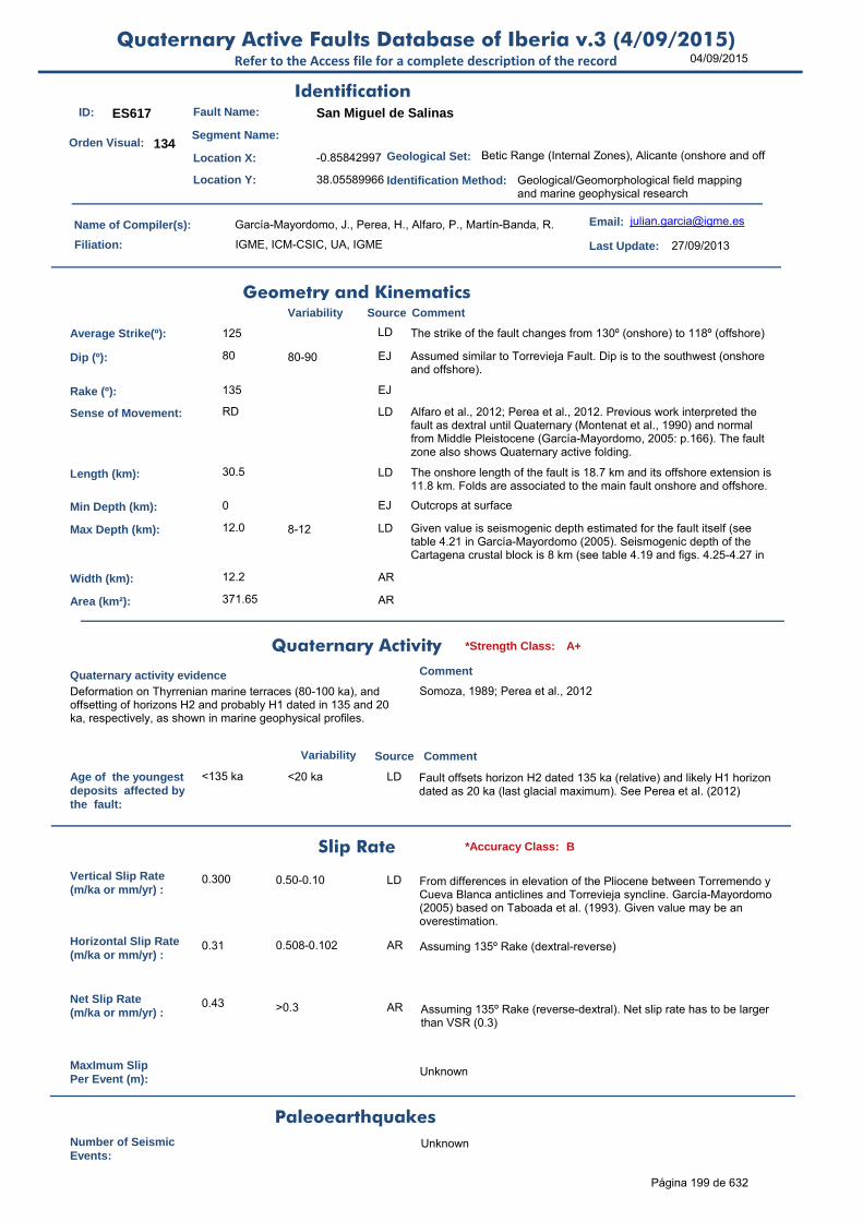
04/09/2015Quaternary Active Faults Database of Iberia v.3 (4/09/2015)
Refer to the Access file for a complete description of the record
ID: ES617 Fault Name: San Miguel de Salinas
Segment Name:
Location X: -0.85842997
Location Y: 38.05589966
Name of Compiler(s): García-Mayordomo, J., Perea, H., Alfaro, P., Martín-Banda, R.
Filiation: IGME, ICM-CSIC, UA, IGME
Email: [email protected]
Last Update: 27/09/2013
Average Strike(º): 125 LD The strike of the fault changes from 130º (onshore) to 118º (offshore)
Dip (º): 80 80-90 EJ Assumed similar to Torrevieja Fault. Dip is to the southwest (onshore and offshore).
Rake (º): 135 EJ
Sense of Movement: RD LD Alfaro et al., 2012; Perea et al., 2012. Previous work interpreted the fault as dextral until Quaternary (Montenat et al., 1990) and normal from Middle Pleistocene (García-Mayordomo, 2005: p.166). The fault zone also shows Quaternary active folding.
Length (km): 30.5 LD The onshore length of the fault is 18.7 km and its offshore extension is 11.8 km. Folds are associated to the main fault onshore and offshore.
Min Depth (km): 0 EJ Outcrops at surface
Max Depth (km): 12.0 8-12 LD Given value is seismogenic depth estimated for the fault itself (see table 4.21 in García-Mayordomo (2005). Seismogenic depth of the Cartagena crustal block is 8 km (see table 4.19 and figs. 4.25-4.27 in
Width (km): 12.2 AR
Area (km²): 371.65 AR
Age of the youngestdeposits affected bythe fault:
<135 ka <20 ka LD Fault offsets horizon H2 dated 135 ka (relative) and likely H1 horizon dated as 20 ka (last glacial maximum). See Perea et al. (2012)
Vertical Slip Rate(m/ka or mm/yr) :
0.300 0.50-0.10 LD From differences in elevation of the Pliocene between Torremendo y Cueva Blanca anticlines and Torrevieja syncline. García-Mayordomo (2005) based on Taboada et al. (1993). Given value may be an overestimation.
Horizontal Slip Rate(m/ka or mm/yr) :
0.31 0.508-0.102 AR Assuming 135º Rake (dextral-reverse)
Net Slip Rate(m/ka or mm/yr) :
0.43 >0.3 AR Assuming 135º Rake (reverse-dextral). Net slip rate has to be larger than VSR (0.3)
MaxImum Slip Per Event (m):
Unknown
Number of SeismicEvents:
Unknown
Identification
Geometry and KinematicsVariability Source Comment
Quaternary Activity
Variability Source
Comment
Deformation on Thyrrenian marine terraces (80-100 ka), and offsetting of horizons H2 and probably H1 dated in 135 and 20 ka, respectively, as shown in marine geophysical profiles.
Somoza, 1989; Perea et al., 2012
Geological Set: Betic Range (Internal Zones), Alicante (onshore and off
Identification Method: Geological/Geomorphological field mapping and marine geophysical research
Comment
Quaternary activity evidence
A+*Strength Class:
Slip Rate *Accuracy Class: B
Paleoearthquakes
Orden Visual: 134
Página 199 de 632

04/09/2015Quaternary Active Faults Database of Iberia v.3 (4/09/2015)
Refer to the Access file for a complete description of the record
Evidence of AseismicCreep:
Unknown
Maximun Magnitude(Mw):
6.86 ± 0.37 ER Mw from total length using Stirling et al. (2002) equation derived from the instrumental dataset.
RecurrenceInterval (years) :
4565 23483-1272 AR Considering the Maximum Earthquake Model (Wesnousky, 1986): RI = Mo f(Mw±d) / Mo f(SR±d). García-Mayordomo (2005) estimated 8,000-10,000 yrs. The occurrence of smaller, damaging earthquakes may be much shorter.
Date of Last MaximumEarthquake (years) :
1829 AD LD The Torrevieja 1829 AD event is chiefly related to the Bajo Segura Fault, but it could be also related to Torrevieja, San Miguel de Salinas faults or ruptures of coupled segments of Bajo Segura Fault (García-Mayordomo y Martínez-Díaz, 2006).
Extended Information: EXTENDED_INFORMATION\ES600-ES625.rar
Alfaro, P., Delgado, J., Estévez, A. y López-Casado, C. (2001). Paleoliquefaction in the Bajo Segura basin (eastern Betic Cordillera). Acta Geologica Hispanica, 36(3-4), 233-244.
Alfaro, P., Delgado, J., A. Estévez, Soria, J.M. y Yébenes, A. (2002a). Onshore and offshorecompressional tectonics in the eastern Betic Cordillera (SE Spain). Marine Geology, 186, 337-349.
Alfaro, P., Andreu, J.M., J. Delgado, Estévez, A., Soria, J.M. y Teixido, T. (2002b). Quaternary deformation of the Bajo Segura blind fault (eastern Betic Cordillera, Spain) revealed by high resolution reflection profiling. Geological Magazine, 139(3), 331-341.
Alfaro, A., Bartolomé, R., Borque, M.J., Estévez, A., García-Mayordomo, J., García-Tortosa, F.J., Gil, A., Gràcia, E., Lo Iacono, C., Perea, H. (2012): The Bajo Segura Fault Zone: Active blind thrusting in the Eastern Betic Cordillera (SE Spain). Journal of Iberian
Geology, 38(1): 271-284.
Garcia-Mayordomo, J. (2005). Caracterización y Análisis de la Peligrosidad Sísmica en el Sureste de España. Tesis Doctoral, Universidad Complutense de Madrid, 373 pp.
García-Mayordomo, J. y Martínez-Díaz, J.J. (2006) Caracterización sísmica del Anticlinorio del Bajo Segura (Alicante): Fallas del Bajo Segura, Torrevieja y San Miguel de Salinas. Geogaceta, 40, 19-22.
Perea, H., Gràcia, E., Alfaro, P., Bartolomé, R., Lo Iacono, C., Moreno, X., Masana, E., and EVENT-SHELF Team: Quaternary active tectonic structures in the offshore Bajo Segura basin (SE Iberian Peninsula – Mediterranean Sea), Natural Hazards and Earth System Science, 12: 3151-3168, doi:10.5194/nhess-12-3151-2012, 2012.
Slemmons, D.B. (1982). Determination of design earthquake magnitudes for microzonation. En: Proceedings of the 3rd International Earthquake Microzonation Conference, Seatle, Washington, v.1, 119-130.
Somoza, L. (1989). El Cuaternario litoral entre Cabo de Palos y Guardamar del Segura (Murcia-Alicante). Evolución geodinámica en
Seismic PotentialSource Comment
Associated Seismicity
Extended Data and References
References
Variability
*Reliability rating: A
*Reliability rating: B
Database of Seismicity Associated to QAFI v.3 FaultsRefer to the Access file for a complete description of the record
ID_Event Event name Date Location XY Int./Mag. Source Association Comment
ES617
Agrupación del Bajo Segura-
Torrevieja
1000-2010 11 events of I=VII since year
1000
IGN Spatial correlation (strong)
García-Mayordomo (2005), p. 173642
ES617
Torrevieja 1829 21/03/1829 -0,6833; 38,0833
I(MSK)=X; Mw=6,8
Spatial correlation The Torrevieja event is chiefly related to the Bajo Segura Fault, but it could be also related to Torrevieja, San Miguel de Salinas faults or ruptures of coupled segments of Bajo Segura Fault (García-Mayordomo y Martínez-Díaz, 2006; Perea et al., 2012).
663
Página 200 de 632

04/09/2015Quaternary Active Faults Database of Iberia v.3 (4/09/2015)
Refer to the Access file for a complete description of the record
relación con las variaciones del nivel del mar. Tesis Doctoral, Universidad Complutense de Madrid, 352 pp.
Stirling, M., Rhoades, D. and Berryman K. (2002): Comparison of Earthquake Scaling Relations Derived from Data of the Instrumental and Preinstrumental Era. Bulletin of the Seismological Society of America, 92 (2): 812–830.
Taboada, A., Bousquet, J.C. y Philip, H. (1993). Coseismic elastic models of folds above blindthrusts in the Betic Cordilleras (spain) and evaluation of seismic hazard. Tectonophysics, 220,223-241.
Villamor, P. y Berryman, K. (1999). La tasa de deslizamiento de una falla como aproximación de primer orden en las estimaciones de peligrosidad sísmica. 1er Congreso Nacional de Ingeniería Sísmica, Murcia, I, 153-163.
Wells, D.L. y Coppersmith, K.J. (1994). New empirical relationships among magnitude, rupture length, rupture width, rupture area, and surface displacement. Bulletin of the Seismological Society of America, 84(4), 974-1002.
Wesnousky, S.G. (1986). Earthquakes, Quaternary faults, and seismic hazard in California. Journal of Geophysical Research. 91(B12), 12587-12631.
Página 201 de 632

04/09/2015Quaternary Active Faults Database of Iberia v.3 (4/09/2015)
Refer to the Access file for a complete description of the record
ID: ES618 Fault Name: Bajo Segura (1/3)
Segment Name: Hurchillo (West Bajo Segura)
Location X: -0.971642
Location Y: 38.052063
Name of Compiler(s): García-Mayordomo, J., Martín-Banda, R., Alfaro, P.
Filiation: IGME, UCM, UA
Email: [email protected]
Last Update: 09/02/2015
Average Strike(º): 083 + 10 / - 7 LD Alfaro et al. (2012)
Dip (º): 60 60-30 EJ See Alfaro et al. (2012). Dip is crucial for the estimation of the seismogenic potential of this fault.
Rake (º): 90 EJ Assumed pure reverse
Sense of Movement: R R-ANT LD Blind fault. See Taboada et al. (1993) and Alfaro et al. (2002) for different models of the subsurface structure of the fault.
Length (km): 10.0 LD Alfaro et al. (2012)
Min Depth (km): 1 0.5-1 LD Blind fault (Alfaro et al. 2002, 2012)
Max Depth (km): 12.0 LD Given value is seismogenic depth. Fault depth reaches upper crust. Table 4.21 in García-Mayordomo (2005).
Width (km): 12.7 AR
Area (km²): 127.02 127-220 AR 220 km^2 results from considering 30º dip (Alfaro et al. 2012)
Age of the youngestdeposits affected bythe fault:
Upper Pleistocene-Holocene
Upper Pleistocene-Holocene
LD Alfaro et al. (2002, 2012)
Vertical Slip Rate(m/ka or mm/yr) :
0.300 0.3-0.2 LD Considering 606 m of accumulated uplift since 2000 or 3000 ka (base of the Rojales Formation) (see Alfaro et al., 2012)
Horizontal Slip Rate(m/ka or mm/yr) :
0 EJ Pure reverse slip is assumed
Net Slip Rate(m/ka or mm/yr) :
0.4 ± 0.11 LD Best estimation is an average between values resulting from 60-30º dip and 2000-3000 ka age of the marker. Variation showed is for the average value. Possible NSR values range 0.23 to 0.61 m/ky (see Alfaro et al., 2012, 2014).
MaxImum Slip Per Event (m):
Unknown
Number of SeismicEvents:
Unknown
Evidence of AseismicCreep:
Unknown
Identification
Geometry and KinematicsVariability Source Comment
Quaternary Activity
Variability Source
Comment
Deformation in Upper Pleistocene to Holocene sediments inferred from seismic reflection lines.
Inferred from seismic reflection lines and field observations (Alfaro et al., 2002, 2012)
Geological Set: Betic Range (Alicante)
Identification Method: Geological/Geomorphological field mapping and geophysics (seismic reflection lines).
Comment
Quaternary activity evidence
A+*Strength Class:
Slip Rate *Accuracy Class: B
Paleoearthquakes
Orden Visual: 135
Página 202 de 632

04/09/2015Quaternary Active Faults Database of Iberia v.3 (4/09/2015)
Refer to the Access file for a complete description of the record
Maximun Magnitude(Mw):
6.40 ± 0.37 ER Mw from length using Stirling et al. (2002) equation derived from the instrumental dataset. Alfaro et al. (2012) obtain a Mw 6.7 (6.6-6.8) using Stirling et al (2002) equation Mw f (Area) for the Censored Instrumental Dataset.
RecurrenceInterval (years) :
2931 14508-640 AR Considering the Maximum Earthquake Model and dip 60. Alfaro et al. (2012) preferred estimation is 6600 after considering dip 30 to 60. García Mayordomo (2005) estimated 1700-6000 yrs.The occurrence of smaller, damaging earthquakes may be much shorter.
Date of Last MaximumEarthquake (years) :
1829 AD LD The Torrevieja 1829 AD event is chiefly related to the Bajo Segura Fault, but it could be also related to Torrevieja, San Miguel de Salinas faults or ruptures of coupled segments of Bajo Segura Fault (García-Mayordomo y Martínez-Díaz, 2006).
Extended Information: EXTENDED_INFORMATION\ES600-ES625.rar
Alfaro, P., Delgado, J., Estévez, A. y López-Casado, C. (2001). Paleoliquefaction in the Bajo Segura basin (eastern Betic Cordillera). Acta Geologica Hispanica, 36(3-4), 233-244.
Alfaro, P., Delgado, J., A. Estévez, Soria, J.M. y Yébenes, A. (2002a). Onshore and offshorecompressional tectonics in the eastern Betic Cordillera (SE Spain). Marine Geology, 186, 337-349.
Alfaro, P., Andreu, J.M., J. Delgado, Estévez, A., Soria, J.M. y Teixido, T. (2002b). Quaternary deformation of the Bajo Segura blind fault (eastern Betic Cordillera, Spain) revealed by high resolution reflection profiling. Geological Magazine, 139(3), 331-341.
Alfaro, P.; Bartolomé, R.; Borque, M.J.; Estévez, A.; García-Mayordomo, J.; García-Tortosa, F.J.; Gil, A.; Gràcia, E.; Lo Iacono, C.; Perea H. (2012). The Bajo Segura Fault Zone: Active blind thrusting in the Eastern Betic Cordillera (SE Spain). Journal of Iberian Geology,
38(1): 271-284.
Garcia-Mayordomo, J. (2005). Caracterización y Análisis de la Peligrosidad Sísmica en el Sureste de España. Tesis Doctoral, Universidad Complutense de Madrid, 373 pp.
García-Mayordomo, J. y Martínez-Díaz, J.J. (2006) Caracterización sísmica del Anticlinorio del Bajo Segura (Alicante): Fallas del Bajo Segura, Torrevieja y San Miguel de Salinas. Geogaceta, 40, 19-22.
Sánchez-Alzola, A.,Borque, M.J., Martín-Rojas, I., García- Tortosa, F.J., Alfaro, P., Estévez, A., Molina, S., Rodríguez-Caderot, G., de Lacy, C., García-Armenteros, J.A., Avilés, M., Herrera-Olmo, A., Rosa, S. & Gil, A.J. (2014). Tasas de deformación GPS en la cuenca
Seismic PotentialSource Comment
Associated Seismicity
Extended Data and References
References
Variability
*Reliability rating: A
*Reliability rating: B
Database of Seismicity Associated to QAFI v.3 FaultsRefer to the Access file for a complete description of the record
ID_Event Event name Date Location XY Int./Mag. Source Association Comment
ES618
Orihuela 1960 MSK: VI; M: 4.4 IGN Catalogue
Spatial correlation García-Mayordomo, J. (2005)644
ES618
Agrupación del Bajo Segura-
Torrevieja
1000-2010 11 events of I=VII since year
1000
IGN Spatial correlation (strong)
García-Mayordomo (2005), p. 173645
ES618
Torrevieja 1829 21/03/1829 -0,6833; 38,0833
I(MSK)=X; Mw=6,8
Spatial correlation The Torrevieja event is chiefly related to the Bajo Segura Fault, but it could be also related to Torrevieja, San Miguel de Salinas faults or ruptures of coupled segments of Bajo Segura Fault (García-Mayordomo y Martínez-Díaz, 2006).
664
Página 203 de 632

04/09/2015Quaternary Active Faults Database of Iberia v.3 (4/09/2015)
Refer to the Access file for a complete description of the record
del Bajo Segura (Cordillera Bética oriental). Geogaceta, 54, 3-6.
Somoza, L. (1989). El Cuaternario litoral entre Cabo de Palos y Guardamar del Segura (Murcia-Alicante). Evolución geodinámica en relación con las variaciones del nivel del mar. Tesis Doctoral, Universidad Complutense de Madrid, 352 pp.
Stirling, M., Rhoades, D. and Berryman K. (2002): Comparison of Earthquake Scaling Relations Derived from Data of the Instrumental and Preinstrumental Era. Bulletin of the Seismological Society of America, 92 (2): 812–830.
Taboada, A., Bousquet, J.C. y Philip, H. (1993). Coseismic elastic models of folds above blindthrusts in the Betic Cordilleras (spain) and evaluation of seismic hazard. Tectonophysics, 220,223-241.
Wells, D.L. y Coppersmith, K.J. (1994). New empirical relationships among magnitude, rupture length, rupture width, rupture area, and surface displacement. Bulletin of the Seismological Society of America, 84(4), 974-1002.
Wesnousky, S.G. (1986). Earthquakes, Quaternary faults, and seismic hazard in California. Journal of Geophysical Research. 91(B12), 12587-12631.
Página 204 de 632

04/09/2015Quaternary Active Faults Database of Iberia v.3 (4/09/2015)
Refer to the Access file for a complete description of the record
ID: ES619 Fault Name: Bajo Segura (2/3)
Segment Name: Benejúzar (Central Bajo Segura)
Location X: -0.859028
Location Y: 38.073354
Name of Compiler(s): García-Mayordomo, J., Martín-Banda, R., Alfaro, P.
Filiation: IGME, UCM, UA
Email: [email protected]
Last Update: 09/02/2015
Average Strike(º): 084 + 10 / - 7 LD Alfaro et al. (2012)
Dip (º): 60 60-30 EJ See Alfaro et al. (2012). Dip is crucial for the estimation of the seismogenic potential of this fault.
Rake (º): 90 EJ Assumed pure reverse
Sense of Movement: R R-ANT LD Blind fault. See Taboada et al. (1993) and Alfaro et al. (2002) for different models of the subsurface structure of the fault.
Length (km): 8.0 LD Alfaro et al. (2012)
Min Depth (km): 1 0.5-1 LD Blind fault (Alfaro et al. 2002, 2012)
Max Depth (km): 12.0 LD Given value is seismogenic depth. Fault depth reaches upper crust. Table 4.21 in García-Mayordomo (2005).
Width (km): 12.7 AR
Area (km²): 101.61 102-176 AR 176 km^2 results from considering 30º dip (Alfaro et al. 2012)
Age of the youngestdeposits affected bythe fault:
Upper Pleistocene-Holocene
Upper Pleistocene-Holocene
LD Alfaro et al. (2002, 2012)
Vertical Slip Rate(m/ka or mm/yr) :
0.225 0.14-0.31 LD Considering 406 m of accumulated uplift since 2000 or 3000 ka (base of the Rojales Formation), the VSR value varies between 0.2 and 0.14 (see Alfaro et al., 2012). Estimations from geodetics (Sánchez-Alzola et al., 2014) for this segment draw 0.31 mm/yr.
Horizontal Slip Rate(m/ka or mm/yr) :
0 EJ Pure reverse slip is assumed
Net Slip Rate(m/ka or mm/yr) :
0.385 0.16-0.61 LD Alfaro et al. (2014) estimates 0.61 mm/yr for this segment based on shortening from geodetics (Sánchez-Alzola et al., 2014) assuming dip 30º and pure reverse. Preferred estimation here is the average from the range VSR 0.14-0.31 and dip 30-60.
MaxImum Slip Per Event (m):
Unknown
Number of SeismicEvents:
Unknown
Evidence of AseismicCreep:
Unknown
Identification
Geometry and KinematicsVariability Source Comment
Quaternary Activity
Variability Source
Comment
Deformation in Upper Pleistocene to Holocene sediments inferred from seismic reflection lines.
Inferred from seismic reflection lines and field observations (Alfaro et al., 2002, 2012)
Geological Set: Betic Range (Alicante)
Identification Method: Geological/Geomorphological field mapping and geophysics (seismic reflection lines).
Comment
Quaternary activity evidence
A+*Strength Class:
Slip Rate *Accuracy Class: B
Paleoearthquakes
Orden Visual: 136
Página 205 de 632
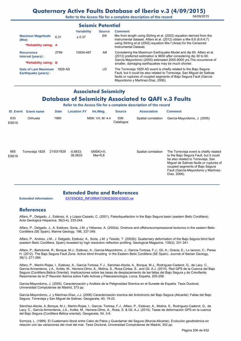
04/09/2015Quaternary Active Faults Database of Iberia v.3 (4/09/2015)
Refer to the Access file for a complete description of the record
Maximun Magnitude(Mw):
6.31 ± 0.37 ER Mw from length using Stirling et al. (2002) equation derived from the instrumental dataset. Alfaro et al. (2012) obtain a Mw 6.6 (6.6-6.7) using Stirling et al (2002) equation Mw f (Area) for the Censored Instrumental Dataset.
RecurrenceInterval (years) :
2769 10934-487 AR Considering the Maximum Earthquake Model and dip 60. Alfaro et al. (2012) preferred estimation is 9600 after considering dip 30 to 60. García Mayordomo (2005) estimated 2000-9000 yrs.The occurrence of smaller, damaging earthquakes may be much shorter.
Date of Last MaximumEarthquake (years) :
1829 AD LD The Torrevieja 1829 AD event is chiefly related to the Bajo Segura Fault, but it could be also related to Torrevieja, San Miguel de Salinas faults or ruptures of coupled segments of Bajo Segura Fault (García-Mayordomo y Martínez-Díaz, 2006).
Extended Information: EXTENDED_INFORMATION\ES600-ES625.rar
Alfaro, P., Delgado, J., Estévez, A. y López-Casado, C. (2001). Paleoliquefaction in the Bajo Segura basin (eastern Betic Cordillera). Acta Geologica Hispanica, 36(3-4), 233-244.
Alfaro, P., Delgado, J., A. Estévez, Soria, J.M. y Yébenes, A. (2002a). Onshore and offshorecompressional tectonics in the eastern Betic Cordillera (SE Spain). Marine Geology, 186, 337-349.
Alfaro, P., Andreu, J.M., J. Delgado, Estévez, A., Soria, J.M. y Teixido, T. (2002b). Quaternary deformation of the Bajo Segura blind fault (eastern Betic Cordillera, Spain) revealed by high resolution reflection profiling. Geological Magazine, 139(3), 331-341.
Alfaro, P.; Bartolomé, R.; Borque, M.J.; Estévez, A.; García-Mayordomo, J.; García-Tortosa, F.J.; Gil, A.; Gràcia, E.; Lo Iacono, C.; Perea H. (2012). The Bajo Segura Fault Zone: Active blind thrusting in the Eastern Betic Cordillera (SE Spain). Journal of Iberian Geology,
38(1): 271-284.
Alfaro, P., Martín-Rojas, I., Estévez, A., García-Tortosa, F.J., Sánchez-Alzola, A., Borque, M.J., Rodríguez-Caderot, G., de Lacy. C., García-Armenteros, J.A., Avilés, M., Herrera-Olmo, A., Molina, S., Rosa-Cintas, S., and Gil, A.J. (2014). Red GPS de la Cuenca del Bajo Segura (Cordillera Bética Oriental). Implicaciones sobre las tasas de desplazamiento de las fallas del Bajo Segura y de Crevillente. Resúmenes de la 2ª Reunión Ibérica sobre Falls Activas y Paleosismología, Lorca, España, 205-208.
Garcia-Mayordomo, J. (2005). Caracterización y Análisis de la Peligrosidad Sísmica en el Sureste de España. Tesis Doctoral, Universidad Complutense de Madrid, 373 pp.
García-Mayordomo, J. y Martínez-Díaz, J.J. (2006) Caracterización sísmica del Anticlinorio del Bajo Segura (Alicante): Fallas del Bajo Segura, Torrevieja y San Miguel de Salinas. Geogaceta, 40, 19-22.
Sánchez-Alzola, A.,Borque, M.J., Martín-Rojas, I., García- Tortosa, F.J., Alfaro, P., Estévez, A., Molina, S., Rodríguez-Caderot, G., de Lacy, C., García-Armenteros, J.A., Avilés, M., Herrera-Olmo, A., Rosa, S. & Gil, A.J. (2014). Tasas de deformación GPS en la cuenca del Bajo Segura (Cordillera Bética oriental). Geogaceta, 54, 3-6.
Somoza, L. (1989). El Cuaternario litoral entre Cabo de Palos y Guardamar del Segura (Murcia-Alicante). Evolución geodinámica en relación con las variaciones del nivel del mar. Tesis Doctoral, Universidad Complutense de Madrid, 352 pp.
Seismic PotentialSource Comment
Associated Seismicity
Extended Data and References
References
Variability
*Reliability rating: A
*Reliability rating: B
Database of Seismicity Associated to QAFI v.3 FaultsRefer to the Access file for a complete description of the record
ID_Event Event name Date Location XY Int./Mag. Source Association Comment
ES619
Orihuela 1960 MSK: VII; M: 4.4 IGN Catalogue
Spatial correlation García-Mayordomo, J. (2005)633
ES619
Torrevieja 1829 21/03/1829 -0,6833; 38,0833
I(MSK)=X; Mw=6,8
Spatial correlation The Torrevieja event is chiefly related to the Bajo Segura Fault, but it could be also related to Torrevieja, San Miguel de Salinas faults or ruptures of coupled segments of Bajo Segura Fault (García-Mayordomo y Martínez-Díaz, 2006).
665
Página 206 de 632

04/09/2015Quaternary Active Faults Database of Iberia v.3 (4/09/2015)
Refer to the Access file for a complete description of the record
Stirling, M., Rhoades, D. and Berryman K. (2002): Comparison of Earthquake Scaling Relations Derived from Data of the Instrumental and Preinstrumental Era. Bulletin of the Seismological Society of America, 92 (2): 812–830.
Taboada, A., Bousquet, J.C. y Philip, H. (1993). Coseismic elastic models of folds above blindthrusts in the Betic Cordilleras (spain) and evaluation of seismic hazard. Tectonophysics, 220,223-241.
Wells, D.L. y Coppersmith, K.J. (1994). New empirical relationships among magnitude, rupture length, rupture width, rupture area, and surface displacement. Bulletin of the Seismological Society of America, 84(4), 974-1002.
Wesnousky, S.G. (1986). Earthquakes, Quaternary faults, and seismic hazard in California. Journal of Geophysical Research. 91(B12), 12587-12631.
Página 207 de 632
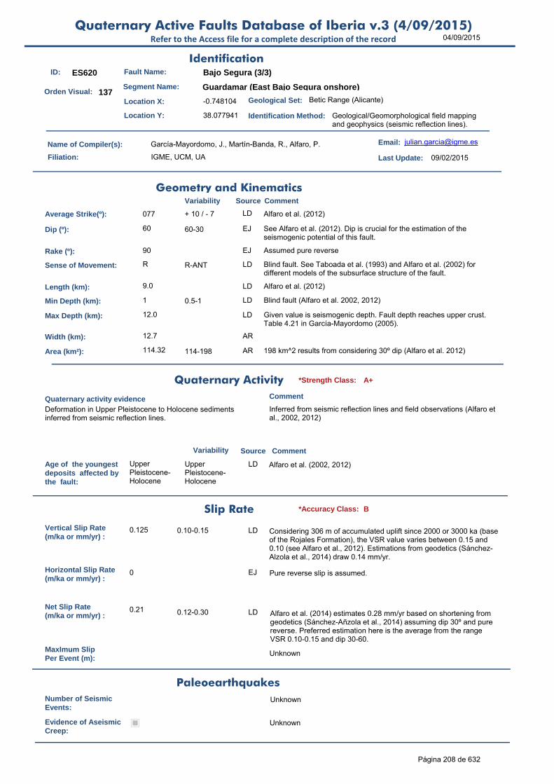
04/09/2015Quaternary Active Faults Database of Iberia v.3 (4/09/2015)
Refer to the Access file for a complete description of the record
ID: ES620 Fault Name: Bajo Segura (3/3)
Segment Name: Guardamar (East Bajo Segura onshore)
Location X: -0.748104
Location Y: 38.077941
Name of Compiler(s): García-Mayordomo, J., Martín-Banda, R., Alfaro, P.
Filiation: IGME, UCM, UA
Email: [email protected]
Last Update: 09/02/2015
Average Strike(º): 077 + 10 / - 7 LD Alfaro et al. (2012)
Dip (º): 60 60-30 EJ See Alfaro et al. (2012). Dip is crucial for the estimation of the seismogenic potential of this fault.
Rake (º): 90 EJ Assumed pure reverse
Sense of Movement: R R-ANT LD Blind fault. See Taboada et al. (1993) and Alfaro et al. (2002) for different models of the subsurface structure of the fault.
Length (km): 9.0 LD Alfaro et al. (2012)
Min Depth (km): 1 0.5-1 LD Blind fault (Alfaro et al. 2002, 2012)
Max Depth (km): 12.0 LD Given value is seismogenic depth. Fault depth reaches upper crust. Table 4.21 in García-Mayordomo (2005).
Width (km): 12.7 AR
Area (km²): 114.32 114-198 AR 198 km^2 results from considering 30º dip (Alfaro et al. 2012)
Age of the youngestdeposits affected bythe fault:
Upper Pleistocene-Holocene
Upper Pleistocene-Holocene
LD Alfaro et al. (2002, 2012)
Vertical Slip Rate(m/ka or mm/yr) :
0.125 0.10-0.15 LD Considering 306 m of accumulated uplift since 2000 or 3000 ka (base of the Rojales Formation), the VSR value varies between 0.15 and 0.10 (see Alfaro et al., 2012). Estimations from geodetics (Sánchez-Alzola et al., 2014) draw 0.14 mm/yr.
Horizontal Slip Rate(m/ka or mm/yr) :
0 EJ Pure reverse slip is assumed.
Net Slip Rate(m/ka or mm/yr) :
0.21 0.12-0.30 LD Alfaro et al. (2014) estimates 0.28 mm/yr based on shortening from geodetics (Sánchez-Añzola et al., 2014) assuming dip 30º and pure reverse. Preferred estimation here is the average from the range VSR 0.10-0.15 and dip 30-60.
MaxImum Slip Per Event (m):
Unknown
Number of SeismicEvents:
Unknown
Evidence of AseismicCreep:
Unknown
Identification
Geometry and KinematicsVariability Source Comment
Quaternary Activity
Variability Source
Comment
Deformation in Upper Pleistocene to Holocene sediments inferred from seismic reflection lines.
Inferred from seismic reflection lines and field observations (Alfaro et al., 2002, 2012)
Geological Set: Betic Range (Alicante)
Identification Method: Geological/Geomorphological field mapping and geophysics (seismic reflection lines).
Comment
Quaternary activity evidence
A+*Strength Class:
Slip Rate *Accuracy Class: B
Paleoearthquakes
Orden Visual: 137
Página 208 de 632

04/09/2015Quaternary Active Faults Database of Iberia v.3 (4/09/2015)
Refer to the Access file for a complete description of the record
Maximun Magnitude(Mw):
6.36 ± 0.37 ER Mw from length using Stirling et al. (2002) equation derived from the instrumental dataset. Alfaro et al. (2012) obtain a Mw 6.7 (6.6-6.8) using Stirling et al (2002) equation Mw f (Area) for the Censored Instrumental Dataset.
RecurrenceInterval (years) :
5337 33525-1041 AR Considering the Maximum Earthquake Model and dip 60. Alfaro et al. (2012) preferred estimation is 12,900 after considering dip 30 to 60. García Mayordomo (2005) estimated 3000-10,000 yrs.The occurrence of smaller, damaging earthquakes may be much shorter.
Date of Last MaximumEarthquake (years) :
1829 AD LD The Torrevieja 1829 AD event is chiefly related to the Bajo Segura Fault, but it could be also related to Torrevieja, San Miguel de Salinas faults or ruptures of coupled segments of Bajo Segura Fault (García-Mayordomo y Martínez-Díaz, 2006).
Extended Information: EXTENDED_INFORMATION\ES600-ES625.rar
Alfaro, P., Delgado, J., Estévez, A. y López-Casado, C. (2001). Paleoliquefaction in the Bajo Segura basin (eastern Betic Cordillera). Acta Geologica Hispanica, 36(3-4), 233-244.
Alfaro, P., Delgado, J., A. Estévez, Soria, J.M. y Yébenes, A. (2002a). Onshore and offshorecompressional tectonics in the eastern Betic Cordillera (SE Spain). Marine Geology, 186, 337-349.
Alfaro, P., Andreu, J.M., J. Delgado, Estévez, A., Soria, J.M. y Teixido, T. (2002b). Quaternary deformation of the Bajo Segura blind fault (eastern Betic Cordillera, Spain) revealed by high resolution reflection profiling. Geological Magazine, 139(3), 331-341.
Alfaro, P.; Bartolomé, R.; Borque, M.J.; Estévez, A.; García-Mayordomo, J.; García-Tortosa, F.J.; Gil, A.; Gràcia, E.; Lo Iacono, C.; Perea H. (2012). The Bajo Segura Fault Zone: Active blind thrusting in the Eastern Betic Cordillera (SE Spain). Journal of Iberian Geology,
38(1): 271-284.
Alfaro, P., Martín-Rojas, I., Estévez, A., García-Tortosa, F.J., Sánchez-Alzola, A., Borque, M.J., Rodríguez-Caderot, G., de Lacy. C., García-Armenteros, J.A., Avilés, M., Herrera-Olmo, A., Molina, S., Rosa-Cintas, S., and Gil, A.J. (2014). Red GPS de la Cuenca del Bajo Segura (Cordillera Bética Oriental). Implicaciones sobre las tasas de desplazamiento de las fallas del Bajo Segura y de Crevillente. Resúmenes de la 2ª Reunión Ibérica sobre Falls Activas y Paleosismología, Lorca, España, 205-208.
Garcia-Mayordomo, J. (2005). Caracterización y Análisis de la Peligrosidad Sísmica en el Sureste de España. Tesis Doctoral, Universidad Complutense de Madrid, 373 pp.
García-Mayordomo, J. y Martínez-Díaz, J.J. (2006) Caracterización sísmica del Anticlinorio del Bajo Segura (Alicante): Fallas del Bajo Segura, Torrevieja y San Miguel de Salinas. Geogaceta, 40, 19-22.
Sánchez-Alzola, A.,Borque, M.J., Martín-Rojas, I., García- Tortosa, F.J., Alfaro, P., Estévez, A., Molina, S., Rodríguez-Caderot, G., de Lacy, C., García-Armenteros, J.A., Avilés, M., Herrera-Olmo, A., Rosa, S. & Gil, A.J. (2014). Tasas de deformación GPS en la cuenca del Bajo Segura (Cordillera Bética oriental). Geogaceta, 54, 3-6.
Somoza, L. (1989). El Cuaternario litoral entre Cabo de Palos y Guardamar del Segura (Murcia-Alicante). Evolución geodinámica en relación con las variaciones del nivel del mar. Tesis Doctoral, Universidad Complutense de Madrid, 352 pp.
Stirling, M., Rhoades, D. and Berryman K. (2002): Comparison of Earthquake Scaling Relations Derived from Data of the Instrumental and Preinstrumental Era. Bulletin of the Seismological Society of America, 92 (2): 812–830.
Taboada, A., Bousquet, J.C. y Philip, H. (1993). Coseismic elastic models of folds above blindthrusts in the Betic Cordilleras (spain) and evaluation of seismic hazard. Tectonophysics, 220,223-241.
Wells, D.L. y Coppersmith, K.J. (1994). New empirical relationships among magnitude, rupture length, rupture width, rupture area, and surface displacement. Bulletin of the Seismological Society of America, 84(4), 974-1002.
Seismic PotentialSource Comment
Associated Seismicity
Extended Data and References
References
Variability
*Reliability rating: A
*Reliability rating: B
Database of Seismicity Associated to QAFI v.3 FaultsRefer to the Access file for a complete description of the record
ID_Event Event name Date Location XY Int./Mag. Source Association Comment
ES620
Torrevieja 1829 21/03/1829 -0,6833; 38,0833
I(MSK)=X; Mw=6,8
Spatial correlation The Torrevieja event is chiefly related to the Bajo Segura Fault, but it could be also related to Torrevieja, San Miguel de Salinas faults or ruptures of coupled segments of Bajo Segura Fault (García-Mayordomo y Martínez-Díaz, 2006).
666
Página 209 de 632

04/09/2015Quaternary Active Faults Database of Iberia v.3 (4/09/2015)
Refer to the Access file for a complete description of the record
Wesnousky, S.G. (1986). Earthquakes, Quaternary faults, and seismic hazard in California. Journal of Geophysical Research. 91(B12), 12587-12631.
Página 210 de 632

04/09/2015Quaternary Active Faults Database of Iberia v.3 (4/09/2015)
Refer to the Access file for a complete description of the record
ID: ES621 Fault Name: Bajo Segura (complete onshore)
Segment Name: Complete fault length onshore
Location X: -0.971642
Location Y: 38.052063
Name of Compiler(s): García-Mayordomo, J., Martín-Banda, R., Alfaro, P.
Filiation: IGME, UCM, UA
Email: [email protected]
Last Update: 09/02/2015
Average Strike(º): 080 + 10 / - 7 LD Alfaro et al. (2012)
Dip (º): 60 60-30 EJ See Alfaro et al. (2012). Dip is crucial for the estimation of the seismogenic potential of this fault.
Rake (º): 90 EJ Assumed pure reverse
Sense of Movement: R R-ANT LD Blind fault. See Taboada et al. (1993) and Alfaro et al. (2002) for different models of the subsurface structure of the fault.
Length (km): 27.0 LD Alfaro et al. (2012)
Min Depth (km): 1 0.5-1 LD Blind fault (Alfaro et al. 2002)
Max Depth (km): 12.0 LD Given value is seismogenic depth. Fault depth reaches upper crust. Table 4.21 in García-Mayordomo (2005).
Width (km): 12.7 AR
Area (km²): 342.95 343-594 AR 594 km^2 results from considering 30º dip (Alfaro et al. 2012)
Age of the youngestdeposits affected bythe fault:
Upper Pleistocene-Holocene
Upper Pleistocene-Holocene
LD Alfaro et al. (2002, 2012).
Vertical Slip Rate(m/ka or mm/yr) :
0.220 0.1-0.30 m/ka LD Maximum uplift rates for Hurchillo, Benejuzar and Guardamar anticlines (García-Mayordomo (2005) based on Taboada et al. (1993).
Horizontal Slip Rate(m/ka or mm/yr) :
0 EJ Pure reverse slip is assumed
Net Slip Rate(m/ka or mm/yr) :
0.33 ± 0.08 LD Average value from Hurchillo, Benejuzar and Guardamar segments. Alfaro et al. (2012) estimated 0.20 to 0.40 m/ka García-Mayordomo (2005) estimated 0.35 to 0.12 m/ka.
MaxImum Slip Per Event (m):
Unknown
Number of SeismicEvents:
Unknown
Evidence of AseismicCreep:
Unknown
Identification
Geometry and KinematicsVariability Source Comment
Quaternary Activity
Variability Source
Comment
Deformation in Upper Pleistocene to Holocene sediments inferred from seismic reflection lines.
Inferred from seismic reflection lines and field observations (Alfaro et al., 2002, 2012)
Geological Set: Betic Range (Alicante and offshore)
Identification Method: Geological/Geomorphological field mapping
Comment
Quaternary activity evidence
A+*Strength Class:
Slip Rate *Accuracy Class: B
Paleoearthquakes
Orden Visual: 138
Página 211 de 632

04/09/2015Quaternary Active Faults Database of Iberia v.3 (4/09/2015)
Refer to the Access file for a complete description of the record
Maximun Magnitude(Mw):
6.81 ± 0.37 ER Mw from length using Stirling et al. (2002) equation derived from the instrumental dataset. Alfaro et al. (2012) obtain a Mw 7.0 (6.9-7.1) using Stirling et al (2002) equation Mw f (Area) for the Censored Instrumental Dataset.
RecurrenceInterval (years) :
15713 74444-3524 AR Considering the Maximum Earthquake Model and dip 60. Alfaro et al. (2012) preferred estimation is 10,000 after considering dip 30 to 60. García Mayordomo (2005) estimated 6000-10,000 yrs.The occurrence of smaller, damaging earthquakes may be much shorter.
Date of Last MaximumEarthquake (years) :
1829 AD LD The Torrevieja 1829 AD event is chiefly related to the Bajo Segura Fault, but it could be also related to Torrevieja, San Miguel de Salinas faults or ruptures of coupled segments of Bajo Segura Fault (García-Mayordomo y Martínez-Díaz, 2006).
Extended Information: EXTENDED_INFORMATION\ES600-ES625.rar
Alfaro, P., Delgado, J., Estévez, A. y López-Casado, C. (2001). Paleoliquefaction in the Bajo Segura basin (eastern Betic Cordillera). Acta Geologica Hispanica, 36(3-4), 233-244.
Alfaro, P., Delgado, J., A. Estévez, Soria, J.M. y Yébenes, A. (2002a). Onshore and offshorecompressional tectonics in the eastern Betic Cordillera (SE Spain). Marine Geology, 186, 337-349.
Alfaro, P., Andreu, J.M., J. Delgado, Estévez, A., Soria, J.M. y Teixido, T. (2002b). Quaternary deformation of the Bajo Segura blind fault (eastern Betic Cordillera, Spain) revealed by high resolution reflection profiling. Geological Magazine, 139(3), 331-341.
Alfaro, P.; Bartolomé, R.; Borque, M.J.; Estévez, A.; García-Mayordomo, J.; García-Tortosa, F.J.; Gil, A.; Gràcia, E.; Lo Iacono, C.; Perea H. (2012). The Bajo Segura Fault Zone: Active blind thrusting in the Eastern Betic Cordillera (SE Spain). Journal of Iberian Geology,
38(1): 271-284.
Garcia-Mayordomo, J. (2005). Caracterización y Análisis de la Peligrosidad Sísmica en el Sureste de España. Tesis Doctoral, Universidad Complutense de Madrid, 373 pp.
García-Mayordomo, J. y Martínez-Díaz, J.J. (2006) Caracterización sísmica del Anticlinorio del Bajo Segura (Alicante): Fallas del Bajo Segura, Torrevieja y San Miguel de Salinas. Geogaceta, 40, 19-22.
Sánchez-Alzola, A.,Borque, M.J., Martín-Rojas, I., García- Tortosa, F.J., Alfaro, P., Estévez, A., Molina, S., Rodríguez-Caderot, G., de Lacy, C., García-Armenteros, J.A., Avilés, M., Herrera-Olmo, A., Rosa, S. & Gil, A.J. (2014). Tasas de deformación GPS en la cuenca del Bajo Segura (Cordillera Bética oriental). Geogaceta, 54, 3-6.
Somoza, L. (1989). El Cuaternario litoral entre Cabo de Palos y Guardamar del Segura (Murcia-Alicante). Evolución geodinámica en relación con las variaciones del nivel del mar. Tesis Doctoral, Universidad Complutense de Madrid, 352 pp.
Stirling, M., Rhoades, D. and Berryman K. (2002): Comparison of Earthquake Scaling Relations Derived from Data of the Instrumental and Preinstrumental Era. Bulletin of the Seismological Society of America, 92 (2): 812–830.
Taboada, A., Bousquet, J.C. y Philip, H. (1993). Coseismic elastic models of folds above blindthrusts in the Betic Cordilleras (spain) and evaluation of seismic hazard. Tectonophysics, 220,223-241.
Wells, D.L. y Coppersmith, K.J. (1994). New empirical relationships among magnitude, rupture length, rupture width, rupture area, and surface displacement. Bulletin of the Seismological Society of America, 84(4), 974-1002.
Wesnousky, S.G. (1986). Earthquakes, Quaternary faults, and seismic hazard in California. Journal of Geophysical Research. 91(B12), 12587-12631.
Seismic PotentialSource Comment
Associated Seismicity
Extended Data and References
References
Variability
*Reliability rating: A
*Reliability rating: B
Database of Seismicity Associated to QAFI v.3 FaultsRefer to the Access file for a complete description of the record
ID_Event Event name Date Location XY Int./Mag. Source Association Comment
ES621
Torrevieja 1829 21/03/1829 -0,6833; 38,0833
I(MSK)=X; Mw=6,8
Spatial correlation The Torrevieja event is chiefly related to the Bajo Segura Fault, but it could be also related to Torrevieja, San Miguel de Salinas faults or ruptures of coupled segments of Bajo Segura Fault (García-Mayordomo y Martínez-Díaz, 2006).
667
Página 212 de 632
04/09/2015Quaternary Active Faults Database of Iberia v.3 (4/09/2015)
Refer to the Access file for a complete description of the record
Página 213 de 632

04/09/2015Quaternary Active Faults Database of Iberia v.3 (4/09/2015)
Refer to the Access file for a complete description of the record
ID: ES622 Fault Name: Muro de Alcoy (o de Mariola)
Segment Name: Muro de Alcoy
Location X: -0.44513963
Location Y: 38.74554248
Name of Compiler(s): García-Mayordomo, J. and Jiménez-Díaz, A.
Filiation: IGME and UCM
Email: [email protected]; ajime
Last Update: 07/10/2010
Average Strike(º): 335 308º to 15º LD Fault trace is curved, basically three trends: NW-SE, NNW-SSE and NE-SW. Average trend is N25W (335º) García-Mayordomo (1998). Cartography also in Pierson d’Autrey (1987) and Goy et al. (1989).
Dip (º): 60 ± 10 LD García-Mayordomo (1998)
Rake (º): -90 LD See next comment.
Sense of Movement: N N to ND LD At the central part (N-S trend) is pure normal and at the southern part (NW-SE trend) is normal-dextral. Striae are very clear on the fault-plane in both cases. At the northern part is difficult to observe either the fault scarp and striae.
Length (km): 6.0 >6 km LD 6 km is a minimum estimation García-Mayordomo (1998). Cartography also in Pierson d’Autrey (1987) and Goy et al. (1989).
Min Depth (km): 0 0 LD Fault plane developed on Cretaceous and Jurassic limestone rock outcrops along Sierra Mariola eastern mountain front.
Max Depth (km): 15.0 - 11 / - 4 LD Max depth matches with 90%percentile of seismicity distribution and with the bottom of the upper crust. Other possibilities for max depth are: a)Fragile-ductile transition at 11 km, b) bottom of Mesozoic cover
Width (km): 17.3 AR Calculated automatically.
Area (km²): 103.92 AR Calculated automatically from minimum length, dip, and max depth.
Age of the youngestdeposits affected bythe fault:
Quaternary Pliocene to Upper Pleistocene
LD García-Mayordomo (1998) from MAGNA maps. No absolute dates available
Vertical Slip Rate(m/ka or mm/yr) :
0.200 0.1-0.2 EJ Considering 800 m and 5 ma (Pliocene).
Horizontal Slip Rate(m/ka or mm/yr) :
0 EJ HSR=0, assumed pure dip-slip faulting.
Net Slip Rate(m/ka or mm/yr) :
0.231 0.115-0.231 AR From VSR, dip and rake
MaxImum Slip Per Event (m):
Unknown
Identification
Geometry and KinematicsVariability Source Comment
Quaternary Activity
Variability Source
Comment
Fault controls a sharp and very straight mountain front, > 800 m offset, travertine terrace tilted towards fault plane, anomalous jumps on longitudinal profiles of streams running perpendicular to fault trace (continues in brief comment)
(continues) Plio-Quaternary adn Quaternary alluvial fans show anomalous steep slopes and some a deformed shape (García-Mayordomo, 1998).
Geological Set: Betic Range (Alicante)
Identification Method: Geological/Geomorphological field mapping
Comment
Quaternary activity evidence
A+*Strength Class:
Slip Rate *Accuracy Class: C
Paleoearthquakes
Orden Visual: 143
Página 214 de 632
04/09/2015Quaternary Active Faults Database of Iberia v.3 (4/09/2015)
Refer to the Access file for a complete description of the record
Number of SeismicEvents:
Unknown
Evidence of AseismicCreep:
Unknown
Maximun Magnitude(Mw):
6.19 ± 0.37 ER Mw from length using Stirling et al. (2002) equation derived from the instrumental dataset. This is a minimum Mw. Fault trace on surface could be longer than 6 km (10 to 15 km). Mw is 6 (6-6.4) using W&C (1994) Mw on Lenght and Rupture area for "All".
RecurrenceInterval (years) :
2995 21595-835 AR Considering the ME Model (Wesnousky, 1986): RI = Mo f(Mw±d) / Mo f(SR±d). Previous estimates by Garcia-Mayordomo: 1000-17,000 yrs.The occurrence of smaller, damaging earthquakes may be much shorter.
Date of Last MaximumEarthquake (years) :
Unknown
Extended Information: EXTENDED_INFORMATION\ES600-ES625.rar
García-Mayordomo, J. (1998). Riesgo Sísmico en la Cuenca de Alcoy (Alicante). Aproximación a una zonificación sísmica. Tesis del Máster de Ingeniería Geológica, Universidad Complutense de Madrid, 98 pp.
García-Mayordomo, J. (2005). Caracterización y análisis de la peligrosidad sísmica en el sureste de España. Tesis Doctoral, Universidad Complutense de Madrid, España, 379 pp.
Goy, J.L., Zazo, C., Silva, P. y Bardají, T. (1989b). Actividad neotectónica cuaternaria en la cuenca neógena de Alcoy (España). Aplicación de criterios geomorfológicos. En: El cuaternario de España y Portugal: actas de la 2ª Reunión del Cuaternario Ibérico, Madrid,25-29 de septiembre de 1989, I.T.G.E., Madrid, 1993, pp. 691-696.
Martínez-Solares JM, Mezcua J (2002) Catálogo Sísmico de la Península Ibérica (800 a.c.–1900). Instituto GeográficoNacional, monografía no. 18.
Pierson d’Autrey, L. (1987). Sedimentation et structuration synsedimentaire dans le basin Neogene d’Alcoy (Cordillères Bétiques Externes Orientales-Spagne). Tesis de la Universidad de París XI-Orsay, 314 pp.
Stirling, M., Rhoades, D. and Berryman K. (2002): Comparison of Earthquake Scaling Relations Derived from Data of the Instrumental and Preinstrumental Era. Bulletin of the Seismological Society of America, 92 (2): 812–830.
Seismic PotentialSource Comment
Associated Seismicity
Extended Data and References
References
Variability
*Reliability rating: A
*Reliability rating: C
Database of Seismicity Associated to QAFI v.3 FaultsRefer to the Access file for a complete description of the record
ID_Event Event name Date Location XY Int./Mag. Source Association Comment
ES622
Cocentaina (Alicante)
29/08/1547 -0.4333, 38.75
VII-VIII EMS IGN after Martínez Solares
and Mezcua (2002)
Possible spatial correlation, weak.
Cocentaina town is at the southern end of the fault. The earthquake could be also related to the Alcoy-Cocentaina fault, or to any other blind fault in the area.
634
ES622
Cocentaina (Alicante)
09/05/1955 -0.45, 38.75 3.1 mbLg, MSK: III
IGN after Martínez Solares
and Mezcua (2002)
Possible spatial correlation
Epicenter is on fault trace, however, location error can be large (old instrumental period),
635
Página 215 de 632

04/09/2015Quaternary Active Faults Database of Iberia v.3 (4/09/2015)
Refer to the Access file for a complete description of the record
ID: ES623 Fault Name: Alcoy-Cocentaina
Segment Name: Alcoy-Cocentaina
Location X: -0.4861623
Location Y: 38.70626017
Name of Compiler(s): García-Mayordomo, J. and Jiménez-Díaz, A.
Filiation: IGME and UCM
Email: [email protected]; ajime
Last Update: 08/10/2010
Average Strike(º): 050 ± 10 LD García-Mayordomo (1998) and Goy et al. (1989)
Dip (º): 75 ± 10 OD Field measurements unpublished.
Rake (º): 45 ± 20 OD Field measurements unpublished.
Sense of Movement: SR 0 LD Clearly Transpressive-sinistral. Development of positive flowers.
Length (km): 6.0 >6 km LD 6 km is a minimum estimation García-Mayordomo (1998). Cartography also in Pierson d’Autrey (1987) and Goy et al. (1989).
Min Depth (km): 0 0 LD Fault plane developed on Middle-Lower Pleistocene alluvial fan deposits.
Max Depth (km): 15.0 - 11 / - 4 LD Max depth matches with 90%percentile of seismicity distribution and with the bottom of the upper crust. Other possibilities for max depth are: a)Fragile-ductile transition at 11 km, b) bottom of Mesozoic cover
Width (km): 15.5 AR Calculated automatically.
Area (km²): 93.17 AR Calculated automatically from minimum length, dip, and max depth.
Age of the youngestdeposits affected bythe fault:
Lower-Middle Pleistocene
high LD The activity of the fault very likely reaches Upper Pleistocene due to the modifications on the drainage pattern. No absolute dating available. Goy et al. (1989) describe sinistral faulting on Lower-Middle Pleistocene alluvial fans at W Loma Redonda.
Vertical Slip Rate(m/ka or mm/yr) :
Unknown
Horizontal Slip Rate(m/ka or mm/yr) :
Unknown. Horizontal slip rate would be larger than vertical.
Net Slip Rate(m/ka or mm/yr) : Unknown
MaxImum Slip Per Event (m):
Unknown
Number of SeismicEvents:
Unknown
Evidence of AseismicCreep:
Unknown
Identification
Geometry and KinematicsVariability Source Comment
Quaternary Activity
Variability Source
Comment
The fault offsets sinistrally streams draining from Sierra Mariola, strong incision and sharp bends, abandoned canals.
Goy et al. (1989), García-Mayordomo (1998) and unpublished field measurements.
Geological Set: Betic Range (Alicante)
Identification Method: Geological/Geomorphological field mapping
Comment
Quaternary activity evidence
A+*Strength Class:
Slip Rate *Accuracy Class: Not rated
Paleoearthquakes
Orden Visual: 144
Página 216 de 632
04/09/2015Quaternary Active Faults Database of Iberia v.3 (4/09/2015)
Refer to the Access file for a complete description of the record
Maximun Magnitude(Mw):
6.19 ± 0.37 ER Mw from length using Stirling et al. (2002) equation derived from the instrumental dataset. This is a minimum Mw. Fault trace on surface could be longer than 6 km (10 to 15 km). Mw is 6 (6-6.4) using W&C (1994) Mw on Lenght and Rupture area for "All".
RecurrenceInterval (years) :
Not enough data for an estimation
Date of Last MaximumEarthquake (years) :
Unknown
Extended Information: EXTENDED_INFORMATION\ES600-ES625.rar
García-Mayordomo, J. (1998). Riesgo Sísmico en la Cuenca de Alcoy (Alicante). Aproximación a una zonificación sísmica. Tesis del Máster de Ingeniería Geológica, Universidad Complutense de Madrid, 98 pp.
García-Mayordomo, J. (2005). Caracterización y análisis de la peligrosidad sísmica en el sureste de España. Tesis Doctoral, Universidad Complutense de Madrid, España, 379 pp.
Goy, J.L., Zazo, C., Silva, P. y Bardají, T. (1989b). Actividad neotectónica cuaternaria en la cuenca neógena de Alcoy (España). Aplicación de criterios geomorfológicos. En: El cuaternario de España y Portugal: actas de la 2ª Reunión del Cuaternario Ibérico, Madrid,25-29 de septiembre de 1989, I.T.G.E., Madrid, 1993, pp. 691-696.
Martínez-Solares JM, Mezcua J (2002) Catálogo Sísmico de la Península Ibérica (800 a.c.–1900). Instituto GeográficoNacional, monografía no. 18.
Pierson d’Autrey, L. (1987). Sedimentation et structuration synsedimentaire dans le basin Neogene d’Alcoy (Cordillères Bétiques Externes Orientales-Spagne). Tesis de la Universidad de París XI-Orsay, 314 pp.
Stirling, M., Rhoades, D. and Berryman K. (2002): Comparison of Earthquake Scaling Relations Derived from Data of the Instrumental and Preinstrumental Era. Bulletin of the Seismological Society of America, 92 (2): 812–830.
Seismic PotentialSource Comment
Associated Seismicity
Extended Data and References
References
Variability
*Reliability rating: A
*Reliability rating: Not rated
Database of Seismicity Associated to QAFI v.3 FaultsRefer to the Access file for a complete description of the record
ID_Event Event name Date Location XY Int./Mag. Source Association Comment
ES623
Alcoy (Alicante) 02/12/1620 -0.4667, 38.7
EMS: VII-VIII IGN after Martínez Solares
and Mezcua (2002)
Possible spatial correlation
636
ES623
Cocentaina (Alicante)
29/08/1547 -0.4333, 38.75
VII-VIII EMS IGN after Martínez Solares
and Mezcua (2002)
Possible spatial correlation, weak.
Muro de Alcoy Fault is also a possible source
637
ES623
Alcoy (Alicante) 28/07/1941 -0.4667, 38.7167
MSK: III IGN after Martínez Solares
and Mezcua (2002)
Possible spatial correlation, weak.
Epicenter is on fault trace, however, location error can be big (old instrumental period),
638
Página 217 de 632

04/09/2015Quaternary Active Faults Database of Iberia v.3 (4/09/2015)
Refer to the Access file for a complete description of the record
ID: ES624 Fault Name: Benasau
Segment Name: Benasau
Location X: -0.31998486
Location Y: 38.69076761
Name of Compiler(s): García-Mayordomo, J. and Jiménez-Díaz, A.
Filiation: IGME and UCM
Email: [email protected]; ajime
Last Update: 11/10/2010
Average Strike(º): 300 ± 15 LD Pierson D'Autrey (1987), García-Mayordomo (1998), García-Mayordomo et al. (2002).
Dip (º): 60 LD Field observations in García-Mayordomo et al. (2002).
Rake (º): -90 ± 15 LD Commonly is 90º, could vary to 75º. Field observations in García-Mayordomo et al. (2002).
Sense of Movement: N N to DN LD Field observations in García-Mayordomo et al. (2002).
Length (km): 5.0 > 5 km (15 to 2 LD 5 km is a minimum estimation. Fault is very likely much longer (15-20 km).
Min Depth (km): 0 0 LD Fault plane is developed on Mesozoic limestones.García-Mayordomo et al. (2002).
Max Depth (km): 15.0 - 11 / - 4 LD Max depth matches with 90%percentile of seismicity distribution and with the bottom of the upper crust. Other possibilities for max depth are: a)Fragile-ductile transition at 11 km, b) bottom of Mesozoic cover
Width (km): 17.3 AR Calculated automatically.
Area (km²): 86.60 ER Calculated automatically from minimum length, dip, and max depth.
Age of the youngestdeposits affected bythe fault:
Quaternary Pleistocene to Holocene
LD Recent colluvial and paleosoil deposits. No absolute dates available. See García-Mayordomo et al. (2002).
Vertical Slip Rate(m/ka or mm/yr) :
0.200 0.10- 0.40 EJ García-Mayordomo et al. (2002) assumes 0.1 to 0.20 for similarity to other faults in the area. Other estimation is 700 m in 1.6 ma (Quaternary).
Horizontal Slip Rate(m/ka or mm/yr) :
EJ Unknown. Very likely is very low.
Net Slip Rate(m/ka or mm/yr) :
0.231 0.115-0.462 AR From VSR, dip and rake.
MaxImum Slip Per Event (m):
6.4 6.4 to 5.1 LD Geometrically interpolated from outcrop to fault plane. They are very likely overestimated. García-Mayordomo et al. (2002).
Number of SeismicEvents:
>3 in Quaternary
3 to 4-5 events LD García-Mayordomo et al. (2002).
Identification
Geometry and KinematicsVariability Source Comment
Quaternary Activity
Variability Source
Comment
Fault controls a sharp and very straight mountain front, > 700 m offset. Colluvial deposits (gravels) with intercalated organic paleosoils appear tilted towards the fault plane.
See figure 2 in García-Mayordomo et al. (2002).
Geological Set: Betic Range (Alicante)
Identification Method: Geological/Geomorphological field mapping
Comment
Quaternary activity evidence
A*Strength Class:
Slip Rate *Accuracy Class: C
Paleoearthquakes
Orden Visual: 145
Página 218 de 632

04/09/2015Quaternary Active Faults Database of Iberia v.3 (4/09/2015)
Refer to the Access file for a complete description of the record
Evidence of AseismicCreep:
Unknown
Maximun Magnitude(Mw):
6.69 ± 0.37 ER Mw from maximum length using Stirling et al. (2002) equation derived from the instrumental dataset. Mw is 7 (6.6-7.4) using Wells and Coppersmith (1994) magnitude on maximum displacement relationship.
RecurrenceInterval (years) :
2772 19985-386 AR Considering the Maximum Earthquake Model (Wesnousky, 1986): slip rate represents the rate at which maximum earthquakes are released by the fault. RI = Mo f(Mw±d) / Mo f(SR±d). The occurrence of smaller, damaging earthquakes may be much shorter.
Date of Last MaximumEarthquake (years) :
Unknown
Extended Information: EXTENDED_INFORMATION\ES600-ES625.rar
García-Mayordomo, J. (1998). Riesgo Sísmico en la Cuenca de Alcoy (Alicante). Aproximación a una zonificación sísmica. Tesis del Máster de Ingeniería Geológica, Universidad Complutense de Madrid, 98 pp.
García-Mayordomo, J. (2005). Caracterización y análisis de la peligrosidad sísmica en el sureste de España. Tesis Doctoral, Universidad Complutense de Madrid, España, 379 pp.
García-Mayordomo, J., Martínez-Díaz, J.J., Arcos, A. y Blázquez, R. (2002). Estudio Preliminar de la Paleosismicidad de la Falla de Benasau (Cuenca de Alcoy, Alicante). 3ª Asamblea de Geodesia y Geofísica, Valencia 4-8 de Febrero de 2002. Memorias, Tomo I, 412-415.
Pierson d’Autrey, L. (1987). Sedimentation et structuration synsedimentaire dans le basin Neogene d’Alcoy (Cordillères Bétiques Externes Orientales-Spagne). Tesis de la Universidad de París XI-Orsay, 314 pp.
Stirling, M., Rhoades, D. and Berryman K. (2002): Comparison of Earthquake Scaling Relations Derived from Data of the Instrumental and Preinstrumental Era. Bulletin of the Seismological Society of America, 92 (2): 812–830.
Seismic PotentialSource Comment
Associated Seismicity
Extended Data and References
References
Variability
*Reliability rating: B
*Reliability rating: C
Database of Seismicity Associated to QAFI v.3 FaultsRefer to the Access file for a complete description of the record
ID_Event Event name Date Location XY Int./Mag. Source Association Comment
ES624
Confrides (Alicante) 09/02/1949 -0.3, 38.7 m=3.8, I (MSK)= V
IGN Weak spatial correlationLocated 2 km east of the fault. Location error can be large (old instrumental period),
639
Página 219 de 632

04/09/2015Quaternary Active Faults Database of Iberia v.3 (4/09/2015)
Refer to the Access file for a complete description of the record
ID: ES626 Fault Name: Alhama de Murcia (1/4)
Segment Name: Goñar - Lorca
Location X: -1.69655139
Location Y: 37.67875673
Name of Compiler(s): Martínez-Díaz, J.J., Ortuño Candela, M., Masana, E., García-Mayordomo, J.
Filiation: UCM, IGME, UNAM, UB
Email: [email protected]
Last Update: 15/10/2013
Average Strike(º): 215 ± 2 LD Martínez-Díaz et al. (2010) To apply the right hand rule dipping is considered towards the N.
Dip (º): 70 ± 10 LD Martínez-Díaz (1998), Masana et al. (2005). Dips to the North.
Rake (º): 20 ± 20 LD Inferred from striations on fault planes. Martínez-Díaz (1998) and coherent with vertical/horizontal slip rates reported for the fault. García-Mayordomo (2005) p. 123.
Sense of Movement: SR LD Oliveros, 1987; Martinez-Díaz, 1998; García-Mayordomo, 2005. p. 122
Length (km): 30.0 ± 3 LD Segment length coincides with fault trace length. García-Mayordomo (2005) Table 3.13. Martínez Díaz et al. (2010).
Min Depth (km): 0 LD Outcrops at the surface
Max Depth (km): 12.0 LD Given value is max depth of fragile rupture (seismogenic) which for this fault is deeper that the fragile-ductile transition in the area. García-Mayordomo (2005). table 4.21. See discussion on p. 306
Width (km): 12.8 AR
Area (km²): 383.10 AR
Age of the youngestdeposits affected bythe fault:
3.25 ky Holocene LD Ortuño et al. (2012), Martínez-Díaz et al. (2012). Coherent with Silva (1994)
Vertical Slip Rate(m/ka or mm/yr) :
0.200 0.07-0.29 LD Obtained from two parallel fault branches (Ortuno et al.in prep.). Uplift rate of 0.08-0.12 m/ka since Pliocene (Silva, 1994); Mountain front classification: 0.08-0.15 m/ka in Silva et al., 2003. Discussion in García-Mayordomo (2005) p. 123
Horizontal Slip Rate(m/ka or mm/yr) :
0.5 0.5-1.0 LD Ortuño et al. (2012). Martínez-Díaz et al. (2012). Echeverria et al. (2013) estimates from GPS data an upper bound horizontal slip rate of 1.5 ± 0.3 mm/yr.
Net Slip Rate(m/ka or mm/yr) :
0.5 0.5-1.0 LD Best estimation based on VSR=0.05 and HSR=0.07 m/ky (from Middle-Late Pleistocene markers) and dip=70. A larger NSR can be obtained considering SR from a different marker whose age is uncertain (VSR=0.29 and HSR=1 m/ka).
MaxImum Slip Per Event (m):
0.81 0.81-1.06 LD Observed at Gabarrones trench (Ortuño et al., 2012; Martínez-Díaz et al., 2012).)
Number of SeismicEvents:
at least 4 since 125
>4 LD As observed in the trenches (Ortuño et al., 2012; Martínez-Díaz et al., 2012).
Identification
Geometry and KinematicsVariability Source Comment
Quaternary Activity
Variability Source
Comment
Geomorphic indexes, controls on alluvial fan evolution, deformation of alluvial fans, offset channels,... (Silva, 1994; Martínez-Díaz, 1998)
Silva (1994); Martínez-Díaz (1998); Martínez-Díaz et al. (2012)
Geological Set: Betic Range (Murcia)
Identification Method: Geological/Geomorphological field mapping
Comment
Quaternary activity evidence
A+*Strength Class:
Slip Rate *Accuracy Class: A
Paleoearthquakes
Orden Visual: 146
Página 220 de 632

04/09/2015Quaternary Active Faults Database of Iberia v.3 (4/09/2015)
Refer to the Access file for a complete description of the record
Evidence of AseismicCreep:
Unknown
Maximun Magnitude(Mw):
6.85 ± 0.37 ER Mw from length using Stirling et al. (2002) equation derived from the instrumental dataset. Mw can varies 6.4-7 (Ortuño et al., 2012; Martínez-Díaz et al., 2012). Range of variation depends on rupture length considering 1-2 segments (Ortuño et al., 2012).
RecurrenceInterval (years) :
15000 15000-29000 LD Ortuño et al (2012) based on a minimum of six events in the last 174–274 ky, with a maximum recurrence interval between 15 and 29 ky for the last 59–116 ky. García-M. (2005) estimated previously 7000 yrs. Considering MEM results 3720 yrs, range:13350-518.
Date of Last MaximumEarthquake (years) :
3250 3250-3890 LD Based on paleoseismic data from Ortuño et al. (2012)
Extended Information:
Echeverria, A., Khazaradze, G., Asensio, E., Gárate, J., Martín Dávila, J. and Suriñach, E. (2013). Crustal deformation in eastern Betics from CuaTeNeo GPS network, Tectonophysics, 608: 600–612.
Garcia-Mayordomo, J. (2005). Caracterización y Análisis de la Peligrosidad Sísmica en el Sureste de España. Tesis Doctoral, Universidad Complutense de Madrid, 373 pp.
I.T.G.E. (1993). Mapa neotectónico, sismotectónico y de actividad de fallas de la Región de Murcia (escalas 1:200.000 y 1:100.000). Conserjería de Política Territorial y Obras Públicas de la Región de Murcia, 6 mapas, 99 pp.
Martínez-Díaz, J.J. (1998). Neotectónica y Tectónica Activa del sector centroccidental de Murcia y Sur de Almería, Cordillera Bética (España). Tesis Doctoral, Universidad Complutense de Madrid, 466 pp.
Martínez-Díaz, J.J. (2000b). Indicios geomorfológicos indicativos de tectónica activa en el sector Lorca-Totana de la Falla de Alhama de Murcia. Boletín Geológico y Minero, 111(1), 67-76.
Martínez-Díaz, J.J. y Hernández-Enrile, J.L. (2001). Using travertine deformations to characterize paleoseismic activity along an active oblique-slip fault: the Alhama de Murcia fault (Betic Cordillera, Spain). Acta Geologica Hispanica, 36, 3-4, 297-313.
Martínez-Díaz, J.J. y Hernández-Enrile,J.L. (1999). Segmentación tectónica de la Falla de Alhama de Murcia y actividad paleosísmica
Seismic PotentialSource Comment
Associated Seismicity
Extended Data and References
References
Variability
*Reliability rating: A
*Reliability rating: A
Database of Seismicity Associated to QAFI v.3 FaultsRefer to the Access file for a complete description of the record
ID_Event Event name Date Location XY Int./Mag. Source Association Comment
ES626
Lorca 1977 1977 MSK: VI; M: 4.2 IGN Catalogue
Spatial correlation See discussion and references in García-Mayordomo (2005), p. 130
646
ES626
SW Lorca Seismic Series 2000
23 to 24 August,
2000
M(mbLg)=3.4; I(MSK)=IV
IGN Spatial correlation (strong)
Discussion in García-Mayordomo (2005), p. 130.
647
ES626
Deep events along fault trace
depth of seismicity vs. tectonic structure
Events well located at depths of ductile crust have to be related to the current activity of the fault in depht. Discussion in García-Mayordomo (2005), p. 298. Fig.4.27
648
Página 221 de 632
04/09/2015Quaternary Active Faults Database of Iberia v.3 (4/09/2015)
Refer to the Access file for a complete description of the record
asociada. Contribución a la determinación de la peligrosidad sísmica en la región de Murcia. I Congreso Nacional de Ingeniería Sísmica, Murcia. Memorias Ia, 75-87.
Martínez-Díaz, J.J., Masana, E., Ortuño, M, (2010). Implications of the structure of the Alhama de Murcia Fault on its paleoseismological analysis. En: Contribución de la Geología al Análisis de la Peligrosidad Sísmica (J.M. Insua y F. Martín‐González, eds.), pp. 2‐5. Sigüenza (Guadalajara, España).
Martínez-Díaz, J.J., Masana, E. and Ortuño, M. (2012). Active tectonics of the Alhama de Murcia fault, Betic Cordillera, Spain. Journal of Iberian Geology 38(1): 253-270.
Oliveros, M.A. (1987). Estudio tectónico-cinemático de la fracturación reciente en el borde oriental y suroriental de la Sierra de Las Estancias (Murcia y Almería).Tesis de Licenciatura. Universidad Complutense de Madrid.
Ortuño, M., Masana, E., Martínez-Díaz, J, García-Meléndez, E. (2010). Limitations of the palaeo-earthquake chronology as a tool to identify simultaneous ruptures of active faults at slow deforming areas: an example from the eastern betics .In: Contribución de la Geología al Análisis de la Peligrosidad Sísmica (J.M. Insua y F. Martín‐González, eds.), pp.109‐112. Sigüenza (Guadalajara, Spain).
Ortuño, M C, Masana, E, Buylaert, J P., Canora, C., Cunha, P., García-Meléndez, E., Martínez-Díaz, J., Murrey, A., Sohbati, R. And Štěpančíková, P. (2009), Paleoseismic activity at the southern termination of Alhama de Murcia fault (Southeastern Betics, Spain): geomorphic and trenching evidence along a slow moving fault. Eos Trans. AGU, 90(52), Fall Meeting. Suppl., Abstract T21D-1851.
Ortuño, M., Masana, E., García-Meléndez, E., Martínez-Díaz, J.J., Štěpančíková,P., Cunha, P., Sohbati, R., Canora, C., Buylaert, J.P., Murray, A-S. (2012): An exceptionally long paleoseismic record of a slow-moving fault: the Alhama de Murcia fault (Eastern Betic Shear Zone, Spain). Geological Society of America Bulletin, 124(9/10): 1474–1494.
Silva, P.G., Goy, J.L., Somoza, L., Zazo, C. y Bardají, T. (1993). Landscape response to strike slip faulting linked to collisional settings: Quaternary tectonics and basin formation in the Eastern Betics, southeastern Spain. Tectonophysics, 224, 289-303
Silva, P.G. (1994). Evolución geodinámica de la Depresión del Guadalentín desde el Mioceno Superior hasta la actualidad: Neotectónica y Geomorfología. Tesis Doctoral, Universidad Complutense de Madrid, 642 pp.
Silva, P.G., Goy, J.L., Zazo, C. y Bardají T. (2003). Fault-generated mountain fronts in southeast Spain: geomorphologic assessment of tectonic and seismic activity. Geomorphology, 50, 203-225.
Silva, P.G., Goy, J.L., Zazo, C., Lario, J. y Bardají, T. (1997). Paleoseismic indications along ‘aseismic’ fault segments in the Guadalentín Depression (SE Spain). Journal of Geodynamics, 24, 1-4, 105-115.
Slemmons, D.B. (1982). Determination of design earthquake magnitudes for microzonation. En: Proceedings of the 3rd International Earthquake Microzonation Conference, Seatle, Washington, v.1, 119-130.
Stirling, M., Rhoades, D. and Berryman K. (2002): Comparison of Earthquake Scaling Relations Derived from Data of the Instrumental and Preinstrumental Era. Bulletin of the Seismological Society of America, 92 (2): 812–830.
Villamor, P. y Berryman, K. (1999). La tasa de deslizamiento de una falla como aproximación de primer orden en las estimaciones de peligrosidad sísmica. 1er Congreso Nacional de Ingeniería Sísmica, Murcia, I, 153-163.
Wells, D.L. y Coppersmith, K.J. (1994). New empirical relationships among magnitude, rupture length, rupture width, rupture area, and surface displacement. Bulletin of the Seismological Society of America, 84(4), 974-1002.
Wesnousky, S.G. (1986). Earthquakes, Quaternary faults, and seismic hazard in California. Journal of Geophysical Research. 91(B12), 12587-12631.
Página 222 de 632

04/09/2015Quaternary Active Faults Database of Iberia v.3 (4/09/2015)
Refer to the Access file for a complete description of the record
ID: ES627 Fault Name: Alhama de Murcia (2/4)
Segment Name: Lorca - Totana
Location X: -1.50455085
Location Y: 37.77281561
Name of Compiler(s): Martínez-Díaz, J.J., García-Mayordomo, J. and Jiménez-Díaz, A.
Filiation: UCM and IGME
Email: [email protected]
Last Update: 15/10/2013
Average Strike(º): 238 + 5 / - 4 LD Martínez-Díaz et al. (2012)
Dip (º): 70 LD Martínez-Díaz et al. (2012). Dip is to the North
Rake (º): 18 18-75 LD Martínez-Díaz et al., 2012.
Sense of Movement: SR R to RS-SR LD Martínez-Díaz (1998) in García-Mayordomo (2005), p.123-124. Falla Norte de Lorca is mainly reverse. Falla Sur de Lorca is sinistral-reverse. See also Martínez-Díaz et al. (2012).
Length (km): 20.0 LD Martínez-Díaz et al. (2012).
Min Depth (km): 0 LD Martínez-Díaz et al. (2012).
Max Depth (km): 12.0 LD Given value is max depth of fragile rupture (seismogenic) which for this fault is deeper that the fragile-ductile transition in the area. García-Mayordomo (2005). table 4.21. See discussion on p. 306
Width (km): 12.8 AR
Area (km²): 255.40 AR
Age of the youngestdeposits affected bythe fault:
Holocene Middle Pleistocene-Holocene
LD Falla Norte de Lorca: Middle Pleistocene. Falla Sur de Lorca: Holocene,<10 ka. Martínez-Díaz y Hernández-Enrile, 1999 y 2001; Hernández-Enrile et al., 2000; Martínez-Díaz et al., 2001; Masana et al., 2004.
Vertical Slip Rate(m/ka or mm/yr) :
0.160 0.12-0.16 LD Martínez-Díaz et al. (2012). García-Mayordomo (2005) based on Masana et al. (2004) and Martínez-Díaz et al. (2003) using data from the last 30 ka.
Horizontal Slip Rate(m/ka or mm/yr) :
0.21 LD Martínez-Díaz et al. (2012). García-Mayordomo (2005) based on offset channels (26.7 m in last 125 ka - Upper Pleistocene s.l.) from Martínez-Díaz et al., 2003. Echeverria et al. (2013) estimates from GPS data an upper bound of 1.5 ± 0.3 mm/yr.
Net Slip Rate(m/ka or mm/yr) :
0.3 0.14-0.30 EJ Martínez-Díaz et al. (2012). Based on Masana et al. (2004) and Martínez-Díaz et al. (2003), see discussion in García-Mayordomo, 2005, p.124-125.
MaxImum Slip Per Event (m):
0.45 0.43-0.45 LD From Rambla del Buitre outcrop (Martínez-Díaz and Hernández-Enrile, 1999), and considering vertical dip and 75º striae (García-Mayordomo, 2005, p.124).
Number of SeismicEvents:
5 to 8 in 26.9 ka
>=5 and <= 8 LD Based on Masana et al. (2004) paleoseismic results in García Mayordomo (2005),p. 125-126.
Identification
Geometry and KinematicsVariability Source Comment
Quaternary Activity
Variability Source
Comment
In this segment fault trace splits in two: Falla Norte de Lorca: Changes in Guadalentin River dynamic, changes in drainage pattern, folding in Middle Pleistocene alluvial fans. Falla Sur: deformation in Upper Pleistocene alluvial fans, offset channels.
ITGE (1993), Silva (1994), Martínez-Díaz (1998), Martínez-Díaz y Hernández-Enrile (1999, 2001), Masana et al. (2004), Martínez-Díaz et al. (2003) in García-Mayordomo (2005), p.123-126; Martínez-Díaz et al. (2012).
Geological Set: Betic Range (Murcia)
Identification Method: Geological/Geomorphological field mapping
Comment
Quaternary activity evidence
A+*Strength Class:
Slip Rate *Accuracy Class: A
Paleoearthquakes
Orden Visual: 147
Página 223 de 632
04/09/2015Quaternary Active Faults Database of Iberia v.3 (4/09/2015)
Refer to the Access file for a complete description of the record
Evidence of AseismicCreep:
Unknown
Maximun Magnitude(Mw):
6.69 ± 0.37 ER Mw from length using Stirling et al. (2002) equation derived from the instrumental dataset. Mw can varies 6.4-7 (Ortuño et al., 2012; Martínez-Díaz et al., 2012). Range of variation depends on rupture length considering 1-2 segments (Ortuño et al., 2012).
RecurrenceInterval (years) :
3500 3500 - <14000 LD Based on paleoseismic results, see Martínez-Diaz et al. (2012). García Mayordomo (2005) estimated previously 2000 yrs. Considering the MEM (Wesnousky, 1986) results 5217 yrs, range: 40126-1454 yrs.
Date of Last MaximumEarthquake (years) :
1650 d.C. shortly before 1650
LD Based on Masana et al. (2004) paleoseismic results in García Mayordomo (2005),p. 125.
Extended Information: EXTENDED_INFORMATION\ES626-ES629.rar
Seismic PotentialSource Comment
Associated Seismicity
Extended Data and References
References
Variability
*Reliability rating: A
*Reliability rating: A
Database of Seismicity Associated to QAFI v.3 FaultsRefer to the Access file for a complete description of the record
ID_Event Event name Date Location XY Int./Mag. Source Association Comment
ES627
Lorca 1579 MSK: VIII Spatial correlation (weak)
García-Mayordomo, J. (2005)649
ES627
Lorca 1674 MSK: VIII Spatial correlation (weak)
García-Mayordomo, J. (2005)650
ES627
Totana 1907 1907 MSK: VII IGN Catalogue
Spatial correlation (weak)
García-Mayordomo, J. (2005)651
ES627
Deep events along fault trace
IGN depth of seismicity vs. tectonic structure
Events well located at depths of ductile crust have to be related to the current activity of the fault in depht. Discussion in García-Mayordomo (2005), p. 298. Fig.4.27
652
ES627
Lorca 11 May 2011 11/05/2011 Máx Mw=5.2, Máx I
(EMS)=VII at Lorca
IGN Spatial, focal mechanism, directivity
effect
See Física de la Tierra (vol.24, 2012), Boletín Geológico y Minero (vol.123/4, 2012) and Bulletin of Earthquake Engineering (in press, 2013) special issues on the earthquake. There are also a number of special reports from IGME, IGN, IAG, IGC,
681
Página 224 de 632

04/09/2015Quaternary Active Faults Database of Iberia v.3 (4/09/2015)
Refer to the Access file for a complete description of the record
Armijo, R. (1977). La zone des failles Lorca-Totana (Cordillères Béticas, Espagne). Étude tectonique et neotectonique. Thèse 3ème cycle, Paris VII, 229 pp.
Echeverria, A., Khazaradze, G., Asensio, E., Gárate, J., Martín Dávila, J. and Suriñach, E. (2013). Crustal deformation in eastern Betics from CuaTeNeo GPS network, Tectonophysics, 608: 600–612.
Garcia-Mayordomo, J. (2005). Caracterización y Análisis de la Peligrosidad Sísmica en el Sureste de España. Tesis Doctoral, Universidad Complutense de Madrid, 373 pp.
I.T.G.E. (1993). Mapa neotectónico, sismotectónico y de actividad de fallas de la Región de Murcia (escalas 1:200.000 y 1:100.000). Conserjería de Política Territorial y Obras Públicas de la Región de Murcia, 6 mapas, 99 pp.
Martínez-Díaz, J.J. (1998). Neotectónica y Tectónica Activa del sector centroccidental de Murcia y Sur de Almería, Cordillera Bética (España). Tesis Doctoral, Universidad Complutense de Madrid, 466 pp.
Martínez-Díaz, J.J. (2000b). Indicios geomorfológicos indicativos de tectónica activa en el sector Lorca-Totana de la Falla de Alhama de Murcia. Boletín Geológico y Minero, 111(1), 67-76.
Martínez-Díaz, J.J. y Hernández-Enrile, J.L. (2001). Using travertine deformations to characterize paleoseismic activity along an active oblique-slip fault: the Alhama de Murcia fault (Betic Cordillera, Spain). Acta Geologica Hispanica, 36, 3-4, 297-313.
Martínez-Díaz, J.J. y Hernández-Enrile,J.L. (1999). Segmentación tectónica de la Falla de Alhama de Murcia y actividad paleosísmica asociada. Contribución a la determinación de la peligrosidad sísmica en la región de Murcia. I Congreso Nacional de Ingeniería Sísmica, Murcia. Memorias Ia, 75-87.
Martínez-Díaz, J.J., Masana, E. and Ortuño, M. (2012). Active tectonics of the Alhama de Murcia fault, Betic Cordillera, Spain. Journal of Iberian Geology 38(1): 253-270.
Masana, E., Martínez-Díaz, J.J., Hernández-Enrile, J.L. y Santanach, P. (2004). Constrainingseismotectonics in a diffuse collisional plate boundary by paleoseismologic results. Apreliminary approach along the Alhama de Murcia Fault (Betic Cordillera, Ibero-Maghrebian region). Journal of Geophysical Research, 109(1).
Ortuño, M., Masana, E., García-Meléndez, E., Martínez-Díaz, J.J., Štěpančíková,P., Cunha, P., Sohbati, R., Canora, C., Buylaert, J.P., Murray, A-S. (2012): An exceptionally long paleoseismic record of a slow-moving fault: the Alhama de Murcia fault (Eastern Betic Shear Zone, Spain). Geological Society of America Bulletin, 124(9/10): 1474–1494.
Silva, P.G., Goy, J.L., Somoza, L., Zazo, C. y Bardají, T. (1993). Landscape response to strike slip faulting linked to collisional settings: Quaternary tectonics and basin formation in the Eastern Betics, southeastern Spain. Tectonophysics, 224, 289-303
Silva, P.G. (1994). Evolución geodinámica de la Depresión del Guadalentín desde el Mioceno Superior hasta la actualidad: Neotectónica y Geomorfología. Tesis Doctoral, Universidad Complutense de Madrid, 642 pp.
Silva, P.G., Goy, J.L., Zazo, C. y Bardají T. (2003). Fault-generated mountain fronts in southeast Spain: geomorphologic assessment of tectonic and seismic activity. Geomorphology, 50, 203-225.
Silva, P.G., Goy, J.L., Zazo, C., Lario, J. y Bardají, T. (1997). Paleoseismic indications along ‘aseismic’ fault segments in the Guadalentín Depression (SE Spain). Journal of Geodynamics, 24, 1-4, 105-115.
Slemmons, D.B. (1982). Determination of design earthquake magnitudes for microzonation. En: Proceedings of the 3rd International Earthquake Microzonation Conference, Seatle, Washington, v.1, 119-130.
Stirling, M., Rhoades, D. and Berryman K. (2002): Comparison of Earthquake Scaling Relations Derived from Data of the Instrumental and Preinstrumental Era. Bulletin of the Seismological Society of America, 92 (2): 812–830.
Villamor, P. y Berryman, K. (1999). La tasa de deslizamiento de una falla como aproximación de primer orden en las estimaciones de peligrosidad sísmica. 1er Congreso Nacional de Ingeniería Sísmica, Murcia, I, 153-163.
Wells, D.L. y Coppersmith, K.J. (1994). New empirical relationships among magnitude, rupture length, rupture width, rupture area, and surface displacement. Bulletin of the Seismological Society of America, 84(4), 974-1002.
Wesnousky, S.G. (1986). Earthquakes, Quaternary faults, and seismic hazard in California. Journal of Geophysical Research. 91(B12), 12587-12631.
Página 225 de 632

04/09/2015Quaternary Active Faults Database of Iberia v.3 (4/09/2015)
Refer to the Access file for a complete description of the record
ID: ES628 Fault Name: Alhama de Murcia (3/4)
Segment Name: Totana - Alhama
Location X: -1.42364596
Location Y: 37.85213568
Name of Compiler(s): Martínez-Díaz, J.J., García-Mayordomo, J. and Jiménez-Díaz, A.
Filiation: UCM and IGME
Email: [email protected]
Last Update: 16/04/2015
Average Strike(º): 221 + 3 / - 2 LD Martínez-Díaz et al. (2012)
Dip (º): 70 LD Martínez-Díaz et al. (2012)
Rake (º): 50 75-15 EJ Assumed.
Sense of Movement: RS RS to SR LD Martinez-Díaz et al. (2010, 2012).
Length (km): 12.0 5 to 12 LD Martínez-Díaz et al. (2012). According to García-Mayordomo, J. (2005) Table 3.12., 5 km is the length of single faults in the fault zone.
Min Depth (km): 0 LD Outcrops at the surface. Martínez-Díaz et al. (2012)
Max Depth (km): 12.0 LD Given value is max depth of fragile rupture (seismogenic) which for this fault is deeper that the fragile-ductile transition in the area. García-Mayordomo (2005). table 4.21. See discussion on p. 306
Width (km): 12.8 AR
Area (km²): 153.24 AR
Age of the youngestdeposits affected bythe fault:
Middle Pleistocene
Lower to Middle Pleistocene
LD I.T.G.E., 1993; Martínez-Díaz et al. (2012)
Vertical Slip Rate(m/ka or mm/yr) :
0.050 0.03-0.07 EJ Values assumed to be the same order as in the Alhama-Alcantarilla segment.
Horizontal Slip Rate(m/ka or mm/yr) :
0.045 0.045-0.063 AR From NSR (assuming rake=50 and assuming VSR are correct).
Net Slip Rate(m/ka or mm/yr) :
0.069 0.042-0.097 AR From assumed rake (50), dip and assumed VSR.
MaxImum Slip Per Event (m):
Unknown
Number of SeismicEvents:
Unknown
Evidence of AseismicCreep:
Unknown
Identification
Geometry and KinematicsVariability Source Comment
Quaternary Activity
Variability Source
Comment
Very low geomorphic expression compare to Puerto Lumbreras-Lorca and Lorca-Totana segments but larger if compared to Alhama-Alcantarilla segment (Silva, 1994; Martínez-Díaz, 1998).
Silva (1994) and Martínez-Díaz (1998) in García-Mayordomo (2005), p. 126; Martínez-Díaz et al. (2012)
Geological Set: Betic Range (Murcia)
Identification Method: Geological/Geomorphological field mapping
Comment
Quaternary activity evidence
B*Strength Class:
Slip Rate *Accuracy Class: C
Paleoearthquakes
Orden Visual: 148
Página 226 de 632
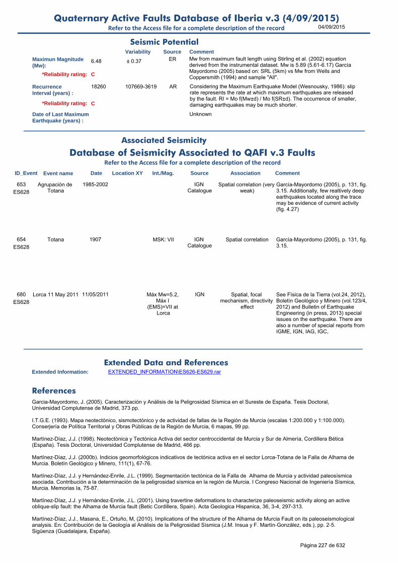
04/09/2015Quaternary Active Faults Database of Iberia v.3 (4/09/2015)
Refer to the Access file for a complete description of the record
Maximun Magnitude(Mw):
6.48 ± 0.37 ER Mw from maximum fault length using Stirling et al. (2002) equation derived from the instrumental dataset. Mw is 5.89 (5.61-6.17) García Mayordomo (2005) based on: SRL (5km) vs Mw from Wells and Coppersmith (1994) and sample "All".
RecurrenceInterval (years) :
18260 107669-3619 AR Considering the Maximum Earthquake Model (Wesnousky, 1986): slip rate represents the rate at which maximum earthquakes are released by the fault. RI = Mo f(Mw±d) / Mo f(SR±d). The occurrence of smaller, damaging earthquakes may be much shorter.
Date of Last MaximumEarthquake (years) :
Unknown
Extended Information: EXTENDED_INFORMATION\ES626-ES629.rar
Garcia-Mayordomo, J. (2005). Caracterización y Análisis de la Peligrosidad Sísmica en el Sureste de España. Tesis Doctoral, Universidad Complutense de Madrid, 373 pp.
I.T.G.E. (1993). Mapa neotectónico, sismotectónico y de actividad de fallas de la Región de Murcia (escalas 1:200.000 y 1:100.000). Conserjería de Política Territorial y Obras Públicas de la Región de Murcia, 6 mapas, 99 pp.
Martínez-Díaz, J.J. (1998). Neotectónica y Tectónica Activa del sector centroccidental de Murcia y Sur de Almería, Cordillera Bética (España). Tesis Doctoral, Universidad Complutense de Madrid, 466 pp.
Martínez-Díaz, J.J. (2000b). Indicios geomorfológicos indicativos de tectónica activa en el sector Lorca-Totana de la Falla de Alhama de Murcia. Boletín Geológico y Minero, 111(1), 67-76.
Martínez-Díaz, J.J. y Hernández-Enrile, J.L. (1999). Segmentación tectónica de la Falla de Alhama de Murcia y actividad paleosísmica asociada. Contribución a la determinación de la peligrosidad sísmica en la región de Murcia. I Congreso Nacional de Ingeniería Sísmica, Murcia. Memorias Ia, 75-87.
Martínez-Díaz, J.J. y Hernández-Enrile, J.L. (2001). Using travertine deformations to characterize paleoseismic activity along an active oblique-slip fault: the Alhama de Murcia fault (Betic Cordillera, Spain). Acta Geologica Hispanica, 36, 3-4, 297-313.
Martínez-Díaz, J.J., Masana, E., Ortuño, M, (2010). Implications of the structure of the Alhama de Murcia Fault on its paleoseismological analysis. En: Contribución de la Geología al Análisis de la Peligrosidad Sísmica (J.M. Insua y F. Martín‐González, eds.), pp. 2‐5. Sigüenza (Guadalajara, España).
Seismic PotentialSource Comment
Associated Seismicity
Extended Data and References
References
Variability
*Reliability rating: C
*Reliability rating: C
Database of Seismicity Associated to QAFI v.3 FaultsRefer to the Access file for a complete description of the record
ID_Event Event name Date Location XY Int./Mag. Source Association Comment
ES628
Agrupación de Totana
1985-2002 IGN Catalogue
Spatial correlation (very weak)
García-Mayordomo (2005), p. 131, fig. 3.15. Additionally, few realtively deep earthquakes located along the trace may be evidence of current activity (fig. 4.27)
653
ES628
Totana 1907 MSK: VII IGN Catalogue
Spatial correlation García-Mayordomo (2005), p. 131, fig. 3.15.
654
ES628
Lorca 11 May 2011 11/05/2011 Máx Mw=5.2, Máx I
(EMS)=VII at Lorca
IGN Spatial, focal mechanism, directivity
effect
See Física de la Tierra (vol.24, 2012), Boletín Geológico y Minero (vol.123/4, 2012) and Bulletin of Earthquake Engineering (in press, 2013) special issues on the earthquake. There are also a number of special reports from IGME, IGN, IAG, IGC,
680
Página 227 de 632
04/09/2015Quaternary Active Faults Database of Iberia v.3 (4/09/2015)
Refer to the Access file for a complete description of the record
Martínez-Díaz, J.J., Masana, E. and Ortuño, M. (2012). Active tectonics of the Alhama de Murcia fault, Betic Cordillera, Spain. Journal of Iberian Geology 38(1): 253-270.
Silva, P.G. (1994). Evolución geodinámica de la Depresión del Guadalentín desde el Mioceno Superior hasta la actualidad: Neotectónica y Geomorfología. Tesis Doctoral, Universidad Complutense de Madrid, 642 pp.
Silva, P.G., Goy, J.L., Zazo, C. y Bardají T. (2003). Fault-generated mountain fronts in southeast Spain: geomorphologic assessment of tectonic and seismic activity. Geomorphology, 50, 203-225.
Silva, P.G., Goy, J.L., Zazo, C., Lario, J. y Bardají, T. (1997). Paleoseismic indications along ‘aseismic’ fault segments in the Guadalentín Depression (SE Spain). Journal of Geodynamics, 24, 1-4, 105-115.
Stirling, M., Rhoades, D. and Berryman K. (2002): Comparison of Earthquake Scaling Relations Derived from Data of the Instrumental and Preinstrumental Era. Bulletin of the Seismological Society of America, 92 (2): 812–830.
Wells, D.L. y Coppersmith, K.J. (1994). New empirical relationships among magnitude, rupture length, rupture width, rupture area, and surface displacement. Bulletin of the Seismological Society of America, 84(4), 974-1002.
Página 228 de 632

04/09/2015Quaternary Active Faults Database of Iberia v.3 (4/09/2015)
Refer to the Access file for a complete description of the record
ID: ES629 Fault Name: Alhama de Murcia (4/4)
Segment Name: Alhama - Alcantarilla
Location X: -1.23109073
Location Y: 38.00316872
Name of Compiler(s): Martínez-Díaz, J.J., García-Mayordomo, J. and Jiménez-Díaz, A.
Filiation: UCM and IGME
Email: [email protected]
Last Update: 16/04/2015
Average Strike(º): 225 + 4 / - 3 LD Martínez-Díaz et al. (2012)
Dip (º): 70 LD Martínez-Díaz et al. (2012). Dips to the North.
Rake (º): 50 75-15 EJ Assumed.
Sense of Movement: RS RS to SR LD Martínez-Díaz et al. (2012)
Length (km): 25.0 17 to 25 LD Martínez-Díaz et al. (2012). According to García-Mayordomo (2005) Table 3.12, 17 km is the length of single faults in the fault zone.
Min Depth (km): 0 LD Outcrops at the surface. Martínez-Díaz et al. (2012)
Max Depth (km): 12.0 LD Given value is max depth of fragile rupture (seismogenic) which for this fault is deeper that the fragile-ductile transition in the area. García-Mayordomo (2005). table 4.21. See discussion on p. 306
Width (km): 12.8 AR
Area (km²): 319.25 AR
Age of the youngestdeposits affected bythe fault:
Middle Pleistocene
Lower to Middle Pleistocene
LD I.T.G.E. (1993); Martínez-Díaz et al. (2012)
Vertical Slip Rate(m/ka or mm/yr) :
0.050 0.03-0.07 LD Average valued from Silva et al. (2003) classification of mountain fronts in García-Mayordomo (2005), p.126. Martínez-Díaz et al. (2012) states 0.07 m/ky.
Horizontal Slip Rate(m/ka or mm/yr) :
0.045 0.045-0.063 AR From NSR (assuming rake=50).
Net Slip Rate(m/ka or mm/yr) :
0.069 0.042-0.097 AR From assumed rake (50), dip and VSR
MaxImum Slip Per Event (m):
Unknown
Number of SeismicEvents:
Unknown
Evidence of AseismicCreep:
Unknown
Identification
Geometry and KinematicsVariability Source Comment
Quaternary Activity
Variability Source
Comment
Low geomorphic expression compared to Puerto Lumbreras-Lorca, Lorca-Totana and Totana-Alhama segments (Silva, 1994; Martínez-Díaz, 1998).
Silva (1994) and Martínez-Díaz (1998) in García-Mayordomo (2005), p. 126. Martinez-Díaz et al. (2010); Martínez-Díaz et al. (2012)
Geological Set: Betic Range (Murcia)
Identification Method: Geological/Geomorphological field mapping
Comment
Quaternary activity evidence
B*Strength Class:
Slip Rate *Accuracy Class: C
Paleoearthquakes
Orden Visual: 149
Página 229 de 632

04/09/2015Quaternary Active Faults Database of Iberia v.3 (4/09/2015)
Refer to the Access file for a complete description of the record
Maximun Magnitude(Mw):
6.78 ± 0.37 ER Mw from maximum fault length using Stirling et al. (2002) equation derived from the instrumental dataset. Mw is 6.51 (6.23-6.79) García Mayordomo (2005) based on: SRL (17km) vs Mw from Wells and Coppersmith (1994) and sample "All".
RecurrenceInterval (years) :
24944 147083-4944 AR Considering the MEM (Wesnousky, 1986): slip rate represents the rate at which maximum earthquakes are released by the fault. RI = Mo f(Mw±d) / Mo f(SR±d). The occurrence of smaller, damaging earthquakes may be much shorter. Previous estimation was 24000.
Date of Last MaximumEarthquake (years) :
Unknown
Extended Information: EXTENDED_INFORMATION\ES626-ES629.rar
García-Mayordomo, J. (2005). Caracterización y Análisis de la Peligrosidad Sísmica en el Sureste de España. Tesis Doctoral, Universidad Complutense de Madrid, 373 pp.
I.T.G.E. (1993). Mapa neotectónico, sismotectónico y de actividad de fallas de la Región de Murcia (escalas 1:200.000 y 1:100.000). Conserjería de Política Territorial y Obras Públicas de la Región de Murcia, 6 mapas, 99 pp.
Martínez-Díaz, J.J. (1998). Neotectónica y Tectónica Activa del sector centroccidental de Murcia y Sur de Almería, Cordillera Bética (España). Tesis Doctoral, Universidad Complutense de Madrid, 466 pp.
Martínez-Díaz, J.J. (2000b). Indicios geomorfológicos indicativos de tectónica activa en el sector Lorca-Totana de la Falla de Alhama de Murcia. Boletín Geológico y Minero, 111(1), 67-76.
Martínez-Díaz, J.J. y Hernández-Enrile, J.L. (1999). Segmentación tectónica de la Falla de Alhama de Murcia y actividad paleosísmica asociada. Contribución a la determinación de la peligrosidad sísmica en la región de Murcia. I Congreso Nacional de Ingeniería Sísmica, Murcia. Memorias Ia, 75-87.
Martínez-Díaz, J.J. y Hernández-Enrile, J.L. (2001). Using travertine deformations to characterize paleoseismic activity along an active oblique-slip fault: the Alhama de Murcia fault (Betic Cordillera, Spain). Acta Geologica Hispanica, 36, 3-4, 297-313.
Martínez-Díaz, J.J., Masana, E., Ortuño, M, (2010). Implications of the structure of the Alhama de Murcia Fault on its paleoseismological analysis. En: Contribución de la Geología al Análisis de la Peligrosidad Sísmica (J.M. Insua y F. Martín‐González, eds.), pp. 2‐5. Sigüenza (Guadalajara, España).
Seismic PotentialSource Comment
Associated Seismicity
Extended Data and References
References
Variability
*Reliability rating: C
*Reliability rating: C
Database of Seismicity Associated to QAFI v.3 FaultsRefer to the Access file for a complete description of the record
ID_Event Event name Date Location XY Int./Mag. Source Association Comment
ES629
Agrupación de Alhama
1996 MSK: III; M: 3.5 IGN Catalogue
Spatial correlation (weak)
García-Mayordomo (2005). Additionally, few realtively deep earthquakes located along the trace may be evidence of current activity (fig. 4.27)
655
ES629
Alhama 1864 MSK: VI IGN Catalogue
Spatial correlation (weak)
García-Mayordomo, J. (2005)656
ES629
Sangonera 1946 MSK: VI; M: 4.2 IGN Catalogue
Spatial correlation (very likely)
García-Mayordomo, J. (2005) p.174 and fig. 3.21.
657
Página 230 de 632

04/09/2015Quaternary Active Faults Database of Iberia v.3 (4/09/2015)
Refer to the Access file for a complete description of the record
Martínez-Díaz, J.J., Masana, E. and Ortuño, M. (2012). Active tectonics of the Alhama de Murcia fault, Betic Cordillera, Spain. Journal of Iberian Geology 38(1): 253-270.
Silva, P.G. (1994). Evolución geodinámica de la Depresión del Guadalentín desde el Mioceno Superior hasta la actualidad: Neotectónica y Geomorfología. Tesis Doctoral, Universidad Complutense de Madrid, 642 pp.
Silva, P.G., Goy, J.L., Zazo, C. y Bardají T. (2003). Fault-generated mountain fronts in southeast Spain: geomorphologic assessment of tectonic and seismic activity. Geomorphology, 50, 203-225.
Silva, P.G., Goy, J.L., Zazo, C., Lario, J. y Bardají, T. (1997). Paleoseismic indications along ‘aseismic’ fault segments in the Guadalentín Depression (SE Spain). Journal of Geodynamics, 24, 1-4, 105-115.
Slemmons, D.B. (1982). Determination of design earthquake magnitudes for microzonation. En: Proceedings of the 3rd International Earthquake Microzonation Conference, Seatle, Washington, v.1, 119-130.
Stirling, M., Rhoades, D. and Berryman K. (2002): Comparison of Earthquake Scaling Relations Derived from Data of the Instrumental and Preinstrumental Era. Bulletin of the Seismological Society of America, 92 (2): 812–830.
Villamor, P. y Berryman, K. (1999). La tasa de deslizamiento de una falla como aproximación de primer orden en las estimaciones de peligrosidad sísmica. 1er Congreso Nacional de Ingeniería Sísmica, Murcia, I, 153-163.
Wells, D.L. y Coppersmith, K.J. (1994). New empirical relationships among magnitude, rupture length, rupture width, rupture area, and surface displacement. Bulletin of the Seismological Society of America, 84(4), 974-1002.
Wesnousky, S.G. (1986). Earthquakes, Quaternary faults, and seismic hazard in California. Journal of Geophysical Research. 91(B12), 12587-12631.
Página 231 de 632

04/09/2015Quaternary Active Faults Database of Iberia v.3 (4/09/2015)
Refer to the Access file for a complete description of the record
ID: ES630 Fault Name: Carboneras (1/2)
Segment Name: Northern
Location X: -2.76389467
Location Y: 36.42757359
Name of Compiler(s): Moreno, X., Masana, E. and Gràcia, E.
Filiation: RISKNAT-UB and UTM-CSIC
Email: [email protected]
Last Update: 17/09/2014
Average Strike(º): 048 + 9 / - 5 LD Measured on multibeam bathymetric data (Moreno, 2010)
Dip (º): 90 ± 10 LD Calculated from seismic profiles (Moreno, 2010)
Rake (º): 10 LD Calculated from offsets of a calcrete crust dated between 130-71 ka. Dip-slip is a maximum value and with a larger uncertainty than strike-slip component (Moreno, 2010).
Sense of Movement: SR LD A predominant left-lateral strike-slip deformation with some vertical slip component was observed by P-C microstructures in trenches at La Serrata and by displacement of linear features such as gullies (Moreno, 2010; Moreno et al., 2008, 2010).
Length (km): 110.5 ± 1 EJ In our opinion, this segment most probably gathers two or more segments, but we have no conclusive evidence to place a segment limit along it. As Expert Judgement, a segment limit may occur along La Serrata, but more evidence are needed.
Min Depth (km): 0 LD Outcrops at surface (Moreno, 2010).
Max Depth (km): 11.0 LD Lower depth of the instrumental seismicity according to IGN online seismic data base (Moreno, 2010).
Width (km): 11.0 AR
Area (km²): 1215.50 AR
Age of the youngestdeposits affected bythe fault:
1190 yr BP ± 25 yr LD Calculated from a faulted and buried paleochannel observed in trenches at El Hacho site (southern part of La Serrata range) (Moreno et al., 2008, 2010). Holocene reflections are also apparently faulted in TOPAS profiles along the offshore portion.
Vertical Slip Rate(m/ka or mm/yr) :
0.040 LD Minimum long-term value obtained from multichannel seismic profiles We can't distinguish at this scale what is dip slip offset from what is lateral movement of terrains having different elevations It has much larger strike slip component than dip slip one
Horizontal Slip Rate(m/ka or mm/yr) :
1.1 LD Calculated from onshore (along La Serrata range) and offset gullies offshore (Moreno, 2010; Moreno et al., 2010). Minimum value. GPS is suggesting also a 1 mm/yr order of magnitude of strike-slip rate.
Net Slip Rate(m/ka or mm/yr) :
1.101 LD Moreno, 2010.
MaxImum Slip Per Event (m):
1.5 0-3 LD Maximum offset estimated from buried paleochannel observed in trenches at El Hacho site (southern part of La Serrata range) (Moreno, 2010; Moreno et al., 2008).
Identification
Geometry and KinematicsVariability Source Comment
Quaternary Activity
Variability Source
Comment
Rectilinear mountain front, offset gullies, beheaded alluvial fans, alluvial fans without drainage area, faulted and folded quaternary deposits
Moreno, 2010.
Geological Set: Betic Range (Almería)
Identification Method: Geological/Geomorphological field mapping
Comment
Quaternary activity evidence
A+*Strength Class:
Slip Rate *Accuracy Class: A
Paleoearthquakes
Orden Visual: 192
Página 232 de 632

04/09/2015Quaternary Active Faults Database of Iberia v.3 (4/09/2015)
Refer to the Access file for a complete description of the record
Number of SeismicEvents:
6 LD A minimum of 6 events since the Mid Pleistocene are observed in trenches along La Serrata. However, we are most probably missing events due to the intermittent deposit aggradation and erosion of the region (Moreno, 2010; Moreno et al., 2008).
Evidence of AseismicCreep:
Unknown
Maximun Magnitude(Mw):
7.39 ± 0.37 ER Mw from length using Stirling et al. (2002) equation derived from the instrumental dataset. Mw is 7.4 (± 0.3) according to W&C'94 empirical relationship between Mw and max. SRL for strike-slip faults. If considering smaller segments, Mw decreases.
RecurrenceInterval (years) :
1150 <13500 LD Considering a long term slip-rate of 1.3 mm/yr and a slip per event of 1.5 m (estimated in 3D trenches at El Hacho). A much longer recurrence is obtained if considering 3 events in the last 40 ka (Moreno, 2010). Considering MEM (W'86) results 3413 yrs.
Date of Last MaximumEarthquake (years) :
<1178 BP younger than 1178 BP
OD Younger than the age of the youngest deposit affected by the fault: the buried paleochannel observed at El Hacho site (southern part of La Serrata range).
Extended Information: EXTENDED_INFORMATION\ES630.rar
Gràcia, E., Pallas, R., Soto, J. I., Comas, M., Moreno, X., Masana, E., Santanach, P., Diez, S., García, M., and Dañobeitia, J. (2006). Active faulting offshore SE Spain (Alboran Sea): Implications for earthquake hazard assessment in the Southern Iberian Margin. Earth and Planetary Science Letters 241, 734-749.
Gràcia, E., Bartolomé, R., Lo Iacono, C., Moreno, X., Martínez-Loriente, S., Perea, H., Masana, E., Pallàs, R., Díez, S., Dañobeitia, J.J., Terrinha, P., Zitellini, N. (2010). Characterizing active faults and associated mass transport deposits in the South Iberian Margin (Alboran Sea and Gulf of Cadiz): On-fault and off-fault paleoseismic evidence. En: Contribución de la Geología al Análisis de la Peligrosidad Sísmica (J.M. Insúa y F.Martín-González, eds.), pp. 163-166. IBERFAULT, Sigüenza (Guadalajara), 27-29 Octubre 2010.
Moreno, X., Masana, E., Gràcia, E., Bartolomé, R., and Piqué-Serra, O. (2008). Estudio paleosismológico de la Falla de Carboneras: Evidencias tierra-mar de actividad tectónica reciente. GeoTemas 10, 1035-1038.
Moreno, X. (2010). Neotectonic and Paleoseismic Onshore-Offshore integrated study of the Carboneras Fault (Eastern Betics, SE Iberia). Doctoral Thesis, Barcelona University.
Masana, E., Gràcia, E., Martínez Díaz, J.J., Moreno, X., Ortuño, M., Perea, H., Khazaradze, G., Pallàs, R., Rodés, A., Queralt, P., Coll, M, Bartolomé, R., García-Meléndez, E., Ruano, P., Stepancikova, P., Dañobeitia, J.J., Santanach, P. (2010). Characterizing the seismic potential of the Eastern Betics Shear Zone (EBSZ), a major source of earthquakes in Southeastern Iberia. En: Contribución de la Geología al Análisis de la Peligrosidad Sísmica (J.M. Insúa y F.Martín-González, eds.), pp. 101-104. IBERFAULT, Sigüenza (Guadalajara), 27-29 Octubre 2010.
Moreno, X., Masana, E., Gràcia, E., Bartolomé, R., Rodés, A., and Pallàs, R. (2010). Onshore-Offshore active tectonics along the Carboneras Fault Zone (Eastern Betic Cordilleras). In "Contribución de la Geología al Análisis de la Peligrosidad Sísmica." (J. M. Insua-Arévalo, and F. Martín-González, Eds.), pp. 105-107, Sigüenza (Guadalajara, Spain).
Reicherter, K. and Hübscher,C. (2007) Evidence for a seafloor rupture of the Carboneras Fault Zone (southern Spain): Relation to the 1522 Almería earthquake? Journal of Seismology, 11:15-16.
Stirling, M., Rhoades, D. and Berryman K. (2002): Comparison of Earthquake Scaling Relations Derived from Data of the Instrumental and Preinstrumental Era. Bulletin of the Seismological Society of America, 92 (2): 812–830.
Seismic PotentialSource Comment
Associated Seismicity
Extended Data and References
References
Variability
*Reliability rating: A
*Reliability rating: A
Database of Seismicity Associated to QAFI v.3 FaultsRefer to the Access file for a complete description of the record
ID_Event Event name Date Location XY Int./Mag. Source Association Comment
ES630
Almeria 1522 earthquake
22/09/1522 -2.40,36.58 EMS=IX; M>6.5 IGN and Reicherter
and Hübscher
(2007)
Reicherter and Hübscher (2007)
Reicherter and Hübscher (2007)727
Página 233 de 632
04/09/2015Quaternary Active Faults Database of Iberia v.3 (4/09/2015)
Refer to the Access file for a complete description of the record
Wells, D. L., and Coppersmith, K. J. (1994). New empirical relationships among magnitude, rupture length, rupture width, and surface displacement. Bulleting of the Seismological Society of America 84, 974-1002.
Página 234 de 632

04/09/2015Quaternary Active Faults Database of Iberia v.3 (4/09/2015)
Refer to the Access file for a complete description of the record
ID: ES631 Fault Name: Amarguillo
Segment Name: Amarguillo
Location X: -1.51032411
Location Y: 37.77421717
Name of Compiler(s): Martinez-Diaz, J.J.
Filiation: UCM
Email: [email protected]
Last Update: 16/12/2010
Average Strike(º): 020 ± 4 LD Martinez -Díaz et al. (2010); IGME (1993).
Dip (º): 90 ± 5 OD Observation in the field
Rake (º): 90 60-90 EJ
Sense of Movement: R N to ND LD Martinez -Díaz et al. (2010); IGME (1993).
Length (km): 12.0 - 0.5 / + 2 EJ Based on data from Martinez -Díaz et al. (2010); IGME (1993).
Min Depth (km): 0
Max Depth (km): 8.0 EJ Inferred from data included in Martinez -Díaz et al. (2010); IGME (1993) to maintain a realistic shape factor.
Width (km): 8.0 AR
Area (km²): 96.00 AR
Age of the youngestdeposits affected bythe fault:
Upper Pleistocene
LD Martinez-Díaz et al. (2010); IGME (1993).
Vertical Slip Rate(m/ka or mm/yr) :
0.100 +0.1/-0.05 EJ From cartographic data of Martínez-Díaz et al. (2010) and IGME (1993).
Horizontal Slip Rate(m/ka or mm/yr) :
0 EJ Pure reverse
Net Slip Rate(m/ka or mm/yr) :
0.1 +0.1/-0.05 EJ From cartographic data of Martínez-Díaz et al. (2010) and IGME (1993).
MaxImum Slip Per Event (m):
Unknown
Number of SeismicEvents:
Unknown
Evidence of AseismicCreep:
Unknown
Identification
Geometry and KinematicsVariability Source Comment
Quaternary Activity
Variability Source
Comment
Seismic Potential
Very clear surface expression, deforms alluvial fans and produce blocking and deflections in fluvial network
Martinez-Díaz et al. (2010); IGME (1993).
Geological Set: Betic Range (Murcia)
Identification Method: Geological/Geomorphological field mapping
Comment
Quaternary activity evidence
A+*Strength Class:
Slip Rate *Accuracy Class: C
Paleoearthquakes
Orden Visual: 150
Página 235 de 632
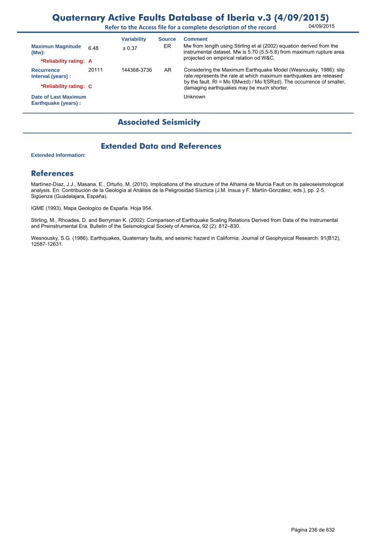
04/09/2015Quaternary Active Faults Database of Iberia v.3 (4/09/2015)
Refer to the Access file for a complete description of the record
Maximun Magnitude(Mw):
6.48 ± 0.37 ER Mw from length using Stirling et al (2002) equation derived from the instrumental dataset. Mw is 5.70 (5.5-5.8) from maximum rupture area projected on empirical relation od W&C.
RecurrenceInterval (years) :
20111 144368-3736 AR Considering the Maximum Earthquake Model (Wesnousky, 1986): slip rate represents the rate at which maximum earthquakes are released by the fault. RI = Mo f(Mw±d) / Mo f(SR±d). The occurrence of smaller, damaging earthquakes may be much shorter.
Date of Last MaximumEarthquake (years) :
Unknown
Extended Information:
Martínez-Díaz, J.J., Masana, E., Ortuño, M, (2010). Implications of the structure of the Alhama de Murcia Fault on its paleoseismological analysis. En: Contribución de la Geología al Análisis de la Peligrosidad Sísmica (J.M. Insua y F. Martín‐González, eds.), pp. 2‐5. Sigüenza (Guadalajara, España).
IGME (1993). Mapa Geologico de España. Hoja 954.
Stirling, M., Rhoades, D. and Berryman K. (2002): Comparison of Earthquake Scaling Relations Derived from Data of the Instrumental and Preinstrumental Era. Bulletin of the Seismological Society of America, 92 (2): 812–830.
Wesnousky, S.G. (1986). Earthquakes, Quaternary faults, and seismic hazard in California. Journal of Geophysical Research. 91(B12), 12587-12631.
Source Comment
Associated Seismicity
Extended Data and References
References
Variability
*Reliability rating: A
*Reliability rating: C
Página 236 de 632

04/09/2015Quaternary Active Faults Database of Iberia v.3 (4/09/2015)
Refer to the Access file for a complete description of the record
ID: ES632 Fault Name: Las Viñas
Segment Name: Las Viñas
Location X: -1.70770893
Location Y: 37.68206054
Name of Compiler(s): Martínez-Díaz, J. J.
Filiation: UCM
Email: [email protected]
Last Update: 16/12/2010
Average Strike(º): 285 ± 3 LD Geometrical data from Martinez-Díaz, J.J. (1998; 2000)
Dip (º): 80 ± 5 LD Geometrical data from Martinez-Díaz, J.J. (1998; 2000)
Rake (º): 70 + 10 / - 20 OD
Sense of Movement: ND N to ND-DN LD From Martinez-Díaz, J.J. (1998; 2000)
Length (km): 3.5 to 5.5 LD From Martinez-Díaz, J.J. (2000)
Min Depth (km): 0 LD From Martinez-Díaz, J.J. (2000)
Max Depth (km): 5.0 EJ This is a coherent value to maintain a realistic shape factor considering that this fault do not affect the entire brittle crust.
Width (km): 5.1 AR
Area (km²): 17.77 AR
Age of the youngestdeposits affected bythe fault:
Upper Pleistocene
Holocene-Upper Pleistocene
LD Martinez-Díaz, J.J. (1998; 2000); IGME, 1993.
Vertical Slip Rate(m/ka or mm/yr) :
0.400 +0.1/-0.1 LD From Martinez-Díaz, J.J. (1998). Geological slip rate from Pliocene time.
Horizontal Slip Rate(m/ka or mm/yr) :
0.137 0.171-0.034 AR From NSR and rake
Net Slip Rate(m/ka or mm/yr) :
0.4 +0.1/-0.3 EJ From data and paleoseismic descriptions in Martinez-Díaz, J.J. (1998).
MaxImum Slip Per Event (m):
0.5 +0.2/-0.1 EJ From data and paleoseismic descriptions in Martinez-Díaz, J.J. (1998).
Number of SeismicEvents:
Unknown
Evidence of AseismicCreep:
Unknown
Identification
Geometry and KinematicsVariability Source Comment
Quaternary Activity
Variability Source
Comment
Seismic Potential
The fault produce tilting on fluvial terraces and alluvial fans and the migration to the south of the Guadalentín river
Martinez-Díaz, J.J. (1998; 2000)
Geological Set: Betic Range (Murcia)
Identification Method: Geological/Geomorphological field mapping
Comment
Quaternary activity evidence
A+*Strength Class:
Slip Rate *Accuracy Class: C
Paleoearthquakes
Orden Visual: 151
Página 237 de 632

04/09/2015Quaternary Active Faults Database of Iberia v.3 (4/09/2015)
Refer to the Access file for a complete description of the record
Maximun Magnitude(Mw):
5.97 ± 0.37 ER To 6.15 if considering maximum length (5.5 km) and using Stirling et al (2002) equation derived from the instrumental dataset. Mw 5.50 (5.30-5.6) from Martinez-Díaz, J.J. (1998; 2000)
RecurrenceInterval (years) :
4693 67373-1046 AR Considering the Maximum Earthquake Model (Wesnousky, 1986): slip rate represents the rate at which maximum earthquakes are released by the fault. RI = Mo f(Mw±d) / Mo f(SR±d). The occurrence of smaller, damaging earthquakes may be much shorter.
Date of Last MaximumEarthquake (years) :
Unknown
Extended Information: EXTENDED_INFORMATION\ES632.rar
Martínez-Díaz, J.J. (1998). Neotectónica y Tectónica Activa del sector centroccidental de Murcia y Sur de Almería, Cordillera Bética (España). Tesis Doctoral, Universidad Complutense de Madrid, 466 pp.
Martínez-Díaz, J.J. (2000). Neotectonica Y Tectonica Activa De La Falla De Las Viñas: Influencia De Las Perturbaciones Del Campo De Esfuerzos Regional Generadas Por La Falla De Alhama De Murcia. Boletín Geológico y Minero, 111-1: 33-52.
Stirling, M., Rhoades, D. and Berryman K. (2002): Comparison of Earthquake Scaling Relations Derived from Data of the Instrumental and Preinstrumental Era. Bulletin of the Seismological Society of America, 92 (2): 812–830.
Wesnousky, S.G. (1986). Earthquakes, Quaternary faults, and seismic hazard in California. Journal of Geophysical Research. 91(B12), 12587-12631.
Source Comment
Associated Seismicity
Extended Data and References
References
Variability
*Reliability rating: A
*Reliability rating: C
Página 238 de 632

04/09/2015Quaternary Active Faults Database of Iberia v.3 (4/09/2015)
Refer to the Access file for a complete description of the record
ID: ES633 Fault Name: Torremendo
Segment Name:
Location X: -0.978778
Location Y: 38.015916
Name of Compiler(s): Alfaro, P.
Filiation: Universidad de Alicante
Email: [email protected]
Last Update: 12/07/2011
Average Strike(º): 079 LD Alfaro et al., 2002
Dip (º): 30 LD Alfaro et al., 2002
Rake (º):
Sense of Movement: R LD Alfaro et al., 2002
Length (km): 11.8 LD Alfaro et al., 2002
Min Depth (km): 1 LD Alfaro et al., 2002
Max Depth (km): 12.0 LD Alfaro et al., 2002
Width (km): 22.0 AR
Area (km²): 259.60 AR
Age of the youngestdeposits affected bythe fault:
Upper Pleistocene-Holocene
Upper Pleistocene-Holocene
LD Alfaro et al., 2002
Vertical Slip Rate(m/ka or mm/yr) :
Unknown
Horizontal Slip Rate(m/ka or mm/yr) :
Unknown
Net Slip Rate(m/ka or mm/yr) : Unknown
MaxImum Slip Per Event (m):
Unknown
Number of SeismicEvents:
Unknown
Evidence of AseismicCreep:
Unknown
Identification
Geometry and KinematicsVariability Source Comment
Quaternary Activity
Variability Source
Comment
Seismic Potential
Deformation in Upper Pleistocene to Holocene sediments inferred from seismic reflection lines (Alfaro et al., 2002).
Inferred from seismic reflection lines (Alfaro et al., 2002); García-Mayordomo (2005), p.167.
Geological Set: Betic Range (Alicante)
Identification Method: Geological/Geomorphological field mapping and geophysical methods (seismic reflection lines).
Comment
Quaternary activity evidence
A+*Strength Class:
Slip Rate *Accuracy Class: Not rated
Paleoearthquakes
Orden Visual: 142
Página 239 de 632
04/09/2015Quaternary Active Faults Database of Iberia v.3 (4/09/2015)
Refer to the Access file for a complete description of the record
Maximun Magnitude(Mw):
6.47 ± 0.37 ER Mw from length using Stirling et al (2002) equation derived from the instrumental dataset.
RecurrenceInterval (years) :
Not enough data for an estimation
Date of Last MaximumEarthquake (years) :
Unknown
Extended Information:
Alfaro, P., Andreu, J.M., J. Delgado, Estévez, A., Soria, J.M. y Teixido, T. (2002). Quaternary deformation of the Bajo Segura blind fault (eastern Betic Cordillera, Spain) revealed by high resolution reflection profiling. Geological Magazine, 139(3), 331-341.
Stirling, M., Rhoades, D. and Berryman K. (2002): Comparison of Earthquake Scaling Relations Derived from Data of the Instrumental and Preinstrumental Era. Bulletin of the Seismological Society of America, 92 (2): 812–830.
Source Comment
Associated Seismicity
Extended Data and References
References
Variability
*Reliability rating: A
*Reliability rating: Not rated
Página 240 de 632

04/09/2015Quaternary Active Faults Database of Iberia v.3 (4/09/2015)
Refer to the Access file for a complete description of the record
ID: ES635 Fault Name: Polopos fault zone (1/2)
Segment Name: North Alhamilla reverse fault
Location X: -2.3266114
Location Y: 37.03004153
Name of Compiler(s): Giaconia, F., Booth-Rea, G., Martínez-Martínez, J.M., Azañón, J.M. and Pérez-Peña,V.
Filiation: Dpto. Geodinámica, IACT (CSIC-UGR)
Email: [email protected]
Last Update: 13/04/2015
Average Strike(º): 080 LD Giaconia et al. (2013)
Dip (º): 40 30-50 LD Giaconia et al. (2013)
Rake (º): 80 LD Giaconia et al. (2013)
Sense of Movement: R LD Giaconia et al. (2013)
Length (km): 17.0 LD Giaconia et al. (2013)
Min Depth (km): 0 LD Giaconia et al. (2013)
Max Depth (km): 10.0 EJ
Width (km): 15.6 AR
Area (km²): 264.47 AR
Age of the youngestdeposits affected bythe fault:
Upper Pleistocene
LD This fault cut through Early Tortonian turbidites and Quaternary alluvial fans associated to the north Alhamilla mountain front (see Giaconia et al., 2012, 2013)
Vertical Slip Rate(m/ka or mm/yr) :
0.100 0.05-0.50 LD Giaconia et al. (2012 and 2013)
Horizontal Slip Rate(m/ka or mm/yr) :
0.03 EJ
Net Slip Rate(m/ka or mm/yr) :
0.25 0.19-0.31 LD Net displacements range between 80 and 125 m in the last 400 ky (see Giaconia et al., 2013)
MaxImum Slip Per Event (m):
Unknown
Number of SeismicEvents:
Unknown
Evidence of AseismicCreep:
Unknown
Identification
Geometry and KinematicsVariability Source Comment
Quaternary Activity
Variability Source
Comment
Seismic Potential
Scarps, deformed alluvial fans, offset channel, drainage pattern, topographic lineament, geomorphic indices.
Azañón et al. (2012); Giaconia et al. (2012); Giaconia et al. (2013);
Geological Set: Betic Range (Almería)
Identification Method: Geological/Geomorphological field mapping
Comment
Quaternary activity evidence
A*Strength Class:
Slip Rate *Accuracy Class: B
Paleoearthquakes
Orden Visual: 194
Página 241 de 632
04/09/2015Quaternary Active Faults Database of Iberia v.3 (4/09/2015)
Refer to the Access file for a complete description of the record
Maximun Magnitude(Mw):
6.62 ± 0.37 ER Mw from length using Stirling et al (2002) equation derived from the instrumental dataset.
RecurrenceInterval (years) :
4797 22654-1078 AR Considering the Maximum Earthquake Model (Wesnousky, 1986): slip rate represents the rate at which maximum earthquakes are released by the fault. RI = Mo f(Mw±d) / Mo f(SR±d). The occurrence of smaller, damaging earthquakes may be much shorter.
Date of Last MaximumEarthquake (years) :
Unknown
Extended Information: EXTENDED_INFORMATION\ES635-ES636.rar
Azañón, J.M., Pérez-Peña, J.V., Giaconia, F., Booth-Rea, G., Martínez-Martínez, M., Rodríguez-Peces, M.J. (2012) Active tectonics in the central and eastern Betic Cordillera through morphotectonic analysis: the case of Sierra Nevada and Sierra Alhamilla.Journal of Iberian Geology, 38(1):225-238.
Giaconia, F., Booth-Rea, G., Martínez-Martínez, J.M., Azañón, J.M., Pérez-Peña, J.V., Pérez-Romero, J., Villegas, I., 2012. Geomorphic evidence of active tectonics in the Sierra Alhamilla (eastern Betics, SE Spain). Geomorphology, 145-146:90-106. http://dx.doi.org/10.1016/j.geomorph.2011.12.043.
Giaconia, F., Booth-Rea, G., Martínez-Martínez, J.M., Azañón, J.M., Pérez-Romero, J. and Villegas, I. (2013) Mountain front migration and drainage captures related to fault segment linkage and growth: The Polopos transpressive fault zone (southeastern Betics, SE Spain). Journal of Structural Geology, 46:76-91.
Stirling, M., Rhoades, D. and Berryman K. (2002): Comparison of Earthquake Scaling Relations Derived from Data of the Instrumental and Preinstrumental Era. Bulletin of the Seismological Society of America, 92 (2): 812–830.
Wesnousky, S.G. (1986). Earthquakes, Quaternary faults, and seismic hazard in California. Journal of Geophysical Research. 91(B12), 12587-12631.
Source Comment
Associated Seismicity
Extended Data and References
References
Variability
*Reliability rating: B
*Reliability rating: B
Database of Seismicity Associated to QAFI v.3 FaultsRefer to the Access file for a complete description of the record
ID_Event Event name Date Location XY Int./Mag. Source Association Comment
ES635
Serie Sísmica de Sierra Alhamilla
1984 MSK: V; M:5.0 IGN Catalogue
Spatial correlation (weak)
Rueda et al. (1992); García-Mayordomo, J. (2005)
630
Página 242 de 632
04/09/2015Quaternary Active Faults Database of Iberia v.3 (4/09/2015)
Refer to the Access file for a complete description of the record
ID: ES636 Fault Name: Polopos fault zone (2/2)
Segment Name: South Gafarillos fault
Location X: -2.15634852
Location Y: 37.03281211
Name of Compiler(s): Booth-Rea, G., Giaconia, F., Martínez-Martínez, J.M., Azañón, J.M. and Villegas, I.
Filiation: Dpto. Geodinámica, IACT (CSIC-UGR)
Email: [email protected]
Last Update: 13/04/2015
Average Strike(º): 095 90-120 LD Giaconia et al. (2013)
Dip (º): 80 LD Giaconia et al. (2013)
Rake (º): 135 LD Giaconia et al. (2013)
Sense of Movement: RD DR-DN LD Giaconia et al. (2013)
Length (km): 13.0 LD Giaconia et al. (2013)
Min Depth (km): 0 LD Giaconia et al. (2013)
Max Depth (km): 10.0 EJ
Width (km): 10.2 AR
Area (km²): 132.01 AR
Age of the youngestdeposits affected bythe fault:
Upper Pleistocene
LD This fault cut through Early Tortonian turbidites and Quaternary alluvial fans associated to the north Alhamilla mountain front (see Giaconia et al., 2012, 2013)
Vertical Slip Rate(m/ka or mm/yr) :
0.100 LD 320 m in the last 3.2 ma (see Giaconia et al., 2013)
Horizontal Slip Rate(m/ka or mm/yr) :
0.15 EJ
Net Slip Rate(m/ka or mm/yr) :
0.24 0.04-0.44 LD Net displacements range between 30-100 m and 144-176 m in the last 400 ky (see Giaconia et al., 2013).
MaxImum Slip Per Event (m):
Unknown
Number of SeismicEvents:
Unknown
Evidence of AseismicCreep:
Unknown
Identification
Geometry and KinematicsVariability Source Comment
Quaternary Activity
Variability Source
Comment
Seismic Potential
Deformed alluvial fans, channel offset, drainage pattern, topographic lineament, geomorphologic indices.
Azañón et al. (2012); Giaconia et al. (2012); Giaconia et al. (2013);
Geological Set: Betic Range (Almería)
Identification Method: Geological/Geomorphological field mapping
Comment
Quaternary activity evidence
A*Strength Class:
Slip Rate *Accuracy Class: B
Paleoearthquakes
Orden Visual: 195
Página 243 de 632
04/09/2015Quaternary Active Faults Database of Iberia v.3 (4/09/2015)
Refer to the Access file for a complete description of the record
Maximun Magnitude(Mw):
6.51 ± 0.37 ER Mw from length using Stirling et al (2002) equation derived from the instrumental dataset.
RecurrenceInterval (years) :
6831 147100-1038 AR Considering the Maximum Earthquake Model (Wesnousky, 1986): slip rate represents the rate at which maximum earthquakes are released by the fault. RI = Mo f(Mw±d) / Mo f(SR±d). The occurrence of smaller, damaging earthquakes may be much shorter.
Date of Last MaximumEarthquake (years) :
Unknown
Extended Information: EXTENDED_INFORMATION\ES635-ES636.rar
Azañón, J.M., Pérez-Peña, J.V., Giaconia, F., Booth-Rea, G., Martínez-Martínez, M., Rodríguez-Peces, M.J. (2012) Active tectonics in the central and eastern Betic Cordillera through morphotectonic analysis: the case of Sierra Nevada and Sierra Alhamilla.Journal of Iberian Geology, 38(1):225-238.
Giaconia, F., Booth-Rea, G., Martínez-Martínez, J.M., Azañón, J.M., Pérez-Peña, J.V., Pérez-Romero, J., Villegas, I., 2012. Geomorphic evidence of active tectonics in the Sierra Alhamilla (eastern Betics, SE Spain). Geomorphology, 145-146:90-106. http://dx.doi.org/10.1016/j.geomorph.2011.12.043.
Giaconia, F., Booth-Rea, G., Martínez-Martínez, J.M., Azañón, J.M., Pérez-Romero, J. and Villegas, I. (2013) Mountain front migration and drainage captures related to fault segment linkage and growth: The Polopos transpressive fault zone (southeastern Betics, SE Spain). Journal of Structural Geology, 46:76-91.
Stirling, M., Rhoades, D. and Berryman K. (2002): Comparison of Earthquake Scaling Relations Derived from Data of the Instrumental and Preinstrumental Era. Bulletin of the Seismological Society of America, 92 (2): 812–830.
Wesnousky, S.G. (1986). Earthquakes, Quaternary faults, and seismic hazard in California. Journal of Geophysical Research. 91(B12), 12587-12631.
Source Comment
Associated Seismicity
Extended Data and References
References
Variability
*Reliability rating: B
*Reliability rating: B
Página 244 de 632
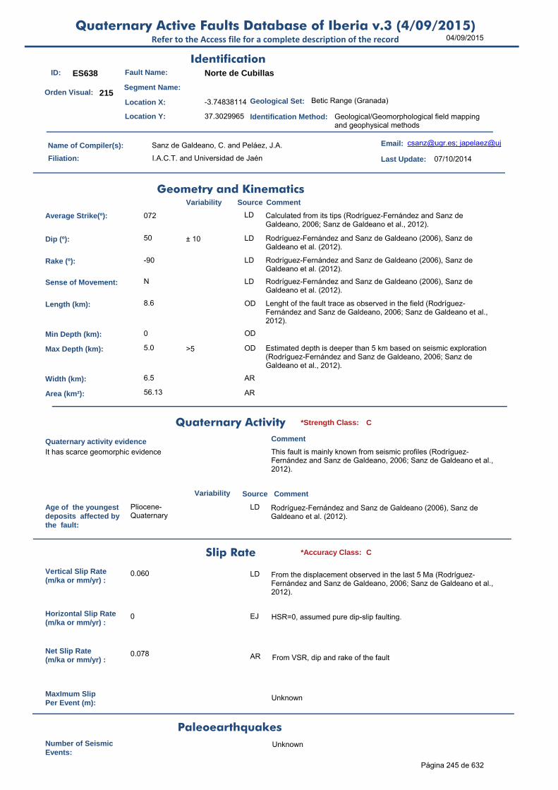
04/09/2015Quaternary Active Faults Database of Iberia v.3 (4/09/2015)
Refer to the Access file for a complete description of the record
ID: ES638 Fault Name: Norte de Cubillas
Segment Name:
Location X: -3.74838114
Location Y: 37.3029965
Name of Compiler(s): Sanz de Galdeano, C. and Peláez, J.A.
Filiation: I.A.C.T. and Universidad de Jaén
Email: [email protected]; japelaez@uj
Last Update: 07/10/2014
Average Strike(º): 072 LD Calculated from its tips (Rodríguez-Fernández and Sanz de Galdeano, 2006; Sanz de Galdeano et al., 2012).
Dip (º): 50 ± 10 LD Rodríguez-Fernández and Sanz de Galdeano (2006), Sanz de Galdeano et al. (2012).
Rake (º): -90 LD Rodríguez-Fernández and Sanz de Galdeano (2006), Sanz de Galdeano et al. (2012).
Sense of Movement: N LD Rodríguez-Fernández and Sanz de Galdeano (2006), Sanz de Galdeano et al. (2012).
Length (km): 8.6 OD Lenght of the fault trace as observed in the field (Rodríguez-Fernández and Sanz de Galdeano, 2006; Sanz de Galdeano et al., 2012).
Min Depth (km): 0 OD
Max Depth (km): 5.0 >5 OD Estimated depth is deeper than 5 km based on seismic exploration (Rodríguez-Fernández and Sanz de Galdeano, 2006; Sanz de Galdeano et al., 2012).
Width (km): 6.5 AR
Area (km²): 56.13 AR
Age of the youngestdeposits affected bythe fault:
Pliocene-Quaternary
LD Rodríguez-Fernández and Sanz de Galdeano (2006), Sanz de Galdeano et al. (2012).
Vertical Slip Rate(m/ka or mm/yr) :
0.060 LD From the displacement observed in the last 5 Ma (Rodríguez-Fernández and Sanz de Galdeano, 2006; Sanz de Galdeano et al., 2012).
Horizontal Slip Rate(m/ka or mm/yr) :
0 EJ HSR=0, assumed pure dip-slip faulting.
Net Slip Rate(m/ka or mm/yr) :
0.078 AR From VSR, dip and rake of the fault
MaxImum Slip Per Event (m):
Unknown
Number of SeismicEvents:
Unknown
Identification
Geometry and KinematicsVariability Source Comment
Quaternary Activity
Variability Source
Comment
It has scarce geomorphic evidence This fault is mainly known from seismic profiles (Rodríguez-Fernández and Sanz de Galdeano, 2006; Sanz de Galdeano et al., 2012).
Geological Set: Betic Range (Granada)
Identification Method: Geological/Geomorphological field mapping and geophysical methods
Comment
Quaternary activity evidence
C*Strength Class:
Slip Rate *Accuracy Class: C
Paleoearthquakes
Orden Visual: 215
Página 245 de 632

04/09/2015Quaternary Active Faults Database of Iberia v.3 (4/09/2015)
Refer to the Access file for a complete description of the record
Evidence of AseismicCreep:
Unknown
Maximun Magnitude(Mw):
6.34 ± 0.37 ER Mw from length using Stirling et al (2002) equation derived from the instrumental dataset. Mw is 6.10 (± 0.6) from the equation Mw=Mw(l) of Wells and Coppersmith (1994) for normal faults.
RecurrenceInterval (years) :
27431 Unstated AR Considering the Maximum Earthquake Model (Wesnousky, 1986): slip rate represents the rate at which maximum earthquakes are released by the fault. RI = Mo f(Mw±d) / Mo f(SR±d). The occurrence of smaller, damaging earthquakes may be much shorter.
Date of Last MaximumEarthquake (years) :
Unknown
Extended Information:
Rodríguez-Fernández, J.C., Sanz de Galdeano, C. (2006): Late orogenic intramontane basin development: the Granada basin, Betics (southern Spain). Basin Research 18, 85-102. doi: 10.1111/j.1365-2117.2006.00284.x
Peláez, J.A., Sanz de Galdeano, C. y López Casado, C. (2001). Potencialidad sísmica de las fallas de la Cuenca de Granada en La Cuenca de Granada. Estructura, tectónica activa, sismicidad, geomorfología y dataciones existentes (Sanz de Galdeano, C., Peláez, J.A. y López, A.C., eds.), 158-174 (ISBN: 84-699-5561-6)
Peláez J.A., Sanz de Galdeano, C. y López Casado, C. (2001). Base de datos de fallas de la Cuenca de Granada y evaluación de su potencialidad sísmica. II Congreso Iberoamericano de Ingeniería Sísmica. 16-19 Octubre, Madrid, 2001. 22-30
Peláez, J.A., Sanz de Galdeano, C. and López Casado, C. (2003). Use of active fault data versus seismicity data in the evaluation of seismic hazard in the Granada basin (Southern Spain). Bulletin of the Seismological Society of America 93, 1670-1678
Sanz de Galdeano, C., Peláez, J.A. and López Casado, C. (2003). Seismic potential of the main active faults in the Granada Basin (southern Spain). Pure and Applied Geophysics 160, 1537-1556.
Sanz de Galdeano, C., Peláez, J.A., López Casado, C., Alfaro, P., García Tortosa, F.J., Galindo Zaldívar, J., y López Garrido, A.C. (2010). Estudios de tectónica activa en las Cuencas de Granada y Guadix-Baza (Cordillera Bética, Sur de España). En: Contribución de la Geología al Análisis de la Peligrosidad Sísmica (Insua, J.M., y Martín González, F., eds.), pp. 141-144. Sigüenza (Guadalajara, España).
Sanz de Galdeano, C., García Tortosa, F.J., Peláez, J.A., Alfaro, P., Azañón, J.M., Galindo Zaldívar, J., López Casado, C., López Garrido, A.C., Rodríguez-Fernández, J. y Ruano, P. (2012). Main active faults in the Granada and Guadix-Baza Basins (Betic Cordillera). Journal of Iberian Geology 38 (1) 2012: 209-223
Stirling, M., Rhoades, D. and Berryman K. (2002): Comparison of Earthquake Scaling Relations Derived from Data of the Instrumental and Preinstrumental Era. Bulletin of the Seismological Society of America, 92 (2): 812–830.
Seismic PotentialSource Comment
Associated Seismicity
Extended Data and References
References
Variability
*Reliability rating: D
*Reliability rating: D
Página 246 de 632

04/09/2015Quaternary Active Faults Database of Iberia v.3 (4/09/2015)
Refer to the Access file for a complete description of the record
ID: ES639 Fault Name: E de Cubillas
Segment Name:
Location X: -3.66928311
Location Y: 37.32259647
Name of Compiler(s): Sanz de Galdeano, C. and Peláez, J.A.
Filiation: I.A.C.T. and Universidad de Jaén
Email: [email protected]; japelaez@uj
Last Update: 07/10/2014
Average Strike(º): 153 LD Calculated from its tips (Rodríguez-Fernández and Sanz de Galdeano, 2006; Sanz de Galdeano et al., 2012).
Dip (º): 50 - 10 / + 20 LD Listric geometry (Rodríguez-Fernández and Sanz de Galdeano, 2006; Sanz de Galdeano et al., 2012).
Rake (º): -90 LD Rodríguez-Fernández and Sanz de Galdeano (2006), Sanz de Galdeano et al. (2012).
Sense of Movement: N LD Rodríguez-Fernández and Sanz de Galdeano (2006), Sanz de Galdeano et al. (2012).
Length (km): 5.1 LD Lenght of the fault trace as observed in the field (Rodríguez-Fernández and Sanz de Galdeano, 2006; Sanz de Galdeano et al., 2012).
Min Depth (km): 0 OD
Max Depth (km): 3.0 >3 LD Estimated depth is deeper than 3 km based on seismic exploration (Rodríguez-Fernández and Sanz de Galdeano, 2006; Sanz de Galdeano et al., 2012).
Width (km): 3.9 AR
Area (km²): 19.97 AR
Age of the youngestdeposits affected bythe fault:
Pliocene-Pleistocene
LD Rodríguez-Fernández and Sanz de Galdeano (2006), Sanz de Galdeano et al. (2012).
Vertical Slip Rate(m/ka or mm/yr) :
0.080 OD From the displacement observed in the last 5 Ma (Rodríguez-Fernández and Sanz de Galdeano, 2006; Sanz de Galdeano et al., 2012).
Horizontal Slip Rate(m/ka or mm/yr) :
0 EJ HSR=0, assumed pure dip-slip faulting.
Net Slip Rate(m/ka or mm/yr) :
0.104 AR From VSR, dip and rake of the fault
MaxImum Slip Per Event (m):
Unknown
Number of SeismicEvents:
Unknown
Identification
Geometry and KinematicsVariability Source Comment
Quaternary Activity
Variability Source
Comment
It has scarce geomorphic evidence Known from seismic profiles (Rodríguez-Fernández and Sanz de Galdeano, 2006; Sanz de Galdeano et al., 2012).
Geological Set: Betic Range (Granada)
Identification Method: Geological/Geomorphological field mapping and geophysical methods
Comment
Quaternary activity evidence
C*Strength Class:
Slip Rate *Accuracy Class: C
Paleoearthquakes
Orden Visual: 216
Página 247 de 632

04/09/2015Quaternary Active Faults Database of Iberia v.3 (4/09/2015)
Refer to the Access file for a complete description of the record
Evidence of AseismicCreep:
Unknown
Maximun Magnitude(Mw):
6.12 ± 0.37 ER Mw from length using Stirling et al (2002) equation derived from the instrumental dataset. Mw is 5.8 (± 0.5) from the equation Mw=Mw(l) of Wells and Coppersmith (1994) for normal faults.
RecurrenceInterval (years) :
27463 Unstated AR Considering the Maximum Earthquake Model (Wesnousky, 1986): slip rate represents the rate at which maximum earthquakes are released by the fault. RI = Mo f(Mw±d) / Mo f(SR±d). The occurrence of smaller, damaging earthquakes may be much shorter.
Date of Last MaximumEarthquake (years) :
Unknown
Extended Information:
Rodríguez-Fernández, J.C., Sanz de Galdeano, C. (2006): Late orogenic intramontane basin development: the Granada basin, Betics (southern Spain). Basin Research 18, 85-102. doi: 10.1111/j.1365-2117.2006.00284.x
Peláez, J.A., Sanz de Galdeano, C. y López Casado, C. (2001). Potencialidad sísmica de las fallas de la Cuenca de Granada en La Cuenca de Granada. Estructura, tectónica activa, sismicidad, geomorfología y dataciones existentes (Sanz de Galdeano, C., Peláez, J.A. y López, A.C., eds.), 158-174 (ISBN: 84-699-5561-6)
Peláez J.A., Sanz de Galdeano, C. y López Casado, C. (2001). Base de datos de fallas de la Cuenca de Granada y evaluación de su potencialidad sísmica. II Congreso Iberoamericano de Ingeniería Sísmica. 16-19 Octubre, Madrid, 2001. 22-30
Peláez, J.A., Sanz de Galdeano, C. and López Casado, C. (2003). Use of active fault data versus seismicity data in the evaluation of seismic hazard in the Granada basin (Southern Spain). Bulletin of the Seismological Society of America 93, 1670-1678
Sanz de Galdeano, C., Peláez, J.A., López Casado, C., Alfaro, P., García Tortosa, F.J., Galindo Zaldívar, J., y López Garrido, A.C. (2010). Estudios de tectónica activa en las Cuencas de Granada y Guadix-Baza (Cordillera Bética, Sur de España). En: Contribución de la Geología al Análisis de la Peligrosidad Sísmica (Insua, J.M., y Martín González, F., eds.), pp. 141-144. Sigüenza (Guadalajara, España).
Sanz de Galdeano, C., García Tortosa, F.J., Peláez, J.A., Alfaro, P., Azañón, J.M., Galindo Zaldívar, J., López Casado, C., López Garrido, A.C., Rodríguez-Fernández, J. y Ruano, P. (2012). Main active faults in the Granada and Guadix-Baza Basins (Betic Cordillera). Journal of Iberian Geology 38 (1) 2012: 209-223Sanz de Galdeano, C., Peláez, J.A. and López Casado, C. (2003). Seismic potential of the main active faults in the Granada Basin (southern Spain). Pure and Applied Geophysics 160, 1537-1556
Stirling, M., Rhoades, D. and Berryman K. (2002): Comparison of Earthquake Scaling Relations Derived from Data of the Instrumental and Preinstrumental Era. Bulletin of the Seismological Society of America, 92 (2): 812–830.
Seismic PotentialSource Comment
Associated Seismicity
Extended Data and References
References
Variability
*Reliability rating: D
*Reliability rating: D
Página 248 de 632

04/09/2015Quaternary Active Faults Database of Iberia v.3 (4/09/2015)
Refer to the Access file for a complete description of the record
ID: ES640 Fault Name: Oeste de Cubillas
Segment Name:
Location X: -3.69338255
Location Y: 37.25849645
Name of Compiler(s): Sanz de Galdeano, C. and Peláez, J.A.
Filiation: I.A.C.T. and Universidad de Jaén
Email: [email protected]; japelaez@uj
Last Update: 07/10/2014
Average Strike(º): 332 LD Calculated from its tips (Rodríguez-Fernández and Sanz de Galdeano, 2006; Sanz de Galdeano et al., 2012).
Dip (º): 60 - 10 / + 15 LD Listric geometry (Rodríguez-Fernández and Sanz de Galdeano, 2006; Sanz de Galdeano et al., 2012).
Rake (º): -90 LD Rodríguez-Fernández and Sanz de Galdeano (2006), Sanz de Galdeano et al. (2012).
Sense of Movement: N LD Rodríguez-Fernández and Sanz de Galdeano (2006), Sanz de Galdeano et al. (2012).
Length (km): 5.0 LD Lenght of the fault trace as observed in the field (Rodríguez-Fernández and Sanz de Galdeano, 2006; Sanz de Galdeano et al., 2012).
Min Depth (km): 0 OD
Max Depth (km): 4.0 >4 LD Estimated depth is deeper than 4 km based on seismic exploration (Rodríguez-Fernández and Sanz de Galdeano, 2006; Sanz de Galdeano et al., 2012).
Width (km): 4.6 AR
Area (km²): 23.09 AR
Age of the youngestdeposits affected bythe fault:
Pliocene-Pleistocene
LD Rodríguez-Fernández and Sanz de Galdeano (2006), Sanz de Galdeano et al. (2012).
Vertical Slip Rate(m/ka or mm/yr) :
0.150 OD From the displacement observed in the last 5 Ma (Rodríguez-Fernández and Sanz de Galdeano, 2006; Sanz de Galdeano et al., 2012).
Horizontal Slip Rate(m/ka or mm/yr) :
0 EJ HSR=0, assumed pure dip-slip faulting.
Net Slip Rate(m/ka or mm/yr) :
0.173 AR From dip and rake of the fault
MaxImum Slip Per Event (m):
Unknown
Number of SeismicEvents:
Unknown
Identification
Geometry and KinematicsVariability Source Comment
Quaternary Activity
Variability Source
Comment
It has scarce geomorphic evidence Known from seismic profiles (Rodríguez-Fernández and Sanz de Galdeano, 2006; Sanz de Galdeano et al., 2012).
Geological Set: Betic Range (Granada)
Identification Method: Geological/Geomorphological field mapping and geophysical methods
Comment
Quaternary activity evidence
C*Strength Class:
Slip Rate *Accuracy Class: C
Paleoearthquakes
Orden Visual: 217
Página 249 de 632

04/09/2015Quaternary Active Faults Database of Iberia v.3 (4/09/2015)
Refer to the Access file for a complete description of the record
Evidence of AseismicCreep:
Unknown
Maximun Magnitude(Mw):
6.11 ± 0.37 ER Mw from length using Stirling et al (2002) equation derived from the instrumental dataset. Mw is 5.8 (± 0.5) from the equation Mw=Mw(l) of Wells and Coppersmith (1994) for normal faults.
RecurrenceInterval (years) :
13882 Unstated AR Considering the Maximum Earthquake Model (Wesnousky, 1986): slip rate represents the rate at which maximum earthquakes are released by the fault. RI = Mo f(Mw±d) / Mo f(SR±d). The occurrence of smaller, damaging earthquakes may be much shorter.
Date of Last MaximumEarthquake (years) :
Unknown
Extended Information:
Rodríguez-Fernández, J.C., Sanz de Galdeano, C. (2006): Late orogenic intramontane basin development: the Granada basin, Betics (southern Spain). Basin Research 18, 85-102. doi: 10.1111/j.1365-2117.2006.00284.x
Peláez, J.A., Sanz de Galdeano, C. y López Casado, C. (2001). Potencialidad sísmica de las fallas de la Cuenca de Granada en La Cuenca de Granada. Estructura, tectónica activa, sismicidad, geomorfología y dataciones existentes (Sanz de Galdeano, C., Peláez, J.A. y López, A.C., eds.), 158-174 (ISBN: 84-699-5561-6)
Peláez J.A., Sanz de Galdeano, C. y López Casado, C. (2001). Base de datos de fallas de la Cuenca de Granada y evaluación de su potencialidad sísmica. II Congreso Iberoamericano de Ingeniería Sísmica. 16-19 Octubre, Madrid, 2001. 22-30
Peláez, J.A., Sanz de Galdeano, C. and López Casado, C. (2003). Use of active fault data versus seismicity data in the evaluation of seismic hazard in the Granada basin (Southern Spain). Bulletin of the Seismological Society of America 93, 1670-1678
Sanz de Galdeano, C., Peláez, J.A. and López Casado, C. (2003). Seismic potential of the main active faults in the Granada Basin (southern Spain). Pure and Applied Geophysics 160, 1537-1556
Sanz de Galdeano, C., Peláez, J.A., López Casado, C., Alfaro, P., García Tortosa, F.J., Galindo Zaldívar, J., y López Garrido, A.C. (2010). Estudios de tectónica activa en las Cuencas de Granada y Guadix-Baza (Cordillera Bética, Sur de España). En: Contribución de la Geología al Análisis de la Peligrosidad Sísmica (Insua, J.M., y Martín González, F., eds.), pp. 141-144. Sigüenza (Guadalajara, España).
Sanz de Galdeano, C., García Tortosa, F.J., Peláez, J.A., Alfaro, P., Azañón, J.M., Galindo Zaldívar, J., López Casado, C., López Garrido, A.C., Rodríguez-Fernández, J. y Ruano, P. (2012). Main active faults in the Granada and Guadix-Baza Basins (Betic Cordillera). Journal of Iberian Geology 38 (1) 2012: 209-223
Stirling, M., Rhoades, D. and Berryman K. (2002): Comparison of Earthquake Scaling Relations Derived from Data of the Instrumental and Preinstrumental Era. Bulletin of the Seismological Society of America, 92 (2): 812–830.
Seismic PotentialSource Comment
Associated Seismicity
Extended Data and References
References
Variability
*Reliability rating: D
*Reliability rating: D
Página 250 de 632
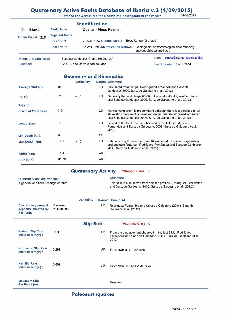
04/09/2015Quaternary Active Faults Database of Iberia v.3 (4/09/2015)
Refer to the Access file for a complete description of the record
ID: ES641 Fault Name: Obéilar - Pinos Puente
Segment Name:
Location X: -3.84467874
Location Y: 37.25479653
Name of Compiler(s): Sanz de Galdeano, C. and Peláez, J.A.
Filiation: I.A.C.T. and Universidad de Jaén
Email: [email protected]; japelaez@uj
Last Update: 07/10/2014
Average Strike(º): 080 LD Calculated from its tips (Rodríguez-Fernández and Sanz de Galdeano, 2006; Sanz de Galdeano et al., 2012).
Dip (º): 75 ± 15 LD Generally the fault deeps 60-70 to the south (Rodríguez-Fernández and Sanz de Galdeano, 2006; Sanz de Galdeano et al., 2012).
Rake (º):
Sense of Movement: ND LD Normal component is predominant although there is a certain dextral strike slip component of unknown magnitude (Rodríguez-Fernández and Sanz de Galdeano, 2006; Sanz de Galdeano et al., 2012).
Length (km): 7.9 LD Lenght of the fault trace as observed in the field (Rodríguez-Fernández and Sanz de Galdeano, 2006; Sanz de Galdeano et al., 2012).
Min Depth (km): 0 OD
Max Depth (km): 10.0 > 10 LD Estimated depth is deeper than 10 km based on seismic exploration and geologic features (Rodríguez-Fernández and Sanz de Galdeano, 2006; Sanz de Galdeano et al., 2012).
Width (km): 10.4 AR
Area (km²): 81.79 AR
Age of the youngestdeposits affected bythe fault:
Pliocene-Pleistocene
LD Rodríguez-Fernández and Sanz de Galdeano (2006), Sanz de Galdeano et al. (2012).
Vertical Slip Rate(m/ka or mm/yr) :
0.500 LD From the displacement observed in the last 5 Ma (Rodríguez-Fernández and Sanz de Galdeano, 2006; Sanz de Galdeano et al., 2012).
Horizontal Slip Rate(m/ka or mm/yr) :
0.299 AR From NSR and -120º rake
Net Slip Rate(m/ka or mm/yr) :
0.598 AR From VSR, dip and -120º rake
MaxImum Slip Per Event (m):
Unknown
Identification
Geometry and KinematicsVariability Source Comment
Quaternary Activity
Variability Source
Comment
A general and linear change of relief. This fault is also known from seismic profiles (Rodríguez-Fernández and Sanz de Galdeano, 2006; Sanz de Galdeano et al., 2012).
Geological Set: Betic Range (Granada)
Identification Method: Geological/Geomorphological field mapping and geophysical methods
Comment
Quaternary activity evidence
C*Strength Class:
Slip Rate *Accuracy Class: C
Paleoearthquakes
Orden Visual: 218
Página 251 de 632
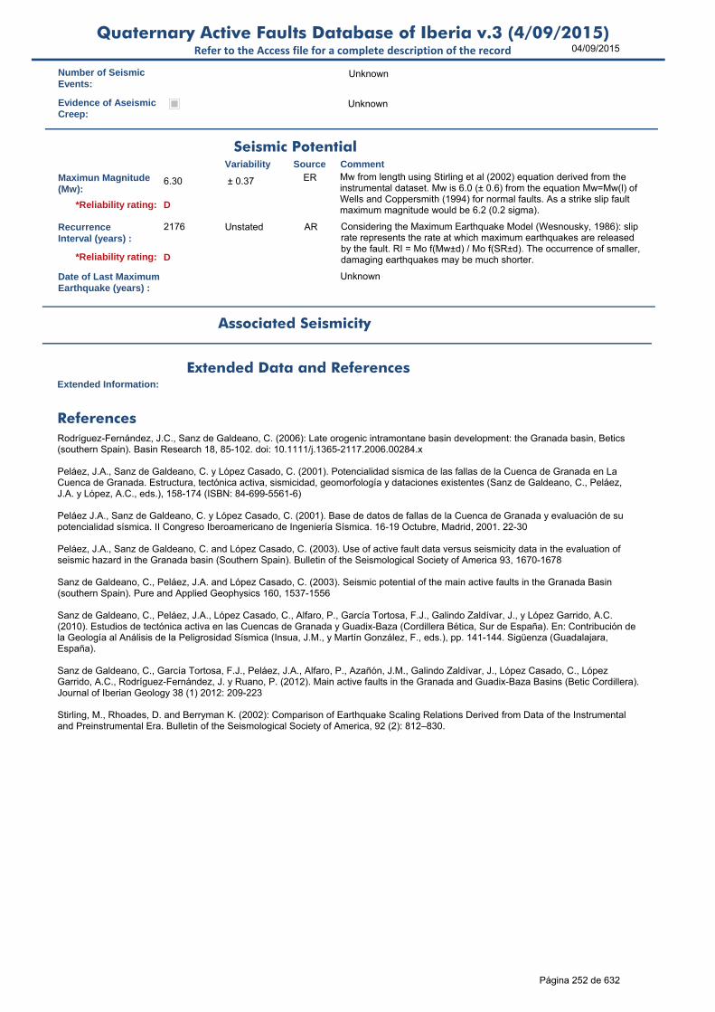
04/09/2015Quaternary Active Faults Database of Iberia v.3 (4/09/2015)
Refer to the Access file for a complete description of the record
Number of SeismicEvents:
Unknown
Evidence of AseismicCreep:
Unknown
Maximun Magnitude(Mw):
6.30 ± 0.37 ER Mw from length using Stirling et al (2002) equation derived from the instrumental dataset. Mw is 6.0 (± 0.6) from the equation Mw=Mw(l) of Wells and Coppersmith (1994) for normal faults. As a strike slip fault maximum magnitude would be 6.2 (0.2 sigma).
RecurrenceInterval (years) :
2176 Unstated AR Considering the Maximum Earthquake Model (Wesnousky, 1986): slip rate represents the rate at which maximum earthquakes are released by the fault. RI = Mo f(Mw±d) / Mo f(SR±d). The occurrence of smaller, damaging earthquakes may be much shorter.
Date of Last MaximumEarthquake (years) :
Unknown
Extended Information:
Rodríguez-Fernández, J.C., Sanz de Galdeano, C. (2006): Late orogenic intramontane basin development: the Granada basin, Betics (southern Spain). Basin Research 18, 85-102. doi: 10.1111/j.1365-2117.2006.00284.x
Peláez, J.A., Sanz de Galdeano, C. y López Casado, C. (2001). Potencialidad sísmica de las fallas de la Cuenca de Granada en La Cuenca de Granada. Estructura, tectónica activa, sismicidad, geomorfología y dataciones existentes (Sanz de Galdeano, C., Peláez, J.A. y López, A.C., eds.), 158-174 (ISBN: 84-699-5561-6)
Peláez J.A., Sanz de Galdeano, C. y López Casado, C. (2001). Base de datos de fallas de la Cuenca de Granada y evaluación de su potencialidad sísmica. II Congreso Iberoamericano de Ingeniería Sísmica. 16-19 Octubre, Madrid, 2001. 22-30
Peláez, J.A., Sanz de Galdeano, C. and López Casado, C. (2003). Use of active fault data versus seismicity data in the evaluation of seismic hazard in the Granada basin (Southern Spain). Bulletin of the Seismological Society of America 93, 1670-1678
Sanz de Galdeano, C., Peláez, J.A. and López Casado, C. (2003). Seismic potential of the main active faults in the Granada Basin (southern Spain). Pure and Applied Geophysics 160, 1537-1556
Sanz de Galdeano, C., Peláez, J.A., López Casado, C., Alfaro, P., García Tortosa, F.J., Galindo Zaldívar, J., y López Garrido, A.C. (2010). Estudios de tectónica activa en las Cuencas de Granada y Guadix-Baza (Cordillera Bética, Sur de España). En: Contribución de la Geología al Análisis de la Peligrosidad Sísmica (Insua, J.M., y Martín González, F., eds.), pp. 141-144. Sigüenza (Guadalajara, España).
Sanz de Galdeano, C., García Tortosa, F.J., Peláez, J.A., Alfaro, P., Azañón, J.M., Galindo Zaldívar, J., López Casado, C., López Garrido, A.C., Rodríguez-Fernández, J. y Ruano, P. (2012). Main active faults in the Granada and Guadix-Baza Basins (Betic Cordillera). Journal of Iberian Geology 38 (1) 2012: 209-223
Stirling, M., Rhoades, D. and Berryman K. (2002): Comparison of Earthquake Scaling Relations Derived from Data of the Instrumental and Preinstrumental Era. Bulletin of the Seismological Society of America, 92 (2): 812–830.
Seismic PotentialSource Comment
Associated Seismicity
Extended Data and References
References
Variability
*Reliability rating: D
*Reliability rating: D
Página 252 de 632

04/09/2015Quaternary Active Faults Database of Iberia v.3 (4/09/2015)
Refer to the Access file for a complete description of the record
ID: ES643 Fault Name: Tocón-Obéilar
Segment Name:
Location X: -3.96257578
Location Y: 37.24789658
Name of Compiler(s): Sanz de Galdeano, C. and Peláez, J.A.
Filiation: I.A.C.T. and Universidad de Jaén
Email: [email protected]; japelaez@uj
Last Update: 07/10/2014
Average Strike(º): 079 LD Calculated from its tips (Rodríguez-Fernández and Sanz de Galdeano, 2006).
Dip (º): 45 + 20 LD Rodríguez-Fernández and Sanz de Galdeano (2006).
Rake (º): -90 LD Rodríguez-Fernández and Sanz de Galdeano (2006).
Sense of Movement: N LD Rodríguez-Fernández and Sanz de Galdeano (2006).
Length (km): 8.8 LD Lenght of the fault trace as observed in the field (Rodríguez-Fernández and Sanz de Galdeano, 2006).
Min Depth (km): 0 OD
Max Depth (km): 3.0 > 3 LD Estimated depth is deeper than 3 km based on seismic exploration (Rodríguez-Fernández and Sanz de Galdeano, 2006).
Width (km): 4.2 AR
Area (km²): 37.34 AR
Age of the youngestdeposits affected bythe fault:
Pliocene-Pleistocene
LD Rodríguez-Fernández and Sanz de Galdeano (2006)
Vertical Slip Rate(m/ka or mm/yr) :
0.100 LD From the displacement observed in the last 5 Ma (Rodríguez-Fernández and Sanz de Galdeano, 2006).
Horizontal Slip Rate(m/ka or mm/yr) :
0 EJ HSR=0, assumed pure dip-slip faulting.
Net Slip Rate(m/ka or mm/yr) :
0.141 AR From VSR, dip and rake of the fault
MaxImum Slip Per Event (m):
Unknown
Number of SeismicEvents:
Unknown
Evidence of AseismicCreep:
Unknown
Identification
Geometry and KinematicsVariability Source Comment
Quaternary Activity
Variability Source
Comment
It has scarce geomorphic evidence This fault is mainly known from seismic profiles (Rodríguez-Fernández and Sanz de Galdeano, 2006).
Geological Set: Betic Range (Granada)
Identification Method: Geological/Geomorphological field mapping and geophysical methods
Comment
Quaternary activity evidence
C*Strength Class:
Slip Rate *Accuracy Class: C
Paleoearthquakes
Orden Visual: 219
Página 253 de 632

04/09/2015Quaternary Active Faults Database of Iberia v.3 (4/09/2015)
Refer to the Access file for a complete description of the record
Maximun Magnitude(Mw):
6.35 ± 0.37 ER Mw from length using Stirling et al (2002) equation derived from the instrumental dataset. Mw is 6.1 (± 0.6) from the equation Mw=Mw(l) of Wells and Coppersmith (1994) for normal faults.
RecurrenceInterval (years) :
23571 Unstated AR Considering the Maximum Earthquake Model (Wesnousky, 1986): slip rate represents the rate at which maximum earthquakes are released by the fault. RI = Mo f(Mw±d) / Mo f(SR±d). The occurrence of smaller, damaging earthquakes may be much shorter.
Date of Last MaximumEarthquake (years) :
Unknown
Extended Information:
Rodríguez-Fernández, J.C., Sanz de Galdeano, C. (2006): Late orogenic intramontane basin development: the Granada basin, Betics (southern Spain). Basin Research 18, 85-102. doi: 10.1111/j.1365-2117.2006.00284.x
Peláez, J.A., Sanz de Galdeano, C. y López Casado, C. (2001). Potencialidad sísmica de las fallas de la Cuenca de Granada en La Cuenca de Granada. Estructura, tectónica activa, sismicidad, geomorfología y dataciones existentes (Sanz de Galdeano, C., Peláez, J.A. y López, A.C., eds.), 158-174 (ISBN: 84-699-5561-6)
Peláez J.A., Sanz de Galdeano, C. y López Casado, C. (2001). Base de datos de fallas de la Cuenca de Granada y evaluación de su potencialidad sísmica. II Congreso Iberoamericano de Ingeniería Sísmica. 16-19 Octubre, Madrid, 2001. 22-30
Peláez, J.A., Sanz de Galdeano, C. and López Casado, C. (2003). Use of active fault data versus seismicity data in the evaluation of seismic hazard in the Granada basin (Southern Spain). Bulletin of the Seismological Society of America 93, 1670-1678
Sanz de Galdeano, C., Peláez, J.A. and López Casado, C. (2003). Seismic potential of the main active faults in the Granada Basin (southern Spain). Pure and Applied Geophysics 160, 1537-155
Sanz de Galdeano, C., Peláez, J.A., López Casado, C., Alfaro, P., García Tortosa, F.J., Galindo Zaldívar, J., y López Garrido, A.C. (2010). Estudios de tectónica activa en las Cuencas de Granada y Guadix-Baza (Cordillera Bética, Sur de España). En: Contribución de la Geología al Análisis de la Peligrosidad Sísmica (Insua, J.M., y Martín González, F., eds.), pp. 141-144. Sigüenza (Guadalajara, España).
Stirling, M., Rhoades, D. and Berryman K. (2002): Comparison of Earthquake Scaling Relations Derived from Data of the Instrumental and Preinstrumental Era. Bulletin of the Seismological Society of America, 92 (2): 812–830.
Seismic PotentialSource Comment
Associated Seismicity
Extended Data and References
References
Variability
*Reliability rating: D
*Reliability rating: D
Página 254 de 632

04/09/2015Quaternary Active Faults Database of Iberia v.3 (4/09/2015)
Refer to the Access file for a complete description of the record
ID: ES644 Fault Name: Alitaje
Segment Name:
Location X: -3.77408052
Location Y: 37.26309649
Name of Compiler(s): Sanz de Galdeano, C. and Peláez, J.A.
Filiation: I.A.C.T. and Universidad de Jaén
Email: [email protected]; japelaez@uj
Last Update: 07/10/2014
Average Strike(º): 144 LD Calculated from its tips (Rodríguez-Fernández and Sanz de Galdeano, 2006; Sanz de Galdeano et al., 2012).
Dip (º): 50 - 10 / + 20 LD Listric geometry (Rodríguez-Fernández and Sanz de Galdeano, 2006; Sanz de Galdeano et al., 2012).
Rake (º): -90 LD (Rodríguez-Fernández and Sanz de Galdeano, 2006; Sanz de Galdeano et al., 2012).
Sense of Movement: N LD (Rodríguez-Fernández and Sanz de Galdeano, 2006; Sanz de Galdeano et al., 2012).
Length (km): 6.4 LD Lenght of the fault trace as observed in the field (Rodríguez-Fernández and Sanz de Galdeano, 2006; Sanz de Galdeano et al., 2012).
Min Depth (km): 0 OD
Max Depth (km): 5.0 > 5 LD Estimated depth is deeper than 5 km based on seismic exploration (Rodríguez-Fernández and Sanz de Galdeano, 2006; Sanz de Galdeano et al., 2012).
Width (km): 6.5 AR
Area (km²): 41.77 AR
Age of the youngestdeposits affected bythe fault:
Pliocene-Pleistocene
LD (Rodríguez-Fernández and Sanz de Galdeano, 2006; Sanz de Galdeano et al., 2012).
Vertical Slip Rate(m/ka or mm/yr) :
0.100 LD From the displacement observed in the last 5 Ma (Rodríguez-Fernández and Sanz de Galdeano, 2006; Sanz de Galdeano et al., 2012).
Horizontal Slip Rate(m/ka or mm/yr) :
0 EJ HSR=0, assumed pure dip-slip faulting.
Net Slip Rate(m/ka or mm/yr) :
0.131 AR From dip and rake of the fault
MaxImum Slip Per Event (m):
Unknown
Number of SeismicEvents:
Unknown
Identification
Geometry and KinematicsVariability Source Comment
Quaternary Activity
Variability Source
Comment
It has scarce geomorphic evidence This fault is known by seismic profiles (Rodríguez-Fernández and Sanz de Galdeano, 2006; Sanz de Galdeano et al., 2012).
Geological Set: Betic Range (Granada)
Identification Method: Geological/Geomorphological field mapping and geophysical methods
Comment
Quaternary activity evidence
C*Strength Class:
Slip Rate *Accuracy Class: C
Paleoearthquakes
Orden Visual: 220
Página 255 de 632
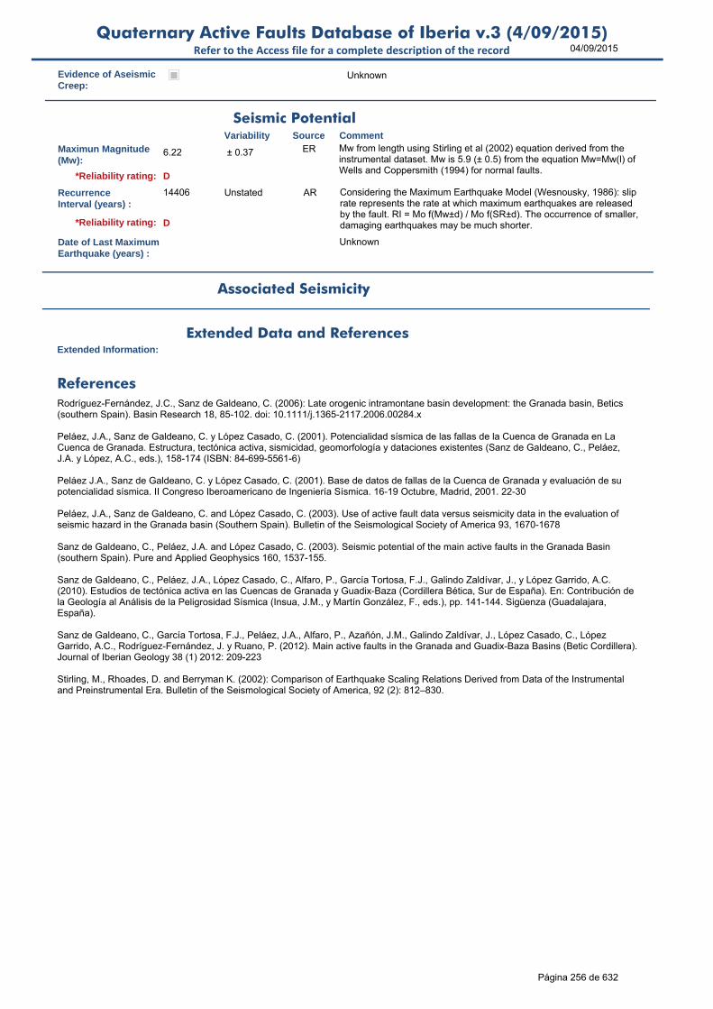
04/09/2015Quaternary Active Faults Database of Iberia v.3 (4/09/2015)
Refer to the Access file for a complete description of the record
Evidence of AseismicCreep:
Unknown
Maximun Magnitude(Mw):
6.22 ± 0.37 ER Mw from length using Stirling et al (2002) equation derived from the instrumental dataset. Mw is 5.9 (± 0.5) from the equation Mw=Mw(l) of Wells and Coppersmith (1994) for normal faults.
RecurrenceInterval (years) :
14406 Unstated AR Considering the Maximum Earthquake Model (Wesnousky, 1986): slip rate represents the rate at which maximum earthquakes are released by the fault. RI = Mo f(Mw±d) / Mo f(SR±d). The occurrence of smaller, damaging earthquakes may be much shorter.
Date of Last MaximumEarthquake (years) :
Unknown
Extended Information:
Rodríguez-Fernández, J.C., Sanz de Galdeano, C. (2006): Late orogenic intramontane basin development: the Granada basin, Betics (southern Spain). Basin Research 18, 85-102. doi: 10.1111/j.1365-2117.2006.00284.x
Peláez, J.A., Sanz de Galdeano, C. y López Casado, C. (2001). Potencialidad sísmica de las fallas de la Cuenca de Granada en La Cuenca de Granada. Estructura, tectónica activa, sismicidad, geomorfología y dataciones existentes (Sanz de Galdeano, C., Peláez, J.A. y López, A.C., eds.), 158-174 (ISBN: 84-699-5561-6)
Peláez J.A., Sanz de Galdeano, C. y López Casado, C. (2001). Base de datos de fallas de la Cuenca de Granada y evaluación de su potencialidad sísmica. II Congreso Iberoamericano de Ingeniería Sísmica. 16-19 Octubre, Madrid, 2001. 22-30
Peláez, J.A., Sanz de Galdeano, C. and López Casado, C. (2003). Use of active fault data versus seismicity data in the evaluation of seismic hazard in the Granada basin (Southern Spain). Bulletin of the Seismological Society of America 93, 1670-1678
Sanz de Galdeano, C., Peláez, J.A. and López Casado, C. (2003). Seismic potential of the main active faults in the Granada Basin (southern Spain). Pure and Applied Geophysics 160, 1537-155.
Sanz de Galdeano, C., Peláez, J.A., López Casado, C., Alfaro, P., García Tortosa, F.J., Galindo Zaldívar, J., y López Garrido, A.C. (2010). Estudios de tectónica activa en las Cuencas de Granada y Guadix-Baza (Cordillera Bética, Sur de España). En: Contribución de la Geología al Análisis de la Peligrosidad Sísmica (Insua, J.M., y Martín González, F., eds.), pp. 141-144. Sigüenza (Guadalajara, España).
Sanz de Galdeano, C., García Tortosa, F.J., Peláez, J.A., Alfaro, P., Azañón, J.M., Galindo Zaldívar, J., López Casado, C., López Garrido, A.C., Rodríguez-Fernández, J. y Ruano, P. (2012). Main active faults in the Granada and Guadix-Baza Basins (Betic Cordillera). Journal of Iberian Geology 38 (1) 2012: 209-223
Stirling, M., Rhoades, D. and Berryman K. (2002): Comparison of Earthquake Scaling Relations Derived from Data of the Instrumental and Preinstrumental Era. Bulletin of the Seismological Society of America, 92 (2): 812–830.
Seismic PotentialSource Comment
Associated Seismicity
Extended Data and References
References
Variability
*Reliability rating: D
*Reliability rating: D
Página 256 de 632

04/09/2015Quaternary Active Faults Database of Iberia v.3 (4/09/2015)
Refer to the Access file for a complete description of the record
ID: ES646 Fault Name: Pinos Puente
Segment Name:
Location X: -3.75728094
Location Y: 37.26329648
Name of Compiler(s): Sanz de Galdeano, C. and Peláez, J.A.
Filiation: I.A.C.T. and Universidad de Jaén
Email: [email protected]; japelaez@uj
Last Update: 07/10/2014
Average Strike(º): 140 LD Calculated from its tips (Rodríguez-Fernández and Sanz de Galdeano, 2006; Sanz de Galdeano et al., 2012).
Dip (º): 60 ± 20 LD Listric geometry (Rodríguez-Fernández and Sanz de Galdeano, 2006; Sanz de Galdeano et al., 2012).
Rake (º): -90 LD (Rodríguez-Fernández and Sanz de Galdeano, 2006; Sanz de Galdeano et al., 2012).
Sense of Movement: N N to ND LD (Rodríguez-Fernández and Sanz de Galdeano, 2006; Sanz de Galdeano et al., 2012).
Length (km): 9.4 LD Lenght of the fault trace as observed in the field (Rodríguez-Fernández and Sanz de Galdeano, 2006; Sanz de Galdeano et al., 2012).
Min Depth (km): 0 OD
Max Depth (km): 10.0 > 10 LD Estimated depth is deeper than 10 km based on seismicity possibly associated to the fault (Rodríguez-Fernández and Sanz de Galdeano, 2006; Sanz de Galdeano et al., 2012).
Width (km): 11.5 AR
Area (km²): 108.54 AR
Age of the youngestdeposits affected bythe fault:
Recent Quaternary
LD (Rodríguez-Fernández and Sanz de Galdeano, 2006; Sanz de Galdeano et al., 2012).
Vertical Slip Rate(m/ka or mm/yr) :
0.400 LD From the displacement observed in the last 5 Ma. (Rodríguez-Fernández and Sanz de Galdeano, 2006; Sanz de Galdeano et al., 2012).
Horizontal Slip Rate(m/ka or mm/yr) :
0 EJ HSR=0, assumed pure dip-slip faulting.
Net Slip Rate(m/ka or mm/yr) :
0.462 ± 0.1 AR From dip and rake of the fault
MaxImum Slip Per Event (m):
Unknown
Number of SeismicEvents:
Unknown
Identification
Geometry and KinematicsVariability Source Comment
Quaternary Activity
Variability Source
Comment
Spectacular scarp and many other geomorphic features. On the scarp can be seen striations with normal and normal-dextral movements. The fault has associated seismicity. It is also known by seismic profiles (Rodríguez-Fernández and Sanz de Galdeano, 2006; Sanz de Galdeano et al., 2012).
Geological Set: Betic Range (Granada)
Identification Method: Geological/Geomorphological field mapping and geophysical methods
Comment
Quaternary activity evidence
A*Strength Class:
Slip Rate *Accuracy Class: C
Paleoearthquakes
Orden Visual: 221
Página 257 de 632

04/09/2015Quaternary Active Faults Database of Iberia v.3 (4/09/2015)
Refer to the Access file for a complete description of the record
Evidence of AseismicCreep:
Unknown
Maximun Magnitude(Mw):
6.37 ± 0.37 ER Mw from length using Stirling et al (2002) equation derived from the instrumental dataset. Mw is 6.1 (± 0.6) from the equation Mw=Mw(l) of Wells and Coppersmith (1994) for normal faults.
RecurrenceInterval (years) :
2719 12453-623 AR Considering the Maximum Earthquake Model (Wesnousky, 1986): slip rate represents the rate at which maximum earthquakes are released by the fault. RI = Mo f(Mw±d) / Mo f(SR±d). The occurrence of smaller, damaging earthquakes may be much shorter.
Date of Last MaximumEarthquake (years) :
Unknown
Extended Information:
Rodríguez-Fernández, J.C., Sanz de Galdeano, C. (2006): Late orogenic intramontane basin development: the Granada basin, Betics (southern Spain). Basin Research 18, 85-102. doi: 10.1111/j.1365-2117.2006.00284.x
Peláez, J.A., Sanz de Galdeano, C. y López Casado, C. (2001). Potencialidad sísmica de las fallas de la Cuenca de Granada en La Cuenca de Granada. Estructura, tectónica activa, sismicidad, geomorfología y dataciones existentes (Sanz de Galdeano, C., Peláez, J.A. y López, A.C., eds.), 158-174 (ISBN: 84-699-5561-6)
Peláez J.A., Sanz de Galdeano, C. y López Casado, C. (2001). Base de datos de fallas de la Cuenca de Granada y evaluación de su potencialidad sísmica. II Congreso Iberoamericano de Ingeniería Sísmica. 16-19 Octubre, Madrid, 2001. 22-30
Peláez, J.A., Sanz de Galdeano, C. and López Casado, C. (2003). Use of active fault data versus seismicity data in the evaluation of seismic hazard in the Granada basin (Southern Spain). Bulletin of the Seismological Society of America 93, 1670-1678
Sanz de Galdeano, C., Peláez, J.A. and López Casado, C. (2003). Seismic potential of the main active faults in the Granada Basin (southern Spain). Pure and Applied Geophysics 160, 1537-155
Sanz de Galdeano, C., Peláez, J.A., López Casado, C., Alfaro, P., García Tortosa, F.J., Galindo Zaldívar, J., y López Garrido, A.C. (2010). Estudios de tectónica activa en las Cuencas de Granada y Guadix-Baza (Cordillera Bética, Sur de España). En: Contribución de la Geología al Análisis de la Peligrosidad Sísmica (Insua, J.M., y Martín González, F., eds.), pp. 141-144. Sigüenza (Guadalajara, España).
Sanz de Galdeano, C., García Tortosa, F.J., Peláez, J.A., Alfaro, P., Azañón, J.M., Galindo Zaldívar, J., López Casado, C., López Garrido, A.C., Rodríguez-Fernández, J. y Ruano, P. (2012). Main active faults in the Granada and Guadix-Baza Basins (Betic Cordillera). Journal of Iberian Geology 38 (1) 2012: 209-223
Stirling, M., Rhoades, D. and Berryman K. (2002): Comparison of Earthquake Scaling Relations Derived from Data of the Instrumental and Preinstrumental Era. Bulletin of the Seismological Society of America, 92 (2): 812–830.
Wesnousky, S.G. (1986). Earthquakes, Quaternary faults, and seismic hazard in California. Journal of Geophysical Research. 91(B12), 12587-12631.
Seismic PotentialSource Comment
Associated Seismicity
Extended Data and References
References
Variability
*Reliability rating: B
*Reliability rating: C
Página 258 de 632

04/09/2015Quaternary Active Faults Database of Iberia v.3 (4/09/2015)
Refer to the Access file for a complete description of the record
ID: ES648 Fault Name: Pedro Ruiz
Segment Name:
Location X: -3.78348028
Location Y: 37.2608965
Name of Compiler(s): Sanz de Galdeano, C. and Peláez, J.A.
Filiation: I.A.C.T. and Universidad de Jaén
Email: [email protected]; japelaez@uj
Last Update: 07/10/2014
Average Strike(º): 151 LD Calculated from its tips (Rodríguez-Fernández and Sanz de Galdeano, 2006; Sanz de Galdeano et al., 2012).
Dip (º): 50 - 10 / + 20 LD Listric geometry (Rodríguez-Fernández and Sanz de Galdeano, 2006; Sanz de Galdeano et al., 2012).
Rake (º): -90 LD (Rodríguez-Fernández and Sanz de Galdeano, 2006; Sanz de Galdeano et al., 2012).
Sense of Movement: N LD (Rodríguez-Fernández and Sanz de Galdeano, 2006; Sanz de Galdeano et al., 2012).
Length (km): 5.9 LD (Rodríguez-Fernández and Sanz de Galdeano, 2006; Sanz de Galdeano et al., 2012)
Min Depth (km): 0 OD
Max Depth (km): 5.0 > 5 LD Estimated depth is deeper than 5 km based on seismic exploration (Rodríguez-Fernández and Sanz de Galdeano, 2006; Sanz de Galdeano et al., 2012).
Width (km): 6.5 AR
Area (km²): 38.51 AR
Age of the youngestdeposits affected bythe fault:
Pliocene-Quaternary
OD
Vertical Slip Rate(m/ka or mm/yr) :
0.100 LD From the displacement observed in the last 5 Ma (Rodríguez-Fernández and Sanz de Galdeano, 2006; Sanz de Galdeano et al., 2012)..
Horizontal Slip Rate(m/ka or mm/yr) :
0 EJ HSR=0, assumed pure dip-slip faulting.
Net Slip Rate(m/ka or mm/yr) :
0.131 AR From dip and rake of the fault
MaxImum Slip Per Event (m):
Unknown
Number of SeismicEvents:
Unknown
Identification
Geometry and KinematicsVariability Source Comment
Quaternary Activity
Variability Source
Comment
It has scarce geomorphic evidence This fault is known from seismic profiles (Rodríguez-Fernández and Sanz de Galdeano, 2006; Sanz de Galdeano et al., 2012).
Geological Set: Betic Range (Granada)
Identification Method: Geological/Geomorphological field mapping and geophysical methods
Comment
Quaternary activity evidence
C*Strength Class:
Slip Rate *Accuracy Class: C
Paleoearthquakes
Orden Visual: 222
Página 259 de 632

04/09/2015Quaternary Active Faults Database of Iberia v.3 (4/09/2015)
Refer to the Access file for a complete description of the record
Evidence of AseismicCreep:
Unknown
Maximun Magnitude(Mw):
6.18 ± 0.37 ER Mw from length using Stirling et al (2002) equation derived from the instrumental dataset. Mw is 5.9 (± 0.5) from the equation Mw=Mw(l) of Wells and Coppersmith (1994) for normal faults.
RecurrenceInterval (years) :
13915 Unstated AR Considering the Maximum Earthquake Model (Wesnousky, 1986): slip rate represents the rate at which maximum earthquakes are released by the fault. RI = Mo f(Mw±d) / Mo f(SR±d). The occurrence of smaller, damaging earthquakes may be much shorter.
Date of Last MaximumEarthquake (years) :
Unknown
Extended Information:
Rodríguez-Fernández, J.C., Sanz de Galdeano, C. (2006): Late orogenic intramontane basin development: the Granada basin, Betics (southern Spain). Basin Research 18, 85-102. doi: 10.1111/j.1365-2117.2006.00284.x
Peláez, J.A., Sanz de Galdeano, C. y López Casado, C. (2001). Potencialidad sísmica de las fallas de la Cuenca de Granada en La Cuenca de Granada. Estructura, tectónica activa, sismicidad, geomorfología y dataciones existentes (Sanz de Galdeano, C., Peláez, J.A. y López, A.C., eds.), 158-174 (ISBN: 84-699-5561-6)
Peláez J.A., Sanz de Galdeano, C. y López Casado, C. (2001). Base de datos de fallas de la Cuenca de Granada y evaluación de su potencialidad sísmica. II Congreso Iberoamericano de Ingeniería Sísmica. 16-19 Octubre, Madrid, 2001. 22-30
Peláez, J.A., Sanz de Galdeano, C. and López Casado, C. (2003). Use of active fault data versus seismicity data in the evaluation of seismic hazard in the Granada basin (Southern Spain). Bulletin of the Seismological Society of America 93, 1670-1678
Sanz de Galdeano, C., Peláez, J.A. and López Casado, C. (2003). Seismic potential of the main active faults in the Granada Basin (southern Spain). Pure and Applied Geophysics 160, 1537-1556
Sanz de Galdeano, C., Peláez, J.A., López Casado, C., Alfaro, P., García Tortosa, F.J., Galindo Zaldívar, J., y López Garrido, A.C. (2010). Estudios de tectónica activa en las Cuencas de Granada y Guadix-Baza (Cordillera Bética, Sur de España). En: Contribución de la Geología al Análisis de la Peligrosidad Sísmica (Insua, J.M., y Martín González, F., eds.), pp. 141-144. Sigüenza (Guadalajara, España).
Sanz de Galdeano, C., García Tortosa, F.J., Peláez, J.A., Alfaro, P., Azañón, J.M., Galindo Zaldívar, J., López Casado, C., López Garrido, A.C., Rodríguez-Fernández, J. y Ruano, P. (2012). Main active faults in the Granada and Guadix-Baza Basins (Betic Cordillera). Journal of Iberian Geology 38 (1) 2012: 209-223.
Stirling, M., Rhoades, D. and Berryman K. (2002): Comparison of Earthquake Scaling Relations Derived from Data of the Instrumental and Preinstrumental Era. Bulletin of the Seismological Society of America, 92 (2): 812–830.
Seismic PotentialSource Comment
Associated Seismicity
Extended Data and References
References
Variability
*Reliability rating: D
*Reliability rating: D
Página 260 de 632

04/09/2015Quaternary Active Faults Database of Iberia v.3 (4/09/2015)
Refer to the Access file for a complete description of the record
ID: ES651 Fault Name: Atarfe
Segment Name:
Location X: -3.74358129
Location Y: 37.25549648
Name of Compiler(s): Sanz de Galdeano, C. and Peláez, J.A.
Filiation: I.A.C.T. and Universidad de Jaén
Email: [email protected]; japelaez@uj
Last Update: 07/10/2014
Average Strike(º): 134 LD Calculated from its tips (Sanz de Galdeano et al., 2012).
Dip (º): 60 ± 15 LD Listric geometry (Sanz de Galdeano et al., 2012).
Rake (º): -90 LD (Sanz de Galdeano et al., 2012).
Sense of Movement: N LD (Sanz de Galdeano et al., 2012).
Length (km): 10.3 LD Lenght of the fault trace as observed in the field (Sanz de Galdeano et al., 2012).
Min Depth (km): 0 OD
Max Depth (km): 10.0 > 10 LD Estimated depth is deeper than 10 km based on seismicity possibly associated to the fault and geologic features (Sanz de Galdeano et al., 2012).
Width (km): 11.5 AR
Area (km²): 118.93 AR
Age of the youngestdeposits affected bythe fault:
Recent Quaternary
LD (Sanz de Galdeano et al., 2012)
Vertical Slip Rate(m/ka or mm/yr) :
0.150 LD From the displacement observed in the last 5 Ma (Sanz de Galdeano et al., 2012).
Horizontal Slip Rate(m/ka or mm/yr) :
0 LD Some striae indicate a dextral horizontal strike but it is not possible to know it importance. In any case the throw is the principal feature (Sanz de Galdeano et al., 2012).
Net Slip Rate(m/ka or mm/yr) :
0.173 ± 0.01 AR From dip and rake of the fault.
MaxImum Slip Per Event (m):
Unknown
Number of SeismicEvents:
Unknown
Evidence of AseismicCreep:
Unknown
Identification
Geometry and KinematicsVariability Source Comment
Quaternary Activity
Variability Source
Comment
Well expressed scarp and minor structures related This fault has associated abundant seismicity, particularly low magnitude earthquakes. The scarp is well conserved (Sanz de Galdeano et al., 2012).
Geological Set: Betic Range (Granada)
Identification Method: Geological/Geomorphological field mapping
Comment
Quaternary activity evidence
A*Strength Class:
Slip Rate *Accuracy Class: C
Paleoearthquakes
Orden Visual: 223
Página 261 de 632

04/09/2015Quaternary Active Faults Database of Iberia v.3 (4/09/2015)
Refer to the Access file for a complete description of the record
Maximun Magnitude(Mw):
6.41 ± 0.37 ER Mw from length using Stirling et al (2002) equation derived from the instrumental dataset. Mw is 6.2 (± 0.6) from the equation Mw=Mw(l) of Wells and Coppersmith (1994) for normal faults.
RecurrenceInterval (years) :
7548 28754-1988 AR Considering the Maximum Earthquake Model (Wesnousky, 1986): slip rate represents the rate at which maximum earthquakes are released by the fault. RI = Mo f(Mw±d) / Mo f(SR±d). The occurrence of smaller, damaging earthquakes may be much shorter.
Date of Last MaximumEarthquake (years) :
Unknown
Extended Information:
Peláez, J.A., Sanz de Galdeano, C. y López Casado, C. (2001). Potencialidad sísmica de las fallas de la Cuenca de Granada en La Cuenca de Granada. Estructura, tectónica activa, sismicidad, geomorfología y dataciones existentes (Sanz de Galdeano, C., Peláez, J.A. y López, A.C., eds.), 158-174 (ISBN: 84-699-5561-6)
Peláez J.A., Sanz de Galdeano, C. y López Casado, C. (2001). Base de datos de fallas de la Cuenca de Granada y evaluación de su potencialidad sísmica. II Congreso Iberoamericano de Ingeniería Sísmica. 16-19 Octubre, Madrid, 2001. 22-30
Peláez, J.A., Sanz de Galdeano, C. and López Casado, C. (2003). Use of active fault data versus seismicity data in the evaluation of seismic hazard in the Granada basin (Southern Spain). Bulletin of the Seismological Society of America 93, 1670-1678
Sanz de Galdeano, C., Peláez, J.A. and López Casado, C. (2003). Seismic potential of the main active faults in the Granada Basin (southern Spain). Pure and Applied Geophysics 160, 1537-155.
Sanz de Galdeano, C., Peláez, J.A., López Casado, C., Alfaro, P., García Tortosa, F.J., Galindo Zaldívar, J., y López Garrido, A.C. (2010). Estudios de tectónica activa en las Cuencas de Granada y Guadix-Baza (Cordillera Bética, Sur de España). En: Contribución de la Geología al Análisis de la Peligrosidad Sísmica (Insua, J.M., y Martín González, F., eds.), pp. 141-144. Sigüenza (Guadalajara, España).
Sanz de Galdeano, C., García Tortosa, F.J., Peláez, J.A., Alfaro, P., Azañón, J.M., Galindo Zaldívar, J., López Casado, C., López Garrido, A.C., Rodríguez-Fernández, J. y Ruano, P. (2012). Main active faults in the Granada and Guadix-Baza Basins (Betic Cordillera). Journal of Iberian Geology 38 (1) 2012: 209-223.
Stirling, M., Rhoades, D. and Berryman K. (2002): Comparison of Earthquake Scaling Relations Derived from Data of the Instrumental and Preinstrumental Era. Bulletin of the Seismological Society of America, 92 (2): 812–830.
Wesnousky, S.G. (1986). Earthquakes, Quaternary faults, and seismic hazard in California. Journal of Geophysical Research. 91(B12), 12587-12631.
Seismic PotentialSource Comment
Associated Seismicity
Extended Data and References
References
Variability
*Reliability rating: B
*Reliability rating: C
Página 262 de 632

04/09/2015Quaternary Active Faults Database of Iberia v.3 (4/09/2015)
Refer to the Access file for a complete description of the record
ID: ES653 Fault Name: El Fargue-Jun
Segment Name:
Location X: -3.63190819
Location Y: 37.25026761
Name of Compiler(s): Sanz de Galdeano, C. and Peláez, J.A.
Filiation: I.A.C.T. and Universidad de Jaén
Email: [email protected]; japelaez@uj
Last Update: 07/10/2014
Average Strike(º): 138 LD Calculated from its tips (Sanz de Galdeano et al., 2012).
Dip (º): 60 ± 10 LD Listric geometry (Sanz de Galdeano et al., 2012).
Rake (º): -90 LD (Sanz de Galdeano et al., 2012).
Sense of Movement: N LD (Sanz de Galdeano et al., 2012).
Length (km): 11.7 LD Lenght of the fault trace as observed in the field (Sanz de Galdeano et al., 2012).
Min Depth (km): 0 OD
Max Depth (km): 10.0 > 10 LD Estimated depth is deeper than 10 km based on seismicity possibly associated to the fault (Sanz de Galdeano et al., 2012).
Width (km): 11.5 AR
Area (km²): 135.10 AR
Age of the youngestdeposits affected bythe fault:
Pliocene-Quaternary
LD (Sanz de Galdeano et al., 2012).
Vertical Slip Rate(m/ka or mm/yr) :
0.350 LD From the displacement observed in the last 0.8 Ma. (Sanz de Galdeano et al., 2012).
Horizontal Slip Rate(m/ka or mm/yr) :
0 EJ HSR=0, assumed pure dip-slip faulting.
Net Slip Rate(m/ka or mm/yr) :
0.404 AR From dip and rake of the fault.
MaxImum Slip Per Event (m):
Unknown
Number of SeismicEvents:
Unknown
Evidence of AseismicCreep:
Unknown
Identification
Geometry and KinematicsVariability Source Comment
Quaternary Activity
Variability Source
Comment
Seismic Potential
The scarp and the line of the fault. The scarp formed in soft Pliocene-Pleistocene sediments was conserved till its destruction to build new houses. The fault is also known from seismic profiles (Sanz de Galdeano et al., 2012).
Geological Set: Betic Range (Granada)
Identification Method: Geological/Geomorphological field mapping
Comment
Quaternary activity evidence
A*Strength Class:
Slip Rate *Accuracy Class: C
Paleoearthquakes
Orden Visual: 224
Página 263 de 632

04/09/2015Quaternary Active Faults Database of Iberia v.3 (4/09/2015)
Refer to the Access file for a complete description of the record
Maximun Magnitude(Mw):
6.46 ± 0.37 ER Mw from length using Stirling et al (2002) equation derived from the instrumental dataset. Mw is 6.3 (± 0.6) from the equation Mw=Mw(l) of Wells and Coppersmith (1994) for normal faults.
RecurrenceInterval (years) :
3412 Unstated AR Considering the Maximum Earthquake Model (Wesnousky, 1986): slip rate represents the rate at which maximum earthquakes are released by the fault. RI = Mo f(Mw±d) / Mo f(SR±d). The occurrence of smaller, damaging earthquakes may be much shorter.
Date of Last MaximumEarthquake (years) :
Unknown
Extended Information:
Peláez, J.A., Sanz de Galdeano, C. y López Casado, C. (2001). Potencialidad sísmica de las fallas de la Cuenca de Granada en La Cuenca de Granada. Estructura, tectónica activa, sismicidad, geomorfología y dataciones existentes (Sanz de Galdeano, C., Peláez, J.A. y López, A.C., eds.), 158-174 (ISBN: 84-699-5561-6)
Peláez J.A., Sanz de Galdeano, C. y López Casado, C. (2001). Base de datos de fallas de la Cuenca de Granada y evaluación de su potencialidad sísmica. II Congreso Iberoamericano de Ingeniería Sísmica. 16-19 Octubre, Madrid, 2001. 22-30
Peláez, J.A., Sanz de Galdeano, C. and López Casado, C. (2003). Use of active fault data versus seismicity data in the evaluation of seismic hazard in the Granada basin (Southern Spain). Bulletin of the Seismological Society of America 93, 1670-1678
Sanz de Galdeano, C., Peláez, J.A. and López Casado, C. (2003). Seismic potential of the main active faults in the Granada Basin (southern Spain). Pure and Applied Geophysics 160, 1537-1556
Sanz de Galdeano, C., Peláez, J.A., López Casado, C., Alfaro, P., García Tortosa, F.J., Galindo Zaldívar, J., y López Garrido, A.C. (2010). Estudios de tectónica activa en las Cuencas de Granada y Guadix-Baza (Cordillera Bética, Sur de España). En: Contribución de la Geología al Análisis de la Peligrosidad Sísmica (Insua, J.M., y Martín González, F., eds.), pp. 141-144. Sigüenza (Guadalajara, España).
Sanz de Galdeano, C., García Tortosa, F.J., Peláez, J.A., Alfaro, P., Azañón, J.M., Galindo Zaldívar, J., López Casado, C., López Garrido, A.C., Rodríguez-Fernández, J. y Ruano, P. (2012). Main active faults in the Granada and Guadix-Baza Basins (Betic Cordillera). Journal of Iberian Geology 38 (1) 2012: 209-223
Stirling, M., Rhoades, D. and Berryman K. (2002): Comparison of Earthquake Scaling Relations Derived from Data of the Instrumental and Preinstrumental Era. Bulletin of the Seismological Society of America, 92 (2): 812–830.
Source Comment
Associated Seismicity
Extended Data and References
References
Variability
*Reliability rating: B
*Reliability rating: C
Database of Seismicity Associated to QAFI v.3 FaultsRefer to the Access file for a complete description of the record
ID_Event Event name Date Location XY Int./Mag. Source Association Comment
ES653
Serie sísmica del 04/06/1998
04/06/1998 -3.6062, 37.1551
3.0 mbLg Geographic proximity Possible seismic series associated616
Página 264 de 632
04/09/2015Quaternary Active Faults Database of Iberia v.3 (4/09/2015)
Refer to the Access file for a complete description of the record
ID: ES655 Fault Name: Escóznar
Segment Name:
Location X: -3.78828022
Location Y: 37.16469647
Name of Compiler(s): Sanz de Galdeano, C. and Peláez, J.A.
Filiation: I.A.C.T. and Universidad de Jaén
Email: [email protected]; japelaez@uj
Last Update: 07/10/2014
Average Strike(º): 330 LD Calculated from its tips (Sanz de Galdeano et al., 2010)
Dip (º): 60 LD Listric geometry based on seismic sections (Sanz de Galdeano et al., 2010)
Rake (º): -90 LD (Sanz de Galdeano et al., 2010)
Sense of Movement: N LD (Sanz de Galdeano et al., 2010)
Length (km): 9.7 LD Lenght of the fault trace as observed in the field (Sanz de Galdeano et al., 2010)
Min Depth (km): 0 OD
Max Depth (km): 3.0 >3 LD Estimated depth is deeper than 3 km based on geologic features (Sanz de Galdeano et al., 2010)
Width (km): 3.5 AR
Area (km²): 33.60 AR
Age of the youngestdeposits affected bythe fault:
Pliocene-Pleistocene
LD (Sanz de Galdeano et al., 2010)
Vertical Slip Rate(m/ka or mm/yr) :
0.100 LD From the displacement observed in the last 5 Ma (Sanz de Galdeano et al., 2010)
Horizontal Slip Rate(m/ka or mm/yr) :
0 EJ HSR=0, assumed pure dip-slip faulting.
Net Slip Rate(m/ka or mm/yr) :
0.115 AR From dip and rake of the fault.
MaxImum Slip Per Event (m):
Unknown
Number of SeismicEvents:
Unknown
Evidence of AseismicCreep:
Unknown
Identification
Geometry and KinematicsVariability Source Comment
Quaternary Activity
Variability Source
Comment
Linear change of relief separating different types of sediments It is also known from seismic profiles (Sanz de Galdeano et al., 2010)
Geological Set: Betic Range (Granada)
Identification Method: Geological/Geomorphological field mapping and geophysical methods
Comment
Quaternary activity evidence
B*Strength Class:
Slip Rate *Accuracy Class: C
Paleoearthquakes
Orden Visual: 225
Página 265 de 632
04/09/2015Quaternary Active Faults Database of Iberia v.3 (4/09/2015)
Refer to the Access file for a complete description of the record
Maximun Magnitude(Mw):
6.39 ± 0.37 ER Mw from length using Stirling et al (2002) equation derived from the instrumental dataset. Mw is 6.1 (± 0.6) from the equation Mw=Mw(l) of Wells and Coppersmith (1994) for normal faults.
RecurrenceInterval (years) :
36897 Unstated AR Considering the Maximum Earthquake Model (Wesnousky, 1986): slip rate represents the rate at which maximum earthquakes are released by the fault. RI = Mo f(Mw±d) / Mo f(SR±d). The occurrence of smaller, damaging earthquakes may be much shorter.
Date of Last MaximumEarthquake (years) :
Unknown
Extended Information:
Peláez, J.A., Sanz de Galdeano, C. y López Casado, C. (2001). Potencialidad sísmica de las fallas de la Cuenca de Granada en La Cuenca de Granada. Estructura, tectónica activa, sismicidad, geomorfología y dataciones existentes (Sanz de Galdeano, C., Peláez, J.A. y López, A.C., eds.), 158-174 (ISBN: 84-699-5561-6)
Peláez J.A., Sanz de Galdeano, C. y López Casado, C. (2001). Base de datos de fallas de la Cuenca de Granada y evaluación de su potencialidad sísmica. II Congreso Iberoamericano de Ingeniería Sísmica. 16-19 Octubre, Madrid, 2001. 22-30
Peláez, J.A., Sanz de Galdeano, C. and López Casado, C. (2003). Use of active fault data versus seismicity data in the evaluation of seismic hazard in the Granada basin (Southern Spain). Bulletin of the Seismological Society of America 93, 1670-1678
Sanz de Galdeano, C., Peláez, J.A. and López Casado, C. (2003). Seismic potential of the main active faults in the Granada Basin (southern Spain). Pure and Applied Geophysics 160, 1537-1556
Sanz de Galdeano, C., Peláez, J.A., López Casado, C., Alfaro, P., García Tortosa, F.J., Galindo Zaldívar, J., y López Garrido, A.C. (2010). Estudios de tectónica activa en las Cuencas de Granada y Guadix-Baza (Cordillera Bética, Sur de España). En: Contribución de la Geología al Análisis de la Peligrosidad Sísmica (Insua, J.M., y Martín González, F., eds.), pp. 141-144. Sigüenza (Guadalajara, España).
Stirling, M., Rhoades, D. and Berryman K. (2002): Comparison of Earthquake Scaling Relations Derived from Data of the Instrumental and Preinstrumental Era. Bulletin of the Seismological Society of America, 92 (2): 812–830.
Seismic PotentialSource Comment
Associated Seismicity
Extended Data and References
References
Variability
*Reliability rating: C
*Reliability rating: C
Página 266 de 632

04/09/2015Quaternary Active Faults Database of Iberia v.3 (4/09/2015)
Refer to the Access file for a complete description of the record
ID: ES656 Fault Name: Santa Fe
Segment Name:
Location X: -3.6470838
Location Y: 37.10469639
Name of Compiler(s): Sanz de Galdeano, C. and Peláez, J.A.
Filiation: I.A.C.T. and Universidad de Jaén
Email: [email protected]; japelaez@uj
Last Update: 07/10/2014
Average Strike(º): 326 LD Calculated from its tips (Sanz de Galdeano et al., 2010)
Dip (º): 60 LD Listric geometry based on seismic sections (Sanz de Galdeano et al., 2010)
Rake (º): -90 LD (Sanz de Galdeano et al., 2010)
Sense of Movement: N LD (Sanz de Galdeano et al., 2010)
Length (km): 13.0 LD Lenght of the fault trace as observed in the field (Sanz de Galdeano et al., 2010)
Min Depth (km): 0 OD
Max Depth (km): 10.0 >10 LD Estimated depth is deeper than 10 km based on geologic features (Sanz de Galdeano et al., 2010)
Width (km): 11.5 AR
Area (km²): 150.11 AR
Age of the youngestdeposits affected bythe fault:
Pliocene-Pleistocene
LD (Sanz de Galdeano et al., 2010)
Vertical Slip Rate(m/ka or mm/yr) :
0.200 LD From the displacement observed in the last 5 Ma (Sanz de Galdeano et al., 2010)
Horizontal Slip Rate(m/ka or mm/yr) :
0 EJ HSR=0, assumed pure dip-slip faulting.
Net Slip Rate(m/ka or mm/yr) :
0.231 AR From dip and rake of the fault.
MaxImum Slip Per Event (m):
Unknown
Number of SeismicEvents:
Unknown
Evidence of AseismicCreep:
Unknown
Identification
Geometry and KinematicsVariability Source Comment
Quaternary Activity
Variability Source
Comment
A linear change of relief It is also known from seismic profiles (Sanz de Galdeano et al., 2010)
Geological Set: Betic Range (Granada)
Identification Method: Geological/Geomorphological field mapping and geophysical methods
Comment
Quaternary activity evidence
B*Strength Class:
Slip Rate *Accuracy Class: C
Paleoearthquakes
Orden Visual: 226
Página 267 de 632

04/09/2015Quaternary Active Faults Database of Iberia v.3 (4/09/2015)
Refer to the Access file for a complete description of the record
Maximun Magnitude(Mw):
6.51 ± 0.37 ER Mw from length using Stirling et al (2002) equation derived from the instrumental dataset. Mw is 6.3 (± 0.6) from the equation Mw=Mw(l) of Wells and Coppersmith (1994) for normal faults.
RecurrenceInterval (years) :
6241 Unstated AR Considering the Maximum Earthquake Model (Wesnousky, 1986): slip rate represents the rate at which maximum earthquakes are released by the fault. RI = Mo f(Mw±d) / Mo f(SR±d). The occurrence of smaller, damaging earthquakes may be much shorter.
Date of Last MaximumEarthquake (years) :
Unknown
Extended Information:
Peláez, J.A., Sanz de Galdeano, C. y López Casado, C. (2001). Potencialidad sísmica de las fallas de la Cuenca de Granada en La Cuenca de Granada. Estructura, tectónica activa, sismicidad, geomorfología y dataciones existentes (Sanz de Galdeano, C., Peláez, J.A. y López, A.C., eds.), 158-174 (ISBN: 84-699-5561-6)
Peláez J.A., Sanz de Galdeano, C. y López Casado, C. (2001). Base de datos de fallas de la Cuenca de Granada y evaluación de su potencialidad sísmica. II Congreso Iberoamericano de Ingeniería Sísmica. 16-19 Octubre, Madrid, 2001. 22-30
Peláez, J.A., Sanz de Galdeano, C. and López Casado, C. (2003). Use of active fault data versus seismicity data in the evaluation of seismic hazard in the Granada basin (Southern Spain). Bulletin of the Seismological Society of America 93, 1670-1678
Sanz de Galdeano, C., Peláez, J.A. and López Casado, C. (2003). Seismic potential of the main active faults in the Granada Basin (southern Spain). Pure and Applied Geophysics 160, 1537-1556
Sanz de Galdeano, C., Peláez, J.A., López Casado, C., Alfaro, P., García Tortosa, F.J., Galindo Zaldívar, J., y López Garrido, A.C. (2010). Estudios de tectónica activa en las Cuencas de Granada y Guadix-Baza (Cordillera Bética, Sur de España). En: Contribución de la Geología al Análisis de la Peligrosidad Sísmica (Insua, J.M., y Martín González, F., eds.), pp. 141-144. Sigüenza (Guadalajara, España).
Sanz de Galdeano, C., García Tortosa, F.J., Peláez, J.A., Alfaro, P., Azañón, J.M., Galindo Zaldívar, J., López Casado, C., López Garrido, A.C., Rodríguez-Fernández, J. y Ruano, P. (2012). Main active faults in the Granada and Guadix-Baza Basins (Betic Cordillera). Journal of Iberian Geology 38 (1) 2012: 209-223
Stirling, M., Rhoades, D. and Berryman K. (2002): Comparison of Earthquake Scaling Relations Derived from Data of the Instrumental and Preinstrumental Era. Bulletin of the Seismological Society of America, 92 (2): 812–830.
Seismic PotentialSource Comment
Associated Seismicity
Extended Data and References
References
Variability
*Reliability rating: C
*Reliability rating: C
Página 268 de 632

04/09/2015Quaternary Active Faults Database of Iberia v.3 (4/09/2015)
Refer to the Access file for a complete description of the record
ID: ES658 Fault Name: Granada
Segment Name:
Location X: -3.591799
Location Y: 37.21374668
Name of Compiler(s): Sanz de Galdeano, C. and Peláez, J.A.
Filiation: I.A.C.T. and Universidad de Jaén
Email: [email protected]; japelaez@uj
Last Update: 13/04/2015
Average Strike(º): 150 LD Calculated from its tips. (Sanz de Galdeano et al., 2003, 2010, 2012)
Dip (º): 60 ± 15 LD Listric geometry based on seismic sections (Sanz de Galdeano et al., 2003, 2010, 2012)Calculated from its tips. (Sanz de Galdeano et al., 2003, 2010).
Rake (º): -90 LD
Sense of Movement: N LD (Sanz de Galdeano et al., 2003, 2010, 2012).
Length (km): 16.8 LD Lenght of the fault trace as observed in the field (Sanz de Galdeano et al., 2003, 2010, 2012).
Min Depth (km): 0 LD Sanz de Galdeano et al., 2003, 2010, 2012.
Max Depth (km): 10.0 > 10 EJ Estimated depth is deeper than 10 km based on seismicity possibly associated to the fault.
Width (km): 11.5 AR
Area (km²): 193.99 AR
Age of the youngestdeposits affected bythe fault:
Pliocene-Pleistocene
>150 ka LD From TL-dating estimates >150 ka (Azañón et al., 2009 and 2013).
Vertical Slip Rate(m/ka or mm/yr) :
0.120 0.38-0.12 LD 0.38 m/ky results from 300 m displacement observed in the last 0.8 ma (Sanz de Galdeano et al., 2003). From the last 2.5 ma Sanz de Galdeano et al., 2012 estimates 0.12 m/ky. Azañón et al. (2013) estimate 0.003 m/ky.
Horizontal Slip Rate(m/ka or mm/yr) :
0 EJ HSR=0, assumed pure dip-slip faulting.
Net Slip Rate(m/ka or mm/yr) :
0.139 0.139-0.439 AR From VSR, dip and rake
MaxImum Slip Per Event (m):
0.056 0.48-0.07 LD Azañón et al., 2009 and 2013
Number of SeismicEvents:
8 in the last 150 ky
8-9 LD Azañón et al., 2009 and 2013
Evidence of AseismicCreep:
Unknown
Identification
Geometry and KinematicsVariability Source Comment
Quaternary Activity
Variability Source
Comment
The scarp, only well conserved in some points. This fault cross the town of Granada and the scarp has been generally destroyed. To the South is better conserved. In some new constructions have been possible to see some parts of the scarp (see Azañón et al., 2009 and 2013).
Geological Set: Betic Range (Granada)
Identification Method: Geological/Geomorphological field mapping and geophysical methods
Comment
Quaternary activity evidence
A*Strength Class:
Slip Rate *Accuracy Class: C
Paleoearthquakes
Orden Visual: 227
Página 269 de 632

04/09/2015Quaternary Active Faults Database of Iberia v.3 (4/09/2015)
Refer to the Access file for a complete description of the record
Maximun Magnitude(Mw):
6.61 ± 0.37 ER Mw from length using Stirling et al (2002) equation derived from the instrumental dataset. Mw is 6.5 (± 0.7) from the equation Mw=Mw(l) of Wells and Coppersmith (1994) for normal faults.
RecurrenceInterval (years) :
11565 480822-19473 AR Considering the Maximum Earthquake Model (Wesnousky, 1986): slip rate represents the rate at which maximum earthquakes are released by the fault. RI = Mo f(Mw±d) / Mo f(SR±d). The occurrence of smaller, damaging earthquakes may be much shorter.
Date of Last MaximumEarthquake (years) :
Unknown
Extended Information: EXTENDED_INFORMATION\ES658.rar
Azañón. J.M., García-Mayordomo, J., Insua-Arévalo, J.M. and Rodríguez-Peces, M.J. (2009) Palaeosismological features of the Granada Fault. En: Pérez-López, R., Grützner, C., Lario, J., Reicherter, K. and Silva, P.G. (eds.), Archaeoseismology and Palaeosismology in the Alpine-Himalayan Collisional Zone: 5-7 p, Baelo Claudia (Cádiz, España), 7-13 de Septiembre de 2009.
Azañón. J.M., García-Mayordomo, J., Insua-Arévalo, J.M. and Rodríguez-Peces, M.J. (2013) Seismiic hazard of the Granada fault. Cuaternario y Geomorfología, 27(3-4):5-32.
Peláez J.A., Sanz de Galdeano, C. y López Casado, C. (2001). Base de datos de fallas de la Cuenca de Granada y evaluación de su potencialidad sísmica. II Congreso Iberoamericano de Ingeniería Sísmica. 16-19 Octubre, Madrid, 2001. 22-30.
Peláez, J.A., Sanz de Galdeano, C. y López Casado, C. (2001). Potencialidad sísmica de las fallas de la Cuenca de Granada en La Cuenca de Granada. Estructura, tectónica activa, sismicidad, geomorfología y dataciones existentes (Sanz de Galdeano, C., Peláez, J.A. y López, A.C., eds.), 158-174 (ISBN: 84-699-5561-6)
Peláez, J.A., Sanz de Galdeano, C. and López Casado, C. (2003). Use of active fault data versus seismicity data in the evaluation of seismic hazard in the Granada basin (Southern Spain). Bulletin of the Seismological Society of America 93, 1670-1678.
Sanz de Galdeano, C., Peláez, J.A. and López Casado, C. (2003). Seismic potential of the main active faults in the Granada Basin (southern Spain). Pure and Applied Geophysics 160, 1537-1556.
Sanz de Galdeano, C., Peláez, J.A., López Casado, C., Alfaro, P., García Tortosa, F.J., Galindo Zaldívar, J., y López Garrido, A.C. (2010). Estudios de tectónica activa en las Cuencas de Granada y Guadix-Baza (Cordillera Bética, Sur de España). En: Contribución de la Geología al Análisis de la Peligrosidad Sísmica (Insua, J.M., y Martín González, F., eds.), pp. 141-144. Sigüenza (Guadalajara, España).
Sanz de Galdeano, C., García Tortosa, F.J., Peláez, J.A., Alfaro, P., Azañón, J.M., Galindo Zaldívar, J., López Casado, C., López Garrido, A.C., Rodríguez-Fernández, J. y Ruano, P. (2012). Main active faults in the Granada and Guadix-Baza Basins (Betic Cordillera). Journal of Iberian Geology 38 (1) 2012: 209-223.
Stirling, M., Rhoades, D. and Berryman K. (2002): Comparison of Earthquake Scaling Relations Derived from Data of the Instrumental and Preinstrumental Era. Bulletin of the Seismological Society of America, 92 (2): 812–830.
Seismic PotentialSource Comment
Associated Seismicity
Extended Data and References
References
Variability
*Reliability rating: B
*Reliability rating: C
Página 270 de 632

04/09/2015Quaternary Active Faults Database of Iberia v.3 (4/09/2015)
Refer to the Access file for a complete description of the record
ID: ES660 Fault Name: Belicena-Alhendín
Segment Name:
Location X: -3.63828403
Location Y: 37.10839639
Name of Compiler(s): Sanz de Galdeano, C. and Peláez, J.A.
Filiation: I.A.C.T. and Universidad de Jaén
Email: [email protected]; japelaez@uj
Last Update: 07/10/2014
Average Strike(º): 326 LD Calculated from its tips (Sanz de Galdeano et al., 2010)
Dip (º): 60 LD Listric geometry based on seismic sections (Sanz de Galdeano et al., 2010)
Rake (º): -90 LD (Sanz de Galdeano et al., 2010)
Sense of Movement: N LD (Sanz de Galdeano et al., 2010)
Length (km): 10.4 LD Lenght of the fault trace as observed in the field (Sanz de Galdeano et al., 2010)
Min Depth (km): 0 OD
Max Depth (km): 5.0 >5 LD Estimated depth is deeper than 5 km based on geologic features (Sanz de Galdeano et al., 2010).
Width (km): 5.8 AR
Area (km²): 60.04 AR
Age of the youngestdeposits affected bythe fault:
Pliocene-Pleistocene
LD (Sanz de Galdeano et al., 2010)
Vertical Slip Rate(m/ka or mm/yr) :
0.200 LD From the displacement observed in the last 5 Ma (Sanz de Galdeano et al., 2010)
Horizontal Slip Rate(m/ka or mm/yr) :
0 EJ HSR=0, assumed pure dip-slip faulting.
Net Slip Rate(m/ka or mm/yr) :
0.231 AR From dip and rake of the fault.
MaxImum Slip Per Event (m):
Unknown
Number of SeismicEvents:
Unknown
Evidence of AseismicCreep:
Unknown
Identification
Geometry and KinematicsVariability Source Comment
Quaternary Activity
Variability Source
Comment
General change of relief separating Upper Miocene sediments to Pliocene-Pleistocene deposits
(Sanz de Galdeano et al., 2010)
Geological Set: Betic Range (Granada)
Identification Method: Geological/Geomorphological field mapping and geophysical methods
Comment
Quaternary activity evidence
C*Strength Class:
Slip Rate *Accuracy Class: C
Paleoearthquakes
Orden Visual: 232
Página 271 de 632

04/09/2015Quaternary Active Faults Database of Iberia v.3 (4/09/2015)
Refer to the Access file for a complete description of the record
Maximun Magnitude(Mw):
6.42 ± 0.37 ER Mw from length using Stirling et al (2002) equation derived from the instrumental dataset. Mw is 6.2 (± 0.6) from the equation Mw=Mw(l) of Wells and Coppersmith (1994) for normal faults.
RecurrenceInterval (years) :
11353 Unstated AR Considering the Maximum Earthquake Model (Wesnousky, 1986): slip rate represents the rate at which maximum earthquakes are released by the fault. RI = Mo f(Mw±d) / Mo f(SR±d). The occurrence of smaller, damaging earthquakes may be much shorter.
Date of Last MaximumEarthquake (years) :
Unknown
Extended Information:
Peláez, J.A., Sanz de Galdeano, C. y López Casado, C. (2001). Potencialidad sísmica de las fallas de la Cuenca de Granada en La Cuenca de Granada. Estructura, tectónica activa, sismicidad, geomorfología y dataciones existentes (Sanz de Galdeano, C., Peláez, J.A. y López, A.C., eds.), 158-174 (ISBN: 84-699-5561-6)
Peláez J.A., Sanz de Galdeano, C. y López Casado, C. (2001). Base de datos de fallas de la Cuenca de Granada y evaluación de su potencialidad sísmica. II Congreso Iberoamericano de Ingeniería Sísmica. 16-19 Octubre, Madrid, 2001. 22-30
Peláez, J.A., Sanz de Galdeano, C. and López Casado, C. (2003). Use of active fault data versus seismicity data in the evaluation of seismic hazard in the Granada basin (Southern Spain). Bulletin of the Seismological Society of America 93, 1670-1678
Sanz de Galdeano, C., Peláez, J.A. and López Casado, C. (2003). Seismic potential of the main active faults in the Granada Basin (southern Spain). Pure and Applied Geophysics 160, 1537-1556
Sanz de Galdeano, C., Peláez, J.A., López Casado, C., Alfaro, P., García Tortosa, F.J., Galindo Zaldívar, J., y López Garrido, A.C. (2010). Estudios de tectónica activa en las Cuencas de Granada y Guadix-Baza (Cordillera Bética, Sur de España). En: Contribución de la Geología al Análisis de la Peligrosidad Sísmica (Insua, J.M., y Martín González, F., eds.), pp. 141-144. Sigüenza (Guadalajara, España).
Sanz de Galdeano, C., García Tortosa, F.J., Peláez, J.A., Alfaro, P., Azañón, J.M., Galindo Zaldívar, J., López Casado, C., López Garrido, A.C., Rodríguez-Fernández, J. y Ruano, P. (2012). Main active faults in the Granada and Guadix-Baza Basins (Betic Cordillera). Journal of Iberian Geology 38 (1) 2012: 209-223
Stirling, M., Rhoades, D. and Berryman K. (2002): Comparison of Earthquake Scaling Relations Derived from Data of the Instrumental and Preinstrumental Era. Bulletin of the Seismological Society of America, 92 (2): 812–830.
Seismic PotentialSource Comment
Associated Seismicity
Extended Data and References
References
Variability
*Reliability rating: D
*Reliability rating: D
Página 272 de 632

04/09/2015Quaternary Active Faults Database of Iberia v.3 (4/09/2015)
Refer to the Access file for a complete description of the record
ID: ES662 Fault Name: Huenes
Segment Name:
Location X: -3.4892945
Location Y: 37.14144993
Name of Compiler(s): Sanz de Galdeano, C. and Peláez, J.A.
Filiation: I.A.C.T. and Universidad de Jaén
Email: [email protected]; japelaez@uj
Last Update: 07/10/2014
Average Strike(º): 212 LD Calculated from its tips (Sanz de Galdeano et al., 2010)
Dip (º): 65 ± 10 LD (Sanz de Galdeano et al., 2010)
Rake (º): -35 LD (Sanz de Galdeano et al., 2010)
Sense of Movement: SN LD Sinistral strike slip is predominant (depending on the site), although its magnitude is unknown (Sanz de Galdeano et al., 2010)
Length (km): 8.0 to 7.5 EJ Compiler's measurement, based on Sanz de Galdeano et al. (2012).
Min Depth (km): 0 OD
Max Depth (km): 10.0 >10 LD Estimated depth is deeper than 10 km based on geologic features (Sanz de Galdeano et al., 2010)
Width (km): 11.0 AR
Area (km²): 88.27 AR
Age of the youngestdeposits affected bythe fault:
Quaternary LD (Sanz de Galdeano et al., 2010)
Vertical Slip Rate(m/ka or mm/yr) :
0.250 LD From the displacement observed in the last 0.4 Ma (Sanz de Galdeano et al., 2010)
Horizontal Slip Rate(m/ka or mm/yr) :
0.394 AR From NSR and rake of the fault.
Net Slip Rate(m/ka or mm/yr) :
0.481 ± 0.1 AR From VSR, dip and rake of the fault.
MaxImum Slip Per Event (m):
Unknown
Number of SeismicEvents:
Unknown
Evidence of AseismicCreep:
Unknown
Identification
Geometry and KinematicsVariability Source Comment
Quaternary Activity
Variability Source
Comment
Seismic Potential
The scarp with many indicators of sense of displacement Some of the scarps have the appearance of very recent formation (Sanz de Galdeano et al., 2010)
Geological Set: Betic Range (Granada)
Identification Method: Geological/Geomorphological field mapping
Comment
Quaternary activity evidence
A*Strength Class:
Slip Rate *Accuracy Class: C
Paleoearthquakes
Orden Visual: 233
Página 273 de 632

04/09/2015Quaternary Active Faults Database of Iberia v.3 (4/09/2015)
Refer to the Access file for a complete description of the record
Maximun Magnitude(Mw):
6.31 ± 0.37 ER Mw from length using Stirling et al (2002) equation derived from the instrumental dataset.
RecurrenceInterval (years) :
2552 11562-589 AR Considering the Maximum Earthquake Model (Wesnousky, 1986): slip rate represents the rate at which maximum earthquakes are released by the fault. RI = Mo f(Mw±d) / Mo f(SR±d). The occurrence of smaller, damaging earthquakes may be much shorter.
Date of Last MaximumEarthquake (years) :
Unknown
Extended Information:
Sanz de Galdeano, C., Peláez, J.A. and López Casado, C. (2003). Seismic potential of the main active faults in the Granada Basin (southern Spain). Pure and Applied Geophysics 160, 1537-1556
Peláez, J.A., Sanz de Galdeano, C. y López Casado, C. (2001). Potencialidad sísmica de las fallas de la Cuenca de Granada en La Cuenca de Granada. Estructura, tectónica activa, sismicidad, geomorfología y dataciones existentes (Sanz de Galdeano, C., Peláez, J.A. y López, A.C., eds.), 158-174 (ISBN: 84-699-5561-6)
Peláez J.A., Sanz de Galdeano, C. y López Casado, C. (2001). Base de datos de fallas de la Cuenca de Granada y evaluación de su potencialidad sísmica. II Congreso Iberoamericano de Ingeniería Sísmica. 16-19 Octubre, Madrid, 2001. 22-30
Peláez, J.A., Sanz de Galdeano, C. and López Casado, C. (2003). Use of active fault data versus seismicity data in the evaluation of seismic hazard in the Granada basin (Southern Spain). Bulletin of the Seismological Society of America 93, 1670-1678
Sanz de Galdeano, C., Peláez, J.A., López Casado, C., Alfaro, P., García Tortosa, F.J., Galindo Zaldívar, J., y López Garrido, A.C. (2010). Estudios de tectónica activa en las Cuencas de Granada y Guadix-Baza (Cordillera Bética, Sur de España). En: Contribución de la Geología al Análisis de la Peligrosidad Sísmica (Insua, J.M., y Martín González, F., eds.), pp. 141-144. Sigüenza (Guadalajara, España).
Sanz de Galdeano, C., F.J. García-Tortosa, J.A. Peláez, P. Alfaro, J.M. Azañón, J. Galindo-Zaldívar, C. López Casado, A.C. López Garrido, J. Rodríguez-Fernández, P. Ruano (2012): Main active faults in the Granada and Guadix-Baza Basins (Betic Cordillera). Journal of Iberian Geology, 38, 209-223.
Stirling, M., Rhoades, D. and Berryman K. (2002): Comparison of Earthquake Scaling Relations Derived from Data of the Instrumental and Preinstrumental Era. Bulletin of the Seismological Society of America, 92 (2): 812–830.
Wesnousky, S.G. (1986). Earthquakes, Quaternary faults, and seismic hazard in California. Journal of Geophysical Research. 91(B12), 12587-12631.
Source Comment
Associated Seismicity
Extended Data and References
References
Variability
*Reliability rating: B
*Reliability rating: C
Página 274 de 632
04/09/2015Quaternary Active Faults Database of Iberia v.3 (4/09/2015)
Refer to the Access file for a complete description of the record
ID: ES664 Fault Name: Dílar
Segment Name:
Location X: -3.59523383
Location Y: 37.10494186
Name of Compiler(s): Sanz de Galdeano, C. and Peláez, J.A.
Filiation: I.A.C.T. and Universidad de Jaén
Email: [email protected]; japelaez@uj
Last Update: 07/10/2014
Average Strike(º): 140 LD Calculated from its tips. (Sanz de Galdeano et al., 2012).
Dip (º): 60 ± 10 LD (Sanz de Galdeano et al., 2012).
Rake (º): -90 LD (Sanz de Galdeano et al., 2012).
Sense of Movement: N LD (Sanz de Galdeano et al., 2012).
Length (km): 8.3 LD Lenght of the fault trace as observed in the field (Sanz de Galdeano et al., 2012).
Min Depth (km): 0 OD
Max Depth (km): 10.0 >10 LD Estimated depth is deeper than 10 km based on geologic features (Sanz de Galdeano et al., 2012).
Width (km): 11.5 AR
Area (km²): 95.84 AR
Age of the youngestdeposits affected bythe fault:
Holocene probably
LD In some places the triangular facets are very well conserved and they seem very recent. (Sanz de Galdeano et al., 2012).
Vertical Slip Rate(m/ka or mm/yr) :
0.330 LD From the displacement observed in the last 1 Ma. If the displacement of the last 5 Ma is considered, vertical slip rate is of the order of 0.16 m/ka. (Sanz de Galdeano et al., 2012).
Horizontal Slip Rate(m/ka or mm/yr) :
0 EJ HSR=0, assumed pure dip-slip faulting.
Net Slip Rate(m/ka or mm/yr) :
0.381 ± 0.1 AR From VSR, dip and rake of the fault.
MaxImum Slip Per Event (m):
Unknown
Number of SeismicEvents:
Unknown
Evidence of AseismicCreep:
Unknown
Identification
Geometry and KinematicsVariability Source Comment
Quaternary Activity
Variability Source
Comment
Seismic Potential
Splendid scarp and other associated features In some places the triangular facets are very well conserved and they seem very recent. Locally the Pliocene-Pleistocene sediments are vertical for the effect of the drag of the fault (Sanz de Galdeano et al., 2012).
Geological Set: Betic Range (Granada)
Identification Method: Geological/Geomorphological field mapping
Comment
Quaternary activity evidence
A*Strength Class:
Slip Rate *Accuracy Class: C
Paleoearthquakes
Orden Visual: 234
Página 275 de 632

04/09/2015Quaternary Active Faults Database of Iberia v.3 (4/09/2015)
Refer to the Access file for a complete description of the record
Maximun Magnitude(Mw):
6.32 ± 0.37 ER Mw from length using Stirling et al (2002) equation derived from the instrumental dataset. Mw is 6.1 (± 0.6) from the equation Mw=Mw(l) of Wells and Coppersmith (1994) for normal faults.
RecurrenceInterval (years) :
3127 15216-690 AR Considering the Maximum Earthquake Model (Wesnousky, 1986): slip rate represents the rate at which maximum earthquakes are released by the fault. RI = Mo f(Mw±d) / Mo f(SR±d). The occurrence of smaller, damaging earthquakes may be much shorter.
Date of Last MaximumEarthquake (years) :
Unknown
Extended Information:
Sanz de Galdeano, C., Peláez, J.A. and López Casado, C. (2003). Seismic potential of the main active faults in the Granada Basin (southern Spain). Pure and Applied Geophysics 160, 1537-1556
Peláez, J.A., Sanz de Galdeano, C. y López Casado, C. (2001). Potencialidad sísmica de las fallas de la Cuenca de Granada en La Cuenca de Granada. Estructura, tectónica activa, sismicidad, geomorfología y dataciones existentes (Sanz de Galdeano, C., Peláez, J.A. y López, A.C., eds.), 158-174 (ISBN: 84-699-5561-6)
Peláez J.A., Sanz de Galdeano, C. y López Casado, C. (2001). Base de datos de fallas de la Cuenca de Granada y evaluación de su potencialidad sísmica. II Congreso Iberoamericano de Ingeniería Sísmica. 16-19 Octubre, Madrid, 2001. 22-30
Peláez, J.A., Sanz de Galdeano, C. and López Casado, C. (2003). Use of active fault data versus seismicity data in the evaluation of seismic hazard in the Granada basin (Southern Spain). Bulletin of the Seismological Society of America 93, 1670-1678
Sanz de Galdeano, C., Peláez, J.A., López Casado, C., Alfaro, P., García Tortosa, F.J., Galindo Zaldívar, J., y López Garrido, A.C. (2010). Estudios de tectónica activa en las Cuencas de Granada y Guadix-Baza (Cordillera Bética, Sur de España). En: Contribución de la Geología al Análisis de la Peligrosidad Sísmica (Insua, J.M., y Martín González, F., eds.), pp. 141-144. Sigüenza (Guadalajara, España).
Sanz de Galdeano, C., F.J. García-Tortosa, J.A. Peláez, P. Alfaro, J.M. Azañón, J. Galindo-Zaldívar, C. López Casado, A.C. López Garrido, J. Rodríguez-Fernández, P. Ruano (2012): Main active faults in the Granada and Guadix-Baza Basins (Betic Cordillera). Journal of Iberian Geology, 38, 209-223.
Stirling, M., Rhoades, D. and Berryman K. (2002): Comparison of Earthquake Scaling Relations Derived from Data of the Instrumental and Preinstrumental Era. Bulletin of the Seismological Society of America, 92 (2): 812–830.
Wesnousky, S.G. (1986). Earthquakes, Quaternary faults, and seismic hazard in California. Journal of Geophysical Research. 91(B12), 12587-12631.
Source Comment
Associated Seismicity
Extended Data and References
References
Variability
*Reliability rating: B
*Reliability rating: C
Página 276 de 632

04/09/2015Quaternary Active Faults Database of Iberia v.3 (4/09/2015)
Refer to the Access file for a complete description of the record
ID: ES666 Fault Name: Padul-Nigüelas
Segment Name:
Location X: -3638
Location Y: 37049
Name of Compiler(s): Sanz de Galdeano, C., Peláez, J.A., García-Mayordomo, J., Martín-Banda, R.
Filiation: I.A.C.T., Universidad de Jaén, IGME, UCM
Email: [email protected]; japelaez@uj
Last Update: 07/10/2014
Average Strike(º): 130 LD Sanz de Galdeano et al. (2012)
Dip (º): 50 + 20 / - 10 LD Sanz de Galdeano et al. (2012)
Rake (º): -90 LD Sanz de Galdeano et al. (2012)
Sense of Movement: N LD Sanz de Galdeano et al. (2012)
Length (km): 13.0 OD At surface comprises two paralel faults (Padul and Padul-Durcal). Length is from Padul-Durcal fault. Sanz de Galdeano et al. (2012)
Min Depth (km): 0 LD Sanz de Galdeano et al. (2012)
Max Depth (km): 5.0 > 5 EJ Estimated depth is deeper than 5 km based on geologic features. It is assumed that Padul and Padul-Durcal faults converge in depth.
Width (km): 6.5 AR
Area (km²): 84.85 AR
Age of the youngestdeposits affected bythe fault:
Upper Pleistocene
Upper Pleistocene to Holocene
LD Sanz de Galdeano et al. (2012)
Vertical Slip Rate(m/ka or mm/yr) :
0.350 0.16-0.35 LD From the displacement observed in the last 1 Ma. If the displacement of the last 5 Ma is considered, vertical slip rate is of the order of 0.16 m/ka.
Horizontal Slip Rate(m/ka or mm/yr) :
0 EJ Fault seems pure normal
Net Slip Rate(m/ka or mm/yr) :
0.46 0.21-0.46 AR From VSR, dip and rake.
MaxImum Slip Per Event (m):
Unknown
Number of SeismicEvents:
Unknown
Evidence of AseismicCreep:
Unknown
Identification
Geometry and KinematicsVariability Source Comment
Quaternary Activity
Variability Source
Comment
Very well-expressed triangular facets, fault scarps, and recent peat layers tilted towards the fault. Alluvial fans are cut by the fault.The mountain front sinuosity points to medium-high to high activity.
Fault scarp is spectacular. Sanz de Galdeano et al. (2012); Hürtgen et al. (2013)
Geological Set: Betic Range (Granada)
Identification Method: Geological/Geomorphological field mapping
Comment
Quaternary activity evidence
A+*Strength Class:
Slip Rate *Accuracy Class: C
Paleoearthquakes
Orden Visual: 235
Página 277 de 632
04/09/2015Quaternary Active Faults Database of Iberia v.3 (4/09/2015)
Refer to the Access file for a complete description of the record
Maximun Magnitude(Mw):
6.51 ± 0.37 ER Using length and Stirling et al (2002) for the instrumental dataset.
RecurrenceInterval (years) :
5581 57210-1555 AR Considering the Maximum Earthquake Model (Wesnousky, 1986): slip rate represents the rate at which maximum earthquakes are released by the fault. RI = Mo f(Mw±d) / Mo f(SR±d). The occurrence of smaller, damaging earthquakes may be much shorter.
Date of Last MaximumEarthquake (years) :
Unknown
Extended Information:
Hürtgen, J., Rudersdorf, A., Grützner, c. and Reicherter, K. (2013). Morphotectonics of the Padul-Nigüelas Fault Zone, southern Spain. Annals of Geophysics,56:6, S0679; doi:10.4401/ag-6208.
Peláez, J.A., Sanz de Galdeano, C. y López Casado, C. (2001). Potencialidad sísmica de las fallas de la Cuenca de Granada en La Cuenca de Granada. Estructura, tectónica activa, sismicidad, geomorfología y dataciones existentes (Sanz de Galdeano, C., Peláez, J.A. y López, A.C., eds.), 158-174 (ISBN: 84-699-5561-6)
Peláez J.A., Sanz de Galdeano, C. y López Casado, C. (2001). Base de datos de fallas de la Cuenca de Granada y evaluación de su potencialidad sísmica. II Congreso Iberoamericano de Ingeniería Sísmica. 16-19 Octubre, Madrid, 2001. 22-30
Peláez, J.A., Sanz de Galdeano, C. and López Casado, C. (2003). Use of active fault data versus seismicity data in the evaluation of seismic hazard in the Granada basin (Southern Spain). Bulletin of the Seismological Society of America 93, 1670-1678
Sanz de Galdeano, C., Peláez, J.A. and López Casado, C. (2003). Seismic potential of the main active faults in the Granada Basin (southern Spain). Pure and Applied Geophysics 160, 1537-1556
Sanz de Galdeano, C., García Tortosa, F.J., Peláez, J.A., Alfaro, P., Azañón, J.M., Galindo Zaldívar, J., López Casado, C., López Garrido, A.C., Rodríguez-Fernández, J. y Ruano, P. (2012). Main active faults in the Granada and Guadix-Baza Basins (Betic Cordillera). Journal of Iberian Geology 38 (1) 2012: 209-223
Stirling, M., Rhoades, D. and Berryman K. (2002): Comparison of Earthquake Scaling Relations Derived from Data of the Instrumental and Preinstrumental Era. Bulletin of the Seismological Society of America, 92 (2): 812–830.
Wesnousky, S.G. (1986). Earthquakes, Quaternary faults, and seismic hazard in California. Journal of Geophysical Research. 91(B12), 12587-12631.
Seismic PotentialSource Comment
Associated Seismicity
Extended Data and References
References
Variability
*Reliability rating: A
*Reliability rating: C
Página 278 de 632

04/09/2015Quaternary Active Faults Database of Iberia v.3 (4/09/2015)
Refer to the Access file for a complete description of the record
ID: ES672 Fault Name: Noroeste de Játar
Segment Name:
Location X: -3.894
Location Y: 36.912
Name of Compiler(s): Sanz de Galdeano, C. and Peláez, J.A.
Filiation: I.A.C.T. and Universidad de Jaén
Email: [email protected]; japelaez@uj
Last Update: 07/10/2014
Average Strike(º): 314 OD Calculated from its tips.
Dip (º): 60 OD
Rake (º): -90 OD
Sense of Movement: N OD
Length (km): 5.2 LD Compiler's measurement, based on Elorza et al. (1979)
Min Depth (km): 0 OD
Max Depth (km): 5.0 >5 OD Estimated depth is deeper than 5 km based on geologic features.
Width (km): 5.8 AR
Area (km²): 30.02 AR
Age of the youngestdeposits affected bythe fault:
Plio-Quaternary
LD Elorza et al. (1979)
Vertical Slip Rate(m/ka or mm/yr) :
0.080 OD From the displacement observed in the last 10 Ma.
Horizontal Slip Rate(m/ka or mm/yr) :
0 EJ HSR=0, assumed pure dip-slip faulting.
Net Slip Rate(m/ka or mm/yr) :
0.092 AR From VSR, dip and rake.
MaxImum Slip Per Event (m):
Unknown
Number of SeismicEvents:
Unknown
Evidence of AseismicCreep:
Unknown
Identification
Geometry and KinematicsVariability Source Comment
Quaternary Activity
Variability Source
Comment
Seismic Potential
The general scarp The scarp separates metamorphic and sedimentary rocks
Geological Set: Betic Range (Granada)
Identification Method: Geological/Geomorphological field mapping
Comment
Quaternary activity evidence
C*Strength Class:
Slip Rate *Accuracy Class: C
Paleoearthquakes
Orden Visual: 236
Página 279 de 632

04/09/2015Quaternary Active Faults Database of Iberia v.3 (4/09/2015)
Refer to the Access file for a complete description of the record
Maximun Magnitude(Mw):
6.13 ± 0.37 ER Mw from length using Stirling et al (2002) equation derived from the instrumental dataset. Mw is 6.1 (± 0.6) from the equation Mw=Mw(l) of Wells and Coppersmith (1994) for normal faults.
RecurrenceInterval (years) :
57010 Unstated AR Considering the Maximum Earthquake Model (Wesnousky, 1986): slip rate represents the rate at which maximum earthquakes are released by the fault. RI = Mo f(Mw±d) / Mo f(SR±d). The occurrence of smaller, damaging earthquakes may be much shorter.
Date of Last MaximumEarthquake (years) :
Unknown
Extended Information:
Elorza, J.J., García-Dueñas, V., Matas, J., Martín, L., González-donoso, J.M., Gómez-Prieto, J. (1979). Hoja de Zafarraya (1040) del Mapa Geológico de España a escala 1: 50.000. Madrid, España.
Sanz de Galdeano, C., Peláez, J.A. and López Casado, C. (2003). Seismic potential of the main active faults in the Granada Basin (southern Spain). Pure and Applied Geophysics 160, 1537-1556
Peláez, J.A., Sanz de Galdeano, C. y López Casado, C. (2001). Potencialidad sísmica de las fallas de la Cuenca de Granada en La Cuenca de Granada. Estructura, tectónica activa, sismicidad, geomorfología y dataciones existentes (Sanz de Galdeano, C., Peláez, J.A. y López, A.C., eds.), 158-174 (ISBN: 84-699-5561-6)
Peláez J.A., Sanz de Galdeano, C. y López Casado, C. (2001). Base de datos de fallas de la Cuenca de Granada y evaluación de su potencialidad sísmica. II Congreso Iberoamericano de Ingeniería Sísmica. 16-19 Octubre, Madrid, 2001. 22-30
Peláez, J.A., Sanz de Galdeano, C. and López Casado, C. (2003). Use of active fault data versus seismicity data in the evaluation of seismic hazard in the Granada basin (Southern Spain). Bulletin of the Seismological Society of America 93, 1670-1678
Sanz de Galdeano, C., Peláez, J.A., López Casado, C., Alfaro, P., García Tortosa, F.J., Galindo Zaldívar, J., y López Garrido, A.C. (2010). Estudios de tectónica activa en las Cuencas de Granada y Guadix-Baza (Cordillera Bética, Sur de España). En: Contribución de la Geología al Análisis de la Peligrosidad Sísmica (Insua, J.M., y Martín González, F., eds.), pp. 141-144. Sigüenza (Guadalajara, España).
Sanz de Galdeano, C., García Tortosa, F.J., Peláez, J.A., Alfaro, P., Azañón, J.M., Galindo Zaldívar, J., López Casado, C., López Garrido, A.C., Rodríguez-Fernández, J. y Ruano, P. (2012). Main active faults in the Granada and Guadix-Baza Basins (Betic Cordillera). Journal of Iberian Geology 38 (1) 2012: 209-223
Stirling, M., Rhoades, D. and Berryman K. (2002): Comparison of Earthquake Scaling Relations Derived from Data of the Instrumental and Preinstrumental Era. Bulletin of the Seismological Society of America, 92 (2): 812–830.
Source Comment
Associated Seismicity
Extended Data and References
References
Variability
*Reliability rating: D
*Reliability rating: D
Página 280 de 632
04/09/2015Quaternary Active Faults Database of Iberia v.3 (4/09/2015)
Refer to the Access file for a complete description of the record
ID: ES673 Fault Name: Ventas de Zafarraya - Norte de Sierra Tejeda
Segment Name: Norte de Sierra Tejeda
Location X: -3.95936829
Location Y: 36.9220126
Name of Compiler(s): Sanz de Galdeano, C. and Peláez, J.A.
Filiation: I.A.C.T. and Universidad de Jaén
Email: [email protected]; japelaez@uj
Last Update: 07/10/2014
Average Strike(º): 282 LD Calculated from its tips (Sanz de Galdeano et al., 2003, 2012)
Dip (º): 75 60-90 LD Sanz de Galdeano et al., 2012
Rake (º): -90 EJ
Sense of Movement: N ND-N LD At Present the normal component is predominant versus dextral strike slip. The magnitude of the latter is unknown (Sanz de Galdeano et al., 2012).
Length (km): 12.0 LD Lenght of the fault trace as observed in the field along the north front of Sierra Tejeda (Sanz de Galdeano et al., 2003, 2012).
Min Depth (km): 0 LD Sanz de Galdeano et al., 2012.
Max Depth (km): 10.0 >10 EJ Estimated depth is deeper than 10 km based on geologic features.
Width (km): 10.4 AR
Area (km²): 124.23 AR
Age of the youngestdeposits affected bythe fault:
Holocene LD Sanz de Galdeano et al. (2012)
Vertical Slip Rate(m/ka or mm/yr) :
0.125 LD From the displacement observed in the last 10 Ma. The throw was formed especially from the late Miocene (Sanz de Galdeano et al., 2012).
Horizontal Slip Rate(m/ka or mm/yr) :
0 LD The main dextral displacement occurred during the early and middle Miocene Sanz de Galdeano et al. (2012).
Net Slip Rate(m/ka or mm/yr) :
0.129 LD From dip, rake and VSR.
MaxImum Slip Per Event (m):
Unknown
Number of SeismicEvents:
Unknown
Evidence of AseismicCreep:
Unknown
Identification
Geometry and KinematicsVariability Source Comment
Quaternary Activity
Variability Source
Comment
The general scarp. In some places it is well conserved and has striae and other features associated
Sanz de Galdeano et al. (2012)
Geological Set: Betic Range (Granada-Málaga)
Identification Method: Geological/Geomorphological field mapping
Comment
Quaternary activity evidence
A*Strength Class:
Slip Rate *Accuracy Class: C
Paleoearthquakes
Orden Visual: 237
Página 281 de 632

04/09/2015Quaternary Active Faults Database of Iberia v.3 (4/09/2015)
Refer to the Access file for a complete description of the record
Maximun Magnitude(Mw):
6.48 ± 0.37 ER Mw from length using Stirling et al (2002) equation derived from the instrumental dataset and from the equation of W&C'94 for strike slip faults. As a normal fault Mw would be 6.6 (0.7 sigma). This fault also has a different interpretation (see ES681).
RecurrenceInterval (years) :
12047 Unstated AR Considering the Maximum Earthquake Model (Wesnousky, 1986): slip rate represents the rate at which maximum earthquakes are released by the fault. RI = Mo f(Mw±d) / Mo f(SR±d). The occurrence of smaller, damaging earthquakes may be much shorter.
Date of Last MaximumEarthquake (years) :
Unknown
Extended Information:
Sanz de Galdeano, C., Peláez, J.A. and López Casado, C. (2003). Seismic potential of the main active faults in the Granada Basin (southern Spain). Pure and Applied Geophysics 160, 1537-1556
Sanz de Galdeano, C.,García-Tortosa, F.J., Peláez, J.A., Alfaro, P., Azañón, J.M.,Galindo-Zaldívar, J., López Casado, S., López Garrido, A.C., Rodríguez-Fernández, J. and Ruano, P. (2012)Main active faults in the Granada and Guadix-Baza Basins (Betic Cordillera), Journal of Iberian Geology 38 (1) 2012: 209-223.
Peláez, J.A., Sanz de Galdeano, C. y López Casado, C. (2001). Potencialidad sísmica de las fallas de la Cuenca de Granada en La Cuenca de Granada. Estructura, tectónica activa, sismicidad, geomorfología y dataciones existentes (Sanz de Galdeano, C., Peláez, J.A. y López, A.C., eds.), 158-174 (ISBN: 84-699-5561-6)
Peláez J.A., Sanz de Galdeano, C. y López Casado, C. (2001). Base de datos de fallas de la Cuenca de Granada y evaluación de su potencialidad sísmica. II Congreso Iberoamericano de Ingeniería Sísmica. 16-19 Octubre, Madrid, 2001. 22-30
Peláez, J.A., Sanz de Galdeano, C. and López Casado, C. (2003). Use of active fault data versus seismicity data in the evaluation of seismic hazard in the Granada basin (Southern Spain). Bulletin of the Seismological Society of America 93, 1670-1678
Sanz de Galdeano, C., Peláez, J.A., López Casado, C., Alfaro, P., García Tortosa, F.J., Galindo Zaldívar, J., y López Garrido, A.C. (2010). Estudios de tectónica activa en las Cuencas de Granada y Guadix-Baza (Cordillera Bética, Sur de España). En: Contribución de la Geología al Análisis de la Peligrosidad Sísmica (Insua, J.M., y Martín González, F., eds.), pp. 141-144. Sigüenza (Guadalajara, España).
Sanz de Galdeano, C., García Tortosa, F.J., Peláez, J.A., Alfaro, P., Azañón, J.M., Galindo Zaldívar, J., López Casado, C., López Garrido, A.C., Rodríguez-Fernández, J. y Ruano, P. (2012). Main active faults in the Granada and Guadix-Baza Basins (Betic Cordillera). Journal of Iberian Geology 38 (1) 2012: 209-223
Stirling, M., Rhoades, D. and Berryman K. (2002): Comparison of Earthquake Scaling Relations Derived from Data of the Instrumental and Preinstrumental Era. Bulletin of the Seismological Society of America, 92 (2): 812–830.
Wesnousky, S.G. (1986). Earthquakes, Quaternary faults, and seismic hazard in California. Journal of Geophysical Research. 91(B12), 12587-12631.
Seismic PotentialSource Comment
Associated Seismicity
Extended Data and References
References
Variability
*Reliability rating: B
*Reliability rating: C
Database of Seismicity Associated to QAFI v.3 FaultsRefer to the Access file for a complete description of the record
ID_Event Event name Date Location XY Int./Mag. Source Association Comment
ES673
Terremoto de Arenas del Rey de
1884
25/12/1884 -3.983, 37.000
IX-X Geographic proximity617
Página 282 de 632

04/09/2015Quaternary Active Faults Database of Iberia v.3 (4/09/2015)
Refer to the Access file for a complete description of the record
ID: ES675 Fault Name: Albuñuelas
Segment Name:
Location X: -3.5976
Location Y: 36.9137
Name of Compiler(s): Sanz de Galdeano, C. and Peláez, J.A.
Filiation: I.A.C.T. and Universidad de Jaén
Email: [email protected]; japelaez@uj
Last Update: 07/10/2014
Average Strike(º): 278 LD Calculated from its tips (Sanz de Galdeano et al., 2012)
Dip (º): 50 ± 10 LD Sanz de Galdeano et al. (2012)
Rake (º): -90 LD Sanz de Galdeano et al. (2012)
Sense of Movement: N LD Sanz de Galdeano et al. (2012)
Length (km): 6.5 LD Lenght of the fault trace as observed in the field (Sanz de Galdeano et al., 2012).
Min Depth (km): 0 OD
Max Depth (km): 5.0 >5 LD Estimated depth is deeper than 5 km based on geologic features (Sanz de Galdeano et al., 2012).
Width (km): 6.5 AR
Area (km²): 42.43 AR
Age of the youngestdeposits affected bythe fault:
Pleistocene LD Sanz de Galdeano et al. (2012)
Vertical Slip Rate(m/ka or mm/yr) :
0.140 LD From the displacement observed in the last 5 Ma. Sanz de Galdeano et al. (2012)
Horizontal Slip Rate(m/ka or mm/yr) :
0 EJ HSR=0, assumed pure dip-slip faulting.
Net Slip Rate(m/ka or mm/yr) :
0.183 AR From VSR, dip and rake of the fault.
MaxImum Slip Per Event (m):
Unknown
Number of SeismicEvents:
Unknown
Evidence of AseismicCreep:
Unknown
Identification
Geometry and KinematicsVariability Source Comment
Quaternary Activity
Variability Source
Comment
Seismic Potential
The line of the fault and at some point the surface of the scarp The general scarp is superior to 200m. Locally some small alluvial fans are cut (Sanz de Galdeano et al., 2012).
Geological Set: Betic Range (Granada)
Identification Method: Geological/Geomorphological field mapping
Comment
Quaternary activity evidence
A*Strength Class:
Slip Rate *Accuracy Class: C
Paleoearthquakes
Orden Visual: 239
Página 283 de 632

04/09/2015Quaternary Active Faults Database of Iberia v.3 (4/09/2015)
Refer to the Access file for a complete description of the record
Maximun Magnitude(Mw):
6.22 ± 0.37 ER Magnitude from length using Stirling et al (2002) equation derived from the instrumental dataset.
RecurrenceInterval (years) :
20645 Unstated AR Considering the Maximum Earthquake Model (Wesnousky, 1986): slip rate represents the rate at which maximum earthquakes are released by the fault. RI = Mo f(Mw±d) / Mo f(SR±d). The occurrence of smaller, damaging earthquakes may be much shorter.
Date of Last MaximumEarthquake (years) :
Unknown
Extended Information:
Sanz de Galdeano, C., Peláez, J.A. and López Casado, C. (2003). Seismic potential of the main active faults in the Granada Basin (southern Spain). Pure and Applied Geophysics 160, 1537-1556
Peláez, J.A., Sanz de Galdeano, C. y López Casado, C. (2001). Potencialidad sísmica de las fallas de la Cuenca de Granada en La Cuenca de Granada. Estructura, tectónica activa, sismicidad, geomorfología y dataciones existentes (Sanz de Galdeano, C., Peláez, J.A. y López, A.C., eds.), 158-174 (ISBN: 84-699-5561-6)
Peláez J.A., Sanz de Galdeano, C. y López Casado, C. (2001). Base de datos de fallas de la Cuenca de Granada y evaluación de su potencialidad sísmica. II Congreso Iberoamericano de Ingeniería Sísmica. 16-19 Octubre, Madrid, 2001. 22-30
Peláez, J.A., Sanz de Galdeano, C. and López Casado, C. (2003). Use of active fault data versus seismicity data in the evaluation of seismic hazard in the Granada basin (Southern Spain). Bulletin of the Seismological Society of America 93, 1670-1678
Sanz de Galdeano, C., Peláez, J.A., López Casado, C., Alfaro, P., García Tortosa, F.J., Galindo Zaldívar, J., y López Garrido, A.C. (2010). Estudios de tectónica activa en las Cuencas de Granada y Guadix-Baza (Cordillera Bética, Sur de España). En: Contribución de la Geología al Análisis de la Peligrosidad Sísmica (Insua, J.M., y Martín González, F., eds.), pp. 141-144. Sigüenza (Guadalajara, España).
Sanz de Galdeano, C., García Tortosa, F.J., Peláez, J.A., Alfaro, P., Azañón, J.M., Galindo Zaldívar, J., López Casado, C., López Garrido, A.C., Rodríguez-Fernández, J. y Ruano, P. (2012). Main active faults in the Granada and Guadix-Baza Basins (Betic Cordillera). Journal of Iberian Geology 38 (1) 2012: 209-223.
Stirling, M., Rhoades, D. and Berryman K. (2002): Comparison of Earthquake Scaling Relations Derived from Data of the Instrumental and Preinstrumental Era. Bulletin of the Seismological Society of America, 92 (2): 812–830.
Source Comment
Associated Seismicity
Extended Data and References
References
Variability
*Reliability rating: B
*Reliability rating: C
Página 284 de 632

04/09/2015Quaternary Active Faults Database of Iberia v.3 (4/09/2015)
Refer to the Access file for a complete description of the record
ID: ES681 Fault Name: Ventas de Zafarraya - Norte de Sierra Tejeda
Segment Name: Ventas de Zafarraya
Location X: -4.08196679
Location Y: 36.95090904
Name of Compiler(s): Rodríguez Peces, M.J., García-Mayordomo, J. and Martín-Banda, R.
Filiation: Universidad Complutense de Madrid and IGME
Email: [email protected]
Last Update: 07/10/2014
Average Strike(º): 282 LD Sanz de Galdeano et al. (2012)
Dip (º): 60 60-90 LD Reicherter et al., 2003; Sanz de Galdeano et al. (2012)
Rake (º): -102 -102 to -117 LD Reicherter et al., 2003; Sanz de Galdeano et al. (2012)
Sense of Movement: N N to ND LD Reicherter et al., 2003; Sanz de Galdeano et al. (2012)
Length (km): 8.0 to 7.5 OD
Min Depth (km): 0 LD Outcrops at surface. Reicherter et al., 2003; Sanz de Galdeano et al. (2012)
Max Depth (km): 10.0 >10 EJ Estimated depth is deeper than 10 km based on geologic features ( Sanz de Galdeano et al., 2003 and 2012)
Width (km): 11.5 AR
Area (km²): 92.38 AR
Age of the youngestdeposits affected bythe fault:
Holocene (Present Day)
LD The fault ruptured at surface in the 1884 event (Reicherter et al., 2003; Grützner et al., 2013).
Vertical Slip Rate(m/ka or mm/yr) :
0.350 0.3 to 0.45 LD Preferred value is for Holocene (2.96m/8.8ka) (Grützner et al., 2013). Considering a total slip since post-Tortonian results 0.17+/-0.03 m/ka (Reicherter et al, 2003).
Horizontal Slip Rate(m/ka or mm/yr) :
0.086 0.074-0.11 AR From NSR and rake
Net Slip Rate(m/ka or mm/yr) :
0.413 0.354-0.531 AR From VSR, dip and rake
MaxImum Slip Per Event (m):
1.5 1.0-1.5 LD Reicherter et al, 2003
Number of SeismicEvents:
3 since 8800 BP
± 130 LD From trenches and radiocarbon dating (Reicherter et al., 2003; Grützner, et al 2013)
Evidence of AseismicCreep:
Unknown
Identification
Geometry and KinematicsVariability Source Comment
Quaternary Activity
Variability Source
Comment
Quaternary sediments offset, fault scarp, Geomorphic anomalies Reicherter et al. (2003) and Grützner et al. (2013)
Geological Set: Betic Range (Granada)
Identification Method: Geological/Geomorphological field mapping
Comment
Quaternary activity evidence
A+*Strength Class:
Slip Rate *Accuracy Class: A
Paleoearthquakes
Orden Visual: 238
Página 285 de 632

04/09/2015Quaternary Active Faults Database of Iberia v.3 (4/09/2015)
Refer to the Access file for a complete description of the record
Maximun Magnitude(Mw):
6.31 ± 0.37 ER Magnitude from length using Stirling et al (2002) equation derived from the instrumental dataset. Mw is 6.5 (to 7.0) according to Reicherter et al. (2003) and Grützner et al. (2013).
RecurrenceInterval (years) :
2000 2000-3000 LD From paleoseismological work of Reicherter et al. (2003) and Grützner et al. (2013). Considering the Maximum Earthquake Model (Wesnousky, 1986) and SR=0.413 m/ky and M=6.31, results 2840 yrs.
Date of Last MaximumEarthquake (years) :
1884 LD Reicherter et al. (2003) and Grützner et al. (2013).
Extended Information:
Grützner, C., Ruano,P., Jabaloy, A., Galindo-Zaldívar, J.Becker-Heidmann, P.,Sanz de Galdeano, C., Rudersdorf, A., Reicherter, K.(2013) Late Holocene rupture history of the Ventas de Zafarraya Fault (Southern Spain), Cuaternario y Geomorfología, 27 (3-4):5-32.
Mezcua, J., Rueda, J. and García Blanco, R.M. (2004). Reevaluation of Historic Earthquakes in Spain. Seismological Research Letters, 75 (1): 75-81.
Reicherter, K.R.; Jabaloy, A.; Galindo-Zaldívar, J.; Ruano, P.; Becker-Heidmann, P.; Morales, J.; Reiss, S. and González-Lodeiro, F. (2003). Repeated palaeoseismic activity of the Ventas de Zafarraya fault (S Spain) and its relation with the 1884 Andalusian earthquake. International Journal of Earth Sciences (Geologische Rundschau), 92: 912-922.
Sanz de Galdeano, C.; Peláez Montilla, J.A. and López Casado, C. (2003). Seismic Potential of the Main Active Faults in the Granada Basin (Southern Spain). Pure and Applied Geophysics, 160: 1537-1556.
Sanz de Galdeano, C., García Tortosa, F.J., Peláez, J.A., Alfaro, P., Azañón, J.M., Galindo Zaldívar, J., López Casado, C., López Garrido, A.C., Rodríguez-Fernández, J. y Ruano, P. (2012). Main active faults in the Granada and Guadix-Baza Basins (Betic Cordillera). Journal of Iberian Geology 38 (1) 2012: 209-223
Stirling, M., Rhoades, D. and Berryman K. (2002): Comparison of Earthquake Scaling Relations Derived from Data of the Instrumental and Preinstrumental Era. Bulletin of the Seismological Society of America, 92 (2): 812–830.
Seismic PotentialSource Comment
Associated Seismicity
Extended Data and References
References
Variability
*Reliability rating: A
*Reliability rating: A
Database of Seismicity Associated to QAFI v.3 FaultsRefer to the Access file for a complete description of the record
ID_Event Event name Date Location XY Int./Mag. Source Association Comment
ES681
Terremoto de Arenas del Rey
(Granada)
25/12/1884 -3.98, 36.95 X (EMS) IGN, IAG Paleoseismological study (Reicherter et al,
2003)
Estimated Mw=6.5 (+0.3, -0.3) (Reicherter et al, 2003; Mezcua et al, 2004)
618
Página 286 de 632

04/09/2015Quaternary Active Faults Database of Iberia v.3 (4/09/2015)
Refer to the Access file for a complete description of the record
ID: ES682 Fault Name: Galera
Segment Name:
Location X: -2.487
Location Y: 37.798
Name of Compiler(s): García Tortosa, F.J., Peláez, J.A., Alfaro, P., Sanz de Galdeano, C. and Galindo, J.
Filiation: Universidades de Jaén, Alicante, Granada e IACT.
Email: [email protected]
Last Update: 09/02/2015
Average Strike(º): 228 LD Calculated from the tips of an intermediate trace inside the fault zone (Sanz de Galdeano et al., 2012)
Dip (º): 50 10 LD Average dip as observed at surface (Sanz de Galdeano et al., 2012)
Rake (º): 40 LD Sanz de Galdeano et al. (2012)
Sense of Movement: SR LD Sanz de Galdeano et al. (2012)
Length (km): 25.0 2 LD Lenght of the fault trace as observed in the field (Sanz de Galdeano et al., 2012)
Min Depth (km): 0 OD
Max Depth (km): 5.0 LD Estimated depth is deeper than 5 km based on gravimetric study and associated seismicity (Sanz de Galdeano et al., 2012)
Width (km): 6.5 AR
Area (km²): 163.18 AR
Age of the youngestdeposits affected bythe fault:
205 ka 205-600 LD Age of glacis dated by a calcrete (Sanz de Galdeano et al., 2012). Pérez-Peña et al. (2009) estimates a much younger age, 45 ka.
Vertical Slip Rate(m/ka or mm/yr) :
0.160 0.08-0.24 LD Average value from the deformation of Quaternary markers, mainly from Middle Pleistocene (Sanz de Galdeano et al., 2012)
Horizontal Slip Rate(m/ka or mm/yr) :
0.249 0.162-0.373 AR From NSR and rake
Net Slip Rate(m/ka or mm/yr) :
0.325 0.162-0.487 AR From VSR, dip and rake
MaxImum Slip Per Event (m):
Unknown
Number of SeismicEvents:
Unknown
Evidence of AseismicCreep:
Unknown
Identification
Geometry and KinematicsVariability Source Comment
Quaternary Activity
Variability Source
Comment
It generates a small mountain front and affects a Quaternary glacis surface.
Sanz de Galdeano et al. (2012)
Geological Set: Betic Range (Granada)
Identification Method: Geological/Geomorphological field mapping
Comment
Quaternary activity evidence
A*Strength Class:
Slip Rate *Accuracy Class: B
Paleoearthquakes
Orden Visual: 201
Página 287 de 632
04/09/2015Quaternary Active Faults Database of Iberia v.3 (4/09/2015)
Refer to the Access file for a complete description of the record
Maximun Magnitude(Mw):
6.78 ± 0.37 ER Mw from length using Stirling et al (2002) equation derived from the instrumental dataset. Mw is 6.6 (± 0.7) from the equation Mw=Mw(l) of W&C'94 for normal faults. As a strike slip fault Mw would be 6.7 (0.2 sigma).
RecurrenceInterval (years) :
10361 74604-1926 AR Considering the Maximum Earthquake Model (Wesnousky, 1986): slip rate represents the rate at which maximum earthquakes are released by the fault. RI = Mo f(Mw±d) / Mo f(SR±d). The occurrence of smaller, damaging earthquakes may be much shorter.
Date of Last MaximumEarthquake (years) :
Unknown
Extended Information: EXTENDED_INFORMATION\ES682-ES699.rar
Alfaro, P., Gibert, L., Moretti, M., García-Tortosa, F.J., Sanz de Galdeano, C., Galindo-Zaldívar, J. y López Garrido, A.C.( 2010). Giant seismites in the Plio-Pleistocene Baza paleolake (S Spain). Terra Nova 22, 172-179.
García Tortosa, F.J., Sanz de Galdeano, C., Alfaro, P. y Ureña, M. (2007). El glacis de la cuenca de Guadix-Baza. Una superficie de referencia para el análisis tectónico y la evolución geomorfológica de la cuenca, en La cuenca de Guadix-Baza. Estructura, tectónica activa, sismicidad, geomorfología y dataciones existentes (Sanz de Galdeano, C., y Peláez, J.A., eds.), Granada, 111-126
García Tortosa, F.J., Sanz de Galdeano, C., Alfaro, P., Galindo Zaldívar, J., y Peláez, J.A. (2007). La falla y los pliegues de Galera, en La cuenca de Guadix-Baza. Estructura, tectónica activa, sismicidad, geomorfología y dataciones existentes (Sanz de Galdeano, C., y Peláez, J.A., eds.), Granada, 141-153.
García-Tortosa, F.J., Sanz de Galdeano, C., Alfaro, P., Galindo-Zaldívar, J. (2008). Deformación reciente de la Cuenca de Guadix-Baza. GeoTemas 10, 1007-1010.
García-Tortosa, F.J., Sanz de Galdeano, C., Peláez, J.A., Alfaro, P., López-Casado, C., Galindo-Zaldívar, J. (2008). Actividad de la falla de Galera (cuenca de Guadix-Baza, Cordillera Bética central). VI Asamblea Hispano-Portuguesa de Geodesia y Geofísica, Tomar (Portugal). 363-364.
García-Tortosa, F.J., Alfaro, P., Sanz de Galdeano, C. y Galindo-Zaldívar, J. (2010). Glacis geometry as a geomorphic marker of recent tectonics: The Guadix-Baza Basin (South Spain). Geomorphology, doi.: 10.1016/j.geomorph.2010.10.021.
Peláez, J.A., Sanz de Galdeano, C., y López Casado, C. (2007). Determinación preliminar del potencial sísmico de la Cuenca de Guadix-Baza (Granada). 3er Congreso Nacional de Ingeniería Sísmica. Girona (España).
Peláez, J.A., Sanz de Galdeano, C., y López Casado, C. (2007). Peligrosidad sísmica en la Cuenca de Guadix-Baza a partir de datos de fallas activa, en La Cuenca de Guadix-Baza. Estructura, Tectónica activa, sismicidad, Geomorfología y dataciones existentes (C. Sanz de Galdeano & J.A. Peláez, eds.). Granada. 301-310.
Pérez-Peña, J.V., Azañón, J.M., Azor, A., Tuccimei, P., Della Seta, M., Soligo, M. (2009b). Quaternary landscape evolution and erosionrates for an intramontane Neogene basin (Guadix-Baza basin, SE Spain). Geomorphology 106, 206-218.
Sanz de Galdeano, C., Peláez, J.A., y López Casado, C. (2007). Fallas activas y potencial sísmico de la cuenca de Guadix-Baza, en La cuenca de Guadix-Baza. Estructura, tectónica activa, sismicidad, geomorfología y dataciones existentes (Sanz de Galdeano, C., y Peláez, J.A., eds.), Granada, 283-299.
Sanz de Galdeano, C., García Tortosa, F.J., Peláez, J.A., Alfaro, P., Azañón, J.M., Galindo Zaldívar, J., López Casado, C., López Garrido, A.C., Rodríguez-Fernández, J. y Ruano, P. (2012). Main active faults in the Granada and Guadix-Baza Basins (Betic Cordillera). Journal of Iberian Geology 38 (1) 2012: 209-223.
Stirling, M., Rhoades, D. and Berryman K. (2002): Comparison of Earthquake Scaling Relations Derived from Data of the Instrumental
Seismic PotentialSource Comment
Associated Seismicity
Extended Data and References
References
Variability
*Reliability rating: B
*Reliability rating: B
Database of Seismicity Associated to QAFI v.3 FaultsRefer to the Access file for a complete description of the record
ID_Event Event name Date Location XY Int./Mag. Source Association Comment
ES682
Terremoto de SW de Galera de 1964
09/06/1964 -2.5667, 37.7367
4.8 mbLg, VIII I.G.N. Geographic proximity Possible associated seismicity619
Página 288 de 632

04/09/2015Quaternary Active Faults Database of Iberia v.3 (4/09/2015)
Refer to the Access file for a complete description of the record
and Preinstrumental Era. Bulletin of the Seismological Society of America, 92 (2): 812–830.
Página 289 de 632

04/09/2015Quaternary Active Faults Database of Iberia v.3 (4/09/2015)
Refer to the Access file for a complete description of the record
ID: ES684 Fault Name: Botardo-Alfahuara
Segment Name:
Location X: -2.56112098
Location Y: 37.81215119
Name of Compiler(s): García Tortosa, F.J., Peláez, J.A., Alfaro, P., Sanz de Galdeano, C. and Galindo, J.
Filiation: Universidades de Jaén, Alicante, Granada e IACT.
Email: [email protected]
Last Update: 09/02/2015
Average Strike(º): 112 OD Calculated from the tips (in the previous section the coordinate of the northern tip is given).
Dip (º): 85 LD Sanz de Galdeano et al. (2012)
Rake (º): 135 180-90 EJ Original record modified by García-Mayordomo (14/10/2013) in order to calculate NSR based on Sanz de Galdeano et al. (2012) description of the fault.
Sense of Movement: RD D to R LD Sanz de Galdeano et al. (2012)
Length (km): 25.0 ± 3 LD Trace of the structure observed in the field and estimation of its continuity towards NW due to seismicity possibly associated (Sanz Galdeano et al., 2012).
Min Depth (km): 0 0-0.5 LD This fault is associated with an anticline structure that produces a N120ºE elongated structural high of more than 20 km length (Sanz Galdeano et al., 2012). Part of the fault is blind.
Max Depth (km): 11.0 5-11 LD At least deeper than 5 km based on gravimetric study (Galdeano et al. (2007, 2012). Original record modified by García-Mayordomo (14/10/2013) to include the depth of the seismogenic crust in the
Width (km): 11.0 AR
Area (km²): 276.05 AR
Age of the youngestdeposits affected bythe fault:
Holocene Upper Pleistocene-Holocene
LD Fault associate to folding affecting upper Miocene to Pleistocene rocks. Several travertines and discontinuous small faults could be related to a blind fault.
Vertical Slip Rate(m/ka or mm/yr) :
0.030 LD From the displacement observed in the last 5 Ma. Galdeano et al. (2007, 2012).
Horizontal Slip Rate(m/ka or mm/yr) :
0.03 AR Using VSR and -135º Rake
Net Slip Rate(m/ka or mm/yr) :
0.043 AR Using VSR and -135º Rake
MaxImum Slip Per Event (m):
Unknown
Identification
Geometry and KinematicsVariability Source Comment
Quaternary Activity
Variability Source
Comment
This fault has been an active fault since the Lat Miocene but not always with a clearly visible fault plane at surface. This structure probably also displaces the glacis of the basin.
Considering its seemingly associated seismicity, it appears more active in its western section (Sanz de Galdeano et al., 2012).
Geological Set: Betic Range (Granada)
Identification Method: Geological/Geomorphological field mapping and association to seismicity
Comment
Quaternary activity evidence
B*Strength Class:
Slip Rate *Accuracy Class: C
Paleoearthquakes
Orden Visual: 202
Página 290 de 632

04/09/2015Quaternary Active Faults Database of Iberia v.3 (4/09/2015)
Refer to the Access file for a complete description of the record
Number of SeismicEvents:
Unknown
Evidence of AseismicCreep:
Unknown
Maximun Magnitude(Mw):
6.78 ± 0.37 ER Mw from length using Stirling et al (2002) equation derived from the instrumental dataset. Mw is 6.6 (± 0.2) from the equation Mw=Mw(l) of W&C'94 for strike slip fault.
RecurrenceInterval (years) :
46290 Unstated AR Considering the Maximum Earthquake Model (Wesnousky, 1986): slip rate represents the rate at which maximum earthquakes are released by the fault. RI = Mo f(Mw±d) / Mo f(SR±d). The occurrence of smaller, damaging earthquakes may be much shorter.
Date of Last MaximumEarthquake (years) :
Unknown
Extended Information: EXTENDED_INFORMATION\ES682-ES699.rar
García Tortosa, F.J., Sanz de Galdeano, C., Alfaro, P. y Ureña, M. (2007). El glacis de la cuenca de Guadix-Baza. Una superficie de referencia para el análisis tectónico y la evolución geomorfológica de la cuenca, en La cuenca de Guadix-Baza. Estructura, tectónica activa, sismicidad, geomorfología y dataciones existentes (Sanz de Galdeano, C., y Peláez, J.A., eds.), Granada, 111-126
García-Tortosa, F.J., Sanz de Galdeano, C., Alfaro, P., Galindo-Zaldívar, J. (2008). Deformación reciente de la Cuenca de Guadix-Baza. GeoTemas 10, 1007-1010.
García-Tortosa, F.J., Alfaro, P., Sanz de Galdeano, C. y Galindo-Zaldívar, J. (2010). Glacis geometry as a geomorphic marker of recent tectonics: The Guadix-Baza Basin (South Spain). Geomorphology, doi.: 10.1016/j.geomorph.2010.10.021.
Peláez, J.A., Sanz de Galdeano, C., y López Casado, C. (2007). Peligrosidad sísmica en la Cuenca de Guadix-Baza a partir de datos de fallas activa, en La Cuenca de Guadix-Baza. Estructura, Tectónica activa, sismicidad, Geomorfología y dataciones existentes (C. Sanz de Galdeano & J.A. Peláez, eds.). Granada. 301-310.
Peláez, J.A., Sanz de Galdeano, C., y López Casado, C. (2007). Determinación preliminar del potencial sísmico de la Cuenca de Guadix-Baza (Granada). 3er Congreso Nacional de Ingeniería Sísmica. Girona (España).
Sanz de Galdeano, C., García Tortosa, F.J., Alfaro, P., López Garrido, A.C., Delgado, J., Gibert, L., y López Garrido, A.C. (2007). El anticlinal de Alfahuara-Botardo (sector de Orce-Huéscar, cuenca de Guadix-Baza, Cordillera Bética), en La cuenca de Guadix-Baza. Estructura, tectónica activa, sismicidad, geomorfología y dataciones existentes (Sanz de Galdeano, C., y Peláez, J.A., eds.), Granada, 127-139.
Sanz de Galdeano, C., Peláez, J.A., y López Casado, C. (2007). Fallas activas y potencial sísmico de la cuenca de Guadix-Baza, en La cuenca de Guadix-Baza. Estructura, tectónica activa, sismicidad, geomorfología y dataciones existentes (Sanz de Galdeano, C., y Peláez, J.A., eds.), Granada, 283-299.
Sanz de Galdeano, C., J.A. Peláez, C. López Casado, P. Alfaro, F.J. García Tortosa, J. Galindo Zaldívar y A.C. López Garrido (2010). Tectónica activa en las cuencas de Granada y Guadix‐Baza (Cordillera Bética, sur de España). En: Contribución de la Geología al Análisis de la Peligrosidad Sísmica (J.M. Insua y F. Martín‐González, eds.), pp. 2‐5. Sigüenza (Guadalajara, España).
Sanz de Galdeano, C., F.J. García Tortosa, J.A. Peláez, P. Alfaro, Azañón, J.M., J. Galindo Zaldívar, C. López Casado, A.C. López Garrido, J. Rodríguez-Fernández y P. Ruano (2012). Main active faults in the Granada and Guadix-Baza basins (Betic Cordillera). Journal of Iberian Geology, 38(1):209-224.
Stirling, M., Rhoades, D. and Berryman K. (2002): Comparison of Earthquake Scaling Relations Derived from Data of the Instrumental
Seismic PotentialSource Comment
Associated Seismicity
Extended Data and References
References
Variability
*Reliability rating: C
*Reliability rating: C
Database of Seismicity Associated to QAFI v.3 FaultsRefer to the Access file for a complete description of the record
ID_Event Event name Date Location XY Int./Mag. Source Association Comment
ES684
Terremoto de NE de Orce de 1973
21/03/1973 -2.4583, 37.7850
4.0 mbLg I.G.N. Geographic proximity Possible associated seismicity620
Página 291 de 632
04/09/2015Quaternary Active Faults Database of Iberia v.3 (4/09/2015)
Refer to the Access file for a complete description of the record
and Preinstrumental Era. Bulletin of the Seismological Society of America, 92 (2): 812–830.
Wesnousky, S.G. (1986). Earthquakes, Quaternary faults, and seismic hazard in California. Journal of Geophysical Research. 91(B12), 12587-12631.
Página 292 de 632
04/09/2015Quaternary Active Faults Database of Iberia v.3 (4/09/2015)
Refer to the Access file for a complete description of the record
ID: ES686 Fault Name: Baza
Segment Name:
Location X: -2.68327084
Location Y: 37.35163302
Name of Compiler(s): García Tortosa, F.J., Peláez, J.A., Alfaro, P., Sanz de Galdeano, C. and Galindo, J.
Filiation: Universidades de Jaén, Alicante, Granada e IACT.
Email: [email protected]
Last Update: 09/02/2015
Average Strike(º): 341 LD Calculated from the tips of the main fault trace, which varies its orientation from the southern part to the northern part (see extended data). Some branches of the fault are very important as regards its dimensions. See Sanz de Galdeano et al. (2012).
Dip (º): 65 45-65 LD Average dip as observed at surface. Deep geometry is listric, as observed in seismic sections. Sanz de Galdeano et al. (2012)
Rake (º): -90 LD Sanz de Galdeano et al. (2012)
Sense of Movement: N LD The striations visible on different surfaces indicate purely normal movements (Sanz de Galdeano et al., 2012).
Length (km): 37.1 LD Lenght of the fault trace as observed in the field (Sanz de Galdeano et al., 2012).
Min Depth (km): 0 LD Outcrops at the surface (Sanz de Galdeano et al., 2012).
Max Depth (km): 11.0 LD The estimated depth from geologic features, gravimetric studies and seismic exploration is deeper than 5 km. Value is the depth of the seismogenic crust in the region: 11 km (García-Mayordomo, 2005).
Width (km): 12.1 AR
Area (km²): 450.29 AR
Age of the youngestdeposits affected bythe fault:
205 ka 205-600 LD Age of glacis dated by a calcrete (Sanz de Galdeano et al., 2012). Pérez-Peña et al. (2009) estimates a much younger age, 45 ka.
Vertical Slip Rate(m/ka or mm/yr) :
0.330 0.17-0.49 LD Preferred value is the mean considering geological and geomorphological markers (glacis surface) from the Middle Pleistocene. Variability considers the age of a calcrete dated 200 to 600 ka.
Horizontal Slip Rate(m/ka or mm/yr) :
0 EJ HSR=0, assumed pure dip-slip faulting.
Net Slip Rate(m/ka or mm/yr) :
0.364 0.177-0.541 AR From VSR, dip and rake
MaxImum Slip Per Event (m):
Unknown
Identification
Geometry and KinematicsVariability Source Comment
Quaternary Activity
Variability Source
Comment
It generates an important mountain front of more than 25 km length, coinciding with the main fault branch. Secondary branches generate conspicuous topographic scarps, which can be continued laterally for several hundreds of meters and even
Considering its associated seismicity, the Baza Fault seems to be more active inits northern part (Sanz de Galdeano et al., 2012).
Geological Set: Betic Range (Granada)
Identification Method: Geological/Geomorphological field mapping and geophysical methods
Comment
Quaternary activity evidence
A+*Strength Class:
Slip Rate *Accuracy Class: A
Paleoearthquakes
Orden Visual: 203
Página 293 de 632

04/09/2015Quaternary Active Faults Database of Iberia v.3 (4/09/2015)
Refer to the Access file for a complete description of the record
Number of SeismicEvents:
Unknown
Evidence of AseismicCreep:
Unknown
Maximun Magnitude(Mw):
6.94 ± 0.37 ER Mw from length using Stirling et al (2002) equation derived from the instrumental dataset. Mw is 6.9 (± 0.7) from the equation Mw=Mw(l) of Wells and Coppersmith (1994) for normal faults.
RecurrenceInterval (years) :
5884 43428-1103 AR Considering the Maximum Earthquake Model (Wesnousky, 1986): slip rate represents the rate at which maximum earthquakes are released by the fault. RI = Mo f(Mw±d) / Mo f(SR±d). The occurrence of smaller, damaging earthquakes may be much shorter.
Date of Last MaximumEarthquake (years) :
1531 AD LD The Baza 1531 AD event is very likely related to the Baza fault (Sanz de Galdeano et al., 2012).
Extended Information: EXTENDED_INFORMATION\ES682-ES699.rar
Alfaro, P., Delgado, J., Sanz de Galdeano, C., Galindo Zaldívar, J., García Tortosa, F.J., López Garrido, A.C., López Casado, C., Marín, C., Gil, A., and Borque, M.J. (2008). The Baza Fault: a major active extensional fault in the Central Betic Cordillera (South Spain). Int. J. Earth Sci. 97, 1353-1365.
Alfaro, P., Gibert, L., Moretti, M., García-Tortosa, F.J., Sanz de Galdeano, C., Galindo-Zaldívar, J. y López Garrido, A.C.( 2010). Giant seismites in the Plio-Pleistocene Baza paleolake (S Spain). Terra Nova 22, 172-179.
García Tortosa, F.J., Sanz de Galdeano, C., Alfaro, P. y Ureña, M. (2007). El glacis de la cuenca de Guadix-Baza. Una superficie de referencia para el análisis tectónico y la evolución geomorfológica de la cuenca, en La cuenca de Guadix-Baza. Estructura, tectónica activa, sismicidad, geomorfología y dataciones existentes (Sanz de Galdeano, C., y Peláez, J.A., eds.), Granada, 111-126
García Tortosa, F.J., Sanz de Galdeano, C., Alfaro, P., Galindo Zaldívar, J., y Peláez, J.A. (2007). La falla y los pliegues de Galera, en La cuenca de Guadix-Baza. Estructura, tectónica activa, sismicidad, geomorfología y dataciones existentes (Sanz de Galdeano, C., y Peláez, J.A., eds.), Granada, 141-153.
García-Tortosa, F.J., Sanz de Galdeano, C., Alfaro, P., Galindo-Zaldívar, J. (2008). Deformación reciente de la Cuenca de Guadix-Baza. GeoTemas 10, 1007-1010.
García Tortosa, F.J., Alfaro, P., Galindo Zaldívar, J., Gibert, L., López Garrido, A.C., Sanz de Galdeano, C., and Ureña, M. (2008). Geomorphologic evidence of the active Baza Fault (Betic Cordillera, South Spain). Geomorphology 97, 374-391.
García-Tortosa, F.J., Alfaro, P., Sanz de Galdeano, C. y Galindo-Zaldívar, J. (2010). Glacis geometry as a geomorphic marker of recent tectonics: The Guadix-Baza Basin (South Spain). Geomorphology, doi.: 10.1016/j.geomorph.2010.10.021.
Peláez, J.A., Sanz de Galdeano, C., y López Casado, C. (2007). Determinación preliminar del potencial sísmico de la Cuenca de Guadix-Baza (Granada). 3er Congreso Nacional de Ingeniería Sísmica. Girona (España).
Peláez, J.A., Sanz de Galdeano, C., y López Casado, C. (2007). Peligrosidad sísmica en la Cuenca de Guadix-Baza a partir de datos de fallas activa, en La Cuenca de Guadix-Baza. Estructura, Tectónica activa, sismicidad, Geomorfología y dataciones existentes (C. Sanz de Galdeano & J.A. Peláez, eds.). Granada. 301-310.
Pérez-Peña, J.V., Azañón, J.M., Azor, A., Tuccimei, P., Della Seta, M., Soligo, M. (2009b). Quaternary landscape evolution and erosionrates for an intramontane Neogene basin (Guadix-Baza basin, SE Spain). Geomorphology 106, 206-218.
Sanz de Galdeano, C., Peláez, J.A., y López Casado, C. (2007). Fallas activas y potencial sísmico de la cuenca de Guadix-Baza, en La
Seismic PotentialSource Comment
Associated Seismicity
Extended Data and References
References
Variability
*Reliability rating: A
*Reliability rating: A
Database of Seismicity Associated to QAFI v.3 FaultsRefer to the Access file for a complete description of the record
ID_Event Event name Date Location XY Int./Mag. Source Association Comment
ES686
Terremoto de Baza de 1531
30/09/1531 -2.5333, 37.5333
VIII-IX, 6.0+-0.6 macroseismic
I.G.N. Geographic proximity Possible associated seismicity621
Página 294 de 632
04/09/2015Quaternary Active Faults Database of Iberia v.3 (4/09/2015)
Refer to the Access file for a complete description of the record
cuenca de Guadix-Baza. Estructura, tectónica activa, sismicidad, geomorfología y dataciones existentes (Sanz de Galdeano, C., y Peláez, J.A., eds.), Granada, 283-299.
Sanz de Galdeano, C., J.A. Peláez, C. López Casado, P. Alfaro, F.J. García Tortosa, J. Galindo Zaldívar y A.C. López Garrido (2010). Tectónica activa en las cuencas de Granada y Guadix‐Baza (Cordillera Bética, sur de España). En: Contribución de la Geología al Análisis de la Peligrosidad Sísmica (J.M. Insua y F. Martín‐González, eds.), pp. 2‐5. Sigüenza (Guadalajara, España).
Stirling, M., Rhoades, D. and Berryman K. (2002): Comparison of Earthquake Scaling Relations Derived from Data of the Instrumental and Preinstrumental Era. Bulletin of the Seismological Society of America, 92 (2): 812–830.
Wesnousky, S.G. (1986). Earthquakes, Quaternary faults, and seismic hazard in California. Journal of Geophysical Research. 91(B12), 12587-12631.
Página 295 de 632

04/09/2015Quaternary Active Faults Database of Iberia v.3 (4/09/2015)
Refer to the Access file for a complete description of the record
ID: ES695 Fault Name: Solana de Zamborino Fault Zone
Segment Name:
Location X: -3.1864769
Location Y: 37.46991846
Name of Compiler(s): García Tortosa, F.J., Peláez, J.A., Alfaro, P., Sanz de Galdeano, C. and Galindo, J.
Filiation: Universidades de Jaén, Alicante, Granada e IACT.
Email: [email protected]
Last Update: 09/02/2015
Average Strike(º): 148 -10 LD Calculated from the tips of a trace located in between the different ramifications in which the fault branches in its northern half (see extended). It might extend towards the south as there is seismicity aligned with the same orientation.
Dip (º): 65 LD Average dip as observed at surface (Sanz de Galdeano et al., 2012).
Rake (º): -90 LD (Sanz de Galdeano et al., 2012).
Sense of Movement: N LD (Sanz de Galdeano et al., 2012).
Length (km): 27.0 0.5 LD It has a wide fault zone, similar to the Baza Fault, with several splays that produce small topographic escarpments that in several sectors have been eroded (Sanz de Galdeano et al., 2012).
Min Depth (km): 0 OD
Max Depth (km): 11.0 LD The estimated depth from geologic features, gravimetric studies and seismic exploration is deeper than 5 km. Value is the depth of the seismogenic crust in the region: 11 km (García-Mayordomo, 2005).
Width (km): 12.1 AR
Area (km²): 327.70 AR
Age of the youngestdeposits affected bythe fault:
205 ka 205-600 LD Age of glacis dated by a calcrete (Sanz de Galdeano et al., 2012). Pérez-Peña et al. (2009) estimates a much younger age, 45 ka.
Vertical Slip Rate(m/ka or mm/yr) :
0.160 0.08-0.24 LD Considering geological and geomorphological markers from Middle Pleistocene (Sanz de Galdeano et al., 2012).
Horizontal Slip Rate(m/ka or mm/yr) :
0 EJ HSR=0, assumed pure dip-slip faulting.
Net Slip Rate(m/ka or mm/yr) :
0.177 0.088-0.265 AR From dip and rake of the fault.
MaxImum Slip Per Event (m):
Unknown
Number of SeismicEvents:
Unknown
Identification
Geometry and KinematicsVariability Source Comment
Quaternary Activity
Variability Source
Comment
Several scarps in a Quaternary glacis surface, which coincide with different branches of the fault. Fault zone cuts Pliocene and Quaternary sediments, displacing the glacis about 50 m.
(Sanz de Galdeano et al., 2012).
Geological Set: Betic Range (Granada)
Identification Method: Geological/Geomorphological field mapping
Comment
Quaternary activity evidence
A+*Strength Class:
Slip Rate *Accuracy Class: A
Paleoearthquakes
Orden Visual: 204
Página 296 de 632
04/09/2015Quaternary Active Faults Database of Iberia v.3 (4/09/2015)
Refer to the Access file for a complete description of the record
Evidence of AseismicCreep:
Unknown
Maximun Magnitude(Mw):
6.81 ± 0.37 ER Magnitude from length using Stirling et al (2002) equation derived from the instrumental dataset.
RecurrenceInterval (years) :
10571 76316-1967 AR Considering the Maximum Earthquake Model (Wesnousky, 1986): slip rate represents the rate at which maximum earthquakes are released by the fault. RI = Mo f(Mw±d) / Mo f(SR±d). The occurrence of smaller, damaging earthquakes may be much shorter.
Date of Last MaximumEarthquake (years) :
Unknown
Extended Information: EXTENDED_INFORMATION\ES682-ES699.rar
García Tortosa, F.J., Sanz de Galdeano, C., Alfaro, P. y Ureña, M. (2007). El glacis de la cuenca de Guadix-Baza. Una superficie de referencia para el análisis tectónico y la evolución geomorfológica de la cuenca, en La cuenca de Guadix-Baza. Estructura, tectónica activa, sismicidad, geomorfología y dataciones existentes (Sanz de Galdeano, C., y Peláez, J.A., eds.), Granada, 111-126
García-Tortosa, F.J., Sanz de Galdeano, C., Alfaro, P., Galindo-Zaldívar, J. (2008). Deformación reciente de la Cuenca de Guadix-Baza. GeoTemas 10, 1007-1010.
García-Tortosa, F.J., Alfaro, P., Sanz de Galdeano, C. y Galindo-Zaldívar, J. (2010). Glacis geometry as a geomorphic marker of recent tectonics: The Guadix-Baza Basin (South Spain). Geomorphology, doi.: 10.1016/j.geomorph.2010.10.021.
Peláez, J.A., Sanz de Galdeano, C., y López Casado, C. (2007). Determinación preliminar del potencial sísmico de la Cuenca de Guadix-Baza (Granada). 3er Congreso Nacional de Ingeniería Sísmica. Girona (España).
Peláez, J.A., Sanz de Galdeano, C., y López Casado, C. (2007). Peligrosidad sísmica en la Cuenca de Guadix-Baza a partir de datos de fallas activa, en La Cuenca de Guadix-Baza. Estructura, Tectónica activa, sismicidad, Geomorfología y dataciones existentes (C. Sanz de Galdeano & J.A. Peláez, eds.). Granada. 301-310.
Pérez-Peña, J.V., Azañón, J.M., Azor, A., Tuccimei, P., Della Seta, M., Soligo, M. (2009b). Quaternary landscape evolution and erosionrates for an intramontane Neogene basin (Guadix-Baza basin, SE Spain). Geomorphology 106, 206-218.
Sanz de Galdeano, C., Peláez, J.A., y López Casado, C. (2007). Fallas activas y potencial sísmico de la cuenca de Guadix-Baza, en La cuenca de Guadix-Baza. Estructura, tectónica activa, sismicidad, geomorfología y dataciones existentes (Sanz de Galdeano, C., y Peláez, J.A., eds.), Granada, 283-299.
Sanz de Galdeano, C., J.A. Peláez, C. López Casado, P. Alfaro, F.J. García Tortosa, J. Galindo Zaldívar y A.C. López Garrido (2010). Tectónica activa en las cuencas de Granada y Guadix‐Baza (Cordillera Bética, sur de España). En: Contribución de la Geología al Análisis de la Peligrosidad Sísmica (J.M. Insua y F. Martín‐González, eds.), pp. 2‐5. Sigüenza (Guadalajara, España).
Sanz de Galdeano, C., García Tortosa, F.J., Peláez, J.A., Alfaro, P., Azañón, J.M., Galindo Zaldívar, J., López Casado, C., López Garrido, A.C., Rodríguez-Fernández, J. y Ruano, P. (2012). Main active faults in the Granada and Guadix-Baza Basins (Betic Cordillera). Journal of Iberian Geology 38 (1) 2012: 209-223.
Stirling, M., Rhoades, D. and Berryman K. (2002): Comparison of Earthquake Scaling Relations Derived from Data of the Instrumental and Preinstrumental Era. Bulletin of the Seismological Society of America, 92 (2): 812–830.
Seismic PotentialSource Comment
Associated Seismicity
Extended Data and References
References
Variability
*Reliability rating: A
*Reliability rating: A
Página 297 de 632

04/09/2015Quaternary Active Faults Database of Iberia v.3 (4/09/2015)
Refer to the Access file for a complete description of the record
ID: ES699 Fault Name: Graena-Lugros Fault Zone
Segment Name:
Location X: -3.16821649
Location Y: 37.20952436
Name of Compiler(s): García Tortosa, F.J., Peláez, J.A., Alfaro, P., Sanz de Galdeano, C. and Galindo, J.
Filiation: Universidades de Jaén, Alicante, Granada e IACT.
Email: [email protected]
Last Update: 09/02/2015
Average Strike(º): 326 LD Calculated from the tips (Sanz de Galdeano et al., 2012).
Dip (º): 70 LD Average dip as observed at surface (Sanz de Galdeano et al., 2012).
Rake (º): -90 LD (Sanz de Galdeano et al., 2012).
Sense of Movement: N LD (Sanz de Galdeano et al., 2012).
Length (km): 11.0 LD Maximum length of single fault traces (Sanz de Galdeano et al., 2012).
Min Depth (km): 0 LD Outcrops at the surface (Sanz de Galdeano et al., 2012).
Max Depth (km): 11.0 LD The estimated depth from geologic features is of the order of 5 km (Sanz de Galdeano et al., 2012).Value is the depth of the seismogenic crust in the region: 11 km (García-Mayordomo, 2005).
Width (km): 11.7 AR
Area (km²): 128.77 AR
Age of the youngestdeposits affected bythe fault:
205 ka 205-600 LD Age of glacis dated by a calcrete (Sanz de Galdeano et al., 2012). Pérez-Peña et al. (2009) estimates a much younger age, 45 ka.
Vertical Slip Rate(m/ka or mm/yr) :
0.130 0.07-0.19 LD Average value considering geological and geomorphological markers from the Middle Pleistocene (glacis) (Sanz de Galdeano et al., 2012).
Horizontal Slip Rate(m/ka or mm/yr) :
0 EJ HSR=0, assumed pure dip-slip faulting.
Net Slip Rate(m/ka or mm/yr) :
0.138 0.074-0.202 AR From dip and rake of the fault.
MaxImum Slip Per Event (m):
Unknown
Number of SeismicEvents:
Unknown
Evidence of AseismicCreep:
Unknown
Identification
Geometry and KinematicsVariability Source Comment
Quaternary Activity
Variability Source
Comment
The faults produce metric to decametric vertical displacements in Pleistocene fluvial rocks and an accumulated displacement of around 40 m across the glacis. Scarps in a Quaternary glacis surface.
(Sanz de Galdeano et al., 2012).
Geological Set: Betic Range (Granada)
Identification Method: Geological/Geomorphological field mapping
Comment
Quaternary activity evidence
A+*Strength Class:
Slip Rate *Accuracy Class: A
Paleoearthquakes
Orden Visual: 205
Página 298 de 632
04/09/2015Quaternary Active Faults Database of Iberia v.3 (4/09/2015)
Refer to the Access file for a complete description of the record
Maximun Magnitude(Mw):
6.44 ± 0.37 ER Mw from length using Stirling et al (2002) equation derived from the instrumental dataset. Mw is 5.8 (± 0.5) from the equation Mw=Mw(l) of Wells and Coppersmith (1994) for normal faults.
RecurrenceInterval (years) :
9598 64242-1827 AR Considering the Maximum Earthquake Model (Wesnousky, 1986): slip rate represents the rate at which maximum earthquakes are released by the fault. RI = Mo f(Mw±d) / Mo f(SR±d). The occurrence of smaller, damaging earthquakes may be much shorter.
Date of Last MaximumEarthquake (years) :
Unknown
Extended Information: EXTENDED_INFORMATION\ES682-ES699.rar
García Tortosa, F.J., Sanz de Galdeano, C., Alfaro, P. y Ureña, M. (2007). El glacis de la cuenca de Guadix-Baza. Una superficie de referencia para el análisis tectónico y la evolución geomorfológica de la cuenca, en La cuenca de Guadix-Baza. Estructura, tectónica activa, sismicidad, geomorfología y dataciones existentes (Sanz de Galdeano, C., y Peláez, J.A., eds.), Granada, 111-126
García-Tortosa, F.J., Sanz de Galdeano, C., Alfaro, P., Galindo-Zaldívar, J. (2008). Deformación reciente de la Cuenca de Guadix-Baza. GeoTemas 10, 1007-1010.
García-Tortosa, F.J., Alfaro, P., Sanz de Galdeano, C. y Galindo-Zaldívar, J. (2010). Glacis geometry as a geomorphic marker of recent tectonics: The Guadix-Baza Basin (South Spain). Geomorphology, doi.: 10.1016/j.geomorph.2010.10.021
Peláez, J.A., Sanz de Galdeano, C., y López Casado, C. (2007). Determinación preliminar del potencial sísmico de la Cuenca de Guadix-Baza (Granada). 3er Congreso Nacional de Ingeniería Sísmica. Girona (España).
Peláez, J.A., Sanz de Galdeano, C., y López Casado, C. (2007). Peligrosidad sísmica en la Cuenca de Guadix-Baza a partir de datos de fallas activa, en La Cuenca de Guadix-Baza. Estructura, Tectónica activa, sismicidad, Geomorfología y dataciones existentes (C. Sanz de Galdeano & J.A. Peláez, eds.). Granada. 301-310.
Pérez-Peña, J.V., Azañón, J.M., Azor, A., Tuccimei, P., Della Seta, M., Soligo, M. (2009b). Quaternary landscape evolution and erosionrates for an intramontane Neogene basin (Guadix-Baza basin, SE Spain). Geomorphology 106, 206-218.
Sanz de Galdeano, C., Peláez, J.A., y López Casado, C. (2007). Fallas activas y potencial sísmico de la cuenca de Guadix-Baza, en La cuenca de Guadix-Baza. Estructura, tectónica activa, sismicidad, geomorfología y dataciones existentes (Sanz de Galdeano, C., y Peláez, J.A., eds.), Granada, 283-299.
Sanz de Galdeano, C., J.A. Peláez, C. López Casado, P. Alfaro, F.J. García Tortosa, J. Galindo Zaldívar y A.C. López Garrido (2010). Tectónica activa en las cuencas de Granada y Guadix‐Baza (Cordillera Bética, sur de España). En: Contribución de la Geología al Análisis de la Peligrosidad Sísmica (J.M. Insua y F. Martín‐González, eds.), pp. 2‐5. Sigüenza (Guadalajara, España).
Sanz de Galdeano, C., García Tortosa, F.J., Peláez, J.A., Alfaro, P., Azañón, J.M., Galindo Zaldívar, J., López Casado, C., López Garrido, A.C., Rodríguez-Fernández, J. y Ruano, P. (2012). Main active faults in the Granada and Guadix-Baza Basins (Betic Cordillera). Journal of Iberian Geology 38 (1) 2012: 209-223.
Stirling, M., Rhoades, D. and Berryman K. (2002): Comparison of Earthquake Scaling Relations Derived from Data of the Instrumental and Preinstrumental Era. Bulletin of the Seismological Society of America, 92 (2): 812–830.
Seismic PotentialSource Comment
Associated Seismicity
Extended Data and References
References
Variability
*Reliability rating: A
*Reliability rating: A
Database of Seismicity Associated to QAFI v.3 FaultsRefer to the Access file for a complete description of the record
ID_Event Event name Date Location XY Int./Mag. Source Association Comment
ES699
Terremoto de Guadix de 1946
09/06/1946 -3.1833, 37.3000
3.9 mbLg, V I.G.N. Geographic proximity Possible associated seismicity622
Página 299 de 632
04/09/2015Quaternary Active Faults Database of Iberia v.3 (4/09/2015)
Refer to the Access file for a complete description of the record
ID: ES705 Fault Name: Laujar
Segment Name:
Location X: -2.94141763
Location Y: 37.00410339
Name of Compiler(s): García Tortosa, F.J., Peláez, J.A. and Sanz de Galdeano, C.
Filiation: Universidad de Jaén, IACT
Email: [email protected]
Last Update: 08/10/2014
Average Strike(º): 095 5 LD Calculated from the tips of the main fault trace. There is a number of vertical fault planes parallel or subparallel, with their corresponding scarps very well preserved (García Tortosa and Sanz de Galdeano, 2007).
Dip (º): 60 10 LD Average dip as observed at surface (García Tortosa and Sanz de Galdeano, 2007).
Rake (º): -90 LD García Tortosa and Sanz de Galdeano (2007)
Sense of Movement: N LD García Tortosa and Sanz de Galdeano (2007)
Length (km): 10.0 10 to 20 LD Lenght of the fault trace as observed in the field is 5 km, although its geomorphologic expression can be extended for more than 10 km to the west and few km to the east (García Tortosa and Sanz de Galdeano, 2007).
Min Depth (km): 0 LD Outcrops at the surface (García Tortosa and Sanz de Galdeano, 2007).
Max Depth (km): 8.0 LD Max depth is bottom fragile crust in this area (García-Mayordomo, 2005, table 4.12 and 4.20, fig, 4.21).
Width (km): 9.2 Unknown
Area (km²): 92.38 Unknown
Age of the youngestdeposits affected bythe fault:
Upper Pleistocene
LD No absolute dates available yet. It is assumed ca 140ka for cemented colluvial deposits and ca 20 ky for the ones not cemented (García-Tortosa and Sanz de Galdeano, 2007).
Vertical Slip Rate(m/ka or mm/yr) :
0.430 0.43-0.75 LD SR estimations are maximum values representative of the uplift associated to the south border of Sierra Nevada Range. Variability indicates estimations from 60m/140ka and 15m/20 ka, respectively (García-Tortosa and Sanz de Galdeano, 2007).
Horizontal Slip Rate(m/ka or mm/yr) :
0 EJ HSR=0, assumed pure dip-slip faulting.
Net Slip Rate(m/ka or mm/yr) :
0.497 0.497-0.866 AR From VSR, dip and rake. Very likely an overestimation.
MaxImum Slip Per Event (m):
Unknown
Identification
Geometry and KinematicsVariability Source Comment
Quaternary Activity
Variability Source
Comment
The fault produces a sharp mountain front and small topographic scarps that can be continued for hundreds of meters.
García Tortosa and Sanz de Galdeano (2007)
Geological Set: Betic Range (Granada)
Identification Method: Geological/Geomorphological field mapping
Comment
Quaternary activity evidence
B*Strength Class:
Slip Rate *Accuracy Class: C
Paleoearthquakes
Orden Visual: 213
Página 300 de 632

04/09/2015Quaternary Active Faults Database of Iberia v.3 (4/09/2015)
Refer to the Access file for a complete description of the record
Number of SeismicEvents:
Unknown
Evidence of AseismicCreep:
Unknown
Maximun Magnitude(Mw):
6.40 ± 0.37 ER Magnitude from length using Stirling et al (2002) equation derived from the instrumental dataset.
RecurrenceInterval (years) :
3243 11640-519 AR Considering the Maximum Earthquake Model (Wesnousky, 1986): slip rate represents the rate at which maximum earthquakes are released by the fault. RI = Mo f(Mw±d) / Mo f(SR±d). The occurrence of smaller, damaging earthquakes may be much shorter.
Date of Last MaximumEarthquake (years) :
Unknown
Extended Information: EXTENDED_INFORMATION\ES705.rar
García Tortosa F.J. y Sanz de Galdeano C. (2007). Evidencias geomorfológicas de actividad tectónica cuaternaria en el frente montañoso del borde sur de Sierra Nevada: la falla normal de Laujar de Andarax. Cuaternario y Geomorfología 21 (3-4), 101-112.
Stirling, M., Rhoades, D. and Berryman K. (2002): Comparison of Earthquake Scaling Relations Derived from Data of the Instrumental and Preinstrumental Era. Bulletin of the Seismological Society of America, 92 (2): 812–830.
Seismic PotentialSource Comment
Associated Seismicity
Extended Data and References
References
Variability
*Reliability rating: C
*Reliability rating: C
Página 301 de 632

04/09/2015Quaternary Active Faults Database of Iberia v.3 (4/09/2015)
Refer to the Access file for a complete description of the record
ID: ES706 Fault Name: Alfacar
Segment Name:
Location X: -3.56755443
Location Y: 37.25631689
Name of Compiler(s): Azañón, J.M., Rodríguez Peces, M.J. and Pérez Peña, J.V.
Filiation: IACT and Universidad Complutense de Madrid
Email: [email protected]; martinjr@g
Last Update: 07/10/2014
Average Strike(º): 129 128-150 LD Compiler's measurement, based on the Sheet number 1009 (Granada) from the Geologic Map of Spain, scale 1:50000 (Lupiani and Soria, 1988) and Pérez-Peña et al (2009), following the right-hand rule.
Dip (º): 50 ± 10 EJ
Rake (º): -80 EJ
Sense of Movement: ND EJ
Length (km): 5.3 LD Compiler's measurement, based on the Sheet number 1009 (Granada) from the Geologic Map of Spain, scale 1:50000 (Lupiani and Soria, 1988) and Pérez-Peña et al (2009), following the right-hand rule.
Min Depth (km): 0 LD Lupiani and Soria (1988)
Max Depth (km): 11.0 EJ Depth of the fragile crust based on similarities in crustal thickness and heat flux to the Central Betic Crustal Block (cf. García-Mayordomo, 2005)
Width (km): 14.4 AR
Area (km²): 76.11 AR
Age of the youngestdeposits affected bythe fault:
Quaternary EJ Late Pleistocene-Holocene, age of the slope and travertine deposits (Lupiani and Soria, 1988)
Vertical Slip Rate(m/ka or mm/yr) :
Unknown
Horizontal Slip Rate(m/ka or mm/yr) :
Unknown
Net Slip Rate(m/ka or mm/yr) : Unknown
MaxImum Slip Per Event (m):
Unknown
Number of SeismicEvents:
Unknown
Identification
Geometry and KinematicsVariability Source Comment
Quaternary Activity
Variability Source
Comment
Well defined mountain front in its NW termination. Fault scarp is traceable in several points. It produces anomalies in drainage network courses. It controls travertine deposits in this mountain front and affects slope deposits.
Lupiani and Soria (1988) and Pérez-Peña et al (2009).
Geological Set: Betic Range (Granada)
Identification Method: Geological/Geomorphological field mapping
Comment
Quaternary activity evidence
B*Strength Class:
Slip Rate *Accuracy Class: Not rated
Paleoearthquakes
Orden Visual: 228
Página 302 de 632

04/09/2015Quaternary Active Faults Database of Iberia v.3 (4/09/2015)
Refer to the Access file for a complete description of the record
Evidence of AseismicCreep:
Unknown
Maximun Magnitude(Mw):
6.14 ± 0.37 ER Magnitude from length using Stirling et al. (2002) equation derived from the instrumental dataset.
RecurrenceInterval (years) :
Not enough data for an estimation
Date of Last MaximumEarthquake (years) :
Unknown
Extended Information:
Azañón JM, Azor A, Booth-Rea G, Torcal F. (2004): Small-scale faulting, topographic steps and seismic ruptures in the Alhambra (Granada, southeast Spain). Journal of Quaternary Science 19: 219-227. DOI: 10.1002/jqs.838
Lupiani, E. and Soria, J. (1988). Mapa geológico de España a escala 1:50.000. Hoja número 1009 (Granada). Madrid, España.
Pérez-Peña JV, Azañón JM, Azor a, Delgado J, González-Lodeiro F. (2009): Spatial analysis of stream power using GIS: SLk anomaly maps. Earth Surface Processes and Landforms 34: 16-25. DOI: 10.1002/esp
Stirling, M., Rhoades, D. and Berryman K. (2002): Comparison of Earthquake Scaling Relations Derived from Data of the Instrumental and Preinstrumental Era. Bulletin of the Seismological Society of America, 92 (2): 812–830.
Seismic PotentialSource Comment
Associated Seismicity
Extended Data and References
References
Variability
*Reliability rating: C
*Reliability rating: Not rated
Página 303 de 632

04/09/2015Quaternary Active Faults Database of Iberia v.3 (4/09/2015)
Refer to the Access file for a complete description of the record
ID: ES707 Fault Name: Cogollos
Segment Name:
Location X: -3.57137173
Location Y: 37.31302214
Name of Compiler(s): Azañón, J.M.; Rodríguez Peces, M.J. and Pérez Peña, J. V.
Filiation: IACT and Universidad Complutense de Madrid
Email: [email protected]; martinjr@g
Last Update: 07/10/2014
Average Strike(º): 177 145-195 LD Compiler's measurement, based on the Sheet number 1009 (Granada) from the Geologic Map of Spain, scale 1:50.000 (Lupiani and Soria, 1988) and Pérez-Peña et al. (2009), following the right-hand rule.
Dip (º): 70 ± 10 EJ
Rake (º): -90 EJ
Sense of Movement: N EJ
Length (km): 5.5 LD Compiler's measurement, based on the Sheet number 1009 (Granada) from the Geologic Map of Spain, scale 1:50.000 (Lupiani and Soria, 1988)
Min Depth (km): 0 LD Lupiani and Soria (1988)
Max Depth (km): 11.0 EJ Depth of the fragile crust based on similarities in crustal thickness and heat flux to the Central Betic Crustal Block (cf. García-Mayordomo, 2005)
Width (km): 11.7 AR
Area (km²): 64.38 AR
Age of the youngestdeposits affected bythe fault:
Quaternary EJ It controls travertine deposits of age Late Pleistocene- Holocene
Vertical Slip Rate(m/ka or mm/yr) :
Unknown
Horizontal Slip Rate(m/ka or mm/yr) :
Unknown
Net Slip Rate(m/ka or mm/yr) : Unknown
MaxImum Slip Per Event (m):
Unknown
Number of SeismicEvents:
Unknown
Identification
Geometry and KinematicsVariability Source Comment
Quaternary Activity
Variability Source
Comment
The fault system forms a well defined mountain front that separates sediments of Granada basin (Plio-Pleistocene) from its basement. Fault scarps are traceable in several points. It produces anomalies in the drainage network
Pérez-Peña et al. (2009).
Geological Set: Betic Range (Granada)
Identification Method: Geological/Geomorphological field mapping
Comment
Quaternary activity evidence
B*Strength Class:
Slip Rate *Accuracy Class: Not rated
Paleoearthquakes
Orden Visual: 229
Página 304 de 632
04/09/2015Quaternary Active Faults Database of Iberia v.3 (4/09/2015)
Refer to the Access file for a complete description of the record
Evidence of AseismicCreep:
Unknown
Maximun Magnitude(Mw):
6.15 ± 0.37 ER Magnitude from length using Stirling et al (2002) equation derived from the instrumental dataset.
RecurrenceInterval (years) :
Not enough data for an estimation
Date of Last MaximumEarthquake (years) :
Unknown
Extended Information:
Azañón JM, Azor A, Booth-Rea G, Torcal F. (2004): Small-scale faulting, topographic steps and seismic ruptures in the Alhambra (Granada, southeast Spain). Journal of Quaternary Science 19: 219-227. DOI: 10.1002/jqs.838
Lupiani, E. and Soria, J. (1988). Mapa geológico de España a escala 1:50.000. Hoja número 1009 (Granada). Madrid, España.
Pérez-Peña JV, Azañón JM, Azor a, Delgado J, González-Lodeiro F. (2009): Spatial analysis of stream power using GIS: SLk anomaly maps. Earth Surface Processes and Landforms 34: 16-25. DOI: 10.1002/esp
Stirling, M., Rhoades, D. and Berryman K. (2002): Comparison of Earthquake Scaling Relations Derived from Data of the Instrumental and Preinstrumental Era. Bulletin of the Seismological Society of America, 92 (2): 812–830.
Seismic PotentialSource Comment
Associated Seismicity
Extended Data and References
References
Variability
*Reliability rating: C
*Reliability rating: Not rated
Página 305 de 632

04/09/2015Quaternary Active Faults Database of Iberia v.3 (4/09/2015)
Refer to the Access file for a complete description of the record
ID: ES712 Fault Name: Malahá
Segment Name:
Location X: -3.77570794
Location Y: 37.12389315
Name of Compiler(s): Azañón, J.M.; Rodríguez Peces, M.J.; Pérez-Peña, J.V.
Filiation: IACT and Universidad Complutense de Madrid
Email: [email protected]; martinjr@g
Last Update: 07/10/2014
Average Strike(º): 112 LD Azañón et al. (2007)
Dip (º): 60 ± 10 EJ
Rake (º): -70 EJ
Sense of Movement: ND LD Azañón et al. (2007)
Length (km): 11.2 LD Compiler's measurement, based on Azañón et al. (2007)
Min Depth (km): 0 LD Azañón et al. (2007)
Max Depth (km): 11.0 EJ Depth of the fragile crust based on similarities in crustal thickness and heat flux to the Central Betic Crustal Block (cf. García-Mayordomo, 2005)
Width (km): 12.7 AR
Area (km²): 142.26 AR
Age of the youngestdeposits affected bythe fault:
<887 years BP ± 48 LD Radiocarbon dating (Azañón et al., 2007)
Vertical Slip Rate(m/ka or mm/yr) :
0.400 LD Actual VSR is unknown but geological evidences point to an activity comparable to the Granada fault. Sedimentary rates associated to the fault plane range from 0.4 to 1.7 mm/yr in the last 3ka (Azañón et al., 2007)
Horizontal Slip Rate(m/ka or mm/yr) :
0.168 AR From NSR and rake
Net Slip Rate(m/ka or mm/yr) :
0.492 ± 0.1 AR From VSR, dip and rake
MaxImum Slip Per Event (m):
Unknown
Number of SeismicEvents:
Unknown
Evidence of AseismicCreep:
Unknown
Identification
Geometry and KinematicsVariability Source Comment
Quaternary Activity
Variability Source
Comment
Seismic Potential
Linear break in the landscape with associated mountain front. Traceable fault surface. Related archaeological evidences.
It generates a moderate mountain front within Granada basin sediments. The fault surface can be viewed in several locations along fault trace. It has associated archaeological evidences of recent deformation (dated by Radiocarbon).
Geological Set: Betic Range (Granada)
Identification Method: Geological/Geomorphological field mapping
Comment
Quaternary activity evidence
B*Strength Class:
Slip Rate *Accuracy Class: C
Paleoearthquakes
Orden Visual: 230
Página 306 de 632

04/09/2015Quaternary Active Faults Database of Iberia v.3 (4/09/2015)
Refer to the Access file for a complete description of the record
Maximun Magnitude(Mw):
6.45 ± 0.37 ER Magnitude from length using Stirling et al (2002) equation derived from the instrumental dataset.
RecurrenceInterval (years) :
2500 579-11263 AR Considering the Maximum Earthquake Model (Wesnousky, 1986): slip rate represents the rate at which maximum earthquakes are released by the fault. RI = Mo f(Mw±d) / Mo f(SR±d). The occurrence of smaller, damaging earthquakes may be much shorter.
Date of Last MaximumEarthquake (years) :
Unknown
Extended Information: EXTENDED_INFORMATION\ES712.rar
Azañón, J.M., Booth-Rea, G., Martínez-Martínez, J.M. and Pérez-Peña, V. (2007) Actividad tectónica durante la época medieval y romana en la cuenca de Granada (La Falla de la Malahá). Resúmenes XII Reunión Nacional de Cuaternario, Ávila, p:131-132.
Stirling, M., Rhoades, D. and Berryman K. (2002): Comparison of Earthquake Scaling Relations Derived from Data of the Instrumental and Preinstrumental Era. Bulletin of the Seismological Society of America, 92 (2): 812–830.
Wesnousky, S.G. (1986). Earthquakes, Quaternary faults, and seismic hazard in California. Journal of Geophysical Research. 91(B12), 12587-12631.
Source Comment
Associated Seismicity
Extended Data and References
References
Variability
*Reliability rating: C
*Reliability rating: C
Página 307 de 632
04/09/2015Quaternary Active Faults Database of Iberia v.3 (4/09/2015)
Refer to the Access file for a complete description of the record
ID: ES716 Fault Name: Albox
Segment Name: Alto del Ruchete - El Saltador
Location X: -1.95161584
Location Y: 37.42568713
Name of Compiler(s): García-Meléndez, E.
Filiation: Universidad de León
Email: [email protected]
Last Update: 10/02/2015
Average Strike(º): 255 LD García-Meléndez (2000), García-Meléndez et al. (2003)
Dip (º): 45 60-30 LD Value shown is the average from dips measured in creeks and in the trenches (Masana et al., 2005)
Rake (º): 90 90-110 LD The strike-slip component is negligible (Masana et al., 2005)
Sense of Movement: R LD Also observed by field and aerospace criteria (García-Meléndez, 2000; García-Meléndez et al., 2003)
Length (km): 10.0 LD Calculated by subtle slope changes through DEM in a GIS (García-Meléndez et al., 1996; García-Meléndez, 2000; García-Meléndez et al., 2002; García-Meléndez et al., 2003; García-Meléndez et al., 2004a y b)
Min Depth (km): 0 LD Outcrops at the surface (García-Meléndez, 2000; García-Meléndez et al., 2003; Masana et al., 2005)
Max Depth (km): 10.0 LD Depth of the fragile-ductile transition in the Central Betic Block (García-Mayordomo, 2005)
Width (km): 14.1 AR
Area (km²): 141.42 AR
Age of the youngestdeposits affected bythe fault:
around 660 AD
LD Masana et al. (2005)
Vertical Slip Rate(m/ka or mm/yr) :
0.025 0.01-0.04 LD Masana et al. (2005) at Ruchete (0.01-0.02 m/ka) and Úrcal (0.02-0.04 m/ka) sites. Value shown is the average.
Horizontal Slip Rate(m/ka or mm/yr) :
0 LD The strike-slip component is negligible (Masana et al., 2005)
Net Slip Rate(m/ka or mm/yr) :
0.035 0.014-0.057 AR From VSR, dip and rake
MaxImum Slip Per Event (m):
Unknown
Number of SeismicEvents:
2 minimum LD Masana et al. (2005)
Identification
Geometry and KinematicsVariability Source Comment
Quaternary Activity
Variability Source
Comment
Deformation of three different Quaternary sedimentary phases. Right lateral displacement of elongated hill. Subtle slope change for at least 4 km The fault trace interaction with drainage controls areas of differential erosional and depositional patterns.
Masana et al. (2005)
Geological Set: Betic Range (Almería)
Identification Method: Geological/Geomorphological field mapping
Comment
Quaternary activity evidence
A*Strength Class:
Slip Rate *Accuracy Class: B
Paleoearthquakes
Orden Visual: 231
Página 308 de 632

04/09/2015Quaternary Active Faults Database of Iberia v.3 (4/09/2015)
Refer to the Access file for a complete description of the record
Evidence of AseismicCreep:
Unknown
Maximun Magnitude(Mw):
6.40 ± 0.37 ER Magnitude from length using Stirling et al (2002) equation for the instrumental dataset. Masana et al. (2005) based on Mw f (AD) from Wells and Coppersmith (1994) estimated Mw 6.50 (± 0.1).
RecurrenceInterval (years) :
30082 269923-5146 AR Considering the Maximum Earthquake Model (Wesnousky, 1986): slip rate represents the rate at which maximum earthquakes are released by the fault. RI = Mo f(Mw±d) / Mo f(SR±d). The occurrence of smaller, damaging earthquakes may be much shorter.
Date of Last MaximumEarthquake (years) :
after 650AD LD Masana et al. (2005): "…may have occurred before the XVIII century, the date of the oldest records in the catalogue"
Extended Information:
Briend, M. (1981): Evolution morpho-tectonique du basin neogene de Huércal-Overa (Cordilleres Bétiques orientales-Espagne). Documents et travaux, IGAL 4, 208 pp.
García-Meléndez, E. (2000): Geomorfología y Neotectónica del Cuaternario de la cuenca de Huércal-Overa y corredor del Almanzora. Análisis y Cartografía mediante Teledetección y SIG. Unpublished PhD Thesis. Universidad de Salamanca, 528 pp.
García-Meléndez, E.; Goy, J.L.; Zazo, C.; Ferrer-Julià, M. (1996): Neotectonic features detection with geomorphologic indicators using GIS analysis. Geographical Information, from Research to Application. (Eds. M. Rumor, R. McMillan & H.F.L. Ottens). IOS press, Amsterdam Vol.1:493-498.
Garcia Melendez, E.; Ferrer-Julià, M.; Goy, J.L.; Zazo, C. (2002). Reconstrucción morfoestructural mediante modelos de elevación digital en un SIG del fondo de la cuenca sedimentaria de la Cubeta del Saltador (Cordilleras Béticas Orientales). Geogaceta 32:2003-2006
García-Meléndez, E., Goy, J.L., Zazo, C. (2003). Neotectonics and Plio-Quaternary landscape development within the eastern Huércal-Overa Basin (Betic Cordilleras, southeastern Spain). Geomorphology 50, 111–133.
García-Meléndez, E., Goy, J.L., Zazo, C. (2004a): Actividad tectónica cuaternaria en la Cuenca de Huércal-Overa (Almería, Sureste de España): deformaciones asociadas a la falla de Albox. Geogaceta 36, 63–66.
García-Meléndez, E.; Goy, J.L.; Zazo, C. (2004b): Síntesis de la evolución geodinámica durante el Cuaternario de la Zona Oriental de la Cuenca de Huércal-Overa (Almería, Cordilleras Béticas Orientales). Geotemas 6(4), 227-230
Masana, E., Pallàs, R., Perea, H., Ortuño, M., Martínez-Díaz, J.J., García-Meléndez, E., Santanach, P. (2005). Large Holocene morphogenic earthquakes along the Albox fault, Betic Cordillera, Spain. J. Geodynamics 40, 119–133.
Stirling, M., Rhoades, D. and Berryman K. (2002): Comparison of Earthquake Scaling Relations Derived from Data of the Instrumental and Preinstrumental Era. Bulletin of the Seismological Society of America, 92 (2): 812–830.
Wells, D. L. y K.J. Coppersmith (1994). New empirical relationships among magnitude, rupture length, rupture area, and surface displacement. Bulletin of the Seismological Society of America, 84(4): 974-1002.
Wesnousky, S.G. (1986). Earthquakes, Quaternary faults, and seismic hazard in California. Journal of Geophysical Research. 91(B12), 12587-12631.
Seismic PotentialSource Comment
Associated Seismicity
Extended Data and References
References
Variability
*Reliability rating: B
*Reliability rating: B
Página 309 de 632

04/09/2015Quaternary Active Faults Database of Iberia v.3 (4/09/2015)
Refer to the Access file for a complete description of the record
ID: ES717 Fault Name: El Acebuchal
Segment Name: El Acebuchal
Location X: -4.66207025
Location Y: 36.5911828
Name of Compiler(s): Insua-Arévalo, J.M.
Filiation: Universidad Complutense de Madrid
Email: [email protected]
Last Update: 07/10/2010
Average Strike(º): 037 +7 / -10 LD Fault trace gently curve (Insua Arévalo, 2008)
Dip (º): 90 -10 LD Subvertical. No fault plane outcropping (Insua Arévalo, 2008)
Rake (º): -90 LD (Insua Arévalo, 2008)
Sense of Movement: N LD Probably normal. No fault plane outcropping (Insua Arévalo, 2008)
Length (km): 11.0 9 to 12 LD (Insua Arévalo, 2008)
Min Depth (km): 0 LD (Insua Arévalo, 2008)
Max Depth (km): 8.0 +2 / -1 EJ Estimated in relation with the length
Width (km): 8.0 AR
Area (km²): 88.00 AR
Age of the youngestdeposits affected bythe fault:
780 ka +800/-600 LD Estimated as Lower-middle Pleistocene by the development of calcrete on the faulted alluvial fans (Insua Arévalo, 2008)
Vertical Slip Rate(m/ka or mm/yr) :
0.050 +0.1/-0.03 LD Considering since 780 ka (beginning of the Middle Pleistocene, Insua Arévalo, 2008)
Horizontal Slip Rate(m/ka or mm/yr) :
0 LD No horizontal movement considered (Insua Arévalo, 2008)
Net Slip Rate(m/ka or mm/yr) :
0.05 0.15-0.02 AR From VSR, dip and rake (pure normal)
MaxImum Slip Per Event (m):
0.39 ER Wells & Coppersmith (1994). Following the empirical relationship between Surface Rupture Length (SRL) and Maximum Displacement (MD)
Number of SeismicEvents:
Unknown
Evidence of AseismicCreep:
Unknown
Identification
Geometry and KinematicsVariability Source Comment
Quaternary Activity
Variability Source
Comment
Seismic Potential
Topographic lineament, and displacement of alluvial fans deposits
(Insua Arévalo, 2008)
Geological Set: Betic Range (Málaga)
Identification Method: Geological/Geomorphological field mapping
Comment
Quaternary activity evidence
B*Strength Class:
Slip Rate *Accuracy Class: C
Paleoearthquakes
Orden Visual: 242
Página 310 de 632

04/09/2015Quaternary Active Faults Database of Iberia v.3 (4/09/2015)
Refer to the Access file for a complete description of the record
Maximun Magnitude(Mw):
6.44 ± 0.37 ER Magnitude from length using Stirling et al (2002) equation derived from the instrumental dataset. Mw is 6.19 (± 0.28) using Wells & Coppersmith (1994), following the empirical relationship between Surface Rupture Length (SRL) and Maximum Magnitude.
RecurrenceInterval (years) :
38762 46376-26999 AR Considering the Maximum Earthquake Model (Wesnousky, 1986): RI = Mo f(Mw±d) / Mo f(SR±d). Previous estimations using W&C'94 relationships led to 6500±1300 yrs.The occurrence of smaller, damaging earthquakes may be much shorter.
Date of Last MaximumEarthquake (years) :
Unknown
Extended Information:
Insua, J.M. (2008) Neotectónica y Tectónica Activa de la Cuenca de Málaga (Cordillera Bética Occidental). Tesis Doctoral. Universidad Complutense de Madrid. 265 pp. http://www.ucm.es/info/tectact/DOCS/Tesis/Tesis%20Insua-Arevalo.pdf
Stirling, M., Rhoades, D. and Berryman K. (2002): Comparison of Earthquake Scaling Relations Derived from Data of the Instrumental and Preinstrumental Era. Bulletin of the Seismological Society of America, 92 (2): 812–830.
Wells, D. L. y K.J. Coppersmith (1994). New empirical relationships among magnitude, rupture length, rupture area, and surface displacement. Bulletin of the Seismological Society of America, 84(4): 974-1002.
Wesnousky, S.G. (1994). The Gutenberg-Richter or the characteristic earthquake model, which is it? Bulletin of the Seismological Society of America, 84: 1940-1959.
Source Comment
Associated Seismicity
Extended Data and References
References
Variability
*Reliability rating: C
*Reliability rating: C
Página 311 de 632

04/09/2015Quaternary Active Faults Database of Iberia v.3 (4/09/2015)
Refer to the Access file for a complete description of the record
ID: ES718 Fault Name: Los Alamillos
Segment Name: Los Alamillos
Location X: -4.64591311
Location Y: 36.6688877
Name of Compiler(s): Insua-Arévalo, J.M.
Filiation: Universidad Complutense de Madrid
Email: [email protected]
Last Update: 08/10/2014
Average Strike(º): 230 +5 / -10 LD Fault trace gently curve (Insua Arévalo, 2008)
Dip (º): 90 -10 LD Subvertical. No fault plane outcropping (Insua Arévalo, 2008)
Rake (º): -90 LD (Insua Arévalo, 2008)
Sense of Movement: N LD Probably normal. No fault plane outcropping (Insua Arévalo, 2008)
Length (km): 7.0 6 LD (Insua Arévalo, 2008)
Min Depth (km): 0 LD (Insua Arévalo, 2008)
Max Depth (km): 8.0 +2 / -1 EJ Estimated in relation with the length
Width (km): 8.0 AR
Area (km²): 56.00 AR
Age of the youngestdeposits affected bythe fault:
780 ka +800/-600 LD Estimated as Lower-middle Pleistocene by the development of calcrete on the faulted alluvial fans (Insua Arévalo, 2008)
Vertical Slip Rate(m/ka or mm/yr) :
0.050 +0.1/-0.03 LD Considering since 780 ka (beginning of the Middle Pleistocene, Insua Arévalo, 2008)
Horizontal Slip Rate(m/ka or mm/yr) :
0 LD No horizontal movement considered (Insua Arévalo, 2008)
Net Slip Rate(m/ka or mm/yr) :
0.05 0.15-0.02 AR From VSR, dip and rake (pure normal)
MaxImum Slip Per Event (m):
0.3 ER Wells & Coppersmith (1994). Following the empirical relationship between Surface Rupture Length (SRL) and Maximum Displacement (MD)
Number of SeismicEvents:
Unknown
Evidence of AseismicCreep:
Unknown
Identification
Geometry and KinematicsVariability Source Comment
Quaternary Activity
Variability Source
Comment
Seismic Potential
topographic lineament, and displacement of alluvial fans deposits (Insua Arévalo, 2008)
Geological Set: Betic Range (Málaga)
Identification Method: Geological/Geomorphological field mapping
Comment
Quaternary activity evidence
C*Strength Class:
Slip Rate *Accuracy Class: C
Paleoearthquakes
Orden Visual: 243
Página 312 de 632
04/09/2015Quaternary Active Faults Database of Iberia v.3 (4/09/2015)
Refer to the Access file for a complete description of the record
Maximun Magnitude(Mw):
6.25 ± 0.37 ER Magnitude from length using Stirling et al (2002) equation derived from the instrumental dataset. Mw is 6.06 (± 0.28) using Wells & Coppersmith (1994), following the empirical relationship between Surface Rupture Length (SRL) and Maximum Magnitude.
RecurrenceInterval (years) :
31988 287029-2971 AR Considering the Maximum Earthquake Model (Wesnousky, 1986): RI = Mo f(Mw±d) / Mo f(SR±d). Previous estimations using W&C'94 relationships led to 5100±900 yrs.The occurrence of smaller, damaging earthquakes may be much shorter.
Date of Last MaximumEarthquake (years) :
Unknown
Extended Information:
Insua, J.M. (2008) Neotectónica y Tectónica Activa de la Cuenca de Málaga (Cordillera Bética Occidental). Tesis Doctoral. Universidad Complutense de Madrid. 265 pp. http://www.ucm.es/info/tectact/DOCS/Tesis/Tesis%20Insua-Arevalo.pdf
Stirling, M., Rhoades, D. and Berryman K. (2002): Comparison of Earthquake Scaling Relations Derived from Data of the Instrumental and Preinstrumental Era. Bulletin of the Seismological Society of America, 92 (2): 812–830.
Wells, D. L. y K.J. Coppersmith (1994). New empirical relationships among magnitude, rupture length, rupture area, and surface displacement. Bulletin of the Seismological Society of America, 84(4): 974-1002.
Wesnousky, S.G. (1994). The Gutenberg-Richter or the characteristic earthquake model, which is it? Bulletin of the Seismological Society of America, 84: 1940-1959.
Source Comment
Associated Seismicity
Extended Data and References
References
Variability
*Reliability rating: D
*Reliability rating: D
Página 313 de 632

04/09/2015Quaternary Active Faults Database of Iberia v.3 (4/09/2015)
Refer to the Access file for a complete description of the record
ID: ES723 Fault Name: Cartama
Segment Name: Cartama
Location X: -4.66107162
Location Y: 36.68918173
Name of Compiler(s): Insua-Arévalo, J.M.
Filiation: Universidad Complutense de Madrid
Email: [email protected]
Last Update: 08/10/2014
Average Strike(º): 070 LD (Insua Arévalo, 2008)
Dip (º): 10 +5 LD Blind thrust (Insua Arévalo, 2008)
Rake (º): 90 LD (Insua Arévalo, 2008)
Sense of Movement: R LD (Insua Arévalo, 2008)
Length (km): 6.0 LD (Insua Arévalo, 2008)
Min Depth (km): 0.5 LD (Insua Arévalo, 2008)
Max Depth (km): 2.5 +2 / -0.5 LD Insua Arévalo (2008)
Width (km): 11.5 AR
Area (km²): 69.11 AR
Age of the youngestdeposits affected bythe fault:
Quaternary s.l. EJ Pliocene (4700 ka) marine deposit folded up to 30º in the northern flank of the Sierra de Cartama (Insua Arévalo, 2008)
Vertical Slip Rate(m/ka or mm/yr) :
0.010 LD Minimum value considering the evolution of the geometry of the associated anticline of the Sierra de Cartama since 4700 ka (in Insua Arévalo, 2008)
Horizontal Slip Rate(m/ka or mm/yr) :
0.05 LD Minimum value considering the evolution of the geometry of the associated anticline of the Sierra de Cartama since 4700 ka (in Insua Arévalo, 2008)
Net Slip Rate(m/ka or mm/yr) :
0.06 AR Considering Dip, Rake and VSR.
MaxImum Slip Per Event (m):
0.77 ER Wells & Coppersmith (1994). Following the empirical relationship between Surface Rupture Length (SRL) and Maximum Displacement (MD)
Number of SeismicEvents:
Unknown
Evidence of AseismicCreep:
Unknown
Identification
Geometry and KinematicsVariability Source Comment
Quaternary Activity
Variability Source
Comment
Seismic Potential
Active anticline, drainage pattern affected (Insua Arévalo, 2008)
Geological Set: Betic Range (Málaga)
Identification Method: Geological/Geomorphological field mapping
Comment
Quaternary activity evidence
C*Strength Class:
Slip Rate *Accuracy Class: C
Paleoearthquakes
Orden Visual: 248
Página 314 de 632

04/09/2015Quaternary Active Faults Database of Iberia v.3 (4/09/2015)
Refer to the Access file for a complete description of the record
Maximun Magnitude(Mw):
6.19 ± 0.37 ER Magnitude from length using Stirling et al (2002) equation derived from the instrumental dataset.
RecurrenceInterval (years) :
17340 Unstated AR Considering the Maximum Earthquake Model (Wesnousky, 1986): slip rate represents the rate at which maximum earthquakes are released by the fault. RI = Mo f(Mw±d) / Mo f(SR±d). The occurrence of smaller, damaging earthquakes may be much shorter.
Date of Last MaximumEarthquake (years) :
Unknown
Extended Information:
Insua, J.M. (2008) Neotectónica y Tectónica Activa de la Cuenca de Málaga (Cordillera Bética Occidental). Tesis Doctoral. Universidad Complutense de Madrid. 265 pp. http://www.ucm.es/info/tectact/DOCS/Tesis/Tesis%20Insua-Arevalo.pdf
Stirling, M., Rhoades, D. and Berryman K. (2002): Comparison of Earthquake Scaling Relations Derived from Data of the Instrumental and Preinstrumental Era. Bulletin of the Seismological Society of America, 92 (2): 812–830.
Wells, D. L. y K.J. Coppersmith (1994). New empirical relationships among magnitude, rupture length, rupture area, and surface displacement. Bulletin of the Seismological Society of America, 84(4): 974-1002.
Wesnousky, S.G. (1994). The Gutenberg-Richter or the characteristic earthquake model, which is it? Bulletin of the Seismological Society of America, 84: 1940-1959.
Source Comment
Associated Seismicity
Extended Data and References
References
Variability
*Reliability rating: D
*Reliability rating: D
Página 315 de 632

04/09/2015Quaternary Active Faults Database of Iberia v.3 (4/09/2015)
Refer to the Access file for a complete description of the record
ID: ES725 Fault Name: Villafranco de Guadalhorce
Segment Name: Villafranco de Guadalhorce
Location X: -4.74406845
Location Y: 36.68418126
Name of Compiler(s): Insua-Arévalo, J.M.
Filiation: Universidad Complutense de Madrid
Email: [email protected]
Last Update: 08/10/2014
Average Strike(º): 070 LD (Insua Arévalo, 2008)
Dip (º): 10 + 5 LD Blind thrust (Insua Arévalo, 2008)
Rake (º): 90 LD (Insua Arévalo, 2008)
Sense of Movement: R LD (Insua Arévalo, 2008)
Length (km): 7.0 LD (Insua Arévalo, 2008)
Min Depth (km): 0.5 LD (Insua Arévalo, 2008)
Max Depth (km): 2.5 + 2 / - 0.5 LD Insua Arévalo (2008)
Width (km): 11.5 AR
Area (km²): 80.62 AR
Age of the youngestdeposits affected bythe fault:
Quaternary s.l. EJ Pliocene (4700 ka) marine deposit folded up to 5º in the southern flank of the Villafranco de Guadalhorce hill (Insua Arévalo, 2008).
Vertical Slip Rate(m/ka or mm/yr) :
0.010 LD Minimum value considering the evolution of the geometry of the associated anticline of the Sierra de Cartama since 4700 ka (in Insua Arévalo, 2008)
Horizontal Slip Rate(m/ka or mm/yr) :
0.05 LD Probably similar to that from Cartama Fault (Upper Flat) (in Insua Arévalo, 2008). See referred record on this database.
Net Slip Rate(m/ka or mm/yr) :
0.06 AR Considering Dip, Rake and VSR.
MaxImum Slip Per Event (m):
0.77 EJ Probably similar to that from Cartama Fault (Upper Flat) (in Insua Arévalo, 2008). See referred record on this database.
Number of SeismicEvents:
Unknown
Evidence of AseismicCreep:
Unknown
Identification
Geometry and KinematicsVariability Source Comment
Quaternary Activity
Variability Source
Comment
Seismic Potential
Active anticline, drainage pattern affected (Insua Arévalo, 2008)
Geological Set: Betic Range (Málaga)
Identification Method: Geological/Geomorphological field mapping
Comment
Quaternary activity evidence
C*Strength Class:
Slip Rate *Accuracy Class: C
Paleoearthquakes
Orden Visual: 250
Página 316 de 632
04/09/2015Quaternary Active Faults Database of Iberia v.3 (4/09/2015)
Refer to the Access file for a complete description of the record
Maximun Magnitude(Mw):
6.25 ± 0.37 ER Magnitude from length using Stirling et al (2002) equation derived from the instrumental dataset.
RecurrenceInterval (years) :
18516 Unstated AR Considering the Maximum Earthquake Model (Wesnousky, 1986): slip rate represents the rate at which maximum earthquakes are released by the fault. RI = Mo f(Mw±d) / Mo f(SR±d). The occurrence of smaller, damaging earthquakes may be much shorter.
Date of Last MaximumEarthquake (years) :
Unknown
Extended Information:
Insua, J.M. (2008) Neotectónica y Tectónica Activa de la Cuenca de Málaga (Cordillera Bética Occidental). Tesis Doctoral. Universidad Complutense de Madrid. 265 pp. http://www.ucm.es/info/tectact/DOCS/Tesis/Tesis%20Insua-Arevalo.pdf
Stirling, M., Rhoades, D. and Berryman K. (2002): Comparison of Earthquake Scaling Relations Derived from Data of the Instrumental and Preinstrumental Era. Bulletin of the Seismological Society of America, 92 (2): 812–830.
Wells, D. L. y K.J. Coppersmith (1994). New empirical relationships among magnitude, rupture length, rupture area, and surface displacement. Bulletin of the Seismological Society of America, 84(4): 974-1002.
Wesnousky, S.G. (1994). The Gutenberg-Richter or the characteristic earthquake model, which is it? Bulletin of the Seismological Society of America, 84: 1940-1959.
Source Comment
Associated Seismicity
Extended Data and References
References
Variability
*Reliability rating: D
*Reliability rating: D
Página 317 de 632

04/09/2015Quaternary Active Faults Database of Iberia v.3 (4/09/2015)
Refer to the Access file for a complete description of the record
ID: ES728 Fault Name: Socovos (1/2)
Segment Name: Socovos-Calasparra
Location X: -1.72680662
Location Y: 38.23370362
Name of Compiler(s): García-Mayordomo, J.
Filiation: IGME
Email: [email protected]
Last Update: 30/04/2015
Average Strike(º): 295 ± 5 LD Baena et al. (1993), Pérez-López et al. (2010), Sánchez-Gómez et al. (2010), Pérez-Valera et al. (2014)
Dip (º): 85 ± 5 EJ Subvertical. Based on Baena et al. (1993), Pérez-López et al. (2010), Sánchez-Gómez et al. (2010), Pérez-Valera et al. (2014).
Rake (º): 180 ± 10 LD Dextral since Tortonian ( Baena et al., 1993). Pérez-López et al. (2010), Sánchez-Gómez et al. (2010), Pérez-Valera et al. (2014).
Sense of Movement: D ± 10 LD Dextral since Tortonian (Baena et al., 1993). Pérez-López et al. (2010), Sánchez-Gómez et al. (2010), Pérez-Valera et al. (2014).
Length (km): 53.0 ± 2 EJ Based on Baena et al (1993), Pérez-López et al (2010) and Sánchez-Gómez et al. (2010). These last authors consider Socovos fault divided into three distinct sectors: Molinicos (15 km), Abejuela (36 km) and Calasparra (28 km)
Min Depth (km): 0 ± 5 LD Outcrops at the surface. Baena et al. (1993), Pérez-López et al. (2010), Sánchez-Gómez et al. (2010), Pérez-Valera et al. (2014)
Max Depth (km): 15.0 LD Given value is seismogenic depth. Fault depth reaches lower crust. Table 4.21 in García-Mayordomo (2005).
Width (km): 15.1 AR
Area (km²): 798.04 AR
Age of the youngestdeposits affected bythe fault:
Upper Pleistocene
Lower Pleistocene to Upper
LD Based on Baena et al. (1993) and Pérez-Varela et al. (2014). Radiometric dating is necessary.
Vertical Slip Rate(m/ka or mm/yr) :
0.000 EJ Pure dextral strike-slip assumed
Horizontal Slip Rate(m/ka or mm/yr) :
0.1 0.04-0.15 EJ Based on Pérez-Valera et al. (2014) estimation at the Abejuela sector: 0.10-0.15 m/ka. Pérez et al. (2010) estimates 0.04 m/ka. Sánchez-Gómez et al. (2010) estimates 0.9-0.3 m/ka since Upper Miocene.
Net Slip Rate(m/ka or mm/yr) :
0.1 0.04-0.15 EJ Pure dextral strike-slip assumed
MaxImum Slip Per Event (m):
Unknown
Number of SeismicEvents:
Unknown
Identification
Geometry and KinematicsVariability Source Comment
Quaternary Activity
Variability Source
Comment
Deformed Upper Pliocene and Lower Pleistocene? geomorphic levels (travertines and alluvial fans). Consistent surface expression. Likely association to seismicity.
Baena et al. (1993), Pérez-López et al. (2010), Sánchez-Gómez et al. (2010), Pérez-Varela et al. (2014).
Geological Set: Betic Range (Albacete-Murcia)
Identification Method: Geological/Geomorphological field mapping
Comment
Quaternary activity evidence
A*Strength Class:
Slip Rate *Accuracy Class: C
Paleoearthquakes
Orden Visual: 126
Página 318 de 632

04/09/2015Quaternary Active Faults Database of Iberia v.3 (4/09/2015)
Refer to the Access file for a complete description of the record
Evidence of AseismicCreep:
Unknown
Maximun Magnitude(Mw):
7.09 ± 0.37 ER Mw from length using Stirling et al (2002) equation derived from the instrumental dataset. Pérez-López et al (2010) estimated Mw 6.80 from SRL (40 km) using Wells and Coppersmith (1994) for strike-slip faults.
RecurrenceInterval (years) :
20088 180255-3731 AR Considering the MEM (Wesnousky, 1986): RI = Mo f(Mw±d) / Mo f(SR±d). The occurrence of smaller, damaging earthquakes may be much shorter. Pérez et al. (2010) estimated 60000-30000 yrs based on Slemmons (1982).
Date of Last MaximumEarthquake (years) :
Unknown
Extended Information: EXTENDED_INFORMATION\ES728-ES729.rar
Baena et al. (1993) in: ITGE (1993a): Mapa Neotectónico, Sismotectónico y de Actividad de Fallas de la Región de Murcia (Escalas 1:200.000 y 1:100.000) and ITGE (1993b): Fichero de Fallas del Mapa Neotectónico, Sismotectónico y de Actividad de Fallas de la Región de Murcia (Escalas 1:200.000 y 1:100.000).
García-Mayordomo, J. (2005). Caracterización y análisis de la peligrosidad sísmica en el SE de España. Tesis Doctoral. UCM. Madrid. 379 pp.
Pérez-López, R., MA Rodríguez-Pascua, PG Silva, JL Giner-Robles and J García-Mayordomo. (2010). The Socovos Fault as seismic source for earthquake-size M>6-. Tectonic slip-rate from geomorphology and instrumental seismicity (SE Spain). In: Contribución de la Geología al análisis de la Peligrosidad Sísmica. Resúmenes de la 1ª Reunión Ibérica sobre Tectónica Activa y Paleosismología. Sigüenza. España, 27-29 de Octubre, pp 117-120.
Pérez-Varela, L.A., Sánchez-Gómez, M., Azor, A., and Pérez-Varela, F. (2014). Actividad Cuaternaria del sistema de estructuras asociado a la Falla de Socovos (Béticas Orientales). Resúmenes de la 2ª Reunión Ibérica sobre Fallas Activas y Paleosismología, Lorca, España, pp 35-38.
Sánchez-Gómez, M., L.A. Pérez-Valera, F. Pérez-Valera y A. Azor (2010) Segmentación de la falla de Socovos a partir de datos geológicos. Resúmenes de la 1ª Reunión Ibérica sobre Fallas Activas y Paleosismología, Sigüenza, España, pp. 137-140.
Slemons, J. (1982). Determination of desing earthquake magnitudes for mnicrozonation. En: Proceedings of the 3rd International Earthquake Microzonation Conference. Seatle, Washington (USA), pp. 119-130.
Stirling, M., Rhoades, D. and Berryman K. (2002): Comparison of Earthquake Scaling Relations Derived from Data of the Instrumental and Preinstrumental Era. Bulletin of the Seismological Society of America, 92 (2): 812–830.
Wells, DL and Coppersmith, KJ (1994). New empirical relationships among magnitude, rupture length, rupture width, rupture area, and surface displacement. Bull. Sesimol. Soc. Am., 974-1002.
Seismic PotentialSource Comment
Associated Seismicity
Extended Data and References
References
Variability
*Reliability rating: B
*Reliability rating: C
Database of Seismicity Associated to QAFI v.3 FaultsRefer to the Access file for a complete description of the record
ID_Event Event name Date Location XY Int./Mag. Source Association Comment
ES728
Calasparra 1941 -1.7361; 38.2348
MSK: VI - Magnitude: 4.1
IGN Catalogue
Spatial correlation Additionally, close to the fault trace relatively deep earthquakes (h>25 km) well located show, which are very likely related to current activity of the fault as this is the deepest tectonic structure in the area (García-Mayordomo (2005) p.273).
659
Página 319 de 632
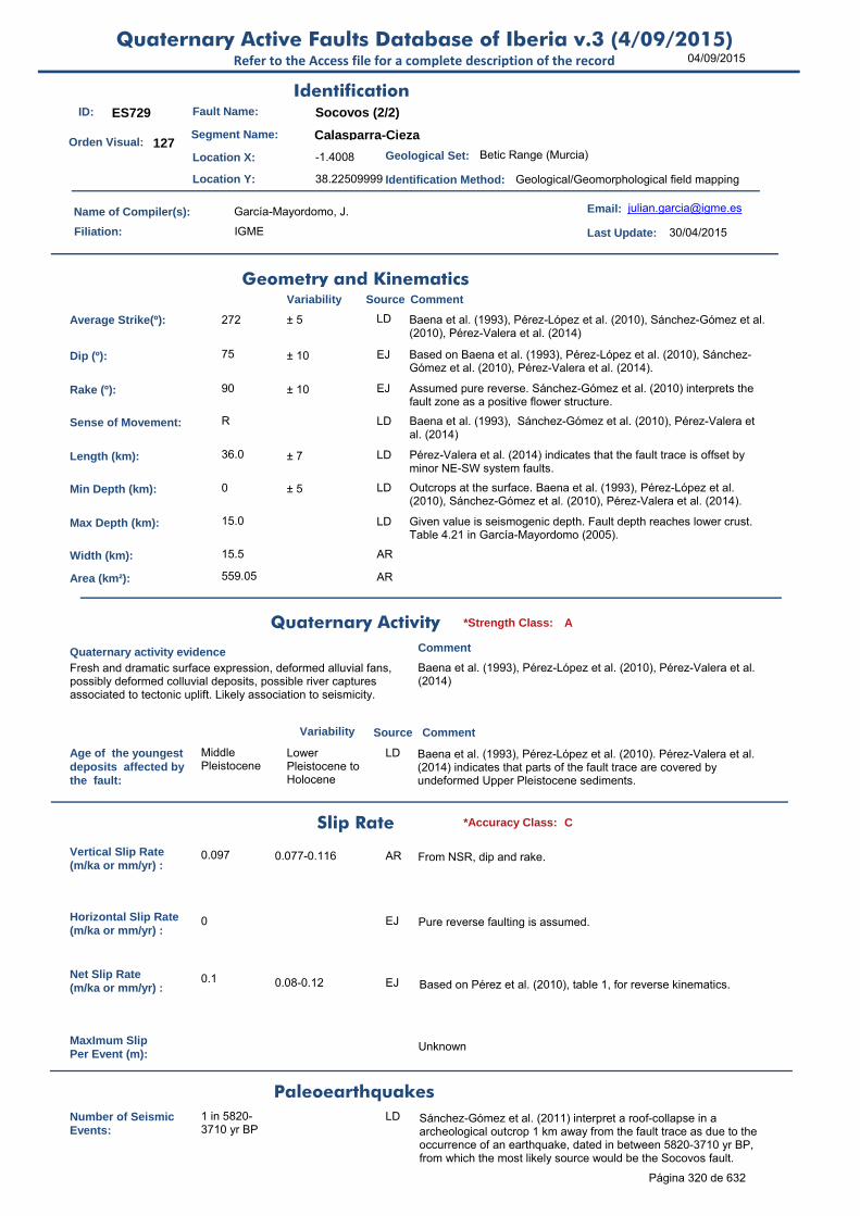
04/09/2015Quaternary Active Faults Database of Iberia v.3 (4/09/2015)
Refer to the Access file for a complete description of the record
ID: ES729 Fault Name: Socovos (2/2)
Segment Name: Calasparra-Cieza
Location X: -1.4008
Location Y: 38.22509999
Name of Compiler(s): García-Mayordomo, J.
Filiation: IGME
Email: [email protected]
Last Update: 30/04/2015
Average Strike(º): 272 ± 5 LD Baena et al. (1993), Pérez-López et al. (2010), Sánchez-Gómez et al. (2010), Pérez-Valera et al. (2014)
Dip (º): 75 ± 10 EJ Based on Baena et al. (1993), Pérez-López et al. (2010), Sánchez-Gómez et al. (2010), Pérez-Valera et al. (2014).
Rake (º): 90 ± 10 EJ Assumed pure reverse. Sánchez-Gómez et al. (2010) interprets the fault zone as a positive flower structure.
Sense of Movement: R LD Baena et al. (1993), Sánchez-Gómez et al. (2010), Pérez-Valera et al. (2014)
Length (km): 36.0 ± 7 LD Pérez-Valera et al. (2014) indicates that the fault trace is offset by minor NE-SW system faults.
Min Depth (km): 0 ± 5 LD Outcrops at the surface. Baena et al. (1993), Pérez-López et al. (2010), Sánchez-Gómez et al. (2010), Pérez-Valera et al. (2014).
Max Depth (km): 15.0 LD Given value is seismogenic depth. Fault depth reaches lower crust. Table 4.21 in García-Mayordomo (2005).
Width (km): 15.5 AR
Area (km²): 559.05 AR
Age of the youngestdeposits affected bythe fault:
Middle Pleistocene
Lower Pleistocene to Holocene
LD Baena et al. (1993), Pérez-López et al. (2010). Pérez-Valera et al. (2014) indicates that parts of the fault trace are covered by undeformed Upper Pleistocene sediments.
Vertical Slip Rate(m/ka or mm/yr) :
0.097 0.077-0.116 AR From NSR, dip and rake.
Horizontal Slip Rate(m/ka or mm/yr) :
0 EJ Pure reverse faulting is assumed.
Net Slip Rate(m/ka or mm/yr) :
0.1 0.08-0.12 EJ Based on Pérez et al. (2010), table 1, for reverse kinematics.
MaxImum Slip Per Event (m):
Unknown
Number of SeismicEvents:
1 in 5820-3710 yr BP
LD Sánchez-Gómez et al. (2011) interpret a roof-collapse in a archeological outcrop 1 km away from the fault trace as due to the occurrence of an earthquake, dated in between 5820-3710 yr BP, from which the most likely source would be the Socovos fault.
Identification
Geometry and KinematicsVariability Source Comment
Quaternary Activity
Variability Source
Comment
Fresh and dramatic surface expression, deformed alluvial fans, possibly deformed colluvial deposits, possible river captures associated to tectonic uplift. Likely association to seismicity.
Baena et al. (1993), Pérez-López et al. (2010), Pérez-Valera et al. (2014)
Geological Set: Betic Range (Murcia)
Identification Method: Geological/Geomorphological field mapping
Comment
Quaternary activity evidence
A*Strength Class:
Slip Rate *Accuracy Class: C
Paleoearthquakes
Orden Visual: 127
Página 320 de 632
04/09/2015Quaternary Active Faults Database of Iberia v.3 (4/09/2015)
Refer to the Access file for a complete description of the record
Evidence of AseismicCreep:
Unknown
Maximun Magnitude(Mw):
6.93 ± 0.37 ER Mw from length using Stirling et al (2002) equation derived from the instrumental dataset. Pérez-López et al (2010) estimated Mw 6.70 from SRL (30 km) using Wells and Coppersmith (1994).
RecurrenceInterval (years) :
16526 74143-3837 AR Considering the MEM (Wesnousky, 1986): RI = Mo f(Mw±d) / Mo f(SR±d). The occurrence of smaller, damaging earthquakes may be much shorter. Pérez et al. (2010) estimated 5000-30000 yrs based on Slemmons (1982).
Date of Last MaximumEarthquake (years) :
Unknown
Extended Information: EXTENDED_INFORMATION\ES728-ES729.rar
Baena et al. (1993) in: ITGE (1993a): Mapa Neotectónico, Sismotectónico y de Actividad de Fallas de la Región de Murcia (Escalas 1:200.000 y 1:100.000) and ITGE (1993b): Fichero de Fallas del Mapa Neotectónico, Sismotectónico y de Actividad de Fallas de la Región de Murcia (Escalas 1:200.000 y 1:100.000).
García-Mayordomo, J. (2005). Caracterización y análisis de la peligrosidad sísmica en el SE de España. Tesis Doctoral. UCM. Madrid. 379 pp.
Pérez-López, R., MA Rodríguez-Pascua, PG Silva, JL Giner-Robles and J García-Mayordomo. (2010). The Socovos Fault as seismic source for earthquake-size M>6. Tectonic slip-rate from geomorphology and instrumental seismicity (SE Spain). En: Contribución de la Geología al análisis de la Peligrosidad Sísmica. Resúmenes de la 1ª Reunión Ibérica sobre Tectónica Activa y Paleosismología. Sigüenza. España, 27-29 de Octubre, pp 117-120.
Pérez-Varela, L.A., Sánchez-Gómez, M., Azor, A., and Pérez-Varela, F. (2014). Actividad Cuaternaria del sistema de estructuras asociado a la Falla de Socovos (Béticas Orientales). Resúmenes de la 2ª Reunión Ibérica sobre Fallas Activas y Paleosismología, Lorca, España, pp 35-38.
Sánchez-Gómez, M., L.A. Pérez-Valera, F. Pérez-Valera y A. Azor (2010) Segmentación de la falla de Socovos a partir de datos geológicos. Resúmenes de la 1ª Reunión Ibérica sobre Fallas Activas y Paleosismología, Sigüenza, España, pp. 137-140.
Sánchez-Gómez, M., Martínez-Sánchez, C., García-García, F., Peláez, J.A., Pérez-Valera, F., Martínez-Andreu, M. & Pérez-Valera, L.A., (2011). Evidence for a 4700-2100 BC palaeoearthquake recorded in a fluvial-archaeological sequence of the Segura River, SE Spain. Quaternary International 242, 106–114.
Slemons, J. (1982). Determination of desing earthquake magnitudes for mnicrozonation. En: Proceedings of the 3rd International Earthquake Microzonation Conference. Seatle, Washington (USA), pp. 119-130.
Stirling, M., Rhoades, D. and Berryman K. (2002): Comparison of Earthquake Scaling Relations Derived from Data of the Instrumental and Preinstrumental Era. Bulletin of the Seismological Society of America, 92 (2): 812–830.
Wells, DL and Coppersmith, KJ (1994). New empirical relationships among magnitude, rupture length, rupture width, rupture area, and surface displacement. Bull. Sesimol. Soc. Am., 974-1002.
Seismic PotentialSource Comment
Associated Seismicity
Extended Data and References
References
Variability
*Reliability rating: B
*Reliability rating: C
Database of Seismicity Associated to QAFI v.3 FaultsRefer to the Access file for a complete description of the record
ID_Event Event name Date Location XY Int./Mag. Source Association Comment
ES729
Cieza 1936 4.5 IGN660
Página 321 de 632

04/09/2015Quaternary Active Faults Database of Iberia v.3 (4/09/2015)
Refer to the Access file for a complete description of the record
ID: ES730 Fault Name: Pozohondo
Segment Name: Tobarra-Cordovilla
Location X: -1.75799561
Location Y: 38.60510254
Name of Compiler(s): Pérez-López, R., Rodríguez-Pascua, M.A., García-Mayordomo, J., Jiménez-Díaz, A.
Filiation: IGME - Instituto Geológico y Minero de España
Email: [email protected]
Last Update: 26/08/2013
Average Strike(º): 113 ± 10 LD Rodríguez-Pascua et al. (2010a)
Dip (º): 75 ± 5 LD Rodríguez-Pascua et al. (2010a)
Rake (º): -120 ± 10 LD Rodríguez-Pascua et al. (2010a)
Sense of Movement: ND ± 10 LD Rodríguez-Pascua et al. (2008, 2010a)
Length (km): 25.0 11-28 LD Lenght of the segment where best evidence of recent activity is found (Tobarra-Cordovilla).Cartographic length of complete fault is more than 75 km.
Min Depth (km): 0 0 LD Surface rupturing; Rodríguez-Pascua et al. (2008)
Max Depth (km): 11.0 ±2 LD From analysis of the rheology of the crust and seismicity depth distribution (García-Mayordomo, 2005).
Width (km): 11.4 AR
Area (km²): 284.70 AR
Age of the youngestdeposits affected bythe fault:
Holocene LD Rodríguez-Pascua et al. (2012)
Vertical Slip Rate(m/ka or mm/yr) :
0.050 ± 0.02 AR Estimated from net slip and rake, Rodríguez-Pascua et al. (2008, 2009, 2010a, 2012)
Horizontal Slip Rate(m/ka or mm/yr) :
0.09 ± 0.02 AR Estimated from net slip and rake, Rodríguez-Pascua et al. (2008, 2009, 2010a, 2012)
Net Slip Rate(m/ka or mm/yr) :
0.1 ± 0.02 LD Obtained from palaeoseismic trenching analysis (Holocene); Rodríguez-Pascua et al. (2012). Slip rate for Late Miocene is 0.05 m/ky, and for Middle-Late Pleistocene is 0.06-0.09 m/ky
MaxImum Slip Per Event (m):
1.2 80-1.2 LD Max. Slip from last event recorded in trench. Fault scarp maximum height varies from 0.6-1.9 m Rodríguez-Pascua et al. (2008, 2009, 2010a, 2012)
Number of SeismicEvents:
2 in last 8 ka
2 to 3 LD There is also evidence for at least another event younger than 26 ka; Rodríguez-Pascua et al. (2012)
Evidence of AseismicCreep:
Unknown
Identification
Geometry and KinematicsVariability Source Comment
Quaternary Activity
Variability Source
Comment
Coseismic surface rupturing, dammed lakes (Alboraj), deformed fluvial network, topographic lineaments, soil cracks, overturned blocks, crossed alluvial fans, fault scarp.
Rodríguez-Pascua et al. (2008, 2009, 2010a, 2012)
Geological Set: Betic Range (Albacete-Murcia)
Identification Method: Geological/Geomorphological field mapping
Comment
Quaternary activity evidence
A*Strength Class:
Slip Rate *Accuracy Class: A
Paleoearthquakes
Orden Visual: 128
Página 322 de 632

04/09/2015Quaternary Active Faults Database of Iberia v.3 (4/09/2015)
Refer to the Access file for a complete description of the record
Maximun Magnitude(Mw):
6.78 ± 0.37 ER Mw from length using Stirling et al (2002) equation derived from the instrumental dataset. Mw is 6.55 (6.3-6.8) from max. Displacement vs. Mw using Wells and Coppersmith (1994) for normal faults (Rodríguez-Pascua et al., 2012).
RecurrenceInterval (years) :
7600 6600 to 8600 yr LD Estimated from paleoseismic events; Rodríguez-Pascua et al. (2012). Considering the Maximum Earthquake Model (Wesnousky, 1986) with NSR 0.1 m/ky results 19,300 yrs.
Date of Last MaximumEarthquake (years) :
1578 BP +/- 204 yrs LD Average radiocarbon age from 7 samples. Calendric age is between centuries I-VI AD, Rodríguez-Pascua et al. (2012)
Extended Information: EXTENDED_INFORMATION\ES730.rar
Rodriguez-Pascua MA.(1999). Tesis Doctoral. Universidad Complutense de Madrid. 600 pp.
Rodríguez-Pascua MA. (2001). Paleosismicidad y sismotectónica de las cuencas lacustres neógenas del Prebético de Albacete. Instituto de Estudios Albacetenses, 123. Albacete, 285 pp.
Rodríguez-Pascua MA, De Vicente G, Calvo JP and Pérez-López, R.(2003) Similarities between recent seismic activity and paleoseismites during the Late Miocene in the external Betic Chain (Spain). Journal of Structural Geology 25(4): 749-753.
Rodríguez-Pascua MA, Pérez-López R, Calvo JP and del Cura MAG. (2008) Recent seismogenic fault activity in a Late-Quaternary closed-lake graben basin (Albacete, Spain). Geomorphology 102(1): 169-178.
Rodríguez-Pascua MA, Bischoff JL., Garduño-Monroy VH, Pérez-López, R., Ginber-Robles JL, Israde-Alcántara I, Calvo JP and Willians RW. (2009). Estimation of the tectonic slip-rate from Quaternary lacustrine facies within the intraplate Albacete province (SE of Spain). Sedimentary Geology 222(1-2): 89-97.
Rodríguez-Pascua MA, Pérez-López R., Garduño-Monroy VH, Giner-Robles JL and BischoffJL. (2010a). Estudio paleosismico de la falla de Pozohondo. Prebético externo (Albacete, SE de España). En: Contribución de la Geología al análisis de la Peligrosidad Sísmica. Resúmenes de la 1ª Reunión Ibérica sobre Tectónica Activa y Paleosismología. Sigüenza. España, 27-29 de Octubre, pp 117-120.
Rodríguez-Pascua MA, Silva PG, Garduño-Monroy VH, Pérez-López R., Israde-Alcántara I, Giner-Robles JL, Bischoff JL and Calvo JP. (2010b). Ancient earthquakes from archaeoseismic evidence during the Visigoth and Islamic periods in the archaeological site of "Tolmo de Minateda" (SE of Spain). Geological Society of America Special Paper, 471: 171-184.
Rodríguez-Pascua MA, Pérez-López R, Garduño-Monroy VH, Giner-Robles JL, Silva PG, Perucha-Atienza MA, Hernández-Madrigal VM and Bischoff JL. (2012). Paleosesimic and geomorphologic evidence of recent tectonic activity of the Pozohondo Fault (Betic Cordillera, SE Spain). Journal of Iberian Geology, 38(1): 239-251.
Stirling, M., Rhoades, D. and Berryman K. (2002): Comparison of Earthquake Scaling Relations Derived from Data of the Instrumental and Preinstrumental Era. Bulletin of the Seismological Society of America, 92 (2): 812–830.
Wells, DL and Coppersmith, KJ (1994). New empirical relationships among magnitude, rupture length, rupture width, rupture area, and surface displacement. Bull. Sesimol. Soc. Am., 974-1002.
Seismic PotentialSource Comment
Associated Seismicity
Extended Data and References
References
Variability
*Reliability rating: B
*Reliability rating: B
Página 323 de 632

04/09/2015Quaternary Active Faults Database of Iberia v.3 (4/09/2015)
Refer to the Access file for a complete description of the record
ID: ES736 Fault Name: East of Guadix
Segment Name:
Location X: -3.15714548
Location Y: 37.36179807
Name of Compiler(s): García Tortosa, F.J., Peláez, J.A., Alfaro, P., Sanz de Galdeano, C. and Galindo, J.
Filiation: Universidades de Jaén, Alicante, Granada e IACT.
Email: [email protected]
Last Update: 10/02/2015
Average Strike(º): 142 5 LD Calculated from the tips of the trace (Sanz de Galdeano et al.,2012)
Dip (º): 90 LD Average dip as observed at surface (Sanz de Galdeano et al.,2012)
Rake (º): -90 LD Sanz de Galdeano et al. (2012)
Sense of Movement: N LD Sanz de Galdeano et al. (2012)
Length (km): 10.8 LD Sanz de Galdeano et al. (2012)
Min Depth (km): 0 LD Sanz de Galdeano et al. (2012)
Max Depth (km): 10.0 ±2 LD Depth of the seismogenic crust in the area: 10 km (García-Mayordomo, 2005).
Width (km): 10.0 AR
Area (km²): 108.00 AR
Age of the youngestdeposits affected bythe fault:
Lower-Middle Pleistocene
LD Sanz de Galdeano et al. (2012)
Vertical Slip Rate(m/ka or mm/yr) :
0.020 LD Average value from deformed Quaternary markers (Sanz de Galdeano et al., 2012)
Horizontal Slip Rate(m/ka or mm/yr) :
0 EJ HSR=0, assumed pure dip-slip faulting.
Net Slip Rate(m/ka or mm/yr) :
0.02 AR From VSR, dip and rake (pure normal)
MaxImum Slip Per Event (m):
Unknown
Number of SeismicEvents:
Unknown
Evidence of AseismicCreep:
Unknown
Identification
Geometry and KinematicsVariability Source Comment
Quaternary Activity
Variability Source
Comment
Seismic Potential
It appears as great vertical joints, partially eroded by the glacis of the Guadix-Baza Basin. Linked geological features are scarce. Seismicity seemingly related.
Sanz de Galdeano et al. (2012)
Geological Set: Betic Range (Granada)
Identification Method: Geological/Geomorphological field mapping
Comment
Quaternary activity evidence
C*Strength Class:
Slip Rate *Accuracy Class: C
Paleoearthquakes
Orden Visual: 208
Página 324 de 632
04/09/2015Quaternary Active Faults Database of Iberia v.3 (4/09/2015)
Refer to the Access file for a complete description of the record
Maximun Magnitude(Mw):
6.43 ± 0.37 ER Mw from length using Stirling et al (2002) equation derived from the instrumental dataset. Mw is 6.20 (± 0.6) from the equation Mw=Mw(l) of Wells and Coppersmith (1994) for normal faults.
RecurrenceInterval (years) :
76923 Unstated AR Considering the Maximum Earthquake Model (Wesnousky, 1986): slip rate represents the rate at which maximum earthquakes are released by the fault. RI = Mo f(Mw±d) / Mo f(SR±d). The occurrence of smaller, damaging earthquakes may be much shorter.
Date of Last MaximumEarthquake (years) :
Unknown
Extended Information:
García Tortosa, F.J., Sanz de Galdeano, C., Alfaro, P. y Ureña, M. (2007). El glacis de la cuenca de Guadix-Baza. Una superficie de referencia para el análisis tectónico y la evolución geomorfológica de la cuenca, en La cuenca de Guadix-Baza. Estructura, tectónica activa, sismicidad, geomorfología y dataciones existentes (Sanz de Galdeano, C., y Peláez, J.A., eds.), Granada, 111-126
García-Tortosa, F.J., Sanz de Galdeano, C., Alfaro, P., Galindo-Zaldívar, J. (2008). Deformación reciente de la Cuenca de Guadix-Baza. GeoTemas 10, 1007-1010.
García-Tortosa, F.J., Alfaro, P., Sanz de Galdeano, C. y Galindo-Zaldívar, J. (2010). Glacis geometry as a geomorphic marker of recent tectonics: The Guadix-Baza Basin (South Spain). Geomorphology, doi.: 10.1016/j.geomorph.2010.10.021
Peláez, J.A., Sanz de Galdeano, C., y López Casado, C. (2007). Determinación preliminar del potencial sísmico de la Cuenca de Guadix-Baza (Granada). 3er Congreso Nacional de Ingeniería Sísmica. Girona (España).
Peláez, J.A., Sanz de Galdeano, C., y López Casado, C. (2007). Peligrosidad sísmica en la Cuenca de Guadix-Baza a partir de datos de fallas activa, en La Cuenca de Guadix-Baza. Estructura, Tectónica activa, sismicidad, Geomorfología y dataciones existentes (C. Sanz de Galdeano & J.A. Peláez, eds.). Granada. 301-310.
Sanz de Galdeano, C., Peláez, J.A., y López Casado, C. (2007). Fallas activas y potencial sísmico de la cuenca de Guadix-Baza, en La cuenca de Guadix-Baza. Estructura, tectónica activa, sismicidad, geomorfología y dataciones existentes (Sanz de Galdeano, C., y Peláez, J.A., eds.), Granada, 283-299.
Sanz de Galdeano, C., J.A. Peláez, C. López Casado, P. Alfaro, F.J. García Tortosa, J. Galindo Zaldívar y A.C. López Garrido (2010). Tectónica activa en las cuencas de Granada y Guadix‐Baza (Cordillera Bética, sur de España). En: Contribución de la Geología al Análisis de la Peligrosidad Sísmica (J.M. Insua y F. Martín‐González, eds.), pp. 2‐5. Sigüenza (Guadalajara, España).
Sanz de Galdeano, C., García Tortosa, F.J., Peláez, J.A., Alfaro, P., Azañón, J.M., Galindo Zaldívar, J., López Casado, C., López Garrido, A.C., Rodríguez-Fernández, J. y Ruano, P. (2012). Main active faults in the Granada and Guadix-Baza Basins (Betic Cordillera). Journal of Iberian Geology 38 (1) 2012: 209-223.
Stirling, M., Rhoades, D. and Berryman K. (2002): Comparison of Earthquake Scaling Relations Derived from Data of the Instrumental and Preinstrumental Era. Bulletin of the Seismological Society of America, 92 (2): 812–830.
Wells, DL and Coppersmith, KJ (1994). New empirical relationships among magnitude, rupture length, rupture width, rupture area, and surface displacement. Bull. Sesimol. Soc. Am., 974-1002.
Source Comment
Associated Seismicity
Extended Data and References
References
Variability
*Reliability rating: D
*Reliability rating: D
Página 325 de 632

04/09/2015Quaternary Active Faults Database of Iberia v.3 (4/09/2015)
Refer to the Access file for a complete description of the record
ID: ES737 Fault Name: Benamaurel
Segment Name:
Location X: -2.72914222
Location Y: 37.58480527
Name of Compiler(s): García Tortosa, F.J., Peláez, J.A., Alfaro, P., Sanz de Galdeano, C. and Galindo, J.
Filiation: Universidades de Jaén, Alicante, Granada e IACT.
Email: [email protected]
Last Update: 10/02/2015
Average Strike(º): 154 LD Sanz de Galdeano et al. (2012)
Dip (º): 60 LD Sanz de Galdeano et al. (2012)
Rake (º): -90 LD Sanz de Galdeano et al. (2012)
Sense of Movement: N LD Sanz de Galdeano et al. (2012)
Length (km): 18.7 LD Inferred from gravity surveying and seismicity data (Sanz de Galdeano et al., 2012)
Min Depth (km): 1 >0 LD Fault revealed from gravity survey (Sanz de Galdeano et al., 2007). The fault has no surface-deformation features associated with it.
Max Depth (km): 10.0 >10 LD Sanz de Galdeano et al. (2012)
Width (km): 10.4 AR
Area (km²): 194.34 AR
Age of the youngestdeposits affected bythe fault:
Unknown LD Fault deduced from seismicity and gravity surveying (Sanz de Galdeano et al., 2012). It is potentially responsible for the November 16, 2003 (mbLg=4.1, I=IV) SW Benamaurel earthquake.
Vertical Slip Rate(m/ka or mm/yr) :
Unknown
Horizontal Slip Rate(m/ka or mm/yr) :
Unknown
Net Slip Rate(m/ka or mm/yr) : Unknown
MaxImum Slip Per Event (m):
Unknown
Number of SeismicEvents:
Unknown
Evidence of AseismicCreep:
Unknown
Identification
Geometry and KinematicsVariability Source Comment
Quaternary Activity
Variability Source
Comment
There are no geomorphic evidence. The fault is deduced from seismicity and gravimetric data.
It is antithetic respect to the Baza Fault (Sanz de Galdeano et al., 2012)
Geological Set: Betic Range (Granada, Guadix Basin)
Identification Method: Geophysical methods and seismological techniques
Comment
Quaternary activity evidence
C*Strength Class:
Slip Rate *Accuracy Class: Not rated
Paleoearthquakes
Orden Visual: 209
Página 326 de 632
04/09/2015Quaternary Active Faults Database of Iberia v.3 (4/09/2015)
Refer to the Access file for a complete description of the record
Maximun Magnitude(Mw):
6.66 ± 0.37 ER Mw from length using Stirling et al (2002) equation derived from the instrumental dataset. Mw is 6.50 (± 0.7) from the equation Mw=Mw(l) of Wells and Coppersmith (1994) for normal faults.
RecurrenceInterval (years) :
Not enough data for an estimation
Date of Last MaximumEarthquake (years) :
Unknown
Extended Information:
Peláez, J.A., Sanz de Galdeano, C., y López Casado, C. (2007). Determinación preliminar del potencial sísmico de la Cuenca de Guadix-Baza (Granada). 3er Congreso Nacional de Ingeniería Sísmica. Girona (España).
Peláez, J.A., Sanz de Galdeano, C., y López Casado, C. (2007). Peligrosidad sísmica en la Cuenca de Guadix-Baza a partir de datos de fallas activa, en La Cuenca de Guadix-Baza. Estructura, Tectónica activa, sismicidad, Geomorfología y dataciones existentes (C. Sanz de Galdeano & J.A. Peláez, eds.). Granada. 301-310.
Sanz de Galdeano, C., Peláez, J.A., y López Casado, C. (2007). Fallas activas y potencial sísmico de la cuenca de Guadix-Baza, en La cuenca de Guadix-Baza. Estructura, tectónica activa, sismicidad, geomorfología y dataciones existentes (Sanz de Galdeano, C., y Peláez, J.A., eds.), Granada, 283-299.
Sanz de Galdeano, C., J.A. Peláez, C. López Casado, P. Alfaro, F.J. García Tortosa, J. Galindo Zaldívar y A.C. López Garrido (2010). Tectónica activa en las cuencas de Granada y Guadix‐Baza (Cordillera Bética, sur de España). En: Contribución de la Geología al Análisis de la Peligrosidad Sísmica (J.M. Insua y F. Martín‐González, eds.), pp. 2‐5. Sigüenza (Guadalajara, España).
Sanz de Galdeano, C., García Tortosa, F.J., Peláez, J.A., Alfaro, P., Azañón, J.M., Galindo Zaldívar, J., López Casado, C., López Garrido, A.C., Rodríguez-Fernández, J. y Ruano, P. (2012). Main active faults in the Granada and Guadix-Baza Basins (Betic Cordillera). Journal of Iberian Geology 38 (1) 2012: 209-223.
Stirling, M., Rhoades, D. and Berryman K. (2002): Comparison of Earthquake Scaling Relations Derived from Data of the Instrumental and Preinstrumental Era. Bulletin of the Seismological Society of America, 92 (2): 812–830.
Wells, DL and Coppersmith, KJ (1994). New empirical relationships among magnitude, rupture length, rupture width, rupture area, and surface displacement. Bull. Sesimol. Soc. Am., 974-1002.
Seismic PotentialSource Comment
Associated Seismicity
Extended Data and References
References
Variability
*Reliability rating: D
*Reliability rating: Not Rated
Database of Seismicity Associated to QAFI v.3 FaultsRefer to the Access file for a complete description of the record
ID_Event Event name Date Location XY Int./Mag. Source Association Comment
ES737
Benamaurel 16/11/2003 4.1 mblg, IV Peláez et al, 2007661
Página 327 de 632

04/09/2015Quaternary Active Faults Database of Iberia v.3 (4/09/2015)
Refer to the Access file for a complete description of the record
ID: ES739 Fault Name: Oeste del Negratín
Segment Name:
Location X: -3.00440465
Location Y: 37.59359178
Name of Compiler(s): García Tortosa, F.J., Peláez, J.A., Alfaro, P., Sanz de Galdeano, C. and Galindo, J.
Filiation: Universidades de Jaén, Alicante, Granada e IACT.
Email: [email protected]
Last Update: 07/10/2014
Average Strike(º): 180 LD Calculated from the tips of the trace (Sanz de Galdeano and Peláez, 2007)
Dip (º): 70 LD Average dip as observed at surface (Sanz de Galdeano and Peláez, 2007)
Rake (º): -90 LD Sanz de Galdeano and Peláez (2007)
Sense of Movement: N LD Sanz de Galdeano and Peláez (2007)
Length (km): 7.8 LD Sanz de Galdeano and Peláez (2007)
Min Depth (km): 5 LD Sanz de Galdeano and Peláez (2007)
Max Depth (km): 10.0 > 5 LD Sanz de Galdeano and Peláez (2007)
Width (km): 5.3 AR
Area (km²): 41.50 AR
Age of the youngestdeposits affected bythe fault:
Pleistocene LD Sanz de Galdeano and Peláez (2007)
Vertical Slip Rate(m/ka or mm/yr) :
0.200 LD From Quaternary markers (Sanz de Galdeano and Peláez, 2007)
Horizontal Slip Rate(m/ka or mm/yr) :
0 EJ HSR=0, assumed pure dip-slip faulting.
Net Slip Rate(m/ka or mm/yr) :
0.213 AR From dip and rake of the fault
MaxImum Slip Per Event (m):
Unknown
Number of SeismicEvents:
Unknown
Evidence of AseismicCreep:
Unknown
Identification
Geometry and KinematicsVariability Source Comment
Quaternary Activity
Variability Source
Comment
It affects Pleistocene sediments Sanz de Galdeano and Peláez (2007)
Geological Set: Betic Range (Granada)
Identification Method: Geological/Geomorphological field mapping
Comment
Quaternary activity evidence
A*Strength Class:
Slip Rate *Accuracy Class: C
Paleoearthquakes
Orden Visual: 211
Página 328 de 632

04/09/2015Quaternary Active Faults Database of Iberia v.3 (4/09/2015)
Refer to the Access file for a complete description of the record
Maximun Magnitude(Mw):
6.30 ± 0.37 ER Mw from length using Stirling et al (2002) equation derived from the instrumental dataset. Mw is 6.00 (± 0.6) from the equation Mw=Mw(l) of Wells and Coppersmith (1994) for normal faults.
RecurrenceInterval (years) :
11822 Unstated AR Considering the Maximum Earthquake Model (Wesnousky, 1986): slip rate represents the rate at which maximum earthquakes are released by the fault. RI = Mo f(Mw±d) / Mo f(SR±d). The occurrence of smaller, damaging earthquakes may be much shorter.
Date of Last MaximumEarthquake (years) :
Unknown
Extended Information:
Peláez, J.A., Sanz de Galdeano, C., y López Casado, C. (2007). Determinación preliminar del potencial sísmico de la Cuenca de Guadix-Baza (Granada). 3er Congreso Nacional de Ingeniería Sísmica. Girona (España).
Peláez, J.A., Sanz de Galdeano, C., y López Casado, C. (2007). Peligrosidad sísmica en la Cuenca de Guadix-Baza a partir de datos de fallas activa, en La Cuenca de Guadix-Baza. Estructura, Tectónica activa, sismicidad, Geomorfología y dataciones existentes (C. Sanz de Galdeano & J.A. Peláez, eds.). Granada. 301-310.
Sanz de Galdeano, C., Peláez, J.A., y López Casado, C. (2007). Fallas activas y potencial sísmico de la cuenca de Guadix-Baza, en La cuenca de Guadix-Baza. Estructura, tectónica activa, sismicidad, geomorfología y dataciones existentes (Sanz de Galdeano, C., y Peláez, J.A., eds.), Granada, 283-299.
Sanz de Galdeano, C., J.A. Peláez, C. López Casado, P. Alfaro, F.J. García Tortosa, J. Galindo Zaldívar y A.C. López Garrido (2010). Tectónica activa en las cuencas de Granada y Guadix‐Baza (Cordillera Bética, sur de España). En: Contribución de la Geología al Análisis de la Peligrosidad Sísmica (J.M. Insua y F. Martín‐González, eds.), pp. 2‐5. Sigüenza (Guadalajara, España).
Stirling, M., Rhoades, D. and Berryman K. (2002): Comparison of Earthquake Scaling Relations Derived from Data of the Instrumental and Preinstrumental Era. Bulletin of the Seismological Society of America, 92 (2): 812–830.
Wells, DL and Coppersmith, KJ (1994). New empirical relationships among magnitude, rupture length, rupture width, rupture area, and surface displacement. Bull. Sesimol. Soc. Am., 974-1002.
Seismic PotentialSource Comment
Associated Seismicity
Extended Data and References
References
Variability
*Reliability rating: B
*Reliability rating: C
Página 329 de 632
04/09/2015Quaternary Active Faults Database of Iberia v.3 (4/09/2015)
Refer to the Access file for a complete description of the record
ID: ES741 Fault Name: Sencelles
Segment Name:
Location X: 2.804
Location Y: 39.601
Name of Compiler(s): García-Mayordomo, J., Martín-Banda, R.
Filiation: IGME, UCM
Email: [email protected]
Last Update: 29/04/2015
Average Strike(º): 050 45-60 LD Silva et al. (2001), Mas et al (2014)
Dip (º): 75 70-80 LD Silva et al. (2001)
Rake (º): 45 EJ Based on Mas et al (2014)
Sense of Movement: SR LD It is interpreted as a left-lateral strike-slip fault zone since Upper Miocene-Pliocene (Mas et al., 2014).
Length (km): 22.5 LD Silva et al. (2001)
Min Depth (km): 0 LD Outcrops at the surface. Silva et al. (2001), Mas et al (2014)
Max Depth (km): 10.0 LD Silva et al. (2001)
Width (km): 10.4 AR
Area (km²): 232.94 AR
Age of the youngestdeposits affected bythe fault:
<780 ka Holocene LD Silva et al. (2001) indicates deformation very likely reaches Holocene.
Vertical Slip Rate(m/ka or mm/yr) :
0.180 0.003-0.35 EJ Based on Silva et al. (2001) data on Portol doline (2.56 m / 780 ka) and Sta. Eugènia (3.5 m/ 10 ka) assuming thrown is given as vertical offsets. Preferred value is the average.
Horizontal Slip Rate(m/ka or mm/yr) :
0.186 0.03-0.362 AR From NSR and rake
Net Slip Rate(m/ka or mm/yr) :
0.264 0.04-0.512 AR From VSR, dip and rake
MaxImum Slip Per Event (m):
0.275 0.4-0.15 LD Silva et al. (2001). It is assumed that they are vertical displacements.
Number of SeismicEvents:
5 3-9 EJ Based on Silva et al. (2001) estimations of displacement/event.
Evidence of AseismicCreep:
Unknown
Identification
Geometry and KinematicsVariability Source Comment
Quaternary Activity
Variability Source
Comment
Seismic Potential
Surface expression, fresh morphology scarps, faulted Quaternary sediments, possible association to seismicity.
Silva et al. (2001), Giménez (2003), Mas et al. (2014)
Geological Set: Betic Cordillera (Mallorca)
Identification Method: Geological/geomorphological field mapping
Comment
Quaternary activity evidence
A*Strength Class:
Slip Rate *Accuracy Class: C
Paleoearthquakes
Orden Visual: 259
Página 330 de 632
04/09/2015Quaternary Active Faults Database of Iberia v.3 (4/09/2015)
Refer to the Access file for a complete description of the record
Maximun Magnitude(Mw):
6.73 ± 0.37 ER Mw from length using Stirling et al (2002) equation derived from the instrumental dataset.
RecurrenceInterval (years) :
6285 903-148889 AR Considering the MEM (Wesnousky, 1986): RI = Mo f(Mw±d) / Mo f(SR±d). The occurrence of smaller, damaging earthquakes may be much shorter. Silva et al. (2001) indicates 70-90 yrs based on historical seismicity.
Date of Last MaximumEarthquake (years) :
1851 LD According to Silva et al. (2001). See also Giménez (2003).
Extended Information:
Giménez, J. 2003. Nuevos datos sobre la actividad post-Neógena en la Isla de Mallorca. Geogaceta, 33, 79-82.
Giménez, J. & Gelabert, B. 2002. Análisis de la actividad tectónica reciente en la isla de Mallorca. In: III Asamblea Hispano-Portuguesa de Geodesia y Geofísica, Valencia, Vol 1, 390-394.
Mas, G., Gelabert, B., and Fornós, J.J. (2014). Evidencias de desplazamiento direccional de la fallaa de Sencelles (Mallorca, Isalas Baleares). Resúmenes de la 2ª Reunión Ibérica sobre Fallas Activas y Paleosismología, Lorca, España, 47-50.
Silva, P.G., González Hernández, F.M., Goy, J.L., Zazo, C. and Carrasco, P. (2001). Paleo and historical seismicity in Mallorca (Baleares, Spain): a preliminary approach. Acta Geológica Hispánica, 36 (3-4), 245-266.
Stirling, M., Rhoades, D. and Berryman K. (2002): Comparison of Earthquake Scaling Relations Derived from Data of the Instrumental and Preinstrumental Era. Bulletin of the Seismological Society of America, 92 (2): 812–830.
Source Comment
Associated Seismicity
Extended Data and References
References
Variability
*Reliability rating: B
*Reliability rating: C
Database of Seismicity Associated to QAFI v.3 FaultsRefer to the Access file for a complete description of the record
ID_Event Event name Date Location XY Int./Mag. Source Association Comment
ES741
Palma earthquake, 1851
15-05-1851 02,48,00E-39,36,00N
VIII MSK IGN and Galbis (1932)
Seismic sequence lasted for more than 6 months Silva et al. (2001).
668
ES741
Sencelles, 1764 26-05-1764 03,00,0E-39,36,0N
unknown IGN According to Silva et al. (2001), Table 1.
669
ES741
Sencelles, 1921 22-10-1921 02,54,00E; 39,39,00N
IV ING According to Silva et al. (2001), Table 1.
671
ES741
Sencelles, 1996 09-04-1996 02,55,6E; 39,38,8N
II-III IGN According to Silva et al. (2001), Table 1.
672
Página 331 de 632

04/09/2015Quaternary Active Faults Database of Iberia v.3 (4/09/2015)
Refer to the Access file for a complete description of the record
ID: ES743 Fault Name: West Cabezo Gordo (Murcia - Mar Menor)
Segment Name:
Location X: -1.01373478
Location Y: 37.86994441
Name of Compiler(s): Martín-Banda, R. and García-Mayordomo, J.
Filiation: IGME
Email: [email protected]
Last Update: 12/09/2013
Average Strike(º): 140 ± 10 LD Compiler's measurement, based on the Record number 111 from the Neotectonic, Seismotectonic and Activity of Faults Map of the Región de Murcia (ITGE, 1993a,b), following the right-hand rule.
Dip (º): 60 EJ García-Mayordomo (2005).
Rake (º): -90 LD Record number 111 from the Neotectonic, Seismotectonic and Activity of Faults Map of the Región de Murcia (ITGE, 1993a,b).
Sense of Movement: N LD Record number 111 from the Neotectonic, Seismotectonic and Activity of Faults Map of the Región de Murcia (ITGE, 1993a,b).
Length (km): 30.9 ± 0.2 EJ Observed on the Neotectonic, Seismotectonic and Activity of Faults Map of the Región de Murcia (ITGE, 1993a).
Min Depth (km): 0.02 ± 0.005 EJ Based on the Plio-Quaternary Isopach Map of the Campo de Cartagena and Guadalentín Basins (ITGE, 1993a).
Max Depth (km): 8.0 LD 8 km is the depth of the fragile-ductile transition in the Cartagena Crustal Block (García-Mayordomo, 2005).
Width (km): 9.2 AR
Area (km²): 284.73 AR
Age of the youngestdeposits affected bythe fault:
Upper Pleistocene
LD Record number 111 from the Neotectonic, Seismotectonic and Activity of Faults Map of the Región de Murcia (ITGE, 1993a,b).
Vertical Slip Rate(m/ka or mm/yr) :
0.075 LD Record number 111 from the Neotectonic, Seismotectonic and Activity of Faults Map of the Región de Murcia (ITGE, 1993a).
Horizontal Slip Rate(m/ka or mm/yr) :
0 EJ Assuming pure normal slip.
Net Slip Rate(m/ka or mm/yr) :
0.087 ± 0.01 AR Assuming pure normal slip and using VSR, Dip and Rake.
MaxImum Slip Per Event (m):
Unknown
Number of SeismicEvents:
Unknown
Identification
Geometry and KinematicsVariability Source Comment
Quaternary Activity
Variability Source
Comment
1) Topographic lineament 2) Threshold between San Pedro del Pinatar Basin and Torrepacheco Basin.
Record number 111 from the Neotectonic, Seismotectonic and Activity of Faults Map of the Región de Murcia (ITGE, 1993a,b).
Geological Set: Betic Range (Murcia)
Identification Method: Geomorphological mapping and geophysics
Comment
Quaternary activity evidence
C*Strength Class:
Slip Rate *Accuracy Class: C
Paleoearthquakes
Orden Visual: 152
Página 332 de 632

04/09/2015Quaternary Active Faults Database of Iberia v.3 (4/09/2015)
Refer to the Access file for a complete description of the record
Evidence of AseismicCreep:
Unknown
Maximun Magnitude(Mw):
6.87 ± 0.37 ER Magnitude from length using Stirling et al (2002) equation derived from the instrumental dataset.
RecurrenceInterval (years) :
30000 7497-121659 AR Considering the Maximum Earthquake Model (Wesnousky, 1986): slip rate represents the rate at which maximum earthquakes are released by the fault. RI = Mo f(Mw±d) / Mo f(SR±d). The occurrence of smaller, damaging earthquakes may be much shorter.
Date of Last MaximumEarthquake (years) :
Unknown
Extended Information: EXTENDED INFORMATION\
Garcia-Mayordomo, J. (2005). Caracterización y Análisis de la Peligrosidad Sísmica en el Sureste de España. Tesis Doctoral, Universidad Complutense de Madrid, 373 pp.
ITGE (1993a): Mapa Neotectónico, Sismotectónico y de Actividad de Fallas de la Región de Murcia (Escalas 1:200.000 y 1:100.000).
ITGE (1993b): Fichero de Fallas del Mapa Neotectónico, Sismotectónico y de Actividad de Fallas de la Región de Murcia (Escalas 1:200.000 y 1:100.000).
Stirling, M., Rhoades, D. and Berryman K. (2002): Comparison of Earthquake Scaling Relations Derived from Data of the Instrumental and Preinstrumental Era. Bulletin of the Seismological Society of America, 92 (2): 812–830.
Wesnousky, S.G. (1986). Earthquakes, Quaternary faults, and seismic hazard in California. Journal of Geophysical Research. 91(B12), 12587-12631.
Seismic PotentialSource Comment
Associated Seismicity
Extended Data and References
References
Variability
*Reliability rating: D
*Reliability rating: D
Página 333 de 632

04/09/2015Quaternary Active Faults Database of Iberia v.3 (4/09/2015)
Refer to the Access file for a complete description of the record
ID: ES744 Fault Name: Cartagena-2
Segment Name:
Location X: -0.72498855
Location Y: 37.75026723
Name of Compiler(s): Martín-Banda, R. and García-Mayordomo, J.
Filiation: IGME
Email: [email protected]
Last Update: 13/09/2013
Average Strike(º): 258 ± 5 EJ Compiler's measurement, based on the Record number 114 from the Neotectonic, Seismotectonic and Activity of Faults Map of the Región de Murcia (ITGE, 1993a,b), following the right-hand rule.
Dip (º): 60 EJ García-Mayordomo (2005).
Rake (º): 90 EJ García-Mayordomo (2005).
Sense of Movement: R EJ García-Mayordomo (2005).
Length (km): 21.0 ± 0.2 EJ Observed on the Neotectonic, Seismotectonic and Activity of Faults Map of the Región de Murcia (ITGE, 1993a).
Min Depth (km): 0.02 ± 0.005 EJ Based on the Plio-Quaternary Isopach Map of the Campo de Cartagena and Guadalentín Basins (ITGE, 1993a).
Max Depth (km): 8.0 EJ Its maximum depth should be within the upper crust. 8 km is the depth of the fragile-ductile transition in the Cartagena Crustal Block (García-Mayordomo, 2005).
Width (km): 9.2 AR
Area (km²): 193.50 AR
Age of the youngestdeposits affected bythe fault:
Gelasian (Early Pleistocene)
LD Record number 114 from the Neotectonic, Seismotectonic and Activity of Faults Map of the Región de Murcia (ITGE, 1993a,b).
Vertical Slip Rate(m/ka or mm/yr) :
Unknown
Horizontal Slip Rate(m/ka or mm/yr) :
Unknown
Net Slip Rate(m/ka or mm/yr) : Unknown
MaxImum Slip Per Event (m):
Unknown
Number of SeismicEvents:
Unknown
Identification
Geometry and KinematicsVariability Source Comment
Quaternary Activity
Variability Source
Comment
1) Controls on early Pleistocene sedimentation 2) Tilting Record number 114 from the Neotectonic, Seismotectonic and Activity of Faults Map of the Región de Murcia (ITGE, 1993a,b).
Geological Set: Betics (Murcia)
Identification Method: Geological, geomorphological field mapping and geophysics
Comment
Quaternary activity evidence
C*Strength Class:
Slip Rate *Accuracy Class: Not rated
Paleoearthquakes
Orden Visual: 153
Página 334 de 632

04/09/2015Quaternary Active Faults Database of Iberia v.3 (4/09/2015)
Refer to the Access file for a complete description of the record
Evidence of AseismicCreep:
Unknown
Maximun Magnitude(Mw):
6.71 ± 0.37 ER Magnitude from length using Stirling et al (2002) equation derived from the instrumental dataset.
RecurrenceInterval (years) :
Not enough data for an estimation
Date of Last MaximumEarthquake (years) :
Unknown
Extended Information: EXTENDED INFORMATION\
Garcia-Mayordomo, J. (2005). Caracterización y Análisis de la Peligrosidad Sísmica en el Sureste de España. Tesis Doctoral, Universidad Complutense de Madrid, 373 pp.
ITGE (1993a): Mapa Neotectónico, Sismotectónico y de Actividad de Fallas de la Región de Murcia (Escalas 1:200.000 y 1:100.000).
ITGE (1993b): Fichero de Fallas del Mapa Neotectónico, Sismotectónico y de Actividad de Fallas de la Región de Murcia (Escalas 1:200.000 y 1:100.000).
Stirling, M., Rhoades, D. and Berryman K. (2002): Comparison of Earthquake Scaling Relations Derived from Data of the Instrumental and Preinstrumental Era. Bulletin of the Seismological Society of America, 92 (2): 812–830.
Seismic PotentialSource Comment
Associated Seismicity
Extended Data and References
References
Variability
*Reliability rating: D
*Reliability rating: Not Rated
Página 335 de 632

04/09/2015Quaternary Active Faults Database of Iberia v.3 (4/09/2015)
Refer to the Access file for a complete description of the record
ID: ES745 Fault Name: El Cantal
Segment Name:
Location X: -1.60692076
Location Y: 37.45738574
Name of Compiler(s): Martín-Banda, R. and García-Mayordomo, J.
Filiation: IGME
Email: [email protected]
Last Update: 13/09/2013
Average Strike(º): 060 ± 3 LD Compiler's measurement, based on the Record number 119 from the Neotectonic, Seismotectonic and Activity of Faults Map of the Región de Murcia (ITGE, 1993a,b), following the right-hand rule.
Dip (º): 80 90 to 60 EJ García-Mayordomo (2005).
Rake (º): -45 LD Record number 119 from the Neotectonic, Seismotectonic and Activity of Faults Map of the Región de Murcia (ITGE, 1993a,b).
Sense of Movement: NS LD Record number 119 from the Neotectonic, Seismotectonic and Activity of Faults Map of the Región de Murcia (ITGE, 1993a,b).
Length (km): 8.9 ± 0.2 EJ Observed on the Neotectonic, Seismotectonic and Activity of Faults Map of the Región de Murcia (ITGE, 1993a).
Min Depth (km): 0 EJ It outcrops at the surface (ITGE, 1993a).
Max Depth (km): 8.0 EJ Its maximum depth should be within the upper crust. 8 km is the depth of the fragile-ductile transition in the Cartagena Crustal Block (García-Mayordomo, 2005).
Width (km): 8.1 AR
Area (km²): 72.30 AR
Age of the youngestdeposits affected bythe fault:
Holocene EJ Observed on the Neotectonic, Seismotectonic and Activity of Faults Map of the Región de Murcia (ITGE, 1993a).
Vertical Slip Rate(m/ka or mm/yr) :
0.050 0.05-0.09 LD The Neotectonic, Seismotectonic and Activity of Faults Map of the Región de Murcia (ITGE, 1993a).
Horizontal Slip Rate(m/ka or mm/yr) :
0.051 0.051-0.091 AR Using NSR and Rake
Net Slip Rate(m/ka or mm/yr) :
0.072 0.072-0.129 AR Using VSR, Dip and Rake
MaxImum Slip Per Event (m):
Unknown
Number of SeismicEvents:
Unknown
Identification
Geometry and KinematicsVariability Source Comment
Quaternary Activity
Variability Source
Comment
1) Deformed Quaternary alluvial fans 2) Scarp 3) Tilting 4) Overlaps 5) Abrupt changes in the profile of the hydrographic network 6) Triangular facets
Record number 119 from the Neotectonic, Seismotectonic and Activity of Faults Map of the Región de Murcia (ITGE, 1993a,b).
Geological Set: Betics (Murcia)
Identification Method: Geological and geomorphological field mapping
Comment
Quaternary activity evidence
B*Strength Class:
Slip Rate *Accuracy Class: C
Paleoearthquakes
Orden Visual: 154
Página 336 de 632

04/09/2015Quaternary Active Faults Database of Iberia v.3 (4/09/2015)
Refer to the Access file for a complete description of the record
Evidence of AseismicCreep:
Unknown
Maximun Magnitude(Mw):
6.35 ± 0.37 ER Magnitude from length using Stirling et al (2002) equation derived from the instrumental dataset.
RecurrenceInterval (years) :
24226 3767-86954 AR Considering the Maximum Earthquake Model (Wesnousky, 1986): slip rate represents the rate at which maximum earthquakes are released by the fault. RI = Mo f(Mw±d) / Mo f(SR±d). The occurrence of smaller, damaging earthquakes may be much shorter.
Date of Last MaximumEarthquake (years) :
Unknown
Extended Information: EXTENDED INFORMATION\
Garcia-Mayordomo, J. (2005). Caracterización y Análisis de la Peligrosidad Sísmica en el Sureste de España. Tesis Doctoral, Universidad Complutense de Madrid, 373 pp.
ITGE (1993a): Mapa Neotectónico, Sismotectónico y de Actividad de Fallas de la Región de Murcia (Escalas 1:200.000 y 1:100.000).
ITGE (1993b): Fichero de Fallas del Mapa Neotectónico, Sismotectónico y de Actividad de Fallas de la Región de Murcia (Escalas 1:200.000 y 1:100.000).
Stirling, M., Rhoades, D. and Berryman K. (2002): Comparison of Earthquake Scaling Relations Derived from Data of the Instrumental and Preinstrumental Era. Bulletin of the Seismological Society of America, 92 (2): 812–830.
Wesnousky, S.G. (1986). Earthquakes, Quaternary faults, and seismic hazard in California. Journal of Geophysical Research. 91(B12), 12587-12631.
Seismic PotentialSource Comment
Associated Seismicity
Extended Data and References
References
Variability
*Reliability rating: C
*Reliability rating: C
Página 337 de 632

04/09/2015Quaternary Active Faults Database of Iberia v.3 (4/09/2015)
Refer to the Access file for a complete description of the record
ID: ES746 Fault Name: Garrovilla
Segment Name:
Location X: -1.5005201
Location Y: 37.45352314
Name of Compiler(s): Martín-Banda, R. and García-Mayordomo, J.
Filiation: IGME
Email: [email protected]
Last Update: 18/09/2013
Average Strike(º): 020 ± 5 LD Compiler's measurement, based on the Record number 120 from the Neotectonic, Seismotectonic and Activity of Faults Map of the Región de Murcia (ITGE, 1993a,b), following the right-hand rule.
Dip (º): 90 EJ García-Mayordomo (2005).
Rake (º): -90 LD Record number 120 from the Neotectonic, Seismotectonic and Activity of Faults Map of the Región de Murcia (ITGE, 1993a,b).
Sense of Movement: N LD Record number 120 from the Neotectonic, Seismotectonic and Activity of Faults Map of the Región de Murcia (ITGE, 1993a,b).
Length (km): 4.0 ± 0.2 EJ Observed on the Neotectonic, Seismotectonic and Activity of Faults Map of the Región de Murcia (ITGE, 1993a).
Min Depth (km): 0 EJ It outcrops at the surface (ITGE, 1993a).
Max Depth (km): 5.0 5-8 EJ 8 km is the depth of the depth of the fragile-ductile transition in the Cartagena Crustal Block (García-Mayordomo, 2005). However, the short length of the fault suggests that is a secondary fault, not likely to
Width (km): 5.0 AR
Area (km²): 20.20 AR
Age of the youngestdeposits affected bythe fault:
Upper Pleistocene
LD Record number 120 from the Neotectonic, Seismotectonic and Activity of Faults Map of the Región de Murcia (ITGE, 1993a,b).
Vertical Slip Rate(m/ka or mm/yr) :
0.050 0.05-0.09 LD The Neotectonic, Seismotectonic and Activity of Faults Map of the Región de Murcia (ITGE, 1993a).
Horizontal Slip Rate(m/ka or mm/yr) :
0 0 EJ Assuming pure normal slip
Net Slip Rate(m/ka or mm/yr) :
0.05 0.05-0.09 AR Using VSR, Dip and Rake
MaxImum Slip Per Event (m):
Unknown
Number of SeismicEvents:
Unknown
Identification
Geometry and KinematicsVariability Source Comment
Quaternary Activity
Variability Source
Comment
1) Tilting 2) Topographic lineament 3) Controls on the Quaternary outcrops 4) Inflections of the river network
Record number 120 from the Neotectonic, Seismotectonic and Activity of Faults Map of the Región de Murcia (ITGE, 1993a,b).
Geological Set: Betics (Murcia)
Identification Method: Geological and geomorphological field mapping
Comment
Quaternary activity evidence
C*Strength Class:
Slip Rate *Accuracy Class: C
Paleoearthquakes
Orden Visual: 155
Página 338 de 632

04/09/2015Quaternary Active Faults Database of Iberia v.3 (4/09/2015)
Refer to the Access file for a complete description of the record
Evidence of AseismicCreep:
Unknown
Maximun Magnitude(Mw):
6.03 ± 0.37 ER Magnitude from length using Stirling et al (2002) equation derived from the instrumental dataset.
RecurrenceInterval (years) :
40518 6272-145429 AR Considering the Maximum Earthquake Model (Wesnousky, 1986): slip rate represents the rate at which maximum earthquakes are released by the fault. RI = Mo f(Mw±d) / Mo f(SR±d). The occurrence of smaller, damaging earthquakes may be much shorter.
Date of Last MaximumEarthquake (years) :
Unknown
Extended Information: EXTENDED INFORMATION\
Garcia-Mayordomo, J. (2005). Caracterización y Análisis de la Peligrosidad Sísmica en el Sureste de España. Tesis Doctoral, Universidad Complutense de Madrid, 373 pp.
ITGE (1993a): Mapa Neotectónico, Sismotectónico y de Actividad de Fallas de la Región de Murcia (Escalas 1:200.000 y 1:100.000).
ITGE (1993b): Fichero de Fallas del Mapa Neotectónico, Sismotectónico y de Actividad de Fallas de la Región de Murcia (Escalas 1:200.000 y 1:100.000).
Stirling, M., Rhoades, D. and Berryman K. (2002): Comparison of Earthquake Scaling Relations Derived from Data of the Instrumental and Preinstrumental Era. Bulletin of the Seismological Society of America, 92 (2): 812–830.
Wesnousky, S.G. (1986). Earthquakes, Quaternary faults, and seismic hazard in California. Journal of Geophysical Research. 91(B12), 12587-12631.
Seismic PotentialSource Comment
Associated Seismicity
Extended Data and References
References
Variability
*Reliability rating: D
*Reliability rating: D
Página 339 de 632
04/09/2015Quaternary Active Faults Database of Iberia v.3 (4/09/2015)
Refer to the Access file for a complete description of the record
ID: ES747 Fault Name: Llano de las Cabras
Segment Name:
Location X: -1.77227249
Location Y: 37.8733788
Name of Compiler(s): Martín-Banda, R. and García-Mayordomo, J.
Filiation: IGME
Email: [email protected]
Last Update: 23/08/2013
Average Strike(º): 150 ± 2 LD Compiler's measurement, based on the Record number 122 from the Neotectonic, Seismotectonic and Activity of Faults Map of the Región de Murcia (ITGE, 1993a,b), following the right-hand rule.
Dip (º): 45 ± 10 LD Record number 122 from the Neotectonic, Seismotectonic and Activity of Faults Map of the Región de Murcia (ITGE, 1993a,b).
Rake (º): -90 LD Record number 122 from the Neotectonic, Seismotectonic and Activity of Faults Map of the Región de Murcia (ITGE, 1993a,b).
Sense of Movement: N LD Record number 122 from the Neotectonic, Seismotectonic and Activity of Faults Map of the Región de Murcia (ITGE, 1993a,b).
Length (km): 7.0 ± 0.2 EJ Observed on the Neotectonic, Seismotectonic and Activity of Faults Map of the Región de Murcia (ITGE, 1993a).
Min Depth (km): 0 EJ It outcrops at the surface (ITGE, 1993a).
Max Depth (km): 5.0 5-11 EJ Its maximum depth should be the main detachment level at the base of the sedimentary cover. 11 km is the fragile-ductile transition in the Central Betic Crustal Block (García-Mayordomo, 2005).
Width (km): 7.1 AR
Area (km²): 49.64 AR
Age of the youngestdeposits affected bythe fault:
Middle Pleistocene
EJ Deduced from the local geology.
Vertical Slip Rate(m/ka or mm/yr) :
Unknown
Horizontal Slip Rate(m/ka or mm/yr) :
Unknown
Net Slip Rate(m/ka or mm/yr) : Unknown
MaxImum Slip Per Event (m):
Unknown
Number of SeismicEvents:
Unknown
Identification
Geometry and KinematicsVariability Source Comment
Quaternary Activity
Variability Source
Comment
1) Faceted faces 2) Tilting 3) Inflections of the river network Record number 122 from the Neotectonic, Seismotectonic and Activity of Faults Map of the Región de Murcia (ITGE, 1993a,b).
Geological Set: Betics (Murcia)
Identification Method: Geomorphological field mapping
Comment
Quaternary activity evidence
C*Strength Class:
Slip Rate *Accuracy Class: C
Paleoearthquakes
Orden Visual: 156
Página 340 de 632

04/09/2015Quaternary Active Faults Database of Iberia v.3 (4/09/2015)
Refer to the Access file for a complete description of the record
Evidence of AseismicCreep:
Unknown
Maximun Magnitude(Mw):
6.25 ± 0.37 ER Magnitude from length using Stirling et al (2002) equation derived from the instrumental dataset.
RecurrenceInterval (years) :
Not enough data for an estimation
Date of Last MaximumEarthquake (years) :
Unknown
Extended Information: EXTENDED INFORMATION\
Garcia-Mayordomo, J. (2005). Caracterización y Análisis de la Peligrosidad Sísmica en el Sureste de España. Tesis Doctoral, Universidad Complutense de Madrid, 373 pp.
ITGE (1993a): Mapa Neotectónico, Sismotectónico y de Actividad de Fallas de la Región de Murcia (Escalas 1:200.000 y 1:100.000).
ITGE (1993b): Fichero de Fallas del Mapa Neotectónico, Sismotectónico y de Actividad de Fallas de la Región de Murcia (Escalas 1:200.000 y 1:100.000).
Stirling, M., Rhoades, D. and Berryman K. (2002): Comparison of Earthquake Scaling Relations Derived from Data of the Instrumental and Preinstrumental Era. Bulletin of the Seismological Society of America, 92 (2): 812–830.
Seismic PotentialSource Comment
Associated Seismicity
Extended Data and References
References
Variability
*Reliability rating: D
*Reliability rating: D
Página 341 de 632

04/09/2015Quaternary Active Faults Database of Iberia v.3 (4/09/2015)
Refer to the Access file for a complete description of the record
ID: ES748 Fault Name: Mazarrón Norte
Segment Name:
Location X: -1.32954952
Location Y: 37.61920566
Name of Compiler(s): Martín-Banda, R. and García-Mayordomo, J.
Filiation: IGME
Email: [email protected]
Last Update: 18/09/2013
Average Strike(º): 110 ± 5 LD Compiler's measurement, based on the Record number 123 from the Neotectonic, Seismotectonic and Activity of Faults Map of the Región de Murcia (ITGE, 1993a,b), following the right-hand rule.
Dip (º): 85 90 to 60 EJ García-Mayordomo (2005).
Rake (º): -45 LD Record number 123 from the Neotectonic, Seismotectonic and Activity of Faults Map of the Región de Murcia (ITGE, 1993a,b).
Sense of Movement: NS LD Record number 123 from the Neotectonic, Seismotectonic and Activity of Faults Map of the Región de Murcia (ITGE, 1993a,b).
Length (km): 16.0 ± 0.2 EJ Observed on the Neotectonic, Seismotectonic and Activity of Faults Map of the Región de Murcia (ITGE, 1993a).
Min Depth (km): 0 EJ It outcrops at the surface (ITGE, 1993a).
Max Depth (km): 8.0 EJ 8 km is the depth of the fragile-ductile transition in the Cartagena Crustal Block (García-Mayordomo, 2005).
Width (km): 8.0 AR
Area (km²): 128.49 AR
Age of the youngestdeposits affected bythe fault:
Upper Pleistocene
LD Record number 123 from the Neotectonic, Seismotectonic and Activity of Faults Map of the Región de Murcia (ITGE, 1993a,b).
Vertical Slip Rate(m/ka or mm/yr) :
Unknown
Horizontal Slip Rate(m/ka or mm/yr) :
Unknown
Net Slip Rate(m/ka or mm/yr) : Unknown
MaxImum Slip Per Event (m):
Unknown
Number of SeismicEvents:
Unknown
Evidence of AseismicCreep:
Unknown
Identification
Geometry and KinematicsVariability Source Comment
Quaternary Activity
Variability Source
Comment
1) Tilting 2) Overlaps 3) Dissection of the slopes 4) Hanging valleys
Record number 123 from the Neotectonic, Seismotectonic and Activity of Faults Map of the Región de Murcia (ITGE, 1993a,b).
Geological Set: Betics (Murcia)
Identification Method: Geological and geomorphological field mapping
Comment
Quaternary activity evidence
C*Strength Class:
Slip Rate *Accuracy Class: Not rated
Paleoearthquakes
Orden Visual: 157
Página 342 de 632
04/09/2015Quaternary Active Faults Database of Iberia v.3 (4/09/2015)
Refer to the Access file for a complete description of the record
Maximun Magnitude(Mw):
6.59 ± 0.37 ER Magnitude from length using Stirling et al (2002) equation derived from the instrumental dataset.
RecurrenceInterval (years) :
Not enough data for an estimation
Date of Last MaximumEarthquake (years) :
Unknown
Extended Information: EXTENDED INFORMATION\
Garcia-Mayordomo, J. (2005). Caracterización y Análisis de la Peligrosidad Sísmica en el Sureste de España. Tesis Doctoral, Universidad Complutense de Madrid, 373 pp.
ITGE (1993a): Mapa Neotectónico, Sismotectónico y de Actividad de Fallas de la Región de Murcia (Escalas 1:200.000 y 1:100.000).
ITGE (1993b): Fichero de Fallas del Mapa Neotectónico, Sismotectónico y de Actividad de Fallas de la Región de Murcia (Escalas 1:200.000 y 1:100.000).
Stirling, M., Rhoades, D. and Berryman K. (2002): Comparison of Earthquake Scaling Relations Derived from Data of the Instrumental and Preinstrumental Era. Bulletin of the Seismological Society of America, 92 (2): 812–830.
Seismic PotentialSource Comment
Associated Seismicity
Extended Data and References
References
Variability
*Reliability rating: D
*Reliability rating: Not Rated
Página 343 de 632

04/09/2015Quaternary Active Faults Database of Iberia v.3 (4/09/2015)
Refer to the Access file for a complete description of the record
ID: ES749 Fault Name: Hinojar
Segment Name:
Location X: -1.44766216
Location Y: 37.69679325
Name of Compiler(s): Martín-Banda, R. and García-Mayordomo, J.
Filiation: IGME
Email: [email protected]
Last Update: 13/09/2013
Average Strike(º): 245 ± 2 LD Compiler's measurement, based on the Record number 128 from the Neotectonic, Seismotectonic and Activity of Faults Map of the Región de Murcia (ITGE, 1993a,b), following the right-hand rule.
Dip (º): 45 ± 2 LD Record number 128 from the Neotectonic, Seismotectonic and Activity of Faults Map of the Región de Murcia (ITGE, 1993a,b).
Rake (º): 45 EJ The Neotectonic, Seismotectonic and Activity of Faults Map of the Región de Murcia (ITGE, 1993a).
Sense of Movement: SR EJ The Neotectonic, Seismotectonic and Activity of Faults Map of the Región de Murcia (ITGE, 1993a).
Length (km): 7.2 ± 0.1 EJ Observed on the Neotectonic, Seismotectonic and Activity of Faults Map of the Región de Murcia (ITGE, 1993a).
Min Depth (km): 0 EJ It outcrops at the surface (ITGE, 1993a).
Max Depth (km): 8.0 EJ 8 km is the depth of the fragile-ductile transition in the Cartagena Crustal Block (García-Mayordomo, 2005).
Width (km): 11.3 AR
Area (km²): 81.57 AR
Age of the youngestdeposits affected bythe fault:
Early Pleistocene
EJ Observed on the Neotectonic, Seismotectonic and Activity of Faults Map of the Región de Murcia (ITGE, 1993a).
Vertical Slip Rate(m/ka or mm/yr) :
Unknown
Horizontal Slip Rate(m/ka or mm/yr) :
Unknown
Net Slip Rate(m/ka or mm/yr) : Unknown
MaxImum Slip Per Event (m):
Unknown
Number of SeismicEvents:
Unknown
Identification
Geometry and KinematicsVariability Source Comment
Quaternary Activity
Variability Source
Comment
1) Triangular facets 2) Tilting 3) Overlaps Record number 128 from the Neotectonic, Seismotectonic and Activity of Faults Map of the Región de Murcia (ITGE, 1993a,b).
Geological Set: Betics (Murcia)
Identification Method: Geomorphological field mapping
Comment
Quaternary activity evidence
C*Strength Class:
Slip Rate *Accuracy Class: Not rated
Paleoearthquakes
Orden Visual: 158
Página 344 de 632

04/09/2015Quaternary Active Faults Database of Iberia v.3 (4/09/2015)
Refer to the Access file for a complete description of the record
Evidence of AseismicCreep:
Unknown
Maximun Magnitude(Mw):
6.27 ± 0.37 ER Magnitude from length using Stirling et al (2002) equation derived from the instrumental dataset.
RecurrenceInterval (years) :
Not enough data for an estimation
Date of Last MaximumEarthquake (years) :
Unknown
Extended Information: EXTENDED INFORMATION\
Garcia-Mayordomo, J. (2005). Caracterización y Análisis de la Peligrosidad Sísmica en el Sureste de España. Tesis Doctoral, Universidad Complutense de Madrid, 373 pp.
ITGE (1993a): Mapa Neotectónico, Sismotectónico y de Actividad de Fallas de la Región de Murcia (Escalas 1:200.000 y 1:100.000).
ITGE (1993b): Fichero de Fallas del Mapa Neotectónico, Sismotectónico y de Actividad de Fallas de la Región de Murcia (Escalas 1:200.000 y 1:100.000).
Stirling, M., Rhoades, D. and Berryman K. (2002): Comparison of Earthquake Scaling Relations Derived from Data of the Instrumental and Preinstrumental Era. Bulletin of the Seismological Society of America, 92 (2): 812–830.
Seismic PotentialSource Comment
Associated Seismicity
Extended Data and References
References
Variability
*Reliability rating: D
*Reliability rating: Not Rated
Página 345 de 632

04/09/2015Quaternary Active Faults Database of Iberia v.3 (4/09/2015)
Refer to the Access file for a complete description of the record
ID: ES750 Fault Name: La Puebla
Segment Name:
Location X: -0.72265022
Location Y: 37.71215697
Name of Compiler(s): Martín-Banda, R. and García-Mayordomo, J.
Filiation: IGME
Email: [email protected]
Last Update: 13/09/2013
Average Strike(º): 271 ± 5 LD Compiler's measurement, based on the Record number 131 from the Neotectonic, Seismotectonic and Activity of Faults Map of the Región de Murcia (ITGE, 1993a,b), following the right-hand rule.
Dip (º): 60 EJ García-Mayordomo (2005).
Rake (º): -90 LD Record number 131 from the Neotectonic, Seismotectonic and Activity of Faults Map of the Región de Murcia (ITGE, 1993a,b).
Sense of Movement: N LD Record number 131 from the Neotectonic, Seismotectonic and Activity of Faults Map of the Región de Murcia (ITGE, 1993a,b).
Length (km): 30.0 ± 0.3 EJ Observed on the Neotectonic, Seismotectonic and Activity of Faults Map of the Región de Murcia (ITGE, 1993a).
Min Depth (km): 0.02 ± 0.005 EJ Based on Plio-Quaternary Isopach Map of the Campo de Cartagena and Guadalentín Basins (ITGE, 1993a).
Max Depth (km): 8.0 EJ 8 km is the depth of the fragile-ductile transition in the Cartagena Crustal Block (García-Mayordomo, 2005).
Width (km): 9.2 AR
Area (km²): 276.44 AR
Age of the youngestdeposits affected bythe fault:
Tyrrhenian Terrace III
80-10 ky EJ Record number 131 from the Neotectonic, Seismotectonic and Activity of Faults Map of the Región de Murcia (ITGE, 1993a).
Vertical Slip Rate(m/ka or mm/yr) :
0.070 LD Record number 131 from the Neotectonic, Seismotectonic and Activity of Faults Map of the Región de Murcia (ITGE, 1993a).
Horizontal Slip Rate(m/ka or mm/yr) :
0 EJ Assuming pure normal slip
Net Slip Rate(m/ka or mm/yr) :
0.081 ± 0.01 AR Using VSR, Dip and Rake.
MaxImum Slip Per Event (m):
Unknown
Number of SeismicEvents:
3 LD 3 instrumental seismic events with 4.2 Mw (Record number 131 from ITGE (1993b)).
Identification
Geometry and KinematicsVariability Source Comment
Quaternary Activity
Variability Source
Comment
1) It marks the axis of maximum subsidence of the Mar Menor Basin during Quaternary 2) Drainage pattern 3) Offset channels 4) Fluvial captures
Record number 131 from the Neotectonic, Seismotectonic and Activity of Faults Map of the Región de Murcia (ITGE, 1993a,b).
Geological Set: Betics (Murcia)
Identification Method: Geological, geomorphological field mapping and geophysics
Comment
Quaternary activity evidence
C*Strength Class:
Slip Rate *Accuracy Class: C
Paleoearthquakes
Orden Visual: 159
Página 346 de 632

04/09/2015Quaternary Active Faults Database of Iberia v.3 (4/09/2015)
Refer to the Access file for a complete description of the record
Evidence of AseismicCreep:
Unknown
Maximun Magnitude(Mw):
6.85 ± 0.37 ER Magnitude from length using Stirling et al (2002) equation derived from the instrumental dataset.
RecurrenceInterval (years) :
31819 7891-130292 AR Considering the Maximum Earthquake Model (Wesnousky, 1986): slip rate represents the rate at which maximum earthquakes are released by the fault. RI = Mo f(Mw±d) / Mo f(SR±d). The occurrence of smaller, damaging earthquakes may be much shorter.
Date of Last MaximumEarthquake (years) :
Unknown
Extended Information: EXTENDED INFORMATION\
Garcia-Mayordomo, J. (2005). Caracterización y Análisis de la Peligrosidad Sísmica en el Sureste de España. Tesis Doctoral, Universidad Complutense de Madrid, 373 pp.
ITGE (1993a): Mapa Neotectónico, Sismotectónico y de Actividad de Fallas de la Región de Murcia (Escalas 1:200.000 y 1:100.000).
ITGE (1993b): Fichero de Fallas del Mapa Neotectónico, Sismotectónico y de Actividad de Fallas de la Región de Murcia (Escalas 1:200.000 y 1:100.000).
Stirling, M., Rhoades, D. and Berryman K. (2002): Comparison of Earthquake Scaling Relations Derived from Data of the Instrumental and Preinstrumental Era. Bulletin of the Seismological Society of America, 92 (2): 812–830.
Wesnousky, S.G. (1986). Earthquakes, Quaternary faults, and seismic hazard in California. Journal of Geophysical Research. 91(B12), 12587-12631.
Seismic PotentialSource Comment
Associated Seismicity
Extended Data and References
References
Variability
*Reliability rating: D
*Reliability rating: D
Database of Seismicity Associated to QAFI v.3 FaultsRefer to the Access file for a complete description of the record
ID_Event Event name Date Location XY Int./Mag. Source Association Comment
ES750
Mar Menor West Event
Max Mag 4.2 IGN Spatial association ITGE (1993b) reports 3 instrumental events likely related to this fault (record number 131).
682
Página 347 de 632
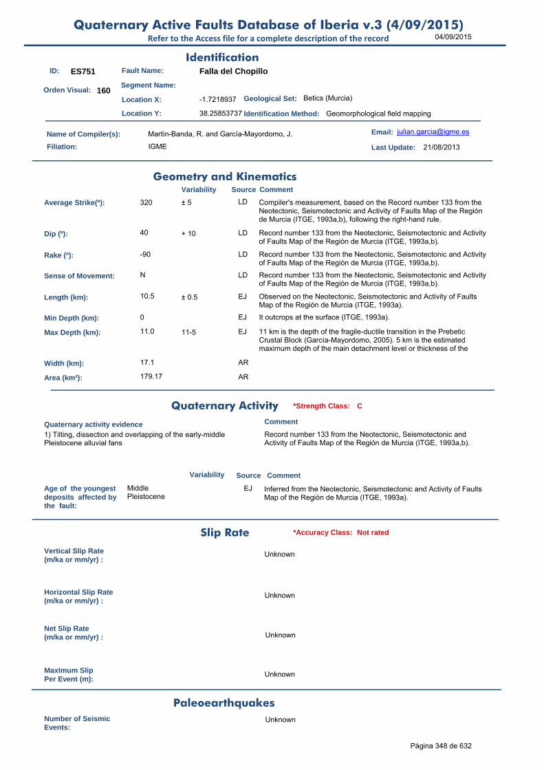
04/09/2015Quaternary Active Faults Database of Iberia v.3 (4/09/2015)
Refer to the Access file for a complete description of the record
ID: ES751 Fault Name: Falla del Chopillo
Segment Name:
Location X: -1.7218937
Location Y: 38.25853737
Name of Compiler(s): Martín-Banda, R. and García-Mayordomo, J.
Filiation: IGME
Email: [email protected]
Last Update: 21/08/2013
Average Strike(º): 320 ± 5 LD Compiler's measurement, based on the Record number 133 from the Neotectonic, Seismotectonic and Activity of Faults Map of the Región de Murcia (ITGE, 1993a,b), following the right-hand rule.
Dip (º): 40 + 10 LD Record number 133 from the Neotectonic, Seismotectonic and Activity of Faults Map of the Región de Murcia (ITGE, 1993a,b).
Rake (º): -90 LD Record number 133 from the Neotectonic, Seismotectonic and Activity of Faults Map of the Región de Murcia (ITGE, 1993a,b).
Sense of Movement: N LD Record number 133 from the Neotectonic, Seismotectonic and Activity of Faults Map of the Región de Murcia (ITGE, 1993a,b).
Length (km): 10.5 ± 0.5 EJ Observed on the Neotectonic, Seismotectonic and Activity of Faults Map of the Región de Murcia (ITGE, 1993a).
Min Depth (km): 0 EJ It outcrops at the surface (ITGE, 1993a).
Max Depth (km): 11.0 11-5 EJ 11 km is the depth of the fragile-ductile transition in the Prebetic Crustal Block (García-Mayordomo, 2005). 5 km is the estimated maximum depth of the main detachment level or thickness of the
Width (km): 17.1 AR
Area (km²): 179.17 AR
Age of the youngestdeposits affected bythe fault:
Middle Pleistocene
EJ Inferred from the Neotectonic, Seismotectonic and Activity of Faults Map of the Región de Murcia (ITGE, 1993a).
Vertical Slip Rate(m/ka or mm/yr) :
Unknown
Horizontal Slip Rate(m/ka or mm/yr) :
Unknown
Net Slip Rate(m/ka or mm/yr) : Unknown
MaxImum Slip Per Event (m):
Unknown
Number of SeismicEvents:
Unknown
Identification
Geometry and KinematicsVariability Source Comment
Quaternary Activity
Variability Source
Comment
1) Tilting, dissection and overlapping of the early-middle Pleistocene alluvial fans
Record number 133 from the Neotectonic, Seismotectonic and Activity of Faults Map of the Región de Murcia (ITGE, 1993a,b).
Geological Set: Betics (Murcia)
Identification Method: Geomorphological field mapping
Comment
Quaternary activity evidence
C*Strength Class:
Slip Rate *Accuracy Class: Not rated
Paleoearthquakes
Orden Visual: 160
Página 348 de 632

04/09/2015Quaternary Active Faults Database of Iberia v.3 (4/09/2015)
Refer to the Access file for a complete description of the record
Evidence of AseismicCreep:
Unknown
Maximun Magnitude(Mw):
6.42 ± 0.37 ER Magnitude from length using Stirling et al (2002) equation derived from the instrumental dataset.
RecurrenceInterval (years) :
Not enough data for an estimation
Date of Last MaximumEarthquake (years) :
Unknown
Extended Information: EXTENDED INFORMATION\
Garcia-Mayordomo, J. (2005). Caracterización y Análisis de la Peligrosidad Sísmica en el Sureste de España. Tesis Doctoral, Universidad Complutense de Madrid, 373 pp.
ITGE (1993a): Mapa Neotectónico, Sismotectónico y de Actividad de Fallas de la Región de Murcia (Escalas 1:200.000 y 1:100.000).
ITGE (1993b): Fichero de Fallas del Mapa Neotectónico, Sismotectónico y de Actividad de Fallas de la Región de Murcia (Escalas 1:200.000 y 1:100.000).
Stirling, M., Rhoades, D. and Berryman K. (2002): Comparison of Earthquake Scaling Relations Derived from Data of the Instrumental and Preinstrumental Era. Bulletin of the Seismological Society of America, 92 (2): 812–830.
Seismic PotentialSource Comment
Associated Seismicity
Extended Data and References
References
Variability
*Reliability rating: D
*Reliability rating: Not Rated
Página 349 de 632

04/09/2015Quaternary Active Faults Database of Iberia v.3 (4/09/2015)
Refer to the Access file for a complete description of the record
ID: ES752 Fault Name: Sucina - El Estacio
Segment Name:
Location X: -0.9386281
Location Y: 37.89410996
Name of Compiler(s): Martín-Banda, R. and García-Mayordomo, J.
Filiation: IGME
Email: [email protected]
Last Update: 12/09/2013
Average Strike(º): 310 ± 10 LD Compiler's measurement, based on the Record number 134 from the Neotectonic, Seismotectonic and Activity of Faults Map of the Región de Murcia (ITGE, 1993a,b), following the right-hand rule.
Dip (º): 85 ± 5 EJ García-Mayordomo (2005)
Rake (º): -180 LD Record number 134 from the Neotectonic, Seismotectonic and Activity of Faults Map of the Región de Murcia (ITGE, 1993a,b).
Sense of Movement: D EJ Record number 134 from the Neotectonic, Seismotectonic and Activity of Faults Map of the Región de Murcia (ITGE, 1993a,b).
Length (km): 24.9 ± 0.5 EJ Observed on the Neotectonic, Seismotectonic and Activity of Faults Map of the Región de Murcia (ITGE, 1993a).
Min Depth (km): 0.02 ± 0.005 EJ Based on the Plio-Quaternary Isopach Map of the Campo de Cartagena and Guadalentín Basins (ITGE, 1993a).
Max Depth (km): 8.0 EJ 8 km is the depth of the fragile-ductile transition in the Cartagena Block (García-Mayordomo, 2005). According to geophysics the fault reaches the basement (Record number 134 from IGTE, 1993b).
Width (km): 8.0 AR
Area (km²): 199.46 AR
Age of the youngestdeposits affected bythe fault:
Tyrrhenian (Upper Pleistocene)
LD Record number 134 from the Neotectonic, Seismotectonic and Activity of Faults Map of the Región de Murcia (ITGE, 1993a,b).
Vertical Slip Rate(m/ka or mm/yr) :
Unknown
Horizontal Slip Rate(m/ka or mm/yr) :
Unknown
Net Slip Rate(m/ka or mm/yr) : Unknown
MaxImum Slip Per Event (m):
Unknown
Number of SeismicEvents:
Unknown
Identification
Geometry and KinematicsVariability Source Comment
Quaternary Activity
Variability Source
Comment
1) Hanging valleys 2) Inflections of the river network 3) It affects eolian Tyrrhenian deposits
Record number 134 from the Neotectonic, Seismotectonic and Activity of Faults Map of the Región de Murcia (ITGE, 1993a,b).
Geological Set: Betics (Murcia)
Identification Method: Geological, geomorphological field mapping and geophysical methods
Comment
Quaternary activity evidence
B*Strength Class:
Slip Rate *Accuracy Class: Not rated
Paleoearthquakes
Orden Visual: 161
Página 350 de 632

04/09/2015Quaternary Active Faults Database of Iberia v.3 (4/09/2015)
Refer to the Access file for a complete description of the record
Evidence of AseismicCreep:
Unknown
Maximun Magnitude(Mw):
6.80 ± 0.37 ER Magnitude from length using Stirling et al (2002) equation derived from the instrumental dataset.
RecurrenceInterval (years) :
Not enough data for an estimation
Date of Last MaximumEarthquake (years) :
Unknown
Extended Information: EXTENDED INFORMATION\
Garcia-Mayordomo, J. (2005). Caracterización y Análisis de la Peligrosidad Sísmica en el Sureste de España. Tesis Doctoral, Universidad Complutense de Madrid, 373 pp.
ITGE (1993a): Mapa Neotectónico, Sismotectónico y de Actividad de Fallas de la Región de Murcia (Escalas 1:200.000 y 1:100.000).
ITGE (1993b): Fichero de Fallas del Mapa Neotectónico, Sismotectónico y de Actividad de Fallas de la Región de Murcia (Escalas 1:200.000 y 1:100.000).
Stirling, M., Rhoades, D. and Berryman K. (2002): Comparison of Earthquake Scaling Relations Derived from Data of the Instrumental and Preinstrumental Era. Bulletin of the Seismological Society of America, 92 (2): 812–830.
Seismic PotentialSource Comment
Associated Seismicity
Extended Data and References
References
Variability
*Reliability rating: C
*Reliability rating: Not rated
Página 351 de 632

04/09/2015Quaternary Active Faults Database of Iberia v.3 (4/09/2015)
Refer to the Access file for a complete description of the record
ID: ES753 Fault Name: Cartagena-1 (Murta - Cartagena)
Segment Name:
Location X: -1.08736936
Location Y: 37.70371662
Name of Compiler(s): Martín-Banda, R. and García-Mayordomo, J.
Filiation: IGME
Email: [email protected]
Last Update: 12/09/2013
Average Strike(º): 320 ± 3 LD Compiler's measurement, based on the Record number 135 from the Neotectonic, Seismotectonic and Activity of Faults Map of the Región de Murcia (ITGE, 1993a,b), following the right-hand rule.
Dip (º): 60 EJ García-Mayordomo (2005).
Rake (º): -135 LD Record number 135 from the Neotectonic, Seismotectonic and Activity of Faults Map of the Región de Murcia (ITGE, 1993a,b).
Sense of Movement: DN LD Record number 135 from the Neotectonic, Seismotectonic and Activity of Faults Map of the Región de Murcia (ITGE, 1993a,b).
Length (km): 17.1 EJ Observed on the Neotectonic, Seismotectonic and Activity of Faults Map of the Región de Murcia (ITGE, 1993a).
Min Depth (km): 0.02 ± 0.005 EJ Based on the Plio-Quaternary Isopach Map of the Campo de Cartagena and Guadalentín Basins (ITGE, 1993a).
Max Depth (km): 8.0 EJ 8 km is the depth of the fragile-ductile transition in the Cartagena Crustal Block (García-Mayordomo, 2005).
Width (km): 9.2 AR
Area (km²): 157.20 AR
Age of the youngestdeposits affected bythe fault:
90 ky 80 to 105 ky EJ Tyrrhenian III. Record number 135 from the Neotectonic, Seismotectonic and Activity of Faults Map of the Región de Murcia (ITGE, 1993a).
Vertical Slip Rate(m/ka or mm/yr) :
0.060 LD Record number 135 from the Neotectonic, Seismotectonic and Activity of Faults Map of the Región de Murcia (ITGE, 1993a).
Horizontal Slip Rate(m/ka or mm/yr) :
0.069 AR From NSR and rake
Net Slip Rate(m/ka or mm/yr) :
0.098 ± 0.01 AR From VSR, dip and rake
MaxImum Slip Per Event (m):
Unknown
Number of SeismicEvents:
Unknown
Identification
Geometry and KinematicsVariability Source Comment
Quaternary Activity
Variability Source
Comment
1) Deformed alluvial fans 2) Fluvial captures 3) Inflections of the river network (it displaces the E-W Rambla Fuente Álamo towards the South ) 4) Subsidence at its SE edge (responsible for creating the Almarjal lagoon complex).
Record number 135 from the Neotectonic, Seismotectonic and Activity of Faults Map of the Región de Murcia (ITGE, 1993a,b).
Geological Set: Betics (Murcia)
Identification Method: Geological, geomorphological field mapping and geophysical methods
Comment
Quaternary activity evidence
B+*Strength Class:
Slip Rate *Accuracy Class: C
Paleoearthquakes
Orden Visual: 162
Página 352 de 632

04/09/2015Quaternary Active Faults Database of Iberia v.3 (4/09/2015)
Refer to the Access file for a complete description of the record
Evidence of AseismicCreep:
Unknown
Maximun Magnitude(Mw):
6.62 ± 0.37 ER Magnitude from length using Stirling et al (2002) equation derived from the instrumental dataset.
RecurrenceInterval (years) :
20690 5231-82702 AR Considering the Maximum Earthquake Model (Wesnousky, 1986): slip rate represents the rate at which maximum earthquakes are released by the fault. RI = Mo f(Mw±d) / Mo f(SR±d). The occurrence of smaller, damaging earthquakes may be much shorter.
Date of Last MaximumEarthquake (years) :
Unknown
Extended Information: EXTENDED INFORMATION\
Garcia-Mayordomo, J. (2005). Caracterización y Análisis de la Peligrosidad Sísmica en el Sureste de España. Tesis Doctoral, Universidad Complutense de Madrid, 373 pp.
ITGE (1993a): Mapa Neotectónico, Sismotectónico y de Actividad de Fallas de la Región de Murcia (Escalas 1:200.000 y 1:100.000).
ITGE (1993b): Fichero de Fallas del Mapa Neotectónico, Sismotectónico y de Actividad de Fallas de la Región de Murcia (Escalas 1:200.000 y 1:100.000).
Stirling, M., Rhoades, D. and Berryman K. (2002): Comparison of Earthquake Scaling Relations Derived from Data of the Instrumental and Preinstrumental Era. Bulletin of the Seismological Society of America, 92 (2): 812–830.
Wesnousky, S.G. (1986). Earthquakes, Quaternary faults, and seismic hazard in California. Journal of Geophysical Research. 91(B12), 12587-12631.
Seismic PotentialSource Comment
Associated Seismicity
Extended Data and References
References
Variability
*Reliability rating: B
*Reliability rating: C
Database of Seismicity Associated to QAFI v.3 FaultsRefer to the Access file for a complete description of the record
ID_Event Event name Date Location XY Int./Mag. Source Association Comment
ES753
Campo de Cartagena NW
Cluster
1985-2002 mbLg=1.8-3.0 IGN catalogue from 1985
to 2002
Spatial association García-Mayordomo, 2005, p.172, fig.3.2.1 and ITGE, 1993a,b (record num. 135)
683
Página 353 de 632
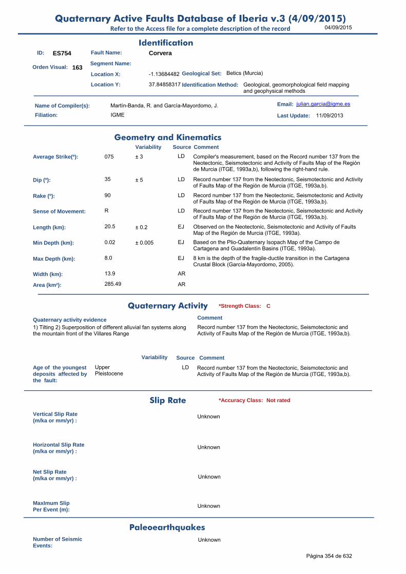
04/09/2015Quaternary Active Faults Database of Iberia v.3 (4/09/2015)
Refer to the Access file for a complete description of the record
ID: ES754 Fault Name: Corvera
Segment Name:
Location X: -1.13684482
Location Y: 37.84858317
Name of Compiler(s): Martín-Banda, R. and García-Mayordomo, J.
Filiation: IGME
Email: [email protected]
Last Update: 11/09/2013
Average Strike(º): 075 ± 3 LD Compiler's measurement, based on the Record number 137 from the Neotectonic, Seismotectonic and Activity of Faults Map of the Región de Murcia (ITGE, 1993a,b), following the right-hand rule.
Dip (º): 35 ± 5 LD Record number 137 from the Neotectonic, Seismotectonic and Activity of Faults Map of the Región de Murcia (ITGE, 1993a,b).
Rake (º): 90 LD Record number 137 from the Neotectonic, Seismotectonic and Activity of Faults Map of the Región de Murcia (ITGE, 1993a,b).
Sense of Movement: R LD Record number 137 from the Neotectonic, Seismotectonic and Activity of Faults Map of the Región de Murcia (ITGE, 1993a,b).
Length (km): 20.5 ± 0.2 EJ Observed on the Neotectonic, Seismotectonic and Activity of Faults Map of the Región de Murcia (ITGE, 1993a).
Min Depth (km): 0.02 ± 0.005 EJ Based on the Plio-Quaternary Isopach Map of the Campo de Cartagena and Guadalentín Basins (ITGE, 1993a).
Max Depth (km): 8.0 EJ 8 km is the depth of the fragile-ductile transition in the Cartagena Crustal Block (García-Mayordomo, 2005).
Width (km): 13.9 AR
Area (km²): 285.49 AR
Age of the youngestdeposits affected bythe fault:
Upper Pleistocene
LD Record number 137 from the Neotectonic, Seismotectonic and Activity of Faults Map of the Región de Murcia (ITGE, 1993a,b).
Vertical Slip Rate(m/ka or mm/yr) :
Unknown
Horizontal Slip Rate(m/ka or mm/yr) :
Unknown
Net Slip Rate(m/ka or mm/yr) : Unknown
MaxImum Slip Per Event (m):
Unknown
Number of SeismicEvents:
Unknown
Identification
Geometry and KinematicsVariability Source Comment
Quaternary Activity
Variability Source
Comment
1) Tilting 2) Superposition of different alluvial fan systems along the mountain front of the Villares Range
Record number 137 from the Neotectonic, Seismotectonic and Activity of Faults Map of the Región de Murcia (ITGE, 1993a,b).
Geological Set: Betics (Murcia)
Identification Method: Geological, geomorphological field mapping and geophysical methods
Comment
Quaternary activity evidence
C*Strength Class:
Slip Rate *Accuracy Class: Not rated
Paleoearthquakes
Orden Visual: 163
Página 354 de 632

04/09/2015Quaternary Active Faults Database of Iberia v.3 (4/09/2015)
Refer to the Access file for a complete description of the record
Evidence of AseismicCreep:
Unknown
Maximun Magnitude(Mw):
6.70 ± 0.37 ER Magnitude from length using Stirling et al (2002) equation derived from the instrumental dataset.
RecurrenceInterval (years) :
Not enough data for an estimation
Date of Last MaximumEarthquake (years) :
Unknown
Extended Information: EXTENDED INFORMATION\
Garcia-Mayordomo, J. (2005). Caracterización y Análisis de la Peligrosidad Sísmica en el Sureste de España. Tesis Doctoral, Universidad Complutense de Madrid, 373 pp.
ITGE (1993a): Mapa Neotectónico, Sismotectónico y de Actividad de Fallas de la Región de Murcia (Escalas 1:200.000 y 1:100.000).
ITGE (1993b): Fichero de Fallas del Mapa Neotectónico, Sismotectónico y de Actividad de Fallas de la Región de Murcia (Escalas 1:200.000 y 1:100.000).
Stirling, M., Rhoades, D. and Berryman K. (2002): Comparison of Earthquake Scaling Relations Derived from Data of the Instrumental and Preinstrumental Era. Bulletin of the Seismological Society of America, 92 (2): 812–830.
Seismic PotentialSource Comment
Associated Seismicity
Extended Data and References
References
Variability
*Reliability rating: D
*Reliability rating: Not Rated
Database of Seismicity Associated to QAFI v.3 FaultsRefer to the Access file for a complete description of the record
ID_Event Event name Date Location XY Int./Mag. Source Association Comment
ES754
1998 and 2002 seismic series SE
Murcia
27-28/10/1998
and 27-28/04/2002
mbLg max 3.0 IGN catalogue from 1985
to 2002
Spatial correlation - NW-SE alignment
García-Mayordomo, 2005, p.172, fig.3.2.1
684
Página 355 de 632
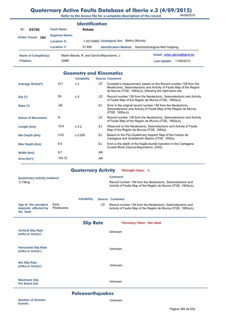
04/09/2015Quaternary Active Faults Database of Iberia v.3 (4/09/2015)
Refer to the Access file for a complete description of the record
ID: ES755 Fault Name: Rebate
Segment Name:
Location X: -1.02134992
Location Y: 37.899
Name of Compiler(s): Martín-Banda, R. and García-Mayordomo, J.
Filiation: IGME
Email: [email protected]
Last Update: 11/09/2013
Average Strike(º): 071 ± 2 LD Compiler's measurement, based on the Record number 138 from the Neotectonic, Seismotectonic and Activity of Faults Map of the Región de Murcia (ITGE, 1993a,b), following the right-hand rule.
Dip (º): 55 ± 5 LD Record number 138 from the Neotectonic, Seismotectonic and Activity of Faults Map of the Región de Murcia (ITGE, 1993a,b).
Rake (º): -90 EJ Error in the original record number 138 from the Neotectonic, Seismotectonic and Activity of Faults Map of the Región de Murcia (ITGE, 1993a,b).
Sense of Movement: N LD Record number 138 from the Neotectonic, Seismotectonic and Activity of Faults Map of the Región de Murcia (ITGE, 1993a,b).
Length (km): 10.8 ± 0.2 EJ Observed on the Neotectonic, Seismotectonic and Activity of Faults Map of the Región de Murcia (ITGE, 1993a).
Min Depth (km): 0.02 ± 0.005 EJ Based on the Plio-Quaternary Isopach Map of the Campo de Cartagena and Guadalentín Basins (ITGE, 1993a).
Max Depth (km): 8.0 EJ 8 km is the depth of the fragile-ductile transition in the Cartagena Crustal Block (García-Mayordomo, 2005).
Width (km): 9.7 AR
Area (km²): 104.72 AR
Age of the youngestdeposits affected bythe fault:
Early Pleistocene
LD Record number 138 from the Neotectonic, Seismotectonic and Activity of Faults Map of the Región de Murcia (ITGE, 1993a,b).
Vertical Slip Rate(m/ka or mm/yr) :
Unknown
Horizontal Slip Rate(m/ka or mm/yr) :
Unknown
Net Slip Rate(m/ka or mm/yr) : Unknown
MaxImum Slip Per Event (m):
Unknown
Number of SeismicEvents:
Unknown
Identification
Geometry and KinematicsVariability Source Comment
Quaternary Activity
Variability Source
Comment
1) Tilting Record number 138 from the Neotectonic, Seismotectonic and Activity of Faults Map of the Región de Murcia (ITGE, 1993a,b).
Geological Set: Betics (Murcia)
Identification Method: Geomorphological field mapping
Comment
Quaternary activity evidence
C*Strength Class:
Slip Rate *Accuracy Class: Not rated
Paleoearthquakes
Orden Visual: 164
Página 356 de 632

04/09/2015Quaternary Active Faults Database of Iberia v.3 (4/09/2015)
Refer to the Access file for a complete description of the record
Evidence of AseismicCreep:
Unknown
Maximun Magnitude(Mw):
6.43 ± 0.37 ER Magnitude from length using Stirling et al (2002) equation derived from the instrumental dataset.
RecurrenceInterval (years) :
Not enough data for an estimation
Date of Last MaximumEarthquake (years) :
Unknown
Extended Information: EXTENDED INFORMATION\
Garcia-Mayordomo, J. (2005). Caracterización y Análisis de la Peligrosidad Sísmica en el Sureste de España. Tesis Doctoral, Universidad Complutense de Madrid, 373 pp.
ITGE (1993a): Mapa Neotectónico, Sismotectónico y de Actividad de Fallas de la Región de Murcia (Escalas 1:200.000 y 1:100.000).
ITGE (1993b): Fichero de Fallas del Mapa Neotectónico, Sismotectónico y de Actividad de Fallas de la Región de Murcia (Escalas 1:200.000 y 1:100.000).
Stirling, M., Rhoades, D. and Berryman K. (2002): Comparison of Earthquake Scaling Relations Derived from Data of the Instrumental and Preinstrumental Era. Bulletin of the Seismological Society of America, 92 (2): 812–830.
Seismic PotentialSource Comment
Associated Seismicity
Extended Data and References
References
Variability
*Reliability rating: D
*Reliability rating: Not Rated
Database of Seismicity Associated to QAFI v.3 FaultsRefer to the Access file for a complete description of the record
ID_Event Event name Date Location XY Int./Mag. Source Association Comment
ES755
1998 and 2002 seismic series SE
Murcia
27-28/10/1998
and 27-28/04/2002
mbLg max 3.0 IGN catalogue from 1985
to 2002
Spatial correlation - NW-SE alignment
García-Mayordomo, 2005, p.172, fig.3.2.1
685
Página 357 de 632

04/09/2015Quaternary Active Faults Database of Iberia v.3 (4/09/2015)
Refer to the Access file for a complete description of the record
ID: ES756 Fault Name: La Galera
Segment Name:
Location X: -1.56633812
Location Y: 37.50371048
Name of Compiler(s): Martín-Banda, R. and García-Mayordomo, J.
Filiation: IGME
Email: [email protected]
Last Update: 13/09/2013
Average Strike(º): 102 ± 2 LD Compiler's measurement, based on the Record number 141 from the Neotectonic, Seismotectonic and Activity of Faults Map of the Región de Murcia (ITGE, 1993a,b), following the right-hand rule.
Dip (º): 80 ± 10 LD Record number 141 from the Neotectonic, Seismotectonic and Activity of Faults Map of the Región de Murcia (ITGE, 1993a,b).
Rake (º): -135 LD Record number 141 from the Neotectonic, Seismotectonic and Activity of Faults Map of the Región de Murcia (ITGE, 1993a,b).
Sense of Movement: DN LD Record number 141 from the Neotectonic, Seismotectonic and Activity of Faults Map of the Región de Murcia (ITGE, 1993a,b).
Length (km): 9.0 ± 0.2 EJ Observed on the Neotectonic, Seismotectonic and Activity of Faults Map of the Región de Murcia (ITGE, 1993a).
Min Depth (km): 0 EJ It outcrops at the surface (ITGE, 1993a).
Max Depth (km): 8.0 EJ 8 km is the depth of the fragile-ductile transition in the Cartagena Crustal Block (García-Mayordomo, 2005).
Width (km): 8.1 AR
Area (km²): 73.11 AR
Age of the youngestdeposits affected bythe fault:
130 ky LD Record number 141 from the Neotectonic, Seismotectonic and Activity of Faults Map of the Región de Murcia (ITGE, 1993a,b).
Vertical Slip Rate(m/ka or mm/yr) :
0.050 0.05-0.09 LD The Neotectonic, Seismotectonic and Activity of Faults Map of the Región de Murcia (ITGE, 1993a).
Horizontal Slip Rate(m/ka or mm/yr) :
0.051 0.051-0.091 AR Using NSR and Rake
Net Slip Rate(m/ka or mm/yr) :
0.072 0.072-0.129 AR Using VSR, Rake and Dip
MaxImum Slip Per Event (m):
Unknown
Number of SeismicEvents:
Unknown
Identification
Geometry and KinematicsVariability Source Comment
Quaternary Activity
Variability Source
Comment
1) It controls the direction of the Quaternary delta fans 2) Topographic lineament 3) Tilting 4) Overlaps 5) Abrupt changes in the profile of the hydrographic network
Record number 141 from the Neotectonic, Seismotectonic and Activity of Faults Map of the Región de Murcia (ITGE, 1993a,b).
Geological Set: Betics (Murcia)
Identification Method: Geological and geomorphological field mapping
Comment
Quaternary activity evidence
C*Strength Class:
Slip Rate *Accuracy Class: C
Paleoearthquakes
Orden Visual: 165
Página 358 de 632
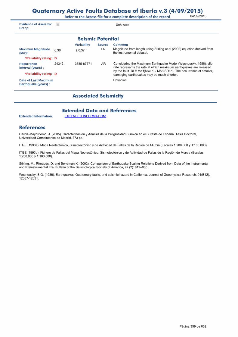
04/09/2015Quaternary Active Faults Database of Iberia v.3 (4/09/2015)
Refer to the Access file for a complete description of the record
Evidence of AseismicCreep:
Unknown
Maximun Magnitude(Mw):
6.36 ± 0.37 ER Magnitude from length using Stirling et al (2002) equation derived from the instrumental dataset.
RecurrenceInterval (years) :
24342 3785-87371 AR Considering the Maximum Earthquake Model (Wesnousky, 1986): slip rate represents the rate at which maximum earthquakes are released by the fault. RI = Mo f(Mw±d) / Mo f(SR±d). The occurrence of smaller, damaging earthquakes may be much shorter.
Date of Last MaximumEarthquake (years) :
Unknown
Extended Information: EXTENDED INFORMATION\
Garcia-Mayordomo, J. (2005). Caracterización y Análisis de la Peligrosidad Sísmica en el Sureste de España. Tesis Doctoral, Universidad Complutense de Madrid, 373 pp.
ITGE (1993a): Mapa Neotectónico, Sismotectónico y de Actividad de Fallas de la Región de Murcia (Escalas 1:200.000 y 1:100.000).
ITGE (1993b): Fichero de Fallas del Mapa Neotectónico, Sismotectónico y de Actividad de Fallas de la Región de Murcia (Escalas 1:200.000 y 1:100.000).
Stirling, M., Rhoades, D. and Berryman K. (2002): Comparison of Earthquake Scaling Relations Derived from Data of the Instrumental and Preinstrumental Era. Bulletin of the Seismological Society of America, 92 (2): 812–830.
Wesnousky, S.G. (1986). Earthquakes, Quaternary faults, and seismic hazard in California. Journal of Geophysical Research. 91(B12), 12587-12631.
Seismic PotentialSource Comment
Associated Seismicity
Extended Data and References
References
Variability
*Reliability rating: D
*Reliability rating: D
Página 359 de 632

04/09/2015Quaternary Active Faults Database of Iberia v.3 (4/09/2015)
Refer to the Access file for a complete description of the record
ID: ES757 Fault Name: Lomas de Cliler - Avilés Sur
Segment Name:
Location X: -1.71030334
Location Y: 37.96405544
Name of Compiler(s): Martín-Banda, R. and García-Mayordomo, J.
Filiation: IGME
Email: [email protected]
Last Update: 23/08/2013
Average Strike(º): 210 ± 11 LD Compiler's measurement, based on the Record number 60 from the Neotectonic, Seismotectonic and Activity of Faults Map of the Región de Murcia (ITGE, 1993a,b), following the right-hand rule.
Dip (º): 45 + 10 LD Record number 60 from the Neotectonic, Seismotectonic and Activity of Faults Map of the Región de Murcia (ITGE, 1993a,b).
Rake (º): -90 LD Record number 60 from the Neotectonic, Seismotectonic and Activity of Faults Map of the Región de Murcia (ITGE, 1993a,b).
Sense of Movement: N LD Record number 60 from the Neotectonic, Seismotectonic and Activity of Faults Map of the Región de Murcia (ITGE, 1993a,b).
Length (km): 8.0 ± 0.5 EJ Observed on the Neotectonic, Seismotectonic and Activity of Faults Map of the Región de Murcia (ITGE, 1993a).
Min Depth (km): 0 EJ It outcrops at the surface (ITGE, 1993a).
Max Depth (km): 5.0 5-11 EJ 5 km is the estimated maximum depth of the main detachment level or thickness of the Mesozoic sedimentary cover. 11 km is the depth of the fragile-ductile transition in the Central Betic Crustal Block (García-
Width (km): 7.1 AR
Area (km²): 56.57 AR
Age of the youngestdeposits affected bythe fault:
Middle Pleistocene
EJ Observed on of the Neotectonic, Seismotectonic and Activity of Faults Map of the Región de Murcia (ITGE, 1993a).
Vertical Slip Rate(m/ka or mm/yr) :
Unknown
Horizontal Slip Rate(m/ka or mm/yr) :
Unknown
Net Slip Rate(m/ka or mm/yr) : Unknown
MaxImum Slip Per Event (m):
Unknown
Number of SeismicEvents:
Unknown
Identification
Geometry and KinematicsVariability Source Comment
Quaternary Activity
Variability Source
Comment
1) It affects the formation of alluvial cones 2) Fault scarps 3) Faceted faces 4) Tilting 5) Overlapping slopes 6) Inflections of the river network
Record number 60 from the Neotectonic, Seismotectonic and Activity of Faults Map of the Región de Murcia (ITGE, 1993a,b).
Geological Set: Betics (Murcia)
Identification Method: Geological and geomorphological field mapping
Comment
Quaternary activity evidence
C*Strength Class:
Slip Rate *Accuracy Class: Not rated
Paleoearthquakes
Orden Visual: 166
Página 360 de 632
04/09/2015Quaternary Active Faults Database of Iberia v.3 (4/09/2015)
Refer to the Access file for a complete description of the record
Evidence of AseismicCreep:
Unknown
Maximun Magnitude(Mw):
6.31 ± 0.37 ER Magnitude from length using Stirling et al (2002) equation derived from the instrumental dataset.
RecurrenceInterval (years) :
Not enough data for an estimation
Date of Last MaximumEarthquake (years) :
Unknown
Extended Information: EXTENDED INFORMATION\
Garcia-Mayordomo, J. (2005). Caracterización y Análisis de la Peligrosidad Sísmica en el Sureste de España. Tesis Doctoral, Universidad Complutense de Madrid, 373 pp.
ITGE (1993a): Mapa Neotectónico, Sismotectónico y de Actividad de Fallas de la Región de Murcia (Escalas 1:200.000 y 1:100.000).
ITGE (1993b): Fichero de Fallas del Mapa Neotectónico, Sismotectónico y de Actividad de Fallas de la Región de Murcia (Escalas 1:200.000 y 1:100.000).
Stirling, M., Rhoades, D. and Berryman K. (2002): Comparison of Earthquake Scaling Relations Derived from Data of the Instrumental and Preinstrumental Era. Bulletin of the Seismological Society of America, 92 (2): 812–830.
Seismic PotentialSource Comment
Associated Seismicity
Extended Data and References
References
Variability
*Reliability rating: D
*Reliability rating: Not Rated
Página 361 de 632

04/09/2015Quaternary Active Faults Database of Iberia v.3 (4/09/2015)
Refer to the Access file for a complete description of the record
ID: ES758 Fault Name: West of Carche
Segment Name:
Location X: -1.2003802
Location Y: 38.42376366
Name of Compiler(s): Martín-Banda, R. and García-Mayordomo, J.
Filiation: IGME
Email: [email protected]
Last Update: 21/08/2013
Average Strike(º): 200 ± 5 LD Compiler's measurement, based on the Record number 149 from the Neotectonic, Seismotectonic and Activity of Faults Map of the Región de Murcia (ITGE, 1993a,b), following the right-hand rule.
Dip (º): 40 to 50 LD Record number 149 from the Neotectonic, Seismotectonic and Activity of Faults Map of the Región de Murcia (ITGE, 1993a,b).
Rake (º): -90 LD Record number 149 from the Neotectonic, Seismotectonic and Activity of Faults Map of the Región de Murcia (ITGE, 1993a,b).
Sense of Movement: N LD Record number 149 from the Neotectonic, Seismotectonic and Activity of Faults Map of the Región de Murcia (ITGE, 1993a,b).
Length (km): 5.9 ± 0.5 EJ Observed on the Neotectonic, Seismotectonic and Activity of Faults Map of the Región de Murcia (ITGE, 1993a).
Min Depth (km): 0 EJ It outcrops at the surface (ITGE, 1993a).
Max Depth (km): 5.0 5-11 EJ Its maximum depth should be the main detachment level at the base of the sedimentary cover. 11 km is the fragile-ductile transition in the Prebetic Crustal Block (García-Mayordomo, 2005).
Width (km): 7.8 AR
Area (km²): 45.97 AR
Age of the youngestdeposits affected bythe fault:
Middle Pleistocene
EJ Observed on the Neotectonic, Seismotectonic and Activity of Faults Map of the Región de Murcia (ITGE, 1993a).
Vertical Slip Rate(m/ka or mm/yr) :
Unknown
Horizontal Slip Rate(m/ka or mm/yr) :
Unknown
Net Slip Rate(m/ka or mm/yr) : Unknown
MaxImum Slip Per Event (m):
Unknown
Number of SeismicEvents:
Unknown
Identification
Geometry and KinematicsVariability Source Comment
Quaternary Activity
Variability Source
Comment
1) Tilting and dissection of the Early-Middle Pleistocene alluvial fans 2) Clear topographic lineament in remote sensing imagery and DEMs
Record number 149 from the Neotectonic, Seismotectonic and Activity of Faults Map of the Región de Murcia (ITGE, 1993a,b).
Geological Set: Betics (Murcia)
Identification Method: Geomorphological field mapping
Comment
Quaternary activity evidence
C*Strength Class:
Slip Rate *Accuracy Class: Not rated
Paleoearthquakes
Orden Visual: 167
Página 362 de 632

04/09/2015Quaternary Active Faults Database of Iberia v.3 (4/09/2015)
Refer to the Access file for a complete description of the record
Evidence of AseismicCreep:
Unknown
Maximun Magnitude(Mw):
6.18 ± 0.37 ER Magnitude from length using Stirling et al (2002) equation derived from the instrumental dataset.
RecurrenceInterval (years) :
Not enough data for an estimation
Date of Last MaximumEarthquake (years) :
Unknown
Extended Information: EXTENDED INFORMATION\
Garcia-Mayordomo, J. (2005). Caracterización y Análisis de la Peligrosidad Sísmica en el Sureste de España. Tesis Doctoral, Universidad Complutense de Madrid, 373 pp.
ITGE (1993a): Mapa Neotectónico, Sismotectónico y de Actividad de Fallas de la Región de Murcia (Escalas 1:200.000 y 1:100.000).
ITGE (1993b): Fichero de Fallas del Mapa Neotectónico, Sismotectónico y de Actividad de Fallas de la Región de Murcia (Escalas 1:200.000 y 1:100.000).
Stirling, M., Rhoades, D. and Berryman K. (2002): Comparison of Earthquake Scaling Relations Derived from Data of the Instrumental and Preinstrumental Era. Bulletin of the Seismological Society of America, 92 (2): 812–830.
Seismic PotentialSource Comment
Associated Seismicity
Extended Data and References
References
Variability
*Reliability rating: D
*Reliability rating: Not Rated
Página 363 de 632
04/09/2015Quaternary Active Faults Database of Iberia v.3 (4/09/2015)
Refer to the Access file for a complete description of the record
ID: ES759 Fault Name: Las Lomas System
Segment Name:
Location X: -1.37092159
Location Y: 37.7431572
Name of Compiler(s): Martín-Banda, R. and García-Mayordomo, J.
Filiation: IGME
Email: [email protected]
Last Update: 18/09/2013
Average Strike(º): 150 ± 10 LD Compiler's measurement, based on the Geological Map of Spain Memory, Digital Edition, Sheet number 954 - Totana (Leyva et al., 2004), following the right-hand rule.
Dip (º): 80 90 to 60 EJ García-Mayordomo (2005).
Rake (º): -45 (-045) to (-090) EJ Observed on the Geological Map of Spain, Digital Edition, Sheet number 954 - Totana (Leyva et al., 2004)
Sense of Movement: NS NS to N EJ Observed on the Geological Map of Spain, Digital Edition, Sheet number 954 - Totana (Leyva et al., 2004)
Length (km): 6.5 ± 0.5 EJ It is a small fault system with a width of 5.3 km and a maximum length of 6.5 km. Observed on the Geological Map of Spain, Digital Edition, Sheet number 954 - Totana (Leyva et al., 2004)
Min Depth (km): 0 EJ It outcrops at the surface (ITGE, 1993a).
Max Depth (km): 5.0 5-8 EJ 8 km is the depth of the fragile-ductile transition in the Cartagena Crustal Block (García-Mayordomo, 2005). However, the short length of the fault suggests that is a secondary fault, not likely to reach the F-
Width (km): 5.1 AR
Area (km²): 33.00 AR
Age of the youngestdeposits affected bythe fault:
Early Pleistocene
LD Observed on the Geological Map of Spain, Digital Edition, Sheet number 954 - Totana (Leyva et al., 2004)
Vertical Slip Rate(m/ka or mm/yr) :
Unknown
Horizontal Slip Rate(m/ka or mm/yr) :
Unknown
Net Slip Rate(m/ka or mm/yr) : Unknown
MaxImum Slip Per Event (m):
Unknown
Number of SeismicEvents:
Unknown
Identification
Geometry and KinematicsVariability Source Comment
Quaternary Activity
Variability Source
Comment
1) It determines the morphology of Saladillo Scarp 2) Associated gravitational processes
Geological Map of Spain Memory, Digital Edition, Sheet number 954 - Totana (Leyva et al., 2004)
Geological Set: Betics (Murcia)
Identification Method: Geological and geomorphological field mapping
Comment
Quaternary activity evidence
C*Strength Class:
Slip Rate *Accuracy Class: Not rated
Paleoearthquakes
Orden Visual: 168
Página 364 de 632

04/09/2015Quaternary Active Faults Database of Iberia v.3 (4/09/2015)
Refer to the Access file for a complete description of the record
Evidence of AseismicCreep:
Unknown
Maximun Magnitude(Mw):
6.22 ± 0.37 ER Magnitude from length using Stirling et al (2002) equation derived from the instrumental dataset.
RecurrenceInterval (years) :
Not enough data for an estimation
Date of Last MaximumEarthquake (years) :
Unknown
Extended Information: EXTENDED INFORMATION\
Garcia-Mayordomo, J. (2005). Caracterización y Análisis de la Peligrosidad Sísmica en el Sureste de España. Tesis Doctoral, Universidad Compultense de Madrid, 373 pp.
Leyva, F., Silva, P.G., García-Tortosa, F.J., Roldán, F.J. and Nozal, F. (2004). Mapa Geológico de España,Edición Digital, Hoja núm.954 (Totana).
Stirling, M., Rhoades, D. and Berryman K. (2002): Comparison of Earthquake Scaling Relations Derived from Data of the Instrumental and Preinstrumental Era. Bulletin of the Seismological Society of America, 92 (2): 812–830.
Seismic PotentialSource Comment
Associated Seismicity
Extended Data and References
References
Variability
*Reliability rating: D
*Reliability rating: Not Rated
Página 365 de 632
04/09/2015Quaternary Active Faults Database of Iberia v.3 (4/09/2015)
Refer to the Access file for a complete description of the record
ID: ES760 Fault Name: Los Tollos
Segment Name:
Location X: -1.44877532
Location Y: 37.72121719
Name of Compiler(s): García-Mayordomo, J., Martín-Banda, R., Insua-Arévalo, J.M.
Filiation: IGME and UCM
Email: [email protected]
Last Update: 13/05/2015
Average Strike(º): 037 ± 5 LD Insua-Arévalo et al (submitted).
Dip (º): 85 80-90 LD Mapped previously as a normal fault dipping to the NW (Silva, 1994; Leyva Cabello et al., 2010), Insua-Arévalo et al (submitted) shows that it is a high angle (sub-vertical) southeast dipping fault.
Rake (º): 15 ± 5 LD As measured in trenches, Insua-Arévalo et al (submitted).
Sense of Movement: S LD Left-lateral strike slip fault with reverse component, as seen in trenches (Insua-Arévalo et al, submitted).
Length (km): 15.0 ± 2 LD Previously interpreted as the SW extension of the Carrascoy Fault (I.-Arévalo et al 2012). I.-Arévalo et al (subm.) interprets it as an independent fault extending SW under Gualentín Dep., as revealed in seismic profiles (Martínez del Olmo, 2006).
Min Depth (km): 0 0-0.01 LD Outcrops at the surface, though its extension to the SW may be covered partially by Guadalentin Depression Holocene filling (Insua-Arévalo et al, submitted).
Max Depth (km): 8.0 LD Depth of the fragile-ductile transition in the Cartagena Crustal Block (García-Mayordomo, 2005).
Width (km): 8.0 AR
Area (km²): 120.46 AR
Age of the youngestdeposits affected bythe fault:
Holocene LD Silva, 1994; Leyva Cabello et al., 2010; Insua-Arévalo et al (submitted) have dated sediments affected by the fault as recent as 2350 BP.
Vertical Slip Rate(m/ka or mm/yr) :
0.041 0.015-0.064 AR From NSR, dip and rake
Horizontal Slip Rate(m/ka or mm/yr) :
0.155 0.058-0.241 AR From NSR and rake
Net Slip Rate(m/ka or mm/yr) :
0.16 0.06-0.25 LD Preferred value is the average from maximum and minimum NSR as shown in Insua-Arévalo et al (submitted).
MaxImum Slip Per Event (m):
0.46 0.386-0.541 LD Preferred value is the average from maximum and minimum, based on Insua-Arévalo et al (submitted).
Identification
Geometry and KinematicsVariability Source Comment
Quaternary Activity
Variability Source
Comment
1) Fault scarp in Quaternary deposits, 2) Control on drainage network
Silva, 1994; Leyva Cabello et al., 2010; Insua-Arévalo et al (submitted). The evidence is mostly concentrated in the NE section of the fault.
Geological Set: Betics (Murcia)
Identification Method: Geological, geomorphological field mapping and geophysics
Comment
Quaternary activity evidence
A*Strength Class:
Slip Rate *Accuracy Class: A
Paleoearthquakes
Orden Visual: 169
Página 366 de 632

04/09/2015Quaternary Active Faults Database of Iberia v.3 (4/09/2015)
Refer to the Access file for a complete description of the record
Number of SeismicEvents:
at least 2 in the last 9 ky
3 to 4 LD Insua-Arévalo et al (submitted).
Evidence of AseismicCreep:
EJ No evidence found.
Maximun Magnitude(Mw):
6.57 ± 0.37 ER Mw from length using Stirling et al (2002) equation derived from the instrumental dataset. Considering Wells and Coppersmith (1994) results Mw 6.2-6.7 (Insua-Arévalo et al, subm.)
RecurrenceInterval (years) :
4530 6860-2200 LD Preferred value is the average from maximum and minimum RI from Insua-Arévalo et al, subm.) paleoseismological research. Considering the MEM (Wesnousky, 1986) results 13767 yrs (using 0.16 m/ky and Mw 6.57).
Date of Last MaximumEarthquake (years) :
between 2740-2140 BP
LD Insua-Arévalo et al. (submitted).
Extended Information: EXTENDED INFORMATION\
García-Mayordomo, J. (2005). Caracterización y Análisis de la Peligrosidad Sísmica en el Sureste de España. Tesis Doctoral, Universidad Complutense de Madrid, 373 pp.
Insua-Arévalo, J.M., García-Mayordomo, J., Salazar, A., Rodríguez-Escudero, E., Martín-Banda, R., Álvarez-Gómez, J.A., Canora, C. and Martínez-Díaz, J.J. (submitted): Paleoseismological evidence of Holocene activity in Los Tollos Fault (Murcia, SE Spain): A new relevant feature of the Eastern Betic Shear Zone. Geomorphology.
Insua-Arévalo, J.M., García-Mayordomo, J., Salazar, A., Rodríguez-Escudero, E., Martínez-Díaz, J.J., Álvarez-Gómez, J.A., Canora, C., Martín-Banda, R., Pérez-López, R., Rodríguez-Pascua, M.A. (2012). Actividad holocena y pleistocena de la falla de Carrascoy, Murcia. Resultados preliminares de un análisis paleosísmico. Geotemas. 13, 1511-1514.
Leyva Cabello, F., Silva Barroso, P.G., García Tortosa, F.J. (2010). Cartografía Geológica de la hoja 954 Totana, Mapa Geológico Digital de España E. 1:50.000. Instituto Geológico y Minero de España, Madrid, España.
Martínez del Olmo, W., Klimowitz, J., Hernández, E., 2006. El despegue extensional mioceno de la zona de falla de Alhama de Murcia. Boletín Geológico y Minero. 117 (3), 363-377.
Silva, P.G., 1994. Evolución Geodinámica de la depresión del Guadalentín (Murcia) desde el Mioceno Superior hasta la actualidad: Neotectónica y Geomorfología. Ph.D. Tesis, Universidad Complutense de Madrid, Spain.
Stirling, M., Rhoades, D. and Berryman K. (2002): Comparison of Earthquake Scaling Relations Derived from Data of the Instrumental and Preinstrumental Era. Bulletin of the Seismological Society of America, 92 (2): 812–830.
Seismic PotentialSource Comment
Associated Seismicity
Extended Data and References
References
Variability
*Reliability rating: B
*Reliability rating: B
Página 367 de 632

04/09/2015Quaternary Active Faults Database of Iberia v.3 (4/09/2015)
Refer to the Access file for a complete description of the record
ID: ES761 Fault Name: Falla de Águilas
Segment Name:
Location X: -1.47692219
Location Y: 37.43738815
Name of Compiler(s): Martín-Banda, R. and García-Mayordomo, J.
Filiation: IGME
Email: [email protected]
Last Update: 13/09/2013
Average Strike(º): 250 ± 20 LD Compiler's measurement, based on the Records number 22, 139, 140 from the Neotectonic, Seismotectonic and Activity of Faults Map of the Región de Murcia (ITGE, 1993a,b), following the right-hand rule.
Dip (º): 90 ± 5 LD Records numbers 22, 139 and 140 from the Neotectonic, Seismotectonic and Activity of Faults Map of the Región de Murcia (ITGE, 1993a,b).
Rake (º): -45 LD Records numbers 22, 139 and 140 from the Neotectonic, Seismotectonic and Activity of Faults Map of the Región de Murcia (ITGE, 1993a,b).
Sense of Movement: NS LD Records numbers 22, 139 and 140 from the Neotectonic, Seismotectonic and Activity of Faults Map of the Región de Murcia (ITGE, 1993a,b).
Length (km): 15.2 ± 0.2 EJ Observed on the Neotectonic, Seismotectonic and Activity of Faults Map of the Región de Murcia (ITGE, 1993a). Lenght is the sum of three distinct faults aligned in N60 direction.
Min Depth (km): 0 EJ It outcrops at the surface (ITGE, 1993a).
Max Depth (km): 5.0 5-8 EJ 8 km is the depth of the depth of the fragile-ductile transition in the Cartagena Crustal Block (García-Mayordomo, 2005). However, the length of single faults suggests that is a secondary fault system fault,
Width (km): 5.0 AR
Area (km²): 76.00 AR
Age of the youngestdeposits affected bythe fault:
130 Ky LD Record number 22 from the Neotectonic, Seismotectonic and Activity of Faults Map of the Región de Murcia (ITGE, 1993a,b).
Vertical Slip Rate(m/ka or mm/yr) :
0.040 0.04-0.09 AR Record number 22 from the Neotectonic, Seismotectonic and Activity of Faults Map of the Región de Murcia (ITGE, 1993a,b).
Horizontal Slip Rate(m/ka or mm/yr) :
0.04 0.04-0.09 AR Using NSR and Rake
Net Slip Rate(m/ka or mm/yr) :
0.057 0.057-0.127 AR Using VSR, Dip and Rake
MaxImum Slip Per Event (m):
Unknown
Identification
Geometry and KinematicsVariability Source Comment
Quaternary Activity
Variability Source
Comment
1) Scarp 2) Tilting 3) Overlaps 4) Topographic lineament 5) Hanging valleys
Record number 22 from the Neotectonic, Seismotectonic and Activity of Faults Map of the Región de Murcia (ITGE, 1993a,b).
Geological Set: Betics (Murcia)
Identification Method: Geological and geomorphological field mapping
Comment
Quaternary activity evidence
C*Strength Class:
Slip Rate *Accuracy Class: C
Orden Visual: 170
Página 368 de 632
04/09/2015Quaternary Active Faults Database of Iberia v.3 (4/09/2015)
Refer to the Access file for a complete description of the record
Number of SeismicEvents:
Unknown
Evidence of AseismicCreep:
Unknown
Maximun Magnitude(Mw):
6.57 ± 0.37 ER Magnitude from length using Stirling et al (2002) equation derived from the instrumental dataset.
RecurrenceInterval (years) :
62419 7805-224036 AR Considering the Maximum Earthquake Model (Wesnousky, 1986): slip rate represents the rate at which maximum earthquakes are released by the fault. RI = Mo f(Mw±d) / Mo f(SR±d). The occurrence of smaller, damaging earthquakes may be much shorter.
Date of Last MaximumEarthquake (years) :
Unknown
Extended Information: EXTENDED INFORMATION\
Garcia-Mayordomo, J. (2005). Caracterización y Análisis de la Peligrosidad Sísmica en el Sureste de España. Tesis Doctoral, Universidad Complutense de Madrid, 373 pp.
ITGE (1993a): Mapa Neotectónico, Sismotectónico y de Actividad de Fallas de la Región de Murcia (Escalas 1:200.000 y 1:100.000).
ITGE (1993b): Fichero de Fallas del Mapa Neotectónico, Sismotectónico y de Actividad de Fallas de la Región de Murcia (Escalas 1:200.000 y 1:100.000).
Stirling, M., Rhoades, D. and Berryman K. (2002): Comparison of Earthquake Scaling Relations Derived from Data of the Instrumental and Preinstrumental Era. Bulletin of the Seismological Society of America, 92 (2): 812–830.
Wesnousky, S.G. (1986). Earthquakes, Quaternary faults, and seismic hazard in California. Journal of Geophysical Research. 91(B12), 12587-12631.
Seismic PotentialSource Comment
Associated Seismicity
Extended Data and References
References
Variability
*Reliability rating: D
*Reliability rating: D
Paleoearthquakes
Página 369 de 632

04/09/2015Quaternary Active Faults Database of Iberia v.3 (4/09/2015)
Refer to the Access file for a complete description of the record
ID: ES762 Fault Name: Ramonete
Segment Name:
Location X: -1.42947224
Location Y: 37.54206164
Name of Compiler(s): Martín-Banda, R. and García-Mayordomo, J.
Filiation: IGME
Email: [email protected]
Last Update: 13/09/2013
Average Strike(º): 100 ± 5 LD Compiler's measurement, based on the Record number 24 from the Neotectonic, Seismotectonic and Activity of Faults Map of the Región de Murcia (ITGE, 1993a,b), following the right-hand rule.
Dip (º): 80 ± 10 LD Record number 24 from the Neotectonic, Seismotectonic and Activity of Faults Map of the Región de Murcia (ITGE, 1993a,b).
Rake (º): -135 LD Record number 24 from the Neotectonic, Seismotectonic and Activity of Faults Map of the Región de Murcia (ITGE, 1993a,b).
Sense of Movement: DN LD Record number 24 from the Neotectonic, Seismotectonic and Activity of Faults Map of the Región de Murcia (ITGE, 1993a,b).
Length (km): 5.0 ± 0.05 EJ Observed on the Neotectonic, Seismotectonic and Activity of Faults Map of the Región de Murcia (ITGE, 1993a). 5 km is the length onshore, fault may extend further offshore.
Min Depth (km): 0 EJ It outcrops at the surface (ITGE, 1993a).
Max Depth (km): 5.0 5-8 EJ 8 km is the depth of the depth of the fragile-ductile transition in the Cartagena Crustal Block (García-Mayordomo, 2005). However, the short length of the fault may suggest that is a secondary fault, not
Width (km): 5.1 AR
Area (km²): 25.39 AR
Age of the youngestdeposits affected bythe fault:
Middle Pleistocene
LD Record number 24 from the Neotectonic, Seismotectonic and Activity of Faults Map of the Región de Murcia (ITGE, 1993a,b).
Vertical Slip Rate(m/ka or mm/yr) :
Unknown
Horizontal Slip Rate(m/ka or mm/yr) :
Unknown
Net Slip Rate(m/ka or mm/yr) : Unknown
MaxImum Slip Per Event (m):
Unknown
Identification
Geometry and KinematicsVariability Source Comment
Quaternary Activity
Variability Source
Comment
1) Deforms Rambla de Ramonete delta fans 2) Topographic lineament 3) Scarp 4) Drainage pattern
Record number 24 from the Neotectonic, Seismotectonic and Activity of Faults Map of the Región de Murcia (ITGE, 1993a,b).
Geological Set: Betics (Murcia)
Identification Method: Geological, geomorphological field mapping and geophysics
Comment
Quaternary activity evidence
B*Strength Class:
Slip Rate *Accuracy Class: Not rated
Paleoearthquakes
Orden Visual: 171
Página 370 de 632
04/09/2015Quaternary Active Faults Database of Iberia v.3 (4/09/2015)
Refer to the Access file for a complete description of the record
Number of SeismicEvents:
Unknown
Evidence of AseismicCreep:
Unknown
Maximun Magnitude(Mw):
6.11 ± 0.37 ER Magnitude from length using Stirling et al (2002) equation derived from the instrumental dataset.
RecurrenceInterval (years) :
Not enough data for an estimation
Date of Last MaximumEarthquake (years) :
Unknown
Extended Information: EXTENDED INFORMATION\
Garcia-Mayordomo, J. (2005). Caracterización y Análisis de la Peligrosidad Sísmica en el Sureste de España. Tesis Doctoral, Universidad Complutense de Madrid, 373 pp.
ITGE (1993a): Mapa Neotectónico, Sismotectónico y de Actividad de Fallas de la Región de Murcia (Escalas 1:200.000 y 1:100.000).
ITGE (1993b): Fichero de Fallas del Mapa Neotectónico, Sismotectónico y de Actividad de Fallas de la Región de Murcia (Escalas 1:200.000 y 1:100.000).
Stirling, M., Rhoades, D. and Berryman K. (2002): Comparison of Earthquake Scaling Relations Derived from Data of the Instrumental and Preinstrumental Era. Bulletin of the Seismological Society of America, 92 (2): 812–830.
Seismic PotentialSource Comment
Associated Seismicity
Extended Data and References
References
Variability
*Reliability rating: C
*Reliability rating: Not rated
Página 371 de 632
04/09/2015Quaternary Active Faults Database of Iberia v.3 (4/09/2015)
Refer to the Access file for a complete description of the record
ID: ES763 Fault Name: Bolmueva
Segment Name:
Location X: -1.34330797
Location Y: 37.56056217
Name of Compiler(s): Martín-Banda, R. and García-Mayordomo, J.
Filiation: IGME
Email: [email protected]
Last Update: 13/09/2013
Average Strike(º): 260 ± 10 LD Compiler's measurement, based on the Record number 29 from the Neotectonic, Seismotectonic and Activity of Faults Map of the Región de Murcia (ITGE, 1993a,b), following the right-hand rule.
Dip (º): 30 ± 2 LD Record number 29 from the Neotectonic, Seismotectonic and Activity of Faults Map of the Región de Murcia (ITGE, 1993a,b).
Rake (º): -90 LD Record number 29 from the Neotectonic, Seismotectonic and Activity of Faults Map of the Región de Murcia (ITGE, 1993a,b).
Sense of Movement: N LD Record number 29 from the Neotectonic, Seismotectonic and Activity of Faults Map of the Región de Murcia (ITGE, 1993a,b).
Length (km): 9.5 ± 0.2 EJ Observed on the Neotectonic, Seismotectonic and Activity of Faults Map of the Región de Murcia (ITGE, 1993a). 10 km is the length onshore, fault may extend further offshore.
Min Depth (km): 0 EJ It outcrops at the surface (ITGE, 1993a).
Max Depth (km): 8.0 EJ 8 km is the depth of the depth of the fragile-ductile transition in the Cartagena Crustal Block (García-Mayordomo, 2005).
Width (km): 16.0 AR
Area (km²): 152.00 AR
Age of the youngestdeposits affected bythe fault:
Upper Pleistocene
LD Record number 29 from the Neotectonic, Seismotectonic and Activity of Faults Map of the Región de Murcia (ITGE, 1993a,b).
Vertical Slip Rate(m/ka or mm/yr) :
Unknown
Horizontal Slip Rate(m/ka or mm/yr) :
Unknown
Net Slip Rate(m/ka or mm/yr) : Unknown
MaxImum Slip Per Event (m):
Unknown
Number of SeismicEvents:
Unknown
Identification
Geometry and KinematicsVariability Source Comment
Quaternary Activity
Variability Source
Comment
1) Scarp Record number 29 from the Neotectonic, Seismotectonic and Activity of Faults Map of the Región de Murcia (ITGE, 1993a,b).
Geological Set: Betics (Murcia)
Identification Method: Geological field mapping
Comment
Quaternary activity evidence
C*Strength Class:
Slip Rate *Accuracy Class: Not rated
Paleoearthquakes
Orden Visual: 172
Página 372 de 632

04/09/2015Quaternary Active Faults Database of Iberia v.3 (4/09/2015)
Refer to the Access file for a complete description of the record
Evidence of AseismicCreep:
Unknown
Maximun Magnitude(Mw):
6.38 ± 0.37 ER Magnitude from length using Stirling et al (2002) equation derived from the instrumental dataset.
RecurrenceInterval (years) :
Not enough data for an estimation
Date of Last MaximumEarthquake (years) :
Unknown
Extended Information: EXTENDED INFORMATION\
Garcia-Mayordomo, J. (2005). Caracterización y Análisis de la Peligrosidad Sísmica en el Sureste de España. Tesis Doctoral, Universidad Complutense de Madrid, 373 pp.
ITGE (1993a): Mapa Neotectónico, Sismotectónico y de Actividad de Fallas de la Región de Murcia (Escalas 1:200.000 y 1:100.000).
ITGE (1993b): Fichero de Fallas del Mapa Neotectónico, Sismotectónico y de Actividad de Fallas de la Región de Murcia (Escalas 1:200.000 y 1:100.000).
Stirling, M., Rhoades, D. and Berryman K. (2002): Comparison of Earthquake Scaling Relations Derived from Data of the Instrumental and Preinstrumental Era. Bulletin of the Seismological Society of America, 92 (2): 812–830.
Seismic PotentialSource Comment
Associated Seismicity
Extended Data and References
References
Variability
*Reliability rating: D
*Reliability rating: Not Rated
Página 373 de 632
04/09/2015Quaternary Active Faults Database of Iberia v.3 (4/09/2015)
Refer to the Access file for a complete description of the record
ID: ES764 Fault Name: West of Pericay - Gigantes
Segment Name:
Location X: -1.97548288
Location Y: 37.80221919
Name of Compiler(s): Martín-Banda, R. and García-Mayordomo, J.
Filiation: IGME
Email: [email protected]
Last Update: 17/09/2013
Average Strike(º): 202 ± 5 LD Compiler's measurement, based on the Record number 40 from the Neotectonic, Seismotectonic and Activity of Faults Map of the Región de Murcia (ITGE, 1993a,b), following the right-hand rule.
Dip (º): 85 ± 5 LD Record number 40 from the Neotectonic, Seismotectonic and Activity of Faults Map of the Región de Murcia (ITGE, 1993a,b).
Rake (º): -90 LD Record number 40 from the Neotectonic, Seismotectonic and Activity of Faults Map of the Región de Murcia (ITGE, 1993a,b).
Sense of Movement: N LD Record number 40 from the Neotectonic, Seismotectonic and Activity of Faults Map of the Región de Murcia (ITGE, 1993a,b).
Length (km): 3.8 ± 0.2 EJ Observed on the Neotectonic, Seismotectonic and Activity of Faults Map of the Región de Murcia (ITGE, 1993a).
Min Depth (km): 0 EJ It outcrops at the surface (ITGE, 1993a).
Max Depth (km): 5.0 EJ 5 km is the estimated maximum depth of the main detachment level or thickness of the Mesozoic sedimentary cover (García-Mayordomo, 2005).
Width (km): 5.0 AR
Area (km²): 19.07 AR
Age of the youngestdeposits affected bythe fault:
Upper Pleistocene
EJ Observed on of the Neotectonic, Seismotectonic and Activity of Faults Map of the Región de Murcia (ITGE, 1993a).
Vertical Slip Rate(m/ka or mm/yr) :
Unknown
Horizontal Slip Rate(m/ka or mm/yr) :
Unknown
Net Slip Rate(m/ka or mm/yr) : Unknown
MaxImum Slip Per Event (m):
Unknown
Number of SeismicEvents:
Unknown
Identification
Geometry and KinematicsVariability Source Comment
Quaternary Activity
Variability Source
Comment
1) Scarps 2) Tilting Record number 40 from the Neotectonic, Seismotectonic and Activity of Faults Map of the Región de Murcia (ITGE, 1993a,b).
Geological Set: Betics (Murcia)
Identification Method: Geological and geomorphological field mapping
Comment
Quaternary activity evidence
C*Strength Class:
Slip Rate *Accuracy Class: Not rated
Paleoearthquakes
Orden Visual: 173
Página 374 de 632

04/09/2015Quaternary Active Faults Database of Iberia v.3 (4/09/2015)
Refer to the Access file for a complete description of the record
Evidence of AseismicCreep:
Unknown
Maximun Magnitude(Mw):
6.00 ± 0.37 ER Magnitude from length using Stirling et al (2002) equation derived from the instrumental dataset.
RecurrenceInterval (years) :
Not enough data for an estimation
Date of Last MaximumEarthquake (years) :
Unknown
Extended Information: EXTENDED INFORMATION\
Garcia-Mayordomo, J. (2005). Caracterización y Análisis de la Peligrosidad Sísmica en el Sureste de España. Tesis Doctoral, Universidad Complutense de Madrid, 373 pp.
ITGE (1993a): Mapa Neotectónico, Sismotectónico y de Actividad de Fallas de la Región de Murcia (Escalas 1:200.000 y 1:100.000).
ITGE (1993b): Fichero de Fallas del Mapa Neotectónico, Sismotectónico y de Actividad de Fallas de la Región de Murcia (Escalas 1:200.000 y 1:100.000).
Stirling, M., Rhoades, D. and Berryman K. (2002): Comparison of Earthquake Scaling Relations Derived from Data of the Instrumental and Preinstrumental Era. Bulletin of the Seismological Society of America, 92 (2): 812–830.
Seismic PotentialSource Comment
Associated Seismicity
Extended Data and References
References
Variability
*Reliability rating: D
*Reliability rating: Not Rated
Database of Seismicity Associated to QAFI v.3 FaultsRefer to the Access file for a complete description of the record
ID_Event Event name Date Location XY Int./Mag. Source Association Comment
ES764
Valdeinfierno events
Max mag 3.3 IGN Spatial ITGE, 1993a,b reports 3 events possibly related to the fault (record num. 40)
686
Página 375 de 632

04/09/2015Quaternary Active Faults Database of Iberia v.3 (4/09/2015)
Refer to the Access file for a complete description of the record
ID: ES767 Fault Name: El Sabinar
Segment Name:
Location X: -2.15150008
Location Y: 38.20798884
Name of Compiler(s): Martín-Banda, R. and García-Mayordomo, J.
Filiation: IGME
Email: [email protected]
Last Update: 17/09/2013
Average Strike(º): 205 ± 5 LD Compiler's measurement, based on the Record number 43 from the Neotectonic, Seismotectonic and Activity of Faults Map of the Región de Murcia (ITGE, 1993a,b), following the right-hand rule.
Dip (º): 85 ± 5 EJ Variable dips both west and east, according to the section of the fault. Mainly it been considered that dips westward (Record number 43 from the Neotectonic, Seismotectonic and Activity of Faults Map of the Región de Murcia (ITGE, 1993a,b)).
Rake (º): -90 LD Record number 43 from the Neotectonic, Seismotectonic and Activity of Faults Map of the Región de Murcia (ITGE, 1993a,b).
Sense of Movement: N LD Record number 43 from the Neotectonic, Seismotectonic and Activity of Faults Map of the Región de Murcia (ITGE, 1993a,b).
Length (km): 5.7 ± 0.2 LD Observed on the Neotectonic, Seismotectonic and Activity of Faults Map of the Región de Murcia (ITGE, 1993a).
Min Depth (km): 0 EJ It outcrops at the surface (ITGE, 1993a).
Max Depth (km): 5.0 EJ 5 km is the estimated maximum depth of the main detachment level or thickness of the Mesozoic sedimentary cover (García-Mayordomo, 2005).
Width (km): 5.0 AR
Area (km²): 28.61 AR
Age of the youngestdeposits affected bythe fault:
Holocene EJ Observed on the Neotectonic, Seismotectonic and Activity of Faults Map of the Región de Murcia (ITGE, 1993a).
Vertical Slip Rate(m/ka or mm/yr) :
Unknown
Horizontal Slip Rate(m/ka or mm/yr) :
Unknown
Net Slip Rate(m/ka or mm/yr) : Unknown
MaxImum Slip Per Event (m):
Unknown
Identification
Geometry and KinematicsVariability Source Comment
Quaternary Activity
Variability Source
Comment
1) Scarps 2) Subsiding area Record number 43 from the Neotectonic, Seismotectonic and Activity of Faults Map of the Región de Murcia (ITGE, 1993a,b).
Geological Set: Betics (Murcia)
Identification Method: Geological and geomorphological field mapping
Comment
Quaternary activity evidence
C*Strength Class:
Slip Rate *Accuracy Class: Not rated
Paleoearthquakes
Orden Visual: 176
Página 376 de 632

04/09/2015Quaternary Active Faults Database of Iberia v.3 (4/09/2015)
Refer to the Access file for a complete description of the record
Number of SeismicEvents:
Unknown
Evidence of AseismicCreep:
Unknown
Maximun Magnitude(Mw):
6.17 ± 0.37 ER Magnitude from length using Stirling et al (2002) equation derived from the instrumental dataset.
RecurrenceInterval (years) :
Not enough data for an estimation
Date of Last MaximumEarthquake (years) :
Unknown
Extended Information: EXTENDED INFORMATION\
Garcia-Mayordomo, J. (2005). Caracterización y Análisis de la Peligrosidad Sísmica en el Sureste de España. Tesis Doctoral, Universidad Complutense de Madrid, 373 pp.
ITGE (1993a): Mapa Neotectónico, Sismotectónico y de Actividad de Fallas de la Región de Murcia (Escalas 1:200.000 y 1:100.000).
ITGE (1993b): Fichero de Fallas del Mapa Neotectónico, Sismotectónico y de Actividad de Fallas de la Región de Murcia (Escalas 1:200.000 y 1:100.000).
Stirling, M., Rhoades, D. and Berryman K. (2002): Comparison of Earthquake Scaling Relations Derived from Data of the Instrumental and Preinstrumental Era. Bulletin of the Seismological Society of America, 92 (2): 812–830.
Seismic PotentialSource Comment
Associated Seismicity
Extended Data and References
References
Variability
*Reliability rating: D
*Reliability rating: Not Rated
Página 377 de 632

04/09/2015Quaternary Active Faults Database of Iberia v.3 (4/09/2015)
Refer to the Access file for a complete description of the record
ID: ES768 Fault Name: Archivel
Segment Name:
Location X: -1.97021335
Location Y: 38.05099458
Name of Compiler(s): Martín-Banda, R. and García-Mayordomo, J.
Filiation: IGME
Email: [email protected]
Last Update: 23/08/2013
Average Strike(º): 316 ± 5 LD Compiler's measurement, based on the Record number 44 from the Neotectonic, Seismotectonic and Activity of Faults Map of the Región de Murcia (ITGE, 1993a,b), following the right-hand rule.
Dip (º): 90 LD Record number 44 from the Neotectonic, Seismotectonic and Activity of Faults Map of the Región de Murcia (ITGE, 1993a,b).
Rake (º): -135 EJ Observed on the Neotectonic, Seismotectonic and Activity of Faults Map of the Región de Murcia (ITGE, 1993a).
Sense of Movement: DN EJ Observed on the Neotectonic, Seismotectonic and Activity of Faults Map of the Región de Murcia (ITGE, 1993a).
Length (km): 12.4 ± 0.1 EJ Observed on the Neotectonic, Seismotectonic and Activity of Faults Map of the Región de Murcia (ITGE, 1993a).
Min Depth (km): 0 EJ Joints observed in Pliocene and Pleistocene deposits (Record number 44 from the Neotectonic, Seismotectonic and Activity of Faults Map of the Región de Murcia (ITGE, 1993a,b)).
Max Depth (km): 5.0 5-11 EJ 5 km is the estimated maximum depth of the main detachment level or thickness of the Mesozoic sedimentary cover. 11 km is the depth of the fragile-ductile transition in the Prebetic Crustal Block (García-
Width (km): 5.0 AR
Area (km²): 62.00 AR
Age of the youngestdeposits affected bythe fault:
Middle Pleistocene
EJ Deduced from the local geology.
Vertical Slip Rate(m/ka or mm/yr) :
Unknown
Horizontal Slip Rate(m/ka or mm/yr) :
Unknown
Net Slip Rate(m/ka or mm/yr) : Unknown
MaxImum Slip Per Event (m):
Unknown
Identification
Geometry and KinematicsVariability Source Comment
Quaternary Activity
Variability Source
Comment
1) Dissection of the hydrographic network 2) Depressed area Record number 44 from the Neotectonic, Seismotectonic and Activity of Faults Map of the Región de Murcia (ITGE, 1993a,b).
Geological Set: Betics (Murcia)
Identification Method: Geomorphological field mapping and geophysical methods
Comment
Quaternary activity evidence
C*Strength Class:
Slip Rate *Accuracy Class: Not rated
Paleoearthquakes
Orden Visual: 177
Página 378 de 632

04/09/2015Quaternary Active Faults Database of Iberia v.3 (4/09/2015)
Refer to the Access file for a complete description of the record
Number of SeismicEvents:
Unknown
Evidence of AseismicCreep:
Unknown
Maximun Magnitude(Mw):
6.50 ± 0.37 ER Magnitude from length using Stirling et al (2002) equation derived from the instrumental dataset.
RecurrenceInterval (years) :
Not enough data for an estimation
Date of Last MaximumEarthquake (years) :
Unknown
Extended Information: EXTENDED INFORMATION\
Garcia-Mayordomo, J. (2005). Caracterización y Análisis de la Peligrosidad Sísmica en el Sureste de España. Tesis Doctoral, Universidad Complutense de Madrid, 373 pp.
ITGE (1993a): Mapa Neotectónico, Sismotectónico y de Actividad de Fallas de la Región de Murcia (Escalas 1:200.000 y 1:100.000).
ITGE (1993b): Fichero de Fallas del Mapa Neotectónico, Sismotectónico y de Actividad de Fallas de la Región de Murcia (Escalas 1:200.000 y 1:100.000).
Stirling, M., Rhoades, D. and Berryman K. (2002): Comparison of Earthquake Scaling Relations Derived from Data of the Instrumental and Preinstrumental Era. Bulletin of the Seismological Society of America, 92 (2): 812–830.
Seismic PotentialSource Comment
Associated Seismicity
Extended Data and References
References
Variability
*Reliability rating: D
*Reliability rating: Not Rated
Página 379 de 632

04/09/2015Quaternary Active Faults Database of Iberia v.3 (4/09/2015)
Refer to the Access file for a complete description of the record
ID: ES769 Fault Name: La Junquera-Mancheño
Segment Name:
Location X: -2.14367993
Location Y: 37.89777986
Name of Compiler(s): Martín-Banda, R. and García-Mayordomo, J.
Filiation: IGME
Email: [email protected]
Last Update: 23/08/2013
Average Strike(º): 325 ± 5 LD Compiler's measurement, based on the Record number 45 from the Neotectonic, Seismotectonic and Activity of Faults Map of the Región de Murcia (ITGE, 1993a,b), following the right-hand rule.
Dip (º): 85 ± 5 EJ García-Mayordomo (2005)
Rake (º): -135 EJ Observed on the Neotectonic, Seismotectonic and Activity of Faults Map of the Región de Murcia (ITGE, 1993a).
Sense of Movement: DN EJ Observed on the Neotectonic, Seismotectonic and Activity of Faults Map of the Región de Murcia (ITGE, 1993a).
Length (km): 16.2 ± 0.2 EJ Observed on the Neotectonic, Seismotectonic and Activity of Faults Map of the Región de Murcia (ITGE, 1993a).
Min Depth (km): 0 EJ Pleistocene sediments are affected by the fault.
Max Depth (km): 5.0 5-11 EJ 5 km is the estimated maximum depth of the main detachment level or thickness of the Mesozoic sedimentary cover. 11 km is the depth of the fragile-ductile transition in the Prebetic Crustal Block (García-
Width (km): 5.0 AR
Area (km²): 81.31 AR
Age of the youngestdeposits affected bythe fault:
Early Pleistocene
EJ Deduced from the local geology.
Vertical Slip Rate(m/ka or mm/yr) :
0.190 0.19-0.40 EJ Using NSR, Rake and Dip
Horizontal Slip Rate(m/ka or mm/yr) :
0.2 0.2-0.40 EJ Record number 45 from ITGE (1993a,b). In that file a horizontal thrown of aprox.1 km accumulated since Plio-Q times is reported. We think that must be an erratum as it would draw an unrealistic 0.40 m/ka HSR. We assume Pliocene times.
Net Slip Rate(m/ka or mm/yr) :
0.28 0.28-0.56 EJ Using Rake and HSR
MaxImum Slip Per Event (m):
Unknown
Number of SeismicEvents:
Unknown
Identification
Geometry and KinematicsVariability Source Comment
Quaternary Activity
Variability Source
Comment
1) Fault scarps 2) fluvial dissection Record number 45 from the Neotectonic, Seismotectonic and Activity of Faults Map of the Región de Murcia (ITGE, 1993a,b).
Geological Set: Betics (Murcia)
Identification Method: Geological and geomorphological field mapping
Comment
Quaternary activity evidence
C*Strength Class:
Slip Rate *Accuracy Class: C
Paleoearthquakes
Orden Visual: 178
Página 380 de 632

04/09/2015Quaternary Active Faults Database of Iberia v.3 (4/09/2015)
Refer to the Access file for a complete description of the record
Evidence of AseismicCreep:
Unknown
Maximun Magnitude(Mw):
6.60 ± 0.37 ER Magnitude from length using Stirling et al (2002) equation derived from the instrumental dataset.
RecurrenceInterval (years) :
Not enough data for an estimation
Date of Last MaximumEarthquake (years) :
Unknown
Extended Information: EXTENDED INFORMATION\
Garcia-Mayordomo, J. (2005). Caracterización y Análisis de la Peligrosidad Sísmica en el Sureste de España. Tesis Doctoral, Universidad Complutense de Madrid, 373 pp.
ITGE (1993a): Mapa Neotectónico, Sismotectónico y de Actividad de Fallas de la Región de Murcia (Escalas 1:200.000 y 1:100.000).
ITGE (1993b): Fichero de Fallas del Mapa Neotectónico, Sismotectónico y de Actividad de Fallas de la Región de Murcia (Escalas 1:200.000 y 1:100.000).
Stirling, M., Rhoades, D. and Berryman K. (2002): Comparison of Earthquake Scaling Relations Derived from Data of the Instrumental and Preinstrumental Era. Bulletin of the Seismological Society of America, 92 (2): 812–830.
Seismic PotentialSource Comment
Associated Seismicity
Extended Data and References
References
Variability
*Reliability rating: D
*Reliability rating: D
Página 381 de 632

04/09/2015Quaternary Active Faults Database of Iberia v.3 (4/09/2015)
Refer to the Access file for a complete description of the record
ID: ES770 Fault Name: Tarragoya
Segment Name:
Location X: -2.1383235
Location Y: 37.92066944
Name of Compiler(s): Martín-Banda, R. and García-Mayordomo, J.
Filiation: IGME
Email: [email protected]
Last Update: 23/08/2013
Average Strike(º): 060 ± 5 LD Compiler's measurement, based on the Record number 47 from the Neotectonic, Seismotectonic and Activity of Faults Map of the Región de Murcia (ITGE, 1993a,b), following the right-hand rule.
Dip (º): 90 LD Record number 47 from the Neotectonic, Seismotectonic and Activity of Faults Map of the Región de Murcia (ITGE, 1993a,b).
Rake (º): 180 LD Record number 47 from the Neotectonic, Seismotectonic and Activity of Faults Map of the Región de Murcia (ITGE, 1993a,b).
Sense of Movement: D LD Record number 47 from the Neotectonic, Seismotectonic and Activity of Faults Map of the Región de Murcia (ITGE, 1993a,b).
Length (km): 22.5 ± 0.2 EJ Observed on the Neotectonic, Seismotectonic and Activity of Faults Map of the Región de Murcia (ITGE, 1993a). This fault likely belongs to the Crevillente Shear Zone (Sector Murcia).
Min Depth (km): 0 EJ Pleistocene sediments are affected.
Max Depth (km): 15.0 11-15 EJ This fault likely belongs to the Crevillente Shear Zone (Sector Murcia). Maximum depth is the estimation for the Crevillente Fault (see Table 4.21 in García-Mayordomo, 2005). 11 km is the depth of the F-D
Width (km): 15.0 AR
Area (km²): 337.50 AR
Age of the youngestdeposits affected bythe fault:
Early Pleistocene
EJ Deduced from the local geology.
Vertical Slip Rate(m/ka or mm/yr) :
Unknown
Horizontal Slip Rate(m/ka or mm/yr) :
Unknown
Net Slip Rate(m/ka or mm/yr) : Unknown
MaxImum Slip Per Event (m):
Unknown
Identification
Geometry and KinematicsVariability Source Comment
Quaternary Activity
Variability Source
Comment
1) Dissection of the hydrographic network 2) Tilting slopes Record number 47 from the Neotectonic, Seismotectonic and Activity of Faults Map of the Región de Murcia (ITGE, 1993a,b).
Geological Set: Betics (Murcia)
Identification Method: Geological and geomorphological field mapping and geophysical methods
Comment
Quaternary activity evidence
C*Strength Class:
Slip Rate *Accuracy Class: Not rated
Paleoearthquakes
Orden Visual: 179
Página 382 de 632

04/09/2015Quaternary Active Faults Database of Iberia v.3 (4/09/2015)
Refer to the Access file for a complete description of the record
Number of SeismicEvents:
Unknown
Evidence of AseismicCreep:
Unknown
Maximun Magnitude(Mw):
6.74 ± 0.37 ER Magnitude from length using Stirling et al (2002) equation derived from the instrumental dataset.
RecurrenceInterval (years) :
Not enough data for an estimation
Date of Last MaximumEarthquake (years) :
Unknown
Extended Information: EXTENDED INFORMATION\
Garcia-Mayordomo, J. (2005). Caracterización y Análisis de la Peligrosidad Sísmica en el Sureste de España. Tesis Doctoral, Universidad Complutense de Madrid, 373 pp.
ITGE (1993a): Mapa Neotectónico, Sismotectónico y de Actividad de Fallas de la Región de Murcia (Escalas 1:200.000 y 1:100.000).
ITGE (1993b): Fichero de Fallas del Mapa Neotectónico, Sismotectónico y de Actividad de Fallas de la Región de Murcia (Escalas 1:200.000 y 1:100.000).
Stirling, M., Rhoades, D. and Berryman K. (2002): Comparison of Earthquake Scaling Relations Derived from Data of the Instrumental and Preinstrumental Era. Bulletin of the Seismological Society of America, 92 (2): 812–830.
Seismic PotentialSource Comment
Associated Seismicity
Extended Data and References
References
Variability
*Reliability rating: D
*Reliability rating: Not Rated
Página 383 de 632

04/09/2015Quaternary Active Faults Database of Iberia v.3 (4/09/2015)
Refer to the Access file for a complete description of the record
ID: ES771 Fault Name: Caravaca - Singla
Segment Name:
Location X: -1.92852373
Location Y: 38.01423372
Name of Compiler(s): Martín-Banda, R. and García-Mayordomo, J.
Filiation: IGME
Email: [email protected]
Last Update: 23/08/2013
Average Strike(º): 030 ± 5 LD Compiler's measurement, based on the Record number 51 from the Neotectonic, Seismotectonic and Activity of Faults Map of the Región de Murcia (ITGE, 1993a,b), following the right-hand rule.
Dip (º): 90 LD Record number 51 from the Neotectonic, Seismotectonic and Activity of Faults Map of the Región de Murcia (ITGE, 1993a,b).
Rake (º): 0 LD Record number 51 from the Neotectonic, Seismotectonic and Activity of Faults Map of the Región de Murcia (ITGE, 1993a,b).
Sense of Movement: S LD Record number 51 from the Neotectonic, Seismotectonic and Activity of Faults Map of the Región de Murcia (ITGE, 1993a,b).
Length (km): 8.6 ± 0.3 LD Observed on the Neotectonic, Seismotectonic and Activity of Faults Map of the Región de Murcia (ITGE, 1993a).
Min Depth (km): 0 EJ Fault scarps are observed on the DEMs.
Max Depth (km): 5.0 5-11 EJ 5 km is the estimated maximum depth of the main detachment level or thickness of the Mesozoic sedimentary cover. 11 km is the depth of the fragile-ductile transition in the Prebetic Crustal Block (García-
Width (km): 5.0 AR
Area (km²): 43.00 AR
Age of the youngestdeposits affected bythe fault:
Upper Pleistocene
EJ Deduced from the local geology.
Vertical Slip Rate(m/ka or mm/yr) :
Unknown
Horizontal Slip Rate(m/ka or mm/yr) :
Unknown
Net Slip Rate(m/ka or mm/yr) : Unknown
MaxImum Slip Per Event (m):
Unknown
Number of SeismicEvents:
Unknown
Identification
Geometry and KinematicsVariability Source Comment
Quaternary Activity
Variability Source
Comment
1) Conspicuous topographic lineament in remote sensing imagery and DEMs 2) Fault scarps
Record number 51 from the Neotectonic, Seismotectonic and Activity of Faults Map of the Región de Murcia (ITGE, 1993a,b).
Geological Set: Betics (Murcia)
Identification Method: Geomorphological field mapping
Comment
Quaternary activity evidence
C*Strength Class:
Slip Rate *Accuracy Class: Not rated
Paleoearthquakes
Orden Visual: 180
Página 384 de 632

04/09/2015Quaternary Active Faults Database of Iberia v.3 (4/09/2015)
Refer to the Access file for a complete description of the record
Evidence of AseismicCreep:
Unknown
Maximun Magnitude(Mw):
6.34 ± 0.37 ER Magnitude from length using Stirling et al (2002) equation derived from the instrumental dataset.
RecurrenceInterval (years) :
Not enough data for an estimation
Date of Last MaximumEarthquake (years) :
Unknown
Extended Information: EXTENDED INFORMATION\
Garcia-Mayordomo, J. (2005). Caracterización y Análisis de la Peligrosidad Sísmica en el Sureste de España. Tesis Doctoral, Universidad Complutense de Madrid, 373 pp.
ITGE (1993a): Mapa Neotectónico, Sismotectónico y de Actividad de Fallas de la Región de Murcia (Escalas 1:200.000 y 1:100.000).
ITGE (1993b): Fichero de Fallas del Mapa Neotectónico, Sismotectónico y de Actividad de Fallas de la Región de Murcia (Escalas 1:200.000 y 1:100.000).
Stirling, M., Rhoades, D. and Berryman K. (2002): Comparison of Earthquake Scaling Relations Derived from Data of the Instrumental and Preinstrumental Era. Bulletin of the Seismological Society of America, 92 (2): 812–830.
Seismic PotentialSource Comment
Associated Seismicity
Extended Data and References
References
Variability
*Reliability rating: D
*Reliability rating: Not Rated
Database of Seismicity Associated to QAFI v.3 FaultsRefer to the Access file for a complete description of the record
ID_Event Event name Date Location XY Int./Mag. Source Association Comment
ES771
Cehegín Cluster Since 1941 Max I MSK=VII / M=5.0 (1948,
Cehegín)
IGN catalogue from 1985
to 2002
Spatial association Three seismic series in 1941, 1948 and 1953. Faults Loma de Yegüas and La Encarnación are also candidates. García-Mayordomo, 2005, p.177, fig.3.13 and ITGE (1993a,b) record num. 51
687
Página 385 de 632
04/09/2015Quaternary Active Faults Database of Iberia v.3 (4/09/2015)
Refer to the Access file for a complete description of the record
ID: ES772 Fault Name: Loma de Yeguas - Cañada Lengua
Segment Name:
Location X: -1.86814322
Location Y: 38.06491922
Name of Compiler(s): Martín-Banda, R. and García-Mayordomo, J.
Filiation: IGME
Email: [email protected]
Last Update: 23/08/2013
Average Strike(º): 215 ± 5 LD Compiler's measurement, based on the Record number 52 from the Neotectonic, Seismotectonic and Activity of Faults Map of the Región de Murcia (ITGE, 1993a,b), following the right-hand rule.
Dip (º): 85 ± 5 EJ García-Mayordomo (2005).
Rake (º): -135 LD Record number 52 from the Neotectonic, Seismotectonic and Activity of Faults Map of the Región de Murcia (ITGE, 1993a,b).
Sense of Movement: DN LD Record number 52 from the Neotectonic, Seismotectonic and Activity of Faults Map of the Región de Murcia (ITGE, 1993a,b).
Length (km): 17.5 ± 0.5 EJ Observed on the Neotectonic, Seismotectonic and Activity of Faults Map of the Región de Murcia (ITGE, 1993a). This fault may belong to the Crevillente Shear Zone (Sector Murcia).
Min Depth (km): 0 EJ Fault scarps are observed on the DEMs.
Max Depth (km): 11.0 11-15 EJ This fault may belong to the Crevillente Shear Zone (Sector Murcia). Maximum depth is the estimation for the Crevillente Fault (see Table 4.21 in García-Mayordomo, 2005). 11 km is the depth of the F-D
Width (km): 11.0 AR
Area (km²): 192.68 AR
Age of the youngestdeposits affected bythe fault:
Middle Pleistocene
EJ Deduced from the local geology.
Vertical Slip Rate(m/ka or mm/yr) :
Unknown
Horizontal Slip Rate(m/ka or mm/yr) :
Unknown
Net Slip Rate(m/ka or mm/yr) : Unknown
MaxImum Slip Per Event (m):
Unknown
Identification
Geometry and KinematicsVariability Source Comment
Quaternary Activity
Variability Source
Comment
1) Fault scarps 2) Tilting slopes 3) Dissection of the hydrographic network
Record number 52 from the Neotectonic, Seismotectonic and Activity of Faults Map of the Región de Murcia (ITGE, 1993a,b).
Geological Set: Betics (Murcia)
Identification Method: Geomorphological field mapping and geophysical methods
Comment
Quaternary activity evidence
C*Strength Class:
Slip Rate *Accuracy Class: Not rated
Paleoearthquakes
Orden Visual: 181
Página 386 de 632

04/09/2015Quaternary Active Faults Database of Iberia v.3 (4/09/2015)
Refer to the Access file for a complete description of the record
Number of SeismicEvents:
Unknown
Evidence of AseismicCreep:
Unknown
Maximun Magnitude(Mw):
6.63 ± 0.37 ER Magnitude from length using Stirling et al (2002) equation derived from the instrumental dataset.
RecurrenceInterval (years) :
Not enough data for an estimation
Date of Last MaximumEarthquake (years) :
Unknown
Extended Information: EXTENDED INFORMATION\
Garcia-Mayordomo, J. (2005). Caracterización y Análisis de la Peligrosidad Sísmica en el Sureste de España. Tesis Doctoral, Universidad Complutense de Madrid, 373 pp.
ITGE (1993a): Mapa Neotectónico, Sismotectónico y de Actividad de Fallas de la Región de Murcia (Escalas 1:200.000 y 1:100.000).
ITGE (1993b): Fichero de Fallas del Mapa Neotectónico, Sismotectónico y de Actividad de Fallas de la Región de Murcia (Escalas 1:200.000 y 1:100.000).
Stirling, M., Rhoades, D. and Berryman K. (2002): Comparison of Earthquake Scaling Relations Derived from Data of the Instrumental and Preinstrumental Era. Bulletin of the Seismological Society of America, 92 (2): 812–830.
Seismic PotentialSource Comment
Associated Seismicity
Extended Data and References
References
Variability
*Reliability rating: D
*Reliability rating: Not Rated
Database of Seismicity Associated to QAFI v.3 FaultsRefer to the Access file for a complete description of the record
ID_Event Event name Date Location XY Int./Mag. Source Association Comment
ES772
Cehegín Cluster Since 1941 Max I MSK=VII / M=5.0 (1948,
Cehegín)
IGN catalogue from 1985
to 2002
Spatial association Three seismic series in 1941, 1948 and 1953. Faults Caravaca and La Encarnación are also candidates. García-Mayordomo, 2005, p.177, fig.3.13 and ITGE (1993a,b) record num. 51
688
Página 387 de 632

04/09/2015Quaternary Active Faults Database of Iberia v.3 (4/09/2015)
Refer to the Access file for a complete description of the record
ID: ES773 Fault Name: La Encarnación
Segment Name:
Location X: -1.8922986
Location Y: 38.03335594
Name of Compiler(s): Martín-Banda, R. and García-Mayordomo, J.
Filiation: IGME
Email: [email protected]
Last Update: 23/08/2013
Average Strike(º): 150 ± 5 LD Compiler's measurement, based on the Record number 54 from the Neotectonic, Seismotectonic and Activity of Faults Map of the Región de Murcia (ITGE, 1993a,b), following the right-hand rule.
Dip (º): 60 ± 2 LD Record number 54 from the Neotectonic, Seismotectonic and Activity of Faults Map of the Región de Murcia (ITGE, 1993a,b).
Rake (º): -90 LD Record number 54 from the Neotectonic, Seismotectonic and Activity of Faults Map of the Región de Murcia (ITGE, 1993a,b).
Sense of Movement: N LD Record number 54 from the Neotectonic, Seismotectonic and Activity of Faults Map of the Región de Murcia (ITGE, 1993a,b).
Length (km): 6.7 ± 0.2 EJ Observed on the Neotectonic, Seismotectonic and Activity of Faults Map of the Región de Murcia (ITGE, 1993a).
Min Depth (km): 0 EJ It outcrops at the surface (ITGE, 1993a).
Max Depth (km): 5.0 5-11 EJ 5 km is the estimated maximum depth of the main detachment level or thickness of the Mesozoic sedimentary cover. 11 km is the depth of the fragile-ductile transition in the Prebetic Crustal Block (García-
Width (km): 5.8 AR
Area (km²): 38.68 AR
Age of the youngestdeposits affected bythe fault:
Early Pleistocene
EJ Deduced from the local geology.
Vertical Slip Rate(m/ka or mm/yr) :
Unknown
Horizontal Slip Rate(m/ka or mm/yr) :
Unknown
Net Slip Rate(m/ka or mm/yr) : Unknown
MaxImum Slip Per Event (m):
Unknown
Number of SeismicEvents:
Unknown
Identification
Geometry and KinematicsVariability Source Comment
Quaternary Activity
Variability Source
Comment
1) Fault scarps Record number 54 from the Neotectonic, Seismotectonic and Activity of Faults Map of the Región de Murcia (ITGE, 1993a,b).
Geological Set: Betics (Murcia)
Identification Method: Geomorphological field mapping
Comment
Quaternary activity evidence
C*Strength Class:
Slip Rate *Accuracy Class: Not rated
Paleoearthquakes
Orden Visual: 182
Página 388 de 632

04/09/2015Quaternary Active Faults Database of Iberia v.3 (4/09/2015)
Refer to the Access file for a complete description of the record
Evidence of AseismicCreep:
Unknown
Maximun Magnitude(Mw):
6.23 ± 0.37 ER Magnitude from length using Stirling et al (2002) equation derived from the instrumental dataset.
RecurrenceInterval (years) :
Not enough data for an estimation
Date of Last MaximumEarthquake (years) :
Unknown
Extended Information: EXTENDED INFORMATION\
Garcia-Mayordomo, J. (2005). Caracterización y Análisis de la Peligrosidad Sísmica en el Sureste de España. Tesis Doctoral, Universidad Complutense de Madrid, 373 pp.
ITGE (1993a): Mapa Neotectónico, Sismotectónico y de Actividad de Fallas de la Región de Murcia (Escalas 1:200.000 y 1:100.000).
ITGE (1993b): Fichero de Fallas del Mapa Neotectónico, Sismotectónico y de Actividad de Fallas de la Región de Murcia (Escalas 1:200.000 y 1:100.000).
Stirling, M., Rhoades, D. and Berryman K. (2002): Comparison of Earthquake Scaling Relations Derived from Data of the Instrumental and Preinstrumental Era. Bulletin of the Seismological Society of America, 92 (2): 812–830.
Seismic PotentialSource Comment
Associated Seismicity
Extended Data and References
References
Variability
*Reliability rating: D
*Reliability rating: Not Rated
Database of Seismicity Associated to QAFI v.3 FaultsRefer to the Access file for a complete description of the record
ID_Event Event name Date Location XY Int./Mag. Source Association Comment
ES773
Cehegín Cluster Since 1941 Max I MSK=VII / M=5.0 (1948,
Cehegín)
IGN catalogue from 1985
to 2002
Spatial association Three seismic series in 1941, 1948 and 1953. Faults Loma de Yegüas and Caravaca are also candidates. García-Mayordomo, 2005, p.177, fig.3.13 and ITGE (1993a,b) record num. 51
689
Página 389 de 632

04/09/2015Quaternary Active Faults Database of Iberia v.3 (4/09/2015)
Refer to the Access file for a complete description of the record
ID: ES774 Fault Name: Segura Medio Fault System (1/2)
Segment Name: Molina de Segura
Location X: -1.23996194
Location Y: 38.10007176
Name of Compiler(s): Martín-Banda, R. and García-Mayordomo, J.
Filiation: IGME
Email: [email protected]
Last Update: 17/09/2013
Average Strike(º): 170 ± 10 LD Compiler's measurement, based on the Record number 142 from the Neotectonic, Seismotectonic and Activity of Faults Map of the Región de Murcia (ITGE, 1993a,b), following the right-hand rule.
Dip (º): 45 ± 5 LD Record number 142 from the Neotectonic, Seismotectonic and Activity of Faults Map of the Región de Murcia (ITGE, 1993a,b).
Rake (º): -90 LD Record number 142 from the Neotectonic, Seismotectonic and Activity of Faults Map of the Región de Murcia (ITGE, 1993a,b).
Sense of Movement: N LD Record number 142 from the Neotectonic, Seismotectonic and Activity of Faults Map of the Región de Murcia (ITGE, 1993a,b).
Length (km): 13.8 ± 0.5 EJ Observed on the Neotectonic, Seismotectonic and Activity of Faults Map of the Región de Murcia (ITGE, 1993a).
Min Depth (km): 0.01 ± 0.005 EJ Observed on the Neotectonic, Seismotectonic and Activity of Faults Map of the Región de Murcia (ITGE, 1993a).
Max Depth (km): 11.0 11-5 EJ 11 km is the depth of the fragile-ductile transition in the Central Betic or Prebetic Crustal blocks (García-Mayordomo, 2005). 5 km is the estimated max. Depth of the main detachment level or thickness of
Width (km): 15.5 AR
Area (km²): 214.33 AR
Age of the youngestdeposits affected bythe fault:
Upper Pleistocene-Holocene
LD Record number 142 from the Neotectonic, Seismotectonic and Activity of Faults Map of the Región de Murcia (ITGE, 1993a,b).
Vertical Slip Rate(m/ka or mm/yr) :
Unknown
Horizontal Slip Rate(m/ka or mm/yr) :
Unknown
Net Slip Rate(m/ka or mm/yr) : Unknown
MaxImum Slip Per Event (m):
Unknown
Identification
Geometry and KinematicsVariability Source Comment
Quaternary Activity
Variability Source
Comment
1) Overlaps 2) Geographic lineament Record number 142 from the Neotectonic, Seismotectonic and Activity of Faults Map of the Región de Murcia (ITGE, 1993a,b).
Geological Set: Betics (Murcia)
Identification Method: Geomorphological field mapping and geophysics
Comment
Quaternary activity evidence
C*Strength Class:
Slip Rate *Accuracy Class: Not rated
Paleoearthquakes
Orden Visual: 183
Página 390 de 632

04/09/2015Quaternary Active Faults Database of Iberia v.3 (4/09/2015)
Refer to the Access file for a complete description of the record
Number of SeismicEvents:
Unknown
Evidence of AseismicCreep:
Unknown
Maximun Magnitude(Mw):
6.53 ± 0.37 ER Magnitude from length using Stirling et al (2002) equation derived from the instrumental dataset.
RecurrenceInterval (years) :
Not enough data for an estimation
Date of Last MaximumEarthquake (years) :
Unknown
Extended Information: EXTENDED INFORMATION\
Garcia-Mayordomo, J. (2005). Caracterización y Análisis de la Peligrosidad Sísmica en el Sureste de España. Tesis Doctoral, Universidad Complutense de Madrid, 373 pp.
ITGE (1993a): Mapa Neotectónico, Sismotectónico y de Actividad de Fallas de la Región de Murcia (Escalas 1:200.000 y 1:100.000).
ITGE (1993b): Fichero de Fallas del Mapa Neotectónico, Sismotectónico y de Actividad de Fallas de la Región de Murcia (Escalas 1:200.000 y 1:100.000).
Stirling, M., Rhoades, D. and Berryman K. (2002): Comparison of Earthquake Scaling Relations Derived from Data of the Instrumental and Preinstrumental Era. Bulletin of the Seismological Society of America, 92 (2): 812–830.
Seismic PotentialSource Comment
Associated Seismicity
Extended Data and References
References
Variability
*Reliability rating: D
*Reliability rating: Not Rated
Database of Seismicity Associated to QAFI v.3 FaultsRefer to the Access file for a complete description of the record
ID_Event Event name Date Location XY Int./Mag. Source Association Comment
ES774
Segura Medio Southern Cluster
since 1883 max I=VIII (Lorquí, 1911),
max m=4.1 (Alcant,1995)
IGN catalogue from 1985
to 2002
Spatial - 1995 Alcantarilla seismic
series
García-Mayordomo, 2005, p.143, fig.3.17 and ITGE, 1993a,b (record num. 142)
690
Página 391 de 632

04/09/2015Quaternary Active Faults Database of Iberia v.3 (4/09/2015)
Refer to the Access file for a complete description of the record
ID: ES775 Fault Name: Segura Medio Fault System (2/2)
Segment Name: Abarán
Location X: -1.45235143
Location Y: 38.21719428
Name of Compiler(s): Martín-Banda, R. and García-Mayordomo, J.
Filiation: IGME
Email: [email protected]
Last Update: 22/08/2013
Average Strike(º): 110 ± 5 LD Compiler's measurement, based on the Record number 64 from the Neotectonic, Seismotectonic and Activity of Faults Map of the Región de Murcia (ITGE, 1993a,b), following the right-hand rule.
Dip (º): 90 (60 to 90) EJ Inferred from the Neotectonic, Seismotectonic and Activity of Faults Map of the Región de Murcia (ITGE, 1993a).
Rake (º): -135 ± 5 LD Record number 64 from the Neotectonic, Seismotectonic and Activity of Faults Map of the Región de Murcia (ITGE, 1993a,b).
Sense of Movement: DN ± 5 LD Record number 64 from the Neotectonic, Seismotectonic and Activity of Faults Map of the Región de Murcia (ITGE, 1993a,b).
Length (km): 14.0 ± 1 EJ Lenght of the Abarán Fault, that belongs to the Segura Medio Fault System. Observed on the Neotectonic, Seismotectonic and Activity of Faults Map of the Región de Murcia (ITGE, 1993a).
Min Depth (km): 0 EJ It outcrops at the surface (ITGE, 1993a).
Max Depth (km): 11.0 11-5 EJ 11 km is the depth of the fragile-ductile transition in the Central Betic or Prebetic Crustal blocks (García-Mayordomo, 2005). 5 km is the estimated max. depth of the main detachment level or thickness of the
Width (km): 11.0 AR
Area (km²): 154.00 AR
Age of the youngestdeposits affected bythe fault:
Holocene LD Record number 64 from the Neotectonic, Seismotectonic and Activity of Faults Map of the Región de Murcia (ITGE, 1993a,b).
Vertical Slip Rate(m/ka or mm/yr) :
Unknown
Horizontal Slip Rate(m/ka or mm/yr) :
Unknown
Net Slip Rate(m/ka or mm/yr) : Unknown
MaxImum Slip Per Event (m):
Unknown
Identification
Geometry and KinematicsVariability Source Comment
Quaternary Activity
Variability Source
Comment
1) Tilting of the Upper Tortonian - Messinian materials, also affecting Quaternary river terrace deposits near Abarán village 2) Dissection of the Segura river 3) Springs at 40ºC
Record number 64 from the Neotectonic, Seismotectonic and Activity of Faults Map of the Región de Murcia (ITGE, 1993a,b).
Geological Set: Betics (Murcia)
Identification Method: Geological and geomorphological field mapping
Comment
Quaternary activity evidence
B*Strength Class:
Slip Rate *Accuracy Class: Not rated
Paleoearthquakes
Orden Visual: 184
Página 392 de 632

04/09/2015Quaternary Active Faults Database of Iberia v.3 (4/09/2015)
Refer to the Access file for a complete description of the record
Number of SeismicEvents:
Unknown
Evidence of AseismicCreep:
Unknown
Maximun Magnitude(Mw):
6.54 ± 0.37 ER Magnitude from length using Stirling et al (2002) equation derived from the instrumental dataset.
RecurrenceInterval (years) :
Not enough data for an estimation
Date of Last MaximumEarthquake (years) :
Unknown
Extended Information: EXTENDED INFORMATION\
Garcia-Mayordomo, J. (2005). Caracterización y Análisis de la Peligrosidad Sísmica en el Sureste de España. Tesis Doctoral, Universidad Complutense de Madrid, 373 pp.
ITGE (1993a): Mapa Neotectónico, Sismotectónico y de Actividad de Fallas de la Región de Murcia (Escalas 1:200.000 y 1:100.000).
ITGE (1993b): Fichero de Fallas del Mapa Neotectónico, Sismotectónico y de Actividad de Fallas de la Región de Murcia (Escalas 1:200.000 y 1:100.000).
Stirling, M., Rhoades, D. and Berryman K. (2002): Comparison of Earthquake Scaling Relations Derived from Data of the Instrumental and Preinstrumental Era. Bulletin of the Seismological Society of America, 92 (2): 812–830.
Seismic PotentialSource Comment
Associated Seismicity
Extended Data and References
References
Variability
*Reliability rating: C
*Reliability rating: Not rated
Database of Seismicity Associated to QAFI v.3 FaultsRefer to the Access file for a complete description of the record
ID_Event Event name Date Location XY Int./Mag. Source Association Comment
ES775
Segura Medio Northern Cluster
Since 1908 Max I MSK=VII (Ojos, 1908)
Max M=4 (Archena, 1951)
IGN catalogue from 1985
to 2002
Spatial association García-Mayordomo, 2005, p.143, fig.3.17 and ITGE, 1993a,b (record num. 64)
691
Página 393 de 632
04/09/2015Quaternary Active Faults Database of Iberia v.3 (4/09/2015)
Refer to the Access file for a complete description of the record
ID: ES776 Fault Name: Sur de la Sierra de la Demanda
Segment Name:
Location X: -3.25695636
Location Y: 42.14533047
Name of Compiler(s): Martín Banda, R. and García Mayordomo, J.
Filiation: Universidad Complutense de Madrid and IGME
Email: [email protected]; Julian.
Last Update: 28/05/2014
Average Strike(º): 090 ± 2 LD Compiler's measurement, based on the Neotectonic Map of Spain, scale 1:1.000.000 (IGME and ENRESA, 1998a), following the right-hand rule.
Dip (º): 60 ± 20 EJ Typical dip of normal faults.
Rake (º): -90 LD IGME and ENRESA (1998b)
Sense of Movement: N LD IGME and ENRESA (1998b)
Length (km): 20.5 ± 0.2 LD Observed on the Neotectonic Map of Spain, scale 1:1.000.000 (IGME and ENRESA, 1998a)
Min Depth (km): 0 LD Observed on the Neotectonic Map of Spain, scale 1:1.000.000 (IGME and ENRESA, 1998a)
Max Depth (km): 12.0 EJ Depths assigned to the seismicity in the region typically range between 5 and 15 km, and are always less than 25 km (IGN,2010). That's consistent with the brittle layer above a basal detachment level,
Width (km): 13.9 AR
Area (km²): 284.06 AR
Age of the youngestdeposits affected bythe fault:
Early Pleistocene (Gelasian)
2580-1800 ka LD IGME and ENRESA (1998b)
Vertical Slip Rate(m/ka or mm/yr) :
Unknown
Horizontal Slip Rate(m/ka or mm/yr) :
Unknown
Net Slip Rate(m/ka or mm/yr) : Unknown
MaxImum Slip Per Event (m):
Unknown
Number of SeismicEvents:
Unknown
Identification
Geometry and KinematicsVariability Source Comment
Quaternary Activity
Variability Source
Comment
1) Topographic lineament 2) Fault scarp 3) It controls the sedimentation of thick Plio-Quaternary materials
IGME and ENRESA (1998b).
Geological Set: Iberian Range (Burgos-La Rioja)
Identification Method: Geological/Geomorphological field mapping
Comment
Quaternary activity evidence
C+*Strength Class:
Slip Rate *Accuracy Class: Not rated
Paleoearthquakes
Orden Visual: 109
Página 394 de 632

04/09/2015Quaternary Active Faults Database of Iberia v.3 (4/09/2015)
Refer to the Access file for a complete description of the record
Evidence of AseismicCreep:
Unknown
Maximun Magnitude(Mw):
6.70 ± 0.37 ER Magnitude from length using Stirling et al (2002) equation derived from the instrumental dataset.
RecurrenceInterval (years) :
Not enough data for an estimation
Date of Last MaximumEarthquake (years) :
Unknown
Extended Information: EXTENDED INFORMATION\
IGME and ENRESA (1998a): Neotectonic Map of Spain, scale 1:1.000.000.
IGME and ENRESA (1998b): Memory of the Neotectonic and Seismotectonic Map of Spain, scale 1:1.000.000. Vol.1
Stirling, M., Rhoades, D. and Berryman K. (2002): Comparison of Earthquake Scaling Relations Derived from Data of the Instrumental and Preinstrumental Era. Bulletin of the Seismological Society of America, 92 (2): 812–830.
Seismic PotentialSource Comment
Associated Seismicity
Extended Data and References
References
Variability
*Reliability rating: C
*Reliability rating: Not rated
Página 395 de 632
04/09/2015Quaternary Active Faults Database of Iberia v.3 (4/09/2015)
Refer to the Access file for a complete description of the record
ID: ES777 Fault Name: Badules
Segment Name:
Location X: -1.19061401
Location Y: 41.11428559
Name of Compiler(s): Martín Banda, R. and García Mayordomo, J.
Filiation: Universidad Complutense de Madrid and IGME
Email: [email protected]; Julian.
Last Update: 28/05/2014
Average Strike(º): 147 ± 2 LD Compiler's measurement, based on the Neotectonic Map of Spain, scale 1:1.000.000 (IGME and ENRESA, 1998a), following the right-hand rule.
Dip (º): 60 ± 20 EJ Typical dip of normal faults.
Rake (º): -90 LD IGME and ENRESA (1998b)
Sense of Movement: N LD IGME and ENRESA (1998b)
Length (km): 10.6 ± 0.2 LD Observed on the Neotectonic Map of Spain, scale 1:1.000.000 (IGME and ENRESA, 1998a)
Min Depth (km): 0 LD Observed on the Neotectonic Map of Spain, scale 1:1.000.000 (IGME and ENRESA, 1998a)
Max Depth (km): 12.0 EJ Depths assigned to the seismicity in the region typically range between 5 and 15 km, and are always less than 25 km (IGN,2010). That's consistent with the brittle layer above a basal detachment level,
Width (km): 13.9 AR
Area (km²): 146.88 AR
Age of the youngestdeposits affected bythe fault:
Early Pleistocene (Gelasian)
2580-1800 ka LD IGME and ENRESA (1998b)
Vertical Slip Rate(m/ka or mm/yr) :
Unknown
Horizontal Slip Rate(m/ka or mm/yr) :
Unknown
Net Slip Rate(m/ka or mm/yr) : Unknown
MaxImum Slip Per Event (m):
Unknown
Number of SeismicEvents:
Unknown
Identification
Geometry and KinematicsVariability Source Comment
Quaternary Activity
Variability Source
Comment
1) It offsets the Fundamental Erosion Surface of the Iberian Range 2) Topographic lineament
IGME and ENRESA (1998b).
Geological Set: Iberian Range (Zaragoza-Teruel)
Identification Method: Geological/Geomorphological field mapping
Comment
Quaternary activity evidence
C+*Strength Class:
Slip Rate *Accuracy Class: Not rated
Paleoearthquakes
Orden Visual: 110
Página 396 de 632
04/09/2015Quaternary Active Faults Database of Iberia v.3 (4/09/2015)
Refer to the Access file for a complete description of the record
Evidence of AseismicCreep:
Unknown
Maximun Magnitude(Mw):
6.42 ± 0.37 ER Magnitude from length using Stirling et al (2002) equation derived from the instrumental dataset.
RecurrenceInterval (years) :
Not enough data for an estimation
Date of Last MaximumEarthquake (years) :
Unknown
Extended Information: EXTENDED INFORMATION\
IGME and ENRESA (1998a): Neotectonic Map of Spain, scale 1:1.000.000.
IGME and ENRESA (1998b): Memory of the Neotectonic and Seismotectonic Map of Spain, scale 1:1.000.000. Vol.1
Stirling, M., Rhoades, D. and Berryman K. (2002): Comparison of Earthquake Scaling Relations Derived from Data of the Instrumental and Preinstrumental Era. Bulletin of the Seismological Society of America, 92 (2): 812–830.
Seismic PotentialSource Comment
Associated Seismicity
Extended Data and References
References
Variability
*Reliability rating: C
*Reliability rating: Not rated
Página 397 de 632

04/09/2015Quaternary Active Faults Database of Iberia v.3 (4/09/2015)
Refer to the Access file for a complete description of the record
ID: ES778 Fault Name: Piedrahita
Segment Name:
Location X: -1.02639336
Location Y: 40.99539064
Name of Compiler(s): Martín Banda, R. and García Mayordomo, J.
Filiation: Universidad Complutense de Madrid and IGME
Email: [email protected]; Julian.
Last Update: 28/05/2014
Average Strike(º): 302 ± 2 LD Compiler's measurement, based on the Neotectonic Map of Spain, scale 1:1.000.000 (IGME and ENRESA, 1998a), following the right-hand rule.
Dip (º): 60 ± 20 EJ Typical dip of normal faults.
Rake (º): -90 LD IGME and ENRESA (1998b)
Sense of Movement: N LD IGME and ENRESA (1998b)
Length (km): 9.0 ± 0.2 LD Observed on the Neotectonic Map of Spain, scale 1:1.000.000 (IGME and ENRESA, 1998a)
Min Depth (km): 0 LD Observed on the Neotectonic Map of Spain, scale 1:1.000.000 (IGME and ENRESA, 1998a)
Max Depth (km): 12.0 Depths assigned to the seismicity in the region typically range between 5 and 15 km, and are always less than 25 km (IGN,2010). That's consistent with the brittle layer above a basal detachment level,
Width (km): 13.9 AR
Area (km²): 124.71 AR
Age of the youngestdeposits affected bythe fault:
Early Pleistocene (Gelasian)
2580-1800 ka LD IGME and ENRESA (1998b)
Vertical Slip Rate(m/ka or mm/yr) :
Unknown
Horizontal Slip Rate(m/ka or mm/yr) :
Unknown
Net Slip Rate(m/ka or mm/yr) : Unknown
MaxImum Slip Per Event (m):
Unknown
Number of SeismicEvents:
Unknown
Identification
Geometry and KinematicsVariability Source Comment
Quaternary Activity
Variability Source
Comment
1) Morphostructural boundary between Iberian Range and Ebro Depression 2) Topographic lineament
IGME and ENRESA (1998b).
Geological Set: Iberian Range (Teruel)
Identification Method: Geological/Geomorphological field mapping
Comment
Quaternary activity evidence
C*Strength Class:
Slip Rate *Accuracy Class: Not rated
Paleoearthquakes
Orden Visual: 111
Página 398 de 632

04/09/2015Quaternary Active Faults Database of Iberia v.3 (4/09/2015)
Refer to the Access file for a complete description of the record
Evidence of AseismicCreep:
Unknown
Maximun Magnitude(Mw):
6.36 ± 0.37 ER Magnitude from length using Stirling et al (2002) equation derived from the instrumental dataset.
RecurrenceInterval (years) :
Not enough data for an estimation
Date of Last MaximumEarthquake (years) :
Unknown
Extended Information: EXTENDED INFORMATION\
IGME and ENRESA (1998a): Neotectonic Map of Spain, scale 1:1.000.000.
IGME and ENRESA (1998b): Memory of the Neotectonic and Seismotectonic Map of Spain, scale 1:1.000.000. Vol.1
Stirling, M., Rhoades, D. and Berryman K. (2002): Comparison of Earthquake Scaling Relations Derived from Data of the Instrumental and Preinstrumental Era. Bulletin of the Seismological Society of America, 92 (2): 812–830.
Seismic PotentialSource Comment
Associated Seismicity
Extended Data and References
References
Variability
*Reliability rating: D
*Reliability rating: Not Rated
Página 399 de 632

04/09/2015Quaternary Active Faults Database of Iberia v.3 (4/09/2015)
Refer to the Access file for a complete description of the record
ID: ES780 Fault Name: Gallocanta (o Valdelacasa)
Segment Name:
Location X: -1.60694947
Location Y: 41.12178653
Name of Compiler(s): Martín Banda, R. and García Mayordomo, J.
Filiation: Universidad Complutense de Madrid and IGME
Email: [email protected]; Julian.
Last Update: 28/05/2014
Average Strike(º): 140 ± 2 LD Compiler's measurement, based on the Neotectonic Map of Spain, scale 1:1.000.000 (IGME and ENRESA, 1998a), following the right-hand rule.
Dip (º): 60 ± 20 EJ Typical dip of normal faults.
Rake (º): -90 LD IGME and ENRESA (1998b)
Sense of Movement: N LD IGME and ENRESA (1998b)
Length (km): 19.7 ± 0.3 LD Observed on the Neotectonic Map of Spain, scale 1:1.000.000 (IGME and ENRESA, 1998a)
Min Depth (km): 0.004 LD It does not outcrop at the surface. It is covered by Middle Pleistocene-Holocene alluvial fan and glacis deposits whose thickness rarely is over 4 m (Gracia and Gutiérrez, 1999).
Max Depth (km): 12.0 EJ Depths assigned to the seismicity in the region typically range between 5 and 15 km, and are always less than 25 km (IGN,2010). That's consistent with the brittle layer above a basal detachment level,
Width (km): 13.9 AR
Area (km²): 272.88 AR
Age of the youngestdeposits affected bythe fault:
Early Pleistocene
2580-780 ka LD Gracia (1990), Gracia (1993), Gracia and Gutiérrez (1996), IGME and ENRESA (1998b)
Vertical Slip Rate(m/ka or mm/yr) :
Unknown
Horizontal Slip Rate(m/ka or mm/yr) :
Unknown
Net Slip Rate(m/ka or mm/yr) : Unknown
MaxImum Slip Per Event (m):
Unknown
Number of SeismicEvents:
Unknown
Identification
Geometry and KinematicsVariability Source Comment
Quaternary Activity
Variability Source
Comment
1) It offsets the Fundamental Erosion Surface of the Iberian Range 2) Topographic lineament 3) It controls Early Pleistocene alluvial fan and glacis deposits
Gracia (1993), Gracia and Gutiérrez (1996), IGME and ENRESA (1998b).
Geological Set: Iberian Range (Zaragoza)
Identification Method: Geological/Geomorphological field mapping
Comment
Quaternary activity evidence
B*Strength Class:
Slip Rate *Accuracy Class: Not rated
Paleoearthquakes
Orden Visual: 112
Página 400 de 632

04/09/2015Quaternary Active Faults Database of Iberia v.3 (4/09/2015)
Refer to the Access file for a complete description of the record
Evidence of AseismicCreep:
Unknown
Maximun Magnitude(Mw):
6.68 ± 0.37 ER Magnitude from length using Stirling et al (2002) equation derived from the instrumental dataset.
RecurrenceInterval (years) :
Not enough data for an estimation
Date of Last MaximumEarthquake (years) :
Unknown
Extended Information: EXTENDED INFORMATION\
Gracia, F. J. (1990): Geomorfologia de la región de Gallocanta. Tesis Doct. Univ. de Zaragoza.
Gracia, F.J. (1993): Evolución geomorfológica de la región de Gallocanta (Cordillera Ibérica Central). Geographicalia, 30, 3-17.
Gracia, F.J. and Gutiérrez, J (1996): Neotectónica y sismicidad del valle de Jiloca y sus alrededores. Xiloca, 17, 165-206.
Gracia, F.J. and Gutiérrez, J (1999): Geomorfología Kárstica de las cuencas de Gallocanta y Jiloca (provincia de Teruel). Teruel, 87 (1), 39-68.
IGN (2010). http://www.ign.es/ign/es/IGN/SisCatalogo.jsp
IGME and ENRESA (1998a): Neotectonic Map of Spain, scale 1:1.000.000.
IGME and ENRESA (1998b): Memory of the Neotectonic and Seismotectonic Map of Spain, scale 1:1.000.000. Vol.1
Roca, E., Guimerà, J. (1992): The Neogene structure of the eastern Iberian margin: structural constraints on the crustal evolution of the Valencia trough (western Mediterranean). Tectonophys, 203: 203-218.
Stirling, M., Rhoades, D. and Berryman K. (2002): Comparison of Earthquake Scaling Relations Derived from Data of the Instrumental and Preinstrumental Era. Bulletin of the Seismological Society of America, 92 (2): 812–830.
Seismic PotentialSource Comment
Associated Seismicity
Extended Data and References
References
Variability
*Reliability rating: C
*Reliability rating: Not rated
Database of Seismicity Associated to QAFI v.3 FaultsRefer to the Access file for a complete description of the record
ID_Event Event name Date Location XY Int./Mag. Source Association Comment
ES780
Used 28/09/1953 41.133333, -1.583333
VIII (MSK/EMS),
4.7 M
IGN spatial correlation, isoseist analysis
Gracia and Gutiérrez (1996)715
Página 401 de 632

04/09/2015Quaternary Active Faults Database of Iberia v.3 (4/09/2015)
Refer to the Access file for a complete description of the record
ID: ES781 Fault Name: Caldereros
Segment Name:
Location X: -1.64013715
Location Y: 40.80683631
Name of Compiler(s): Martín Banda, R. and García Mayordomo, J.
Filiation: Universidad Complutense de Madrid and IGME
Email: [email protected]; Julian.
Last Update: 28/05/2014
Average Strike(º): 308 ± 2 LD Compiler's measurement, based on Gracia and Gutiérrez (1996), following the right-hand rule.
Dip (º): 60 ± 20 EJ Typical dip of normal faults.
Rake (º): -90 LD Gracia and Gutiérrez (1996)
Sense of Movement: N LD Gracia and Gutiérrez (1996)
Length (km): 13.9 ± 0.5 LD Compiler's measurement, based on Gracia and Gutiérrez (1996)
Min Depth (km): 0 LD The fault crops out at the surface (Gracia and Gutiérrez, 1996)
Max Depth (km): 12.0 EJ Depths assigned to the seismicity in the region typically range between 5 and 15 km, and are always less than 25 km (IGN,2010). That's consistent with the brittle layer above a basal detachment level,
Width (km): 13.9 AR
Area (km²): 192.60 AR
Age of the youngestdeposits affected bythe fault:
Early Pleistocene
2580-780 ka LD Gracia and Gutiérrez (1996)
Vertical Slip Rate(m/ka or mm/yr) :
Unknown
Horizontal Slip Rate(m/ka or mm/yr) :
Unknown
Net Slip Rate(m/ka or mm/yr) : Unknown
MaxImum Slip Per Event (m):
Unknown
Number of SeismicEvents:
Unknown
Evidence of AseismicCreep:
Unknown
Identification
Geometry and KinematicsVariability Source Comment
Quaternary Activity
Variability Source
Comment
1) It offsets the Fundamental Erosion Surface of the Iberian Range 2) Topographic lineament 3) It controls early Pleistocene alluvial fan and glacis deposits
Gracia and Gutiérrez (1996).
Geological Set: Iberian Range (Guadalajara)
Identification Method: Geological/Geomorphological field mapping
Comment
Quaternary activity evidence
B*Strength Class:
Slip Rate *Accuracy Class: Not rated
Paleoearthquakes
Orden Visual: 113
Página 402 de 632

04/09/2015Quaternary Active Faults Database of Iberia v.3 (4/09/2015)
Refer to the Access file for a complete description of the record
Maximun Magnitude(Mw):
6.54 ± 0.37 ER Magnitude from length using Stirling et al (2002) equation derived from the instrumental dataset.
RecurrenceInterval (years) :
Not enough data for an estimation
Date of Last MaximumEarthquake (years) :
Unknown
Extended Information: EXTENDED INFORMATION\
Gracia, F.J. and Gutiérrez, J (1996): Neotectónica y sismicidad del valle de Jiloca y sus alrededores. Xiloca, 17, 165-206.
IGN (2010). Http://www.ign.es/ign/es/IGN/SisCatalogo.jsp
Roca, E., Guimerà, J. (1992): The Neogene structure of the eastern Iberian margin: structural constraints on the crustal evolution of the Valencia trough (western Mediterranean). Tectonophys, 203: 203-218.
Stirling, M., Rhoades, D. and Berryman K. (2002): Comparison of Earthquake Scaling Relations Derived from Data of the Instrumental and Preinstrumental Era. Bulletin of the Seismological Society of America, 92 (2): 812–830.
Seismic PotentialSource Comment
Associated Seismicity
Extended Data and References
References
Variability
*Reliability rating: C
*Reliability rating: Not rated
Página 403 de 632

04/09/2015Quaternary Active Faults Database of Iberia v.3 (4/09/2015)
Refer to the Access file for a complete description of the record
ID: ES782 Fault Name: Sierra Menera
Segment Name:
Location X: -1.43593925
Location Y: 40.59090576
Name of Compiler(s): Martín Banda, R. and García Mayordomo, J.
Filiation: Universidad Complutense de Madrid and IGME
Email: [email protected]; Julian.
Last Update: 28/05/2014
Average Strike(º): 330 ± 2 LD Compiler's measurement, based on Gracia and Gutiérrez (1996), following the right-hand rule.
Dip (º): 60 ± 20 EJ Typical dip of normal faults.
Rake (º): -90 LD Gracia and Gutiérrez (1996)
Sense of Movement: N LD Gracia and Gutiérrez (1996)
Length (km): 23.8 LD Compiler's measurement, based on Gracia and Gutiérrez (1996)
Min Depth (km): 0 LD The fault crops out at the surface (Gracia and Gutiérrez, 1996)
Max Depth (km): 12.0 EJ Depths assigned to the seismicity in the region typically range between 5 and 15 km, and are always less than 25 km (IGN,2010). That's consistent with the brittle layer above a basal detachment level,
Width (km): 13.9 AR
Area (km²): 329.78 AR
Age of the youngestdeposits affected bythe fault:
Holocene Upper Pleistocene-Holocene
LD Colluvial deposits with anomalous dips (Gracia and Gutiérrez, 1996)
Vertical Slip Rate(m/ka or mm/yr) :
Unknown
Horizontal Slip Rate(m/ka or mm/yr) :
Unknown
Net Slip Rate(m/ka or mm/yr) : Unknown
MaxImum Slip Per Event (m):
Unknown
Number of SeismicEvents:
Unknown
Evidence of AseismicCreep:
Unknown
Identification
Geometry and KinematicsVariability Source Comment
Quaternary Activity
Variability Source
Comment
1) Topographic lineament 2) It affects Pleistocene-Holocene alluvial cones
Gracia and Gutiérrez (1996).
Geological Set: Iberian Range (Guadalajara-Teruel)
Identification Method: Geological/Geomorphological field mapping
Comment
Quaternary activity evidence
B*Strength Class:
Slip Rate *Accuracy Class: Not rated
Paleoearthquakes
Orden Visual: 114
Página 404 de 632

04/09/2015Quaternary Active Faults Database of Iberia v.3 (4/09/2015)
Refer to the Access file for a complete description of the record
Maximun Magnitude(Mw):
6.76 ± 0.37 ER Magnitude from length using Stirling et al (2002) equation derived from the instrumental dataset.
RecurrenceInterval (years) :
Not enough data for an estimation
Date of Last MaximumEarthquake (years) :
Unknown
Extended Information: EXTENDED INFORMATION\
Gracia, F.J. and Gutiérrez, J (1996): Neotectónica y sismicidad del valle de Jiloca y sus alrededores. Xiloca, 17, 165-206.
IGN (2010). Http://www.ign.es/ign/es/IGN/SisCatalogo.jsp
Roca, E., Guimerà, J. (1992): The Neogene structure of the eastern Iberian margin: structural constraints on the crustal evolution of the Valencia trough (western Mediterranean). Tectonophys, 203: 203-218.
Stirling, M., Rhoades, D. and Berryman K. (2002): Comparison of Earthquake Scaling Relations Derived from Data of the Instrumental and Preinstrumental Era. Bulletin of the Seismological Society of America, 92 (2): 812–830.
Seismic PotentialSource Comment
Associated Seismicity
Extended Data and References
References
Variability
*Reliability rating: C
*Reliability rating: Not rated
Página 405 de 632

04/09/2015Quaternary Active Faults Database of Iberia v.3 (4/09/2015)
Refer to the Access file for a complete description of the record
ID: ES783 Fault Name: Vall d'Alba
Segment Name:
Location X: -0.06812756
Location Y: 40.16251891
Name of Compiler(s): Martín Banda, R. and García Mayordomo, J.
Filiation: Universidad Complutense de Madrid and IGME
Email: [email protected]; Julian.
Last Update: 21/07/2014
Average Strike(º): 035 ± 5 LD Compiler's measurement, based on the Neotectonic Map of Spain, scale 1:1.000.000 (IGME and ENRESA, 1998a), Simon (1984) and Simon et al (2013), following the right-hand rule.
Dip (º): 60 ± 20 EJ Typical dip of normal faults.
Rake (º): -90 LD IGME and ENRESA (1998b), Simon (1984) and Simon et al (2013).
Sense of Movement: N LD IGME and ENRESA (1998b), Simon (1984) and Simon et al (2013).
Length (km): 26.0 ± 0.5 LD Compiler's measurement, based on the Neotectonic Map of Spain, scale 1:1.000.000 (IGME and ENRESA, 1998a), Simon (1984) and Simon et al (2013).
Min Depth (km): 0 LD The fault crops out at the surface (Simon, 1984)
Max Depth (km): 14.0 ± 1 EJ Seismic data and deep structural reconstructions indicate that these Maestrat extensional faults have a listric geometry and are detached at a mid-crustal level, some 13-15 km deep (Roca and Guimerà,
Width (km): 16.2 AR
Area (km²): 420.31 AR
Age of the youngestdeposits affected bythe fault:
Early Pleistocene (Gelasian)
2580-1800 ka LD It affects G3 (its age has been constrained by magneto-stratigraphy in 1.9-2.6 Ma (Adrover, 1986) and it is fossilized by G2-T2 attributed to Early-Middle Pleistocene (Birot, 1959; Constante, 1975; Simon, 1984 and Simon et al., 2013).
Vertical Slip Rate(m/ka or mm/yr) :
0.020 ± 0.01 EJ Inferred from 40 m of vertical fault displacement of G3 at southwestern Torre Endomenech village (based on Simon, 1984 data, p.165).
Horizontal Slip Rate(m/ka or mm/yr) :
0 EJ HSR=0, assumed pure dip-slip faulting.
Net Slip Rate(m/ka or mm/yr) :
0.023 ± 0.01 AR From VSR, Dip and Rake
MaxImum Slip Per Event (m):
Unknown
Number of SeismicEvents:
Unknown
Identification
Geometry and KinematicsVariability Source Comment
Quaternary Activity
Variability Source
Comment
1) It cuts G3, the oldest pediment inset in the Fundamental Erosion Surface of the Iberian Range 2) Morphological scarp offsets G3 in the Vall d'Alba-Benlloch alluvial fan 3) Fossilized by G2-T2 deposits (Early-Middle Pleistocene)
Simon (1984)
Geological Set: Iberian Range (Maestrat)
Identification Method: Geological/Geomorphological field mapping
Comment
Quaternary activity evidence
B*Strength Class:
Slip Rate *Accuracy Class: B
Paleoearthquakes
Orden Visual: 77
Página 406 de 632

04/09/2015Quaternary Active Faults Database of Iberia v.3 (4/09/2015)
Refer to the Access file for a complete description of the record
Evidence of AseismicCreep:
Unknown
Maximun Magnitude(Mw):
6.79 ± 0.37 ER Magnitude from length using Stirling et al (2002) equation derived from the instrumental dataset.
RecurrenceInterval (years) :
60106 381683 - 11672 AR Considering the Maximum Earthquake Model (Wesnousky, 1986): slip rate represents the rate at which maximum earthquakes are released by the fault. RI = Mo f(Mw±d) / Mo f(SR±d). The occurrence of smaller, damaging earthquakes may be much shorter.
Date of Last MaximumEarthquake (years) :
Unknown
Extended Information: EXTENDED INFORMATION\
Adrover, R. (1986): Nuevas faunas de roedores en el Mio-Plioceno continental de la región de Teruel (España). Interés bioestratigráfico y paleoecológico. Inst. Estudios Turolenses, Teruel, 423 p.
Birot, P. (1959): Esquisse morphologique des Monts Celtibériques orientaux. Bull. Comité Travaux Historiques et Scientifiques, Section Géographie I 72, 101-130.
Constante, J.L. (1975): El piedemonte costero de Vinaroz-Benicarló. Boletín de la Sociedad Castellonense de Cultura 51, 224-273.
IGME and ENRESA (1998a): Neotectonic Map of Spain, scale 1:1.000.000.
IGME and ENRESA (1998b): Memory of the Neotectonic and Seismotectonic Map of Spain, scale 1:1.000.000. Vol.1
Roca, E., Guimerà, J., 1992. The Neogene structure of the eastern Iberian margin: structural constraints on the crustal evolution of the Valencia trough (western Mediterranean). Tectonophysics 203, 203-218.
Simon, J.L. (1984): Compresión y distensión alpinas en la Cadena Ibérica Oriental. Tesis Doctoral (1982). Institutos de Estudios Turolenses. 269 p.
Simon, J.L., Pérez-Cuevas, A.J., Calvo-Cases, A. (2013): Tectonic beheading of fluvial valleys in the Maestrat grabens (eastern Spain): Insights into slip rates of Pleistocene extensional faults. Tectonophysics, 593, 73-84.
Stirling, M., Rhoades, D. and Berryman K. (2002): Comparison of Earthquake Scaling Relations Derived from Data of the Instrumental and Preinstrumental Era. Bulletin of the Seismological Society of America, 92 (2): 812–830.
Wesnousky, S.G. (1986). Earthquakes, Quaternary faults, and seismic hazard in California. Journal of Geophysical Research. 91(B12), 12587-12631.
Seismic PotentialSource Comment
Associated Seismicity
Extended Data and References
References
Variability
*Reliability rating: C
*Reliability rating: C
Página 407 de 632

04/09/2015Quaternary Active Faults Database of Iberia v.3 (4/09/2015)
Refer to the Access file for a complete description of the record
ID: ES784 Fault Name: Mas dels Calduchs
Segment Name:
Location X: 0.08549813
Location Y: 40.37423912
Name of Compiler(s): Martín Banda, R. and García Mayordomo, J.
Filiation: Universidad Complutense de Madrid and IGME
Email: [email protected]; Julian.
Last Update: 29/05/2014
Average Strike(º): 035 ± 1 LD Compiler's measurement, based on the Neotectonic Map of Spain, scale 1:1.000.000 (IGME and ENRESA, 1998a), Simon (1984) and Simon et al (2013), following the right-hand rule.
Dip (º): 60 ± 20 EJ Typical dip of normal faults.
Rake (º): -90 LD IGME and ENRESA (1998b), Simon (1984) and Simon et al (2013).
Sense of Movement: N LD IGME and ENRESA (1998b), Simon (1984) and Simon et al (2013).
Length (km): 6.7 LD Compiler's measurement, based on the Neotectonic Map of Spain, scale 1:1.000.000 (IGME and ENRESA, 1998a), Simon (1984) and Simon et al (2013).
Min Depth (km): 0 LD The fault crops out at the surface (Simon, 1984).
Max Depth (km): 14.0 ± 1 EJ Seismic data and deep structural reconstructions indicate that these Maestrat extensional faults have a listric geometry and are detached at a mid-crustal level, some 13-15 km deep (Roca and Guimerà,
Width (km): 16.2 AR
Area (km²): 108.31 AR
Age of the youngestdeposits affected bythe fault:
Early Pleistocene (Gelasian)
2580-1800 ka LD Simon (1984)
Vertical Slip Rate(m/ka or mm/yr) :
0.030 ± 0.01 AR Inferred from 50 m of vertical fault displacement of G3 found around the Valltorta gully (based on Simon, 1984 data, p.165). Inferred slip rate is a minimum.
Horizontal Slip Rate(m/ka or mm/yr) :
0 EJ HSR=0, assumed pure dip-slip faulting.
Net Slip Rate(m/ka or mm/yr) :
0.035 ± 0.01 AR From VSR, Dip and Rake
MaxImum Slip Per Event (m):
Unknown
Number of SeismicEvents:
Unknown
Identification
Geometry and KinematicsVariability Source Comment
Quaternary Activity
Variability Source
Comment
1) It cuts G3 (oldest pediment inset in the Fundamental Erosion Surface of the Iberian Range, F.S.E.)
Simon (1984)
Geological Set: Iberian Range (Maestrat)
Identification Method: Geological/Geomorphological field mapping
Comment
Quaternary activity evidence
B*Strength Class:
Slip Rate *Accuracy Class: B
Paleoearthquakes
Orden Visual: 78
Página 408 de 632

04/09/2015Quaternary Active Faults Database of Iberia v.3 (4/09/2015)
Refer to the Access file for a complete description of the record
Evidence of AseismicCreep:
Unknown
Maximun Magnitude(Mw):
6.23 ± 0.37 ER Magnitude from length using Stirling et al (2002) equation derived from the instrumental dataset.
RecurrenceInterval (years) :
22197 111539 - 4810 AR Considering the Maximum Earthquake Model (Wesnousky, 1986): slip rate represents the rate at which maximum earthquakes are released by the fault. RI = Mo f(Mw±d) / Mo f(SR±d). The occurrence of smaller, damaging earthquakes may be much shorter.
Date of Last MaximumEarthquake (years) :
Unknown
Extended Information: EXTENDED INFORMATION\
IGME and ENRESA (1998a): Neotectonic Map of Spain, scale 1:1.000.000.
IGME and ENRESA (1998b): Memory of the Neotectonic and Seismotectonic Map of Spain, scale 1:1.000.000. Vol.1
Roca, E., Guimerà, J., 1992. The Neogene structure of the eastern Iberian margin: structural constraints on the crustal evolution of the Valencia trough (western Mediterranean). Tectonophysics 203, 203-218.
Simon, J.L. (1984): Compresión y distensión alpinas en la Cadena Ibérica Oriental. Tesis Doctoral (1982). Institutos de Estudios Turolenses. 269 p.
Simon, J.L., Pérez-Cuevas, A.J., Calvo-Cases, A. (2013): Tectonic beheading of fluvial valleys in the Maestrat grabens (eastern Spain): Insights into slip rates of Pleistocene extensional faults. Tectonophysics, 593, 73-84.
Stirling, M., Rhoades, D. and Berryman K. (2002): Comparison of Earthquake Scaling Relations Derived from Data of the Instrumental and Preinstrumental Era. Bulletin of the Seismological Society of America, 92 (2): 812–830.
Wesnousky, S.G. (1986). Earthquakes, Quaternary faults, and seismic hazard in California. Journal of Geophysical Research. 91(B12), 12587-12631.
Seismic PotentialSource Comment
Associated Seismicity
Extended Data and References
References
Variability
*Reliability rating: C
*Reliability rating: C
Página 409 de 632

04/09/2015Quaternary Active Faults Database of Iberia v.3 (4/09/2015)
Refer to the Access file for a complete description of the record
ID: ES785 Fault Name: Villafames
Segment Name:
Location X: 0.0059201
Location Y: 40.13175236
Name of Compiler(s): Martín Banda, R. and García Mayordomo, J.
Filiation: Universidad Complutense de Madrid and IGME
Email: [email protected]; Julian.
Last Update: 29/05/2014
Average Strike(º): 240 ± 10 LD Compiler's measurement, based on the Neotectonic Map of Spain, scale 1:1.000.000 (IGME and ENRESA, 1998a), Simon (1984) and Simon et al (2013), following the right-hand rule.
Dip (º): 60 ± 20 EJ Typical dip of normal faults.
Rake (º): -90 LD IGME and ENRESA (1998b), Simon (1984) and Simon et al (2013).
Sense of Movement: N LD IGME and ENRESA (1998b), Simon (1984) and Simon et al (2013).
Length (km): 10.9 0.2 LD Compiler's measurement, based on the Neotectonic Map of Spain, scale 1:1.000.000 (IGME and ENRESA, 1998a), Simon (1984) and Simon et al (2013).
Min Depth (km): 0.02 ± 0.01 EJ It does not outcrop at the surface.The thickness of the Pleistocene deposits of Maestrat grabens is not more than 30-40 m (Simon, 1984).
Max Depth (km): 14.0 ± 1 EJ Seismic data and deep structural reconstructions indicate that these Maestrat extensional faults have a listric geometry and are detached at a mid-crustal level, some 13-15 km deep (Roca and Guimerà,
Width (km): 16.1 AR
Area (km²): 175.96 AR
Age of the youngestdeposits affected bythe fault:
Early Pleistocene (Gelasian)
2580-1800 ka LD It reactivates after the deposit of G3 (Simon, 1984).
Vertical Slip Rate(m/ka or mm/yr) :
Unknown
Horizontal Slip Rate(m/ka or mm/yr) :
Unknown
Net Slip Rate(m/ka or mm/yr) : Unknown
MaxImum Slip Per Event (m):
Unknown
Number of SeismicEvents:
Unknown
Identification
Geometry and KinematicsVariability Source Comment
Quaternary Activity
Variability Source
Comment
1) Topographic lineament, 2) It offsets G3 and likely G2, 2) Apparently fossilized by G1 alluvial fan deposits.
Simon (1984)
Geological Set: Iberian Range (Maestrat)
Identification Method: Geological/Geomorphological field mapping
Comment
Quaternary activity evidence
B*Strength Class:
Slip Rate *Accuracy Class: Not rated
Paleoearthquakes
Orden Visual: 79
Página 410 de 632

04/09/2015Quaternary Active Faults Database of Iberia v.3 (4/09/2015)
Refer to the Access file for a complete description of the record
Evidence of AseismicCreep:
Unknown
Maximun Magnitude(Mw):
6.44 ± 0.37 ER Magnitude from length using Stirling et al (2002) equation derived from the instrumental dataset.
RecurrenceInterval (years) :
Not enough data for an estimation
Date of Last MaximumEarthquake (years) :
Unknown
Extended Information: EXTENDED INFORMATION\
IGME and ENRESA (1998a): Neotectonic Map of Spain, scale 1:1.000.000.
IGME and ENRESA (1998b): Memory of the Neotectonic and Seismotectonic Map of Spain, scale 1:1.000.000. Vol.1
Roca, E., Guimerà, J., 1992. The Neogene structure of the eastern Iberian margin: structural constraints on the crustal evolution of the Valencia trough (western Mediterranean). Tectonophysics 203, 203-218.
Simon, J.L. (1984): Compresión y distensión alpinas en la Cadena Ibérica Oriental. Tesis Doctoral (1982). Institutos de Estudios Turolenses. 269 p.
Simon, J.L., Pérez-Cuevas, A.J., Calvo-Cases, A. (2013): Tectonic beheading of fluvial valleys in the Maestrat grabens (eastern Spain): Insights into slip rates of Pleistocene extensional faults. Tectonophysics, 593, 73-84.
Stirling, M., Rhoades, D. and Berryman K. (2002): Comparison of Earthquake Scaling Relations Derived from Data of the Instrumental and Preinstrumental Era. Bulletin of the Seismological Society of America, 92 (2): 812–830.
Seismic PotentialSource Comment
Associated Seismicity
Extended Data and References
References
Variability
*Reliability rating: C
*Reliability rating: Not rated
Página 411 de 632
04/09/2015Quaternary Active Faults Database of Iberia v.3 (4/09/2015)
Refer to the Access file for a complete description of the record
ID: ES786 Fault Name: Alcossebre
Segment Name:
Location X: 0.24797207
Location Y: 40.2470556
Name of Compiler(s): Martín Banda, R. and García Mayordomo, J.
Filiation: Universidad Complutense de Madrid and IGME
Email: [email protected]; Julian.
Last Update: 29/05/2014
Average Strike(º): 045 ± 2 LD Compiler's measurement, based on the Neotectonic Map of Spain, scale 1:1.000.000 (IGME and ENRESA, 1998a), Simon (1984) and Simon et al. (2013), following the right-hand rule.
Dip (º): 60 ± 20 EJ Typical dip of normal faults.
Rake (º): -90 LD IGME and ENRESA (1998b), Simon (1984) and Simon et al. (2013).
Sense of Movement: N LD IGME and ENRESA (1998b), Simon (1984) and Simon et al. (2013).
Length (km): 16.6 0.2 LD Compiler's measurement, based on the Neotectonic Map of Spain, scale 1:1.000.000 (IGME and ENRESA, 1998a), Simon (1984) and Simon et al. (2013).
Min Depth (km): 0.02 ± 0.01 EJ It does not outcrop at the surface. The thickness of the Pleistocene deposits of Maestrat grabens is not more than 30-40 m (Simon, 1984).
Max Depth (km): 14.0 ± 1 EJ Seismic data and deep structural reconstructions indicate that these Maestrat extensional faults have a listric geometry and are detached at a mid-crustal level, some 13-15 km deep (Roca and Guimerà,
Width (km): 16.1 AR
Area (km²): 267.97 AR
Age of the youngestdeposits affected bythe fault:
Early Pleistocene (Gelasian)
2580-1800 ka LD Simon (1984): It offsets G3, apparently fossilized by G2 alluvial fan deposits.
Vertical Slip Rate(m/ka or mm/yr) :
Unknown
Horizontal Slip Rate(m/ka or mm/yr) :
Unknown
Net Slip Rate(m/ka or mm/yr) : Unknown
MaxImum Slip Per Event (m):
Unknown
Number of SeismicEvents:
Unknown
Identification
Geometry and KinematicsVariability Source Comment
Quaternary Activity
Variability Source
Comment
Its Smf (Mountain-front sinuosity index, Bull and McFadden, 1997) is 2.89, high in relation to other nearby faults, suggesting that this fault has a low degree of recent activity.
Simon et al (2013)
Geological Set: Iberian Range (Maestrat)
Identification Method: Geological/Geomorphological field mapping
Comment
Quaternary activity evidence
B*Strength Class:
Slip Rate *Accuracy Class: Not rated
Paleoearthquakes
Orden Visual: 80
Página 412 de 632

04/09/2015Quaternary Active Faults Database of Iberia v.3 (4/09/2015)
Refer to the Access file for a complete description of the record
Evidence of AseismicCreep:
Unknown
Maximun Magnitude(Mw):
6.61 ± 0.37 ER Magnitude from length using Stirling et al (2002) equation derived from the instrumental dataset.
RecurrenceInterval (years) :
Not enough data for an estimation
Date of Last MaximumEarthquake (years) :
Unknown
Extended Information: EXTENDED INFORMATION\
IGME and ENRESA (1998a): Neotectonic Map of Spain, scale 1:1.000.000.
IGME and ENRESA (1998b): Memory of the Neotectonic and Seismotectonic Map of Spain, scale 1:1.000.000. Vol.1
Roca, E., Guimerà, J., 1992. The Neogene structure of the eastern Iberian margin: structural constraints on the crustal evolution of the Valencia trough (western Mediterranean). Tectonophysics 203, 203-218.
Simon, J.L. (1984): Compresión y distensión alpinas en la Cadena Ibérica Oriental. Tesis Doctoral (1982). Institutos de Estudios Turolenses. 269 p.
Simon, J.L., Pérez-Cuevas, A.J., Calvo-Cases, A. (2013): Tectonic beheading of fluvial valleys in the Maestrat grabens (eastern Spain): Insights into slip rates of Pleistocene extensional faults. Tectonophysics, 593, 73-84.
Stirling, M., Rhoades, D. and Berryman K. (2002): Comparison of Earthquake Scaling Relations Derived from Data of the Instrumental and Preinstrumental Era. Bulletin of the Seismological Society of America, 92 (2): 812–830.
Seismic PotentialSource Comment
Associated Seismicity
Extended Data and References
References
Variability
*Reliability rating: C
*Reliability rating: Not rated
Página 413 de 632

04/09/2015Quaternary Active Faults Database of Iberia v.3 (4/09/2015)
Refer to the Access file for a complete description of the record
ID: ES787 Fault Name: Torreblanca
Segment Name:
Location X: 0.08070379
Location Y: 40.11299145
Name of Compiler(s): Martín Banda, R. and García Mayordomo, J.
Filiation: Universidad Complutense de Madrid and IGME
Email: [email protected]; Julian.
Last Update: 29/05/2014
Average Strike(º): 035 ± 5 LD Compiler's measurement, based on the Neotectonic Map of Spain, scale 1:1.000.000 (IGME and ENRESA, 1998a), Simon (1984) and Simon et al (2013), following the right-hand rule.
Dip (º): 60 ± 20 EJ Typical dip of normal faults.
Rake (º): -90 LD IGME and ENRESA (1998b), Simon (1984) and Simon et al (2013).
Sense of Movement: N LD IGME and ENRESA (1998b), Simon (1984) and Simon et al (2013).
Length (km): 30.0 ± 0.5 LD Compiler's measurement, based on the Neotectonic Map of Spain, scale 1:1.000.000 (IGME and ENRESA, 1998a), Simon (1984) and Simon et al (2013).
Min Depth (km): 0.02 ± 0.01 LD It does not outcrop at the surface. The thickness of the Pleistocene deposits of Maestrat grabens is not more than 30-40 m (Simon, 1984).
Max Depth (km): 14.0 ± 1 EJ Seismic data and deep structural reconstructions indicate that these Maestrat extensional faults have a listric geometry and are detached at a mid-crustal level, some 13-15 km deep (Roca and Guimerà,
Width (km): 16.1 AR
Area (km²): 484.28 AR
Age of the youngestdeposits affected bythe fault:
<253 ky LD 253 ka is a minimum date, from Simon et al (2013).
Vertical Slip Rate(m/ka or mm/yr) :
0.280 0.04-0.30 LD Simon et al (2013) constrains a vertical slip rate between a minimum 0.04-0.07 m/ky for the last 1.9 to 2.6 Ma, and a maximum of 0.26-0.30 mm/y for the last 253.3 ± 18.0 ky (G2-T2). Preferred value here is the average.
Horizontal Slip Rate(m/ka or mm/yr) :
0 EJ HSR=0, assumed pure dip-slip faulting.
Net Slip Rate(m/ka or mm/yr) :
0.323 ± 0.02 AR From VSR, Dip and Rake
MaxImum Slip Per Event (m):
Unknown
Number of SeismicEvents:
Unknown
Identification
Geometry and KinematicsVariability Source Comment
Quaternary Activity
Variability Source
Comment
Most of the documented evidence is described at the northern sector: 1) Beheaded valleys 2) Anomalous morphologies evidenced by morphometric analysis 3) It offsets G2-T2 deposits
Simon et al (2013)
Geological Set: Iberian Range (Maestrat)
Identification Method: Geological/Geomorphological field mapping
Comment
Quaternary activity evidence
A*Strength Class:
Slip Rate *Accuracy Class: B
Paleoearthquakes
Orden Visual: 81
Página 414 de 632

04/09/2015Quaternary Active Faults Database of Iberia v.3 (4/09/2015)
Refer to the Access file for a complete description of the record
Evidence of AseismicCreep:
Unknown
Maximun Magnitude(Mw):
6.85 ± 0.37 ER Magnitude from length using Stirling et al (2002) equation derived from the instrumental dataset.
RecurrenceInterval (years) :
4555 17428 - 1195 AR Considering the Maximum Earthquake Model (Wesnousky, 1986): slip rate represents the rate at which maximum earthquakes are released by the fault. RI = Mo f(Mw±d) / Mo f(SR±d). The occurrence of smaller, damaging earthquakes may be much shorter.
Date of Last MaximumEarthquake (years) :
Unknown
Extended Information: EXTENDED INFORMATION\
IGME and ENRESA (1998a): Neotectonic Map of Spain, scale 1:1.000.000.
IGME and ENRESA (1998b): Memory of the Neotectonic and Seismotectonic Map of Spain, scale 1:1.000.000. Vol.1
Roca, E., Guimerà, J., 1992. The Neogene structure of the eastern Iberian margin: structural constraints on the crustal evolution of the Valencia trough (western Mediterranean). Tectonophysics 203, 203-218.
Simon, J.L. (1984): Compresión y distensión alpinas en la Cadena Ibérica Oriental. Tesis Doctoral (1982). Institutos de Estudios Turolenses. 269 p.
Simon, J.L., Pérez-Cuevas, A.J., Calvo-Cases, A. (2013): Tectonic beheading of fluvial valleys in the Maestrat grabens (eastern Spain): Insights into slip rates of Pleistocene extensional faults. Tectonophysics, 593, 73-84.
Stirling, M., Rhoades, D. and Berryman K. (2002): Comparison of Earthquake Scaling Relations Derived from Data of the Instrumental and Preinstrumental Era. Bulletin of the Seismological Society of America, 92 (2): 812–830.
Wesnousky, S.G. (1986). Earthquakes, Quaternary faults, and seismic hazard in California. Journal of Geophysical Research. 91(B12), 12587-12631.
Seismic PotentialSource Comment
Associated Seismicity
Extended Data and References
References
Variability
*Reliability rating: B
*Reliability rating: B
Página 415 de 632

04/09/2015Quaternary Active Faults Database of Iberia v.3 (4/09/2015)
Refer to the Access file for a complete description of the record
ID: ES788 Fault Name: Villanueva de Alcolea
Segment Name:
Location X: 0.07759154
Location Y: 40.24864251
Name of Compiler(s): Martín Banda, R. and García Mayordomo, J.
Filiation: Universidad Complutense de Madrid and IGME
Email: [email protected]; Julian.
Last Update: 29/05/2014
Average Strike(º): 193 ± 2 LD Compiler's measurement, based on the Neotectonic Map of Spain, scale 1:1.000.000 (IGME and ENRESA, 1998a), Simon (1984) and Simon et al (2013), following the right-hand rule.
Dip (º): 60 ± 20 EJ Typical dip of normal faults.
Rake (º): -90 LD IGME and ENRESA (1998b), Simon (1984) and Simon et al (2013).
Sense of Movement: N LD IGME and ENRESA (1998b), Simon (1984) and Simon et al (2013).
Length (km): 7.5 ± 0.2 LD Compiler's measurement, based on the Neotectonic Map of Spain, scale 1:1.000.000 (IGME and ENRESA, 1998a), Simon (1984) and Simon et al (2013).
Min Depth (km): 0.02 ± 0.01 EJ It does not outcrop at the surface. The thickness of the Pleistocene deposits of Maestrat grabens is not more than 30-40 m (Simon, 1984).
Max Depth (km): 14.0 ± 1 EJ Seismic data and deep structural reconstructions indicate that these Maestrat extensional faults have a listric geometry and are detached at a mid-crustal level, some 13-15 km deep (Roca and Guimerà,
Width (km): 16.1 AR
Area (km²): 121.07 AR
Age of the youngestdeposits affected bythe fault:
Middle Pleistocene
<253 ky LD It affects G2-T2 deposits (Simon, 1984, fig.14.2), attributed to early-middle Pleistocene (Birot, 1959; Constante, 1975) and OSL dated by Simon et al (2013).
Vertical Slip Rate(m/ka or mm/yr) :
Unknown
Horizontal Slip Rate(m/ka or mm/yr) :
Unknown
Net Slip Rate(m/ka or mm/yr) : Unknown
MaxImum Slip Per Event (m):
Unknown
Number of SeismicEvents:
Unknown
Identification
Geometry and KinematicsVariability Source Comment
Quaternary Activity
Variability Source
Comment
1) Topographic lineament 2) It offsets G2-T2 deposits. Simon (1984)
Geological Set: Iberian Range (Maestrat)
Identification Method: Geological/Geomorphological field mapping
Comment
Quaternary activity evidence
B*Strength Class:
Slip Rate *Accuracy Class: Not rated
Paleoearthquakes
Orden Visual: 82
Página 416 de 632
04/09/2015Quaternary Active Faults Database of Iberia v.3 (4/09/2015)
Refer to the Access file for a complete description of the record
Evidence of AseismicCreep:
Unknown
Maximun Magnitude(Mw):
6.28 ± 0.37 ER Magnitude from length using Stirling et al (2002) equation derived from the instrumental dataset.
RecurrenceInterval (years) :
Not enough data for an estimation
Date of Last MaximumEarthquake (years) :
Unknown
Extended Information: EXTENDED INFORMATION\
Birot, P. (1959): Esquisse morphologique des Monts Celtibériques orientaux. Bull. Comité Travaux Historiques et Scientifiques, Section Géographie I 72, 101-130.
Constante, J.L. (1975): El piedemonte costero de Vinaroz-Benicarló. Boletín de la Sociedad Castellonense de Cultura 51, 224-273.
IGME and ENRESA (1998a): Neotectonic Map of Spain, scale 1:1.000.000.
IGME and ENRESA (1998b): Memory of the Neotectonic and Seismotectonic Map of Spain, scale 1:1.000.000. Vol.1
Roca, E., Guimerà, J., 1992. The Neogene structure of the eastern Iberian margin: structural constraints on the crustal evolution of the Valencia trough (western Mediterranean). Tectonophysics 203, 203-218.
Simon, J.L. (1984): Compresión y distensión alpinas en la Cadena Ibérica Oriental. Tesis Doctoral (1982). Institutos de Estudios Turolenses. 269 p.
Simon, J.L., Pérez-Cuevas, A.J., Calvo-Cases, A. (2013): Tectonic beheading of fluvial valleys in the Maestrat grabens (eastern Spain): Insights into slip rates of Pleistocene extensional faults. Tectonophysics, 593, 73-84.
Stirling, M., Rhoades, D. and Berryman K. (2002): Comparison of Earthquake Scaling Relations Derived from Data of the Instrumental and Preinstrumental Era. Bulletin of the Seismological Society of America, 92 (2): 812–830.
Seismic PotentialSource Comment
Associated Seismicity
Extended Data and References
References
Variability
*Reliability rating: C
*Reliability rating: Not rated
Página 417 de 632

04/09/2015Quaternary Active Faults Database of Iberia v.3 (4/09/2015)
Refer to the Access file for a complete description of the record
ID: ES789 Fault Name: Benicarló
Segment Name:
Location X: 0.3086167
Location Y: 40.38234023
Name of Compiler(s): Martín Banda, R. and García Mayordomo, J.
Filiation: Universidad Complutense de Madrid and IGME
Email: [email protected]; Julian.
Last Update: 29/05/2014
Average Strike(º): 038 ± 2 LD Compiler's measurement, based on the Neotectonic Map of Spain, scale 1:1.000.000 (IGME and ENRESA, 1998a), Simon (1984) and Simon et al (2013), following the right-hand rule.
Dip (º): 60 ± 20 EJ Typical dip of normal faults.
Rake (º): -90 LD IGME and ENRESA (1998b), Simon (1984) and Simon et al (2013).
Sense of Movement: N LD IGME and ENRESA (1998b), Simon (1984) and Simon et al (2013).
Length (km): 12.0 ± 0.2 LD Compiler's measurement, based on the Neotectonic Map of Spain, scale 1:1.000.000 (IGME and ENRESA, 1998a), Simon (1984) and Simon et al. (2013).
Min Depth (km): 0.03 ± 0.01 EJ It does not outcrop at the surface. The thickness of the Pleistocene deposits of Maestrat grabens is not more than 30-40 m (Simon, 1984).
Max Depth (km): 14.0 ± 1 EJ Seismic data and deep structural reconstructions indicate that these Maestrat extensional faults have a listric geometry and are detached at a mid-crustal level, some 13-15 km deep (Roca and Guimerà,
Width (km): 16.1 AR
Area (km²): 193.57 AR
Age of the youngestdeposits affected bythe fault:
Early Pleistocene (Gelasian)
2580-1800 ka LD It affects G3 accumulation-erosion level (Simon, 1984).
Vertical Slip Rate(m/ka or mm/yr) :
Unknown
Horizontal Slip Rate(m/ka or mm/yr) :
Unknown
Net Slip Rate(m/ka or mm/yr) : Unknown
MaxImum Slip Per Event (m):
Unknown
Number of SeismicEvents:
Unknown
Identification
Geometry and KinematicsVariability Source Comment
Quaternary Activity
Variability Source
Comment
1) Linear scarp 2) It offsets the G3 accumulation-erosion level Simon (1984)
Geological Set: Iberian Range (Maestrat)
Identification Method: Geological/Geomorphological field mapping
Comment
Quaternary activity evidence
B*Strength Class:
Slip Rate *Accuracy Class: Not rated
Paleoearthquakes
Orden Visual: 83
Página 418 de 632

04/09/2015Quaternary Active Faults Database of Iberia v.3 (4/09/2015)
Refer to the Access file for a complete description of the record
Evidence of AseismicCreep:
Unknown
Maximun Magnitude(Mw):
6.48 ± 0.37 ER Magnitude from length using Stirling et al (2002) equation derived from the instrumental dataset.
RecurrenceInterval (years) :
Not enough data for an estimation
Date of Last MaximumEarthquake (years) :
Unknown
Extended Information: EXTENDED INFORMATION\
IGME and ENRESA (1998a): Neotectonic Map of Spain, scale 1:1.000.000.
IGME and ENRESA (1998b): Memory of the Neotectonic and Seismotectonic Map of Spain, scale 1:1.000.000. Vol.1
Roca, E., Guimerà, J., 1992. The Neogene structure of the eastern Iberian margin: structural constraints on the crustal evolution of the Valencia trough (western Mediterranean). Tectonophysics 203, 203-218.
Simon, J.L. (1984): Compresión y distensión alpinas en la Cadena Ibérica Oriental. Tesis Doctoral (1982). Institutos de Estudios Turolenses. 269 p.
Simon, J.L., Pérez-Cuevas, A.J., Calvo-Cases, A. (2013): Tectonic beheading of fluvial valleys in the Maestrat grabens (eastern Spain): Insights into slip rates of Pleistocene extensional faults. Tectonophysics, 593, 73-84.
Stirling, M., Rhoades, D. and Berryman K. (2002): Comparison of Earthquake Scaling Relations Derived from Data of the Instrumental and Preinstrumental Era. Bulletin of the Seismological Society of America, 92 (2): 812–830.
Seismic PotentialSource Comment
Associated Seismicity
Extended Data and References
References
Variability
*Reliability rating: C
*Reliability rating: Not rated
Página 419 de 632

04/09/2015Quaternary Active Faults Database of Iberia v.3 (4/09/2015)
Refer to the Access file for a complete description of the record
ID: ES790 Fault Name: Castellón
Segment Name:
Location X: -0.35771589
Location Y: 39.95144568
Name of Compiler(s): Martín Banda, R. and García Mayordomo, J.
Filiation: Universidad Complutense de Madrid and IGME
Email: [email protected]; Julian.
Last Update: 29/05/2014
Average Strike(º): 060 ± 5 LD Compiler's measurement, based on the Neotectonic Map of Spain, scale 1:1.000.000 (IGME and ENRESA, 1998a), Simon (1984) and Simon et al. (2013), following the right-hand rule.
Dip (º): 60 ± 20 EJ Typical dip of normal faults.
Rake (º): -90 LD IGME and ENRESA (1998b), Simon (1984) and Simon et al, (2013).
Sense of Movement: N LD IGME and ENRESA (1998b), Simon (1984) and Simon et al. (2013).
Length (km): 46.0 ± 0.5 LD Compiler's measurement, based on the Neotectonic Map of Spain, scale 1:1.000.000 (IGME and ENRESA, 1998a), Simon (1984) and Simon et al. (3013).
Min Depth (km): 0 LD The fault crops out at the surface (Simon, 1984).
Max Depth (km): 14.0 ± 1 EJ Seismic data and deep structural reconstructions indicate that these Maestrat extensional faults have a listric geometry and are detached at a mid-crustal level, some 13-15 km deep (Roca and Guimerà,
Width (km): 16.2 AR
Area (km²): 743.63 AR
Age of the youngestdeposits affected bythe fault:
Middle Pleistocene
<253 ky LD It affects G2-T2 deposits (Simon, 1984), attributed to early-middle Pleistocene (Birot, 1959; Constante, 1975) and OSL dated by Simon et al (2013).
Vertical Slip Rate(m/ka or mm/yr) :
0.593 EJ Inferred from 150 m of vertical fault displacement in G2-T2 deposits found near the mouth of the Mijares river (based on Simon, 1984 data).
Horizontal Slip Rate(m/ka or mm/yr) :
0 EJ HSR=0, assumed pure dip-slip faulting.
Net Slip Rate(m/ka or mm/yr) :
0.685 ± 0.02 AR From VSR, Dip and Rake. Uncertainty is quoted from Expert Judgment.
MaxImum Slip Per Event (m):
Unknown
Number of SeismicEvents:
Unknown
Identification
Geometry and KinematicsVariability Source Comment
Quaternary Activity
Variability Source
Comment
1) Topographic lineament 2) It offsets G2-T2 alluvial deposits. Simon (1984)
Geological Set: Iberian Range (Maestrat)
Identification Method: Geological/Geomorphological field mapping
Comment
Quaternary activity evidence
B*Strength Class:
Slip Rate *Accuracy Class: B
Paleoearthquakes
Orden Visual: 84
Página 420 de 632
04/09/2015Quaternary Active Faults Database of Iberia v.3 (4/09/2015)
Refer to the Access file for a complete description of the record
Evidence of AseismicCreep:
Unknown
Maximun Magnitude(Mw):
7.03 ± 0.37 ER Magnitude from length using Stirling et al (2002) equation derived from the instrumental dataset.
RecurrenceInterval (years) :
2572 9509 - 696 AR Considering the Maximum Earthquake Model (Wesnousky, 1986): slip rate represents the rate at which maximum earthquakes are released by the fault. RI = Mo f(Mw±d) / Mo f(SR±d). The occurrence of smaller, damaging earthquakes may be much shorter.
Date of Last MaximumEarthquake (years) :
Unknown
Extended Information: EXTENDED INFORMATION\
Birot, P. (1959): Esquisse morphologique des Monts Celtibériques orientaux. Bull. Comité Travaux Historiques et Scientifiques, Section Géographie I 72, 101-130.
Constante, J.L. (1975): El piedemonte costero de Vinaroz-Benicarló. Boletín de la Sociedad Castellonense de Cultura 51, 224-273.
IGME and ENRESA (1998a): Neotectonic Map of Spain, scale 1:1.000.000.
IGME and ENRESA (1998b): Memory of the Neotectonic and Seismotectonic Map of Spain, scale 1:1.000.000. Vol.1
Roca, E., Guimerà, J., 1992. The Neogene structure of the eastern Iberian margin: structural constraints on the crustal evolution of the Valencia trough (western Mediterranean). Tectonophysics 203, 203-218.
Simon, J.L. (1984): Compresión y distensión alpinas en la Cadena Ibérica Oriental. Tesis Doctoral (1982). Institutos de Estudios Turolenses. 269 p.
Simon, J.L., Pérez-Cuevas, A.J., Calvo-Cases, A. (2013): Tectonic beheading of fluvial valleys in the Maestrat grabens (eastern Spain): Insights into slip rates of Pleistocene extensional faults. Tectonophysics, 593, 73-84.
Stirling, M., Rhoades, D. and Berryman K. (2002): Comparison of Earthquake Scaling Relations Derived from Data of the Instrumental and Preinstrumental Era. Bulletin of the Seismological Society of America, 92 (2): 812–830.
Wesnousky, S.G. (1986). Earthquakes, Quaternary faults, and seismic hazard in California. Journal of Geophysical Research. 91(B12), 12587-12631.
Seismic PotentialSource Comment
Associated Seismicity
Extended Data and References
References
Variability
*Reliability rating: C
*Reliability rating: C
Página 421 de 632
04/09/2015Quaternary Active Faults Database of Iberia v.3 (4/09/2015)
Refer to the Access file for a complete description of the record
ID: ES791 Fault Name: Onda
Segment Name:
Location X: -0.19714564
Location Y: 39.91203931
Name of Compiler(s): Martín Banda, R. and García Mayordomo, J.
Filiation: Universidad Complutense de Madrid and IGME
Email: [email protected]; Julian.
Last Update: 29/05/2014
Average Strike(º): 303 ± 2 LD Compiler's measurement, based on the Neotectonic Map of Spain, scale 1:1.000.000 (IGME and ENRESA, 1998a), Simon (1984) and Simon et al (2013), following the right-hand rule.
Dip (º): 60 ± 20 EJ Typical dip of normal faults.
Rake (º): -90 LD IGME and ENRESA (1998b), Simon (1984) and Simon et al (2013).
Sense of Movement: N LD IGME and ENRESA (1998b), Simon (1984) and Simon et al (2013).
Length (km): 10.0 ± 0.2 LD Compiler's measurement, based on the Neotectonic Map of Spain, scale 1:1.000.000 (IGME and ENRESA, 1998a), Simon (1984) and Simon et al (2013).
Min Depth (km): 0 LD The fault crops out at the surface (Simon, 1984).
Max Depth (km): 14.0 ± 1 EJ Seismic data and deep structural reconstructions indicate that these Maestrat extensional faults have a listric geometry and are detached at a mid-crustal level, some 13-15 km deep (Roca and Guimerà,
Width (km): 16.2 AR
Area (km²): 161.66 AR
Age of the youngestdeposits affected bythe fault:
Middle Pleistocene
<253 ky LD It affects G2-T2 deposits (Simon, 1984), attributed to early-middle Pleistocene (Birot, 1959; Constante, 1975) and OSL dated by Simon et al (2013).
Vertical Slip Rate(m/ka or mm/yr) :
0.400 EJ Inferred from 100 m of vertical fault displacement in G2-T2 deposits (Simon, 1984).
Horizontal Slip Rate(m/ka or mm/yr) :
0 EJ HSR=0, assumed pure dip-slip faulting.
Net Slip Rate(m/ka or mm/yr) :
0.462 ± 0.02 AR From VSR, Dip and Rake. Uncertainty is quoted from Expert Judgment.
MaxImum Slip Per Event (m):
Unknown
Number of SeismicEvents:
Unknown
Identification
Geometry and KinematicsVariability Source Comment
Quaternary Activity
Variability Source
Comment
1) Topographic lineament 2) It offsets G2-T2 alluvial deposits Simon (1984)
Geological Set: Iberian Range (Maestrat)
Identification Method: Geological/Geomorphological field mapping
Comment
Quaternary activity evidence
B*Strength Class:
Slip Rate *Accuracy Class: B
Paleoearthquakes
Orden Visual: 85
Página 422 de 632

04/09/2015Quaternary Active Faults Database of Iberia v.3 (4/09/2015)
Refer to the Access file for a complete description of the record
Evidence of AseismicCreep:
Unknown
Maximun Magnitude(Mw):
6.40 ± 0.37 ER Magnitude from length using Stirling et al (2002) equation derived from the instrumental dataset.
RecurrenceInterval (years) :
1994 7479 - 532 AR Considering the Maximum Earthquake Model (Wesnousky, 1986): slip rate represents the rate at which maximum earthquakes are released by the fault. RI = Mo f(Mw±d) / Mo f(SR±d). The occurrence of smaller, damaging earthquakes may be much shorter.
Date of Last MaximumEarthquake (years) :
Unknown
Extended Information: EXTENDED INFORMATION\
Birot, P. (1959): Esquisse morphologique des Monts Celtibériques orientaux. Bull. Comité Travaux Historiques et Scientifiques, Section Géographie I 72, 101-130.
Constante, J.L. (1975): El piedemonte costero de Vinaroz-Benicarló. Boletín de la Sociedad Castellonense de Cultura 51, 224-273.
IGME and ENRESA (1998a): Neotectonic Map of Spain, scale 1:1.000.000.
IGME and ENRESA (1998b): Memory of the Neotectonic and Seismotectonic Map of Spain, scale 1:1.000.000. Vol.1
Roca, E., Guimerà, J., 1992. The Neogene structure of the eastern Iberian margin: structural constraints on the crustal evolution of the Valencia trough (western Mediterranean). Tectonophysics 203, 203-218.
Simon, J.L. (1984): Compresión y distensión alpinas en la Cadena Ibérica Oriental. Tesis Doctoral (1982). Institutos de Estudios Turolenses. 269 p.
Simon, J.L., Pérez-Cuevas, A.J., Calvo-Cases, A. (2013): Tectonic beheading of fluvial valleys in the Maestrat grabens (eastern Spain): Insights into slip rates of Pleistocene extensional faults. Tectonophysics, 593, 73-84.
Stirling, M., Rhoades, D. and Berryman K. (2002): Comparison of Earthquake Scaling Relations Derived from Data of the Instrumental and Preinstrumental Era. Bulletin of the Seismological Society of America, 92 (2): 812–830.
Wesnousky, S.G. (1986). Earthquakes, Quaternary faults, and seismic hazard in California. Journal of Geophysical Research. 91(B12), 12587-12631.
Seismic PotentialSource Comment
Associated Seismicity
Extended Data and References
References
Variability
*Reliability rating: C
*Reliability rating: C
Página 423 de 632
04/09/2015Quaternary Active Faults Database of Iberia v.3 (4/09/2015)
Refer to the Access file for a complete description of the record
ID: ES792 Fault Name: Peñaescabia
Segment Name:
Location X: -0.78903142
Location Y: 39.8603994
Name of Compiler(s): Martín Banda, R. and García Mayordomo, J.
Filiation: Universidad Complutense de Madrid and IGME
Email: [email protected]; Julian.
Last Update: 02/06/2014
Average Strike(º): 045 ± 5 LD Compiler's measurement, based on the Neotectonic Map of Spain, scale 1:1.000.000 (IGME and ENRESA, 1998a) and Simon (1984).
Dip (º): 60 ± 20 EJ Typical dip of normal faults.
Rake (º): -90 LD IGME and ENRESA (1998b) and Simon (1984).
Sense of Movement: N LD IGME and ENRESA (1998b) and Simon (1984).
Length (km): 21.0 ± 0.2 LD Compiler's measurement, based on the Neotectonic Map of Spain, scale 1:1.000.000 (IGME and ENRESA, 1998a) and Simon (1984).
Min Depth (km): 0.04 ± 0.2 LD Simon (1984).
Max Depth (km): 12.0 ± 2 EJ It corresponds to the basal detachment level, 10-15 km depth, identified by Roca and Guimerá (1992).
Width (km): 13.8 AR
Area (km²): 290.01 AR
Age of the youngestdeposits affected bythe fault:
Early Pleistocene
2580-780 ka LD Simon (1984), pp. 195.
Vertical Slip Rate(m/ka or mm/yr) :
Unknown
Horizontal Slip Rate(m/ka or mm/yr) :
Unknown
Net Slip Rate(m/ka or mm/yr) : Unknown
MaxImum Slip Per Event (m):
Unknown
Number of SeismicEvents:
Unknown
Evidence of AseismicCreep:
Unknown
Identification
Geometry and KinematicsVariability Source Comment
Quaternary Activity
Variability Source
Comment
1) Fault scarp 2) It offsets G3 deposits. Simon (1984)
Geological Set: Iberian Range (Castellón)
Identification Method: Geological/Geomorphological field mapping
Comment
Quaternary activity evidence
B*Strength Class:
Slip Rate *Accuracy Class: Not rated
Paleoearthquakes
Orden Visual: 86
Página 424 de 632

04/09/2015Quaternary Active Faults Database of Iberia v.3 (4/09/2015)
Refer to the Access file for a complete description of the record
Maximun Magnitude(Mw):
6.71 ± 0.37 ER Magnitude from length using Stirling et al (2002) equation derived from the instrumental dataset.
RecurrenceInterval (years) :
Not enough data for an estimation
Date of Last MaximumEarthquake (years) :
Unknown
Extended Information: EXTENDED INFORMATION\
IGME and ENRESA (1998a): Neotectonic Map of Spain, scale 1:1.000.000.
IGME and ENRESA (1998b): Memory of the Neotectonic and Seismotectonic Map of Spain, scale 1:1.000.000. Vol.1
Roca, E., Guimerà, J., 1992. The Neogene structure of the eastern Iberian margin: structural constraints on the crustal evolution of the Valencia trough (western Mediterranean). Tectonophysics 203, 203-218.
Simon, J.L. (1984): Compresión y distensión alpinas en la Cadena Ibérica Oriental. Tesis Doctoral (1982). Institutos de Estudios Turolenses. 269 p.
Stirling, M., Rhoades, D. and Berryman K. (2002): Comparison of Earthquake Scaling Relations Derived from Data of the Instrumental and Preinstrumental Era. Bulletin of the Seismological Society of America, 92 (2): 812–830.
Seismic PotentialSource Comment
Associated Seismicity
Extended Data and References
References
Variability
*Reliability rating: C
*Reliability rating: Not rated
Página 425 de 632

04/09/2015Quaternary Active Faults Database of Iberia v.3 (4/09/2015)
Refer to the Access file for a complete description of the record
ID: ES793 Fault Name: Caudiel
Segment Name:
Location X: -0.61299533
Location Y: 39.94513919
Name of Compiler(s): Martín Banda, R. and García Mayordomo, J.
Filiation: Universidad Complutense de Madrid and IGME
Email: [email protected]; Julian.
Last Update: 02/06/2014
Average Strike(º): 040 ± 5 LD Compiler's measurement, based on the Neotectonic Map of Spain, scale 1:1.000.000 (IGME and ENRESA, 1998a) and Simon (1984).
Dip (º): 60 ± 20 LD Typical dip of normal faults.
Rake (º): -90 LD IGME and ENRESA (1998b) and Simon (1984).
Sense of Movement: N LD IGME and ENRESA (1998b) and Simon (1984).
Length (km): 10.5 ± 0.2 LD Compiler's measurement, based on the Neotectonic Map of Spain, scale 1:1.000.000 (IGME and ENRESA, 1998a) and Simon (1984).
Min Depth (km): 0.4 ± 0.2 LD Simon (1984).
Max Depth (km): 12.0 ± 2 EJ It corresponds to the basal detachment level, 10-15 km depth, identified by Roca and Guimerá (1992).
Width (km): 13.4 AR
Area (km²): 140.64 AR
Age of the youngestdeposits affected bythe fault:
Early Pleistocene
2580-780 ka LD Simon (1984), pp. 195.
Vertical Slip Rate(m/ka or mm/yr) :
Unknown
Horizontal Slip Rate(m/ka or mm/yr) :
Unknown
Net Slip Rate(m/ka or mm/yr) : Unknown
MaxImum Slip Per Event (m):
Unknown
Number of SeismicEvents:
Unknown
Evidence of AseismicCreep:
Unknown
Identification
Geometry and KinematicsVariability Source Comment
Quaternary Activity
Variability Source
Comment
1) Fault scarp 2) It offsets G3 deposits Simon (1984)
Geological Set: Iberian Range (Castellón)
Identification Method: Geological/Geomorphological field mapping
Comment
Quaternary activity evidence
B*Strength Class:
Slip Rate *Accuracy Class: Not rated
Paleoearthquakes
Orden Visual: 87
Página 426 de 632

04/09/2015Quaternary Active Faults Database of Iberia v.3 (4/09/2015)
Refer to the Access file for a complete description of the record
Maximun Magnitude(Mw):
6.42 ± 0.37 ER Magnitude from length using Stirling et al (2002) equation derived from the instrumental dataset.
RecurrenceInterval (years) :
Not enough data for an estimation
Date of Last MaximumEarthquake (years) :
Unknown
Extended Information: EXTENDED INFORMATION\
IGME and ENRESA (1998a): Neotectonic Map of Spain, scale 1:1.000.000.
IGME and ENRESA (1998b): Memory of the Neotectonic and Seismotectonic Map of Spain, scale 1:1.000.000. Vol.1
Roca, E., Guimerà, J., 1992. The Neogene structure of the eastern Iberian margin: structural constraints on the crustal evolution of the Valencia trough (western Mediterranean). Tectonophysics 203, 203-218.
Simon, J.L. (1984): Compresión y distensión alpinas en la Cadena Ibérica Oriental. Tesis Doctoral (1982). Institutos de Estudios Turolenses. 269 p.
Stirling, M., Rhoades, D. and Berryman K. (2002): Comparison of Earthquake Scaling Relations Derived from Data of the Instrumental and Preinstrumental Era. Bulletin of the Seismological Society of America, 92 (2): 812–830.
Seismic PotentialSource Comment
Associated Seismicity
Extended Data and References
References
Variability
*Reliability rating: C
*Reliability rating: Not rated
Página 427 de 632
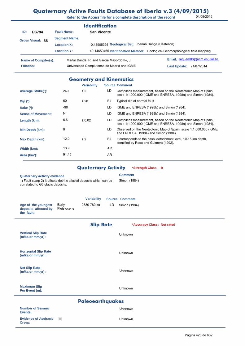
04/09/2015Quaternary Active Faults Database of Iberia v.3 (4/09/2015)
Refer to the Access file for a complete description of the record
ID: ES794 Fault Name: San Vicente
Segment Name:
Location X: -0.45905395
Location Y: 40.14650465
Name of Compiler(s): Martín Banda, R. and García Mayordomo, J.
Filiation: Universidad Complutense de Madrid and IGME
Email: [email protected]; Julian.
Last Update: 21/07/2014
Average Strike(º): 240 ± 2 LD Compiler's measurement, based on the Neotectonic Map of Spain, scale 1:1.000.000 (IGME and ENRESA, 1998a) and Simón (1984).
Dip (º): 60 ± 20 EJ Typical dip of normal fault
Rake (º): -90 LD IGME and ENRESA (1998b) and Simón (1984).
Sense of Movement: N LD IGME and ENRESA (1998b) and Simón (1984).
Length (km): 6.6 ± 0.02 LD Compiler's measurement, based on the Neotectonic Map of Spain, scale 1:1.000.000 (IGME and ENRESA, 1998a) and Simón (1984).
Min Depth (km): 0 LD Observed on the Neotectonic Map of Spain, scale 1:1.000.000 (IGME and ENRESA, 1998a) and Simón (1984).
Max Depth (km): 12.0 ± 2 EJ It corresponds to the basal detachment level, 10-15 km depth, identified by Roca and Guimerá (1992).
Width (km): 13.9 AR
Area (km²): 91.45 AR
Age of the youngestdeposits affected bythe fault:
Early Pleistocene
2580-780 ka LD Simon (1984)
Vertical Slip Rate(m/ka or mm/yr) :
Unknown
Horizontal Slip Rate(m/ka or mm/yr) :
Unknown
Net Slip Rate(m/ka or mm/yr) : Unknown
MaxImum Slip Per Event (m):
Unknown
Number of SeismicEvents:
Unknown
Evidence of AseismicCreep:
Unknown
Identification
Geometry and KinematicsVariability Source Comment
Quaternary Activity
Variability Source
Comment
1) Fault scarp 2) It offsets detritic alluvial deposits which can be correlated to G3 glacis deposits.
Simon (1984)
Geological Set: Iberian Range (Castellón)
Identification Method: Geological/Geomorphological field mapping
Comment
Quaternary activity evidence
B*Strength Class:
Slip Rate *Accuracy Class: Not rated
Paleoearthquakes
Orden Visual: 88
Página 428 de 632

04/09/2015Quaternary Active Faults Database of Iberia v.3 (4/09/2015)
Refer to the Access file for a complete description of the record
Maximun Magnitude(Mw):
6.23 ± 0.37 ER Magnitude from length using Stirling et al (2002) equation derived from the instrumental dataset.
RecurrenceInterval (years) :
Not enough data for an estimation
Date of Last MaximumEarthquake (years) :
Unknown
Extended Information: EXTENDED INFORMATION\
IGME and ENRESA (1998a): Neotectonic Map of Spain, scale 1:1.000.000.
IGME and ENRESA (1998b): Memory of the Neotectonic and Seismotectonic Map of Spain, scale 1:1.000.000. Vol.1
Roca, E., Guimerà, J., 1992. The Neogene structure of the eastern Iberian margin: structural constraints on the crustal evolution of the Valencia trough (western Mediterranean). Tectonophysics 203, 203-218.
Simon, J.L. (1984): Compresión y distensión alpinas en la Cadena Ibérica Oriental. Tesis Doctoral (1982). Institutos de Estudios Turolenses. 269 p.
Stirling, M., Rhoades, D. and Berryman K. (2002): Comparison of Earthquake Scaling Relations Derived from Data of the Instrumental and Preinstrumental Era. Bulletin of the Seismological Society of America, 92 (2): 812–830.
Seismic PotentialSource Comment
Associated Seismicity
Extended Data and References
References
Variability
*Reliability rating: C
*Reliability rating: Not rated
Página 429 de 632

04/09/2015Quaternary Active Faults Database of Iberia v.3 (4/09/2015)
Refer to the Access file for a complete description of the record
ID: ES795 Fault Name: Els Ivarsos (3/3)
Segment Name: Els Ivarsos sur
Location X: -0.06481412
Location Y: 40.17335387
Name of Compiler(s): Martín Banda, R. and García Mayordomo, J.
Filiation: Universidad Complutense de Madrid and IGME
Email: [email protected]; Julian.
Last Update: 28/07/2014
Average Strike(º): 212 - 20 / + 2 LD Compiler's measurement, based on Simon (1984) and Simon et al. (2013).
Dip (º): 60 ± 20 EJ Typical dip of normal faults.
Rake (º): -90 LD Simon (1984) and Simon et al. (2013).
Sense of Movement: N LD Simon (1984) and Simon et al. (2013).
Length (km): 9.0 ± 0.2 EJ Compiler's measurement, based on Simon (1984) and Simon et al. (2013).
Min Depth (km): 0 LD Simon (1984) and Simon et al. (2013).
Max Depth (km): 12.0 ± 2 EJ It corresponds to the basal detachment level, 10-15 km depth, identified by Roca and Guimerá (1992).
Width (km): 13.9 AR
Area (km²): 124.71 AR
Age of the youngestdeposits affected bythe fault:
Early Pleistocene
2580-780 ka LD Simon (1984) and Pérez and Simón (1989)
Vertical Slip Rate(m/ka or mm/yr) :
Unknown
Horizontal Slip Rate(m/ka or mm/yr) :
Unknown
Net Slip Rate(m/ka or mm/yr) : Unknown
MaxImum Slip Per Event (m):
Unknown
Number of SeismicEvents:
Unknown
Evidence of AseismicCreep:
Unknown
Identification
Geometry and KinematicsVariability Source Comment
Quaternary Activity
Variability Source
Comment
Marked fluvial anomaly at Els Estrests de Rodamonte, where the Rambla de la Viuda gully captures the Pla de Vilafamés endorheic area.
Simon (1984) and Pérez and Simón (1989)
Geological Set: Catalan Coastal Ranges (Castellón)
Identification Method: Geological/Geomorphological field mapping
Comment
Quaternary activity evidence
B*Strength Class:
Slip Rate *Accuracy Class: Not rated
Paleoearthquakes
Orden Visual: 75
Página 430 de 632

04/09/2015Quaternary Active Faults Database of Iberia v.3 (4/09/2015)
Refer to the Access file for a complete description of the record
Maximun Magnitude(Mw):
6.36 ± 0.37 ER Magnitude from length using Stirling et al (2002) equation derived from the instrumental dataset.
RecurrenceInterval (years) :
Not enough data for an estimation
Date of Last MaximumEarthquake (years) :
Unknown
Extended Information: EXTENDED INFORMATION\
Pérez, A.J., and Simón, J.L. (1989): Cambios en el trazado de la red fluvial producidos por la tectónica cuaternaria en el sistema de fosas del Maestrat. Actas II Reunión del Cuaternario Ibérico, El Cuaternario de España y Portugal, vol. 2, 707-715. ITGE-Asociación Española para el Estudio del Cuaternario, Madrid (publ. 1993).
Roca, E., Guimerà, J., 1992. The Neogene structure of the eastern Iberian margin: structural constraints on the crustal evolution of the Valencia trough (western Mediterranean). Tectonophysics 203, 203-218.
Simon, J.L. (1984): Compresión y distensión alpinas en la Cadena Ibérica Oriental. Tesis Doctoral (1982). Institutos de Estudios Turolenses. 269 p.
Simon, J.L., Pérez-Cuevas, A.J., Calvo-Cases, A. (2013): Tectonic beheading of fluvial valleys in the Maestrat grabens (eastern Spain): Insights into slip rates of Pleistocene extensional faults. Tectonophysics, 593, 73-84.
Stirling, M., Rhoades, D. and Berryman K. (2002): Comparison of Earthquake Scaling Relations Derived from Data of the Instrumental and Preinstrumental Era. Bulletin of the Seismological Society of America, 92 (2): 812–830.
Seismic PotentialSource Comment
Associated Seismicity
Extended Data and References
References
Variability
*Reliability rating: C
*Reliability rating: Not rated
Página 431 de 632
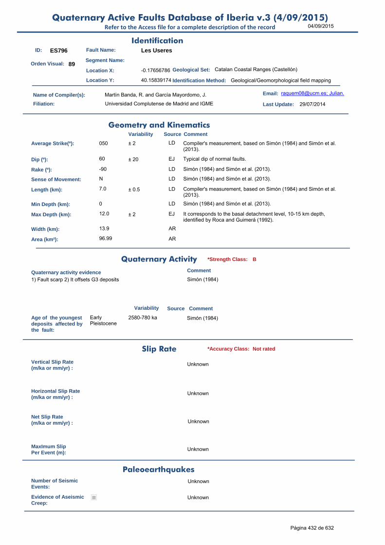
04/09/2015Quaternary Active Faults Database of Iberia v.3 (4/09/2015)
Refer to the Access file for a complete description of the record
ID: ES796 Fault Name: Les Useres
Segment Name:
Location X: -0.17656786
Location Y: 40.15839174
Name of Compiler(s): Martín Banda, R. and García Mayordomo, J.
Filiation: Universidad Complutense de Madrid and IGME
Email: [email protected]; Julian.
Last Update: 29/07/2014
Average Strike(º): 050 ± 2 LD Compiler's measurement, based on Simón (1984) and Simón et al. (2013).
Dip (º): 60 ± 20 EJ Typical dip of normal faults.
Rake (º): -90 LD Simón (1984) and Simón et al. (2013).
Sense of Movement: N LD Simón (1984) and Simón et al. (2013).
Length (km): 7.0 ± 0.5 LD Compiler's measurement, based on Simón (1984) and Simón et al. (2013).
Min Depth (km): 0 LD Simón (1984) and Simón et al. (2013).
Max Depth (km): 12.0 ± 2 EJ It corresponds to the basal detachment level, 10-15 km depth, identified by Roca and Guimerá (1992).
Width (km): 13.9 AR
Area (km²): 96.99 AR
Age of the youngestdeposits affected bythe fault:
Early Pleistocene
2580-780 ka Simón (1984)
Vertical Slip Rate(m/ka or mm/yr) :
Unknown
Horizontal Slip Rate(m/ka or mm/yr) :
Unknown
Net Slip Rate(m/ka or mm/yr) : Unknown
MaxImum Slip Per Event (m):
Unknown
Number of SeismicEvents:
Unknown
Evidence of AseismicCreep:
Unknown
Identification
Geometry and KinematicsVariability Source Comment
Quaternary Activity
Variability Source
Comment
1) Fault scarp 2) It offsets G3 deposits Simón (1984)
Geological Set: Catalan Coastal Ranges (Castellón)
Identification Method: Geological/Geomorphological field mapping
Comment
Quaternary activity evidence
B*Strength Class:
Slip Rate *Accuracy Class: Not rated
Paleoearthquakes
Orden Visual: 89
Página 432 de 632

04/09/2015Quaternary Active Faults Database of Iberia v.3 (4/09/2015)
Refer to the Access file for a complete description of the record
Maximun Magnitude(Mw):
6.25 ± 0.37 ER Magnitude from length using Stirling et al (2002) equation derived from the instrumental dataset.
RecurrenceInterval (years) :
Not enough data for an estimation
Date of Last MaximumEarthquake (years) :
Unknown
Extended Information: EXTENDED INFORMATION\
Roca, E., Guimerà, J., 1992. The Neogene structure of the eastern Iberian margin: structural constraints on the crustal evolution of the Valencia trough (western Mediterranean). Tectonophysics 203, 203-218.
Simon, J.L. (1984): Compresión y distensión alpinas en la Cadena Ibérica Oriental. Tesis Doctoral (1982). Institutos de Estudios Turolenses. 269 p.
Simon, J.L., Pérez-Cuevas, A.J., Calvo-Cases, A. (2013): Tectonic beheading of fluvial valleys in the Maestrat grabens (eastern Spain): Insights into slip rates of Pleistocene extensional faults. Tectonophysics, 593, 73-84.
Stirling, M., Rhoades, D. and Berryman K. (2002): Comparison of Earthquake Scaling Relations Derived from Data of the Instrumental and Preinstrumental Era. Bulletin of the Seismological Society of America, 92 (2): 812–830.
Seismic PotentialSource Comment
Associated Seismicity
Extended Data and References
References
Variability
*Reliability rating: C
*Reliability rating: Not rated
Página 433 de 632

04/09/2015Quaternary Active Faults Database of Iberia v.3 (4/09/2015)
Refer to the Access file for a complete description of the record
ID: ES797 Fault Name: Andarax Valley and El Alquián Fault System
Segment Name:
Location X: -2.50098402
Location Y: 37.06361025
Name of Compiler(s): Martín Banda, R. and García Mayordomo, J.
Filiation: Universidad Complutense de Madrid and IGME
Email: [email protected]; Julian.
Last Update: 29/07/2014
Average Strike(º): 133 ± 12 LD Compiler's measurement, based on Pedrera et al. (2012). To apply right hand rule criteria dip is considered towards W. The downthrown block is frequently the western one (Sanz de Galdeano et al., 2010).
Dip (º): 60 ± 20 EJ Typical dip of normal faults.
Rake (º): -90 LD Pedrera et al. (2012). In some cases, near the locality of Tabernas, these NW-SE faults present oblique displacements and even pure horizontal dextral movements (Sanz de Galdeano et al., 2010).
Sense of Movement: N LD Pedrera et al. (2012). In some cases, near the locality of Tabernas, these NW-SE faults present oblique displacements and even pure horizontal dextral movements (Sanz de Galdeano et al., 2010).
Length (km): 36.0 ± 2 LD Compiler's measurement, based on Pedrera et al. (2012). This system is formed by a set of faults with lengths between 2 and 8 km (Cuevas de los Úbeda Fault). The fault zone shows a width from 5 to 10 km.
Min Depth (km): 0 LD Pedrera et al. (2012); Sanz de Galdeano et al. (2010); Marín-Lechado et al. (2005).
Max Depth (km): 8.0 ± 2 LD Given value is the depth of the fragile crust in the area. García-Mayordomo (2005), table 4.20.
Width (km): 9.2 AR
Area (km²): 332.55 AR
Age of the youngestdeposits affected bythe fault:
Holocene LD This system presents a very clear active geomorphologic imprint. The epicentres of the Gergal 2002 seismic series aligned with the general trend of the fault system, suggesting the current activity of these faults (Sanz de Galdeano et al., 2010).
Vertical Slip Rate(m/ka or mm/yr) :
0.500 LD Uplift rates at the southern mountain front are higher than 0.5 m/ky in the Quaternary (Giaconia et al., 2012).
Horizontal Slip Rate(m/ka or mm/yr) :
0 AR HSR=0, assumed pure dip-slip faulting.
Net Slip Rate(m/ka or mm/yr) :
0.577 ± 0.02 AR From VSR, Dip and Rake. Uncertainty is quoted from Expert Judgment.
MaxImum Slip Per Event (m):
Unknown
Identification
Geometry and KinematicsVariability Source Comment
Quaternary Activity
Variability Source
Comment
1) The system show young echeloned scarps SW of Sierra Alhamilla 2) Pliocene-Quaternary sediments are faulted 3) From Gergal to Cabo de Gata, the fault system controls the Andarax valley geometry and the rectilinear coast line 4) Wedge infill 5)
Earthquakes related to the Cuevas de los Úbeda Fault (Marín-Lechado et al., 2005); Martínez-Díaz and Hernández-Enrile (2004); Pedrera et al. (2006); Sanz de Galdeano et al. (2010); Pedrera et al. (2012)
Geological Set: Betic Range (Almería)
Identification Method: Geological/Geomorphological field mapping
Comment
Quaternary activity evidence
A+*Strength Class:
Slip Rate *Accuracy Class: B
Paleoearthquakes
Orden Visual: 196
Página 434 de 632
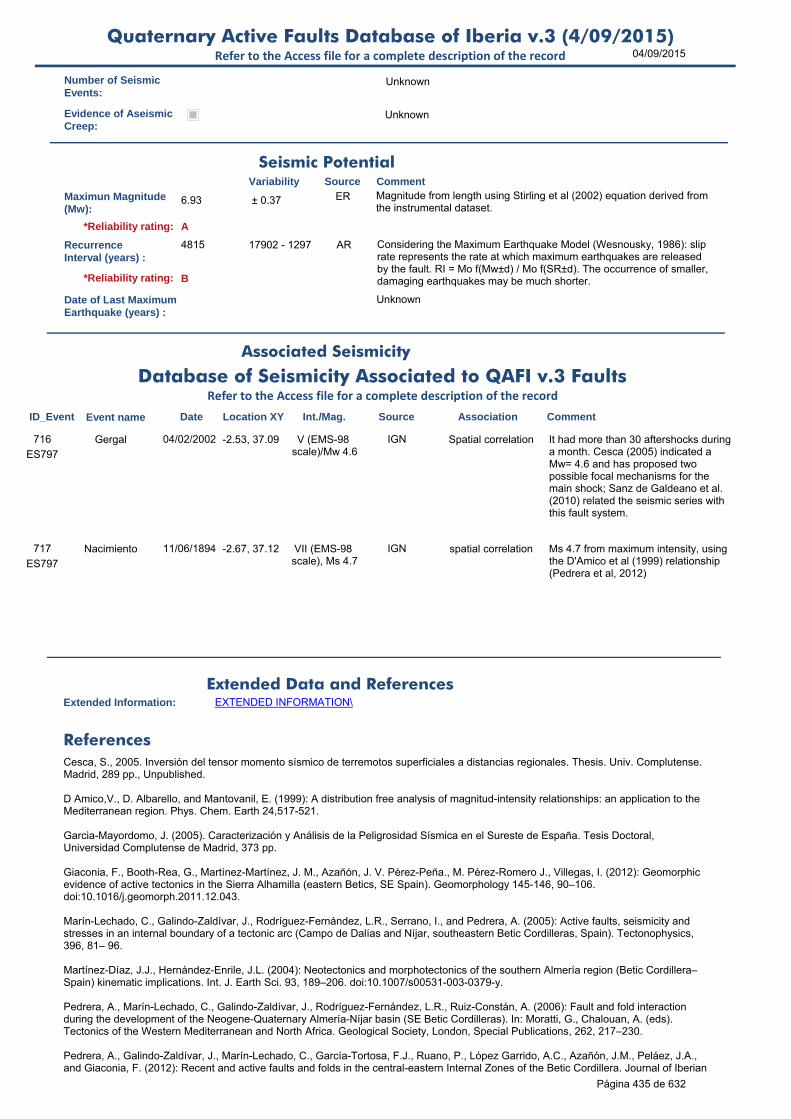
04/09/2015Quaternary Active Faults Database of Iberia v.3 (4/09/2015)
Refer to the Access file for a complete description of the record
Number of SeismicEvents:
Unknown
Evidence of AseismicCreep:
Unknown
Maximun Magnitude(Mw):
6.93 ± 0.37 ER Magnitude from length using Stirling et al (2002) equation derived from the instrumental dataset.
RecurrenceInterval (years) :
4815 17902 - 1297 AR Considering the Maximum Earthquake Model (Wesnousky, 1986): slip rate represents the rate at which maximum earthquakes are released by the fault. RI = Mo f(Mw±d) / Mo f(SR±d). The occurrence of smaller, damaging earthquakes may be much shorter.
Date of Last MaximumEarthquake (years) :
Unknown
Extended Information: EXTENDED INFORMATION\
Cesca, S., 2005. Inversión del tensor momento sísmico de terremotos superficiales a distancias regionales. Thesis. Univ. Complutense. Madrid, 289 pp., Unpublished.
D Amico,V., D. Albarello, and Mantovanil, E. (1999): A distribution free analysis of magnitud-intensity relationships: an application to the Mediterranean region. Phys. Chem. Earth 24,517-521.
Garcia-Mayordomo, J. (2005). Caracterización y Análisis de la Peligrosidad Sísmica en el Sureste de España. Tesis Doctoral, Universidad Complutense de Madrid, 373 pp.
Giaconia, F., Booth-Rea, G., Martínez-Martínez, J. M., Azañón, J. V. Pérez-Peña., M. Pérez-Romero J., Villegas, I. (2012): Geomorphicevidence of active tectonics in the Sierra Alhamilla (eastern Betics, SE Spain). Geomorphology 145-146, 90–106. doi:10.1016/j.geomorph.2011.12.043.
Marín-Lechado, C., Galindo-Zaldívar, J., Rodríguez-Fernández, L.R., Serrano, I., and Pedrera, A. (2005): Active faults, seismicity and stresses in an internal boundary of a tectonic arc (Campo de Dalías and Níjar, southeastern Betic Cordilleras, Spain). Tectonophysics, 396, 81– 96.
Martínez-Díaz, J.J., Hernández-Enrile, J.L. (2004): Neotectonics and morphotectonics of the southern Almería region (Betic Cordillera–Spain) kinematic implications. Int. J. Earth Sci. 93, 189–206. doi:10.1007/s00531-003-0379-y.
Pedrera, A., Marín-Lechado, C., Galindo-Zaldívar, J., Rodríguez-Fernández, L.R., Ruiz-Constán, A. (2006): Fault and fold interactionduring the development of the Neogene-Quaternary Almería-Níjar basin (SE Betic Cordilleras). In: Moratti, G., Chalouan, A. (eds). Tectonics of the Western Mediterranean and North Africa. Geological Society, London, Special Publications, 262, 217–230.
Pedrera, A., Galindo-Zaldívar, J., Marín-Lechado, C., García-Tortosa, F.J., Ruano, P., López Garrido, A.C., Azañón, J.M., Peláez, J.A., and Giaconia, F. (2012): Recent and active faults and folds in the central-eastern Internal Zones of the Betic Cordillera. Journal of Iberian
Seismic PotentialSource Comment
Associated Seismicity
Extended Data and References
References
Variability
*Reliability rating: A
*Reliability rating: B
Database of Seismicity Associated to QAFI v.3 FaultsRefer to the Access file for a complete description of the record
ID_Event Event name Date Location XY Int./Mag. Source Association Comment
ES797
Gergal 04/02/2002 -2.53, 37.09 V (EMS-98 scale)/Mw 4.6
IGN Spatial correlation It had more than 30 aftershocks during a month. Cesca (2005) indicated a Mw= 4.6 and has proposed two possible focal mechanisms for the main shock; Sanz de Galdeano et al. (2010) related the seismic series with this fault system.
716
ES797
Nacimiento 11/06/1894 -2.67, 37.12 VII (EMS-98 scale), Ms 4.7
IGN spatial correlation Ms 4.7 from maximum intensity, using the D'Amico et al (1999) relationship (Pedrera et al, 2012)
717
Página 435 de 632

04/09/2015Quaternary Active Faults Database of Iberia v.3 (4/09/2015)
Refer to the Access file for a complete description of the record
Geology, 38 (1), 191-208.
Sanz de Galdeano, C., Shanovb, S., Galindo-Zaldívara, J., Radulovb, A., and Nikolovb. G. (2010): A new tectonic discontinuity in the Betic Cordillera deduced from active tectonics and seismicity in the Tabernas Basin. Journal of Geodynamics, 50, 57–66.
Stirling, M., Rhoades, D. and Berryman K. (2002): Comparison of Earthquake Scaling Relations Derived from Data of the Instrumental and Preinstrumental Era. Bulletin of the Seismological Society of America, 92 (2): 812–830.
Wesnousky, S.G. (1986). Earthquakes, Quaternary faults, and seismic hazard in California. Journal of Geophysical Research. 91(B12), 12587-12631.
Página 436 de 632
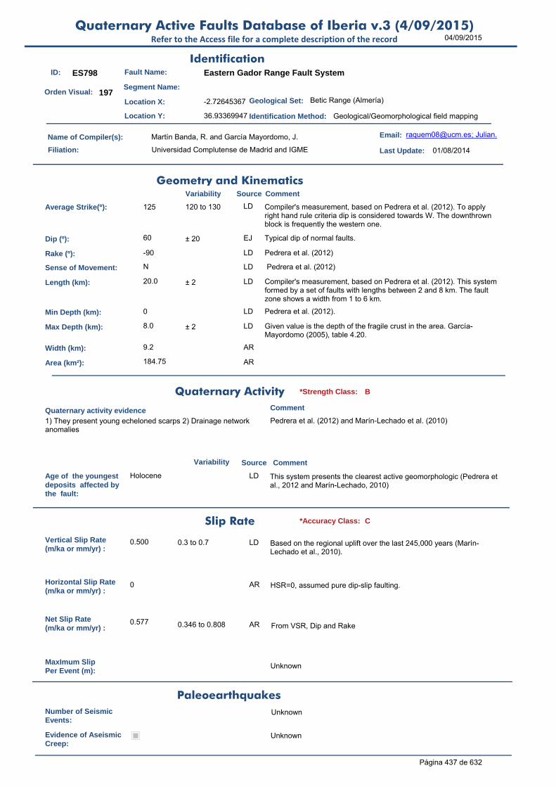
04/09/2015Quaternary Active Faults Database of Iberia v.3 (4/09/2015)
Refer to the Access file for a complete description of the record
ID: ES798 Fault Name: Eastern Gador Range Fault System
Segment Name:
Location X: -2.72645367
Location Y: 36.93369947
Name of Compiler(s): Martín Banda, R. and García Mayordomo, J.
Filiation: Universidad Complutense de Madrid and IGME
Email: [email protected]; Julian.
Last Update: 01/08/2014
Average Strike(º): 125 120 to 130 LD Compiler's measurement, based on Pedrera et al. (2012). To apply right hand rule criteria dip is considered towards W. The downthrown block is frequently the western one.
Dip (º): 60 ± 20 EJ Typical dip of normal faults.
Rake (º): -90 LD Pedrera et al. (2012)
Sense of Movement: N LD Pedrera et al. (2012)
Length (km): 20.0 ± 2 LD Compiler's measurement, based on Pedrera et al. (2012). This system formed by a set of faults with lengths between 2 and 8 km. The fault zone shows a width from 1 to 6 km.
Min Depth (km): 0 LD Pedrera et al. (2012).
Max Depth (km): 8.0 ± 2 LD Given value is the depth of the fragile crust in the area. García-Mayordomo (2005), table 4.20.
Width (km): 9.2 AR
Area (km²): 184.75 AR
Age of the youngestdeposits affected bythe fault:
Holocene LD This system presents the clearest active geomorphologic (Pedrera et al., 2012 and Marín-Lechado, 2010)
Vertical Slip Rate(m/ka or mm/yr) :
0.500 0.3 to 0.7 LD Based on the regional uplift over the last 245,000 years (Marín-Lechado et al., 2010).
Horizontal Slip Rate(m/ka or mm/yr) :
0 AR HSR=0, assumed pure dip-slip faulting.
Net Slip Rate(m/ka or mm/yr) :
0.577 0.346 to 0.808 AR From VSR, Dip and Rake
MaxImum Slip Per Event (m):
Unknown
Number of SeismicEvents:
Unknown
Evidence of AseismicCreep:
Unknown
Identification
Geometry and KinematicsVariability Source Comment
Quaternary Activity
Variability Source
Comment
1) They present young echeloned scarps 2) Drainage network anomalies
Pedrera et al. (2012) and Marín-Lechado et al. (2010)
Geological Set: Betic Range (Almería)
Identification Method: Geological/Geomorphological field mapping
Comment
Quaternary activity evidence
B*Strength Class:
Slip Rate *Accuracy Class: C
Paleoearthquakes
Orden Visual: 197
Página 437 de 632
04/09/2015Quaternary Active Faults Database of Iberia v.3 (4/09/2015)
Refer to the Access file for a complete description of the record
Maximun Magnitude(Mw):
6.69 ± 0.37 ER Magnitude from length using Stirling et al (2002) equation derived from the instrumental dataset.
RecurrenceInterval (years) :
3803 22762 - 757 AR Considering the Maximum Earthquake Model (Wesnousky, 1986): slip rate represents the rate at which maximum earthquakes are released by the fault. RI = Mo f(Mw±d) / Mo f(SR±d). The occurrence of smaller, damaging earthquakes may be much shorter.
Date of Last MaximumEarthquake (years) :
Unknown
Extended Information: EXTENDED INFORMATION\
Garcia-Mayordomo, J. (2005). Caracterización y Análisis de la Peligrosidad Sísmica en el Sureste de España. Tesis Doctoral, Universidad Complutense de Madrid, 373 pp.
Marín-Lechado, C., Galindo-Zaldívar, J., Gil, A.J., Borque, M.J., de Lacy, M.C., Pedrera, A., López-Garrido, A.C., Alfaro, P., García-Tortosa, F., Ramos, M.I., Rodríguez-Caderot, G., Rodríguez-Fernández, J., Ruiz-Constán, A., and Sanz de Galdeano-Equiza, C. (2010): Levelling Profiles and a GPS Network to Monitor the Active Folding and Faulting Deformation in the Campo de Dalias (Betic Cordillera, Southeastern Spain). Sensors, 10, 3504-3518; doi:10.3390/s100403504.
Pedrera, A., Galindo-Zaldívar, J., Marín-Lechado, C., García-Tortosa, F.J., Ruano, P., López Garrido, A.C., Azañón, J.M., Peláez, J.A., and Giaconia, F. (2012): Recent and active faults and folds in the central-eastern Internal Zones of the Betic Cordillera. Journal of Iberian Geology, 38 (1), 191-208.
Stirling, M., Rhoades, D. and Berryman K. (2002): Comparison of Earthquake Scaling Relations Derived from Data of the Instrumental and Preinstrumental Era. Bulletin of the Seismological Society of America, 92 (2): 812–830.
Wesnousky, S.G. (1986). Earthquakes, Quaternary faults, and seismic hazard in California. Journal of Geophysical Research. 91(B12), 12587-12631.
Seismic PotentialSource Comment
Associated Seismicity
Extended Data and References
References
Variability
*Reliability rating: C
*Reliability rating: C
Página 438 de 632

04/09/2015Quaternary Active Faults Database of Iberia v.3 (4/09/2015)
Refer to the Access file for a complete description of the record
ID: ES799 Fault Name: Balanegra
Segment Name:
Location X: -2.90420183
Location Y: 36.76633002
Name of Compiler(s): Martín Banda, R. and García Mayordomo, J.
Filiation: Universidad Complutense de Madrid and IGME
Email: [email protected]; Julian.
Last Update: 01/08/2014
Average Strike(º): 150 ± 5 EJ Compiler's measurement, Marín-Lechado et al. (2010). To apply right hand rule criteria dip is considered towards W.
Dip (º): 60 ± 20 EJ Typical dip of normal faults.
Rake (º): -135 LD Martínez-Díaz and Hernádez-Enrile (2004); Marín-Lechado et al. (2005); Marín-Lechado et al. (2010)
Sense of Movement: DN LD Martínez-Díaz and Hernádez-Enrile (2004); Marín-Lechado et al. (2005); Marín-Lechado et al. (2010)
Length (km): 9.0 EJ Compiler's measurement, based on Marín-Lechado et al. (2010). The Balanegra Fault Zone comprises two main parallel faults along with other minor synthetic faults, producing a staircase morphology.
Min Depth (km): 0 LD Martínez-Díaz and Hernádez-Enrile (2004); Marín-Lechado et al. (2005); Marín-Lechado et al. (2010)
Max Depth (km): 8.0 ± 2 EJ According to Marín-Lechado et al. (2005), the normal faulting with local strike-slip regimes occur within the upper crust. So, the given maximum value is the depth of the fragile crust (García-Mayordomo,
Width (km): 9.2 AR
Area (km²): 83.14 AR
Age of the youngestdeposits affected bythe fault:
Holocene LD Shallow instrumental seismicity shows NW–SE oriented lineations of epicentres that align with the fault zone (Martínez-Díaz and Hernádez-Enrile, 2004; Marín-Lechado et al., 2005)
Vertical Slip Rate(m/ka or mm/yr) :
0.065 0.05-0.08 LD The vertical relative slip rates that result from the present topographic height of Quaternary marine terraces. It was calculated from Late Pleistocene (Martínez-Díaz and Hernádez-Enrile, 2004).
Horizontal Slip Rate(m/ka or mm/yr) :
0.075 0.058-0.092 AR From NSR and Rake
Net Slip Rate(m/ka or mm/yr) :
0.106 0.082-0.131 AR From VSR, Dip and Rake
MaxImum Slip Per Event (m):
Unknown
Number of SeismicEvents:
Unknown
Identification
Geometry and KinematicsVariability Source Comment
Quaternary Activity
Variability Source
Comment
1) Rectilinear scarps with staircase morphology that influence the drainage network 2) Holocene asymmetric clastic wedges 3) They cut Holocene sediments 4) Seismites in Quaternary sediments 5) They control the coastline of the Campo de Dalías
Martínez-Díaz and Hernádez-Enrile (2004); Marín-Lechado et al. (2005); Marín-Lechado et al. (2010); Pedrera et al. (2012)
Geological Set: Betic Range (Almería)
Identification Method: Geological/Geomorphological field mapping
Comment
Quaternary activity evidence
A+*Strength Class:
Slip Rate *Accuracy Class: B
Paleoearthquakes
Orden Visual: 198
Página 439 de 632
04/09/2015Quaternary Active Faults Database of Iberia v.3 (4/09/2015)
Refer to the Access file for a complete description of the record
Evidence of AseismicCreep:
Unknown
Maximun Magnitude(Mw):
6.36 ± 0.37 ER Magnitude from length using Stirling et al. (2002) equation derived from the instrumental dataset. Marín-Lechado et al. (2005) estimates a Mw of 5.5 using Wells and Coppersmith (1994) and a fault length of 8 km.
RecurrenceInterval (years) :
14715 68274 - 3317 AR Considering the Maximum Earthquake Model (Wesnousky, 1986): slip rate represents the rate at which maximum earthquakes are released by the fault. RI = Mo f(Mw±d) / Mo f(SR±d). The occurrence of smaller, damaging earthquakes may be much shorter.
Date of Last MaximumEarthquake (years) :
Unknown
Seismic PotentialSource Comment
Associated Seismicity
Variability
*Reliability rating: A
*Reliability rating: B
Database of Seismicity Associated to QAFI v.3 FaultsRefer to the Access file for a complete description of the record
ID_Event Event name Date Location XY Int./Mag. Source Association Comment
ES799
Adra Series December 1994 to January
1995
near Adra VII (MSK), Mb=4.9 and
Mb=5.0 mainshocks
Andalusian Seismic Network
(RSA)
Spatial correlation, aftershocks distribution
The spatial distribution of the series and the most recent seismic activity (792 events) defines an approximately NNW-SSE elongated region limited to the North and South by the two mainshocks (Marín-Lechado et al., 2005, 2010)
718
ES799
South Adra 22/09/1522 -2.866; 36.433
IX (MSK) Martínez-Díaz (2000)
Spatial correlation Marín-Lechado et al. (2010)719
ES799
Adra 21/01/1804 -3.000; 36.701
VIII (MSK) Martínez-Díaz (2000)
Spatial correlation Marín-Lechado et al. (2010)720
ES799
Southwest Adra 25/08/1804 -4.183, 40.645
IX (MSK) Martínez-Díaz (2000)
Spatial correlation Marín-Lechado et al. (2010)721
ES799
Adra 16/06/1910 -3.367; 36.667
VII (MSK) Martínez-Díaz (2000)
Spatial correlation Marín-Lechado et al. (2010)722
ES799
Adra 16/06/1910 -3.367; 36.667
VIII (MSK) Martínez-Díaz (2000)
Spatial correlation Marín-Lechado et al. (2010)723
Página 440 de 632

04/09/2015Quaternary Active Faults Database of Iberia v.3 (4/09/2015)
Refer to the Access file for a complete description of the record
Extended Information: EXTENDED INFORMATION\
Garcia-Mayordomo, J. (2005). Caracterización y Análisis de la Peligrosidad Sísmica en el Sureste de España. Tesis Doctoral, Universidad Complutense de Madrid, 373 pp.
Marıín-Lechado, C., Galindo-Zaldívar, J., Rodrıíguez-Fernández, L.R., Serrano, I., Pedrera, A. (2005): Active faults, seismicity and stresses in an internal boundary of a tectonic arc (Campo de Dalías and Níjar, southeastern Betic Cordilleras, Spain). Tectonophysics, 396, 81– 96.
Marín-Lechado, C., Galindo-Zaldívar, J., Gil, A.J., Borque, M.J., de Lacy, M.C., Pedrera, A., López-Garrido, A.C., Alfaro, P., García-Tortosa, F., Ramos, M.I., Rodríguez-Caderot, G., Rodríguez-Fernández, J., Ruiz-Constán, A., and Sanz de Galdeano-Equiza, C. (2010): Levelling Profiles and a GPS Network to Monitor the Active Folding and Faulting Deformation in the Campo de Dalias (Betic Cordillera, Southeastern Spain). Sensors, 10, 3504-3518; doi:10.3390/s100403504.
Martínez-Díaz, J.J. (2000): Análisis sismotectónico de la serie sísmica de Adra: mecanismos de terremotos compuestos como respuesta a la interacción entre fallas activas en el sureste de la Cordillera Bética. Rev. Soc. Geol. Esp. 2000, 13, 31-43.
Martínez-Díaz, J.J, and Hernández-Henrile, J.L. (2004): Neotectonics and morphotectonics of the southern Almería region (Betic Cordillera-Spain) kinematic implications. Int J Earth Sci (Geol Rundsch), 93, 189–206. DOI 10.1007/s00531-003-0379-y
Pedrera, A., Galindo-Zaldívar, J., Marín-Lechado, C., García-Tortosa, F.J., Ruano, P., López Garrido, A.C., Azañón, J.M., Peláez, J.A., and Giaconia, F. (2012): Recent and active faults and folds in the central-eastern Internal Zones of the Betic Cordillera. Journal of Iberian Geology 38 (1), 191-208.
Stirling, M., Rhoades, D. and Berryman K. (2002): Comparison of Earthquake Scaling Relations Derived from Data of the Instrumental and Preinstrumental Era. Bulletin of the Seismological Society of America, 92 (2): 812–830.
Wells, D. L., and Coppersmith, K. J. (1994). New empirical relationships among magnitude, rupture length, rupture width, and surface displacement. Bulleting of the Seismological Society of America 84, 974-1002.
Wesnousky, S.G. (1986). Earthquakes, Quaternary faults, and seismic hazard in California. Journal of Geophysical Research. 91(B12), 12587-12631.
Extended Data and References
References
Página 441 de 632

04/09/2015Quaternary Active Faults Database of Iberia v.3 (4/09/2015)
Refer to the Access file for a complete description of the record
ID: ES800 Fault Name: Loma del Viento
Segment Name:
Location X: -2.63813655
Location Y: 36.71772615
Name of Compiler(s): Martín Banda, R. and García Mayordomo, J.
Filiation: Universidad Complutense de Madrid and IGME
Email: [email protected]; Julian.
Last Update: 05/08/2014
Average Strike(º): 300 ± 15 LD To apply right hand rule criteria dip is considered towards NNE. Segmented fault comprising six onshore hard-linked and soft-linked segments with an average strike varying between N105°E and N135°E (Marín-Lechado et al. 2004; Pedrera et al., 2012a,b).
Dip (º): 80 70 to 90 LD The average dip is 80° toward the NNE, though some sub-segments are vertical and others dip 80° toward the SSW (Marín-Lechado et al. 2004; Pedrera et al., 2012a).
Rake (º): -135 LD Marín-Lechado et al. (2004); Pedrera et al. (2012a); Pedrera et al. (2012b).
Sense of Movement: DN LD Marín-Lechado et al. (2004); Pedrera et al. (2012a); Pedrera et al. (2012b).
Length (km): 8.0 ± 0.2 LD Pedrera et al. (2012a).
Min Depth (km): 0 LD Pedrera et al. (2012a).
Max Depth (km): 8.0 ± 2 LD According to Marín-Lechado et al. (2005), the normal faulting with local strike-slip regimes occur within the upper crust. So, the given maximum value is the depth of the fragile crust (García-Mayordomo,
Width (km): 8.1 AR
Area (km²): 64.99 AR
Age of the youngestdeposits affected bythe fault:
Holocene LD Association to current instrumental seismicity is very likely (Pedrera et al., 2012a).
Vertical Slip Rate(m/ka or mm/yr) :
0.049 ± 0.021 AR From NSR, dip and rake
Horizontal Slip Rate(m/ka or mm/yr) :
0.049 ± 0.021 AR From NSR and rake
Net Slip Rate(m/ka or mm/yr) :
0.07 ± 0.03 LD Pedrera et al. (2012a) evaluates the min/max age of the affected formation (~3.6 to ~1.8 Ma) and calculates a min/max fault offset (90 to 100 m). They thus arrived at a long-term slip rate of 0.07±0.03 mm/y.
MaxImum Slip Per Event (m):
Unknown
Identification
Geometry and KinematicsVariability Source Comment
Quaternary Activity
Variability Source
Comment
1) Fault scarp 2) Associated deposit with wedge geometry 3) The marine terraces show a staircase layout and are characterized by vertical aggradation on the hanging-wall, revealing Pleistocene fault activity
Marín-Lechado et al. (2004); Pedrera et al. (2012a)
Geological Set: Betic Range (Almería)
Identification Method: Geological/Geomorphological field mapping
Comment
Quaternary activity evidence
A+*Strength Class:
Slip Rate *Accuracy Class: B
Paleoearthquakes
Orden Visual: 199
Página 442 de 632
04/09/2015Quaternary Active Faults Database of Iberia v.3 (4/09/2015)
Refer to the Access file for a complete description of the record
Number of SeismicEvents:
Unknown
Evidence of AseismicCreep:
Unknown
Maximun Magnitude(Mw):
6.31 ± 0.37 ER Magnitude from length using Stirling et al (2002) equation derived from the instrumental dataset.
RecurrenceInterval (years) :
23814 149581 - 4644 AR Considering the Maximum Earthquake Model (Wesnousky, 1986): slip rate represents the rate at which maximum earthquakes are released by the fault. RI = Mo f(Mw±d) / Mo f(SR±d). The occurrence of smaller, damaging earthquakes may be much shorter.
Date of Last MaximumEarthquake (years) :
Unknown
Extended Information: EXTENDED INFORMATION\
Garcia-Mayordomo, J. (2005). Caracterización y Análisis de la Peligrosidad Sísmica en el Sureste de España. Tesis Doctoral, Universidad Complutense de Madrid, 373 pp.
Marín-Lechado, C., Galindo-Zaldívar, J., Rodríguez-Fernández, L.R., González-Lodeiro, F. (2004): Faulted hybrid joints: an example from the Campo de Dalías (Betic Cordilleras, Spain). Journal of Structural Geology 26, 2025–2037.
Marıín-Lechado, C., Galindo-Zaldívar, J., Rodrıíguez-Fernández, L.R., Serrano, I., Pedrera, A. (2005): Active faults, seismicity and stresses in an internal boundary of a tectonic arc (Campo de Dalías and Níjar, southeastern Betic Cordilleras, Spain). Tectonophysics, 396, 81– 96.
Pedrera, A., Marín-Lechado, C., Stich, D., Ruiz-Constán, A., Galindo-Zaldívar, J., Rey-Moral, C., and Mancilla, F.L. (2012a): Nucleation, linkage and active propagation of a segmented Quaternary normal-dextral fault: the Loma del Viento fault (Campo de Dalías, Eastern Betic Cordillera, SE Spain). Tectonophysics, 522–523 (2012), 208–217.
Pedrera, A., Galindo-Zaldívar, J., Marín-Lechado, C., García-Tortosa, F.J., Ruano, P., López Garrido, A.C., Azañón, J.M., Peláez, J.A., and Giaconia, F. (2012b): Recent and active faults and folds in the central-eastern Internal Zones of the Betic Cordillera. Journal of Iberian Geology 38 (1), 191-208.
Stirling, M., Rhoades, D. and Berryman K. (2002): Comparison of Earthquake Scaling Relations Derived from Data of the Instrumental and Preinstrumental Era. Bulletin of the Seismological Society of America, 92 (2): 812–830.
Wesnousky, S.G. (1986). Earthquakes, Quaternary faults, and seismic hazard in California. Journal of Geophysical Research. 91(B12), 12587-12631.
Seismic PotentialSource Comment
Associated Seismicity
Extended Data and References
References
Variability
*Reliability rating: A
*Reliability rating: B
Database of Seismicity Associated to QAFI v.3 FaultsRefer to the Access file for a complete description of the record
ID_Event Event name Date Location XY Int./Mag. Source Association Comment
ES800
Offshore Loma del Viento fault
November 2010
-2.591; 36.713
Mw 3.5 to 4.2 IGN Spatial correlation Correlation is probable. Moment tensor analysis revealed a strike-slip fault with a rightlateral, slightly oblique focal plane striking ~N125°E and hypocenter depths of 12 km (Pedrera et al., 2012a)
724
Página 443 de 632

04/09/2015Quaternary Active Faults Database of Iberia v.3 (4/09/2015)
Refer to the Access file for a complete description of the record
ID: ES801 Fault Name: Almanzora Corridor Fault Zone
Segment Name:
Location X: -2.43803077
Location Y: 37.40771162
Name of Compiler(s): Martín Banda, R. and García Mayordomo, J.
Filiation: Universidad Complutense de Madrid and IGME
Email: [email protected]; Julian.
Last Update: 05/08/2014
Average Strike(º): 080 75 to 130 EJ Compiler's measurement, Pedrera et al. (2012). To apply right hand rule criteria dip is considered towards W. The western fault zone shows a WNW-ESE to NW-SE variable strike. The central and eastern zones show ENE-WSW strike.
Dip (º): 70 30 to 90 EJ From the high dips of strike-slip faults to the low dips of reverse faults (Pedrera et al., 2012).
Rake (º): -180 90 to -90 LD At the western fault zone, the faults are normal, and at the central and eastern part, the fault zone shows WNW-ESE trending dextral faults and ENE-WSW oriented open folds, fault-propagation folds, and reverse faults (Pedrera et al., 2012).
Sense of Movement: D N to R LD At the western fault zone, the faults are normal, and at the central and eastern part, the fault zone shows WNW-ESE trending dextral faults and ENE-WSW oriented open folds, fault-propagation folds, and reverse faults (Pedrera et al., 2012).
Length (km): 23.0 ± 2 EJ Compiler's measurement, Pedrera et al. (2012).
Min Depth (km): 0 LD Pedrera et al. (2012).
Max Depth (km): 11.0 9-11 LD According to Marín-Lechado et al. (2005), the normal faulting with local strike-slip regimes occur within the upper crust. Given maximum value is the depth of the fragile crust in the area (García-Mayordomo,
Width (km): 11.7 AR
Area (km²): 269.24 AR
Age of the youngestdeposits affected bythe fault:
Holocene LD Pedrera et al. (2012)
Vertical Slip Rate(m/ka or mm/yr) :
0.014 LD Calculated for the fault-propagation folds of the Molata from mid-Pleistocene to Present (Pedrera et al., 2009).
Horizontal Slip Rate(m/ka or mm/yr) :
0.007 LD Calculated for the fault-propagation folds of the Molata from the mid-Pleistocene to Present (Pedrera et al., 2009).
Net Slip Rate(m/ka or mm/yr) :
0.015 ± 0.01 EJ From the Molata's VSR and HSR estimations above. Uncertainty is from Expert Judgment.
MaxImum Slip Per Event (m):
Unknown
Identification
Geometry and KinematicsVariability Source Comment
Quaternary Activity
Variability Source
Comment
1) Western fault zone (normal faults) deforms Quaternary sediments and shows a steep scarp. 2) The folds and related faults show a syn-tectonic geometry of the growth strata. 3) The fault zone controls the drainage network of the Almanzora River
Pedrera et al. (2012)
Geological Set: Betic Range (Almería)
Identification Method: Geological/Geomorphological field mapping
Comment
Quaternary activity evidence
A+*Strength Class:
Slip Rate *Accuracy Class: B
Orden Visual: 200
Página 444 de 632
04/09/2015Quaternary Active Faults Database of Iberia v.3 (4/09/2015)
Refer to the Access file for a complete description of the record
Number of SeismicEvents:
Unknown
Evidence of AseismicCreep:
Unknown
Maximun Magnitude(Mw):
6.74 ± 0.37 ER Magnitude from length using Stirling et al (2002) equation derived from the instrumental dataset.
RecurrenceInterval (years) :
166117 1788694 - 27769 AR Considering the Maximum Earthquake Model (Wesnousky, 1986): slip rate represents the rate at which maximum earthquakes are released by the fault. RI = Mo f(Mw±d) / Mo f(SR±d). The occurrence of smaller, damaging earthquakes may be much shorter.
Date of Last MaximumEarthquake (years) :
Unknown
Extended Information: EXTENDED INFORMATION\
Garcia-Mayordomo, J. (2005). Caracterización y Análisis de la Peligrosidad Sísmica en el Sureste de España. Tesis Doctoral, Universidad Complutense de Madrid, 373 pp.
Pedrera, A., Galindo-Zaldívar, J., Ruiz-Bustos, A., Rodríguez-Fernández, J., Ruíz- Constán, A. (2009): The role of small-scale fold andfault development in seismogenic zones: example of the Western Huércal-Overa basin (Eastern Betic Cordillera, Spain). J. Quat. Sci. 24, 581–592, doi:10.1002/jqs.1246
Pedrera, A., Galindo-Zaldívar, J., Marín-Lechado, C., García-Tortosa, F.J., Ruano, P., López Garrido, A.C., Azañón, J.M., Peláez, J.A., and Giaconia, F. (2012): Recent and active faults and folds in the central-eastern Internal Zones of the Betic Cordillera. Journal of Iberian Geology 38 (1), 191-208.
Silva, P., Rodríguez-Pascua, M.A., Giner-Robles, J.L., Roquero, E., Pérez-López, R., Huerta, P., and Bardají, T. (2014). Anatomy of an earthquake: geological anlalysis of the Huércal-Overa AD 1863 event (Almería, SE Spain). Resúmenes de la 2ª Reunión Ibérica sobre Fallas Activas y Paleosismología, Lorca, Esapña, 151-154.
Stirling, M., Rhoades, D. and Berryman K. (2002): Comparison of Earthquake Scaling Relations Derived from Data of the Instrumental and Preinstrumental Era. Bulletin of the Seismological Society of America, 92 (2): 812–830.
Wesnousky, S.G. (1986). Earthquakes, Quaternary faults, and seismic hazard in California. Journal of Geophysical Research. 91(B12), 12587-12631.
Seismic PotentialSource Comment
Associated Seismicity
Extended Data and References
References
Variability
*Reliability rating: A
*Reliability rating: B
Paleoearthquakes
Database of Seismicity Associated to QAFI v.3 FaultsRefer to the Access file for a complete description of the record
ID_Event Event name Date Location XY Int./Mag. Source Association Comment
ES801
Huércal-Overa AD 1863
10th June 1863 AD
VIII (ESI-07 scale)
Silva et al. (2014)
Aftershocks distribution Silva et al. (2014)725
Página 445 de 632
04/09/2015Quaternary Active Faults Database of Iberia v.3 (4/09/2015)
Refer to the Access file for a complete description of the record
ID: ES802 Fault Name: Torre Carbonero-Marilópez
Segment Name:
Location X: -6.515
Location Y: 36.94181774
Name of Compiler(s): Martín Banda, R. and García Mayordomo, J.
Filiation: Universidad Complutense de Madrid and IGME
Email: [email protected]; Julian.
Last Update: 07/08/2014
Average Strike(º): 075 ± 2 LD Compiler's measurement, based on Rodríguez-Ramírez et al. (2014). To apply right hand rule criteria dip is considered towards W.
Dip (º): 60 ± 20 EJ Typical dip of normal faults.
Rake (º): -90 LD Rodríguez-Ramírez et al. (2014).
Sense of Movement: N LD Rodríguez-Ramírez et al. (2014).
Length (km): 13.0 ± 0.5 EJ Compiler's measurement, based on Rodríguez-Ramírez et al. (2014).
Min Depth (km): 0.3 > 0.3 EJ According to Rodríguez-Ramírez et al. (2014), this fault does not outcrop at the surface but it controls the estuarine infilling and its geomorphological configuration during the Holocene, and should
Max Depth (km): 4.0 ± 0.5 EJ This fault can be related to the Pliocene-Quaternary listric faults rooted in the Allochthonous Complex of the Guadalquivir, like other faults of the Gulf of Cadiz (Vazquez et al.,2010).The base of the
Width (km): 4.3 AR
Area (km²): 55.54 AR
Age of the youngestdeposits affected bythe fault:
c. 2000 cal yr BP
LD Rodríguez-Ramírez et al. (2014).
Vertical Slip Rate(m/ka or mm/yr) :
Unknown
Horizontal Slip Rate(m/ka or mm/yr) :
Unknown
Net Slip Rate(m/ka or mm/yr) : Unknown
MaxImum Slip Per Event (m):
Unknown
Number of SeismicEvents:
Unknown
Evidence of AseismicCreep:
Unknown
Identification
Geometry and KinematicsVariability Source Comment
Quaternary Activity
Variability Source
Comment
1) Geomorphological anomalies: anomalous drainage, subdued morphologies, erosive forms, patches of vegetation caused by weaknesses and changes of humidity in the ground. 2) Stratigraphical evidences
Rodríguez-Ramírez et al. (2014). Other plausible non-tectonic causes for these anomalies are not discussed in the paper.
Geological Set: Guadalquivir Basin (Huelva)
Identification Method: Geological/Geomorphological field mapping
Comment
Quaternary activity evidence
C*Strength Class:
Slip Rate *Accuracy Class: Not rated
Paleoearthquakes
Orden Visual: 254
Página 446 de 632

04/09/2015Quaternary Active Faults Database of Iberia v.3 (4/09/2015)
Refer to the Access file for a complete description of the record
Maximun Magnitude(Mw):
6.51 ± 0.37 ER Magnitude from length using Stirling et al (2002) equation derived from the instrumental dataset.
RecurrenceInterval (years) :
Not enough data for an estimation
Date of Last MaximumEarthquake (years) :
Unknown
Extended Information: EXTENDED INFORMATION\
Medialdea, T. (2007): Estructura y evolución tectónica del Golfo de Cádiz. Instituto Geológico y Minero de España. Serie: Tesis Doctorales Nº8. 328 pp.
Rodríguez-Ramírez, A., Flores-Hurtado, E., Contreras, C., Villarías-Robles, J.J.R., Jiménez-Moreno, G., Pérez-Asensio, J.N., López-Sáez, J.A., Celestino-Pérez, S., Cerrillo-Cuenca, E., and León A. (2014): The role of neo-tectonics in the sedimentary infilling and geomorphological evolution of the Guadalquivir estuary (Gulf of Cadiz, SW Spain) during Holocene. Geomorphology, 219, 126-140.
Stirling, M., Rhoades, D. and Berryman K. (2002): Comparison of Earthquake Scaling Relations Derived from Data of the Instrumental and Preinstrumental Era. Bulletin of the Seismological Society of America, 92 (2): 812–830.
Vázquez, J.T.,Fernández-Puga, M.C., Medialdea, T., Díaz del Río, V., Fernández-Salas, L.M., Llave, E., Lobo, F.J., Lopes, F.C., Maldonado, A., Somoza, L. and Palomino, D. (2010): Fracturación normal durante el Cuaternario Superior en la Plataforma Continental Septentrional del Golfo de Cádiz (SO de Iberia). Resúmenes de la 1ª Reunión Ibérica sobre Tectónica Activa y Paleosismología, Sigüenza, España (2010).
Wesnousky, S.G. (1986). Earthquakes, Quaternary faults, and seismic hazard in California. Journal of Geophysical Research. 91(B12), 12587-12631.
Seismic PotentialSource Comment
Associated Seismicity
Extended Data and References
References
Variability
*Reliability rating: D
*Reliability rating: Not rated
Página 447 de 632

04/09/2015Quaternary Active Faults Database of Iberia v.3 (4/09/2015)
Refer to the Access file for a complete description of the record
ID: ES803 Fault Name: Torre Marilópez
Segment Name:
Location X: -6.37028018
Location Y: 37.04112315
Name of Compiler(s): Martín Banda, R. and García Mayordomo, J.
Filiation: Universidad Complutense de Madrid and IGME
Email: [email protected]; Julian.
Last Update: 07/08/2014
Average Strike(º): 120 ± 2 LD Compiler's measurement, based on Rodríguez-Ramírez et al. (2014). To apply right hand rule criteria dip is considered towards W.
Dip (º): 60 ± 20 EJ Typical dip of normal faults.
Rake (º): -90 LD Rodríguez-Ramírez et al. (2014).
Sense of Movement: N LD Rodríguez-Ramírez et al. (2014).
Length (km): 8.0 ± 0.5 LD Compiler's measurement, based on Rodríguez-Ramírez et al. (2014).
Min Depth (km): 0.3 > 0.3 EJ According to Rodríguez-Ramírez et al. (2014), this fault does not outcrop at the surface but it controls the estuarine infilling and its geomorphological configuration during the Holocene, and should
Max Depth (km): 4.0 ± 0.5 EJ This fault can be related to the Pliocene-Quaternary listric faults rooted in the Allochthonous Complex of the Guadalquivir, like other faults of the Gulf of Cadiz (Vazquez et al.,2010).The base of the
Width (km): 4.3 AR
Area (km²): 34.18 AR
Age of the youngestdeposits affected bythe fault:
c. 2000 cal yr BP
LD Rodríguez-Ramírez et al. (2014).
Vertical Slip Rate(m/ka or mm/yr) :
Unknown
Horizontal Slip Rate(m/ka or mm/yr) :
Unknown
Net Slip Rate(m/ka or mm/yr) : Unknown
MaxImum Slip Per Event (m):
Unknown
Number of SeismicEvents:
Unknown
Evidence of AseismicCreep:
Unknown
Identification
Geometry and KinematicsVariability Source Comment
Quaternary Activity
Variability Source
Comment
1) Geomorphological anomalies: peculiar drainages, subdued morphologies, erosive forms, patches of vegetation caused by weaknesses and changes of humidity in the ground. 2) Stratigraphical evidences
Rodríguez-Ramírez et al. (2014). Other plausible non-tectonic causes for these anomalies are not discussed in the paper.
Geological Set: Guadalquivir Basin (Sevilla)
Identification Method: Geological/Geomorphological field mapping
Comment
Quaternary activity evidence
C*Strength Class:
Slip Rate *Accuracy Class: Not rated
Paleoearthquakes
Orden Visual: 255
Página 448 de 632

04/09/2015Quaternary Active Faults Database of Iberia v.3 (4/09/2015)
Refer to the Access file for a complete description of the record
Maximun Magnitude(Mw):
6.31 ± 0.37 ER Magnitude from length using Stirling et al (2002) equation derived from the instrumental dataset.
RecurrenceInterval (years) :
Not enough data for an estimation
Date of Last MaximumEarthquake (years) :
Unknown
Extended Information: EXTENDED INFORMATION\
Medialdea, T. (2007): Estructura y evolución tectónica del Golfo de Cádiz. Instituto Geológico y Minero de España. Serie: Tesis Doctorales Nº8. 328 pp.
Rodríguez-Ramírez, A., Flores-Hurtado, E., Contreras, C., Villarías-Robles, J.J.R., Jiménez-Moreno, G., Pérez-Asensio, J.N., López-Sáez, J.A., Celestino-Pérez, S., Cerrillo-Cuenca, E., and León A. (2014): The role of neo-tectonics in the sedimentary infilling and geomorphological evolution of the Guadalquivir estuary (Gulf of Cadiz, SW Spain) during Holocene. Geomorphology, 219, 126-140.
Stirling, M., Rhoades, D. and Berryman K. (2002): Comparison of Earthquake Scaling Relations Derived from Data of the Instrumental and Preinstrumental Era. Bulletin of the Seismological Society of America, 92 (2): 812–830.
Vázquez, J.T.,Fernández-Puga, M.C., Medialdea, T., Díaz del Río, V., Fernández-Salas, L.M., Llave, E., Lobo, F.J., Lopes, F.C., Maldonado, A., Somoza, L. and Palomino, D. (2010): Fracturación normal durante el Cuaternario Superior en la Plataforma Continental Septentrional del Golfo de Cádiz (SO de Iberia). Resúmenes de la 1ª Reunión Ibérica sobre Tectónica Activa y Paleosismología, Sigüenza, España (2010).
Seismic PotentialSource Comment
Associated Seismicity
Extended Data and References
References
Variability
*Reliability rating: D
*Reliability rating: Not rated
Página 449 de 632
04/09/2015Quaternary Active Faults Database of Iberia v.3 (4/09/2015)
Refer to the Access file for a complete description of the record
ID: ES804 Fault Name: Madre de las Marismas
Segment Name:
Location X: -6.40217364
Location Y: 36.96101858
Name of Compiler(s): Martín Banda, R. and García Mayordomo, J.
Filiation: Universidad Complutense de Madrid and IGME
Email: [email protected]; Julian.
Last Update: 07/08/2014
Average Strike(º): 142 ± 2 LD Compiler's measurement, based on Rodríguez-Ramírez et al. (2014). To apply right hand rule criteria dip is considered towards W.
Dip (º): 60 ± 20 EJ Typical dip of normal faults.
Rake (º): -90 LD Rodríguez-Ramírez et al. (2014).
Sense of Movement: N LD Rodríguez-Ramírez et al. (2014).
Length (km): 8.0 ± 0.5 LD Compiler's measurement, based on Rodríguez-Ramírez et al. (2014).
Min Depth (km): 0.3 > 0.3 EJ According to Rodríguez-Ramírez et al. (2014), this fault does not outcrop at the surface but it controls the estuarine infilling and its geomorphological configuration during the Holocene, and should
Max Depth (km): 4.0 ± 0.5 EJ This fault can be related to the Pliocene-Quaternary listric faults rooted in the Allochthonous Complex of the Guadalquivir, like other faults of the Gulf of Cadiz (Vazquez et al.,2010).The base of the
Width (km): 4.3 AR
Area (km²): 34.18 AR
Age of the youngestdeposits affected bythe fault:
c. 2000 cal yr BP
LD Rodríguez-Ramírez et al. (2014).
Vertical Slip Rate(m/ka or mm/yr) :
Unknown
Horizontal Slip Rate(m/ka or mm/yr) :
Unknown
Net Slip Rate(m/ka or mm/yr) : Unknown
MaxImum Slip Per Event (m):
Unknown
Number of SeismicEvents:
Unknown
Evidence of AseismicCreep:
Unknown
Identification
Geometry and KinematicsVariability Source Comment
Quaternary Activity
Variability Source
Comment
1) Geomorphological anomalies: peculiar drainages, subdued morphologies, erosive forms, patches of vegetation caused by weaknesses and changes of humidity in the ground. 2) Stratigraphical evidences
Rodríguez-Ramírez et al. (2014). Other plausible non-tectonic causes for these anomalies are not discussed in the paper.
Geological Set: Guadalquivir Basin (Huelva)
Identification Method: Geological/Geomorphological field mapping
Comment
Quaternary activity evidence
C*Strength Class:
Slip Rate *Accuracy Class: Not rated
Paleoearthquakes
Orden Visual: 256
Página 450 de 632
04/09/2015Quaternary Active Faults Database of Iberia v.3 (4/09/2015)
Refer to the Access file for a complete description of the record
Maximun Magnitude(Mw):
6.31 ± 0.37 ER Magnitude from length using Stirling et al (2002) equation derived from the instrumental dataset.
RecurrenceInterval (years) :
Not enough data for an estimation
Date of Last MaximumEarthquake (years) :
Unknown
Extended Information: EXTENDED INFORMATION\
Medialdea, T. (2007): Estructura y evolución tectónica del Golfo de Cádiz. Instituto Geológico y Minero de España. Serie: Tesis Doctorales Nº8. 328 pp.
Rodríguez-Ramírez, A., Flores-Hurtado, E., Contreras, C., Villarías-Robles, J.J.R., Jiménez-Moreno, G., Pérez-Asensio, J.N., López-Sáez, J.A., Celestino-Pérez, S., Cerrillo-Cuenca, E., and León A. (2014): The role of neo-tectonics in the sedimentary infilling and geomorphological evolution of the Guadalquivir estuary (Gulf of Cadiz, SW Spain) during Holocene. Geomorphology, 219, 126-140.
Stirling, M., Rhoades, D. and Berryman K. (2002): Comparison of Earthquake Scaling Relations Derived from Data of the Instrumental and Preinstrumental Era. Bulletin of the Seismological Society of America, 92 (2): 812–830.
Vázquez, J.T.,Fernández-Puga, M.C., Medialdea, T., Díaz del Río, V., Fernández-Salas, L.M., Llave, E., Lobo, F.J., Lopes, F.C., Maldonado, A., Somoza, L. and Palomino, D. (2010): Fracturación normal durante el Cuaternario Superior en la Plataforma Continental Septentrional del Golfo de Cádiz (SO de Iberia). Resúmenes de la 1ª Reunión Ibérica sobre Tectónica Activa y Paleosismología, Sigüenza, España (2010).
Seismic PotentialSource Comment
Associated Seismicity
Extended Data and References
References
Variability
*Reliability rating: D
*Reliability rating: Not rated
Página 451 de 632

04/09/2015Quaternary Active Faults Database of Iberia v.3 (4/09/2015)
Refer to the Access file for a complete description of the record
ID: ES806 Fault Name: Barbate Fault System
Segment Name:
Location X: -5.90005342
Location Y: 36.15822848
Name of Compiler(s): Martín Banda, R. and García Mayordomo, J.
Filiation: Universidad Complutense de Madrid and IGME
Email: [email protected]; Julian.
Last Update: 25/08/2014
Average Strike(º): 300 ± 10 LD Compiler's measurement, based on Zazo et al. (2008). The system shows a N-S fault. To apply right hand rule criteria dip is considered towards N (dip sense of the most faults)
Dip (º): 90 to 60 EJ Typical dip of strike-slip faults. The N-S fault shows a 60º dip, typical dip of a normal fault (Zazo et al., 2008)
Rake (º): -180 to -90 LD Zazo et al. (2008).
Sense of Movement: D to N LD Zazo et al. (2008).
Length (km): 12.5 ± 0.5 LD Compiler's measurement, based on Zazo et al. (2008).
Min Depth (km): 0 LD Zazo et al. (2008).
Max Depth (km): 4.0 ± 0.5 EJ This fault can be related to the Pliocene-Quaternary listric faults rooted in the Allochthonous Complex of the Guadalquivir, like other faults of the Gulf of Cadiz (Vazquez et al.,2010).The base of the
Width (km): 4.0 AR
Area (km²): 50.00 AR
Age of the youngestdeposits affected bythe fault:
Holocene LD Zazo et al. (2008).
Vertical Slip Rate(m/ka or mm/yr) :
Unknown
Horizontal Slip Rate(m/ka or mm/yr) :
Unknown
Net Slip Rate(m/ka or mm/yr) : Unknown
MaxImum Slip Per Event (m):
Unknown
Number of SeismicEvents:
Unknown
Evidence of AseismicCreep:
Unknown
Identification
Geometry and KinematicsVariability Source Comment
Quaternary Activity
Variability Source
Comment
1) It controls the deposits of the alluvial fans and the drainage network 2) it controls the present topographic elevations of the OIS 5c marine sediments and the morphology of the inner continental shelf.
Zazo et al. (2008)
Geological Set: Guadalquivir Basin (Cádiz)
Identification Method: Geological/Geomorphological field mapping
Comment
Quaternary activity evidence
B*Strength Class:
Slip Rate *Accuracy Class: Not rated
Paleoearthquakes
Orden Visual: 258
Página 452 de 632

04/09/2015Quaternary Active Faults Database of Iberia v.3 (4/09/2015)
Refer to the Access file for a complete description of the record
Maximun Magnitude(Mw):
6.49 ± 0.37 ER Magnitude from length using Stirling et al (2002) equation derived from the instrumental dataset.
RecurrenceInterval (years) :
Not enough data for an estimation
Date of Last MaximumEarthquake (years) :
Unknown
Extended Information: EXTENDED INFORMATION\
Medialdea, T. (2007): Estructura y evolución tectónica del Golfo de Cádiz. Instituto Geológico y Minero de España. Serie: Tesis Doctorales Nº8. 328 pp.
Stirling, M., Rhoades, D. and Berryman K. (2002): Comparison of Earthquake Scaling Relations Derived from Data of the Instrumental and Preinstrumental Era. Bulletin of the Seismological Society of America, 92 (2): 812–830.
Vázquez, J.T.,Fernández-Puga, M.C., Medialdea, T., Díaz del Río, V., Fernández-Salas, L.M., Llave, E., Lobo, F.J., Lopes, F.C., Maldonado, A., Somoza, L. and Palomino, D. (2010): Fracturación normal durante el Cuaternario Superior en la Plataforma Continental Septentrional del Golfo de Cádiz (SO de Iberia). Resúmenes de la 1ª Reunión Ibérica sobre Tectónica Activa y Paleosismología, Sigüenza, España (2010).
Zazo, C.; Mercier, N.; Lario, J.; Roquero, E.; Goy, J.L.; Silva, P.G.; Cabero, A.; Borja, F.; Dabrio, C.J.; Bardaji, T.; Soler, V.; Garcia-Blazquez, A.; Luque, L. (2008). Palaeoenvironmental evolution of the Barbate-Trafalgar coast (Cadiz) during the last 140 ka: tectonics, climate and sea-level interactions. Geomorphology, 100 (1-2): 212-222.
Seismic PotentialSource Comment
Associated Seismicity
Extended Data and References
References
Variability
*Reliability rating: C
*Reliability rating: Not rated
Página 453 de 632

04/09/2015Quaternary Active Faults Database of Iberia v.3 (4/09/2015)
Refer to the Access file for a complete description of the record
ID: ES808 Fault Name: Teruel
Segment Name:
Location X: -1.10450951
Location Y: 40.35397889
Name of Compiler(s): Martín Banda, R. and García Mayordomo, J.
Filiation: Universidad Complutense de Madrid and IGME
Email: [email protected]; Julian.
Last Update: 26/08/2014
Average Strike(º): 170 ± 20 LD Compiler's measurement, based on Lafuente et al. (2011) and Ezquerro et al. (2012).
Dip (º): 60 to 80 LD Lafuente et al. (2011).
Rake (º): -90 LD Lafuente et al. (2011) and Ezquerro et al. (2012).
Sense of Movement: N LD Lafuente et al. (2011) and Ezquerro et al. (2012).
Length (km): 6.0 ± 0.3 LD Compiler's measurement, based on Lafuente et al. (2011) and Ezquerro et al. (2012).
Min Depth (km): 0 LD Lafuente et al. (2011) and Ezquerro et al. (2012).
Max Depth (km): 12.0 EJ Depths assigned to the seismicity in the region typically range between 5 and 15 km, and are always less than 25 km (IGN,2010). That's consistent with the brittle layer above a basal detachment level,
Width (km): 13.9 AR
Area (km²): 83.14 AR
Age of the youngestdeposits affected bythe fault:
Upper Pleistocene
LD Ezquerro et al. (2012).
Vertical Slip Rate(m/ka or mm/yr) :
0.057 0.053 to 0.061 AR Calculated according to the vertical slip values given by Lafuente et al. (2011).
Horizontal Slip Rate(m/ka or mm/yr) :
0 EJ HSR=0, assumed pure dip-slip faulting.
Net Slip Rate(m/ka or mm/yr) :
0.061 0.057 to 0.065 AR Calculated according to the net slip values given by Lafuente et al. (2011).
MaxImum Slip Per Event (m):
Unknown
Number of SeismicEvents:
Unknown
Evidence of AseismicCreep:
Unknown
Identification
Geometry and KinematicsVariability Source Comment
Quaternary Activity
Variability Source
Comment
1) It offsets Quaternary deposits 2) fault scarp Lafuente et al. (2011) and Ezquerro et al. (2012)
Geological Set: Iberian Range (Teruel)
Identification Method: Geological/Geomorphological field mapping
Comment
Quaternary activity evidence
A*Strength Class:
Slip Rate *Accuracy Class: B
Paleoearthquakes
Orden Visual: 108
Página 454 de 632

04/09/2015Quaternary Active Faults Database of Iberia v.3 (4/09/2015)
Refer to the Access file for a complete description of the record
Maximun Magnitude(Mw):
6.19 ± 0.37 ER Magnitude from length using Stirling et al (2002) equation derived from the instrumental dataset.
RecurrenceInterval (years) :
14178 54458 - 3707 AR Considering the Maximum Earthquake Model (Wesnousky, 1986): slip rate represents the rate at which maximum earthquakes are released by the fault. RI = Mo f(Mw±d) / Mo f(SR±d). The occurrence of smaller, damaging earthquakes may be much shorter.
Date of Last MaximumEarthquake (years) :
Unknown
Extended Information: EXTENDED INFORMATION\
Ezquerro, L., Lafuente, P., Pesquero, Mª. D., Alcalá, L., Arlegui, L.E., Liesa, C.L., Luque, L., Rodríguez-Pascua, M.A., Simón, J.L. (2012). Una cubeta endorreica residual plio-pleistocena en la zona de relevo entre las fallas de Concud y Teruel: implicaciones paleogeográficas. Revista de la Sociedad Geológica de España, 25, 157-173.
IGN (2010). http://www.ign.es/ign/es/IGN/SisCatalogo.jsp
Lafuente, P., Arlegui, L.E., Casado, I., Ezquerro, L., Liesa, C.L., Pueyo, Ó., Simón, J.L. (2011). Geometría y cinemática de la zona de relevo entre las fallas neógeno-cuaternarias de Concud y Teruel (Cordillera Ibérica). Revista de la Sociedad Geológica de España, 24, 109-125.
Roca, E., Guimerà, J. (1992): The Neogene structure of the eastern Iberian margin: structural constraints on the crustal evolution of the Valencia trough (western Mediterranean). Tectonophys, 203: 203-218.
Stirling, M., Rhoades, D. and Berryman K. (2002): Comparison of Earthquake Scaling Relations Derived from Data of the Instrumental and Preinstrumental Era. Bulletin of the Seismological Society of America, 92 (2): 812–830.
Wesnousky, S.G. (1986). Earthquakes, Quaternary faults, and seismic hazard in California. Journal of Geophysical Research. 91(B12), 12587-12631.
Seismic PotentialSource Comment
Associated Seismicity
Extended Data and References
References
Variability
*Reliability rating: B
*Reliability rating: B
Página 455 de 632
04/09/2015Quaternary Active Faults Database of Iberia v.3 (4/09/2015)
Refer to the Access file for a complete description of the record
ID: ES809 Fault Name: Rius Cabanes
Segment Name: Rius Colomers
Location X: 0.90484599
Location Y: 42.62284339
Name of Compiler(s): Ortuño, M.
Filiation: Universitat de Barcelona
Email: [email protected]
Last Update: 09/10/2014
Average Strike(º): 304 ± 5 OD Geomorphological mapping in Ortuño (2008)
Dip (º): 85 ± 5 OD According to the rectilinear trace
Rake (º): -90 OD Normal fault according to the displacement of glacial surfaces. It could have some minor lateral component
Sense of Movement: N OD
Length (km): 3.1 ± 0.01 OD Two parts are distinguished, the NW part (2,48 km) and the SE part (0,78 km). Total length of the system is given according to a rectilinear distance from origin.
Min Depth (km): 0 OD Inferred from the surface displacement
Max Depth (km): 12.0 LD Maximum value (12 km) comes from the seismogenic depth inferred to the area by Souriau and Pauchet (1998) by analyzing the instrumental seismicity.
Width (km): 12.0 AR
Area (km²): 37.58 AR
Age of the youngestdeposits affected bythe fault:
Upper Pleistocene
EJ The action of the glaciers during the LGM has modified the glacial surfaces and the scarp. The glacial landform displaced should have been originated during the glaciation previous to the LGM and not before, as inferred from its good preservation.
Vertical Slip Rate(m/ka or mm/yr) :
Unknown
Horizontal Slip Rate(m/ka or mm/yr) :
Unknown
Net Slip Rate(m/ka or mm/yr) : Unknown
MaxImum Slip Per Event (m):
Unknown
Number of SeismicEvents:
Unknown
Identification
Geometry and KinematicsVariability Source Comment
Quaternary Activity
Variability Source
Comment
Displacement of glacial surfaces that form the glacial cirques of the Aiguastortes National Park (Colomers cirque).
The glacial retro-excavation has probably enhanced the apparent vertical displacement, which averages 40 m. Analysis of the along-trace variation of the slip show that fault displacement increases towards the centre of the trace (Ortuño, 2008).
Geological Set: Pyrenees (Lleida)
Identification Method: Geomorphological field mapping and analysis of microseismicity
Comment
Quaternary activity evidence
B*Strength Class:
Slip Rate *Accuracy Class: Not rated
Paleoearthquakes
Orden Visual: 18
Página 456 de 632

04/09/2015Quaternary Active Faults Database of Iberia v.3 (4/09/2015)
Refer to the Access file for a complete description of the record
Evidence of AseismicCreep:
EJ Part of the offset seems to be apparent and results from the glacial overdeepening. Part of the offset could be active faulting related to glacial elastic rebound of the uppermost crust (Ortuño, 2008).
Maximun Magnitude(Mw):
5.92 ± 0.37 ER Magnitude from length using Stirling et al (2002) equation derived from the instrumental dataset.
RecurrenceInterval (years) :
Not enough data for an estimation
Date of Last MaximumEarthquake (years) :
1373 LD This fault system could have caused the historical Ribagorça earthquake (Ortuño, 2008).
Extended Information: EXTENDED INFORMATION\
Olivera, C. y Fleta, J., 1996. Analysis of Microearthquakes (1986-1993) in Vielha Area, Axial Zone of the Central Pyrenees.European Seismological Commision, XXV General Assembley, Reykjavik, Iceland. 288-293.
Ortuño, M. (2008). Deformación activa en el Pirineo Central: la falla Norte de la Maladeta y otras fallas activas. Tesis doctoral, Univ. de Barcelona, 346 pp.
Souriau, A. y Pauchet, H., 1998. A new synthesis of Pyrenean seismicity and its tectonic implications. Tectonophysics, 290, 221-244.
Stirling, M., Rhoades, D. and Berryman K. (2002): Comparison of Earthquake Scaling Relations Derived from Data of the Instrumental and Preinstrumental Era. Bulletin of the Seismological Society of America, 92 (2): 812–830.
Seismic PotentialSource Comment
Associated Seismicity
Extended Data and References
References
Variability
*Reliability rating: C
*Reliability rating: Not rated
Database of Seismicity Associated to QAFI v.3 FaultsRefer to the Access file for a complete description of the record
ID_Event Event name Date Location XY Int./Mag. Source Association Comment
ES809
The Ribagorça earthquake
3th March 1373
42º38’ N, 0º41’E
Imax = VIII - IX; M = 6.2
Olivera et al., (2006)
The faults are within the epicentral area
Historic earthquake (Olivera et al., 2006) that might be produced by this fault (Ortuño, 2008)
702
ES809
Microseismicity 1977-2005 Maladeta massif
M = 2-4 Institut Cartogràfic
de Catalunya
(ICC)
epicentre and hipocentre spatial
distribution
Microseismicity in the area is relatively intense in the period 1986-1993 (Olivera and Fleta, 1996) and 1986-1996 (Souriau and Pauchet, 1998).. Epicentres of 3>M>4 earthquakes are aligned with the system for the period 1977-2005 (Ortuño, 2008).
703
Página 457 de 632

04/09/2015Quaternary Active Faults Database of Iberia v.3 (4/09/2015)
Refer to the Access file for a complete description of the record
ID: ES810 Fault Name: Rius-Cabanes
Segment Name: Rius-Cabidornats
Location X: 0.84487697
Location Y: 42.63720463
Name of Compiler(s): Ortuño, M.
Filiation: Universitat de Barcelona
Email: [email protected]
Last Update: 09/10/2014
Average Strike(º): 114 ± 5 OD Geomorphological mapping in Ortuño (2008)
Dip (º): 85 ± 5 OD According to the rectilinear trace
Rake (º): -90 OD Normal fault according to the displacement of glacial surfaces. It could have some minor lateral component
Sense of Movement: N OD
Length (km): 8.3 ± 0.01 OD Three parts are distinguished, the NW (3,64 km), the central (1,24) and the SE part (3,45 km). Total length of the system is given according to a rectilinear distance from origin.
Min Depth (km): 0 OD Inferred from the surface displacement
Max Depth (km): 12.0 LD Maximum value (12 km) comes from the seismogenic depth inferred to the area by Souriau and Pauchet (1998) by analyzing the instrumental seismicity.
Width (km): 12.0 AR
Area (km²): 99.98 AR
Age of the youngestdeposits affected bythe fault:
Upper Pleistocene
EJ The action of the glaciers during the LGM has modified the glacial surfaces and the scarp. The glacial landform displaced should have been originated during the glaciation previous to the LGM and not before, as inferred from its good preservation.
Vertical Slip Rate(m/ka or mm/yr) :
Unknown
Horizontal Slip Rate(m/ka or mm/yr) :
Unknown
Net Slip Rate(m/ka or mm/yr) : Unknown
MaxImum Slip Per Event (m):
Unknown
Number of SeismicEvents:
Unknown
Identification
Geometry and KinematicsVariability Source Comment
Quaternary Activity
Variability Source
Comment
Displacement of glacial surfaces that form the glacial cirques of the Aiguastortes National Park (Colomers cirque).
The glacial retro-excavation has probably enhanced the apparent vertical displacement, which averages 40 m. Analysis of the along-trace variation of the slip show that fault displacement increases towards the centre of the trace (Ortuño, 2008).
Geological Set: Pyrenees (Lleida)
Identification Method: Geomorphological field mapping and analysis of microseismicity
Comment
Quaternary activity evidence
B*Strength Class:
Slip Rate *Accuracy Class: Not rated
Paleoearthquakes
Orden Visual: 19
Página 458 de 632

04/09/2015Quaternary Active Faults Database of Iberia v.3 (4/09/2015)
Refer to the Access file for a complete description of the record
Evidence of AseismicCreep:
EJ Part of the offset seems to be apparent and results from the glacial overdeepening. Part of the offset could be active faulting related to glacial elastic rebound of the uppermost crust (Ortuño, 2008).
Maximun Magnitude(Mw):
6.32 ± 0.37 ER Magnitude from length using Stirling et al (2002) equation derived from the instrumental dataset.
RecurrenceInterval (years) :
Not enough data for an estimation
Date of Last MaximumEarthquake (years) :
1373 EJ This fault system could have caused the historical Ribagorça earthquake (Ortuño, 2008).
Extended Information: EXTENDED INFORMATION\
Olivera, C. y Fleta, J., 1996. Analysis of Microearthquakes (1986-1993) in Vielha Area, Axial Zone of the Central Pyrenees. European Seismological Commision, XXV General Assembley, Reykjavik, Iceland. 288-293.
Ortuño, M. (2008). Deformación activa en el Pirineo Central: la falla Norte de la Maladeta y otras fallas activas. Tesis doctoral, Univ. de Barcelona, 346 pp.
Souriau, A. y Pauchet, H., 1998. A new synthesis of Pyrenean seismicity and its tectonic implications. Tectonophysics, 290, 221-244.
Stirling, M., Rhoades, D. and Berryman K. (2002): Comparison of Earthquake Scaling Relations Derived from Data of the Instrumental and Preinstrumental Era. Bulletin of the Seismological Society of America, 92 (2): 812–830.
Seismic PotentialSource Comment
Associated Seismicity
Extended Data and References
References
Variability
*Reliability rating: C
*Reliability rating: Not rated
Database of Seismicity Associated to QAFI v.3 FaultsRefer to the Access file for a complete description of the record
ID_Event Event name Date Location XY Int./Mag. Source Association Comment
ES810
The Ribagorça earthquake
3th-March-1373
42º38’ N, 0º41’E
Imax = VIII - IX; M = 6.2
Olivera et al. (2006)
The faults are within the epicentral area
Historic earthquake (Olivera et al., 2006) that might be produced by this fault (Ortuño, 2008)
704
ES810
Microseismicity 1986-2005 maladeta Massif
M = 2-4 Institut Cartogràfic
de Catalunya
(ICC)
epicentre and hipocentre spatial
distribution
Microseismicity in the area is relatively intense in the period 1986-1993 (Olivera and Fleta, 1996) and 1986-1996 (Souriau and Pauchet, 1998).. Epicentres of 3>M>4 earthquakes are aligned with the system for the period 1977-2005 (Ortuño, 2008).
706
Página 459 de 632

04/09/2015Quaternary Active Faults Database of Iberia v.3 (4/09/2015)
Refer to the Access file for a complete description of the record
ID: ES811 Fault Name: Rius-Cabanes
Segment Name: Gerber-Cabanes
Location X: 0.95639141
Location Y: 42.62243479
Name of Compiler(s): Ortuño, M.
Filiation: Universitat de Barcelona
Email: [email protected]
Last Update: 09/10/2014
Average Strike(º): 110 ± 5 OD Geomorphological mapping in Ortuño (2008)
Dip (º): 85 ± 5 OD According to the rectilinear trace
Rake (º): -90 OD Normal fault according to the displacement of glacial surfaces. It could have some minor lateral component
Sense of Movement: N OD
Length (km): 5.7 ± 0.01 OD Two segments are distinguished, the NW segment (1,75 km) and the SE segment (4 km). Total length of the system is given according to a rectilinear distance from origin.
Min Depth (km): 0 OD Inferred from the surface displacement
Max Depth (km): 12.0 LD Maximum value (12 km) comes from the seismogenic depth inferred to the area by Souriau and Pauchet (1998) by analyzing the instrumental seismicity.
Width (km): 12.0 AR
Area (km²): 68.66 AR
Age of the youngestdeposits affected bythe fault:
Upper Pleistocene
EJ The action of the glaciers during the LGM has modified the glacial surfaces and the scarp. The glacial landform displaced should have been originated during the glaciation previous to the LGM and not before, as inferred from its good preservation.
Vertical Slip Rate(m/ka or mm/yr) :
Unknown
Horizontal Slip Rate(m/ka or mm/yr) :
Unknown
Net Slip Rate(m/ka or mm/yr) : Unknown
MaxImum Slip Per Event (m):
Unknown
Number of SeismicEvents:
Unknown
Identification
Geometry and KinematicsVariability Source Comment
Quaternary Activity
Variability Source
Comment
Displacement of glacial surfaces that form the glacial cirques of the Aiguastortes National Park (Colomers cirque).
The glacial retro-excavation has probably enhanced the apparent vertical displacement, which averages 110 m. Analysis of the along-trace variation of the slip show that fault displacement increases towards the centre of the trace (Ortuño, 2008).
Geological Set: Pyrenees (Lleida)
Identification Method: Geomorphological field mapping and analysis of microseismicity
Comment
Quaternary activity evidence
B*Strength Class:
Slip Rate *Accuracy Class: Not rated
Paleoearthquakes
Orden Visual: 20
Página 460 de 632

04/09/2015Quaternary Active Faults Database of Iberia v.3 (4/09/2015)
Refer to the Access file for a complete description of the record
Evidence of AseismicCreep:
EJ Part of the offset seems to be apparent and results from the glacial overdeepening. Part of the offset could be active faulting related to glacial elastic rebound of the uppermost crust (Ortuño, 2008).
Maximun Magnitude(Mw):
6.17 ± 0.37 ER Magnitude from length using Stirling et al (2002) equation derived from the instrumental dataset.
RecurrenceInterval (years) :
Not enough data for an estimation
Date of Last MaximumEarthquake (years) :
1373 EJ This fault system could have caused the historical Ribagorça earthquake (Ortuño, 2008).
Extended Information: EXTENDED INFORMATION\
Olivera, C. y Fleta, J., 1996. Analysis of Microearthquakes (1986-1993) in Vielha Area, Axial Zone of the Central Pyrenees. European Seismological Commision, XXV General Assembley, Reykjavik, Iceland. 288-293.
Ortuño, M. (2008). Deformación activa en el Pirineo Central: la falla Norte de la Maladeta y otras fallas activas. Tesis doctoral, Univ. de Barcelona, 346 pp.
Souriau, A. y Pauchet, H., 1998. A new synthesis of Pyrenean seismicity and its tectonic implications. Tectonophysics, 290, 221-244.
Stirling, M., Rhoades, D. and Berryman K. (2002): Comparison of Earthquake Scaling Relations Derived from Data of the Instrumental and Preinstrumental Era. Bulletin of the Seismological Society of America, 92 (2): 812–830.
Seismic PotentialSource Comment
Associated Seismicity
Extended Data and References
References
Variability
*Reliability rating: C
*Reliability rating: Not rated
Database of Seismicity Associated to QAFI v.3 FaultsRefer to the Access file for a complete description of the record
ID_Event Event name Date Location XY Int./Mag. Source Association Comment
ES811
The Ribagorça earthquake
3th march 1373
42º38’ N, 0º41’E
Imax = VIII - IX; M = 6.2
Olivera et al. (2006)
The faults are within the epicentral area
Historic earthquake (Olivera et al., 2006) that might be produced by this fault (Ortuño, 2008)
705
ES811
Microseismicity 1986-2005 maladeta massif
M =2-4 Institut Cartografic
de Catalunya
(ICC)
epicentre and hipocentre spatial
distribution
Microseismicity in the area is relatively intense in the period 1986-1993 (Olivera and Fleta, 1996) and 1986-1996 (Souriau and Pauchet, 1998).. Epicentres of 3>M>4 earthquakes are aligned with the system for the period 1977-2005 (Ortuño, 2008).
707
Página 461 de 632

04/09/2015Quaternary Active Faults Database of Iberia v.3 (4/09/2015)
Refer to the Access file for a complete description of the record
ID: FR001 Fault Name: Tech
Segment Name:
Location X: 3.08926559
Location Y: 42.54298512
Name of Compiler(s): Martín Banda, R.
Filiation: IGME
Email: [email protected]
Last Update: 16/11/2011
Average Strike(º): 254 ± 10 LD Briais et al (1990); Calvet (1985); Carte géologique de la France 1/1.000.000; NEOPAL -Déformations récentes et paléoséismes- (BRGM)
Dip (º): 60 ± 5 EJ
Rake (º): -90 ± 10 LD Briais et al (1990); Calvet (1985); NEOPAL -Déformations récentes et paléoséismes- (BRGM)
Sense of Movement: N N-R LD Briais et al (1990); Calvet (1985); NEOPAL -Déformations récentes et paléoséismes- (BRGM); Philip et al. (1992)
Length (km): 40.0 ± 3 LD Briais et al (1990); Carte géologique de la France 1/1.000.000; NEOPAL -Déformations récentes et paléoséismes- (BRGM). Lacan and Ortuño (2012) consider active a much shorter section, 20 km length.
Min Depth (km): 0 EJ
Max Depth (km): 10.0 10-20 km EJ Estimated depth of the seismogenic crust
Width (km): 11.5 AR
Area (km²): 461.88 AR
Age of the youngestdeposits affected bythe fault:
Upper Pleistocene
Holocene? LD Briais et al (1990); NEOPAL -Déformations récentes et paléoséismes- (BRGM)
Vertical Slip Rate(m/ka or mm/yr) :
0.100 0.06-0.16 LD Briais et al (1990); NEOPAL -Déformations récentes et paléoséismes- (BRGM)
Horizontal Slip Rate(m/ka or mm/yr) :
0 EJ Assumed pure dip slip.
Net Slip Rate(m/ka or mm/yr) :
0.115 0.069-0.185 AR From dip, rake and VSR.
MaxImum Slip Per Event (m):
Unknown
Number of SeismicEvents:
Unknown
Identification
Geometry and KinematicsVariability Source Comment
Quaternary Activity
Variability Source
Comment
The presence of an E-W topographic linear scarp which affect the Würmian terrace.
Briais et al (1990); NEOPAL -Déformations récentes et paléoséismes- (BRGM). Lacan and Ortuño (2012).
Geological Set: Pyrenees Orientales (France)
Identification Method: Geological/Geomorphological field mapping
Comment
Quaternary activity evidence
B*Strength Class:
Slip Rate *Accuracy Class: C
Paleoearthquakes
Orden Visual: 28
Página 462 de 632

04/09/2015Quaternary Active Faults Database of Iberia v.3 (4/09/2015)
Refer to the Access file for a complete description of the record
Evidence of AseismicCreep:
Unknown
Maximun Magnitude(Mw):
7.00 ± 0.37 ER Using NEOPAL estimation of length and Stirling et al (2002) equation for instrumental data.
RecurrenceInterval (years) :
20211 3500-120903 AR Considering the Maximum Earthquake Model (Wesnousky, 1986): slip rate represents the rate at which maximum earthquakes are released by the fault. RI = Mo f(Mw±d) / Mo f(SR±d). The occurrence of smaller, damaging earthquakes may be much shorter.
Date of Last MaximumEarthquake (years) :
1428 AD LD This fault could have caused the historical Queralbs (Girona) earthquake (Briais et al., 1990).
Extended Information:
BRIAIS A. ARMIJO R. WINTER T. TAPPONNIER P. HERBECQ A. (1990). Morphological evidence for Quaternary normal faulting and seismic hazard in the Eastern Pyrenees. Annales Tectonicae, IV, 1, 19-42.
CALVET M. (1985). Néotectonique et mise en place des reliefs dans l'est de Pyrénées : l'exemple du horst des Albères. Revue de Géologie dynamique et de géographie physique, 26, 119-130.
CALVET M. (1999). Rythmes et vitesse d'évolution morphogénétique dans un orogène alpin. Le cas des Pyrénées orientales franco-espagnoles. Z. Geomorph, 118, 91-105.
CALVET M. (1999). Régimes des contraintes et volumes de relief dans l'est des Pyrénées. Géomorphologie :relief, processus environnement, n°3, 253-278.
CLAUZON G. (1990). Restitution de l'évolution géodynamique néogène du bassin du Roussillon, et de l'unité adjacente des Corbières d'après les données écostratigraphiques et paléogéographique. Paléobiologie continentale, Montpellier, XVII, 1990, 125-155.
COINTRE M. (1987). Etude néotectonique des Pyrénées orientales. DEA Univ. de Montpellier (USTL).
DENSMORE A. L., ELLIS M. A, ANDERSON, S. R. (1998). Landsliding and the évolution of normal fault-bounded mountains, JGR, 103, B7, 15,203-15,219.
ELLIS M. A, DENSMORE A. L, ANDERSON, S. R (1999). Development of mountainous topography in the Basin Ranges, USA, Basin Research, 11, 21-41.
Lacan, P. and Ortuño, M. (2012). Active Tectonics of the Pyrenees: A review. Journal of the Iberian Geology, 38 (1) 9-30.
MAUREL O, BRUNEL M, MONIE P (2002). Exhumation Cénozoique des massifs du Canigou et de Mont-Louis (Pyrénées orientales, France), C. R. Géosciences, 334, p941-948.
NEOPAL (2011) Base de données nationale des déformations récentes et des paléoséismes.BRGM. Www.neopal.net
PHILIP H., BOUSQUET J.C., ESCUER J., FLETA J., GOULA X. ET GRELLET B. (1992). Présence de failles inverses d'âge quaternaire dans l'est des Pyrénées : implications sismotectoniques, C. R. Acad. Sci. Paris, 314, 1239-1245.
STIRLING, M.; Rhoades, D. & Berryman, K. (2002): Comparison of earthquake scaling relations derived from data of the instrumental and preinstrumental era. Bulletin of the Seismological Society of America, 92: 812-830.
VERGES J., MILLAN H., ROCA E, MUNOZ J.A., MARZO M., CIRES J., DEN BEZEMER T., ZOETEMEIJER R., CLOETINGH S (1995).
Seismic PotentialSource Comment
Associated Seismicity
Extended Data and References
References
Variability
*Reliability rating: C
*Reliability rating: C
Database of Seismicity Associated to QAFI v.3 FaultsRefer to the Access file for a complete description of the record
ID_Event Event name Date Location XY Int./Mag. Source Association Comment
FR001
Queralbs (Girona) 2/02/1428 2.1667, 42.3500
IX - X (MSK) IGN and www.sisfran
ce.net
Briais et al. (1990) in NEOPAL.NET
Briais et al. (1990) in NEOPAL.NET679
Página 463 de 632
04/09/2015Quaternary Active Faults Database of Iberia v.3 (4/09/2015)
Refer to the Access file for a complete description of the record
Eastern Pyrenees and related foreland basins: pre- syn- and post-collisional crustal-scale cross-section, Marine and Petroleum Geology, vol 12, No 8, pp 893-915.
Wesnousky, S.G. (1986). Earthquakes, Quaternary faults, and seismic hazard in California. Journal of Geophysical Research. 91(B12), 12587-12631.
Página 464 de 632
04/09/2015Quaternary Active Faults Database of Iberia v.3 (4/09/2015)
Refer to the Access file for a complete description of the record
ID: FR005 Fault Name: Herrére
Segment Name:
Location X: -0.65735172
Location Y: 43.13827536
Name of Compiler(s): Lacan, P., García-Mayordomo, J. and Martín-Banda, R.
Filiation: UNAM-México, IGME and UCM
Email: [email protected].
Last Update: 14/04/2015
Average Strike(º): 090 ± 10 LD Dubos-salee et al. (2007), Lacan et Ortuño (2012)
Dip (º): 90 ± 20 LD Dubos-salee et al. (2007), Lacan et Ortuño (2012)
Rake (º): 180 ± 20 LD Dubos-salee et al. (2007), Lacan et Ortuño (2012)
Sense of Movement: D LD Dubos-salee et al. (2007), Lacan et Ortuño (2012)
Length (km): 16.5 to 30 LD Compiler's measurement, based on Dubos-salee et al. (2007), Lacan et Ortuño (2012)
Min Depth (km): 5 LD Dubos-salee et al. (2007), Lacan et Ortuño (2012)
Max Depth (km): 25.0 LD Dubos-salee et al. (2007), Lacan et Ortuño (2012)
Width (km): 20.0 AR
Area (km²): 330.00 AR
Age of the youngestdeposits affected bythe fault:
18 ky ± 2 kyr LD Niviére et al. (subbmited)
Vertical Slip Rate(m/ka or mm/yr) :
Unknown
Horizontal Slip Rate(m/ka or mm/yr) :
Unknown
Net Slip Rate(m/ka or mm/yr) : Unknown
MaxImum Slip Per Event (m):
Unknown
Number of SeismicEvents:
Unknown
Evidence of AseismicCreep:
Unknown
Identification
Geometry and KinematicsVariability Source Comment
Quaternary Activity
Variability Source
Comment
Seismic Potential
Indirect geomorphic evidences, seismicity (1980 Arudy, M = 5.1). (Dubos-salee et al., 2007; Lacan, 2008; Lacan et al., 2012). Comité de pilotage Néopal (2008) argues that the recent activity is not yet demostrated.
Lacan et al. (2012), Dubos-salee et al. (2007), Comité de pilotage Néopal (2008).
Geological Set: North Western Pyrenees
Identification Method: Geophysical/Geomorphological field mapping
Comment
Quaternary activity evidence
C*Strength Class:
Slip Rate *Accuracy Class: Not rated
Paleoearthquakes
Orden Visual: 32
Página 465 de 632

04/09/2015Quaternary Active Faults Database of Iberia v.3 (4/09/2015)
Refer to the Access file for a complete description of the record
Maximun Magnitude(Mw):
6.61 ± 0.37 ER Mw from length using Stirling et al (2002) equation derived from the instrumental dataset. Mw could reach to 6.9 if the maximum length (30 km) is considered. Mw is 6.50 according to Dubos-Salee et al. (2007).
RecurrenceInterval (years) :
Not enough data for an estimation
Date of Last MaximumEarthquake (years) :
Unknown
Extended Information: EXTENDED INFORMATION\
Comité de pilotage Néopal (2008) Visite de terrain: rapport de mission sur le terrain dans les Pyrenees Centrales du Comite de Pilotage de la base NEOPAL le jeudi 23 octobre 2008. Available on-line at www.neopal.net/donneesDownLoad.asp
Courjault-Radé, P., Darrozes, J., Gaillot, P. (2009): The M=5.1 1980 Arudy earthquake sequence (western Pyrenees, France): a revisited multi-scale integrated seismologic, geomorphologic and tectonic investigation. Int. J. Earth Sci. Doi: 10.1007/s00531-008-0320-5.
Dubos-Sallée, N., Nivière, B., Lacan, P., Hervouët, Y. (2007): A structural model for the seismicity of the Arudy (1980) epicentral area (Western Pyrenees, France). Geophys. J. Int. 171, 259-270, doi: 10.1111/j.1365-246X.2007.03499.x.
Lacan, P. (2008): Activité Sismotectonique Plio-Quaternaire de l’Ouest des Pyrénées. PhD. Thesis. Université de Pau et des Pays de l’Adour: 284 p.
Lacan, P., Ortuño, M. (2012), Active Tectonics of the Pyrenees: A review, Journal of Iberian Geology 38(1), 9-30. DOI: 10.5209/rev_JIGE.2012.v38.n1.39203
Lacan, P., Nivière, B., Rousset, D., Sénéchal, P. (2012): Late Pleistocene folding above the Mail Arrouy Thrust, North-Western Pyrenees (France). Tectonophysics 541-543, 57-68. doi: 10.1016/j.tecto.2012.03.022.
Nivière, B., Lacan, P., Regard, V., Delmas, M., Calvet, M. (submitted): Cosmogenic dating of an alluvial terrace in the foothills of the western Pyrenees. Implication on the late glacial chronology, Submitted to Geomorphology.
Stirling, M., Rhoades, D. and Berryman K. (2002): Comparison of Earthquake Scaling Relations Derived from Data of the Instrumental and Preinstrumental Era. Bulletin of the Seismological Society of America, 92 (2): 812–830.
Source Comment
Associated Seismicity
Extended Data and References
References
Variability
*Reliability rating: D
*Reliability rating: Not Rated
Página 466 de 632

04/09/2015Quaternary Active Faults Database of Iberia v.3 (4/09/2015)
Refer to the Access file for a complete description of the record
ID: FR008 Fault Name: Mail Arrouy
Segment Name:
Location X: -0.66451531
Location Y: 43.11511279
Name of Compiler(s): Lacan, P., García-Mayordomo, J. and Martín-Banda, R.
Filiation: UNAM-México, IGME and UCM
Email: [email protected].
Last Update: 14/04/2015
Average Strike(º): 110 ± 10 LD Dubos-salee et al. (2007), Lacan et al. (2012), Lacan et Ortuño (2012)
Dip (º): 30 ± 20 LD Dubos-salee et al. (2007), Lacan et al. (2012), Lacan et Ortuño (2012)
Rake (º): 90 ± 10 LD Dubos-salee et al. (2007), Lacan et al. (2012), Lacan et Ortuño (2012)
Sense of Movement: R LD Dubos-salee et al. (2007), Lacan et al. (2012), Lacan et Ortuño (2012)
Length (km): 30.0 ± 5 LD Dubos-salee et al. (2007), Lacan et al. (2012), Lacan et Ortuño (2012)
Min Depth (km): 5 LD Dubos-salee et al. (2007), Lacan et al. (2012), Lacan et Ortuño (2012)
Max Depth (km): 20.0 LD Dubos-salee et al. (2007), Lacan et al. (2012), Lacan et Ortuño (2012)
Width (km): 30.0 AR
Area (km²): 900.00 AR
Age of the youngestdeposits affected bythe fault:
18 kyr ± 2 kyr LD Niviére et al. (subbmited).
Vertical Slip Rate(m/ka or mm/yr) :
0.250 0 to 0.5 LD Lacan et al. (2012).
Horizontal Slip Rate(m/ka or mm/yr) :
0 EJ HSR=0, assumed pure dip-slip faulting.
Net Slip Rate(m/ka or mm/yr) :
0.5 to 1.000 AR From VSR, dip and rake
MaxImum Slip Per Event (m):
Unknown
Number of SeismicEvents:
Unknown
Evidence of AseismicCreep:
Unknown
Identification
Geometry and KinematicsVariability Source Comment
Quaternary Activity
Variability Source
Comment
Seismic Potential
Fluvial terraces folded, subsurface geophysics, seismicity (Dubos-salee et al., 2007; Lacan, 2008; Lacan et al., 2012). Comité de pilotage Néopal (2008) argues that the recent activity is not yet demostrated.
Lacan et al. (2012), Dubos-salee et al. (2007), Comité de pilotage Néopal (2008).
Geological Set: North Western Pyrenees
Identification Method: Geological/Geomorphological field mapping
Comment
Quaternary activity evidence
B*Strength Class:
Slip Rate *Accuracy Class: Not rated
Paleoearthquakes
Orden Visual: 35
Página 467 de 632

04/09/2015Quaternary Active Faults Database of Iberia v.3 (4/09/2015)
Refer to the Access file for a complete description of the record
Maximun Magnitude(Mw):
6.85 ± 0.37 ER Mw from length using Stirling et al (2002) equation derived from the instrumental dataset. Mw is 6.50 according to Dubos-salee et al. (2007).
RecurrenceInterval (years) :
1583 221-5683 AR Considering the Maximum Earthquake Model (Wesnousky, 1986): slip rate represents the rate at which maximum earthquakes are released by the fault. RI = Mo f(Mw±d) / Mo f(SR±d). The occurrence of smaller, damaging earthquakes may be much shorter.
Date of Last MaximumEarthquake (years) :
since 18000 LD Lacan et al. (2012); Niviére et al. (subbmited).
Extended Information: EXTENDED INFORMATION\
Comité de pilotage Néopal (2008) Visite de terrain: rapport de mission sur le terrain dans les Pyrenees Centrales du Comite de Pilotage de la base NEOPAL le jeudi 23 octobre 2008. Available on-line at www.neopal.net/donneesDownLoad.asp
Courjault-Radé, P., Darrozes, J., Gaillot, P. (2009): The M=5.1 1980 Arudy earthquake sequence (western Pyrenees, France): a revisited multi-scale integrated seismologic, geomorphologic and tectonic investigation. Int. J. Earth Sci. Doi: 10.1007/s00531-008-0320-5.
Gagnepain-Beyneix, J., Haessler, H., Modiano, T. (1982): The Pyrenean earthquake of February 29, 1980: an example of complex faulting, Tectonophysics 85, 273-290. doi:10.1016/0040-1951(82)90106-8.
Lacan, P. (2008): Activité Sismotectonique Plio-Quaternaire de l’Ouest des Pyrénées. PhD. Thesis. Université de Pau et des Pays de l’Adour: 284 p.
Lacan, P., Ortuño, M. (2012), Active Tectonics of the Pyrenees: A review, Journal of Iberian Geology 38(1), 9-30. DOI: 10.5209/rev_JIGE.2012.v38.n1.39203
Lacan, P., Nivière, B., Rousset, D., Sénéchal, P. (2012): Late Pleistocene folding above the Mail Arrouy Thrust, North-Western Pyrenees (France). Tectonophysics 541-543, 57-68. doi: 10.1016/j.tecto.2012.03.022.
Nivière, B., Lacan, P., Regard, V., Delmas, M., Calvet, M. (submitted): Cosmogenic dating of an alluvial terrace in the foothills of the western Pyrenees. Implication on the late glacial chronology, Submitted to Geomorphology.
Stirling, M., Rhoades, D. and Berryman K. (2002): Comparison of Earthquake Scaling Relations Derived from Data of the Instrumental and Preinstrumental Era. Bulletin of the Seismological Society of America, 92 (2): 812–830.
Wesnousky, S.G. (1986). Earthquakes, Quaternary faults, and seismic hazard in California. Journal of Geophysical Research. 91(B12), 12587-12631.
Source Comment
Associated Seismicity
Extended Data and References
References
Variability
*Reliability rating: C
*Reliability rating: Not rated
Página 468 de 632

04/09/2015Quaternary Active Faults Database of Iberia v.3 (4/09/2015)
Refer to the Access file for a complete description of the record
ID: ME001 Fault Name: Golfo de Rosas
Segment Name:
Location X: 2.9736
Location Y: 42.3458
Name of Compiler(s): Perea, H.
Filiation: ICM-CSIC
Email: [email protected]
Last Update: 08/10/2010
Average Strike(º): 135 LD Roca (1992); Perea (2006). Strike changes from north being 134 until (3.194, 42.185), 142 until (3.573, 41.824).
Dip (º): 60 ± 10 LD Roca (1992 and 1996); Roca and Guimerà (1992)
Rake (º): -90 ± 10 LD Roca (1992 and 1996); Roca and Guimerà (1992)
Sense of Movement: N LD Roca (1992 and 1996); Roca and Guimerà (1992)
Length (km): 76.0 ± 1 LD Perea (2006)
Min Depth (km): 1.5 ± 1 EJ
Max Depth (km): 15.0 ± 5 LD Roca and Guimerà (1992); Sàbat et al. (1997). The maximum depth is also established by expert judgement (EJ) from the analysis of the earthquake focal depth (Perea, 2006 and 2009; Perea et al.,2006)
Width (km): 15.6 AR
Area (km²): 1184.72 AR
Age of the youngestdeposits affected bythe fault:
Plio-Quaternary
LD Roca (1992); Perea (2006).
Vertical Slip Rate(m/ka or mm/yr) :
0.030 0.030-0.070 LD Displacement on the Plio-Quaternary seismic reflectors:140m/5Ma and 2Ma (Perea, 2006).
Horizontal Slip Rate(m/ka or mm/yr) :
0 EJ HSR=0, assumed pure dip-slip faulting.
Net Slip Rate(m/ka or mm/yr) :
0.035 0.035-0.081 AR From VRS, dip and rake
MaxImum Slip Per Event (m):
Unknown
Number of SeismicEvents:
Unknown
Evidence of AseismicCreep:
Unknown
Identification
Geometry and KinematicsVariability Source Comment
Quaternary Activity
Variability Source
Comment
Faults affecting identified Plio-Quaternary seismic reflectors. Roca (1992); Perea (2006).
Geological Set: Mediterranean Sea (Onshore-offshore East Girona)
Identification Method: Geophysical methods
Comment
Quaternary activity evidence
B*Strength Class:
Slip Rate *Accuracy Class: C
Paleoearthquakes
Orden Visual: 260
Página 469 de 632

04/09/2015Quaternary Active Faults Database of Iberia v.3 (4/09/2015)
Refer to the Access file for a complete description of the record
Maximun Magnitude(Mw):
7.24 ± 0.37 ER Magnitude from length using Stirling et al (2002) equation derived from the instrumental dataset. Mw is 7.30 using Wells and Coppersmith (1994) surface rupture length relationship for normal faults (Perea, 2006; Perea et al., 2006).
RecurrenceInterval (years) :
64618 231929-7779 AR Considering the Maximum Earthquake Model (Wesnousky, 1986): RI = Mo f(Mw±d) / Mo f(SR±d). Perea et al. (2006) obtained 95,000 yrs considering Mw 7.30 from W&C'94 and 0.030 m/ka. The occurrence of smaller, damaging earthquakes may be much shorter.
Date of Last MaximumEarthquake (years) :
Unknown
Extended Information:
Perea, H. (2006): Falles actives i perillositat sísmica al marge nord-occidental del solc de València, PhD Thesis Universitat de Barcelona, Barcelona, 382 pp.
Perea, H. (2009): The Catalan seismic crisis (1427 and 1428; NE Iberian Peninsula): Geological sources and earthquake triggering. Journal of Geodynamics, 47, 259-270.
Roca, E. (1992): L'estructura de la Conca Catalano-Balear: paper de la compressió i de la distensió en la seva gènesi. PhD thesis, Universitat de Barcelona, pp. 330.
Roca, E. (1996): La evolución geodinámica de la Cuenca Catalano-Balear y áreas adyacentes desde el Mesozoico hasta la actualidad. Acta Geol. Hispanica 29(1994), 3-26.
Roca, E., Guimerà, J. (1992): The Neogene structure of the eastern Iberian margin: structural constrains on the crustal evolution of the València trough (western Mediterranean). Tectonophysics 203, 203-218.
Sàbat, F., Roca, E., Muñoz, J.A., Vergés, J., Sans, M., Masana, E., Santanach, P. Estévez, A., Santisteban, C. (1997): Role of extension and compression in the evolution of the eastern margin of Iberia: the ESCI-València Trough seismic profile. Rev. Soc. Geol. España 8 (1995), 431-448.
Stirling, M., Rhoades, D. and Berryman K. (2002): Comparison of Earthquake Scaling Relations Derived from Data of the Instrumental and Preinstrumental Era. Bulletin of the Seismological Society of America, 92 (2): 812–830.
Wells, D.L., Coppersmith, K.J. (1994): New empirical relationships among magnitude, rupture length, rupture width, rupture area, and surface displacement. Bulletin of the Seismological Society of America 84 (4), 974–1002.
Wesnousky, S. G. (1986): Earthquakes, quaternary faults and seismic hazard in California. J. Geophys. Res. 91(B12), 12587–12631.
Seismic PotentialSource Comment
Associated Seismicity
Extended Data and References
References
Variability
*Reliability rating: C
*Reliability rating: C
Página 470 de 632

04/09/2015Quaternary Active Faults Database of Iberia v.3 (4/09/2015)
Refer to the Access file for a complete description of the record
ID: ME002 Fault Name: Amposta Western Fault
Segment Name:
Location X: 0.397
Location Y: 40.284
Name of Compiler(s): Perea, H.
Filiation: ICM-CSIC
Email: [email protected]
Last Update: 08/10/2010
Average Strike(º): 027 LD Roca (1992); Perea (2006).
Dip (º): 60 ± 10 LD Roca (1992 and 1996); Roca and Guimerà (1992)
Rake (º): -90 ± 10 LD Roca (1992 and 1996); Roca and Guimerà (1992)
Sense of Movement: N LD Roca (1992 and 1996); Roca and Guimerà (1992)
Length (km): 18.0 ± 1 LD Perea (2006)
Min Depth (km): 1.5 ± 1 EJ
Max Depth (km): 15.0 ± 5 LD Roca and Guimerà (1992); Sàbat et al. (1997). The maximum depth is also established by expert judgement (EJ) from the analysis of the earthquake focal depth (Perea, 2006 and 2009; Perea et al.,2006)
Width (km): 15.6 AR
Area (km²): 280.59 AR
Age of the youngestdeposits affected bythe fault:
Plio-Quaternary
LD Roca (1992); Perea (2006).
Vertical Slip Rate(m/ka or mm/yr) :
0.020 0.010-0.030 LD Displacement on the Plio-Quaternary seismic reflectors:52m/5Ma and 2Ma (Perea, 2006).
Horizontal Slip Rate(m/ka or mm/yr) :
0 EJ HSR=0, assumed pure dip-slip faulting.
Net Slip Rate(m/ka or mm/yr) :
0.023 0.012-0.035 AR From VSR, dip and rake.
MaxImum Slip Per Event (m):
Unknown
Number of SeismicEvents:
Unknown
Evidence of AseismicCreep:
Unknown
Identification
Geometry and KinematicsVariability Source Comment
Quaternary Activity
Variability Source
Comment
Seismic Potential
Faults affecting identified Plio-Quaternary seismic reflectors. Roca (1992); Perea (2006).
Geological Set: Mediterranean Sea (Offshore East Castellón-Tarragona
Identification Method: Geophysical methods
Comment
Quaternary activity evidence
B*Strength Class:
Slip Rate *Accuracy Class: C
Paleoearthquakes
Orden Visual: 263
Página 471 de 632
04/09/2015Quaternary Active Faults Database of Iberia v.3 (4/09/2015)
Refer to the Access file for a complete description of the record
Maximun Magnitude(Mw):
6.64 ± 0.37 ER Mw from length using Stirling et al (2002) equation derived from the instrumental dataset. Mw is 6.50 using Wells and Coppersmith (1994) surface rupture length relationship for normal faults (Perea, 2006; Perea et al., 2006).
RecurrenceInterval (years) :
53314 366766-9761 AR Considering the Maximum Earthquake Model (Wesnousky, 1986): RI = Mo f(Mw±d) / Mo f(SR±d). Perea et al. (2006) obtained 38000 yrs considering Mw 6.50 from W&C'94 and 0.020 m/ka. The occurrence of smaller, damaging earthquakes may be much shorter.
Date of Last MaximumEarthquake (years) :
Unknown
Extended Information:
Perea, H. (2006): Falles actives i perillositat sísmica al marge nord-occidental del solc de València, PhD Thesis Universitat de Barcelona, Barcelona, 382 pp.
Perea, H. (2009): The Catalan seismic crisis (1427 and 1428; NE Iberian Peninsula): Geological sources and earthquake triggering. Journal of Geodynamics, 47, 259-270.
Roca, E. (1992): L'estructura de la Conca Catalano-Balear: paper de la compressió i de la distensió en la seva gènesi. PhD thesis, Universitat de Barcelona, pp. 330.
Roca, E. (1996): La evolución geodinámica de la Cuenca Catalano-Balear y áreas adyacentes desde el Mesozoico hasta la actualidad. Acta Geol. Hispanica 29(1994), 3-26.
Roca, E., Guimerà, J. (1992): The Neogene structure of the eastern Iberian margin: structural constrains on the crustal evolution of the València trough (western Mediterranean). Tectonophysics 203, 203-218.
Sàbat, F., Roca, E., Muñoz, J.A., Vergés, J., Sans, M., Masana, E., Santanach, P. Estévez, A., Santisteban, C. (1997): Role of extension and compression in the evolution of the eastern margin of Iberia: the ESCI-València Trough seismic profile. Rev. Soc. Geol. España 8 (1995), 431-448.
Stirling, M., Rhoades, D. and Berryman K. (2002): Comparison of Earthquake Scaling Relations Derived from Data of the Instrumental and Preinstrumental Era. Bulletin of the Seismological Society of America, 92 (2): 812–830.
Wells, D.L., Coppersmith, K.J. (1994): New empirical relationships among magnitude, rupture length, rupture width, rupture area, and surface displacement. Bulletin of the Seismological Society of America 84 (4), 974–1002.
Wesnousky, S. G. (1986): Earthquakes, quaternary faults and seismic hazard in California. J. Geophys. Res. 91(B12), 12587–12631.
Source Comment
Associated Seismicity
Extended Data and References
References
Variability
*Reliability rating: C
*Reliability rating: C
Página 472 de 632

04/09/2015Quaternary Active Faults Database of Iberia v.3 (4/09/2015)
Refer to the Access file for a complete description of the record
ID: ME003 Fault Name: Amposta Central Fault
Segment Name:
Location X: 0.431
Location Y: 40.217
Name of Compiler(s): Perea, H.
Filiation: ICM-CSIC
Email: [email protected]
Last Update: 08/10/2010
Average Strike(º): 025 LD Roca (1992); Perea (2006).
Dip (º): 60 ± 10 LD Roca (1992 and 1996); Roca and Guimerà (1992)
Rake (º): -90 ± 10 LD Roca (1992 and 1996); Roca and Guimerà (1992)
Sense of Movement: N LD Roca (1992 and 1996); Roca and Guimerà (1992)
Length (km): 35.0 ± 1 LD Perea (2006)
Min Depth (km): 1.5 ± 1 EJ
Max Depth (km): 15.0 ± 5 LD Roca and Guimerà (1992); Sàbat et al. (1997). The maximum depth is also established by expert judgement (EJ) from the analysis of the earthquake focal depth (Perea, 2006 and 2009; Perea et al.,2006)
Width (km): 15.6 AR
Area (km²): 545.60 AR
Age of the youngestdeposits affected bythe fault:
Plio-Quaternary
LD Roca (1992); Perea (2006).
Vertical Slip Rate(m/ka or mm/yr) :
0.020 0.010-0.030 LD Displacement on the Plio-Quaternary seismic reflectors:57m/5Ma and 2Ma (Perea, 2006).
Horizontal Slip Rate(m/ka or mm/yr) :
0 EJ HSR=0, assumed pure dip-slip faulting.
Net Slip Rate(m/ka or mm/yr) :
0.023 0.012-0.035 AR From VSR, dip and rake.
MaxImum Slip Per Event (m):
Unknown
Number of SeismicEvents:
Unknown
Evidence of AseismicCreep:
Unknown
Identification
Geometry and KinematicsVariability Source Comment
Quaternary Activity
Variability Source
Comment
Seismic Potential
Faults affecting identified Plio-Quaternary seismic reflectors. Roca (1992); Perea (2006).
Geological Set: Mediterranean Sea (Offshore East Castellón-Tarragona
Identification Method: Geophysical methods
Comment
Quaternary activity evidence
B*Strength Class:
Slip Rate *Accuracy Class: C
Paleoearthquakes
Orden Visual: 264
Página 473 de 632

04/09/2015Quaternary Active Faults Database of Iberia v.3 (4/09/2015)
Refer to the Access file for a complete description of the record
Maximun Magnitude(Mw):
6.92 ± 0.37 ER Mw from length using Stirling et al (2002) equation derived from the instrumental dataset. Mw is 6.90 using Wells and Coppersmith (1994) surface rupture length relationship for normal faults (Perea, 2006; Perea et al., 2006).
RecurrenceInterval (years) :
70725 486542-12949 AR Considering the Maximum Earthquake Model (Wesnousky, 1986): RI = Mo f(Mw±d) / Mo f(SR±d). Perea et al. (2006) obtained 78,000 yrs considering Mw 6.90 from W&C'94 and 0.020 m/ka. The occurrence of smaller, damaging earthquakes may be much shorter.
Date of Last MaximumEarthquake (years) :
Unknown
Extended Information:
Perea, H. (2006): Falles actives i perillositat sísmica al marge nord-occidental del solc de València, PhD Thesis Universitat de Barcelona, Barcelona, 382 pp.
Perea, H. (2009): The Catalan seismic crisis (1427 and 1428; NE Iberian Peninsula): Geological sources and earthquake triggering. Journal of Geodynamics, 47, 259-270.
Roca, E. (1992): L'estructura de la Conca Catalano-Balear: paper de la compressió i de la distensió en la seva gènesi. PhD thesis, Universitat de Barcelona, pp. 330.
Roca, E. (1996): La evolución geodinámica de la Cuenca Catalano-Balear y áreas adyacentes desde el Mesozoico hasta la actualidad. Acta Geol. Hispanica 29(1994), 3-26.
Roca, E., Guimerà, J. (1992): The Neogene structure of the eastern Iberian margin: structural constrains on the crustal evolution of the València trough (western Mediterranean). Tectonophysics 203, 203-218.
Sàbat, F., Roca, E., Muñoz, J.A., Vergés, J., Sans, M., Masana, E., Santanach, P. Estévez, A., Santisteban, C. (1997): Role of extension and compression in the evolution of the eastern margin of Iberia: the ESCI-València Trough seismic profile. Rev. Soc. Geol. España 8 (1995), 431-448.
Stirling, M., Rhoades, D. and Berryman K. (2002): Comparison of Earthquake Scaling Relations Derived from Data of the Instrumental and Preinstrumental Era. Bulletin of the Seismological Society of America, 92 (2): 812–830.
Wells, D.L., Coppersmith, K.J. (1994): New empirical relationships among magnitude, rupture length, rupture width, rupture area, and surface displacement. Bulletin of the Seismological Society of America 84 (4), 974–1002.
Wesnousky, S. G. (1986): Earthquakes, quaternary faults and seismic hazard in California. J. Geophys. Res. 91(B12), 12587–12631.
Source Comment
Associated Seismicity
Extended Data and References
References
Variability
*Reliability rating: C
*Reliability rating: C
Página 474 de 632

04/09/2015Quaternary Active Faults Database of Iberia v.3 (4/09/2015)
Refer to the Access file for a complete description of the record
ID: ME004 Fault Name: Amposta Eastern Quaternary Fault
Segment Name:
Location X: 0.691
Location Y: 40.443
Name of Compiler(s): García-Mayordomo, J., Fernández, F., Bohoyo, F., Maestro, A.
Filiation: IGME
Email: [email protected]
Last Update: 08/05/2015
Average Strike(º): 175 ± 5 LD This is the strike of the Quaternary trace of the Amposta Eastern Fault. The geometry and dimensions of the fault have changed since Pliocene (Fernández et al, 2014).
Dip (º): 30 ± 10 LD Representative value. It is a listric fault, so dip varies with depth, but it also varies along strike. For the central and southern parts from an average 42º (top) to 17º (bottom), and for the northern 60 to 40º (Fernández et al, 2014).
Rake (º): -90 ± 10 LD Assumed pure normal fault, based on Roca (1992 and 1996), Roca and Guimerà (1992), Perea (2006), Perea et al (2006), Fernández et al (2014).
Sense of Movement: N N to ND LD Roca (1992 and 1996); Roca and Guimerà (1992); Perea (2006); Perea et al (2006); Perea et al (2012); Fernández et al (2014). Under the current stress regime it may have a dextral component.
Length (km): 16.0 +2 LD Length of the Quaternary fault trace (Fernández et al, 2014). The Quaternary fault trace may extend further to the south, but the lack of available seismic lines prevents confirming it.
Min Depth (km): 0.1 0.1-1.6 LD Closest distance to surface as interpreted in seismic profiles (Fernández et al, 2014)
Max Depth (km): 3.1 3-15 LD The fault seems to attenuate into the Mesozoic cover (Fernández et al, 2014), although it could be rooted in a deeper fault in the crystalline basement. Perea et al (2006) estimated 15 km based on
Width (km): 6.0 4-7.4 AR Width varies along strike, Fernández et al (2014) measured 4 to 7.4 km.
Area (km²): 96.00 ±6 AR Fernández et al (2014) measured a total of 96±6 km2 of fault area affecting Quaternary.
Age of the youngestdeposits affected bythe fault:
Middle Pleistocene
Pleistocene-Holocene
LD Roca (1992); Perea (2006), Perea et al (2006), Perea et al (2012), Fernández et al (2014). The fault activity very likely reaches Upper Pleistocene and may be Holocene. No numeric dating available.
Vertical Slip Rate(m/ka or mm/yr) :
0.105 0.08-0.13 AR From NSR, dip and rake. Perea (2006) estimated 0.04-0.10 m/ky assuming a vertical offset of 193 m in the last 5 or 3 Ma.
Horizontal Slip Rate(m/ka or mm/yr) :
0 EJ HSR=0, assumed pure dip-slip faulting.
Net Slip Rate(m/ka or mm/yr) :
0.21 0.16-0.26 LD Fernández et al (2014). Previous estimation from Perea´s (2006) VSR resulted in 0.115-0.046 m/ky.
Identification
Geometry and KinematicsVariability Source Comment
Quaternary Activity
Variability Source
Comment
Fault offsets Quaternary units (Arenas del Ebro) and reflectors (Ebro marker). It reaches very close to the surface (100 m).
Roca (1992), Perea (2006), Perea et al (2006), Perea et al (2012), Fernández et al (2014)
Geological Set: Mediterranean Sea (Offshore East Castellón-Tarragona
Identification Method: Geophysical methods
Comment
Quaternary activity evidence
A+*Strength Class:
Slip Rate *Accuracy Class: C
Orden Visual: 265
Página 475 de 632

04/09/2015Quaternary Active Faults Database of Iberia v.3 (4/09/2015)
Refer to the Access file for a complete description of the record
MaxImum Slip Per Event (m):
Unknown
Number of SeismicEvents:
Unknown
Evidence of AseismicCreep:
Unknown
Maximun Magnitude(Mw):
6.59 ± 0.37 ER Mw from length using Stirling et al (2002) equation derived from the instrumental dataset. Fernández et al (2014) estimate an average Mw 6.1±0.3 from length and rupture area using Wesnousky (2008) and Yen an Ma (2011).
RecurrenceInterval (years) :
14430 67976-3247 AR Considering the Maximum Earthquake Model (Wesnousky, 1986): RI = Mo f(Mw±d) / Mo f(SR±d). Perea et al. (2006) obtained 53,000 yrs considering Mw 7.10 from W&C'94 and 0.040 m/ky. The occurrence of smaller, damaging earthquakes may be much shorter.
Date of Last MaximumEarthquake (years) :
Unknown
Extended Information:
Fernández, F., Bohoyo, F., Maestro, A. and García-Mayordomo, J. (2014) Nuevas aportaciones sobre las características geométricas del sistema de fallas Amposta Oriental-Montsià Norte (Margen Catalano-Valenciano, España). Resúmenes de la 2ª Reunión Ibérica sobre Fallas Activas y Paleosismología (Iberfault), Lorca, España, pp. 105-108.
Perea, H. (2006): Falles actives i perillositat sísmica al marge nord-occidental del solc de València, PhD Thesis Universitat de Barcelona, Barcelona, 382 pp.
Perea, H. (2009): The Catalan seismic crisis (1427 and 1428; NE Iberian Peninsula): Geological sources and earthquake triggering. Journal of Geodynamics, 47, 259-270.
Roca, E. (1992): L'estructura de la Conca Catalano-Balear: paper de la compressió i de la distensió en la seva gènesi. PhD thesis, Universitat de Barcelona, pp. 330.
Roca, E. (1996): La evolución geodinámica de la Cuenca Catalano-Balear y áreas adyacentes desde el Mesozoico hasta la actualidad. Acta Geol. Hispanica 29(1994), 3-26.
Roca, E., Guimerà, J. (1992): The Neogene structure of the eastern Iberian margin: structural constrains on the crustal evolution of the València trough (western Mediterranean). Tectonophysics 203, 203-218.
Sàbat, F., Roca, E., Muñoz, J.A., Vergés, J., Sans, M., Masana, E., Santanach, P. Estévez, A., Santisteban, C. (1997): Role of extension and compression in the evolution of the eastern margin of Iberia: the ESCI-València Trough seismic profile. Rev. Soc. Geol. España 8 (1995), 431-448.
Stirling, M., Rhoades, D. and Berryman K. (2002): Comparison of Earthquake Scaling Relations Derived from Data of the Instrumental and Preinstrumental Era. Bulletin of the Seismological Society of America, 92 (2): 812–830.
Wells, D.L., Coppersmith, K.J. (1994): New empirical relationships among magnitude, rupture length, rupture width, rupture area, and surface displacement. Bulletin of the Seismological Society of America 84 (4), 974–1002.
Wesnousky, S. G. (1986): Earthquakes, quaternary faults and seismic hazard in California. J. Geophys. Res. 91(B12), 12587–12631.
Wesnousky, S. G. (2008). Displacement and geometrical characteristics of earthquake surface ruptures: Issues and implications for seismic hazard analysis and the process of earthquake rupture. Bulletin of the Seismological Society of America, 98(4): 1609–1632.
Yen, Y.-T., and K.-F. Ma (2011). Source-scaling relationship for M 4.6–8.1 earthquakes, specifically for earthquakes in the collision zone of Taiwan. Bulletin of the Seismological Society of America, 101(2): 464–481.
Seismic PotentialSource Comment
Associated Seismicity
Extended Data and References
References
Variability
*Reliability rating: A
*Reliability rating: C
Paleoearthquakes
Página 476 de 632

04/09/2015Quaternary Active Faults Database of Iberia v.3 (4/09/2015)
Refer to the Access file for a complete description of the record
ID: ME005 Fault Name: Cabo de Cullera Western Fault
Segment Name:
Location X: -0.175
Location Y: 39.158
Name of Compiler(s): Perea, H.
Filiation: ICM-CSIC
Email: [email protected]
Last Update: 08/10/2010
Average Strike(º): 327 LD Roca (1992); Perea (2006).
Dip (º): 60 ± 10 LD Roca (1992 and 1996); Roca and Guimerà (1992)
Rake (º): -90 ± 10 LD Roca (1992 and 1996); Roca and Guimerà (1992)
Sense of Movement: N LD Roca (1992 and 1996); Roca and Guimerà (1992)
Length (km): 28.0 ± 1 LD Perea (2006)
Min Depth (km): 1.5 ± 1 EJ
Max Depth (km): 15.0 ± 5 LD Roca and Guimerà (1992); Sàbat et al. (1997). The maximum depth is also established by expert judgement (EJ) from the analysis of the earthquake focal depth (Perea, 2006 and 2009; Perea et al.,2006)
Width (km): 15.6 AR
Area (km²): 436.48 AR
Age of the youngestdeposits affected bythe fault:
Plio-Quaternary
LD Roca (1992); Perea (2006).
Vertical Slip Rate(m/ka or mm/yr) :
0.030 0.020-0.050 LD Displacement on the Plio-Quaternary seismic reflectors:99m/5Ma and 2Ma (Perea, 2006).
Horizontal Slip Rate(m/ka or mm/yr) :
0 EJ HSR=0, assumed pure dip-slip faulting.
Net Slip Rate(m/ka or mm/yr) :
0.035 0.023-0.058 AR From VSR, dip and rake.
MaxImum Slip Per Event (m):
Unknown
Number of SeismicEvents:
Unknown
Evidence of AseismicCreep:
Unknown
Identification
Geometry and KinematicsVariability Source Comment
Quaternary Activity
Variability Source
Comment
Seismic Potential
Faults affecting identified Plio-Quaternary seismic reflectors. Roca (1992); Perea (2006).
Geological Set: Mediterranean Sea (Offshore East Valencia)
Identification Method: Geophysical methods
Comment
Quaternary activity evidence
B*Strength Class:
Slip Rate *Accuracy Class: C
Paleoearthquakes
Orden Visual: 266
Página 477 de 632

04/09/2015Quaternary Active Faults Database of Iberia v.3 (4/09/2015)
Refer to the Access file for a complete description of the record
Maximun Magnitude(Mw):
6.82 ± 0.37 ER Mw from length using Stirling et al (2002) equation derived from the instrumental dataset. Mw is 6.80 using Wells and Coppersmith (1994) surface rupture length relationship for normal faults (Perea, 2006; Perea et al., 2006).
RecurrenceInterval (years) :
42271 230880-7107 AR Considering the Maximum Earthquake Model (Wesnousky, 1986): RI = Mo f(Mw±d) / Mo f(SR±d). Perea et al. (2006) obtained 46,000 yrs considering Mw 6.80 from W&C'94 and 0.030 m/ka. The occurrence of smaller, damaging earthquakes may be much shorter.
Date of Last MaximumEarthquake (years) :
1396 AD LD This fault could have caused the historical Tabernas earthquake (Perea, 2006)
Extended Information:
López Marinas, J.M. (1982): ¿Uno o dos terremotos catastróficos a fines del siglo XIV en el Reino de Valencia? Rev.Inst.Estudios Alicantinos, 36, 59-72.
Perea, H. (2006): Falles actives i perillositat sísmica al marge nord-occidental del solc de València, PhD Thesis Universitat de Barcelona, Barcelona, 382 pp.
Perea, H. (2009): The Catalan seismic crisis (1427 and 1428; NE Iberian Peninsula): Geological sources and earthquake triggering. Journal of Geodynamics, 47, 259-270.
Roca, E. (1992): L'estructura de la Conca Catalano-Balear: paper de la compressió i de la distensió en la seva gènesi. PhD thesis, Universitat de Barcelona, pp. 330.
Roca, E. (1996): La evolución geodinámica de la Cuenca Catalano-Balear y áreas adyacentes desde el Mesozoico hasta la actualidad. Acta Geol. Hispanica 29(1994), 3-26.
Roca, E., Guimerà, J. (1992): The Neogene structure of the eastern Iberian margin: structural constrains on the crustal evolution of the València trough (western Mediterranean). Tectonophysics 203, 203-218.
Sàbat, F., Roca, E., Muñoz, J.A., Vergés, J., Sans, M., Masana, E., Santanach, P. Estévez, A., Santisteban, C. (1997): Role of extension and compression in the evolution of the eastern margin of Iberia: the ESCI-València Trough seismic profile. Rev. Soc. Geol. España 8 (1995), 431-448.
Stirling, M., Rhoades, D. and Berryman K. (2002): Comparison of Earthquake Scaling Relations Derived from Data of the Instrumental and Preinstrumental Era. Bulletin of the Seismological Society of America, 92 (2): 812–830.
Wells, D.L., Coppersmith, K.J. (1994): New empirical relationships among magnitude, rupture length, rupture width, rupture area, and surface displacement. Bulletin of the Seismological Society of America 84 (4), 974–1002.
Wesnousky, S. G. (1986): Earthquakes, quaternary faults and seismic hazard in California. J. Geophys. Res. 91(B12), 12587–12631.
Source Comment
Associated Seismicity
Extended Data and References
References
Variability
*Reliability rating: C
*Reliability rating: C
Database of Seismicity Associated to QAFI v.3 FaultsRefer to the Access file for a complete description of the record
ID_Event Event name Date Location XY Int./Mag. Source Association Comment
ME005
Tabernas earthquake
18/12/1396 -0.3203, 39.1657
IMSK = IX / Mw = 6.7
López Marinas (1982)
Spatial correlation and macroseismic data
analysis
Perea (2006) propose this fault or "Centro-Occidental del Cabo de Cullera" as the possible sources of this earthquake. Mw is obtained from Boxer (Gasperini, 1999).
605
Página 478 de 632

04/09/2015Quaternary Active Faults Database of Iberia v.3 (4/09/2015)
Refer to the Access file for a complete description of the record
ID: ME006 Fault Name: Cabo de Cullera Central-Western Fault
Segment Name:
Location X: -0.134
Location Y: 39.186
Name of Compiler(s): Perea, H.
Filiation: ICM-CSIC
Email: [email protected]
Last Update: 08/10/2010
Average Strike(º): 331 LD Roca (1992); Perea (2006).
Dip (º): 60 ± 10 LD Roca (1992 and 1996); Roca and Guimerà (1992)
Rake (º): -90 ± 10 LD Roca (1992 and 1996); Roca and Guimerà (1992)
Sense of Movement: N LD Roca (1992 and 1996); Roca and Guimerà (1992)
Length (km): 25.0 ± 1 LD Perea (2006)
Min Depth (km): 1.5 ± 1 EJ
Max Depth (km): 15.0 ± 5 LD Roca and Guimerà (1992); Sàbat et al. (1997). The maximum depth is also established by expert judgement (EJ) from the analysis of the earthquake focal depth (Perea, 2006 and 2009; Perea et al.,2006)
Width (km): 15.6 AR
Area (km²): 389.71 AR
Age of the youngestdeposits affected bythe fault:
Plio-Quaternary
LD Roca (1992); Perea (2006).
Vertical Slip Rate(m/ka or mm/yr) :
0.030 0.030-0.080 LD Displacement on the Plio-Quaternary seismic reflectors:154m/5Ma and 2Ma (Perea, 2006).
Horizontal Slip Rate(m/ka or mm/yr) :
0 EJ HSR=0, assumed pure dip-slip faulting.
Net Slip Rate(m/ka or mm/yr) :
0.035 0.035-0.092 AR From VSR, dip and rake.
MaxImum Slip Per Event (m):
Unknown
Number of SeismicEvents:
Unknown
Evidence of AseismicCreep:
Unknown
Identification
Geometry and KinematicsVariability Source Comment
Quaternary Activity
Variability Source
Comment
Seismic Potential
Faults affecting identified Plio-Quaternary seismic reflectors. Roca (1992); Perea (2006).
Geological Set: Mediterranean Sea (Offshore East Valencia)
Identification Method: Geophysical methods
Comment
Quaternary activity evidence
B*Strength Class:
Slip Rate *Accuracy Class: C
Paleoearthquakes
Orden Visual: 267
Página 479 de 632
04/09/2015Quaternary Active Faults Database of Iberia v.3 (4/09/2015)
Refer to the Access file for a complete description of the record
Maximun Magnitude(Mw):
6.78 ± 0.37 ER Mw from length using Stirling et al (2002) equation derived from the instrumental dataset. Mw is 6.70 using Wells and Coppersmith (1994) surface rupture length relationship for normal faults (Perea, 2006; Perea et al., 2006).
RecurrenceInterval (years) :
40284 144588-4270 AR Considering the Maximum Earthquake Model (Wesnousky, 1986): RI = Mo f(Mw±d) / Mo f(SR±d). Perea et al. (2006) obtained 35,000 yrs considering Mw 6.70 from W&C'94 and 0.030 m/ka. The occurrence of smaller, damaging earthquakes may be much shorter.
Date of Last MaximumEarthquake (years) :
1396 AD LD This fault could have caused the historical Tabernas earthquake (Perea, 2006)
Extended Information:
López Marinas, J.M. (1982): ¿Uno o dos terremotos catastróficos a fines del siglo XIV en el Reino de Valencia? Rev.Inst.Estudios Alicantinos, 36, 59-72.
Perea, H. (2006): Falles actives i perillositat sísmica al marge nord-occidental del solc de València, PhD Thesis Universitat de Barcelona, Barcelona, 382 pp.
Perea, H. (2009): The Catalan seismic crisis (1427 and 1428; NE Iberian Peninsula): Geological sources and earthquake triggering. Journal of Geodynamics, 47, 259-270.
Roca, E. (1992): L'estructura de la Conca Catalano-Balear: paper de la compressió i de la distensió en la seva gènesi. PhD thesis, Universitat de Barcelona, pp. 330.
Roca, E. (1996): La evolución geodinámica de la Cuenca Catalano-Balear y áreas adyacentes desde el Mesozoico hasta la actualidad. Acta Geol. Hispanica 29(1994), 3-26.
Roca, E., Guimerà, J. (1992): The Neogene structure of the eastern Iberian margin: structural constrains on the crustal evolution of the València trough (western Mediterranean). Tectonophysics 203, 203-218.
Sàbat, F., Roca, E., Muñoz, J.A., Vergés, J., Sans, M., Masana, E., Santanach, P. Estévez, A., Santisteban, C. (1997): Role of extension and compression in the evolution of the eastern margin of Iberia: the ESCI-València Trough seismic profile. Rev. Soc. Geol. España 8 (1995), 431-448.
Stirling, M., Rhoades, D. and Berryman K. (2002): Comparison of Earthquake Scaling Relations Derived from Data of the Instrumental and Preinstrumental Era. Bulletin of the Seismological Society of America, 92 (2): 812–830.
Wells, D.L., Coppersmith, K.J. (1994): New empirical relationships among magnitude, rupture length, rupture width, rupture area, and surface displacement. Bulletin of the Seismological Society of America 84 (4), 974–1002.
Wesnousky, S. G. (1986): Earthquakes, quaternary faults and seismic hazard in California. J. Geophys. Res. 91(B12), 12587–12631.
Source Comment
Associated Seismicity
Extended Data and References
References
Variability
*Reliability rating: C
*Reliability rating: C
Database of Seismicity Associated to QAFI v.3 FaultsRefer to the Access file for a complete description of the record
ID_Event Event name Date Location XY Int./Mag. Source Association Comment
ME006
Tabernas earthquake
18/12/1396 -0.3203, 39.1657
IMSK = IX / Mw = 6.7
López Marinas (1982)
Spatial correlation and macroseismic data
analysis
Perea (2006) propose this fault or "Occidental del Cabo de Cullera" as the possible sources of this earthquake. Mw is obtained from Boxer (Gasperini, 1999).
606
Página 480 de 632

04/09/2015Quaternary Active Faults Database of Iberia v.3 (4/09/2015)
Refer to the Access file for a complete description of the record
ID: ME007 Fault Name: Cabo de Cullera Central-Eastern Fault
Segment Name:
Location X: 0.007
Location Y: 39.463
Name of Compiler(s): Perea, H.
Filiation: ICM-CSIC
Email: [email protected]
Last Update: 08/10/2010
Average Strike(º): 197 LD Roca (1992); Perea (2006).
Dip (º): 60 ± 10 LD Roca (1992 and 1996); Roca and Guimerà (1992)
Rake (º): -90 ± 10 LD Roca (1992 and 1996); Roca and Guimerà (1992)
Sense of Movement: N LD Roca (1992 and 1996); Roca and Guimerà (1992)
Length (km): 48.0 ± 1 LD Perea (2006)
Min Depth (km): 1.5 ± 1 EJ
Max Depth (km): 15.0 ± 5 LD Roca and Guimerà (1992); Sàbat et al. (1997). The maximum depth is also established by expert judgement (EJ) from the analysis of the earthquake focal depth (Perea, 2006 and 2009; Perea et al.,2006)
Width (km): 15.6 AR
Area (km²): 748.25 AR
Age of the youngestdeposits affected bythe fault:
Plio-Quaternary
LD Roca (1992); Perea (2006).
Vertical Slip Rate(m/ka or mm/yr) :
0.020 0.010-0.030 LD Displacement on the Plio-Quaternary seismic reflectors:64m/5Ma and 2Ma (Perea, 2006).
Horizontal Slip Rate(m/ka or mm/yr) :
0 EJ HSR=0, assumed pure dip-slip faulting.
Net Slip Rate(m/ka or mm/yr) :
0.023 0.012-0.035 AR From VSR, dip and rake.
MaxImum Slip Per Event (m):
Unknown
Number of SeismicEvents:
Unknown
Evidence of AseismicCreep:
Unknown
Identification
Geometry and KinematicsVariability Source Comment
Quaternary Activity
Variability Source
Comment
Seismic Potential
Faults affecting identified Plio-Quaternary seismic reflectors. Roca (1992); Perea (2006).
Geological Set: Mediterranean Sea (Offshore East Valencia)
Identification Method: Geophysical methods
Comment
Quaternary activity evidence
B*Strength Class:
Slip Rate *Accuracy Class: C
Paleoearthquakes
Orden Visual: 268
Página 481 de 632

04/09/2015Quaternary Active Faults Database of Iberia v.3 (4/09/2015)
Refer to the Access file for a complete description of the record
Maximun Magnitude(Mw):
7.05 ± 0.37 ER Mw from length using Stirling et al (2002) equation derived from the instrumental dataset. Mw is 7.10 using Wells and Coppersmith (1994) surface rupture length relationship for normal faults (Perea, 2006; Perea et al., 2006).
RecurrenceInterval (years) :
62013 556442-14809 AR Considering the Maximum Earthquake Model (Wesnousky, 1986): RI = Mo f(Mw±d) / Mo f(SR±d). Perea et al. (2006) obtained 113,000 yrs considering Mw 7.10 from W&C'94 and 0.023 m/ka. The occurrence of smaller, damaging earthquakes may be much shorter.
Date of Last MaximumEarthquake (years) :
Unknown
Extended Information:
Perea, H. (2006): Falles actives i perillositat sísmica al marge nord-occidental del solc de València, PhD Thesis Universitat de Barcelona, Barcelona, 382 pp.
Perea, H. (2009): The Catalan seismic crisis (1427 and 1428; NE Iberian Peninsula): Geological sources and earthquake triggering. Journal of Geodynamics, 47, 259-270.
Roca, E. (1992): L'estructura de la Conca Catalano-Balear: paper de la compressió i de la distensió en la seva gènesi. PhD thesis, Universitat de Barcelona, pp. 330.
Roca, E. (1996): La evolución geodinámica de la Cuenca Catalano-Balear y áreas adyacentes desde el Mesozoico hasta la actualidad. Acta Geol. Hispanica 29(1994), 3-26.
Roca, E., Guimerà, J. (1992): The Neogene structure of the eastern Iberian margin: structural constrains on the crustal evolution of the València trough (western Mediterranean). Tectonophysics 203, 203-218.
Sàbat, F., Roca, E., Muñoz, J.A., Vergés, J., Sans, M., Masana, E., Santanach, P. Estévez, A., Santisteban, C. (1997): Role of extension and compression in the evolution of the eastern margin of Iberia: the ESCI-València Trough seismic profile. Rev. Soc. Geol. España 8 (1995), 431-448.
Stirling, M., Rhoades, D. and Berryman K. (2002): Comparison of Earthquake Scaling Relations Derived from Data of the Instrumental and Preinstrumental Era. Bulletin of the Seismological Society of America, 92 (2): 812–830.
Wells, D.L., Coppersmith, K.J. (1994): New empirical relationships among magnitude, rupture length, rupture width, rupture area, and surface displacement. Bulletin of the Seismological Society of America 84 (4), 974–1002.
Wesnousky, S. G. (1986): Earthquakes, quaternary faults and seismic hazard in California. J. Geophys. Res. 91(B12), 12587–12631.
Source Comment
Associated Seismicity
Extended Data and References
References
Variability
*Reliability rating: C
*Reliability rating: C
Página 482 de 632

04/09/2015Quaternary Active Faults Database of Iberia v.3 (4/09/2015)
Refer to the Access file for a complete description of the record
ID: ME008 Fault Name: Cabo de Cullera Eastern Fault
Segment Name:
Location X: 0.062
Location Y: 39.392
Name of Compiler(s): Perea, H.
Filiation: ICM-CSIC
Email: [email protected]
Last Update: 08/10/2010
Average Strike(º): 188 LD Roca (1992); Perea (2006).
Dip (º): 60 ± 10 LD Roca (1992 and 1996); Roca and Guimerà (1992)
Rake (º): -90 ± 10 LD Roca (1992 and 1996); Roca and Guimerà (1992)
Sense of Movement: N LD Roca (1992 and 1996); Roca and Guimerà (1992)
Length (km): 16.0 ± 1 LD Perea (2006)
Min Depth (km): 1.5 ± 1 EJ
Max Depth (km): 15.0 ± 5 LD Roca and Guimerà (1992); Sàbat et al. (1997). The maximum depth is also established by expert judgement (EJ) from the analysis of the earthquake focal depth (Perea, 2006 and 2009; Perea et al.,2006)
Width (km): 15.6 AR
Area (km²): 249.42 AR
Age of the youngestdeposits affected bythe fault:
Plio-Quaternary
LD Roca (1992); Perea (2006).
Vertical Slip Rate(m/ka or mm/yr) :
0.020 0.010-0.020 LD Displacement on the Plio-Quaternary seismic reflectors:43m/5Ma and 2Ma (Perea, 2006).
Horizontal Slip Rate(m/ka or mm/yr) :
0 EJ HSR=0, assumed pure dip-slip faulting.
Net Slip Rate(m/ka or mm/yr) :
0.023 0.012-0.023 AR From VSR, dip and rake.
MaxImum Slip Per Event (m):
Unknown
Number of SeismicEvents:
Unknown
Evidence of AseismicCreep:
Unknown
Identification
Geometry and KinematicsVariability Source Comment
Quaternary Activity
Variability Source
Comment
Seismic Potential
Faults affecting identified Plio-Quaternary seismic reflectors. Roca (1992); Perea (2006).
Geological Set: Mediterranean Sea (Offshore East Valencia)
Identification Method: Geophysical methods
Comment
Quaternary activity evidence
B*Strength Class:
Slip Rate *Accuracy Class: C
Paleoearthquakes
Orden Visual: 269
Página 483 de 632

04/09/2015Quaternary Active Faults Database of Iberia v.3 (4/09/2015)
Refer to the Access file for a complete description of the record
Maximun Magnitude(Mw):
6.59 ± 0.37 ER Mw from length using Stirling et al (2002) equation derived from the instrumental dataset. Mw is 6.40 using Wells and Coppersmith (1994) surface rupture length relationship for normal faults (Perea, 2006; Perea et al., 2006).
RecurrenceInterval (years) :
50710 348849-14128 AR Considering the Maximum Earthquake Model (Wesnousky, 1986): RI = Mo f(Mw±d) / Mo f(SR±d). Perea et al. (2006) obtained 30,000 yrs considering Mw 6.40 from W&C'94 and 0.020 m/ka. The occurrence of smaller, damaging earthquakes may be much shorter.
Date of Last MaximumEarthquake (years) :
Unknown
Extended Information:
Perea, H. (2006): Falles actives i perillositat sísmica al marge nord-occidental del solc de València, PhD Thesis Universitat de Barcelona, Barcelona, 382 pp.
Perea, H. (2009): The Catalan seismic crisis (1427 and 1428; NE Iberian Peninsula): Geological sources and earthquake triggering. Journal of Geodynamics, 47, 259-270.
Roca, E. (1992): L'estructura de la Conca Catalano-Balear: paper de la compressió i de la distensió en la seva gènesi. PhD thesis, Universitat de Barcelona, pp. 330.
Roca, E. (1996): La evolución geodinámica de la Cuenca Catalano-Balear y áreas adyacentes desde el Mesozoico hasta la actualidad. Acta Geol. Hispanica 29(1994), 3-26.
Roca, E., Guimerà, J. (1992): The Neogene structure of the eastern Iberian margin: structural constrains on the crustal evolution of the València trough (western Mediterranean). Tectonophysics 203, 203-218.
Sàbat, F., Roca, E., Muñoz, J.A., Vergés, J., Sans, M., Masana, E., Santanach, P. Estévez, A., Santisteban, C. (1997): Role of extension and compression in the evolution of the eastern margin of Iberia: the ESCI-València Trough seismic profile. Rev. Soc. Geol. España 8 (1995), 431-448.
Stirling, M., Rhoades, D. and Berryman K. (2002): Comparison of Earthquake Scaling Relations Derived from Data of the Instrumental and Preinstrumental Era. Bulletin of the Seismological Society of America, 92 (2): 812–830.
Wells, D.L., Coppersmith, K.J. (1994): New empirical relationships among magnitude, rupture length, rupture width, rupture area, and surface displacement. Bulletin of the Seismological Society of America 84 (4), 974–1002.
Wesnousky, S. G. (1986): Earthquakes, quaternary faults and seismic hazard in California. J. Geophys. Res. 91(B12), 12587–12631.
Source Comment
Associated Seismicity
Extended Data and References
References
Variability
*Reliability rating: C
*Reliability rating: C
Página 484 de 632
04/09/2015Quaternary Active Faults Database of Iberia v.3 (4/09/2015)
Refer to the Access file for a complete description of the record
ID: ME009 Fault Name: Southwest of Columbretas Basin
Segment Name:
Location X: 0.242
Location Y: 39.291
Name of Compiler(s): Perea, H.
Filiation: ICM-CSIC
Email: [email protected]
Last Update: 08/10/2010
Average Strike(º): 335 LD Roca (1992); Perea (2006).
Dip (º): 60 ± 10 LD Roca (1992 and 1996); Roca and Guimerà (1992)
Rake (º): -90 ± 10 LD Roca (1992 and 1996); Roca and Guimerà (1992)
Sense of Movement: N LD Roca (1992 and 1996); Roca and Guimerà (1992)
Length (km): 10.0 ± 1 LD Perea (2006)
Min Depth (km): 1.5 ± 1 EJ
Max Depth (km): 15.0 ± 5 LD Roca and Guimerà (1992); Sàbat et al. (1997). The maximum depth is also established by expert judgement (EJ) from the analysis of the earthquake focal depth (Perea, 2006 and 2009; Perea et al.,2006)
Width (km): 15.6 AR
Area (km²): 155.88 AR
Age of the youngestdeposits affected bythe fault:
Plio-Quaternary
LD Roca (1992); Perea (2006).
Vertical Slip Rate(m/ka or mm/yr) :
0.020 0.010-0.030 LD Displacement on the Plio-Quaternary seismic reflectors:55m/5Ma and 2Ma (Perea, 2006).
Horizontal Slip Rate(m/ka or mm/yr) :
0 EJ HSR=0, assumed pure dip-slip faulting.
Net Slip Rate(m/ka or mm/yr) :
0.023 0.012-0.023 AR From VSR, dip and rake.
MaxImum Slip Per Event (m):
Unknown
Number of SeismicEvents:
Unknown
Evidence of AseismicCreep:
Unknown
Identification
Geometry and KinematicsVariability Source Comment
Quaternary Activity
Variability Source
Comment
Seismic Potential
Faults affecting identified Plio-Quaternary seismic reflectors. Roca (1992); Perea (2006).
Geological Set: Mediterranean Sea (Offshore East Valencia)
Identification Method: Geophysical methods
Comment
Quaternary activity evidence
B*Strength Class:
Slip Rate *Accuracy Class: C
Paleoearthquakes
Orden Visual: 270
Página 485 de 632

04/09/2015Quaternary Active Faults Database of Iberia v.3 (4/09/2015)
Refer to the Access file for a complete description of the record
Maximun Magnitude(Mw):
6.40 ± 0.37 ER Mw from length using Stirling et al (2002) equation derived from the instrumental dataset. Mw is 6.20 using Wells and Coppersmith (1994) surface rupture length relationship for normal faults (Perea, 2006; Perea et al., 2006).
RecurrenceInterval (years) :
41530 285698-11571 AR Considering the Maximum Earthquake Model (Wesnousky, 1986): RI = Mo f(Mw±d) / Mo f(SR±d). Perea et al. (2006) obtained 24,000 yrs considering Mw 6.20 from W&C'94 and 0.020 m/ka. The occurrence of smaller, damaging earthquakes may be much shorter.
Date of Last MaximumEarthquake (years) :
Unknown
Extended Information:
Perea, H. (2006): Falles actives i perillositat sísmica al marge nord-occidental del solc de València, PhD Thesis Universitat de Barcelona, Barcelona, 382 pp.
Perea, H. (2009): The Catalan seismic crisis (1427 and 1428; NE Iberian Peninsula): Geological sources and earthquake triggering. Journal of Geodynamics, 47, 259-270.
Roca, E. (1992): L'estructura de la Conca Catalano-Balear: paper de la compressió i de la distensió en la seva gènesi. PhD thesis, Universitat de Barcelona, pp. 330.
Roca, E. (1996): La evolución geodinámica de la Cuenca Catalano-Balear y áreas adyacentes desde el Mesozoico hasta la actualidad. Acta Geol. Hispanica 29(1994), 3-26.
Roca, E., Guimerà, J. (1992): The Neogene structure of the eastern Iberian margin: structural constrains on the crustal evolution of the València trough (western Mediterranean). Tectonophysics 203, 203-218.
Sàbat, F., Roca, E., Muñoz, J.A., Vergés, J., Sans, M., Masana, E., Santanach, P. Estévez, A., Santisteban, C. (1997): Role of extension and compression in the evolution of the eastern margin of Iberia: the ESCI-València Trough seismic profile. Rev. Soc. Geol. España 8 (1995), 431-448.
Stirling, M., Rhoades, D. and Berryman K. (2002): Comparison of Earthquake Scaling Relations Derived from Data of the Instrumental and Preinstrumental Era. Bulletin of the Seismological Society of America, 92 (2): 812–830.
Wells, D.L., Coppersmith, K.J. (1994): New empirical relationships among magnitude, rupture length, rupture width, rupture area, and surface displacement. Bulletin of the Seismological Society of America 84 (4), 974–1002.
Wesnousky, S. G. (1986): Earthquakes, quaternary faults and seismic hazard in California. J. Geophys. Res. 91(B12), 12587–12631.
Source Comment
Associated Seismicity
Extended Data and References
References
Variability
*Reliability rating: C
*Reliability rating: C
Página 486 de 632

04/09/2015Quaternary Active Faults Database of Iberia v.3 (4/09/2015)
Refer to the Access file for a complete description of the record
ID: ME010 Fault Name: Alborán Ridge North
Segment Name:
Location X: -3.117
Location Y: 36.037
Name of Compiler(s): Estrada, F., Vázquez, J.T. and Ercilla, G.
Filiation: ICM (Barcelona); IEO (Málaga)
Email: [email protected]
Last Update: 22/04/2015
Average Strike(º): 080 ± 5 LD Álvarez-Gómez et al. (2011); Estrada et al. (2014)
Dip (º): 60 ± 20 LD Álvarez-Gómez et al. (2011); Estrada et al. (2014)
Rake (º): 45 ± 25 LD Álvarez-Gómez et al. (2011); Estrada et al. (2014)
Sense of Movement: SR LD Álvarez-Gómez et al. (2011); Estrada et al. (2014)
Length (km): 37.4 ± 5 LD Álvarez-Gómez et al. (2011); Estrada et al. (2014)
Min Depth (km): 0 + 0.5 LD Álvarez-Gómez et al. (2011); Estrada et al. (2014)
Max Depth (km): 11.0 + 5 / - 2 LD Álvarez-Gómez et al. (2011)
Width (km): 12.7 9/25 AR
Area (km²): 475.04 288-1050 AR
Age of the youngestdeposits affected bythe fault:
Quaternary s.l. LD Estrada et al. (2014)
Vertical Slip Rate(m/ka or mm/yr) :
Unknown
Horizontal Slip Rate(m/ka or mm/yr) :
Unknown
Net Slip Rate(m/ka or mm/yr) : Unknown
MaxImum Slip Per Event (m):
1.02 LD Álvarez-Gómez et al. (2011)
Number of SeismicEvents:
Unknown
Evidence of AseismicCreep:
Unknown
Identification
Geometry and KinematicsVariability Source Comment
Quaternary Activity
Variability Source
Comment
Seismic Potential
Faulting, folding and tilting of Plio-Quaternary sediments. Estrada et al. (2014)
Geological Set: Alboran Sea (Offshore Africa)
Identification Method: Geophysical methods
Comment
Quaternary activity evidence
A*Strength Class:
Slip Rate *Accuracy Class: Not rated
Paleoearthquakes
Orden Visual: 271
Página 487 de 632

04/09/2015Quaternary Active Faults Database of Iberia v.3 (4/09/2015)
Refer to the Access file for a complete description of the record
Maximun Magnitude(Mw):
6.94 ± 0.37 ER Mw from length using Stirling et al (2002) equation derived from the instrumental dataset. Mw is 6.7 (6.5-7.0) using Wells y Coppersmith (1994) from Area - Mw relationship (Alvarez-Gomez et al., 2010).
RecurrenceInterval (years) :
Not enough data for an estimation
Date of Last MaximumEarthquake (years) :
Unknown
Extended Information:
Álvarez-Gómez, J. A., Aniel-Quiroga, Í., González, M., Olabarrieta, M., Carreño, E., 2011. Scenarios for earthquake-generated tsunamis on the Alboran Sea, Western Mediterranean. Marine Geology, 284:55-73.
Estrada, F. Ercilla, G., Alonso, B., 1997. Pliocene-Quaternary Tectonic-sedimentary Evolution of the Northeastern Alboran Sea (SW Mediterranean Sea). S. Cloetingh and M. Fernández (Eds.) Origin of Sedimentary Basins., Spc. Vol. Tectonophysics 282, 423-442.
Estrada, F., J.T. Vázquez, G. Ercilla, B. Alonso, E. d’Acremont, C. Gorini, M. Gómez, M.C. Fernández-Puga, A. Ammar y B. El Moumni, 2014. Recent tectonic inversion of the Central Alboran Zone. IBERFAULT, Resúmenes de la 2ª Reunión Ibérica sobre Fallas Activas y Paleosismología, Lorca, España.
Martínez-García, P., Soto, J.I. & Comas, M. (2011). Recent structures in the Alboran Ridge and Yusuf fault zones based on swath bathymetry and sub-bottom profiling: evidence of active tectonics. Geo-Mar. Lett., 31, 16–39. doi:10.1007/s00367-010-0212-0.
Martínez-García, P., Comas, M., Soto, J.I., Lonergan, L. & Watts, A.B. (2013). Strike-slip tectonics and basin inversion in the WesternMediterranean: the Post-Messinian evolution of the Alboran Sea. Basin Research (2013) 25, 1–27, doi: 10.1111/bre.12005.
Pérez-Belzuz, F., 1999. Geología del Margen y Cuenca de Mar de Alborán Durante el Plio-Cuaternario: Sedimentación y Tectónica, PhD Thesis, CSIC, Universidad de Barcelona.
Stirling, M., Rhoades, D. and Berryman K. (2002): Comparison of Earthquake Scaling Relations Derived from Data of the Instrumental and Preinstrumental Era. Bulletin of the Seismological Society of America, 92 (2): 812–830.
Vázquez, J.T., 2001. Estructura del margen septentrional del Mar de Alboran. PhD Thesis, Universidad Complutense de Madrid
Vázquez, J.T., F. Estrada, R. Vegas, G. Ercilla, E. d’Acremont, L.M. Fernández-Salas, B. Alonso, M.C. Fernández-Puga, M. Gómez-Ballesteros, Ch. Gorini, P. Bárcenas, D. Palomino, 2014. Quaternary tectonics influence on the Adra continental slope morphology (Northern Alboran Sea). IBERFAULT, Resúmenes de la 2ª Reunión Ibérica sobre Fallas Activas y Paleosismología, Lorca, España.
Source Comment
Associated Seismicity
Extended Data and References
References
Variability
*Reliability rating: B
*Reliability rating: Not rated
Página 488 de 632

04/09/2015Quaternary Active Faults Database of Iberia v.3 (4/09/2015)
Refer to the Access file for a complete description of the record
ID: ME012 Fault Name: Alborán Ridge South
Segment Name:
Location X: -2.68580392
Location Y: 36.00089458
Name of Compiler(s): García-Mayordomo, J. and Álvarez-Gómez, J.A.
Filiation: IGME, UCM
Email: [email protected]
Last Update: 22/04/2015
Average Strike(º): 242 ± 5 LD Álvarez-Gomez et al. (2011); Martínez-García et al. (2011, 2013)
Dip (º): 60 ± 20 LD Álvarez-Gomez et al. (2011); Martínez-García et al. (2011, 2013) indicates subvertical dip.
Rake (º): 70 ± 20 LD Álvarez-Gomez et al. (2011); Martínez-García et al. (2011, 2013)
Sense of Movement: RS LD Álvarez-Gomez et al. (2011); Martínez-García et al. (2011) indicates a dominant strike-slip character.
Length (km): 93.0 ± 5 LD Álvarez-Gomez et al. (2011); Martínez-García et al. (2011), fig. 11 suggests that the fault trace may be divided in two sections.
Min Depth (km): 0 + 0.5 LD Álvarez-Gomez et al. (2011); Martínez-García et al. (2011, 2013)
Max Depth (km): 11.0 + 5 / - 2 LD Álvarez-Gomez et al. (2011)
Width (km): 12.7 9/25 AR
Area (km²): 1181.26 804/2450 AR
Age of the youngestdeposits affected bythe fault:
Lower Pleistocene
Holocene LD Martínez-García et al. (2011, 2013). The age of deposits affected by the fault are probably younger than Lower Pleistocene (1.8-0.8 ma).
Vertical Slip Rate(m/ka or mm/yr) :
Unknown
Horizontal Slip Rate(m/ka or mm/yr) :
Unknown
Net Slip Rate(m/ka or mm/yr) : Unknown
MaxImum Slip Per Event (m):
Unknown
Number of SeismicEvents:
Unknown
Evidence of AseismicCreep:
Unknown
Identification
Geometry and KinematicsVariability Source Comment
Quaternary Activity
Variability Source
Comment
Faulting, folding and tilting of Quaternary sediments, scarps. Martínez-García et al. (2011, 2013)
Geological Set: Alboran Sea (Offshore Africa)
Identification Method: Geophysical methods
Comment
Quaternary activity evidence
A*Strength Class:
Slip Rate *Accuracy Class: Not rated
Paleoearthquakes
Orden Visual: 272
Página 489 de 632

04/09/2015Quaternary Active Faults Database of Iberia v.3 (4/09/2015)
Refer to the Access file for a complete description of the record
Maximun Magnitude(Mw):
7.32 ± 0.37 ER Mw from length using Stirling et al (2002) equation derived from the instrumental dataset. Mw is 7.10 (6.94-7.44) using Wells y Coppersmith (1994) from Area - Mw relationship (Alvarez-Gomez et al., 2011).
RecurrenceInterval (years) :
Not enough data for an estimation
Date of Last MaximumEarthquake (years) :
Unknown
Extended Information:
Álvarez-Gómez, J. A., Aniel-Quiroga, Í., González, M., Olabarrieta, M., Carreño, E., 2011. Scenarios for earthquake-generated tsunamis on the Alboran Sea, Western Mediterranean. Marine Geology, 284:55-73.
Martínez-García, P., Soto, J.I. & Comas, M. (2011). Recent structures in the Alboran Ridge and Yusuf fault zones based on swath bathymetry and sub-bottom profiling: evidence of active tectonics. Geo-Mar. Lett., 31, 16–39. doi:10.1007/s00367-010-0212-0.
Martínez-García, P., Comas, M., Soto, J.I., Lonergan, L. & Watts, A.B. (2013). Strike-slip tectonics and basin inversion in the Western Mediterranean: the Post-Messinian evolution of the Alboran Sea. Basin Research (2013) 25, 1–27, doi: 10.1111/bre.12005.
Stirling, M., Rhoades, D. and Berryman K. (2002): Comparison of Earthquake Scaling Relations Derived from Data of the Instrumental and Preinstrumental Era. Bulletin of the Seismological Society of America, 92 (2): 812–830.
Seismic PotentialSource Comment
Associated Seismicity
Extended Data and References
References
Variability
*Reliability rating: B
*Reliability rating: Not rated
Página 490 de 632

04/09/2015Quaternary Active Faults Database of Iberia v.3 (4/09/2015)
Refer to the Access file for a complete description of the record
ID: ME013 Fault Name: Jebha Offshore
Segment Name:
Location X: -3.71974632
Location Y: 35.5357606
Name of Compiler(s): Álvarez-Gómez, J.A. and García-Mayordomo, J.
Filiation: UCM; IGME
Email: joseantonio.alvarezgomez@
Last Update: 22/04/2015
Average Strike(º): 242 ± 5 LD Álvarez-Gomez et al. (2011)
Dip (º): 60 ± 20 LD Álvarez-Gomez et al. (2011)
Rake (º): 70 ± 20 LD Álvarez-Gomez et al. (2011). Martínez-García et al. (2011) interprets a predominant strike-slip character.
Sense of Movement: RS LD Álvarez-Gomez et al. (2011). Martínez-García et al. (2011) interprets a predominant strike-slip character.
Length (km): 58.0 ± 5 LD Álvarez-Gomez et al. (2011)
Min Depth (km): 0 + 0.5 LD Álvarez-Gomez et al. (2011)
Max Depth (km): 11.0 + 5 / - 2 LD Álvarez-Gomez et al. (2011)
Width (km): 12.7 10.1/25 AR
Area (km²): 736.70 592/1568 AR
Age of the youngestdeposits affected bythe fault:
Quaternary s.l. EJ Assumed from Martínez et al. (2011, 2013) and Calvert et al. (1997) descriptions and interpretations, among others. Benmakhlouf et al. (2012) founds no Quaternary activity on the onshore part of the Jebha Fault.
Vertical Slip Rate(m/ka or mm/yr) :
2.420 1.87-2.97 EJ From Vernant et al. (2010) CHEF and KTMA GPS stations at both sides of the fault, results 1.1 mm/yr on N141. A shortening of 1.08 considering fault strikes N60º and dips 60-70º, draws a dip-slip and dextral components of 2.2-3.2 and 0.21 mm/yr, respect.
Horizontal Slip Rate(m/ka or mm/yr) :
0.26 0.21-0.31 EJ From NSR and a calculated rake of 174º, reverse with a bit of a dextral component. This is not consistent with the general interpretation of the fault as reverse or reverse with sinistral component.
Net Slip Rate(m/ka or mm/yr) :
2.68 2.17-3.18 EJ From dip, rake and VSR. This is likely an overestimation as the fault may be more strike-slip type, with a high dip (80-90º), rather than reverse and dip=60-70.
MaxImum Slip Per Event (m):
1.32 LD Álvarez-Gómez et al. (2011)
Number of SeismicEvents:
Unknown
Evidence of AseismicCreep:
Unknown
Identification
Geometry and KinematicsVariability Source Comment
Quaternary Activity
Variability Source
Comment
Recent deformation structures along southern Xauen Bank, association to seismicity.
Calvert et al. (1997), Chalouan et al. (1997, 2006), Comas et al. (1999), Martínez-García et al. (2011, 2013), Álvarez-Gómez et al. (2011). This fault is interpreted as the offshore continuation of the Jebha Fault (Morocco).
Geological Set: Alboran Sea (Offshore Africa)
Identification Method: Geophysical methods
Comment
Quaternary activity evidence
B*Strength Class:
Slip Rate *Accuracy Class: C
Paleoearthquakes
Orden Visual: 273
Página 491 de 632

04/09/2015Quaternary Active Faults Database of Iberia v.3 (4/09/2015)
Refer to the Access file for a complete description of the record
Maximun Magnitude(Mw):
7.13 ± 0.37 ER Mw from length using Stirling et al (2002) equation derived from the instrumental dataset. Mw is 6.91 (6.81-7.24) using Wells y Coppersmith (1994) from Area - Mw relationship (Alvarez-Gomez et al., 2010).
RecurrenceInterval (years) :
923 4093-217 AR Considering the Maximum Earthquake Model (Wesnousky, 1986): slip rate represents the rate at which maximum earthquakes are released by the fault. RI = Mo f(Mw±d) / Mo f(SR±d). The occurrence of smaller, damaging earthquakes may be much shorter.
Date of Last MaximumEarthquake (years) :
Unknown
Extended Information:
Álvarez-Gómez, J. A., Aniel-Quiroga, Í., González, M., Olabarrieta, M., Carreño, E., 2011. Scenarios for earthquake-generated tsunamis on the Alboran Sea, Western Mediterranean. Marine Geology, 284:55-73.
Benmakhlouf, M., Galindo-Zaldívar, J., Chalouan, A., de Galdeano, C. S., & López-Garrido, A. C. (2012). Inversion of transfer faults: the Jebha–Chrafate fault (Rif, Morocco). Journal of African Earth Sciences, 73, 33-43.
Calvert, A., Gomez, F., Seber, D., Barazangi, M., Jabour, N., Ibenbrahim, A., & Demnati, A. (1997). An integrated geophysical investigation of recent seismicity in the Al-Hoceima region of North Morocco. Bulletin of the Seismological Society of America, 87(3), 637-651.
Chalouan, A., Saji, R., Michard, A., & Bally, A. W. (1997). Neogene tectonic evolution of the southwestern Alboran Basin as inferred from seismic data off Morocco. AAPG bulletin, 81(7), 1161-1184.
Chalouan, A., Galindo-Zaldívar, J., Akil, M., Marín-Lechado, C., Chabli, A., Ruano, P., ... & Gourari, L. (2006). Tectonic wedge escape in the southwestern front of the Rif Cordillera (Morocco). Geological Society of London.
Comas, M. C., & Soto, J. I. (1999). 25. Brittle deformation in the metamorphic basement at site 976: implications for middle Miocene extensional tectonics. In Proceedings of the Ocean Drilling Program: Scientific results (Vol. 161, p. 331). The Program.
Martínez-García, P., Soto, J.I. & Comas, M. (2011). Recent structures in the Alboran Ridge and Yusuf fault zones based on swath bathymetry and sub-bottom profiling: evidence of active tectonics. Geo-Mar. Lett., 31, 16–39. doi:10.1007/s00367-010-0212-0.
Martínez-García, P., Comas, M., Soto, J.I., Lonergan, L. & Watts, A.B. (2013). Strike-slip tectonics and basin inversion in the Western Mediterranean: the Post-Messinian evolution of the Alboran Sea. Basin Research (2013) 25, 1–27, doi: 10.1111/bre.12005.
Stirling, M., Rhoades, D. and Berryman K. (2002): Comparison of Earthquake Scaling Relations Derived from Data of the Instrumental and Preinstrumental Era. Bulletin of the Seismological Society of America, 92 (2): 812–830.
Vernant, P., Fadil, A., Mourabit, T., Ouazar, D., Koulali, A., Davila, J. M., ... & Reilinger, R. (2010). Geodetic constraints on active tectonics of the Western Mediterranean: Implications for the kinematics and dynamics of the Nubia-Eurasia plate boundary zone. Journal of Geodynamics, 49(3), 123-129.
Seismic PotentialSource Comment
Associated Seismicity
Extended Data and References
References
Variability
*Reliability rating: C
*Reliability rating: C
Página 492 de 632
04/09/2015Quaternary Active Faults Database of Iberia v.3 (4/09/2015)
Refer to the Access file for a complete description of the record
ID: ME014 Fault Name: Tofiño Bank
Segment Name:
Location X: -4.26613863
Location Y: 35.54977067
Name of Compiler(s): Álvarez-Gómez, J.A. and García-Mayordomo, J.
Filiation: UCM; IGME
Email: [email protected]
Last Update: 22/04/2015
Average Strike(º): 078 ± 5 LD Álvarez-Gómez et al., 2011
Dip (º): 45 ± 20 LD Álvarez-Gómez et al., 2011
Rake (º): 75 + 15 / - 20 LD Álvarez-Gómez et al., 2011
Sense of Movement: RS LD Álvarez-Gómez et al., 2011
Length (km): 49.0 ± 5 LD Álvarez-Gómez et al., 2011
Min Depth (km): 0 + 0.5 LD Álvarez-Gómez et al., 2011
Max Depth (km): 11.0 + 5 / - 2 LD Álvarez-Gómez et al., 2011
Width (km): 15.6 12.137/37.8 AR
Area (km²): 762.26 534/2044 AR
Age of the youngestdeposits affected bythe fault:
Quaternary s.l. LD Calvert et al. (1997); Chalouan et al. (1997); Martínez-García et al. (2011)
Vertical Slip Rate(m/ka or mm/yr) :
0.600 <0.6 LD Chalouan et al. (1997). This value must be regarded as a maximum.
Horizontal Slip Rate(m/ka or mm/yr) :
0.227 <0.227 AR From NSR and assumed rake. This value must be regarded as a maximum.
Net Slip Rate(m/ka or mm/yr) :
0.878 <0.878 AR From VSR, dip and assumed rake. This value must be regarded as a maximum.
MaxImum Slip Per Event (m):
1.3 LD Álvarez-Gómez et al., 2011
Number of SeismicEvents:
Unknown
Evidence of AseismicCreep:
Unknown
Identification
Geometry and KinematicsVariability Source Comment
Quaternary Activity
Variability Source
Comment
Seismic Potential
Prominent morphologic submarine topography, actively uplifted during Quaternary; Tilting and folding of Quaternary sediments.
Calvert et al. (1997); Chalouan et al. (1997); Martínez-García et al. (2011)
Geological Set: Alboran Sea (Offshore Africa)
Identification Method: Geophysical methods
Comment
Quaternary activity evidence
A*Strength Class:
Slip Rate *Accuracy Class: C
Paleoearthquakes
Orden Visual: 274
Página 493 de 632

04/09/2015Quaternary Active Faults Database of Iberia v.3 (4/09/2015)
Refer to the Access file for a complete description of the record
Maximun Magnitude(Mw):
7.06 ± 0.37 ER Mw from length using Stirling et al (2002) equation derived from the instrumental dataset. Mw is 6.92 (6.76-7.36) using Wells y Coppersmith (1994) from Area - Mw relationship (Alvarez-Gomez et al., 2010).
RecurrenceInterval (years) :
2142 Unstated AR Considering the Maximum Earthquake Model (Wesnousky, 1986): slip rate represents the rate at which maximum earthquakes are released by the fault. RI = Mo f(Mw±d) / Mo f(SR±d). The occurrence of smaller, damaging earthquakes may be much shorter.
Date of Last MaximumEarthquake (years) :
Unknown
Extended Information:
Álvarez-Gómez, J. A., Aniel-Quiroga, Í., González, M., Olabarrieta, M., Carreño, E., 2011. Scenarios for earthquake-generated tsunamis on the Alboran Sea, Western Mediterranean. Marine Geology, 284:55-73.
Calvert, A., Gomez, F., Seber, D., Barazangi, M., Jabour, N., Ibenbrahim, A., & Demnati, A. (1997). An integrated geophysical investigation of recent seismicity in the Al-Hoceima region of North Morocco. Bulletin of the Seismological Society of America, 87(3), 637-651.
Chalouan, A., Saji, R., Michard, A., & Bally, A. W. (1997). Neogene tectonic evolution of the southwestern Alboran Basin as inferred from seismic data off Morocco. AAPG bulletin, 81(7), 1161-1184.
Martínez-García, P., Soto, J. I., & Comas, M. (2011). Recent structures in the Alboran Ridge and Yusuf fault zones based on swath bathymetry and sub-bottom profiling: evidence of active tectonics. Geo-Marine Letters, 31(1), 19-36.
Stirling, M., Rhoades, D. and Berryman K. (2002): Comparison of Earthquake Scaling Relations Derived from Data of the Instrumental and Preinstrumental Era. Bulletin of the Seismological Society of America, 92 (2): 812–830.
Source Comment
Associated Seismicity
Extended Data and References
References
Variability
*Reliability rating: B
*Reliability rating: C
Página 494 de 632

04/09/2015Quaternary Active Faults Database of Iberia v.3 (4/09/2015)
Refer to the Access file for a complete description of the record
ID: ME015 Fault Name: Carboneras (2/2)
Segment Name: Southern
Location X: -3.0597335
Location Y: 36.29203001
Name of Compiler(s): Moreno, X., Gràcia, E. and Masana, E.
Filiation: UTM-CSIC and RISKNAT-UB
Email: [email protected]
Last Update: 17/09/2014
Average Strike(º): 058 ± 2 LD Measured on multibeam bathymetric data (Moreno, 2010).
Dip (º): 90 ± 10 LD Calculated from seismic profiles (Moreno, 2010).
Rake (º): 0 EJ
Sense of Movement: S EJ Coherently with observations in the northern segment
Length (km): 36.0 ± 4 OD In surface and in High-res seismics, this segment is observed as at least two different segments with a stepover around (-2,941; 36,283), but more observation at seismogenic depth should be done to prove if this is significant to the seismic behaviour.
Min Depth (km): 0 LD Moreno, 2010.
Max Depth (km): 11.0 LD Lower depth of the instrumental seismicity according to IGN online seismic data base (Moreno, 2010).
Width (km): 11.0 AR
Area (km²): 396.00 AR
Age of the youngestdeposits affected bythe fault:
Holocene LD Faulted Holocene reflections can be observed in TOPAS profiles. The age of reflections is estimated from sedimentation rates obtained from sediment core analysis (Moreno, 2010).
Vertical Slip Rate(m/ka or mm/yr) :
0.040 LD This is a long-term value obtained from multichannel seismic profiles. We haven't considered more recent vertical offsets because the uncertainty caused by horizontally displacing an irregular topography (Moreno, 2010).
Horizontal Slip Rate(m/ka or mm/yr) :
1.1 <1.100 EJ No linear feature offsets are observed and thus, no estimations of the strike-slip rate can be done. As expert judgement, the strike slip-rate should be similar to the one observed for the northern segment (<1.1 mm/y), but this needs to be confirmed.
Net Slip Rate(m/ka or mm/yr) :
1.1 0.5 <1.100 EJ Assumed pure strike-slip.
MaxImum Slip Per Event (m):
Unknown
Number of SeismicEvents:
Unknown
Evidence of AseismicCreep:
Unknown
Identification
Geometry and KinematicsVariability Source Comment
Quaternary Activity
Variability Source
Comment
Surface expression, Pressure Ridges, vertically offset quaternary reflection in seismic profiles
Moreno (2010).
Geological Set: Alboran Sea (Offshore Almería)
Identification Method: Geophysical methods
Comment
Quaternary activity evidence
A+*Strength Class:
Slip Rate *Accuracy Class: C
Paleoearthquakes
Orden Visual: 193
Página 495 de 632
04/09/2015Quaternary Active Faults Database of Iberia v.3 (4/09/2015)
Refer to the Access file for a complete description of the record
Maximun Magnitude(Mw):
6.93 ± 0.37 ER Mw from length using Stirling et al (2002) equation derived from the instrumental dataset. Mw is 6.9 (± 0.3) using W&C'94 empirical relationship between Mw and max SRL for strike-slip faults. If considering smaller segments, the Mw would decrease.
RecurrenceInterval (years) :
2121 591-16747 AR Considering the Maximum Earthquake Model (Wesnousky, 1986): slip rate represents the rate at which maximum earthquakes are released by the fault. RI = Mo f(Mw±d) / Mo f(SR±d). The occurrence of smaller, damaging earthquakes may be much shorter.
Date of Last MaximumEarthquake (years) :
Unknown
Extended Information: EXTENDED_INFORMATION\ME015.rar
Gràcia, E., Pallas, R., Soto, J. I., Comas, M., Moreno, X., Masana, E., Santanach, P., Diez, S., García, M., and Dañobeitia, J. (2006). Active faulting offshore SE Spain (Alboran Sea): Implications for earthquake hazard assessment in the Southern Iberian Margin. Earth and Planetary Science Letters 241, 734-749.
Gràcia, E., Bartolomé, R., Lo Iacono, C., Moreno, X., Martínez-Loriente, S., Perea, H., Masana, E., Pallàs, R., Díez, S., Dañobeitia, J.J., Terrinha, P., Zitellini, N. (2010). Characterizing active faults and associated mass transport deposits in the South Iberian Margin (Alboran Sea and Gulf of Cadiz): On-fault and off-fault paleoseismic evidence. En: Contribución de la Geología al Análisis de la Peligrosidad Sísmica (J.M. Insúa y F.Martín-González, eds.), pp. 163-166. IBERFAULT, Sigüenza (Guadalajara), 27-29 Octubre 2010.
Masana, E., Gràcia, E., MARTINEZ DIAZ, J.J., Moreno, X., ORTUÑO, M., Perea, H., KHAZARADZE, G., Pallàs, R., Rodés, A., QUERALT, P., COLL, M, Bartolomé, R., GARCIA-MELENDEZ, E., RUANO, P., STEPANCIKOVA, P., DANOBEITIA, J.J., SANTANACH, P. (2010). Characterizing the seismic potential of the Eastern Betics Shear Zone (EBSZ), a major source of earthquakes in Southeastern Iberia. En: Contribución de la Geología al Análisis de la Peligrosidad Sísmica (J.M. Insúa y F.Martín-González, eds.), pp. 101-104. IBERFAULT, Sigüenza (Guadalajara), 27-29 Octubre 2010.
Moreno, X. (2010). Neotectonic and Paleoseismic Onshore-Offshore integrated study of the Carboneras Fault (Eastern Betics, SE Iberia). Doctoral Thesis, Barcelona University.
Moreno, X., Masana, E., Gràcia, E., Bartolomé, R., and Piqué-Serra, O. (2008). Estudio paleosismológico de la Falla de Carboneras: Evidencias tierra-mar de actividad tectónica reciente. GeoTemas 10, 1035-1038.
Moreno, X., Masana, E., Gràcia, E., Bartolomé, R., Rodés, A., and Pallàs, R. (2010). Onshore-Offshore active tectonics along the Carboneras Fault Zone (Eastern Betic Cordilleras). In "Contribución de la Geología al Análisis de la Peligrosidad Sísmica." (J. M. Insua-Arévalo, and F. Martín-González, Eds.), pp. 105-107, Sigüenza (Guadalajara, Spain).
Stirling, M., Rhoades, D. and Berryman K. (2002): Comparison of Earthquake Scaling Relations Derived from Data of the Instrumental and Preinstrumental Era. Bulletin of the Seismological Society of America, 92 (2): 812–830.
Wells, D. L., and Coppersmith, K. J. (1994). New empirical relationships among magnitude, rupture length, rupture width, and surface displacement. Bulleting of the Seismological Society of America 84, 974-1002.
Wesnousky, S.G. (1986). Earthquakes, Quaternary faults, and seismic hazard in California. Journal of Geophysical Research. 91(B12), 12587-12631.
Seismic PotentialSource Comment
Associated Seismicity
Extended Data and References
References
Variability
*Reliability rating: A
*Reliability rating: C
Página 496 de 632

04/09/2015Quaternary Active Faults Database of Iberia v.3 (4/09/2015)
Refer to the Access file for a complete description of the record
ID: ME016 Fault Name: Adra
Segment Name:
Location X: -3.039
Location Y: 36.625
Name of Compiler(s): Gràcia, E., Bartolomé, R., Lo Iacono, C., Moreno, X. and Masana, E.
Filiation: Unitat de Tecnologia Marina - CSIC / U. Barcelona
Email: [email protected]
Last Update: 14/04/2015
Average Strike(º): 130 LD Gràcia et al., 2012.
Dip (º): 80 ± 10 LD Gràcia et al., 2012.
Rake (º): -135 LD Gràcia et al., 2012.
Sense of Movement: DN LD Gràcia et al., 2012.
Length (km): 18.5 18.5-9.4 LD Gràcia et al., 2012.
Min Depth (km): 0 LD Gràcia et al., 2012.
Max Depth (km): 15.0 LD Gràcia et al., 2012.
Width (km): 15.2 AR
Area (km²): 281.78 AR
Age of the youngestdeposits affected bythe fault:
Holocene LD The fault reaches up to the surface, as demonstrated by MCS and TOPAS profiles. The age of the seafloor sediments is of Holocene age based on sediment cores (Gràcia et al., 2012).
Vertical Slip Rate(m/ka or mm/yr) :
Unknown
Horizontal Slip Rate(m/ka or mm/yr) :
Unknown
Net Slip Rate(m/ka or mm/yr) : Unknown
MaxImum Slip Per Event (m):
Unknown
Number of SeismicEvents:
Unknown
Evidence of AseismicCreep:
Unknown
Identification
Geometry and KinematicsVariability Source Comment
Quaternary Activity
Variability Source
Comment
Seismic Potential
Surface expression, offset Quaternary horizons, seismicity (1910 Adra earthquake) (Stich et al., 2003; Gràcia et al., 2012).
Gràcia et al., 2012.
Geological Set: Alboran Sea (Offshore Almería)
Identification Method: Geophysical methods
Comment
Quaternary activity evidence
A+*Strength Class:
Slip Rate *Accuracy Class: Not rated
Paleoearthquakes
Orden Visual: 275
Página 497 de 632
04/09/2015Quaternary Active Faults Database of Iberia v.3 (4/09/2015)
Refer to the Access file for a complete description of the record
Maximun Magnitude(Mw):
6.48 ± 0.37 ER Mw from length using Stirling et al (2002) equation derived from the instrumental dataset. Mw is 6.47-6.18 if calculated according to Wells & Coppersmith (1994) rupture area relationship (Gràcia et al., 2012).
RecurrenceInterval (years) :
Not enough data for an estimation
Date of Last MaximumEarthquake (years) :
1910 AD LD This fault very likely caused the historical Adra 1910 earthquake (Stich et al., 2003; Gràcia et al., 2012)
Extended Information: EXTENDED_INFORMATION\ME016.rar
Gràcia, E., Bartolomé, R., Lo Iacono, C., Moreno, X., Martínez-Loriente, S., Perea, H., Masana, E., Pallàs, R., Díez, S., Dañobeitia, J.J., Terrinha, P., Zitellini, N. (2010). Characterizing active faults and associated mass transport deposits in the South Iberian Margin (Alboran Sea and Gulf of Cadiz): On-fault and off-fault paleoseismic evidence. En: Contribución de la Geología al Análisis de la Peligrosidad Sísmica (J.M. Insúa y F.Martín-González, eds.), pp. 163-166. IBERFAULT, Sigüenza (Guadalajara), 27-29 Octubre 2010.
Gràcia, E., Bartolome, R., Lo Iacono, C., Moreno, X., Stich, D., Martínez-Diaz, J.J., Bozzano, G., Martínez-Loriente, S., Perea, H., Diez, S., Masana, E., Dañobeitia, J.J., Tello, O., Sanz, J.L., Carreño, E. & EVENT-SHELF Team (2012). Acoustic and seismic imaging of the Adra Fault (NE Alboran Sea) in search of the source of the 1910 Adra earthquake, Nat. Hazards Earth Syst. Sci., 12, 3255-3267, doi:10.5194/nhess-12-3255-2012.
Stich et al., 2003. Source parameters of the Mw 6.1 1910 Adra Earthquake (southern Spain). Geophys. J. Int., 155, 539-546.
Stirling, M., Rhoades, D. and Berryman K. (2002): Comparison of Earthquake Scaling Relations Derived from Data of the Instrumental and Preinstrumental Era. Bulletin of the Seismological Society of America, 92 (2): 812–830.
Wells, D. L., and Coppersmith, K. J. (1994). New empirical relationships among magnitude, rupture length, rupture width, and surface displacement. Bulleting of the Seismological Society of America 84, 974-1002.
Source Comment
Associated Seismicity
Extended Data and References
References
Variability
*Reliability rating: A
*Reliability rating: Not rated
Database of Seismicity Associated to QAFI v.3 FaultsRefer to the Access file for a complete description of the record
ID_Event Event name Date Location XY Int./Mag. Source Association Comment
ME016
Adra 1910 1910 Mw=6.1 Stich et al. (2003), Geophys. J. Int., 155, 539-546.
673
Página 498 de 632
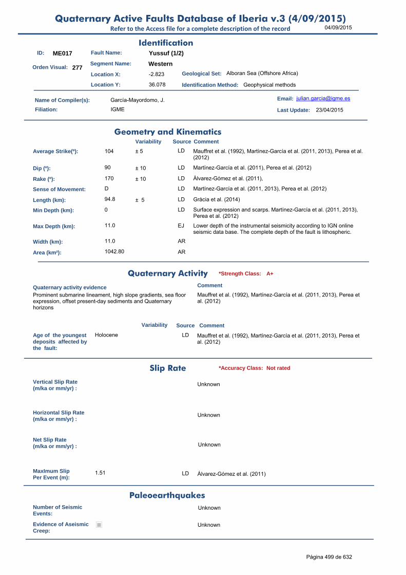
04/09/2015Quaternary Active Faults Database of Iberia v.3 (4/09/2015)
Refer to the Access file for a complete description of the record
ID: ME017 Fault Name: Yussuf (1/2)
Segment Name: Western
Location X: -2.823
Location Y: 36.078
Name of Compiler(s): García-Mayordomo, J.
Filiation: IGME
Email: [email protected]
Last Update: 23/04/2015
Average Strike(º): 104 ± 5 LD Mauffret et al. (1992), Martínez-García et al. (2011, 2013), Perea et al. (2012)
Dip (º): 90 ± 10 LD Martínez-García et al. (2011), Perea et al. (2012)
Rake (º): 170 ± 10 LD Álvarez-Gómez et al. (2011),
Sense of Movement: D LD Martínez-García et al. (2011, 2013), Perea et al. (2012)
Length (km): 94.8 ± 5 LD Gràcia et al. (2014)
Min Depth (km): 0 LD Surface expression and scarps. Martínez-García et al. (2011, 2013), Perea et al. (2012)
Max Depth (km): 11.0 EJ Lower depth of the instrumental seismicity according to IGN online seismic data base. The complete depth of the fault is lithospheric.
Width (km): 11.0 AR
Area (km²): 1042.80 AR
Age of the youngestdeposits affected bythe fault:
Holocene LD Mauffret et al. (1992), Martínez-García et al. (2011, 2013), Perea et al. (2012)
Vertical Slip Rate(m/ka or mm/yr) :
Unknown
Horizontal Slip Rate(m/ka or mm/yr) :
Unknown
Net Slip Rate(m/ka or mm/yr) : Unknown
MaxImum Slip Per Event (m):
1.51 LD Álvarez-Gómez et al. (2011)
Number of SeismicEvents:
Unknown
Evidence of AseismicCreep:
Unknown
Identification
Geometry and KinematicsVariability Source Comment
Quaternary Activity
Variability Source
Comment
Prominent submarine lineament, high slope gradients, sea floor expression, offset present-day sediments and Quaternary horizons
Mauffret et al. (1992), Martínez-García et al. (2011, 2013), Perea et al. (2012)
Geological Set: Alboran Sea (Offshore Africa)
Identification Method: Geophysical methods
Comment
Quaternary activity evidence
A+*Strength Class:
Slip Rate *Accuracy Class: Not rated
Paleoearthquakes
Orden Visual: 277
Página 499 de 632

04/09/2015Quaternary Active Faults Database of Iberia v.3 (4/09/2015)
Refer to the Access file for a complete description of the record
Maximun Magnitude(Mw):
7.33 ± 0.37 ER Mw from length using Stirling et al (2002) equation derived from the instrumental dataset. Mw is 7.37 (± 0.3) according to Wells & Coppersmith (1994) from L/Mw relationship.
RecurrenceInterval (years) :
Not enough data for an estimation
Date of Last MaximumEarthquake (years) :
Unknown
Extended Information: EXTENDED_INFORMATION\ME017-ME020.rar
Álvarez-Gómez, J. A., Aniel-Quiroga, Í., González, M., Olabarrieta, M., Carreño, E., 2011. Scenarios for earthquake-generated tsunamis on the Alboran Sea, Western Mediterranean. Marine Geology, 284:55-73.
Bartolomé, R., Gràcia, E., Lo Iacono, C., Martínez-Loriente, S., Moreno, X., Perea, H., Masana, E., EVENT-DEEP TEAM (2010). Seismic imaging of active faults in the Southern Alboran Sea (SE Iberian Margin): First results of the 2010 EVENT-DEEP cruise. En: Contribución de la Geología al Análisis de la Peligrosidad Sísmica (J.M. Insúa y F.Martín-González, eds.), pp. 155-158. IBERFAULT, Sigüenza (Guadalajara), 27-29 Octubre 2010.
Gràcia, E., Bartolomé, R., Lo Iacono, C., Moreno, X., Martínez-Loriente, S., Perea, H., Masana, E., Pallàs, R., Díez, S., Dañobeitia, J.J., Terrinha, P., Zitellini, N. (2010). Characterizing active faults and associated mass transport deposits in the South Iberian Margin (Alboran Sea and Gulf of Cadiz): On-fault and off-fault paleoseismic evidence. En: Contribución de la Geología al Análisis de la Peligrosidad Sísmica (J.M. Insúa y F.Martín-González, eds.), pp. 163-166. IBERFAULT, Sigüenza (Guadalajara), 27-29 Octubre 2010.
Gràcia, E. et al. (2014) Seismic hazard of active faults in the Alboran sea inferred from submarine paleosismology. Resúmenes de la 2ª Reunión Ibérica sobre Fallas Activas y Paleosismología (IBERFAULT), Lorca, España, 101-104.
Martínez-García, P., Soto, J.I. & Comas, M. (2011). Recent structures in the Alboran Ridge and Yusuf fault zones based on swath bathymetry and sub-bottom profiling: evidence of active tectonics. Geo-Mar. Lett., 31, 16–39. doi:10.1007/s00367-010-0212-0.
Martínez-García, P., Comas, M., Soto, J.I., Lonergan, L. & Watts, A.B. (2013). Strike-slip tectonics and basin inversion in the Western Mediterranean: the Post-Messinian evolution of the Alboran Sea. Basin Research (2013) 25, 1–27, doi: 10.1111/bre.12005.
Mauffret A, Maldonado A, Campillo AC (1992) Tectonic framework of the eastern Alboran and western Algerian basins, westernMediterranean. Geo Mar Lett 12(2/3):104–110. doi:10.1007/ BF02084919
Perea, H., Gràcia, E., Bartolomé, R., Ranero, C.R., Lo Iacono, C., Martínez- Loriente, S., Moreno, X.and EVENT-DEEP and TOPOMED-GASSIS teams (2012) The strike-slip Yussuf fault system (Alboran Sea): Multi-scale seismic imaging and evidences of Quaternary activity. Abstract in PANAF meeting, Istambul, October 8- 10, 2012.
Stirling, M., Rhoades, D. and Berryman K. (2002): Comparison of Earthquake Scaling Relations Derived from Data of the Instrumental and Preinstrumental Era. Bulletin of the Seismological Society of America, 92 (2): 812–830.
Wells, D. L., and Coppersmith, K. J. (1994). New empirical relationships among magnitude, rupture length, rupture width, and surface displacement. Bulleting of the Seismological Society of America 84, 974-1002.
Seismic PotentialSource Comment
Associated Seismicity
Extended Data and References
References
Variability
*Reliability rating: A
*Reliability rating: Not rated
Página 500 de 632

04/09/2015Quaternary Active Faults Database of Iberia v.3 (4/09/2015)
Refer to the Access file for a complete description of the record
ID: ME018 Fault Name: Yussuf (2/2)
Segment Name: Eastern
Location X: -2.128
Location Y: 35.883
Name of Compiler(s): García-Mayordomo, J.
Filiation: IGME
Email: [email protected]
Last Update: 23/04/2015
Average Strike(º): 001 ± 5 LD Mauffret et al. (1992), Martínez-García et al. (2011, 2013), Perea et al. (2012)
Dip (º): 90 ± 10 LD Martínez-García et al. (2011), Perea et al. (2012)
Rake (º): 170 ± 10 LD Álvarez-Gómez et al. (2011),
Sense of Movement: D LD Martínez-García et al. (2011, 2013), Perea et al. (2012)
Length (km): 98.6 ± 10 LD Gràcia et al. (2014)
Min Depth (km): 0 LD Surface expression and scarps. Martínez-García et al. (2011, 2013), Perea et al. (2012)
Max Depth (km): 11.0 EJ Lower depth of the instrumental seismicity according to IGN online seismic data base. The complete depth of the fault is lithospheric.
Width (km): 11.0 AR
Area (km²): 1084.60 AR
Age of the youngestdeposits affected bythe fault:
Holocene LD Mauffret et al. (1992), Martínez-García et al. (2011, 2013), Perea et al. (2012)
Vertical Slip Rate(m/ka or mm/yr) :
Unknown
Horizontal Slip Rate(m/ka or mm/yr) :
Unknown
Net Slip Rate(m/ka or mm/yr) : Unknown
MaxImum Slip Per Event (m):
1.39 LD Álvarez-Gómez et al. (2011)
Number of SeismicEvents:
Unknown
Evidence of AseismicCreep:
Unknown
Identification
Geometry and KinematicsVariability Source Comment
Quaternary Activity
Variability Source
Comment
Prominent submarine lineament, high slope gradients, sea floor expression, offset present-day sediments and Quaternary horizons
Mauffret et al. (1992), Martínez-García et al. (2011, 2013), Perea et al. (2012)
Geological Set: Alboran Sea (Offshore Argelia)
Identification Method: Geophysical methods
Comment
Quaternary activity evidence
A+*Strength Class:
Slip Rate *Accuracy Class: Not rated
Paleoearthquakes
Orden Visual: 278
Página 501 de 632

04/09/2015Quaternary Active Faults Database of Iberia v.3 (4/09/2015)
Refer to the Access file for a complete description of the record
Maximun Magnitude(Mw):
7.34 ± 0.37 ER Mw from length using Stirling et al (2002) equation derived from the instrumental dataset. Mw is 7.39 (± 0.3) according to Wells & Coppersmith (1994) from L/Mw relationship.
RecurrenceInterval (years) :
Not enough data for an estimation
Date of Last MaximumEarthquake (years) :
Unknown
Extended Information: EXTENDED_INFORMATION\ME017-ME020.rar
Álvarez-Gómez, J. A., Aniel-Quiroga, Í., González, M., Olabarrieta, M., Carreño, E., 2011. Scenarios for earthquake-generated tsunamis on the Alboran Sea, Western Mediterranean. Marine Geology, 284:55-73.
Bartolomé, R., Gràcia, E., Lo Iacono, C., Martínez-Loriente, S., Moreno, X., Perea, H., Masana, E., EVENT-DEEP TEAM (2010). Seismic imaging of active faults in the Southern Alboran Sea (SE Iberian Margin): First results of the 2010 EVENT-DEEP cruise. En: Contribución de la Geología al Análisis de la Peligrosidad Sísmica (J.M. Insúa y F.Martín-González, eds.), pp. 155-158. IBERFAULT, Sigüenza (Guadalajara), 27-29 Octubre 2010.
Gràcia, E., Bartolomé, R., Lo Iacono, C., Moreno, X., Martínez-Loriente, S., Perea, H., Masana, E., Pallàs, R., Díez, S., Dañobeitia, J.J., Terrinha, P., Zitellini, N. (2010). Characterizing active faults and associated mass transport deposits in the South Iberian Margin (Alboran Sea and Gulf of Cadiz): On-fault and off-fault paleoseismic evidence. En: Contribución de la Geología al Análisis de la Peligrosidad Sísmica (J.M. Insúa y F.Martín-González, eds.), pp. 163-166. IBERFAULT, Sigüenza (Guadalajara), 27-29 Octubre 2010.
Gràcia, E. et al. (2014) Seismic hazard of active faults in the Alboran sea inferred from submarine paleosismology. Resúmenes de la 2ª Reunión Ibérica sobre Fallas Activas y Paleosismología (IBERFAULT), Lorca, España, 101-104.
Martínez-García, P., Soto, J.I. & Comas, M. (2011). Recent structures in the Alboran Ridge and Yusuf fault zones based on swath bathymetry and sub-bottom profiling: evidence of active tectonics. Geo-Mar. Lett., 31, 16–39. doi:10.1007/s00367-010-0212-0.
Martínez-García, P., Comas, M., Soto, J.I., Lonergan, L. & Watts, A.B. (2013). Strike-slip tectonics and basin inversion in the Western Mediterranean: the Post-Messinian evolution of the Alboran Sea. Basin Research (2013) 25, 1–27, doi: 10.1111/bre.12005.
Mauffret A, Maldonado A, Campillo AC (1992) Tectonic framework of the eastern Alboran and western Algerian basins, westernMediterranean. Geo Mar Lett 12(2/3):104–110. doi:10.1007/ BF02084919
Perea, H., Gràcia, E., Bartolomé, R., Ranero, C.R., Lo Iacono, C., Martínez- Loriente, S., Moreno, X.and EVENT-DEEP and TOPOMED-GASSIS teams (2012) The strike-slip Yussuf fault system (Alboran Sea): Multi-scale seismic imaging and evidences of Quaternary activity. Abstract in PANAF meeting, Istambul, October 8- 10, 2012.
Stirling, M., Rhoades, D. and Berryman K. (2002): Comparison of Earthquake Scaling Relations Derived from Data of the Instrumental and Preinstrumental Era. Bulletin of the Seismological Society of America, 92 (2): 812–830.
Wells, D. L., and Coppersmith, K. J. (1994). New empirical relationships among magnitude, rupture length, rupture width, and surface displacement. Bulleting of the Seismological Society of America 84, 974-1002.
Seismic PotentialSource Comment
Associated Seismicity
Extended Data and References
References
Variability
*Reliability rating: A
*Reliability rating: Not rated
Página 502 de 632

04/09/2015Quaternary Active Faults Database of Iberia v.3 (4/09/2015)
Refer to the Access file for a complete description of the record
ID: ME019 Fault Name: Al-Idrisi (1/2)
Segment Name: Northern
Location X: -3.68717631
Location Y: 35.63777476
Name of Compiler(s): García-Mayordomo, J.
Filiation: IGME
Email: [email protected]
Last Update: 23/04/2015
Average Strike(º): 030 ± 2 LD Gràcia et al. (2014), Martínez-García et al. (2011, 2013)
Dip (º): 75 ± 10 LD Álvarez-Gómez et al. (2011), Martínez-García et al. (2011, 2013)
Rake (º): 10 LD Álvarez-Gómez et al. (2011)
Sense of Movement: S LD Álvarez-Gómez et al. (2011), Martínez-García et al. (2011, 2013)
Length (km): 54.5 ± 5 LD Gràcia et al. (2014)
Min Depth (km): 0 LD Martínez-García et al. (2011, 2013)
Max Depth (km): 11.0 11-15 EJ Assumed the same value as in other similar faults in the area.
Width (km): 11.4 AR
Area (km²): 620.65 AR
Age of the youngestdeposits affected bythe fault:
<0.79 ma Holocene LD Martínez-García (2013). Very likely Holocene as the fault reaches up to the surface.
Vertical Slip Rate(m/ka or mm/yr) :
Unknown
Horizontal Slip Rate(m/ka or mm/yr) :
Unknown
Net Slip Rate(m/ka or mm/yr) : Unknown
MaxImum Slip Per Event (m):
Unknown
Number of SeismicEvents:
Unknown
Evidence of AseismicCreep:
Unknown
Identification
Geometry and KinematicsVariability Source Comment
Quaternary Activity
Variability Source
Comment
Seismic Potential
Surface expression, offset Quaternary horizons. Gràcia et al. (2014), Martínez-García et al. (2011, 2013)
Geological Set: Alboran Sea (Offshore Africa)
Identification Method: Geophysical methods
Comment
Quaternary activity evidence
A+*Strength Class:
Slip Rate *Accuracy Class: Not rated
Paleoearthquakes
Orden Visual: 279
Página 503 de 632

04/09/2015Quaternary Active Faults Database of Iberia v.3 (4/09/2015)
Refer to the Access file for a complete description of the record
Maximun Magnitude(Mw):
7.10 ± 0.37 ER Mw from length using Stirling et al (2002) equation derived from the instrumental dataset. Mw is 7.09 (± 0.3) according to Wells & Coppersmith (1994) from L/Mw relationship.
RecurrenceInterval (years) :
Not enough data for an estimation
Date of Last MaximumEarthquake (years) :
Unknown
Extended Information: EXTENDED_INFORMATION\ME017-ME020.rar
Álvarez-Gómez, J. A., Aniel-Quiroga, Í., González, M., Olabarrieta, M., Carreño, E., 2011. Scenarios for earthquake-generated tsunamis on the Alboran Sea, Western Mediterranean. Marine Geology, 284:55-73.
Bartolomé, R., Gràcia, E., Lo Iacono, C., Martínez-Loriente, S., Moreno, X., Perea, H., Masana, E., EVENT-DEEP TEAM (2010). Seismic imaging of active faults in the Southern Alboran Sea (SE Iberian Margin): First results of the 2010 EVENT-DEEP cruise. En: Contribución de la Geología al Análisis de la Peligrosidad Sísmica (J.M. Insúa y F.Martín-González, eds.), pp. 155-158. IBERFAULT, Sigüenza (Guadalajara), 27-29 Octubre 2010.
Gràcia, E., Bartolomé, R., Lo Iacono, C., Moreno, X., Martínez-Loriente, S., Perea, H., Masana, E., Pallàs, R., Díez, S., Dañobeitia, J.J., Terrinha, P., Zitellini, N. (2010). Characterizing active faults and associated mass transport deposits in the South Iberian Margin (Alboran Sea and Gulf of Cadiz): On-fault and off-fault paleoseismic evidence. En: Contribución de la Geología al Análisis de la Peligrosidad Sísmica (J.M. Insúa y F.Martín-González, eds.), pp. 163-166. IBERFAULT, Sigüenza (Guadalajara), 27-29 Octubre 2010.
Gràcia, E. et al. (2014) Seismic hazard of active faults in the Alboran sea inferred from submarine paleosismology. Resúmenes de la 2ª Reunión Ibérica sobre Fallas Activas y Paleosismología (IBERFAULT), Lorca, España, 101-104.
Martínez-García, P., Soto, J.I. & Comas, M. (2011). Recent structures in the Alboran Ridge and Yusuf fault zones based on swath bathymetry and sub-bottom profiling: evidence of active tectonics. Geo-Mar. Lett., 31, 16–39. doi:10.1007/s00367-010-0212-0.
Martínez-García, P., Comas, M., Soto, J.I., Lonergan, L. & Watts, A.B. (2013). Strike-slip tectonics and basin inversion in the Western Mediterranean: the Post-Messinian evolution of the Alboran Sea. Basin Research (2013) 25, 1–27, doi: 10.1111/bre.12005.
Stirling, M., Rhoades, D. and Berryman K. (2002): Comparison of Earthquake Scaling Relations Derived from Data of the Instrumental and Preinstrumental Era. Bulletin of the Seismological Society of America, 92 (2): 812–830.
Wells, D. L., and Coppersmith, K. J. (1994). New empirical relationships among magnitude, rupture length, rupture width, and surface displacement. Bulleting of the Seismological Society of America 84, 974-1002.
Source Comment
Associated Seismicity
Extended Data and References
References
Variability
*Reliability rating: A
*Reliability rating: Not rated
Página 504 de 632

04/09/2015Quaternary Active Faults Database of Iberia v.3 (4/09/2015)
Refer to the Access file for a complete description of the record
ID: ME020 Fault Name: Al-Idrisi (2/2)
Segment Name: Southern
Location X: -3.74400324
Location Y: 35.45305063
Name of Compiler(s): García-Mayordomo, J.
Filiation: IGME
Email: [email protected]
Last Update: 23/04/2015
Average Strike(º): 008 ± 2 LD Martínez-García et al. (2011, 2013), Gràcia et al. (2014)
Dip (º): 75 ± 10 LD Álvarez-Gómez et al. (2011), Martínez-García et al. (2011, 2013)
Rake (º): 10 LD Álvarez-Gómez et al. (2011)
Sense of Movement: S LD Álvarez-Gómez et al. (2011), Martínez-García et al. (2011, 2013)
Length (km): 17.2 17-50 LD Gràcia et al. (2014). Very likely the fault zone extends southwards into the seismic cluster of Al-Hoicema and even onshore along Trougout fault (d'Acremont et al., 2014)
Min Depth (km): 0 LD Martínez-García et al. (2011, 2013)
Max Depth (km): 11.0 11-15 LD Assumed the same value as in other similar faults in the area.
Width (km): 11.4 AR
Area (km²): 195.87 AR
Age of the youngestdeposits affected bythe fault:
<0.79 ma Holocene LD Martínez-García et al. (2011, 2013).Very likely Holocene as the fault reaches up to the surface. Southward extension of the fault may be related to scarps produced by the Al-Hoicema seismic events (d'Acremont et al., 2014).
Vertical Slip Rate(m/ka or mm/yr) :
Unknown
Horizontal Slip Rate(m/ka or mm/yr) :
Unknown
Net Slip Rate(m/ka or mm/yr) : Unknown
MaxImum Slip Per Event (m):
Unknown
Number of SeismicEvents:
Unknown
Evidence of AseismicCreep:
Unknown
Identification
Geometry and KinematicsVariability Source Comment
Quaternary Activity
Variability Source
Comment
Surface expression, offset Quaternary horizons, likely relation to Al-Hoicema earthquake series
Martínez-García et al. (2011, 2013), Bartolomé et al. (2013), Gràcia et al. (2014), d'Acremont et al. (2014).
Geological Set: Alboran Sea (Offshore Africa)
Identification Method: Geophysical methods
Comment
Quaternary activity evidence
A+*Strength Class:
Slip Rate *Accuracy Class: Not rated
Paleoearthquakes
Orden Visual: 280
Página 505 de 632

04/09/2015Quaternary Active Faults Database of Iberia v.3 (4/09/2015)
Refer to the Access file for a complete description of the record
Maximun Magnitude(Mw):
6.62 ± 0.37 ER Mw from length using Stirling et al (2002) equation derived from the instrumental dataset. Mw is 6.51 (± 0.3) according to Wells & Coppersmith (1994) from L/Mw relationship. Mw could much larger as the fault very likely extends southwards.
RecurrenceInterval (years) :
Not enough data for an estimation
Date of Last MaximumEarthquake (years) :
Unknown
Extended Information: EXTENDED_INFORMATION\ME017-ME020.rar
Álvarez-Gómez, J. A., Aniel-Quiroga, Í., González, M., Olabarrieta, M., Carreño, E., 2011. Scenarios for earthquake-generated tsunamis on the Alboran Sea, Western Mediterranean. Marine Geology, 284:55-73.
Bartolomé, R., Gràcia, E., Lo Iacono, C., Martínez-Loriente, S., Moreno, X., Perea, H., Masana, E., EVENT-DEEP TEAM (2010). Seismic imaging of active faults in the Southern Alboran Sea (SE Iberian Margin): First results of the 2010 EVENT-DEEP cruise. En: Contribución de la Geología al Análisis de la Peligrosidad Sísmica (J.M. Insúa y F.Martín-González, eds.), pp. 155-158. IBERFAULT, Sigüenza (Guadalajara), 27-29 Octubre 2010.
d'Acremont, E., M.-A. Gutscher, A. Rabaute, Mercier de Lépinay, M. Lafosse, J.Poort, A.Ammar, A. Tahayt, P. Le Royc, J. Smit, D. Do Couto, R. Cancouët, C. Prunier, G. Ercilla, C. Gorini (2014). High-resolution imagery of active faulting offshore Al Hoceima, Northern Morocco. Tectonophysics, 632:160–166.
Gràcia, E., Bartolomé, R., Lo Iacono, C., Moreno, X., Martínez-Loriente, S., Perea, H., Masana, E., Pallàs, R., Díez, S., Dañobeitia, J.J., Terrinha, P., Zitellini, N. (2010). Characterizing active faults and associated mass transport deposits in the South Iberian Margin (Alboran Sea and Gulf of Cadiz): On-fault and off-fault paleoseismic evidence. En: Contribución de la Geología al Análisis de la Peligrosidad Sísmica (J.M. Insúa y F.Martín-González, eds.), pp. 163-166. IBERFAULT, Sigüenza (Guadalajara), 27-29 Octubre 2010.
Gràcia, E. et al. (2014) Seismic hazard of active faults in the Alboran sea inferred from submarine paleosismology. Resúmenes de la 2ª Reunión Ibérica sobre Fallas Activas y Paleosismología (IBERFAULT), Lorca, España, 101-104.
Martínez-García, P., Soto, J.I. & Comas, M. (2011). Recent structures in the Alboran Ridge and Yusuf fault zones based on swath bathymetry and sub-bottom profiling: evidence of active tectonics. Geo-Mar. Lett., 31, 16–39. doi:10.1007/s00367-010-0212-0.
Martínez-García, P., Comas, M., Soto, J.I., Lonergan, L. & Watts, A.B. (2013). Strike-slip tectonics and basin inversion in the Western Mediterranean: the Post-Messinian evolution of the Alboran Sea. Basin Research (2013) 25, 1–27, doi: 10.1111/bre.12005.
Stirling, M., Rhoades, D. and Berryman K. (2002): Comparison of Earthquake Scaling Relations Derived from Data of the Instrumental and Preinstrumental Era. Bulletin of the Seismological Society of America, 92 (2): 812–830.
Wells, D. L., and Coppersmith, K. J. (1994). New empirical relationships among magnitude, rupture length, rupture width, and surface displacement. Bulleting of the Seismological Society of America 84, 974-1002.
Seismic PotentialSource Comment
Associated Seismicity
Extended Data and References
References
Variability
*Reliability rating: A
*Reliability rating: Not rated
Página 506 de 632
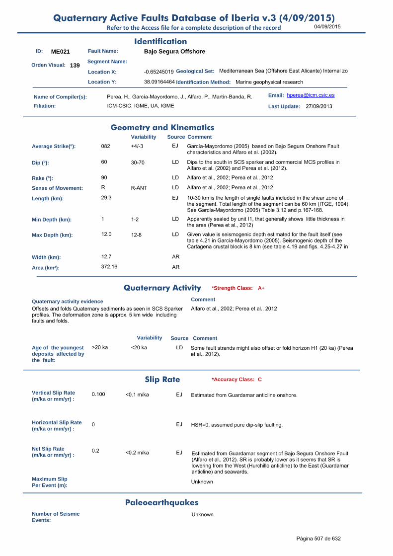
04/09/2015Quaternary Active Faults Database of Iberia v.3 (4/09/2015)
Refer to the Access file for a complete description of the record
ID: ME021 Fault Name: Bajo Segura Offshore
Segment Name:
Location X: -0.65245019
Location Y: 38.09164464
Name of Compiler(s): Perea, H., García-Mayordomo, J., Alfaro, P., Martín-Banda, R.
Filiation: ICM-CSIC, IGME, UA, IGME
Email: [email protected]
Last Update: 27/09/2013
Average Strike(º): 082 +4/-3 EJ García-Mayordomo (2005) based on Bajo Segura Onshore Fault characteristics and Alfaro et al. (2002).
Dip (º): 60 30-70 LD Dips to the south in SCS sparker and commercial MCS profiles in Alfaro et al. (2002) and Perea et al. (2012).
Rake (º): 90 LD Alfaro et al., 2002; Perea et al., 2012
Sense of Movement: R R-ANT LD Alfaro et al., 2002; Perea et al., 2012
Length (km): 29.3 EJ 10-30 km is the length of single faults included in the shear zone of the segment. Total length of the segment can be 60 km (ITGE, 1994). See García-Mayordomo (2005) Table 3.12 and p.167-168.
Min Depth (km): 1 1-2 LD Apparently sealed by unit I1, that generally shows little thickness in the area (Perea et al., 2012)
Max Depth (km): 12.0 12-8 LD Given value is seismogenic depth estimated for the fault itself (see table 4.21 in García-Mayordomo (2005). Seismogenic depth of the Cartagena crustal block is 8 km (see table 4.19 and figs. 4.25-4.27 in
Width (km): 12.7 AR
Area (km²): 372.16 AR
Age of the youngestdeposits affected bythe fault:
>20 ka <20 ka LD Some fault strands might also offset or fold horizon H1 (20 ka) (Perea et al., 2012).
Vertical Slip Rate(m/ka or mm/yr) :
0.100 <0.1 m/ka EJ Estimated from Guardamar anticline onshore.
Horizontal Slip Rate(m/ka or mm/yr) :
0 EJ HSR=0, assumed pure dip-slip faulting.
Net Slip Rate(m/ka or mm/yr) :
0.2 <0.2 m/ka EJ Estimated from Guardamar segment of Bajo Segura Onshore Fault (Alfaro et al., 2012). SR is probably lower as it seems that SR is lowering from the West (Hurchillo anticline) to the East (Guardamar anticline) and seawards.
MaxImum Slip Per Event (m):
Unknown
Number of SeismicEvents:
Unknown
Identification
Geometry and KinematicsVariability Source Comment
Quaternary Activity
Variability Source
Comment
Offsets and folds Quaternary sediments as seen in SCS Sparker profiles. The deformation zone is approx. 5 km wide including faults and folds.
Alfaro et al., 2002; Perea et al., 2012
Geological Set: Mediterranean Sea (Offshore East Alicante) Internal zo
Identification Method: Marine geophysical research
Comment
Quaternary activity evidence
A+*Strength Class:
Slip Rate *Accuracy Class: C
Paleoearthquakes
Orden Visual: 139
Página 507 de 632

04/09/2015Quaternary Active Faults Database of Iberia v.3 (4/09/2015)
Refer to the Access file for a complete description of the record
Evidence of AseismicCreep:
Unknown
Maximun Magnitude(Mw):
6.80 ± 0.37 ER Magnitude from length using Stirling et al (2002) equation derived from the instrumental dataset.
RecurrenceInterval (years) :
9256 Unstated AR Considering the Maximum Earthquake Model (W'86): RI = Mo f(6.8±0.37) / Mo f(SR=0.2). RI should be longer than Bajo Segura Onshore, as slip rate decreases from W to E (Alfaro et al. 2012). The occurrence of smaller, damaging earthquakes may be much shorter
Date of Last MaximumEarthquake (years) :
Unknown
Extended Information:
Alfaro, P., Delgado, J., A. Estévez, Soria, J.M. y Yébenes, A. (2002a). Onshore and offshore compressional tectonics in the eastern Betic Cordillera (SE Spain). Marine Geology, 186, 337-349.
Alfaro, P., Andreu, J.M., J. Delgado, Estévez, A., Soria, J.M. y Teixido, T. (2002b). Quaternary deformation of the Bajo Segura blind fault (eastern Betic Cordillera, Spain) revealed by high resolution reflection profiling. Geological Magazine, 139(3), 331-341.
Alfaro, A., Bartolomé, R., Borque, M.J., Estévez, A., García-Mayordomo, J., García-Tortosa, F.J., Gil, A., Gràcia, E., Lo Iacono, C., Perea, H. (2012): The Bajo Segura Fault Zone: Active blind thrusting in the Eastern Betic Cordillera (SE Spain). Journal of Iberian
Geology, 38(1): 271-284.
Garcia-Mayordomo, J. (2005). Caracterización y Análisis de la Peligrosidad Sísmica en el Sureste de España. Tesis Doctoral, Universidad Complutense de Madrid, 373 pp.
I.T.G.E. (1994a). Mapa Geológico de la Plataforma Continental Española y Zonas Adyacentes a escala 1:200.000. Hoja nº 72-73, Elche-Alicante.
Perea, H., Gràcia, E., Alfaro, P., Bartolomé, R., Lo Iacono, C., Moreno, X., Masana, E., and EVENT-SHELF Team (2012): Quaternary active tectonic structures in the offshore Bajo Segura basin (SE Iberian Peninsula – Mediterranean Sea), Natural Hazards and Earth System Science, 12: 3151-3168, doi:10.5194/nhess-12-3151-2012, 2012.
Stirling, M., Rhoades, D. and Berryman K. (2002): Comparison of Earthquake Scaling Relations Derived from Data of the Instrumental and Preinstrumental Era. Bulletin of the Seismological Society of America, 92 (2): 812–830.
Taboada, A., Bousquet, J.C. y Philip, H. (1993). Coseismic elastic models of folds above blindthrusts in the Betic Cordilleras (spain) and evaluation of seismic hazard. Tectonophysics, 220,223-241.
Seismic PotentialSource Comment
Associated Seismicity
Extended Data and References
References
Variability
*Reliability rating: A
*Reliability rating: C
Página 508 de 632
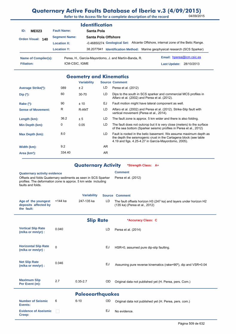
04/09/2015Quaternary Active Faults Database of Iberia v.3 (4/09/2015)
Refer to the Access file for a complete description of the record
ID: ME023 Fault Name: Santa Pola
Segment Name: Santa Pola Offshore
Location X: -0.46850274
Location Y: 38.2077941
Name of Compiler(s): Perea, H., García-Mayordomo, J. and Martín-Banda, R.
Filiation: ICM-CSIC, IGME
Email: [email protected]
Last Update: 28/10/2013
Average Strike(º): 089 ± 2 LD Perea et al. (2012)
Dip (º): 60 30-70 LD Dips to the south in SCS sparker and commercial MCS profiles in Alfaro et al. (2002) and Perea et al. (2012).
Rake (º): 90 ± 10 EJ Fault motion might have lateral component as well.
Sense of Movement: R R-ANT LD Alfaro et al. (2002) and Perea et al. (2012). Strike-Slip fault with vertical movement (Perea et al., 2014).
Length (km): 36.2 ± 5 LD The fault zone is approx. 5 km wider and there is also folding.
Min Depth (km): 0 0.05 LD The fault does not outcrop but it is very close (meters) to the surface of the sea bottom (Sparker seismic profiles in Perea et al., 2012)
Max Depth (km): 8.0 LD Fault is rooted in the betic basement. We assume maximum depth as the depth the seismogenic crust in the Cartagena block (see table 4.19 and figs. 4.25-4.27 in García-Mayordomo, 2005).
Width (km): 9.2 AR
Area (km²): 334.40 AR
Age of the youngestdeposits affected bythe fault:
<144 ka 247-135 ka LD The fault offsets horizon H3 (247 ka) and layers under horizon H2 (135 ka) (Perea et al., 2012)
Vertical Slip Rate(m/ka or mm/yr) :
0.040 LD Perea et al. (2014)
Horizontal Slip Rate(m/ka or mm/yr) :
0 EJ HSR=0, assumed pure dip-slip faulting.
Net Slip Rate(m/ka or mm/yr) :
0.046 EJ Assuming pure reverse kinematics (rake=90º), dip and VSR=0.04
MaxImum Slip Per Event (m):
2.7 0.35-2.7 OD Original data not published yet (H. Perea, pers. Com.)
Number of SeismicEvents:
6 6-10 OD Original data not published yet (H. Perea, pers. com.)
Evidence of AseismicCreep:
EJ No evidence.
Identification
Geometry and KinematicsVariability Source Comment
Quaternary Activity
Variability Source
Comment
Offsets and folds Quaternary sediments as seen in SCS Sparker profiles. The deformation zone is approx. 5 km wide including faults and folds.
Perea et al. (2012)
Geological Set: Alicante Offshore, internal zone of the Betic Range.
Identification Method: Marine geophysical research (SCS Sparker)
Comment
Quaternary activity evidence
A+*Strength Class:
Slip Rate *Accuracy Class: C
Paleoearthquakes
Orden Visual: 140
Página 509 de 632

04/09/2015Quaternary Active Faults Database of Iberia v.3 (4/09/2015)
Refer to the Access file for a complete description of the record
Maximun Magnitude(Mw):
6.90 ± 0.37 ER Magnitude from length using Stirling et al (2002) equation derived from the instrumental dataset. According to Perea et al. (2014) the Mw varies between 5.9 and 7.1 using Wells and Coppersmith (1994) relationships.
RecurrenceInterval (years) :
60536 Unstated LD Considering the Maximum Earthquake Model (Wesnousky, 1986). Perea et al. (2014) estimates 3,000-50,000 yrs considering Mw 5.9-7.1 from W&C'94 and 0.040 m/ka. The occurrence of smaller, damaging earthquakes may be much shorter.
Date of Last MaximumEarthquake (years) :
Unknown
Extended Information: EXTENDED INFORMATION\
Alfaro, P., Delgado, J., A. Estévez, Soria, J.M. y Yébenes, A. (2002a). Onshore and offshore compressional tectonics in the eastern Betic Cordillera (SE Spain). Marine Geology, 186, 337-349.
Garcia-Mayordomo, J. (2005). Caracterización y Análisis de la Peligrosidad Sísmica en el Sureste de España. Tesis Doctoral, Universidad Complutense de Madrid, 373 pp.
Perea, H., Gràcia, E., Alfaro, P., Bartolomé, R., Lo Iacono, C., Moreno, X., Masana, E., and EVENT-SHELF Team: Quaternary active tectonic structures in the offshore Bajo Segura basin (SE Iberian Peninsula – Mediterranean Sea), Natural Hazards and Earth System Science, 12: 3151-3168, doi:10.5194/nhess-12-3151-2012, 2012.
Perea, H., Gràcia, E., Martínez-Loriente, S., and Bartolomé, R. (2014). Submarine paleoseismology on the Santa Pola fault (Bajo Segura Basin, Western Mediterranean): Derivating direct on-fault paleoearthquakes. Resúmenes de la 2ª Reunión Ibérica sobre Fallas Activas y Paleosismología, Lorca, España, 121-124.
Stirling, M., Rhoades, D. and Berryman K. (2002): Comparison of Earthquake Scaling Relations Derived from Data of the Instrumental and Preinstrumental Era. Bulletin of the Seismological Society of America, 92 (2): 812–830.
Wells, D. L., and Coppersmith, K. J. (1994). New empirical relationships among magnitude, rupture length, rupture width, and surface displacement. Bulleting of the Seismological Society of America 84, 974-1002.
Seismic PotentialSource Comment
Associated Seismicity
Extended Data and References
References
Variability
*Reliability rating: A
*Reliability rating: C
Página 510 de 632

04/09/2015Quaternary Active Faults Database of Iberia v.3 (4/09/2015)
Refer to the Access file for a complete description of the record
ID: ME024 Fault Name: La Marina
Segment Name: La Marina Offshore
Location X: -0.6238204
Location Y: 38.1255311
Name of Compiler(s): Perea, H., García-Mayordomo, J., Martín-Banda, R.
Filiation: UTM-CSIC, IGME
Email: [email protected]
Last Update: 28/10/2013
Average Strike(º): 082 ± 2 LD Perea et al. (2012).
Dip (º): 60 30-70 LD As seen in SCS sparker and commercial MCS profiles in Alfaro et al. (2002) and Perea et al. (2012).
Rake (º): 90 LD Alfaro et al. (2002) and Perea et al. (2012).
Sense of Movement: R R-ANT LD Alfaro et al. (2002) and Perea et al. (2012).
Length (km): 38.8 ± 1 LD Perea et al. (2012).
Min Depth (km): 0 0.05 LD The fault does not outcrop but is very close (meters) to the surface of the sea bottom (Sparker seismic profiles in Perea et al., 2012).
Max Depth (km): 8.0 LD Fault is rooted in the betic basement. We assume maximum depth as the depth the seismogenic crust in the Cartagena block (see table 4.19 and figs. 4.25-4.27 in García-Mayordomo, 2005).
Width (km): 9.2 AR
Area (km²): 358.42 AR
Age of the youngestdeposits affected bythe fault:
<135 ka 135-20 ka LD Some fault strands might also offset or fold horizon H1 (20 ka) (Perea et al., 2012).
Vertical Slip Rate(m/ka or mm/yr) :
Unknown
Horizontal Slip Rate(m/ka or mm/yr) :
Unknown
Net Slip Rate(m/ka or mm/yr) : Unknown
MaxImum Slip Per Event (m):
Unknown
Number of SeismicEvents:
Unknown
Evidence of AseismicCreep:
EJ No evidence
Identification
Geometry and KinematicsVariability Source Comment
Quaternary Activity
Variability Source
Comment
Offsets and folds Quaternary sediments as seen in SCS Sparker profiles. The deformation zone is approx. 5 km wide including faults and folds.
Perea et al. (2012)
Geological Set: Alicante Offshore, internal zone of the Betic Range.
Identification Method: Marine geophysical research (SCS Sparker)
Comment
Quaternary activity evidence
A+*Strength Class:
Slip Rate *Accuracy Class: Not rated
Paleoearthquakes
Orden Visual: 141
Página 511 de 632

04/09/2015Quaternary Active Faults Database of Iberia v.3 (4/09/2015)
Refer to the Access file for a complete description of the record
Maximun Magnitude(Mw):
6.96 ± 0.37 ER Magnitude from length using Stirling et al (2002) equation derived from the instrumental dataset.
RecurrenceInterval (years) :
Not enough data for an estimation
Date of Last MaximumEarthquake (years) :
Unknown
Extended Information: EXTENDED INFORMATION\
Alfaro, P., Delgado, J., A. Estévez, Soria, J.M. y Yébenes, A. (2002a). Onshore and offshore compressional tectonics in the eastern Betic Cordillera (SE Spain). Marine Geology, 186, 337-349.
Garcia-Mayordomo, J. (2005). Caracterización y Análisis de la Peligrosidad Sísmica en el Sureste de España. Tesis Doctoral, Universidad Complutense de Madrid, 373 pp.
Perea, H., Gràcia, E., Alfaro, P., Bartolomé, R., Lo Iacono, C., Moreno, X., Masana, E., and EVENT-SHELF Team: Quaternary active tectonic structures in the offshore Bajo Segura basin (SE Iberian Peninsula – Mediterranean Sea), Natural Hazards and Earth System Science, 12: 3151-3168, doi:10.5194/nhess-12-3151-2012, 2012.
Stirling, M., Rhoades, D. and Berryman K. (2002): Comparison of Earthquake Scaling Relations Derived from Data of the Instrumental and Preinstrumental Era. Bulletin of the Seismological Society of America, 92 (2): 812–830.
Seismic PotentialSource Comment
Associated Seismicity
Extended Data and References
References
Variability
*Reliability rating: A
*Reliability rating: Not rated
Página 512 de 632

04/09/2015Quaternary Active Faults Database of Iberia v.3 (4/09/2015)
Refer to the Access file for a complete description of the record
ID: ME025 Fault Name: Barcelona
Segment Name:
Location X: 2.24432473
Location Y: 41.43310306
Name of Compiler(s): Martín Banda, R. and García Mayordomo, J.
Filiation: Universidad Complutense de Madrid and IGME
Email: [email protected]; Julian.
Last Update: 02/06/2014
Average Strike(º): 058 ± 2 LD Compiler's measurement, based on the Neotectonic Map of Spain, scale 1:1.000.000 (IGME and ENRESA, 1998a) and Perea (2006).
Dip (º): 60 ± 20 EJ Typical dip of normal faults.
Rake (º): -90 LD IGME and ENRESA (1998b) and Perea (2006).
Sense of Movement: N LD IGME and ENRESA (1998b) and Perea (2006).
Length (km): 52.0 ± 0.5 LD Compiler's measurement, based on the Neotectonic Map of Spain, scale 1:1.000.000 (IGME and ENRESA, 1998a) and Perea (2006).
Min Depth (km): 0
Max Depth (km): 15.0 ± 5 EJ By comparison to similar records in the area.
Width (km): 17.3 AR
Area (km²): 900.67 AR
Age of the youngestdeposits affected bythe fault:
Quaternary LD ITGE (1989)
Vertical Slip Rate(m/ka or mm/yr) :
Unknown
Horizontal Slip Rate(m/ka or mm/yr) :
Unknown
Net Slip Rate(m/ka or mm/yr) : Unknown
MaxImum Slip Per Event (m):
Unknown
Number of SeismicEvents:
Unknown
Evidence of AseismicCreep:
Unknown
Identification
Geometry and KinematicsVariability Source Comment
Quaternary Activity
Variability Source
Comment
Seismic Potential
It offsets Plio-Quaternary reflectors IGME and ENRESA (1998b).
Geological Set: Catalan Coastal Ranges and northern border of the Val
Identification Method: Marine geophysical methods
Comment
Quaternary activity evidence
B*Strength Class:
Slip Rate *Accuracy Class: Not rated
Paleoearthquakes
Orden Visual: 261
Página 513 de 632

04/09/2015Quaternary Active Faults Database of Iberia v.3 (4/09/2015)
Refer to the Access file for a complete description of the record
Maximun Magnitude(Mw):
7.08 ± 0.37 ER Magnitude from length using Stirling et al (2002) equation derived from the instrumental dataset.
RecurrenceInterval (years) :
Not enough data for an estimation
Date of Last MaximumEarthquake (years) :
Unknown
Extended Information: EXTENDED INFORMATION\
IGME and ENRESA (1998a): Neotectonic Map of Spain, scale 1:1.000.000.
IGME and ENRESA (1998b): Memory of the Neotectonic and Seismotectonic Map of Spain, scale 1:1.000.000. Vol.1
Perea, H. (2006): Falles actives i perillositat sísmica al marge nord-occidental del solc de València, PhD Thesis Universitat de Barcelona, Barcelona, 382 pp.
Stirling, M., Rhoades, D. and Berryman K. (2002): Comparison of Earthquake Scaling Relations Derived from Data of the Instrumental and Preinstrumental Era. Bulletin of the Seismological Society of America, 92 (2): 812–830.
Source Comment
Associated Seismicity
Extended Data and References
References
Variability
*Reliability rating: C
*Reliability rating: Not rated
Página 514 de 632
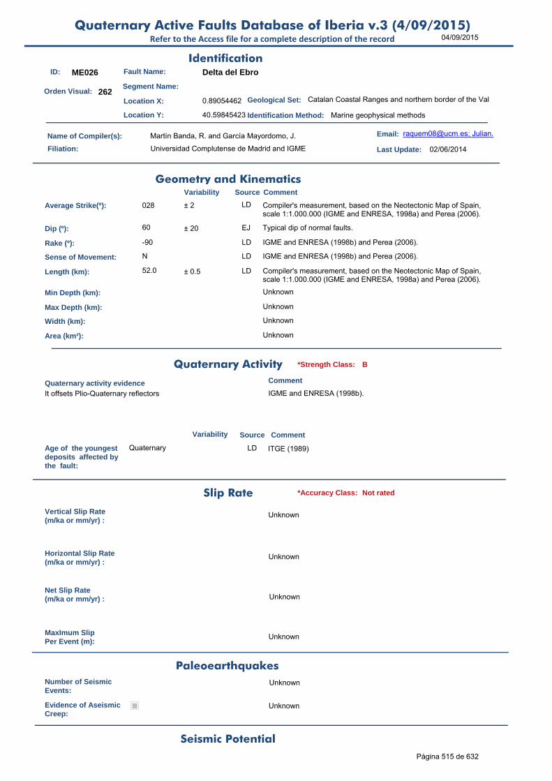
04/09/2015Quaternary Active Faults Database of Iberia v.3 (4/09/2015)
Refer to the Access file for a complete description of the record
ID: ME026 Fault Name: Delta del Ebro
Segment Name:
Location X: 0.89054462
Location Y: 40.59845423
Name of Compiler(s): Martín Banda, R. and García Mayordomo, J.
Filiation: Universidad Complutense de Madrid and IGME
Email: [email protected]; Julian.
Last Update: 02/06/2014
Average Strike(º): 028 ± 2 LD Compiler's measurement, based on the Neotectonic Map of Spain, scale 1:1.000.000 (IGME and ENRESA, 1998a) and Perea (2006).
Dip (º): 60 ± 20 EJ Typical dip of normal faults.
Rake (º): -90 LD IGME and ENRESA (1998b) and Perea (2006).
Sense of Movement: N LD IGME and ENRESA (1998b) and Perea (2006).
Length (km): 52.0 ± 0.5 LD Compiler's measurement, based on the Neotectonic Map of Spain, scale 1:1.000.000 (IGME and ENRESA, 1998a) and Perea (2006).
Min Depth (km): Unknown
Max Depth (km): Unknown
Width (km): Unknown
Area (km²): Unknown
Age of the youngestdeposits affected bythe fault:
Quaternary LD ITGE (1989)
Vertical Slip Rate(m/ka or mm/yr) :
Unknown
Horizontal Slip Rate(m/ka or mm/yr) :
Unknown
Net Slip Rate(m/ka or mm/yr) : Unknown
MaxImum Slip Per Event (m):
Unknown
Number of SeismicEvents:
Unknown
Evidence of AseismicCreep:
Unknown
Identification
Geometry and KinematicsVariability Source Comment
Quaternary Activity
Variability Source
Comment
Seismic Potential
It offsets Plio-Quaternary reflectors IGME and ENRESA (1998b).
Geological Set: Catalan Coastal Ranges and northern border of the Val
Identification Method: Marine geophysical methods
Comment
Quaternary activity evidence
B*Strength Class:
Slip Rate *Accuracy Class: Not rated
Paleoearthquakes
Orden Visual: 262
Página 515 de 632

04/09/2015Quaternary Active Faults Database of Iberia v.3 (4/09/2015)
Refer to the Access file for a complete description of the record
Maximun Magnitude(Mw):
7.08 ± 0.37 ER Magnitude from length using Stirling et al (2002) equation derived from the instrumental dataset.
RecurrenceInterval (years) :
Not enough data for an estimation
Date of Last MaximumEarthquake (years) :
Unknown
Extended Information: EXTENDED INFORMATION\
IGME and ENRESA (1998a): Neotectonic Map of Spain, scale 1:1.000.000.
IGME and ENRESA (1998b): Memory of the Neotectonic and Seismotectonic Map of Spain, scale 1:1.000.000. Vol.1
Perea, H. (2006): Falles actives i perillositat sísmica al marge nord-occidental del solc de València, PhD Thesis Universitat de Barcelona, Barcelona, 382 pp.
Stirling, M., Rhoades, D. and Berryman K. (2002): Comparison of Earthquake Scaling Relations Derived from Data of the Instrumental and Preinstrumental Era. Bulletin of the Seismological Society of America, 92 (2): 812–830.
Source Comment
Associated Seismicity
Extended Data and References
References
Variability
*Reliability rating: C
*Reliability rating: Not rated
Página 516 de 632
04/09/2015Quaternary Active Faults Database of Iberia v.3 (4/09/2015)
Refer to the Access file for a complete description of the record
ID: ME027 Fault Name: Seco de Palos Fault Zone
Segment Name:
Location X: -0.4682901
Location Y: 37.48887825
Name of Compiler(s): Martín Banda, R. and García Mayordomo, J.
Filiation: Universidad Complutense de Madrid and IGME
Email: [email protected]; Julian.
Last Update: 22/07/2014
Average Strike(º): 014 10-16 (max 48) LD Compiler's measurement, based on Acosta et al. (2013).
Dip (º): 90 EJ Based on Acosta et al. (2013).
Rake (º): 0 LD Acosta et al. (2013).
Sense of Movement: S LD Acosta et al. (2013).
Length (km): 40.0 18 to 40 LD 40 km length of the longest strand. 18 km and 32 km length of the other strands in the fault zone (18 km width). Compiler's measurement, based on Acosta et al. (2013).
Min Depth (km): 0 LD Acosta et al. (2013).
Max Depth (km): 8.0 EJ Given value is the depth of the fragile crust. The fault depth is mantelic. García-Mayordomo (2005), table 4.21.
Width (km): 8.0 AR
Area (km²): 320.00 AR
Age of the youngestdeposits affected bythe fault:
Holocene LD Acosta et al. (2013)
Vertical Slip Rate(m/ka or mm/yr) :
0.000 EJ VSR=0, assumed pure strike-slip faulting.
Horizontal Slip Rate(m/ka or mm/yr) :
0.05 <0.05 m/ka EJ By comparison with other active faults in the area (Table 3.30 y Fig. 3.29 in García-Mayordomo, 2005).
Net Slip Rate(m/ka or mm/yr) :
0.05 ± 0.01 AR From HSR and rake
MaxImum Slip Per Event (m):
Unknown
Number of SeismicEvents:
Unknown
Evidence of AseismicCreep:
Unknown
Identification
Geometry and KinematicsVariability Source Comment
Quaternary Activity
Variability Source
Comment
It offsets Quaternary reflectors Acosta et al. (2013).
Geological Set: Betic Range (Murcia)
Identification Method: Marine geophysical methods
Comment
Quaternary activity evidence
B*Strength Class:
Slip Rate *Accuracy Class: C
Paleoearthquakes
Orden Visual: 188
Página 517 de 632
04/09/2015Quaternary Active Faults Database of Iberia v.3 (4/09/2015)
Refer to the Access file for a complete description of the record
Maximun Magnitude(Mw):
6.80 6.6 to 6.9 ER Magnitude from length using Stirling et al (2002) equation derived from the instrumental dataset and 40-18 km length.
RecurrenceInterval (years) :
67096 15578-301026 AR Considering the Maximum Earthquake Model (Wesnousky, 1986): slip rate represents the rate at which maximum earthquakes are released by the fault. RI = Mo f(Mw±d) / Mo f(SR±d). The occurrence of smaller, damaging earthquakes may be much shorter.
Date of Last MaximumEarthquake (years) :
Unknown
Extended Information: EXTENDED INFORMATION\
Acosta J., Fontán A., Muñoz A., Muñoz-Martín, A., Rivera, J., and Uchupi, E. (2013). The morpho-tectonic setting of the Southeast margin of Iberia and the adjacent oceanic Algero-Balear Basin. Marine and Petroleum Geology, 45:17-41.
Garcia-Mayordomo, J. (2005). Caracterización y Análisis de la Peligrosidad Sísmica en el Sureste de España. Tesis Doctoral, Universidad Complutense de Madrid, 373 pp.
Stirling, M., Rhoades, D. and Berryman K. (2002): Comparison of Earthquake Scaling Relations Derived from Data of the Instrumental and Preinstrumental Era. Bulletin of the Seismological Society of America, 92 (2): 812–830.
Wesnousky, S.G. (1986). Earthquakes, Quaternary faults, and seismic hazard in California. Journal of Geophysical Research. 91(B12), 12587-12631.
Seismic PotentialSource Comment
Associated Seismicity
Extended Data and References
References
Variability
*Reliability rating: C
*Reliability rating: C
Página 518 de 632
04/09/2015Quaternary Active Faults Database of Iberia v.3 (4/09/2015)
Refer to the Access file for a complete description of the record
ID: ME028 Fault Name: Don Juan Fault Zone
Segment Name:
Location X: 0.16871986
Location Y: 38.16081517
Name of Compiler(s): Martín Banda, R. and García Mayordomo, J.
Filiation: Universidad Complutense de Madrid and IGME
Email: [email protected]; Julian.
Last Update: 22/07/2014
Average Strike(º): 120 ± 2 LD Compiler's measurement, based on Acosta et al. (2013).
Dip (º): 90 85-90 LD Acosta et al. (2013).
Rake (º): 180 LD Acosta et al. (2013).
Sense of Movement: D LD Acosta et al. (2013).
Length (km): 60.0 38 to 60 LD 60 km length of the longest strand. 38 km length of the other strand in the fault zone (12.5 km width). Compiler's measurement, based on Acosta et al. (2013).
Min Depth (km): 0 LD Acosta et al. (2013).
Max Depth (km): 8.0 EJ Given value is the depth of the fragile crust. The fault depth is mantelic. García-Mayordomo (2005), table 4.21.
Width (km): 8.0 AR
Area (km²): 480.00 AR
Age of the youngestdeposits affected bythe fault:
Holocene LD Acosta et al. (2013).
Vertical Slip Rate(m/ka or mm/yr) :
0.000 EJ VSR=0, assumed pure strike-slip faulting.
Horizontal Slip Rate(m/ka or mm/yr) :
0.05 <0.05 m/ka EJ By comparison with other active faults in the area (Table 3.30 y Fig. 3.29 in García-Mayordomo, 2005).
Net Slip Rate(m/ka or mm/yr) :
0.05 ± 0.01 AR From HSR and rake
MaxImum Slip Per Event (m):
Unknown
Number of SeismicEvents:
Unknown
Evidence of AseismicCreep:
Unknown
Identification
Geometry and KinematicsVariability Source Comment
Quaternary Activity
Variability Source
Comment
It offsets Quaternary reflectors Acosta et al. (2013).
Geological Set: Betic Range (Murcia)
Identification Method: Marine geophysical methods
Comment
Quaternary activity evidence
B*Strength Class:
Slip Rate *Accuracy Class: C
Paleoearthquakes
Orden Visual: 189
Página 519 de 632

04/09/2015Quaternary Active Faults Database of Iberia v.3 (4/09/2015)
Refer to the Access file for a complete description of the record
Maximun Magnitude(Mw):
7.00 6.9 to 7.1 ER Magnitude from length using Stirling et al (2002) equation derived from the instrumental dataset and the lengths of two strands.
RecurrenceInterval (years) :
41578 9653-186539 AR Considering the Maximum Earthquake Model (Wesnousky, 1986): slip rate represents the rate at which maximum earthquakes are released by the fault. RI = Mo f(Mw±d) / Mo f(SR±d). The occurrence of smaller, damaging earthquakes may be much shorter.
Date of Last MaximumEarthquake (years) :
Unknown
Extended Information: EXTENDED INFORMATION\
Acosta J., Fontán A., Muñoz A., Muñoz-Martín, A., Rivera, J., and Uchupi, E. (2013). The morpho-tectonic setting of the Southeast margin of Iberia and the adjacent oceanic Algero-Balear Basin. Marine and Petroleum Geology, 45:17-41.
Garcia-Mayordomo, J. (2005). Caracterización y Análisis de la Peligrosidad Sísmica en el Sureste de España. Tesis Doctoral, Universidad Complutense de Madrid, 373 pp.
Stirling, M., Rhoades, D. and Berryman K. (2002): Comparison of Earthquake Scaling Relations Derived from Data of the Instrumental and Preinstrumental Era. Bulletin of the Seismological Society of America, 92 (2): 812–830.
Wesnousky, S.G. (1986). Earthquakes, Quaternary faults, and seismic hazard in California. Journal of Geophysical Research. 91(B12), 12587-12631.
Seismic PotentialSource Comment
Associated Seismicity
Extended Data and References
References
Variability
*Reliability rating: C
*Reliability rating: C
Página 520 de 632
04/09/2015Quaternary Active Faults Database of Iberia v.3 (4/09/2015)
Refer to the Access file for a complete description of the record
ID: ME029 Fault Name: Las Moreras - Escarpe de Mazarrón (1/3)
Segment Name: Sierra de las Moreras - Cabo Tiñoso
Location X: -1.41273146
Location Y: 37.60068182
Name of Compiler(s): García Mayordomo, J. and Martín Banda, R.
Filiation: IGME and Universidad Complutense de Madrid
Email: [email protected]; raq
Last Update: 22/07/2014
Average Strike(º): 104 + 2 / - 1 LD García-Mayordomo (2005); Acosta et al. (2013). To apply right hand rule criteria dip is considered towards S.
Dip (º): 90 LD García-Mayordomo (2005) Table 4.21.
Rake (º): 180 LD Acosta et al. (2013)
Sense of Movement: D D to R LD García-Mayordomo (2005); Acosta et al. (2013); Echeverria et al. (2013) based on GPS data suggests reverse fault kinematics for this fault.
Length (km): 31.6 ± 0.02 LD Compiler's measurement, based on Acosta et al. (2013).
Min Depth (km): 0 LD This is the onshore continuation of Escarpe de Mazarrón offshore structure (García-Mayordomo, 2005, p.169.; Acosta et al., 2013).
Max Depth (km): 8.0 LD Given value is the depth of the fragile crust. The fault depth is mantelic. García-Mayordomo (2005), table 4.21.
Width (km): 8.0 AR
Area (km²): 252.96 AR
Age of the youngestdeposits affected bythe fault:
Middle Pleistocene
LD Bardají (1999) in García-Mayordomo (2005), p. 169.
Vertical Slip Rate(m/ka or mm/yr) :
0.000 EJ VSR=0, assumed pure strike-slip faulting.
Horizontal Slip Rate(m/ka or mm/yr) :
0.05 <0.05 m/ka EJ By comparison with other active faults in the area (Table 3.30 y Fig. 3.29 in García-Mayordomo, 2005)
Net Slip Rate(m/ka or mm/yr) :
0.05 AR From HSR and rake
MaxImum Slip Per Event (m):
Unknown
Number of SeismicEvents:
Unknown
Evidence of AseismicCreep:
Unknown
Identification
Geometry and KinematicsVariability Source Comment
Quaternary Activity
Variability Source
Comment
Activity of the fault is related to the uplift of Sierra de las Moreras during Lower and Middle Pleistocene (Bardají, 1999).
Bardají (1999) in García-Mayordomo (2005), p. 169.
Geological Set: Betic Range (Murcia)
Identification Method: Geological/Geomorphological field mapping
Comment
Quaternary activity evidence
C*Strength Class:
Slip Rate *Accuracy Class: C
Paleoearthquakes
Orden Visual: 185
Página 521 de 632

04/09/2015Quaternary Active Faults Database of Iberia v.3 (4/09/2015)
Refer to the Access file for a complete description of the record
Maximun Magnitude(Mw):
6.87 ± 0.37 ER Mw from length using Stirling et al (2002) equation derived from the instrumental dataset. Mw is 6.80 (± 0.3) according to García Mayordomo (2005) based on: SRL(31.6 km) vs Mw, from Wells and Coppersmith (1994) and sample "All".
RecurrenceInterval (years) :
Not enough data for an estimation
Date of Last MaximumEarthquake (years) :
Unknown
Extended Information: EXTENDED_INFORMATION\ES600-ES625.rar
Acosta J., Fontán A., Muñoz A., Muñoz-Martín, A., Rivera, J., and Uchupi, E. (2013). The morpho-tectonic setting of the Southeast margin of Iberia and the adjacent oceanic Algero-Balear Basin. Marine and Petroleum Geology, 45:17-41.
Bardají, T. (1999). Evolución geodinámica de las cuencas neógenas del litoral de Murcia y Almería durante el cuaternario. Tesis Doctoral, Universidad Complutense de Madrid, 457 pp.
Comas, M.C., Soto, J.I. y Woodside, J.M. (2000). Structure and related seafloor morphology of the Palomares and Mazarrón margins (Western Mediterranean). En: European Geophysical Society, 25th General Assembly, Katlenburg-Lindau, Germany, abstract.
Coppier, G., Griveaud, P., Larouzière, F. (1989). Example of Neogene tectonic indentation in the Eastern Betic Cordilleras: the Arc of Aguilas (Southeastern Spain). Geodinamica Acta, 3(1), 37-51.
Díaz del Río, V. (1991). El margen continental Bético Mediterráneo. Extremo Bético Oriental. Cuenca de Murcia-Escarpe de Mazarrón. Publicaciones Especiales del Instituto Español de Oceanografía, 6, pp. 239.
Echeverria, A., Khazaradze, G., Asensio, E., Gárate, J., Martín Dávila, J. and Suriñach, E. (2013). Crustal deformation in eastern Betics from CuaTeNeo GPS network, Tectonophysics, 608: 600–612.
Garcia-Mayordomo, J. (2005). Caracterización y Análisis de la Peligrosidad Sísmica en el Sureste de España. Tesis Doctoral, Universidad Complutense de Madrid, 373 pp.
Griveaud, P. Coppier, G., Montenat, C. y Ott d’Estevou, Ph. (1990). Le Néogène des Sierras d'Aguilas. En: Montenat, C. (ed.), Les Bassins néogènes du domaine Bétique oriental(Espagne), Documents et Travaux de l’Institut Geologique Albert de Lapparent, 12-13, 221-238.
I.T.G.E. (1990). Mapa Geológico de la Plataforma Continental Española y Zonas Adyacentes a escala 1:200.000. Hoja nº 79-79E, Murcia.
Stirling, M., Rhoades, D. and Berryman K. (2002): Comparison of Earthquake Scaling Relations Derived from Data of the Instrumental and Preinstrumental Era. Bulletin of the Seismological Society of America, 92 (2): 812–830.
Wells, D.L. y Coppersmith, K.J. (1994). New empirical relationships among magnitude, rupture length, rupture width, rupture area, and surface displacement. Bulletin of the Seismological Society of America, 84(4), 974-1002.
Seismic PotentialSource Comment
Associated Seismicity
Extended Data and References
References
Variability
*Reliability rating: D
*Reliability rating: D
Página 522 de 632

04/09/2015Quaternary Active Faults Database of Iberia v.3 (4/09/2015)
Refer to the Access file for a complete description of the record
ID: ME030 Fault Name: Las Moreras - Escarpe de Mazarrón (2/3)
Segment Name: Cabo Tiñoso - West Cabo de Palos
Location X: -1.16977967
Location Y: 37.53185591
Name of Compiler(s): García-Mayordomo, J. and Martín-Banda, R.
Filiation: IGME and Universidad Complutense de Madrid
Email: [email protected]; raq
Last Update: 22/07/2014
Average Strike(º): 102 + 20 / - 1 LD Compiler's measurement, based on Acosta et al. (2013) and García-Mayordomo (2005). To apply right hand rule criteria dip is considered towards S.
Dip (º): 90 LD García-Mayordomo (2005) table 4.21.
Rake (º): 180 LD Acosta et al. (2013)
Sense of Movement: D LD García-Mayordomo (2005) and Acosta et al. (2013)
Length (km): 27.0 ± 0.4 LD Compiler's measurement, based on Acosta et al. (2013).
Min Depth (km): 0 LD García-Mayordomo (2005) and Acosta et al. (2013).
Max Depth (km): 8.0 LD Given value is the depth of the fragile crust. The fault depth is mantelic. García-Mayordomo (2005), table 4.21.
Width (km): 8.0 AR
Area (km²): 347.20 AR
Age of the youngestdeposits affected bythe fault:
Holocene LD Several of the offshore seismic events are associated with the Mazarrón Escarpment indicating that the scarp is tectonically active (Acosta et al., 2013).
Vertical Slip Rate(m/ka or mm/yr) :
0.000 EJ VSR=0, assumed pure strike-slip faulting.
Horizontal Slip Rate(m/ka or mm/yr) :
0.05 <0.05 m/ky EJ By comparison with other active faults in the area (Table 3.30 y Fig. 3.29 in García-Mayordomo, 2005).
Net Slip Rate(m/ka or mm/yr) :
0.05 ± 0.01 AR From HSR and rake
MaxImum Slip Per Event (m):
Unknown
Number of SeismicEvents:
Unknown
Evidence of AseismicCreep:
Unknown
Identification
Geometry and KinematicsVariability Source Comment
Quaternary Activity
Variability Source
Comment
1) Offshore Quaternary marine deposits 2) The mass wasting probably triggered by recent seismic events. These events are scattered throughout the margin.
ITGE (1990), Díaz del Río (1991), García-Mayordomo (2005), p. 169; Acosta et al. (2013).
Geological Set: Betic Range (Murcia offshore)
Identification Method: Marine geophysical methods
Comment
Quaternary activity evidence
B*Strength Class:
Slip Rate *Accuracy Class: C
Paleoearthquakes
Orden Visual: 186
Página 523 de 632

04/09/2015Quaternary Active Faults Database of Iberia v.3 (4/09/2015)
Refer to the Access file for a complete description of the record
Maximun Magnitude(Mw):
6.81 ± 0.37 ER Mw from length using Stirling et al (2002) equation derived from the instrumental dataset. Mw is 6.7 (± 0.3) according to García Mayordomo (2005) based on: SRL(27 km) vs Mw, from Wells and Coppersmith (1994) and sample "All".
RecurrenceInterval (years) :
35320 8201-158465 AR Considering the Maximum Earthquake Model (Wesnousky, 1986): slip rate represents the rate at which maximum earthquakes are released by the fault. RI = Mo f(Mw±d) / Mo f(SR±d). The occurrence of smaller, damaging earthquakes may be much shorter.
Date of Last MaximumEarthquake (years) :
Unknown
Extended Information: EXTENDED_INFORMATION\ES600-ES625.rar
Acosta J., Fontán A., Muñoz A., Muñoz-Martín, A., Rivera, J., and Uchupi, E. (2013). The morpho-tectonic setting of the Southeast margin of Iberia and the adjacent oceanic Algero-Balear Basin. Marine and Petroleum Geology, 45:17-41.
Bardají, T. (1999). Evolución geodinámica de las cuencas neógenas del litoral de Murcia y Almería durante el cuaternario. Tesis Doctoral, Universidad Complutense de Madrid, 457 pp.
Comas, M.C., Soto, J.I. y Woodside, J.M. (2000). Structure and related seafloor morphology of the Palomares and Mazarrón margins (Western Mediterranean). En: European Geophysical Society, 25th General Assembly, Katlenburg-Lindau, Germany, abstract.
Coppier, G., Griveaud, P., Larouzière, F. (1989). Example of Neogene tectonic indentation in the Eastern Betic Cordilleras: the Arc of Aguilas (Southeastern Spain). Geodinamica Acta, 3(1), 37-51.
Díaz del Río, V. (1991). El margen continental Bético Mediterráneo. Extremo Bético Oriental. Cuenca de Murcia-Escarpe de Mazarrón. Publicaciones Especiales del Instituto Español de Oceanografía, 6, pp. 239.
Garcia-Mayordomo, J. (2005). Caracterización y Análisis de la Peligrosidad Sísmica en el Sureste de España. Tesis Doctoral, Universidad Complutense de Madrid, 373 pp.
Griveaud, P. Coppier, G., Montenat, C. y Ott d’Estevou, Ph. (1990). Le Néogène des Sierras d'Aguilas. En: Montenat, C. (ed.), Les Bassins néogènes du domaine Bétique oriental(Espagne), Documents et Travaux de l’Institut Geologique Albert de Lapparent, 12-13, 221-238.
I.T.G.E. (1990). Mapa Geológico de la Plataforma Continental Española y Zonas Adyacentes a escala 1:200.000. Hoja nº 79-79E, Murcia.
Stirling, M., Rhoades, D. and Berryman K. (2002): Comparison of Earthquake Scaling Relations Derived from Data of the Instrumental and Preinstrumental Era. Bulletin of the Seismological Society of America, 92 (2): 812–830.
Wells, D.L. y Coppersmith, K.J. (1994). New empirical relationships among magnitude, rupture length, rupture width, rupture area, and surface displacement. Bulletin of the Seismological Society of America, 84(4), 974-1002.
Wesnousky, S.G. (1986). Earthquakes, Quaternary faults, and seismic hazard in California. Journal of Geophysical Research. 91(B12), 12587-12631.
Seismic PotentialSource Comment
Associated Seismicity
Extended Data and References
References
Variability
*Reliability rating: C
*Reliability rating: C
Página 524 de 632

04/09/2015Quaternary Active Faults Database of Iberia v.3 (4/09/2015)
Refer to the Access file for a complete description of the record
ID: ME031 Fault Name: Las Moreras - Escarpe de Mazarrón (3/3)
Segment Name: East Cabo de Palos
Location X: -0.695
Location Y: 37.505
Name of Compiler(s): García-Mayordomo, J. and Martín-Banda, R.
Filiation: IGME
Email: [email protected]
Last Update: 22/07/2014
Average Strike(º): 066 + 2 / - 1 LD Compiler's measurement, based on Acosta et al. (2013). To apply right hand rule criteria dip is considered towards S.
Dip (º): 90 LD García-Mayordomo (2005); Acosta et al. (2013).
Rake (º): 0 Acosta et al. (2013).
Sense of Movement: S LD Acosta et al. (2013).
Length (km): 41.0 10-30 to 45 LD 41 km is the total length of the segment. Note that 23.5 km is the max length of single faults included in the shear zone of the segment (8 km width) (Acosta et al., 2013).
Min Depth (km): 0 LD García-Mayordomo (2005); Acosta et al. (2013).
Max Depth (km): 8.0 LD Given value is the depth of the fragile crust. The fault depth is mantelic. García-Mayordomo (2005), table 4.21.
Width (km): 8.0 AR
Area (km²): 330.40 AR
Age of the youngestdeposits affected bythe fault:
Holocene LD Several of the offshore seismic events are associated with the Mazarrón Escarpment indicating that the scarp is tectonically active (Acosta et al., 2013).
Vertical Slip Rate(m/ka or mm/yr) :
0.000 EJ VSR=0, assumed pure strike-slip faulting.
Horizontal Slip Rate(m/ka or mm/yr) :
0.05 <0.05 m/ka EJ By comparison with other active faults in the area (Table 3.30 y Fig. 3.29 in García-Mayordomo, 2005).
Net Slip Rate(m/ka or mm/yr) :
0.05 ± 0.01 AR From HSR and rake
MaxImum Slip Per Event (m):
Unknown
Number of SeismicEvents:
Unknown
Evidence of AseismicCreep:
Unknown
Identification
Geometry and KinematicsVariability Source Comment
Quaternary Activity
Variability Source
Comment
1) Offshore Quaternary marine deposits 2) The mass wasting probably triggered by recent seismic events. These events are scattered throughout the margin.
ITGE (1990), Díaz del Río (1991), García-Mayordomo (2005), p. 169; Acosta et al. (2013).
Geological Set: Betic Range (Murcia offshore)
Identification Method: Marine geophysical methods
Comment
Quaternary activity evidence
B*Strength Class:
Slip Rate *Accuracy Class: C
Paleoearthquakes
Orden Visual: 187
Página 525 de 632

04/09/2015Quaternary Active Faults Database of Iberia v.3 (4/09/2015)
Refer to the Access file for a complete description of the record
Maximun Magnitude(Mw):
6.75 ± 0.37 ER Mw from maximum single fault length (23.5 km) using Stirling et al (2002) equation derived from the instrumental dataset. Mw is 6.9 (± 0.3) according to García Mayordomo (2005) based on: SRL(41 km) vs Mw from W&C (1994).
RecurrenceInterval (years) :
30454 7071-136631 AR Considering the Maximum Earthquake Model (Wesnousky, 1986): slip rate represents the rate at which maximum earthquakes are released by the fault. RI = Mo f(Mw±d) / Mo f(SR±d). The occurrence of smaller, damaging earthquakes may be much shorter.
Date of Last MaximumEarthquake (years) :
Unknown
Extended Information: EXTENDED_INFORMATION\ES600-ES625.rar
Acosta J., Fontán A., Muñoz A., Muñoz-Martín, A., Rivera, J., and Uchupi, E. (2013). The morpho-tectonic setting of the Southeast margin of Iberia and the adjacent oceanic Algero-Balear Basin. Marine and Petroleum Geology, 45:17-41.
Bardají, T. (1999). Evolución geodinámica de las cuencas neógenas del litoral de Murcia y Almería durante el cuaternario. Tesis Doctoral, Universidad Complutense de Madrid, 457 pp.
Comas, M.C., Soto, J.I. y Woodside, J.M. (2000). Structure and related seafloor morphology of the Palomares and Mazarrón margins (Western Mediterranean). En: European Geophysical Society, 25th General Assembly, Katlenburg-Lindau, Germany, abstract.
Coppier, G., Griveaud, P., Larouzière, F. (1989). Example of Neogene tectonic indentation in the Eastern Betic Cordilleras: the Arc of Aguilas (Southeastern Spain). Geodinamica Acta, 3(1), 37-51.
Díaz del Río, V. (1991). El margen continental Bético Mediterráneo. Extremo Bético Oriental. Cuenca de Murcia-Escarpe de Mazarrón. Publicaciones Especiales del Instituto Español de Oceanografía, 6, pp. 239.
Garcia-Mayordomo, J. (2005). Caracterización y Análisis de la Peligrosidad Sísmica en el Sureste de España. Tesis Doctoral, Universidad Complutense de Madrid, 373 pp.
Griveaud, P. Coppier, G., Montenat, C. y Ott d’Estevou, Ph. (1990). Le Néogène des Sierras d'Aguilas. En: Montenat, C. (ed.), Les Bassins néogènes du domaine Bétique oriental(Espagne), Documents et Travaux de l’Institut Geologique Albert de Lapparent, 12-13, 221-238.
I.T.G.E. (1990). Mapa Geológico de la Plataforma Continental Española y Zonas Adyacentes a escala 1:200.000. Hoja nº 79-79E, Murcia.
Stirling, M., Rhoades, D. and Berryman K. (2002): Comparison of Earthquake Scaling Relations Derived from Data of the Instrumental and Preinstrumental Era. Bulletin of the Seismological Society of America, 92 (2): 812–830.
Wells, D.L. y Coppersmith, K.J. (1994). New empirical relationships among magnitude, rupture length, rupture width, rupture area, and surface displacement. Bulletin of the Seismological Society of America, 84(4), 974-1002.
Wesnousky, S.G. (1986). Earthquakes, Quaternary faults, and seismic hazard in California. Journal of Geophysical Research. 91(B12), 12587-12631.
Seismic PotentialSource Comment
Associated Seismicity
Extended Data and References
References
Variability
*Reliability rating: C
*Reliability rating: C
Página 526 de 632

04/09/2015Quaternary Active Faults Database of Iberia v.3 (4/09/2015)
Refer to the Access file for a complete description of the record
ID: ME032 Fault Name: Averroes (also known as Djibouti)
Segment Name:
Location X: -3.363
Location Y: 36.285
Name of Compiler(s): Estrada, F., Vázquez, J.T. and Ercilla, G.
Filiation: ICM (Barcelona); IEO (Málaga)
Email: [email protected]
Last Update: 29/01/2015
Average Strike(º): 120 ± 5 LD Measured on multibean bathymetric data (Estrada et al., 1997; Pérez Belzuz, 1999; Estrada et al., 2014; Martínez-García et al., 2011, 2013; Perea et al., 2014).
Dip (º): 23 ± 3 OD Calculated from seismic profiles
Rake (º): 135 EJ Assumed value for a reverse-dextral kinematics.
Sense of Movement: RD LD Estrada et al., 1997; Pérez Belzuz, 1999; Estrada et al., 2014; Martínez-García et al., 2011, 2013; Perea et al., 2014.
Length (km): 44.0 LD Measured on multibeam bathymetric data (Estrada et al., 2014)
Min Depth (km): 0 LD Outcrops at the sea bottom (Estrada et al., 2014)
Max Depth (km): 10.0 EJ It is assumed the same value as in other faults in the area, that is based on the depth distribution of instrumental seismicity from IGN database (cf. Álvarez-Gómez et al., 2010)
Width (km): 25.6 AR
Area (km²): 1126.09 AR
Age of the youngestdeposits affected bythe fault:
Quaternary OD Probably Holocene, seismics inconclusive
Vertical Slip Rate(m/ka or mm/yr) :
0.040 0.05-0.03 EJ Considering a generic Plio-Quaternary marker (2600 ky) and 140-90 m offset.
Horizontal Slip Rate(m/ka or mm/yr) :
1.69 EJ Considering a generic Plio-Quaternary marker (2600 ky) and 4.4 km offset.
Net Slip Rate(m/ka or mm/yr) :
1.69 AR From HSR, VSR and dip
MaxImum Slip Per Event (m):
Unknown
Number of SeismicEvents:
Unknown
Evidence of AseismicCreep:
EJ
Identification
Geometry and KinematicsVariability Source Comment
Quaternary Activity
Variability Source
Comment
Lateral and vertical displacements, bathymetry and seismic profiles, associated minor scale structures (faults & folds), lateral displacement of volcanic edifice.
Estrada et al., 1997; Pérez Belzuz, 1999; Estrada et al., 2014; Martínez-García et al., 2011, 2013; Perea et al., 2014.
Geological Set: Alboran Sea (Offshore South Granada)
Identification Method: Geophysical methods
Comment
Quaternary activity evidence
A+*Strength Class:
Slip Rate *Accuracy Class: C
Paleoearthquakes
Orden Visual: 276
Página 527 de 632
04/09/2015Quaternary Active Faults Database of Iberia v.3 (4/09/2015)
Refer to the Access file for a complete description of the record
Maximun Magnitude(Mw):
7.02 ± 0.37 ER Mw from length using Stirling et al (2002) equation derived from the instrumental dataset.
RecurrenceInterval (years) :
655 Unstated AR Considering the Maximum Earthquake Model (Wesnousky, 1986): slip rate represents the rate at which maximum earthquakes are released by the fault. RI = Mo f(Mw±d) / Mo f(SR±d). The occurrence of smaller, damaging earthquakes may be much shorter.
Date of Last MaximumEarthquake (years) :
Unknown
Extended Information: EXTENDED INFORMATION\
Estrada, F. Ercilla, G., Alonso, B., 1997. Pliocene-Quaternary Tectonic-sedimentary Evolution of the Northeastern Alboran Sea (SW Mediterranean Sea). S. Cloetingh and M. Fernández (Eds.) Origin of Sedimentary Basins., Spc. Vol. Tectonophysics 282, 423-442.
Estrada, J.T. Vázquez, G. Ercilla, B. Alonso, E. d’Acremont, C. Gorini, M. Gómez, M.C. Fernández-Puga, A. Ammar y B. El Moumni, 2014. Recent tectonic inversion of the Central Alboran Zone. IBERFAULT, Resúmenes de la 2ª Reunión Ibérica sobre Fallas Activas y Paleosismología, Lorca, España.
Martínez-García, P., Soto, J.I. & Comas, M. (2011). Recent structures in the Alboran Ridge and Yusuf fault zones based on swath bathymetry and sub-bottom profiling: evidence of active tectonics. Geo-Mar. Lett., 31, 16–39. doi:10.1007/s00367-010-0212-0.
Martínez-García, P., Comas, M., Soto, J.I., Lonergan, L. & Watts, A.B. (2013). Strike-slip tectonics and basin inversion in the WesternMediterranean: the Post-Messinian evolution of the Alboran Sea. Basin Research (2013) 25, 1–27, doi: 10.1111/bre.12005.
Perea, H., E. Gràcia, R. Bartolomé, L. Gómez de la Peña, S. Martínez-Loriente, X Moreno, B. De Mol, Tello, O., Ballesteros, M. and EVENT-DEEP cruise party (2014). Evidences of Quaternary Active Faults Across the Djibouti High and the Adra Ridge (Alboran Sea). IBERFAULT, Resúmenes de la 2ª Reunión Ibérica sobre Fallas Activas y Paleosismología, Lorca, España.
Pérez-Belzuz, F., 1999. Geología del Margen y Cuenca de Mar de Alborán Durante el Plio-Cuaternario: Sedimentación y Tectónica, PhD Thesis, CSIC, Universidad de Barcelona.
Seismic PotentialSource Comment
Associated Seismicity
Extended Data and References
References
Variability
*Reliability rating: A
*Reliability rating: C
Página 528 de 632

04/09/2015Quaternary Active Faults Database of Iberia v.3 (4/09/2015)
Refer to the Access file for a complete description of the record
ID: PO001 Fault Name: Vidigueira-Moura
Segment Name: Vidigueira-Moura
Location X: -7.386
Location Y: 38.175
Name of Compiler(s): Brum da Silveira, A. and Cabral, J.
Filiation: Lisbon University - FCUL / IDL
Email: [email protected]
Last Update: 28/01/2011
Average Strike(º): 275 ± 5 LD Related data also presented in Brum da Silveira, 1990, 2002 and published in Cabral and Ribeiro, 1988, Brum da Silveira et al., 2009
Dip (º): 45 ± 15 LD Related data also presented in Brum da Silveira, 1990, 2002 and published in Brum da Silveira et al., 2009
Rake (º): 135 ± 15 LD Related data also presented in Brum da Silveira, 1990, 2002 and published in Brum da Silveira et al., 2009
Sense of Movement: RD LD Related data also presented in Brum da Silveira, 1990, 2002 and published in Brum da Silveira et al., 2009
Length (km): 39.0 ± 1 LD Related data also presented in Brum da Silveira, 1990, 2002 and published in Brum da Silveira et al., 2009
Min Depth (km): 0 LD Fault outcrops at the surface ( Brum da Silveira et al., 2009).
Max Depth (km): 20.0 ± 5 EJ Related data also presented in Brum da Silveira, 1990, 2002 and published in Brum da Silveira et al., 2009; regional low magnitude seismicity down to ~16 km
Width (km): 28.3 AR Related data also presented in Brum da Silveira, 1990, 2002 and published in Brum da Silveira et al., 2009
Area (km²): 1103.09 AR
Age of the youngestdeposits affected bythe fault:
84 ky ± 6 ky OD River terrace, preliminary OSL age dating
Vertical Slip Rate(m/ka or mm/yr) :
0.070 0.060 - 0.076 LD Correlation of erosion surface in upper block with unconformity surface at base of alluvial fan in lower block; 150-190m/2.5 Ma; Brum da Silveira et al., 2009
Horizontal Slip Rate(m/ka or mm/yr) :
0.095 0.085-0.106 AR From estimated NSR and rake
Net Slip Rate(m/ka or mm/yr) :
0.135 0.12-0.15 LD Net-slip on the fault is considered assuming an average dip of the fault surface of 45° N and an average rake of 135º; Brum da Silveira et al., 2009
MaxImum Slip Per Event (m):
Unknown
Number of SeismicEvents:
Unknown
Identification
Geometry and KinematicsVariability Source Comment
Quaternary Activity
Variability Source
Comment
Well preserved fault scarp, clear topographic lineament in remote sensing imagery and DEMs
Related data also presented in Brum da Silveira, 1990, 2002 and published in Brum da Silveira et al., 2009
Geological Set: Iberian Massif (Portugal)
Identification Method: Geological/Geomorphological field mapping
Comment
Quaternary activity evidence
B*Strength Class:
Slip Rate *Accuracy Class: B
Paleoearthquakes
Orden Visual: 289
Página 529 de 632

04/09/2015Quaternary Active Faults Database of Iberia v.3 (4/09/2015)
Refer to the Access file for a complete description of the record
Evidence of AseismicCreep:
Unknown
Maximun Magnitude(Mw):
6.96 ± 0.37 ER Mw from length using Stirling et al (2002) equation derived from the instrumental dataset. Mw is 6.93 using W&C (1994) surface rupture length relationship for "all faults" set, assuming rupture along entire fault length in the maximum earthquake.
RecurrenceInterval (years) :
6953 28077-1744 AR Considering the MEM (Wesnousky, 1986): slip rate represents the rate at which maximum earthquakes are released by the fault. RI = Mo f(Mw±d) / Mo f(SR±d). The occurrence of smaller, damaging earthquakes may be much shorter. Previous estimate was 4450 yrs.
Date of Last MaximumEarthquake (years) :
Unknown
Extended Information:
Alves, C.O. (1971): A Bacia de Marmelar. Aplicação de métodos sedimentológicos ao estudo da evolução do relevo. Finisterra, 6: 218–245.
Araújo, A., Espinha Marques, J., Brum da Silveira, A., Cabral, J., Ribeiro, A. (1998): Cartografia geológica de pormenor das estruturas frágeis da região de Alqueva. In: Chaminé, H.I., Guerner Dias, A., Ribeiro, M.A., Sodré Borges, F. (Eds.), 4° Conferência Anual GGET'98, Porto, 1998. Geólogos, 2: 141–145.
Brum da Silveira, A. (1990): Neotectónica e Sismotectónica da Região Vidigueira–Moura. MSc Thesis, Univ. Lisboa, 204 pp.
Brum da Silveira, A (2002): Neotectónica e Sismotectónica de um Sector do Alentejo Oriental. PhD Thesis, Univ. Lisboa, 339 pp.
Brum da Silveira, A., Araújo, A. (1989): A Falha do Alqueva: evidências de actividade neotectónica. Encontro sobre Sismologia e Engenharia Sísmica. Comunicações. Sociedade Portuguesa de Engenharia Sísmica, L.N.E.C. Lisboa, 431–440.
Brum da Silveira, A., Cabral, J., Araújo, A., Espinha Marques, J. (1997): Estudo Neotectónico e Sismotectónico da Falha de Alqueva. ICAT, FCUL, Unpublished Report for Empresa de Desenvolvimento e Infraestruturas do Alqueva - EDIA, S. A., Lisboa, 119 pp.
Brum da Silveira, A., Cabral, J., Araújo, A., Espinha Marques, J. (1998): A falha de Alqueva (Alentejo): um exemplo de falha activa normal em regime tectónico compressivo. In: Chaminé, H.I., Guerner Dias, A., Ribeiro, M.A., Sodré Borges, F. (Eds.), 4° Conferência Anual GGET'98, Porto, 1998, Geólogos, 2: 141–145.
Brum da Silveira, A., Cabral, J., Ribeiro, A. (1998): Caracterização sismotectónica da falha activa de Alqueva (Alentejo). Actas do V Congresso Nacional de Geologia 1998, Lisboa. Comunicações 84 (1): D65–D68.
Brum da Silveira, A., Cabral, J., Perea, H., Ribeiro, A. (2009): Evidence for coupled reverse and normal active faulting in W Ibéria. The Vidigueira–Moura and Alqueva faults (SE Portugal). Tectonophysics, 474: 184–199.
Cabral, J. (1995): Neotectónica em Portugal Continental. Memórias do Instituto Geológico e Mineiro, vol. 31, 265 pp.
Cabral, J., Ribeiro, A. (1988): Carta Neotectónica de Portugal Continental, Escala 1:1.000.000. Dep. Geol. Fac. Ciênc. de Lisboa, Serv.Geol. de Portugal, Gab. Prot. Seg. Nuclear. Lisboa, Instituto Geológico e Mineiro, Lisboa.
Carvalho, A.M.G., Alves, C.O. (1970): Nota sobre os depósitos terciários de Moura. Finisterra 5 (10): 282–291.Carvalhosa, A.B., Carvalho, A.M.G. (1970): Carta Geológica de Portugal à escala 1/50000. Notícia explicativa da folha 43-B Moura. Serv. Geol. Portugal, Lisboa.
Feio, M. (1946): Os terraços do Guadiana a jujante do Ardila. Com. Serv. Geol. Portugal, 27: 3–84.
Feio, M. (1949): A Serra de Portel. Bol. Soc. Geol. Portugal, 8: 101–106.
Feio, M. (1951): A evolução do relevo do Baixo Alentejo e Algarve. Com. Serv. Geol. Portugal, 32 (2): 303–504.
Oliveira, J.T., Oliveira, V., Manuppella, G., Zbyszewski, G., Antunes, M.T., Monteiro, J.H. (Coords.) (1988): Carta Geológica de Portugal, escala 1:200.000, Folha 8. Serviços Geológicos de Portugal, Lisboa.
Oliveira, J.T., Pereira, E., Ramalho, M.M., Antunes, M.T., Monteiro, J.H. (Coords.) (1992): Carta Geológica de Portugal, Escala 1:500.000. Serviços Geológicos de Portugal, Lisboa.
Ribeiro, A., Kullberg, M.C., Kullberg, J.C., Manuppella, G., Phipps, S., 1990. A review of Alpine tectonics in Portugal: foreland detachment in basement and cover rocks. Tectonophysics, 184: 357–366.
Seismic PotentialSource Comment
Associated Seismicity
Extended Data and References
References
Variability
*Reliability rating: C
*Reliability rating: C
Página 530 de 632
04/09/2015Quaternary Active Faults Database of Iberia v.3 (4/09/2015)
Refer to the Access file for a complete description of the record
Ribeiro, A., Cabral, J., Baptista, R., Matias, L., 1996. Stress pattern in Portugal mainland and the adjacent Atlantic region, West Iberia. Tectonics, 15 (2): 641–659.
Stirling, M., Rhoades, D. and Berryman K. (2002): Comparison of Earthquake Scaling Relations Derived from Data of the Instrumental and Preinstrumental Era. Bulletin of the Seismological Society of America, 92 (2): 812–830.
Wells, D.L. y Coppersmith, K.J. (1994). New empirical relationships among magnitude, rupture length, rupture width, rupture area, and surface displacement. Bulletin of the Seismological Society of America, 84(4), 974-1002.
Wesnousky, S.G. (1986). Earthquakes, Quaternary faults, and seismic hazard in California. Journal of Geophysical Research. 91(B12), 12587-12631.
Página 531 de 632

04/09/2015Quaternary Active Faults Database of Iberia v.3 (4/09/2015)
Refer to the Access file for a complete description of the record
ID: PO002 Fault Name: Ponsul (complete)
Segment Name: Ponsul
Location X: -6.70976
Location Y: 40.13454
Name of Compiler(s): Dias, R. and Cabral, J.
Filiation: LNEG, Portugal, and Lisbon University - FCUL / IDL
Email: [email protected]
Last Update: 28/01/2011
Average Strike(º): 235 + 5 / - 30 LD Fault trace is undulated. In some areas it presents large sinuosities separating NE trending right-hand stepping en-echelon segments. Related data published in Cabral and Ribeiro, 1988, Dias and Cabral, 1989.
Dip (º): 55 + 35 / - 30 LD Very different dips observed at outcrop (from 25ºNW to ~90º), mostly between 35º and 55ºNW. Related data published in Dias and Cabral, 1989.
Rake (º): 100 ± 10 LD Related data published in Dias and Cabral, 1989.
Sense of Movement: R AR Related data published in Dias and Cabral, 1989.
Length (km): 115.0 ± 5 LD Length of the Portuguese sector, comprising 4 segments, is 82km. Fault continues in Spain for more 36km, along a 5th segment (Moraleja segment). Related data published in Dias and Cabral, 1989.
Min Depth (km): 1 ± 1 LD Fault outcrops at the surface
Max Depth (km): 25.0 ± 5 EJ Inferred from maximum depth of (scarce and low magnitude) regional seismicity and rheological models of lithosphere.
Width (km): 29.3 AR
Area (km²): 3369.34 AR
Age of the youngestdeposits affected bythe fault:
140 ky ± 10 ky OD Estimated correction of OSL age of T4 terrace sediments of the Tagus river (129 +/- 8 ky, in Cunha et al., 2008) (Cunha, personal communication). Deformation inferred from vertical offset of top of T4 from one side of the fault to the other side.
Vertical Slip Rate(m/ka or mm/yr) :
0.020 0.014 - 0.027 EJ Min- 50m displacement of basal surface of sediments of Falagueira Formation (3.6-2.6 Ma); max- 8m displacement of basal surface of T4 terrace of Tagus river (~295 ky, Cunha, pers. Comm.). (See also Dias and Cabral, 1989, 1991, Cunha et al., 2005, 2008)
Horizontal Slip Rate(m/ka or mm/yr) :
0.004 0.003-0.006 AR From estimated NSR and rake
Net Slip Rate(m/ka or mm/yr) :
0.025 0.017 - 0.033 AR Net-slip on the fault assuming average dip of fault surface of 55° N, rake of slip lines of 100º and the above referred vertical slip rates.
MaxImum Slip Per Event (m):
Unknown
Identification
Geometry and KinematicsVariability Source Comment
Quaternary Activity
Variability Source
Comment
Well preserved fault scarp, clear topographic lineament in remote sensing imagery and DEMs
Related data published in Dias and Cabral, 1989, 1991; Cunha et al., 2005, 2008.
Geological Set: Iberian Massif (Portugal)
Identification Method: Geological/Geomorphological field mapping
Comment
Quaternary activity evidence
C*Strength Class:
Slip Rate *Accuracy Class: C
Paleoearthquakes
Orden Visual: 290
Página 532 de 632

04/09/2015Quaternary Active Faults Database of Iberia v.3 (4/09/2015)
Refer to the Access file for a complete description of the record
Number of SeismicEvents:
Unknown
Evidence of AseismicCreep:
Unknown
Maximun Magnitude(Mw):
7.41 ± 0.37 ER Mw from max. Length using Stirling et al (2002) equation derived from the instrumental dataset. Mw is 7.47 using W&C'94 from SRL relationship for "all faults" set, assuming rupture along the entire fault (115 km, Mw). (segms. From Dias and Cabral, 1989).
RecurrenceInterval (years) :
57397 302956-12115 AR Considering the MEM (Wesnousky, 1986): slip rate represents the rate at which maximum earthquakes are released by the fault. RI = Mo f(Mw±d) / Mo f(SR±d). The occurrence of smaller, damaging earthquakes may be much shorter. Previous estimate was 63530 yr.
Date of Last MaximumEarthquake (years) :
Unknown
Extended Information:
Cabral, J. (1995): Neotectónica em Portugal Continental. Memórias do Instituto Geológico e Mineiro, vol. 31, 265 pp.
Cabral, J., Ribeiro, A. (1988): Carta Neotectónica de Portugal Continental, Escala 1:1.000.000. Dep. Geol. Fac. Ciênc. de Lisboa, Serv.Geol. de Portugal, Gab. Prot. Seg. Nuclear. Lisboa, Instituto Geológico e Mineiro, Lisboa.
Cunha, P.P., Martins, A.A., Daveau, S., Friend, P.F. (2005): Tectonic control of the Tejo river fluvial incision during the late Cenozoic, in Ródão – central Portugal (Atlantic Iberian border). Geomorphology, 64: 271–298.
Cunha, P.P., Martins, A.A., Huot, S., Murray, A., Raposo, L. (2008): Dating the Tejo River lower terraces in the Ródão area (Portugal) to assess the role of tectonics and uplift. Geomorphology, 102: 43–54.Dias, R. P., Cabral, J. (1989): Neogene and Quaternary reactivation of the Ponsul fault in Portugal. Comum. Serv. Geol. Portugal, 75: 3-28.
Dias, R. P., Cabral, J. (1991): Neogene and Quaternary reactivation of the Ponsul river fault (Central Portugal). Publication I.G.N., Série Monografia, 8: 269-282. Madrid.
Stirling, M., Rhoades, D. and Berryman K. (2002): Comparison of Earthquake Scaling Relations Derived from Data of the Instrumental and Preinstrumental Era. Bulletin of the Seismological Society of America, 92 (2): 812–830.
Wells, D.L. y Coppersmith, K.J. (1994). New empirical relationships among magnitude, rupture length, rupture width, rupture area, and surface displacement. Bulletin of the Seismological Society of America, 84(4), 974-1002.
Wesnousky, S.G. (1986). Earthquakes, Quaternary faults, and seismic hazard in California. Journal of Geophysical Research. 91(B12), 12587-12631.
Seismic PotentialSource Comment
Associated Seismicity
Extended Data and References
References
Variability
*Reliability rating: D
*Reliability rating: D
Página 533 de 632

04/09/2015Quaternary Active Faults Database of Iberia v.3 (4/09/2015)
Refer to the Access file for a complete description of the record
ID: PO003 Fault Name: Ponsul (1/4)
Segment Name: Arneiro-Coxerro
Location X: -7.67075
Location Y: 39.68494
Name of Compiler(s): Dias, R. and Cabral, J.
Filiation: LNEG, Portugal, and Lisbon University - FCUL / IDL
Email: [email protected]
Last Update: 28/01/2011
Average Strike(º): 203 ± 5 LD Related data published in Cabral and Ribeiro, 1988, Dias and Cabral, 1989.
Dip (º): 55 + 35 / - 30 LD Variable dips observed at outcrop along the fault. Values are the same used for the all fault. Related data published in Dias and Cabral, 1989.
Rake (º): 100 ± 10 OD Values are the same used for the all fault. Related data published in Dias and Cabral, 1989.
Sense of Movement: R LD Related data published in Dias and Cabral, 1989.
Length (km): 12.0 ± 1 LD Related data published in Dias and Cabral, 1989.
Min Depth (km): 1 ± 1 LD Fault outcrops at the topographic surface
Max Depth (km): 25.0 ± 5 EJ Values are the same used for the all fault. Inferred from maximum depth of (scarce and low magnitude) regional seismicity and rheological models of lithosphere.
Width (km): 29.3 AR
Area (km²): 351.58 AR
Age of the youngestdeposits affected bythe fault:
140 ky ± 10 ky OD Estimated correction of OSL age of T4 terrace sediments of the Tagus river (129 +/- 8 ky, in Cunha et al., 2008) (Cunha, personal communication). Deformation inferred from vertical offset of top of T4 from one side of the fault to the other side.
Vertical Slip Rate(m/ka or mm/yr) :
0.020 0.014 - 0.027 EJ Min- 50m displacement of basal surface of sediments of Falagueira Formation (3.6-2.6 Ma); max- 8m displacement of basal surface of T4 terrace of Tagus river (~295 ky, Cunha, pers. Comum). (See also Dias and Cabral, 1989, 1991, Cunha et al., 2005, 2008)
Horizontal Slip Rate(m/ka or mm/yr) :
0.004 0.003-0.006 AR From estimated NSR and rake
Net Slip Rate(m/ka or mm/yr) :
0.025 0.017 - 0.033 EJ Net-slip on the fault assuming average dip of fault surface of 55° N, rake of slip lines of 100º and the above referred vertical slip rates.
MaxImum Slip Per Event (m):
Unknown
Number of SeismicEvents:
Unknown
Identification
Geometry and KinematicsVariability Source Comment
Quaternary Activity
Variability Source
Comment
Well preserved fault scarp, clear topographic lineament in remote sensing imagery and DEMs
Related data published in Dias and Cabral, 1989, 1991; Cunha et al., 2005, 2008.
Geological Set: Iberian Massif (Portugal)
Identification Method: Geological/Geomorphological field mapping
Comment
Quaternary activity evidence
B*Strength Class:
Slip Rate *Accuracy Class: B
Paleoearthquakes
Orden Visual: 291
Página 534 de 632

04/09/2015Quaternary Active Faults Database of Iberia v.3 (4/09/2015)
Refer to the Access file for a complete description of the record
Evidence of AseismicCreep:
Unknown
Maximun Magnitude(Mw):
6.48 ± 0.37 ER Mw from length using Stirling et al (2002) equation derived from the instrumental dataset. Mw is 6.33 using W&C'94 SRL relationship for "all faults" set, assuming rupture along the entire fault segment (12 km, Mw). (segms. From Dias and Cabral, 1989).
RecurrenceInterval (years) :
21966 115942-4636 AR Considering the MEM (Wesnousky, 1986): slip rate represents the rate at which maximum earthquakes are released by the fault. RI = Mo f(Mw±d) / Mo f(SR±d). The occurrence of smaller, damaging earthquakes may be much shorter. Previous estimate was 11930 yr.
Date of Last MaximumEarthquake (years) :
Unknown
Extended Information:
Cabral, J. (1995): Neotectónica em Portugal Continental. Memórias do Instituto Geológico e Mineiro, vol. 31, 265 pp.
Cabral, J., Ribeiro, A. (1988): Carta Neotectónica de Portugal Continental, Escala 1:1.000.000. Dep. Geol. Fac. Ciênc. de Lisboa, Serv.Geol. de Portugal, Gab. Prot. Seg. Nuclear. Lisboa, Instituto Geológico e Mineiro, Lisboa.
Cunha, P.P., Martins, A.A., Daveau, S., Friend, P.F. (2005): Tectonic control of the Tejo river fluvial incision during the late Cenozoic, in Ródão – central Portugal (Atlantic Iberian border). Geomorphology, 64: 271–298.
Cunha, P.P., Martins, A.A., Huot, S., Murray, A., Raposo, L. (2008): Dating the Tejo River lower terraces in the Ródão area (Portugal) to assess the role of tectonics and uplift. Geomorphology, 102: 43–54.
Dias, R. P., Cabral, J. (1989): Neogene and Quaternary reactivation of the Ponsul fault in Portugal. Comum. Serv. Geol. Portugal, 75: 3-28.
Dias, R. P., Cabral, J. (1991): Neogene and Quaternary reactivation of the Ponsul river fault (Central Portugal). Publication I.G.N., Série Monografia, 8: 269-282. Madrid.
Stirling, M., Rhoades, D. and Berryman K. (2002): Comparison of Earthquake Scaling Relations Derived from Data of the Instrumental and Preinstrumental Era. Bulletin of the Seismological Society of America, 92 (2): 812–830.
Wells, D.L. y Coppersmith, K.J. (1994). New empirical relationships among magnitude, rupture length, rupture width, rupture area, and surface displacement. Bulletin of the Seismological Society of America, 84(4), 974-1002.
Wesnousky, S.G. (1986). Earthquakes, Quaternary faults, and seismic hazard in California. Journal of Geophysical Research. 91(B12), 12587-12631.
Seismic PotentialSource Comment
Associated Seismicity
Extended Data and References
References
Variability
*Reliability rating: C
*Reliability rating: C
Página 535 de 632

04/09/2015Quaternary Active Faults Database of Iberia v.3 (4/09/2015)
Refer to the Access file for a complete description of the record
ID: PO004 Fault Name: Ponsul (2/4)
Segment Name: Arneiro-Monte dos Inventos
Location X: -7.50815
Location Y: 39.74558
Name of Compiler(s): Dias, R. and Cabral, J.
Filiation: LNEG, Portugal, and Lisbon University - FCUL / IDL
Email: [email protected]
Last Update: 28/01/2011
Average Strike(º): 245 ± 5 LD Related data published in Cabral and Ribeiro, 1988, Dias and Cabral, 1989.
Dip (º): 55 + 35 / - 30 LD Variable dips observed at outcrop along the fault. Values are the same used for the all fault. Related data published in Dias and Cabral, 1989.
Rake (º): 100 ± 10 OD Values are the same used for the all fault. Related data published in Dias and Cabral, 1989.
Sense of Movement: R LD Related data published in Dias and Cabral, 1989.
Length (km): 15.0 ± 1 LD Related data published in Dias and Cabral, 1989.
Min Depth (km): 1 ± 1 LD Fault outcrops at the topographic surface.
Max Depth (km): 25.0 ± 5 EJ Values are the same used for the all fault. Inferred from maximum depth of (scarce and low magnitude) regional seismicity and rheological models of lithosphere.
Width (km): 29.3 AR
Area (km²): 439.48 AR
Age of the youngestdeposits affected bythe fault:
OD No young deposits (Quaternary) have been found affected by the fault segment.
Vertical Slip Rate(m/ka or mm/yr) :
0.020 0.017-0.027 EJ Values are the same used for the all fault and other segments. Min- 50m displacement of basal surface of sediments of Falagueira Formation (3.6-2.6 Ma); max- 8m displacement of basal surface of T4 terrace of Tagus river (~295 ky).
Horizontal Slip Rate(m/ka or mm/yr) :
0.004 0.003-0.006 AR From estimated NSR and rake
Net Slip Rate(m/ka or mm/yr) :
0.025 0.017-0.033 AR Values are the same used for the all fault and other segments. Net-slip on the fault assuming average dip of fault surface of 55° N, rake of slip lines of 100º and the above referred vertical slip rates.
MaxImum Slip Per Event (m):
Unknown
Number of SeismicEvents:
Unknown
Identification
Geometry and KinematicsVariability Source Comment
Quaternary Activity
Variability Source
Comment
Well preserved fault scarp, clear topographic lineament in remote sensing imagery and DEMs
Related data published in Dias and Cabral, 1989, 1991; Cunha et al., 2005, 2008.
Geological Set: Iberian Massif (Portugal)
Identification Method: Geological/Geomorphological field mapping
Comment
Quaternary activity evidence
C*Strength Class:
Slip Rate *Accuracy Class: C
Paleoearthquakes
Orden Visual: 292
Página 536 de 632

04/09/2015Quaternary Active Faults Database of Iberia v.3 (4/09/2015)
Refer to the Access file for a complete description of the record
Evidence of AseismicCreep:
Unknown
Maximun Magnitude(Mw):
6.57 ± 0.37 ER Mw from length using Stirling et al (2002) equation derived from the instrumental dataset. Mw is 6.44 using W&C'94 SRL relationship for "all faults" set, assuming rupture along the entire fault segment (15 km, Mw). (segms. From Dias and Cabral, 1989).
RecurrenceInterval (years) :
24151 127474-5097 AR Considering the MEM (Wesnousky, 1986): slip rate represents the rate at which maximum earthquakes are released by the fault. RI = Mo f(Mw±d) / Mo f(SR±d). The occurrence of smaller, damaging earthquakes may be much shorter. Previous estimate was 14070 yr.
Date of Last MaximumEarthquake (years) :
Unknown
Extended Information:
Cabral, J. (1995): Neotectónica em Portugal Continental. Memórias do Instituto Geológico e Mineiro, vol. 31, 265 pp.
Cabral, J., Ribeiro, A. (1988): Carta Neotectónica de Portugal Continental, Escala 1:1.000.000. Dep. Geol. Fac. Ciênc. de Lisboa, Serv.Geol. de Portugal, Gab. Prot. Seg. Nuclear. Lisboa, Instituto Geológico e Mineiro, Lisboa.
Cunha, P.P., Martins, A.A., Daveau, S., Friend, P.F. (2005): Tectonic control of the Tejo river fluvial incision during the late Cenozoic, in Ródão – central Portugal (Atlantic Iberian border). Geomorphology, 64: 271–298.
Cunha, P.P., Martins, A.A., Huot, S., Murray, A., Raposo, L. (2008): Dating the Tejo River lower terraces in the Ródão area (Portugal) to assess the role of tectonics and uplift. Geomorphology, 102: 43–54.
Dias, R. P., Cabral, J. (1989): Neogene and Quaternary reactivation of the Ponsul fault in Portugal. Comum. Serv. Geol. Portugal, 75: 3-28.
Dias, R. P., Cabral, J. (1991): Neogene and Quaternary reactivation of the Ponsul river fault (Central Portugal). Publication I.G.N., Série Monografia, 8: 269-282. Madrid.
Stirling, M., Rhoades, D. and Berryman K. (2002): Comparison of Earthquake Scaling Relations Derived from Data of the Instrumental and Preinstrumental Era. Bulletin of the Seismological Society of America, 92 (2): 812–830.
Wells, D.L. y Coppersmith, K.J. (1994). New empirical relationships among magnitude, rupture length, rupture width, rupture area, and surface displacement. Bulletin of the Seismological Society of America, 84(4), 974-1002.
Wesnousky, S.G. (1986). Earthquakes, Quaternary faults, and seismic hazard in California. Journal of Geophysical Research. 91(B12), 12587-12631.
Seismic PotentialSource Comment
Associated Seismicity
Extended Data and References
References
Variability
*Reliability rating: D
*Reliability rating: D
Página 537 de 632

04/09/2015Quaternary Active Faults Database of Iberia v.3 (4/09/2015)
Refer to the Access file for a complete description of the record
ID: PO005 Fault Name: Ponsul (3/4)
Segment Name: Monte dos Inventos - Idanha a Nova
Location X: -7.19793
Location Y: 39.94722
Name of Compiler(s): Dias, R. and Cabral, J.
Filiation: LNEG, Portugal, and Lisbon University - FCUL / IDL
Email: [email protected]
Last Update: 28/01/2011
Average Strike(º): 232 ± 5 LD Related data published in Cabral and Ribeiro, 1988, Dias and Cabral, 1989.
Dip (º): 55 + 35 / - 30 LD Variable dips observed at outcrop along the fault. Values are the same used for the all fault. Related data published in Dias and Cabral, 1989.
Rake (º): 100 ± 10 OD Values are the same used for the all fault. Related data published in Dias and Cabral, 1989.
Sense of Movement: R LD Related data published in Dias and Cabral, 1989.
Length (km): 33.0 ± 2 LD Related data published in Dias and Cabral, 1989.
Min Depth (km): 1 ± 1 LD Fault outcrops at the topographic surface.
Max Depth (km): 25.0 ± 5 EJ Values are the same used for the all fault. Inferred from maximum depth of (scarce and low magnitude) regional seismicity and rheological models of lithosphere.
Width (km): 29.3 AR
Area (km²): 966.85 AR
Age of the youngestdeposits affected bythe fault:
OD No young deposits (Quaternary) have been found affected by the fault segment.
Vertical Slip Rate(m/ka or mm/yr) :
0.020 0.017-0.027 EJ Values are the same used for the all fault and other segments. Min- 50m displacement of basal surface of sediments of Falagueira Formation (3.6-2.6 Ma); max- 8m displacement of basal surface of T4 terrace of Tagus river (~295 ky).
Horizontal Slip Rate(m/ka or mm/yr) :
0.004 0.003-0.006 AR From estimated NSR and rake
Net Slip Rate(m/ka or mm/yr) :
0.025 0.017-0.033 AR Values are the same used for the all fault and other segments. Net-slip on the fault assuming average dip of fault surface of 55° N, rake of slip lines of 100º and the above referred vertical slip rates.
MaxImum Slip Per Event (m):
Unknown
Number of SeismicEvents:
Unknown
Identification
Geometry and KinematicsVariability Source Comment
Quaternary Activity
Variability Source
Comment
Well preserved fault scarp, clear topographic lineament in remote sensing imagery and DEMs
Related data published in Dias and Cabral, 1989, 1991; Cunha et al., 2005, 2008.
Geological Set: Iberian Massif (Portugal)
Identification Method: Geological/Geomorphological field mapping
Comment
Quaternary activity evidence
C*Strength Class:
Slip Rate *Accuracy Class: C
Paleoearthquakes
Orden Visual: 293
Página 538 de 632

04/09/2015Quaternary Active Faults Database of Iberia v.3 (4/09/2015)
Refer to the Access file for a complete description of the record
Evidence of AseismicCreep:
Unknown
Maximun Magnitude(Mw):
6.89 ± 0.37 ER Mw from length using Stirling et al (2002) equation derived from the instrumental dataset. Mw is 6.84 using W&C'94 SRL relationship for "all faults" set, assuming rupture along the entire fault segment (33 km, Mw). (segms. From Dias and Cabral, 1989).
RecurrenceInterval (years) :
33765 178219-7127 AR Considering the MEM (Wesnousky, 1986): slip rate represents the rate at which maximum earthquakes are released by the fault. RI = Mo f(Mw±d) / Mo f(SR±d). The occurrence of smaller, damaging earthquakes may be much shorter. Previous estimate was 25220 yr.
Date of Last MaximumEarthquake (years) :
Unknown
Extended Information:
Cabral, J. (1995): Neotectónica em Portugal Continental. Memórias do Instituto Geológico e Mineiro, vol. 31, 265 pp.
Cabral, J., Ribeiro, A. (1988): Carta Neotectónica de Portugal Continental, Escala 1:1.000.000. Dep. Geol. Fac. Ciênc. de Lisboa, Serv.Geol. de Portugal, Gab. Prot. Seg. Nuclear. Lisboa, Instituto Geológico e Mineiro, Lisboa.
Cunha, P.P., Martins, A.A., Daveau, S., Friend, P.F. (2005): Tectonic control of the Tejo river fluvial incision during the late Cenozoic, in Ródão – central Portugal (Atlantic Iberian border). Geomorphology, 64: 271–298.
Cunha, P.P., Martins, A.A., Huot, S., Murray, A., Raposo, L. (2008): Dating the Tejo River lower terraces in the Ródão area (Portugal) to assess the role of tectonics and uplift. Geomorphology, 102: 43–54.
Dias, R. P., Cabral, J. (1989): Neogene and Quaternary reactivation of the Ponsul fault in Portugal. Comum. Serv. Geol. Portugal, 75: 3-28.
Dias, R. P., Cabral, J. (1991): Neogene and Quaternary reactivation of the Ponsul river fault (Central Portugal). Publication I.G.N., Série Monografia, 8: 269-282. Madrid.
Stirling, M., Rhoades, D. and Berryman K. (2002): Comparison of Earthquake Scaling Relations Derived from Data of the Instrumental and Preinstrumental Era. Bulletin of the Seismological Society of America, 92 (2): 812–830.
Wells, D.L. y Coppersmith, K.J. (1994). New empirical relationships among magnitude, rupture length, rupture width, rupture area, and surface displacement. Bulletin of the Seismological Society of America, 84(4), 974-1002.
Wesnousky, S.G. (1986). Earthquakes, Quaternary faults, and seismic hazard in California. Journal of Geophysical Research. 91(B12), 12587-12631.
Seismic PotentialSource Comment
Associated Seismicity
Extended Data and References
References
Variability
*Reliability rating: D
*Reliability rating: D
Página 539 de 632

04/09/2015Quaternary Active Faults Database of Iberia v.3 (4/09/2015)
Refer to the Access file for a complete description of the record
ID: PO006 Fault Name: Ponsul (4/4)
Segment Name: Idanha a Nova - Monfortinho - Moraleja
Location X: -6.70976
Location Y: 40.13454
Name of Compiler(s): Dias, R. and Cabral, J.
Filiation: LNEG, Portugal, and Lisbon University - FCUL / IDL
Email: [email protected]
Last Update: 28/01/2011
Average Strike(º): 235 ± 5 LD Related data published in Cabral and Ribeiro, 1988, Dias and Cabral, 1989.
Dip (º): 55 + 35 /- 30 LD Variable dips observed at outcrop along the fault. Values are the same used for the all fault. Related data published in Dias and Cabral, 1989.
Rake (º): 100 ± 10 OD Values are the same used for the all fault. Related data published in Dias and Cabral, 1989.
Sense of Movement: R AR Related data published in Dias and Cabral, 1989.
Length (km): 49.0 ± 5 LD Related data published in Dias and Cabral, 1989.
Min Depth (km): 1 ± 1 Fault outcrops poorly at the topographic surface; difficult to trace.
Max Depth (km): 25.0 ± 5 Values are the same used for the all fault. Inferred from maximum depth of (scarce and low magnitude) regional seismicity and rheological models of lithosphere.
Width (km): 29.3 AR
Area (km²): 1435.63 AR
Age of the youngestdeposits affected bythe fault:
Unknown
Vertical Slip Rate(m/ka or mm/yr) :
Unknown
Horizontal Slip Rate(m/ka or mm/yr) :
Unknown
Net Slip Rate(m/ka or mm/yr) : Unknown
MaxImum Slip Per Event (m):
Unknown
Number of SeismicEvents:
Unknown
Identification
Geometry and KinematicsVariability Source Comment
Quaternary Activity
Variability Source
Comment
Poor geomorphic evidence; topographic expression tends to decrease eastwards, often as a faint flexure on the regional planar morphology.
The poor geomorphic expression apparentely indicates a decrease of tectonic activity relatively to the western segments; very faint evidence of Quaternary activity, or even evidence of inactivity. Accordingly, no further parameters will be presented.
Geological Set: Iberian Massif (Portugal)
Identification Method: Geological/Geomorphological field mapping
Comment
Quaternary activity evidence
C*Strength Class:
Slip Rate *Accuracy Class: Not rated
Paleoearthquakes
Orden Visual: 294
Página 540 de 632
04/09/2015Quaternary Active Faults Database of Iberia v.3 (4/09/2015)
Refer to the Access file for a complete description of the record
Evidence of AseismicCreep:
Unknown
Maximun Magnitude(Mw):
7.06 ± 0.37 ER Mw from length using Stirling et al (2002) equation derived from the instrumental dataset.
RecurrenceInterval (years) :
Not enough data for an estimation
Date of Last MaximumEarthquake (years) :
Unknown
Extended Information:
Cabral, J. (1995): Neotectónica em Portugal Continental. Memórias do Instituto Geológico e Mineiro, vol. 31, 265 pp.
Cabral, J., Ribeiro, A. (1988): Carta Neotectónica de Portugal Continental, Escala 1:1.000.000. Dep. Geol. Fac. Ciênc. de Lisboa, Serv.Geol. de Portugal, Gab. Prot. Seg. Nuclear. Lisboa, Instituto Geológico e Mineiro, Lisboa.
Cunha, P.P., Martins, A.A., Daveau, S., Friend, P.F. (2005): Tectonic control of the Tejo river fluvial incision during the late Cenozoic, in Ródão – central Portugal (Atlantic Iberian border). Geomorphology, 64: 271–298.
Cunha, P.P., Martins, A.A., Huot, S., Murray, A., Raposo, L. (2008): Dating the Tejo River lower terraces in the Ródão area (Portugal) to assess the role of tectonics and uplift. Geomorphology, 102: 43–54.
Dias, R. P., Cabral, J. (1989): Neogene and Quaternary reactivation of the Ponsul fault in Portugal. Comum. Serv. Geol. Portugal, 75: 3-28.
Dias, R. P., Cabral, J. (1991): Neogene and Quaternary reactivation of the Ponsul river fault (Central Portugal). Publication I.G.N., Série Monografia, 8: 269-282. Madrid.
Stirling, M., Rhoades, D. and Berryman K. (2002): Comparison of Earthquake Scaling Relations Derived from Data of the Instrumental and Preinstrumental Era. Bulletin of the Seismological Society of America, 92 (2): 812–830.
Seismic PotentialSource Comment
Associated Seismicity
Extended Data and References
References
Variability
*Reliability rating: D
*Reliability rating: Not Rated
Página 541 de 632

04/09/2015Quaternary Active Faults Database of Iberia v.3 (4/09/2015)
Refer to the Access file for a complete description of the record
ID: PO007 Fault Name: Manteigas-Vilariça-Bragança (complete)
Segment Name: Manteigas-Vilariça-Bragança
Location X: -6.717
Location Y: 41.98
Name of Compiler(s): Cabral, J.
Filiation: Lisbon University - FCUL / IDL
Email: [email protected]
Last Update: 28/01/2011
Average Strike(º): 200 ± 10 LD Related data presented in Cabral, 1989, 1995, Cabral and Ribeiro, 1988, Ribeiro et al., 1996, Rockwell et al., 2009.s). Fault is relatively sinuous (major bend at Bornes), and presents some step-overs (Vilariça, Longroiva)
Dip (º): 88 + 2 / - 13 LD Related data presented in Cabral, 1989, 1995, Rockwell et al., 2009.
Rake (º): 5 ± 15 LD Related data also presented in Cabral, 1989, 1995, Cabral and Ribeiro, 1988, Rockwell et al., 2009.
Sense of Movement: S LD Related data also presented in Cabral, 1989, 1995, Cabral and Ribeiro, 1988, Ribeiro et al., 1996, Rockwell et al., 2009.
Length (km): 215.0 ± 10 LD Related data also presented in Cabral, 1989, 1995, Cabral and Ribeiro, 1988, Ribeiro et al., 1996, Rockwell et al., 2009.
Min Depth (km): 1 ± 1 LD Fault outcrops at the topographic surface.
Max Depth (km): 25.0 ± 5 EJ Inferred from maximum depth of the (low magnitude) regional seismicity and rheological models of lithosphere. Related data in Amaral, 2004.
Width (km): 24.0 AR
Area (km²): 5163.15 AR
Age of the youngestdeposits affected bythe fault:
11 ky ± 1.8 ky LD OSL age of highest unit displaced in Vale Meão trench (See Manteiga-Vilariça-Bragança segment) (Rockwell et al. 2009)
Vertical Slip Rate(m/ka or mm/yr) :
0.000 EJ VSR=0, assumed pure strike-slip faulting.See Manteiga-Vilariça-Bragança segment.
Horizontal Slip Rate(m/ka or mm/yr) :
0.3 +0.2/-0.1 LD Horizontal slip rates from channel offsets in Quaternary sediments (Cabral, 1989, 1995, Rockwell et al., 2009). See Manteiga-Vilariça-Bragança segment.
Net Slip Rate(m/ka or mm/yr) :
0.301 +0.201/-0.1 AR From HSR and rake
MaxImum Slip Per Event (m):
2.5 ± 0.5 LD Estimated from paleoseismic data (Rockwell et al., 2009)
Identification
Geometry and KinematicsVariability Source Comment
Quaternary Activity
Variability Source
Comment
Clear topographic lineament in remote sensing imagery and DEMs in central segment; presents depressed and elevated areas interpreted as strike slip basins and pushups, with well preserved fault scarps; in one sector apparently deflects
Related data also presented in Cabral, 1989, 1995, Cabral and Ribeiro, 1988, Ribeiro et al., 1996, Rockwell et al., 2009.
Geological Set: Iberian Massif (Portugal)
Identification Method: Geological/Geomorphological field mapping
Comment
Quaternary activity evidence
C*Strength Class:
Slip Rate *Accuracy Class: C
Paleoearthquakes
Orden Visual: 295
Página 542 de 632
04/09/2015Quaternary Active Faults Database of Iberia v.3 (4/09/2015)
Refer to the Access file for a complete description of the record
Number of SeismicEvents:
3-4 in 23 ky; 2-3 in
LD Data and interpretation from Rockwell et al., 2009. Events inferred from vertical and horizontal offsets of fluvial and colluvial sediments in trenches, and one offset rill.
Evidence of AseismicCreep:
Unknown
Maximun Magnitude(Mw):
7.67 ± 0.37 ER Mw from length using Stirling et al (2002) equation derived from the instrumental dataset. Mw is 7.2 (± 0.1) from sediment offsets observed (Rockwell et al., 2009), and from fault segmentation model (fault segment length, SRL), using W&C'94 relationships.
RecurrenceInterval (years) :
7588 40784-1268 AR Considering the MEM (Wesnousky, 1986): slip rate represents the rate at which maximum earthquakes are released by the fault. RI = Mo f(Mw±d) / Mo f(SR±d). The occurrence of smaller, damaging earthquakes may be much shorter.
Date of Last MaximumEarthquake (years) :
8000 ± 3000 LD The most recent surface slip occurred between ~ 4.8 and 11 ky, but is most likely close to the older end of this range, indicating that there is an open interval of ~ 5–11 ka (Rockwell et al., 2009)
Extended Information:
Amaral, I.C.F.V. (2004) Monitorização da Actividade Sísmica no Território do Parque Arqueológico do Vale do Côa. Relatório de estágio profissionalizante da licenciatura em Ciências Geofísicas na variante Geofísica Interna. Departamento de Física da Faculdade de Ciências. Universidade de Lisboa, 223pp
Cabral, J. (1989): An example of intraplate neotectonic activity, Vilariça basin, Northeast Portugal. Tectonics, 8 (2). 285-303.
Cabral, J. (1995). Neotectónica em Portugal Continental. Mem. Inst. Geol. E Min., 31, Lisboa, 265 pp.
Cunha, P.P. and Pereira, D.I. (2000). Evolução cenozóica da área de Longroiva-Vilariça (NE Portugal). Ciências da Terra (UNL), 14, 89-198.Cunha, P.P., Pimentel, N. and Pereira, D.I. (2000). A assinatura tectono-sedimentar do auge da compressão bética em Portugal: a descontinuidade sedimentar Valesiano terminal-Turoliano. Ciências da Terra (UNL), 14, 61-72.
De Vicente, G., Vegas, R., Cabral J., Van Wees, J. D., Olaiz, A. (2008) Corredores de desgarre cenozoicos en la Península Ibérica (Cenozoic strike-slip corridors of the Iberian Península). Actas VII Cong. Geol. Esp., Univ. De Las Palmas de Gran Canaria, 14-18 Julio, 2008, Editores: Francisco José Pérez Torrado, María del Carmen Cabrera Santana, Geo-Temas, Vol. 10, 333-336.
Pereira, D.I. (1997). Sedimentologia e estratigrafia do Cenozóico de Tras-os-Montes oriental (NE Portugal). Tese de Doutoramento, Univ. Do Minho, 341 pp.
Marques, F.O., Mateus, A., Tassinari, C. (2002). The Late-Variscan fault network in Central-Northern Portugal. Tectonophysics 359, 255–270.
Seismic PotentialSource Comment
Associated Seismicity
Extended Data and References
References
Variability
*Reliability rating: D
*Reliability rating: D
Database of Seismicity Associated to QAFI v.3 FaultsRefer to the Access file for a complete description of the record
ID_Event Event name Date Location XY Int./Mag. Source Association Comment
PO007
Moncorvo 1751-12-19 41.20 -7.00 Intensity 5+/-1 Oliveira, 1986
Spatial correlation Oliveira, C.S. (1986): A Sismicidade Histórica e a Revisa~o do Catálogo Sísmico. Proc. 36/11/7368, I e D, Estruturas, Relatório 99/86 - NDA, LNEC, Lisboa, 192 pp.
614
PO007
Moncorvo 1858-03-19 41.20 -7.00 3 -0/+1 Oliveira, 1986
Spatial correlation Oliveira, C.S. (1986): A Sismicidade Histórica e a Revisa~o do Catálogo Sísmico. Proc. 36/11/7368, I e D, Estruturas, Relatório 99/86 - NDA, LNEC, Lisboa, 192 pp.; various references to strong destruction are not suported.
615
Página 543 de 632

04/09/2015Quaternary Active Faults Database of Iberia v.3 (4/09/2015)
Refer to the Access file for a complete description of the record
Ribeiro, A. (1974). Contribution à L’étude Tectonique de Tras-os-Montes Oriental. Mem. Serv. Geol. Portugal, 24. Lisboa, 168 pp.
Ribeiro, A., Kullberg, M.C., Kullberg, J.C., Manuppella, G., Phipps, S. (1990). A review of Alpine tectonics in Portugal: Foreland detachment in basement and cover rocks. Tectonophysics, 184, 357-366.
Ribeiro, A., Cabral, J., Baptista, R., Matias, L., 1996. Stress pattern in Portugal mainland and the adjacent Atlantic region, West Iberia. Tectonics, 15 (2): 641–659.
Rockwell, T., Fonseca, J., Madden, C., Dawson, T., Owen, L.A., Vilanova, S., Figueiredo, P. (2009). Paleoseismology of the Vilariça Segment of the Manteigas-Bragança Fault in Northeastern Portugal. Geol. Soc. London, Special Publication, 316, 237-258
Stirling, M., Rhoades, D. and Berryman K. (2002): Comparison of Earthquake Scaling Relations Derived from Data of the Instrumental and Preinstrumental Era. Bulletin of the Seismological Society of America, 92 (2): 812–830.
Wells, D.L. y Coppersmith, K.J. (1994). New empirical relationships among magnitude, rupture length, rupture width, rupture area, and surface displacement. Bulletin of the Seismological Society of America, 84(4), 974-1002.
Página 544 de 632

04/09/2015Quaternary Active Faults Database of Iberia v.3 (4/09/2015)
Refer to the Access file for a complete description of the record
ID: PO008 Fault Name: Manteigas-Vilariça-Bragança (1/2)
Segment Name: Bornes – Portelo
Location X: -6.717
Location Y: 41.98
Name of Compiler(s): Cabral, J.
Filiation: Lisbon University - FCUL / IDL
Email: [email protected]
Last Update: 28/01/2011
Average Strike(º): 202 ± 5 LD Corresponds to N segment. Mapped trace branched and anastomosed. Related data presented in Cabral, 1989, 1995, Cabral and Ribeiro, 1988, Ribeiro et al., 1996, Rockwell et al., 2009.s).
Dip (º): 88 + 2 / - 13 LD Values are the same used for the all fault. Related data presented in Cabral, 1989, 1995, Rockwell et al., 2009.
Rake (º): 5 ± 15 LD Values are the same used for the all fault. Related data presented in Cabral, 1989, 1995, Rockwell et al., 2009.
Sense of Movement: S LD Related data also presented in Cabral, 1989, 1995, Cabral and Ribeiro, 1988, Ribeiro et al., 1996, Rockwell et al., 2009.
Length (km): 57.0 ± 3 LD From Calabor, at the NNE, to Bornes, at the SSW. Related data also presented in Cabral, 1989, 1995, Cabral and Ribeiro, 1988, Ribeiro et al., 1996, Rockwell et al., 2009.
Min Depth (km): 1 ± 1 LD Fault outcrops at the topographic surface.
Max Depth (km): 25.0 ± 5 EJ Values are the same used for the all fault. Inferred from maximum depth of the (low magnitude) regional seismicity and rheological models of lithosphere. Related data in Amaral, 2004.
Width (km): 24.0 AR
Area (km²): 1368.83 AR
Age of the youngestdeposits affected bythe fault:
OD No young deposits (Quaternary) have been found affected by the fault segment.
Vertical Slip Rate(m/ka or mm/yr) :
0.000 EJ VSR=0, assumed pure strike-slip faulting. See Manteiga-Vilariça-Bragança segment.
Horizontal Slip Rate(m/ka or mm/yr) :
0.3 +0.2/-0.1 LD Values are the same used for the all fault and the other segments. Horizontal slip rates from channel offsets in Quaternary sediments (Cabral, 1989, 1995, Rockwell et al., 2009). See Manteiga-Vilariça-Bragança segment.
Net Slip Rate(m/ka or mm/yr) :
0.301 +0.201/-0.1 AR From HSR and rake. V
MaxImum Slip Per Event (m):
2.5 ± 0.5 LD Values are the same used for the all fault and other segments. Estimated from paleoseismic data (Rockwell et al., 2009). See Manteiga-Vilariça-Bragança segment.
Identification
Geometry and KinematicsVariability Source Comment
Quaternary Activity
Variability Source
Comment
Segment presents poor geomorphic evidence. Some control on topography; W side is higher (Nogueira and Montesinho ranges).
Related data also presented in Cabral, 1989, 1995, Cabral and Ribeiro, 1988, Ribeiro et al., 1996, Rockwell et al., 2009.
Geological Set: Iberian Massif (Portugal)
Identification Method: Geological/Geomorphological field mapping
Comment
Quaternary activity evidence
C*Strength Class:
Slip Rate *Accuracy Class: C
Paleoearthquakes
Orden Visual: 296
Página 545 de 632
04/09/2015Quaternary Active Faults Database of Iberia v.3 (4/09/2015)
Refer to the Access file for a complete description of the record
Number of SeismicEvents:
Unknown
Evidence of AseismicCreep:
Unknown
Maximun Magnitude(Mw):
7.12 ± 0.37 ER Mw is 7.12 (± 0.1) estimated from fault segmentation model (fault segment length, SRL), using Wells and Coppersmith (1994) relationships.
RecurrenceInterval (years) :
4316 23198-721 AR Considering the MEM (Wesnousky, 1986): slip rate represents the rate at which maximum earthquakes are released by the fault. RI = Mo f(Mw±d) / Mo f(SR±d). The occurrence of smaller, damaging earthquakes may be much shorter. Previous estimate was 4860 yr.
Date of Last MaximumEarthquake (years) :
Unknown
Extended Information:
Amaral, I.C.F.V. (2004) Monitorização da Actividade Sísmica no Território do Parque Arqueológico do Vale do Côa. Relatório de estágio profissionalizante da licenciatura em Ciências Geofísicas na variante Geofísica Interna. Departamento de Física da Faculdade de Ciências. Universidade de Lisboa, 223pp
Cabral, J. (1989): An example of intraplate neotectonic activity, Vilariça basin, Northeast Portugal. Tectonics, 8 (2). 285-303.
Cabral, J. (1995). Neotectónica em Portugal Continental. Mem. Inst. Geol. e Min., 31, Lisboa, 265 pp.
Cunha, P.P. and Pereira, D.I. (2000). Evolução cenozóica da área de Longroiva-Vilariça (NE Portugal). Ciências da Terra (UNL), 14, 89-198.
Cunha, P.P., Pimentel, N. and Pereira, D.I. (2000). A assinatura tectono-sedimentar do auge da compressão bética em Portugal: a descontinuidade sedimentar Valesiano terminal-Turoliano. Ciências da Terra (UNL), 14, 61-72.
De Vicente, G., Vegas, R., Cabral J., Van Wees, J. D., Olaiz, A. (2008) Corredores de desgarre cenozoicos en la Península Ibérica (Cenozoic strike-slip corridors of the Iberian Península). Actas VII Cong. Geol. Esp., Univ. de Las Palmas de Gran Canaria, 14-18 Julio, 2008, Editores: Francisco José Pérez Torrado, María del Carmen Cabrera Santana, Geo-Temas, Vol. 10, 333-336.
Pereira, D.I. (1997). Sedimentologia e estratigrafia do Cenozóico de Trás-os-Montes oriental (NE Portugal). Tese de Doutoramento, Univ. do Minho, 341 pp.
Marques, F.O., Mateus, A., Tassinari, C. (2002). The Late-Variscan fault network in Central-Northern Portugal. Tectonophysics 359, 255–270.
Ribeiro, A. (1974). Contribution à L’étude Tectonique de Trás-os-Montes Oriental. Mem. Serv. Geol. Portugal, 24. Lisboa, 168 pp.Ribeiro, A., Kullberg, M.C., Kullberg, J.C., Manuppella, G., Phipps, S. (1990). A review of Alpine tectonics in Portugal: Foreland detachment in basement and cover rocks. Tectonophysics, 184, 357-366.
Ribeiro, A., Cabral, J., Baptista, R., Matias, L., 1996. Stress pattern in Portugal mainland and the adjacent Atlantic region, West Iberia. Tectonics, 15 (2): 641–659.
Rockwell, T., Fonseca, J., Madden, C., Dawson, T., Owen, L.A., Vilanova, S., Figueiredo, P. (2009). Paleoseismology of the Vilariça Segment of the Manteigas-Bragança Fault in Northeastern Portugal. Geol. Soc. London, Special Publication, 316, 237-258
Stirling, M., Rhoades, D. and Berryman K. (2002): Comparison of Earthquake Scaling Relations Derived from Data of the Instrumental and Preinstrumental Era. Bulletin of the Seismological Society of America, 92 (2): 812–830.
Wells, D.L. y Coppersmith, K.J. (1994). New empirical relationships among magnitude, rupture length, rupture width, rupture area, and surface displacement. Bulletin of the Seismological Society of America, 84(4), 974-1002.
Wesnousky, S.G. (1986). Earthquakes, Quaternary faults, and seismic hazard in California. Journal of Geophysical Research. 91(B12), 12587-12631.
Seismic PotentialSource Comment
Associated Seismicity
Extended Data and References
References
Variability
*Reliability rating: D
*Reliability rating: D
Página 546 de 632
04/09/2015Quaternary Active Faults Database of Iberia v.3 (4/09/2015)
Refer to the Access file for a complete description of the record
ID: PO009 Fault Name: Manteigas-Vilariça-Bragança (2/2)
Segment Name: Longroiva – Bornes
Location X: -6.932
Location Y: 41.521
Name of Compiler(s): Cabral, J.
Filiation: Lisbon University - FCUL / IDL
Email: [email protected]
Last Update: 28/01/2011
Average Strike(º): 197 ± 5 LD Related data presented in Cabral, 1989, 1995, Cabral and Ribeiro, 1988, Ribeiro et al., 1996, Rockwell et al., 2009.s). Fault segment is sinuous with a major bend at Bornes.
Dip (º): 88 + 2 / - 13 LD Values are the same used for the all fault. Related data presented in Cabral, 1989, 1995, Rockwell et al., 2009. Related data also presented in Cabral, 1989, 1995, Rockwell et al., 2009.
Rake (º): 5 ± 15 LD Values are the same used for the all fault. Related data presented in Cabral, 1989, 1995, Rockwell et al., 2009. At N end, probably has higher rake (bounding thrust of Bornes push-up).
Sense of Movement: S LD Related data also presented in Cabral, 1989, 1995, Cabral and Ribeiro, 1988, Ribeiro et al., 1996, Rockwell et al., 2009.
Length (km): 67.0 ± 3 LD From Bornes, at the NNE, to Longroiva, at the SSW. Related data also presented in Cabral, 1989, 1995, Cabral and Ribeiro, 1988, Ribeiro et al., 1996, Rockwell et al., 2009.
Min Depth (km): 1 ± 1 LD Fault outcrops at the topographic surface
Max Depth (km): 25.0 ± 5 EJ Values are the same used for the all fault. Inferred from maximum depth of the (low magnitude) regional seismicity and rheological models of lithosphere. Related data in Amaral, 2004.
Width (km): 24.0 AR
Area (km²): 1608.98 AR
Age of the youngestdeposits affected bythe fault:
11 ky ± 1.8 LD OSL age of highest unit displaced in Vale Meão trench (Vilariça) (Rockwell et al. 2009)
Vertical Slip Rate(m/ka or mm/yr) :
0.000 EJ VSR=0, assumed pure strike-slip faulting.
Horizontal Slip Rate(m/ka or mm/yr) :
0.3 +0.2/-0.1 LD Horizontal slip rates from channel offsets in Quaternary sediments (Cabral, 1989, 1995, Rockwell et al., 2009)
Net Slip Rate(m/ka or mm/yr) :
0.301 +0.201/-0.1 AR From HSR and rake
MaxImum Slip Per Event (m):
2.5 ± 0.5 LD Estimated from paleoseismic data (Rockwell et al., 2009)
Identification
Geometry and KinematicsVariability Source Comment
Quaternary Activity
Variability Source
Comment
Clear topographic lineament in remote sensing imagery and DEMs in central segment; presents depressed and elevated areas interpreted strike slip basins and a pushup, with well preserved fault scarps; in one sector apparently deflects
Related data also presented in Cabral, 1989, 1995, Cabral and Ribeiro, 1988, Ribeiro et al., 1996, Rockwell et al., 2009.
Geological Set: Iberian Massif (Portugal)
Identification Method: Geological/Geomorphological field mapping
Comment
Quaternary activity evidence
A*Strength Class:
Slip Rate *Accuracy Class: A
Paleoearthquakes
Orden Visual: 297
Página 547 de 632

04/09/2015Quaternary Active Faults Database of Iberia v.3 (4/09/2015)
Refer to the Access file for a complete description of the record
Number of SeismicEvents:
3-4 in 23 ky; 2-3 in
LD Data and interpretation from Rockwell et al., 2009. Events inferred from vertical and horizontal offsets of fluvial and colluvial sediments in trenches, and one offset rill.
Evidence of AseismicCreep:
Unknown
Maximun Magnitude(Mw):
7.18 ± 0.37 ER Mw from length using Stirling et al (2002) equation derived from the instrumental dataset. Mw is 7.2 (± 0.1) from sediment offsets observed (Rockwell et al., 2009), and from fault segmentation model (fault segment length, SRL), using W&C'94 relationships.
RecurrenceInterval (years) :
6000 ± 1000 LD From paleoseismic data (Rockwell et al., 2009). High likelihood of clustering of events in time, with return period <2ky between three events in the 14.5-11 ky interval. From MME (Wesnousky, 1986) results: 4623 yrs (24848-772).
Date of Last MaximumEarthquake (years) :
8000 ± 3000 LD The most recent surface slip occurred between ~ 4.8 and 11 ky, but is most likely close to the older end of this range, indicating that there is an open interval of ~ 5–11 ka (Rockwell et al., 2009)
Extended Information:
Amaral, I.C.F.V. (2004) Monitorização da Actividade Sísmica no Território do Parque Arqueológico do Vale do Côa. Relatório de estágio profissionalizante da licenciatura em Ciências Geofísicas na variante Geofísica Interna. Departamento de Física da Faculdade de Ciências. Universidade de Lisboa, 223pp
Cabral, J. (1989): An example of intraplate neotectonic activity, Vilariça basin, Northeast Portugal. Tectonics, 8 (2). 285-303.
Cabral, J. (1995). Neotectónica em Portugal Continental. Mem. Inst. Geol. e Min., 31, Lisboa, 265 pp.
Cunha, P.P. and Pereira, D.I. (2000). Evolução cenozóica da área de Longroiva-Vilariça (NE Portugal). Ciências da Terra (UNL), 14, 89-198.
Cunha, P.P., Pimentel, N. and Pereira, D.I. (2000). A assinatura tectono-sedimentar do auge da compressão bética em Portugal: a descontinuidade sedimentar Valesiano terminal-Turoliano. Ciências da Terra (UNL), 14, 61-72.
De Vicente, G., Vegas, R., Cabral J., Van Wees, J. D., Olaiz, A. (2008) Corredores de desgarre cenozoicos en la Península Ibérica (Cenozoic strike-slip corridors of the Iberian Península). Actas VII Cong. Geol. Esp., Univ. de Las Palmas de Gran Canaria, 14-18 Julio, 2008, Editores: Francisco José Pérez Torrado, María del Carmen Cabrera Santana, Geo-Temas, Vol. 10, 333-336.
Pereira, D.I. (1997). Sedimentologia e estratigrafia do Cenozóico de Trás-os-Montes oriental (NE Portugal). Tese de Doutoramento, Univ. do Minho, 341 pp.
Marques, F.O., Mateus, A., Tassinari, C. (2002). The Late-Variscan fault network in Central-Northern Portugal. Tectonophysics 359, 255–270.
Ribeiro, A. (1974). Contribution à L’étude Tectonique de Trás-os-Montes Oriental. Mem. Serv. Geol. Portugal, 24. Lisboa, 168 pp.
Ribeiro, A., Kullberg, M.C., Kullberg, J.C., Manuppella, G., Phipps, S. (1990). A review of Alpine tectonics in Portugal: Foreland detachment in basement and cover rocks. Tectonophysics, 184, 357-366.
Ribeiro, A., Cabral, J., Baptista, R., Matias, L., 1996. Stress pattern in Portugal mainland and the adjacent Atlantic region, West Iberia. Tectonics, 15 (2): 641–659.
Rockwell, T., Fonseca, J., Madden, C., Dawson, T., Owen, L.A., Vilanova, S., Figueiredo, P. (2009). Paleoseismology of the Vilariça Segment of the Manteigas-Bragança Fault in Northeastern Portugal. Geol. Soc. London, Special Publication, 316, 237-258
Stirling, M., Rhoades, D. and Berryman K. (2002): Comparison of Earthquake Scaling Relations Derived from Data of the Instrumental and Preinstrumental Era. Bulletin of the Seismological Society of America, 92 (2): 812–830.
Wells, D.L. y Coppersmith, K.J. (1994). New empirical relationships among magnitude, rupture length, rupture width, rupture area, and surface displacement. Bulletin of the Seismological Society of America, 84(4), 974-1002.
Seismic PotentialSource Comment
Associated Seismicity
Extended Data and References
References
Variability
*Reliability rating: B
*Reliability rating: B
Página 548 de 632
04/09/2015Quaternary Active Faults Database of Iberia v.3 (4/09/2015)
Refer to the Access file for a complete description of the record
ID: PO010 Fault Name: Porto-Tomar
Segment Name:
Location X: -8.33868
Location Y: 40.0369
Name of Compiler(s): Cabral J., Besana-Ostman G.M., Nemser E.S. and Martín Banda, R.
Filiation: Lisbon University; ICIST (Portugal); IGME
Email: [email protected]
Last Update: 18/11/2011
Average Strike(º): 350 ± 5 OD Martín Banda based on Cabral, Besana-Ostman and Nemser (SHARE-Database, 2011)
Dip (º): 75 ± 15 EJ Cabral, Besana-Ostman and Nemser (SHARE-Database, 2011)
Rake (º): 15 ± 15 EJ Cabral, Besana-Ostman and Nemser (SHARE-Database, 2011)
Sense of Movement: S AR
Length (km): 130.8 ± 10 LD Martín Banda based on Cabral, Besana-Ostman and Nemser (SHARE-Database, 2011)
Min Depth (km): 1 EJ Cabral, Besana-Ostman and Nemser (SHARE-Database, 2011)
Max Depth (km): 17.5 EJ Cabral, Besana-Ostman and Nemser (SHARE-Database, 2011)
Width (km): 17.1 AR
Area (km²): 2233.87 AR
Age of the youngestdeposits affected bythe fault:
Quaternary s.l. EJ Taken for granted, as the fault is included in the Share-Database (2011)
Vertical Slip Rate(m/ka or mm/yr) :
0.053 0.005-0.100 AR From NSR, dip and rake
Horizontal Slip Rate(m/ka or mm/yr) :
0.203 0.019-0.386 AR From NSR and rake
Net Slip Rate(m/ka or mm/yr) :
0.21 0.02-0.4 EJ Cabral, Besana-Ostman and Nemser (SHARE-Database, 2011)
MaxImum Slip Per Event (m):
Unknown
Number of SeismicEvents:
Unknown
Evidence of AseismicCreep:
Unknown
Identification
Geometry and KinematicsVariability Source Comment
Quaternary Activity
Variability Source
Comment
Compiled information is not yet available. Work in progress (LNEG-Lisbon).
Taken for granted, as the fault is included in the Share-Database (2011)
Geological Set: Orla Ocidental - Iberian Massif (Portugal)
Identification Method: Geological/geomorphological field mapping
Comment
Quaternary activity evidence
Not rated*Strength Class:
Slip Rate *Accuracy Class: Not rated
Paleoearthquakes
Orden Visual: 298
Página 549 de 632
04/09/2015Quaternary Active Faults Database of Iberia v.3 (4/09/2015)
Refer to the Access file for a complete description of the record
Maximun Magnitude(Mw):
7.46 ± 0.37 ER Mw from length using Stirling et al (2002) equation derived from the instrumental dataset. Mw is 7.60 according to Share-Database (2011). Estimations highly speculative as database lacks information on Quaternary evidence (work in progress, LNEG-Lisbon).
RecurrenceInterval (years) :
Lack of compiled information on Quaternary activity evidence (work in progress, LNEG-Lisbon) prevents from producing any estimation at this moment.
Date of Last MaximumEarthquake (years) :
Unknown
Extended Information:
SHARE-Database (2011). The European Database of Seismogenic Faults: http://diss.rm.ingv.it/share-edsf/index.html
Stirling, M., Rhoades, D. and Berryman K. (2002): Comparison of Earthquake Scaling Relations Derived from Data of the Instrumental and Preinstrumental Era. Bulletin of the Seismological Society of America, 92 (2): 812–830.
Seismic PotentialSource Comment
Associated Seismicity
Extended Data and References
References
Variability
*Reliability rating: Not rated
*Reliability rating: Not rated
Página 550 de 632

04/09/2015Quaternary Active Faults Database of Iberia v.3 (4/09/2015)
Refer to the Access file for a complete description of the record
ID: PO011 Fault Name: Penacova-Régua-Verín fault
Segment Name:
Location X: -8.3327
Location Y: 40.1626
Name of Compiler(s): Cabral J., Besana-Ostman G.M., Nemser E.S. and Martín Banda, R.
Filiation: Lisbon University; ICIST (Portugal); IGME
Email: [email protected]
Last Update: 18/11/2011
Average Strike(º): 026 ± 10 OD Martín Banda based on Cabral, Besana-Ostman and Nemser (SHARE-Database, 2011)
Dip (º): 83 ± 7 EJ Cabral, Besana-Ostman and Nemser (SHARE-Database, 2011)
Rake (º): 85 ± 15 EJ Cabral, Besana-Ostman and Nemser (SHARE-Database, 2011)
Sense of Movement: R AR
Length (km): 221.7 ± 10 LD Martín Banda based on Cabral, Besana-Ostman and Nemser (SHARE-Database, 2011)
Min Depth (km): 1 EJ Cabral, Besana-Ostman and Nemser (SHARE-Database, 2011)
Max Depth (km): 19.5 EJ Cabral, Besana-Ostman and Nemser (SHARE-Database, 2011)
Width (km): 18.6 AR
Area (km²): 4132.03 AR
Age of the youngestdeposits affected bythe fault:
Quaternary s.l. EJ Taken for granted, as the fault is included in the Share-Database (2011)
Vertical Slip Rate(m/ka or mm/yr) :
0.272 0.049-0.494 AR From NSR, dip and rake
Horizontal Slip Rate(m/ka or mm/yr) :
0.024 0.004-0.044 AR From NSR and rake
Net Slip Rate(m/ka or mm/yr) :
0.275 0.05 - 0.5 EJ Cabral, Besana-Ostman and Nemser (SHARE-Database, 2011)
MaxImum Slip Per Event (m):
Unknown
Number of SeismicEvents:
Unknown
Evidence of AseismicCreep:
Unknown
Identification
Geometry and KinematicsVariability Source Comment
Quaternary Activity
Variability Source
Comment
Compiled information is not yet available. Work in progress (LNEG-Lisbon).
Taken for granted, as the fault is included in the Share-Database (2011)
Geological Set: Iberian Massif (Portugal)
Identification Method: Geological/Geomorphological field mapping
Comment
Quaternary activity evidence
Not rated*Strength Class:
Slip Rate *Accuracy Class: Not rated
Paleoearthquakes
Orden Visual: 299
Página 551 de 632

04/09/2015Quaternary Active Faults Database of Iberia v.3 (4/09/2015)
Refer to the Access file for a complete description of the record
Maximun Magnitude(Mw):
7.68 ± 0.37 ER Mw from length using Stirling et al (2002) equation derived from the instrumental dataset. Mw is 7.90 according to Share-Database (2011). Estimations highly speculative as database lacks information on Quaternary evidence (work in progress, LNEG-Lisbon).
RecurrenceInterval (years) :
Lack of compiled information on Quaternary activity evidence (work in progress, LNEG-Lisbon) prevents from producing any estimation at this moment.
Date of Last MaximumEarthquake (years) :
Unknown
Extended Information:
SHARE-Database (2011). The European Database of Seismogenic Faults: http://diss.rm.ingv.it/share-edsf/index.html
Stirling, M., Rhoades, D. and Berryman K. (2002): Comparison of Earthquake Scaling Relations Derived from Data of the Instrumental and Preinstrumental Era. Bulletin of the Seismological Society of America, 92 (2): 812–830.
Seismic PotentialSource Comment
Associated Seismicity
Extended Data and References
References
Variability
*Reliability rating: Not rated
*Reliability rating: Not rated
Página 552 de 632
04/09/2015Quaternary Active Faults Database of Iberia v.3 (4/09/2015)
Refer to the Access file for a complete description of the record
ID: PO012 Fault Name: Seia - Lousa Fault
Segment Name:
Location X: -8.3815
Location Y: 40.0057
Name of Compiler(s): Cabral J., Besana-Ostman G.M., Nemser E.S. and Martín Banda, R.
Filiation: Lisbon University; ICIST (Portugal); IGME
Email: [email protected]
Last Update: 18/11/2011
Average Strike(º): 056 ± 10 OD Martín Banda based on SHARE-Database (2011)
Dip (º): 60 ± 15 EJ SHARE-Database (2011)
Rake (º): 15 ± 15 EJ SHARE-Database (2011)
Sense of Movement: S AR
Length (km): 106.9 ± 5 OD Martín Banda based on SHARE-Database (2011)
Min Depth (km): 1 EJ SHARE-Database (2011)
Max Depth (km): 19.5 EJ SHARE-Database (2011)
Width (km): 21.4 AR
Area (km²): 2284.26 AR
Age of the youngestdeposits affected bythe fault:
Quaternary s.l. EJ Taken for granted, as the fault is included in the Share-Database (2011)
Vertical Slip Rate(m/ka or mm/yr) :
0.031 0.016-0.047 AR From NSR, dip and rake
Horizontal Slip Rate(m/ka or mm/yr) :
0.135 AR From NSR and rake
Net Slip Rate(m/ka or mm/yr) :
0.14 0.07 - 0.21 EJ Share-Database (2011)
MaxImum Slip Per Event (m):
Unknown
Number of SeismicEvents:
Unknown
Evidence of AseismicCreep:
Unknown
Identification
Geometry and KinematicsVariability Source Comment
Quaternary Activity
Variability Source
Comment
Seismic Potential
Compiled information is not yet available. Work in progress (LNEG-Lisbon).
Taken for granted, as the fault is included in the Share-Database (2011)
Geological Set: Iberian Massif (Portugal)
Identification Method: Geological/Geomorphological field mapping
Comment
Quaternary activity evidence
Not rated*Strength Class:
Slip Rate *Accuracy Class: Not rated
Paleoearthquakes
Orden Visual: 300
Página 553 de 632

04/09/2015Quaternary Active Faults Database of Iberia v.3 (4/09/2015)
Refer to the Access file for a complete description of the record
Maximun Magnitude(Mw):
7.38 ± 0.37 ER Mw from length using Stirling et al (2002) equation derived from the instrumental dataset. Mw is 7.50 according to Share-Database (2011). Estimations highly speculative as database lacks information on Quaternary evidence (work in progress, LNEG-Lisbon).
RecurrenceInterval (years) :
Lack of compiled information on Quaternary activity evidence (work in progress, LNEG-Lisbon) prevents from producing any estimation at this moment.
Date of Last MaximumEarthquake (years) :
Unknown
Extended Information:
SHARE-Database (2011). The European Database of Seismogenic Faults: http://diss.rm.ingv.it/share-edsf/index.html
Stirling, M., Rhoades, D. and Berryman K. (2002): Comparison of Earthquake Scaling Relations Derived from Data of the Instrumental and Preinstrumental Era. Bulletin of the Seismological Society of America, 92 (2): 812–830.
Source Comment
Associated Seismicity
Extended Data and References
References
Variability
*Reliability rating: Not rated
*Reliability rating: Not rated
Página 554 de 632

04/09/2015Quaternary Active Faults Database of Iberia v.3 (4/09/2015)
Refer to the Access file for a complete description of the record
ID: PO013 Fault Name: Nazare/Caldas da Rainha - Vimeiro (complete)
Segment Name:
Location X: -9.3656
Location Y: 39.1343
Name of Compiler(s): Cabral J., Besana-Ostman G.M., Nemser E.S. and Martín Banda, R.
Filiation: Lisbon University; ICIST (Portugal); IGME
Email: [email protected]
Last Update: 18/11/2011
Average Strike(º): 037 ± 10 OD Martín Banda based on SHARE-Database (2011)
Dip (º): 75 ± 15 EJ SHARE-Database (2011)
Rake (º): 42 ± 32 EJ SHARE-Database (2011)
Sense of Movement: SR AR
Length (km): 161.8 ± 10 OD Martín Banda based on SHARE-Database (2011)
Min Depth (km): 1 EJ SHARE-Database (2011)
Max Depth (km): 17.5 EJ SHARE-Database (2011)
Width (km): 17.1 AR
Area (km²): 2764.47 AR
Age of the youngestdeposits affected bythe fault:
Quaternary s.l. EJ Taken for granted, as the fault is included in the Share-Database (2011)
Vertical Slip Rate(m/ka or mm/yr) :
0.099 0.004-0.194 AR From NSR, dip and rake
Horizontal Slip Rate(m/ka or mm/yr) :
0.114 0.004-0.223 AR From NSR and rake
Net Slip Rate(m/ka or mm/yr) :
0.153 0.006 - 0.3 EJ Share-Database (2011)
MaxImum Slip Per Event (m):
Unknown
Number of SeismicEvents:
Unknown
Evidence of AseismicCreep:
Unknown
Identification
Geometry and KinematicsVariability Source Comment
Quaternary Activity
Variability Source
Comment
Seismic Potential
Compiled information is not yet available. Work in progress (LNEG-Lisbon).
Taken for granted, as the fault is included in the Share-Database (2011)
Geological Set: Orla Ocidental - Iberian Massif (Portugal)
Identification Method: Geological/Geomorphological field mapping
Comment
Quaternary activity evidence
Not rated*Strength Class:
Slip Rate *Accuracy Class: Not rated
Paleoearthquakes
Orden Visual: 301
Página 555 de 632

04/09/2015Quaternary Active Faults Database of Iberia v.3 (4/09/2015)
Refer to the Access file for a complete description of the record
Maximun Magnitude(Mw):
7.55 ± 0.37 ER Mw from length using Stirling et al (2002) equation derived from the instrumental dataset. Mw is 7.70 according to Share-Database (2011). Estimations highly speculative as database lacks information on Quaternary evidence (work in progress, LNEG-Lisbon).
RecurrenceInterval (years) :
Lack of compiled information on Quaternary activity evidence (work in progress, LNEG-Lisbon) prevents from producing any estimation at this moment.
Date of Last MaximumEarthquake (years) :
Unknown
Extended Information:
SHARE-Database (2011). The European Database of Seismogenic Faults: http://diss.rm.ingv.it/share-edsf/index.html
Stirling, M., Rhoades, D. and Berryman K. (2002): Comparison of Earthquake Scaling Relations Derived from Data of the Instrumental and Preinstrumental Era. Bulletin of the Seismological Society of America, 92 (2): 812–830.
Source Comment
Associated Seismicity
Extended Data and References
References
Variability
*Reliability rating: Not rated
*Reliability rating: Not rated
Página 556 de 632
04/09/2015Quaternary Active Faults Database of Iberia v.3 (4/09/2015)
Refer to the Access file for a complete description of the record
ID: PO014 Fault Name: Ota
Segment Name:
Location X: -8.996
Location Y: 39
Name of Compiler(s): Carvalho J., Nemser E.S. and Martín Banda, R.
Filiation: LNEG; ICIST (Portugal); IGME
Email: [email protected]
Last Update: 18/11/2011
Average Strike(º): 003 ± 8 OD Martín Banda based on SHARE-Database (2011)
Dip (º): 83 ± 8 OD SHARE-Database (2011)
Rake (º): 45 ± 15 OD SHARE-Database (2011)
Sense of Movement: SR AR
Length (km): 35.6 ± 3 LD Martín Banda based on SHARE-Database (2011)
Min Depth (km): 1 EJ SHARE-Database (2011)
Max Depth (km): 18.5 EJ SHARE-Database (2011)
Width (km): 17.6 AR
Area (km²): 628.33 AR
Age of the youngestdeposits affected bythe fault:
Quaternary s.l. EJ Taken for granted, as the fault is included in the Share-Database (2011)
Vertical Slip Rate(m/ka or mm/yr) :
0.221 0.211-0.232 AR From NSR, dip and rake
Horizontal Slip Rate(m/ka or mm/yr) :
0.223 0.212-0.233 AR From NSR and rake
Net Slip Rate(m/ka or mm/yr) :
0.315 0.3 - 0.33 EJ Share-Database (2011)
MaxImum Slip Per Event (m):
Unknown
Number of SeismicEvents:
Unknown
Evidence of AseismicCreep:
Unknown
Identification
Geometry and KinematicsVariability Source Comment
Quaternary Activity
Variability Source
Comment
Seismic Potential
Compiled information is not yet available. Work in progress (LNEG-Lisbon).
Taken for granted, as the fault is included in the Share-Database (2011)
Geological Set: Orla Ocidental (Portugal)
Identification Method: Geological/Geomorphological field mapping
Comment
Quaternary activity evidence
Not rated*Strength Class:
Slip Rate *Accuracy Class: Not rated
Paleoearthquakes
Orden Visual: 302
Página 557 de 632

04/09/2015Quaternary Active Faults Database of Iberia v.3 (4/09/2015)
Refer to the Access file for a complete description of the record
Maximun Magnitude(Mw):
6.92 ± 0.37 ER Mw from length using Stirling et al (2002) equation derived from the instrumental dataset. Mw is 7.00 according to Share-Database (2011). Estimations highly speculative as database lacks information on Quaternary evidence (work in progress, LNEG-Lisbon).
RecurrenceInterval (years) :
Lack of compiled information on Quaternary activity evidence (work in progress, LNEG-Lisbon) prevents from producing any estimation at this moment.
Date of Last MaximumEarthquake (years) :
Unknown
Extended Information:
SHARE-Database (2011). The European Database of Seismogenic Faults: http://diss.rm.ingv.it/share-edsf/index.html
Stirling, M., Rhoades, D. and Berryman K. (2002): Comparison of Earthquake Scaling Relations Derived from Data of the Instrumental and Preinstrumental Era. Bulletin of the Seismological Society of America, 92 (2): 812–830.
Source Comment
Associated Seismicity
Extended Data and References
References
Variability
*Reliability rating: Not rated
*Reliability rating: Not rated
Página 558 de 632

04/09/2015Quaternary Active Faults Database of Iberia v.3 (4/09/2015)
Refer to the Access file for a complete description of the record
ID: PO015 Fault Name: Azambuja (complete)
Segment Name:
Location X: -8.78468
Location Y: 39.19659
Name of Compiler(s): Cabral J., Nemser E.S. and Martín Banda, R.
Filiation: Lisbon University; ICIST (Portugal); IGME
Email: [email protected]
Last Update: 18/11/2011
Average Strike(º): 207 ± 10 OD Martín Banda based on SHARE-Database (2011)
Dip (º): 70 ± 10 EJ SHARE-Database (2011)
Rake (º): 15 ± 15 EJ SHARE-Database (2011)
Sense of Movement: S AR
Length (km): 28.2 ± 3 LD Martín Banda based on SHARE-Database (2011)
Min Depth (km): 1 EJ SHARE-Database (2011)
Max Depth (km): 18.5 EJ SHARE-Database (2011)
Width (km): 18.6 AR
Area (km²): 524.00 AR
Age of the youngestdeposits affected bythe fault:
Quaternary s.l. EJ Taken for granted, as the fault is included in the Share-Database (2011)
Vertical Slip Rate(m/ka or mm/yr) :
0.015 0.012-0.017 AR From NSR, dip and rake
Horizontal Slip Rate(m/ka or mm/yr) :
0.058 0.048-0.068 AR From NSR and rake
Net Slip Rate(m/ka or mm/yr) :
0.06 0.05 -0.07 EJ Share-Database (2011)
MaxImum Slip Per Event (m):
Unknown
Number of SeismicEvents:
Unknown
Evidence of AseismicCreep:
Unknown
Identification
Geometry and KinematicsVariability Source Comment
Quaternary Activity
Variability Source
Comment
Seismic Potential
Compiled information is not yet available. Work in progress (LNEG-Lisbon).
Taken for granted, as the fault is included in the Share-Database (2011)
Geological Set: Orla Ocidental (Portugal)
Identification Method: Geological/Geomorphological field mapping
Comment
Quaternary activity evidence
Not rated*Strength Class:
Slip Rate *Accuracy Class: Not rated
Paleoearthquakes
Orden Visual: 303
Página 559 de 632

04/09/2015Quaternary Active Faults Database of Iberia v.3 (4/09/2015)
Refer to the Access file for a complete description of the record
Maximun Magnitude(Mw):
6.83 ± 0.37 ER Mw from length using Stirling et al (2002) equation derived from the instrumental dataset. Mw is 6.90 according to Share-Database (2011). Estimations highly speculative as database lacks information on Quaternary evidence (work in progress, LNEG-Lisbon).
RecurrenceInterval (years) :
Lack of compiled information on Quaternary activity evidence (work in progress, LNEG-Lisbon) prevents from producing any estimation at this moment.
Date of Last MaximumEarthquake (years) :
Unknown
Extended Information:
SHARE-Database (2011). The European Database of Seismogenic Faults: http://diss.rm.ingv.it/share-edsf/index.html
Stirling, M., Rhoades, D. and Berryman K. (2002): Comparison of Earthquake Scaling Relations Derived from Data of the Instrumental and Preinstrumental Era. Bulletin of the Seismological Society of America, 92 (2): 812–830.
Source Comment
Associated Seismicity
Extended Data and References
References
Variability
*Reliability rating: Not rated
*Reliability rating: Not rated
Página 560 de 632
04/09/2015Quaternary Active Faults Database of Iberia v.3 (4/09/2015)
Refer to the Access file for a complete description of the record
ID: PO016 Fault Name: Lower Tagus Valley (complete)
Segment Name:
Location X: -9.1097
Location Y: 38.7141
Name of Compiler(s): Besana-Ostman G.M., Nemser E.S. and Martín Banda, R.
Filiation: ICIST (Portugal); IGME
Email: glenda.besana-ostman@ist.
Last Update: 18/11/2011
Average Strike(º): 035 ± 3 OD Martín Banda based on SHARE-Database (2011)
Dip (º): 80 ± 10 OD SHARE-Database (2011)
Rake (º): 90 ± 5 EJ SHARE-Database (2011)
Sense of Movement: R AR
Length (km): 107.2 ± 10 LD Martín Banda based on SHARE-Database (2011)
Min Depth (km): 0 OD SHARE-Database (2011)
Max Depth (km): 18.5 EJ SHARE-Database (2011)
Width (km): 18.8 AR
Area (km²): 2012.87 AR
Age of the youngestdeposits affected bythe fault:
Quaternary s.l. EJ Taken for granted, as the fault is included in the Share-Database (2011)
Vertical Slip Rate(m/ka or mm/yr) :
0.040 0.02 - 0.06 AR From NSR, dip and rake, assumed pure dip-slip faulting.
Horizontal Slip Rate(m/ka or mm/yr) :
0 EJ HSR=0, assumed pure dip-slip faulting.
Net Slip Rate(m/ka or mm/yr) :
0.04 0.02 - 0.06 EJ Share-Database (2011)
MaxImum Slip Per Event (m):
Unknown
Number of SeismicEvents:
Unknown
Evidence of AseismicCreep:
Unknown
Identification
Geometry and KinematicsVariability Source Comment
Quaternary Activity
Variability Source
Comment
Seismic Potential
Compiled information is not yet available. Work in progress (LNEG-Lisbon).
Taken for granted, as the fault is included in the Share-Database (2011)
Geological Set: Orla Ocidental (Portugal)
Identification Method: Geological/Geomorphological field mapping
Comment
Quaternary activity evidence
Not rated*Strength Class:
Slip Rate *Accuracy Class: Not rated
Paleoearthquakes
Orden Visual: 304
Página 561 de 632

04/09/2015Quaternary Active Faults Database of Iberia v.3 (4/09/2015)
Refer to the Access file for a complete description of the record
Maximun Magnitude(Mw):
7.38 ± 0.37 ER Mw from length using Stirling et al (2002) equation derived from the instrumental dataset. Mw is 6.90 according to Share-Database (2011). Estimations highly speculative as database lacks information on Quaternary evidence (work in progress, LNEG-Lisbon).
RecurrenceInterval (years) :
Lack of compiled information on Quaternary activity evidence (work in progress, LNEG-Lisbon) prevents from producing any estimation at this moment.
Date of Last MaximumEarthquake (years) :
Unknown
Extended Information:
SHARE-Database (2011). The European Database of Seismogenic Faults: http://diss.rm.ingv.it/share-edsf/index.html
Stirling, M., Rhoades, D. and Berryman K. (2002): Comparison of Earthquake Scaling Relations Derived from Data of the Instrumental and Preinstrumental Era. Bulletin of the Seismological Society of America, 92 (2): 812–830.
Source Comment
Associated Seismicity
Extended Data and References
References
Variability
*Reliability rating: Not rated
*Reliability rating: Not rated
Página 562 de 632

04/09/2015Quaternary Active Faults Database of Iberia v.3 (4/09/2015)
Refer to the Access file for a complete description of the record
ID: PO017 Fault Name: Vila Franca de Xira (complete)
Segment Name:
Location X: -9.10977
Location Y: 38.71319
Name of Compiler(s): Cabral J., Carvalho J., Nemser E.S. and Martín Banda, R.
Filiation: Lisbon University; LNEG; ICIST (Portugal); IGME
Email: [email protected]
Last Update: 18/11/2011
Average Strike(º): 027 ± 7 OD Martín Banda based on SHARE-Database (2011)
Dip (º): 75 ± 15 EJ SHARE-Database (2011)
Rake (º): 45 ± 35 EJ SHARE-Database (2011)
Sense of Movement: SR AR
Length (km): 41.5 ± 3 LD Martín Banda based on SHARE-Database (2011)
Min Depth (km): 1 EJ SHARE-Database (2011)
Max Depth (km): 18.5 EJ SHARE-Database (2011)
Width (km): 18.1 AR
Area (km²): 751.58 AR
Age of the youngestdeposits affected bythe fault:
Quaternary s.l. EJ Taken for granted, as the fault is included in the Share-Database (2011)
Vertical Slip Rate(m/ka or mm/yr) :
0.140 0.055-0.225 AR From NSR, dip and rake.
Horizontal Slip Rate(m/ka or mm/yr) :
0.145 0.057-0.233 AR From NSR and rake
Net Slip Rate(m/ka or mm/yr) :
0.205 0.08 - 0.33 EJ Share-Database (2011)
MaxImum Slip Per Event (m):
Unknown
Number of SeismicEvents:
Unknown
Evidence of AseismicCreep:
Unknown
Identification
Geometry and KinematicsVariability Source Comment
Quaternary Activity
Variability Source
Comment
Seismic Potential
Compiled information is not yet available. Work in progress (LNEG-Lisbon).
Taken for granted, as the fault is included in the Share-Database (2011)
Geological Set: Orla Ocidental (Portugal)
Identification Method: Geological/Geomorphological field mapping
Comment
Quaternary activity evidence
Not rated*Strength Class:
Slip Rate *Accuracy Class: Not rated
Paleoearthquakes
Orden Visual: 305
Página 563 de 632

04/09/2015Quaternary Active Faults Database of Iberia v.3 (4/09/2015)
Refer to the Access file for a complete description of the record
Maximun Magnitude(Mw):
6.99 ± 0.37 ER Mw from length using Stirling et al (2002) equation derived from the instrumental dataset. Mw is 6.90 according to Share-Database (2011). Estimations highly speculative as database lacks information on Quaternary evidence (work in progress, LNEG-Lisbon).
RecurrenceInterval (years) :
Lack of compiled information on Quaternary activity evidence (work in progress, LNEG-Lisbon) prevents from producing any estimation at this moment.
Date of Last MaximumEarthquake (years) :
Unknown
Extended Information:
SHARE-Database (2011). The European Database of Seismogenic Faults: http://diss.rm.ingv.it/share-edsf/index.html
Stirling, M., Rhoades, D. and Berryman K. (2002): Comparison of Earthquake Scaling Relations Derived from Data of the Instrumental and Preinstrumental Era. Bulletin of the Seismological Society of America, 92 (2): 812–830.
Source Comment
Associated Seismicity
Extended Data and References
References
Variability
*Reliability rating: Not rated
*Reliability rating: Not rated
Página 564 de 632

04/09/2015Quaternary Active Faults Database of Iberia v.3 (4/09/2015)
Refer to the Access file for a complete description of the record
ID: PO018 Fault Name: Lower Tagus Valley Fault Zone (complete)
Segment Name:
Location X: -8.74257
Location Y: 39.11799
Name of Compiler(s): Cabral, J., Nemser E.S. and Martín Banda, R.
Filiation: Lisbon University; ICIST (Portugal); IGME
Email: [email protected]
Last Update: 18/11/2011
Average Strike(º): 044 ± 10 OD Martín Banda based on SHARE-Database (2011)
Dip (º): 75 ± 15 EJ SHARE-Database (2011)
Rake (º): 90 ± 15 EJ SHARE-Database (2011)
Sense of Movement: R AR
Length (km): 47.9 ± 3 LD Martín Banda based on SHARE-Database (2011)
Min Depth (km): 1 EJ SHARE-Database (2011)
Max Depth (km): 18.5 EJ SHARE-Database (2011)
Width (km): 18.1 AR
Area (km²): 867.39 AR
Age of the youngestdeposits affected bythe fault:
Quaternary s.l. EJ Taken for granted, as the fault is included in the Share-Database (2011)
Vertical Slip Rate(m/ka or mm/yr) :
0.148 0.006-0.290 AR From NSR, dip and rake.
Horizontal Slip Rate(m/ka or mm/yr) :
0 EJ HSR=0, assumed pure dip-slip faulting.
Net Slip Rate(m/ka or mm/yr) :
0.153 0.006 - 0.3 EJ Share-Database (2011)
MaxImum Slip Per Event (m):
Unknown
Number of SeismicEvents:
Unknown
Evidence of AseismicCreep:
Unknown
Identification
Geometry and KinematicsVariability Source Comment
Quaternary Activity
Variability Source
Comment
Seismic Potential
Compiled information is not yet available. Work in progress (LNEG-Lisbon).
Taken for granted, as the fault is included in the Share-Database (2011)
Geological Set: Orla Ocidental (Portugal)
Identification Method: Geological/Geomorphological field mapping
Comment
Quaternary activity evidence
Not rated*Strength Class:
Slip Rate *Accuracy Class: Not rated
Paleoearthquakes
Orden Visual: 306
Página 565 de 632

04/09/2015Quaternary Active Faults Database of Iberia v.3 (4/09/2015)
Refer to the Access file for a complete description of the record
Maximun Magnitude(Mw):
7.05 ± 0.37 ER Mw from length using Stirling et al (2002) equation derived from the instrumental dataset. Mw is 7.10 according to Share-Database (2011). Estimations highly speculative as database lacks information on Quaternary evidence (work in progress, LNEG-Lisbon).
RecurrenceInterval (years) :
Lack of compiled information on Quaternary activity evidence (work in progress, LNEG-Lisbon) prevents from producing any estimation at this moment.
Date of Last MaximumEarthquake (years) :
Unknown
Extended Information:
SHARE-Database (2011). The European Database of Seismogenic Faults: http://diss.rm.ingv.it/share-edsf/index.html
Stirling, M., Rhoades, D. and Berryman K. (2002): Comparison of Earthquake Scaling Relations Derived from Data of the Instrumental and Preinstrumental Era. Bulletin of the Seismological Society of America, 92 (2): 812–830.
Source Comment
Associated Seismicity
Extended Data and References
References
Variability
*Reliability rating: Not rated
*Reliability rating: Not rated
Página 566 de 632

04/09/2015Quaternary Active Faults Database of Iberia v.3 (4/09/2015)
Refer to the Access file for a complete description of the record
ID: PO019 Fault Name: Pinhal Novo Fault
Segment Name:
Location X: -8.8787
Location Y: 38.51857
Name of Compiler(s): Cabral J., Besana-Ostman G.M., Nemser E.S. and Martín Banda, R.
Filiation: Lisbon University; ICIST (Portugal); IGME
Email: [email protected]
Last Update: 18/11/2011
Average Strike(º): 342 ± 5 OD Martín Banda based on SHARE-Database (2011)
Dip (º): 70 ± 10 EJ SHARE-Database (2011)
Rake (º): 90 ± 15 EJ SHARE-Database (2011)
Sense of Movement: R AR
Length (km): 40.5 ± 3 LD Martín Banda based on SHARE-Database (2011)
Min Depth (km): 1 EJ SHARE-Database (2011)
Max Depth (km): 18.5 EJ SHARE-Database (2011)
Width (km): 18.6 AR
Area (km²): 754.53 AR
Age of the youngestdeposits affected bythe fault:
Quaternary s.l. EJ Taken for granted, as the fault is included in the Share-Database (2011)
Vertical Slip Rate(m/ka or mm/yr) :
0.050 0.005-0.094 AR From NSR, dip and rake.
Horizontal Slip Rate(m/ka or mm/yr) :
0 EJ HSR=0, assumed pure dip-slip faulting.
Net Slip Rate(m/ka or mm/yr) :
0.0525 0.005 - 0.1 EJ Share-Database (2011)
MaxImum Slip Per Event (m):
Unknown
Number of SeismicEvents:
Unknown
Evidence of AseismicCreep:
Unknown
Identification
Geometry and KinematicsVariability Source Comment
Quaternary Activity
Variability Source
Comment
Seismic Potential
Compiled information is not yet available. Work in progress (LNEG-Lisbon).
Taken for granted, as the fault is included in the Share-Database (2011)
Geological Set: Orla Ocidental (Portugal)
Identification Method: Geological/Geomorphological field mapping
Comment
Quaternary activity evidence
Not rated*Strength Class:
Slip Rate *Accuracy Class: Not rated
Paleoearthquakes
Orden Visual: 307
Página 567 de 632

04/09/2015Quaternary Active Faults Database of Iberia v.3 (4/09/2015)
Refer to the Access file for a complete description of the record
Maximun Magnitude(Mw):
6.98 ± 0.37 ER Mw from length using Stirling et al (2002) equation derived from the instrumental dataset. Mw is 7.10 according to Share-Database (2011). Estimations highly speculative as database lacks information on Quaternary evidence (work in progress, LNEG-Lisbon).
RecurrenceInterval (years) :
Lack of compiled information on Quaternary activity evidence (work in progress, LNEG-Lisbon) prevents from producing any estimation at this moment.
Date of Last MaximumEarthquake (years) :
Unknown
Extended Information:
SHARE-Database (2011). The European Database of Seismogenic Faults: http://diss.rm.ingv.it/share-edsf/index.html
Stirling, M., Rhoades, D. and Berryman K. (2002): Comparison of Earthquake Scaling Relations Derived from Data of the Instrumental and Preinstrumental Era. Bulletin of the Seismological Society of America, 92 (2): 812–830.
Source Comment
Associated Seismicity
Extended Data and References
References
Variability
*Reliability rating: Not rated
*Reliability rating: Not rated
Página 568 de 632

04/09/2015Quaternary Active Faults Database of Iberia v.3 (4/09/2015)
Refer to the Access file for a complete description of the record
ID: PO020 Fault Name: Porto Alto
Segment Name:
Location X: -8.55
Location Y: 38.92
Name of Compiler(s): Carvalho J., Nemser E.S. and Martín Banda, R.
Filiation: LNEG; ICIST (Portugal); IGME
Email: [email protected]
Last Update: 18/11/2011
Average Strike(º): 138 ± 12 OD Martín Banda based on SHARE-Database (2011)
Dip (º): 83 ± 8 LD SHARE-Database (2011)
Rake (º): 145 ± 35 LD SHARE-Database (2011)
Sense of Movement: DR AR
Length (km): 12.5 ± 1 LD Martín Banda based on SHARE-Database (2011)
Min Depth (km): 1 EJ SHARE-Database (2011)
Max Depth (km): 13.0 EJ SHARE-Database (2011)
Width (km): 12.1 AR
Area (km²): 150.47 AR
Age of the youngestdeposits affected bythe fault:
Quaternary s.l. EJ Taken for granted, as the fault is included in the Share-Database (2011)
Vertical Slip Rate(m/ka or mm/yr) :
0.137 0.085-0.188 AR From NSR, dip and rake.
Horizontal Slip Rate(m/ka or mm/yr) :
0.197 0.123-0.270 AR From NSR and rake.
Net Slip Rate(m/ka or mm/yr) :
0.24 0.15 - 0.33 EJ Share-Database (2011)
MaxImum Slip Per Event (m):
Unknown
Number of SeismicEvents:
Unknown
Evidence of AseismicCreep:
Unknown
Identification
Geometry and KinematicsVariability Source Comment
Quaternary Activity
Variability Source
Comment
Seismic Potential
Compiled information is not yet available. Work in progress (LNEG-Lisbon).
Taken for granted, as the fault is included in the Share-Database (2011)
Geological Set: Orla Ocidental (Portugal)
Identification Method: Geological/Geomorphological field mapping
Comment
Quaternary activity evidence
Not rated*Strength Class:
Slip Rate *Accuracy Class: Not rated
Paleoearthquakes
Orden Visual: 308
Página 569 de 632

04/09/2015Quaternary Active Faults Database of Iberia v.3 (4/09/2015)
Refer to the Access file for a complete description of the record
Maximun Magnitude(Mw):
6.49 ± 0.37 ER Mw from length using Stirling et al (2002) equation derived from the instrumental dataset. Mw is 6.40 according to Share-Database (2011). Estimations highly speculative as database lacks information on Quaternary evidence (work in progress, LNEG-Lisbon).
RecurrenceInterval (years) :
Lack of compiled information on Quaternary activity evidence (work in progress, LNEG-Lisbon) prevents from producing any estimation at this moment.
Date of Last MaximumEarthquake (years) :
Unknown
Extended Information:
SHARE-Database (2011). The European Database of Seismogenic Faults: http://diss.rm.ingv.it/share-edsf/index.html
Stirling, M., Rhoades, D. and Berryman K. (2002): Comparison of Earthquake Scaling Relations Derived from Data of the Instrumental and Preinstrumental Era. Bulletin of the Seismological Society of America, 92 (2): 812–830.
Source Comment
Associated Seismicity
Extended Data and References
References
Variability
*Reliability rating: Not rated
*Reliability rating: Not rated
Página 570 de 632

04/09/2015Quaternary Active Faults Database of Iberia v.3 (4/09/2015)
Refer to the Access file for a complete description of the record
ID: PO021 Fault Name: Aljezur-S. Teotónio Fault Sistem (complete)
Segment Name:
Location X: -8.8995
Location Y: 37.034755
Name of Compiler(s): Dias R.P., Cabral J., Besana-Ostman G.M., Nemser E.S. and Martín Banda, R.
Filiation: LNEG; Lisbon University; ICIST (Portugal); IGME
Email: [email protected]
Last Update: 18/11/2011
Average Strike(º): 020 + 1 / - 9 OD Martín Banda based on SHARE-Database (2011)
Dip (º): 78 ± 12 OD SHARE-Database (2011)
Rake (º): 45 ± 15 EJ SHARE-Database (2011)
Sense of Movement: SR AR
Length (km): 49.3 ± 3 LD Martín Banda based on SHARE-Database (2011)
Min Depth (km): 1 EJ SHARE-Database (2011)
Max Depth (km): 20.5 EJ SHARE-Database (2011)
Width (km): 19.9 AR
Area (km²): 982.85 AR
Age of the youngestdeposits affected bythe fault:
Quaternary s.l. EJ Taken for granted, as the fault is included in the Share-Database (2011)
Vertical Slip Rate(m/ka or mm/yr) :
0.003 0.002-0.004 AR From NSR, dip and rake.
Horizontal Slip Rate(m/ka or mm/yr) :
0.004 0.002-0.004 AR From NSR and rake.
Net Slip Rate(m/ka or mm/yr) :
0.0045 0.003 - 0.006 EJ Share-Database (2011)
MaxImum Slip Per Event (m):
Unknown
Number of SeismicEvents:
Unknown
Evidence of AseismicCreep:
Unknown
Identification
Geometry and KinematicsVariability Source Comment
Quaternary Activity
Variability Source
Comment
Seismic Potential
Compiled information is not yet available. Work in progress (LNEG-Lisbon).
Taken for granted, as the fault is included in the Share-Database (2011)
Geological Set: Orla Algarvía - Iberian Massif (Portugal)
Identification Method: Geological/Geomorphological field mapping
Comment
Quaternary activity evidence
Not rated*Strength Class:
Slip Rate *Accuracy Class: Not rated
Paleoearthquakes
Orden Visual: 309
Página 571 de 632

04/09/2015Quaternary Active Faults Database of Iberia v.3 (4/09/2015)
Refer to the Access file for a complete description of the record
Maximun Magnitude(Mw):
7.06 ± 0.37 ER Mw from length using Stirling et al (2002) equation derived from the instrumental dataset. Mw is 7.10 according to Share-Database (2011). Estimations highly speculative as database lacks information on Quaternary evidence (work in progress, LNEG-Lisbon).
RecurrenceInterval (years) :
Lack of compiled information on Quaternary activity evidence (work in progress, LNEG-Lisbon) prevents from producing any estimation at this moment.
Date of Last MaximumEarthquake (years) :
Unknown
Extended Information:
SHARE-Database (2011). The European Database of Seismogenic Faults: http://diss.rm.ingv.it/share-edsf/index.html
Stirling, M., Rhoades, D. and Berryman K. (2002): Comparison of Earthquake Scaling Relations Derived from Data of the Instrumental and Preinstrumental Era. Bulletin of the Seismological Society of America, 92 (2): 812–830.
Source Comment
Associated Seismicity
Extended Data and References
References
Variability
*Reliability rating: Not rated
*Reliability rating: Not rated
Página 572 de 632
04/09/2015Quaternary Active Faults Database of Iberia v.3 (4/09/2015)
Refer to the Access file for a complete description of the record
ID: PO022 Fault Name: Barao de S. Joao (complete)
Segment Name:
Location X: -8.765
Location Y: 37.1537
Name of Compiler(s): Dias R.P., Cabral J., Nemser E.S. and Martín Banda, R.
Filiation: LNEG; Lisbon University; ICIST (Portugal); IGME
Email: [email protected]
Last Update: 18/11/2011
Average Strike(º): 225 ± 5 OD Martín Banda based on SHARE-Database (2011)
Dip (º): 78 ± 13 OD SHARE-Database (2011)
Rake (º): 135 ± 15 OD SHARE-Database (2011)
Sense of Movement: RD AR
Length (km): 13.7 ± 1 LD Martín Banda based on SHARE-Database (2011)
Min Depth (km): 1 EJ SHARE-Database (2011)
Max Depth (km): 20.5 EJ SHARE-Database (2011)
Width (km): 19.9 AR
Area (km²): 272.20 AR
Age of the youngestdeposits affected bythe fault:
Quaternary s.l. EJ Taken for granted, as the fault is included in the Share-Database (2011)
Vertical Slip Rate(m/ka or mm/yr) :
0.017 0.014-0.021 AR From NSR, dip and rake.
Horizontal Slip Rate(m/ka or mm/yr) :
0.018 0.014-0.021 AR From NSR and rake.
Net Slip Rate(m/ka or mm/yr) :
0.025 0.02 - 0.03 EJ Share-Database (2011)
MaxImum Slip Per Event (m):
Unknown
Number of SeismicEvents:
Unknown
Evidence of AseismicCreep:
Unknown
Identification
Geometry and KinematicsVariability Source Comment
Quaternary Activity
Variability Source
Comment
Seismic Potential
Compiled information is not yet available. Work in progress (LNEG-Lisbon).
Taken for granted, as the fault is included in the Share-Database (2011)
Geological Set: Orla Algarvía (Portugal)
Identification Method: Geological/Geomorphological field mapping
Comment
Quaternary activity evidence
Not rated*Strength Class:
Slip Rate *Accuracy Class: Not rated
Paleoearthquakes
Orden Visual: 310
Página 573 de 632

04/09/2015Quaternary Active Faults Database of Iberia v.3 (4/09/2015)
Refer to the Access file for a complete description of the record
Maximun Magnitude(Mw):
6.53 ± 0.37 ER Mw from length using Stirling et al (2002) equation derived from the instrumental dataset. Mw is 6.50 according to Share-Database (2011). Estimations highly speculative as database lacks information on Quaternary evidence (work in progress, LNEG-Lisbon).
RecurrenceInterval (years) :
Lack of compiled information on Quaternary activity evidence (work in progress, LNEG-Lisbon) prevents from producing any estimation at this moment.
Date of Last MaximumEarthquake (years) :
Unknown
Extended Information:
SHARE-Database (2011). The European Database of Seismogenic Faults: http://diss.rm.ingv.it/share-edsf/index.html
Stirling, M., Rhoades, D. and Berryman K. (2002): Comparison of Earthquake Scaling Relations Derived from Data of the Instrumental and Preinstrumental Era. Bulletin of the Seismological Society of America, 92 (2): 812–830.
Source Comment
Associated Seismicity
Extended Data and References
References
Variability
*Reliability rating: Not rated
*Reliability rating: Not rated
Página 574 de 632
04/09/2015Quaternary Active Faults Database of Iberia v.3 (4/09/2015)
Refer to the Access file for a complete description of the record
ID: PO023 Fault Name: Espiche-Odiáxere (complete)
Segment Name:
Location X: -8.8402
Location Y: 37.0603
Name of Compiler(s): Dias R.P., Cabral J., Nemser E.S. and Martín Banda, R.
Filiation: LNEG; Lisbon University; ICIST (Portugal); IGME
Email: [email protected]
Last Update: 18/11/2011
Average Strike(º): 064 ± 10 OD Martín Banda based on SHARE-Database (2011)
Dip (º): 78 ± 13 OD SHARE-Database (2011)
Rake (º): -135 ± 15 OD SHARE-Database (2011)
Sense of Movement: DN AR
Length (km): 25.3 ± 1 LD Martín Banda based on SHARE-Database (2011)
Min Depth (km): 1 EJ SHARE-Database (2011)
Max Depth (km): 20.5 EJ SHARE-Database (2011)
Width (km): 19.9 AR
Area (km²): 503.93 AR
Age of the youngestdeposits affected bythe fault:
Quaternary s.l. EJ Taken for granted, as the fault is included in the Share-Database (2011)
Vertical Slip Rate(m/ka or mm/yr) :
0.036 0.002-0.069 AR From NSR, dip and rake.
Horizontal Slip Rate(m/ka or mm/yr) :
0.037 0.002-0.071 AR From NSR and rake.
Net Slip Rate(m/ka or mm/yr) :
0.0515 0.003 - 0.1 EJ Share-Database (2011)
MaxImum Slip Per Event (m):
Unknown
Number of SeismicEvents:
Unknown
Evidence of AseismicCreep:
Unknown
Identification
Geometry and KinematicsVariability Source Comment
Quaternary Activity
Variability Source
Comment
Seismic Potential
Compiled information is not yet available. Work in progress (LNEG-Lisbon).
Taken for granted, as the fault is included in the Share-Database (2011)
Geological Set: Orla Algarvía (Portugal)
Identification Method: Geological/Geomorphological field mapping
Comment
Quaternary activity evidence
Not rated*Strength Class:
Slip Rate *Accuracy Class: Not rated
Paleoearthquakes
Orden Visual: 311
Página 575 de 632

04/09/2015Quaternary Active Faults Database of Iberia v.3 (4/09/2015)
Refer to the Access file for a complete description of the record
Maximun Magnitude(Mw):
6.78 ± 0.37 ER Mw from length using Stirling et al (2002) equation derived from the instrumental dataset. Mw is 6.80 according to Share-Database (2011). Estimations highly speculative as database lacks information on Quaternary evidence (work in progress, LNEG-Lisbon).
RecurrenceInterval (years) :
Lack of compiled information on Quaternary activity evidence (work in progress, LNEG-Lisbon) prevents from producing any estimation at this moment.
Date of Last MaximumEarthquake (years) :
Unknown
Extended Information:
SHARE-Database (2011). The European Database of Seismogenic Faults: http://diss.rm.ingv.it/share-edsf/index.html
Stirling, M., Rhoades, D. and Berryman K. (2002): Comparison of Earthquake Scaling Relations Derived from Data of the Instrumental and Preinstrumental Era. Bulletin of the Seismological Society of America, 92 (2): 812–830.
Source Comment
Associated Seismicity
Extended Data and References
References
Variability
*Reliability rating: Not rated
*Reliability rating: Not rated
Página 576 de 632
04/09/2015Quaternary Active Faults Database of Iberia v.3 (4/09/2015)
Refer to the Access file for a complete description of the record
ID: PO024 Fault Name: Lagos
Segment Name:
Location X: -8.6898
Location Y: 37.0846
Name of Compiler(s): Dias R.P., Cabral J., Nemser E.S. and Martín Banda, R.
Filiation: LNEG; Lisbon University; ICIST (Portugal); IGME
Email: [email protected]
Last Update: 18/11/2011
Average Strike(º): 003 ± 5 OD Martín Banda based on SHARE-Database (2011)
Dip (º): 78 ± 13 OD SHARE-Database (2011)
Rake (º): 0 ± 15 OD SHARE-Database (2011)
Sense of Movement: S AR
Length (km): 7.7 ± 0.5 LD Martín Banda based on SHARE-Database (2011)
Min Depth (km): 1 EJ SHARE-Database (2011)
Max Depth (km): 8.5 EJ SHARE-Database (2011)
Width (km): 7.7 AR
Area (km²): 59.35 AR
Age of the youngestdeposits affected bythe fault:
Quaternary s.l. EJ Taken for granted, as the fault is included in the Share-Database (2011)
Vertical Slip Rate(m/ka or mm/yr) :
0.000 EJ VSR=0, assumed pure strike-slip faulting.
Horizontal Slip Rate(m/ka or mm/yr) :
0.052 0.003 - 0.1 AR From NSR and rake
Net Slip Rate(m/ka or mm/yr) :
0.052 0.003 - 0.1 EJ Share-Database (2011)
MaxImum Slip Per Event (m):
Unknown
Number of SeismicEvents:
Unknown
Evidence of AseismicCreep:
Unknown
Identification
Geometry and KinematicsVariability Source Comment
Quaternary Activity
Variability Source
Comment
Seismic Potential
Compiled information is not yet available. Work in progress (LNEG-Lisbon).
Taken for granted, as the fault is included in the Share-Database (2011)
Geological Set: Orla Algarvía (Portugal)
Identification Method: Geological/Geomorphological field mapping
Comment
Quaternary activity evidence
Not rated*Strength Class:
Slip Rate *Accuracy Class: Not rated
Paleoearthquakes
Orden Visual: 312
Página 577 de 632

04/09/2015Quaternary Active Faults Database of Iberia v.3 (4/09/2015)
Refer to the Access file for a complete description of the record
Maximun Magnitude(Mw):
6.29 ± 0.37 ER Mw from length using Stirling et al (2002) equation derived from the instrumental dataset. Mw is 6.20 according to Share-Database (2011). Estimations highly speculative as database lacks information on Quaternary evidence (work in progress, LNEG-Lisbon).
RecurrenceInterval (years) :
Lack of compiled information on Quaternary activity evidence (work in progress, LNEG-Lisbon) prevents from producing any estimation at this moment.
Date of Last MaximumEarthquake (years) :
Unknown
Extended Information:
SHARE-Database (2011). The European Database of Seismogenic Faults: http://diss.rm.ingv.it/share-edsf/index.html
Stirling, M., Rhoades, D. and Berryman K. (2002): Comparison of Earthquake Scaling Relations Derived from Data of the Instrumental and Preinstrumental Era. Bulletin of the Seismological Society of America, 92 (2): 812–830.
Source Comment
Associated Seismicity
Extended Data and References
References
Variability
*Reliability rating: Not rated
*Reliability rating: Not rated
Página 578 de 632

04/09/2015Quaternary Active Faults Database of Iberia v.3 (4/09/2015)
Refer to the Access file for a complete description of the record
ID: PO025 Fault Name: Portimao
Segment Name:
Location X: -8.5428
Location Y: 37.1171
Name of Compiler(s): Dias R.P., Cabral J., Nemser E.S. and Martín Banda, R.
Filiation: LNEG; Lisbon University; ICIST (Portugal); IGME
Email: [email protected]
Last Update: 18/11/2011
Average Strike(º): 359 ± 5 OD Martín Banda based on SHARE-Database (2011)
Dip (º): 82 ± 8 OD SHARE-Database (2011)
Rake (º): 90 ± 15 OD SHARE-Database (2011)
Sense of Movement: R AR
Length (km): 12.1 ± 0.5 LD Martín Banda based on SHARE-Database (2011)
Min Depth (km): 1 EJ SHARE-Database (2011)
Max Depth (km): 12.0 EJ SHARE-Database (2011)
Width (km): 11.1 AR
Area (km²): 134.30 AR
Age of the youngestdeposits affected bythe fault:
Quaternary s.l. EJ Taken for granted, as the fault is included in the Share-Database (2011)
Vertical Slip Rate(m/ka or mm/yr) :
0.051 0.003 - 0.099 AR From NSR, dip and rake
Horizontal Slip Rate(m/ka or mm/yr) :
0 EJ HSR=0, assumed pure dip-slip faulting.
Net Slip Rate(m/ka or mm/yr) :
0.052 0.003 - 0.1 EJ Share-Database (2011)
MaxImum Slip Per Event (m):
Unknown
Number of SeismicEvents:
Unknown
Evidence of AseismicCreep:
Unknown
Identification
Geometry and KinematicsVariability Source Comment
Quaternary Activity
Variability Source
Comment
Seismic Potential
Compiled information is not yet available. Work in progress (LNEG-Lisbon).
Taken for granted, as the fault is included in the Share-Database (2011)
Geological Set: Orla Algarvía (Portugal)
Identification Method: Geological/Geomorphological field mapping
Comment
Quaternary activity evidence
Not rated*Strength Class:
Slip Rate *Accuracy Class: Not rated
Paleoearthquakes
Orden Visual: 313
Página 579 de 632

04/09/2015Quaternary Active Faults Database of Iberia v.3 (4/09/2015)
Refer to the Access file for a complete description of the record
Maximun Magnitude(Mw):
6.48 ± 0.37 ER Mw from length using Stirling et al (2002) equation derived from the instrumental dataset. Mw is 6.40 according to Share-Database (2011). Estimations highly speculative as database lacks information on Quaternary evidence (work in progress, LNEG-Lisbon).
RecurrenceInterval (years) :
Lack of compiled information on Quaternary activity evidence (work in progress, LNEG-Lisbon) prevents from producing any estimation at this moment.
Date of Last MaximumEarthquake (years) :
Unknown
Extended Information:
SHARE-Database (2011). The European Database of Seismogenic Faults: http://diss.rm.ingv.it/share-edsf/index.html
Stirling, M., Rhoades, D. and Berryman K. (2002): Comparison of Earthquake Scaling Relations Derived from Data of the Instrumental and Preinstrumental Era. Bulletin of the Seismological Society of America, 92 (2): 812–830.
Source Comment
Associated Seismicity
Extended Data and References
References
Variability
*Reliability rating: Not rated
*Reliability rating: Not rated
Página 580 de 632

04/09/2015Quaternary Active Faults Database of Iberia v.3 (4/09/2015)
Refer to the Access file for a complete description of the record
ID: PO026 Fault Name: Baleeira
Segment Name:
Location X: -8.2631
Location Y: 37.08077
Name of Compiler(s): Dias R.P., Cabral J., Nemser E.S. and Martín Banda, R.
Filiation: LNEG; Lisbon University; ICIST (Portugal); IGME
Email: [email protected]
Last Update: 18/11/2011
Average Strike(º): 302 -13 OD Martín Banda based on SHARE-Database (2011)
Dip (º): 78 ± 13 OD SHARE-Database (2011)
Rake (º): 90 ± 15 OD SHARE-Database (2011)
Sense of Movement: R AR
Length (km): 13.8 ± 0.5 LD Martín Banda based on SHARE-Database (2011)
Min Depth (km): 1 EJ SHARE-Database (2011)
Max Depth (km): 20.5 EJ SHARE-Database (2011)
Width (km): 19.9 AR
Area (km²): 275.99 AR
Age of the youngestdeposits affected bythe fault:
Quaternary s.l. EJ Taken for granted, as the fault is included in the Share-Database (2011)
Vertical Slip Rate(m/ka or mm/yr) :
0.030 0.02 - 0.04 EJ Assumed pure dip-slip faulting.
Horizontal Slip Rate(m/ka or mm/yr) :
0 EJ HSR=0, assumed pure dip-slip faulting.
Net Slip Rate(m/ka or mm/yr) :
0.03 0.02 - 0.04 EJ Share-Database (2011)
MaxImum Slip Per Event (m):
Unknown
Number of SeismicEvents:
Unknown
Evidence of AseismicCreep:
Unknown
Identification
Geometry and KinematicsVariability Source Comment
Quaternary Activity
Variability Source
Comment
Seismic Potential
Compiled information is not yet available. Work in progress (LNEG-Lisbon).
Taken for granted, as the fault is included in the Share-Database (2011)
Geological Set: Orla Algarvía (Portugal)
Identification Method: Geological/Geomorphological field mapping
Comment
Quaternary activity evidence
Not rated*Strength Class:
Slip Rate *Accuracy Class: Not rated
Paleoearthquakes
Orden Visual: 314
Página 581 de 632

04/09/2015Quaternary Active Faults Database of Iberia v.3 (4/09/2015)
Refer to the Access file for a complete description of the record
Maximun Magnitude(Mw):
6.53 ± 0.37 ER Mw from length using Stirling et al (2002) equation derived from the instrumental dataset. Mw is 6.50 according to Share-Database (2011). Estimations highly speculative as database lacks information on Quaternary evidence (work in progress, LNEG-Lisbon).
RecurrenceInterval (years) :
Lack of compiled information on Quaternary activity evidence (work in progress, LNEG-Lisbon) prevents from producing any estimation at this moment.
Date of Last MaximumEarthquake (years) :
Unknown
Extended Information:
SHARE-Database (2011). The European Database of Seismogenic Faults: http://diss.rm.ingv.it/share-edsf/index.html
Stirling, M., Rhoades, D. and Berryman K. (2002): Comparison of Earthquake Scaling Relations Derived from Data of the Instrumental and Preinstrumental Era. Bulletin of the Seismological Society of America, 92 (2): 812–830.
Source Comment
Associated Seismicity
Extended Data and References
References
Variability
*Reliability rating: Not rated
*Reliability rating: Not rated
Página 582 de 632

04/09/2015Quaternary Active Faults Database of Iberia v.3 (4/09/2015)
Refer to the Access file for a complete description of the record
ID: PO027 Fault Name: Albufeira
Segment Name:
Location X: -8.2617
Location Y: 37.083
Name of Compiler(s): Dias R.P., Cabral J., Nemser E.S. and Martín Banda, R.
Filiation: LNEG; Lisbon University; ICIST (Portugal); IGME
Email: [email protected]
Last Update: 18/11/2011
Average Strike(º): 007 ± 10 OD Martín Banda based on SHARE-Database (2011)
Dip (º): 83 ± 8 OD SHARE-Database (2011)
Rake (º): 80 ± 15 OD SHARE-Database (2011)
Sense of Movement: R AR
Length (km): 12.6 ± 0.20 LD Martín Banda based on SHARE-Database (2011)
Min Depth (km): 1 EJ SHARE-Database (2011)
Max Depth (km): 20.5 EJ SHARE-Database (2011)
Width (km): 19.6 AR
Area (km²): 246.84 AR
Age of the youngestdeposits affected bythe fault:
Quaternary s.l. EJ Taken for granted, as the fault is included in the Share-Database (2011)
Vertical Slip Rate(m/ka or mm/yr) :
0.100 0.003 - 0.195 AR From NSR, dip and rake
Horizontal Slip Rate(m/ka or mm/yr) :
0.018 0.001-0.035 AR From NSR and rake
Net Slip Rate(m/ka or mm/yr) :
0.1015 0.003 - 0.2 EJ Share-Database (2011)
MaxImum Slip Per Event (m):
Unknown
Number of SeismicEvents:
Unknown
Evidence of AseismicCreep:
Unknown
Identification
Geometry and KinematicsVariability Source Comment
Quaternary Activity
Variability Source
Comment
Seismic Potential
Compiled information is not yet available. Work in progress (LNEG-Lisbon).
Taken for granted, as the fault is included in the Share-Database (2011)
Geological Set: Orla Algarvía (Portugal)
Identification Method: Geological/Geomorphological field mapping
Comment
Quaternary activity evidence
Not rated*Strength Class:
Slip Rate *Accuracy Class: Not rated
Paleoearthquakes
Orden Visual: 315
Página 583 de 632

04/09/2015Quaternary Active Faults Database of Iberia v.3 (4/09/2015)
Refer to the Access file for a complete description of the record
Maximun Magnitude(Mw):
6.50 ± 0.37 ER Mw from length using Stirling et al (2002) equation derived from the instrumental dataset. Mw is 6.60 according to Share-Database (2011). Estimations highly speculative as database lacks information on Quaternary evidence (work in progress, LNEG-Lisbon).
RecurrenceInterval (years) :
Lack of compiled information on Quaternary activity evidence (work in progress, LNEG-Lisbon) prevents from producing any estimation at this moment.
Date of Last MaximumEarthquake (years) :
Unknown
Extended Information:
SHARE-Database (2011). The European Database of Seismogenic Faults: http://diss.rm.ingv.it/share-edsf/index.html
Stirling, M., Rhoades, D. and Berryman K. (2002): Comparison of Earthquake Scaling Relations Derived from Data of the Instrumental and Preinstrumental Era. Bulletin of the Seismological Society of America, 92 (2): 812–830.
Source Comment
Associated Seismicity
Extended Data and References
References
Variability
*Reliability rating: Not rated
*Reliability rating: Not rated
Página 584 de 632

04/09/2015Quaternary Active Faults Database of Iberia v.3 (4/09/2015)
Refer to the Access file for a complete description of the record
ID: PO028 Fault Name: S. Marcos-Quarteira (complete)
Segment Name:
Location X: -8.4875
Location Y: 37.4625
Name of Compiler(s): Dias R.P., Cabral J., Nemser E.S. and Martín Banda, R.
Filiation: LNEG; Lisbon University; ICIST (Portugal); IGME
Email: [email protected]
Last Update: 18/11/2011
Average Strike(º): 146 ± 10 OD Martín Banda based on SHARE-Database (2011)
Dip (º): 73 ± 18 OD SHARE-Database (2011)
Rake (º): -45 ± 15 OD SHARE-Database (2011)
Sense of Movement: NS AR
Length (km): 55.1 ± 1 LD Martín Banda based on SHARE-Database (2011)
Min Depth (km): 1 EJ SHARE-Database (2011)
Max Depth (km): 20.5 EJ SHARE-Database (2011)
Width (km): 20.4 AR
Area (km²): 1123.85 AR
Age of the youngestdeposits affected bythe fault:
Quaternary s.l. EJ Taken for granted, as the fault is included in the Share-Database (2011)
Vertical Slip Rate(m/ka or mm/yr) :
0.034 0.001-0.068 AR From NSR, dip and rake
Horizontal Slip Rate(m/ka or mm/yr) :
0.036 0.001 - 0.071 AR From NSR and rake
Net Slip Rate(m/ka or mm/yr) :
0.0505 0.001 - 0.1 EJ Share-Database (2011)
MaxImum Slip Per Event (m):
Unknown
Number of SeismicEvents:
Unknown
Evidence of AseismicCreep:
Unknown
Identification
Geometry and KinematicsVariability Source Comment
Quaternary Activity
Variability Source
Comment
Seismic Potential
Compiled information is not yet available. Work in progress (LNEG-Lisbon).
Taken for granted, as the fault is included in the Share-Database (2011)
Geological Set: Orla Algarvía - Iberian Massif (Portugal)
Identification Method: Geological/Geomorphological field mapping
Comment
Quaternary activity evidence
Not rated*Strength Class:
Slip Rate *Accuracy Class: Not rated
Paleoearthquakes
Orden Visual: 316
Página 585 de 632

04/09/2015Quaternary Active Faults Database of Iberia v.3 (4/09/2015)
Refer to the Access file for a complete description of the record
Maximun Magnitude(Mw):
7.10 ± 0.37 ER Mw from length using Stirling et al (2002) equation derived from the instrumental dataset. Mw is 7.20 according to Share-Database (2011). Estimations highly speculative as database lacks information on Quaternary evidence (work in progress, LNEG-Lisbon).
RecurrenceInterval (years) :
Lack of compiled information on Quaternary activity evidence (work in progress, LNEG-Lisbon) prevents from producing any estimation at this moment.
Date of Last MaximumEarthquake (years) :
Unknown
Extended Information:
SHARE-Database (2011). The European Database of Seismogenic Faults: http://diss.rm.ingv.it/share-edsf/index.html
Stirling, M., Rhoades, D. and Berryman K. (2002): Comparison of Earthquake Scaling Relations Derived from Data of the Instrumental and Preinstrumental Era. Bulletin of the Seismological Society of America, 92 (2): 812–830.
Source Comment
Associated Seismicity
Extended Data and References
References
Variability
*Reliability rating: Not rated
*Reliability rating: Not rated
Página 586 de 632

04/09/2015Quaternary Active Faults Database of Iberia v.3 (4/09/2015)
Refer to the Access file for a complete description of the record
ID: PO029 Fault Name: Loulé
Segment Name:
Location X: -8.1666
Location Y: 37.1316
Name of Compiler(s): Dias R.P., Cabral J., Nemser E.S. and Martín Banda, R.
Filiation: LNEG; Lisbon University; ICIST (Portugal); IGME
Email: [email protected]
Last Update: 18/11/2011
Average Strike(º): 089 - 15 / + 1 OD Martín Banda based on SHARE-Database (2011)
Dip (º): 78 ± 13 OD SHARE-Database (2011)
Rake (º): 135 ± 15 OD SHARE-Database (2011)
Sense of Movement: RD AR
Length (km): 15.7 ± 1 LD Martín Banda based on SHARE-Database (2011)
Min Depth (km): 1 EJ SHARE-Database (2011)
Max Depth (km): 20.5 EJ SHARE-Database (2011)
Width (km): 19.9 AR
Area (km²): 312.43 AR
Age of the youngestdeposits affected bythe fault:
Quaternary s.l. EJ Taken for granted, as the fault is included in the Share-Database (2011)
Vertical Slip Rate(m/ka or mm/yr) :
0.035 0.001 - 0.069 AR From NSR, dip and rake
Horizontal Slip Rate(m/ka or mm/yr) :
0.036 0.001-0.071 AR From NSR and rake
Net Slip Rate(m/ka or mm/yr) :
0.0505 0.001 - 0.1 EJ Share-Database (2011)
MaxImum Slip Per Event (m):
Unknown
Number of SeismicEvents:
Unknown
Evidence of AseismicCreep:
Unknown
Identification
Geometry and KinematicsVariability Source Comment
Quaternary Activity
Variability Source
Comment
Seismic Potential
Compiled information is not yet available. Work in progress (LNEG-Lisbon).
Taken for granted, as the fault is included in the Share-Database (2011)
Geological Set: Orla Algarvía (Portugal)
Identification Method: Geological/Geomorphological field mapping
Comment
Quaternary activity evidence
Not rated*Strength Class:
Slip Rate *Accuracy Class: Not rated
Paleoearthquakes
Orden Visual: 317
Página 587 de 632

04/09/2015Quaternary Active Faults Database of Iberia v.3 (4/09/2015)
Refer to the Access file for a complete description of the record
Maximun Magnitude(Mw):
6.59 ± 0.37 ER Mw from length using Stirling et al (2002) equation derived from the instrumental dataset. Mw is 6.60 according to Share-Database (2011). Estimations highly speculative as database lacks information on Quaternary evidence (work in progress, LNEG-Lisbon).
RecurrenceInterval (years) :
Lack of compiled information on Quaternary activity evidence (work in progress, LNEG-Lisbon) prevents from producing any estimation at this moment.
Date of Last MaximumEarthquake (years) :
Unknown
Extended Information:
SHARE-Database (2011). The European Database of Seismogenic Faults: http://diss.rm.ingv.it/share-edsf/index.html
Stirling, M., Rhoades, D. and Berryman K. (2002): Comparison of Earthquake Scaling Relations Derived from Data of the Instrumental and Preinstrumental Era. Bulletin of the Seismological Society of America, 92 (2): 812–830.
Source Comment
Associated Seismicity
Extended Data and References
References
Variability
*Reliability rating: Not rated
*Reliability rating: Not rated
Página 588 de 632

04/09/2015Quaternary Active Faults Database of Iberia v.3 (4/09/2015)
Refer to the Access file for a complete description of the record
ID: PO030 Fault Name: Carcavai (complete)
Segment Name:
Location X: -7.0865
Location Y: 37.058
Name of Compiler(s): Dias R.P., Cabral J., Ressurreição R., Nemser E.S. and Martín Banda R.
Filiation: LNEG; Lisbon University; ICIST (Portugal); IGME
Email: [email protected]
Last Update: 18/11/2011
Average Strike(º): 056 ± 6 OD Martín Banda based on SHARE-Database (2011)
Dip (º): 78 ± 13 OD SHARE-Database (2011)
Rake (º): 45 ± 15 OD SHARE-Database (2011)
Sense of Movement: SR AR
Length (km): 21.9 ± 1 LD Martín Banda based on SHARE-Database (2011)
Min Depth (km): 1 EJ SHARE-Database (2011)
Max Depth (km): 20.5 EJ SHARE-Database (2011)
Width (km): 19.9 AR
Area (km²): 438.29 AR
Age of the youngestdeposits affected bythe fault:
Quaternary s.l. EJ Taken for granted, as the fault is included in the Share-Database (2011)
Vertical Slip Rate(m/ka or mm/yr) :
0.006 0.005-0.007 AR From NSR, dip and rake
Horizontal Slip Rate(m/ka or mm/yr) :
0.006 0.005-0.007 AR From NSR and rake
Net Slip Rate(m/ka or mm/yr) :
0.0085 0.007 - 0.01 EJ Share-Database (2011)
MaxImum Slip Per Event (m):
Unknown
Number of SeismicEvents:
Unknown
Evidence of AseismicCreep:
Unknown
Identification
Geometry and KinematicsVariability Source Comment
Quaternary Activity
Variability Source
Comment
Seismic Potential
Compiled information is not yet available. Work in progress (LNEG-Lisbon).
Taken for granted, as the fault is included in the Share-Database (2011)
Geological Set: Orla Algarvía (Portugal)
Identification Method: Geological/Geomorphological field mapping
Comment
Quaternary activity evidence
Not rated*Strength Class:
Slip Rate *Accuracy Class: Not rated
Paleoearthquakes
Orden Visual: 318
Página 589 de 632

04/09/2015Quaternary Active Faults Database of Iberia v.3 (4/09/2015)
Refer to the Access file for a complete description of the record
Maximun Magnitude(Mw):
6.72 ± 0.37 ER Mw from length using Stirling et al (2002) equation derived from the instrumental dataset. Mw is 6.70 according to Share-Database (2011). Estimations highly speculative as database lacks information on Quaternary evidence (work in progress, LNEG-Lisbon).
RecurrenceInterval (years) :
Lack of compiled information on Quaternary activity evidence (work in progress, LNEG-Lisbon) prevents from producing any estimation at this moment.
Date of Last MaximumEarthquake (years) :
Unknown
Extended Information:
SHARE-Database (2011). The European Database of Seismogenic Faults: http://diss.rm.ingv.it/share-edsf/index.html
Stirling, M., Rhoades, D. and Berryman K. (2002): Comparison of Earthquake Scaling Relations Derived from Data of the Instrumental and Preinstrumental Era. Bulletin of the Seismological Society of America, 92 (2): 812–830.
Source Comment
Associated Seismicity
Extended Data and References
References
Variability
*Reliability rating: Not rated
*Reliability rating: Not rated
Página 590 de 632

04/09/2015Quaternary Active Faults Database of Iberia v.3 (4/09/2015)
Refer to the Access file for a complete description of the record
ID: PO031 Fault Name: S. Estevao (complete)
Segment Name:
Location X: -7.83856
Location Y: 37.0437
Name of Compiler(s): Dias R.P., Cabral J., Nemser E.S. and Martín Banda, R.
Filiation: LNEG; Lisbon University; ICIST (Portugal); IGME
Email: [email protected]
Last Update: 18/11/2011
Average Strike(º): 065 ± 5 OD Martín Banda based on SHARE-Database (2011)
Dip (º): 83 ± 8 OD SHARE-Database (2011)
Rake (º): -90 ± 15 OD SHARE-Database (2011)
Sense of Movement: N AR
Length (km): 40.5 ± 0.5 LD Martín Banda based on SHARE-Database (2011)
Min Depth (km): 1 EJ SHARE-Database (2011)
Max Depth (km): 20.5 EJ SHARE-Database (2011)
Width (km): 19.6 AR
Area (km²): 796.62 AR
Age of the youngestdeposits affected bythe fault:
Quaternary s.l. EJ Taken for granted, as the fault is included in the Share-Database (2011)
Vertical Slip Rate(m/ka or mm/yr) :
0.025 0.02 - 0.03 EJ Assumed pure dip-slip faulting.
Horizontal Slip Rate(m/ka or mm/yr) :
0 EJ HSR=0, assumed pure dip-slip faulting.
Net Slip Rate(m/ka or mm/yr) :
0.025 0.02 - 0.03 EJ Share-Database (2011)
MaxImum Slip Per Event (m):
Unknown
Number of SeismicEvents:
Unknown
Evidence of AseismicCreep:
Unknown
Identification
Geometry and KinematicsVariability Source Comment
Quaternary Activity
Variability Source
Comment
Seismic Potential
Compiled information is not yet available. Work in progress (LNEG-Lisbon).
Taken for granted, as the fault is included in the Share-Database (2011)
Geological Set: Orla Algarvía (Portugal)
Identification Method: Geological/Geomorphological field mapping
Comment
Quaternary activity evidence
Not rated*Strength Class:
Slip Rate *Accuracy Class: Not rated
Paleoearthquakes
Orden Visual: 319
Página 591 de 632

04/09/2015Quaternary Active Faults Database of Iberia v.3 (4/09/2015)
Refer to the Access file for a complete description of the record
Maximun Magnitude(Mw):
6.98 ± 0.37 ER Mw from length using Stirling et al (2002) equation derived from the instrumental dataset. Mw is 7.00 according to Share-Database (2011). Estimations highly speculative as database lacks information on Quaternary evidence (work in progress, LNEG-Lisbon).
RecurrenceInterval (years) :
Lack of compiled information on Quaternary activity evidence (work in progress, LNEG-Lisbon) prevents from producing any estimation at this moment.
Date of Last MaximumEarthquake (years) :
Unknown
Extended Information:
SHARE-Database (2011). The European Database of Seismogenic Faults: http://diss.rm.ingv.it/share-edsf/index.html
Stirling, M., Rhoades, D. and Berryman K. (2002): Comparison of Earthquake Scaling Relations Derived from Data of the Instrumental and Preinstrumental Era. Bulletin of the Seismological Society of America, 92 (2): 812–830.
Source Comment
Associated Seismicity
Extended Data and References
References
Variability
*Reliability rating: Not rated
*Reliability rating: Not rated
Página 592 de 632
04/09/2015Quaternary Active Faults Database of Iberia v.3 (4/09/2015)
Refer to the Access file for a complete description of the record
ID: PO032 Fault Name: Nazare/Caldas da Rainha - Vimeiro (SW segment)
Segment Name: Caldas De Rainha - Vimeiro
Location X: -9.3656
Location Y: 39.1343
Name of Compiler(s): Cabral J., Besana-Ostman G.M., Nemser E.S. and Martín Banda, R.
Filiation: Lisbon University; ICIST (Portugal); IGME
Email: [email protected]
Last Update: 18/11/2011
Average Strike(º): 036 ± 10 OD Martín Banda based on SHARE-Database (2011)
Dip (º): 75 ± 15 EJ SHARE-Database (2011)
Rake (º): 42 ± 32 EJ SHARE-Database (2011)
Sense of Movement: SR AR
Length (km): 67.7 ± 10 OD Martín Banda based on SHARE-Database (2011)
Min Depth (km): 1 EJ SHARE-Database (2011)
Max Depth (km): 17.5 EJ SHARE-Database (2011)
Width (km): 17.1 AR
Area (km²): 1156.51 AR
Age of the youngestdeposits affected bythe fault:
Quaternary s.l. EJ Taken for granted, as the fault is included in the Share-Database (2011)
Vertical Slip Rate(m/ka or mm/yr) :
0.099 0.004-0.194 AR From NSR, dip and rake
Horizontal Slip Rate(m/ka or mm/yr) :
0.114 0.004-0.223 AR From NSR and rake
Net Slip Rate(m/ka or mm/yr) :
0.153 0.006-0.3 EJ Share-Database (2011)
MaxImum Slip Per Event (m):
Unknown
Number of SeismicEvents:
Unknown
Evidence of AseismicCreep:
Unknown
Identification
Geometry and KinematicsVariability Source Comment
Quaternary Activity
Variability Source
Comment
Seismic Potential
Compiled information is not yet available. Work in progress (LNEG-Lisbon).
Taken for granted, as the fault is included in the Share-Database (2011)
Geological Set: Orla Ocidental (Portugal)
Identification Method: Geological/Geomorphological field mapping
Comment
Quaternary activity evidence
Not rated*Strength Class:
Slip Rate *Accuracy Class: Not rated
Paleoearthquakes
Orden Visual: 320
Página 593 de 632

04/09/2015Quaternary Active Faults Database of Iberia v.3 (4/09/2015)
Refer to the Access file for a complete description of the record
Maximun Magnitude(Mw):
7.19 ± 0.37 ER Mw from length using Stirling et al (2002) equation derived from the instrumental dataset. Mw is 7.70 according to Share-Database (2011). Estimations highly speculative as database lacks information on Quaternary evidence (work in progress, LNEG-Lisbon).
RecurrenceInterval (years) :
Lack of compiled information on Quaternary activity evidence (work in progress, LNEG-Lisbon) prevents from producing any estimation at this moment.
Date of Last MaximumEarthquake (years) :
Unknown
Extended Information:
SHARE-Database (2011). The European Database of Seismogenic Faults: http://diss.rm.ingv.it/share-edsf/index.html
Stirling, M., Rhoades, D. and Berryman K. (2002): Comparison of Earthquake Scaling Relations Derived from Data of the Instrumental and Preinstrumental Era. Bulletin of the Seismological Society of America, 92 (2): 812–830.
Source Comment
Associated Seismicity
Extended Data and References
References
Variability
*Reliability rating: Not rated
*Reliability rating: Not rated
Página 594 de 632
04/09/2015Quaternary Active Faults Database of Iberia v.3 (4/09/2015)
Refer to the Access file for a complete description of the record
ID: PO033 Fault Name: Azambuja (1/2)
Segment Name: Azambuja NE-Segment
Location X: -8.7846
Location Y: 39.19659
Name of Compiler(s): Cabral J., Nemser E.S. and Martín Banda, R.
Filiation: Lisbon University; ICIST (Portugal); IGME
Email: [email protected]
Last Update: 18/11/2011
Average Strike(º): 212 ± 10 OD Martín Banda based on SHARE-Database (2011)
Dip (º): 70 ± 10 EJ SHARE-Database (2011)
Rake (º): 15 ± 15 EJ SHARE-Database (2011)
Sense of Movement: S AR
Length (km): 6.6 ± 3 OD Martín Banda based on SHARE-Database (2011)
Min Depth (km): 1 EJ SHARE-Database (2011)
Max Depth (km): 18.5 EJ SHARE-Database (2011)
Width (km): 18.6 AR
Area (km²): 123.64 AR
Age of the youngestdeposits affected bythe fault:
Quaternary s.l. EJ Taken for granted, as the fault is included in the Share-Database (2011)
Vertical Slip Rate(m/ka or mm/yr) :
0.015 0.012-0.017 AR From NSR, dip and rake
Horizontal Slip Rate(m/ka or mm/yr) :
0.058 0.048-0.068 AR From NSR and rake
Net Slip Rate(m/ka or mm/yr) :
0.06 0.05-0.07 EJ Share-Database (2011)
MaxImum Slip Per Event (m):
Unknown
Number of SeismicEvents:
Unknown
Evidence of AseismicCreep:
Unknown
Identification
Geometry and KinematicsVariability Source Comment
Quaternary Activity
Variability Source
Comment
Seismic Potential
Compiled information is not yet available. Work in progress (LNEG-Lisbon).
Taken for granted, as the fault is included in the Share-Database (2011)
Geological Set: Orla Ocidental (Portugal)
Identification Method: Geological/Geomorphological field mapping
Comment
Quaternary activity evidence
Not rated*Strength Class:
Slip Rate *Accuracy Class: Not rated
Paleoearthquakes
Orden Visual: 321
Página 595 de 632
04/09/2015Quaternary Active Faults Database of Iberia v.3 (4/09/2015)
Refer to the Access file for a complete description of the record
Maximun Magnitude(Mw):
6.23 ± 0.37 ER Mw from length using Stirling et al (2002) equation derived from the instrumental dataset.
RecurrenceInterval (years) :
Lack of compiled information on Quaternary activity evidence (work in progress, LNEG-Lisbon) prevents from producing any estimation at this moment.
Date of Last MaximumEarthquake (years) :
Unknown
Extended Information:
SHARE-Database (2011). The European Database of Seismogenic Faults: http://diss.rm.ingv.it/share-edsf/index.html
Stirling, M., Rhoades, D. and Berryman K. (2002): Comparison of Earthquake Scaling Relations Derived from Data of the Instrumental and Preinstrumental Era. Bulletin of the Seismological Society of America, 92 (2): 812–830.
Source Comment
Associated Seismicity
Extended Data and References
References
Variability
*Reliability rating: Not rated
*Reliability rating: Not rated
Página 596 de 632

04/09/2015Quaternary Active Faults Database of Iberia v.3 (4/09/2015)
Refer to the Access file for a complete description of the record
ID: PO034 Fault Name: Azambuja (2/2)
Segment Name: Azambuja SW-Segment
Location X: -8.82069
Location Y: 39.1439
Name of Compiler(s): Cabral J., Nemser E.S. and Martín Banda, R.
Filiation: Lisbon University; ICIST (Portugal); IGME
Email: [email protected]
Last Update: 18/11/2011
Average Strike(º): 206 ± 10 OD Martín Banda based on SHARE-Database (2011)
Dip (º): 70 ± 10 EJ SHARE-Database (2011)
Rake (º): 15 ± 15 EJ SHARE-Database (2011)
Sense of Movement: S AR
Length (km): 21.5 ± 3 OD Martín Banda based on SHARE-Database (2011)
Min Depth (km): 1 EJ SHARE-Database (2011)
Max Depth (km): 18.5 EJ SHARE-Database (2011)
Width (km): 18.6 AR
Area (km²): 400.36 AR
Age of the youngestdeposits affected bythe fault:
Quaternary s.l. EJ Taken for granted, as the fault is included in the Share-Database (2011)
Vertical Slip Rate(m/ka or mm/yr) :
0.015 0.012-0.017 AR From NSR, dip and rake
Horizontal Slip Rate(m/ka or mm/yr) :
0.058 0.048-0.068 AR From NSR and rake
Net Slip Rate(m/ka or mm/yr) :
0.06 0.05-0.07 EJ Share-Database (2011)
MaxImum Slip Per Event (m):
Unknown
Number of SeismicEvents:
Unknown
Evidence of AseismicCreep:
Unknown
Identification
Geometry and KinematicsVariability Source Comment
Quaternary Activity
Variability Source
Comment
Seismic Potential
Compiled information is not yet available. Work in progress (LNEG-Lisbon).
Taken for granted, as the fault is included in the Share-Database (2011)
Geological Set: Orla Ocidental (Portugal)
Identification Method: Geological/Geomorphological field mapping
Comment
Quaternary activity evidence
Not rated*Strength Class:
Slip Rate *Accuracy Class: Not rated
Paleoearthquakes
Orden Visual: 322
Página 597 de 632

04/09/2015Quaternary Active Faults Database of Iberia v.3 (4/09/2015)
Refer to the Access file for a complete description of the record
Maximun Magnitude(Mw):
6.72 ± 0.37 ER Mw from length using Stirling et al (2002) equation derived from the instrumental dataset. Mw is 6.90 according to Share-Database (2011). Estimations highly speculative as database lacks information on Quaternary evidence (work in progress, LNEG-Lisbon).
RecurrenceInterval (years) :
Lack of compiled information on Quaternary activity evidence (work in progress, LNEG-Lisbon) prevents from producing any estimation at this moment.
Date of Last MaximumEarthquake (years) :
Unknown
Extended Information:
SHARE-Database (2011). The European Database of Seismogenic Faults: http://diss.rm.ingv.it/share-edsf/index.html
Stirling, M., Rhoades, D. and Berryman K. (2002): Comparison of Earthquake Scaling Relations Derived from Data of the Instrumental and Preinstrumental Era. Bulletin of the Seismological Society of America, 92 (2): 812–830.
Source Comment
Associated Seismicity
Extended Data and References
References
Variability
*Reliability rating: Not rated
*Reliability rating: Not rated
Página 598 de 632
04/09/2015Quaternary Active Faults Database of Iberia v.3 (4/09/2015)
Refer to the Access file for a complete description of the record
ID: PO035 Fault Name: Lower Tagus Valley (1/2)
Segment Name: Lower Tagus Valley SW segment
Location X: -9.1097
Location Y: 38.7141
Name of Compiler(s): Besana-Ostman G.M., Nemser E.S. and Martín Banda, R.
Filiation: ICIST (Portugal); IGME
Email: glenda.besana-ostman@ist.
Last Update: 18/11/2011
Average Strike(º): 036 ± 3 OD Martín Banda based on SHARE-Database (2011)
Dip (º): 80 ± 10 OD SHARE-Database (2011)
Rake (º): 90 ± 5 EJ SHARE-Database (2011)
Sense of Movement: R AR
Length (km): 61.2 ± 3 LD Martín Banda based on SHARE-Database (2011)
Min Depth (km): 0 OD SHARE-Database (2011)
Max Depth (km): 18.5 EJ SHARE-Database (2011)
Width (km): 18.8 AR
Area (km²): 1149.22 AR
Age of the youngestdeposits affected bythe fault:
Quaternary s.l. EJ Taken for granted, as the fault is included in the Share-Database (2011)
Vertical Slip Rate(m/ka or mm/yr) :
0.039 0.02-0.059 AR From NSR, dip and rake
Horizontal Slip Rate(m/ka or mm/yr) :
0 EJ HSR=0, assumed pure dip-slip faulting.
Net Slip Rate(m/ka or mm/yr) :
0.04 0.02-0.06 EJ Share-Database (2011)
MaxImum Slip Per Event (m):
Unknown
Number of SeismicEvents:
Unknown
Evidence of AseismicCreep:
Unknown
Identification
Geometry and KinematicsVariability Source Comment
Quaternary Activity
Variability Source
Comment
Seismic Potential
Compiled information is not yet available. Work in progress (LNEG-Lisbon).
Taken for granted, as the fault is included in the Share-Database (2011)
Geological Set: Orla Ocidental (Portugal)
Identification Method: Geological/Geomorphological field mapping
Comment
Quaternary activity evidence
Not rated*Strength Class:
Slip Rate *Accuracy Class: Not rated
Paleoearthquakes
Orden Visual: 323
Página 599 de 632

04/09/2015Quaternary Active Faults Database of Iberia v.3 (4/09/2015)
Refer to the Access file for a complete description of the record
Maximun Magnitude(Mw):
7.15 ± 0.37 ER Mw from length using Stirling et al (2002) equation derived from the instrumental dataset. Mw is 7.50 according to Share-Database (2011). Estimations highly speculative as database lacks information on Quaternary evidence (work in progress, LNEG-Lisbon).
RecurrenceInterval (years) :
Lack of compiled information on Quaternary activity evidence (work in progress, LNEG-Lisbon) prevents from producing any estimation at this moment.
Date of Last MaximumEarthquake (years) :
Unknown
Extended Information:
SHARE-Database (2011). The European Database of Seismogenic Faults: http://diss.rm.ingv.it/share-edsf/index.html
Stirling, M., Rhoades, D. and Berryman K. (2002): Comparison of Earthquake Scaling Relations Derived from Data of the Instrumental and Preinstrumental Era. Bulletin of the Seismological Society of America, 92 (2): 812–830.
Source Comment
Associated Seismicity
Extended Data and References
References
Variability
*Reliability rating: Not rated
*Reliability rating: Not rated
Página 600 de 632

04/09/2015Quaternary Active Faults Database of Iberia v.3 (4/09/2015)
Refer to the Access file for a complete description of the record
ID: PO036 Fault Name: Lower Tagus Valley (2/2)
Segment Name: Lower Tagus Valley NE segment
Location X: -8.706
Location Y: 39.2173
Name of Compiler(s): Besana-Ostman G.M., Nemser E.S. and Martín Banda, R.
Filiation: ICIST (Portugal); IGME
Email: glenda.besana-ostman@ist.
Last Update: 18/11/2011
Average Strike(º): 041 ± 3 OD Martín Banda based on SHARE-Database (2011)
Dip (º): 80 ± 10 OD SHARE-Database (2011)
Rake (º): 90 ± 5 EJ SHARE-Database (2011)
Sense of Movement: R AR
Length (km): 40.3 ± 3 LD Martín Banda based on SHARE-Database (2011)
Min Depth (km): 0 OD SHARE-Database (2011)
Max Depth (km): 18.5 EJ SHARE-Database (2011)
Width (km): 18.8 AR
Area (km²): 757.05 AR
Age of the youngestdeposits affected bythe fault:
Quaternary s.l. EJ Taken for granted, as the fault is included in the Share-Database (2011)
Vertical Slip Rate(m/ka or mm/yr) :
0.039 0.02-0.059 AR From NSR, dip and rake
Horizontal Slip Rate(m/ka or mm/yr) :
0 EJ HSR=0, assumed pure dip-slip faulting.
Net Slip Rate(m/ka or mm/yr) :
0.04 0.02-0.06 EJ Share-Database (2011)
MaxImum Slip Per Event (m):
Unknown
Number of SeismicEvents:
Unknown
Evidence of AseismicCreep:
Unknown
Identification
Geometry and KinematicsVariability Source Comment
Quaternary Activity
Variability Source
Comment
Seismic Potential
Compiled information is not yet available. Work in progress (LNEG-Lisbon).
Taken for granted, as the fault is included in the Share-Database (2011)
Geological Set: Orla Ocidental (Portugal)
Identification Method: Geological/Geomorphological field mapping
Comment
Quaternary activity evidence
Not rated*Strength Class:
Slip Rate *Accuracy Class: Not rated
Paleoearthquakes
Orden Visual: 324
Página 601 de 632

04/09/2015Quaternary Active Faults Database of Iberia v.3 (4/09/2015)
Refer to the Access file for a complete description of the record
Maximun Magnitude(Mw):
6.98 ± 0.37 ER Mw from length using Stirling et al (2002) equation derived from the instrumental dataset. Mw is 7.50 according to Share-Database (2011). Estimations highly speculative as database lacks information on Quaternary evidence (work in progress, LNEG-Lisbon).
RecurrenceInterval (years) :
Lack of compiled information on Quaternary activity evidence (work in progress, LNEG-Lisbon) prevents from producing any estimation at this moment.
Date of Last MaximumEarthquake (years) :
Unknown
Extended Information:
SHARE-Database (2011). The European Database of Seismogenic Faults: http://diss.rm.ingv.it/share-edsf/index.html
Stirling, M., Rhoades, D. and Berryman K. (2002): Comparison of Earthquake Scaling Relations Derived from Data of the Instrumental and Preinstrumental Era. Bulletin of the Seismological Society of America, 92 (2): 812–830.
Source Comment
Associated Seismicity
Extended Data and References
References
Variability
*Reliability rating: Not rated
*Reliability rating: Not rated
Página 602 de 632

04/09/2015Quaternary Active Faults Database of Iberia v.3 (4/09/2015)
Refer to the Access file for a complete description of the record
ID: PO037 Fault Name: Vila Franca da Xira (NE Segment)
Segment Name: NE Segment
Location X: -9.008
Location Y: 38.937
Name of Compiler(s): Cabral J., Carvalho J., Nemser E.S. and Martín Banda, R.
Filiation: Lisbon University; LNEG; ICIST (Portugal); IGME
Email: [email protected]
Last Update: 18/11/2011
Average Strike(º): 030 ± 7 OD Martín Banda based on SHARE-Database (2011)
Dip (º): 75 ± 15 EJ SHARE-Database (2011)
Rake (º): 45 ± 35 EJ SHARE-Database (2011)
Sense of Movement: SR AR
Length (km): 14.5 ± 3 LD Martín Banda based on SHARE-Database (2011)
Min Depth (km): 1 EJ SHARE-Database (2011)
Max Depth (km): 18.5 EJ SHARE-Database (2011)
Width (km): 18.1 AR
Area (km²): 262.28 AR
Age of the youngestdeposits affected bythe fault:
Quaternary s.l. EJ Taken for granted, as the fault is included in the Share-Database (2011)
Vertical Slip Rate(m/ka or mm/yr) :
0.140 0.055-0.225 AR From NSR, dip and rake
Horizontal Slip Rate(m/ka or mm/yr) :
0.145 0.057-0.233 AR From NSR and rake
Net Slip Rate(m/ka or mm/yr) :
0.205 0.08-0.33 EJ Share-Database (2011)
MaxImum Slip Per Event (m):
Unknown
Number of SeismicEvents:
Unknown
Evidence of AseismicCreep:
Unknown
Identification
Geometry and KinematicsVariability Source Comment
Quaternary Activity
Variability Source
Comment
Seismic Potential
Compiled information is not yet available. Work in progress (LNEG-Lisbon).
Taken for granted, as the fault is included in the Share-Database (2011)
Geological Set: Orla Ocidental (Portugal)
Identification Method: Geological/Geomorphological field mapping
Comment
Quaternary activity evidence
Not rated*Strength Class:
Slip Rate *Accuracy Class: Not rated
Paleoearthquakes
Orden Visual: 325
Página 603 de 632

04/09/2015Quaternary Active Faults Database of Iberia v.3 (4/09/2015)
Refer to the Access file for a complete description of the record
Maximun Magnitude(Mw):
6.55 ± 0.37 ER Mw from length using Stirling et al (2002) equation derived from the instrumental dataset. Mw is 7.00 according to Share-Database (2011). Estimations highly speculative as database lacks information on Quaternary evidence (work in progress, LNEG-Lisbon).
RecurrenceInterval (years) :
Lack of compiled information on Quaternary activity evidence (work in progress, LNEG-Lisbon) prevents from producing any estimation at this moment.
Date of Last MaximumEarthquake (years) :
Unknown
Extended Information:
SHARE-Database (2011). The European Database of Seismogenic Faults: http://diss.rm.ingv.it/share-edsf/index.html
Stirling, M., Rhoades, D. and Berryman K. (2002): Comparison of Earthquake Scaling Relations Derived from Data of the Instrumental and Preinstrumental Era. Bulletin of the Seismological Society of America, 92 (2): 812–830.
Source Comment
Associated Seismicity
Extended Data and References
References
Variability
*Reliability rating: Not rated
*Reliability rating: Not rated
Página 604 de 632
04/09/2015Quaternary Active Faults Database of Iberia v.3 (4/09/2015)
Refer to the Access file for a complete description of the record
ID: PO038 Fault Name: Lower Tagus Valley Fault Zone (1/2)
Segment Name: Lower Tagus Valley Fault
Location X: -8.74257
Location Y: 39.11799
Name of Compiler(s): Cabral, J., Nemser E.S. and Martín Banda, R.
Filiation: Lisbon University; ICIST (Portugal); IGME
Email: [email protected]
Last Update: 18/11/2011
Average Strike(º): 035 ± 10 OD Martín Banda based on SHARE-Database (2011)
Dip (º): 75 ± 15 EJ SHARE-Database (2011)
Rake (º): 90 ± 15 EJ SHARE-Database (2011)
Sense of Movement: R AR
Length (km): 18.9 ± 3 LD Martín Banda based on SHARE-Database (2011)
Min Depth (km): 1 EJ SHARE-Database (2011)
Max Depth (km): 18.5 EJ SHARE-Database (2011)
Width (km): 18.1 AR
Area (km²): 341.98 AR
Age of the youngestdeposits affected bythe fault:
Quaternary s.l. EJ Taken for granted, as the fault is included in the Share-Database (2011)
Vertical Slip Rate(m/ka or mm/yr) :
0.148 0.006-0.290 AR From NSR, dip and rake
Horizontal Slip Rate(m/ka or mm/yr) :
0 EJ HSR=0, assumed pure dip-slip faulting.
Net Slip Rate(m/ka or mm/yr) :
0.153 0.006-0.3 EJ Share-Database (2011)
MaxImum Slip Per Event (m):
Unknown
Number of SeismicEvents:
Unknown
Evidence of AseismicCreep:
Unknown
Identification
Geometry and KinematicsVariability Source Comment
Quaternary Activity
Variability Source
Comment
Seismic Potential
Compiled information is not yet available. Work in progress (LNEG-Lisbon).
Taken for granted, as the fault is included in the Share-Database (2011)
Geological Set: Orla Ocidental (Portugal)
Identification Method: Geological/Geomorphological field mapping
Comment
Quaternary activity evidence
Not rated*Strength Class:
Slip Rate *Accuracy Class: Not rated
Paleoearthquakes
Orden Visual: 326
Página 605 de 632

04/09/2015Quaternary Active Faults Database of Iberia v.3 (4/09/2015)
Refer to the Access file for a complete description of the record
Maximun Magnitude(Mw):
6.66 ± 0.37 ER Mw from length using Stirling et al (2002) equation derived from the instrumental dataset. Mw is 7.10 according to Share-Database (2011). Estimations highly speculative as database lacks information on Quaternary evidence (work in progress, LNEG-Lisbon).
RecurrenceInterval (years) :
Lack of compiled information on Quaternary activity evidence (work in progress, LNEG-Lisbon) prevents from producing any estimation at this moment.
Date of Last MaximumEarthquake (years) :
Unknown
Extended Information:
SHARE-Database (2011). The European Database of Seismogenic Faults: http://diss.rm.ingv.it/share-edsf/index.html
Stirling, M., Rhoades, D. and Berryman K. (2002): Comparison of Earthquake Scaling Relations Derived from Data of the Instrumental and Preinstrumental Era. Bulletin of the Seismological Society of America, 92 (2): 812–830.
Source Comment
Associated Seismicity
Extended Data and References
References
Variability
*Reliability rating: Not rated
*Reliability rating: Not rated
Página 606 de 632

04/09/2015Quaternary Active Faults Database of Iberia v.3 (4/09/2015)
Refer to the Access file for a complete description of the record
ID: PO039 Fault Name: Lower Tagus Valley Fault Zone (2/2)
Segment Name: Entroncamento-Santarem
Location X: -8.50767
Location Y: 39.32975
Name of Compiler(s): Cabral, J., Nemser E.S. and Martín Banda, R.
Filiation: Lisbon University; ICIST (Portugal); IGME
Email: [email protected]
Last Update: 18/11/2011
Average Strike(º): 037 ± 10 OD Martín Banda based on SHARE-Database (2011)
Dip (º): 75 ± 15 EJ SHARE-Database (2011)
Rake (º): 90 EJ SHARE-Database (2011)
Sense of Movement: R AR
Length (km): 16.1 ± 3 LD Martín Banda based on SHARE-Database (2011)
Min Depth (km): 1 EJ SHARE-Database (2011)
Max Depth (km): 18.5 EJ SHARE-Database (2011)
Width (km): 18.1 AR
Area (km²): 291.51 AR
Age of the youngestdeposits affected bythe fault:
Quaternary s.l. EJ Taken for granted, as the fault is included in the Share-Database (2011)
Vertical Slip Rate(m/ka or mm/yr) :
0.148 0.006-0.290 AR From NSR, dip and rake
Horizontal Slip Rate(m/ka or mm/yr) :
0 EJ HSR=0, assumed pure dip-slip faulting.
Net Slip Rate(m/ka or mm/yr) :
0.153 0.006-0.3 EJ Share-Database (2011)
MaxImum Slip Per Event (m):
Unknown
Number of SeismicEvents:
Unknown
Evidence of AseismicCreep:
Unknown
Identification
Geometry and KinematicsVariability Source Comment
Quaternary Activity
Variability Source
Comment
Seismic Potential
Compiled information is not yet available. Work in progress (LNEG-Lisbon).
Taken for granted, as the fault is included in the Share-Database (2011)
Geological Set: Orla Ocidental (Portugal)
Identification Method: Geological/Geomorphological field mapping
Comment
Quaternary activity evidence
Not rated*Strength Class:
Slip Rate *Accuracy Class: Not rated
Paleoearthquakes
Orden Visual: 327
Página 607 de 632

04/09/2015Quaternary Active Faults Database of Iberia v.3 (4/09/2015)
Refer to the Access file for a complete description of the record
Maximun Magnitude(Mw):
6.60 ± 0.37 ER Mw from length using Stirling et al (2002) equation derived from the instrumental dataset. Mw is 7.10 according to Share-Database (2011). Estimations highly speculative as database lacks information on Quaternary evidence (work in progress, LNEG-Lisbon).
RecurrenceInterval (years) :
Lack of compiled information on Quaternary activity evidence (work in progress, LNEG-Lisbon) prevents from producing any estimation at this moment.
Date of Last MaximumEarthquake (years) :
Unknown
Extended Information:
SHARE-Database (2011). The European Database of Seismogenic Faults: http://diss.rm.ingv.it/share-edsf/index.html
Stirling, M., Rhoades, D. and Berryman K. (2002): Comparison of Earthquake Scaling Relations Derived from Data of the Instrumental and Preinstrumental Era. Bulletin of the Seismological Society of America, 92 (2): 812–830.
Source Comment
Associated Seismicity
Extended Data and References
References
Variability
*Reliability rating: Not rated
*Reliability rating: Not rated
Página 608 de 632
04/09/2015Quaternary Active Faults Database of Iberia v.3 (4/09/2015)
Refer to the Access file for a complete description of the record
ID: PO040 Fault Name: Aljezur-S. Teotónio Fault Sistem (1/2)
Segment Name: Aljezur-S. Teotónio Fault Sistem-Sinceira segment
Location X: -8.8995
Location Y: 37.034755
Name of Compiler(s): Dias R.P., Cabral J., Besana-Ostman G.M., Nemser E.S. and Martín Banda, R.
Filiation: LNEG; Lisbon University; ICIST (Portugal); IGME
Email: [email protected]
Last Update: 18/11/2011
Average Strike(º): 016 ± 9 OD Martín Banda based on SHARE-Database (2011)
Dip (º): 78 ± 12 OD SHARE-Database (2011)
Rake (º): 45 ± 15 EJ SHARE-Database (2011)
Sense of Movement: SR AR
Length (km): 12.2 ± 3 LD Martín Banda based on SHARE-Database (2011)
Min Depth (km): 1 EJ SHARE-Database (2011)
Max Depth (km): 20.5 EJ SHARE-Database (2011)
Width (km): 19.9 AR
Area (km²): 243.79 AR
Age of the youngestdeposits affected bythe fault:
Quaternary s.l. EJ Taken for granted, as the fault is included in the Share-Database (2011)
Vertical Slip Rate(m/ka or mm/yr) :
0.003 0.002-0.004 AR From NSR, dip and rake
Horizontal Slip Rate(m/ka or mm/yr) :
0.004 0.002-0.004 AR From NSR and rake
Net Slip Rate(m/ka or mm/yr) :
0.005 0.003-0.006 EJ Share-Database (2011)
MaxImum Slip Per Event (m):
Unknown
Number of SeismicEvents:
Unknown
Evidence of AseismicCreep:
Unknown
Identification
Geometry and KinematicsVariability Source Comment
Quaternary Activity
Variability Source
Comment
Seismic Potential
Compiled information is not yet available. Work in progress (LNEG-Lisbon).
Taken for granted, as the fault is included in the Share-Database (2011)
Geological Set: Orla Algarvía - Iberian Massif (Portugal)
Identification Method: Geological/Geomorphological field mapping
Comment
Quaternary activity evidence
Not rated*Strength Class:
Slip Rate *Accuracy Class: Not rated
Paleoearthquakes
Orden Visual: 328
Página 609 de 632

04/09/2015Quaternary Active Faults Database of Iberia v.3 (4/09/2015)
Refer to the Access file for a complete description of the record
Maximun Magnitude(Mw):
6.48 ± 0.37 ER Mw from length using Stirling et al (2002) equation derived from the instrumental dataset. Mw is 7.10 according to Share-Database (2011). Estimations highly speculative as database lacks information on Quaternary evidence (work in progress, LNEG-Lisbon).
RecurrenceInterval (years) :
Lack of compiled information on Quaternary activity evidence (work in progress, LNEG-Lisbon) prevents from producing any estimation at this moment.
Date of Last MaximumEarthquake (years) :
Unknown
Extended Information:
SHARE-Database (2011). The European Database of Seismogenic Faults: http://diss.rm.ingv.it/share-edsf/index.html
Stirling, M., Rhoades, D. and Berryman K. (2002): Comparison of Earthquake Scaling Relations Derived from Data of the Instrumental and Preinstrumental Era. Bulletin of the Seismological Society of America, 92 (2): 812–830.
Source Comment
Associated Seismicity
Extended Data and References
References
Variability
*Reliability rating: Not rated
*Reliability rating: Not rated
Página 610 de 632

04/09/2015Quaternary Active Faults Database of Iberia v.3 (4/09/2015)
Refer to the Access file for a complete description of the record
ID: PO041 Fault Name: Aljezur-S. Teotónio Fault Sistem (2/2)
Segment Name: Aljezur-S. Teotónio Fault Sistem-Baiona segment
Location X: -8.8518
Location Y: 37.18082
Name of Compiler(s): Dias R.P., Cabral J., Besana-Ostman G.M., Nemser E.S. and Martín Banda, R.
Filiation: LNEG; Lisbon University; ICIST (Portugal); IGME
Email: [email protected]
Last Update: 18/11/2011
Average Strike(º): 021 +1/-9 OD Martín Banda based on SHARE-Database (2011)
Dip (º): 78 ± 12 OD SHARE-Database (2011)
Rake (º): 45 ± 15 EJ SHARE-Database (2011)
Sense of Movement: SR AR
Length (km): 37.1 ± 3 LD Martín Banda based on SHARE-Database (2011)
Min Depth (km): 1 EJ SHARE-Database (2011)
Max Depth (km): 20.5 EJ SHARE-Database (2011)
Width (km): 19.9 AR
Area (km²): 739.05 AR
Age of the youngestdeposits affected bythe fault:
Quaternary s.l. EJ Taken for granted, as the fault is included in the Share-Database (2011)
Vertical Slip Rate(m/ka or mm/yr) :
0.003 0.002-0.004 AR From NSR, dip and rake
Horizontal Slip Rate(m/ka or mm/yr) :
0.004 0.002-0.004 AR From NSR and rake
Net Slip Rate(m/ka or mm/yr) :
0.005 0.003-0.006 EJ Share-Database (2011)
MaxImum Slip Per Event (m):
Unknown
Number of SeismicEvents:
Unknown
Evidence of AseismicCreep:
Unknown
Identification
Geometry and KinematicsVariability Source Comment
Quaternary Activity
Variability Source
Comment
Seismic Potential
Compiled information is not yet available. Work in progress (LNEG-Lisbon).
Taken for granted, as the fault is included in the Share-Database (2011)
Geological Set: Orla Algarvía - Iberian Massif (Portugal)
Identification Method: Geological/Geomorphological field mapping
Comment
Quaternary activity evidence
Not rated*Strength Class:
Slip Rate *Accuracy Class: Not rated
Paleoearthquakes
Orden Visual: 329
Página 611 de 632

04/09/2015Quaternary Active Faults Database of Iberia v.3 (4/09/2015)
Refer to the Access file for a complete description of the record
Maximun Magnitude(Mw):
6.94 ± 0.37 ER Mw from length using Stirling et al (2002) equation derived from the instrumental dataset. Mw is 7.10 according to Share-Database (2011). Estimations highly speculative as database lacks information on Quaternary evidence (work in progress, LNEG-Lisbon).
RecurrenceInterval (years) :
Lack of compiled information on Quaternary activity evidence (work in progress, LNEG-Lisbon) prevents from producing any estimation at this moment.
Date of Last MaximumEarthquake (years) :
Unknown
Extended Information:
SHARE-Database (2011). The European Database of Seismogenic Faults: http://diss.rm.ingv.it/share-edsf/index.html
Stirling, M., Rhoades, D. and Berryman K. (2002): Comparison of Earthquake Scaling Relations Derived from Data of the Instrumental and Preinstrumental Era. Bulletin of the Seismological Society of America, 92 (2): 812–830.
Source Comment
Associated Seismicity
Extended Data and References
References
Variability
*Reliability rating: Not rated
*Reliability rating: Not rated
Página 612 de 632

04/09/2015Quaternary Active Faults Database of Iberia v.3 (4/09/2015)
Refer to the Access file for a complete description of the record
ID: PO042 Fault Name: Barao de S. Joao (1/2)
Segment Name: Barao de S. Joao (NE segment)
Location X: -8.76525
Location Y: 37.1537
Name of Compiler(s): Dias R.P., Cabral J., Nemser E.S. and Martín Banda, R.
Filiation: LNEG; Lisbon University; ICIST (Portugal); IGME
Email: [email protected]
Last Update: 18/11/2011
Average Strike(º): 220 ± 5 OD Martín Banda based on SHARE-Database (2011)
Dip (º): 78 ± 13 OD SHARE-Database (2011)
Rake (º): 135 ± 15 OD SHARE-Database (2011)
Sense of Movement: RD AR
Length (km): 4.8 ± 1 LD Martín Banda based on SHARE-Database (2011)
Min Depth (km): 1 EJ SHARE-Database (2011)
Max Depth (km): 20.5 EJ SHARE-Database (2011)
Width (km): 19.9 AR
Area (km²): 94.75 AR
Age of the youngestdeposits affected bythe fault:
Quaternary s.l. EJ Taken for granted, as the fault is included in the Share-Database (2011)
Vertical Slip Rate(m/ka or mm/yr) :
0.017 0.014-0.021 AR From NSR, dip and rake
Horizontal Slip Rate(m/ka or mm/yr) :
0.018 0.014-0.021 AR From NSR and rake
Net Slip Rate(m/ka or mm/yr) :
0.025 0.02-0.03 EJ Share-Database (2011)
MaxImum Slip Per Event (m):
Unknown
Number of SeismicEvents:
Unknown
Evidence of AseismicCreep:
Unknown
Identification
Geometry and KinematicsVariability Source Comment
Quaternary Activity
Variability Source
Comment
Seismic Potential
Compiled information is not yet available. Work in progress (LNEG-Lisbon).
Taken for granted, as the fault is included in the Share-Database (2011)
Geological Set: Orla Algarvía (Portugal)
Identification Method: Geological/Geomorphological field mapping
Comment
Quaternary activity evidence
Not rated*Strength Class:
Slip Rate *Accuracy Class: Not rated
Paleoearthquakes
Orden Visual: 330
Página 613 de 632

04/09/2015Quaternary Active Faults Database of Iberia v.3 (4/09/2015)
Refer to the Access file for a complete description of the record
Maximun Magnitude(Mw):
6.10 ± 0.37 ER Mw from length using Stirling et al (2002) equation derived from the instrumental dataset. Mw is 6.50 according to Share-Database (2011). Estimations highly speculative as database lacks information on Quaternary evidence (work in progress, LNEG-Lisbon).
RecurrenceInterval (years) :
Lack of compiled information on Quaternary activity evidence (work in progress, LNEG-Lisbon) prevents from producing any estimation at this moment.
Date of Last MaximumEarthquake (years) :
Unknown
Extended Information:
SHARE-Database (2011). The European Database of Seismogenic Faults: http://diss.rm.ingv.it/share-edsf/index.html
Stirling, M., Rhoades, D. and Berryman K. (2002): Comparison of Earthquake Scaling Relations Derived from Data of the Instrumental and Preinstrumental Era. Bulletin of the Seismological Society of America, 92 (2): 812–830.
Source Comment
Associated Seismicity
Extended Data and References
References
Variability
*Reliability rating: Not rated
*Reliability rating: Not rated
Página 614 de 632
04/09/2015Quaternary Active Faults Database of Iberia v.3 (4/09/2015)
Refer to the Access file for a complete description of the record
ID: PO043 Fault Name: Barao de S. Joao (2/2)
Segment Name: Barao de S. Joao (SW segment)
Location X: -8.7961
Location Y: 37.1185
Name of Compiler(s): Dias R.P., Cabral J., Nemser E.S. and Martín Banda, R.
Filiation: LNEG; Lisbon University; ICIST (Portugal); IGME
Email: [email protected]
Last Update: 18/11/2011
Average Strike(º): 228 ± 5 OD Martín Banda based on SHARE-Database (2011)
Dip (º): 78 ± 13 OD SHARE-Database (2011)
Rake (º): 135 ± 15 OD SHARE-Database (2011)
Sense of Movement: RD AR
Length (km): 8.9 ± 1 LD Martín Banda based on SHARE-Database (2011)
Min Depth (km): 1 EJ SHARE-Database (2011)
Max Depth (km): 20.5 EJ SHARE-Database (2011)
Width (km): 19.9 AR
Area (km²): 177.45 AR
Age of the youngestdeposits affected bythe fault:
Quaternary s.l. EJ Taken for granted, as the fault is included in the Share-Database (2011)
Vertical Slip Rate(m/ka or mm/yr) :
0.017 0.014-0.021 AR From NSR, dip and rake
Horizontal Slip Rate(m/ka or mm/yr) :
0.018 0.014-0.021 AR From NSR and rake
Net Slip Rate(m/ka or mm/yr) :
0.025 0.02-0.03 EJ Share-Database (2011)
MaxImum Slip Per Event (m):
Unknown
Number of SeismicEvents:
Unknown
Evidence of AseismicCreep:
Unknown
Identification
Geometry and KinematicsVariability Source Comment
Quaternary Activity
Variability Source
Comment
Seismic Potential
Compiled information is not yet available. Work in progress (LNEG-Lisbon).
Taken for granted, as the fault is included in the Share-Database (2011)
Geological Set: Orla Algarvía (Portugal)
Identification Method: Geological/Geomorphological field mapping
Comment
Quaternary activity evidence
Not rated*Strength Class:
Slip Rate *Accuracy Class: Not rated
Paleoearthquakes
Orden Visual: 331
Página 615 de 632

04/09/2015Quaternary Active Faults Database of Iberia v.3 (4/09/2015)
Refer to the Access file for a complete description of the record
Maximun Magnitude(Mw):
6.35 ± 0.37 ER Mw from length using Stirling et al (2002) equation derived from the instrumental dataset. Mw is 6.50 according to Share-Database (2011). Estimations highly speculative as database lacks information on Quaternary evidence (work in progress, LNEG-Lisbon).
RecurrenceInterval (years) :
Lack of compiled information on Quaternary activity evidence (work in progress, LNEG-Lisbon) prevents from producing any estimation at this moment.
Date of Last MaximumEarthquake (years) :
Unknown
Extended Information:
SHARE-Database (2011). The European Database of Seismogenic Faults: http://diss.rm.ingv.it/share-edsf/index.html
Stirling, M., Rhoades, D. and Berryman K. (2002): Comparison of Earthquake Scaling Relations Derived from Data of the Instrumental and Preinstrumental Era. Bulletin of the Seismological Society of America, 92 (2): 812–830.
Source Comment
Associated Seismicity
Extended Data and References
References
Variability
*Reliability rating: Not rated
*Reliability rating: Not rated
Página 616 de 632

04/09/2015Quaternary Active Faults Database of Iberia v.3 (4/09/2015)
Refer to the Access file for a complete description of the record
ID: PO044 Fault Name: Espiche-Odiáxere (1/2)
Segment Name: Espiche-Odiáxere (SW segment)
Location X: -8.8402
Location Y: 37.0603
Name of Compiler(s): Dias R.P., Cabral J., Nemser E.S. and Martín Banda, R.
Filiation: LNEG; Lisbon University; ICIST (Portugal); IGME
Email: [email protected]
Last Update: 18/11/2011
Average Strike(º): 065 ± 3 OD Martín Banda based on SHARE-Database (2011)
Dip (º): 78 ± 13 OD SHARE-Database (2011)
Rake (º): -135 ± 15 OD SHARE-Database (2011)
Sense of Movement: DN AR
Length (km): 15.2 ± 3 LD Martín Banda based on SHARE-Database (2011)
Min Depth (km): 1 EJ SHARE-Database (2011)
Max Depth (km): 20.5 EJ SHARE-Database (2011)
Width (km): 19.9 AR
Area (km²): 303.14 AR
Age of the youngestdeposits affected bythe fault:
Quaternary s.l. EJ Taken for granted, as the fault is included in the Share-Database (2011)
Vertical Slip Rate(m/ka or mm/yr) :
0.036 0.002-0.069 AR From NSR, dip and rake
Horizontal Slip Rate(m/ka or mm/yr) :
0.037 0.002-0.071 AR From NSR and rake
Net Slip Rate(m/ka or mm/yr) :
0.052 0.003-0.1 EJ Share-Database (2011)
MaxImum Slip Per Event (m):
Unknown
Number of SeismicEvents:
Unknown
Evidence of AseismicCreep:
Unknown
Identification
Geometry and KinematicsVariability Source Comment
Quaternary Activity
Variability Source
Comment
Seismic Potential
Compiled information is not yet available. Work in progress (LNEG-Lisbon).
Taken for granted, as the fault is included in the Share-Database (2011)
Geological Set: Orla Algarvía (Portugal)
Identification Method: Geological/Geomorphological field mapping
Comment
Quaternary activity evidence
Not rated*Strength Class:
Slip Rate *Accuracy Class: Not rated
Paleoearthquakes
Orden Visual: 332
Página 617 de 632

04/09/2015Quaternary Active Faults Database of Iberia v.3 (4/09/2015)
Refer to the Access file for a complete description of the record
Maximun Magnitude(Mw):
6.57 ± 0.37 ER Mw from length using Stirling et al (2002) equation derived from the instrumental dataset. Mw is 6.80 according to Share-Database (2011). Estimations highly speculative as database lacks information on Quaternary evidence (work in progress, LNEG-Lisbon).
RecurrenceInterval (years) :
Lack of compiled information on Quaternary activity evidence (work in progress, LNEG-Lisbon) prevents from producing any estimation at this moment.
Date of Last MaximumEarthquake (years) :
Unknown
Extended Information:
SHARE-Database (2011). The European Database of Seismogenic Faults: http://diss.rm.ingv.it/share-edsf/index.html
Stirling, M., Rhoades, D. and Berryman K. (2002): Comparison of Earthquake Scaling Relations Derived from Data of the Instrumental and Preinstrumental Era. Bulletin of the Seismological Society of America, 92 (2): 812–830.
Source Comment
Associated Seismicity
Extended Data and References
References
Variability
*Reliability rating: Not rated
*Reliability rating: Not rated
Página 618 de 632

04/09/2015Quaternary Active Faults Database of Iberia v.3 (4/09/2015)
Refer to the Access file for a complete description of the record
ID: PO045 Fault Name: Espiche-Odiáxere (2/2)
Segment Name: Espiche-Odiáxere (NE segment)
Location X: -8.69
Location Y: 37.125
Name of Compiler(s): Dias R.P., Cabral J., Nemser E.S. and Martín Banda, R.
Filiation: LNEG; Lisbon University; ICIST (Portugal); IGME
Email: [email protected]
Last Update: 18/11/2011
Average Strike(º): 063 ± 5 OD Martín Banda based on SHARE-Database (2011)
Dip (º): 78 ± 13 OD SHARE-Database (2011)
Rake (º): -135 ± 15 OD SHARE-Database (2011)
Sense of Movement: DN AR
Length (km): 10.1 ± 5 LD Martín Banda based on SHARE-Database (2011)
Min Depth (km): 1 EJ SHARE-Database (2011)
Max Depth (km): 20.5 EJ SHARE-Database (2011)
Width (km): 19.9 AR
Area (km²): 200.77 AR
Age of the youngestdeposits affected bythe fault:
Quaternary s.l. EJ Taken for granted, as the fault is included in the Share-Database (2011)
Vertical Slip Rate(m/ka or mm/yr) :
0.036 0.002-0.069 AR From NSR, dip and rake
Horizontal Slip Rate(m/ka or mm/yr) :
0.037 0.002-0.071 AR From NSR and rake
Net Slip Rate(m/ka or mm/yr) :
0.052 0.003-0.1 EJ Share-Database (2011)
MaxImum Slip Per Event (m):
Unknown
Number of SeismicEvents:
Unknown
Evidence of AseismicCreep:
Unknown
Identification
Geometry and KinematicsVariability Source Comment
Quaternary Activity
Variability Source
Comment
Seismic Potential
Compiled information is not yet available. Work in progress (LNEG-Lisbon).
Taken for granted, as the fault is included in the Share-Database (2011)
Geological Set: Orla Algarvía (Portugal)
Identification Method: Geological/Geomorphological field mapping
Comment
Quaternary activity evidence
Not rated*Strength Class:
Slip Rate *Accuracy Class: Not rated
Paleoearthquakes
Orden Visual: 333
Página 619 de 632
04/09/2015Quaternary Active Faults Database of Iberia v.3 (4/09/2015)
Refer to the Access file for a complete description of the record
Maximun Magnitude(Mw):
6.40 ± 0.37 ER Mw from length using Stirling et al (2002) equation derived from the instrumental dataset. Mw is 6.80 according to Share-Database (2011). Estimations highly speculative as database lacks information on Quaternary evidence (work in progress, LNEG-Lisbon).
RecurrenceInterval (years) :
Lack of compiled information on Quaternary activity evidence (work in progress, LNEG-Lisbon) prevents from producing any estimation at this moment.
Date of Last MaximumEarthquake (years) :
Unknown
Extended Information:
SHARE-Database (2011). The European Database of Seismogenic Faults: http://diss.rm.ingv.it/share-edsf/index.html
Stirling, M., Rhoades, D. and Berryman K. (2002): Comparison of Earthquake Scaling Relations Derived from Data of the Instrumental and Preinstrumental Era. Bulletin of the Seismological Society of America, 92 (2): 812–830.
Source Comment
Associated Seismicity
Extended Data and References
References
Variability
*Reliability rating: Not rated
*Reliability rating: Not rated
Página 620 de 632
04/09/2015Quaternary Active Faults Database of Iberia v.3 (4/09/2015)
Refer to the Access file for a complete description of the record
ID: PO046 Fault Name: S. Marcos-Quarteira (1/2)
Segment Name: S. Marcos-Quarteira (NW segment)
Location X: -8.4875
Location Y: 37.4625
Name of Compiler(s): Dias R.P., Cabral J., Nemser E.S. and Martín Banda, R.
Filiation: LNEG; Lisbon University; ICIST (Portugal); IGME
Email: [email protected]
Last Update: 18/11/2011
Average Strike(º): 148 ± 10 OD Martín Banda based on SHARE-Database (2011)
Dip (º): 73 ± 18 OD SHARE-Database (2011)
Rake (º): -45 ± 15 OD SHARE-Database (2011)
Sense of Movement: NS AR
Length (km): 44.1 ± 2 LD Martín Banda based on SHARE-Database (2011)
Min Depth (km): 1 EJ SHARE-Database (2011)
Max Depth (km): 20.5 EJ SHARE-Database (2011)
Width (km): 20.4 AR
Area (km²): 899.71 AR
Age of the youngestdeposits affected bythe fault:
Quaternary s.l. EJ Taken for granted, as the fault is included in the Share-Database (2011)
Vertical Slip Rate(m/ka or mm/yr) :
0.034 0.001-0.068 AR From NSR, dip and rake
Horizontal Slip Rate(m/ka or mm/yr) :
0.036 0.001-0.071 AR From NSR and rake
Net Slip Rate(m/ka or mm/yr) :
0.051 0.001-0.1 EJ Share-Database (2011)
MaxImum Slip Per Event (m):
Unknown
Number of SeismicEvents:
Unknown
Evidence of AseismicCreep:
Unknown
Identification
Geometry and KinematicsVariability Source Comment
Quaternary Activity
Variability Source
Comment
Seismic Potential
Compiled information is not yet available. Work in progress (LNEG-Lisbon).
Taken for granted, as the fault is included in the Share-Database (2011)
Geological Set: Orla Algarvía - Iberian Massif (Portugal)
Identification Method: Geological/Geomorphological field mapping
Comment
Quaternary activity evidence
Not rated*Strength Class:
Slip Rate *Accuracy Class: Not rated
Paleoearthquakes
Orden Visual: 334
Página 621 de 632

04/09/2015Quaternary Active Faults Database of Iberia v.3 (4/09/2015)
Refer to the Access file for a complete description of the record
Maximun Magnitude(Mw):
7.01 ± 0.37 ER Mw from length using Stirling et al (2002) equation derived from the instrumental dataset. Mw is 7.20 according to Share-Database (2011). Estimations highly speculative as database lacks information on Quaternary evidence (work in progress, LNEG-Lisbon).
RecurrenceInterval (years) :
Lack of compiled information on Quaternary activity evidence (work in progress, LNEG-Lisbon) prevents from producing any estimation at this moment.
Date of Last MaximumEarthquake (years) :
Unknown
Extended Information:
SHARE-Database (2011). The European Database of Seismogenic Faults: http://diss.rm.ingv.it/share-edsf/index.html
Stirling, M., Rhoades, D. and Berryman K. (2002): Comparison of Earthquake Scaling Relations Derived from Data of the Instrumental and Preinstrumental Era. Bulletin of the Seismological Society of America, 92 (2): 812–830.
Source Comment
Associated Seismicity
Extended Data and References
References
Variability
*Reliability rating: Not rated
*Reliability rating: Not rated
Página 622 de 632

04/09/2015Quaternary Active Faults Database of Iberia v.3 (4/09/2015)
Refer to the Access file for a complete description of the record
ID: PO047 Fault Name: S. Marcos-Quarteira (2/2)
Segment Name: S. Marcos-Quarteira (SE segment)
Location X: -8.2003
Location Y: 37.13899
Name of Compiler(s): Dias R.P., Cabral J., Nemser E.S. and Martín Banda, R.
Filiation: LNEG; Lisbon University; ICIST (Portugal); IGME
Email: [email protected]
Last Update: 18/11/2011
Average Strike(º): 138 ± 10 OD Martín Banda based on SHARE-Database (2011)
Dip (º): 73 ± 18 OD SHARE-Database (2011)
Rake (º): -45 ± 15 OD SHARE-Database (2011)
Sense of Movement: NS AR
Length (km): 10.9 ± 3 LD Martín Banda based on SHARE-Database (2011)
Min Depth (km): 1 EJ SHARE-Database (2011)
Max Depth (km): 20.5 EJ SHARE-Database (2011)
Width (km): 20.4 AR
Area (km²): 224.12 AR
Age of the youngestdeposits affected bythe fault:
Quaternary s.l. EJ Taken for granted, as the fault is included in the Share-Database (2011)
Vertical Slip Rate(m/ka or mm/yr) :
0.034 0.001-0.068 AR From NSR, dip and rake
Horizontal Slip Rate(m/ka or mm/yr) :
0.036 0.001-0.071 AR From NSR and rake
Net Slip Rate(m/ka or mm/yr) :
0.051 0.001-0.1 EJ Share-Database (2011)
MaxImum Slip Per Event (m):
Unknown
Number of SeismicEvents:
Unknown
Evidence of AseismicCreep:
Unknown
Identification
Geometry and KinematicsVariability Source Comment
Quaternary Activity
Variability Source
Comment
Seismic Potential
Compiled information is not yet available. Work in progress (LNEG-Lisbon).
Taken for granted, as the fault is included in the Share-Database (2011)
Geological Set: Orla Algarvía (Portugal)
Identification Method: Geological/Geomorphological field mapping
Comment
Quaternary activity evidence
Not rated*Strength Class:
Slip Rate *Accuracy Class: Not rated
Paleoearthquakes
Orden Visual: 335
Página 623 de 632

04/09/2015Quaternary Active Faults Database of Iberia v.3 (4/09/2015)
Refer to the Access file for a complete description of the record
Maximun Magnitude(Mw):
6.44 ± 0.37 ER Mw from length using Stirling et al (2002) equation derived from the instrumental dataset. Mw is 7.20 according to Share-Database (2011). Estimations highly speculative as database lacks information on Quaternary evidence (work in progress, LNEG-Lisbon).
RecurrenceInterval (years) :
Lack of compiled information on Quaternary activity evidence (work in progress, LNEG-Lisbon) prevents from producing any estimation at this moment.
Date of Last MaximumEarthquake (years) :
Unknown
Extended Information:
SHARE-Database (2011). The European Database of Seismogenic Faults: http://diss.rm.ingv.it/share-edsf/index.html
Stirling, M., Rhoades, D. and Berryman K. (2002): Comparison of Earthquake Scaling Relations Derived from Data of the Instrumental and Preinstrumental Era. Bulletin of the Seismological Society of America, 92 (2): 812–830.
Source Comment
Associated Seismicity
Extended Data and References
References
Variability
*Reliability rating: Not rated
*Reliability rating: Not rated
Página 624 de 632

04/09/2015Quaternary Active Faults Database of Iberia v.3 (4/09/2015)
Refer to the Access file for a complete description of the record
ID: PO048 Fault Name: Carcavai (1/2)
Segment Name: Carcavai (SW segment)
Location X: -8.0865
Location Y: 37.0583
Name of Compiler(s): Dias R.P., Cabral J., Ressurreição R., Nemser E.S. and Martín Banda R.
Filiation: LNEG; Lisbon University; ICIST (Portugal); IGME
Email: [email protected]
Last Update: 18/11/2011
Average Strike(º): 038 ± 10 OD Martín Banda based on SHARE-Database (2011)
Dip (º): 78 ± 13 OD SHARE-Database (2011)
Rake (º): 45 ± 15 OD SHARE-Database (2011)
Sense of Movement: SR AR
Length (km): 7.1 ± 1 LD Martín Banda based on SHARE-Database (2011)
Min Depth (km): 1 EJ SHARE-Database (2011)
Max Depth (km): 20.5 EJ SHARE-Database (2011)
Width (km): 19.9 AR
Area (km²): 141.58 AR
Age of the youngestdeposits affected bythe fault:
Quaternary s.l. EJ Taken for granted, as the fault is included in the Share-Database (2011)
Vertical Slip Rate(m/ka or mm/yr) :
0.006 0.005-0.007 AR From NSR, dip and rake
Horizontal Slip Rate(m/ka or mm/yr) :
0.006 0.005-0.007 AR From NSR and rake
Net Slip Rate(m/ka or mm/yr) :
0.009 0.007-0.01 EJ Share-Database (2011)
MaxImum Slip Per Event (m):
Unknown
Number of SeismicEvents:
Unknown
Evidence of AseismicCreep:
Unknown
Identification
Geometry and KinematicsVariability Source Comment
Quaternary Activity
Variability Source
Comment
Seismic Potential
Compiled information is not yet available. Work in progress (LNEG-Lisbon).
Taken for granted, as the fault is included in the Share-Database (2011)
Geological Set: Orla Algarvía (Portugal)
Identification Method: Geological/Geomorphological field mapping
Comment
Quaternary activity evidence
Not rated*Strength Class:
Slip Rate *Accuracy Class: Not rated
Paleoearthquakes
Orden Visual: 336
Página 625 de 632

04/09/2015Quaternary Active Faults Database of Iberia v.3 (4/09/2015)
Refer to the Access file for a complete description of the record
Maximun Magnitude(Mw):
6.26 ± 0.37 ER Mw from length using Stirling et al (2002) equation derived from the instrumental dataset. Mw is 6.70 according to Share-Database (2011). Estimations highly speculative as database lacks information on Quaternary evidence (work in progress, LNEG-Lisbon).
RecurrenceInterval (years) :
Lack of compiled information on Quaternary activity evidence (work in progress, LNEG-Lisbon) prevents from producing any estimation at this moment.
Date of Last MaximumEarthquake (years) :
Unknown
Extended Information:
SHARE-Database (2011). The European Database of Seismogenic Faults: http://diss.rm.ingv.it/share-edsf/index.html
Stirling, M., Rhoades, D. and Berryman K. (2002): Comparison of Earthquake Scaling Relations Derived from Data of the Instrumental and Preinstrumental Era. Bulletin of the Seismological Society of America, 92 (2): 812–830.
Source Comment
Associated Seismicity
Extended Data and References
References
Variability
*Reliability rating: Not rated
*Reliability rating: Not rated
Página 626 de 632
04/09/2015Quaternary Active Faults Database of Iberia v.3 (4/09/2015)
Refer to the Access file for a complete description of the record
ID: PO049 Fault Name: Carcavai (2/2)
Segment Name: Carcavai (NE segment)
Location X: -8.0409
Location Y: 37.1107
Name of Compiler(s): Dias R.P., Cabral J., Ressurreição R., Nemser E.S. and Martín Banda R.
Filiation: LNEG; Lisbon University; ICIST (Portugal); IGME
Email: [email protected]
Last Update: 18/11/2011
Average Strike(º): 064 ± 10 OD Martín Banda based on SHARE-Database (2011)
Dip (º): 78 ± 13 OD SHARE-Database (2011)
Rake (º): 45 ± 15 OD SHARE-Database (2011)
Sense of Movement: SR AR
Length (km): 14.9 ± 2 LD Martín Banda based on SHARE-Database (2011)
Min Depth (km): 1 EJ SHARE-Database (2011)
Max Depth (km): 20.5 EJ SHARE-Database (2011)
Width (km): 19.9 AR
Area (km²): 296.70 AR
Age of the youngestdeposits affected bythe fault:
Quaternary s.l. EJ Taken for granted, as the fault is included in the Share-Database (2011)
Vertical Slip Rate(m/ka or mm/yr) :
0.006 0.005-0.007 AR From NSR, dip and rake
Horizontal Slip Rate(m/ka or mm/yr) :
0.006 0.005-0.007 AR From NSR and rake
Net Slip Rate(m/ka or mm/yr) :
0.009 0.007-0.01 EJ Share-Database (2011)
MaxImum Slip Per Event (m):
Unknown
Number of SeismicEvents:
Unknown
Evidence of AseismicCreep:
Unknown
Identification
Geometry and KinematicsVariability Source Comment
Quaternary Activity
Variability Source
Comment
Seismic Potential
Compiled information is not yet available. Work in progress (LNEG-Lisbon).
Taken for granted, as the fault is included in the Share-Database (2011)
Geological Set: Orla Algarvía (Portugal)
Identification Method: Geological/Geomorphological field mapping
Comment
Quaternary activity evidence
Not rated*Strength Class:
Slip Rate *Accuracy Class: Not rated
Paleoearthquakes
Orden Visual: 337
Página 627 de 632

04/09/2015Quaternary Active Faults Database of Iberia v.3 (4/09/2015)
Refer to the Access file for a complete description of the record
Maximun Magnitude(Mw):
6.56 ± 0.37 ER Mw from length using Stirling et al (2002) equation derived from the instrumental dataset. Mw is 6.70 according to Share-Database (2011). Estimations highly speculative as database lacks information on Quaternary evidence (work in progress, LNEG-Lisbon).
RecurrenceInterval (years) :
Lack of compiled information on Quaternary activity evidence (work in progress, LNEG-Lisbon) prevents from producing any estimation at this moment.
Date of Last MaximumEarthquake (years) :
Unknown
Extended Information:
SHARE-Database (2011). The European Database of Seismogenic Faults: http://diss.rm.ingv.it/share-edsf/index.html
Stirling, M., Rhoades, D. and Berryman K. (2002): Comparison of Earthquake Scaling Relations Derived from Data of the Instrumental and Preinstrumental Era. Bulletin of the Seismological Society of America, 92 (2): 812–830.
Source Comment
Associated Seismicity
Extended Data and References
References
Variability
*Reliability rating: Not rated
*Reliability rating: Not rated
Página 628 de 632

04/09/2015Quaternary Active Faults Database of Iberia v.3 (4/09/2015)
Refer to the Access file for a complete description of the record
ID: PO050 Fault Name: S. Estevao (1/2)
Segment Name: S. Estevao (SW segment)
Location X: -7.83856
Location Y: 37.0437
Name of Compiler(s): Dias R.P., Cabral J., Nemser E.S. and Martín Banda, R.
Filiation: LNEG; Lisbon University; ICIST (Portugal); IGME
Email: [email protected]
Last Update: 18/11/2011
Average Strike(º): 056 ± 5 OD Martín Banda based on SHARE-Database (2011)
Dip (º): 83 ± 8 OD SHARE-Database (2011)
Rake (º): -90 ± 15 OD SHARE-Database (2011)
Sense of Movement: N AR
Length (km): 18.2 ± 3 LD Martín Banda based on SHARE-Database (2011)
Min Depth (km): 1 EJ SHARE-Database (2011)
Max Depth (km): 20.5 EJ SHARE-Database (2011)
Width (km): 19.6 AR
Area (km²): 358.04 AR
Age of the youngestdeposits affected bythe fault:
Quaternary s.l. EJ Taken for granted, as the fault is included in the Share-Database (2011)
Vertical Slip Rate(m/ka or mm/yr) :
0.025 0.02-0.03 EJ Assumed pure dip-slip faulting.
Horizontal Slip Rate(m/ka or mm/yr) :
0 EJ HSR=0, assumed pure dip-slip faulting.
Net Slip Rate(m/ka or mm/yr) :
0.025 0.02-0.03 EJ Share-Database (2011)
MaxImum Slip Per Event (m):
Unknown
Number of SeismicEvents:
Unknown
Evidence of AseismicCreep:
Unknown
Identification
Geometry and KinematicsVariability Source Comment
Quaternary Activity
Variability Source
Comment
Seismic Potential
Compiled information is not yet available. Work in progress (LNEG-Lisbon).
Taken for granted, as the fault is included in the Share-Database (2011)
Geological Set: Orla Algarvía (Portugal)
Identification Method: Geological/Geomorphological field mapping
Comment
Quaternary activity evidence
Not rated*Strength Class:
Slip Rate *Accuracy Class: Not rated
Paleoearthquakes
Orden Visual: 338
Página 629 de 632

04/09/2015Quaternary Active Faults Database of Iberia v.3 (4/09/2015)
Refer to the Access file for a complete description of the record
Maximun Magnitude(Mw):
6.65 ± 0.37 ER Mw from length using Stirling et al (2002) equation derived from the instrumental dataset. Mw is 7.00 according to Share-Database (2011). Estimations highly speculative as database lacks information on Quaternary evidence (work in progress, LNEG-Lisbon).
RecurrenceInterval (years) :
Lack of compiled information on Quaternary activity evidence (work in progress, LNEG-Lisbon) prevents from producing any estimation at this moment.
Date of Last MaximumEarthquake (years) :
Unknown
Extended Information:
SHARE-Database (2011). The European Database of Seismogenic Faults: http://diss.rm.ingv.it/share-edsf/index.html
Stirling, M., Rhoades, D. and Berryman K. (2002): Comparison of Earthquake Scaling Relations Derived from Data of the Instrumental and Preinstrumental Era. Bulletin of the Seismological Society of America, 92 (2): 812–830.
Source Comment
Associated Seismicity
Extended Data and References
References
Variability
*Reliability rating: Not rated
*Reliability rating: Not rated
Página 630 de 632

04/09/2015Quaternary Active Faults Database of Iberia v.3 (4/09/2015)
Refer to the Access file for a complete description of the record
ID: PO051 Fault Name: S. Estevao (2/2)
Segment Name: S. Estevao (NE segment)
Location X: -7.6753
Location Y: 37.14255
Name of Compiler(s): Dias R.P., Cabral J., Nemser E.S. and Martín Banda, R.
Filiation: LNEG; Lisbon University; ICIST (Portugal); IGME
Email: [email protected]
Last Update: 18/11/2011
Average Strike(º): 073 ± 5 OD Martín Banda based on SHARE-Database (2011)
Dip (º): 83 ± 8 OD SHARE-Database (2011)
Rake (º): -90 ± 15 OD SHARE-Database (2011)
Sense of Movement: N AR
Length (km): 22.3 ± 3 LD Martín Banda based on SHARE-Database (2011)
Min Depth (km): 1 EJ SHARE-Database (2011)
Max Depth (km): 20.5 EJ SHARE-Database (2011)
Width (km): 19.6 AR
Area (km²): 438.12 AR
Age of the youngestdeposits affected bythe fault:
Quaternary s.l. EJ Taken for granted, as the fault is included in the Share-Database (2011)
Vertical Slip Rate(m/ka or mm/yr) :
0.025 0.02-0.03 EJ Assumed pure dip-slip faulting.
Horizontal Slip Rate(m/ka or mm/yr) :
0 EJ HSR=0, assumed pure dip-slip faulting.
Net Slip Rate(m/ka or mm/yr) :
0.025 0.02-0.03 EJ Share-Database (2011)
MaxImum Slip Per Event (m):
Unknown
Number of SeismicEvents:
Unknown
Evidence of AseismicCreep:
Unknown
Identification
Geometry and KinematicsVariability Source Comment
Quaternary Activity
Variability Source
Comment
Seismic Potential
Compiled information is not yet available. Work in progress (LNEG-Lisbon).
Taken for granted, as the fault is included in the Share-Database (2011)
Geological Set: Orla Algarvía (Portugal)
Identification Method: Geological/Geomorphological field mapping
Comment
Quaternary activity evidence
Not rated*Strength Class:
Slip Rate *Accuracy Class: Not rated
Paleoearthquakes
Orden Visual: 339
Página 631 de 632
04/09/2015Quaternary Active Faults Database of Iberia v.3 (4/09/2015)
Refer to the Access file for a complete description of the record
Maximun Magnitude(Mw):
6.73 ± 0.37 ER Mw from length using Stirling et al (2002) equation derived from the instrumental dataset. Mw is 7.00 according to Share-Database (2011). Estimations highly speculative as database lacks information on Quaternary evidence (work in progress, LNEG-Lisbon).
RecurrenceInterval (years) :
Lack of compiled information on Quaternary activity evidence (work in progress, LNEG-Lisbon) prevents from producing any estimation at this moment.
Date of Last MaximumEarthquake (years) :
Unknown
Extended Information:
SHARE-Database (2011). The European Database of Seismogenic Faults: http://diss.rm.ingv.it/share-edsf/index.html
Stirling, M., Rhoades, D. and Berryman K. (2002): Comparison of Earthquake Scaling Relations Derived from Data of the Instrumental and Preinstrumental Era. Bulletin of the Seismological Society of America, 92 (2): 812–830.SHARE-Database (2011). The European Database of Seismogenic Faults: http://diss.rm.ingv.it/share-edsf/index.html
Stirling, M., Rhoades, D. and Berryman K. (2002): Comparison of Earthquake Scaling Relations Derived from Data of the Instrumental and Preinstrumental Era. Bulletin of the Seismological Society of America, 92 (2): 812–830.
Source Comment
Associated Seismicity
Extended Data and References
References
Variability
*Reliability rating: Not rated
*Reliability rating: Not rated
Página 632 de 632