GEOLOGY, SOILS & GROUNDWATER€¦ · I-405 Bellevue Nickel Improvement Project I-90 to Southeast...
80
I-405 Bellevue Nickel Improvement Project I-90 to Southeast 8th Street GEOLOGY, SOILS & GROUNDWATER DISCIPLINE REPORT January 2006 % & e ( ! " b $ A É ! " ` $ ! " ` $ A æ % & e ( Lake Washington Bothell Kirkland Bellevue Renton A Ê A Ð A í A ô A Ì A í A ç A Å Arterial Road Freeway Municipality Lake Park M 0 2 Miles I-405 Project Area Bellevue Nickel Study Area
Transcript of GEOLOGY, SOILS & GROUNDWATER€¦ · I-405 Bellevue Nickel Improvement Project I-90 to Southeast...

I-405 Bellevue Nickel Improvement Project I-90 to Southeast 8th Street
GEOLOGY, SOILS & GROUNDWATER DISCIPLINE REPORT January 2006
%&e(
!"b$
AÉ
!"̀$
!"̀$
Aæ
%&e(
LakeWashington
B o t h e l l
K i r k l a n d
B e l l e v u e
R e n t o n
AÊ
AÐ
Aí
Aô
AÌ
Aí
Aç
AÅ
Arterial Road
Freeway
Municipality
Lake
Park
M0 2
Mi le s
I-405 Project Area
BellevueNickel
Study Area

This document should be cited as: Washington State Department of Transportation. 2005. I-405 Bellevue Nickel Improvement Project. Geology, Soils, and Groundwater Discipline Report. December. Bellevue, WA. Prepared for the Washington State Department of Transportation, Urban Corridors Office, and the Federal Highway Administration, Olympia, WA.

Title VI WSDOT ensures full compliance with Title VI of the Civil Rights Act of 1964 by prohibiting discrimination against any person on the basis of race, color, national origin or sex in the provision of benefits and services resulting from its federally assisted programs and activities. For questions regarding WSDOT's Title VI Program, you may contact the Department's Title VI Coordinator at 360. 705.7098.
Americans with Disabilities Act (ADA) Information If you would like copies of this document in an alternative format -- large print, Braille, cassette tape, or on computer disk, please call 360.705.7097. Persons who are deaf or hard of hearing, please call the Washington State Telecommunications Relay Service, or Tele-Braille at 7-1-1, Voice 1.800.833.6384, and ask to be connected to 360.705.7097.

This page is blank for double-sided copying.

Contents i
Table of Contents Introduction ...............................................................................................1 What alternatives do we analyze in this discipline report? .................................................................3
What is the No Build Alternative? ................................................................................................3 What are the principal features of the Build Alternative? .............................................................3
Why do we consider geology, soils, and groundwater as we plan this project? ...............................13 What are the key points of this report?.............................................................................................13
Existing Conditions ................................................................................15 How did we collect information on geology, soils, and groundwater? ..............................................15 What is the study area for the geology, soils, and groundwater analysis? .......................................16 What created the topography and geology of the Puget Sound area?.............................................18 What is the topography of the study area?.......................................................................................18 What is the geology of the study area? ............................................................................................19
Engineered Fill (m) ....................................................................................................................19 Non-Engineered Fill (m).............................................................................................................20 Wetland Deposits (Qw)..............................................................................................................22 Recessional Outwash (Qvr).......................................................................................................22 Glacial Till (Qvt) .........................................................................................................................22 Advance Outwash (Qva)............................................................................................................23 Transition Beds (Qtb).................................................................................................................23 Pre-Fraser Deposits (Qpf) .........................................................................................................23
What are geologic hazards and do any exist in the study area? ......................................................23 Earthquake Hazards..................................................................................................................24 Crustal earthquake conditions and fault rupture areas ..............................................................25 Secondary earthquake hazard areas.........................................................................................26 Ground Motion Amplification Areas ...........................................................................................27 Soft Ground Areas and Area of Landslide Hazard.....................................................................27 High Erosion Potential Areas.....................................................................................................32 Shallow Groundwater Areas ......................................................................................................33
What groundwater resources do we find in the study area?.............................................................33 What aquifers do we find in the study area? ....................................................................................35
Kelsey Creek Aquifer .................................................................................................................35 What are the uses of groundwater in the study area?......................................................................38
Groundwater Rights...................................................................................................................38

Geology, Soils, and Groundwater Discipline Report
WSDOT I-405 Bellevue Nickel Improvement Project
ii Contents
Groundwater Wells ....................................................................................................................38 Are there critical/sensitive areas for groundwater protection?..........................................................38
Critical Recharge Areas.............................................................................................................40 What is the quality of groundwater in the study area?......................................................................40
Potential Effects......................................................................................41 What methods did we use to evaluate potential effects to geology, soils, and groundwater? ..........41 How would project operation affect geology, soils, and groundwater?.............................................42 Could geology, soils, or groundwater affect the construction of the project?....................................42 Could geology, soils, or groundwater affect the operation of the project? ........................................42 How could project construction affect geology, soils, and groundwater? .........................................43
Moisture-sensitive soils..............................................................................................................43 Increased erosion ......................................................................................................................43 Vibration effects of construction equipment ...............................................................................44
Does the project have other effects that could be delayed or distant from the project? ...................44 Did we consider potential cumulative effects for the Build and No Build Alternatives?.....................44
Measures to Avoid or Minimize Project Effects ...................................45 What will we do to avoid or minimize negative effects to geology, soils, and groundwater? ............45 What will we do to minimize construction effects? ...........................................................................45 How will we mitigate unavoidable negative effects?.........................................................................46
References...............................................................................................49
Exhibits Exhibit 1. Project Vicinity Map................................................................................................................... 2
Exhibit 2. Proposed Bellevue Nickel Project Improvements (Sheet 1 of 3) ............................................... 5
Exhibit 3. Proposed Bellevue Nickel Project Improvements (Sheet 2 of 3) ............................................... 6
Exhibit 4. Proposed Bellevue Nickel Project Improvements (Sheet 3 of 3) ............................................... 7
Exhibit 5. Proposed Wetland Mitigation Area .......................................................................................... 11
Exhibit 6. Conceptual Stream Mitigation Plan ......................................................................................... 12
Exhibit 7. Light Distance and Ranging Image of the Study Area............................................................. 17
Exhibit 8. Topography of the Study Area................................................................................................. 19
Exhibit 9. Schematic Topographic Profiles and General Geology of the I-405 Project Area (not to scale)................................................................................................................................................ 20

Geology, Soils, and Groundwater Discipline Report
WSDOT I-405 Bellevue Nickel Improvement Project
Contents iii
Exhibit 10. Geologic Units in the Study Area ............................................................................................ 21
Exhibit 11. Grain Sizes and Names........................................................................................................... 22
Exhibit 12. Liquefaction and Lateral Spreading of Soil in Olympia, WA, Caused by the 1965 Seattle Earthquake.............................................................................................................................. 24
Exhibit 13. Pacific Northwest Tectonic Setting.......................................................................................... 25
Exhibit 14. Fault Scarp from the Magnitude 7.1 1959 Hebgen Lake, Montana, Earthquake..................... 26
Exhibit 15. Liquefaction Potential of Soil in the Study Area ...................................................................... 28
Exhibit 16. National Earthquake Hazard Reduction Program Site Classes in the Study Area.................. 29
Exhibit 17. Areas Underlain by Potentially Landslide-Prone Soils............................................................. 30
Exhibit 18. Relative Compressibility of Soils in the Study Area................................................................. 31
Exhibit 19. Typical Landslide at the Contact between Highly Permeable Sand and Low Permeability Silt and Clay.................................................................................................................................. 32
Exhibit 20. Erosion Potential of Soil Units in the Study Area .................................................................... 34
Exhibit 21. Potential Shallow Groundwater and Productive Groundwater Resource Areas...................... 36
Exhibit 22. A Simplified View of the Water Cycle Showing How Infiltration Recharges Groundwater....... 37
Exhibit 23. Location of Groundwater Wells in the Study Area.................................................................. 39
Appendices Appendix A. Avoidance and Minimization Measures
Appendix B. Groundwater Table

Geology, Soils, and Groundwater Discipline Report
WSDOT I-405 Bellevue Nickel Improvement Project
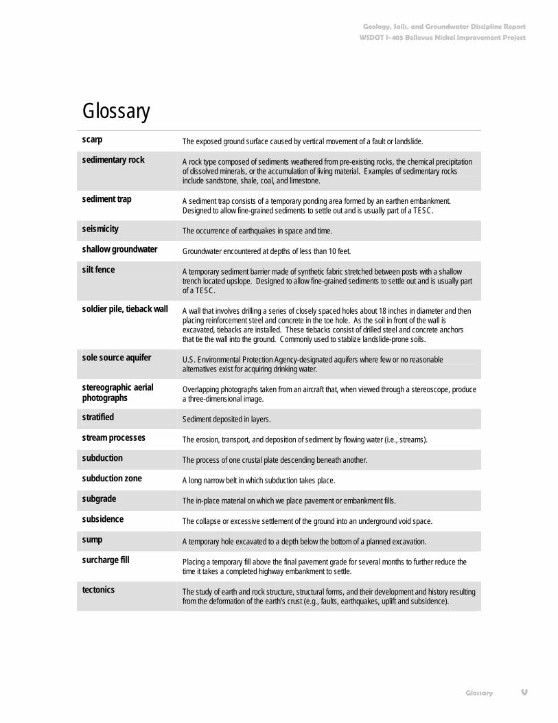
iv Glossary
Glossary acceleration Measurement of strong ground shaking from an earthquake, commonly expressed as fraction of
the acceleration of gravity (1g).
active fault A fault that has had sufficiently recent displacements so that, in the opinion of the user of the term, further displacements in the foreseeable future are likely. For common engineering applications, any fault that has had one or more displacements in the past 10,000 years is an active fault.
alluvium Sediment deposited by flowing water, such as a river or stream.
critical aquifer recharge area
Aquifers that are considered more susceptible to groundwater contamination because the depth to groundwater is shallow; a low permeability protective layer at the surface does not exist; and, the aquifers are critical for supply and use.
crust The outermost layer or shell of the earth.
downgradient Lower in elevation.
fault A fracture or zone of fractures along which displacement has occurred parallel to the fracture.
fill Soil placed by humans, such as for roads or building foundations.
glacier A major body of ice that moves under the influence of gravity. Examples of glaciers include the numerous glaciers on Mount Rainier or the continental ice sheet on Antarctica.
hydrologically connected Water bodies or aquifers linked by the movement of water. For instance, we consider an aquifer that supplies water to a wetland to be hydrologically connected to the wetland.
lahar A rapidly flowing mixture of rock and water originating on a volcano.
LiDAR Light Distance and Ranging. An airborne laser surveying technique that can produce high-quality digital topographic maps of the earth’s surface with the overlying vegetation removed.
liquefaction (of soil) Transformation of a granular material from a solid state into a liquefied state as a consequence of increased pore-water pressures; commonly induced by strong earthquake shaking.
overridden Compacted by the weight of overlying ice.
outwash Sediment deposited by flowing water originating from a glacier, typically referring to sediments deposited in the Pleistocene Epoch by large continental ice sheets. Outwash that is deposited and then subsequently overrun by an advancing ice sheet is known as advance outwash. Outwash that is not overrun is commonly called recessional outwash.
perched groundwater Local groundwater that sits above a layer of low permeable material and which is separate from the regional aquifer.
permeability A measure of how quickly a fluid (in this case water) can flow through a sediment or rock. In this report, the term is the same as hydraulic conductivity.
plate tectonics A global theory of tectonics in which an outermost layer of a sphere (the crust) is divided into a number of relatively rigid plates that collide with, separate from, and move past one another at their boundaries.
Geology, Soils, and Groundwater Discipline Report
WSDOT I-405 Bellevue Nickel Improvement Project
Glossary v
Glossary scarp The exposed ground surface caused by vertical movement of a fault or landslide.
sedimentary rock A rock type composed of sediments weathered from pre-existing rocks, the chemical precipitation of dissolved minerals, or the accumulation of living material. Examples of sedimentary rocks include sandstone, shale, coal, and limestone.
sediment trap A sediment trap consists of a temporary ponding area formed by an earthen embankment. Designed to allow fine-grained sediments to settle out and is usually part of a TESC.
seismicity The occurrence of earthquakes in space and time.
shallow groundwater Groundwater encountered at depths of less than 10 feet.
silt fence A temporary sediment barrier made of synthetic fabric stretched between posts with a shallow trench located upslope. Designed to allow fine-grained sediments to settle out and is usually part of a TESC.
soldier pile, tieback wall A wall that involves drilling a series of closely spaced holes about 18 inches in diameter and then placing reinforcement steel and concrete in the toe hole. As the soil in front of the wall is excavated, tiebacks are installed. These tiebacks consist of drilled steel and concrete anchors that tie the wall into the ground. Commonly used to stablize landslide-prone soils.
sole source aquifer U.S. Environmental Protection Agency-designated aquifers where few or no reasonable alternatives exist for acquiring drinking water.
stereographic aerial photographs
Overlapping photographs taken from an aircraft that, when viewed through a stereoscope, produce a three-dimensional image.
stratified Sediment deposited in layers.
stream processes The erosion, transport, and deposition of sediment by flowing water (i.e., streams).
subduction The process of one crustal plate descending beneath another.
subduction zone A long narrow belt in which subduction takes place.
subgrade The in-place material on which we place pavement or embankment fills.
subsidence The collapse or excessive settlement of the ground into an underground void space.
sump A temporary hole excavated to a depth below the bottom of a planned excavation.
surcharge fill Placing a temporary fill above the final pavement grade for several months to further reduce the time it takes a completed highway embankment to settle.
tectonics The study of earth and rock structure, structural forms, and their development and history resulting from the deformation of the earth’s crust (e.g., faults, earthquakes, uplift and subsidence).

Geology, Soils, and Groundwater Discipline Report
WSDOT I-405 Bellevue Nickel Improvement Project
vi Glossary
Glossary till An unsorted to poorly layered deposit of clay to boulder-sized clasts deposited by a glacier. Till
deposited at the base of a glacier is usually hard or very dense and is known as lodgment till. Till deposited at the margins of a glacier is known as ablation till and is usually much less dense than lodgment till. Till is often referred to as hardpan.
trench (oceanic) Linear bathymetric depression on the sea floor, commonly thousands of meters (feet) deep and thousands of kilometers (miles) long, which results from the bending of oceanic crust as it begins its descent at a subduction zone.
tsunami A long-period, high-speed ocean wave usually caused by sea-floor movements during an earthquake, submarine volcanic eruption, or submarine landslide.
underdrain A drain installed at the base of a fill embankment or cut wall to control seepage and eliminate water pressure against the wall.
upgradient Higher in elevation.
wellhead protection area The area surrounding a drinking water well that supplies groundwater to the well. The Wellhead Protection Area is calculated by the time it takes potential contaminants to enter the well.

Geology, Soils, and Groundwater Discipline Report
WSDOT I-405 Bellevue Nickel Improvement Project
Acronyms and Abbreviations vii
Acronyms and Abbreviations amsl above mean sea level
BMPs best management practices
BNSF Burlington Northern Santa Fe Railroad
DDT dichloro-diphenyl-trichloroethane
EA environmental assessment
Ecology Washington State Department of Ecology
EIS environmental impact statement
FHWA Federal Highway Administration
FTA Federal Transit Administration
HOV high-occupancy vehicle
I-405 Interstate 405
I-90 Interstate 90
LiDAR Light Distance and Ranging
M Magnitude
MP milepost
NB northbound
NEHRP National Earthquake Hazard Reduction Program
NEPA National Environmental Policy Act
NPDES National Pollutant Discharge Elimination System
NRCS National Resource Conservation Service
ROD record of decision
ROW right of way
SB southbound
SCS Soil Conservation Service
SE southeast

Geology, Soils, and Groundwater Discipline Report
WSDOT I-405 Bellevue Nickel Improvement Project
viii Acronyms and Abbreviations
Acronyms and Abbreviations SPCC Spill Prevention Control and Countermeasures
TESC Temporary Erosion and Sedimentation Control
USDA U.S. Department of Agriculture
USGS U.S. Geological Survey
WDNR Washington State Department of Natural Resources
WSDOT Washington State Department of Transportation

Introductions 1
Introduction In 1998, the Washington State Department of Transportation (WSDOT) joined with the Federal Highway Administration (FHWA), the Federal Transit Administration (FTA), Central Puget Sound Regional Transit Authority (Sound Transit), King County, and local governments in an effort to reduce traffic congestion and improve mobility in the Interstate 405 (I-405) corridor. In fall 2002, the combined efforts of these entities culminated in the I-405 Corridor Program Final Environmental Impact Statement (EIS) and FHWA Record of Decision (ROD).
The ROD selected a project alternative that would widen I-405 by as many as two lanes in each direction throughout its 30-mile length. The ultimate configuration of the selected alternative includes buffers separating general-purpose lanes from parallel high-occupancy vehicle (HOV) lanes (potentially used by future high-capacity transit). The design also allows for expanded “managed lane” operations along I-405 that could include use of HOV lanes by other user groups, such as trucks.
In 2003, the Washington State legislature approved a statewide transportation-funding plan called the “nickel package.” The nickel package provided funding for congestion relief projects in three critical traffic hotspots along the I-405 Corridor: Renton, Bellevue, and Kirkland. The Bellevue Nickel Improvement Project is one of several projects now moving forward as part of a phased implementation of the I-405 Corridor Program. Exhibit 1 shows the location of the Bellevue Nickel Improvement Project.
In 2003, the Washington State legislature approved a statewide transportation-funding plan called the “nickel package.” The nickel package provides funding for congestion relief projects in three critical traffic hotspots along the I-405 Corridor, including Bellevue.
Traffic moving along I-405

Geology, Soils, and Groundwater Discipline Report
WSDOT I-405 Bellevue Nickel Improvement Project
2 Introduction
Exhibit 1. Project Vicinity Map
!
!
!
!
!
Me
r ce
r Sl o
ug
h
L a k eB e l l e v u e
WilburtonHil l Park
KelseyCreekPark
MercerSloughNature
Park
Bel levueDowntown
Park
Be
l l e v u e Wa y S
E
Ri c h a
rds R
d12
8th
Ave
SE
112
th A
ve
SE
S E 8 t h S t
116
th A
ve N
E
N E 8 t h S t
N E 1 2 t h S t
BN
SF
K e l s e y C r e e k
13.0
12.0
13.5
12.5
11.5
!"b$
%&e(
SouthernProjectLimits
NorthernProjectLimits
Lake Hi ll s C
onnec
tor
L a k eW a s h i n g t o n
C I T Y O FB E A U X
A R T S
C I T Y O FB E L L E V U E
B e l l e v u e R e d m o n d R d
Sour
ce: W
SD
OT;
200
5, K
ing
Cou
nty;
200
4 | \
\SEA
W40
5\40
5gis
\pro
ject
\bel
levu
e\m
ap_d
ocs\
proj
ect_
vici
ntiy
\Bel
levu
e_P
roje
ct_V
icin
ity.m
xd |
Last
Upd
ated
: 11
-08-
05
Legend! Mile Marker
Local Road
Arterial Road
Freeway
Railroad
Streams
Lake
Park
Municipality
Project Footprint
0 0.2 0.4
Miles
{
AÊ
AÉ
!"b$
Aæ
%&e(
%&e(
!"̀$
!"̀$
Ne w c a s t l e
Snohomish County
King County
Aç
B e l l e v ue
Re n t o n
K e n t
B o t h e l l
K i r k l an d
T uk w i l a

Geology, Soils, and Groundwater Discipline Report
WSDOT I-405 Bellevue Nickel Improvement Project
Introduction 3
In keeping with the direction established in the Final EIS (FEIS) and ROD, we are preparing a National Environmental Policy Act (NEPA) Environmental Assessment (EA) that focuses on project-level effects of constructing and operating the Bellevue Nickel Improvement Project.
We will base the EA on the analysis in the I-405 Corridor Program Final EIS, and will describe any new or additional project changes, information, effects, or mitigation measures not identified and analyzed in the corridor-level FEIS. The project-level EA for the Bellevue Nickel Improvement Project will not reexamine the corridor-level alternatives, impacts, and mitigation measures presented in the corridor-level FEIS, or the decisions described in the ROD.
What alternatives do we analyze in this discipline report? This discipline report is one of 19 environmental elements WSDOT will study to analyze the effects of the Bellevue Nickel Improvement Project. All of the discipline reports will analyze one build alternative and one “no build” or “no action” alternative. This approach is consistent with FHWA’s guidelines for preparing a NEPA EA.
What is the No Build Alternative? NEPA requires us to include and evaluate the No Build Alternative in this discipline report. We use this approach to establish an existing and future baseline for comparing the effects associated with the Build Alternative. We assume that the No Build Alternative will maintain the status quo: only routine activities such as road maintenance, repair, and safety improvements would occur within the corridor between now and 2030. The No Build Alternative does not include improvements that would increase roadway capacity or reduce congestion on I-405. We describe these improvements further in the Bellevue Nickel Improvement Project Traffic and Transportation Discipline Report.
What are the principal features of the Build Alternative? The Bellevue Nickel Improvement Project will add one new general-purpose lane in each direction along a 2-mile section of I–405 between I-90 and SE 8th Street. We will generally use the
The Environmental Assessment will describe new project changes, information, effects, or mitigation measures, but the assessment will not revisit the alternatives, impacts, and mitigation measures evaluated in the corridor-level EIS or the decisions documented in the Record of Decision.
We assume the No Build Alternative will maintain the status quo: only routine activities such as road maintenance, repair, and safety improvements would occur within the corridor between now and 2030.
Geology, Soils, and Groundwater Discipline Report
WSDOT I-405 Bellevue Nickel Improvement Project
4 Introduction
inside or “median” side of I-405 for construction. After we re-stripe the highway, the new lanes will occupy the outside of the existing roadway. The project also includes new stormwater management facilities and better drainage structures and systems.
Other project activities include developing off-site wetland mitigation as well as on-site stream mitigation areas to compensate for the loss of these resources within the project area. We expect project construction to begin in spring 2007 and the improved roadway to be open to traffic by fall 2009.
Improvements to Southbound I-405 In the southbound (SB) direction, we plan to add one new travel lane from approximately Southeast (SE) 8th Street to I-90 (Exhibits 2, 3, and 4). In addition, the existing outside HOV lane at I-90 will be extended north so that it begins at the on-ramp from SE 8th Street. In order to add these lanes and maintain traffic flow during construction, we will shift approximately 3,000 feet of the SB roadway as much as 200 feet east into the existing median. The relocated SB roadway will connect to the existing SB travel lanes just north of the I-90 interchange, and south of the existing bridge over SE 8th Street.
We will build a new tunnel underneath the Burlington Northern Santa Fe (BNSF) railroad, just east of the existing Wilburton Tunnel, to accommodate the relocated and widened SB roadway. The existing tunnel does not have the capacity to accommodate additional lanes of SB traffic.
The existing SB travel lanes and the Wilburton Tunnel will remain open to traffic during construction of the new tunnel and the relocated/widened SB lanes. We will also build the new tunnel wide enough to accommodate additional lanes. The existing tunnel will remain after we complete the improvements.
We will add one lane in the southbound direction of I-405 from approximately SE 8th Street to I-90.

Geology, Soils, and Groundwater Discipline Report
WSDOT I-405 Bellevue Nickel Improvement Project
Introduction 5
Exhibit 2. Proposed Bellevue Nickel Project Improvements (Sheet 1 of 3)
!(!
!
!
!
!
!
!
!
!
ce
rS
l ou
gh
12
4t h
Ave
SE
118
t h A
ve S
E
BN
SF
S E 3 2 n d S t
120 t
h A
ve S
E
I - 9 0
I - 40
5
I-90On-ramp Modification
NorthboundConstruction Limit
SouthboundConstruction Limit
11.9
11.8
11.7
11.6
11.5
11.4
11.3
11.1
11.2
SOUTHBOUND I-405
Existing
Proposed
Bellevue
Bellevue
Bellevue
Bellevue
NORTHBOUND I-405
Existing
Proposed
Sour
ce: W
SD
OT;
200
4, K
ing
Cou
nty;
200
4 | \
\SE
AW
405\
405g
is\p
roje
ct\b
elle
vue\
map
_doc
s\di
scip
line_
repo
rts\p
roje
ct_d
escr
iptio
n\Pr
ojec
t Des
crip
tion.
mxd
| La
st U
pdat
ed :
11-0
7-05
|
LegendRailroad
! Mile Marker
Streams
Matchline
Existing ROW
Existing Noise Walls
Proposed Noise Wall
Proposed RetainingWallProposedConveyence
ProposedEmbankmentProposed DetentionPond
Striping
New ImperviousSurface
Roadway Improvements
!( Interchange
!( Lane Reconfiguration
!( New Alignment
!( Railroad Structure
!( Transit/HOV
0 250 500
Feet
{
B E L L E V U EAÉ
!"b$
%&e(
Sheet 1
Sheet 2
Sheet 3

Geology, Soils, and Groundwater Discipline Report
WSDOT I-405 Bellevue Nickel Improvement Project
6 Introduction
Exhibit 3. Proposed Bellevue Nickel Project Improvements (Sheet 2 of 3)
!(
!(
!(
!(
!(!(
!
!
!
!
!
!
!
!
!
!
!
!
!
I -4
05
NO
RT
HB
OU
ND
BN
SF
I-40
5 S
OU
TH
BO
UN
D
S E 8 t h S t
118
th A
ve
SE
12
1th
Ave
SE
114
t h A
v e S
E
Me
r ce
r Sl o
ug
h
S E 8 t h S t
K e l s e y C r e e k
k e H
i l l s Co n n e c t o rS E 6 t h S t
Wilburton TunnelNew Structure
& Lanes Realigned
Bridge WidenedOver BNSF
SE 8th StreetOff-ramp Modification
SE 8th StreetOn-ramp Modification
& HOV Lane Accomodated
Lanes Realigned
Bridge WidenedOver SE 8th Street
NorthboundConstruction Limit
12.0
13.0
12.4
12.3
12.2
12.1
11.9
11.8
12.5
12.6
12.7
12.8
12.9
NORTHBOUND I-405
Existing
Proposed
SOUTHBOUND I-405
Existing
Proposed
Bellevue
BellevueBellevue
Sou
rce:
WS
DO
T; 2
004,
Kin
g C
ount
y; 2
004
| \\S
EA
W40
5\40
5gis
\pro
ject
\bel
levu
e\m
ap_d
ocs\
disc
iplin
e_re
ports
\pro
ject
_des
crip
tion\
Pro
ject
Des
crip
tion.
mxd
| La
st U
pdat
ed :
11-0
7-05
|
LegendRailroad
! Mile Marker
Streams
Matchline
Existing ROW
Existing Noise Walls
Proposed Noise Wall
Proposed RetainingWallProposedConveyence
ProposedEmbankmentProposed DetentionPond
Striping
New ImperviousSurface
Roadway Improvements
!( Interchange
!( Lane Reconfiguration
!( New Alignment
!( Railroad Structure
!( Transit/HOV
0 250 500
Feet
{
B E L L E V U EAÉ
!"b$
%&e(
Sheet 1
Sheet 2
Sheet 3

Geology, Soils, and Groundwater Discipline Report
WSDOT I-405 Bellevue Nickel Improvement Project
Introduction 7
Exhibit 4. Proposed Bellevue Nickel Project Improvements (Sheet 3 of 3)
!(
!(
!
!
!
!
!
!
!
!
!
116
th A
ve
NE
N E 8 t h S t
112
th A
ve
NE
N E 4 t h S t
BN
SF
Ma i n S t
110
th A
ve
NE
La
k e Hi l l s C
o n n e c t o r
Int e
r st a
t e 4
05
Stu
rte
va
nt
Cr
ee
k
S E 6 t h S t
SE 8th StreetOff-ramp Modification
SouthboundConstruction Limit
13.0
12.8
12.9
13.3
13.4
13.5
13.6
13.2
13.1
NORTHBOUND I-405
Existing
Proposed
SOUTHBOUND I-405
Existing
Proposed
Bellevue
Bellevue
Sou
rce:
WS
DO
T; 2
004,
Kin
g C
ount
y; 2
004
| \\S
EA
W40
5\40
5gis
\pro
ject
\bel
levu
e\m
ap_d
ocs\
disc
iplin
e_re
ports
\pro
ject
_des
crip
tion\
Pro
ject
Des
crip
tion.
mxd
| La
st U
pdat
ed :
11-0
7-05
|
LegendRailroad
! Mile Marker
Streams
Matchline
Existing ROW
Existing Noise Walls
Proposed Noise Wall
Proposed RetainingWallProposedConveyence
ProposedEmbankmentProposed DetentionPond
Striping
New ImperviousSurface
Roadway Improvements
!( Interchange
!( Lane Reconfiguration
!( New Alignment
!( Railroad Structure
!( Transit/HOV
0 250 500
Feet
{
B E L L E V U EAÉ
!"b$
%&e(
Sheet 1
Sheet 2
Sheet 3

Geology, Soils, and Groundwater Discipline Report
WSDOT I-405 Bellevue Nickel Improvement Project
8 Introduction
We will also include the following improvements in the Build Alternative:
Modify the existing off-ramp at SE 8th Street to make room for an additional southbound lane on I-405. The off-ramp will then become a single-lane, optional off-ramp (i.e., the off-ramp will no longer be an “exit only” off-ramp).
Build a retaining wall between the SB travel lanes and the off-ramp at SE 8th Street.
Widen the existing bridge over SE 8th Street to the west to accommodate the new SB lane.
Modify the existing on-ramp at SE 8th Street to tie into the relocated SB general-purpose travel lanes.
Reconfigure the on-ramp at SE 8th Street to accommodate the extended outside HOV lane.
Temporarily shift the existing BNSF railroad track from its current alignment to allow for continuous railroad operation during construction of the new tunnel.
Construct retaining walls along the eastern edge of the relocated SB travel lanes.
Improvements to Northbound I-405 In the northbound (NB) direction, we plan to add one new travel lane from approximately I-90 to SE 8th Street (Exhibits 2, 3, and 4). We will add one new lane to the NB ramp from I-90. We will shift the NB lanes to allow all of the proposed widening to occur on the inside, or median side of the existing roadway.
Additional improvements include:
Re-stripe the westbound/eastbound I-90 on-ramp to NB I-405 resulting in one lane becoming two lanes in the NB direction.
Widen, shift, and re-stripe NB I-405 travel lanes north of I-90 to allow the westbound I-90 to NB I-405 on-ramp and the eastbound I-90 to NB I-405 on-ramp to enter I-405 without having to merge into a single lane.
Construct several retaining walls needed for road widening in locations that allow for existing and future widening of I-405.
We will add one lane in the northbound direction of I-405 from approximately I-90 to SE 8th Street. All widening of the northbound mainline will occur on the inside (median side) of the existing roadway.

Geology, Soils, and Groundwater Discipline Report
WSDOT I-405 Bellevue Nickel Improvement Project
Introduction 9
Construct a noise barrier approximately 725 feet long and 16 feet high (see Exhibit 2).
Widen the existing bridge over the BNSF Railroad to the west to accommodate the new NB lane.
Modify the NB off-ramp to SE 8th Street to make it a single-lane “exit-only” off-ramp.
Transition the NB travel lanes back into the existing lane configuration before crossing over SE 8th Street.
Improvements to the Stormwater Management System Managing stormwater for the I-405 Bellevue Nickel Improvement Project involves the collection and treatment of rainfall runoff from the new project pavement consistent with the guidelines in the WSDOT Highway Runoff Manual.
Currently, we treat less than 5 percent of the existing runoff from paved surfaces in the project area before discharging it. We will improve this condition by treating 17 percent more area than the new paved surface area we create. By treating a greater area, we improve flow control and remove pollutants from a portion of the existing roadway as well as from newly constructed areas.
Reconfiguration and new construction associated with the SB lanes will mean that we need to replace much of the existing drainage system. We will continue to use open roadside ditches along the shoulders of the roadway shoulders where possible. We will use standard WSDOT catch basins and manhole structures to move the roadway runoff to a system of stormwater drain pipes. These features will transport runoff to treatment and flow-control facilities within the existing ROW.
We will construct three new stormwater ponds (detention ponds combined with stormwater treatment wetlands) as part of the project and enlarge the existing pond at SE 8th Street. Two of the new ponds will be located south of the Wilburton Tunnel between the SB lanes and the BNSF railroad ROW. We will construct the third new pond in the northwest quadrant of the I-90/I-405 interchange. The project will discharge treated stormwater following existing flow patterns to Mercer Slough or to the wetlands that surround it.
Avoidance and Minimization Measures WSDOT will use Best Management Practices (BMPs), WSDOT Standard Specifications, and design elements to avoid or minimize potential effects to the environment for the Bellevue
Best Management Practices (BMPs)
BMPs are generally accepted techniques that, when used alone or in combination, prevent or reduce adverseeffects of a project. Examples include erosion control measures and construction management to minimize traffic disruption. Please see Appendix A for a complete list of BMPs.
WSDOT Standard Specifications
Guidelines and procedures established by WSDOT for roadway design and construction in a variety of design, engineering, and environmental manuals.

Geology, Soils, and Groundwater Discipline Report
WSDOT I-405 Bellevue Nickel Improvement Project
10 Introduction
Nickel Improvement Project. Collectively, these measures to avoid or minimize potential effects to the environment are known as “avoidance measures.” We describe these measures in more detail in an Appendix A. If the project has additional effects not addressed in the avoidance measures, we will address these measures through mitigation.
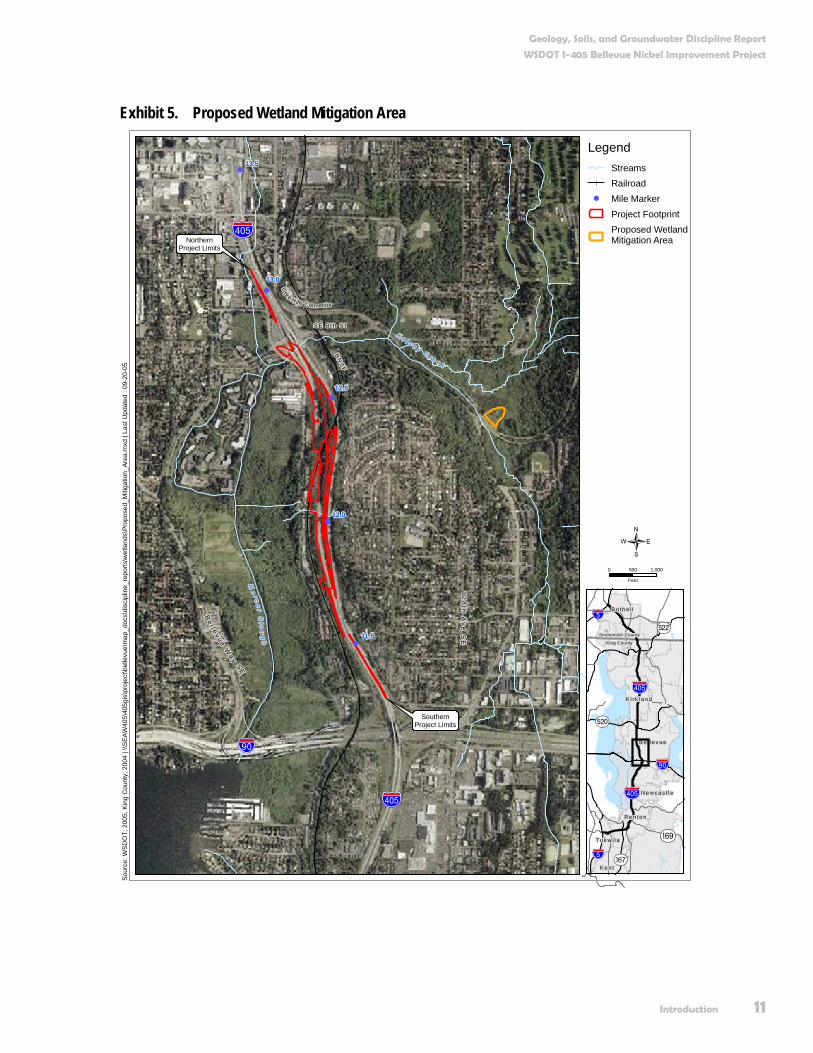
Wetland and Stream Mitigation Sites We will compensate for adverse effects to wetlands and their buffers by creating just over an acre of wetland within the boundaries of Kelsey Creek Park (Exhibit 5). The site is located north of the intersection of Richards Road and the Lake Hills Connector.
Our general concept will be to create an area that will transition from forested land beside the Lake Hills Connector to wetlands within Kelsey Creek Park. We will reshape the surface area to create favorable conditions for the necessary wetland aquatic characteristics, and we will replant and enhance habitat in the area by constructing habitats and replanting adjacent roadside areas with forest-type vegetation.
Similarly, we will compensate for unavoidable effects to “Median Stream,” the unnamed stream within the I-405 median. We have developed a conceptual stream mitigation plan that includes on-site habitat restoration and creation. The conceptual stream mitigation plan includes the following specific elements (See Exhibit 6):
Connect the new Median Stream culvert under I-90 to the existing channel and wetland located west of SB I-405.
Create approximately 500 linear feet of stream channel along the western slope of SB I-405.
Buffer the created stream channel with approximately 16,000 square feet of native streamside vegetation.
Enhance approximately 300 linear feet of riparian habitat west of SB I-405 by removing selected non-native invasive plant species and replacing with native streamside vegetation.
We provide more detailed information about mitigation efforts planned in conjunction with the Bellevue Nickel Improvement in the Surface Water, Floodplains, and Water Quality, and Wetlands Discipline Reports.
Geology, Soils, and Groundwater Discipline Report
WSDOT I-405 Bellevue Nickel Improvement Project
Introduction 11
Exhibit 5. Proposed Wetland Mitigation Area
!
!
!
!
!
%&e(
Be l l e v u e W
ay SE
112
th A
ve S
E
S E 8 t h S t
BN
SF
!"b$
%&e(
13.5
13.0
12.5
12.0
11.5
K e l s e y C r e e k
Me
r ce
r Sl o
ug
h
12
8th
Ave
SE
Rich
ard
s Rd
116
th A
ve N
ELake H ills Connector
SouthernProject Limits
NorthernProject Limits
Sour
ce: W
SDO
T; 2
005,
Kin
g C
ount
y; 2
004
| \\S
EAW
405\
405g
is\p
roje
ct\b
elle
vue\
map
_doc
s\di
scip
line_
repo
rts\w
etla
nds\
Prop
osed
_Miti
gatio
n_Ar
ea.m
xd |
Last
Upd
ated
: 09
-20-
05
LegendStreamsRailroad
! Mile MarkerProject FootprintProposed WetlandMitigation Area
0 500 1,000
Feet
{
AÊ
AÉ
!"b$
Aæ
%&e(
%&e(
!"̀$
!"̀$
Ne w c a s t l e
Snohomish County
King County
Aç
B e l l e v ue
Re n t o n
K e n t
B o t h e l l
K i r k l an d
T uk w i l a

Geology, Soils, and Groundwater Discipline Report
WSDOT I-405 Bellevue Nickel Improvement Project
12 Introduction
Exhibit 6. Conceptual Stream Mitigation Plan

Geology, Soils, and Groundwater Discipline Report
WSDOT I-405 Bellevue Nickel Improvement Project
Introduction 13
Why do we consider geology, soils, and groundwater as we plan this project? We consider geology, soils, and groundwater because they are major factors in determining the types of foundations, pavement sections, subsurface drainage, retaining walls, and bridges required for the project. When we refer to geology and soils , we mean the physical material that makes up the ground. These physical characteristics also determine the risk of landslides, liquefaction, erosion, and other types of behavior, which can affect the environment.
Groundwater pertains to the water contained in the soil and bedrock below the ground’s surface. We consider groundwater quality and quantity because changes to quality and quantity can affect water supplies for drinking water and water available for surface water bodies such as lakes, streams, and wetlands. When reviewing potential effects to groundwater quality and quantity in the study area, we considered federal and state regulations, including: Federal (40 CFR 141) and State Drinking Water regulations (WAC 246-290), State of Washington Water Resource regulations (WAC Title 508 and WAC 173-500), Model Toxics Control Act regulations (WAC 173-340), and Groundwater Quality regulations (WAC 173-200).
What are the key points of this report? The primary points discussed in this report are:
We will build the project in a highly variable geologic environment. The location for the majority of the project is a hillside between I-90 and the SE 8th Street exit. Dense, glacially deposited soil generally underlies the hillside.
Potential effects from the project to soils, geology, and groundwater will likely include increased erosion, disturbance to moisture-sensitive soils, and construction-related vibration. Proper design and construction techniques will avoid or minimize these effects.
We will follow standard WSDOT construction practices to ensure that unavoidable effects from the project will be minimal. Unavoidable effects include the effects discussed in the preceding paragraph and are common to large highway projects.


Existing Conditions 15
Existing Conditions How did we collect information on geology, soils, and groundwater? The Bellevue Nickel Improvement project (hereafter referred to as the project) lies in a heavily populated area that has been the subject of thorough investigation over the years for the initial construction and subsequent upgrades of I-405. For this reason, considerable information related to the geology, soils, and groundwater along the proposed alignment is readily available. To compile this report, we reviewed the following data sources:
Previous investigations along I-405 conducted by WSDOT and others, including the borehole logs for these investigations. Borehole logs provide information about the soil conditions underlying the project.
Public data sources such as LiDAR, stereographic aerial photographs, the U.S. Department of Agriculture (USDA) Soil Conservation Service (now known as the National Resource Conservation Service [NRCS]) soil maps, geologic maps, coal mine maps, liquefaction susceptibility maps, and sensitive groundwater areas (e.g., Sole Source Aquifers and Group A and B Wellhead Protection Areas that are defined in the glossary).
Published articles obtained through reference searches from various agencies such as the U.S. Geological Survey (USGS): Washington State Department of Ecology (Ecology); U.S. Environmental Protection Agency (EPA); and King County.
What is LiDAR?
LiDAR is an acronym for Light Distance and Ranging. In the context of this report, LiDAR refers to an airborne lasersurveying technique that can produce high-quality topographic data of the earth’s surface with the overlying vegetation removed. The topographic data can serve many purposes, such as producing images like Exhibit 6 or topographic maps.
What are Group A and B wells?
Group A wells serve 15 or more households. Group B groundwater supply wells serve between 2 and 14 households.
Congestion building along the I-405 corridor

Geology, Soils, and Groundwater Discipline Report
WSDOT I-405 Bellevue Nickel Improvement Project
16 Existing Conditions
Agency web sites for geology, soils, and groundwater conditions and identified sensitive areas, as well as databases on wells and water rights.
Applicable WSDOT standards, such as those contained in the revised WSDOT Geotechnical Design Manual.
We contacted several additional agencies to obtain information. Please see the References section for a complete list.
After compiling the information, we evaluated existing conditions within the study area. In some cases, we evaluated existing conditions directly from the data sources. For instance, we could determine the erosion potential of soils along the study area from the erosion hazard rating previously established by the NRCS soil survey map. In most cases, however, we evaluated information from multiple sources using standard geologic and hydrogeologic principles. For example, we evaluated areas that were likely underlain by soft soils by reviewing and compiling published information, and by examining boring logs from previous investigations.
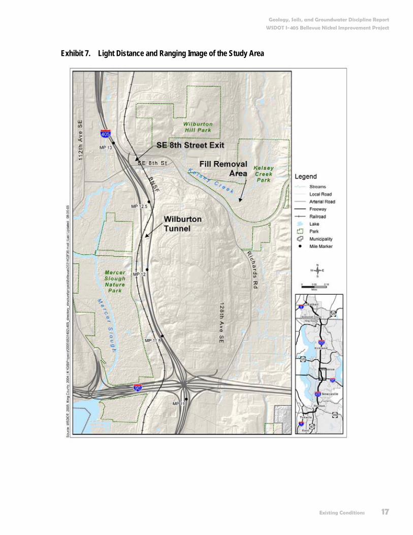
What is the study area for the geology, soils, and groundwater analysis? At a minimum, we considered everything within the I-405 right of way from the beginning to the end of the proposed Bellevue Nickel Improvement Project. In addition, we extended the study area outside of these limits to a maximum of 0.5 mile to properly assess the relevant conditions. As an example, on hillsides, conditions beyond the right of way can affect the stability along the roadway. Assessing potential effects of the project on groundwater also requires us to look well beyond the limits of the right of way. We also considered the fill pad removal area of the Kelsey Creek wetland mitigation area. The fill pad removal area is an area of fill historically placed over a wetland area. As part of the proposed mitigation for wetlands affected by the project, project design includes removal of this fill to restore the wetland area. The fill pad removal area is located to the east of the project, off the Lake Hills Connector near Kelsey Creek (Exhibit 7).
Geology, Soils, and Groundwater Discipline Report
WSDOT I-405 Bellevue Nickel Improvement Project
Existing Conditions 17
Exhibit 7. Light Distance and Ranging Image of the Study Area
Geology, Soils, and Groundwater Discipline Report
WSDOT I-405 Bellevue Nickel Improvement Project
18 Existing Conditions
What created the topography and geology of the Puget Sound area? The topography and surface geology of the Puget Sound area are largely the result of glacial and fluvial (riverine) processes. Recently, human activities have caused large-scale modifications to the landscape. Examples include the lowering of Lake Washington and the construction of I-405.
During the time between about 1.6 million and 10,000 years ago (known as the Pleistocene Epoch), massive glaciers advanced south from Canada into the Puget Sound area at least four times (Easterbrook 1994, Troost 2001). The advance and retreat of these glaciers caused deep scouring in some areas, thereby creating Lake Washington and Lake Sammamish, and placed thick deposits of sediment in other areas. In the study area, the glacial ice was likely more than 3,000 feet thick (Galster and Laprade 2001).
The last retreat of the glacial ice began about 13,000 years ago. During the retreat, water and sediment flowed off the melting ice down large drainage channels, and the high volume of meltwater created or enhanced these channels. In the study area, both Kelsey Creek/Mercer Slough and the I-90 corridor were meltwater channels for the retreating glacial ice. Following this retreat, stream processes, such as those from Kelsey Creek and the erosion of the glacial landforms, shaped the geology and topography of the area.
The most recent agent of geologic and topographic change has been human activity. The construction of the Lake Washington Ship Canal from 1911 to 1916 lowered Lake Washington by approximately 10 feet. Prior to this event, the area currently known as Mercer Slough was a shallow bay of Lake Washington (Galster and Laprade 2001).
Most recently, the construction of I-405 and the extensive development of neighboring areas in Bellevue further altered the topography in the vicinity.
What is the topography of the study area? The location of the project is the west side of a hill between the I-90 interchange and the SE 8th Street exit in Bellevue. The west side of the hill has localized slopes as steep as 40 percent (about 21 degrees). Erosional gullies heavily dissect the area.
How can a glacier deposit sediment? Aren’t glaciers just flowing ice?
When a glacier covers a land surface, the material on that surface, such as gravel or bedrock, can freeze to the base of the glacier and become part of the glacier. If a valley confines a glacier, landslides from the valley sides may fall on the glacier, and this debris might also become part of the glacier. The sediment moves within the ice toward the front of the glacier where it melts and is deposited either at the base or margin of the glacier. These deposits are called till. If the deposits are from flowing streams originating at the glacier, they are called outwash.
What are stream processes?
Stream processes essentially consist of the erosion, transport, and deposition of sediment by flowing water (i.e., streams). In some areas, such as steep hillsides or mountainous areas, streams erode into the underlying sediment or rock. In areas where the stream flows relatively slowly, such as Mercer Slough, streams deposit sediment.
Geology, Soils, and Groundwater Discipline Report
WSDOT I-405 Bellevue Nickel Improvement Project
Existing Conditions 19
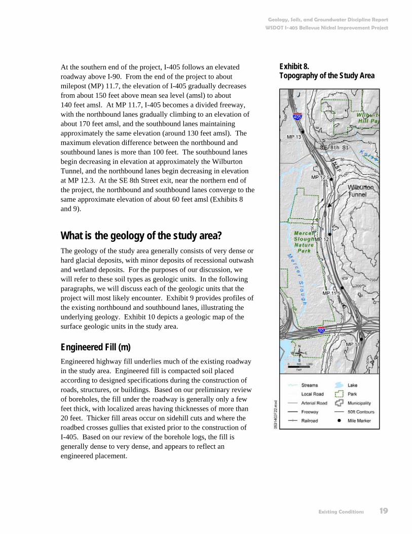
At the southern end of the project, I-405 follows an elevated roadway above I-90. From the end of the project to about milepost (MP) 11.7, the elevation of I-405 gradually decreases from about 150 feet above mean sea level (amsl) to about 140 feet amsl. At MP 11.7, I-405 becomes a divided freeway, with the northbound lanes gradually climbing to an elevation of about 170 feet amsl, and the southbound lanes maintaining approximately the same elevation (around 130 feet amsl). The maximum elevation difference between the northbound and southbound lanes is more than 100 feet. The southbound lanes begin decreasing in elevation at approximately the Wilburton Tunnel, and the northbound lanes begin decreasing in elevation at MP 12.3. At the SE 8th Street exit, near the northern end of the project, the northbound and southbound lanes converge to the same approximate elevation of about 60 feet amsl (Exhibits 8 and 9).
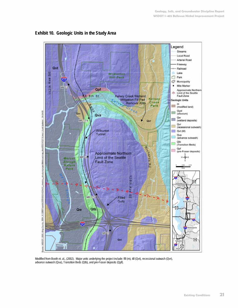
What is the geology of the study area? The geology of the study area generally consists of very dense or hard glacial deposits, with minor deposits of recessional outwash and wetland deposits. For the purposes of our discussion, we will refer to these soil types as geologic units. In the following paragraphs, we will discuss each of the geologic units that the project will most likely encounter. Exhibit 9 provides profiles of the existing northbound and southbound lanes, illustrating the underlying geology. Exhibit 10 depicts a geologic map of the surface geologic units in the study area.
Engineered Fill (m) Engineered highway fill underlies much of the existing roadway in the study area. Engineered fill is compacted soil placed according to designed specifications during the construction of roads, structures, or buildings. Based on our preliminary review of boreholes, the fill under the roadway is generally only a few feet thick, with localized areas having thicknesses of more than 20 feet. Thicker fill areas occur on sidehill cuts and where the roadbed crosses gullies that existed prior to the construction of I-405. Based on our review of the borehole logs, the fill is generally dense to very dense, and appears to reflect an engineered placement.
Exhibit 8. Topography of the Study Area

Geology, Soils, and Groundwater Discipline Report
WSDOT I-405 Bellevue Nickel Improvement Project
20 Existing Conditions
Exhibit 9. Schematic Topographic Profiles and General Geology of the I-405 Project Area (not to scale)
Elevations given in feet. Geologic units depicted on the profile include: m (fill or modified land) Qvr (recessional outwash), Qvt (till), Qva (advance outwash), Qtb (Transition Beds), and Qpf (pre-Fraser deposits).
Non-Engineered Fill (m) A thick stockpile of fill is located in an old gully within the study area at about MP 11.71 to 11.76. A 1992 project to improve the Renton S-Curves on I-405 (south of the project) and to improve I-90, included placement of the fill in that gully. According to WSDOT employees, the fill pile experienced some slope instability shortly after placement. In 1996, WSDOT repaired and stabilized the fill pile. WSDOT employees have not reported movement or evidence of slope instability in the fill pile since 1996. The fill may be as much as 75 feet thick and reportedly consists of waste “earth material,” probably an unsorted mixture of silt, sand, gravel, crushed rock, and other construction debris.
Why do engineering geologists use words like “soft and hard” or “loose and dense” to describe soils and other material deposits?
Words like soft, hard, loose, and dense have very specific meanings to engineering geologists. The words soft and hard refer to the consistency of cohesive soils, like silts and clays. The words loose and dense refer to the density of soils lacking cohesion, like sand and gravel. The consistency or density of the soil refers to the amount of weight the soil can support, and helpspredict the behavior of the soil. Hence, hard or dense soils can support much heavier loads than soft or loose soils.
Geology, Soils, and Groundwater Discipline Report
WSDOT I-405 Bellevue Nickel Improvement Project
Existing Conditions 21
Exhibit 10. Geologic Units in the Study Area
Modified from Booth et. al., (2002). Major units underlying the project include: fill (m), till (Qvt), recessional outwash (Qvr), advance outwash (Qva), Transition Beds (Qtb), and pre-Fraser deposits (Qpf).
Geology, Soils, and Groundwater Discipline Report
WSDOT I-405 Bellevue Nickel Improvement Project
22 Existing Conditions
Wetland Deposits (Qw) The edge of Mercer Slough borders the west side of the SE 8th Street exit (southbound on- and off-ramps), at the northern end of the study area. According to borehole logs we reviewed, the west side of the SE 8th Street exit may be underlain by more than 20 feet of soft peat, and organic-rich silts, and further underlain by sand and gravel outwash (discussed below). The exact edge of the wetland deposits is not clear from the reviewed borehole logs. Galster and Laprade (1991) also note that a thick deposit of peat-rich soil underlies Mercer Slough.
In 1973, the NRCS (then known as the Soil Conservation Service) mapped the area under the Kelsey Creek wetland mitigation area fill removal pad area as being composed of Seattle muck, a wetland deposit soil. The thickness of the wetland deposits under the fill pad is unknown.
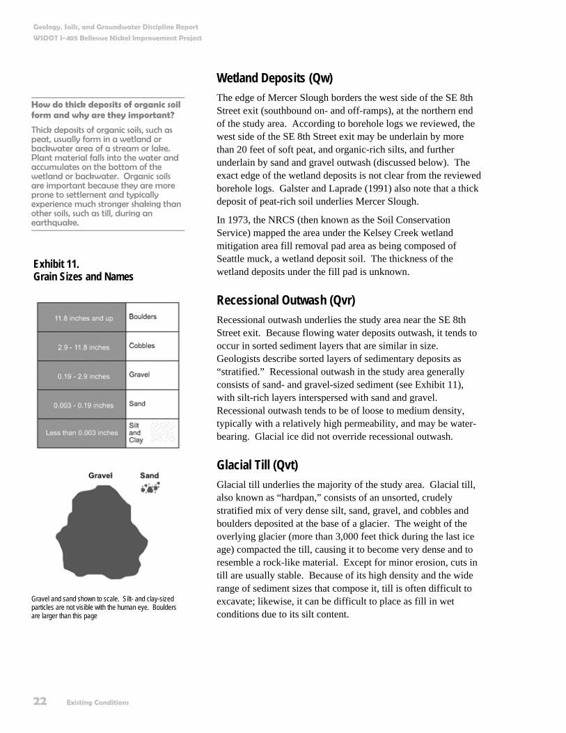
Recessional Outwash (Qvr) Recessional outwash underlies the study area near the SE 8th Street exit. Because flowing water deposits outwash, it tends to occur in sorted sediment layers that are similar in size. Geologists describe sorted layers of sedimentary deposits as “stratified.” Recessional outwash in the study area generally consists of sand- and gravel-sized sediment (see Exhibit 11), with silt-rich layers interspersed with sand and gravel. Recessional outwash tends to be of loose to medium density, typically with a relatively high permeability, and may be water-bearing. Glacial ice did not override recessional outwash.
Glacial Till (Qvt) Glacial till underlies the majority of the study area. Glacial till, also known as “hardpan,” consists of an unsorted, crudely stratified mix of very dense silt, sand, gravel, and cobbles and boulders deposited at the base of a glacier. The weight of the overlying glacier (more than 3,000 feet thick during the last ice age) compacted the till, causing it to become very dense and to resemble a rock-like material. Except for minor erosion, cuts in till are usually stable. Because of its high density and the wide range of sediment sizes that compose it, till is often difficult to excavate; likewise, it can be difficult to place as fill in wet conditions due to its silt content.
Exhibit 11. Grain Sizes and Names
Exhibit 10 Grain sizes and names
How do thick deposits of organic soil form and why are they important?
Thick deposits of organic soils, such as peat, usually form in a wetland or backwater area of a stream or lake. Plant material falls into the water and accumulates on the bottom of the wetland or backwater. Organic soils are important because they are more prone to settlement and typically experience much stronger shaking than other soils, such as till, during an earthquake.
Gravel and sand shown to scale. Silt- and clay-sized particles are not visible with the human eye. Boulders are larger than this page

Geology, Soils, and Groundwater Discipline Report
WSDOT I-405 Bellevue Nickel Improvement Project
Existing Conditions 23
Advance Outwash (Qva) Advance outwash underlies the glacial till, and emerges near the surface in the vicinity of the Wilburton Tunnel. Streams flowing off the glacier deposit advance outwash, as they do recessional outwash. Unlike recessional outwash, however, the glacier overrode advance outwash after deposition. Similar to glacial till, the great weight of the glaciers compressed the advance outwash, causing it to become very dense. Advance outwash tends to have a relatively high permeability.
Transition Beds (Qtb) Transition Beds underlie the advance outwash and are composed of glacially overridden sediments that consist of thinly interlayered silt, clay, and fine sand deposited in a glacial lake. These sediments are known as “glaciolacustrine” deposits. While the overall deposit has a very low permeability, the fine sand interbeds may contain water. Galster and Laprade (1991) note that the Transition Beds often contain numerous fractures, thought to be the result of stress relief when the weight of the glacial ice receded. These fractures typically cause few problems, except on excavated slopes where small blocks of the Transition Beds can “pop-out.” These “pop-outs” can cause blocks of the Transition Beds to fall, thereby creating dangerous conditions for workers below the slope. Because the Transition Beds were deposited in a glacial lake, dropstones can often be present. (Dropstones are gravel- to boulder-sized sediments that melt out of an iceberg after it has detached from a glacier.)
Pre-Fraser Deposits (Qpf) A small, localized exposure of pre-Fraser deposits (i.e., deposited prior to the most recent glaciation) may underlie the study area at the SE 8th Street exit. Based on our review of the borehole logs, and similar exposures in other areas of I-405, the pre-Fraser deposits consist of stratified sand and pebble gravel deposited by flowing water during this period. This unit is very dense, has relatively high permeability, and contains groundwater.
What are geologic hazards and do any exist in the study area? In the context of this discipline report, a geologic hazard is a natural geologic condition that can adversely affect project
What is permeability?
Permeability is a measure of a soil or rock’s ability to transmit water. Soils such as clean sands and gravel have a high permeability. Excavations below the groundwater table in these types of materials will encounter heavy seepage flows requiring high-capacity pumps to dewater. At the other extreme, soils such as clay and silt, and very dense tills have a low permeability. Excavations below the groundwater table in these types of materials will encounter minimal seepage.
What are Transition Beds?
Geologists believe that the Transition Beds represent the transition from a non-glacial environment (similar to the present day) to a glacial environment (like present-day Greenland). Scientists think that the Transition Beds have been deposited in a large lake that was formed when the advancing glacial ice blocked the northern part of the Puget Sound Basin (Galster and Laprade 1991).

Geology, Soils, and Groundwater Discipline Report
WSDOT I-405 Bellevue Nickel Improvement Project
24 Existing Conditions
design or construction. It also includes conditions that can cause the project construction or operation to result in an adverse effect on adjacent properties or resources. Two examples of such an event might include: a large earthquake inducing loose saturated soil to liquefy, causing settlement and damage to the highway (Exhibit 12); or a hillside cut into an unstable slope occupied by houses. If the slope is not properly retained after the cut, the slope may fail, causing damage to property in the vicinity of the slope.
As we will discuss later in this report, WSDOT routinely deals with these types of hazards to eliminate or avoid adverse construction and operation effects.
Based on our data review, we identified the following geologic hazards that we may encounter within the study area:
Earthquake hazards including fault rupture areas.
Secondary earthquake hazards including liquefaction hazard areas and ground amplification areas.
Soft ground areas.
Landslide hazard areas.
High erosion potential areas.
Shallow groundwater areas.
We also considered subsidence hazard areas from abandoned coal mines and volcanic hazard areas. However, our review did not identify any subsidence hazard areas or volcanic hazard areas within the study area. We present below details of each geologic hazard we identified.
Earthquake Hazards The study area is located in a region where earthquakes occur due to the interaction of the Juan de Fuca and North American tectonic plates. Tectonic plates are pieces of the earth’s crust that move independently of each other. Strong ground shaking from earthquakes can damage roadways and structures constructed for the project.
Subduction zone and intraplate earthquake conditions The Juan de Fuca plate moves northeastward and intersects with the North American continental coastal plate along an oceanic trench located offshore (Yeats et al. 1987). At this intersection, the denser Juan de Fuca plate dives, or subducts, beneath the less dense North American plate. Earthquakes can occur where the
Exhibit 12. Liquefaction and Lateral Spreading of Soil in Olympia, WA, Caused by the 1965 Seattle Earthquake
How do we measure the size of an earthquake?
Scientists generally measure the size, or magnitude, of an earthquake by taking the largest ground motion recorded during the arrival of a particular seismic wave at a recording station, then applying a standard correction for the distance to the earthquake source. For this report, we represent the magnitude scale by an “M” for “Moment Magnitude.” An increase of magnitude by 1, such as from M 5 to M 6, represents an increase in energy releases by 32 (i.e. M 6 has 32 times greater energy than M 5).

Geology, Soils, and Groundwater Discipline Report
WSDOT I-405 Bellevue Nickel Improvement Project
Existing Conditions 25
two plates converge, an area we call the “subduction zone interface region” (Exhibit 13). Earthquakes within this region can be as large as Magnitude (M) 9.0, which was the size of the recent earthquake in Indonesia (Weaver and Shedlock 1996; Stanley et al. 1999). Scientists believe the most recent large earthquake in the subduction zone occurred in 1700 A.D. (Leonard et al. 2004).
Exhibit 13. Pacific Northwest Tectonic Setting
Earthquakes can also occur in the subducted Juan de Fuca plate beneath Puget Sound. Earthquakes generally occur at depths of 25 to 37 miles in what scientists refer to as the “intraplate region.” Intraplate earthquakes can have maximum magnitudes of about 7.5 and are the most frequent type affecting the Puget Sound region (McCrumb et al. 1989; Weaver and Shedlock 1996). Specific examples of such earthquakes include the M 6.9 1949 Olympia earthquake, the M 6.7 1965 Seattle earthquake, and the M 6.8 2001 Nisqually earthquake.
Crustal earthquake conditions and fault rupture areas Convergence along the “Cascadia subduction zone” also causes active faulting within the crust of the North American plate. Crustal earthquakes are generally less than 25 miles deep. Earthquakes on crustal faults can be as large as M 7.0 to M 7.5. The largest historical earthquake reported in Washington (M 6.8 to M 7.4) happened in 1872 on a crustal fault near Lake Chelan (USGS 2003).
Why does the source of an earthquake matter? Isn’t an M 6.8 intraplate earthquake the same as an M 6.8 crustal earthquake?
The deeper an earthquake occurs, the more the energy released by the earthquake is attenuated before reaching the surface. Thus, crustal earthquakes will tend to cause significantly stronger shaking than deep intraplate earthquakes. For example, the 2001 M 6.8 Nisqually earthquake occurred in the intraplate region and caused relatively little damage. In contrast, the 1995 M 6.9 Kobe, Japan earthquake occurred on a crustal fault similar to the Seattle fault. The Kobe earthquake resulted in the deaths of more than 5,000 people and about $200 billion in property damage.
Geology, Soils, and Groundwater Discipline Report
WSDOT I-405 Bellevue Nickel Improvement Project
26 Existing Conditions
The Seattle fault zone is a broad, 3- to 4-mile-wide active fault that crosses in an east-west direction through the project (Blakely et al. 2002; Johnson et al. 2004). The approximate northern limit of the fault zone is about 0.5 mile north of I-90 (Exhibit 10) and includes numerous individual fault traces.
Past fault displacement events on individual faults within the Seattle fault zone have produced scarps at the ground surface with lengths of approximately 0.5 to 1.0 mile and maximum heights of 10 to 23 feet (Johnson et al. 2004). These maximum displacements probably correlate with earthquakes of M 7.0 and greater (Exhibit 14). The fault may have been the source of at least five large earthquakes in the prior 12,000 years (Sherrod 2003).
The last major fault rupture/earthquake event on the Seattle fault was about 1,100 years ago (Bucknam et al.1992). Future surface faulting events in the Seattle fault zone in the study area can produce surface displacements ranging from less than 3 feet to more than 10 feet (Wells and Coopersmith 1994).
Thick vegetation and the lack of surface fault rupture events in historical times generally made it difficult for geologists and engineers to locate and identify active faults. However, with the advent of new technologies, such as LiDAR and studies by the USGS and other agencies, we have identified several active surface faults. The increased availability of such data allows us to consider them more closely in the design of key facilities including freeways.
Secondary earthquake hazard areas While the entire project is susceptible to shaking from a large earthquake, some areas may be more susceptible to damage due to soil liquefaction or ground motion amplification induced by the earthquake. We discuss these areas below.
Liquefaction hazard areas Under the influence of strong earthquake shaking, soil liquefaction can occur in saturated, loose, granular soil (gravel, sand, silty sand, sandy silt, and silt). During strong seismic shaking, these soils can liquefy and become a slurry (like quicksand). The effects of liquefaction can be loss of foundation support, excessive settlement, buoyancy (floating) of underground utilities and facilities, and lateral spreading. Lateral spreading is a process whereby liquefied ground cannot support ground slopes or embankments. The ground literally flows
Photo courtesy of the National Geophysics Data Center
Exhibit 14. Fault Scarp from the Magnitude 7.1 1959 Hebgen Lake, Montana, Earthquake
What is an active fault?
An active fault is a fault that has ruptured within the last 10,000 years.
What is a scarp?
A scarp is the exposed ground surface caused by vertical movement of a fault or landslide (Exhibit 13).

Geology, Soils, and Groundwater Discipline Report
WSDOT I-405 Bellevue Nickel Improvement Project
Existing Conditions 27
downhill, resulting in large lateral movements and ground cracking. Exhibit 12 shows the result of lateral spreading of the ground adjacent to a road in Olympia caused by the 1965 Seattle earthquake.
Within the study area, the potential for liquefaction is generally very low (Exhibit 15). Loose sand and gravel underlying organic soils at the west side of the SE 8th Street (southbound) exit have the highest potential for liquefaction in the study area. Other geologic units underlying the study area, such as till or advance outwash, have a very low potential to liquefy (Palmer et al. 2004).
Ground Motion Amplification Areas Strong seismic ground shaking can cause more damage to structures because of the effects of deep soft ground. The soft ground can act like a “bowl of Jell-O,” increasing the ground acceleration and movement at the surface.
Exhibit 16 displays National Earthquake Hazard Reduction Program (NEHRP) ratings for the study area, as determined by the Washington Division of Geology and Earth Resources (Palmer et al. 2004). NEHRP ratings range from A to F, with A being hard bedrock and F being loose liquefiable soil or soft organic soil such as peat. The anticipated ground shaking increases from A to F.
NEHRP class B to C soil underlies the majority of the study area, according to the Washington State Department of Natural Resources (WDNR). Therefore, during a seismic event, the majority of the study area is not likely to experience substantial ground shaking compared to nearby areas, such as Mercer Slough.
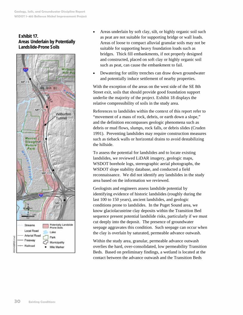
Soft Ground Areas and Area of Landslide Hazard The project may affect landslide hazard areas because hillside cuts or fills created by the project may destabilize landslide-prone areas (Exhibit 17), and we may encounter soft organic-rich soil underlying the west side of the SE 8th Street (SB) exit.
Soft ground areas are considered to be a geologic hazard for the following reasons:
Areas underlain by soft clay, silt, or highly organic soil such as peat can experience substantial settlements under foundation or embankment loads.

Geology, Soils, and Groundwater Discipline Report
WSDOT I-405 Bellevue Nickel Improvement Project
28 Existing Conditions
Exhibit 15. Liquefaction Potential of Soil in the Study Area
Source: Modified from Palmer et al. 2004

Geology, Soils, and Groundwater Discipline Report
WSDOT I-405 Bellevue Nickel Improvement Project
Existing Conditions 29
Exhibit 16. National Earthquake Hazard Reduction Program Site Classes in the Study Area
Source: Palmer 2004 The anticipated ground shaking in an earthquake increases from NEHRP site class B to NEHRP site class F.
Geology, Soils, and Groundwater Discipline Report
WSDOT I-405 Bellevue Nickel Improvement Project
30 Existing Conditions
Areas underlain by soft clay, silt, or highly organic soil such as peat are not suitable for supporting bridge or wall loads. Areas of loose to compact alluvial granular soils may not be suitable for supporting heavy foundation loads such as bridges. Thick fill embankments, if not properly designed and constructed, placed on soft clay or highly organic soil such as peat, can cause the embankment to fail.
Dewatering for utility trenches can draw down groundwater and potentially induce settlement of nearby properties.
With the exception of the areas on the west side of the SE 8th Street exit, soils that should provide good foundation support underlie the majority of the project. Exhibit 18 displays the relative compressibility of soils in the study area.
References to landslides within the context of this report refer to “movement of a mass of rock, debris, or earth down a slope,” and the definition encompasses geologic phenomena such as debris or mud flows, slumps, rock falls, or debris slides (Cruden 1991). Preventing landslides may require construction measures such as tieback walls or horizontal drains to avoid destabilizing the hillside.
To assess the potential for landslides and to locate existing landslides, we reviewed LiDAR imagery, geologic maps, WSDOT borehole logs, stereographic aerial photographs, the WSDOT slope stability database, and conducted a field reconnaissance. We did not identify any landslides in the study area based on the information we reviewed.
Geologists and engineers assess landslide potential by identifying evidence of historic landslides (roughly during the last 100 to 150 years), ancient landslides, and geologic conditions prone to landslides. In the Puget Sound area, we know glaciolacustrine clay deposits within the Transition Bed sequence present potential landslide risks, particularly if we must cut deeply into the deposit. The presence of groundwater seepage aggravates this condition. Such seepage can occur when the clay is overlain by saturated, permeable advance outwash.
Within the study area, granular, permeable advance outwash overlies the hard, over-consolidated, low permeability Transition Beds. Based on preliminary findings, a wetland is located at the contact between the advance outwash and the Transition Beds
Exhibit 17. Areas Underlain by Potentially Landslide-Prone Soils
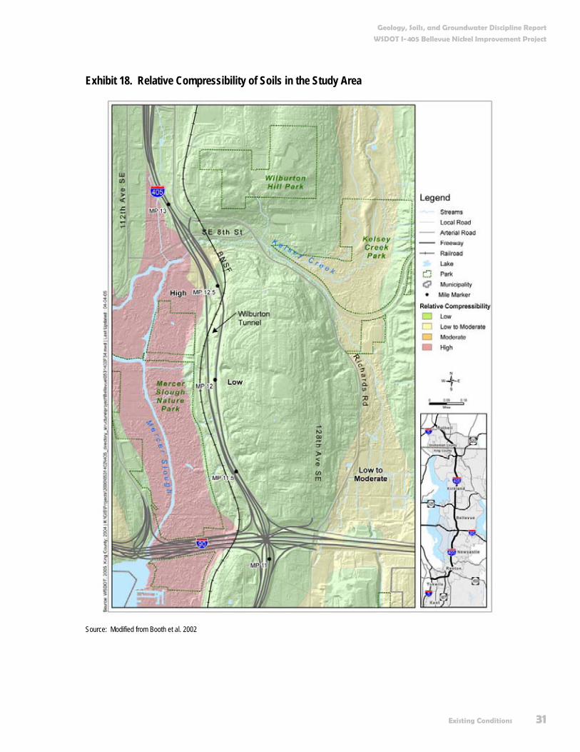
Geology, Soils, and Groundwater Discipline Report
WSDOT I-405 Bellevue Nickel Improvement Project
Existing Conditions 31
Exhibit 18. Relative Compressibility of Soils in the Study Area
Source: Modified from Booth et al. 2002

Geology, Soils, and Groundwater Discipline Report
WSDOT I-405 Bellevue Nickel Improvement Project
32 Existing Conditions
just south of the SE 8th Street exit. Its presence suggests that groundwater is perched on the underlying Transition Beds and is seeping through the advance outwash; therefore, excavations into the hillside in the area located north of the Wilburton Tunnel may be prone to landslides. Exhibit 19 shows a typical landslide found at the contact between highly permeable sand, such as advance outwash, and low permeability silt and clay, such as the Transition Bed. The slide shown is a slump.
Exhibit 19. Typical Landslide at the Contact between Highly Permeable Sand and Low Permeability Silt and Clay
Source: Tubbs 1975
High Erosion Potential Areas We will encounter a variety of surface soil types in the study area. While all soils have the potential for erosion, some soils have a higher potential for such occurrence. Consequently, we will need to expend more effort during and after construction to minimize such effects. Within the context of this report, we consider erosion-prone soils (i.e., soils that will require additional work to minimize erosion) to be soils rated by the NRCS as having a severe or very severe erosion potential (USDA, Soil Conservation Service [SCS] 1973).

Geology, Soils, and Groundwater Discipline Report
WSDOT I-405 Bellevue Nickel Improvement Project
Existing Conditions 33
Generally, NRCS rated the majority of the soil units in the study area as having a severe potential for erosion. Soil units encountered in the study area with a severe erosion potential consist of glacial soils (identified as Alderwood and Kitsap series soils on the NRCS map) with slopes of greater than 15 percent, located between I-90 and the SE 8th Street exit. All of the glacial soils (e.g., till, outwash, and Transition Beds) in the study area are at least partially composed of silt-sized particles. Since silt is particularly susceptible to erosion, any cuts into these glacial soils will have a high potential for erosion, especially during the wet winter months. The relative erosion potential of soils in the study area appears in Exhibit 20.
Shallow Groundwater Areas The presence of shallow groundwater can require special measures during construction, such as dewatering of trenches dug for utilities. The only area likely to have substantial quantities of shallow groundwater is located on the west side of the SE 8th Street (southbound) exit. Perched groundwater (defined in the glossary) can occur in any unit, particularly at the contact between the Transition Beds and advance outwash (Exhibit 10).
What groundwater resources do we find in the study area? Groundwater aquifers in the study area occur primarily in glacial advance outwash (Qva) and recessional outwash (Qvr) deposits. Glacial outwash sediments in the study area consist primarily of sand and gravel with varying amounts of silt.
Renton Formation bedrock underlies the alluvial sediments at depth below the study area. The bedrock is saturated and contains groundwater; however, it typically has low permeability and we do not consider it to be an aquifer. Locally, bedrock can yield useable quantities of water where substantial weathering or fracturing has occurred. Within the study area, bedrock does not appear at the surface, and is generally deeper than 600 feet below the land surface (Galster and Laprade 1991; and Vaccaro et. al. 1998).
Glacial aquifers above the bedrock usually consist of a series of glacially deposited sediments (Galster and Laprade 1991; and Vaccaro et. al. 1998). The series has alternating layers of sediments ranging from coarse-grained to very fine-grained.
What is shallow groundwater?
In the context of this report, shallow groundwater is fully saturated soil encountered at depths of less than 10 feet.
What is an aquifer?
An aquifer is a unit of saturated geologic materials that is capable of producing useable quantities of groundwater on a long-term sustainable basis.
What do you mean by saturated?
Saturated means that all pore or open spaces in a geologic material are completely filled with groundwater at or greater than atmospheric pressure. Saturated thickness is an indication of the amount of water that may be available. The greater the saturated thickness for a geologic material, the greater the potential amount of groundwater that may be available.

Geology, Soils, and Groundwater Discipline Report
WSDOT I-405 Bellevue Nickel Improvement Project
34 Existing Conditions
Exhibit 20. Erosion Potential of Soil Units in the Study Area
Based on mapping by the U.S. Department of Agriculture, Soil Conservation Service (1973)

Geology, Soils, and Groundwater Discipline Report
WSDOT I-405 Bellevue Nickel Improvement Project
Existing Conditions 35
The coarser-grained sediments are commonly associated with recessional and advance outwash deposits. The coarse-grained sediments typically have higher permeability and can be productive aquifers. Pre-Fraser deposits (Qpf) can also be aquifers. The layers of finer-grained sediments are associated with glaciolacustrine transition beds (Qtb) and highly consolidated glacial tills (Qvt). We consider the fine-grained sediments to be aquitards.
Wetland deposits are present along and near the project corridor. A wetland exists between the northern and southern lanes north of the Wilburton Tunnel. Kelsey Creek drains into Mercer Slough, a large wetland complex. Mercer Slough is down gradient of the project corridor. Wetland deposits are fine-grained and contain great amounts of organic material. They can be relatively thick but typically do not produce large quantities of groundwater; therefore, we do not consider them to be aquifers.
What aquifers do we find in the study area? Most of the groundwater resources in the study area exist within near-surface sediment deposits along the Kelsey Creek Valley. The extent of shallow groundwater in the study area appears in Exhibit 21.
Kelsey Creek Aquifer A shallow unconfined aquifer exists along Kelsey Creek. Glacial advance outwash and recessional outwash deposits underlie the study area along Kelsey Creek south of SE 8th Street (see Exhibit 10). These shallow deposits in the narrow Kelsey Creek Valley contain potential groundwater resources. Pre-Fraser deposits of dense sands and gravels are present along the north side of the Kelsey Creek Valley and appear to underlie the surface deposits along Kelsey Creek. The thickness of these sediments varies but can be more than 60 feet along Kelsey Creek beneath the I-405 corridor.
We expect the permeability of this aquifer system to be variable. Locally, Transition Beds are present beneath the advance and recessional outwash deposits and appear to overlie the pre-Fraser deposits along the Kelsey Creek Valley. The Transition Beds typically consist of silt or clay-rich materials that we consider to be an aquitard rather than an aquifer.
What is an Aquitard?
An aquitard is a geologic material that is not capable of producing usable quantities of groundwater.
What is an unconfined and confined aquifer?
An unconfined aquifer is usually a relatively shallow aquifer that downward seepage can recharge directly. An unconfined aquifer is not overlain by a thick low-permeability layer, such as a thick deposit of clay or silt. In contrast, a confined aquifer is commonly overlain by a thick low-permeability layer.

Geology, Soils, and Groundwater Discipline Report
WSDOT I-405 Bellevue Nickel Improvement Project
36 Existing Conditions
Exhibit 21. Potential Shallow Groundwater and Productive Groundwater Resource Areas

Geology, Soils, and Groundwater Discipline Report
WSDOT I-405 Bellevue Nickel Improvement Project
Existing Conditions 37
The groundwater productivity of these aquifer systems is uncertain but Kelsey Creek drains approximately 11,000 acres. The surface water and groundwater most likely flow through the relatively narrow Kelsey Creek Valley and we should consider them to be a potentially productive aquifer system.
Groundwater is relatively shallow in this aquifer, often at less than 10 feet below ground surface in the valley bottom; however, depths vary with surface topography and season. In many places, the water table is at or near the surface and connects hydrologically to the Mercer Slough wetlands. Groundwater flow in the Kelsey Creek Valley aquifer is primarily toward the west to southwest. The primary discharge of groundwater is to Kelsey Creek, the Mercer Slough wetlands, and the wetlands located between the northbound and southbound I-405 corridor lanes. Direct infiltration from precipitation recharges this aquifer within its drainage area but recharge can also occur from overland flow from bordering higher-elevation areas, particularly where glacial till occurs at or near the surface (Exhibits 22 and 9).
Exhibit 22. A Simplified View of the Water Cycle Showing How Infiltration Recharges Groundwater

Geology, Soils, and Groundwater Discipline Report
WSDOT I-405 Bellevue Nickel Improvement Project
38 Existing Conditions
What are the uses of groundwater in the study area? Groundwater within the study area has multiple uses with respect to groundwater rights and groundwater wells. We describe specific uses below.
Groundwater Rights Users extract groundwater as a water supply along the study area. In Appendix B, we list groundwater certificates and permits for use recorded by Ecology that have a point of withdrawal within 0.5 mile of the Bellevue Nickel Improvement Project (Ecology 2005a). Groundwater certificates and permits exist for springs since springs represent groundwater discharges. Appendix B does not list any surface water rights.
Groundwater Wells Many documented water supply wells exist within 0.5 mile of the study area. Existing groundwater wells are identified in Exhibit 23 (King County 2005). There are no Group A or B groundwater wells within 0.5 mile of the project corridor. The Group A and B wells identified in Exhibit 23 are either separated by Mercer Slough (Group A well) or upgradient of the study area (Group B well). The only additional wells within the study area bear the “other” classification and include private domestic wells and resource monitoring wells.
Ecology maintains a database of wells in Washington State. Our research shows approximately 21 listed, groundwater supply wells in the study area (Ecology 2005a). However, many of these wells may not currently exist or are not operational today.
Are there critical/sensitive areas for groundwater protection? One of the primary purposes of this report is to identify areas that are particularly susceptible to groundwater contamination. We identify these areas because they currently supply or can supply water for drinking and industrial uses, and connect hydrologically to bodies of surface water, such as lakes, wetlands, or rivers. We discuss specific areas and their conditions below.

Geology, Soils, and Groundwater Discipline Report
WSDOT I-405 Bellevue Nickel Improvement Project
Existing Conditions 39
Exhibit 23. Location of Groundwater Wells in the Study Area

Geology, Soils, and Groundwater Discipline Report
WSDOT I-405 Bellevue Nickel Improvement Project
40 Existing Conditions
Critical Recharge Areas King County designates certain areas of aquifers as “critical aquifer recharge areas.” These areas are more susceptible to groundwater contamination because the depth to groundwater is shallow; a surface low-permeability protective layer does not exist; and the aquifers are critical for supply and use. We reviewed King County databases and found that there are no designated critical aquifer recharge areas within the study area (King County 2005).
Although the Kelsey Creek aquifers are not within a designated critical aquifer recharge area, groundwater is shallow, without a surface low-permeability protective layer, and is susceptible to contamination.
What is the quality of groundwater in the study area? The Kelsey Creek aquifer groundwater quality is not well studied and little information exists. We did not find water quality testing data or the characterization of groundwater in this aquifer. Ecology monitors Kelsey Creek surface water and lists it as a 303(d) surface water (Ecology 1998). The parameters found to be of concern are fecal coliform and the pesticides DDT (dichloro-diphenyl-trichloroethane), dieldrin, and heptachlor epoxide. Since the aquifer connects hydrologically to the creek, these constituents may also be affecting the groundwater quality of the aquifer.
What is a 303(d) surface water body?
A 303(d) surface water body is a surface water body for which pollutants impair beneficial uses of the water, such as drinking, recreation, aquatic habitat, or industrial use. The 303(d) refers to section 303(d) of the federal Clean Water Act, which requires Washington State to periodically prepare a list of all impaired surface water bodies.
Traffic moving through the existing Wilburton Tunnel

Potential Effects 41
Potential Effects What methods did we use to evaluate potential effects to geology, soils, and groundwater? The methods we used to evaluate the project’s potential effects included:
Reviewing the proposed project design concept and likely construction methods.
Evaluating the potential effects of geology, soils, and groundwater on the project, based on the existing site conditions and standard WSDOT practices, including the avoidance and minimization measures listed in Appendix A.
Evaluating the potential effects of the project on geology, soils, and groundwater, based on the existing site conditions and standard WSDOT practices, including the avoidance and minimization measures listed in Appendix A.
We based the evaluations primarily on our experience, our expert judgment, WSDOT practices, and sound engineering principles. WSDOT’s 2004 Geotechnical Design Manual discusses many of their design and construction practices.
The study area for geology, soils, and groundwater extends as far as a half-mile beyond the right of way.
Geology, Soils, and Groundwater Discipline Report
WSDOT I-405 Bellevue Nickel Improvement Project
42 Potential Effects
How would project operation affect geology, soils, and groundwater? There should be essentially no permanent effects from the project related to geology, soils, or groundwater, except for a slight increase in impervious surfaces. The total increase in impervious surfaces in the project is less than 10 acres, (compared to a recharge area of about 11,000 acres for Kelsey Creek), and will not substantially affect the total amount of recharge to the Kelsey Creek aquifer.
Could geology, soils, or groundwater affect the construction of the project? The conditions along the roadway are not unusual for the Puget Sound area and generally present construction conditions WSDOT routinely encounters. WSDOT has managed these types of conditions on other projects, including the original construction of I-405. Assuming proper implementation of standard WSDOT practices, BMPs, and project-specific design elements, there essentially will be no effects from geology, soils, or groundwater on the project.
Could geology, soils, or groundwater affect the operation of the project? The conditions along the roadway generally present conditions routinely encountered by WSDOT in their design, operation, and maintenance plans, except for the presence of the Seattle Fault zone. Assuming proper implementation of the avoidance and minimization measures listed in Appendix A, geology, soils, and groundwater should have a minimal effect on the project, with the exception of a rupture from the Seattle Fault zone.
Rupture of the Seattle Fault zone may have an effect on the project as the southern portion of the project occurs within the northern area of the fault zone (see Exhibit 10). Based on current WSDOT practices, project design will not accommodate potential fault rupture due to the low probability of one occurring, the cost and difficulty in designing structures to avoid faults, and the difficulty in locating active traces of the Seattle fault.

Geology, Soils, and Groundwater Discipline Report
WSDOT I-405 Bellevue Nickel Improvement Project
Potential Effects 43
How could project construction affect geology, soils, and groundwater? The anticipated construction conditions along the roadway are not unusual for the Puget Sound area. WSDOT routinely encounters these types of conditions and resolves them with implementation of standard BMPs. Relevant construction conditions along the study area include:
Disturbance of moisture-sensitive soils.
Increased erosion potential.
Vibration effects of construction equipment.
Moisture-sensitive soils Most of the soils that will be encountered during construction are moisture-sensitive. These soils typically include wetland deposits, till, Transition Beds, and existing embankment fills. Included in this classification is the soil underlying the Kelsey Creek wetland mitigation fill removal pad area.
Heavy earth-moving equipment tracking on moisture-sensitive soils will tend to degrade the subgrade into a soft unstable material during wet weather, in areas of seepage, or in areas of shallow groundwater. WSDOT is aware of these types of conditions and routinely uses a variety of methods to minimize adverse effects. We describe these methods in Appendix A and at the end of the report.
Increased erosion Within the study area, cut-and-fill areas for new retaining walls constructed for the project will be susceptible to increased erosion. In addition, the fill pad removal area will likely be susceptible to erosion as we remove existing fill and expose the native soils. Increased erosion caused by construction of the project is a concern due to the project's proximity to Kelsey Creek and Mercer Slough.
The majority of the soil types in the study area are susceptible to erosion. We usually assess erosion risk by looking at the steepness of a slope in combination with the soil type. Generally speaking, erosion risk increases with the steepness of the slope, as shown on Exhibit 20. However, since hillside cuts create a steep slope during construction, cut areas—even where we do not rate them as a high erosion risk—can become susceptible to erosion.
What do you mean by subgrade?
The subgrade is the in-place material on which we place pavement or embankment fills.
A scraper stuck in the mud
An example of a negative effect in moisture-sensitive soils, if not properly addressed.
Geology, Soils, and Groundwater Discipline Report
WSDOT I-405 Bellevue Nickel Improvement Project
44 Potential Effects
In addition, fill placed to widen existing embankments may also be susceptible to erosion. Fill, particularly when stockpiled prior to its placement during construction, can easily sustain erosion during a storm event. Implementation of BMPs will minimize but will not completely eliminate erosion. We describe BMPs to reduce erosion in more detail in Appendix A and at the end of the report.
Vibration effects of construction equipment Any large construction project will cause ground vibrations due to the use of heavy equipment. Sources of construction ground vibrations might include:
Heavy earth-moving equipment including trucks.
Large cranes used to install deep foundations, particularly driven piles.
Does the project have other effects that could be delayed or distant from the project? Based on our review, this project will not likely cause any delayed or distant effects to soils, geology, or groundwater.
Did we consider potential cumulative effects for the Build and No Build Alternatives? Per FHWA guidance, cumulative effects analysis is resource-area-specific and generally performed for the resource areas directly affected by the action (such as a transportation project) under study. However, not all of the resource areas directly affected by a project will require a cumulative effects analysis. The resource areas subject to cumulative effects analysis should be determined on a case-by-case basis early in the NEPA process, generally as part of early coordination or scoping. Consistent with the I-405 Corridor Program Final EIS and the results of scoping for the Bellevue Nickel Improvement project, cumulative effects were not analyzed for this resource area.

Measures to Avoid or Minimize Project Effects 45
Measures to Avoid or Minimize Project Effects What will we do to avoid or minimize negative effects to geology, soils, and groundwater? If we follow proper construction and maintenance techniques, there should be no long-term negative effects to geology, soils, and groundwater from the project.
What will we do to minimize construction effects? WSDOT has well-established design and construction practices for managing construction issues associated with the types of geologic, soil, and groundwater conditions anticipated along the project. Appendix A and the following section describe the measures that we will implement to avoid potential effects. These measures are an inherent part of the design and WSDOT will implement them during construction. Their correct implementation will ensure that the project’s effects are minimal.
Plans include several large cut retaining walls, as high as 50 feet, in areas potentially underlain by landslide-prone soils. WSDOT will fully examine these areas and develop appropriate construction procedures to maintain or enhance slope stability.
We expect virtually no permanent effects from the project related to geology, soils and groundwater.
Geology, Soils, and Groundwater Discipline Report
WSDOT I-405 Bellevue Nickel Improvement Project
46 Measures to Avoid or Minimize Project Effects
We may need to install underdrains to control seepage for retaining walls and fill embankments. These underdrains may lower the groundwater table in the immediate vicinity of the project. In the unlikely scenario that the effects from this drawdown could be adverse, WSDOT will include special provisions in the design, such as discharging drain flow back into affected wetlands.
If we identify areas where dewatering will be necessary for utility work, we will take steps to minimize the potential effects to settlement. These steps may include recharge wells and/or cut-off shoring walls, as well as surveying adjacent properties to monitor for settlement.
Should any BMP or other operation not function as intended, we will take additional action to minimize erosion and maintain water quality.
How will we mitigate unavoidable negative effects? Assuming proper implementation of standard WSDOT practices, BMPs (see Appendix A), and project-specific design elements, there will be no adverse effects to soils, geology, or groundwater from the project.
Although green highlights are different from EA, where the intent was “no adverse effects from soils, geology…on the project.”
While we will avoid the majority of potential effects from the project by following standard WSDOT procedures and BMPs, we will likely face a few unavoidable negative effects. These include:
Wet-weather earthworks such as cuts and fills will likely degrade moisture-sensitive soils. We can reduce effects to these soils using the measures we describe in Appendix A and the previous section but we cannot completely eliminate them.
The possibility exists that during project construction, a rain event will exceed the BMP-design levels and transport some soil off site. We consider these types of risks to be acceptable because BMPs contain an implied risk level.
A few people may feel unavoidable construction vibration, even at levels maintained below damage thresholds. This

Geology, Soils, and Groundwater Discipline Report
WSDOT I-405 Bellevue Nickel Improvement Project
Measures to Avoid or Minimize Project Effects 47
outcome is particularly likely in areas underlain by deep soft ground.
Damage from a fault rupture remains a low risk.
As we discussed above, we can reduce and largely control these effects; however, WSDOT will not be able to completely eliminate them.

References 49
References Association of Bay Area Governments. 2003. Modified Mercalli Intensity Scale. Available at:
http://www.abag.ca.gov, 10/15/03. Accessed on: February 9, 2005.
Blakely, R.J., Wells, R.E., Weaver, C.S., and Johnson, S.Y. 2002. Location, structure, and seismicity of the Seattle fault zone, Washington: Evidence from aeromagnetic anomalies, geologic mapping, and seismic-reflection data. Geological Society of America Bulletin, vol. 114, no. 2, pp. 169-177.
Booth, D.B., Haugerud, R.A., and Sacket, J.B. 2002. Geologic Map of King County, Washington, 1:100,000.
ten Brink, U.S., Molzer, P.C., Fisher, M.A., Blakely, R.J., Bucknam, R.C., Parsons, T., Crossone, R.S., and Creager, K.C. 2002. Subsurface Geometry and Evolution of the Seattle Fault Zone and the Seattle Basin, Washington. Bulletin of the Seismological Society of America (92): pp. 1737-1753.
Bronson, R.A. 1989. Geotechnical Impacts on Construction of State Route 167, The Valley Freeway. In Galster, R.W, Coombs, H.A., Bliton, W.S., Neff, G.E., McCrumb, D.R., Laprade, W.T., Evans, W.D., Jr., Robinson, R.A., Koler, T.E., Warfel, M.R., West, L., Bailey, J.S., Marcus, K.L., and Schuster, R.L., eds., Engineering Geology in Washington, Volumes I and II. Washington Division of Geology and Earth Resources, Bulletin 78: pp. 797-806.
Bucknam, R.C., Hemphill-Haley, E., and Leopold, E.B. 2002. Abrupt Uplift within the Past 1700 Years at Southern Puget Sound, Washington: Science, (258): pp.1611-1614.
Cruden, D.M. 1991. A Simple Definition of a Landslide. Bulletin of the International Association of Engineering Geology (43): pp. 27-29.
Easterbrook, D.J. 1994. Stratigraphy and Chronology of Early to Late Pleistocene Glacial and Interglacial Sediments in the Puget Lowland, Washington. In Swanson, D.A., and
Geology, Soils, and Groundwater Discipline Report
WSDOT I-405 Bellevue Nickel Improvement Project
50 References
Haugerud, R.A., eds., Geologic Field Trips in the Pacific Northwest: 1994 Geological Society of America Annual Meeting, 37 p.
Galster, R.W and Laprade, W.T. 1991. Geology of Seattle, Washington, United States of America. Bulletin of the Association of Engineering Geologists, vol. 28, no. 3, pp. 235-302.
HDR Engineering. 1992. Unknown report title (title page not provided); report concerns improvements of I-405 between Coal Creek Parkway and SE 8th Street exit, WSDOT project no. W7748.
Johnson, S.Y., Blakely, R.J., Brocher, T.M., Bucknam, R.C., Haeussler, P.J., Pratt, T.L., Nelson, A.R., Sherrod, B.L., Wells, R.E., Harding, D.J., and Kelsey, H.M., compilers. 2004. Fault number 570, Seattle fault zone, in Quaternary fault and fold database of the United States, ver. 1.0: U.S. Geological Survey Open-File Report 03-417. Available at: http://qfaults.cr.usgs.gov. Accessed on: March 2, 2005.
King County. 2005. IMAP Web Site. Available at: http://www5.metrokc.gov/imap/?mapset=wria. Accessed on: April 18, 2005.
Leonard, L.J., Hyndman, R.D., and Mazzotti, S. 2004. Coseismic subsidence in the 1700 great Cascadia earthquake: Coastal estimates versus elastic dislocation models. Geological Society of America Bulletin, vol. 116, no. 5/6, pp. 655-670.
McCrumb, D.R., Galster, R.W., West, D.O., Crosson, R.S., Ludwin, R.S., Hancock, W.E., and Mann, L.V. 1989. Tectonics, Seismicity, and Engineering Seismology in Washington: in Engineering Geology in Washington, Volume I, Washington Division of Geology and Earth Resources Bulletin (78): pp. 97-120.
Pacific Northwest Seismograph Network. 2001. Background Information on the Shake Maps. Available at: http://www.ess.washington.edu/shake, last modified 10/9/01. Accessed on: February 9, 2005.
———. 2003. Map and List of Selected Significant Quakes in WA and OR: PNSN Historic Earthquakes. Available at: http://www.pnsn.org, last modified 3/27/03. Accessed on: February 9, 2005.
Palmer, S.P., Magsino, S.L., Bilderback, E. L., Poelstra, J.L., Folger, D.S., and Niggeman, R.A. 2004. Liquefaction Susceptibility Map of King County. Washington Division of Geology and Earth Resources, 1:100,000.
Schasse, H.W., Koler, M. L., Eberle, N.A., and Christie, R.A. 1994. The Washington State Coal Mine Map Collection: A Catalog, Index, and User’s Guide. Washington State Division of Geology and Earth Resources Open-File Report 94-7.
Sherrod, B.L. 2003. Update on Active Holocene Faults: U.S. Geological Survey National Earthquake Program, Update on Current USGS Earthquake Hazards Studies in Puget Sound, October 21.

Geology, Soils, and Groundwater Discipline Report
WSDOT I-405 Bellevue Nickel Improvement Project
References 51
Stanley, D., Villasenor, A., and Benz, H. 1999. Subduction Zone and Crustal Dynamics of Western Washington: A Tectonic Model for Earthquake Hazards Evaluation: U.S. Geological Survey Open-File Report 99-311.
Stirbys, A. Engineering – Geotechnical Lead, WSDOT I-405 Project Lead. 2005. E-mail correspondence re: stability of fill placed between MP 11.71 and MP 11.76, April 21, 2005.
Terrapoint (LiDAR), The Woodlands, TX. 2005. LiDAR Bare Earth DEM [computer file] from 2000-2004. Available: Puget Sound LiDAR Consortium, Seattle, WA. Available at: http://rocky2.ess.washington.edu/data/raster/lidar/index.htm. Accessed on: February, 2005.
Tubbs, D.W. 1975. Causes, Mechanisms and Predictions of Landsliding in Seattle, Ph.D. Dissertation, University of Washington, Seattle, Washington.
Troost, K.G. 2001. Conceptual Stratigraphic Column, Central Puget Lowland Area, in Overview of Puget Lowland Geology, nonpublished training course.
———. 2003. Introduction to Workshop on Geologic Research in the Seattle Area: Seattle-Area Geologic Mapping Project and US Geological Survey, October 20, 2003.
U.S. Department of Agriculture, Soil Conservation Service. 1973. Soil Survey, King County Area, Washington.
U.S. Geological Survey. 2002. Lat/Lon Lookup Output, Latitude 47.5915N, Longitude 122.1808W: Earthquake Hazards Program. Available at: http://eqint.cr.usgs.gov. Accessed on: February 9, 2005.
———. 2002. Latitude/Longitude Lookup Output, 47.4678N and 122.2240W: Earthquake Hazards Program. Available at: http://eqint.cr.usgs.gov/eq. Accessed on: February 9, 2005.
———. 2003. Largest Earthquake in Washington, Near Lake Chelan, Washington, 1872 12 15 05:40 UTC (local (12/14), Magnitude 7.3: Large Earthquakes in the United States, Earthquake Hazards Program. Available at: http://neic.usgs.gov/neis/eq, last modified 2003 October 15. Accessed on: February 9, 2005.
———. 2003. Appendix 2, Magnitudes of Significant Earthquakes: Earthquake Hazards Program. Available at: http://earthquake.usgs.gov, updated August 8, 2003. Accessed on: February 9, 2005.
———. 2005. NEIC: Earthquake Search Results for Latitude 47.591N, Longitude 122.180W, 150 km Radius, 1568-2005: Earthquake Hazards Program. Available at: http://eqint.cr.usgs.gov/neic. Accessed on: February 9, 2005.
Vaccaro, J.J., Hansen Jr., A.J., and Jones, M.A. 1998. Hydrogeologic Framework of the Puget Sound Aquifer System, Washington and British Columbia. U.S. Geological Survey Professional Paper 1424-D. Denver, Colorado.

Geology, Soils, and Groundwater Discipline Report
WSDOT I-405 Bellevue Nickel Improvement Project
52 References
Walker and Associates. 1936. Aerial Photographs, Photograph Numbers 1205 to 1213, Scale Unknown (presumably 1”:800’).
Washington State Department of Ecology. 1998. 303(d) List. Available at: http://www.ecy.wa.gov/programs/wq/303d/1998/wrias/wria8.pdf. Accessed on: April 18, 2005.
———. 2005. Well Logs. Available at: http://apps.ecy.wa.gov/welllog/. Accessed on: April 18, 2005.
———. 2005. Washington State Department of Ecology Water Rights Application Tracking System (WRATS) Database, January 2005.
Washington State Department of Transportation. 2004. Geotechnical Design Manual.
———. 2005. Borehole logs from WSDOT projects L1146 (2000), L3188 (1970), L3544 (2001), L5687 (1981), and L8034 (1990).
———. 2005. Slope stability database – accessed via email correspondence with Mr. Dave Jenkins of WSDOT on March 10, 2005.
Weaver, C.S. and Shedlock, K.M. 1996. Estimates of Seismic Source Regions from the Earthquake Distribution and Regional Tectonics in the Pacific Northwest: U.S. Geological Survey Professional Paper 1560, p. 285-306.
Wells, D.L. and Coppersmith, K.J. 1994. New empirical relationships among magnitude, rupture length, rupture width, rupture area, and surface displacement: Bulletin of the Seismological Society of America, v. 84, n. 4, p. 974-1002.
Yeats, R.S., Sieh, K, and Allen, C.R. 1997. The Geology of Earthquakes. Oxford University Press, New York, NY, 568 p.
Youngs, R., Chiou, S-J, Silva, W., and Humphrey, J. 1997. Strong Ground Motion Attenuation Relationships for Subduction Zone Earthquakes. Seismological Research Letters, v. 68, p. 58-73.

Appendix A Avoidance and Minimization Measures

Appendix A A-1
Avoidance and Minimization Measures The following sections describe the established design and construction practices that WSDOT will include to avoid or minimize effects to the various environmental resources during both the construction and operation phases of the project.
Project Measures to Avoid or Minimize Effects During Construction Design elements, such as modifications to boundaries of areas that can be affected, have been incorporated into the project specifications, construction plans, and procedures, to help avoid or minimize most potential construction impacts. When appropriate, monitoring will be conducted to ensure that these design and construction measures are effective.
Measures for Geology, Soils, and Groundwater WSDOT will prepare and implement a Temporary Erosion and Sedimentation Control
(TESC) plan consisting of operational and structural measures to control the transport of sediment. Operational measures include removing mud and dirt from trucks before they leave the site, covering fill stockpiles or disturbed areas, and avoiding unnecessary vegetation clearing. Structural measures are temporary features used to reduce the transport of sediment, such as silt fences and sediment traps.
WSDOT will reduce degradation of moisture-sensitive soils by limiting major earthwork to the drier, late spring through early fall construction season; by maintaining proper surface drainage to avoid ponding of surface water or groundwater; by minimizing ground disturbance through limiting the use of heavy equipment, limiting turns, and/or not tracking directly on the subgrade; and by covering the final subgrade elevation with a working mat of crushed rock and/or geotextile for protection. Mixing a soil admix such as cement into the subgrade may also add strength and stabilize the ground.
WSDOT will determine acceptable limits for off-site construction-related ground vibration before construction begins and demonstrate that off-site ground vibrations are within the limits set for the project through the use of vibration-monitoring equipment.
WSDOT will identify areas subject to shaking from a large earthquake and will mitigate risks using ground modifications or other procedures identified in the WSDOT Geotechnical Design Manual.
WSDOT will implement construction procedures identified in the geotechnical investigation to maintain or enhance slope stability in areas potentially underlain by landslide-prone soils.
WSDOT will protect the Kelsey Creek aquifer from contamination by construction-related spills by development and implementation of BMPs and a Spill Prevention Control and
A-2 Appendix A
Countermeasures plan (SPCCP). The SPCC will specifically address fuel spills from vehicles and from spills of other chemicals commonly transported over I-405. Spill response equipment will be located at regular and specified intervals within the project area for minimizing countermeasure response times.
WSDOT will ensure only clean fill is imported and placed for the project and will require documentation for fill brought onto the site from the supplier certifying that the fill does not exceed Washington State soil cleanup standards. If documentation is not available, testing of imported fill soils will be required prior to placement. Suspect soils encountered during project construction will be tested and, where necessary, removed from the site and disposed of in accordance with Washington State regulations.
WSDOT will identify and develop staging areas for equipment repair and maintenance away from all drainage courses. Washout from concrete trucks will not be dumped into storm drains or onto soil or pavement that carries stormwater runoff. A wash down area for equipment and concrete trucks will be designated and the use of thinners and solvents to wash oil, grease, or similar substances from heavy machinery or machine parts will be prohibited.
WSDOT will obtain a NPDES (National Pollutant Discharge Elimination System) permit and will conduct a regular program of testing and lab work to ensure that water encountered during construction meets the water quality standards specified in the NPDES permit.
WSDOT will to meet the NPDES water quality standards prior to the discharge of the encountered water to a surface water body, such as Kelsey Creek. If necessary, water quality will be improved, such as by using sediment ponds to allow sediment to settle out prior to discharge.
If it is necessary to install seepage drains to control seepage for retaining walls and fill embankments, WSDOT will include special provisions in the design to discharge drain flow back into affected areas, including wetlands.
Measures for Water Quality In addition to measures for geology, soils, groundwater, and for hazardous materials that are protective of water quality, the following measures would be implemented for water quality.
WSDOT will identify and develop staging areas for equipment repair and maintenance away from all drainage courses.
Washout from concrete trucks will not be dumped into storm drains or onto soil or pavement that carries stormwater runoff.
Thinners and solvents will not be used to wash oil, grease, or similar substances from heavy machinery or machine parts.
WSDOT will designate a wash down area for equipment and concrete trucks.

Appendix A A-3
Measures for Wetlands WSDOT will protect, preserve, and enhance wetlands in the project area during the planning,
construction, and operation of transportation facilities and projects consistent with USDOT Order 5660.1A, Executive Order 11990, and Governor’s Executive Orders EO 89-10 and EO 90-04.
WSDOT’s project-level design and environmental review has included avoidance, minimization, restoration, and compensation of wetlands. WSDOT will implement these measures prior to or concurrent with adverse effects on wetlands, to reduce temporal losses of wetland functions.
WSDOT will follow guidance contained in the wetlands section of the WSDOT Environmental Procedures Manual (WSDOT 2004a), which outlines the issues and actions to be addressed prior to authorizing work that could affect wetlands.
WSDOT will use high-visibility fencing to clearly mark wetlands to be avoided in the construction area.
Measures for Upland Vegetation and Wildlife WSDOT will ensure mitigation measures established in the I-405 Corridor EIS will be
implemented on the Bellevue Nickel Improvement Project.
WSDOT will prepare and implement a revegetation plan. In addition, areas with mixed forest will not be removed for temporary use (i.e., construction staging). If an area of mixed forest must be removed for roadway construction, it will be replaced with plantings of native tree and shrub species within the affected area.
WSDOT will adhere to project conditions identified in the Biological Assessment and agency concurrence letters.
WSDOT will limit construction activity to a relatively small area immediately adjacent to the existing roadway to minimize vegetation clearing and leave as many trees as possible.
Measures for Fisheries and Aquatic Resources WSDOT will implement construction BMPs (such as silt fencing or sedimentation ponds) to
avoid disturbing sensitive areas during the development and use of any staging areas, access roads, and turnouts associated with resurfacing activities.
WSDOT will not allow in-water work to occur except during seasonal work windows established to protect fish.
WSDOT will require that all stormwater treatment wetland/detention facilities are sited and constructed at a sufficient distance from named and unnamed streams so no grading or filling in the streams or the streamside zones will be required.
A-4 Appendix A
Measures for Air Quality WSDOT will require preparation and implementation of a Fugitive Dust Control Plan in
accordance with the Memorandum of Agreement between WSDOT and PSCAA Regarding Control of Fugitive Dust from Construction Projects (October 1999).
During dry weather, exposed soil will be sprayed with water to reduce emissions of and deposition of particulate matter (PM10).
WSDOT will provide aequate freeboard (space from the top of the material to the top of the truck), cover truckloads, and, in dry weather, wet materials in trucks to reduce emission of and deposition of particulate matter during transport.
WSDOT use wheel washers to remove particulate matter that would otherwise be carried offsite by vehicles to decrease deposition of particulate matter on area roadways.
WSDOT will remove particulate matter deposited on public roads to reduce mud on area roadways.
WSDOT will cover or spray with water any dirt, gravel, and debris piles during periods of high wind when the stockpiles are not in use to control dust and transmissions of particulate matter.
WSDOT will route and schedule construction trucks to reduce travel delays and unnecessary fuel consumption during peak travel times, and therefore reduce secondary air quality impacts (i.e. emissions of carbon monoxide and nitrogen oxides) that result when vehicles slow down to wait for construction trucks.
Measures for Noise Noise berms and barriers will be erected prior to other construction activities to provide noise
shielding.
The noisiest construction activities, such as pile driving, will be limited to between 7 AM and 10 PM to reduce construction noise levels during sensitive nighttime hours.
Construction equipment engines will be equipped with adequate mufflers, intake silencers, and engine enclosures.
Construction equipment will be turned off during prolonged periods of nonuse to eliminate noise.
All equipment will be maintained appropriately and equipment operators will be trained in good practices to reduce noise levels.
Stationary equipment will be stored away from receiving properties to decrease noise.
Temporary noise barriers or curtains will be constructed around stationary equipment that must be located close to residences.
Resilient bed liners will be required in dump trucks to be loaded on site during nighttime hours.

Appendix A A-5
WSDOT use Occupational Safety and Health Administration (OSHA)-approved ambient sound-sensing backup alarms that would reduce disturbances during quieter periods.
Measures for Hazardous Materials
Known or Suspected Contamination within the Build Alternative Right of Way WSDOT will prepare an SPCCP that provides specific guidance for managing contaminated
media that may be encountered within the right of way (ROW).
WSDOT may be responsible for remediation and monitoring of any contaminated properties acquired for this project. WSDOT will further evaluate the identified properties before acquisition or construction occurs. Contamination in soils will be evaluated relative to the Model Toxics Control Act (MTCA).
If WSDOT encounters an underground storage tank (UST) within the ROW, WSDOT will assume cleanup liability for the appropriate decommissioning and removal of USTs. If this occurs, WSDOT will follow all applicable rules and regulations associated with UST removal activities.
WSDOT will conduct thorough asbestos-containing material/lead paint building surveys by an Asbestos Hazard Emergency Response Act (AHERA)-certified inspector on all property structures acquired or demolished. WSDOT will properly remove and dispose of all asbestos-containing material/lead-based paint in accordance with applicable rules and regulations.
Construction waste material such as concrete or other harmful materials will be disposed of at approved sites in accordance with Sections 2-01, 2-02, and 2-03 of the WSDOT Standard Specifications.
WSDOT may acquire the responsibility for cleanup of any soil or groundwater contamination encountered during construction (that must be removed from the project limits) within WSDOT ROW. Contamination will be evaluated relative to Model Toxics Control Act (MTCA) cleanup levels.
WSDOT will consider entering into pre-purchaser agreements for purpose of indemnifying itself against acquiring the responsibility for any long-term cleanup and monitoring costs.
All regulatory conditions imposed at contaminated properties (e.g., Consent Decree) associated with construction will be met. These conditions could include ensuring that the surrounding properties and population are not exposed to the contaminants on the site: i.e., WSDOT will ensure that the site is properly contained during construction so that contaminants do not migrate offsite, thereby protecting the health and safety of all on-site personnel during work at the site.
Known or Suspected Contamination Outside of the Right of Way Contaminated groundwater originating from properties located up-gradient of the ROW could
migrate to the project area. WSDOT generally will not incur liability for groundwater contamination that has migrated into the project footprint as long as the agency does not

A-6 Appendix A
acquire the source of the contamination. However, WSDOT will manage the contaminated media in accordance with all applicable rules and regulations.
Unknown Contamination If unknown contamination is discovered during construction, WSDOT will follow the SPCCP
as well as all appropriate regulations.
Worker and Public Health and Safety and other Regulatory Requirements The WSDOT will comply with the following regulations and agreements:
State Dangerous Waste Regulations (Chapter 173-303 WAC);
Safety Standards for Construction Work (Chapter 296-155 WAC);
National Emission Standards for Hazardous Air Pollutants (CFR, Title 40, Volume 5, Parts 61 to 71);
General Occupational Health Standards (Chapter 296-62 WAC); and
Implementing Agreement between Ecology and WSDOT Concerning Hazardous Waste Management (April 1993).
Hazardous Materials Spills During Construction WSDOT will prepare and implement a SPCCP to minimize or avoid effects on human health,
soil, surface water and groundwater.
Measures for Traffic and Transportation WSDOT will coordinate with local agencies and other projects to prepare and implement a
Traffic Management Plan (TMP) prior to making any changes to the traffic flow or lane closures. WSDOT willl inform the public, school districts, emergency service providers, and transit agencies of the changes ahead of time through a public information process. Pedestrian and bicycle circulation will be maintained as much as possible during construction.
Prior to and during construction, WSDOT will implement strategies to manage the demand on transportation infrastructure. These transportation demand management strategies will form an important part of the construction management program and will be aimed at increasing public awareness and participation in HOV travel. The major focus will be on expanding vanpooling and van-share opportunities. Other elements of the transportation demand management plan may include:
increased HOV awareness and public information, and
work-based support and incentives.
Appendix A A-7
Measures for Visual Quality WSDOT will follow the I-405 Urban Design Criteria. Where the local terrain and placement
of light poles allow, the WSDOT will reduce light and glare effects by shielding roadway lighting and using downcast lighting so light sources will not be directly visible from residential areas and local streets.
WSDOT will restore (revegetate) construction areas in phases rather than waiting for the entire project to be completed.
Measures for Neighborhoods, Businesses, Public Services and Utilities WSDOT will prepare and implement a transportation management plan (TMP). If local
streets must be temporarily closed during construction, WSDOT will provide detour routes clearly marked with signs.
WSDOT will coordinate with school districts before construction.
WSDOT will implement and coordinate the TMP with all emergency services prior to any construction activity.
WSDOT will coordinate with utility providers prior to construction to identify conflicts and resolve the conflicts prior to or during construction. Potential utility conflicts within WSDOT ROW will be relocated at the utility’s expense prior to contract award.
WSDOT will prepare a consolidated utility plan consisting of key elements such as existing locations, potential temporary locations and potential new locations for utilities; sequence and coordinated schedules for utility work; and detailed descriptions of any service disruptions. This plan will be reviewed by and discussed with affected utility providers prior to the start of construction.
WSDOT will field verify the exact locations and depths of underground utilities prior to construction.
WSDOT will notify neighborhoods of utility interruptions by providing a scheduled of construction activities in those areas.
WSDOT will coordinate with utility franchise holders and provide them with project schedules to minimize the effects of utility relocations (for example, equipment procurement times, relocation ahead of construction, etc.)
WSDOT will notify and coordinate with fire departments for water line relocations that may affect water supply for fire suppression, and establish alternative supply lines prior to any breaks in service; and to ensure that fire departments can handle all calls during construction periods and to alleviate the potential for increased response times.
WSDOT will notify and coordinate with police departments to implement crime prevention principles and to ensure that they have adequate staffing to provide traffic and pedestrian control.

A-8 Appendix A
WSDOT will maintain access to businesses throughout the construction period through careful planning of construction activities and an awareness of the needs to provide adjacent properties with reasonable access during business hours. As part of construction management, WSDOT will prepare access measures. WSDOTT will make provisions for posting appropriate signs to communicate the necessary information to potential customers.
WSDOT will keep daytime street closures to a minimum to provide access for businesses during regular business hours.
Measures for Cultural Resources WSDOT will prepare an Unanticipated Discovery Plan for the project that WSDOT will
follow. This will avoid or minimize unanticipated effects to historic, cultural, and archaeological resources.
Project Measures to Avoid or Minimize Effects During Project Operation The following sections describe the measures that WSDOT will implement during project operation.
Measures for Surface Waters and Water Quality WSDOT will follow the Highway Runoff Manual for both the design and implementation of
stormwater facilities. WSDOT is not required to manage flow where drainage is directly to Mercer Slough. Where drainage is to a tributary to Mercer Slough, WSDOT will construct a stormwater management system that does provide flow control.
Measures for Fisheries and Aquatic Resources WSDOT will compensate for adverse effects to fish habitat and aquatic resources by
providing in-kind mitigation. This in-kind mitigation will take the form of on-site, off-site, or a combination of on- and off-site mitigation.
Off-site mitigation could include planting native riparian vegetation outside of the study area in areas where restoring native riparian buffers may have a greater benefit to fish and aquatic species. Mitigation could be concentrated along streams with high fish use where important stream processes and functions related to riparian buffers (for example, large woody debris [LWD] recruitment levels, litter fall, and bank stabilization) are impaired.
On-site/off-site mitigation could include installing in-stream habitat features (for example, boulders or LWD) in the streambed downstream of the project footprint to increase the habitat complexity of the affected waterbody.

Appendix A A-9
Ongoing maintenance (during and post-construction) of stormwater treatment and detention facilities by WSDOT will not include the application of any chemical weed control agents (e.g., herbicides).
Measures for Upland Vegetation and Wildlife WSDOT will replace areas of mixed forest that will be permanently removed for roadway
construction with plantings of native tree and shrub species within the affected area.


Appendix B Groundwater Table


A
pp
end
ix B
B
-1
Gro
undw
ater
Tab
le
DOCU
MENT
NU
MBER
DO
CUME
NT T
YPE
PURP
OSE
LIST
NA
ME
PRIO
RITY
DA
TE
GPM
ACRE
FE
ET
TRS
G1-1
5562
0CL
Claim
Sho
rt Fo
rm
DG
DALE
M M
ADDE
N
T24N
/R05
E-04
G1-1
4838
8CL
Claim
Sho
rt Fo
rm
DG
EDW
ARD
DOOL
ITTL
E
T24N
/R05
E-04
G1-1
4462
4CL
Claim
Lon
g For
m DG
IR
THOM
AS M
HAC
KETT
T24N
/R05
E-04
G1-1
3564
9CL
Claim
Sho
rt Fo
rm
DG IR
W
R E
IKEL
BERG
ER
T2
4N/R
05E-
04
G1-1
2894
5CL
Claim
Lon
g For
m DG
IR
HARR
Y A
MC K
EEVE
R
T24N
/R05
E-04
G1-1
2791
6CL
Claim
Sho
rt Fo
rm
DG IR
RI
CHAR
D S
EVAN
S
T24N
/R05
E-04
G1-1
2125
0CL
Claim
Lon
g For
m DG
JA
NICE
KOL
BET
T2
4N/R
05E-
04
G1-1
0114
7CL
Claim
Sho
rt Fo
rm
DG
THOM
AS R
DOC
HERT
Y
T24N
/R05
E-04
G1-0
5200
4CL
Claim
Sho
rt Fo
rm
DG
LOUI
S SY
LTE
T2
4N/R
05E-
04
G1-1
5220
6CL
Claim
Lon
g For
m DG
RO
BERT
C P
UTNA
M
T25N
/R05
E-09
G1-1
4080
7CL
Claim
Lon
g For
m IR
M
MARV
IN W
ALLA
CE
T2
5N/R
05E-
09
G1-1
2210
7CL
Claim
Lon
g For
m DG
IR
WM
O GR
ISW
OLD
T2
5N/R
05E-
09
G1-0
6471
2CL
Claim
Sho
rt Fo
rm
DG S
T JA
MES
V. JO
HNCO
X
T25N
/R05
E-09
G1-0
5277
2CL
Claim
Sho
rt Fo
rm
DG
JOSE
PH L.
WAH
LER
T2
5N/R
05E-
09
G1-0
5037
8CL
Claim
Sho
rt Fo
rm
DG
CARL
V. U
LBRI
CKSO
N
T25N
/R05
E-09
G1-0
4934
1CL
Claim
Sho
rt Fo
rm
DG
RAY
HAIN
ES
T2
5N/R
05E-
09
G1-0
4388
6CL
Claim
Lon
g For
m DG
AR
THUR
W. M
ILLER
T25N
/R05
E-09
G1-0
4025
0CL
Claim
Sho
rt Fo
rm
DG
NOVA
A. K
IDDE
R
T25N
/R05
E-09
G1-0
3664
0CL
Claim
Sho
rt Fo
rm
DG S
T LA
WRE
NCE
F. B
AUM
T2
5N/R
05E-
09
G1-0
3544
6CL
Claim
Lon
g For
m DG
CA
RROL
L M. B
ALDW
IN
T2
5N/R
05E-
09

B-2
A
pp
end
ix B
DOCU
MENT
NU
MBER
DO
CUME
NT T
YPE
PURP
OSE
LIST
NA
ME
PRIO
RITY
DA
TE
GPM
ACRE
FE
ET
TRS
G1-0
3519
8CL
Claim
Sho
rt Fo
rm
DG S
T W
. J. P
ETER
S
T25N
/R05
E-09
G1-0
2964
4CL
Claim
Lon
g For
m DG
O.
H. P
ETER
SON
T2
5N/R
05E-
09
G1-0
1620
7CL
Claim
Lon
g For
m DG
W
ILLIA
M C.
DOD
D
T25N
/R05
E-09
G1-1
3419
6CL
Claim
Sho
rt Fo
rm
DG
HARR
Y V
TAYL
OR
T2
5N/R
05E-
32
G1-0
6550
5CL
Claim
Sho
rt Fo
rm
DG
TSUT
OMU
KAJIM
URA
T2
5N/R
05E-
32
G1-0
4405
5CL
Claim
Sho
rt Fo
rm
IR
P. W
. PIE
LEME
IER
T2
5N/R
05E-
32
G1-*0
0490
CWRI
S Ce
rtifica
te MU
Ki
ng C
nty W
ater D
ist 68
25
-Mar
-47
700
780
T25N
/R05
E-32
G1-1
6058
7CL
Claim
Lon
g For
m IR
JO
HN B
PRA
TT
T2
5N/R
05E-
33
G1-1
2495
6CL
Claim
Lon
g For
m DG
IR
HARR
IET
W H
ORTS
T25N
/R05
E-33
G1-0
8742
9CL
Claim
Sho
rt Fo
rm
IR S
T W
ALTE
R T.
TRO
Y
T25N
/R05
E-33
G1-0
5858
1CL
Claim
Lon
g For
m DG
IR
WILL
IAM
E. V
ANKL
EECK
T25N
/R05
E-33
G1-0
3300
9CL
Claim
Sho
rt Fo
rm
DG
HENR
Y AR
SHON
T25N
/R05
E-33
G1-0
3161
5CL
Claim
Sho
rt Fo
rm
DG
GARR
ETT
A. S
MATH
ERS
T2
5N/R
05E-
33
Sour
ce: W
ashin
gton S
tate D
epar
tmen
t of E
colog
y Wate
r Righ
ts Ap
plica
tion S
ystem
Data
base
, Jan
uary
2005
.