GEOLOGY ON THE CONTINENT AND THE CONTINENTAL · PDF fileon the continental margin west of...
30
33. THE CONTINENTAL MARGIN OFF GALICIA AND PORTUGAL: ACOUSTICAL STRATIGRAPHY, DREDGE STRATIGRAPHY, AND STRUCTURAL EVOLUTION Groupe Galice 1,2,3 SUMMARY This report proposes a generalized stratigraphy and a structural history of the western Iberian margin ac- cording to the data provided by gravimetric and mag- netic surveys, seismic profiles, and dredgings or coring of the sea bottom. These results are correlated with data yielded by Site 398 (DSDP Leg 47B of the IPOD Project). More detailed conclusions are found in the stratigraphic and sedimentologic report in this volume. INTRODUCTION Geological Framework Physiography The bathymetric maps 4 of the Galicia Bank area (Figures 1 and 2) reveal two main physiographic units on the continental margin west of Iberia and north of the Nazaré Canyon (39°30'N). 1) From Nazaré Canyon to the latitude of Porto, offshore from the Portugal Basin, the 40 to 50-km wide continental shelf is linked to the Iberian Abyssal Plain by a relatively narrow continental slope. The con- tinental slope drops down directly to depths of 4000 to 5000 meters, except where it is interrupted by the Porto Seamount at 2200 meters. 2) Farther north, all the way to Cape Finisterre, the continental shelf is about 30 km wide and is bounded in the east by the Hercynian basement of Galicia. 3) To the west, it is prolonged for nearly 200 km by a marginal plateau. This plateau comprises the large Galicia Bank, whose top is 700 meters deep, and sever- al other seamounts (Vigo, Vasco da Gama seamounts). The Galicia Bank is separated from the shelf by an In- terior Basin running in a north-south direction from the Biscay Abyssal Plain to Porto Seamount. 1 Centre Océanologique de Bretagne (Centre National pour Fex- ploitation des Oceans): J. P. Auzende, H. Jonquet, J. L. Olivet, J.-C. Sibuet, B. P. 337, 29273 Brest Cedex, France. 2 Groupe d'Etude de la Marge continentale de'Université de Paris: J. L. Auxiètre, G. Boillot, J. P. Dunand, A. Mauffret, 4, PI. Jussieu, 75230 Paris Cedex 5, France. 3 Institut Français du Pétrole: O. de Charpal, V. Apostolescu, L. Montadert, 1-4 Av. de Bois-Preau, 92506 Rueil Cedex, France. 4 Maps were compiled from Berthois and Brenot, 1964; Berthois, 1966; Black et al., 1964; and Laughton et al., 1975; then modified with data from recent cruises and site survey conducted by French institutions. GEOLOGY ON THE CONTINENT AND THE CONTINENTAL SHELF 5 Two regions (separated near 41°N latitude) must be distinguished on land and on the continental shelf, as they are on the margin (Lamboy and Dupeuble, 1975; Boillot et al., 1975). North of this parallel, the Iberian Peninsula contains no Mesozoic or Recent sediment. A large section of the Hercynian Range outcrops in this region, with Paleo- zoic and Precambrian rocks (Galicia province in Spain, and northern Portugal). On the shelf, a monocline of Cretaceous and Cenozoic layers dipping gently west- southwest has a thin veneer of sediments whose age is uncertain. South of this boundary, sediments progressively cover larger surfaces of the Hercynian country in a southerly direction into the Portugal Basin. This basin trends NNE-SSW and cuts across the Hercynian direc- tions. The oldest Mesozoic deposits are Triassic and con- sist of conglomerates, sandstones, and perhaps eva- porites of limnic and lagoonal environments. The la- goonal type of environment continued to prevail in the Early Jurassic, producing dolomites and evaporites which result in the formation of diapirs (Hallam, 1971). Open marine sedimentation followed and persisted un- til Middle Jurassic time, with argillaceous and oolitic limestones on the continent and pelagic limestones on the shelf. After a short regression (Oxfordian), marine deposition resumed during the Late Jurassic, but with neritic and reefal characteristics developing both in the continental basin and on the shelf. This was followed by finely terrigenous deposition. At the end of the Ju- rassic, the sea receded from most of the basin and red clayey sandstones were deposited. The regression and deposition of elastics are related to important epeiro- genic movements which have been observed in many places in western Europe. In the mid-Cretaceous (Ce- nomanian), an important transgression in Portugal was 5 The following authors may be referred to: Baldy, 1977; Baldy et al., 1977; Berthou, 1973; Berthou and Lauverjat, 1974; Boillot et al., 1974a, 1974b, 1975; Boillot and Capdevila, 1977; Boillot and Mougenot, 1977; Hallam, 1971; Lamboy and Dupeuble, 1975; Lam- boy, 1975; Mougenot, 1976; Mouterde, 1971; Mouterde and Ruget, 1975; Musellec, 1974; Parga, 1969; Ramalho and Rey, 1975; Rey, 1975; Ruget-Perrot, 1961; Teixera, 1968; Vegas, 1975; and Wilson, 1975. 633
Transcript of GEOLOGY ON THE CONTINENT AND THE CONTINENTAL · PDF fileon the continental margin west of...

33. THE CONTINENTAL MARGIN OFF GALICIA AND PORTUGAL: ACOUSTICALSTRATIGRAPHY, DREDGE STRATIGRAPHY, AND STRUCTURAL EVOLUTION
Groupe Galice1,2,3
SUMMARYThis report proposes a generalized stratigraphy and
a structural history of the western Iberian margin ac-cording to the data provided by gravimetric and mag-netic surveys, seismic profiles, and dredgings or coringof the sea bottom. These results are correlated withdata yielded by Site 398 (DSDP Leg 47B of the IPODProject). More detailed conclusions are found in thestratigraphic and sedimentologic report in this volume.
INTRODUCTION
Geological Framework
PhysiographyThe bathymetric maps4 of the Galicia Bank area
(Figures 1 and 2) reveal two main physiographic unitson the continental margin west of Iberia and north ofthe Nazaré Canyon (39°30'N).
1) From Nazaré Canyon to the latitude of Porto,offshore from the Portugal Basin, the 40 to 50-kmwide continental shelf is linked to the Iberian AbyssalPlain by a relatively narrow continental slope. The con-tinental slope drops down directly to depths of 4000 to5000 meters, except where it is interrupted by thePorto Seamount at 2200 meters.
2) Farther north, all the way to Cape Finisterre, thecontinental shelf is about 30 km wide and is boundedin the east by the Hercynian basement of Galicia.
3) To the west, it is prolonged for nearly 200 km bya marginal plateau. This plateau comprises the largeGalicia Bank, whose top is 700 meters deep, and sever-al other seamounts (Vigo, Vasco da Gama seamounts).The Galicia Bank is separated from the shelf by an In-terior Basin running in a north-south direction from theBiscay Abyssal Plain to Porto Seamount.
1 Centre Océanologique de Bretagne (Centre National pour Fex-ploitation des Oceans): J. P. Auzende, H. Jonquet, J. L. Olivet, J.-C.Sibuet, B. P. 337, 29273 Brest Cedex, France.
2 Groupe d'Etude de la Marge continentale de'Université de Paris:J. L. Auxiètre, G. Boillot, J. P. Dunand, A. Mauffret, 4, PI. Jussieu,75230 Paris Cedex 5, France.
3 Institut Français du Pétrole: O. de Charpal, V. Apostolescu, L.Montadert, 1-4 Av. de Bois-Preau, 92506 Rueil Cedex, France.
4 Maps were compiled from Berthois and Brenot, 1964; Berthois,1966; Black et al., 1964; and Laughton et al., 1975; then modifiedwith data from recent cruises and site survey conducted by Frenchinstitutions.
GEOLOGY ON THE CONTINENT AND THECONTINENTAL SHELF5
Two regions (separated near 41°N latitude) mustbe distinguished on land and on the continental shelf,as they are on the margin (Lamboy and Dupeuble,1975; Boillot et al., 1975).
North of this parallel, the Iberian Peninsula containsno Mesozoic or Recent sediment. A large section of theHercynian Range outcrops in this region, with Paleo-zoic and Precambrian rocks (Galicia province in Spain,and northern Portugal). On the shelf, a monocline ofCretaceous and Cenozoic layers dipping gently west-southwest has a thin veneer of sediments whose age isuncertain.
South of this boundary, sediments progressivelycover larger surfaces of the Hercynian country in asoutherly direction into the Portugal Basin. This basintrends NNE-SSW and cuts across the Hercynian direc-tions.
The oldest Mesozoic deposits are Triassic and con-sist of conglomerates, sandstones, and perhaps eva-porites of limnic and lagoonal environments. The la-goonal type of environment continued to prevail in theEarly Jurassic, producing dolomites and evaporiteswhich result in the formation of diapirs (Hallam, 1971).Open marine sedimentation followed and persisted un-til Middle Jurassic time, with argillaceous and ooliticlimestones on the continent and pelagic limestones onthe shelf. After a short regression (Oxfordian), marinedeposition resumed during the Late Jurassic, but withneritic and reefal characteristics developing both in thecontinental basin and on the shelf. This was followedby finely terrigenous deposition. At the end of the Ju-rassic, the sea receded from most of the basin and redclayey sandstones were deposited. The regression anddeposition of elastics are related to important epeiro-genic movements which have been observed in manyplaces in western Europe. In the mid-Cretaceous (Ce-nomanian), an important transgression in Portugal was
5 The following authors may be referred to: Baldy, 1977; Baldyet al., 1977; Berthou, 1973; Berthou and Lauverjat, 1974; Boillot etal., 1974a, 1974b, 1975; Boillot and Capdevila, 1977; Boillot andMougenot, 1977; Hallam, 1971; Lamboy and Dupeuble, 1975; Lam-boy, 1975; Mougenot, 1976; Mouterde, 1971; Mouterde and Ruget,1975; Musellec, 1974; Parga, 1969; Ramalho and Rey, 1975; Rey,1975; Ruget-Perrot, 1961; Teixera, 1968; Vegas, 1975; and Wilson,1975.
633

GROUPE GALICE
12*
Figure 1. Generalized physiography of southwestern European coast and margin, indicating the loca-tion of the Leg 47B drilling area. (1) Hercynian Ranges and Paleozoic basins. (2) Undersea areaaffected by Pyrenean tectonic movements (probable extension). Blank areas inland represent Meso-zoic and Cenozoic basins. (3) Boundaries of inland basins and their undersea extension. (4) Mainfracture zones and faults. (5) Main Hercynian fold trends. (6) Contours of 200, 2000, and 4000-meter bathymetric intervals. (7) Tectonized area on the Abyssal Plain. (8) Central Portuguese Basin.Data from large-scale onshore geological maps, maps of the English Channel and Armorican Shelf,and map of the Portuguese Shelf (in press).
634
CONTINENTAL MARGIN OFF GALICIA
Figure 2. Bathymetric map of the western Iberian margin. Contours in corrected meters (intervals of 200 meters in the mar-gin and 100 meters in the Abyssal Plain). Map contoured by J. L. Auxietre, J. P. Dunand, andJ. R. Vanney, after datafrom Laughton et al. (1975) and French cruises.
as extensive as the one in the Middle Jurassic and re-placed continental sedimentation with marine deposits.Afterwards, because of vertical movement of the elon-gated Nazare Fault, the southern part of the basin (inthe Estramadura province) emerged and was coveredby volcano-sedimentary layers of uncertain age (LateCretaceous to Eocene), resting unconformably on theCenomanian. During this time, the northern part of the
basin progressively subsided and underwent alternatingtransgressive-regressive episodes during Late Creta-ceous and Tertiary time. On the continental shelf, noidentifiable Cenomanian or Turonian has been dredged,but the same differentiation seems to exist as on land.Senonian is well represented only north of Nazaré Can-yon which prolongs the Nazare' Fault. The Senonianstrata consist of limestones with pelagic microfauna,
635

GROUPE GALICE
and resemble sediments which generally occur at theedge of a shelf or on top of a continental slope (Boillotet al., 1975). South of Nazaré Canyon, no Upper Creta-ceous dredgings have been recovered, except for neriticMaestrichtian samples.
In the lower Cenozoic, regressive facies prevail every-where; while inland, sedimentation is continental. Onthe shelf, it is characterized by shallow water de-posits: microcodium limestones, benthic foraminifers,and algal limestones in the Eocene with clastic compo-nents in the Upper Eocene, which suggests continentalerosion. The Neogene is transgressive and unconform-able, but restricted to the outer parts of the shelf.
We should emphasize some types of deposits andgeological events of widespread extention in westernEurope: (a) evaporitic sediments in Triassic and EarlyJurassic times, (b) marine Jurassic sequence, (c) LateJurassic-Early Cretaceous regression and continentaldeposits, (d) Cenomanian transgression.
Structurally, deformation of the sedimentary seriesbecome more and more pronounced southwards. Northof 41°N latitude, the continental shelf is a simple mono-cline of Cretaceous and Paleogene sediments with a3° dip towards the WSW. At 40 °N, latitude, diapiricanticlines both inland and on the shelf result from themobilization of Triassic-Jurassic salt. Their NNE-SSWtrend suggests that they were induced by a buried faultwhich prolongs a structural high of the same orienta-tion.
Farther south, the ENE-WSW Nazarè structure isthe most important tectonic feature of northern Portu-gal. It resulted from the reactivation of an ancient faultof the late Hercynian phase. We have already seen thatmovement along the fault during the Cretaceous sepa-rated two regions of differing deposition. It was activeagain during the Eocene and Neogene, probably as areverse fault under the compressionnal stresses whichaffected all of Iberia (Boillot et al., 1975). Off the coast,it is prolonged by the Nazaré Canyon which cutsacross the shelf and the continental slope. Faults of thesame general NE-SW trend occur over the entireHercynian basement, especially in Galicia where theycontrol the direction of the coastal rias.
Gravimetric DataWe have compiled a gravimetric map of free-air
anomalies from data collected by the Centre Océano-logique de Bretagne and other institutions: the RoyalNetherlands Navy, the University of Cambridge, andthe Service Hydrographique et Océanographique de laMarine (Sibuet et al., in preparation).
The following four clearcut domains can be distin-guished (Figure 3):
a) Galicia Bank corresponds to a strong positiveanomaly which may exceed 150 mgal. The free-airgravity anomaly, corrected for the edge effect, reachesalmost 100 mgal on the Galicia Bank shoal (SibuetandLePichon, 1971).
b) East of Galicia Bank, a negative anomaly out-lines the Interior Basin, and especially its western bor-der where the free-air gravity anomaly gradient is very
high and corresponds to the eastern structural bound-ary of Galicia Bank. The major structural boundary,parallel to one of the Hercynian Fault directions, ex-tends to the Iberian continental slope and limits thecontinental shelf seawards off Porto. This direction mayalso extend inland.
c) North of Galicia Bank, a negative gravimetricanomaly, reaching -125 mgal is oriented in a NE-SWdirection. This anomaly extends along the northernSpanish marginal trough, in a different direction andweaker in amplitude. According to Sibuet and LePichon (1971) and Sibuet et al. (1971), this structuremay be interpreted as an extension of a fossilizedtrench that was active either until the late Eocene (co-incident with formation of the Pyrenees; Choukrouneet al., 1973) or until the early Miocene. This structureends north of Galicia Bank and has been considered byLe Pichon and Sibuet (1971b) to be a plate boundary ex-tending to the northwest through the Azores-Biscay Riseas a boundary of a different type (shearing or exten-sion).
d) West of Galicia Bank, the Iberian Abyssal Plainshows anomalies of wide extension, slightly negative,thereby excluding the presence of a trench structuresimilar to that North of the Iberian Peninsula.
Magnetic DataData collected by the Centre Océanologique de Bre-
tagne have been combined with data collected by theRoyal Netherlands Navy, the University of Cambridge,the Service Hydrographique et Océanographique de laMarine, the Université Pierre et Marie Curie, and theInstitut Français du Pétrole to draw a map of magneticanomalies (Sibuet et al., in preparation). The tracklinesare sufficiently closely spaced to draw significantmagnetic anomalies. However, because the measure-ments were obtained during the last 15 years, the secularvariation can produce errors of as much as several tensof gammas at the intersections of the profiles (GroupeGalice et al., 1976; discussion in Sibuet et al., in prepa-ration).
Three domains can be distinguished (Figure 4) asfollows:
a) The area of Galicia Bank, in its broadest sense(involving Galicia Bank itself and the north-south ba-sin separating it from the Iberian Peninsula and theadjacent continental shelf), is characterized by mag-netic anomalies of ±150 gammas, without any orien-tation. This is similar to the continental magneticanomalies. As magnetic sources are at a depth of sev-eral kilometers below the sedimentary basin, their simi-larity of form and amplitude means the Galicia Bankcould be of continental origin without making any as-sumptions as to the nature and origin of the sedimen-tary basin between it and the continent.
b) Between Galicia Bank and the first anomalies ofthe northeast Atlantic 04-34, dated 78 m.y.B.P. andlate Santonian according to van Hinte, 1976), a seriesof positive and negative anomalies of ±150 gammasoccur with a spacing less than that in the continentaldomain. Their size and spacing are close to those of the
636

CONTINENTAL MARGIN OFF GALICIA
14Figure 3. Free-air gravimetric anomaly map of northern Iberian margin and southwestern Bay of Biscay. Contour
interval is 25 milligals; continuous lines represent tracklines; heavy dashed lines are the limits of domains; explana-tion in text (after Sibuet et al, in preparation).
637

GROUPE GALICE
Figure 4. Magnetic anomaly map of Iberian margin. Contour interval is 50 gammas; heavy solid lines representJ anomaly; heavy dashed line is the western boundary of the Cretaceous magnetic quiet zone (after Sibuetet ah, in preparation).
638

CONTINENTAL MARGIN OFF GALICIA
Cretaceous quiet zone west of northern Africa (Hayesand Rabinowitz, 1975). These anomalies have a gen-eral NE-SW orientation. It is difficult to correlate theseanomalies with Keathley's Sequence because they aretoo short. If this zone corresponds to the Cretaceousquiet sequence, it is interesting to note that magneticcorrelations exist over short distances (of 100 km maxi-mum). Such correlations can also be observed on theprofiles of Hayes and Rabinowitz (1975).
The Cretaceous quiet magnetic zone (Figure 4) isidentified with the following: (1) the Tore-MadeiraRise which corresponds to anomaly J (Pitman andTalwani, 1972; Olivet et al., 1976a; Rabinowitz et al.,1979); (2) a positive anomaly which prolongs theTore-Madeira Rise until 41°N latitude and whichcould correspond to anomaly MO; and (3) a line whichseparates two distinct magnetic provinces and boundsthe northwest corner of Galicia Bank.
Anomaly / has been identified with anomaly M0-M\ (Rabinowitz et al., 1979) and dated late Aptian(Leg 53, Francheteau, personal communication; vanHinte, 1976). If these assumptions are correct, oceaniccrust younger than late Aptian is present west of thisboundary. This does not mean that typical oceaniccrust older than late Aptian is absent to the east of thisboundary.
c) North of Galicia Bank, the Cretaceous quietmagnetic zone disappears at 44 °N latitude againsteast-west magnetic trends of high amplitude (300 gam-mas) associated with North and South Charcot sea-mounts and Biscay Seamount.
STRATIGRAPHY
This section uses two sources of data and attemptscorrelation between them. The first source is the acous-tic stratigraphy interpreted from numerous seismic pro-files existing in the Galicia Bank and Vigo Seamountarea (Figure 5). The second source is data from dredgeand core samples, and including samples from DSDPSite 398.
When the IPOD project in the Galicia area was initi-ated, published regional information was scarce (Blacket al., 1964; Funnel and Smith, 1968; Montadert et al.,1974). The three French institutions interested in theprogram (Centre Océanologique de Bretagne-CNEXO,the University of Paris "Groupe d'Etude de la MargeContinentale," and Institut Français du Pétrole) joinedthe "Galicia Group." Three cruises (Albatlante, Lusit-anie 14, Tripode) were carried out on the western Ibe-rian continental margin before IFP undertook the sitesurvey. After Site 398 was drilled, the Hespérides cruiseadded to previous information with 850 km of seismicsand through dredgings on Vigo Seamount, Vasco daGama Seamount, and the Galicia Bank. Overall, weused 8350 km of reflection seismics and 20 large sam-plings of outcropping rocks. Table 1 summarizes theseoperations.
Acoustic Stratigraphy
The seismic sections generally show a layered sedi-mentary sequence covering an irregular "mountain-
ous" diffractive acoustic basement whose compres-sional wave velocities are higher than velocities in thesediments.
The sedimentary cover infills the topographic lowsand blankets the highs of the so-called acoustic base-ment, as can be seen on Figure 6. The isopach map ofthe entire sedimentary cover (Figure 7), when com-pared to the bathymetric map (Figure 2), shows thatpresent morphological depressions correspond to sedi-mentary basins with thick deposits. Similary, seamountsand banks are generally places of thin and incompletedeposits. An exception is Vigo Seamount whose centralhollow is infilled by a thick sedimentary sequence.Therefore, there are permanent structural features inthe west Iberian margin and we meet again the fourphysiographic units previously described, i.e., the con-tinental slope, the Interior Basin, the Galicia Bank, andthe Iberian Abyssal Plain.
The sedimentary cover comprises four main units,numbered Formations 1 to 4 from the sea floor down-ward. The first three correspond with Units 1 to 3 pre-viously distinguished in the Bay of Biscay and on theIberian margin (Montadert et al., 1971; Montadert andWinnock, 1971).
The basement and formations are described in theirstratigraphic order, then unusual features, sedimentol-ogy, and sound velocity are discussed.
Acoustic BasementAcoustic basement is generally diffractive and its
structure is not always easily identifiable. Its upper sur-face is irregular and shows strong relief, either asbroad undulations or as sharp crests constituting buriedheights. Some of the heights may pierce the sea bottomand outcrop (Figure 6). On the continental slope andon the sides of most prominent reliefs (such as GaliciaBank), the basement seems to be divided in blocksforming a steplike pattern. In the western part of themargin, acute crests and strongly dipping layers in thebasement suggest that the crests are part of tiltedfaulted blocks (Figure 6, in profile GP 11). Such fea-tures typify passive continental margins. We observedthat several highs were topped by perfectly flat sur-faces covered by a thin sedimentary blanket, e.g., Gali-cia Bank, and other reliefs to the southwest of GaliciaBank and northwest of Vigo Seamount. The basementof Vigo Seamount itself is flat in some parts, probablyas a result of erosion.
In some cases, the basement is bedded and its layer-ing is strongly unconformable beneath the top surface.West of Galicia Bank, the internal basement reflectorsseem to be parts of folds with anticlines and synclines.The age (Paleozoic or Mesozoic) of these east-west ori-ented structures is speculative; however, they wereformed prior to the rifting of the margin.
Formation 4The first sequence encountered above the difFractive
acoustic basement is a moderately to strongly layeredformation, often distinguished from overlying Forma-tion 3 by a strong reflector (Figure 8B and C). For-
639

GROUPE GALICE
Figure 5. Location map of the seismic profiles in the Leg 47B area. Heavy lines indicate profiles used for our figures.
mation 4 infills narrow troughs between horsts or tiltedblocks, and its deposition must have taken place in astructurally and morphologically differentiated environ-ment with strong relief. Layering is conformable withthe structural top of the basement in the lowest parts ofthe troughs. However, it becomes less and less inclinedupwards and is nearly flat at the top of the formation.This clearly indicates that sedimentation occurred dur-ing tilting of the basement blocks, and trended towardhorizontal layering during subsidence. Considerable
differences of thickness result from this configuration(west of Profile OC 104, Figure 6). Where it is thin,Formation 4 is not easily distinguished from the strongreflectors at the top of acoustic basement.
Formation 3
Formation 3 is a generally transparent or slightlylayered sequence which infills depressions or troughsbetween horsts and tilted blocks. This deposition be-havior is similar to Formation 4, but differs in having
640

CONTINENTAL MARGIN OFF GALICIA
TABLE 1Summary of Stratigraphic Investigative Operations in the Continental Margin off Galicia and Portugal,
Undertaken Prior to and After Drilling Site 398
Cruise
R.S.S. DISCOVERY II
Galice•Portugalprofiles OC 102 to 106
Albatlante, profiles A,Al to A10
Lusitanie, profiles L,LI toL22
Tripode, profiles Tl toT9,T15andT16
Galice-Portugal(Site Survey)profiles GP1 toGP23,GP26 toGP29
Hesperides, profiles H,HI toH7,H31 toH33
Year
1958
1969
1974
1974
1975
1975
1976
Institution
I.O.S.a
IFPb - SNPAC
C.O.B.d
G.E.M.C.e
Galicia-Groupoperator GEMC+ COB
Galicia-Groupoperator IFP
G.E.M.C.
Seismic Route(km)
-
850
1500
1650
1800
1700
850
8350
Seismic Sourceand Processing
-
Flexotir multichannelX3, processedWater-gun monotrace
Airgun monotrace
Water-gun monotrace
Flexichoc multichannelX6and X24,535 kmprocessed by IFP andSNPA
Airgun monotrace
Dredging andCoring
Successful
4
5
4
7
20
Publications
Black etal., 1964Funnel and Smith, 1968
Montadert etal., 1974
Dupeuble etal., 1976
Dupeuble et al., 1976
Unpublished
Unpublished
Unpublished andDupeuble etal., 1977
Institute of Oceanographic Sciences, Wormley.Institut Français du Pétrole, Rueil-Malmaison.Société Nationale des Pétroles d'Aquitaine, Pau.Centre Océanologique de Bretagne, Brest.Groupe d'Etudes de la Marge Continentale,Université Pierre et Marie Curie, Paris.C.O.B. + I.F.P. +G.E.M.C.
less inclined bedding. Dips appear to be only the con-sequence of deposition on an irregular surface and notof structural deformation. A good example of inclinedsedimentary dips is the fan-like deposit seen on Figure9C which may be interpreted either as scree at the footof Vasco da Gama Seamount or as current transportaccumulation on the "lee" side of this seamount. Depo-sition of Formation 3 has resulted in significant, butincomplete, leveling of the topography. Many highs arecompletely buried, but Formation 3 may be missing onstructural crests or is represented by thin deposits invis-ible on seismic sections. The most prominent relief fea-tures, which appear much higher than the top of For-mation 3, may have been reactivated afterwards.
Formation 2As a consequence of the leveling action of Forma-
tion 3 sedimentation, Formation 2 seems to have de-posited often on almost flat topography. It may blanketbasement areas which previously received no sediments(Figure 6, center of profile OC 106). Formation 2 is alayered sequence with several good reflectors (Figure8), especially to the east and south of the margin. For-mation 2 is layered at the top in the west and south-west, and bounded in its lowermost part by one ormore strong reflectors; the middle part is layered onlyweakly. Its well-defined base frequently lies in slightunconformity on Formation 3; a ragged or "wavy"boundary is common. Bedding is generally flat or con-
formable with the lower boundary. Profiles clearlyshow large-scale inclined bedding in Formation 2 inthe interior basin. In the southeastern part of the mar-gin (along profile T 9), several strong reflectors seemto correspond to layers prograding southward; eachprograding unit averages 30 km in length.
Formation 1Formation 1 comprises an upper Member la, which
is widespread over the entire area, and a lower Mem-ber lb of more restricted extent. Member la (Figures8B and 9A) is everywhere acoustically transparent orslightly and regularly layered. It drapes the topographyin formerly tectonically active zones, whereas its inter-nal layering and top surface (forming the present seabottom) are flat and horizontal in abyssal plains.
In some regions, a lower Member lb can be distin-guished from Member la. It is heavily layered andonly can be differentiated from the underlying Forma-tion 2 where a well-marked angular unconformity ex-ists between these two units. Moderate movements dis-torted Formation 2; afterwards, the material of Mem-ber lb, probably transported by deep turbiditic cur-rents, replenished the lowest parts of the deformed seabottom, so that the horizontal layers of lb onlap For-mation 2 and cover the relief (Figure 6, upper left).
Member lb is well represented in the abyssal west-ern and southwestern parts of the margin; in the south-ern part of the Iberian Abyssal Plain it may be more
641
w t N
°£ l 0 6'Gαlicion Continental
Shelf
O
ocmQ>Oin
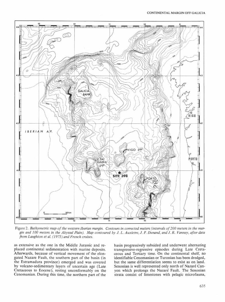
Figure 6. Depth sections across the Galician-Portuguese margin. Sections are constructed with the help of sound velocities derived from processing of seismic data.For unprocessed profiles, approximate velocity laws from nearest processed profiles were used. Depth below sea level is expressed in kilometers, vertical exaggera-tion is 2.5X. North-south spacing of profiles is compressed of about a 1.7 factor if compared to the east-west scale. (1) Formation 1 (a = upper member, b= lower member, c = undifferentiated); (2) Formation 2; (3) Formation 3; (4) Formation 4; (5) seismic reflectors (solid lines = boundaries between formations,dotted lines = other sedimentary reflectors); (6) top of acoustic basement; (7) acoustic basement rocks collected from dredging. J8-6, Upper Jurassic (Kimmerid-gian to Portlandian), m. metamorphic and crystalline; (8) Faults.

CONTINENTAL MARGIN OFF GALICIA
13
Figure 7. Time-isopach map of sedimentary cover. Contour intervals are in half-second of two-way sound travel time.Striped areas indicate little or no sediment is present above acoustic basement. Arrows show directions of bottom cur-rent inferred from sedimentary features seen on seismic profiles; black arrows = currents in Formation 2, empty arrows =currents in Formation 1.
than 1500 meters thick. It is also possible that sedi-ments contemporaneous with Member lb are presentin the Interior Basin, but they cannot be separatedfrom la.
Formation 1 generally is horizontally bedded, butinclined bedding is frequent in the axis of Interior Ba-
sin, between Vigo and Porto seamounts, and in thesouthern Iberian Abyssal Plain (Figure 9A).
Other Sedimentary DepositsBesides the above-mentioned formations, some seis-
mic profiles below Formation 2 show thick series
643

GROUPE GALICE
W
WNWI POD 398
E S E
~^
•• i" . ^ i • • • • • ; " * ! ! 1 , . : t ' * ' l | l ! , . i " " " • •
B
HElsB
Figure 8. Acoustic formations. (A) Abyssal plateau west ofGalicia Bank (OC 106). (B) Profile GP 19 in Site398 area. Note erosional feature on right of the figure. (C) Sediments in trough between two tilted blocks(GP 08 in Iberian Abyssal Plain). Thickness of sediments is more than two seconds. Discontinuities be-tween 2 and 3, as well as 3 and 4 appear very clearly; strata in Formations 3 and 4 are dipping. 1,2,3, and4 = Formation numbers; S = sediments lower than Formation 4; B = acoustic basement. Vertical scale inseconds of two-way travel time.
644

CONTINENTAL MARGIN OFF GALICIA
sw7 ~
SW
SW
Figure 9. Sedimentary features, resulting from current transport. (A) Inclined bedding south of Vasco da GamaSeamount (profile GP20). (B) Ridges with inclined bedding west of Vigo Seamount (GP 20). (C) Sedimentaryprism at foot of Vasco da Gama Seamount (GP 20).
645

GROUPE GALICE
which we could not correlate with some other forma-tions. They infill narrow basins isolated from other re-gions by horsts. Such basins are apparent on the conti-nental slope (Figure 6, eastern part of profiles OC 102,103, and 105) and in some parts of the Interior Basin.They may contain diapir-like structures (OC 102 and103, Montadert et al, 1974), which is not surprisingsince salt basins and structures are known inland. Wereasonably can assume that the thick series representthe Mesozoic down to the Triassic and Lower Jurassic.Such basins may reflect the vestiges of initial rifting witha restricted marine environment (Auffret et al., 1976).
Other thick sedimentary sequences occur locallywest of Galicia Bank and in the Iberian Abyssal Plain.They may comprise the lower Mesozoic series, but welack direct evidence for that assumption.
Sedimentary and Erosional Features; Unconformities
Inclined bedding is seen in Formation 1 and occa-sionally in Formation 2 on profiles A 1, H 32, T 9, A 7,and GP 20 (Figure 9A, OC 102 and H9). This uncon-formity occurs in the Interior Basin, especially aroundits southern outlet between Vigo and Porto seamounts.Large-scale progradation is observed to the south ofVigo Seamount. These sedimentary features indicate ageneral sediment transport direction trending south-westward from the Interior Basin to the Iberian AbyssalPlain. In the Interior Basin itself, there also may bereverse south-north currents. In the Iberian AbyssalPlain, currents diverge and spread laterally in a complexpattern. Current deposition is ongoing today and ap-pears to have been a long-persisting feature on thesouthern part of the margin. Current deposition, whichseems first recorded in Formation 2 (where some pro-gradation appears) is conspicuous in Unit 1 (inclinedbedding). Giant sedimentary ridges or "ripples" may beseen west of Vigo Seamount (Figure 9B) in the "strait"between Vasco da Gama and Vigo seamounts. Currentsmay have been strong enough to prevent deposition orremoval of previously deposited formations. Formation1 is almost completely missing on the sides or "banks"of the channel between Vigo and Porto seamounts,whereas its bottom is infilled with prograding sedi-ments.
Less conspicuous erosional features are seen else-where, mainly at the boundaries between Formations 1and 2 and Formations 2 and 3. Part of Formation 2may be eroded from the top of flexures in the abyssalplain west of Galicia Bank, and on tilted blocks east ofthe same bank. More important and widespread ero-sion occurs at the top of Formation 3, which is conspic-uous when the beds are slightly deformed (as in Figure8B. It seems that, either resulting from differentialcompaction or slight tectonic movements, the top ofFormation 3 was deformed slightly and the highs wereeroded. In other cases, the boundary between Forma-tions 2 and 3 is ragged. Erosion at the top of Forma-tions 3 and 2 is dated, respectively, as Cenomanianand latest Eocene. In the "strait" between Vigo and
Porto seamounts, erosional processes have been contin-uous at least since Eocene time.
Sound Velocity in the Formations
About 350 compressional wave velocities were cal-culated for the construction of depth profiles, for thepurpose of obtaining geological sections with minimalscale deformation. To this must be added 260 velocityvalues solely for the study of the Site 398 area. Thesevelocity values were obtained by the Dix relation fromrms velocity spectra after processing of seismic records.It was soon obvious that velocity characteristics of dif-ferent formations were of stratigraphic value. We re-tained 450 values as suitable for constructing mean ve-locity curves for different sites.
When a sufficient number of measurements providesa statistical basis (Figure 10B), velocity values appearwell grouped in Formations 1 and 2. They are moredispersed in Formation 3, and widely scattered in For-mation 4 and the basement probably because increas-ing depth and dip of the layers make the method inac-curate. Figures 10A and B show the result of the rep-resentation of mean formation velocities as a functionof mean formation depth (or mean formation two-waytime delay). It is seen that the increase of velocity withdepth is not regular. Velocity rises in Formations 1 and2 (1.7 km/sec to 2.5 km/sec); a relative stagnation ofvelocity is observed in Formation 3 and often in thelowest part of Formation 2 (around 2.5 km/sec). Astrong increase occurs in Formation 4 (2.5 to 3.5 km/sec). In acoustic basement, sound velocity is 4 km/sec. This velocity profile immediately suggests that ve-locity is related not only to the burial depth of sedi-ments, but also to some lithological characteristic ofFormation 3. This Formation is the equivalent of the"black shales" (i.e., Units 4A and 4B of Site 398).DSDP shipboard measurements at Hole 398D showeda break in the increase of values (velocity, density)against depth in the interval between reflectors Yellow1 and Orange (an interval corresponding to low orzero carbonate content).
Stratigraphy From Core and Dredge Samples
Numerous samples from Vigo, Porto, and Galiciaseamounts and surrounding relief allow us to constructa regional stratigraphic sequence (Black et al., 1964;Funnel and Smith, 1968; Dupeuble et al., 1976, 1977;unpublished data of the Hespérides cruise, 1976) andto identify (to a certain extent) Formations 1 to 4 (ob-served on reflection seismics) and acoustic basement(Figure 11).
Acoustic Basement
In general, these rocks belong to the pre-Mesozoicsubstratum of the margin (Plutonic or metamorphicrocks of Paleozoic or Precambrian age). On several oc-casions we also collected samples of neritic limestonesof Late Jurassic or Early Cretaceous age from outcropzones of acoustic basement. It is therefore possible thatin some cases, these fractured rocks with reefal facies
646

CONTINENTAL MARGIN OFF GALICIA
react as diffractory bodies and correspond to a part ofthe acoustic basement.
Mesozoic Cover
The oldest Mesozoic strata sampled are of Late Ju-rassic and early Cretaceous age (Vigo, Porto, andVasco da Gama seamounts). These are shallow-waterbioclastic limestone and Calpionella pelagic micrites(Dupeuble et al., 1976, 1977). The present west Ibe-rian margin therefore occupies an area which, at theend of Jurassic time, was an open sea continental shelfarea linked to the Mesogea and the Bay of Biscay(Boillot et al., 1971a,b; Durand-Delga, 1973; Pastouretet al., 1974). Depending on where collected, the sam-ples of Late Jurassic-Early Cretaceous age represent ei-ther acoustic basement or perhaps Formation 4.
We collected Upper Cretaceous rocks from Galiciaand Vigo seamounts. They are generally marl with apelagic microfauna (Funnel and Smith, 1968); Dupeu-ble et al., 1976). From Galicia Bank, however, Black etal. (1964) collected very shallow water bioclastic lime-stones which they believed were latest Cretaceous orPaleocene. It therefore seems that during the Late Cre-taceous the west Iberian margin had already under-gone a strong subsidence, except for Galicia Bankwhich probably was a slightly submerged shoal. Ineach case, the Upper Cretaceous samples were collectedfrom outcrop zones of Formation 2.
Cenozoic BlanketThe samples from this period are all pelagic: Paleo-
cene from Vigo Seamount, Oligocene from GaliciaBank, and Miocene from the Vigo Seamount area. Ad-ditionally, Pleistocene to Recent samples were taken(Dupeuble et al., 1976). The Neogene samples belongto Formation 1. From this stratigraphic evidence,Dupeuble et al. (1976) deduced that the west Iberianmargin separated from the continental plateau in latestJurassic or earliest Cretaceous time and underwent sub-sidence. It is possible, however, that Galicia Bank es-caped the subsidence experienced in neighboring areasand continued in the neritic domain, at least until thebeginning of the Cenozoic (see Structural EvolutionDuring the Cenozoic, this report).
CorrelationsCorrelation between regional basins and Site 398
rests on seismic facies analogy and on layer-to-layer or"direct" correlation at intersections of profiles. The lat-ter avoids facies variations. Difficulties were encoun-tered near Site 398, where topographic conditions andsynsedimentary erosion prevent a direct layer-to-layercorrelation. Correlation with the Interior Basin was alsopoor. However, good facies analogy exists among Site398, the Interior Basin, and the Iberian Abyssal Plain,where correlation is easy with the region west of Gali-cia Bank. No correlation was attempted with the surfi-cial sedimentary formations of Galicia Bank which donot have any characteristics in common with surround-ing deposits. The relationships which may exist be-tween the oceanic series and those of the continental
slopes and platform are obscure except on profile OC102, where Formation 2 appears to insert itself in theplatform series. However, the definition of the seismicdata is too poor on the continental shelf for a precisecorrelation. Table 2 summarizes the quality of correla-tions between physiographic divisions and within eachdivision, and the reasons for the estimates. The term"analogy" means that correlation is based only onseismic facies analogies.
Acoustic formations so defined and correlated maybe related to the lithologic column of Site 398 as de-scribed below.
Formation 4Strongly layered with velocities near 3 km/sec, For-
mation 4 corresponds narrowly with Units 5 and 4C(Hauterivian to Aptian), and consists of fine limestonesand marls grading into turbiditic non-calcareous sand-stones and siltstones. The strong reflector at the top ofFormation 4 may be identified in the area of theDSDP site with the coarse turbiditic limestone bed at1430 meters. Drilling stopped in Hauterivian denselimestones conformable with the basement layers at thedrill site. Thus, all the Neocomian there may be identi-fied as belonging to "acoustic basement."
Formation 3Seismically transparent with velocities generally
lower than 2.5 km/sec, this formation represents theAlbian to Cenomanian "black shales" sequence, con-sisting of dark claystones and mudstones deposited be-neath the carbonate compensation depth.
Formation 2As the relative depth of the CCD lowers, the car-
bonate content of sediments increases, but not in a reg-ular manner. There are fluctuations in the CaCO3 con-tent and, correspondingly, in velocities and bulk den-sity in lithologic Units 3B, 3A, and 2 (900 to 500 m,Campanian to Eocene). In this way, the units of vary-ing CaCO3 content can be correlated with layered For-mation 2.
Formation IBFormation IB, as defined in the abyssal plain, is not
easily correlated with any formation at Site 398. Be-cause Formation 1B is well represented south of Site398, we can tentatively correlate it with the upper partof the layered sequence in profile GP 19, i.e., Unit 1Cand the lower part of borehole Unit IB (510 to 400 m;Oligocene and early Miocene age).
Formation 1AMost of Units IB and 1A, consisting of unconsoli-
dated sediments of uniform carbonate content, can becorrelated with Formation 1A. This explains the iso-tropic character of the formation in the profiles (400 tozero m, late Miocene to present).
If we try to extend the correlations towards the Bayof Biscay, it may be seen that Formations 1, 2, and 3in the Iberian margin are roughly the same as Forma-
647

GROUPE GALICE
GP29 Sea
bottom-1000m
GP01 Seabottom:- 3850m
GP06
Sea bottom:-4000 to-4600
GP 19
398 boreholearea.Sea bottom:-385Om
GP 19trough in East of profile
Sea bottom - 4 4 0 0
GP08
Sea bottom:-5OOO to-5300
A
T r
GP 20NE
Sea bottom:-3OOOm
B
Acoustic basement
0.5
t-0.5 -K^f
-1
-1.5
Sediments
- 2
1
_A
JpA
^ A
A A
D
1.5
G α
α
α
* >
A
-1.8
Acoustic
basement
Figure 10. Relationship between interval velocity and depth below sea bottom. (A) Mean Formation velocity (horizontalscale) for different formation mean depths (vertical scale) in the Iberian Abyssal Plain (upper row) and the Vigo Sea-mount area (lower row). Empty figures and dashed lines = velocity versus two-way travel time. Black figures and solidlines = velocity versus calculated depth in kilometers. Crosses = Formation 1, circles - Formation 2, triangles = Formation3, squares = Formation 4, lozenges = acoustic basement. Vertical scale = seconds and kilometers below sea bottom. Hori-zontal scale = kilometers per second. (B) Frequency distribution of velocities versus formation depth below sea bottom atSite 398 area. Horizontal scale = velocity in km/sec, vertical scale - depth in kilometers. (C) Two-way travel time (hori-zontal scale in seconds) versus calculated depths (vertical scale in kilometers) in sediments and basement along part of pro-file GP 19 crossing a sedimentary trough. For the basement, the reference depth is below sediment-basement interface.(D, E) Mean curves drawn from plots such as presented in C; curve obtained from core measurements at Site 398 is shownfor comparison. The mean curves drawn on transparencies were used for the construction of depth sections from seismicprofiles.
tions 1, 2, and 3 previously established in the Bay ofBiscay. Hence, the ages attributed to Formations 1 and2 (Recent to Oligocene-Eocene to Late Cretaceous,Montadert et al, 1974) after the data collected inJOIDES Drüling Sites 118 and 119 (Laughton,Berggren, et al., 1972), and the age postulated for For-mation 3 (Early Cretaceous) are mostly confirmed bystratigraphic data from Site 398. Formation 4 of the
western Iberian margin cannot be correlated with thatalready distinguished in the Bay of Biscay.
STRUCTURE AND STRUCTURAL EVOLUTIONThe continental margin around Galicia Bank, and
Vigo and Porto seamounts is severely faulted. Faultsand flexures (represented by the same symbol in Fig-ure 12) determine structural highs (usually horsts or
648

CONTINENTAL MARGIN OFF GALICIA
Figure 10. (Continued).
semi-horsts) where acoustic basement outcrops locally,and lows (grabens, semi-grabens, and wide basins)with a thick sedimentary cover.
Present-day morphology (Figure 2) faithfully re-flects the structural framework. The banks are highzones and horsts, the depressions are grabens and ba-sins, the steep slopes correspond to faults, Figures 2 and12 can practically be superimposed.
Some structures are old and buried under sediments,or still form high zones (Mounts Vasco da Gama).Other relief was formed by faults also active during theTertiary.
Direction and Origin of Fractures
The faults and flexures near Galicia Bank areroughly oriented in three prominent directions: NE-SW, NW-SE, and N-S. However, differences appearbetween the areas situated north and south of 42 °N. Inthe north (Galicia Bank), faults oriented 150°E and40°N predominate (Figure 12A), whereas in the south(Vigo and Porto seamounts), the predominate directionis 60°E and north (Figure 12B).
Except for the fewer north-south faults, the base-ment of the Iberian Peninsula shows similar structuralorientation. These are reflected in old faults of Steph-anian and Permian age (Parga, 1969; Arthaud andMatte, 1975). These fractures, however, were activeagain in the Mesozoic and Cenozoic. This is especiallytrue on the continental margin, whose sedimentary andstructural evolution were thus controlled during periodsof both Mesozoic distension and phases of Cenozoiccompression (Boillot et al, 1974). It is possible that
north-south direction, which is not obvious in the in-land basement of the peninsula, is of a different originand only appeared during the rifting phase.
Structural and Sedimentary Evolution During theMesozoic
The west Iberian continental margin has been suc-cessively affected by two episodes of rifting related totwo probable phases of the ocean in that part of theAtlantic. The geological history of the neighboring con-tinent and of the Atlantic margin generally shows ini-tial Triassic rifting. We discuss here the effects of thesecond (Late Jurassic-Early Cretaceous) rifting.
Formation 4 (Neocomian to Aptian) was depositedduring active faulting. It appears, therefore, that activerifting took place at the same time that Formation 4 wasdeposited.
During the deposition of Formation 3, which corre-sponds to the Albian "black shales," the earlier tec-tonic rifts were gradually filled, whereas the normalfaults that bound them remained active. It appears thatthe vertical movements were an isostatic response tothe sedimentary overloading in the basins rather thanto the effect of active rifting. Thus, it is probable thatoceanic spreading began after deposition of Formation4. Finally, during the late Cretaceous (Formation 2),local subsidence practically stopped, the depressionswere almost completely filled by differential sedimenta-tion, and deposition took place in many places on hori-zontal surfaces. At this time, relief was restricted toVasco da Gama Seamount, and to some crests andridges on buried, tilted, fault blocks. The existence of
649

GROUPE GALICE
404 0
Figure 11. Summarized results of dredgings. 1 = marl, 2 = limestone and marl with foraminifers, 3 = bioclastic limestone,4 - detrital limestone, 5 = limestone with algaes, 6 = limestone with calpionellae, 7 = dolomitic limestone, 8 = chalk, 9 =limestone, 10 = sandstone, 11= schist and phyllite, 12=gneiss and granulite fades, 13 = granite, 14 = basalt. Stratigraphicseries: HI = Tertiary undifferentiated (Neogene not symbolized), O = Oligocene, E = Eocene, Ev =Paleocene, C9-8 =Maestrich-tian, C8 = Senonian, C8-6 = Senonian and Turonian, J8-6 = Tithonian (Late Jurassic), CVI = Berriasian (Early Cretaceous),J8-C = Late Jurassic and undifferentiated Cretaceous. After Black et al. (1964, 4 dredges), Dupeuble et al. (1976, 9dredges), and cruise Hespérides 76 (7 dredges, unpublished data).
650

CONTINENTAL MARGIN OFF GALICIA
TABLE 2Summary of Quality of Correlations Between Physiographic Divisions
Iberian Plain
Site 398 Area
Interior Basin
ContinentalSlope andRelated Basins
ContinentalShelf
Galicia Bank
Iberian Plain
Good, direct, gaponH 9
Poor structuraland erosionalfeatures, onlyby analogy
Good by profileT 9, partlydiachronous(progradation)
No correlationexcept forrecent deposits;no characteranalogy
Site 398 Area
Poor; structuraland erosionalfeatures, only byanalogy
Good; direct andby analogy
Poor by GP 19and H 32, struc-tural and ero-sional features
Interior Basin
Good by profileT 9, partlydiachronous(progradation)
Only by analogy,poor by GP 19and H 32, struc-tural and erosionfeatures
Good, direct,someprogradation
Generally bad,except forFormation 1 andFormation 2along OC102-103
No correlationexcept forrecent deposits;no characteranalogy
Continental Slopeand Related Basins
Generally badexcept for>Form.1, and Form. 2,inOC 102,OC 103
Good, locally,basins areisolated
Bad, gaps due toscarps
ContinentalShelf
Bad, gaps due toscarps
Galicia Bank
No correlationexcept for recentdeposits, nocharacter analogy
No correlation,except for recentdeposits — nocharacter analogy
Good along OC106 and GP 29
such important topographic features as Galicia Bankand Vigo Seamount during this epoch will be discussedlater.
Structural Evolution During the Cenozoic
Age and Nature of Tertiary Tectonic MovementsThe analysis of seismic recordings reveals two tec-
tonic phases during the Cenozoic age.1) The large fault along the northwest edge of Gali-
cia Bank continues to the southwest as a flexure whichaffects Mesozoic and Eocene layers without disturbingmore recent deposits. Tectonic movements occurredduring the late Eocene (Figure 13). Movements of thesame age are also seen in the Interior Basin.
2) Certain faults have moved recently, displacingan important part of the upper Tertiary series (Neo-gene phase, Figure 14).
Actually, the Iberian margin reflects the effects ofnumerous episodes of strain during the Cenozoic, asshown by studies on adjacent oceanic areas and on theneighboring continental plateau (Lamboy and Dupeu-ble, 1975; Lamboy, 1976; Boillot et al., 1975; Baldy etal., 1977; Boillot and Mougenot, 1977). It still remainsdifficult, however, to reconstitute them in detail and tostate their precise nature. Some movements suggestingEocene compression and reverse faults have been ob-served in the abyssal plain, northwest of Galicia Bank(Figures 15 and 16). Other movements may have causednormal faults. Additionally, the northeast-southwest
faults west of Galicia Bank with a reverse componentalso may have acted as wrench faults.
Structural Evolution of the Vigo Seamount Area
Vigo Seamount, with its central infilled basin and itsalmost flat rim, is most interesting. It may *>e regardedeither as an uplifted block or as an incompletely sub-sided part of the continental margin.
The first interpretation (Boillot, Mauffret, Auxiètre)is based on the fact that, whereas almost every high onthe margin is only covered with thin sediments, thepre-Oligocene sedimentary series on Vigo Seamount isalmost as thick on top as it is at the foot of this feature.This series only shows minor differences as regards itsthickness and seismic character. We interpret this ap-parent identity between layers which are now at morethan 1500 meters difference in elevation as reflectingcontinuity of bedding during the Mesozoic. VigoSeamount then formed in the Tertiary as the result oftectonic movement. Figure 17A shows this interpreta-tion and also describes the previous stages of structuralevolution. Those stages begin with Upper Jurassic-LowerCretaceous distension and deposition of Formation 4;then intervenes a local subsidence in the tectonic rift-valleys (Formation 3 or "black shales"), and lastly gen-eral leveling of the Upper Cretaceous topographic surface(sedimentation of Formation 2). However, this mono-tonous relief was completely disrupted during the Ter-tiary by the formation of new relief, including Vigo andPorto seamounts. The sedimentary series infilling Vigo
651

GROUPE GALICE
Figure 12. Structural map. 1 = Acoustic basement outcrop, 2 = Cenozoic cover, 3 = Cretaceous and Cenozoic cover (Gali-cia Bank), 4 = Fault, 5 = Basin axis, 6 = Ridge axis. A and B = Frequency distribution of fault directions north of42°N(A) and south of42°N (B).
Seamount's central basin and those at its toe remainidentical up to the Tertiary, then differ completely sincethis period.
This interpretation, if accepted, has important conse-quences:
1) The Late Jurassic-Early Cretaceous series whichcould not be reached by Site 398 drilling is probably
the same as that which outcrops on the sides of VigoSeamount and was sampled during the Lusitania 74and Hespérides 16 cruises.
2) The region northwest of the Iberian Peninsulacannot be considered as a typical passive continentalmargin since its normal evolution was interrupted byimportant tectonic movements in the Tertiary.
652

NNE
CONTINENTAL MARGIN OFF GALICIA
SSE
VERTICAL EXAGGERATION X14,8
JiOKmFigure 13. Section showing post-Formation 2 movements. In this figure, Formation 2 (Campanian to Eocene) is deformed,
whereas Formation lb appears to overlap 2 and infill hollows.
NNW SSE
VERTICAL EXAGGERATION X 14,8• 10 Km
Figure 14. Neogene tectonic movement. On left, a tilted block basement remained as a passive relief feature during most ofthe sedimentation; on the right, a flexure caused gentle bending of sediment up to the formation la/lb boundary (middleMiocene). Vertical scale = two-way travel time in seconds.
The second interpretation of this area's structuralevolution (Montadert, Sibuet, Da Charpal, Figure 17B),i.e., an incompletely subsided part of the continentalmargin, is supported by the existence of several erosionalsurfaces analogous to that on the flat rim of Vigo Sea-mounts^ basement,which lie between Galicia Bank andVigo Seamount. These surfaces truncate acoustic base-ment at roughly the same depth, 3.2 ±0.1 seconds oftwo-way travel time. They are perfectly flat and couldbe remnants of the initial continental surface subjectedto subaerial erosion while the other parts of the contin-ent were foundering and submerged below sea level. Asthey subsequently remained at similar depths, they must
only have undergone regional subsidence since that time,until they reached their present depth of 2500 meters.So,it seems that blocks bearing such erosional surfaces, inparticular Vigo Seamount, were not uplifted duringCenozoic compression, otherwise they probably wouldnot have remained at the same elevation. Using the samereasoning they could not have undergone important dis-tensional movements during the Cenozoic. It is probablethat Vigo Seamount remained as an important relief fea-ture since the Early Cretaceous, i.e., since the riftingof the margin. It may have contributed to the coarselimestone clasts found in the turbiditic material atSite 398 at the foot of Vigo Seamount.
653

GROUPE GALICE
Figure 15. Paleogene reverse fault and other vertical movements. Upper profile (GP 01, migrated). The fault on the left ischaracteristically reverse. It affects Formation 3 isopachs, whereas part of the upper Formation 2 appears to be condensedin the uplifted block, so that deformation appears to be contemporaneous with it and, therefore, is probably of Eocene age.Formation lb is only slightly deformed or overlapping. Lower profile (GP 04). Although more obscure than in the upperprofile, reverse faults or faults with a reverse component may also be present in this section, with important vertical dis-placement; probable age is Eocene to Oligocene. Vertical scale = two-way travel time in seconds.
Structural Evolution of Galicia Bank
The sedimentary cover of the Galicia Bank containssome neritic Upper Cretaceous (Maestrichtian: Blacket al., 1964), which shows that the bank was already inexistence at this time. If our first interpretation of VigoSeamount also applies to Galicia Bank, we would haveto accept that the tectonic movements which elevatedthe Iberian marginal banks were pre-Maestrichtian,which is possible but has not been proved. Two inter-pretations for the evolution Galicia Bank therefore re-main, as is true for Vigo Seamount.
a) The Bank is a horst which formed in the EarlyCretaceous during rifting. It has been a slightly subsid-ing feature since then and is covered by carbonateshelf deposits of Senonian age (Montadert et al., 1974)
b) The Bank is a Senonian horst due to a compres-sive episode whose effects are known in the Pyreneesand on the Iberian northern margin (Boillot et al.,1971a, b, 1973; Lamboy and Dupeuble, 1975; Chouk-roune, 1976; Boillot and Capdevila, 1977).
In the first case, Galicia Bank and Vigo Seamountunderwent differential subsidence and the structuralcontrast observed north and south of the 42°N (Figure12) is an effect of this difference. In the second case,the uplift of marginal banks (horsts) probably resultedfrom the subduction of the ocean bed of the Bay ofBiscay under the Iberian Penisula, which took place inthe Late Cretaceous and early Eocene (Montadert etal., 1970, 1971; Montadert and Winnock, 1971; Sibuetand Le Pichon, 1971).
In either event, it is clear that important tectonicmovements took place in the Tertiary, particularly inthe Eocene. Even if Galicia Bank is a Mesozoic horst,the faults which border it moved again in the Ceno-zoic, and the present morphology is partly a result ofTertiary movements.
CONCLUSION
In the proposed reconstruction of continents, duringTrias and Lias (Figure 18), Galicia Bank area is lo-
654

Figure 16. Structure of Galician-Portuguese margin west of Galicia Bank. Sections are viewed from the southwest. Sediments are shown with theirdeformations. Synrift deformation (prior to Formation 3) is normal block faulting, as in A. Post-rift deformation (during and after depositionof Formation 2) is conspicuous as vertical and inclined faults with a reverse component (see B). It is also possible that movement during thisepoch (Eocene) took place along former normal faults. Dips in the acoustic basement suggest that rocks were gently folded, then eroded, beforerifting (see C). Vertical scale = kilometers below sea level; no vertical exaggeration. 1, 2, 3,4 = Formation numbers. 5 = Seismic reflectors (solidlines boundaries between formations, dotted lines = other sedimentaries reflectors). 6 = heavy solid lines indicating top of acoustic basementand faults. 7 = Projection of the major faults on the sea bottom.

GROUPE GALICE
o _
2000m_
4000"'-
NW
A L B A T L A N T E 6 b + G . P . 1 9
SE c/c N
Final stage: PRESENT
Middle stage: EOCENE
Early stage: EARL Y CRETACEOUS
(α)10 km
BÉÉ 1 2 3 4 :=] 5
ALBATLANTE 6bNW
c/cSE | N
-Gαliciα Bank
- 2 0 0 0 —
- 4 0 0 0 —
Final stage : PRESENT
Vigo Seamount
Middle stage: end of EOCENE
- 2000 —
- 4 0 0 0 —
(b)
Early stage : end of APTIAN
Figure 17. Tentative reconstructions of Vigo Seamount's structural history: (a) as a block raised during Cenozoictimes; (b) as a block synchronous with the rifting. 1 = acoustic basement, 2 = infilling series (Formation 4), 3 =Formation 3,4 = Formation 2, 5 = upper series (Formation 1).
656

70° 6 060'
50'
60° 50 4 0 ' 30s
Figure 18. Position of continents during Trias-Liassic. North America is fixed. The rotation parameters are: Europe/N. America: 89°1N, 1O3°1W, 29°6; Iberia/N. America: 73°9N,16°6W, 49°1; Africa/N. America: 66°3N, 17°1W, 74°1. Heavy lines = major faults, dense stripped areas = major basins located at plate boundaries, clear striped areas = sedimentarybasins from carboniferous until Liassic. Limits of oceanic basins inferred from evaporitic deposits (after Olivet et al., in preparation; from data of Pautot et al., 1970; Sibuet et al., 1971;Bonnin et al., 1973; Grunau et al., 1975; Schlee et al., 1976, Olivet et al., 1976).

GROUPE GALICE
cated between the three major plates of Africa, NorthAmerica, and Europe (see also Laughton, Berggren,et al., 1972; Le Pichon et al., 1977). This area is withina complex region north of the Kelvin Seamount-SouthAtlasic line and was affected by several tensional stressphases between the late Carboniferous (Pennsylvanian,300 m.y.B.P.) and the late Lias (180 m.y.B.P.). The rel-ative significance of these tensional phases is still underdiscussion (Ziegler, 1975; Arthaud and Matte, 1975),but we may assume that the origin of the continentalmargin around Galicia Bank dates back to Trias orearlier.
However, the first period of Iberian margin historyabout which we possess some reliable data is Triassicand/or Early Jurassic. Series of this age occur onlandon the periphery of Iberia and the Portuguese conti-nental shelf. The deposits are partly clastic, partly eva-poritic and dolomitic. Sedimentary sequences with eva-porites are also recorded in the small basins of the con-tinental slope and probably in some parts of the Inte-rior Basin. West of Galicia Bank and in the IberianAbyssal Plain, troughs infilled by a thick sedimentarysequence may contain pre-Neocomian or older sedi-ments. This is likely since they are located in a zoneeast of the probable eastern limit of the late AptianCretaceous magnetic quiet zone. This signifies thatdeposition of lower Mesozoic layers could have takenplace in grabens formed well before the Lower Creta-ceous. Whether they are evaporitic or not is question-able since there are no convincing diapiric structures.In any case, grabens of this age are known in Portugal,and distensive tectonism with Triassic infill occurs onthe North American margin (Pautot et al., 1970; Am-oco, 1973; Schlee et al., 1976; Van Houten, 1977). De-posits of the same age should also occur, according tosome interpretations, in the northern and southern Bayof Biscay (where they would prolong the evaporitic in-land basin), and on the Tagus and Seine abyssal plainsbetween Tore-Madeira Rise and the nearby evaporiticbasins (Figure 18).
On the Iberian margin, fractures oriented in thesame direction as the late Hercynian on-land faultsseem to have controlled pre-Cretaceous basins.
The oldest dated samples are Jurassic. An abun-dance of large samples reveals a platform or reefal en-vironment with open-sea influences in the Late Jurassicand perhaps the beginning of Cretaceous. To date, norock of Early or Middle Jurassic age has been dredged.
The second great tectonic event is the Late Jurassic-Early Cretaceous rifting. Aptian to Hauterivian, andperhaps Valanginian sedimentary infills are obviouslycontemporaneous with at least the final movements ofhorst and graben structures. However, the initial stageof distension cannot be easily dated because the greatamplitude of fault movements and rapid subsidenceobscure the sediment-tectonics relationship in the seis-mic imagery. The Site 398 data show that the site wasalready under deep water in Barremian-Aptian time,but we lack the crucial information which could havebeen provided by a borehole drilled on an elevated
part of the region and another one down to Jurassic in adeep part. This information would have indicated if adifferentiation already existed in the Late Jurassic(dredges brought up only samples from seamounts)and what sort of difference may exist between sedimen-tation on highs and lows during the Hauterivian orBarremian.
During this important stage of rifting, a strong reliefwas created on the continental slope and by theseamounts. North/south faults functioned parallel tothe continental margin. Their movement may have re-sulted in breaks in margin sedimentation or erosion, asappears in particular on the seismic profiles of thenorthwest and northeast Atlantic (Sherwin, 1973; Am-oco, 1973; Winnock and Fried, 1973; Wüson, 1975).
After the rifting phase, it seems that the entire mar-gin subsided and that differential movements ceased, atleast those resulting from distension. Some movementmight have continued as an isostatic response to thesedimentary overburden. Thick and rapid sedimenta-tion of the Albian "black shales" took place duringthis period and infilled the troughs. According to themagnetic data, a rapid expansion of the oceanic floorcreated the Iberian Abyssal Plain (Cretaceous magneticquiet zone).
The effects of erosional processes and a slight un-conformity at the end of the Albian are visible every-where. The character of sedimentation changed andpelagic carbonates replaced clayey mudstones. In manyplaces, sedimentation took place on "leveled surfaces,"although seamounts were still present. Seismic evidenceshows that bottom currents began to prevail whichwere strong enough to cause incline bedding. FromCenomanian to Campanian time, sedimentation wascondensed and ocean current action increased and per-sisted throughout the Cenozoic up to the present at thefoot of the continental slope. This indicates importantchanges in the environment. On land, it is well knownthat the Cenomanian is a time of general transgression,with corresponding changes in the microfaunal distri-bution in Europe and America (Jansa and Wade,1975). In the North Atlantic, there are breaks in depo-sition, changes to carbonate sediments, and a greaterabundance of planktonic fauna. Drilling of the sub-sided Orphan Knoll, shows lack of deposition duringmost of the Late Cretaceous, with pelagic sedimenta-tion following (Site 111 of JOIDES Leg 12, Laughton,Berggren, et al., 1972). All these events may be relatedto an increased rate of sea floor spreading in the earlyCenomanian (Larson and Pitman, 1972; Hays and Pit-man, 1973), and to the opening of the North Atlanticbetween Labrador and Europe.
Galicia Bank area is enclosed between two majortectonized belts which are the western prolongation ofthe Pyrenean orogen and of the Betic and Rif system(Figure 19).
The northern belt was affected by the Late Creta-ceous-Eocene tectonic phase and by minor Oligocene-Miocene movements. Relative vertical movements andflexures resulted in a rejuvenation of the bottom topog-
658

CONTINENTAL MARGIN OFF GALICIA
raphy; we have already stated that faults with reversecomponent occur to the west of Galicia Bank. Thisshows that the margin underwent compressionalstresses, which can be related to compressive events ofthe Pyrenean phase sensu lato. Manifestations of thePyrenean phase are obvious in the Bay of Biscay (Fig-ure 19) as an angular unconformity in the sedimentarysequence (Laughton, Berggren, et al., 1972) and by theoccurrence of subduction north of the Iberian Penin-sula (Le Pichon and Sibuet, 1971a, b; Montadert et al.,1970, 1971; Montadert and Winnock, 1971; Boillot andCapdevila, 1977).
The southern belt, which includes the Tore-MadeiraRise and the Gorringe Bank area, has been affectedmostly by a Miocene compressive episode. These Mio-cene movements, marked by a hiatus between seismiclayers 1A and IB, are as well displayed south of Gali-cia Bank as they are in the Tagus, Horseshoe, andSeine abyssal plains (Figure 19), where intense defor-mation has affected the continental margin, the Tore-Madeira Rise, and the Gorringe and Ampere banks(Olivet et al., 1976b). They are probably linked to thealpine tectonics of early to middle Miocene age whichaffects the Betics and northern Africa.
Consequently, Galicia Bank occupies a zone of criti-cal interest with respect to the principal east-west-trending belts of deformation that lie to the north andsouth. The interpretation illustrated in Figure 19 is thatGalicia Bank is relatively undeformed, having re-mained welded to the rigid blocks that border it,namely, the Iberian land mass to the east and the Ibe-rian deep-sea basin to the west. However, the possibil-ity is not excluded that Galicia Bank, which is a nar-row, continental margin structure, responded to the in-ferred WNW, ESE stress and is therefore the site ofintra-plate deformation.
ACKNOWLEDGMENTSThe authors express their gratitude to G. A. Auffret and L.
Pastouret, contribution No. 533 of the Scientific Departmentof the Centre Océanologique de Bretagne, J. P. Réhault and J.R. Vanney (University of Paris), B. de Givry and Y. Godart(Institut Français du Pétrole), who took an active part in thiswork. They are especially indebted to the crews and scientificteams of the O.S. /. Charcot, LeNoroit (Centre National pour1'Exploitation des Oceans), and Florence (Institut Français duPétrole, Laboratoire du Verdon), who participated in the geo-physical cruises and the dredgings, and to the geophysicists ofSociété Nationale des Pétroles d'Aquitaine (now SNEA P) andof Bureau d'Etudes Industrielles et de Cooperation de 1'Insti-tut du Pétrole, who processed the seismic data.
They are grateful to Dr. J. I. Ewing, both for having re-viewed the text and for his useful advice relative to translationproblems.
REFERENCES
Amoco, 1973. Regional geology of the Grand Banks; off-shore exploration staffs, Canadian Soc. Petrol. Geol. Bull.Con Petrol. Geol., v. 21, p. 479-503.
Arthaud, F. and Matte, P., 1975. Late Hercynian wrenchfaults in southern Europe and northern Africa: geometryand nature of deformation, Tectonophysics, v. 25, p.139-171.
Auffret, G. A., Pastouret, L., Auzende, J. M., and Olivet, J.L., 1976. L'évolution du Golfe de Gascogne et de sesmarges, Fourth reunion Sci. Terre, Paris, p. 25.
Baldy, P., 1977. Géologie du plateau continental portugais ausud du cap de Sines, These 3 e u cycle, Université de ParisVI.
Baldy, P., Boillot, G., Dupeuble, P. A., Malod, J., Moita, L,and Mougenot, D., in press. Carte géologique du plateaucontinental sud-portugais et sud-espagnol (golfe de Cadix),Soc. Géol. Fr. Bull.
Berthois, L., 1966. Bathymetric maps of the continental slopeand shelf, 11 sheet edited by Berthois and printed by theCentre Nat. Rech. Scientif. Paris.
Berthois, L. and Brenot, R., 1964. Bathymétrie du Golfe deGascogne et de la cote du Portugal. I — Commentaires surla levé complémentaire des feuilles 9 et 10 des abords duplateau continental. II — Bathymétrie du talus du plateaucontinental à 1'ouest de la péninsule Ibérique du Cap Finis-terre au cap Saint Vincent, cons. Intern. Expl. Mer, procès-verb., 52nd Reunion, Sept.-Oct. 1964.
Berthou, P. Y., 1973. Le Cénomanien de 1'Estramadoure por-tugaise, Serv. Geol. Portugal, Mem., 23.
Berthou, P. Y. and Lauverjat, J., 1974. La limite Céno-manien-Turonien. Essai de correlation entre la série portu-gaise à Vascoceras et les series de 1'Europe de Sue-Ouestet de 1'Afrique du Nord, C.R. Acad. Sci. Fr., v. 278, p.2605-2608.
Black, M, Hill, M. N., Laughton, A. S., and Matthews, D. H.,1964. Three non magnetic seamounts off the Iberian coast,Geol. Soc. London Quart. J., v. 120, p. 477-517.
Boillot, G. and Capdevila, R., in press. The Pyrenees: sub-duction and collision, Earth Planet. Sci. Lett.
Boillot, G. and Mougenot, D., in press. Carte géologique duplateau continental portugais à l/1000.000e et sa noticeexplicative, Services geológicos do Portugal.
Boillot, G., Depeuble, P. A., d'Ozouville, L., and Sibuet, J.C, 1971a. Structure et histoire géologique de la margecontinentale du Nord de 1'Espagne (entre £° et 9° W). InHistoire structural du Golfe de Gascogne: Paris (Tech-nip), v. 2, p. V-6.1-52.
Boillot, G., Dupeuble, P. A., Durand-Delga, M., and d'Ozou-ville, L., 1971b. Age minimal de PAtlantique Nordd'après la découverte de calcaire tithonique à Calpionellesdans le Golfe de Gascogne, C. R. Acad. Sci. Paris, v. 67,p. 671-674.
Boillot, G., Dupeuble, P. A., Hennequin-Marchand, I., Lam-boy, M., and Leprëtre, J. P., 1973. Carte géologique duplateau continental nord-espagnol entre le Canyon de Capbreton et le Canyon d'Aviles, Soc. Géol. Fr. Bull., v. 15, p.367-391.
Boillot, G., Dupeuble, P. A., Hennequin-Marchand, I., Lam-boy, M., Leprétre, J. P., and Musellec, P., 1974a. Le roledes décrochements tardi-hercyniens dans 1'evolution struc-turale de la marge continentale et dans la localisation desgrands canyons sous-marins à 1'Ouest et au Nord de laPéninsule Ibérique, Rev. Géogr. Phys. Géol. Dyn, Fr.,v. XVI, n» 1, p. 75-85.
Boillot, G., Lefort, J. P., and Rioult, M., 1974b. Carte géo-logique de la Manche, Bur. Rech. Geol. et Minières.
Boillot, G., Dupeuble, P. A., and Musellec, P., 1975. Cartegéologique du plateau continental nord-portugais au norddu cap Carvoeiro, Soc. Géol. Fr. Bull, v. 4, p. 462-480.
Bonnin, J., Auzende, J. M., and Olivet, J. L., 1973. L'ex-trémité orientale de la zone Açores-Gibraltar: structure etevolution, Reunion Ann. Sci. Terre, Paris, p. 91.
Choukroune, P., 1976. Structure et evolution tectonique de lazone nord-pyrénéenne. Analyse de la deformation dans
659

GROUPE GALICE
2050
45
30° 30 '
25 25«
15' 10
Figure 19. Upper Cretaceous and Tertiary tectonic elements near the Iberian Peninsula. V = trenches with subduc-tion, + = axis of uplift area, - = trench axis, double line = boundary of uplifted area, solid lines = main fracturezones (from bottom morphology in underwater areas), striped areas zones deformed under compressive stress,vertical stripes = weak deformation, oblique stripes = intense deformation.
660

CONTINENTAL MARGIN OFF GALICIA
une portion de chaine à schistosité subverticale, Mém. Soc.Géol. Fr., 127.
Choukroune, P., Le Pichon, X., Séguret, M., and Sibuet, J.C , 1973. Bay of Biscay and Pyrenees, Earth Planet. Sci.Lett., v. 18, p. 109-118.
Dupeuble, P. A., Réhault, J. P., Auxiètre, J. L., Dunand, J.P., and Pastouret, L., 1976. Résultats de dragages et essaide stratigraphie des banes de Galice et des montagnes dePorto et de Vigo (Marge occidentale ibérique), MarineGeoL, v. 22, p. M 37-M 49.
Dupeuble, P. A., Boillot, G., Lamboy, M., Malod, J., Mauf-fret, A., and Mougenot, D., 1977. Le passage Jurassique-Crétacé sur la marge continentale atlantique de la PéninsuleIbérique, Fifth reunion, Sci. Terre, Rennes, p. 210.
Durand-Delga, M., 1973. Les Calpionelles du Golfe de Gas-cogne, témoins de Pouverture de 1'Atlantique Nord, Soc.Géol. Fr. Bull., v. 15, p. 22-24.
Funnel, B. M. and Smith, A. G., 1968. Opening of the Atlan-tic Ocean, Nature, v. 219, p. 1328-1333.
Groupe Galice, Jonquet, H., and Williams, C , 1976. Lesanomalies magnétiques du champ terrestre dans la regiondes banes de Galice, Fourth reunion, Sci. Terre, Paris, p.181.
Grunau, H. R., Lehner, P., Cleintuar, H. R., Allenbach, P.,and Bakker, G., 1975. New radiometric ages and seismicdata from Fuerteventura, Maio and Sao Tome, In Progressin geodynamics: Amsterdam (Roy. Neth. Acad. Art andSci.), p. 90-118.
Hallam, A., 1971. Facies analysis of the Lias of West Central,Portugal, N. Yahrb. Geol. Pal., v. 139, p. 226-265.
Hayes, D. E. and Rabinowitz, P. D., 1975. Mesozoic mag-netic lineations and the magnetic quiet zone off NorthwestAfrica, Earth Planet. Sci. Lett., v. 28, p. 105-115.
Hays, J. D. and Pitman, W. C , III, 1973. Lithospheric platemotion, sea level changes and climatic and ecological con-sequences, Nature, v. 246, p. 18-22.
Jansa, L. F. and Wade, J., 1975. Geology of the continentalmargin off Nova Scotia and Newfoundland. Offshore Ge-ology of Eastern Canada, Geol. Surv. Canada, Paper74-30, v. 2, p. 51-105.
Lamboy, M., 1976. Geologie marine et sous-marine du plateaucontinental au nord-ouest de 1'Espagne. Genèse desglauconies et des phosphorites, These d'état, Rouen,France.
Lamboy, M. and Dupeuble, P. A., 1975. Carte géologique duplateau continental nord-ouest espagnol entre le canyond'Aviles et la frontière portugaise, Soc. Géol. Fr. Bull., v.17, p. 442-461.
Larson, R. L., Pitman, W. C , III, 1972. World-wide correla-tion of Mesozoic magnetic anomalies and its implications,Geol. Soc. Am. Bull., v. 83, p. 3645-3662.
Laughton, A. S. and Berggren, W. A., et al., 1972. Shipboardreports of Sites 112, 118 and 119. In Laughton, A. S., Berg-gren, W. A., et al., Initial Reports of the Deep Sea DrillingProject, v. 12: Washington (U.S. Government Printing Of-fice), p. 161-253 and 673-901.
Laughton, A. S., Roberts, D. G., and Graves, R., 1975.Bathymetry of the northeast Atlantic: Mid-Atlantic Ridgeto southwest Europe, Deep-Sea Res., v. 22, p. 791-810.
Le Pichon, X. and Sibuet, J. C., 1971a. Comments on the evo-lution of the North-East Atlantic, Nature, v. 233, p.257-258.
, 1971b. Western extension of boundary betweenEuropean and Iberian plates during the Pyrenean orogeny,Earth Planet. Sci. Lett., v. 12, p. 83-88.
Le Pichon, X., Sibuet, J. C , and Francheteau, J., 1977. Thefit of continents around the North Atlantic Ocean, Tecton-ophysics, v. 38, p. 169-209.
Montadert, L. and Winnock, E., 1971. L'Histoire structuraldu Golfe de Gascogne. In Histoire structural du Golfe deGascogne, a symposium: Paris (Technip), v. 2, Ch. VI-16.
Montadert, L., Damotte, B., Debyser, J., Fail, J. P., Delteil,J. R., and Valéry, P., 1970. Continental margin in the Bayof Biscay. In The Geology of the East Atlantic continentalmargin: ICSU-SCOR Working Party 31, Symposium,Cambridge 1970. Report 70-15, I.G.S., 1971.
Montadert, L., Damotte, B., Fail, J. P., Delteil, J. R., andValéry, P., 1971. Structure géologique de laplaine abyssaledu Golfe de Gascogne. In Histoire structural du Golfe deGascogne, a symposium: Paris (Technip), v. 2, Ch. XI-14.
Montadert, L., Winnock, E., Delteil, J. R., and Grau, G.,1974. Continental Margins of Galicia-Portugal and Bay ofBiscay. In Burk, C. A., Drake, C. L. (Eds.), The Geologyof Continental Margins: New York (Springer-Verlag), p.323-342.
Mougenot, D., 1976. Geologie du plateau continental portu-gais (entre le Cap Carvoeiro et le Cap de Sines), Théese3ème cycle, Université de Rennes, France.
Mouterde, R., 1971. Le Jurassique du Portugal. Esquisse stra-tigraphique et zonale, Soc. Geol. Portugal Bull., v. 18, p.73-104.
Mouterde, R. and Ruget, C , 1975. Esquisse de la paléogéog-raphie du Jurassique inférieur et moyen au Portugal. Soc.Géol. Fr. Bull., v. 17, p. 779-786.
Musellec, P., 1974. Geologie du plateau continental portugaisau Nord du Cap Carvoeiro, These 3ème cycle, Université deRennes, France.
Olivet, J. L., Pastouret, L., Auzende, J. M., and Auffret, G.,1976a. Armorican margin evolution on relation with the
Bay of Biscay genesis, Coll. IUSGS Durham, April 1976.Olivet, J. L., Bonnin, J., and Auzende, J. M., 1976b. Mani-
festation des phases de compression tertiaire dans 1'Atlan-tique du Nord-est, Fourth reunion, Sci. Terre, Paris, p.311.
Parga, J. R., 1969. Sistemas de fracturas tardihercinicas delmacizo hesperico, Trabajos Lab. Geol. de Lage, v. 37, p.1-5.
Pastouret, L., Masse, J. P., Philip, J., and Auffret, G. A.,1974. Découverte de Rudistes d'àge Crétacé inférieur sur lamarge armoricaine—implications paléogéographiques. Sec-ond reunion ann. Sci. Terre, Pont-à-Mousson. Soc. Geol.Fr. Spec. Summary.
Pautot, G., Auzende, J. M., and Le Pichon, X., 1970. Contin-uous deep-sea salt layer along north-Atlantic margins re-lated to early phase of rifting. Nature, v. 227, p. 351-354.
Rabinowitz, P. D., Cande, S. C , and Hayes, D. E., in press.The /Anomaly in the Central North Atlantic Ocean. InitialReports of the Deep Sea Drilling Project, v. 43: Washing-ton (U.S. Government Printing Office), p. 879-886.
Pitman, W. C. Ill, and Talwani, N., 1972. Sea-floor spread-ing in the North Atlantic. Geol. Soc. Am. Bull., 83, p. 619-646.
Ramalho, M. and Rey, J., 1975. Etat des connaissances actu-elles sur le Jurassique et le Crétacé basal du Portugal. Mém.Bur. Rech. Géol. et Minières., Fr., n. 86, p. 265-275.
Rey, J., 1972. Etude stratigraphique du Jurassique supérieuret du Crétacé inférieur de la region de Lisbonne, Thesed'état, Université de Toulouse.
Ruget-Perrot, C , 1961. Etudes stratigraphiques sur le Doggeret le Malm inférieur du Portugal au Nord du Tage, Mem.Serv. Geol. Portugal, no. 7, p. 195.
Schlee, J., Behrendt, J. L., Grow, J. A., Robb, J. M., Mat-tick, R. E., Taylor, P. T., and Lawson, B. J., 1976.Regional geologic framework off northeastern UnitedStates, Am. Assoc. Petrol. Geol. Bull., no. 60, p. 926-951.
661

GROUPE GALICE
Sherwin, D. F., 1973. Scotian shelf and Gr-and Banks. InGrossan, M. (Ed.), The future petroleum provinces of Can-ada: Can. Soc. Petrol. GeoL, p. 519-559.
Sibuet, J. C. and Le Pichon, X., 1971. Structure gravimétriquedu Golfe de Gascogne et fosse marginal nord-espagnol. InHistoire structurale du Golfe de Gascogne, a symposium:Paris (Technip), v. 2, Ch. VI-9.
Sibuet, J. C , Pautot, G., and Le Pichon, X., 1971. Interpre-tation structurale du Golfe de Gascogne à partir des profilsde sismique. In Histoire structurale du Golfe de Gascogne,a symposium: Paris (Technip), v. 2, Ch. VI-10.
Teixera, C , 1968. Quelques problèmes de la géologie du Por-tugal, 23rd GeoL Congress, Prague, v. 13, p. 133-242.
van Hinte, J. E., 1976. A Cretaceous time scale, Am. Assoc.Petrol. Geol. Bull., no. 60, p. 498-516.
Van Houten, F. B., 1977. Triassic-Liassic deposits of Moroccoand Eastern North America, Am. Assoc. Petrol. Geol.Bull., no. 61, p. 79-99.
Vegas, R., 1975. Wrench-(Transcurrent) fault system of theSouthwestern Iberian Peninsula, Paleogeographic andmorpho-structural implications, Geol. Rundschau, v. 64,p. 266-278.
Wilson, R. C. L., 1975. Atlantic opening and Mesozoic Conti-nental Margin basins of Iberia, Earth Planet. Sci. Lett., v.25, p. 33-43.
Winnock, E., Fried, E., and Kieken, M., 1973. Les caractéris-tiques des sillons aquitains, Bull. Soc. Géol. Fr., v. 15, p.51-60.
Ziegler, W. H., 1975. Outline of geological history of NorthSea. In Woodland, A. W. (Ed.), Petroleum and the Conti-nental shelf of North West Europe, Geology, v. 1.
662