GEOLOGY OF THE METHOW VALLEY OKANOGAN COUNTY, … · 2020-05-28 · state of washington department...
84
STATE OF WASHINGTON DEPARTMENT OF NATURAL RESOURCES BERT L. COLE, Commissioner of Public Lands DON LEE FRASER, Supervisor DIVISION OF GEOLOGY AND EARTH RESOURCES VAUGHN E. LIVINGSTON JR. , State Geologist BULLETIN N0.68 GEOLOGY OF THE METHOW VALLEY OKANOGAN COUNTY, WASHINGTON By JULIAN D. BARKSDALE ' 1975 ..
Transcript of GEOLOGY OF THE METHOW VALLEY OKANOGAN COUNTY, … · 2020-05-28 · state of washington department...

STATE OF WASHINGTON
DEPARTMENT OF NATURAL RESOURCES
BERT L. COLE, Commissioner of Public Lands
DON LEE FRASER, Supervisor
DIVISION OF GEOLOGY AND EARTH RESOURCES
VAUGHN E. LIVINGSTON JR., State Geologist
BULLETIN N0.68
GEOLOGY OF THE METHOW VALLEY
OKANOGAN COUNTY, WASHINGTON
By
JULIAN D. BARKSDALE '
1975
..

-WASHINGTON STATE LIBRARY
111~1111111111 Ill llll!l llll l!I Ill Ill 111111~~ AbOOOO 135493
GEOLOGY OF THE METHOW VALLEY OKANOGAN COUNTY, WASHINGTON

FRONTISPIECE
Methow Valley looking southeast from lower slopes of Last Chance Point. Goat Wall in the middle distance left is the result of glacial erosion of Midnight Peak Formation andesitic rocks .
II

STATE OF WASHINGTON
DEPARTMENT OF NATURAL RESOURCES
BERT L. COLE, Commissioner of Public lands
DON LEE FRASER, Supervisor
DIVISION OF GEOLOGY AND EARTH RESOURCES
VAUGHN E. LIVINGSTON, JR., State Geologist
BULLETIN N0.68
GEOLOGY OF THE METHOW VALLEY
OKANOGAN COUNTY, WASHINGTON
By
JULIAN D. BARKSDALE
1975
For sale by Department of Natural Resources, Olympia, Washington
Price $ 2.00
\

The publishing of this report
on the
Methow Valley
was made possible by the
generous financial contributions of the
EXXON COMPANY Minerals Department,
PLACER AMEX INCORPORATED,
and
QUINTANA MINERALS CORPORATION
and
THE U.S. GEOLOGICAL SURVEY
IV

FOREWORD
Dr. Julian Barksdale, the author of this report, is the dean of the Methow River Valley
geology . Berky, as he is known to his friends and colleagues, began his ~ork in the rugged
Methow country in 1939 as a new Ph. D, recently hired by the University of Washington. During
a field trip into the upper Methow late in 1938 with Dr. A. C . Waters and Professor and Mrs .
Adolph Knopf, Mrs. Knopf advised Marajane, Berky's talented wife, that she should do everything
possible to discourage Berky from undertaking such an enormous project. Nevertheless, Berky took
on the project and for years, with Mara jane's continua I support, spent many summers in the Methow
working out complex structure and stratigraphy. During those years he had some interesting experi
ences, not the least of which was working as a cook for a pock-horse outfit to get transportation
into the remote back country . He worked out of tent camps for weeks at a time, and sometimes
suffered physically to accomplish his work.
Dr. Barksdale has been subjected to occasional criticism for not publishing his work .
I was one of the critics until Berky took me through the area on a 2-day field trip in the summer of
1974. After seeing firsthand the size of the project and the remoteness of some of the area,
I came away with a different point of view. The logistics problems that he overcame were stagger
ing in their magnitude, and the complexities of the geology would have discouraged most
geologists.
Dr . Barksdale has done o remarkable job in deciphering the geologic framework of the
Methow area, and we ore fortunate to be able to make the information contained herein available
to the geologic community. All of the geologists in the future who work in the Methow will be
standing on Dr. Barksdale's shoulders.
March, 1975
V
Vaughn E. Livingston, Jr. State Geologist


CONTENTS
Foreword • • . • • • • • • • • • • • • • • • • • . . • • • • • • • • • • • • . . . . • . • • . . . • • • • • • . . • . • • • • • • • • • • • • • • • • • • • • v Introduction • • • • • • . • • . • • • . • • . • • • • . . • . • • . • . . • • . • • . • • • • • . • . . • • • • . • • • • • • • • • • . . . . . • • • • . . . 1
Location and geography •• • •••••••• ••. .•••••. •....... • •••..•••...•...••.•• • •• • ..
Previous work . • • . . . . . . . . • . • • • • • • • . . . • • . . • . • . • . • . • • • • . • . • • • • • . . . • . • . • • . • • • • . . • . 2
Present work and acknowledgments • • • . • . • • • • • • • • • • • • • . • • . • • . • • . • • . • • . . . • • • • • • • • • • 3
Geology..... • • . • • • . • • • • . • • • • . • . • • . . • • . . . . • . . . • • • . • • • • • • . . . . • • . . • . . • • • • . • . . . . . • • • . • • 4
Metamorphic rocks . • . . • • . • • • • • • • • • . • • . . • • • • • • • • • • . • • • • • • • • • . • • . . • • • • • . • • • • • . • . 4
Chelan botholithic complex • • . • . . • • . • • • • • • • • • • . • . • . • • • . . . • • . • . • . • • . • • . • • . 4
Okanogan botholithic complex • • . . . . • • . • • • • • • • • • . • . . • • • • . • • • . • • . • . . • • • • • • 6
Leecher Metamorphics... . ..... . .... . .. .... ... . ............ . ......... . . . . 7
Methow Gneiss • • . • . • • • • . • • . . . . • • . . • • • • • . • • . • • • • • • • • • . • • . . • • • • • • • • • • . . • • 8
lntrusi ve rocks • . . . . . . • • . • • • • • • • . • • . • • • • . • • • . • . . • • • • • • • • • . • . . • • • • • . • • . . • . . • • • • • 9
Summit Creek pluton .•••• . ...•....•• .• •.•. ••. ••••.•. .••.. • • ••.••••• . . . • , 9
Pasayten stock-dike . • • • . • • . • • . • • . . . • • • • • • • • • • • • • • • • • • • • • • . • • • . . . . • • • • • . • 10
Button Creek stock . . • • • • • • . • • . • . . . . . • • • • • • • • • • • . • . • . • . • • • • • • • • • • • • • • • • • • 11
Oval Peak botholith............................ . .. ... ........ .. . ........ 12
Carlton stocks • • . • • • • • • • • • • • . • • . • . . • • • • • • • . • • • . • . . . • • • • . . • . . . . . • . • • • • • • . 13
Fawn Peak stock • • • . • . • • . • • • • . • . . . . • • • • • . • • • . • • • • . • • • • • • . • • • • • • • . • • • • • • • 13
Alder Creek stock • • • • • • • . • • • . . • . . . • • • • • • • • . • . • • • • • • • • • • . • . • • • • . • • • • • . . • 14
Black Peak botholith • • • • • • • • • • • . . • . • • . • • • • • • • • • • . • . . . • • • . • • • • • • • • • • • • • • • 15
Noname stock . . . . . . . . . . . . . . . . . . . . . . . . . . . . . . . . . . . . . . . . . . . . . . . . . . . . . . . . . . 17
Cooper Mountain botholith........... . .............................. .. . .. 17
Midnight stock . . • • • • • • . • • . • • • • • • • . • • • • • • • • • • • . • • . • • . • • . • • • • • • • • • • • • • • • • 18
Texas Creek stock • • • • • • • • • • • . . . . . . . . . • • • • • • • • • • • • • • . • . • • • • • • • • • • • • • • • • • 18
Frazer Creek complex • • • • • • • • • • • • • • • • • • • • • • • • . • • • • • • • • . • • • • • • • • • . • • . • • • • 19
Monument Peak stock • • • • • • • . . . • • • • • . • • • • • • • . . • • • • • • • • • • • . . • • • • • . • • . • • • • 20
Golden Horn bothol ith • • • • • • • . . • • • • • • • • . • • . • • . • • • • • • . • • • . • . • • • • • . . • . • • • • 21
Surface accumulated rocks ••• •• •• ••• •••••••• ••. , • • • • • . • • • • • • • • • • • • • • • • • • • • • • • • • • 22
Newby Group, Undifferentiated • • • • • • • • • • . • • • • • • . • • • • • • • • . • • • • • • • • • • • • • . • 22
Twisp Formation • . • • • • • • • • • • • • • • • • • • • • • • • • . • • . • . . • • • • • • . • • • • • • • • . • • . • • • • 22
Buck Mountain Formation • • • • • • • • • • • • • • • . . • • • • . • • • • • • • • • • • • • • • • • • • • • . • • • • 24
Age and correlation • • • . • . . • . . • . . . . • • • . • • • • • • • • • • • • • • • • . • . • • • • • • • • 25
Goat Creek Formation • • • • • • • • • • . . . . . • . • • • • • • • • • • . • • . . • • • • • • • • • . . . • • • • • • • 27
Age and correlation • • • . . • • . • • • • • • • • • • • • • • • • • • • • • • • • • • • • • • . • • • • • • • 29
VII

Geo logy-Continued
Surface occumu lated rocks-Continued
Panther Creek Fonnotion .• • •••.•.•••.••••••••••• . ••.•... . .• • . • . •• . .. . . .. •
Age and correlation .• . •.• . •.. . •.•••••••• •••.•• . ••.••••..••.••.••.
Harts Pass Formation ••••••••••• •.. . . . •. .•.• •••.•• ..•..••.• . •. • .• • .. . ••••
Age and correlation •...•.••..••.••••• , ••••••••.• ••• ••.•.•• . ••• : •.
Virginian Ridge Formation • , ••.••....•.• •. ••.•.. . ..•.• .. •. .• .•• . ••. •. .•• .
Age and correlation •••••.•... . .•. • .• • •• . .. . ••..••.. . .. • .••.• . .. ..
Winthrop Sandstone .•• • •.•.. ••••.•.• ••••••••.••.• . .•... . .•.••.•. • ••••••.
Age and correlation ...... .•••••••.• •••......•.•• •.••••• ....•••••.
Midnight Peak Formation ••••• , • • . . •.•••• . ...•• . .••••. . ••..• . • . . . • .• . .•• .
Ventura Member ..... . ...•.......•.................•........ •..• .
Ventura Member in the Midnight Peak syncline ••.• • •• . •.•• ••••
Ventura Member in the Goat Peak syncline .••.•••••••••••••••
Volcanic (upper) Member ..••.• •••• • ••••.•••.•••••.••••••••••••.••
Volcanic (upper) Member in the Midnight Peak syncline . . • .• • . • .
Volcanic (upper) Member in the Goat Peak syncline •.. . •..•• • ••
Age and correlation •••.•.••• • ••.•. .•. ••..••.•.•..••..• . ..••••. . ••
Pipestone Canyon Formation ••••• . . .. .••.•.. . •• •. •• . .•... . ..•. . •. . ••• ••• • .
Age and corre lotion •••.• . • • . . • ... . . . ..•. .. .. •. • .• . .. . . .. .. .• • • . .•
G lociotion ••••• . • . • .••• . •.••••••••.....•.••.••• .• . • ••• •. •. .•.. .... . . .••.•..•.
Structure •• . ••••••••.•••••••• • ••.• •••• ..•• , , ••••.•..• · · · • · · · · • · • • · · • · · • • • · • · · ·
Methow- Posoyten groben •••••••...•.••••. •• ...••. ••. ..••.•..•.. ...••. ••.
Bounding structures ••• . •••••••..••••.•• . .•.••.••.••••.•••••..•. . ••
Structures within the graben .•.•. • . • •..••.••••. • •••. . •.••••••.•• • ••
Folding •••••••.••••••••.••..•• • •. . ••••••••••.•••• . •••••••
Faulting •• • ••• . •••••.••.•••••.•••.• . ••. • . •..• . • , .• , ••• • • •
Geologic history • . ••...••••••••••••••...••••••..•••••.••.•• . .• . , . . ••.. . •.. , •••
References cited •••••••••.••••• . •• • ••• ••••.•• •.• .. • •. • • ••••• • • • · · • · · · • · • · · · • • • • · · • • • ·
VIII
29
31
32 35 37
41
42
44
45
45
48
48
49
49
49
50 51
51
53
56
56 56 60
60
62
65 69
ILLUSTRATIONS
Methow Va lley looking southeast from slope of Last Chance Point • • • . • • • • . . . . • • • • • • • . • Frontispiece
Plate 1. Geologic map of Methow Valley area, Washington ••••••••• . . . . . .. ..• .•.. In pocket
Page
Figure 1. Map showing location of area considered in this report . . . . . • • . • • • • . • . . . . • • • . . • 1
2. Methow Gneiss. Well-deve loped foliation on quarry block, north of Methow, State Highway 153. Biotite ovoids i llustrate weak lineation . •. .• . . •• 8
3. Twisp Formation. Folded black shales 1 . 8 miles south of Winthrop on State Highway 20 • • • . . • • • . . • . . . . . • . . . • • • • • • • • • • • • . . . • . • . . . • . • . . . • • . • 23
4. Temporal correlation of units in Methow-Pasayten graben , Washington and British Columbia • • • . • . . . . . . • • . . . • • • • . • . . • • • • . • • • • . • • . . • • • • • • • • . • • • . 26
5 . Looking north- northwest from Sweetgrass Butte showing type sections of Goat Creek and Panther Creek Formations . . • . • • • • • • • • . . • . . . . . . . . . . . . . . . • . • 27
6. Panther Creek Formation. Glacially eroded, horizontal surface on near-vertical bed of granitoid cobble-boulder conglomerate from type section . . • • • • • 31
7. Harts Pass Formation. Middle and upper members in type area, overla in unconformably by Virginian Ridge Formation • • . • . • . • • • • • • • • • • . • . . . • • . • • • • • 34
8. Litho logic comporison of stratigraphic sections Methow- Pasayten graben in Washington and British Columbia • . • • . • • . • • • • . • • • • • • • . . • • • • • . . • • • • • • • • • 36
9. Type section Virginian Ridge Formation . . • • • . • . . .. • • • • • • • • . • • • .. .. • .. • • • • • • • 37
1 o. Virginian Ridge Formation. Predominantly black shale, with chert pebble conglomerate a nd chert grain sandstone maki ng hard outcrop • • . • • • . • • . . • • • • • • 40
11. Winthrop Sandstone. Upper part of type section truncated by Boesel Fault. Outcrop northeast side of State Highway 20, 6 miles northwest of Winthrop .. ... 42
12. Type section Ventura Member . Midnight Peak Formation Methow Valley, 9 mi les northwest of Winthrop • • • . . . . • • . • • • • • • • • • . . • • . • • . • • • • • • . • • • • • • • • . . 45
13. Upper part of type section in Pipestone Canyon Formation • • • • • • • • • • . • . • • • • • . • • 51
14. Paleontologic section, Methow Valley . • . . • • • • • • • • • • • • • • • . • • . • • • • • • • • • . • • . • • 54
15. Stratig raph ic section, Methow Valley . • • • • .. • • • . • • • • • • • • • • • • • . • • • • • • • • • • • • • 55
16 . Chewack-Pasayten fault scarp of Summit Creek gneissic quartz diorite • • • . . • • • • • • 58
17. Thrust fault, Midnight Peak Formation, Volcanic (upper) Member over older Ventura Member red beds . Face of spur between Lost River and Robinson Creek, Methow Valley . . . .. .. ... . .......... . ......... .. ..... 65
IX


GEOLOGY OF THE METHOW VALLEY OKANOGAN COUNTY, WASHINGTON
By
Julian D. Barksdale
INT RODUCTION
LOCATION AND GEOGRAPHY
The study area comprises almost the entire
drainage of the Methow, Twisp, and port of the Che
wack Rivers. This, together with the adjacent divide
between the Methow drainage and Lake Chelan,
amounts to about 1,650 square miles in north-central
Washington State from the Cascade crest east to the
Okanogan Range and from a line 12 miles south of the
Canadian boundary to lat . 48°00 (fig. 1) .
us• 49•
45•
47•
46 '
122· 120' 118 '
FIGURE 1 .-Map showing location of area considered in this report.
The area is one of ridges and canyons, except
for the stretch of the Methow River between Mazama
on the north {elevation 2,100 feet) and Carlton on the
south (1,450 feet). For this distance of 32 miles the
valley bottom is more than a mile wide. The brood
glaciofluvial terraces, suitable for irrigation, drew
homesteaders to the valley in the late 19th century.
The relief between the broad valley and the surround
ing hills is on the order of 4,200 feet.
Ridges rise to elevations in excess of 7,000
feet, with several iagged peaks reaching almost 9,000
feet above sea level away from the main drainages.
The maximum re I ief of the area mapped is 5,371 feet
and is near the center of the map area, where Gardner
Mountain (8,897 feet) rises above the Twisp River
valley (3,526 feet), 5 miles away.
The maior canyons for the most part a re U
shoped, the result of extensive glacial erosion. The
Methow Valley above Mazama is particularly striking
as the walls on both sides of the canyon rise 2,000 feet
or more in sheer cliffs above the broad flat floor,
where the underfit Methow River has established a
well-developed meander pattern in the glaciofluvial
fill. The valleys of Twisp River and Eightmile Creek
exhibit similar characteristics but too lesser scale.
The volley floors of the Methow River above
Mazama, of the Twisp River above the sharp elbow
bend 14 miles west of Twisp, and of the Chewack

2 GEOLOGY OF THE METHOW VALLEY
River and Eightmile Creek above their confluence ore
all heavily forested with a mixture of ponderosa pine
(Pinus ponderosa) , grand fir (Abies grandis), interior
Douglas fir (Pseudotsuga menzies), and occasional
red cedar (Thuja pl icata). Ponderosa pine and cedar
ore seldom found above 3,200-feet elevation. Grand
and Douglas firs overlap with true alpine fir {Abies
lasiocarpo), the latter becoming dominant above
4,000 feet.
Forest cover is porticularly important in limit
ing outcrops on the north and east slopes of the tribu
tary canyons entering the Methow and the Chewack
Valleys from the west. Outcrops must be sought on
the south and west sides of the ridges or above timber-
1 ine {+7,000 feet) .
The lower slopes of the Methow Valley be
tween Mazama and Twisp are largely nonforested , or
at best are covered by a sparse ponderosa pine (Pinus
ponderosa) steppe mosaic with bitterbrush (Purshia
tridentata), and beardless bluebunch wheat grass
(Agropyron inermi, a variety of A. spicatum) as the
major components. South of Twisp on the better soil
sites, the big sagebrush (Artemisia tridentata} mingles
with the bitterbrush; but for the most part, on the
slopes east of the Methow River, bunchgrass is the
predominant vegetation and rock outcrops are plenti
ful.
The climate of the valley below Winthrop can
be classed as semiarid, with precipitation in the Twisp
Winthrop area (mostly in the form of snow} averaging
15 inches per year. Harts Pass, at elevation 6,109
feet on the Cascade crest, has a 27-year recorded
yearly average of 60 inches of precipitation . Most
years, one cannot plan to trave I the crest trails from
late October to late May because of the deep snow
drifts. Patches of snow remain on north slopes until
late Ju ly, some years not melting complete ly at all.
Because of th is prolonged melting at the higher eleva-
tions, many springs and some streams maintain year
round flow .
Access to the area from the Co lumbia River
(U.S. Highway 97) is northeast from Pateros via State
Highway 153 to its intersection with Washington North
Cascade State Highway 20 (cross state). This east
west road connects Okanogan with the main Puget
Sound artery via the Methow and its tributary, Early
Winters Creek, to the Cascade crest at Washington
Pass, and down westward- flowing G ranite Creek and
the Skagit River to the Puget Lowland. The Forest
Service maintains excellent secondary roads in all the
main drainages in addition to the many main haulage
roads constructed and maintained during and after
timber soles have ceased .
PREV IOUS WORK
The earliest published record of geological
observation of the lower Methow Va I ley was that of
Gibbs {1855). He traversed the range between Fort
Okinakane (Okanogan) and the Methow and pro
ceeded down the valley to its mouth. He said (p . 483):
The Valley of the Methow affords a richer field for the geologist in plutonic and metamorphic rocks than any other portion of the Territory visited by the survey, and would richly reword a careful exploration.
Gibbs was intrigued by the terraces at the mouth of
the Methow, reporting that he could count no less
than 18 rising one above the other.
The first geological map of the upper port of
the area was that of Russe II (1900) who, in 1898, as
cended the Skagit drainage and examined the gold
mining operations on Slate Creek and in the Pasayten
Middle and West Forks . He crossed the summit and on
his trip down the Methow drainage examined the
geology between Crater Pass (Harts Pass) and Winthrop,
formally naming the Winthrop Sandstone and the Ven-
tura System of red beds.

Barksdale {1941, 1947, 1948, 1956, 1958,
1960), in a series of papers and abstracts , reported on
glaciation , stra tigraphy, and structure in the present
map area. Ma llory and Barksdale (1963) discussed the
fossil assemblages found in the rocks of the Methow
Pasayten graben .
Several master's theses at the University of
Washington have been written on individual geologic
problems . Maurer {1958) reported on the biostratigra
phy of rocks in the vicinity of Buck Mountain. Pitard
{1958) concentrated on the Mazama area with particu
lar emphasis on the Ventura red beds. Dixon (1959)
worked in the Isa be lla-Sweetgross area. Ryason (1959)
reported on the stratigraphy and structure of the Pipe
stone Canyon area northeast of Twisp . Adams {1961 ,
1964) contri buted information on the rocks of the upper
Twisp River, particularly on the origin of the Block
Peak batholith . Libby {1964), in a Ph . D. disserta
tion, reported on some phases of the crystalline rocks
of the Lake Chelan area, with special attention to the
Oval Peak pluton.
Royse {1965) published on the flora of the Pipe
stone Canyon Formation enlarging upon Ryoson's plant
fossil discovery. Misch {1952, 1966b), in his pioneer
work on the general geology and his more recent over
view of the tectonic evolution of the Northern Cas
cades, has contributed o vo luable interpretation to the
broad geologic problems involved. Menzer (1970)
made a study of the geochronology of the granitic
rocks of the Okanogan Range, which adjoins the area
to the east. Staotz and others {1971) overlapped the
northern part of the map area in their study of the min
eral resources of the Pasayten Wilderness.
Pierson (1972) made o detailed study of the
sedimentary petrology of the arkosic rocks in the
vicinity of Harts Poss, and Tennyson (1974) did a col
lation of other sedimentary petro logy studies in the
area and added her own interpretation from a restudy
PRESENT WORK AND ACKNOWLEDGMENTS 3
of the thin sections . Woitt (1972) restudied the gla
cia I hi story of the area . Co le {1973) made the most
complete study of direction of transport for the sedi
mentary rocks above the Twisp and below the Midnight
Peak Formations.
PRESENT WORK AND ACKNOW LEDGMENTS
Mopping for this project was done on o variety
of mop bases. Early reconnaissance, using the Forest
Service fire control mop at 1:125, 000 scale for the
area north of lot . 48°30'N., accomplished little; so
the more deta iled mopping was begun on photostati c
enlargements of the Methow quadrangle to 1 :62,500
scale, with 100-foot contour interval. Air photographs
become available in 1948 for the port of the a rea
north of lot. 48°30' N. on a scale of approximately
1 :47,500. The Forest Service plonimetric mops made
from these photos become o plotting base until comple
tion of the U. S. Geological Survey Mazama and Doe
Mountain quadrangles (1 :62,500 scale). More re
cently, the area west of the Mazama quadrangle has
been covered by o series of U. S. Geo logical Survey
quadrangles on o scale of 1 :24, 000 . Information plot
ted and replotted on these mops of varying sea les hos
been brought together on the Army Mop Service Con
crete sheet, at a scale of 1 inch equals 2 mi les. The
cooperation of the Portland, Oregon, regional head
quarters of the U.S. Forest Service is gratefully ac-
k now I edged .
The author owes much to Aaron C. Waters for
the introduction to the area in 1938. Appreciation
also is expressed for the many kindnesses extended by
George and Foy Dibble and Jock and Elsie Wilson ,
and the large number of Forest Service personnel,
who over the years supplied maps, trail advice, and
hospitality. Numerous graduate students in geology
hove contributed to the study, and their names wi II

4 GEOLOGY OF THE METHOW VALLEY
be found in the section on previous work. The ex
change of ideas with the students and with field as
sistants Fred Roberts and Gordon McAllister is grate
fully acknowledged.
Many people have contributed paleontologi
ca I information for which the author is gratefu I.
Their names will be found in the appropriate sections
of the text. Special thanks are due Robert Dabritz
for his prowess as a collector and finder of new fossil
localities.
Appreciation is also expressed to Bates McKee
and V. Standish .Ytallory who have worked in parts of
the area and with whom there have been many discus
sions. Elaine DuRall is the most patient re-typist.
The critical help of Vaughn E. Livingston, Washington
State Geo logist, and his staff, particularly laura Bray,
Doyal Foster, and William H. Reicher t, and of Dean
Rinehart and Rudolph Kopf of the United States Geo
logical Survey, has been most valuable.
Without the help and forebearance of my
wife Marajane and son Tucker this work could not
have been done.
GEOLOGY
METAMORPH IC ROCKS
Very little detai led work has been personally
done on the metamorphic rocks of the two complexes
-Chelan and Okanogan- outside the graben. It will
suffice for this report to call attention to their gross
aspects. Relatively more attention was paid by the
author to the obvibusly parametamorphic suite, the
leecher Metamorphics, and the intrusive orthogneiss,
the Methow Gneiss, which make up an important part
of the rocks that crop out in the graben south of
Twisp.
Chelan Batholithic Complex
Barksdale (1948, p. 165) referred to the vari
ous assemblages of igneous and metamorphic rocks
occurring in the southwestern part of the study area
as the Chelan batholithic complex. Hopson (1955),
Adams (1961, 1964), and Libby (1964) investigated
the area in detoi I and gave local names to the various
mappable units that they recognized . Their work and
that of the author make it evident that this assemblage
comprises o great complexity of porogneisses, schists,
and marbles that hove been intruded by stocks and
batholiths, some of which themselves hove been meta
morphosed. The general name will be retained, but
individual plutons where mapped wi ll be given geo
graphic names and described in the section devoted to
igneous rocks.
Adams (1964, p. 292-293) was able to distin
guish five major divisions of what he called the Skagit
Gneiss (ofter Misch, 1952), beginning at the Stehekin
River at the head of lake Chelan. He described these
units from west to east as:
1. Migmatitic biotite gneiss.
2. Migmatitic to homogeneo'us hornblende
biotite gneiss .
3. Homogeneous biotite gneiss .
4. Heterogeneous schist unit containing mixed
layers of highest medium-grade omphibolitic schist,
hornblende biotite schist, biotite quartzite, gornet
biotite-staurolite schist, and muscovite-bearing gneiss,
in order of decreasing abundance. These schists grade
into gneiss across the strike in a distance of a few feet

to tens of feet and locally grade into gneiss along the
strike.
5. Homogeneous biotite gneiss.
Small isolated pods and lenses of quartzite
and marble are sparsely scattered throughout all the
gneiss. These together with the schist unit, are in
terpreted by Adams (p. 292) as evidence of the sedi
mentary nature of the pre-gneiss material.
Libby (1964, p. 9) studied the gneisses occur
ring in the area between the Oval Peak batholith and
Lake Chelan, south of the area mapped by Adams. He
described o highly heterogeneous rock assemblage,
which in some areas consists of o mass of cross-cutting
gneissic dikes enclosing only minor remnants of what
could be interpreted as nonmobilized gneiss. In other
areas, the gneiss is thinly layered, consisting of alter
nating layers with different textures, with or without
schist intercolotions. He found the layers to be both
planar and swirled and pinched in a complex manner.
Elsewhere the gneiss is essentially homogeneous, the
planar structure being marked solely by grain orienta
tion.
The most common gneiss is coarse groined with
crysta lloblasti c texture and largely composed of quartz,
oligoclase, and biotite. Green omphibole is present
in minor quantity. Schist layers within the gneiss
range from migmatitic interlominotions to units hun
dreds of feet thick and traceable for long distances.
The most common of these are biotite schists but there
are amphibolites and minor schistose quartzite and
calc-silicate schist. Marble layers also occur; one
near South Navarre Peak is about 25 feet thick.
Libby (1964, p. 96) was able to trace one
schist unit on the southwest border of the Oval Peak
batholith for a distance of at least 12 miles. This
band, which he informally designated the "Horseheads
Poss schist," is only a few hundred feet thick. It
separates the Oval Peak batholith from the gneiss.
METAMORPHIC ROCKS 5
He gave ranges for the minerals present, but, in
summary, biotite averages 12 percent, quartz 54 per
cent, plagioclase of upper oligoclase to lower ande
sine composition 28 percent, and K-feldspar 8 per
cent. The accessory minerals ore garnet, muscovite,
chlorite, colorless amphibole, titanite, apatite, and
opaque minerals.
Hopson (1955) mapped the smo II triangu lor
area in the extreme southwest part of the map as
"undifferentiated regional metamorphic rocks (esp.
gneiss) containing migmatitic zones." He postulated
a pre-Late Jurassic age for the rocks.
Both Adams (1964, p. 292) and Libby (1964,
p. 130) considered the metamorphic rocks of the map
area to be the southeast continuation of simi lor rocks,
which Misch (1952, p. 7) described as forming the
backbone of the Northern Cascades and the product
of migmatizotion and granitization of a sedimentary
volcanic sequence, plus small amounts of gneisses of
doubtful origin. To this complex he gave the name
"Skagit gneisses."
More recently, Misch, (1966b, p. 112-115)
proposed the name "Skagit Suite" for two recog
nizable metamorphic entities: (l) Cascade River
Schist, the isochemi cally metamorphosed eugeosyn
clinal sequence of varied elastic with subordinate
volcanic rocks and minor limestone, and (2) "Skagit
Gneiss," a migmatitic complex lying norltheast of the
Cascade River Schist and forming the backbone of
the range.
There is some confusion regarding the nomen
clature. Daly (1912, p, 528-536) used the name
"Skagit" for the volcanic sequence along the Cana
dian border just west of the Skagit River. Mc Taggart
and Thompson (1967, p. 1205-1209) pr,eserved the
name for these rocks and used "Custer Gneiss" for
metamorphic rocks that ore the extension of those
mapped by Misch, which Daly (1912, p. 523-526)

6 GEOLOGY OF THE METHOW VALLEY
named the "Custer Granite Gneiss. 11 Staatz and
others (1972, p. 840) have remapped Misch's area
between the Skagit River and the Canadian boundary
and follow Mc Taggart and Thompson's name of "Cus
ter Gneiss."
There. seems to be little doubt that most of the
rocks of the present map shown as Chelan Complex
are, in general, correlative with Misch's (1966b,
p. 102) "Skagit Gneiss" and Mc Taggart and Thomp
son's (I 967) and Staatz and others' (1972) "Custer
Gneiss. 11
It should be pointed out, however, that there
is one group of rocks included in the Chelan batho
lithic complex that is of a different metamorphic fam
ily from the others . Adams (1964, p. 293) used the
name "Twisp Valley Schist" for rocks exposed be
tween the upper Twisp River valley and his "Block
Peak Quartz Diorite" and the long, fingerlike exten
sion of the Oval Peak intrusion. Contact effects from
the intrusions have caused minerals, such as biotite,
muscovite, hornblende, plagioclase, garnet, and
andalusite, to grow statically. In some cases these
minerals cut across the foliation of greenschists,
quartz-sericite schists, micaceous quartzitic schist,
and quartzite, calc-phyllite, and othet low-grade
metamorphic rocks derived from sedimentary and vol
canic rocks. These low-grade metamorphic rocks may
be correlative with similar rocks described by Misch
(1966b, p. 116) as the "Elijah Ridge Schist. 11
Mc Taggart and Thompson (1967, p . 1208) be
lieve that "the Custer Gneiss was probobly formed by
regional metamorphism and migmatization of Hoza
meen strata. The gneiss contact is believed to mark
a migmatite front, the limit of injection, replacement,
and recrystallization of earlier formed metamorphic
rocks by trondhjemite and pegmatite." This conclu
sion is in general agreement with that reached by
Misch (1952, 1966b).
The age of metamorphism of Misch's (1966b,
p. 113) "Skagit Suite" is not known, beyond its being
older than mid-Cretaceous orogeny and, presumably,
than latest Triassic-Jurassic-Early Cretaceous deposi
tion. McTaggart and Thompson (1967, p. 1210) say
only that the development of the Custer Gneiss is
younger than the Hozameen Group and older than
Eocene beds, but designate it on their map as pre
Jurassic?.
Okanogan Batholithic Complex
Examination of the granitoid gneisses and as
sociated intrusive rocks northeast of the graben was
confined for the most part to a narrow strip imme
diately northeast of the Chewack-Pasayten Fault. No
samples were collected more than 3 miles from the
fault and most of them within 1 mile. Barksdale
(1948, p. 165)referred to these rocks as the Okanogan
batholithic complex and the name is. retained. In
general, the rocks are largely leucocratic biotite
quartz-feldspar rocks that are for the most part weakly
gneissic. Hornblende is present in some thin sections
but is not prominent. There is amp1le evidence of
shearing in the development of the gneissic structure.
The quartz is granulated, the mica appears in wispy
trai Is that accommodate themselves to the porphyro
clasts of elongated, spindle-shaped, and apparently
rotated plagioclase. Much of the plagioclase is zoned
and some of it twinned. There ore sufficient hypidio
morphic crystals that have not recrystallized to give
assurance these were igneous rocks of a very light
colored quartz diorite or trondh jemite family that have
in part been recrysta II ized.
The reader is referred to four studies for an
understanding of the metamorphic and igneous geology
in the Okanogan complex between the Chewack
Pasayten Fault and the Canadian boundary. Goldsmith

(1952} has discussed the petrology of the Tiffany
Conconully area. Menzer (1964, 1970} reported on
the geology of the crystalline rocks west of Okanogan.
Hawkins (1968} published a comprehensive study on
the regional metamorphism of the Lake Creek-Andrews
Creek area, and Hibbard (1971) discussed in detail
the evolution of a plutonic complex in the Okanogan
Range, east of the Hawkins' study area.
Leecher Metamorphics
Barksdale (1948, p. 166) gave the name
"Leecher Metamorphics" to a series of distinctly
banded hornblende schist, quartzite, quartz-oligoclase
hornblende gneiss, biotite-quartz-oligoclase gneiss,
marble, and calc-silicate rocks occurring in a curving
belt from 1 to 2 miles wide east of the Methow River
in the drainage of Leecher Creek and in the vicinity
of the town of Carlton. The best exposed sections lie
northeast of Carlton for 6 miles along the prevailing
strike, where westward-draining canyons cut across the
compositional layering that, in general, parallels the
schistosity. The prevailing dips are steeply to the east;
the strike, however, swings from a near east-west at
the eastern boundary of the area, south of the Texas
Creek stock, to north-south in the vicinity of Carlton
and then northeast for approximately 6 miles, where
the metamorphic terrane ends in a thrust over the non
metamorphic Frazer Creek complex.
The rocks west of the Methow River and east of
the Smith Canyon Fault are shown on the map as
Leecher Metamorphics, because all of the rock types
found in the type area except marble appear to be
present. There is, however, a marked difference be
tween the type Leecher and the rocks sporadically
cropping out between the Methow River and the Smith
Canyon Fault to the west. So numerous are the nearly
vertica I zones of mylonite striking north-northeast that
LEECHER METAMORPHICS 7
they almost equal the volume of the less sheared gneiss
and schist which appears to have the same general at
titude.
The western contact between the Methow Gneiss
and the Leecher Metamorphics is a fault. The severely
sheared rocks in the fault zone are exposed in the mile
long roadcut along Highway 153, just so,uth of Carlton.
The Leecher at the north end of the roadcut are very
sheared hornblendic augen gneisses. Examination of
thin sections shows the hornblende to be cut by chlo
rite veinlets and, in some cases, it is largely replaced .
The schistose nature of the rock is caused by alignment
of the stringers of epidote, chlorite, and hornblende
surrounding the mi Idly drawn out spindle-shaped, dusty
feldspars. The feldspar has been sericitized. Quartz
is a minor constituent in this particular rock. Dark
green fine-grained rocks that appear to be phyllites
ore, under the microscope, sheared hombl ende epidote
schists. Chlorite has in part replaced the hornblende
or crystallized in the apexes of small-scale crinkle
folds of the alternating layers of ocicular green horn
blende and epidote in a matrix of albiite and quartz.
Shearing in pale-green phyllitic-appeoiring rocks hos
apparently reduced the previous generation of metamor
phic minerals, suspected to be largely hornblende and
plagioclose, to very fine-groin minera Is, consisting
largely of chlorite and epidote with augen of larger
grain size aggregates of epidote. These rocks ore diaph
thoriti c phyllonites (Knopf, 1931, p. 14, 19-20) rather
than phyllites, and owe their origin to the process
of mylonitization accompanied by retrograde metamor
phism.
Quartz-biotite-feldspar-gornet gneisses (SH
sec. 19, T. 32 N., R. 22 E.) have also been severely
sheared and the biotite almost completely replaced by
chlorite. The garnet crystals are 1 mm or more along
their longest direction. They contain well-preserved
fragments of red-brown biotite and twinned feldspar,

8 GEOLOGY OF THE METHOW VALLEY
one of which could be determined as An30• The garnet
is cracked and e longated in the p lanes of shear. Chlo
r ite has replaced garnet in veinlets a long the cracks.
Porphyroclasts of qua rtz and sharply twinned plagio
clase in the andesine range, up to 1 mm in size,
float in a mylonitized matrix of quartz, feldspa r, and
chloritized biotite. There is considerable iron oxide
distributed in the planes of shearing. These rocks
have a complex multistage metamorphic history, and
their retrogressive or diaphthoritic phase is especially
conspicuous.
Fina lly there are zones (SE! sec. 30, T. 32
N., R. 22 E.) of ultramylonite in which the porphyro
c lasts are mostly very rounded feldspar crystals in a
fine-gra ined mesostasis of quartz, fe ldspar, chlorite,
and epidote. In several localities, the ultramylonites
conta in small inclusion-free garnets with the larger
ones being cracked and replaced by chlorite only oc
casiona lly.
The parametamorphic nature of the Leecher
Metamorphics is not unl ike that of some of the rocks in
the Chelan complex, but the age of neither is known .
The Leecher Metamorphics have been intruded by an
igneous mass that was penetratively sheared and re
crystal lized to fo rm the Methow Gneiss. The evidence
is not clear just how much metamorphism of the Leecher
was accomplished before the making of the Methow
Gneiss.
Methow Gneiss
A very distinctive biotite "granite" gneiss crops
out, for approximately 50 square miles , in the south
east part of the area . Barksdale (1948, p. 166),
named this the "Methow gneiss" for the town of
Methow, which lies near the center of the outcrop
area . The Methow Gneiss is faulted against the
Leecher Metamorph i cs on the west . It intrudes the
gently dipping Leecher on the north almost concord
antly and is intruded by the Cooper Mountain batholith
on the south. The eastern contact is covered.
Megascopically , the strong gneissic character
of the rock is emphasized by the large clots of biotite,
in many instances over a cm in diameter . The biotite
clots occur as irregularly drawn out ovoids of paper
thinness or as ragged books as much as 2 mm in thick
ness. Blocks of rock quarried out parallel to the gneiss
structure have a leopard-spot appearance on the sur
faces parallel to the foliation. The biotite ovoids
indicate a weak lineation (fig. 2).
FIGURE 2.-Methow Gneiss. Well- d~veloped foliation on quarry block, north of Methow, State Highway 153. Biotite ovoids illustrate weak lineation.

Many attitudes token on the well-defined foli
ation plot out as being nearly horizontal over a forge
area in the central port of the body mapped. Dips
generally are in the 10° to 20° range; seldom do they
exceed 30° . The preponderance of gentle dips of the
schistosity and its near concordance with the overlying
Leecher to the north and east make the Methow Gneiss
an attractive candidate for a gneiss dome mode of
origin. All that con be said at present (1974) is that
the rock hos been penetratively sheared and almost
completely recrystallized. It is remarkably uniform
over a wide area and its parent magmatic composition
was that of quartz diorite to granodiorite.
The rock in thin section hos a mosaic texture
typical of recrystallization and is composed of notably
untwinned, clear and fresh plogioclase consistently
within the o liogoclose range where determinable. No
potash feldspar is present . The quartz occurs in dis
tinctly smaller groins than the feldspar and appears in
floods along the planes of schistosity- some of it clear
and unstrained but other grains show strain shadows.
The strongly aligned biotite is intimately intergrown
with epidote. Much of the epidote crysto II ized in
prismatic euhedral form and apparently grew simul
taneously with the biotite. Apatite and magnetite are
common accessory minerals.
The sheared Methow Gneiss along the fault
contact, so well exposed in the south half of the
roadcut along Highway 153 south of Carlton, offers a
good example of retrogression of a gneiss to a schist.
Megascopi co lly, the cha racteri sti c I eopard-spot ap
pearance of the Methow Gneiss is muted there, be
cause the spots are no longer shiny block but green.
The biotite in thin section is completely replaced by
chlorite and fine granular epidote. The large epidote
clots of the parent rock ore drown into fusiform shapes,
enclosed in granulated quartz and sericiticized and
granulated feldspar, thus emphasizing the foliation.
INTRUSIVE ROCKS 9
All that can be said at this time of the age of
the Methow Gneiss is that it is younger than the
Leecher Metamorphi cs and older than the Cooper
Mountain botholith.
INTRUS IVE ROCKS
There are numerous magmatic intrusions within
the Methow-Posoyten graben and adjacent to it, vary
ing in composition from diorite to granit·e and in size
from thin si lls, dikes, and small plugs to those of both
olithic dimensions . Some of the major i ntrusions are
syntectonic or hove been affected by major tectonic
events. Megoscopic gneissic structure has been devel
oped in some of the rocks; in others the tectonism
is recorded by the development of prehenite, epidote,
and ch lorite, and by catoclasis of the essential min
erals quartz and(or) feldspar, recognizable only i n thin
sections. The myriad of si Ifs, dikes, and other minor
intrusions has not been mapped for the current publica
tion.
Radioactive age determinations for only four
of the 15 intrusions described are available; the order
of description is, therefore, highly subjective.
Summit Creek Pluton
A light-colored biotite quartz diorite intrudes
the Leecher Metamorphics directly east of Carlton in
T. 32 N. , R. 22 E. This is the western limit of
the large body of a faintly gneissic rock that Menzer
(1964, p. 22) mapped as trondhjemitic gneiss.
Bates McKee (persona I comm uni cation) has
made a careful study of the contact relations between
the Summit Creek body and adjacent Leecher Meta
morphics . In general , the contact parallels the marked
foliation in the Leecher Metamorphics that dips steeply
to the east directly east of Carlton, and swings to an

10 GEOLOGY OF THE METHOW VALLEY
east-west strike, with the north dip south of the intru
sion. The quartz diorite has intruded the Leecher rocks
lit-par-lit in a broad injection zone, with numerous
quartz-diorite sills, tens to hundreds of feet thick,
separating the layers of Leecher schist and gneiss.
There are numerous rotated xenoliths in the Summit
Creek pluton, some of which have reacted with the
magma. The contact zone also contains dikes of
andesite, basalt, and pegmatite . It is not clear
whether the latter ore related to the Summit Creek
plutonic rocks or to the younger Texas Creek composite
stock, which intrudes bath Leecher Metamorphics and
the Summit Creek pluton.
The weak gneissose structure in the Summit
Creek quartz diorite is more pronounced near the con
tacts than in the main body of the intrusion. The foli
ation is defined by the more or less parallel arrange
ment of streaks of wispy biotite flakes. In some hand
specimens, elongate streaks of quartz can be seen
roughly paralleling the mica. Much of the rock, how
ever, is megascopically directionless.
The predominant feldspar is oligoclase
(An23_31 ), which makes up about 65 percent of the
rock. Quartz varies in amount of 10 to 50 percent,
probably averaging 30 percent. Potassium feldspar is
less than 5 percent. Biotite is nowhere more than 10
percent. The most important accessory mineral is
epidote; muscovite, magnetite, titanite, zircon, and
apatite are present in small quantities.
The rock has an overall granoblastic texture,
the outer growth on the feldspars not following the
idiomorphic pattern of the weak normal zoning, and
sparse twinning. The quartz is generally recrystallized
into elongate mosaics. The wispy biotite is associated
with epidote, muscovite, and magnetite.
The age of the Summit Creek intrusion is not
known . Menzer (1970, p. 577) reported the results
of a rubidium-strontium study of two samples on which
both biotite and whole- rock analyses were carried out.
He suggested that there was an isotopic homogeniza
tion due to penetroti ve rock deformation of the unit,
approximately 104 mi Ilion years before present.
Pasoyten Stock-Dike
Posoyten Peak is a landmark in the most north
em part of the map on the ridge separating the Middle
and West Forks of the Posoyten River. The peak is
underlain by a body of medium- to coarse-groined,
light-colored biotite- hornblende quartz diorite, which
become of great interest when it was discovered to be
the source of the glacial erratics so plentiful in the
Harts Pass area. These rocks were the first evidence
that Canadian ice had spilled south across the divides
from Posayten to Methow drainages (Barksdale, 1941).
Rocks of similar character crop out on the ridge
north of Robinson Pass and in the Lost River Canyon.
Recent mopping by Stootz and others (1971, p. 30)
has shown that these occurrences, previously mapped
as separate smo II stocks, ore in fact parts of a very un
usua I tabular intrusion that is 12.4 miles long and
overages 1.1 miles wide. Stoatz' interpretation has
been incorporated in plate 1, and the nomenclature
adopted,
The rock in Posoyten Peak itself is hypidio
morphic and is composed of 65 to 70 percent strongly
zoned plagioclase, with cores as calcic as An45
, and
showing both norma I and osci llotory zonings. Some
crystals have olbitic myrmekite rims. Much of the
feldspar is in the lower ondesine range . Potassium
feldspar probably constitutes less than 5 percent;
quartz is unstressed and makes up 20 to 25 percent of
the rock. Green hornblende, showing a strong tend
ency toward euhedral shape, and deep-brown biotite,
in blocky books, together form approximately 5 per
cent of the rock. Titanite, apatite, and magnetite

are the common accessory minerals. Some alteration
of biotite to ch lorite and hornblende to chlorite and
epi dote was noted . Some of the feldspar cores have
a dusty a Iteration, but the rock is essentiall y fresh.
At the southeast end of the stock-dike, the
rock has been affected by the younger Monument Peak
intrusion. Much of the hornblende hos been replaced
by aggregates of dark brown bi oti te, but fe ldspors ore
unaltered.
Tabor and others (1968, p . C45-C52) report
K- Ar biotite and hornblende ages of 87.7±2 . 6 m.y.
and 86,0±2.6 m.y., respectively, from a sample col
lected from the center of the dike li ke part of the plu
ton , about 3 miles southeast of Posoyten Peak . These
Late Cretaceous ages bear significantly on the loca l
geologic history because they are concordant within
the assigned limits of error, and are therefore reli
able . This intrusion cuts the Winthrop Sandstone and
probobly also cuts the Midnight Peak Formation,
thereby establishing a minimum age of earliest Conio
cian for the Midnight Peak.
Bu tton Creek Stock
A biotite-hornblende quartz diorite stock, ap
proximate ly 5 mi les long by three- quarters of a mile
wide, is exposed in the northeast part of the map area.
It intrudes the ondesitic and volcaniclastic rocks of
the Buck Mountain Formation to the northwest and
orkosi c sandstones and shales of the Panther Creek
Formation to the southeast. The intrusion is younger
than the Orte I I Creek Fault, but its relation to the
Chewock-Pasoyten Fault in the Eightmile Creek valley
is not clear .
The rock of the Okanogan complex exposed
on the northeast side of the valley is biotite-horn
blende quartz diorite gneiss that has been penetratively
BUTTON CREEK STOCK 11
sheared. The feldspars show evidence of igneous
origin but the overall texture and structure is defi
nitely metamorphic . In contrast, shearing in the But
ton Creek rocks away from the fault has been minimal.
The rock contains hornblende as well as biotite, the
former in greater abundance . No intrusions of Button
Creek rock were found in gneiss of the Okanogan
complex .
The Button Creek rock in thin section is com
posed of about 50 percent well-twinned, strongly
euhedrol plogioclase, normally zoned with cores of
An35_45 grading to rims of An15_30• Most of the
fe ldspar shows sericitic alteration . Orthoclose is
sparse or absent. Quartz makes up 20 to 25 percent of
the rock, and in some thin sections its extinction is
sharp, in others it is mildly undulotory. Biotite with
straw yellow to deep-brown pleochroism occurs in
ragged, paikilitic crystals up to severo l mm in diame
ter. Its shape is controlled by the earlmer crystallized
plagioclose. In some instances, quartz shows sharp,
well-developed crystal faces against the biotite. A
characteristic of the biotite is its intergrowth with
spindle- shaped groins of prehnite, which have forced
apart the biotite cleavages. MognetHe as well as
plogioclase and quartz occur as inclusions in biotite,
and chlorite is its chief alteration product. Hornblende
occurs in we II-formed crysto Is up to 5 mm Ion~ and as
irregular poikilitic masses enclosing well-formed feld
spar, magnetite, and zircon crystals. hs pleochroism
is yellow to green to olive . Some crystals are com
pletely altered to chlorite and calcite . Mafic min
erals make up about 20 to 25 percent of the rock .
Copper mineralization in the andesitic and the
less common felsic volcanic members of the Buck Moun
tain Formation on Isabella Ridge may be re lated to the
intrusion of the Button Creek stock. Copper staining
has stimulated prospecting on the north and west sides
of the intrusion and some adjacent rocks. Smaller

12 GEOLOGY OF THE METHOW VALLEY
granitoid intrusions in the andesites of the Buck Moun
tain Formation near Billy Goat and Eightmile Pass may
be continuous at depth with the Button Creek body.
The age of the Button Creek is not definitely
known . There is some evidence that it has been in
volved in the Chewack-Pasayten Fault movement .
Roadcuts at the mouth of the Ortell Creek expose
highly sheared granitoid rock that may be Button
Creek. If so, the stock may be as young as post
Paleocene for the Chewack-Pasayten Fault cuts the
Pipestone Canyon Formation of Paleocene age .
0 v a I Pe a k Ba tho I i th
An irregu lar-shaped intrusion of quartz diorite,
elongated in a northwest-southeast direction, crops
out south and west of the prominent bend in the Twisp
River (T. 33 N., R. 19 E.), overanareaofapproxi
mately 50 square miles. The writer mapped the north
ern and eastern contacts as shown on the map. The
southwestern contact was taken from Adams (1961) and
Libby {1964).
Adams (1961, p. 163) informally named the
intrusion the "Oval Peak pluton," from the prominent -
peak occurring in the northern part of the main mass
that he included in the map area of his Ph. D. thesis .
The irregular shape of the body, with its strong pro
jections in a northwest- southeast direction parallel to
the regional trend of the rocks of the Chelan batho
lithic complex-Twisp Valley Schist member, makes
for sharp contacts . The contacts are both parallel and
discordant with the schistosity of the host rocks sur
rounding the northern part of the intrusion. Contact
effects on the schists are discernible for up to one
half mile from the intrusion.
Libby (1964) completed the mapping of the
Oval Peak batho li th to the southeast and found a per-·
sistent band of schist several hundred feet wide. This
can be traced for at least 12 miles as it makes a sep
tum between the southwest boundary of the main body
of the Oval Peak intrusion and the Chelan complex
"Skagit gneisses" of Misch (1952). The textures of
these biotite-quartz-plagioclase schists, and minor
hornblende-quartz-plagioclase schists, some of which
contain clinopyroxene, do not show the obvious con
tact effects reported by Adams (1961, p. 163) ad ja
cent to the elongated northern extension of the in
trusion. Libby {1964, p. 24 and pl. Ill) did find,
however, that the metamorphic grade of the schist ap
pears to increase southward along the sitrike but he rec
ognized no such effects a long the northeastern border
of the main body of the pluton. The sedimentary and
volcanic rocks within the graben are intimately mixed
with slivers of mylonitized gneiss, schist, and Oval
Peak rocks in the major shear zone that is the Twisp
River Fault.
The quartz diorite of the Ova I Peak batholith
in the most northwesterly lobe is of very uniform com
position. Adams (1961, p . 163) reports quartz, 23
percent; plagioclase, 62 percent; K-feMspar, 3 per
cent; biotite, 8 percent; and epidote, 3 percent; with
about 1 percent accessory minerals including horn
blende, muscovite, chlorite, sphene, apatite, and
zircon. The plagioclase in rocks of the northern part
of the pluton shows complex oscillatory zoning but
with an overall normal trend toward more sodic mar
gins. The average composition is near An30 with
a range from approximately An32 in the cores to An10 in the rims. Libby (1964) agrees that the overall
composition of the plagioclase for the pluton averages
An30 but finds that the plagioclase in the southern
lobe tends to have more calcic cores.
Biotite is the common dark mineral in the plu
ton, exhibiting blocky pseudohexagonal shapes. The
parallelism of the biotite is pronounced in rocks of the

most northwesterly lobe and is present in the southwest
margin of the pluton, the dominant trend being north
west-southeast. Epidote occurs in anhedral to euhedral
grains associated with biotite and muscovite in the
northern part of the pluton. Libby (1964) reports that
both epidote and muscovite disappear in the southern
most part of the Oval Peak body, and their place is
taken by an amphibole with optical properties similar
to those of ferrohastingsite, occurring in amounts from
2 to 4 percent associated with the biotite.
The age of the Oval Peak botholith is not
known except that it predates the Foggy Dew Fault.
Carlton Stocks
Two small stocks of coarse-grained quartz dio
rite with a distinct pinkish color are exposed west of
the Methow River, southwest of Carlton. Evidence
may be seen in the large roadcuts in Libby Creek that
the northern and smaller body near the Smith Canyon
Fault has been strongly sheared and converted to
schist. At some distance from the fault, hand speci
mens of relatively structureless rock can be found in
the larger joint blocks between the evident shears.
Rocks of the larger southern stock are wholly
enclosed in Leecher Metamorphics and show no mega
scopic evidence of schistose or gneissic structure, al
though close spaced jointing is developed in the
northern part of the intrusion .
All of the rocks in thin section show consider
able alteration . The plagioclase is strongly euhedral
to subhedra I, poorly twinned but markedly zoned .
The cores are altered to a mixture of sericite, epidote,
and a dusty-gray product that sometimes is nearly
opaque. Determination of the feldspar is difficult,
but two less altered crystal cores are as ca lcic as
An32 and are surrounded by rims of sodi c oligoclase.
FAWN PEAK STOCK 13
The pink color is evidently due to iron oxide in cracks
in the feldspar or along grain boundaries. The iron
was probably derived from the almost total decomposi
tion of the mafic minerals. The plagioclase makes up
approximately two-thirds of the rock. In some of the
specimens, there is no potash feldspar; i1n others there
is a sma II amount, but not enough to qoo I ify the rock
as a granodiorite. The determination was made only
after staining with sodium cobaltinitrite. Quartz is
present in larger amounts than is normal for most of the
quartz diorites in the Methow and makes up 25 percent
of some samples. In some specimens it is markedly
sheared and shows undulatory extinction; in others,
extinction even in the large crystals is surprisingly
uniform.
It is difficult to tell what the original mafic
minerals were in some thin sections. There has been
some microshearing; and reddish alteration products
suggest that oxidation was an important alteration
reaction. In others, both hornblende and biotite are
preserved. Some alteration to chlorite and epidote is
re cog n i za bl e •
The age of these intrusions cannot be deter
mined other than to say they are older than Smith
Canyon faulting.
Fawn Peak Stock
A composite diorite to quartz diorite stock
makes an irregularly shaped outcrop pattern that is
approximately 4 miles wide north-south and 5! miles
long, east-west. Its most southwesterly outcrop is
within a mi le of the Mazama post office (T. 36 N.,
R. 20 E.). The lower course of Goat Creek deeply
incises the stock.
The southwest one- half of the stock has in
truded andesite of the Midnight Peak Formation and

14 GEOLOGY OF THE METHOW VALLEY
the red beds of the underlying Ventura Member. The
andesites, red beds, and dioritic rocks are more min
eralized there than in the northeast part of the intru
sion, where the magma invaded the steeply dipping
arkoses of the Winthrop Sandstone.
The intrusion in the south and western part of
the stock crystallized as a coarse-groined biotite
hornblende diorite, with minor amounts of primary
quartz. The plagioclase, in the calcic andesine
range is markedly euhedrol, sharply twinned , showing
oscillatory zoning, and it makes up 60 to 80 percent
of the rock. The feldspar shows some sericitic altera
tion. Biotite occurs as primary blocky books and as
secondary aggregates replacing amphibole. Chlorite
and muscovite replace some biotite. Remnants of a
green amphibole ore encased in secondary tremolite
actino lite, chlorite, and muscovite. A brown staining
that may be hematite is associated with this assem
blage. Quartz is present as an accessory mineral but
seldom makes up as much as 5 percent of the diorite.
Apatite and skeletal black opaque minerals , mag
netite and(or) ilmenite ore important accessory constit
uents .
There is markedly less alteration in the north
and east part of the stock. The rocks there ore finer
groined than those to the west. Andesine makes up
two- thirds of the rock, and green amphibole, much of
it euhedrol, having a strong brown pleochrism, com
prises most of the remaining third. Quartz, biotite,
and a black opaque mineral, probably magnetite, ore
the chief accessory minera ls. There has been very
little alteration of the mafics. A chilled border facies
exists close to the arkose contacts and resembles horn
blende andesite porphyry .
The Fawn Peak stock differs from all the others
described in this report by being the most quartz-poor.
One is hardly justified in naming very much of it
quartz diorite. ft is the most complexly jointed, and
the only one sufficiently mineralized to be seriously
prospected for ore deposits.
There ore numerous prospect pits in the ande
site adjacent to the stock on the south and west sides
and in the diorite of the stock there. From the turn
of the century to World War fl, gold was the mineral
being sought . Continued interest in the district over
a long period of time has led to the patenting of
claims; and as a result, there is a considerable block
of patented land within the southwest part of the in
trusive. The fact that copper accompanies the gold,
as well as silver and zinc, has fed to renewed interest
in the possibility of developing a large tonnage, low
grade copper mine wi thin the stock. Three major cop
per companies have recovered thousands of feet of
diamond-drill core in thei r effort to determine the
size and grade of the ore bodies. Drill ing was in
progress as late as 1975.
The Fawn Peak stock was probably emplaced
late in the last folding episode. The complex, closely
spaced jointing and the existence of minor faulting
and shear zones, which ore now mineralized, suggest
that it was not completely post- tectonic, especially
that part exposed west of Goat Creek. The stock cuts
the Midnight Peak Formation, thus establ ishing a max
imum age of emplacement as Late Cretaceous. The
stock has as yet not been dated rodiometri ca lfy .
Alder Creek Stock
Immediately southwest of Twisp, a small com
plex stock of predominantly light-colored quartz dio
rite makes a rectangular outcrop of about 4 square
miles in area . The country rock is largely Newby
Group volcanics and for most of the intrusion the con
tacts are not sharp; many dikes cut the country rock
and numerous xenoliths of the volcanic and vol can-

iclastic rocks occur in the main body of the intrusion.
The northern two-thirds of the western border of the
intrusion has been affected by movement on the Smith
Canyon shear zone; a northeast branch of the fault
between Elbow Coulee and the Twisp River separates
a wedge of biotite- quartz- oligoclase gneiss of un
known affinity from the stock. La rge and small xeno
liths of hornblende gneiss. are engulfed in the quartz
diorite north of Elbow Coulee . The stock's northern
and eastern contacts are against Newby Group rocks.
Thin sections of rocks from the main body of
the stock are composed of up to 75 percent moderately
to strongly aligned subhedral plagioclase with patchy
zoning. locally bent and sometime ruptured twin
lame llae give evidence of mi Id deformation. The
composition of the most calcic feldspars determined is
An32 • The plagioclase is moderately fresh in some
slides, in others strongly sericitized. Potassium feld
spar is present in very minor amounts. Quartz with
marked undulatory extinction occupies interstitial
spaces between the fe Ids par, and occasionally inc I udes
small patches of myrmekite or clear orthoclase. The
quartz is estimated to make up less than 5 percent of
the rock. Biotite and hornblende occur in about
equal amounts; the quartz has fair crystal form, but
the biotite is very irregular in shape and in some
slides is complete ly altered to chlorite and locally to
deep-yellow epidote. In some sections, lozenges of
prehnite have grown along the biotite cleavages in
amounts equa I to the host crysta I. The hornblende is
relatively unaltered and is strongly pleochroic in the
following scheme: X = green, Y = yellow, and Z
= olive green. Titanite, zircon, apatite, and magne
tite are the accessory mi nera Is.
A small area of moderately dark hornblende
diorite occurs in the northeast part of the stock, cut
ting the older quartz diori te and rocks of the Newby
Group . This rock in thin section is composed of al-
BLACK PEAK BATHOLITH 15
most equal amounts of feldspar and fresh, strong ly
euhedral crystals of hornblende up to 1 mm in length.
Its pleochroic scheme is X = yellow- brown, Y =
yellow, to Z = brown. The feldspars are much smaller
in size and strongly sericitized. Patches of calcite
are present, but quartz is almost totally lacking.
The age of the Alder Creek stock could not be
determined. The evidences of deformation of the feld
spars and the development of epidote and prehnite
suggest that it has been subjected to stresses possibly
associated with the thrust faulting that brought the
Leecher Metamorphics over the Newby Group rocks
immediately to the south, and also to structures asso
ciated with movement along the Smith Canyon Fault
to the west. The late hornblende diorite and numer
ous porphyry dikes that can be found in this area may
be related genetically to the Midnight Peak Tertiary
volcanic episode.
One of the most productive mines in the area
has been the Alder, now dormant. This gold-si Iver
copper-zinc mine is located 5 miles southwest of
Twisp, east of the Smith Canyon Fault zone. Between
1939 to 1955, ore was mined from open pits and three
adits. The ore came from a 15- to 75-foot-wide silic
ified, sheared zone in a felsic member of Newby
Group volcanic rocks. Ore minerals were deposited
possibly during the emplacement of the stock.
B I a c k Pe a k Ba th o I i th
Misch (1952, p. 16) fi rst reported a body of
apparently massive granitic rock younger than his
"Skagit gneisses" outcropping to the east of Mt. Logan
and Mt. Goode on the Cascade crest, and extending
east a long the crest through Black Peak and Rainy Pass
to a point just west of Liberty Bell Mountain (T. 35 N.,
R. 17, 18 E.) . For this he proposed the name

16 GEOLOGY OF THE METHOW VALLEY
"Black Peak Granodiorite" and suggested that these
rocks had been fonned from the "Skagit gneiss"
(Chelan complex). Later work by Misch (1966b,
p . 139) revealed that the Black Peak grades to the
west into an orthogneiss younger than his restricted
"Skagit Gneiss" and is intruded on the east by the
Tertiary Golden Horn batho lith.
Adams (1961) mapped the continuation of Black
Peak rocks southeast of the type area as a part of his
Ph . D. resea rch, a nd later (1964) discussed the origin
of the "Black Peak Quartz Diori te . " He found the
unit to be a n essential ly massive rock made up of
dominantly quartz diorite , but varying in composi tion
from diorite to granodiorite. To him the evidence
was particu la rly clear that this was a n example of an
igneous rock derived from a gneiss.
The Black Peak batho lith's sharply discordant
contacts on the north and east shown on p late I were
mapped by the writer. The Black Peak is definitely
intrusive on its northeastern margin in the upper Twisp
Valley into schists inc luded in the Chelan batholithic
complex, which was loca lly called "Twisp Valley
Schist" by Adams (1964, p. 293), and into andesitic
volcanics of the undifferentiated Newby Group, called
by Misch (1966b, map), the "North Creek Volcanics."
The intrusive rock in this area is directionless and ex
hibits a marked contact aureole approximately one
half mile wide.
The contact on the south and west on plate 1
is taken from Adams (1964, p. 291), who described it
as gradational into gneisses of the Che lan complex
("Skagit Gneiss" of Adams and Misch) . Rocks of the
Black Peak differ from the gneiss megascopically in
that they have little or no planar fabric, la rger grain
size, and more nearly euhedral plagioclase. Adams
{1964, p . 293) found tho t the gradua I transition from
gneiss to quartz diorite made it impossible to map a
sharp boundary in the field . He could, in his labara-
tory study, recognize a compositional layering in the
gneiss that strikes northwest and which, by careful
thin-section study, could be traced into the Black
Peak body and mapped through the massive rocks. This
is port of the evidence for his interpretation that the
Black Peak was derived from the gneiss by static re
crystallization in the south and west, which was ac
companied by partial liquefaction and production of
true igneous phenomena to the north and east. The development of a mafi c border, one
quarter to 1 mile wide, is of particular interest in the
Black Peak intrusive, south of the pronounced re
entrant in the upper drainage of the Twisp River (T.
34 N. , R. 1 8 E.). The mafi c border grades from a
biotite- hornblende- quartz diorite to hornblende dio
rite to hornblendite as one approaches the schists from
west to east . Adams {1964, p . 304) considered the
mafic rocks to be the resu lt of hydrothennal leaching
along the eastern contact, which dissolved and re
moved silica and a lka l ies from the reactive gneiss and
quartz diorite, leaving a relatively mafic residue.
North of the schist reentrant in the upper Twisp Va l
ley, the quartz diorite abruptly cuts across the re
giona l schistosity, and the contact crosses the Twisp
River to cut the andesitic vo lcanics of the Newby
Group. The quartz diorite, there, has a markedly ig
neous texture and is composed of sharp ly twinned and
zoned plagioclase of subhedral to euhedral shapes,
averaging An25_35 in composition; quartz up to 30
percent; and minor microcline- microperthite fi !ling the
interstitial spaces. Biotite and hornblende are the
chief mafic minera ls, although in a few places pyrox
ene is present. Adams (1964, p. 294- 5) has given a
detailed summary of moda l ana lyses of a large number
of thin sections from the Black Peak body .
The age of the Black Peak intrusive is uncer
tain, but Misch (1966b, p. 134) considers it Late
Cretaceous in that it post- dates the intra- Cretaceous

orogeny and predates the intrusion of the Golden Horn
botholith (Eocene-Oligocene). The Black Peak oblit
erates the Twisp River Fault where it crosses the vo l
ley to intrude the Lower Cretaceous(?) Newby Group.
The fault is thought to be simi lor in age to the
Chewack- Pasoyten Fault, which is post-Paleocene in
its latest movement. If this assumption is correct, the
intrusion is probably early Tertiary in age .
Nonome Stock
A small stock of biotite granodiorite intruding
the Methow Gneiss is exposed one-ha If mile north of
the town of Methow. Its outcrop is less than a square
mile in area. The highway there cuts through a dis
tinctly pinkish-white leucocratic medium-grained
granitic rock in which well - formed crystals of pyro
genic biotite and of titanite can be seen with a hand
lens.
The rock, in thin section, is composed of oli
goclase that is weakly twinned, and normally zoned
in strongly· euhedral to subhedral crystals. Quartz
occurs in rather large clots made up of several crystals
all poikilitically enclosed in still larger areas of un
altered orthoclase. The orthoclase is relatively more
abundant than quartz in the few thin sections ex
amined. The rock is compositionally very similar to
rocks in the nearby Cooper Mountain batholith, ex
cept that titanite and magnetite ore more abundant in
the stock. In addition, biotite in blocky crystal form
is portly altered to chlorite, and occasional groins of
strongly yellow, pistocite-epidote are associated with
the biotite. The rock shows no evidence of shearing
or strong alteration of the feldspars.
Cooper Mountain Botholith
The Cooper Mountain batholith is an elliptical
shaped body of biotite granodiorite that is exposed
COOPER MOUNTAIN BATHOLITH 17
over on area of at least 120 square miles in the south
ern part of the map area. On the south and west it
intrudes schists, gneisses, and migmotitic rocks of the
Chelan batholithic complex; on the northeast it in
trudes the Methow Gneiss , Leecher Metamorphics,
and volcanic sedimentary rocks of the Newby Group.
The contacts between the intrusive and the country
rocks are invariably sharp wherever observed, espe
cially where they cut across the structure I trend of the
Chelan metamorphics on the south and northwest. The
northeast contact is not as well exposed.
There is considerable variation in texture with
in the intrusive body. The rock in the vicinity of
Cooper Mountain is very coarse grained and strongly
porphyritic. Stained slabs show crysta~s of potassium
feldspar as much as 2 .cm long . Some of these have
rims of plagioclase. Quartz crysta Is as much as l cm
across occur in amounts about equal to the potassium
feldspar. The plagioclase crystals are generally not
over 0.5 cm long. Biotite in crystals, seldom over 1
mm in diameter, is the only dork mineral in the coarse
grained phase. Polished and stained specimen slabs
show plagioclase 59 percent, orthoclase 18 percent,
and quartz and biotite 23 percent.
A few miles north and west of Cooper Moun
toi n the porphyritic phase of the granodiorite dis
appears. Within less than a mile of the southern
contact, a more even and apparently finer grain is
attained. Megascopically, the bulk of the intrusion
appears deceptively fine grained due to the sma II size
of the biotite. Close examination with hand lens,
however, revea Is that the plagioclase is l to 3 mm in
longest dimension. Sodic plagioclase is the predominant constitu
ent as seen in thin section, making up approximately
60 percent of the rock . The crysta Is ore euhedra I to
subhedrol and zoning is oscillatory. The twinning is
shadowy and indistinct and commonly absent. Univer
sal stage determinations show cores of An20-40 with

18 GEOLOGY OF THE METHOW VALLEY
rims of An15_20• The potash feldspar is orthoclase,
some of which has remarkably strong subhedral shapes
showing Carlsbad twinning. Much of the orthoclase is
anhedral and poikilitically encloses well-formed quartz
and plagioclase crystals . Perthite is present, but is
not strongly developed. Quartz has a tendency to oc
cur in clots, although occasionally crystal faces are
found developed against potassium feldspar crystals.
The quartz-orthoclase ratio is about l: l.
Biotite is the only dark mineral present in most
of the rock, and occurs in very small but well-formed
blocky crystals with pleochroism from straw yellow to
dark brown. It has been replaced in part by chlorite
near the borders of the intrusion, but it is quite unal
tered in other parts of the intrusion. Amphibo le was
seen in only two of thirty widely dispersed samples.
Many porphyry dikes issue from the intrusion
and cut the granodiorite and adjacent country rock .
The best exposed dikes can be seen on the walls of
Black Canyon Creek and in the lower Methow River
canyon. These gray dikes, mostly vertical, with north
to northeast trends, have dark, chilled selvages of a
few inches against the country rock. Many of the
dikes exceed 40 feet in thickness and show progressive
changes from dark, chilled borders through a porphy
ritic to an almost equigranular texture in their central
zones. Euhedral phenocrysts of plogioclose as much
as 2 inches long are not unusual. The quartz pheno
crysts are in pa rt terminated, although there is con
siderable rounding and embaying of these crystals.
The dikes, l O feet or less in thickness, are strongly
porphyritic to their cores. Closely adjacent to the in
trusive in Black Canyon, the dikes make up as much
as 25 percent of the outcropping rock . lndividua I
dikes intrusive into the Methow Gneiss can be traced
to the northeast in the Methow drainage for several
miles.
The age of the intrusion has not been de
termined, but it belongs chemical ly and minerologi-
cally to the same family as the Golden Horn and Mon
ument· Peak intrusions of early Tertiary age . It is not
cut by- hence appears to be later than- the Foggy
Dew Fault, separating the Methow graben from the
Chelan metamorphic block.
Midnight Stock
A young stock of gray hornblende ondesite
porphyry intrudes a very thin unit within the Winthrop
Sandstone and a thick section of ondesite breccio
within the Midnight Peak Formation in the upper
reaches of Wolf Creek {T. 34 N . , R. 19 E.). The
stock is less than a mi le wide and 2 mi les long. No
material from this stock was available for examination.
Texas Creek Stock
Immediately southeast of Corl ton, a smol I
composite stock is sporadically exposed in the canyon
of Texas Creek and on the ridges flanking the canyon.
The older rocks ore in the southwest part of the stock
and consist of medium-groined directionless horn
blende diorite that makes a somewhat indefinite con
tact with strongly hornblendic schists and gneisses of
the Leecher Metomorphics. The metamorphic rocks
dip into the stock at its west and south boundaries.
Between the diorite and the Summit Creek pluton to
the east, leucocrati c biotite granodiorite makes up
the major part of the stock. This potosh- ri ch phase is
clearly intrusive into the Summit Creek pluton to the
east, the Leecher rocks to the north and south, and
the earlier diorite on the west and southwest.
The Texas Creek area was uti liz.ed for a Uni
versity of Washington student field-cou rse study area
for several seasons. It is highly recommended as
a fascinating place for the study of intrvsive relation-

ships and contact metamorphic effects where the stock
cuts marb le beds of the Leecher Metamorphics. Skarn
zones were formed a long its south boundary that con
tain the ore minera ls scheelite, chalcopyrite, mo lyb
denite, pyrite, magnetite, and hematite. The gangue
is largely calcite, epidote, and garnet. A tungsten
prospect in sec . 2, T. 31 N ., R. 22 E., known
locally as the Dutch John claim, is described by
Huntting (1956, p. 345).
The older, darker phase of the intrusion is, in
thin section, made up of sharply twinned and zoned
andesine crystals, strongly subhedral to euhedral in
shape. Cores as calcic as An45 have rims of An35 .
Late overgrowths on some crystals in the low oligo
clase range have been accompanied by the develop
ment of myrmekite. Hornblende is the most abundant
mafic mineral but seldom makes up more than 30 per
cent of the rock . The crystals are irregularly shaped,
having adjusted to space not filled by the earlier
formed plagioclase. Pleochroism is in shades of olive,
yello"". green, to yellow. Biotite is present in wispy
crystals but is subordinate to the hornblende . A minor
amount of chlorite has been formed by s light alteration
of both the hornblende and biotite. Quartz is present
in small interstitial patches in most thin sections, but
it seldom amounts to as much as 10 percent, and is
usually less than 5 percent. Magnetite is the chief
accessory minera l but apatite, deep-yellow epidote,
and more rarely titanite are present. Although the
bulk of the darker phase is a hornblende diorite,
local parts of this earlier intrusion can be classified as
biotite-hornb lende quartz diorite.
The main body of the Texas Creek stock is dis
tinctly more leucocratic than the rocks described
above. Petrographic examination shows the plagio
clase to be euhedral and complexly twinned and
zoned. The most calcic cores are An35 and have
rims that are An28• The plagioclase in most sections
FRAZER CREEK COMPLEX 19
studied is more abundant than the quartz and orthoclase
combined, but in the center of the intrusive body the
the two fe ldspars are of about equal amounts . Non
perthitic orthoclase occurs in large patches that en
case all other minerals. Alteration of the feldspars
has been mi Id; the orthoc lase has a ltered to a dark,
dusty kaol inite, while the plagioclase has altered to
sericite and muscovite. The chief dark mineral is a
strongly pleochroic dark-brown to yellow, blocky,
pyrogenic biotite that has been slight ly altered to
chlorite. Hornblende is present in most sections, but
it is distinctly subordinate to the biotite. The most
common accessory mineral is titanite, which occurs in
well-formed crystals many of which q:m be identified
megascopi ca lly. Apatite and magnetite are common,
and deep-yellow epidote locally occurs a lone or in
association with the fresh biotite.
The major part of the Texas Creek stock is
composed of a directionless hornblende-biotite
granodiorite and quartz monzonite that are chemically
and mineralogically closely similar to the Tertiary
Golden Horn and Cooper Mountain intrusives. The
equally directionless but earlier calc- a lkalic phase
may be corre lative with the Cretaceous intrusions of
the Pasayten Peak stock-dike type of Late Cretaceous
age.
Frazer Creek Complex
Scattered exposures of a variety of intrusive
rock types in the drainage of Beaver and Frazer Creeks
in the eastern part of the area in T. 33 , 34 N . ,
R. 22 E. have been designated the Frazer Creek
complex. Coarse- grained leucocratic biotite quartz
diorite underlies the hills north and west of Beaver
Creek. The western contact between the intrusive
and fossilferous rocks of the Buck Mountain Formation .

20 GEOLOGY OF THE METHOW VALLEY
is easily recognized due to leaching, silicification,
and bleaching of andesitic sedimentary rocks. The
contact with Pipestone Canyon Formation is inferred
to be intrusive rather than faulted but no exposures
were found to verify this .
The leucocratic rock in thin section has only
a few percent of blocky brown biotite as its mafic
constituent, although an occasional crystal of green
hornblende is seen. The plagioclase is strongly
euhedral, very sporsely twinned, but markedly zoned.
The compo$Jtion ranges from cores of An45
_32
, to
rims of An27_ 13 . Quartz, in coarse unstrained
crystals, makes up approximately 20 percent of the
rock. Myrmekitic intergrowths occur between the
well-formed plagioclase crystals, particularly in the
western part of the intrusion. Micropegmatitic inter
growths of quartz and potassium feldspar also fi II the
angular spaces between the earlier formed plagioclase
crystals.
The chief rock type exposed in the southeast
ern part of the complex is hornblende quartz diorite
that is considerably more basic than the leucocrati c
rock described above. The mafic constituents make
up approximately 20 to 25 percent of the volume.
Green hornblende in very irregular crystals is molded
against the early formed plagioclase and poikilitically
includes well-formed feldspar and small magnetite
crystals. Biotite is minor in amount and was formed
very late . The mafi c mi nera Is are fresh looking and
show little chloritic alteration. Quartz seldom
reaches 15 percent and is usually less than 10 percent
of the rock. The plagioclase is very fresh, subhedral,
we II twinned, but weakly zoned. The most basic
cores noted are An4T The composition is in the high
andesine range. Rocks near the McClure thrust fault,
in thin section, show considerable evidence of cata
clasis. Feldspar twinning lamellae are sharply bent,
sometimes broken and invaded by thin veins of chlo-
rite and(or) epidote, evidently derived from horn
blende.
The hills east of Beaver Creek and north of
Frazer Creek, a long the eastern border of the area
(T. 33 N., R. 22 E.) are underlain by a dark-gray
augite-amphibole diorite that, on weathered surface,
megascopically, resembles the quartz diorite described
above . In thin section, however, it is of a different
composition. Pale-green tremolitic amphibole crystals,
containing remnants of augite surrounded by rims of
green hornblende, comprise 25 percent of the rock.
Generous amounts of magnetite are associated with
the mafic minerals. The subhedral plagioclase, mak
ing up approximately 70 percent of the rock, is un
altered, and its composition is near the andesine
labradorite boundary. Twinning is sharp but zoning is
almost absent. Quartz is present only in accessory
amounts, if present at all. The rock is a true igneous
diorite. There is no evidence of dynamic metamor
phism; so the lack of zoning is interpreted as the re
sult of extremely slow cooling of the parent magma.
The age of the complex is indeterminate at
this point, except that the most potassic part of it
intruded Early Cretaceous Newby Group rocks and
possibly those of the Paleocene Pipestone Canyon
Formation.
Monument Peak Stock
A roughly circular granite stock, approxi
mately 7 miles in diameter, is exposed on the ridge
between lost River and Eureka Creek in the north
part of the map area, and has been given the name
"Monument Peak stock" by Staatz and others (1971,
p. 35) . Erosion in the steep-walled canyon of lost
River is just beginning to expose the eastern part
of the intrusion. From Drake Creek to Monument

Creek one can walk for more than 7 miles very
near the top of this major intrusion, which has sent
numerous sills and dikes from the main magma cham
ber into the almost vertical beds of homfelsed black
shale, conglomerate, and arkose. There is almost a
mile of topographic relief from lost River to the top
of Monument Peak, which means that there was even
more relief on the top of the original stock before
erosion removed an unknown amount of rock from the
top of the western port of the body . The exposed
western part of the intrusion is only a cupola on a
much larger body.
The granite in lost River Canyon and on the
heights to the west is characteristically yellowish
pink in fresh exposures, weathering to a distinctive
orange color. It is fine grained and porphyritic near
the contacts and medium grained in the interior. The
rock is miarolitic with well-developed terminations
on both quartz and feldspar crystals exposed in the
cavities, which are as much !JS one-third inch in
diameter.
Perthitic microcline is the chief mineral pres
ent, averaging about 45 percent; quartz, 35 percent;
and plagioclase, largely o ligoclase, 20 percent. The
plagioclase is weakly twinned and zoned . Pyrogenic
biotite in books of blocky outline is the chief acces
sory mineral, accompanied by minor amounts of ti
tanite, apatite, and zircon.
Spectacular yellowish dikes and sills of rhyo
lite cut the Monument Peak stock and extend beyond
it. They range in width from a few feet to several
hundred feet, and are prominent as far west as Slate
Peak, 6 miles from the nearest outcrop of the stock.
Similar dikes occur in the main valley of the Methow
south of the intrusion. One cannot be sure whether
they issued from the Monument Peak or Golden Hom
intrusions or from an unexposed magma chamber be
neath the valley between the two bodies.
GOLDEN HORN BATHOLITH 21
Complicating the picture is the presence of
many thick quartz-feldspar porphyry dikes, with gray
to greenish-gray groundmass associated with the dis
tinctive yellow rhyolites. The complicated multiple
intrusions, which make Dead Horse Point on the road
to Harts Pass so spectacular, are composed of the
porphyry dikes.
Tabor and others (1968, p. C-51) report that
biotite collected from the exposures of the main mass
0.4 mile northeast of Monument Peak was dated by
J. C. Engels, using the potassium-argon method, as
47. 9 ± 1 .4 million years. This Tertiary age is in
general accord with that reported by Misch (1966,
p. 139) for the Golden Horn intrusive as being near
the Eocene-Oligocene boundary.
Go Iden Horn Ba tho Ii th
A northwest-southeast trending granitic intru
sion, 19 miles long by 6 to 7 miles wide, is exposed
a long the Cascade crest in the most rnorthwesterly
part of the map area. It was named the "Go Iden Horn
granodiorite" by Misch (1952, p. 17). The southeast
em part of the botholith has been studied in detail by
Stull (1969).
The botholithic rocks exposed irn the magnifi
cent peaks of Golden Horn, Tower Mountain, and
Si Iver Star are now readily accessible in roadcuts
along Washington North Cascade Stat,e Highway 20
(cross state), via Granite Creek and Washington Pass.
Misch (1966b, p. 139) pointed out that this forceful
intrusion cut across or shouldered aside steeply folded
Lower Cretaceous sandstones and shales on its northeast
side and made spectacular intrusion breccias on its
southwest boundary, where it engulfed blocks of Black
Peak Quartz Diorite, containing inclusions of horn
felsed volcanics. Rocks of the Golden Horn are fine

22 GEOLOGY OF THE METHOW VALLEY
to coarse grained and are gray to pink in fresh outcrop
but weather to a characteristic yellow or yellowish
orange. Much of the rock is miarolitic with cavities,
a few mm to several cm in diameter. Well-formed
crystals of quartz, feldspar, and locally black amphi
bole protrude into the cavities.
Misch {1966a, p. 216) first mentioned the oc
currence of three types of granite within the Golden
Horn mass: a two feldspar biotite granite, a one
feldspar biotite granite, and an alkaline granite
bearing sodic amphibole. Stull (1969} mapped and
described these three rock types in detail in the south
eastern parts of the batholith. The two feldspar vari
ety has approximately equal amounts of perthitic ortho
clase, zoned plagioclase {oligoclase to albite), and
quartz . Biotite is more common than hornblende, the
combination of the two seldom amounting to more than
5 percent of the rock. These rocks exhibit striking
rapakivi textures vividly brought out by pink perthitic
orthoclase cores contrasting with white plagioclase
rims. Stull {1969, p. 20} describes the three types of
rapakivi.
The one-feldspar granite consists (Stull, 1969,
p . 25) largely of perthite 45 to 63 percent; albite,
seldom in primary crystals, 3 to 14 percent; and quartz,
28 to 35 percent. Biotite and amphibole are the dark
minerals. The alkali granite differs from the rock just
described in that the potassium feldspar is predominant
{greater than 60 percent); quartz (32 to 34 percent);
and albite less than 4 percent. Biotite is absent.
The mafic, i., thin section, is a dark blue, sodic
amphibole. Megascopically, these are the black
crystals, locally as much as several inches long, oc
curring in the miarolitic cavities.
Considerable similarity exists between the
highly potassic rocks of the Golden Horn and those of
the Monument Peak stocks. Both contain phases that
are true granites in a geographic area in which Misch
(1966b, p. 139} has pointed out the typical intrusive
rocks are calc-alkaline diorites, quartz diorites, and
granodiorites.
Potassium-argon age measurements made on
biotite by J. L. Kulp and G. H. Curtis date the em
placement of the Golden Horn near the Eocene
Oligocene boundary (Misch 1966b, p . 139).
SURFACE ACCUMULATED ROCKS
Newby Group, Undifferentiated
The name "Newby Formation" was given by
Barksdale (1948, p. 167) to strongly follded, faulted,
and altered andesitic bedded breccias and flows,
black shales, and interbedded volcaniic lithic sand
stones. The type locality was designated as Lookout
Ridge, extending from Lookout Mountain in sec. 35,
T. 33 N., R. 21 E. to Black Pine Lake, sec. 36,
T. 33 N . , R. 20 E., about 6 miles southwest of Twisp.
The name of the formation was taken from Newby
Ridge, a spur of Lookout Ridge. Subsequent work to
the north of the type area has shown that the great
thickness of the Newby rocks of eugeosynclinal origin
can be subdivided. It is here proposed that the name
Newby be raised to Group status because, in parts of
the map area, it has been possible to subdivide the
group into two formations-Twisp and Buck Mountain.
Newby Group, undifferentiated, is used for those areas
where Newby Group has not yet been subdivided.
Twisp Formation
The oldest formation recognized in the map
area, and the older formation in the, Newby Group,
is here named the Twisp Formation. It is a complexly

folded and faulted accumulation of thin-bedded black
argi llites and interbedded lithic sandstones named for
the town just south of the southernmost exposures of
the formation. The type area of the here designated
formation is the channel wa lls of the Methow and
lower Chewack Rivers, between Twisp and a point
two miles north of Winthrop, where scattered outcrops
afford the best exposures. Exposures in roadcuts just
south of Winthrop on both sides of the Methow River
are particularly instructive in both lithology and fold
pattern. The outcrops are so widely spaced and the
structures so complex that it is not possible to desig
nate a type loca li ty.
It wi II be noted on plate l that for the area
north of the Twisp River the formation is exposed
largely west of the Methow and Chewack Rivers; the
exception is the topographic high immediately east of
Winthrop. The core of this hil I is composed of com
plex ly folded Twisp unconformably under andesitic
sedimentary breccia of the Buck Mountain Formation.
The unconformity is well exposed on the south end of
the hill (sec. 12, T. 34 N ., R. 21 E.).
The Twisp Formation is composed largely of
very hard, a rgillitic block shales, which characteris
tically weather into long, sharp, pencil-like frag
ments. Beddi ng in the argi llite varies from a fraction
of on inch to 4 inches in thickness; some beds are lam
inated. The formation contains occasional interbedded
dark volcanic siltstones, in places irregularly concre
tionary, and varying in thickness from a few inches to
2 feet, and beds of dark volcanic lithic sandstone,
locally conglomeratic, up to l O feet thick. Theim
pression of the overall lithology, however, is essen
tially one of fine -grained block elastics that are
judged to be marine because of the consistent ly regu
lar bedding and fine texture.
Bedding attitudes cha racteristi ca fl y are steep
and ore widely varied in strike. The formation is
SURFACE ACCUMULATED ROCKS 23
structurally weak; its component beds, especiol ly
those composed of orgi lloceous rocks, have responded
incompetently to stress and are tightly fo lded with
amplitudes and wavelengths measuring tens to hundreds
FIGURE 3.-Twisp Formation. Folded block shales 1.8 miles south of Winthrop on State Highway 20.
of feet. The folded rocks were subsequently broken
into many fault blocks. Only locally, where igneous
sills hove stiffened the formation, can individual folds
be traced for more than a mi le .
The total th ickness of the Twisp can only be
estimated; but approximately 4 mi les west of Winth rop
(sec . 20, T. 35 N., R. 21 E.), at least 4,000 feet of
section can be measured on the west limb of a verti
cally plunging fo ld. Neither the base nor the top of
the section has been identified.
No diagnostic fossils hove been found in the
Twisp. Fragments of molds of belemnites occur in
two localities: SWi sec. 16 and SWi sec. 22,
T. 35 N., R. 21 E. , and cyca~ fragments have been
found in the NE,l- sec. 22. However, these are i nsuf
ficient for an age determination. The rocks lie un
conformably beneath the Buck Mountain Formation
{Hauterivian-Barremian) and may possibly be Early
to Middle Jurassic in age, perhaps equivalent to

24 GEOLOGY OF THE METHOW VALLEY
some part of the Ladner Group as defined by Coates
(1970, p. 150), and later extended by Jeletzky
(1972), in the Manning Park area of southern British
Columbia. The part of the Ladner to which it is most
similar is exposed on the road leading from Manning
Park Lodge northeast to the naturalist's hut.
Buck Mountain Formation
The name Buck Mountain Formation is here
given to a distinctive assemblage of interlayered vol
canic and volcaniclastic rocks, 14,500 feet thick,
that extends with local interruptions northwest 50
miles from 3 miles southeast of Twisp to the Inter
national boundary. The formation is named for a
small mountain about nine miles north of Winthrop.
The base of the type section is a mile east of the sum
mit of Buck Mountain, at Buck Lake in sec. 22,
T. 36 N., R. 21 E., where it is defined by the
Chewack-Pasayten Fault. The type section is steeply
homoc Ii no I, faces southwest, and extends through Buck
Mountain, terminating on the ridge separating Second
and Third Creeks, in sec. 29, T. 36 N., R. 21 E.,
where it is truncated at an erosional unconformity by
arkose of the stratigraphically overlying Goat Creek
Formation. The only unfaulted exposure of the basal
contact is found immediately east of Winthrop, where
the Buck Mountain is seen to overlie the Twisp Forma
tion along an erosional unconformity.
The formation occurs in a series of fault blocks,
and throughout most of its length it is bounded on the
east by the Chewack-Pasayten Fault. Structura I trends
are more uniform within the fau It blocks than are those
within the incompetent, stratigraphically lower Twisp
Formation. The prevailing strike in the type section
is northward to N . 35° W. and dips are steep, ranging
from 70° W. to 70° E. , and overturned. Few dips as
gentle as 35 ° were observed. The formation can be
described best in terms of three informal and unmapped
members .
The lowest member is in fault contact with the
Okanogan complex and its exposed thickness is about
2,500 feet.!/ It consists predominatly of andesitic
breccia that contains a few interbedded siltstone
sondstones and a few vesicular to amygdaloidal but
more commonly massive flows . The andesiti c ground
mass is typically recrystallized to a mat of chlorite,
epidote, and albite; the feldspar and mafic phenocrysts
in most places having been completely saussuritized.
However, in some breccias and flows, hornblende and
plagioclase crystals are preserved that are only slightly
altered. Some of the sedimentary interbeds contain
marine fossi Is. The andesitic breccias grade upward into a
thick middle member that is composed of 6,300 feet of
lithic sandstones, siltstones, and black shales in which
lenticular beds of conglomerate up to 850 feet thick
occur. The clasts in the conglomerate vary in size
from granule grave I to boulders of well-rounded dark
colored andesite, chert, dike rocks, and rare lime
stone; in lenticular beds at higher stratigraphic levels,
some granitoid clasts occur as large pebbles, cobbles,
and boulders up to ten inches in diamet·er. The sand
stone matrix of the conglomerate is largely andesitic
debris. The sandstone beds characteristically consist
of angular clasts of andesite, plagioclase (much of it
euhedral), green hornblende, and magnetite. Quartz
is distinctly an accessory mineral in these rocks. The
sorting is generally good; these sandstones are clean
marine graywackes that contain virtually no matrix
!/ The thickest section (5,000 ft.) of the lower breccia member is preserved in tile vicinity of Davis Lake (secs. 17 and 18, T. 34 N., R. 22 E.), southeast of Winthrop.

but owe thei r li thification in a large measure to the
authigenic growth, in intergranular spaces, of minerals
of the chlorite and epidote families, together with
calcite.
The uppermost unit consists of dark- gray vol
canic lithic sandstone, siltstone, and black shale,
and differs from the middle unit in that it does not
contain conglomerate interbeds. The fragmental ma
terial is very low in quartz, and high in lithic frag
ments and volcanic feldspar. In the type section on ly
1,400 to 1,640 stratigraphic feet of this unit are pre
served unconformably, beneath the arkose of the
Goat Creek Formation. A section of 3,200 feet,
thought to be the thickest, can be measured in sec.
10, T. 36N., R. 21 E.,westoftheChewack River,
5 miles north of Winthrop . The upper part of this sec
tion is foss iliferous .
Age and Correlation
V. Standish Mallory and Robert Dabritz have
made extensive coll ections of fossi ls from widely dis
tributed localities in rocks of the Newby Group.
Mallory has identified a belemnite recovered from the
lower volcanic unit of the Buck Mountain Formation,
in the vicinity of Davis Lake, SW}SWi sec. 16,
T. 34 N . , R. 22 E. as: Acroteuthis cf . A. impressa
Anderson, a form which occurs in strata of Neocomian
age in California. Mallory's best localities (UWA
2010, A2012, A2013) sec. 21, T. 36 N., R. 21 E.,
west of the summit of Buck Mountain, occur in the
middle unit of the formation. He has identified the
fol lowing two ammonites, three pelecypads and two
belemnites:
Shasti crioceras hesperum Anderson
Shasti crioceras poni ente Anderson
lnoceromus co loni cus
Peri plomya trinitatensis Stanton
BUCK MOUNTAIN FORMAT ION 25
Pleuromya popyracea Gabb
Acroteuthis aborigine lis Anderson
Acroteuthis shastensis Anderson
All of the fossi Is listed except the Shasti
crioceras are found in Cal ifornia and Alaska i n beds
commonly considered Hauterivian, usually middle or
late Hauterivian in age {Imlay, 1960) . Moore {1959,
p. 208) considers the Shasti crioceras to range into the
Barremian.
Mallory also identified two ammonites from the
upper unit of the Buck Mountain Formation {UWA
2018) {sec. 20, T. 36 N . , R. 21 E.) near Third Creek,
west of the summit of Buck Mountain, as:
Hoplocrioceras remondi Gabb
?Ancycloceros ajax Anderson
Both of these fossi ls are known to occur higher
in the section in California than Shasticrioceras.
Since they are stratigraphically the highest forms re
covered here, it seems probable that the Buck Moun
tain Formation represents a t ime from middle or late
Hauterivian to well into the Barremia111.
Coates (1970, p. 150) in studying the geology
of the Manning Pa rk area of southern British Columbia
revived the name Jackass Mountain Group of Selwyn
{1873, p. 60) for the rocks that Rice (1947, p. 15)
called the Dewdney Creek Group. He restricted the
Dewdney Creek Group to a moderately thick section
of volcanic sandstone, siltstone, and pebble conglom
erate occurring unconformably above black argillites
of the Ladner Group, as exposed a long Skag it Bluffs
on the north side of the Hope- Princeton Highway. He
found fossils in this abbreviated section that he con
sidered indicative of Upper Jurassic a:ge. The imme
diately overlying sandstone of the Jackass Mountain
Group is shown by Jeletzky (1972, p . 61) to be litho
logica lly indistinguishable from the Dewdney Creek
volcanic sandstone . Paleontolog ical and regional
structural grounds are cited by Jeletzky as the on ly

26 GEO LOGY OF THE METHOW VALLEY
PERIOD STAGE METHOW- PASAYTEN AREA MANNING PARK, BRITISH COLUMBIA
50 >-
Rice (19 47) 0:: Borksdole (1973) Jeletzky (1972) Coates (1970) <t j:::
FORMATION OR GROUP 60 0::
w I- Paleocene
Maestrichlian 70
Companion
80 Sontonian
Cornocion iD Turonion 1-'1.....--•- •
~ 90 Midnight Peak Fm. a. (/) Volcanic Member 3 ::::> 'II'.'. Ventura ( red l member ... 0 2 w 4 100 u Cenomanian Posayten Group
~ Winthrop Sondstone (/) w (orkose) a:: 0:: <! CJ ~ 110 •- ? ? ?
z Q Albion Pasayten Pasayten _J _J Jackass Jackass Group Group ~ 120 Mountain Mountain
Aptian Group Group , , , ,
Barremian Dewdney 130 1-buterivion Cr,eek
Valen inion Berriasian
Gr,oup
Portlandian 140
Kimmeridgian
Dewdney 15 Oxfordian Creek
(.) Group v; (/) Callovian
160 ~ 0:: ::::>
Bathonion J
Bajocian 170 Toorcion Twisp Formation
Pliensbochion ( No fossi ls -Sinemurian Ladner lithology) Helton ion
FIGURE 4. - Tempora l correlation of units in Methow-Pasayten graben, Washington and British Columbia. t

evidences of a prolonged hiatus and unconformity
developed during the late Tithonian {Portlandian) and
Berriasian to late Hauterivian times of emergence and
erosion in this part of British Columbia.
The Buck Mountain Formation appears to have
been deposited in the same time interval as the
Hauterivian and Barremian part of the Jackass Moun
tain Group of Coates and Jeletzky.
Goat Creek Formation
The Goat Creek Formation is here named for a
section of we ll- bedded, coarse- to fine-grained orkose
and block orgillite, 5,120 feet thick, exposed discon
tinuously northwestward from near Buck Mountain for
21 miles to the northern border of the mop {p I. 1 ) . It
is named for the creek whose headwaters drain the
type section exposed in the east end of the drainage
divide between Isabella Ridge and Sunrise Peak, in
sec. 4, T. 37 N., R. 20 E. At the type section, the
Goat Creek Formation conformobly underlies block
shale and roundstone gronitoid conglomerate of the
GOAT CREEK FORMATION 27
Panther Creek Formation and unconformobly overlies
volcanic and volcaniclostic rocks of the Buck Moun
tain Formation.
In the formation exposed from Orte 11 Creek
Fault to the Monument Creek batholith, the beds are
vertical near the basa l contact, but become steeply
overturned to the east as one goes west through the
section. Many determinations of facing indicate that
the beds are younger to the west. No evidence could
be found of repetition of section .
Outcrops of orkose in the block between the
Ortell Creek Fault and the Boesel Foullt ore discontin
uous, but part of the Goat Creek Formation is repeated
in the anticline west of Sweetgross Butte.
Arkoses of the Goat Creek Formation crop out
south of the Boese l Fault, where they unconformobly
overlie fossiliferous upper Buck Mountain Formation,
and in turn ore overlain unconformobly by the Virgin
ian Ridge Formation.
The Goat Creek Formation cannot definitely
be identified in the Cascade crest area unless it forms
part of a complexly faulted core of on unmapped anti
form south of Totie Peak in SW! T. 37 N . , R. 18 E. ,
FIGURE 5. -Look ing north-northwest from Sweetgross Butte showing type sections of Goat Creek and Panther Creek Formations.

28 GEOLOGY OF THE METHOW VALLEY
the most northwesterly part of the map area.
Lithologically, the Goat Creek sandstones are
plagioclase arkoses very similar in average composition
to arkoses of the younger Harts Pass Formation. The
fabric groins, in thin section, are composed of angular
plagioclase, sericitized or slightly kaolinized, and
sometimes altered to minerals of the epidote group.
Potassium feldspar is of minor importance. The feld
spar averages 55 percent; quartz rarely makes up more
than 25 percent of the coarse- to medium-grained
arkose, but it is more important in the fine-grained
varities, averaging about 30 percent. Lithic frog-
ment composition is a low 15 percent, with plutonic
fragments being more numerous than volcanic . The
accessory minerals are biotite, altered to chlorite or
muscovite, detrital epidote, muscovite, apatite, z ir
con, and magnetite.
The rocks ore characteristically well indurated . Adjustment of grains during deformation is demon-
strated by the close packing of the quartz and feld
spar, with the resulting crinkling of the rather thick
books of biotite, partially altered to chlorite. The
most common intergranular material is chlorite and
minerals of the epidote-clinozoisite group and locally
Goat Creek Formation
Type Section
East end of drainage divide between Isabella Ridge and Sunrise Peak, sec. 33,
T. 38 N., R. 20 E., and sec. 4, T. 37 N . , R. 20 E.
Panther Creek Formation
Top of section
Arkose, light-gray to off-white, coarse-grained, with minor black shale interbeds. A 3-ft bed of granitoid pebble conglomerate occurs at its bose .•• . ••• • • • •• . ••••.••
Arkose, fi ne- g rained ••••• . •••••••••• • ••.•••.••.••• •
Arkose, coarse-grained, with minor pebble conglomerate lenses; near mid-section, l 00 ft of shale and fine sand-stone interbedded • . •••• • •• . • • . . . . ••• • ••• . • .. •••.•
Shale, black •• • •• .•• •• • . .. .• . . .. • • •• • • • • •.• . • . ••.•
Arkose •.••••••• • •••••••• . . . • . • . •• . ••. • • • •• • . . •...
Shole, black, very indurated; slaty parting parallel to bedding .•••••.••••••••••.•.•.•••. • •• • ••. .• . ..••••
Tota I thickness
Unconformity
Buck Mountain Formation-andesitic flows, breccias, and sediments
Thickness (feet)
2,270
965
585
145
485
670
5,120

prehnite(?). These minerals are probably not the re
sult of recrystallization of a matrix; rather they are
products of mild metamorphism of clean arkose.
~e and Correlation
No fossi Is have been found in the Goat Creek
Formation, but it is probably correlative with a part
of Coates' {1970, p. 151) 11 Jackass Mountain Group, 11
most likely "the Upper Greywacke Member," reported
by Je letzky (1972, p. 59, fig. 10-1) to be of Aptian{?)
age.
Panther Creek Formation
The name Panther Creek Formation is here pro
posed for a section of black shale containing beds of
granitoid, roundstone conglomerate and minor arkose,
approximately 5,200 feet thick. This distinctive unit
of elastic extremes is discontinuously exposed from the
Boese I Fault, for 18 miles northwestward, unti I its out
crop is truncated by the Monument Peak batholith.
The name is taken from the creek that drains the south
slope of the east-west ridge of the type section, which
is located in W! sec. 9 and E! sec. 8, T. 37 N.,
R. 20 E. At the type section, the Panther Creek con
formab ly overlies the Goat Creek Formation and is
conformably overlain by massively bedded arkose
mapped as Harts Pass Formation.
The Panther Creek Formation in the type area
strikes N. 20° to 25° W., with near vertical to some
times overturned dips. Facings are to the west and
overturning is locally 75° to the east. Much of the
rock is a very hard, black hornfels, cut by dikes and
sills related to the shallow Monument Peak batholith,
which is in the early stage of being deroofed.
PANTHER CREEK FORMATION 29
The formation also crops out in the fault block
to the southeast of the type section between the Ortell
Creek Fault and the Boesel Fault, where it makes up
both the east and west limbs of a sy1ncline east of
Goat Creek and the east limb of an anticline adjacent
to the west. There is less conglomerote and more
arkose interbedded with the black shale in this section
than in the type section.
Rocks thought to be correlative with the Pan
ther Creek crop out southwest of Harts Poss, along the
Cascade crest, beneath the type Harts Pass Formation.
In this area, 2,700 feet of orkose with rare conglom
erate beds are overlain by 400 feet of b lack shale.
This section has been faulted and its base cannot be
seen .
Lithologically, the shale comprises about 90
percent of the formation in the type section. It is
thin-bedded, very black, and where not affected by
the many intrusions, is fissile, weathering into small
platy fragments. The arkose occurs in beds from a few
inches to 15 feet thick, but comprises only 4 percent
of the type section. Thin-section study shows that the
fabric grains are composed of approxiimately 35 per
cent quartz, 40 percent plagioclase, with minor
potassium feldspar, and 20 percent lithic fragments,
nearly half of which are volcanic. The other lithic
fragments ore sedimentary, plutonic i'gneous, and
metamorphic in orgin. Accessory minerals are biotite,
epidote, and chlorite. The cementing material is
largely chloritic with minor calcite. Minerals of the
prehnite-pumpellyite assemblage have developed under
the stress conditions.
The conglomerate, in six to eight intervals,
makes up about 6.0 percent of the formation . It
is well distributed in the middle 2,500 feet of the
formation's black shale. The conglomerate beds have
sharp contacts with the underlying shaie showing little

30 GEOLOGY OF THE METHOW VALLEY
Panther Creek Formation
Type Section
East-west ridge dividing upper Panther Creek drainage from upper Goat Creek head
waters, E!sec. 8andW!sec. 9, T. 37N., R. 20E.
Harts Pass Formation
Top of section
Shale, black, with minor arkose beds 2 to 10 ft thick in upper part of section (quartz porphyry si tis comprise approximately one- third upper 350 ft of section) •••• .• ••••••• •• • • •• • ••
Arkose •• • ••. •• ••••••••••• • ••• • • •• ••••• • ••••••• • • · · • • ·
Conglomerate of granitoid, well-rounded clasts up to maxi-mum of 5 in; matrix is fine arkose, grading into bed above.
Shale, black • . • •• • •• ••• • •••••••••••••• ••• • • • • •.••••••
Conglomerate •• . •••• ••••• • • •• .•• •. • •••• • •••• • •••••••• •
Shale, black • •••• . •••••• •. • • ••• ••.•.••••••••• • ••••••.
Arkose ••••••• .•. • • •• ••••• ••••••• • ••••• • • • • • • • • • • · · • • •
Conglomerate .•• • •• • •• •• • •• •• • • • • • • •••• . •• • •• . ••.••••
Shale, black •••• •• • . ••••• .• • •• • .• • • ••• • •••••••• •• ••••
Conglomerate ••••••••••••••••••. .• . • • •• •• • ••••• •• •• •..
Shale, black, with lenticu lar arkose beds 8 to 10 ft thick near top of unit •.••• •• •• • •••••••• . •••••• •• •• .•• •••••••• .
Conglomerate • • •••••••••••••• . • .• . .•. • • •••••••.••• , , • ,
Shale, black • •••••••••••••• , •••• , . .• • • •••••••••• .• • ••
Conglomerate •••• , , , ••• • •• , .••••••• . , • , , • · • • , • • • · • • • • •
Shale, black (one-half mile south of type section along strike, two lenticular beds of conglomerate, 50 and 150 thick, can be followed for 1 mile . They are truncated by Ortell Creek Fault) •• . •• • ••••• • ••• , ••••.• , , •• ••• , • •, , • •, • • • • · · • · •
Arkose, thin- bedded, with pebbly granitic lenses containing molds of marine pe lecypods .•••••••• • • •• •••• • ••••• . • , . .
· Sha le, black, poorly exposed in type section but well exposed and conformable over Goat Creek Formation 1 mi le north of type along strike • • ••••••••••••••• • ••• •• • • ••••• • • •• •••
Tota I thickness •••• •• • ••.• • •.••••.•••• •••••.• •• , .• .• • • ,
Goat Creek Formation
Thickness (feet)
1,350
15
15
21
25
220
70
150
24
10
1, 000
35
75
60
780
50
1,300
5,200

or no cannibalization or incorporation of sholy fines
in the usual arkosic sand matrix . The beds ore lentic
ular but some hove been traced along the strike for
more than a mi le. In some instances, the conglomer
ate grades laterally into orkose but more often the bed
simply lenses out.
The first outpouring of coarse debris produced
lenticular beds 50 to 150 feet thick of roundstone,
pebble to boulder cong lomerote of rather poorly sorted
but exceptionally well-rounded closts of several types
of rock up to 18 inches in diameter. Coarse- to fine
groined quartz- rich, biotite gronitoid rock, hornblende
diorite, faint ly gneis.si c hornblende-fe ldspor rocks,
strongly gneissic and sheared oplitic types, dark-gray
to greenish ophoni tes (possibly dike rocks), a few gray
FIGURE 6. - Ponther Creek Formation. G lacially eroded , horizontal surface on near- vertical bed of gronitoid cobble-bou lder conglomerate from type section.
ondesitic and simi lar volcanic breccio, vein quartz,
and quortzitic closts ore all present in on orkosic sand
matrix . The growth of prehnite and pumpellyite is
recognized in the orkose. The gronitoid rocks often
make up more than 50 percent of the cobble to boulder
sized c losts.
lndurotion of the cong lomerate is quite vari
able. Joints cutting the beds in some places make
PANTHER CREEK FORMAT ION 31
smooth planes passing through closts and matrix alike
to form pebble to boulder mosaics. G laciated surfaces
on many of these firmly induroted vertical- dipping
conglomerates offer detailed informatio n on bed fac
ings and depositional surfaces. The term induration
is used instead of cementation because the effects of
low- grade metamorphism were probably greater than
conventiona I cementation . The cong lomerote fai Is to
crop out on wooded, deeply weathered, or g lacial
debris-covered slopes, but deep cuts a long logging
roads reveal almost unconsol idated gravel instead of
conglomerate and enable the unit to be traced.
Age and Corre lotion
Morine fossils ore found as mofids in the thin
bedded arkoses associated with minor pebble conglom
erate, approximate ly 1,350 feet above the base of the
formation in the type section (UWA 9653, ·sec. 9,
T. 37 N . , R. 20 E.) .
The following pelecypods hove been identified
by V. Standish Mallory:
Megatrigonio cf. M. condoni (Packard)
Pterotrigonia oregona (Packard)
Anchura biangulata Anderson
Ampullino ave llano (Gobb)
The Trigonia species ore most commonly found
in Aptian- Albian stage strata, but the Anchuro and
Ampull ina species occur commonly with faunas indica
tive of late Hauterivian age , according to Im lay
(1960, p. 173). Perhaps in the Methow a rea , the
latter fossi Is occur in strata younger than the age gen
erally ascribed by Im lay, but o Ider than the upper
Aption of the Hort's Poss Formation, which rests above
them . This would make them middle Aptian in age.
Rocks with a lithology similar to that of the
Panther Creek Formation were examined by Smi th and
Calkins (1904, p. 22) between Ruby Creek and the

32 GEOLOGY OF THE METHOW VALLEY
Hidden Lakes in the area lying between the present
map area and the Canadian boundary . They gave the
name "Pasayten Formation" to the unit and noted that
these shales and sandstones were without contempora
neous volcanic materio Is and:
It is along the main divide north of Barron that the most instructive exposures of the Pasayten formation are seen. The lowest part of the section seen along the crest of the Hozomeen Range includes at least 1,000 feet of black shale, above this is a sandy cong lomerote with pebbles 1 to 8 inches in diameter. About 500 feet of this conglomerate is exposed at the head of Canyon Creek. Sandstone overlies the conglomerate and is succeeded by more black shale.
The head of Canyon Creek is 10 miles north
of Harts Pass along the Cascade crest. The section
described by Smith and Calkins is probobly equivalent
in part to the type Panther Creek Formation. The bose
of the section is not exposed in the Canyon Creek lo
cality.
Daly {1912, p . 485) mapped a distinctive
granite boulder conglomerate approximately 1,400
feet thick along the Canadian boundary strip and
called it "member J. of the Pasayten Series." Rice
(1947, p. 17) remapped Daly's section as a part of the
Hope-Princeton quadrangle proiect in southern British
Columbia and redefined Daly's conglomerate as "Di
vision C of the Dewdney Creek Group." He measured
1,290 feet of massive conglomerate containing many
granite cobbles up to 8 inches in diameter, overlying
790 feet of massive conglomerate with interbeds of
fine-groined, sandy argillite. At another section,
1,300 feet of conglomerate was found to be overlain
by 2,660 feet of thin-bedded, dark, sandy orgillite,
gray-green graywacke, tuffaceous sandstone, and
concretionory sandy shale. He considered the Dewd
ney Creek group to be Lower Cretaceous in age .
Coates (1970) restudied the section of Do ly
(1912) and Rice (1947) in his mapping of the geology
of Manning Pork and included the conglomerates in
the middle part of "the Jackass Mountain Group, a
Lower Cretaceous marine assemblage."
Jeletzky (1972, p. 62) records the findings of
two fossils in thin-bedded to laminated argillaceous
rocks about 145 feet strotigrophically below the thick
conglomerate north of Manning Pork Lodge. The ar
gillaceous rocks are distinctly graded and locally sole
morked. He interprets them as turbidites. The fossils
are Brewericeras (Leconteites) leconti and Aucellina
ex. off. A. gryphaeoides (Sowerby). These he con
siders Albion and (?)Aptian in age.
Harts Pass Formation
The Harts Pass Formation is here named for a
section of predominantly marine arkose with subordi
nate amounts of fossiliferous black shale, 7,900 feet
thick, exposed along the Cascade crest northeast and
southwest of Harts Pass (sec. 7, T. 37 Ni., R. 18 E.)
for which the formation is named. The formation ex
tends northwest from its southern termination of a fault
3 miles east-northeast of Si Iver Star Mountain to the
northwestern limit of the area mapped, a distance of
about 18 miles.
The type area is designated as the terrane oc
cupied by the formation within three miles northwest
and southeast of Harts Pass.
The formation, in the type area, is divisible
into three ports: The lower member consists of mas
sively bedded orkose with very minor black shale inter
beds, and is best exposed on the Cascade crest (secs.
23 and 24, T. 37 N., R. 17 E.), along the main trail
beginning 7,000 feet almost due south of Harts Pass.
The middle member of the formation is composed of
about equal amounts of arkose and black shale, and is
best exposed where the North Fork of Trout Creek cuts
the strike ridge, approximately three miles southeast
of Harts Pass (sec. 19, T. 37 N., R. 18, E.) . The up-

HARTS PASS FORMA llON 33
per member, a massively bedded arkose with minor
amounts of black shale can best be seen in the steep
valley wall of Slate Creek (secs. l and 2, T. 37 N.,
R. 17 E.), immediately south of Slate Peak and a mile
north-northwest of Harts Pass .
Thicknesses of the three members in the type
area were measured from cross sections carefully drawn
using as a base the topography from U.S.G.S. Slate
Peak Quad rang le (1 :24, 000) and are presented as
follows:
Harts Pass Formation
Type Section
Virginian Ridge Formation-black mudstone, chert conglomerate, and chert-grain sandstone
Unconformity
~Member
Arkose, massive-bedded (up to 50 ft thick), medium- to coarse-grained, marine, with minor crossbedding; interlayered, with fine-grained arkose and , more rarely, black argillite, a few in to 10 ft thick, containing cephalopods and echinoderms . . •.••..•••• .• •••• • •• •..
Middle Member
Arkose, medium-grained, marine, and black argillite in about equa I amounts, varying from 50 ft to 120 ft in thickness . Where the argi llite is predominant, it carries beds of fine arkose 6 in to 1 ft thick. Where the arkose is predominant (in beds 2 to 22 ft, individual thickness), there are black argillite interbeds of a few in to a few ft in thickness •..••• • •• • •••.• • .•••••• • •. . ••. ..••. ••.•
Lower Member
Arkose, marine, in beds 3 to 6 ft thick, with argillite interbeds 6 to 10 in thick in upper part of section, but arkose beds increase in thickness down section to 10 to 50 ft, separated by black argill ite beds of 6 in to 4 ft . There are a few granule quartz and feldspar lenses in these sandstone. Fossiliferous. • • •. •••••••. . ••
Tota I thickness .•.•••.••••..• . .....•••• •. • ••• ••• •... ••
Panther Creek Formation-black argillite with granitoid pebble to boulder cong lomerate and arkose interbeds
Thickness (feet)
2,200
2,500
3,200
7,900

34 GEOLOGY OF THE METHOW VALLEY
The section exposed in the vicinity of Harts
Pass can be traced northwestward for about 5 mi Jes
along the strike to where it begins to swing to a more
northerly di re ct ion and thicken. The sec ti on farther
north has not been studied in detail.
Seven mi Jes southeast of Harts Pass along the
strike, the Methow River cuts across the formation ex
posing only 3,200 feet of arkose stratigraphically
above a black argi llite mapped as the Panther Creek
Formation and stratigraphically below black shales and
chert pebble conglomerate of the Virginian Ridge,
which overlies the Harts Pass Formation with slight
angular discordance. Continuing to the southeast
along strike for an additional 3! miles, the Harts Pass
Formation thins to 2,300 feet of massive arkose that
lies unconformably beneath the Virginian Ridge . The
arkose there rests conformably on black argillite map
ped as Panther Creek Formation.
Rocks mapped as Harts Pass Formation occupy
a triangular- shaped area of about 4 square miles, 8
miles southeast of Monument Peak. They consist
mainly of thick-bedded arkose resting conformably
above the type section of the Panther Creek Formation .
The orkoses are cut by many sills and dikes. lnsuf-
FIGURE 7.-Harts Poss Formation. Middle and upper members in type area, overlain unconformably by Virginian Ridge Formation. Photographed from 3 miles southeast of Harts Poss.
ficent work has been done in this area to tell whether
there has been structural repetition of section.
A few miles farther to the southeast, in the
block between the Boesel and Ortell Creek Faults,
Harts Pass Formation appears to occupy the core of the
Sweetgrass syncline. The arkose is not as thickly bed
ded in this section and contains more black shale in
terbeds than has been noted in other basal sections of
the formation.
The arkoses of the Harts Poss Formation in the
type area are we II sorted, extremely we II i ndurated,
and rarely crossbedded or channeled. The contact be
tween overlying light-colored orkose beds, with under
lying argillite interbeds, are characteristically sharp.
The black carbonaceous argi llites are we II indurated,
fracture with sharp edges, and break across the bedding
at unpredictable angles.
Pierson (1972, p. 14), who made a detailed
lithologi c study of the type Harts Pass Formation,
reports that the arkoses have a moda l composition of
quartz 30 percent, feldspor 55 percent, and lithics
15 percent. Very angular-shaped grains of monocrys
talline quartz make up 70 percent of the si liceous
framework. The remainder of the si liceous grains are
polycrystall ine quartz aggregates. The feldspar is
largely plagioclase in the ol igoclase-andesine range
and does not appear to have been albitized. Myrme
kitic intergrowths, apatite inclusions, and occasional
zoned grains suggest a plutonic origin . The potassium
feldspar is minor, varying in the samples examined
from 1 to 11 percent. Pierson (1972, p. 22) found evi
dence that the potassium feldspar content was influ
e·nced by gro in- size variation within the same bed; the
finer the grain the higher the potassium fe ldspar con
tent. Sampling and study of medium- to coarse- grained
types may give a false impression of the total potassium
content. The lithic clasts tend to be felsic plutonic
and metamorphic fragments with minor volcanic clasts.

The heavy mineral suite includes biotite, epidote,
zoisite, muscovite, chlorite, sphene, and opaques.
The extreme induration of the Harts Pass ar
koses can be explained by two generations of cemen
tation; an earlier polyminerolic matrix, at times ap
proaching a pure chlorite cement, is probably the
result of a diagenetic reaction in unstable grains. The
remaining pore space was filled by precipitated car
bonate and si Ii ca. There is a toto I absence of zeo
lites, but a few widely scattered samples from the
middle and upper members contain well-developed
prehnite.
Age and Correlation
Ammonites were first found in 1939 in the upper
member of the Harts Pass Formation in roadcut outcrops
of black sha le, interbedded with white orkose, ap
proximately 0.7 miles southeast of Harts Pass.
This locality lies approximately 870 feet strot
igraphically below the eroded top of the formation and
approximately 7,000 feet above its base . The most
common fossil remains are broken fragments of a straight,
transversely ribbed ammonite with the beginning of a
bend at the larger end . Part of a cast of a normally
coiled ammonite on which the suture pattern could be
worked out was also found. The fossil material was sent
to Professor Siemon William Muller of Stanford Univer
sity, who identified the uncoiled form as belonging to
the genus Hamites . The coiled form he recognized as
Puzosia cf.!• mayoriana (D'Orbigny) or Puzosia cf.
~ . sharpei Spath. He considered the fossils as prob
ably Albion in age.
The original discovery outcrop was greatly en
larged during a subsequent road- widening project and
has since yielded severa l additional species. David L.
Jones (written communication) of the U.S. Geologi
cal Survey, Menlo Park, California , examined addi-
HARTS PASS FORMATION 35
tiona l collections and confirmed the Hamites sp. and
recognized also Melchiorites cf. M. shastensis Ander
son. Both of these forms occur in the Gabbioceras
wintunium zone in northern California and are prob
ably late Aptian rather than Albion in age .
V. Standish Mallory collected extensively from
the original locality (UWA 6230, sec . 7, T. 37 N.,
R. 18 E., SW. 48°43' , 120°39' ) . Mallory (personal
communication, 1973) has determined the following:
Dumblea sp.
Cheloniceras sp .
Hamites cf. H. attenuatus
Hypophylloceras cf . .!:! . onoensis (Anderson)
Melchiorites sp.
Pinna equivellaro
Anchura biangulata Anderson
Dumblea is a widely distributed Lower Cretaceous
echinoid. Cheloniceras is reported from upper Aptian;
Hamites attenuatus is known from the interval upper
Aptian- upper Albion; Hypophylloceras onoensis is
Aptian; the genus Melchiorites occur from the lower
Aptian into possibly the lower Albion .
On the basis of the study to date, Mallory
(personal communication, 1973) is of the opinion that
the upper part of the Harts Pass Formation is Aptian,
and probably upper Aptian in age.
The Harts Pass Formation may be correlative
with the upper part of the "Jackass Mountain Group"
of Coates (1970), probably in part of the section re
ferred to by Jeletzky (1972, p . 59) as "variegated
marine clasti cs (succession and facies pattern poorly
known)." These rocks overlie the cong lomerate unit
in Manning Park. Thin sections of a sandstone col
lected along the Hope-Princeton Highway (Canada 1)
in this stratigraphic position have been examined by
me, and the mineral composition is essentially that of
the Harts Pass orkoses.

36 GEOLOGY OF THE METHOW VALLEY
>a:: <i z a:: w ~ .::::, 0
METHOW VALLEY, WASHINGTON BARKSDALE ( 1973 l
Moroines,kome terraces, alluvium.
:-•• UNCONFORMITY
..:;-=--., - .r=.-=--""-. / Pebble conglomerate with ~ :,-:, "::. ·~ • 2":- • orkose and_ s~ole 1nterbeds;
MANNING PARK, BRITISH COLUMBIA AFTER COATES ( 1970)
I---+-----------~~;.-"°9.~s: .... :.-.:.;:_.~,::,"';:~...!......;..;:. ...... ~:. •• f!:"':-~' basal gronito1d boulder con->- "'8 ... ~:P.o!!nfl.~ .. o•o:_ooO glomerote. _ , _ a:: ~IPESTONECANYON ... i:'!_:! -~ -~~-" .'! •,, ,, .. UNCONFORMITY .. ,,.• ?--? <t """A A A A 5._A A AT
£ 4.I" ....L" 0 " Andesite tuft, breccio and
Upper Unit
I- ~"4-" "~"~T flows. ~ AAA AA AAA ~ A ,------------1
Sandstones and conglomerates ! 1,000 ft. I
~ ·;:_i. ~,; ~ _j..' /Red-purple sondst~ne,silt~ ",." ,. .................. ,,o. ,. stone, and shale with lenltc-
,-.-"""T' -f-.. r .. "'t:"4 -r,, ~ ulor bedsofpebbleconglo-
Middle Unit
Red beds ( 1,000 ft. I
U) :::, 0 w 0 <i tw a:: (.)
--C'-· (.)
(/) (/) <i a::: :::, ..,
- VENTURAMEMBER ·:: ..... ... : : ::::, .;.;. meroteofwhiteondre~ 2 040 FEET :~ -~~·- :,.:,··-~f.!:f:;;...: chert.quartz and ondes1te.
WINTHROP SANDSTONE 0 - 13,500 FEET
.. :·:~ :·: ·:··:::·:·:.:;.;,.: : '. '.' Continental a<kose 5,700ft. in / .. f.i .. :i.f_:::.:'_;:,;_-:_:_:;·_(_·-~./.,_\:""_i __ .:·.~:_.-_·:,':_.:.f.. type section; faulted top. Mox-... .. . .. .. .. .. .... . . .. . imum thickness northeost of . · .,·. ·:: :·:: · .. ..... ..... · .. I\. Goat PeoK. Thins and dispp-
.!i '\. pears to southwest.
- Block shale with chert·pebbte conglomerate and chert-groin· ed sandstone in lenticular beds. Some orkose near top of
_: type sectiOI); type estimoted
PASAYTEN
GROUP
( 10,000 ft.)
Lower Unit
Arkose wilh some orgillite beds (8,000ft. )
1--V-IR-G-IN_I_A_N_R_D_G_E_F_M __ .y_._ - =- ---=---:.-::- 7,160ft. Th1cKes1 seclton head I • ,.~·.;;.; · ;; o;;· ;.·;.--., • oo Twisp River. Formation thins ~-------1--------------1
1,080· 11,600 FEET / :·:· ~ .-::·::.':~ .' ':":" ·. ':: '•, and disappears to northeast. , :·,i,'-:i:-_;_;_:.::.;_;:=:-:· . .,.:_,..:: '• --·UNCONFORMITY .. , ,.:'
HARTS PASS FM. ;; -}~;_,~t~~i Mossivelybeddedorkosewith
Upper beds Eastern port of oreo · Thick sections of orkose with no trace of volcanic material. 7,900 FEET .,., ..... ...._ .. .,_ .. .. .. = · minor block shale upper 2,200
t--- ----------f·::c: "-=-.:'=.-.'"'··=··;.:.~=:.;.::-=: ::c: ·:,;..;..,=:::'=. ··=::::·;;.i.: ft.1 orkose and block shale in __ - .- __ -- <iloul equal amounts 2,500ft.
Central region-Block orgillite
Sandstone ona blockorgiffite including section of coorse conglomerate up to 2,000 ~I. thicK of gronitic, volconic,ond metamorphic provenance.
PANTHER CREEK FM.
5,200 FEET Arkose in beds 3to50 feet thick with minor shale breaks in tower 3,200feet of section.
a.. :::)
0 a:: (!)
>-CD
3: w z
GOAT CREEK FM. 5,120 FEET
Block shale with thick lenticular beds of groniloid boulder to pebble conglomerate.
Coarse to fine orkose with mino YJ,;:-:;·:··;._::~'-::1;;,~f ·,. beds of pebble conglomerate.
JACKASS
MOUNTAIN
GROUP 14pOOft.
Lower beas Western ports oforeo-Sondston1 compos mainly of volcanic material with some det>ris of metamorphic origin.
.. -=· "-'-'"-'-""-' ·.=a""· = •. Block shale interbeds• 20°/o .~·;;::=-.~.~-~~~~~~ •. thickness. :::_·=··· ···•_••-···~~ ~•••UNCONFORMITY••••••
BUCK MOUNTAIN FM. .,:::·.~::::·.::~.:.::_:·~!;:; Lithic sondstonE!..i.!iltstone,ond block shale 3,2vv feet .
Eastern port of o,eo-Sondstine and orgiflite of mixed granitic, volconic,ond metomorphic prove nonce.
14,500 FEET ~:,:ai7-:'~~;,;:_';_:,\~LG -;._;,.~ '_}.~ ·4 : ~ 'i: ~~6~-4~~ i,...6...-6 ~ ~ b.,.O.-/!..
Block shole,volconic lithic sandstone and lenticular conglomerate 6,300 feet. 60.A66A
t--- ----- - ........ e.~;';.c:::;._\"'_:_."'A"'._ .. __ .. a:I!:·~,..·-._ ... ·.,.._~_- • .... ~_~:: ... __ ~--~. •• ~~!~1 :~t~~~~d5.~1!;t0 .:''o"E"w··
0·~;E .. Y .... • • ...... UNCONFORMITY ...... -.
• n Well-sorted volcanic sandstones, '• .... UNCONFORMITY...... CREEK sondyorgilfites withsorrepebbte
TWISP FM.
4,0QQt FEET
Thin-bedded block shales and GROUP conglomerate near base.
volcanic lithic sandstone com 1---""!l-=0'-"0'-0=--'-ft,.,.)'---+•""'-l.lNCONFORMITY ....... .. plexly folded and faulted. Volcanic sandstones ond interbed
LADNER ded orgitfites or shales. Lovas, GROUP primary pyroclostics ond flow
(6,000 f t. t) breccias.
FIGURE 8. -Li thologic comparison of stratigraphic sections Methow-Pasayten graben in Washington and British Columbia.

Virginian Ridge Formation
The name Virginian Ridge Formation was given
by Barksdale (1948, p. 169) to a marine section of
steeply dipping black mudstone, siltstone, chert
grained sandstone, and chert pebble conglomerate beds
found in Wolf Creek and along Virginian Ridge between
Wolf Creek and the Methow River (secs . 35 and 36,
T. 35 N . , R. 20 E.), the locality of the type section,
approximately 5 miles west of Winthrop. Field work
during the present study shows the formation to be dis
tributed over a wide area from the valley of the Twisp
River on the southeast to at least as far as Slate Peak
on the northwest and McLeod Mountain on the north
east. Its thickness, conservatively estimated at 7, 160
feet at the type locality, ranges from about l, l 00 feet
in the northeast to about 11,600 feet in the west-cen
tra I part of the map area.
In the stratigraph ic section at the type locality,
neither the bose nor the top is exposed, but 4,480 feet
VIRGIN IAN RIDGE FORMAT ION 37
in the middle part of the section was measured and is
detailed on the following page.
The Virginian Ridge Formation rests with marked
discordance on rocks of the Newby Group, south of
The Boesel Fault; clasts in widespread basal conglom
erate were derived from the Newby Group rocks. The
best exposed section of this conglomerate, which is
l ,250 feet thick, is in a roadcut along the north side
of the Twisp River, 4 mi les west of Twisp. Here the
conglomerate is made up of poorly sorted, well
rounded pebbles to cobbles, not over six inches in di
ameter. The clasts are black argi II ite, andesite brec
cia, lithic sandstone, and chert bound in a matrix of
grit and sand of the same derivation. The unit rests
on the eroded black shales of the Newby Group at
this local ity. Cementation is poor, therefore, these
conglomerates do not crop out, except in artifi cia I
cuts and on severely glaciated surfaces. The basal
conglomerate is not exposed in the type section but
occurs along the strike 6 miles northwest of Winthrop,
FIGURE 9. - Type section Virginian Ridge Formation. Photo looking southwest from State Highway 20, 5 miles west of Winthrop.

38 GEOLOGY OF THE METHOW VALLEY
Virginian Ridge Formation
Type Section
Virginian Ridge- Wolf Creek trail section. First outcrop {estimated 1,000 ft above base) on upper trail, first canyon above cabin, sec. 36, T. 35 N., R. 20 E., to deep saddle on Virginian Ridge sec. 35, T. 35 N., R. 20 E.
Winthrop Sandstone
Top not exposed
Middle section
Sandstone, light-gray, arkosi c •.•. . •.••••••••••••.•..•..•
Siltstone, black; poor outcrop . •••• ... . ...•..•••. • • •• . . ..
Sandstone, light-gray, arkosic; cross-bedded, soft weathering .••••••••••••.•.. . .• . .•.••••• . • ... • . ...••.
Siltstone, black, and fine-groined g ray sandstone .•.•••••••.
Sandstone, gray, feldspathic ...... ... .................. .
Siltstone, black, sha ly •.•.. . .... . . .... ..•.....•......•.•
Sandstone at bose, massive, gray; top few feet severely jointed . .. . ...•... •..• . .... ... .. .•.• •••.....•• .... ..
Siltstone, black, with lenticular gray chert sandstone •.•.. . •
Sandstone, chert, massive, gray ........................ . .
Siltstone, black, with lenticular gray chert sandstone . • .. •••
Sandstone, chert, massive, gray •.. .. •...••••••... •• ..•....
Siltstone, gray .••.••.•••. .. .... .. •...•. . . . . .. •. . ••....
Sandstone, gray, with chert gravel conglomerate base . •.....
Sandstone, gray, weathering, blocky, grading to siltstone at top .......••..... . .•• . ..... . ..•.• . .... . ..
Conglomerate, chert, ! -in pebbles at base, grading up to fine pea-grave I size •..••.....•..• . ••.•••••••.... . .
Siltstone, black, nodular weathering, ~nd fine sandstone .. . .
Sandstone, chert, coarse, with irregular chert grovel lenses ...•.....•.•..•........•...•••........... . . .. .
Siltstone, black, splintery weathering, with sandy beds .. . ..
Conglomerate, chert pebble .. •.•.•. ....•. •. ..•. . . • • ....•
Shale, black, nodular weathering, with thin sandstone beds . .. . . .•..•.. •. . ••..• . •. . ... . ...•.••.•. . •.••••...
Sandstone, gray, fine ..••••..•. . ..•..•••..•.••.• .. .... .
Sandstone, chert, gray, lenticular ...•....••••.... .. ......
Thickness (feet)
8.5
190
17
165
17
66
21
384
21
384
21
267 26
37
26 78
32 151
25
355
9
24

VIRGINIAN RIDGE FORMAT ION 39
Virginian Ridge Formation Type Section-Continued
Covered • .. . • •••• . •.•• . •. . . . . . . . ••• • ••••.••.••.••.••..
Sandstone, arkosi c; crops out sporadi ca I ly . ...••.•••••.•••.
Covered . , ..••.•••.• , ••. •.....•••...•.•.•• . •• ... . . . ••.
Covered ••.••••• , , .. , , ...•.......•.•• . • . ....•... . .•.. •
Conglomerate, chert; massive-bedded, pebbles greater than 1 in diameter •......••........ . .....•....•..••••....
Sandstone, chert, gray .••........••. . ....•.•...••••••.•
Siltstone, black, and shale; sporadic outcrops ••••.•• • . .. . . .
Sandstone, chert, gray•• ••••. · ••.•••• , , • . .. . . • . .•..• . ••.
Siltstone, black to olive, nodular weathering •. , ..••••••...
Chert grit •••••••••••• • •••••.••.•• . ••• • •• •. ••••••• . ••..
Covered (sha le soil) • . • .. • .. . .. . . •. . .••••••.•.• • ••. • .. ..
Conglomerate, chert; massive outcrop, pebbles (! to 3/4 in, and smaller), some white quartz, silica cement . . .• . ..•...
Shale, black; with occasional dark, medium-grained sandstone beds up to 4 ft thick • .. • .. . .. • • •••••••••.••. .
Hornblende porphyry si 11 • • •• • •• • •• • •• •• ••••••• • ••• • • • • ••
Covered (shale soil) • . •••• . ••. . .. . • •. . .. •• . ••••• • •• • •.. .
Sandstone, gray ••• , ••••••.•.•.. . •• . • •. •• . •••••••.••.. .
Silt- shale, black •••••••••..•...•••.•. . • •. .••••••••••.•
Sandstone, gray, medium-grained ••••••••• .. . • .• . ••..•••
Siltstone, black • . •. • ....•• . •..•• . • • ••••••.• • •• . •• . .•.•
Sandstone, gray •• . .. . .•...• . •..• • •••.••••.• . .• .. . .. •..
Siltstone, black, nodular weathering •. .. .•.• . ••.••.. . . . . .
Conglomerate, sedimentary, volcanic black and gray chert pebbles (well-rounded, 3/4 in and smaller); very poorly consolidated ••••..••••....... . ..•..••••.•••......•.•
Sandstone, gray, coarse •.. . ..... . • . ......•..•..... . ...•
Siltstone, olive, nodular weathering . . •.......•......••.•
Sandstone, olive, coarse
Tota I thickness · • • • · • · • • . .. · • . · ....... · •••......•.••.. ·
Covered-base not exposed
Unconformity
426 180
776
119
62 22
137
11
108 3.5
101
28
158 9
317
4.5 20
6
3.5
6
15.5
5
3.5
10 4.5
4,480

40 GEOLOGY OF THE METHOW VALLEY
and in the fault blocks east of Patterson Lake, 3! miles
soutl:iwest of Winthrop. The basal conglomerate is
lacking where the Virginian Ridge sha les rest , with
slight angular discordance, on the orkoses of the Harts
Pass Formation, northwest of the Boesel Fault .
A section of the Virginian Ridge Formation es
timated to be 11,600 feet thick is exposed in the vol
ley of the North Fork of the Twisp River (sec . 36,
T. 35 N . , R. 18 E.), where it rests on rocks of the
Newby Group. It con be fol lowed east over the divide,
into the upper reaches of Wolf Creek . Some structural
thickening is suspected, but it cannot be demonstrated.
Conglomerate beds are distributed throughout the sec
tion in upper Wolf Creek, but they ore thicker and
contain larger sized chert clasts than conglomerate
beds to the north and east. The middle 5,000 feet of
the section in upper Wolf Creek is largely chert pebble
and cobble conglomerate.
The most striking change in thickness and
character of the formation is found on the northeast
limb of the Goat Peak syncline. A vertically stand
ing section of l ,080 feet of black shale , gray siltstone,
chert groin sandstone, and chert grit and granule con
glomerate is completely exposed above timberline in
sec . 19, T. 37 N. , R. 19 E. It is overla in conform
ably by the Winthrop Sandstone and rests unconformably
on the Harts Pass , Panther Creek, and Goat Creek
Formations.
The most continuous section of the Virginian
Ridge Formation is exposed in the southwest limb of
the Goat Peak syncline. There, the format ion can be
traced along the strike from the Boesel Fault to Slate
Peak, a distance of twenty-five miles . In this limb,
thickness varies from 7,800 feet in the southeastern
port of the outcrop to 4,000 feet on the ridge 2 miles
southeast of Harts Pass.
Lithologically, the predominant rock types in
the Virginian Ridge ore black mudstone and greenish-
FIGURE 10.- Virginion Ridge Formation. Predominantly black shale, with chert pebble conglomerate and chert grain sandstone making hard outcrop. View to the northeast (Robinson Mountain in distance) . Road in lower left is 2.5 miles southeast of Harts Pass.
black siltstone. The pelitic rocks have a character
istic nodular weathering, and are poorly exposed, ex
cept in major streams or roadcuts, or where they are
totally exposed above timberline; as, for example,
from Last Chance Point to Slate Peak. There the len
ticular nature of the associated dark- gray , chert- groin
sandstones and chert pebble conglomerates, which are
also characteristic of the formation, can be seen.
The conglomerate beds range in thickness from 3 to 62
feet in the type section, and individual beds of sand
stone and conglomerate can be traced from tens to
thousands of feet along the strike. Occasional beds
of arkose occur in the upper pa rt of the section .
The drab gray to black chert clasts of the con
glomerate ore only moderately rounded, and average
less than an inch in diameter in exposures on the south
limb of the Goat Peak syncline. C lasts in the upper
Twisp River-Wolf Creek exposures reach up to 3 inches
in diameter and are more rounded; the beds there are
much thicker than those in the Goat Peak syncline .
Cement in the conglomerate is largely quartz; joint-

ing in these rocks characteristically cuts across clasts,
sand matrix, and cement.
Pierson (1972, p. 14) has studied the sandstones
in the upper part of the Virginian Ridge section in the
Harts Pass area. His calculations indicate the follow
ing averages: chert, polycrystoll ine quartz and quartz
ite, 55 percent; lithic fragments of several kinds of
volcanic and metamorphic rocks, 30 percent; feldspar,
l O percent; and single quartz grains, 5 percent. The
cement there is largely chlorite, carbonate, silica and
sericite.
In summary, the Virginian Ridge Formation is
made up predominantly of black mudstone and siltstone
characteristically containing chert pebble conglomer
ate and chert grain sandstone i nterbeds; a few arkosi c
beds interfinger with the chert sands in the upper part.
Beds rich in elastic chert are thicker, are greater in
number, and the elasts larger in the south and west part
of the map area. In accord with this, the grain size,
number of coarse elastic beds, and total thickness of
the formation decreases to the north and east. This is
strong evidence that the elastic material was derived
from the west. The formation south of lat. 48°30' N.
rests unconformably on the Newby Group, and north
of this line on the arkoses of the Harts Pass, Goat
Creek, and Panther Creek Formations . Clearly this is
an unconformity of considerable magnitude.
Age and Correlation
Marine fossils were reported by Barksdale (1948,
p. 170), from a locality near Patterson Lake, 3 miles
southwest of the town of Winthrop, (NW.\ sec . 8, T.
34 N •. , R. 21 E.). Two collections were made; one
in 1941, from which Dr. Ralph Stewart (written com-
. munication, 1942) of the U.S. Geological Survey,
recognized the following:
Trigonia sp . cf . .!· evansana Meek
Trigonia sp. cf . .!• leana Gabb
VIRGINIAN RIDGE FORMATION 41
?Etea angulata Packard (as Me·retrix)
?Trigonarca sp.
Venerid sp.
Turritella sp.
?Cyelothyris sp.
Another collection from the same locality was
made in 1946, from which Dr. W. P. Popenoe (written
communication), of the University of California at Los
Angeles, was able to recognize the following similari
ties:
Trigonia sp. cf . .!· evansana Meek
Trigonia sp. cf. T. leana Gabb - --T rigonia sp. cf • .! . maudensis Whiteaves
Trigonia sp. cf • .!· diversicostata Whiteaves
Turritella sp.
Cucullaea sp. cf.~. ponderosa Whiteaves
The Virginian Ridge Formation rests with ang
ular unconformity, not only on the Buck Mountain
volcanic sediments, but also on Goat Creek Formation
arkoses in sec. 7, T. 35 N., R. 20 E., approximately
7 miles northwest of Winthrop. Several pelecypods
and one cephalopod were collected from this section
and identified by V. Standish Mallory (written com
munication, 1973) as:
Megatrigonia cf. M. condoni (Packard)
Pteritrigonia oregona (Packard)
Beaudanticeras haydeni (Gabb)
He paints out that the genus Beaudanticeras
is usually thought of as being an Albion indicator.
The Trigonia species are most commonly found in
Aptian-Albian age strata, but the M. condoni is known
to extend into Cenomanian age strata.
The best known Virginian Ridge Formation fos
sil locality (UWA 9971, NW! sec. l, T. 37 N.,
R. 17 E.) occurs along the much traveled rood from
Harts Pass to the Slate Peak Lookout. Stratigraphically,
the most productive fossil bed here lies approximately
600 feet above the base of the Virginian Ridge Fonna-

42 GEOLOGY OF THE METHOW VALLEY
tion. The fossils occur as molds in dark chert grain
sandstone beds, and have been ident ified by V. Stan
dish Mallory (written communication, 1973) . The more
common fossil is a robust gastropod Actaeonella
packardi Anderson. Molds of Turritella also occur
and one is thought to be Turritella cf. _!. hearni
Anderson. The Actaeonella packardi Anderson is
known from beds near Hornbrook, California , dated
as Turonian in age, and in the Santiago district of
Orange County, California . The California beds are
thought by some to be as young as Santonian-Campanian
(Senonian). Turritella hearni is known from Turonian
age rocks from near Montagu and Yreka, Siskiyou
County, California.
The paleontologic data indicates that the Vir
ginian Ridge Formation is probably in part Albion but
mostly Cenomanian in age. It can hardly be as young
as Turonia n here in light of the radioactive age given
as about 86 million years by Tabor (1968, p . C45) for
the Pasayten stock- dike, which cuts beds known to
overlie the Virginian Ridge and that may in fact in
trude the formation itse If.
There is no lithologic correlative of the Vir
ginian Ridge Formation in the described Cretaceous
section of southern British Co lumbia. It is thought to
be the temporal correlative of some part of the lower
arkose member of the "Pasayten Group" of Coates
(1970) and Jeletzky {1972). This point will be dis
cussed in more detail in the following section on the
Winthrop Sandstone .
Winthrop Sandstone
The name "Winthrop sandstone" was given by
Russell (1900, p. 117) to a continental assemblage of
nearly wh ite, massive arkosic sandstones and light
gray shales cropping out on the north border of the
Methow Valley, 5 miles northwest of Winthrop. He
estimated the thickness to be about 2, 000 feet.
FIGURE 11 . - Winthrop Sandstone. Upper part of type section truncated by Boese I Fau It. Outcrop northeast side of State Highway 20, 6 miles northwest of Winthrop
The type locality of the Winthrop Sandstone
actually lies in secs. 13 and 14, T. 35 N., R. 20 E.
on the northeast side of State Highway 20 between 5
and 6 miles northwest of Winthrop. The beds there
strike N. 10° E. and dip steeply northwest. The bosal
beds of the Winthrop, a lthough interrupted by a minor
intrusion of fe ldspor porphyry, show a gradation into
the black shale and chert pebb le cong lomerate of the
underlying Virginian Ridge Formation. The upper part
of the section has been cut out by the Boese l Fault .
The formation is well exposed in both of the g lacially
eroded walls of the Methow Valley, a I though the cover
of deep soil and glacial debris prevent satisfactory
tracing of beds e lsewhere. The estimated thickness of
the formation preserved on the northeast side of the
Methow River in the type section is 5,700 feet. A
thickness of 6,510 feet of section is exposed over the

Virginian Ridge Formation directly across the Methow
Valley from the type section.
A much thinner section of Winthrop Sandstone
is exposed in the northeast limb of the Midni'ght Peak
syncline in the Twisp River-Little Bridge Creek area,
7 miles southwest of Winthrop. Only 2,080 feet of
section can be measured between the underlying typi
ca I Virginian Ridge Formation on the northeast limb,
and the overlying andesitic breccia of the Midnight
Peak Formation on the northeast limb, and 2,700 feet
on the southwest limb of the fold . In the vicinity of
Gardner Mountain (T. 35 N . , R. 14 E.), Winthrop
Sandstone is present only as a few tens of feet of feld
spathic-lithic sandstone, and is not shown there on
plate 1. The Winthrop thins as it is traced northwest
from the Boesel Fau lt along the southwest limb of the
Goat Peak syncline. At the mouth of Little Boulder
Creek , it is 4,230 feet thick; and 4! miles northwest,
i n the cliffs above Early Winters Creek, 3,200 feet
of section can be measured. The arkose section thins
and disappears approximate ly 1 mile northwest of Last
Chance Point (T. 37 N. , R. 18 E.). Well-bedded,
apparently conformable , volcanic lithic sandstone
and(or) red beds and volcanic breccias of the Midnight
Peak Formation overlie the Virginian Ridge shale and
chert conglomerate disconformably. The general re
lationship is very much like that found in the Gardner
Mountain area of the Midnight Peak syncl ine and in
dicates a regional thinning and disappearance of the
Winthrop Sandstone to the west and southwest. The
thinning is probably a depositiona I feature rather than
the result of erosion. Many small cross faults, and
some low- angle thrusting at last Chance Point of
younger over o lder beds occur where the more rigid
Midnight Peak Formation could not adjust to the fold
ing by bedding plane slippage. The absence of the
Winthrop beyond last Chance is, neverthe less , inde
pendent of these structural complications. The Win-
WINTHROP SANDSTONE 43
throp Sandstone thickens spectacularly across the Goat
Peak syncline from southwest to northeast, where
13,500 feet of arkose are exposed in its northeast limb.
On the high divide between the l ost River and the
Goat Creek drainages, the beds steepen in dip from
75° SW. becoming overturned, dipping 60° NE., as
one goes northeast from the top of the section (base of
the red Ventura) to the base resting on a very thin Vir
ginian Ridge Formation (1,080 feet) . No evidence
that the strata are structura lly repeated could be found.
The Winthrop Sandstone is highly feldspothic
and on freshly broken surfaces is light-gray to greenish
gray, often showing distinctive mott ling . Some beds
weather white, but more commonly weather light buff.
The beds vary in thickness from a few inches to 12 feet
with thin shale and si ltstone pa rtings, which emphasize
the cross bedding that is common. Many outcrops are
so massive that reliable attitudes are only obtained
with difficulty , if at all . The formation is essentially
sandstone, the gra in size varying from very fine to very
coarse, including sparse lenses of small pebble con
glomerate. Siltstone and shale are minor constituents
of the formation.
In thin section, samples from the lower and
middle part of the Winthrop Sandstone consist of more
than half feldspar, mostly plagioclase., but up to 10
percent of the feldspar may be of potassium varieties;
quartz averages nearly 30 percent; lithic fragments of
bath volcanic and fine-gra ined sedimentary rocks usu
a I ly make up less than 20 percent. Varied amounts of
biotite, chlorite, muscovite, and epidote occur as ac
cessories. As one goes up section, the volcanic lithic
fraction increases, commonly exceeding 60 percent .
The grains are cemented by chlorite and other fine ·
micaceous minerals. Quartz and zeolite(?) are loca lly
present, and in sections rich in lithic fragments, sec
ondary epidote accompanies the chlori te as cement.
The formation is interpreted as continental in origin.

GEOLOGY OF THE METHOW VALLEY
Age and Corre lation
The Winthrop Sandstone is in gradationa l con
tact with the underlying marine Virginian Ridge For
mation and is gradationally overla in, over much of
its outcrop, by the continental red beds of the largely
volcanic- derived Ventura Member of the Midnight
Peak Formation. Fossil leaves were collected by Rus
sell (1899) from silt-shale interbeds in the type local
ity, behind the old school house on the Boesel ranch,
approximately 7 miles northwest from Winthrop on the
Harts Pass (Methow River) road. Knowlton (Russell,
1900, p. 171) identified them and found them similar
to forms described from the Upper Cretaceous of Green
land. Additional collections were made from the Rus
sell locality. Dr. Roland W. Brown {written communi
cation, 1946), of the United States Geological Survey,
identified the fossils as:
Anemia cf. ~ . supercretacea Ho II i ck
Cladophlebis sp.
Gleichenites cf. G. geiseckiana Heer
Pseudocyas steenstrupi Heer
Cyparissidium graci le Heer or Sequoia
fastigiata Heer
Menispermites sp. or Nelumbium sp.
?palm fragment and fragments of dicotyledons
Leaves collected from an outcrop of arkose on the ridge
2 mi les due north of Bench mark 2806, Twisp River
Road, were also identified at the same time by Dr.
Brown (written communication, 1946) as:
C ladophlebis cf. septentrionalis Hollick
Sapindopsis sp.
other fragments of dicotyledons
Both collections, in the opinion of Dr. Brown, indicate
Upper Cretaceous age, but because the species in most
cases are not clearly defined, no more definite identi
fication could be made. C losely comparable, if not
identica l, species have been described from the Cre-
taceous of western Greenland and the L:Jpper Cretaceous
of Alaska.
The Winthrop Sandstone is probably correlative
with the arkose described by Daly {1912, p. 480) as
Member B of the "Pasayten Seri es" exposed in the
Canadian boundary section between monuments Nos.
81 and 85. Penhollow {Daly, 1912, p . 487) considered
the plant fossils collected by Daly from two localities
in Member B to give evidence of both Lower and Upper
Cretaceous (Shasta- Chico) ages. Daly thought that
this member was at the base of his section, a lthough it
has been proven to be at the top.
Rice (1947, p. 19-22) remapped Daly's Pasey
ten sec.tion as the "Pasayten Group," and collected
plant fossi Is a long the southeast side of the Simi lka
meen River, 10,000 to 11 , 000 feet above the base of
the "group" and several thousand feet below the red
bed sequence. W. A. Bell, of the Geo logica l Survey
of Canada, identified ferns, conifers and angiosperms,
most of which are common to those ident ified from the
Winthrop Sandstone. Be II (Rice 1947, p. 23) con
sidered the flora to be very late Lower Cretaceous age,
equivalent to the Albion of Europe.
Coates {1967, p. 151) assigned 8,000 feet of
arkose, with some argillite overlain su.ccessive ly by
1 , 000 feet of red beds and about 1 , 000 feet of sand
stone and cong lomerate to his "Pasayten Group . " The
age was reported as Albion for the lowest unit on the
basis of marine fossils found in the easternmost out
crops of the arkosic rocks. In a later paper Coates
(1970, p. 150) interpreted the lower part of the arkose
to be part of his "Jackass Mountain Group." Je letzky
(1972, p . 59) reiterates a late Albion age for the lower
arkosic unit of "the Pasayten Group of Coates."
There is little doubt that the Winthrop Sand
stone is lithologically correlative with .a part of the
Canadian boundary section, called by Da ly, Rice, and
Coates the "Pasayten Series or Group." The Methow .
section of the Winthrop Sandstone cannot, however, be

as old as the Albion age claimed for those rocks. Thou
sands of feet of black shales of the Virginian Ridge
Formation underlie the Winthrop in the area mapped.
The fossil evidence from the Virginian Ridge Formation,
points to its being as young as Cenomanian .
Perhaps the best explanation for the apparent
confusion in dating is that the Cretaceous basin in late
Albian time was receiving sediment simultaneously
from both west and east. Evidence indicates that the
black muds and chert and minor volcanic pebble con
glomerates that became the Virginian Ridge Formation
were pouring into the sedimentary basin from the west
southwest during an early part of the Late Cretaceous.
At the same time or possibly begfnning a little earlier,
the wedge of fe ldspathic debris, which became the
lower member of formation of the "Pasayten Group"
in Canada, was being supplied from the east or north
east. Its deposition in Canada may well have begun
in late Albion t ime and continued there through Ceno
manian and possibly into Turon ion time . The upper
part of the lower member in Canada would, therefore,
be tempora lly and lithologically correlative with the
Winth rop Sandstone . The correlations a re summeirized
in figure 4.
Midn i ght Peak Format i on
Midnight Peak Formation is the name given by
Barksdale (1948, p. 173-4) to the youngest rocks in
two major northwest-trending sync I ines cut by the Twisp
and Methow Rivers. The name was taken from Midnight
Peak, 15 mi les west- northwest of Twisp, Washington.
(On more modern maps, the name has been changed to
Midnight Mountain .) The type section of the Midnight
Peak Formation , resting on Winthrop Sandstone, is ex
posed in the southwest limb of the syncline lying be
tween the Twisp River and its tr ibutary Canyon Creek
(T. 34 N. , R. 20 E.).
MIDNIGHT PEAK FORMATIION 45
The formation is composed predominantly of
andesitic volcanic debris . A very distinctive, and
readily mappable red-bed unit, made up of dark-red
to purple shale-siltstone, pink to dark-red sandstone,
and pink to gray c_ong lomerate occurs in places at its
base, a lthough it is not present at the type locality.
The name Ventura Member is given to th is unit, where
mappable, following the origina l designation by Rus
se 11 (1900, p. 4) for outcrops of d isti ncti ve red rocks
near the then thriving mining town of Ventura on the
Methow River, approximately 20 miles northwest of
Winthrop. No traces of the town survive.
Ventura Member
Although considerable variation in lithologic
character is typi ca I of the Ventura Member throughout
its widespread distribution, the type sedion is here
designated as the section exposed and measured in
Lucky J im Bluff, 9 miles northwest of Winthrop on the
southwest side of the Methow Valley, in parts of secs .
8, 9, 16, and 17, T. 35 N., R. 20 E. There, the
red-bed sequence underlies a prominent glacia lly
FIGURE 12.-Type section in Ventura Member. Midnight Peak Formation, Methow Va lley, 9 miles northwest of Winthrop (secs. 8, 9, 16, and 17, T. 35 N., R. 20 E.).

46 GEOLOGY OF THE METHOW VALLEY
rounded remnant of the volcanic member and can be
followed downward in section to a well- exposed base
that grades into the Winthrop Sandstone.
Fine- to coarse-grained sandstone, varying in
color from white to deep red, makes up 70 percent of
the Ventura Member in the type section . Next in im-
Midnight Peak Formation
Ventura Member
Type Section
Lucky Jim Bluff, parts of secs. 8, 9, 16, and 17, T. 35 N., R. 20 E., Mazama quadrangle (measured with Alden B. Pitard).
Volcanic (upper) Member-andesitic breccia
Top of section
Covered. Soft red di sh soi I
Thickness (feet)
40
Arkose, white, well-sorted . • •••.•••.••.•..••• ! . . . . . . . . . . 20
Covered, but includes 30-ft thick diorite sill........ .. .. . .. 95
Covered . . . • . • . • • • . . • • . . • . • • • . . • . • . . . • . . • • • • . • . • . . • . • • 265
Sandstone, red, fine-grained • . • . . • • • • .. • .. .. • • • • • • . . • . . . 125
Sandstone, red • • • • • . • • • . • • • • . • • . . • • . . • • . • • • • • • . • . • • . . • . 280
Shale, red • . • • • . • • .. • . • • • . .. • • • . . . .. • • • • • • • • . . • • . • • . • • 56
Conglomerate, containing abundant red chert clasts, with red sandstone matrix • • . • • . • • . • • . • • • • • • • . • • • • • • • • . 8
Sandstone, red, medium- to fine-grained, with silt beds up to 18 in thick • • • • • . • • • • • • • • • • . . • • . • • • • • . • . . • • . • • . . 20
Siltstone, red, with sandstone and grit lenses up to 6 in thick . • • . . • • . • • • • • • • • • • . . • . . • . • . • . • • • • • • • • • • • • • • • • • . 50
Sandstone, red, medium-grained, in beds 6 in to 2 ft thick, with interbeds of red siltstone . • . • • . • • • • • • . • . . • • • 36
Sandstone, red, conglomeratic, massive • • • • • • • • • • • • • . . • • . 8
Siltstone and shale, red, with distinctive blocky fracture • • . • 15
Sandstone, red, coarse at base, grading into fine-grained at top, lenticular . . . • • • • • • . . • • • • • • • . • • • . • • • • • . • • . • • • • 38
Porphyry si 11, white . . • • • • • . . • • • . • • . . • • • • . • • • • • . . • . • • . • • 24
Sandstone, red, fine-grained, in beds from 1 in to 2 ft thick . • • • • . . • . . . . • • . • . . . • • . . . . • . . . . . • . . • • . • • • • . . . . . • 19
Siltstone and mudstone, red, with green splotches, beds 6 in to 1 ft thick, nodular weathering • . • • • . • . . . • • . • . . . . • 27
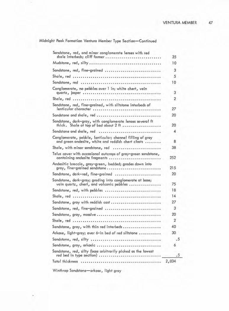
...
Midnight Peak Formation Ventura Member Type Section-Continued
Sandstone, red, and minor conglomerate lenses with red shale interbeds; c liff former .....•......••..•••.••.•....
Mudstone, red, silty .. ..••........... . ••..•.... .. ..• . ...
Sandstone, red, fine-grained ••.•.•..• • • . ••.•.•••• . ••• . •.
Shale, red . . .. . .. . •. . .. . ........•..•••••.•..•.........
Sandstone, red ••.• . ••• • .•..•...• • ••••• . •••••••••••..•.
Conglomerate, no pebbles over 1 in; white chert, vein quartz, jasper •• .. . . •••.•••• . •.••••• • •••••••••••••. . •
Shale, red . .. . •. •.. • . • • .• .. .• . . .. . . ••.. • .. .•••. •..... •
Sandstone, red, fine-grained, with siltstone interbeds of lenticular character . •. . ....•. . •••••••••. • ••...• .... •.
Sandstone and sha I e, red ••.........•..•.•.••..•..•... . .•
Sandstone, dark-gray, with conglomerate lenses several ft thick. Sha le at top of bed about 2 ft .•••••••••••....••.•
Sandstone and shale, red . . . .. • .. .•.. • ..• • .• •. . •.•• . .. . •
Conglomerate, pebble, lenti cular; channel filling of gray and green andesite, white and reddish chert clasts .•. .....
Shale, with minor sandstone, red . .•.... • .•.. •. • • .• . •. • . .
Talus cover with occasional outcrops of gray-green sandstone, containing andesite fragments • . .•••. ••• • ••••.•.• . ..• . . .
Andesitic breccia, gray-green, bedded; grades down into gray, fine-grained sandstone .. . • • •. . ...••. . .........•••
Sandstone, dark- red, fine-grained •. • .• • .. • . •. .. . ...• ...•
Sandstone, dark-gray; grading into conglomerate at base; vein quartz, chert, and volconic pebbles .•. . .... . . . . ... .
Sandstone, red, with pebbles .....•..•• • .••• . •..•.• . .. . . .
Shale, red . . .••.•••• . ••... . ..... . • . .••.••.•..•.•.. . •••
Sandstone, gray with reddish cast .• •. • • •••.••.•••• . .•.•. . •
Sandstone, red, fine-grained . .. . .• . •.• •. •. .... . •.• . .... •
Sandstone, gray, massive .. .. . ....•••.•. .• •. .. . . . .•..... .
Sha le, red . . •• . •.••• . .••.•••.....•••.••••••••• • • · · • · · ·
Sandstone, gray, with thin red interbeds . •. •. . •..• .. .••..•.
Arkose, light-gray; over 6-in bed of red siltstone •.•••• .. . . •
Sandstone, red, si lty • . •........•••••.•.•• . •.. . .• . .•.. . •
Sandstone, gray, arkosi c • . .••. .. . ... . • .. ••. . • .• ..• . . • • . •
Sandstone, red, silty (base arbitrarily picked as the lowest red bed in type section) .... . .. • .. • • •• .. • .. .. • . .• . . ....
Total thickness . .•.•..•••.•.•..•....••••• . ••• . •• . • .....
Winthrop Sandstone-arkose, light gray
VENTURA MEMBER 47
35 10
3 5
10
3 2
27 20
20 4
8 38
252
215 20
75 18 14 27 3
20 2
40
30
.5 6
.5
2,034

48 GEOLOGY OF THE METHOW VALLEY
portance (12 percent) is the mudstone-siltstone frac
tion. The darkest red-maroon color is characteristic
of the finer grain sediments. Gray to green andesitic
breccia makes up 10 percent of the section. Conglom
erate is of minor importance in the type section (8 per
cent), but is spectacular in appearance. The conglom
erates are lenticular, poorly to moderately well sorted,
with maximum sized clast usually less than 8 inches in
diameter. In most of the conglomerates, chert and
andesite clasts are the dominant components. The chert
is gray, white, light green, and various shades of red
in color . The sand matrix and interbeds are angular
chert and lithic clasts. The andesite clasts are some
times vesicular, are dark-gray, green, maroon to red
in color, and better rounded than the cherts. Occa
sional rounded clasts of buff sandstone , light co lored
arkose, vein quartz, and gray chert fine-pebble con
glomerate clasts are seen; granitoid clasts are rare .
The sandstones near the base of the member
have appreciable quantities of quartz and feldspar
mixed with andesitic volcanic clasts and chert. The
cement is largely red iron oxide but calc ite and a
mica hash of bleached biotite and chlorite occur.
Ventura Member in the Midnight Peak syn
cline.-The southeastemmost outcrops of red sandstone
are found on the northeast limb of the syncline along
Little Bridge Creek. Beginning H miles northwest of
the mouth of this tributary of the Twisp River, the
poorly exposed red beds can be traced for 3 miles un
ti l the northeast limb of the syncline is removed by the
Gardner Mountain Fault, northwest of sec. 21 ,
T. 34 N., R. 20 E. These are included in the
Midnight Peak Formation on plate 1. Red beds occur
well above the base of the fonnation, with some 2,000
feet of andesite breccia and lithic sandstone · interven
ing between the poorly exposed red beds and the first
recognizable arkose of the thin Winthrop Sandstone
below .
No red beds are found a long the southwestern
limb of the syncline from the Twisp River to Midnight
stock (T. 34 N., R. 19 E.). The Ventura Member was
mapped in the offset northwestern conti'nuation of the
west limb of the syncline between Midnight Mountain
and north Gardner Mountain. There, the red beds,
estimated to be 300 feet thick, were deposited directly
on black shale and chert pebble conglomerate of the
Virginian Ridge Fonnation. The Winthrop Sandstone,
which typically occupies the interval between the Vir
ginian Ridge and the Ventura (or Midnight Peak),
pinches out northwestward from the Twisp River out
crops and is absent in th is area.
Ventura Member in the Goat Peak syncline.-
Exposures of the complete red-bed Ventura Member
can be seen in the southwest limb of the Goat Peak
syncline from the Boesel Fault to Lost River, a distance
of 12! miles . Several cross fau lts, between lost River
and Robinson Creek, interrupt the continuity of out
crop for the next 4 miles at which point the underlying
Winthrop Sandstone thins to zero. Beyond this paint
to the northwest, the gray andesitic breccia, lithic
sandstone, and shale, 1,500 fee t thick, overl ie the
Virgin ian Ridge Fonnation directly and are overlain
by 650 feet of red sandstone and sha I e . The red sand
stone and shale are overlain by andesitic breccia .
This type of occurrence is described as olso occurring
on the northeast limb of the Midnight Peak syncl ine
in little Bridge Creek.
A good section of the red- bed member can be
fol lowed on the southeastern slopes of t:he canyon of
lost River where the latter has eroded through the base
of the axial portion of the syncline, w~ich plunges
southeast there. A dense forest cover obscures the
bedrock on the northeast limb of the syncline between
lost River and the Fawn Peak stock, but spotty outcrops
allow the member to be mapped beyond the intrusion
southeast of its truncation by the Boesel Fault.

The writer was unable to complete the mapping
of the red-bed member beyond Last Chance Point and
the mouth of the Robinson Creek, but Staatz and others
(1971, p. 28) were able to map the two members in
Robinson Creek and on the southwest shoulder of Rob
inson Mountain. They report that the member there
is composed of 60 percent dark red to purple argillite,
consisting of small angular grains of quartz, plagioclase,
altered volcanic rock, chert, and epidote. Cement is
mostly hematite, but chlorite, calcite, and sericite
ore also common. They also reported no red beds on
the northeast limb of the structure on Robinson Moun
tain.
Volconi c (Upper) Member
The type section of the Midnight Peak Forma
tion's upper volcanic member is here designated as the
ondesitic sandstones, tuffs, breccias, and flows ex
posed in the southwest limb of tfie syncline, lying be
tween the Twisp River and its tributary Canyon Creek
(T. 34 N., R. 20 E.). The estimated thickness of the
member token from a section drown across the syncline
3 miles southeast of Midnight Mountain is 10,400 feet.
Volcanic (upper) Member in the Midnight Peak
syncline.-light- to dork-gray, greenish-black well
bedded ondesitic lithic sandstone, tuff, and fine brec
cio, approximately 500 feet thick, rest directly upon
Winthrop Sandstone in the southwest limb of the syn
cline from the Twisp River northwest to the Midnight
stock. The bulk of the formation, however, is com
posed of purple, gray, red, and green altered ande
sitic breccio and occasional identifiable flows. The
rocks ore we ll indurated and resistant to erosion, form-
in~the prominent peak, Midnight Mountain.
Northwest of Midnight stock, the volcanic
member, which there underlies Gordner Mountain,
was deposited upon approximately 300 feet of red beds
VOLCANIC (UPPER) MEMBER 49
of the Ventura Member . The rock, wh ich makes up a
large port of the summit of Gardner Mountain, is a
distinctive green ondesite, containing 'large horn
blende phenocrysts. The more common varicolored
breccias underlie Storey Peak and Milton Mountain.
The northeast limb of the syncline east of Little
Bridge Creek is composed of 2,000 feet of volcanic
sandstone, tuff, and fine breccia, grading stratigroph
icolly into coarse ondesitic breccio. Along Little
Bridge Creek, beginning H miles from the mouth of
this tributary of the Twisp River, red sandstone and
shale approximately 500 feet thick overlie the breccia
and are in turn overlain by breccio. Faulting obscures
relations as the beds are followed along strike north
west.
Volcanic (upper) Member in the Goat Peak
syncline.-The Midnight Peak Formation is also well
exposed in a parallel northwest-trend ing sister struc
ture, the Goat Peak syncline. The thickness of the
volconi c upper member preserved there is estimated
from a section drown across the structure in the vicinity
of Mazama to be 5,000 feet. It con be separated from
the Ventura Member on both limbs of t~e Goat Peak
syncline from the Boesel Fault to Robinson Creek, a
distance of 14 miles. Beyond Robinson Creek it was
not possible to separate the formation into members .
The boso I beds of the Volconi c (upper) Member
of the Midnight Peak Formation ore for the most port
light- to dork-gray and greenish ondesitic fine breccias
and tuffs, with some wel I-bedded lithi c sandstones
grading into the red-bed sequence below . A particu
larly good place to study this relationship is on the
slopes northeast of the mouth of Lost Riiver.
The well-bedded breccias and tuffs consist of
angular closts of gray, green, red, and purple ande
site in a weakly metamorphosed matrix of fine-grained
andesitic debris. Some homogeneous dark-colored
andesites ore judged to be flows, but coarse breccia

50 GEOLOGY OF THE METHOW VALLEY
is the dominant mode of occurrence. Jointing is widely
spaced, and the rock makes very massive outcrops,
particularly on the glacially steepened cliffs called
the Goat Wa II a long the Methow River, between
Mazama and Lost River . Ep idote occurs in veinlets
and as coatings on s lickensided joints where the vol
canic pile has adjusted to tight fo lding. Attitudes
are difficult if not impossible to obtain in the volcanic
member above its base.
The andesiti c rocks in some th in sections are
comple tely saussuritized, but in others, andesine feld
spar and green hornblende phenocrysts are preserved.
Outlines of pyroxene are recognized in some of the
rocks, but more often it is altered to chlorite and{or)
epidote .
Staatz and others {1971, p. 29) have studied
the volcanic member of the Midnight Peak where it
outcrops on Robinson Peak and report the rocks to vary
from dacite to pyroxene andesite. The tuffs consist of
tiny fragments of devitrified glass, quartz, feldspar,
and a li ttle argilli te. They recognized alteration min
erals of calcite, cl inozoisite, and zeo lite.
Age and Corre lation
No fossils have been found in the Midnight
Peak Formation . It can only be so id to be stratigra-
ph i ca II y younger than the leaf- bearing Winthrop Sand
stone, which is Late Cretaceous in age. The Mid
night Peak Formation is probably no younger than the
youngest Coniacian or uppermost Turonion since it ap
pears to hove been intruded by dikes associated with
the 86-mill ion- year- old Pasoyten Peak stock. Daly
{1912, p. 484) described as "Member C of the Pasayten
Series" a 600-foot- section of red argi llaceous sand
stones, grits, gray feldspathic sandstone, and gray,
red , and green cong lomerates, overlying a thick arkose
section (Member B) along the Canadial"I bounda ry. He
mentions no volcanics in this part of the section .
Rice (1947, p. 20) described as distinctive the
rather vivid purple color of some of the members of
his Division D of the Pasayten Group. This is appar
ently Daly's C Member . Rice measured 900 feet of
purple rocks along the Hope- Princeton Highway in
Manning Park, British Columbia. They are described
as well-bedded purple, occasionally green tuff or tuf
faceous graywocke, purple argi ll ite, or fine - grained
tuff, purple and green andesite porphyry, a nd coarse
and fine cong lomerates, with many granite pebbles
and a green or purple coarse-grained matrix . Division
Dis succeeded by up to 2,200 fee t of soft, light brown
to green a rkose or graywacke interbedded with many
thin beds of fine conglomerate .
Coates, (1970, p. l 51) remapped the area of
Daly and Rice and proposed the middle unit of his
"Pasayten Group" to be 1,000 feet of red beds. He
stressed that the red beds record o gradual change in
provenance from an easterly granitic source area for
an underlying 8,000 feet of arkoses to a westerly
source for the red beds, composed main ly of volcanic
and sedimentary rocks. Above these red beds, he
recognized up to 1,000 feet of pebbly, coarse- to
medium- grained carbonaceous arkose and graywacke
be low truncation by the Chuckuwanten Fau lt . He re
stricted the entire Posayten Group to an Albion age.
Je letzky (1972, p . 61) considers the red beds
and conglomeratic arenite above them to be post- upper
Al bian. The Ventura Member is roughly corre la ti ve
with the red beds of Daly (1912), Rice (1947) and
Coates (1970) in the Manning Park area, but appar
ently the thick andesi t ic pile, wh ich comprises the
Methow's Volcanic Member of the Midnight Peak For
mation, did not reach Canada. Its stratigra phic posi
tion is occupied by the pebb ly arkose-graywocke above
the red beds in the southern British Columbia section.

Pipestone Canyon Formation
Barksdale (1948, p. 175) gave the name Pipe
stone Canyon Formation to a section of granitic, chert,
and volcanic- clast conglomerate, coarse to fine or
kosic sandstone, and thin interbeds of fine siltstone
and shale totalling 2,313 feet in thickness. The type
area was designated as the Pipestone Canyon, on aban
doned glacial channel, approximately 5 miles north
east of Twisp, in the drainage of Beaver Creek (secs .
15, 22, and 27, T. 34 N., R. 22 E. ).
Rocks of the Pipestone Canyon lithology ore
found in only three small fault blocks within the
FIGURE 13.-Upper port of type section in Pipestone Canyon Formation (secs . 15, 22, T. 34 N, R. 22 E.).
Methow- Pasoyten graben. One, the bold cliff seen
from the highway 2 miles north of Twisp, along the
east side of the Methow River, exposes a gently dip
ping basal granitoid boulder-cobble conglomerate
resting on vertical beds of volcanic rocks of the Buck
Mountain Formation.
The Pipestone Canyon Formation is present in
a third small fault block between the Methow River
exposures and those of the type area. The formation
in the third block is deeply weathered and poorly ex
posed.
PIPESTONE CANYON FORMATION 51
The basal conglomerate in the type area hos a
varied thickness as it overlaps an erosion surface of
considerable relief. The deepest exposure in the can
yon reveals a bed, 145 feet in thickness, consisting
of a poorly sorted cobble to boulder conglomerate.
Well-rounded rocks of granitoid and gneissic compo
sition, with a maximum clast size of up to 5 feet, are
set in a red to purple matrix of coarse quartz-feldspar
sand . Granitoid rock fragments dominate the conglom
erates for the lower 300 feet of the section. The c lasts
diminish in size upward through the unit and become
increasingly more abundant in chert, andesite, and
light- colored quartz-bearing volcanic rock fragments .
The sands are arkosic and poorly cemented. The buff
si ltstones and shale interbeds are laminated in places
and give evidence of long periods of low- energy dep
osition, suggesting periods of temporary lake develop
ment . It is in these fine sediments that fossil leaves,
cones, and wood are preserved.
Sporadic outcrops over a wide area show the
upper two-thirds of the section to be soft sandstone
and shale with only a few conglomerate beds. The
section is truncated by the Chewack-Pasayten Fault.
Age and Correlation
Ryason (1959} discovered well-preserved fossil
plants and described them as Parataxodium sp. and
Nymphae ites sp.
Royse (1965, p. 19) made more extensive col-
lections and reported the following flora:
Metasequoia occidental is (Newberry) Chaney
Taxodium dubium (Sternberg) Heer
Nymphaeites angulatus (Newberry) Bell
Cercidiphyllum arcticum (Heer) Brown
Dillenites sp. cf. Q_. ellipticus Hollick
Platanus raynoldsi Newberry

52 GEOLOGY OF THE METHOW VALLEY
Pterospermites sp. cf. _f. spectabilis Heer
Vibernum antiquum (Newberry) Holli ck
constitute the Pipestone assemblage, range from Late
Cretaceous well into the Tertiary, the on ly epoch com
mon to all is the Paleocene.
Using LaMotte's (1952) geologic ranges of species,
Royse concluded that although the eight species, which
The pa leontologic and stratigraphic sections of
the Methow Va lley are summarized in figures 14 and 15.
Pipestone Canyon Formation
Type Section
In Pipestone Canyon, secs. 15, 22, and 27, T. 34 N., R. 22 E., Okanogan County
(measured with Dan Ryason).
Top of section
Thickness (feet)
Sandstone and shale; soft, makes weak outcrop; thickness estimated •••••••• •• ••• , ••.• . •• •• •••••• , • • • • • • • • • . • • • 1 ,430
Conglomerate; pebble clasts (mostly under 2 in but some 6 in diameter); chert, flint, and light- colored quartz-fe Ids par porphyry ••• , ••••••.. , . •••••• , , • • • • • • • • • • • • • • • 100
Grit, coarse, grading into arkosic sandstone . • • • • • • • • . • • • • . 45
Conglomerate; fine pebbles of chert and volcanics in quartz and feldspar matrix • , , , , •. •• •••. , • • • • • • • . • • . • • • • . • . . • • 22
Grit, grading into light-gray sandstone • • • • • . • • • . • • . • • . . . • • 6
Sandstone; laminated, fine-grained • • . . • • • • • • • • • • • • . . • • • • • 4
Conglomerate, lenticular beds; well-rounded pebbles of chert, flint, white quartz-feldspar porphyry . • • • • • . • • . • . • . 6-10
Sandstone, buff to white, arkosic, conspicuous cavernous weathering , • • , • • • • , , • , • • • • • • . . . • • . . . . • • . • • . . • . • • . • • • 30
Conglomerate; pebbles (maximum 3 in diameter mostly less than 2 in) of chert, andesite, light-colored volcanics • . • • • 26
Sandstone, with lenticular beds of laminated siltstone • • • . • • . 18
Conglomerate; fine pebble, largely chert and flint • • • • . • . • • . 25
Sandstone, fine- grained....... .... ..... . .. . . . ......... .. 10
Conglomerate; poorly sorted, maximum pebbles 6 to 8 in, grading down to sand; red andesite, gray chert, flint, quartzite, some rotten graniti c pebbles ••.••• , • • • •• • •••• , 35
Conglomerate; fine pebbles (maximum 3 in diameter, mostly less than 2 in) of chert and flint most commonly but containing light-colored volcanics-andesite and rhyol i te ••••••••••••••••••••••..••••• , , . • . • • • • • • • • • • 45
Sandstone, arkosic; thin-bedded • .. • • . • . • • • • . .. .. • .. • .. • • 20

Pipestone Canyon Formation Type Section-Continued
Sandstone and siltstone; laminated, brown weathering
Sandstone, orkosi c •• • ••••• . • . .••••••. .. ••••••••.••••••.
Conglomerate and sandstone; well-rounded, light-colored granitic clasts (usually under 6 in diameter), some sandstone and a few chert pebbles. Conglomerate channels the siltstone below .....••• . •••.•.• .• •• • ••.•••
Si Its tone; laminated, lower ft is fissile, gray in color, (laminations from fraction of mm to l cm), and grades upward into brown shale that weathers white . ..••.•• • •• . ..
Sandstone; very poorly sorted, orkosic, coarse-groined, with conglomerate lenses up to l Oft thick of granitic derivation ••. •. .• . •.••••••.. . ••.•.•. • • • · · · • · · • · • · · • · ·
Conglomerate of granitic boulders less than 1 ft in diameter, which grades into coarse light-colored sandstone .• • • . • .. • .. •.•...•..• .... •..••.. • ...•.••.•••
Shale, dork-gray, platy; weathers white ••••••. . .•..••..••.
Basal conglomerate containing granitic boulders (maximum 4 to 5 ft in diameter), well-rounded, light-colored granitic and granitoid gneiss in a matrix of gruss, red to purple in
GLACIATION 53
35
8
40
8
140
5
9
color. Deposited on irregular surface of dioritic gneiss and other granitoid rocks of Okanogan complex •• . •••••.•. . .•• __ 1_45_
Tota I thickness •.•..••• • ••••..•.... • .••••.•. • ••.••.•. . • . 2,313
GLACIATION
Barksdale (1941, p . 721) first called attention
to the fact that the Methow Valley hod been subjected
to continental glaciation when ice moved south out of
Canada up the volleys of the north-flowing branches
of the Pasayten River and across divides into both
Methow and Skagit River tributaries in the vicinity of
Harts Poss. Excellently preserved striations were found
at on elevation of 7,290 feet on the Cascade crest due
north of Harts Pass.
Many granitic erratics from the Pasayten Peak
stock-dike were found resting on the Cretaceous sedi
mentary rocks in the meadows south and east of Horts
Pass and on the divide between the Middle Fork of the
Pasayten River and Robinson Creek. Ice overrode Goat
Peak (7,019 feet) just east of Mazama, Lookout Moun
tain (5,522 feet) five miles southwest of Twisp, and
Leecher Moun ta in (5,012 feet) just off the present map
due east of Carlton. Methow Valley-derived erratics
ore found at elevations of 4,500 to 4,600 feet on Goat
Mountain west of the mouth of the Methow where it
joins the Columbia River. The above elevations ore
probably close to the maximum height of Methow ice
during a stage of glaciation when the terminus of the
coo lesced Okanogan and Methow lobes was south of
the present junction of the rivers . Ample evidence
that the Okanogan lobe lasted longer than the Methow
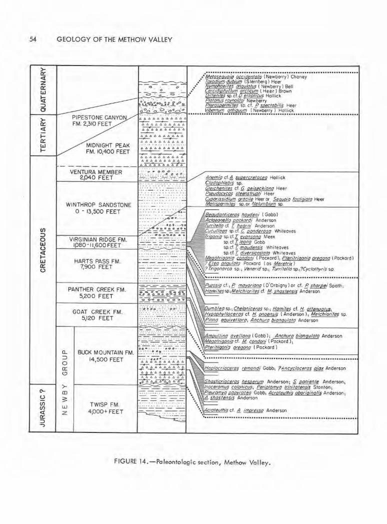
54
>a:: <X .... a:: I.LI ....
Cl)
::> 0 L&J (.)
~ UJ a:: 0
('-
u (/) Cl) <t Q: ::> -:,
GEOLOGY OF THE METHOW VALLEY
MIDNIGHT PEAK FM. 10,400 FEET
VENTURA MEMBER 2,040 FEET
WINTHROP SANDSTONE 0 - 13,500 FEET
VIRGINIAN RIDGE FM. 1pso-11,600FEET
HARTS PASS FM. 7,900 FEET
PANTHER CREEK FM. 5,200 FEET
GOAT CREEK FM. 5,120 FEET
.. ·;,;;;;;;~~;,; ·;~;;;;a;;i; · i N~-;b~~;; 1 · c;;;~;; · · · · · · · · · · · · · · · · · · · · · · · ••• Toxodium dubium ( S Jernberg) Heer =-0~;, -0 :_ ...... ~e;Y{:g::1::~s,,,(m;~:)r~~o~~' .. = · o . . 0
· •. • 0//len,tes sp. cf.fl, ell1pl1cus Hollick . . . ·· ·. · · · · Plotonus rot'.,nolds, Newberry ".':.
0.?~002..!t .!.. 0 ~.!e!. ~rm,tes sp. cf..£? spectobilis Heer ~00 :.; ·o::ood·,, Vi/Jernum ontiquum (Newt>erry) Hol l ick
AAb.464AAA6A -A A.0.66 6 .QO,A,6 - -4AA66AAAA6 ----- ~ A6b.66A.0.6AA -A A666AA AAA
A6AdAAAA66
_,__ ----A 66 A6 A6AA A A 6 4AAAAAAA
A~AA~
oo•··· · · · · · •OO·· · ···
............................................................................
Anem!o cf.~ supercrelaceo Hollick Cladophlebis sp. Gleicheniles cf. ti geiseckiana Heer Pseudacvcas sleenstrupli Heer (yoorissidium ~ Heer or Sequoia fosliqiota Heer Mem£ m,1 sp.or Nelumbium sp.
danl,ceras haydeni ( Gobbi ta Ila pacltardi Anderson .,.,le/lo d T. heorni Anderson
ucullo a !!P-cf.£ oonderoso Whiteoves sp. ct . .z; evonsano Meek sp. cf. T. leono Gobb sp.cf. ·rmoudensis Whi leoves sp. cf.Z: di versicoslolo Whi teoves
Meqatriqonio ~i ( PocKordl, Pteritriqonio ~ lPockordl ? (kQ anqulato PocKord ( os MerelriJr l ?Triqanarca sp.1 Venerid sp.; Turrite/la sp.,?Cycfathyri's sp.
uzosia cf., B mayariana ( O'Orbigny l or cf. B sflarpei Spolh; n:11.,essp.1Melcflio11ies cf. !kt snostensis Anderson
umbl o sp.; Chgloniceros sp.; Homiles cf. !:!: ollenuQ/l{S; a h llaceras cf. !:J.. onoensis ( Anderson l; Melchiori/es sp.
Pinno equivellaro1 Anchura b1anq11lalo Anderson
m 11/lina ovellono ( Gobb l; Ancnuro bionguloto Anderson eootriqonia cf. M condom· ( Pockord l;
0... BUCK MOUNTAIN FM. ·:: ·::·:.~ .~!:::: ·::.: :·.: Pteritiiqoni:J ~ < Pockord l
:::)
0 a:: (9
>-Q)
3 w z
14,500 FEET
TWISP FM. 4,000.._ FEET
remandi Gobb; ?Ancyc/oceras f!i!B Anderson
Ii ri /lesperum Anderson ; ~ ponienle Anderson, aceramus coloilicus; Periplamra trinilatensis S1on1on; ~ 1' a popyroceo Gobb, Acroleulflis abariqinafis Anderson;
:!1_. shoslgnsis Anderson
FIGURE 14.-Paleontologic section, Methow Valley.

(/)
:::::> 0 UJ 0 ex tUJ 0:: 0
C,.•
0 cii (/) ex a: :::::> -:,
VENTURA MEMBER 2P40 FEET
.. .. . . .. .. ...... •• •. C) C> C>O cl- • • • • • •
-: ~ .o.~~:: ':"""":" -:' . ':""'7".
. . . . . . . ..... . . . . . .
- ·· ·· ······ · ·· -WINTHROP SANDSTONE
1----0---13_,SO_O_FE_E_T--~~
VIRGINIAN RIDGE FM. 1pso - 11,600 FEET ----- ---------
•• ••• •• · ·----· . •---.t_ •
G LAC IA TION 55
Ventura Member loco fly at base of formation; redpurple sandstone, siltstone, and shale with lenticular beds of pebble conglomerate of white and red chert, quartz, and ondesite.
Continental orkose 5,700 ft in type section; faulted top. Maximum thickness northeast of Goat Peak. Thins and disappears to southwest.
Block shale with chert pebble conglomerate and chert groin sandstone in lenticular beds. Some orkose near top of type section; type estimated 7,160 ft. Thickest section head Twisp River . Formation thins and disappears to northeast.
. - --:-. . . . - ... ........................................................................... . Arkose in beds 3 to 50 fi thick, with minor shale
breaks in lower 3,200 ft of section; orkose and block shale in about equal amounts
HARTS PASS FM. 7,900 FEET
PANTHER CREEK FM. 5,200 FEET
GOAT CREEK FM. 5,120 FEET
········ ·· - ····· .. . . . ....
- - -F.cs.~~,: _;.~g if -------- - - --~oo.oaao~
·.: ,;,.:. ·•o:: .·.·. a·. ·: .·: .·.· . · : ·.·:·. : : ·;·::· . .:....:.: ............ ... .... . .. ... . ... . ... .. ... . . ... ... - .... . .. . .... .. . . . . .. .
2,500 ft; massively bedded orkose witF, minor block shale upper 2,200 ft.
Block shale with thick lenticular beds of gronitoid boulder to pebble conglomerate.
Coarse to fine orkose with minor beds of pebble conglomerate. Block shale interbeds ± 20 percent thickness •
!----,----- -----+.~: ,_.· -:-·. -:--·. ·-.·~::-:-.'-:.~ ,__,· =· '?:'.. -;--: :.;.~=- . •••••••••••••••••••••••• ••••• ••••••••••••••••••••• ••••••••••• ••••••••••••••• ~ . ~ .-:77"'7"'". -:""':° .~
a.. ::::::, 0 0:: (!)
>-CD
~ w z
BUCK MOUNTAIN FM. 14,500 FEET
~-=----=-~-= ... . ... ... - ---- -------------• • o • • • • • • • 0 0 • • • •• , .. . "' o •o · · · ••• ..... •
•• •O• ' • • • • •' • • ' 6666666.C.A.C. -- - __,,_ AAAA4AAAAA - ......_ __,,._. __,,_ bA A66AAAb6 --- ~ 46C.A6A66
Basal meta-ondesite breccio flows, tuffs 5,000 ft; black shale, volcanic lithic sandstone and lenticular conglomerate 6,300 ft; lithic sandstone, siltstone, and block shale 3,200 ft.
~~&.::!I 1------------ii-::----..; - - ~ I- . .............................................................. . . ........ .. .
TWISP FM. 4,000+ FEET ~~-=--=
~
Thin- bedded block shales and volcanic lithic sandstone complexly folded and faulted.
FIGURE 15. - Stratigraphic section, Methow Va lley.

56 GEOLOGY OF THE METHOW VALLEY
lobe is provided by the numerous eastern-derived ba
saltic "haystack" erratics found on the east side of the
Methow River, near its mouth.
Barksdale (1941 p. 732} proposed that a valley
glacier stage in the Methow followed the continental
ice maximum, and pointed out at several places what
were considered at the time to be recessional moraines
at the mouth of Libby Creek at Carlton, at the mouth
of Benson Creek, and at a large kettle complex in the
Twin Lakes area near Winthrop. Ice from the Okanogan
lobe spilled into the Methow drainage via Benson Creek
at some time after the Methow maximum, building a
moraine there and contributing much granitic debris
from the east.
Waitt (1972) has restudied the geomorphology
and glacial geology of the Methow drainage basin.
His conclusions in general are that, although cirques,
aretes, and U-shaped hanging troughs dominate the
northern Methow landscape, surface drift, character
istically of northern provenance, mantles high ridge
crests as well as valley floors suggesting deposition
from an ice sheet rather than a valley glacier. Further
more, ice-sheet glaciation post-dated the most recent
alpine advances because alpine drift and depositional
landforms characteristic of a I pine glaciation are absent
in the Methow region, apparently having been eroded
by the ice sheet. The deposits identified by Barksdale
as moraines are shown to be kame-kettle complexes
built by the wastage of dead ice in a very late stage
of deglaciation.
The upper limit of evidence for a continental
glacial maximum in the northern Methow region is at
about 8,000 feet. From that elevation, the ice surface
sloped to an elevation of about 3,000 feet in the
Columbia River valley. Thus the Cordilleran Ice Sheet
covered the northern areas a I most tota fly; its surface
broken only by a few scattered peaks (nunataks) rising
above the ice.
Waitt was able to show that the continental
ice, which spilled south from Canada across the divides
separating the Pasayten and Methow drainages, also
continued down the Cascade crest and contributed ice
into the upper Twisp River drainage and into the head
waters of the Stehekin River-Lake Chelan drainage to
augment that basin's locally derived ice . There is no
evidence, however, that the Methow Mountains (di
vide between Lake Chelan and lower Methow River)
were crossed by continental ice south of lat. 48°15' N.
There seems to have been no rebirth of alpine
glaciers after the Cordilleran Ice Sheet disappeared,
largely by downwasting and regional stagnation .
Barksdale (1941, p. 737) came to the conclu
sion that, based largely on the thinness of the weather
ing rind of the high elevation erratics, the preservation
of striated bedrock surfaces and the general freshness
of glacial deposits, the widespread ice sheet at its
maximum was late Wisconsin in age.
Waitt (1972, p. 33) concludes that the fresh
ness of the Methow drift indicates that the glaciation
correlates broadly with the Fraser Glaciation of the
Puget Lowland and British Columbia {late Wisconsin).
He also conc ludes that the ice sheet probably arrived
in the Methow region by 16,000 years B. P. and had
largely diminished by 13,500 years B.I?. There seems
to be I itt le or no evidence of pre- late Wisconsin gla
cial deposits.
STRUCTURE
The Methow-Pasayten Graben
Bounding Structures
The dominant structure I featu re of the area
studied is the Methow-Pasayten graben {Barksdale 1958;
Mallory and Barksdale 1963) in which the folded and
•

faulted Jurassic-Cretaceous-Tertiary sedimentary and
volcanic rocks are preserved in a structural low be
tween metamorph ic and igneous highs to the northeast
and southwest. The graben is 1~ miles wide at its
narrowest part, near Twisp in Washington. It widens
to more than 24 miles in the northern part of the map
area, and reconnaissance mapping shows that it nar
rows again to 16 miles at the Canadian boundary (lat.
49°00' N.). The structure is at least 52 miles long in
Washington, and it extends northwestward for an ad
ditional 120 miles into British Columbia.
Bowen (1914) was the first to point out thegra
ben nature of the structure that conta ins folded Creta
ceous rocks in the Fraser River canyon of British Co
lumbia. Subsequent workers, Cairnes (1924), Rice
(1947), Duffel! and McTaggart (1952) mapped the
folded and faulted Cretaceous extending northwest
from the boundary for 120 miles to approximately lat.
50°32.5' N., where the boundary faults converge in
the Fraser River canyon. Thus this narrow structural
feature maintains its integrity for over 170 miles.
Duffett and McToggart (1952) point out that northwest
from the point of convergence in the Fraser River can
yon the graben ceases to exist as both the western and
eastern faults bounding the folded Cretaceous rocks are
downthrown to the east.
The graben 's northeastern boundary in Wash
ington is the Chewack-Pasayten Fault, which was ex
amined by Barksdale (1958, p. 1531), from the point
where it crosses the Canadian boundary at the Pasayten
River , S. 20° E., for 47 miles where it becomes un
recognizable in the weakly gneissic rocks of the Oka
nogan complex, east of 120° west longitude, about
eight miles southeast of Winthrop. Six miles northwest
of the northern boundary of the map, the Chewack
Pasayten Fault trace swings in strike from N. 30° W.
to N. 50° W. The fault separates various kinds of
granitic gne issic rocks on the northeast from strongly
BOUNDING STRUCTURES 57
folded and faulted sedimentary and volcanic rocks on
the southwest. At no place along its trace can any
units be matched across the Chewack-Pasayten Fault.
The glacial and post-glacial alluvium in the
valley of Eightmile Creek and the Chewock River hides
the fault outcrop, hence no Holocene displacement
was recognized . The dip of the fault in the map area
cannot be directly determined, but the fault's straight
trace suggests that the attitude is near vertical or dips
steeply to the southwest.
On the spur between Ramsey Creek and the
Chewack River (sec. 11, T. 35 N., R. 21 E.) the fault
trace strikes N. 30°W. and shows up clearly as a
shear zone approximately 300 feet wide that is mostly
in the granitoid gneiss of the eastern block. The zone
has weathered to an ocherous brown color and contains
rich, red hematite streaks. The schistosity of the gran
itoid gneiss is near vertical and strikes north-south.
The gneiss is shattered into small joint ~locks and
weathers to a reddish-orange color for considerable
distance from the fault. The jointing is so close
spaced that it is difficult to collect a standard-sized
hand specimen. The volcanic breccia, sandstone, and
shale, adjacent to the fault at that point, strike N.
10° W. and dip to the east 75°. Shearing effects in
the sedimentary section there are not uniformly evi
dent, but elsewhere a long the contact the volcanic
rocks are shattered, and are altered to a rusty brown
for several hundred yards away from the fault .
The gneissic banding in the rocks northeast of
the fault varies in strike from N . 20° W. to N. 50°
W. and the dip of the foliation varies from 30° to 50°
NE. The fo liation can be mapped for approximately
a mile northeast of the fault where the rock becomes
almost directionless. Thin sections of the gneiss near
the fault reveal its cataclastic origin. The quartz and
much of the fe ldspar were granulated and recrystallized
as were the biotite and hornblende. Large feldspar por-

58 GEOLOGY OF THE METHOW VALLEY
phyroclasts were rotated and shaped into augen; con
siderable pressure twinning was developed. Some late
movement occurred in which mechanically cracked
feldspars were not healed. The cracks have been in
vaded by iron oxide stain, which possibly accounts for
the characteristic orange to light reddish-brown color
of the gneissic rocks close to the fault.
FIGURE 16.-Chewack-Pasayten fault scarp of Summit Creek gneissic quartz diorite. Pipestone Canyon Formation weakly cemented sandstone makes gentle topography in foreground (sec. 15, T. 34 N., R. 22 E.).
An imposing fault scarp rises northeast of the
fault at the eastern border of the map area (T. 34 N.,
R. 22 E.). The cataclastic gneiss just described rises
above the easily eroded Pipestone Canyon Formation
of Paleocene age, which dips gently north into the
fault zone. Glacial cover and soil hide the contact
but the two rock types crop out within a few hundred
fe.et of each other. These re lat ions are evidence only
that there has been a relative down-dropping of the
Paleocene block with respect to the Okanogan complex
rocks. There is no apparent evidence for strike-slip
movement for the latest activity on the fault, which is
at least as young as post-Paleocene.
Lawrence (1968) studied the Chewack-Pasayten
Fault in the Hidden Lakes area near the Canadian
boundary, north of the present map area. He (1971,
p. 147) suggested on the basis of field and petrofabric
studies that:
• •. primary right lateral strike-slip motion of Middle and Late Cretaceous age, probably fol lowed by reverse motion.
It is not clear what "reverse" means in this statement
because the only reference to attitude is that the fault
is verti ca I.
Coates (1970, p. 153) studied the Pasayten
Fault immediately north of the Canadian boundary and
pointed out that there must have been a large amount
of dip-slip movement in order to accommodate the very
large thickness of Lower Cretaceous strata west of the
fault. He noted that strike-slip movement is also in
dicated because of the lack of correspondence between
the sedimentary rocks west of the fault area and pos
sible source areas to the east.
In summary, there is great vertical displace
ment along the Chewack-Pasayten Favlt. The block
to the southwest has been dropped relative to the
northeast block making possible the preservation of
more than sixty thousand feet of stratigraphic section
of Jurassic(?), Cretaceous, and Tertiary folded and
faulted sedimentary rocks. Evidence that some of the
movement was strike-slip in nature could not be docu
mented.
The graben boundary on the southwest is formed
by two faults: the Foggy Dew Fault and the Twisp
River Fault . The older, the Foggy Dew Fault, can be
mapped as the graben boundary in the 17-m ile interval
between the elbow bend on the Twisp River and the
point to the south where the fault disappears into the
young Cooper Mountain batholith. The fault strikes
N. 32° W. and its rather straight overall trace indi
cates a steep dip. There is evidence in the fault's out
crop pattern in the tributaries of Gold Creek that the
dip is steeply northeast. Mylonites derived from horn
blendites, granitic gneisses, and Newby Group vol-

conic rocks con be collected in a zone as much as one
quarter of a mile wide, where the fault traverses the
upper reaches of the North Fork of Gold Creek, Foggy
Dew Creek, and the South Fork of Libby Creek.
Chief evidence that the major displacement
along the Foggy Dew Fault has been dip-slip, down to
the northeast, is that along the fault mesozonol meta
morphic rocks of the Chelan botholithic complex have
been brought into contact with a thick section of rela
tively unmetamorphosed Jurassic(?) and Cretaceous
volcanic and sedimentary rocks . These relations are
similar to those described in the Ross Lake Fault zone
by Misch (1966b, p. 133), and the Foggy Dew Fault
may well be a continuation of this major Cascade struc
ture. No evidence of strike-sf ip movement has been
recognized along the Foggy Dew Fault.
The age of the latest movement on this segment
of the southwest boundary fault can only be approxi
mated as Upper Cretaceous or lower Tertiary. The fault
cuts Midnight Peak volcanics of probable Turonian age
and is intruded by the Eocene- Oligocene(?) Cooper
Mountain botholith.
The younger boundary fault, the Twisp River
Fault, has developed a shear zone approximately one
half mile wide, striking N. 50° W., beginning at the
southeastern border of the Black Peak intrusion and
extending southeastward for at least 21 miles. The
shear zone has been excavated to form the canyon of
the upper Twisp River for 12 miles above the point
where that southeast-flowing stream swings to the
northeast in a conspicuous elbow bend. The fault zone
-with diminishing physical expression-continues on
to the southeast for about nine miles southeast of the
bend, beyond which it was not recognized.
The shear zone in the upper Twisp Valley is
largely covered by glacial terrace material and modern
stream alluvium. Occasional outcrops reveal the
mylonitized rocks of the Chelan crystalline block to
BOUNDING STRUCTURES 59
the southwest of the fault and of the andesitic sedi
ments and breccias of the Newby Group and the black
shales and chert pebble conglomerates of the Virginian
Ridge Formation to the northeast of the shear zone.
Mylonite cutting a biotite-quartz-feldspar
crystalline rock, probably belonging to the Chelan
botholithic complex, crops out in roodcuts north of
War Creek and southeast of the Twisp River (sec. 12,
T. 33 N . , R. 19 E.). The schistosity of the mylonite
strikes approximately N. 45 ° W. and is verti ca I. Lin
eat ion in the planes of shear indicate the last movement
was horizontal.
Across the Twisp River to the northeast, approx
imately one- ha If of a mi le from the mylonite mentioned
above, outcrops of Virginian Ridge chert pebble con
glomerate show megascopic results of granulation and
pebble elongation. Thin sections show a flaser struc
ture of very fine-grained quartz recrystallized from the
tectonically reduced chert of former pebbles. At sev
eral other places in the Virginian Ridge, beds of ap
parently unbrecciated conglomerate can be traced into
a rock resembling a schistose quartzite as the fault zone
is approached. Farther northwest, volcanic breccias and lithic
sandstones of the Newby Group near the fault zone
are sheared to gray and greenish schistose rocks,
which under the microscope show all gradations from
unstressed volcanic fragments to very fine-grained
chlorite, epidote, and plogioclose schist. Consider
able recrystallization has taken place in these rocks
with the growth of a nearly colorless unidentified mi
caceous mineral.
Movement along the Twisp River Fault must
have been complex. Overa II, the graben block is
down to the northeast, but there must hove been some
late left-lateral strike-slip movement. The position
of the triangular block of Virginian Ridge Formation,
south of the big elbow turn of the Twisp River, and

60 GEOLOGY OF THE METHOW VALLEY
the block of Midnight Peak volcanics and red beds,
down dropped south of a cross- fault, indicates the left
latera I nature of part of the movement.
All that can be said as to the age of the latest
movement on the Twisp River Fault is that it is younger
than the Foggy Dew Fault, which it truncates, and
older than the Black Peak bathol ith, which truncates
it.
Structures Within the Graben
Folding.-Folding within the groben probably
occurred in four separate episodes. The fourth or most
recent episode produced two para I le I northwest- trend
i ng , asymmetrical major folds: the Goat Peak syncline
and the Midnight Peak syncline. These folds involve
the conformable Virginian Ridge, Winthrop, and Mid
night Peak Formations, which rest unconformaqly on
a ll the older sedimentary and volcanic rocks within the
graben.
The Goat Peak syncline con be mapped for a
distance of 25 miles N . 40° W. from its truncation by
the Boesel Fault (T. 35 N ., R. 20 E.) to the Cascade
crest . The northeast limb of the fold is the steeper,
and the beds, locally overturned, dip steeply to the
northeast. The beds in the southwest I imb have dips as
low as 10° northeast in the southernmost exposures .
They steepen to 75° in the vicinity of Early Winters
Creek (T. 35 N., R. 19 E.), and farther northwest
along strike, flatten to a gentle 30° northeast near the
Cascade crest.
The Midnight Peak syncline lies to the south
west en eche Ion to the Goat Peak structure. Both
limbs are preserved in the south half of the syncline.
The structure is truncated on the southeast by a cross
fault . There is sufficient convergence of the limbs to
indicate o plunge to the northwest. The Midnight Peak
syncline is more nearly symmetrica I than the Goat Peak;
dips on both limbs average 65°. The northeast limb
and axial part of the syncl ine is faulted beneath the
southwest limb of the Goat Peak syncline a long the
Gardner Mountain Fault . A sma ll segment of what
may be part of on intervening anticline can be seen
immediately northwest of the juncture of the Gardner
Mountain and Boese l Faults (T. 34 N., R. 20 E.).
An anticline lies northeast of the southern part
of the Midnight Peak syncline , its axial trace in the
Virginian Ridge Formation. It plunges west-northwest
and can be mapped for 10 miles along i ts sinuous trend
between the Twisp River and the Boesel Fau lt . The
anticline's northeastern limb is overridden by the Moc
casin Lake Fault . The core of the anticline is com
posed of folded Newby Group rocks, showing marked
angular d iscordance with the overlying Vi rginia n Ridge
Formation . The dips on both limbs of the anticline
vary from 60° to 75°.
There is a marked discontinuity in direction of
folding of rocks of the same age on e ither side of the
Boesel Fault. An asymmetrical south- plunging anti
cline, whose axis trends N. 25° E., is well exposed
4 miles west of Winthrop, south of the Methow River .
The anticline involves the type sections of both the
Winthrop Sandstone and the underlying Virginian Ridge
Formation . The west limb of the fo ld dips 70° and the
east limb 35° to 45°. The east limb cannot be followed
north of the Methow River, but the west limb is map
pable from its truncation by the Moccasin Fault for 8
miles northeastward to where it curves into the Boese l
Fault.
Folded structures formed during the third (next
to the most recent) episode of fo lding, and almost
surely involved in the most recent episode {fourth) of
fo lding, can best be seen in the fault block lying west
of the Button Creek stock and the Boesel and Ortell
Creek Fau lts, northeast of the Goat Peak syncl ine.
There the Sweetgross Butte syncline and its companion

anticline to the west trend N . 25° W. and are prob
ably representative of third-episode folding. The rocks
involved are the middle Cretaceous Goat Creek, Pan
ther Creek, and Harts Pass Formations. The axial
trends of these folds make an angle of 20° with the
sub- Virginian Ridge Formation unconformity, beneath
which they disappear. The dips on the limbs of the
Sweetgrass fold range from 50° to 70°, the steeper
limbs being to the west. Locally the west limb is
overturned.
Folds of this same (third) episode of folding
are also evident in the northwestern part of the map
area where folded and faulted beds of the Harts Pass
and Panther Creek Formations emerge from beneath
the sub-Virginian Ridge Formation unconformity, form
ing a narrow band more than 17 miles Jong. In these
beds an anticline was mapped in the canyons of Early
Winters Creek and the West Fork of the Methow River,
and in the ridge separating them (T. 36 N., R. 18 E.) .
The beds trend N. 30° to 40° W .-not markedly dif
ferent from trends in the Goat Peak syncline-and dip
typically in excess of 60° . The core of the fold is
mainly incompetent black shale of the Panther Creek
Formation; the limbs are composed of thick, competent
beds of arkose of the Harts Pass Formation. locally
the competent arkose beds have been isoclinally com
pressed to such an extent that they rise up and pinch
out the shale core of the anticline. This is best shown
in Trout Creek, a tributary of the West Fork of the
Methow River(SWiSWiT. 37N . , R. l8E.).
The strongest evidence for more than one
period of folding at this locality is the outcrop width
of the Harts Pass Formation, which widens fourfold
between its faulted terminus, east of Silver Star Moun
tain, and the northern limit of mapping, northwest of
Slate Peak. Erosion evidently removed a part of the
folded section there before deposition of the Virginian
Ridge Formation. The western limb has been broken
by faulting (not shown on geologic map) and also dis-
STRUCTURES WITHIN THE GRABEN 61
appears beneath the sub-Virginian unconformity in
the eastern limb of the Grasshopper syncline. The
unconformity may account for the disparity in apparent
thickness of the Harts Pass Formation on opposite sides
of the Panther Creek Formation.
Folding during the second episode can best be
demonstrated on the ridges leading south and west of
Buck Mountain (T. 36 N., R. 21 E.). There a thick
overturned homocline of Buck Mountain Formation,
striking N. 25° W. and dipping 90° to 75° east, is
unconformably overlain by west-dipping Goat Creek
Formation of strongly contrasting lithology.
The unconformity can also be seen north of
the Ortell Creek Fault where it is vertical, extending
northwest and separating Buck Mountain Formation
andesitic tuff, breccias, and flows from Goat Creek
Formation on the west. Folding in the volcanic rocks
cannot be convincingly demonstrated beneath the
Goat Creek there, but considerable amounts of Buck
Mountain Formation shales, volcanic lithic sandstone,
and conglomerates were removed by erosion before
the deposition of the Goat Creek.
Second-episode folding invol~ing Buck Moun
tain Formation, south and east of Winthrop, is difficult
to define owing to the erratic distribution of ouFcrops.
The best exposed fold is immediately southeast of Win
throp, where a fairly open syncline (T. 34 N, R. 22 E.)
can be traced southeast for four miles, until it is cut off
by a cross fault. The steepest opposing dips are 70° .
A light-colored, tuffaceous marker bed can be recog
nized in both limbs. The trend is approximately N.
25° W. in the southern two-thirds of the fold, swing
ing to nearly west south of Winthrop where the Buck
Mountain Formation can be seen to rest with marked
angular unconformity on the underlying Twisp Forma
tion.
An anticline involving Buck Mountain Forma
tion bedded andesiti c breccia and shale is poorly
exposed beneath the folded sub-Virginian Ridge

62 GEOLOGY OF THE METHOW VALLEY
unconformity (T. 34 N., R. 21 E.); the axis trends
N. 60° E. and the limbs dip at angles of 60°.
The first or earliest period of fold ing was of
a distinctly different type from the succeeding three.
Individua l folds in the Twisp Formation can be followed
for even less distance than those of the later formations.
Part of the difficu lty is due to the cover and deeper
soil formation , but much of it stems from the incompe
tent behavior of the weak shales. The fold trends box
the compass , steep dips are the rule, and plunges up
to 90° have been found. The sca le of the individual
folds is measured in tens to hundreds of feet rather than
in miles. Some of the best examples of the fo lding in
the weak Twisp Formation can be seen in the roodcuts
between Winthrop and Tw isp, on the glac iated hill
tops northwest of Winthrop, on Potterson Mountain
west of Winthrop, or on Stud Horse Hill directly east
of the town. An exception to the small- scale failure
con be seen in T. 35 N., R. 21 E. Several porphyry
sills in the weak, black shales of the Twisp have acted
as stiffeners, and amplitudes of the plunging folds ore
greater than ampl itudes of most folds in the formation.
The forces which repeatedly folded the th ick
sedimentary sect ion preserved in the graben can only
be generally characterized as compression in a north
east-southwest direction. The origin of the compres
sion is not understood, but is suspected to be related
to movement between the continental Okanogan block
and the Chelan- "Skagit" block of debatable ancestry.
Fault ing . -For descriptive purposes, the faults
within the groben are discussed in three groups, based
largely on inferred age of major movement, which, in
turn, is based on the ages of the units cut by the faults,
as we fl as loca fly, on the ages of uni ts not cut by the
faults. No comprehensive detailed structural analysis
is attempted here because the main purpose of this
paper is description accompanied by brood interpreta
tion .
The first and probab ly oldest group of faults
involves rocks of the Newby Group a nd older: the
Smith Canyon Faul t and related shear zones and the
McClure thrust. Numerous other faults cut rocks of
the Newby Group and have been recognized and
mopped over short distances, but appear to be of less
significance and a re not discussed in the text.
A fault that affects only rocks of the Buck
Mountain Formation and Goat Creek-Panther Creek
Harts Pass Formations is the Ortell Creek Fault .
The th ird group of fau lts includes those which
involves a ll of the units of the Cretaceous folded sec
tion . These are the Moccasin Lake Fault, the Gardner
Mountain Fault, the Boesel Fault, and many northeast
southwest cross fau lts.
The Smith Canyon Fault is a major north-south,
nearly verti ca I shear zone, which con be traced from
a mi le north of the Twisp River south for 15 miles,
where it is cut off by the Cooper Mounta in batholith.
The broad flat valley of Smith Canyon formed along
the shear zone as did the upper port of Alder Creek
(T. 33 N. , R. 22 E.). The apparent movement on the
fault was both vertical and left lateral; the Carlton
block, defined as rocks east of the fau It, composed of
Leecher Metamorphics and Methow Gneiss farther east,
moved up and to the north with respect to the western
block composed of rocks of the Newby Group. In the
latest movement, the Carlton block was thrust north
ward over the Buck Mountain Formation and young in
trusions along the McClure thrust- movement that was
left-lateral strike- slip along the Smith Canyon Fault.
The best exposure of the shear zone of the
Smith Canyon Fault is in a roadcut on the south side
of Libby Creek (sec . 23, T. 32 N., R. 21 E.), where
the latter intersects Smith Canyon . Gray- green, pur
ple ultramy lonites and phyllonites lie within the zones
of maximum shear and "horses" of recognizab le vo l
canic sedimentary rocks interspersed in the zone,

which there is 0.3 miles wide, and is mainly in rocks
of the western block. Adjacent on the east are
gneisses of the Leecher Metamorph ics intruded by the
Carlton stocks of quartz diorite. The sma lier stock,
exposed along the road, is semi-schistose due to shear
ing for a distance of 0.2 miles east of the easternmost
exposure of the sheared volcanics.
Several near vertical, N. 10° to 20° E. shear
zones, branching en echelon from the Smith Canyon
Fault, cut rocks of the undifferentiated Newby Group,
mylonitizing them in zones a few tens of feet to hun
dreds of feet in width. The rocks of the shear zones
have a phyllitic appearance in hand specimen, but
under the microscope are seen to be cotoclastically
reduced rocks, phyllonites. Commonly, neom inerali
zation is shown by crystalloblosts of feldspar, or clots
of epidote- group minerals that disturb the planes of
shear. Although only three such zones of shear are
shown on the map, there ore undoubtedly many more
that con be mapped at a larger sea le.
The McClure thrust (T. 33 N., R. 22 E. ) fo rms
the northern boundary of the Leecher Metamorphi cs,
north of which lie rocks of the Buck Mountain Forma
tion, young intrusive rocks of the Frazer Creek com
plex, and the Alder Creek stock. The fault hos an
east-west strike west of the Methow River and swings
to the northeast where it crosses the river. The para
gneisses and schists of the Leecher make an impressive
cliff east of the river, at the base of which ore scat
tered outcrops of unmetomorphosed quartz diorite , a
phase of the Frazer Creek complex. There is no evi
dence recognized of an intrusive relationship between
them. Limited outcrops of east- west striking, gently
southward-dipping shear zones occur bath in the gneiss
at the base of the cliff and in the unmetamorphosed
quartz diorite below and north of the cliff. None of
these shears can be traced far, but they lend support
to a thrust hypothesis.
FAULTING 63
Outcrops in the Methow River flood plain are
rare, but in sec. 35, T. 33 N . , R. 22 E. (where the
river channel impinges on State Highway 153} a red
brown massive appearing rock crops out at low water.
This rock, in thin section is an almost completely si-
1 icified, ghostly textured tuff or volcanic sediment,
containing a few embayed quartz crystal:s or fragments
displaced on widely-spaced microshears. This rock
definitely does not belong to the Leecher Metamor
phics, but could have a Newby Group affinity and be
a part of the overridden lower plate of the thrust.
Thi ck g lacia I-wastage deposits c,over much of
the barren south and east slopes of McClure Mountain .
However, sufficient outcrops exist to permit sampling
the steeply dipping, highly sheared gneiss and phyl
lonite of the Leecher Metomorphics, south of the
McC I ure Fau It. The rocks north of the fau It are better
exposed volcanic sediments of_ the Buck Mountain
Formation. The decision as to final placement of the
fault on the map was made only after careful thin
section study of the mi croscopi ca lly contrasting but
megascopi ca lly ambiguous rock types of the two groups.
This is a most unsatisfactory way to map structure but
it was used as a method of lost resort here.
The second, and probably next younger, group
of faults is represented by a single fault, the Ortell
Creek Fault (T. 37 N., R. 20 E.). It is a near verti
cal, left lateral shear, separating the near vertical
lsabe Ila Ridge section of Buck Mountain Formation
volcanics and younger arkoses from moderately folded
arkoses and black shales in the Sweetgrass syncline
and accompanying anticline. A particularly confusing
coincidence mode the early mapping of this fault rela
tionship understandably difficult. The d istinctive
granite boulder conglomerates in the black shale sec
tion of the Panther Creek Formation were first discov
ered on the west slopes of Sweetgrass Butte, striking
N. 25 ° W. and dipping 60° E. They were traced

64 GEOLOGY OF THE METHOW VALLEY
north along their strike down into Goat Creek. A con
glomerate thought to be the continuation of the Sweet
grass beds was encountered northwest of Goat Creek.
It was soon discovered that it was a member of a west
facing section of conglomerate in black shale, and
was correlative with conglomerate in the east limb of
the Sweetgrass Butte syncline . This suggests a left
lateral movement on the Ortell Creek Fau lt of at least
two miles. The fault disappears westward beneath the
sub- Virginian Ridge unconformity and on the east is
intruded by the Button Creek stock.
The next a nd probably youngest group of faults
include the Moccasin Lake, Gardner Mountain, and
Boesel Faults, as well as the many northeast- trending
cross faults.
The Moccasin Lake Fault (T. 34 N., R. 21 E.)
forms the boundary between complexly folded, north
east-trending rocks and the north and northwest- trending
rocks of the Midnight Peak syncline on the south. The
fault strikes N. 60° W. at its tennination against the
Boesel Fault, extends southwestward curving to a trend
of N. 25° W., where it evidently merges with the
Smith Canyon shear zone in a relationsh ip not under
stood at this time. The northeastern block appears to
be structurally high with respect to the southwestern
block because of the older rocks in it. The fault is
therefore inferred to be a northeastward- dipping thrust
or moderate-angle reverse fault . No outcrops of the
fau It have been found.
The Gardner Mountain Fault, well exposed
just northeast of Gardner Mountain, strikes N. 45° W.
and dips 75° NE. For 10 miles it marks the boundary
between the Goat Peak syncline and the Midnight Peak
syncline. Much of the northeast limb of the Midnight
Peak syncline, and the anticline that might well be
expected to intervene, are fau I ted out. The northeast
block appears to be structurally high with respect to
the southwest block. Compressional shortening could
best be explained by a low to moderate angle thrust,
but the Gardner Mountain Fault is a nearly vertical
fault that hinges out 4 miles southeast of the junction
with the Boesel Fault (T. 34 N., R. 20 E.). An at
tractive hypothesis is that the northea st block moved
southwest on a thrust, now buried, that may be the
northwestern offset continuation of the Moccasin Lake
Fault. The Boesel Fault acted as a tear, perhaps dur
ing thrusting, but sustained add itiona I displacement of
the same sense subsequent to thrusting , thereby offset
ting the thrust . Alternatively, differential movement
along the Boese l Fault might hove occurred during
thrusting . Later dip-slip movement along the Gardner
Fault dropped the northeast block to its present posi
tion, which concealed the earlier thrust.
The Boesel Fau lt (T. 20, 21 N. , R. 34, 36 E.)
strikes N. 20° E. and is near vertical, judg ing from
its rather straight course across rugged topography.
The fault can be mapped for 15 mi les from its northeast
termination at the Chewack- Pasayten border fault to
its junction with the Gardner Mounta in Fault, a lthough
no exposure of the fault plane or zone was found .
Rocks east of the fault hove moved up with respect to
rocks on the west. There was some left- latera l strike
slip motion on the Boesel as the rocks on the west
moved farther to the southwest than did rocks on the '
east.
Cross faults of minor displacement, which are
near vertical and strike N. 50° E. , are porticularly
well developed on the southwest limb of the Midnight
Peak syncline . The thinned section of Winthrop Sand
stone makes an excellent marker in mopping the ex
tent of the cross faults on the steep northeast wall of
the upper Twisp Valley . The most northwesterly fault
shows the greatest displacement . It brought up a very
thick section of Virginian Ridge Fonnation , which rests
unconformably on volcanic and sedimentary rocks of
the Newby Group .

Simi lar steep cross faults of minor vertical
displacement cut the Goat Peak syncline, both north
and south of Lost River. These faults strike northeast,
and in some instances hove been filled by dikes ema
nating from the Tertiary Golden Horn and(or) Monu
ment Peak intrusions. The cross faults here are prob
ably related to forceful intrusion of these late granitic
bodies.
It wi ll be noted that many fau lts shown on the
map are not discussed, and there are many more which
could be on the map. Most of these are interpretations
of the disruption of local stratigraphic patterns and
warrant further study, but the reader wi II be spared
(with one exception) the tedious recitation of detai Is
about them, which add little to the broader story.
The exception is the thrusting at low angle of
younger-over-older rocks in that part of the Goat Peak
syncline that lies north of Lost River . Note that Win
throp Sandstone is cut out and Midnight Peak Formation
rests directly on the Virginian Ridge Formation. This
relationship can be mapped for over 2 miles, although
the thrust is broken by later cross faults . It seems
likely that the relatively massive volcanics could not
FIGURE 17.- Thrust fault, Midnight Peak Formation, Volcanic (upper) Member over older Ventura Member red beds. Face of spur between Lost River and Robinson Creek, Methow Valley.
GEOLOG IC HISTORY 65
adjust to folding by slippage along bedding planes, but
did adjust along shears, some of which are restricted
to the volcanics themselves and some of which cut down
through the section to become low-angle thrusts. A
well-exposed example of such faulting can also be seen
on the face of Scramble Point, a few hundred feet
above the road between Lost River and Robinson Creek.
GEOLOGIC HISTORY
The oldest geologic event recorded in the map
area was the deposition of mud, sand, limy sediment,
and basic volcanics probably in a marine environment.
At some later time they were intruded by quartz dio
riti c to granodioritic rocks. All were subsequently
metamorphosed to form the schists and gneisses and
minor marble that constitute the medium-grade Chelan
batholithic complex rocks , the Leecher paraschists,
gneiss and marble, and the Methow Gneiss. The simi
larity between rocks of the Chelan complex and those
of the "Skagit Metamorphic Suite" of Misch (1966b)
has been discussed by Adams (1961) and Libby (1964).
Staatz (1972) calls these rocks the "Custer Gneiss."
Misch suggested that the parent sedimentary rock of
the "Skagit Suite" might be Paleozoic in age. Al
though the age of the metamorphism is not known, it
is presumed to be older than the Triassic- Jurassic
Early Cretaceous deposition and is likely to be late
Permian or early Mesozoic or older.
The oldest nonmetamorphic rocks in the graben
are typical eugeosyncl inol sediments, of the Newby
Group but without chert, and which everywhere are
in tectonic contact with the crystall ine rocks on each
side of the groben . Black shales and andesitic lithic
sandstones of the Twisp Formation have yielded no
diagnostic fossils, but their sedimentary characteristics
indicate a marine origin. Andesitic poll'phyry dikes and

66 GEOLOGY OF THE METHOW VALLEY
sills were intruded into them prior to their being com
plexly folded and faulted • .Where thus stiffened, the
shales were folded into broad folds, some of which
plunge 90°. Where not reinforced by either thick sand
stone beds or by dikes and sills, the shales foil incom
petently, and the amp I itudes of the folds typically
measure in the tens of feet. These folded beds were
eroded prior to the deposition of the Buck Mountain
Formation upon them . The best exposure of the uncon
formity can be seen on the south end of the large hill
immediately east of Winthrop. The basal beds of the
Buck Mountain are bedded andesitic breccias that are
in marked angular discordance with complexly folded
Twisp Formation shales and sandstones .
The marine nature of the Buck Mountain vol
canic sediments is not in doubt-corals, echinoids,
pelecypods, belemnites, and ammonites of Early Cre
taceous age have been found at a number of places in
the thick section of bedded volcanic breccias, conglom
erate, sandstone, and black shale. These fossils indi
cate a Neocomian (Hauterivian-Barremian) age.
Folding, uplift and some erosion of the Newby
Group eugeosynclinal rocks took place within a very
short interval in middle-Lower Cretaceous time. This
is no doubt part of Misch's (1966b) intra-Cretaceous
major orogeny, which he finds clearly postdates rocks
of the upper Nooksack Group of upper Valanginian
age, on the west side of the Cascade Range.
This orogeny caused major changes in the prov
enance of later sediments. No longer was the volcanic
source available. The folded and eroded Newby Group
rocks were submerged, and a quartz-feldspor-biotite
source area to the east and north began to supply thick
beds of medium- to coarse-grained arkose, which
would become the Goat Creek Formation . It was de
posited in a shallow marine environment, with marked
angular unconformity over the eroded Twisp and Buck
Mountain Formations. After some 5,000 feet of arkosic
sand of the Goat Creek Formation had accumulated,
the transport energy dropped so that black mud was the
major sedimentary material being deposited except
when sporadic bursts of energy permitted the transport
of large boulder roundstone granitic conglomerate to
form i nterbeds.
The black shale and conglomerate sedimenta
tion was followed without break by marine arkose and
black shale deposits, which became the Harts Pass For
mation. The widely distributed ammonite fauna found
in the interbedded shales of the Harts Pass rock is
thought to be Aptian in age . Mild folding along north
west-southeast axes followed deposition of this thick
pile of material derived from granitic debris to the
east.
Erosion, following fold ing, faulting and up-
I ift, removed a considerable section of the arkosi c
pile before the area was again submerged and marine
sedimentation from a western or southwestern source
began to form the Virginian Ridge Formation. Black
mud was the chief contribution, but t'1e energy level
rose at times to allow a contribution of chert pebble
interbeds. Chert grain sandstone was at other times
the resistate fraction. The size of chert pebbles and
the number and thickness of the beds are greater on
the southwest side of the graben than on the east.
South of lat. 48°30' W., this accumulation of black
shales, chert conglomerate, and sandstone of the Vir
ginian Ridge Formation rests with marked angular un
conformity on rocks of Newby Group. North of this
parallel, the Virginian Ridge beds are unconformable
on various arkosic elastic units of the Goat Creek
Panther Creek-Harts Pass Formations.
Near the close of Virginian Ridge time, the
marine basin was filled with sediment and began to
receive continental- arkosic sedimentation this time
from the east- northeast. Evidence of interfingering of
arkose and the black shale-chert pebble beds is portic-

ularly well shown in the Virginian Ridge type area 5
miles west of Winthrop. The result of this renewed
arkosic sedimentation, this time in a continental en
vironment, is the very thick Winthrop Sandstone.
The Winthrop Sandstone is impressively thick
to the north and east, but thins markedly to the south
west where it crops out on the east side of the Twisp
Valley . As it is traced westward, it disappears short
of the Cascade dra inage divide. The th inning appears
to be depositional rather than erosional.
Continenta l deposition continued after Winthrop
time; but its character changed with an introduction of
andesitic volcanic sandstones, breccias, and tuff in
some places, and red sandstone, sil tstone, and con
glomerate containing pebbles and cobbles of andesite
and red, green, and white chert, and quartz in others .
The red sediments constitute the Ventura Member of
the Midnight Peak Formation, which can be traced in
the Methow Valley from its truncation by the Boesel
Fault 6! miles west- northwest of Winthrop, northwest
wa rd almost to the Cascade crest. Quartz and feldspor
were still prominent in the Ventura sedimentation but
they were overwhelmed by copious andesitic tuff,
breccia, and flows, which make up the Volcanic
(upper) Member of the Midnight Peak Formation, and
which is so we ll preserved in the Goat Peak and Mid
night Peak synclines.
Following deposi tion of the Midnight Peak For
mation, folding and faulting began again in Late
Cretaceous time. The evidence for the age of folding
is as fo llows: the Pasayten stock-dike, dated by Tabor
and others (1968, p. C48) at approximately 86 million
years, definitely cuts the Winthrop Sandstone; and
dikes, possibly related to the intrusion, cut the Mid
night Peak Formation. The igneous rocks are fresh,
the jointing is widely spoced and the a Iteration of
GEOLOGIC HISTORY 67
biotite and hornblende is minor, suggesting a post
tectonic or at most a very late tectonic age for the
intrusion.
Following the tectonism and erosion of Cre
taceous sedimentary rocks, continental, leaf-bearing
beds of coarse granitic boulder and cobble conglom
erate, arkose, and chert and volcanic pebble con
glomerate of the Pipestone Canyon Formation were
deposited in a local basin(?) in the eastern part of the
map area during some part of Paleocene time.
Renewed tectonism brought the graben into
being, activating or re- activating the bordering
Chewack- Pasayten Fault. The Pa leocene Pipestone
Formation was broken into several fault blocks and
dropped down against the rising Okanogan batholithic
complex. During the Eocene intrusion of the potash
rich rocks of the Golden Horn and Monument Peak
batholiths, the latter dated as 47.9±1.4 mill ion years
(Tabor and others, 1968), was followed by uplift and
- erosion that developed the major stream pattern essen
tially as it is today.
Some modification of the topography by alpine
g laciation occurred during the Pleistocene and Recent,
but the major changes were wrought by the massive
Canadian continental ice sheet that spilled across the
major divides into the Methow and Stehekin drainages.
Waitt (1972) has shown that although there are numer
ous erratics and ice-abraded surfaces exist, true mo
raines are rare. The many conspicuous terraces pre
served are essentially ice-wastage features developed
by ice that became stagnant when the Canadian source
was cut off.
Since glacial times, the streams have resumed
their work in eroding the high lands and redistributing
the thick fluvioglacial deposits on the valley floors .


REFERENCES CITED
Adams, J. 8., 1961, Petrology and structure of the Stehekin-Twisp Poss area, Northern Cascades, Washington: University of Washington Ph. D. thesis, 172 p.
Adams, J. B., 1964, Origin of the Block Peak Quartz Diorite, Northern Cascades, Washington: American Journal of Science, v. 262, no. 3, p. 290-306.
Barksdale, J . D. , 1941, Glaciation of the Methow Valley, Washington: Journal of Geology, v. 49, no. 7, p. 721-737.
Barksdale, J . D., 1947, Geology of the Methow quadrangle, Washington [abstract]: Geological Society of America Bulletin, v. 58, no. 12, pt. 2, p. 1247- 1248.
• Barksdale, J . D., 1948, Stratigraphy in the Methow quadrangle, Washington: Northwest Science, v. 22, no. 4, p. 164- 176.
Barksdale, J. D. , 1956, Igneous intrusions in the northeastern Cascades of Washington [abstract]: Geological Society of America Bulletin, v . 67, no. 12, pt . 2, p . 1761.
Barksdale, J . D., 1958, Methow-Pasayten fault trough, northeastern Cascades, Washington [abstract]: Geological Society of America Bulletin, v. 69, no. 12, pt. 2, p. 1531 .
Barksdale, J. D., 1960, Late Mesozoic sequences in the northeastern Cascade Mountains of Washington Cobstract] : Geological Society of America Bulletin, v . 71, no. 12, pt. 2, p. 2049.
Bowen, N. L., 1914, A geological reconnaissance of the Fraser River volley from Lytton to Vancouver, British Columbia: Geological Survey of Canada Summary Report for 1912, p. 108-114.
Cairnes, C. E., 1924, Coquihalla area, British Columbia: Geological Survey of Canada Memoir 139, 187 p.
Coates, J. A., 1967, Manning Park area {92H), Cascade Mountains: Geological Survey of Canada Paper 67-1 , pt. A, p. 56-57.
Coates, J. A., 1970, Stratigraphy and structure of Manning Park area, Cascade Mountains, British Columbia. In Wheeler, J. 0 ., editor. Structure of the southern Canadian Cordillera: Geological °Association of Canada Special Poper No. 6, p. 149-154.
Cole, M. R., 1973, Petrology and dispersal patterns of Jurassic and Cretaceous rocks in the Methow River area, North Cascades, Washington: University of Washington Ph. D. thesis, 110 p .
.. Daly, R. A., 1912, Geology of the North American Cordillera at the forty-ninth parallel: Geological Survey of Canada Memoir No. 38, 3 ports, 857 p., 17 mop sheets.
Dixon , R. W., 1959, Geology of the Isabel lo-Sweetgross area, Okanogan County, Washington: University of Washington M. S. thesis, 64 p.
Duffell, Stanley; McToggort, K. C., 1952, Ashcroft map-area, British Columbia: Geological Survey of Canada Memoir 262, 122 p.
Gibbs, George, 1855, Report of George Gibbs upon the geology of the central portion of Washington Territory: U.S. Congress, 33rd, 2nd session, v. 1, Senate Executive Document No. 78, p. 473-486 .
69

70 GEOLOGY OF THE METHOW VALLEY
RE FE RE NC ES C I TED - Continued
Goldsmith, Richard, 1952, Petrology of the Tiffany-Conconully area, Okanogan County, Washington: University of Washington Ph. D. thesis, 356 p.
Hawkins, J. W., Jr., 1968, Regional metamorphism, metasomotism, and partial fusion in the northwestern part of the Okanogan Range, Washington: Geological Society of Amerrica Bulletin, v. 79, no. 12, p . 1785-1819.
Hibbard, M. J., 1971, Evolution of a plutonic complex, Okanogan Range, Washington: Geological Society of America Bulletin, v. 82, no. 11, p . 3013-3047.
Hopson, C. A., 1955, Petrology and structure of the Chelan batholith near Chelan, Washirngton: Johns Hopkins University Ph. D. thesis, 176 p.
Huntting, M. T., 1956, Inventory of Washington minerals- Port 2, Metallic minerals: Washington Division of Mines and Geology Bulletin 37, v. 1, 428 p.
Imlay, R. W., 1960, Ammonites of Early Cretaceous age (Vo langinian and Hauterivian) from the Pacific Coast States: U. S. Geological Survey Professional Paper 334- F, p. 167-228, plates 24-43.
Jeletzky, J . A., 1972, Mesozoic rocks of Manning Park area. In Geology of the southern Canadian Cordillera: International Geological Congress, 24th, Ottawa, Guidebook for Fie Id Excursion A03- C03, 87 p.
Knopf, E. B., 1931, Retrogressive metamorphism and phyl lonitization: American Journal of Science, 5th series, v . 21, no . 121, p. 1-27.
Kulp, J. L., 1961, Geologic time scale: Science, v. 133, no. 3459, p. 1105- 1114.
La Motte, R. S. , 1952, Catalogue of the Cenozoic plants of North America through 1950: Geological Society of America Memoir 51, 381 p.
Lawrence, R. D., 1968, The Eightmile Creek fault, northeastern Cascade Range, Wash ington: \ Stanford University Ph. D. thesis, 66 p.
Lawrence, R. D., 1971, The Chewack-Pasayten Fault , western Okanogan County, Washington State [abstract]: Geological Society of America Abstracts with Programs, v. 3, no. 2 (Cordilleran Section Meeting), p. 147.
Libby, W. G . , 1964, Petrography and structure of the crystalline rocks between Agnes Creek and thP MP.thaw Vallev. Washington: University of Washington Ph. D. thesis, 133 p.
Mal lory, V. S.; Barksdale, J . D. , 1963, Fossil assemblages from Late Mesozoic and early Tertiary rocks in the Methow-Pasayten graben, Washington Cabstract]: Northwest Science, v. 37, no. 4, p . 166.
Maurer, D. L. , 1958, Biostratigrophy of the Buck Mountain member and adjacent units in the Winthrop area, Washington: University of Washington M. S. thesis, 111 p .
McTaggart, K. C. ; Thompson, R. M., 1967, Geology of part of the Northern Cascades in southern British Columbia: Canadian Journal of Earth Sciences, v . 4, no . 6, p. 1199- 1228.

REFERENCES CITED 71
REFERENCES C I TED- Continued
Menzer, F. J., Jr., 1964, Geology of the crystalline rocks west of Okanogan, Washington: University of Washington Ph. D. thesis, 64 p .
Menzer, F. J., Jr., 1970, Geoch ronologic study of granitic rocks from the Okanogan Range, north-central Washington: Geo logical Society of America Bulletin, v. 81, no. 2, p . 573-578.
Misch, Peter, 1952, Geology of the Northern Cascades of Washington : The Mountaineer, v. 45, no . 13, p. 4-22 .
Misch, Peter, 1966a, Alkaline granite amidst the calc-alkaline intrusive suite of the Northern Cascades, Washington [abstract]: Geological Society of America Special Paper 87, p. 216- 217.
Misch, Peter, 1966b, Tectonic evolution of the Northern Cascades of Washington State- a westcordilleran case history. In A symposium on the tectonic history and mineral deposits of the Western Cordillera inBritish Columbia and neighboring ports of the United States, October 25-28, 1964, Vancouver, B. C .: Canadian Institute of Mining and Metallurgy Special Volume 8, p. 101-148.
Moore, R. C . , editor, 1957, Treatise on invertebrate poleontology; part L-Mollusca 4 : Geological Society of America and University of Kansas Press, 490 p.
Pierson, T. C., 1972, Petro logic and tectonic relationships of Cretaceous sandstones in the Harts Pass area, North Cascade Mountains, Washington : University of Washington M. S. thesis, 37 p.
Pitard , A. M., 1958, Geology of the Mazama area, Methow Valley, Washington: University of Washington M. S. thesis, 61 p.
Rice, H. M. A., 1947, Geology and mineral deposits of the Princeton map-area , British Columbia: Geological Survey of Canada Memoir 243, 136 p .
Royse, C. F. , Jr., 1965, Tertiary plant fossils from the Methow Valley, Washington : Northwest Science, v. 39, no. 1, p . 18-25.
, Russell , I. C., 1900, A preliminary paper on the geology of the Cascade Mountains in northern Washington: U.S. Geo logical Survey 20th Annual Report, part 2, p. 83- 210 .
Ryason, D. J. , 1959, The stratigraphy and structure of the Pipestone Canyon area in north centre I Washington: University of Washington M. S. thesis, 45 p.
Selwyn, A. R. C., 1873, Journal and report of preliminary explorations in British Co lumbia : Geological Survey of Canada Report of Progress for 1871-72, p. 16- 72 .
Smith, G. O.; Calkins, F. C . , 1904, A geological reconnaissance across the Cascade Range near the forty-ninth parallel: U.S. Geological Survey Bulletin 235, 103 p.
Staatz, M. H.; and others, 1971, Mineral resources of the Pasayten Wi lderness Area, Washington: U.S . Geological Survey Bulletin 1325, 255 p .
Staotz, M. H.; and others, 1972, Geo logy and mi nera I resources of the northern part of the North Cascades National Pork, Washington: U.S . Geological Survey Bulletin 1359, 132 p.

72 GEOLOGY OF THE METHOW VALLEY
REFER ENC ES C IT ED-Continued
Stull, R. J . , 1969, The geochemistry of the southeastern portion of the Golden Horn batholith, Northern Cascades, Washington: University of Washington Ph . D. thesis, 127 p.
Tabor, R. W.; Engels, J . C.; Staatz, M. H., 1968, Quartz diorite- quartz monzonite and granite plutonsofthe Pasayten River area, Washington- Petrology, age, and emplacement:: U. S. Geological Survey Professional Paper 600- C, p. C45-C52.
Waitt, R. B., Jr., 1972, Geomorphology and glacial geology of the Methow drainage basin, eastern North Cascade Range, Washington: University of Washington Ph. D. thesis, 154 p .
Tennyson, M. E., 1974, Stratigraphy, structure, and tectonic setting of Jurassic and Cretaceous sedimentary rocks in the west-central Methow- Pasayten area, northeastern Cascade Range, Washington and British Columbia: University of Wash ington Ph. D. thesis, 111 p.

a r--0 z -::c r:/').
~ ~ 0::: <t:
; -l
1 a.) -c<S
:$ ~ 0 $ ~ i; ::C a -
:::
~ ~ ~ ::c: r--Ci.. 0 0... <t: ~ u -0 0 -l 0 ~
"' w u
"'"' w=> uo "'"' :::,w 0"' "':,: w~ "' "' ~ <: <:w "' :::,0 !;, z z <: ~5 Oo ~~ zo wW "('.) ~~
:'iO :l; z oQ
"' > 1S
c<S ·--.=;
~ <: z "' w '<t a >-"' ~ ~
"' w ~
~ :::, 0 w
~ w
"' u
O·
\d "' ';/ "' :::, ~
EXPLANATION
SURFACE ACCUMULATED ROCKS
~ Moraines, kome terraces, and alluvium
~ PIPESTONE CANYON FORMATION Conglomerate, sandstone, and siltstone
- Unconformity-
cg MIDNIGHT PEAK FORt,,.\ATION Andesite flows, breccias, and luffs
I l<mpv ] VENTURA MEMBER Red bed Facies of shale, sandstone,
and conglomerate
G
~
~
~
~
WINTHROP SANDSTONE Continental plogioclose orkose with minor
buff siltstone and shale
VIRGINIAN RIDGE FORMATION Block shale, chert pebble conglomerate, and
sandstone
-Unconformity-
HARTS PASS FORMAT!ON P!agioclose orkose, block shale interbeds;
marine fossils
PANTHER CREEK FORMATION Block shale, gronitoid boulder to pebble con
glomerate; marine fossils
GOAT CREEK FORMATION Plogioclase arkose, minor black shale
- Unconformity -
G NEWBY GROUP-Undifferentiated Andesitic flows, breccias, luffs, block shales,
lithic sandstones, and conglomerotes
] <obm ] BUCK MOUNTAIN FORMATION Volcanic flows, breccias, conglomerate, lithic
sondstone,minor block shole;morine fossils
- Unconformity
a TWISP FORMATION Thin-bedded block shales and volcanic lithic
sandstone
Ii< w ~
' ' O•
"' i3 w u i's w
"' u
0 w z
" "' w r w
' '
INTRUSIVE IGNEOUS ROCKS
I!!!)
--
-B
0
MINOR INTRUSIONS
GOLDEN HORN BATHOLITH Biotite-riebekite granite and gronodiorite
MONUMENT PEAK STOCK Bioti te granite
FRAZER CREEK COMPLEX Granodiorite, quartz diorite, diorite
TEXAS CREEK STOCK Hornblende-biotite gronodiorite to quartz
monzonite and hornblende diorile
MIDNIGHT STOCK Hornblende andesite p:>rphyry
COOPER MOUNTAIN BATHOLITH Biotite gronodiorite
NONAME STOCK Biotire granodiorite
BLACK PEAK BATHOLITH Biotite-hornblende quartz diorite ond
gronodiorite
ALDER CREEK STOCK Biotite-hornblende quartz diorite
FAWN PEAK STOCK Biotite-hornblende quartz diorite and
diorite
CARLTON STOCKS Bio ti te quartz. diori le
OVAL PEAK BATHOLITH Biotite qu::irtz diorite
BUTTON CREEK STOCK Biotite-hornblende quartz diorite
PASAYTEN STOCK-DIKE Hornblende quartz diorite
SUMMIT CREEK PLUTON Biotite quortz. diorite (g neissic )
METAlv\ORPHIC ROCKS
METHOW GNEISS Biotite-epidote-quartz. oligoclose gneiss
LEECHER METAMORPHICS Biotite and hon;1blende schists and gneisses
with minor amounts of quartzite and marble If £
~ I ~ OKANOGAN BATHOLITHIC COMPLEX Granitoid gneisses and associated intrusive
rocks
1o9~ Coot.ct
DculMd where approrimauly u,c,a.ud
-%--1- - -Fault, showing dip
DculMd where approximately l«ated u, iiptk'l'OWn eid.t,· D, downthrown BUU
Concealed fault
--~...;> Mylonite zone
Fault, showing relative movement
Thrust fault {T, upper plate)
Axis of anticline
' ' - 22'-.
i~~ .;
ilj'.' , ... ,~,, .. ~.,, ~·~· OfCu N,TION, 10"'
Axis of syncline w
'.ii .2' Strike and dip of beds
~~ Strike of vertical beds
-#' Strike and dip of overturned beds
• Horizontal beds
~ Strike and dip of foliation
~
Strike of vertiC'Al foliation
+ Horizontal foliation
.. Wl<SHINGTON
LOCATION MAP
~ CHELAN BATHOLITHIC COMPLEX Biotite and hornblende gneiss, heterogeneous
schists, minor marble intruded by quartz, dioritic to gronodioritic pfutons
Bose Mop; U.S. Army Mop Service, I: 250,000series, Concrete sheet. SCALE l · 125,000 • 0 ' ' ' ' 5 MILES
HE'l' 11<>00· eooo
1000
SEA LEVEL ·1000
A
GEOLOGIC SECTION ALONG A-A!.
mP".
'
Ko '-,\_\ '"
~ • • u 0 0
" -
-~ ~
Kmp i . ~ ,, . \Kvr ~ i
i 1'1 ,.. , , I 0o1 : ,.._., ~ \ " I I~ Kvr \ Kw \ \ / / Kw / ~/\ '~ Kpc '-.._~ ... / I Knbm
11f...... I J'~r\ \ \ \ Kmp / / /1 '"\ \, i11f Y"-.. , ' ,, ,, tl ""- ~! 'I' I\' ,'/ '/ ___ .J ' \ \ ' 1 I I
, \ \ 1\''--, ,,/'/ /l I
\ ,._...._ __ ..... , /'
~ \ ', ,, / / ,I
\ '-...._Kmpv // / / ' ____ __.,.. I I
' I I ' I ' ,, ',,,',,, ///' II " -.... __ .,,..,, / ' --- - / ~ --------- ,/
_ ..... -----/
/
,
Ool
~ • • u .,, 'e .. . ~
ob,
120°00·
A' llQOO FEET .,,, rooo
"'" ~" ~" ~" "'" 1000
SEA LEVEL -,ooo ·2000
·~oo